Navigation and Ancillary Information Facility NIF Writing a CSPICE Based Program October 2007.
26
Navigation and Ancillary Information Facility N IF Writing a CSPICE Based Program October 2007
-
Upload
jonah-little -
Category
Documents
-
view
216 -
download
0
Transcript of Navigation and Ancillary Information Facility NIF Writing a CSPICE Based Program October 2007.

Navigation and Ancillary Information Facility
N IF
Writing a CSPICE Based Program
October 2007

Navigation and Ancillary Information Facility
Writing a CSPICE-based program 2
N IF
This coding example is an “animated” presentation that is best viewed using PowerPoint set to “Slide Show” mode.
Undefined variables are displayed in red; results are displayed in blue.
Viewing This Tutorial

Navigation and Ancillary Information Facility
Writing a CSPICE-based program 3
N IFFirst, let's go over the important steps in the process of writing a CSPICE-basedprogram and putting it to work:
• Understand the geometry problem.• Identify the set of SPICE kernels that contain the data needed to perform the
computation.• Formulate an algorithm to compute the quantities of interest using SPICE.• Write and compile the program.• Get actual kernel files and verify that they contain the data needed to support
the computation for the time(s) of interest.• Run the program.
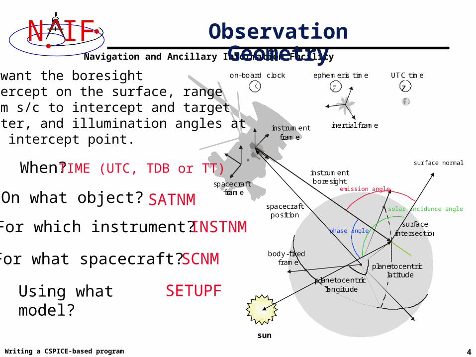
To illustrate these steps, let's write a program that computes the apparent intersection of the boresight ray of a given CASSINI science instrument with the surface of a given Saturnian satellite. The program will compute
• Planetocentric and planetodetic (geodetic) latitudes and longitudes of the intercept point.
• Range from spacecraft to intercept point and from spacecraft to target center.• Illumination angles (phase, solar incidence, and emission) at the intercept point.
Introduction
Navigation and Ancillary Information Facility
Writing a CSPICE-based program 4
N IFon-board clock ephemeris time UTC time
inertial frame
spacecraft frame
instrument frame
instrument boresight
body-fixed frame
surface intersection
spacecraft position
planetocentric latitude
planetocentric longitudeUsing what model?
We want the boresightintercept on the surface, rangefrom s/c to intercept and targetcenter, and illumination angles at the intercept point.
When?
On what object?
For which instrument?
For what spacecraft?
TIME (UTC, TDB or TT)
SATNM
INSTNM
SCNM
SETUPF
Observation Geometry
phase angle
solar incidence angle
surface normal
emission angle
sun

Navigation and Ancillary Information Facility
Writing a CSPICE-based program 5
N IF Needed Data
on-board clock ephemeris time UTC time
inertial frame
spacecraft frame
instrument frame
instrument boresight
body-fixed frame
surface intersection
spacecraft position
planetocentric latitude
planetocentric longitude
Time transformation kernels
Orientation models
Instrument descriptions
Shapes of satellites, planets
Ephemerides for spacecraft, Saturn barycenter and satellites.
surface normal
solar incidence angle
emission angle
phase angle
sun
Navigation and Ancillary Information Facility
Writing a CSPICE-based program 6
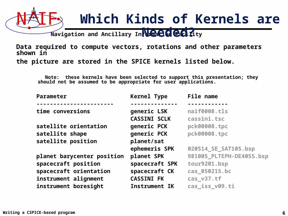
N IFData required to compute vectors, rotations and other parameters shown in the picture are stored in the SPICE kernels listed below.
Note: these kernels have been selected to support this presentation; they should not be assumed to be appropriate for user applications.
Parameter Kernel Type File name ----------------------- -------------- ------------ time conversions generic LSK naif0008.tls CASSINI SCLK cassini.tsc satellite orientation generic PCK pck00008.tpc satellite shape generic PCK pck00008.tpc satellite position planet/sat ephemeris SPK 020514_SE_SAT105.bsp planet barycenter position planet SPK 981005_PLTEPH-DE405S.bsp spacecraft position spacecraft SPK tour9201.bsp spacecraft orientation spacecraft CK cas_050215.bc instrument alignment CASSINI FK cas_v37.tf instrument boresight Instrument IK cas_iss_v09.ti
Which Kinds of Kernels are Needed?
Navigation and Ancillary Information Facility
Writing a CSPICE-based program 7
N IF
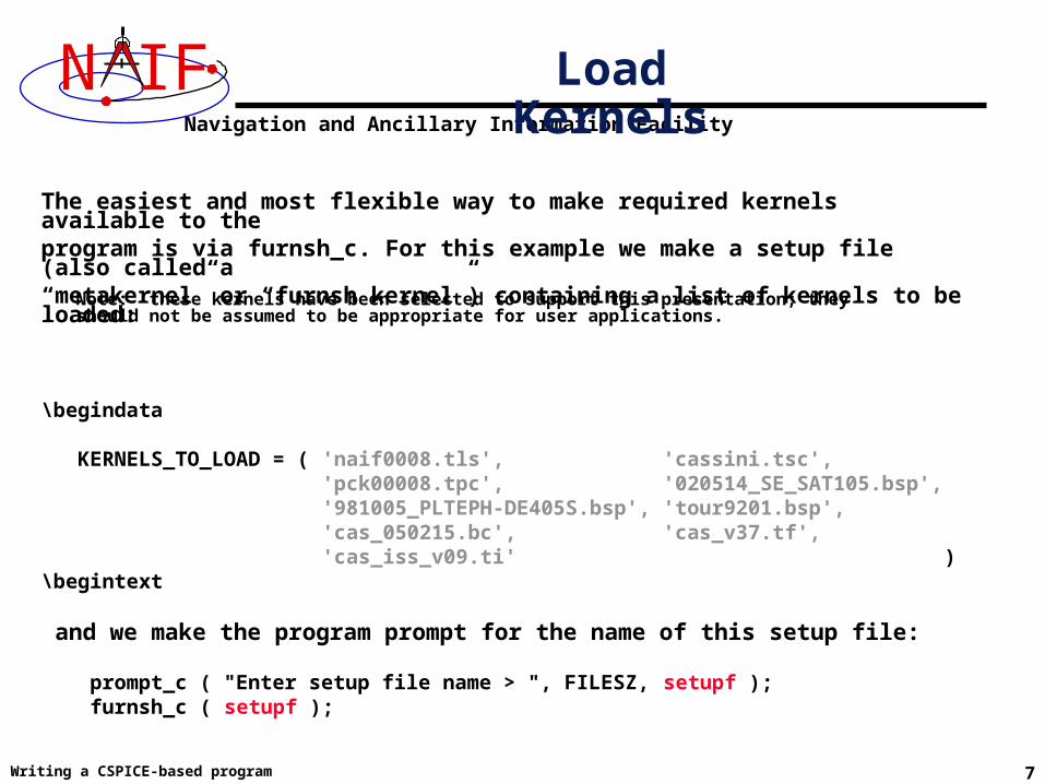
The easiest and most flexible way to make required kernels available to the program is via furnsh_c. For this example we make a setup file (also called a “metakernel” or “furnsh kernel”) containing a list of kernels to be loaded:
\begindata
KERNELS_TO_LOAD = ( 'naif0008.tls', 'cassini.tsc', 'pck00008.tpc', '020514_SE_SAT105.bsp', '981005_PLTEPH-DE405S.bsp', 'tour9201.bsp', 'cas_050215.bc', 'cas_v37.tf', 'cas_iss_v09.ti' )\begintext
and we make the program prompt for the name of this setup file:
prompt_c ( "Enter setup file name > ", FILESZ, setupf ); furnsh_c ( setupf );
Load Kernels
Note: these kernels have been selected to support this presentation; they should not be assumed to be appropriate for user applications.
Navigation and Ancillary Information Facility
Writing a CSPICE-based program 8
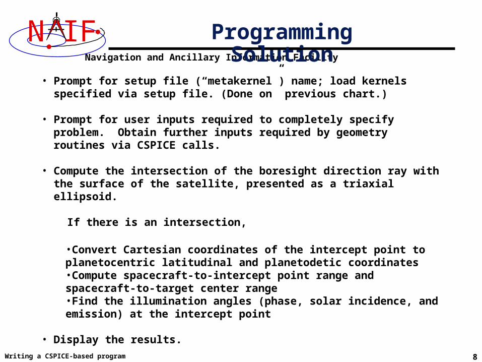
N IF Programming Solution
• Prompt for setup file (“metakernel”) name; load kernels specified via setup file. (Done on previous chart.)
• Prompt for user inputs required to completely specify problem. Obtain further inputs required by geometry routines via CSPICE calls.
• Compute the intersection of the boresight direction ray with the surface of the satellite, presented as a triaxial ellipsoid.
If there is an intersection,
•Convert Cartesian coordinates of the intercept point to planetocentric latitudinal and planetodetic coordinates•Compute spacecraft-to-intercept point range and spacecraft-to-target center range•Find the illumination angles (phase, solar incidence, and emission) at the intercept point
• Display the results.
We discuss the geometric portion of the problem next.

Navigation and Ancillary Information Facility
Writing a CSPICE-based program 9
N IF Compute Surface Intercept and Ranges
The ranges we want are obtained from the outputs of srfxpt_c. These outputs are defined only if a surface intercept is found. If found is true, the spacecraft-to-surface intercept range is the output argument dist, and the spacecraft-to-target center range is the norm of the output argument obspos. Units are km. We use the CSPICE function vnorm_c to obtain the norm:
vnorm_c ( obspos )
We'll write out the range data along with the other program results.
Compute the intercept point (point) of the instrument boresight vector (insite) with the satellite’s (satnm) surface at the TDB time of interest (et). This call also returns the distance between the spacecraft and intercept point (dist), the light-time corrected epoch at the intercept point (trgepc), the target center-to-spacecraft vector (obspos), and a boolean flag indicating whether the intercept was found (found). We use "converged Newtonian" light time plus stellar aberration corrections to produce the most accurate surface Intercept solution possible.
srfxpt_c ( "Ellipsoid", satnm, et, "CN+S", scnm, iframe, insite, point, &dist, &trgepc, obspos, &found );

Navigation and Ancillary Information Facility
Writing a CSPICE-based program 10
N IF
Compute the planetocentric latitude (pclat) and longitude (pclon), as well as the planetodetic latitude (pdlat) and longitude (pdlon) of the intersection point.
if ( found ) {
reclat_c ( point, &r, &pclon, &pclat );
Compute Lat/Lon and Illumination Angles
The illumination angles we want are the outputs of illum_c. Units are radians. For this call, normal light time and stellar aberration corrections suffice.
illum_c ( satnm, et, "LT+S", scnm, point, &phase, &solar, &emissn );
/* Let re, rp, and f be the satellite's longer equatorial radius, polar radius, and flattening factor. */re = radii[0];rp = radii[2];f = ( re – rp ) / re;
recgeo_c ( point, re, f, &pdlon, &pdlat, &alt);

Navigation and Ancillary Information Facility
Writing a CSPICE-based program 11
N IF
illum_c ( satnm, et, "LT+S", scnm, point, &phase, &solar, &emissn ); ... } else { ... }
/* Compute the boresight ray intersection with the surface of the satellite. `dist’ and vnorm_c(obspos) yield desired ranges. */
srfxpt_c ( "Ellipsoid", satnm, et, "CN+S", scnm, iframe, insite, point, &dist, &trgepc, obspos, &found );
/* If an intercept is found, compute planetocentric and planetodetic latitude and longitude of the point. */ if ( found ) { reclat_c ( point, &r, &pclon, &pclat ); /* Let re, rp, and f be the satellite's longer equatorial radius, polar radius, and flattening factor. */ re = radii[0]; rp = radii[2]; f = ( re – rp ) / re; recgeo_c ( point, re, f, &pdlon, &pdlat, &alt );
/* Compute illumination angles at the surface point. */
Geometry Calculations: Summary

Navigation and Ancillary Information Facility
Writing a CSPICE-based program 12
N IF
The code above used quite a few inputs that we don't have yet:
• TDB epoch of interest ( et );• satellite and s/c names (satnm, scnm);• satellite ellipsoid radii (radii);• instrument fixed frame name (iframe);• instrument boresight vector in the instrument frame (insite);
Some of these values are user inputs; others can be obtained via CSPICE calls once the required kernels have been loaded.
Let's prompt for the satellite name (satnm), spacecraft name (scnm), instrument name (instnm) and time of interest (time):
prompt_c ( "Enter satellite name > ", WORDSZ, satnm ); prompt_c ( "Enter spacecraft name > ", WORDSZ, scnm ); prompt_c ( "Enter instrument name > ", WORDSZ, instnm ); prompt_c ( "Enter time > ", WORDSZ, time );
Get Inputs - 1

Navigation and Ancillary Information Facility
Writing a CSPICE-based program 13
N IF Get Inputs - 2
Then we can get the rest of the inputs from CSPICE calls:
To get the TDB epoch (et) from the user-supplied time string (which may refer to the UTC, TDB or TT time systems): str2et_c ( time, &et );
To get the satellite’s ellipsoid radii (radii): bodvrd_c ( satnm, "RADII", 3, &i, radii );
To get the instrument boresight direction (insite) and the name of the instrument frame (iframe) in which it is defined:
bodn2c_c ( instnm, &instid, &found );
if ( !found ) { setmsg_c ( "Instrument name # could not be " "translated to an ID code." ); errch_c ( "#", instnm ); sigerr_c ( "NAMENOTFOUND" ); } getfov_c ( instid, ROOM, WORDSZ, WORDSZ, shape, iframe, insite, &n, bundry );

Navigation and Ancillary Information Facility
Writing a CSPICE-based program 14
N IF Getting Inputs: Summary
bodn2c_c ( instnm, &instid, &found ); if ( !found ) { setmsg_c ( "Instrument name # could not be " "translated to an ID code." ); errch_c ( "#", instnm ); sigerr_c ( "NAMENOTFOUND" ); } getfov_c ( instid, ROOM, WORDSZ, WORDSZ, shape, iframe, insite, &n, bundry );
/* Prompt for the user-supplied inputs for our program */ prompt_c ( "Enter setup file name > ", FILESZ, setupf ); furnsh_c ( setupf ); prompt_c ( "Enter satellite name > ", WORDSZ, satnm ); prompt_c ( "Enter spacecraft name > ", WORDSZ, scnm ); prompt_c ( "Enter instrument name > ", WORDSZ, instnm ); prompt_c ( "Enter time > ", WORDSZ, time );
/* Get the epoch corresponding to the input time: */ str2et_c ( time, &et );
/* Get the radii of the satellite. */
bodvrd_c ( satnm, "RADII", 3, &i, radii );
/* Get the instrument boresight and frame name. */

Navigation and Ancillary Information Facility
Writing a CSPICE-based program 15
N IF Display Results
/* Display results. Convert angles from radians to degrees for output. */printf ( "\n" "Intercept planetocentric longitude (deg): %11.6f\n" "Intercept planetocentric latitude (deg): %11.6f\n" "Intercept planetodetic longitude (deg): %11.6f\n" "Intercept planetodetic latitude (deg): %11.6f\n" "Range from spacecraft to intercept point (km): %11.6f\n" "Range from spacecraft to target center (km): %11.6f\n" "Intercept phase angle (deg): %11.6f\n" "Intercept solar incidence angle (deg): %11.6f\n" "Intercept emission angle (deg): %11.6f\n", dpr_c() * pclon, dpr_c() * pclat, dpr_c() * pdlon, dpr_c() * pdlat, dist, vnorm_c( obspos ), dpr_c() * phase, dpr_c() * solar, dpr_c() * emissn );
}else{ printf ( "No intercept point found at %s\n", time );}

Navigation and Ancillary Information Facility
Writing a CSPICE-based program 16
N IF
To finish up the program we need to declare the variables we've used.
• We'll highlight techniques used by NAIF programmers
• Add remaining C code required to make a syntactically valid program
Complete the Program

Navigation and Ancillary Information Facility
Writing a CSPICE-based program 17
N IF
#include <stdio.h>#include "SpiceUsr.h"
Complete Source Code - 1
SpiceDouble alt; SpiceDouble bundry[ROOM][3]; SpiceDouble dist; SpiceDouble emissn; SpiceDouble et; SpiceDouble f; SpiceDouble insite[3]; SpiceDouble obspos[3]; SpiceDouble pclat; SpiceDouble pclon; SpiceDouble pdlat; SpiceDouble pdlon; SpiceDouble phase; SpiceDouble point [3]; SpiceDouble r; SpiceDouble radii [3]; SpiceDouble re; SpiceDouble rp; SpiceDouble solar; SpiceDouble trgepc;
SpiceChar iframe[WORDSZ]; SpiceChar instnm[WORDSZ]; SpiceChar satnm [WORDSZ]; SpiceChar scnm [WORDSZ]; SpiceChar setupf[FILESZ]; SpiceChar shape [WORDSZ]; SpiceChar time [WORDSZ];
SpiceBoolean found;
#define FILESZ 256 #define WORDSZ 41 #define ROOM 10
int main () {
SpiceInt i; SpiceInt instid; SpiceInt n;

Navigation and Ancillary Information Facility
Writing a CSPICE-based program 18
N IF Complete Source Code - 2
bodn2c_c ( instnm, &instid, &found ); if ( !found ) { setmsg_c ( "Instrument name # could not be " "translated to an ID code." ); errch_c ( "#", instnm ); sigerr_c ( "NAMENOTFOUND" ); } getfov_c ( instid, ROOM, WORDSZ, WORDSZ, shape, iframe, insite, &n, bundry );
/* Prompt for the user-supplied inputs for our program */ prompt_c ( "Enter setup file name > ", FILESZ, setupf ); furnsh_c ( setupf ); prompt_c ( "Enter satellite name > ", WORDSZ, satnm ); prompt_c ( "Enter spacecraft name > ", WORDSZ, scnm ); prompt_c ( "Enter instrument name > ", WORDSZ, instnm ); prompt_c ( "Enter time > ", WORDSZ, time );
/* Get the epoch corresponding to the input time: */ str2et_c ( time, &et );
/* Get the radii of the satellite. */
bodvrd_c ( satnm, "RADII", 3, &i, radii );
/* Get the instrument boresight and frame name. */

Navigation and Ancillary Information Facility
Writing a CSPICE-based program 19
N IF
illum_c ( satnm, et, "LT+S", scnm, point, &phase, &solar, &emissn );
/* Compute the boresight ray intersection with the surface of the satellite. `dist’ and vnorm_c(obspos) yield desired ranges. */
srfxpt_c ( "Ellipsoid", satnm, et, "CN+S", scnm, iframe, insite, point, &dist, &trgepc, obspos, &found );
/* If an intercept is found, compute planetocentric and planetodetic latitude and longitude of the point. */ if ( found ) { reclat_c ( point, &r, &pclon, &pclat ); /* Let re, rp, and f be the satellite's longer equatorial radius, polar radius, and flattening factor. */ re = radii[0]; rp = radii[2]; f = ( re – rp ) / re; recgeo_c ( point, re, f, &pdlon, &pdlat, &alt ); /* Compute illumination angles at the surface point. */
Complete Source Code - 3
printf ( "\n" "Intercept planetocentric longitude (deg): %11.6f\
n" "Intercept planetocentric latitude (deg): %11.6f\
n"
/* Display results. Convert angles from radians to degrees for output. */

Navigation and Ancillary Information Facility
Writing a CSPICE-based program 20
N IF Complete Source Code - 4
"Intercept planetodetic longitude (deg): %11.6f\n" "Intercept planetodetic latitude (deg): %11.6f\n" "Range from spacecraft to intercept point (km): %11.6f\n" "Range from spacecraft to target center (km): %11.6f\n" "Intercept phase angle (deg): %11.6f\n" "Intercept solar incidence angle (deg): %11.6f\n" "Intercept emission angle (deg): %11.6f\n", dpr_c() * pclon, dpr_c() * pclat, dpr_c() * pdlon, dpr_c() * pdlat, dist, vnorm_c( obspos ), dpr_c() * phase, dpr_c() * solar, dpr_c() * emissn );
} else { printf ( "No intercept point found at %s\n", time ); } return(0); }

Navigation and Ancillary Information Facility
Writing a CSPICE-based program 21
N IF
• First be sure that both the CSPICE Toolkit and a C compiler are properly installed.
– A "hello world" C program must be able to compile, link, and run successfully in your environment.
– Any of the mkprodct.* scripts in the cspice/src/* paths of the CSPICE installation should execute properly.
• Ways to compile and link the program:– If you're familiar with the "make" utility, create a makefile. Use compiler
and linker options from the mkprodct.* script found in the cspice/src/cook_c path of your CSPICE installation.
– Or, modify the cookbook mkprodct.* build script. » Your program name must be *.pgm, for example demo.pgm, to be
recognized by the script.» Change the library references in the script to use absolute
pathnames. » Change the path for the executable to the current working directory.» If you compiler supports it, add a –I option to reference the
cspice/include path to make CSPICE *.h files available. Otherwise, copy those files from the include path to your current working directory.
» On some platforms, you must modify the script to refer to your program by name.
Compile and Link the Program - 1

Navigation and Ancillary Information Facility
Writing a CSPICE-based program 22
N IF
– Or, compile the program on the command line. The program must be linked against the CSPICE object library cspice.a (cspice.lib under MS Visual C++/C) and the C math library. On a PC running Linux and gcc, if
» The gcc compiler is in your path• As indicated by the response to the command "which gcc"
» the Toolkit is installed in the path (for the purpose of this example) /myhome/cspice
» You've named the program demo.c then you can compile and link your program using the
command» gcc –I/myhome/cspice/include \
-o demo \ demo.c /myhome/cspice/lib/cspice.a –lm
• Note: the preprocessor flag -DNON_UNIX_STDIO
used in the mkprodct.csh script is needed for code generated by f2c, but is usually unnecessary for compiling user code.
Compile and Link the Program - 2

Navigation and Ancillary Information Facility
Writing a CSPICE-based program 23
N IF
Terminal Window
Prompt>
Setting default compiler:gcc
Setting default compile options: -c -ansi -O2 -DNON_UNIX_STDIO
Setting default link options: -lm
Compiling and linking: demo.pgmCompiling and linking: demo.pgm
Prompt>
mkprodct.csh
Compile and Link the Program - 3

Navigation and Ancillary Information Facility
Writing a CSPICE-based program 24
N IF
It looks like we have everything taken care of:
• We have all necessary kernels
• We made a setup file (metakernel) pointing to them
• We wrote the program
• We compiled and linked it
Let's run it.
Running the Program - 1

Navigation and Ancillary Information Facility
Writing a CSPICE-based program 25
N IF Running the Program - 2
Terminal Window
Prompt>Enter setup file name > setup.kerEnter satellite name > titanEnter spacecraft name > cassiniEnter instrument name > cassini_iss_nacEnter time > 2005 feb 15 8:15 UTC
Intercept planetocentric longitude (deg): -156.443003Intercept planetocentric latitude (deg): 18.788539Intercept planetodetic longitude (deg): -156.443003Intercept planetodetic latitude (deg): 18.788539Range from spacecraft to intercept point (km): 4810.941881Range from spacecraft to target center (km): 7384.326555Intercept phase angle (deg): 43.274588Intercept solar incidence angle (deg): 41.038424Intercept emission angle (deg): 2.514613Prompt>
demo
Navigation and Ancillary Information Facility
Writing a CSPICE-based program 26
N IF
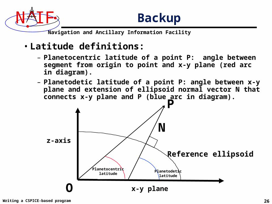
• Latitude definitions:– Planetocentric latitude of a point P: angle between segment from
origin to point and x-y plane (red arc in diagram).
– Planetodetic latitude of a point P: angle between x-y plane and extension of ellipsoid normal vector N that connects x-y plane and P (blue arc in diagram).
Backup
P
O
Reference ellipsoid
x-y plane
z-axis
N
Planetocentric latitude
Planetodetic latitude