NavCom Technology, Inc. - The United States of America · NavCom Technology, Inc. A John Deere...
18
NCT PROPRIETARY NavCom Technology, Inc. NavCom Technology, Inc. A John Deere Company A John Deere Company FCC Rural Satellite Forum – January 27, 2004 “ Making the Rural Connection” Satellite Precise Positioning for Agriculture Satellite Precise Positioning for Agriculture and Farming and Farming by Dr. Peter Williams Director, Advanced Programs Presented to:
Transcript of NavCom Technology, Inc. - The United States of America · NavCom Technology, Inc. A John Deere...

NCT PROPRIETARY
NavCom Technology, Inc. NavCom Technology, Inc. A John Deere CompanyA John Deere Company
FCC Rural Satellite Forum – January 27, 2004 “Making the Rural Connection”
Satellite Precise Positioning for Agriculture Satellite Precise Positioning for Agriculture and Farmingand Farming
by
Dr. Peter WilliamsDirector, Advanced Programs
Presented to:

NCT PROPRIETARY
Who We Are Who We Are John DeereJohn Deere & & NavComNavCom
§ John Deere, Ag Management Solutions supplies innovative solutions for advanced “Precision Farming” systems§ NavCom has evolved from a provider of contract
engineering services to a rapidly growing system integration company§ Located in Southern California
§ NavCom began developing GPS based Precise Positioning systems for Deere in 1994
NavCom became a John Deere Company in November 1999

NCT PROPRIETARY
§ Provide a center of excellence in precise positioning and wireless data communications to support Deere SBU’s
§ Ensure Deere is first and bestin the provision of advanced technology options for its major products
§ Add shareholder value through the development of new business opportunities for non-traditional Deere markets
What NavCom Does for DeereWhat NavCom Does for Deere

NCT PROPRIETARY
The need for Precise The need for Precise Positioning in Farming todayPositioning in Farming today§ Precision Farming§ Allows mapping of crop yields to create data base
for future crop management§ Precise application of fertilizers and seeds to
optimize yield§ Improved yield reduces cost and eliminates harmful
run off due to over application
§ Automatic Vehicle Guidance§ Assists the operator to maintain precise crop rows
during planting and harvesting§ Permits automatic guidance of vehicles to further
improve operator performance.

NCT PROPRIETARY
The StarFire SystemThe StarFire System

NCT PROPRIETARY
Network of GPS Reference SitesUser Equipment on Ag Machine
Processing Hubs
StarFire Network OverviewStarFire Network Overview
GPS
GPSGPS
GPS
L-BandCommunications
Satellite
Land Earth StationDGPS
Corrections

NCT PROPRIETARY
StarFire Global Reference NetworkStarFire Global Reference Network
GPS Dual Frequency Reference StationsData Processing HubsSatellite Uplink Stations

NCT PROPRIETARY
MonitorsMonitors
§ One or more StarFire user receivers are located at all NCT reference sites in the global StarFireStarFire network.
§ These Monitors receive the broadcast correction stream, perform differential GPS navigation and report their positioning results in real time.
§ Automated alerts are generated if problems are noted, and performance graphs are posted to the secure StarFire web site every few minutes.
§ Performance measures include:l Navigation Accuracyl Pass-to-Pass Accuracy

NCT PROPRIETARY
§ NavCom’s arrangement with NASA/JPL included:§License to use the JPL Real Time GIPSY (RTG) algorithms and software.
§Use of the JPL dual frequency GPS Ground Network (GGN)
§ NavCom has integrated the NASA/JPL GGN data into its own global network of reference stations
§ NavCom has continued to develop and extend the global correction algorithms in the implementation of the current SBAS system.
§§ StarFire StarFire now offers a unique global 10cm service via Inmarsat Satellites
§ Future Developments: §Full GPS/INS integration for terrain compensation and improved
performance under foliage
§Return link to permit short message service (SMS)
NavCom & Deere team with NavCom & Deere team with NASA/JPLNASA/JPL

NCT PROPRIETARY
Horizontal Positioning AccuracyHorizontal Positioning AccuracyUsing the JPL RTG Corrections with NCT Extended Kalman Filter

NCT PROPRIETARY
Rugged Rugged StarFireStarFireTMSensorSensor
§ Rugged and light weight position sensor combines GPS receiver and L-band demodulator§ Built in tri-band antenna for GPS
and L-band signals§ External power input§ Automatically accepts
WAAS/EGNOS data§ Flexible user interface including
output of standard NMEA messages
… decimeter Accuracy decimeter Accuracy in real time worldwidein real time worldwide

NCT PROPRIETARY
Yield MappingYield Mapping
Many crops (wheat, corn, etc.) are harvested with large machines called combines.
In the last few years, increasing numbers of these machines have been equipped with sensors and computers that simultaneously measure and record crop yield and accurate position in real time as the crop is being harvested.

NCT PROPRIETARY

NCT PROPRIETARY
Automatic SteeringAutomatic Steering
Many of the field operations involved in row crop production (planting, spraying, cultivating, etc.) involve steering a tractor and towed implement along a straight line with as little deviation as possible.These operations require a skilled driver and cumbersome visual aids. They are also limited to good visibility conditions. All of which affects productivity.

NCT PROPRIETARY
Automatic SteeringAutomatic SteeringPrecise navigation and positioning information from sensors such as GPS combined with computer based control algorithms enable systems to be designed to meet even the most challenging automatic steering requirements.
This row crop cultivation operation requires one inch accuracy from pass to pass otherwise crop plants will be destroyed instead of weeds.

NCT PROPRIETARY
AMS GreenStar AMS GreenStar AutoTracAutoTrac AdvantagesAdvantages
§ Reduce Operator Fatigue § More comfortable working hours
§ Increased awareness of machine functions
§ Optimize Machine Efficiency§ Operate at faster field speeds
§ Reduce per acre fuel consumption
§ Reduce overlap on implements and sprayers
§ Increase Yield § Cover more acres with fewer hours of operation
§ Centralize compaction due to planned traffic patterns on fields
§ More accurate placement of agronomic inputs such as fertilizer and herbicides
NCT PROPRIETARY
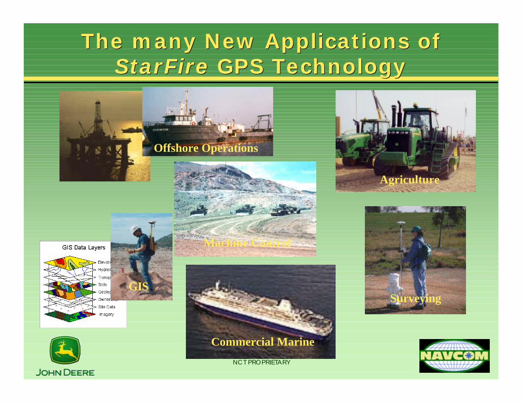
The many New Applications of The many New Applications of StarFire StarFire GPS TechnologyGPS Technology
Offshore Operations
GISSurveying
Commercial Marine
Agriculture
Machine Control

NCT PROPRIETARY
…………..in Summary..in Summary
•Integrated Satellite Navigation (GPS) and Communications systems (Inmarsat) have enabled the development of precise positioning systems which contribute to improved farming operations:
•Yield mapping
•Steering Aids for Parallel Tracking
•Automatic Steering for Ag vehicles
•Future developments will improve accuracy add capability to greatly enhance agricultural efficiency, cost and reliability