
NATURAL RESOURCE INVENTORY - Manalapan...
96
NATURAL RESOURCE INVENTORY Manalapan Township Monmouth County, New Jersey Prepared by: CME ASSOCIATES 1460 Route 9 South Howell, NJ 07731-1194 December 2001 1460 Route 9 South, Howell, NJ 07731 (732) 462-7400 Fax (732) 409-0756
-
Upload
hoangthien -
Category
Documents
-
view
222 -
download
0
Transcript of NATURAL RESOURCE INVENTORY - Manalapan...
NATURAL RESOURCE INVENTORY
Manalapan Township Monmouth County, New Jersey
Prepared by:
CME ASSOCIATES 1460 Route 9 South
Howell, NJ 07731-1194
December 2001
1460 Route 9 South, Howell, NJ 07731 (732) 462-7400 Fax (732) 409-0756
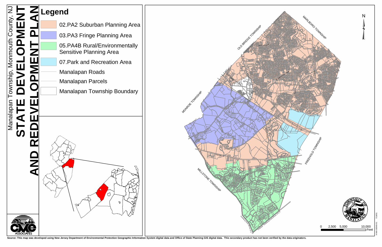
TABLE OF CONTENTS
Page INTRODUCTION.................................................................................................. 1 LAND USE ........................................................................................................... 6 STATE DEVELOPMENT AND REDEVELOPMENT PLAN ................................. 11 SANITARY SEWER SERVICE AREAS............................................................... 14 HISTORIC SITES................................................................................................. 15 GEOLOGY ........................................................................................................... 21 AQUIFERS........................................................................................................... 27 STREAMS AND LAKES....................................................................................... 30 FLOOD-PRONE AREAS...................................................................................... 33 FRESHWATER WETLANDS............................................................................... 34 SOILS................................................................................................................... 37 PRIME FARMLAND............................................................................................. 57 DEPTH TO WATER TABLE................................................................................. 59 FORESTS ............................................................................................................ 60 RARE SPECIES AND NATURAL COMMUNITIES.............................................. 63 WILDLIFE APPENDIX ......................................................................................... A1-A14 REFERENCES
S:\RPT\Environmental\46-01 Manalapan NRI 8-01.doc i

INTRODUCTION
This Natural Resource Inventory (NRI) for Manalapan Township has been compiled
pursuant to the authorization of the Mayor and Township Committee. The previous
inventory of Manalapan’s environmental resources was prepared in 1976. A geographic
information system was used in the preparation of this completely new NRI to incorporate
updated mapping and to generate high quality color maps.
In accordance with Municipal Land Use Law (N.J.S.A. 40:55D-1 et seq.), a municipal
Master Plan is required to contain a land use plan element. An NRI is a compilation of basic
environmental information that is an essential supplement to a land use plan. This
document is therefore intended to be utilized by the Manalapan Township Environmental
Commission, Planning and Zoning Boards, and Township Committee to aid in the
identification of significant natural resources and the evaluation of environmental issues in
land use planning.
Maps for this NRI were generated using Geographic Information Systems (GIS)
software. A GIS facilitates the linking of digital spatial data that define the location and
boundaries of natural and cultural resources to databases that contain information
identifying the characteristics of each resource. Data used in this project was obtained from
secondary sources including the New Jersey Department of Environmental Protection
(NJDEP), the New Jersey Geological Survey (NJGS), the New Jersey Office of State
Planning, and the Monmouth County GIS Management Office (MCGISMO). Compilation of
the NJDEP data was completed in 1996/1997, the NJGS data was completed in 1998/1999,
and the MCGISMO data was completed in 2000. Most data sets were used as received
from the source agencies, but some were partially modified to include changes that have
occurred since the original data was acquired or to include local information. The base map
depicting Manalapan tax lots and roadways was created by CME Associates using
Computer Aided Drafting and Design (CADD) software.
S:\RPT\Environmental\46-01 Manalapan NRI 8-01.doc 1

Maps for this NRI are provided at two different scales. Maps at a 1”=5000’ scale are
bound into this document, and a set of similar maps at a 1”=2,500’ scale are attached
separately. The larger scale maps are intended to assist in the assessment of individual
land parcels.
POPULATION
Manalapan Township comprises an area of approximately 30.6 square miles. The
Township population recorded in the year 2000 census is 33,423. There was a substantial
growth in Township population over the four decades from 1960 to 2000. During these forty
years, population increased from 3,990 to 33,423. (See Table 1 Population Trends) The
ten-year growth from 1990 to 2000 is 25%. If this growth trend continues, the projected
Township population would be approximately 37,000 by the year 2005 and 42,000 by the
year 2020. Population increase in Manalapan has been directly related to new residential
development. The total number of housing units increased from 9,029 in 1990 to 10,781 in
the year 2000, as former farmland and woodland were converted to residential land use.
Table 2 shows the number of certificates of occupancy issued by the Township between
1983 and 2000.
S:\RPT\Environmental\46-01 Manalapan NRI 8-01.doc 2
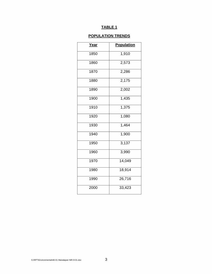
TABLE 1
POPULATION TRENDS
Year Population
1850 1,910
1860 2,573
1870 2,286
1880 2,175
1890 2,002
1900 1,435
1910 1,375
1920 1,080
1930 1,464
1940 1,900
1950 3,137
1960 3,990
1970 14,049
1980 18,914
1990 26,716
2000 33,423
S:\RPT\Environmental\46-01 Manalapan NRI 8-01.doc 3

TABLE 2
CERTIFICATES OF OCCUPANCY ISSUED BY MANALAPAN TOWNSHIP
BETWEEN 1983-2000
Year No. of C.O.’s
1983 249 (residential) 13 (non-residential)
1984 343 (residential) 13 (non-residential)
1985 362 (residential) 8 (non-residential)
1986 366 (residential) 6 (non-residential)
1987 390 (residential) 5 (non-residential)
1988 343 (combined residential and non-residential)
1989 102 (combined residential and non-residential)
1990 297 (combined residential and non-residential)
1991 317 (combined residential and non-residential)
1992 292 (combined residential and non-residential)
1993 260 (combined residential and non-residential)
1994 207 (combined residential and non-residential)
1995 187 (combined residential and non-residential)
1996 157 (combined residential and non-residential)
1997 278 (residential) 2 (non-residential)
1998 215 (residential) 4 (non-residential)
1999 196 (residential) 12 (non-residential)
2000 455 (residential) 4 (non-residential)
S:\RPT\Environmental\46-01 Manalapan NRI 8-01.doc 4

CLIMATE
Manalapan Township has a continental climate, with the prevailing winds from the
west-northwest in the winter months, and from the southwest during summer months. The
buffering effects from the Atlantic Ocean on temperature are small. In an average year, the
growing season extends from early April until mid to late October and lasts approximately
240 days. Rainfall averages approximately 44 inches per year, and is more or less evenly
distributed month to month. Total annual snowfall accumulations average 24”.
S:\RPT\Environmental\46-01 Manalapan NRI 8-01.doc 5
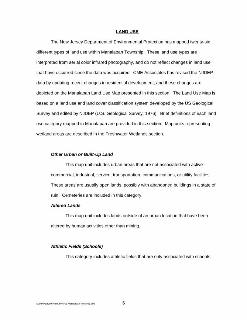
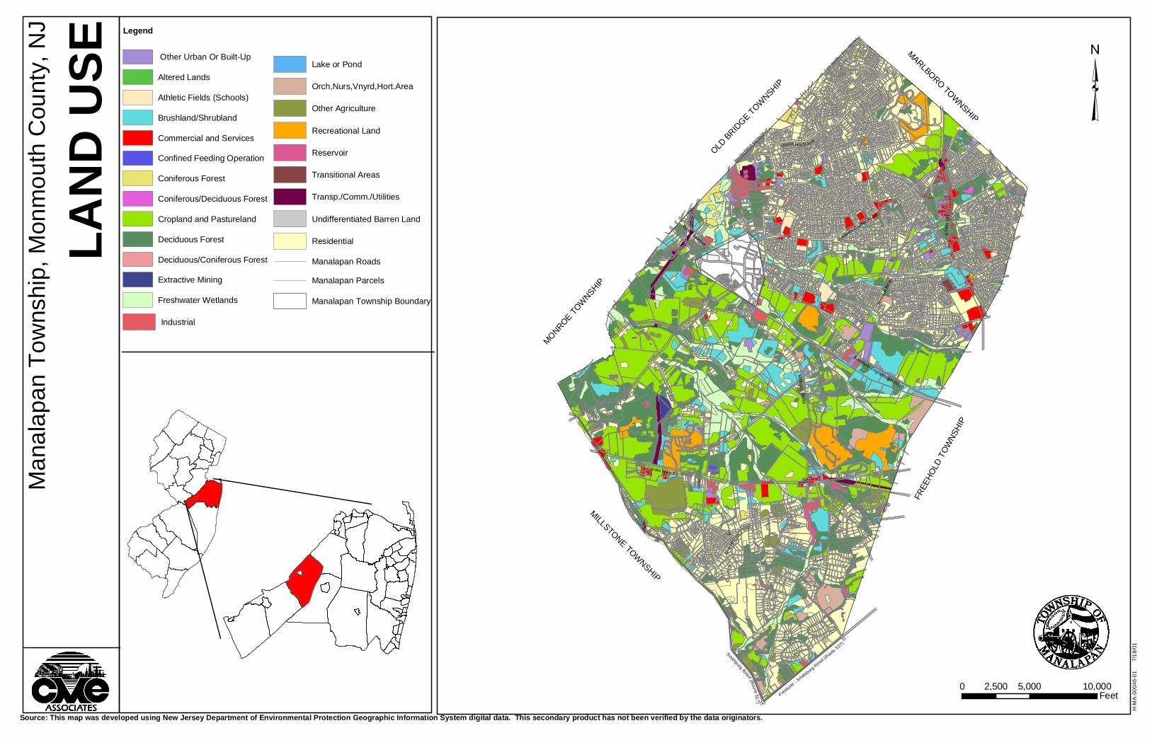
LAND USE
The New Jersey Department of Environmental Protection has mapped twenty-six
different types of land use within Manalapan Township. These land use types are
interpreted from aerial color infrared photography, and do not reflect changes in land use
that have occurred since the data was acquired. CME Associates has revised the NJDEP
data by updating recent changes in residential development, and these changes are
depicted on the Manalapan Land Use Map presented in this section. The Land Use Map is
based on a land use and land cover classification system developed by the US Geological
Survey and edited by NJDEP (U.S. Geological Survey, 1976). Brief definitions of each land
use category mapped in Manalapan are provided in this section. Map units representing
wetland areas are described in the Freshwater Wetlands section.
Other Urban or Built-Up Land
This map unit includes urban areas that are not associated with active
commercial, industrial, service, transportation, communications, or utility facilities.
These areas are usually open lands, possibly with abandoned buildings in a state of
ruin. Cemeteries are included in this category.
Altered Lands
This map unit includes lands outside of an urban location that have been
altered by human activities other than mining.
Athletic Fields (Schools)
This category includes athletic fields that are only associated with schools.
S:\RPT\Environmental\46-01 Manalapan NRI 8-01.doc 6

Brushland/Shrubland
Areas mapped as brushland/shrubland are wooded lands that have a cover
canopy between 0 and 20 feet in height. Brushland/shrubland can include early
successional plant communities only a few years old as well as climax or near climax
communities many years old.
Commercial and Services
The commercial and services land use coverage includes properties that
contain buildings predominantly used for services and the sale of products. Also
included in this map unit are support areas such as parking lots, driveways, and
associated landscaped areas. Due to the limitations in the mapping process, some
residential and industrial land uses may be contained within this map unit. Non-
commercial land uses do not exceed one-third of the total area mapped as
commercial and services.
Confined Feeding Operations
Confined feeding operations contain specialized livestock and poultry
production businesses as well as other types of specialty farms.
Coniferous Forest
Lands mapped as coniferous forest have a cover canopy with an average
tree height greater than 20 feet and contain at least 75% conifers.
Coniferous/Deciduous Forest
These forest areas contain both coniferous and deciduous trees, but the
coniferous trees are more prevalent. Average tree height is greater than 20 feet.
S:\RPT\Environmental\46-01 Manalapan NRI 8-01.doc 7

Cropland and Pastureland
This map unit includes agricultural properties used for the production of crops
and animal grazing. These areas may also include fallow farm fields.
Deciduous Forest
This map unit includes woodlands with an average tree height greater than
20 feet and at least 75% deciduous trees.
Deciduous/Coniferous Forest
These forest areas contain a mixture of deciduous and coniferous trees, but
with deciduous trees being dominant. Average tree height is in excess of 20 feet.
Extractive Mining
One area of extractive mining is mapped within Manalapan, in the
southwestern portion of the Township. Mining operations in the unconsolidated
sediments of the New Jersey coastal plain typically involve the extraction of gravel,
sand, or clay for construction materials.
Industrial
Light and heavy industrial land uses are included in this map unit.
Lakes or Ponds
Lakes and ponds depicted on the land use map are as small as one acre and
are naturally enclosed. Manmade water impoundments are not included in this map
unit, and are mapped separately as reservoirs. Millhurst Mill Pond is mapped as a
S:\RPT\Environmental\46-01 Manalapan NRI 8-01.doc 8

pond or a lake, whereas Taylorr’s Lake (near the Route 33 Business Exit Ramp) is
mapped as a reservoir.
Orchards, Nurseries, Vineyards, and Horticulture Areas
Land uses within these mapped areas include agricultural properties that are
intensively managed for the production of ornamental plants, fruits, trees, and
vegetable seedlings. Wholesale greenhouse operations are included herein.
Other Agriculture
Experimental agricultural fields, isolated structures for crop or equipment
storage, and horse farms are depicted in this mapping unit.
Recreation Land
Areas depicted as recreation land have been specifically developed for
recreational activities that are open to the general public.
Reservoir
Human created impoundments of at least 3 acres are included in this map
unit. These water bodies may be created for irrigation, flood control, municipal water
supplies, recreation, and landscaping.
Transitional Areas
Lands on which site work or construction has begun for a range of
development types are mapped as transitional areas.
S:\RPT\Environmental\46-01 Manalapan NRI 8-01.doc 9

Transportation, Communication, and Utilities
Areas included in this category are limited access highways, railroad facilities,
bus and truck terminals, airports, wetland rights-of-way, water treatment facilities,
sewage treatment facilities, and communication towers.
Undifferentiated Barren Land
Undifferentiated barren land areas include cleared areas in a non-urban
setting with exposed soil and sparse vegetative cover.
Residential
Single-family residential, multiple unit and mobile home residences are
included in this land use category.
S:\RPT\Environmental\46-01 Manalapan NRI 8-01.doc 10
³M
anal
apan
Tow
nshi
p, M
onm
outh
Cou
nty,
NJ
LAND
USE
Source: This map was developed using New Jersey Department of Environmental Protection Geographic Information System digital data. This secondary product has not been verified by the data originators.
Gordon's Corner Road
Union Hi ll R oad
Tenn
ent R
oad
US
Hw
y 9
Wood Avenue
Freehold Englishtown Road
Mi ll hurst R
o ad
State Hwy 33
Swe
etm
an
s Lane
H-M
A-0
0046
-01
7
/18/
01
MONROE TOW
NSHIP
OLD BRID
GE TOWNSHIP
MILLSTONE TOWNSHIP
FREE
HOLD
TOW
NSHI
P
MARLBORO TOWNSHIP
0 5,000 10,0002,500Feet
Lake or Pond
Orch,Nurs,Vnyrd,Hort.Area
Other Agriculture
Recreational Land
Reservoir
Transitional Areas
Transp./Comm./Utilities
Undifferentiated Barren Land
Residential
Manalapan Roads
Manalapan Parcels
Manalapan Township Boundary
Industrial
Legend
Other Urban Or Built-Up
Altered Lands
Athletic Fields (Schools)
Brushland/Shrubland
Commercial and Services
Confined Feeding Operation
Coniferous Forest
Coniferous/Deciduous Forest
Cropland and Pastureland
Deciduous Forest
Deciduous/Coniferous Forest
Extractive Mining
Freshwater Wetlands
Freehold - Smith
burg Road (R
oute 537)
Smithburg Road (Route 527)
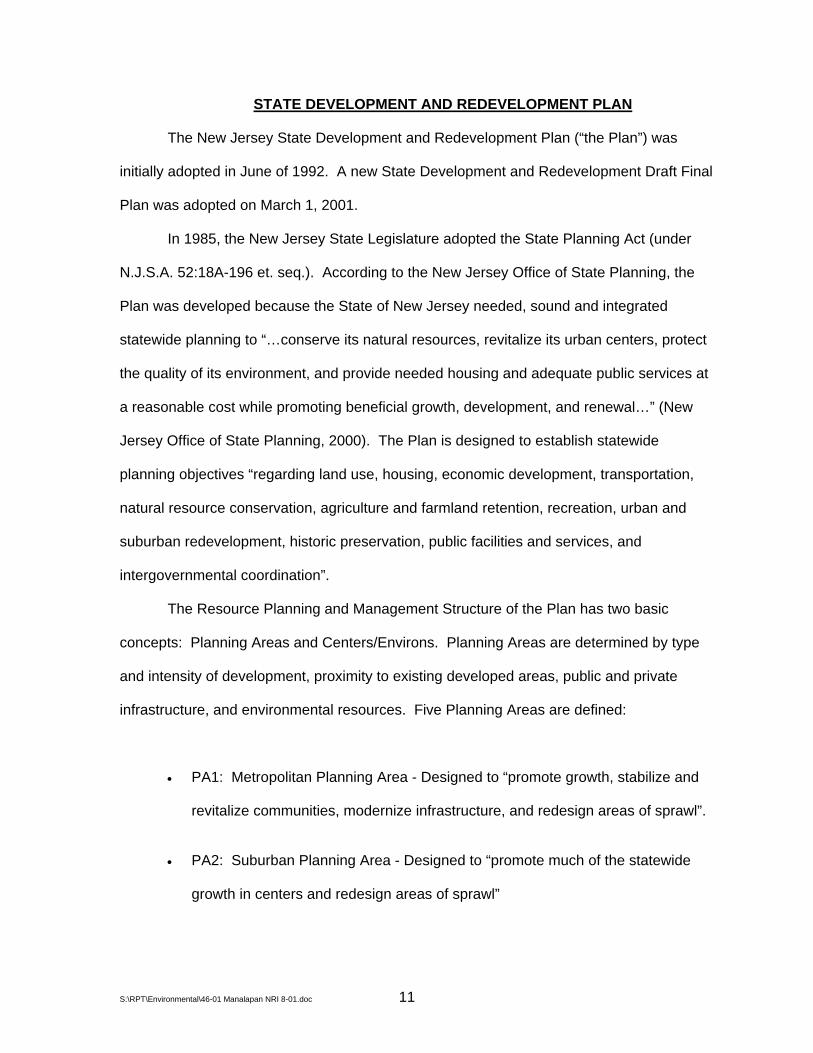
STATE DEVELOPMENT AND REDEVELOPMENT PLAN
The New Jersey State Development and Redevelopment Plan (“the Plan”) was
initially adopted in June of 1992. A new State Development and Redevelopment Draft Final
Plan was adopted on March 1, 2001.
In 1985, the New Jersey State Legislature adopted the State Planning Act (under
N.J.S.A. 52:18A-196 et. seq.). According to the New Jersey Office of State Planning, the
Plan was developed because the State of New Jersey needed, sound and integrated
statewide planning to “…conserve its natural resources, revitalize its urban centers, protect
the quality of its environment, and provide needed housing and adequate public services at
a reasonable cost while promoting beneficial growth, development, and renewal…” (New
Jersey Office of State Planning, 2000). The Plan is designed to establish statewide
planning objectives “regarding land use, housing, economic development, transportation,
natural resource conservation, agriculture and farmland retention, recreation, urban and
suburban redevelopment, historic preservation, public facilities and services, and
intergovernmental coordination”.
The Resource Planning and Management Structure of the Plan has two basic
concepts: Planning Areas and Centers/Environs. Planning Areas are determined by type
and intensity of development, proximity to existing developed areas, public and private
infrastructure, and environmental resources. Five Planning Areas are defined:
• PA1: Metropolitan Planning Area - Designed to “promote growth, stabilize and
revitalize communities, modernize infrastructure, and redesign areas of sprawl”.
• PA2: Suburban Planning Area - Designed to “promote much of the statewide
growth in centers and redesign areas of sprawl”
S:\RPT\Environmental\46-01 Manalapan NRI 8-01.doc 11

• PA3: Fringe Planning Area - Designed to “accommodate growth in centers and
keep environs largely open”
• PA4: Rural Planning Area, which includes PA4B, the Rural/Environmentally
Sensitive Planning Area - Designed to “promote a viable agricultural industry,
protect large contiguous areas of farmland – including those on environmentally
sensitive land – and accommodate growth in centers”.
• PA5: Environmentally Sensitive Planning Area, which includes PA5B, the
Environmentally Sensitive/Barrier Island Planning Area - Designed to “protect
environmental resources – including large areas of open lands and sensitive
barrier islands – and accommodate growth in centers”.
Centers are defined as central places within planning areas where growth should be
either attracted or contained, depending on the unique characteristics and growth
opportunities of each center and the characteristics of the surrounding planning area in
which it is located.
Environs are “areas outside centers and should be protected from the growth that
occurs in centers”.
Three State planning areas are designated within Manalapan Township: the
Suburban Planning Area (PA2), Fringe Planning Area (PA3), and Rural/Environmentally
Sensitive Planning Area (PA4 & PA4B). In addition, Monmouth Battleground State Park is a
designated park and recreation area. The largest coverage in the Township is the Suburban
Planning Area. It should be noted that State Planning Areas generally do not coincide with
the Township boundaries, but extend into adjacent municipalities. The New Jersey State
Development and Redevelopment Plan should be referenced for specific details on how the
designated State planning areas may affect various aspects of development within
S:\RPT\Environmental\46-01 Manalapan NRI 8-01.doc 12

Manalapan Township. A copy of the Plan can be obtained from the New Jersey Office of
State Planning, Department of Community Affairs (33 West State Street, P.O. Box 204,
Trenton, NJ 08625-0204, Phone: 609-292-7156).
S:\RPT\Environmental\46-01 Manalapan NRI 8-01.doc 13
³M
anal
apan
Tow
nshi
p, M
onm
outh
Cou
nty,
NJ
Source: This map was developed using New Jersey Department of Environmental Protection Geographic Information System digital data and Office of State Planning GIS digital data. This secondary product has not been verified by the data originators.
Gordon's Corner Road
Union Hi ll Road
Tenn
ent R
oad
US
Hw
y 9
Wood Avenue
Freehold Englishtown Road
Mi ll hu rs t R
oad
State Hwy 33
Sw
eetm
an
s Lane
H-M
A-0
0046
-01
7
/18/
01
MONROE TOW
NSHIP
OLD BRID
GE TOWNSHIP
MILLSTONE TOWNSHIP
FREE
HOLD
TOW
NSHI
P
MARLBORO TOWNSHIP
0 5,000 10,0002,500Feet
STAT
E DEV
ELOP
MENT
AND
REDE
VELO
PMEN
T PLA
N Legend02.PA2 Suburban Planning Area
03.PA3 Fringe Planning Area
05.PA4B Rural/Environmentally Sensitive Planning Area
07.Park and Recreation Area
Manalapan RoadsManalapan Parcels
Manalapan Township Boundary
Freehold - Smith
burg Road (R
oute 537)
Smithburg Road (Route 527)
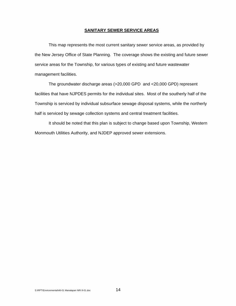
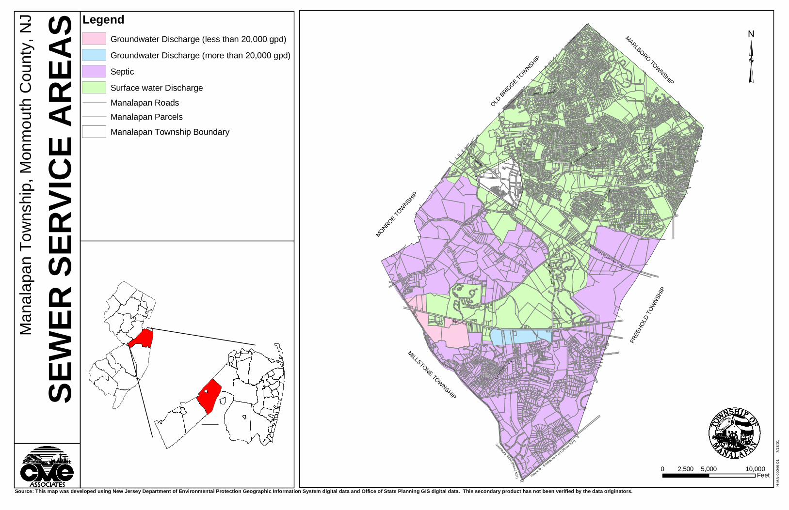
SANITARY SEWER SERVICE AREAS
This map represents the most current sanitary sewer service areas, as provided by
the New Jersey Office of State Planning. The coverage shows the existing and future sewer
service areas for the Township, for various types of existing and future wastewater
management facilities.
The groundwater discharge areas (>20,000 GPD and <20,000 GPD) represent
facilities that have NJPDES permits for the individual sites. Most of the southerly half of the
Township is serviced by individual subsurface sewage disposal systems, while the northerly
half is serviced by sewage collection systems and central treatment facilities.
It should be noted that this plan is subject to change based upon Township, Western
Monmouth Utilities Authority, and NJDEP approved sewer extensions.
S:\RPT\Environmental\46-01 Manalapan NRI 8-01.doc 14
³M
anal
apan
Tow
nshi
p, M
onm
outh
Cou
nty,
NJ
SEWE
R SE
RVIC
E ARE
AS
Source: This map was developed using New Jersey Department of Environmental Protection Geographic Information System digital data and Office of State Planning GIS digital data. This secondary product has not been verified by the data originators.
Gordon's Corner Road
Union Hi l l Road
Tenn
ent R
oad
US
Hw
y 9
Wood Avenue
Freehold Englishtown Road
Mi ll hurst R
o ad
State Hwy 33
Swee
tman
s Lane
H-M
A-0
0046
-01
7
/18/
01
MONROE TOW
NSHIP
OLD BRID
GE TOWNSHIP
MILLSTONE TOWNSHIP
FREE
HOLD
TOW
NSHI
P
MARLBORO TOWNSHIP
0 5,000 10,0002,500Feet
LegendGroundwater Discharge (less than 20,000 gpd)
Groundwater Discharge (more than 20,000 gpd)
Septic
Surface water Discharge
Manalapan RoadsManalapan Parcels
Manalapan Township Boundary
Freehold - Smith
burg Road (R
oute 537)
Smithburg Road (Route 527)
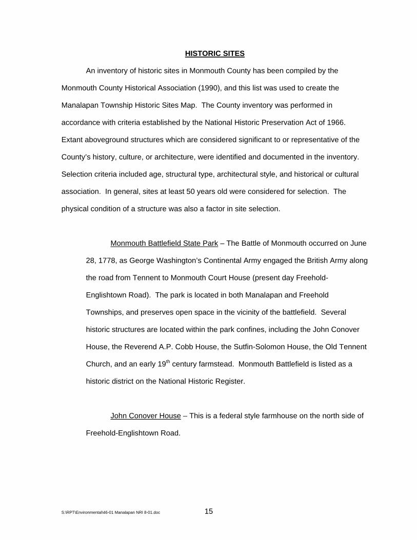
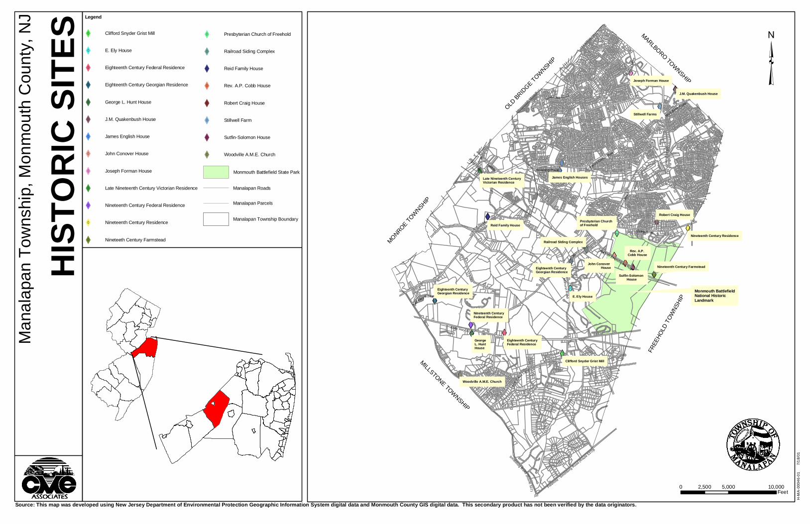
HISTORIC SITES
An inventory of historic sites in Monmouth County has been compiled by the
Monmouth County Historical Association (1990), and this list was used to create the
Manalapan Township Historic Sites Map. The County inventory was performed in
accordance with criteria established by the National Historic Preservation Act of 1966.
Extant aboveground structures which are considered significant to or representative of the
County’s history, culture, or architecture, were identified and documented in the inventory.
Selection criteria included age, structural type, architectural style, and historical or cultural
association. In general, sites at least 50 years old were considered for selection. The
physical condition of a structure was also a factor in site selection.
Monmouth Battlefield State Park – The Battle of Monmouth occurred on June
28, 1778, as George Washington’s Continental Army engaged the British Army along
the road from Tennent to Monmouth Court House (present day Freehold-
Englishtown Road). The park is located in both Manalapan and Freehold
Townships, and preserves open space in the vicinity of the battlefield. Several
historic structures are located within the park confines, including the John Conover
House, the Reverend A.P. Cobb House, the Sutfin-Solomon House, the Old Tennent
Church, and an early 19th century farmstead. Monmouth Battlefield is listed as a
historic district on the National Historic Register.
John Conover House – This is a federal style farmhouse on the north side of
Freehold-Englishtown Road.
S:\RPT\Environmental\46-01 Manalapan NRI 8-01.doc 15
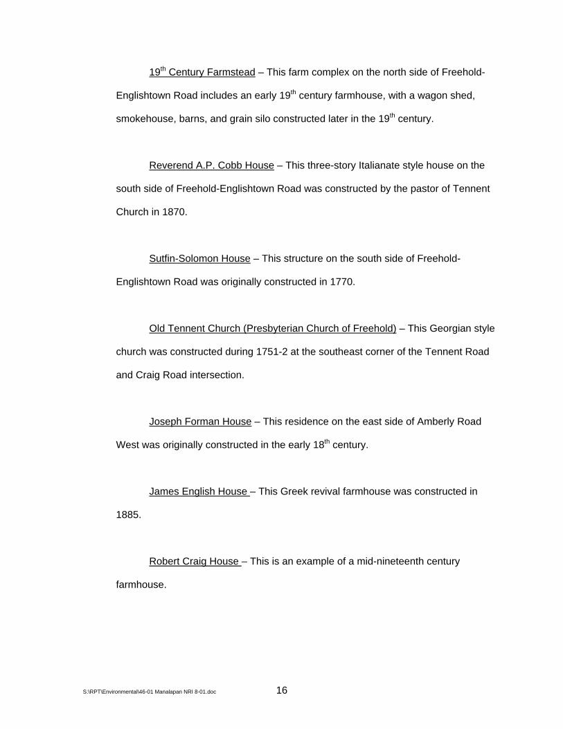
19th Century Farmstead – This farm complex on the north side of Freehold-
Englishtown Road includes an early 19th century farmhouse, with a wagon shed,
smokehouse, barns, and grain silo constructed later in the 19th century.
Reverend A.P. Cobb House – This three-story Italianate style house on the
south side of Freehold-Englishtown Road was constructed by the pastor of Tennent
Church in 1870.
Sutfin-Solomon House – This structure on the south side of Freehold-
Englishtown Road was originally constructed in 1770.
Old Tennent Church (Presbyterian Church of Freehold) – This Georgian style
church was constructed during 1751-2 at the southeast corner of the Tennent Road
and Craig Road intersection.
Joseph Forman House – This residence on the east side of Amberly Road
West was originally constructed in the early 18th century.
James English House – This Greek revival farmhouse was constructed in
1885.
Robert Craig House – This is an example of a mid-nineteenth century
farmhouse.
S:\RPT\Environmental\46-01 Manalapan NRI 8-01.doc 16

Nineteenth Century Farmstead – This farm complex on the south side of
Craig Road includes two farmhouses, a wagon shed, and a barn. The earliest house
was built in the mid-nineteenth century.
Nineteenth Century Residence – This federal style building on the south side
of Craig Road was originally constructed in the early 19th century and has had
several later alterations.
James English House – This residence on Gordon’s Corner Road was
originally constructed in 1740 and expanded in 1800.
Reid Family House – This residence on Iron Ore Road was originally
constructed in 1839 with Federal and Greek revival style characteristics, and later
expanded in a Victorian and Italianate style.
Eighteenth Century House – This Georgian style residence off of LaValley
Road in the present day Quail Hill Boy Scout Reservation was originally constructed
in 1770 and later altered.
Early Nineteenth Century House – This Italianate style house on Main Street
near the Conrail Railroad tracks was constructed in 1810.
Early Twentieth Century Railroad Siding Complex – This site at the
intersection of Main Street and the Conrail Railroad tracks includes a small office
building and a grain elevator built between 1916 and 1920.
S:\RPT\Environmental\46-01 Manalapan NRI 8-01.doc 17
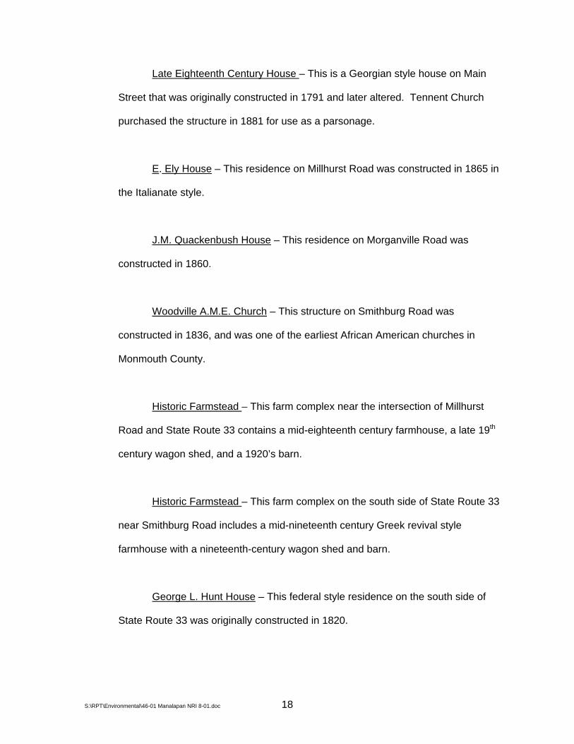
Late Eighteenth Century House – This is a Georgian style house on Main
Street that was originally constructed in 1791 and later altered. Tennent Church
purchased the structure in 1881 for use as a parsonage.
E. Ely House – This residence on Millhurst Road was constructed in 1865 in
the Italianate style.
J.M. Quackenbush House – This residence on Morganville Road was
constructed in 1860.
Woodville A.M.E. Church – This structure on Smithburg Road was
constructed in 1836, and was one of the earliest African American churches in
Monmouth County.
Historic Farmstead – This farm complex near the intersection of Millhurst
Road and State Route 33 contains a mid-eighteenth century farmhouse, a late 19th
century wagon shed, and a 1920’s barn.
Historic Farmstead – This farm complex on the south side of State Route 33
near Smithburg Road includes a mid-nineteenth century Greek revival style
farmhouse with a nineteenth-century wagon shed and barn.
George L. Hunt House – This federal style residence on the south side of
State Route 33 was originally constructed in 1820.
S:\RPT\Environmental\46-01 Manalapan NRI 8-01.doc 18

Late Eighteenth Century House – This residence on State Route 33 was
owned by John Rue Perrine from between 1837 and 1841 through 1889.
Clifford Snyder Grist Mill – This three-story mill located on the west side of
Sweetman’s Lane near Millhurst Pond was constructed in 1877.
Victorian Vernacular House – This residence was constructed in the late 19th-
early 20th century.
Stillwell Farm – This farm complex on U.S. Route 9 near Pine Brook Road
includes a Greek revival and Italianate style farmhouse constructed in 1850 as well
as a later 19th century barn and wagon shed.
Late Eighteenth Century House – This structure at the northeast corner of
Wickatunk Road and Morganville Road was originally constructed in 1797 with
additions between 1810 and 1820. The site was operated as a tavern for most of the
nineteenth century.
The Master Plan for Manalapan (Manalapan Township Planning Board, 1991)
identifies the following additional sites of historical significance within the Township.
Dreyer House – This is an 18th century farmhouse on the south side of
Freehold-Englishtown Road.
Millhurst School – This is a single story school building located at the
southwest corner of State Route 33 and Millhurst Road.
S:\RPT\Environmental\46-01 Manalapan NRI 8-01.doc 19

Landmark Corridor – This includes the approaches to Tennent along
Freehold-Englishtown Road, Main Street, and Tennent Road, providing access to
Monmouth Battlefield and Old Tennent Church.
The Historic Preservation Plan Element of the Manalapan Master Plan designates all
of the above-listed sites as Historic Landmarks. The plan includes a recommendation that
preservation of these landmark sites be encouraged and the destruction or inappropriate
alteration of landmark sites be discouraged.
S:\RPT\Environmental\46-01 Manalapan NRI 8-01.doc 20
XW
XW
XW
XWXW
XW
XWXW
XWXWXW
XW
XWXW
XW
XW
XW
XW
XWXW
XW
XW
XW
³M
anal
apan
Tow
nshi
p, M
onm
outh
Cou
nty,
NJ
Source: This map was developed using New Jersey Department of Environmental Protection Geographic Information System digital data and Monmouth County GIS digital data. This secondary product has not been verified by the data originators.
Gordon's Corner R
oad
Union Hi ll Road
Tenn
ent R
oad
US
Hig
hwa y 9
Mi ll hu rs t R
oad
State Hwy 33
Swee
tman
s Lane
H-M
A-0
0046
-01
7
/18/
01
MILLSTONE TOWNSHIP
FREE
HOLD
TOW
NSHI
P
MARLBORO TOWNSHIP
OLD BRID
GE TOWNSHIP
MONROE TOW
NSHIP
Wood Avenue
HIST
ORIC
SITE
SWickatunk Road
Browning Place
Tracy Station Road
Craig Road
Freehold Englishtown Road
Main Street
Iron
Ore Road
LaValley Road
0 5,000 10,0002,500Feet
Joseph Forman House
J.M. Quakenbush House
Stillwell Farms
James English Houses
Presbyterian Church of Freehold
Robert Craig House
John Conover House
Rev. A.P. Cobb House
Sutfin-Solomon House
Reid Family House
E. Ely House
Clifford Snyder Grist Mill
George L. Hunt House
Woodville A.M.E. Church
Monmouth BattlefieldNational HistoricLandmark
A m
berl y
Driv
e
Nineteenth Century Residence
Nineteenth Century Farmstead
Railroad SIding Complex
Eighteenth Century Georgian Residence
Eighteenth Century Federal Residence
Nineteenth Century Federal Residence
Eighteenth Century Georgian Residence
Late Nineteenth CenturyVictorian Residence
Legend
XW Clifford Snyder Grist Mill
XW E. Ely House
XW Eighteenth Century Federal Residence
XW Eighteenth Century Georgian Residence
XW George L. Hunt House
XW J.M. Quakenbush House
XW James English House
XW John Conover House
XW Joseph Forman House
XW Late Nineteenth Century Victorian Residence
XW Nineteenth Century Federal Residence
XW Nineteenth Century Residence
XW Nineteeth Century Farmstead
XW Railroad Siding Complex
XW Reid Family House
XW Rev. A.P. Cobb House
XW Robert Craig House
XW Stillwell Farm
XW Sutfin-Solomon House
XW Woodville A.M.E. Church
Manalapan Roads
Manalapan Parcels
Manalapan Township Boundary
Monmouth Battlefield State Park
XW Presbyterian Church of Freehold
Freehold - Smith
burg R
oad (Route 537)
Smithburg Road (R
oute 527 )
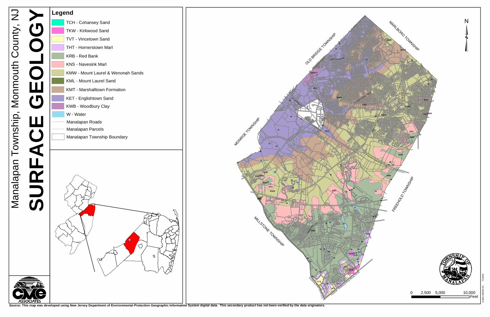
GEOLOGY
Physiography Manalapan Township is located entirely within the Atlantic Coastal Plain
physiographic province. The Coastal Plain is characterized by low lying terrain with open
stream valleys and broad, gently sloping divides. Topography in the Coastal Plain is a result
of the differential erosion of unconsolidated, gently dipping strata of gravel, sand, silt, and
clay. Relatively resistant geologic formations erode less rapidly and typically form the higher
elevations. The majority of Manalapan is at an elevation less than 200 feet, with the lowest
areas along the northwest boundary of the Township at less than 80 feet. Hills with an
elevation in excess of 200 feet are located in the south and southwest portions of the
Township. The highest point in Manalapan Township is Locust Hill at an elevation in excess
of 250 feet above mean sea level (NGVD 1929).
Stratigraphy
The Atlantic Coastal Plain is mainly composed of strata of clay, silt, sand, and gravel
deposited during the Cretaceous and Tertiary geologic time periods. These layers of
unconsolidated sediment lie over a basement of much older Precambrian and early
Paleozoic crystalline rock (schist and gneiss). The sedimentary formations dip gently toward
the southeast (10 to 60 feet per mile), and generally thicken toward the southeast (Kümmel,
1940). In Manalapan Township, the total thickness of sedimentary strata lying over the
crystalline basement ranges from approximately 550 feet along the northwest border up to
approximately 850 feet along the southeast border.
Each sedimentary formation of the Coastal Plain consists of a succession of strata of
similar or variable characteristics that were deposited over a particular interval of geologic
time. The surface outcrop patterns of the formations generally trend from southwest to
S:\RPT\Environmental\46-01 Manalapan NRI 8-01.doc 21
northeast. On a local scale, formation boundaries typically appear irregular due to their
gentle dip and the effects of topography. Sedimentary strata of the Coastal Plain dip to the
southeast, and the formations become successively younger toward the southeast. Brief
descriptions of each formation that outcrops within the Township are obtained from Kümmel
(1940).
Woodbury Clay (Kwb)
The Woodbury formation consists of black non-glauconitic clay deposited in a
marine environment. Maximum thickness is approximately 50 feet. The Woodbury
is the oldest formation to outcrop in Manalapan, and is conformable (transitions
gradually) to the underlying Merchantville clay. The Woodbury and Merchantville
form a hydrogeologic confining unit, impeding the movement of groundwater. In
Manalapan, the Woodbury clay only outcrops along McGellairds Brook at the
northwest boundary of the Township. Below the surface, the Woodbury is mapped
under the entire Township.
Englishtown Sand (Ket)
The Englishtown formation consists of light colored, slightly micaceous quartz
sand deposited in a near shore environment. Locally, sections of the sand may be
cemented by iron oxide into masses of ironstone. Thin layers of clay may be present
in places. Maximum thickness of the Englishtown sand is 140 feet. The contact with
the underlying Woodbury is unconformable (abrupt). The Englishtown sand
formation comprises the Englishtown aquifer system.
S:\RPT\Environmental\46-01 Manalapan NRI 8-01.doc 22

TABLE
GEOLOGIC FORMATIONS OF MANALAPAN TOWNSHIP
AGE FORMATION HYDROGEOLOGIC UNIT
THICKNESS (Feet)
Cohansey Sand 0-30
Kirkwood Formation Kirkwood-Cohansey
Aquifer System 100
Vincentown Sand Vincentown Aquifer 100
Tertiary
(70 mya)
Hornerstown Marl Confining Unit 30
Red Bank and Tinton Sands Red Bank sand 140
Navesink Formation Confining Unit 25-40
Mount Laurel and Wenonah Sands
Wenonah-Mount Laurel Aquifer
40-80
Marshalltown Formation Marshalltown-Wenonah Confining Unit
30-40
Englishtown Sand Englishtown Aquifer System < 140
Woodbury Clay 50
Merchantville Formation Merchantville-Woodbury
Confining Unit 60
Upper Aquifer 50-200
Confining Unit 50-150
Upper
Cretaceous
(70-100 mya)
Magothy and Raritan Formations
Raritan-Magothy Aquifer System Middle
Aquifer 50-150
Pre-Cretaceous Pre-Cambrian/Lower Paleozoic Schist and Gneiss
Bedrock Confining Unit ----
Adapted from Pucci, Gronberg, & Pope (1989)
S:\RPT\Environmental\46-01 Manalapan NRI 8-01.doc 23
Marshalltown Formation (Kmt)
The Marshalltown formation consists of strata of black sandy clay and
glauconitic sand (greensand) deposited in a marine environment. Thickness ranges
from 30 to 40 feet. The Marshalltown and lower part of the overlying Wenonah
Formation form a hydrogeologic confining unit.
Mount Laurel Sand and Wenonah Formation (Kmw)
The Mount Laurel Sand and Wenonah formations are grouped together into a
single unit. The lower section of this unit is the Wenonah, which consists of fine-
grained micaceous quartz sand that is conformable to the underlying Marshalltown.
The Mount Laurel is the upper section and consists of coarser grained quartz sand
that is variably glauconitic. Sediment in both formations was deposited in a near
shore marine environment. Combined thickness of the units ranges from 40 to 80
feet. The Mount Laurel sand generally constitutes an aquifer.
Navesink Formation (Kns)
The Navesink formation consists of green to black glauconitic quartz sand
and clayey sand deposited in a marine environment. The Navesink is conformable
to the underlying Mount Laurel sand and the overlying Red Bank sand. Thickness
ranges from a maximum of 40 feet to less than 25 feet. The Navesink is a
hydrogeologic confining unit.
Red Bank and Tinton Sands (Krb)
The Red Bank and Tinton Sand formations are typically grouped together as
a mapping unit in Monmouth County. The Red Bank dominantly consists of coarse-
grained yellowish, reddish brown, or gray quartz sand, locally cemented by iron
S:\RPT\Environmental\46-01 Manalapan NRI 8-01.doc 24
oxide. The Tinton consists of glauconitic sand and clay. Thickness of the Red Bank
is up to 140 feet, and the Tinton is 10 to 20 feet thick. The Red Bank sand may
locally yield small quantities of water and be considered an aquifer.
Hornerstown Marl (Tht)
The Hornerstown formation consists of dark green glauconitic sand and clay
beds deposited in a marine environment. The Tertiary Age Hornerstown
unconformably overlays the Cretaceous Age formations below. Total thickness is up
to 30 feet. The Hornerstown is a confining unit. In Manalapan, Tertiary Age
formations only outcrop near the south end of the Township.
Vincentown Sand (Tvt)
The Vincentown formation contains two facies (zones of distinct composition
within the formation). One facies consists of calcareous sand with abundant marine
fossils. A second facies consists of glauconitic quartz sand. This glauconite facies is
dominant in Monmouth County. The Vincentown conformably overlies the
Hornerstown, and is up to 100 feet thick. The Vincentown can potentially yield
moderate quantities of water, but its occurrence in Manalapan is not extensive.
Kirkwood Sand (Tkw)
The Kirkwood formation consists of light-colored fine-grained micaceous
quartz sand deposited in a near shore marine environment and unconformably
overlying the Vincentown sand. Black lignitic clay occurs in some localities at the
based of the Kirkwood. Total thickness of the Kirkwood is up to 100 feet. Portions of
the Kirkwood are aquifers, but its occurrence in Manalapan Township is not
extensive.
S:\RPT\Environmental\46-01 Manalapan NRI 8-01.doc 25
Cohansey Sand (Tch)
The Cohansey formation dominantly consists of quartz sand, although it
locally may contain thin clay seams (laminae), thicker clay lenses, or lenses of
gravel. Cohansey sediments were deposited in a near shore environment, generally
disconformably overlying Kirkwood sands. The Cohansey is an important water
table aquifer throughout much of the Coastal Plain, but its occurrence in Manalapan
Township is restricted to a hilltop near Oakland Mills.
According to the NJDEP Technical Manual for Stream Encroachment, nine (9) of
these formations (Raritan, Magothy, Merchantville, Woodbury, Englishtown, Marshalltown,
Navesink, Red Bank, and Kirkwood) may contain iron sulfide minerals (pyrite or marcasite),
that if exposed to air for a period of time can produce sulfuric acid. This material can
drastically impact new and proposed vegetative cover and cause water pollution. The
handling of this material should be done in accordance with the aforementioned NJDEP
Stream Encroachment Manual.
S:\RPT\Environmental\46-01 Manalapan NRI 8-01.doc 26
KRB
KET
KMT KMW
KMW KNS
KNS
THT
KNS
KRB
TVT
KWB
KRB
KRB
KNS
TVT
KET
KRB
KMW
TVT
TKW
THT
W
THT
W
KMW
KNS
KNS
TKW
KML
WW
W
W
W
W
KNS
W
W
W
W
W
W
W
W
W
W
W
W
KMW
W
W
W
W
KMW
W
WW
KRB
W
W
W
W
W
W
TCH
W
W
W
W
KRB
W
W
W
W
W
WW
W
W
WW
W
W
W
W
W
WW
W
W
W
W
W
W
³M
anal
apan
Tow
nshi
p, M
onm
outh
Cou
nty,
NJ
SURF
ACE G
EOLO
GY
Source: This map was developed using New Jersey Department of Environmental Protection Geographic Information System digital data. This secondary product has not been verified by the data originators.
Gordon's Corner Road
Union Hi ll Road
Tenn
ent R
oad
US
Hw
y 9
Wood Avenue
Freehold Englishtown Road
Mil lh urst R
o ad
State Hwy 33
Swee
tman
s Lane
H-M
A-0
0046
-01
7
/18/
01
MONROE TOW
NSHIP
OLD BRID
GE TOWNSHIP
MILLSTONE TOWNSHIP
FREE
HOLD
TOW
NSHI
P
MARLBORO TOWNSHIP
0 5,000 10,0002,500Feet
Legend
KET - Englishtown Sand
KML - Mount Laurel Sand
KMT - Marshalltown Formation
KMW - Mount Laurel & Wenonah Sands
KNS - Navesink Marl
KRB - Red Bank
KWB - Woodbury Clay
TCH - Cohansey Sand
THT - Hornerstown Marl
TKW - Kirkwood Sand
TVT - Vincetown Sand
W - Water
Manalapan Roads
Manalapan Parcels
Manalapan Township Boundary
Freehold - Smith
burg Road (R
oute 537)
Smithburg Road (Route 527)

AQUIFERS
Aquifers are saturated geologic formations capable of yielding significant quantities
of water under conventional pumping pressures. An unconfined aquifer is a near surface
aquifer that has the water table as its upper boundary (also called a water table aquifer). A
confined aquifer is a fully saturated unit bounded above and below by relatively
impermeable formations called confining units. Aquifers underlying Manalapan Township
include the Raritan-Magothy aquifer system, the Englishtown aquifer system, the Mount
Laurel - Wenonah aquifer, and portions the Red Bank and Tinton sand formation.
Although the Raritan-Magothy aquifer system is not exposed at the surface within
Manalapan, the formation is present at depth within the Township. The Raritan and
Magothy formations are a complex sequence of interbedded sand, gravel, silt, and clay
strata. In the northern Coastal Plain, this sequence can be divided for simplicity into upper
and middle aquifers separated by a confining unit (Pucci, Gronberg, & Pope, 1989). Locally,
the upper and middle aquifers may be respectively correlated to the Old Bridge sand and
Farrington sand members of the Raritan-Magothy formations. A lower aquifer
corresponding to the Potomic formation is absent in the northern Coastal Plain, and the
middle aquifer is underlain directly by Pre-Cretaceous bedrock or by a clay layer that rests
on bedrock. The Raritan-Magothy aquifer system is assigned rank “A” by the New Jersey
Geological Survey, with an average yield of high capacity wells in excess of 500 gallons per
minute. Water is typically fresh and moderately hard, with a near neutral pH. Elevated iron
and manganese levels are common (NJDEP, 1996).
The Merchantville-Woodbury confining unit separates the Raritan-Magothy aquifer
system from the overlying Englishtown aquifer system. The confining unit is comprised of
silt and clay with thin layers of sand. An aquifer rank of “E” is assigned to the Merchantville-
Woodbury formations, with an average yield of high capacity wells less than 25 gallons per
minute.
S:\RPT\Environmental\46-01 Manalapan NRI 8-01.doc 27

The Englishtown sand has an extensive outcrop area in the northern portion of
Manalapan Township where it is a water table (unconfined) aquifer. In the southern portion
of the Township, these aquifers are bounded above and below by relatively low permeability
confining units. The Englishtown aquifer system includes upper and lower sand units with
localized clay beds. An aquifer rank of “B” is assigned to the Englishtown, with an average
yield of high capacity wells between 250 and 500 gallons per minute.
The Marshalltown and lower portion of the Wenonah formation comprise a confining
unit that separates the underlying Englishtown aquifer system and the overlying Mount
Laurel-Wenonah aquifer. This confining unit is comprised of silt and clay with thin sand
layers. The aquifer rank is “E”, with an average yield of high capacity wells less than 25
gallons per minute.
The Mount Laurel-Wenonah aquifer is comprised of glauconitic sand overlying
micaceous sand. These formations outcrop across central Manalapan, striking from
southwest to northeast. An aquifer rank of “C” is assigned to the Mount Laurel-Wenonah,
with an average yield of high capacity wells less than 25 gallons per minute. Water is
typically fresh, moderately hard, and alkaline. Iron and manganese levels may be locally
elevated. Calcium and magnesium levels decrease with depth (NJDEP, 1996).
The stratigraphic interval including the Navesink formation, Red Bank and Tinton
sands, and Hornerstown marl are mapped as a composite confining unit that outcrops in the
southern portion of Manalapan Township. This composite unit locally contains sandy
intervals that may be important water table aquifers and are mapped as “composite
confining unit aquifers”. In Manalapan, these aquifers correspond to the Red Bank sand
and the Tinton sand formations. Aquifer rankings range from “E” for confining members
(average yield of high capacity wells less than 25 gallons per minute) to “B” for more
permeable members (average yield of high capacity wells between 250 and 500 gallons per
S:\RPT\Environmental\46-01 Manalapan NRI 8-01.doc 28

minute). Water quality in the aquifers is generally good, although iron and manganese
levels may be locally elevated (NJDEP, 1996).
Groundwater recharge is the transmission of water from the surface to the saturated
zone beneath the water table. Areas of high aquifer recharge areas typically correspond to
the outcrop occurrence of permeable strata that are hydraulically connected to an aquifer.
Potential recharge areas therefore roughly correspond to areas where geologic formations
comprising aquifers are exposed at the surface. Actual groundwater recharge is dependent
on climate, soil characteristics, slope, vegetative cover, and land use. A method for
quantitatively evaluating recharge areas and creating detailed groundwater recharge maps
has been proposed by the New Jersey Geological Survey (Charles and Others, 1993).
S:\RPT\Environmental\46-01 Manalapan NRI 8-01.doc 29

eas
mlwa
ccu
ccua
ccu
mawcu
ccu
ccu
ccu
ccua
ccua
ccua
mewcu
ccua
ccu
eas
ccua
ccu
ccua
ccu
³M
anal
apan
Tow
nshi
p, M
onm
outh
Cou
nty,
NJ
AQUI
FERS
Source: This map was developed using New Jersey Department of Environmental Protection Geographic Information System digital data and NJGS GIS digital data. This secondary product has not been verified by the data originators.
Gordon's Corner Road
Union Hi ll Road
Tenn
ent R
oad
US
Hw
y 9
Wood Avenue
Freehold Englishtown Road
Mi ll hurst R
o ad
State Hwy 33
Swee
tman
s Lane
H-M
A-0
0046
-01
7
/18/
01
0 5,000 10,0002,500Feet
LegendAQUIFERS
ccu - Composite confining unit
ccua - Composite confining unit aquifer
eas - Englishtown aquifer system
mawcu - Marshalltown-Wenonah confining unit
mewcu - Merchantville-Woodbury confining unit
mlwa - Mt. Laurel-Wenonah aquifer
Manalapan RoadsManalapan Parcels
Manalapan Township Boundary
MONROE TOW
NSHIP
OLD BRID
GE TOWNSHIP
MILLSTONE TOWNSHIP
FREE
HOLD
TOW
NSHI
P
MARLBORO TOWNSHIP
Freehold - Smith
burg Road (R
oute 537)
Sm
it hburg Ro
ad (Route 527)

STREAMS AND LAKES
Major surface hydrologic features within Manalapan Township are presented on the
Streams and Lakes Map. A northeast-southwest trending drainage divide within the Coastal
Plain is located to the southeast of the eastern Township line, and drainage within the
Township is generally toward the northwest. Main streams in the north and central portions
of the Township include McGellairds Brook and Weamaconk Creek, which combine to form
Matchaponix Brook to the northwest of Englishtown. The headwaters of McGellairds Brook
and Weamaconk Creek are located to the east of Manalapan in Freehold Township. Larger
tributary streams in northern Manalapan include Tepehemus Brook, Milford Brook, and Pine
Brook. These streams generally flow toward the west-southwest from highlands in Marlboro
and Freehold. The main stream in the southern portion of the Township is Manalapan
Brook, with headwaters in Millstone Township, Freehold Township, and southern
Manalapan. Northwest of the Manalapan boundary, the Manalapan Brook and Matchaponix
Brook turn generally northward and combine to form the South River near the town of
Spotswood. The majority of Manalapan Township is thus part of the South River watershed
and the Raritan River drainage basin. Some areas along the southwestern and
southeastern Township lines may lie within the Millstone or Manasquan River watersheds.
All streams within Manalapan Township are classified as FW2-NT by the New Jersey
Department of Environmental Protection (NJAC 7:9B; NJDEP, 1998). FW2 is a general
surface water classification applied to fresh waters that are not considered to be of
exceptional quality, significance, or resource value (i.e., not FW1 waters). NT is the
designation for non-trout waters.
The New Jersey Department of Environmental Protection has divided the State into
20 Watershed Management Areas for the purposes of environmental planning and
management. The major drainage systems of Manalapan Township are within Watershed
S:\RPT\Environmental\46-01 Manalapan NRI 8-01.doc 30

Management Area 9, which includes the mainstream Raritan River, South River, Lawrence
Brook, Matchaponix Brook, and Manalapan River watersheds (NJDEP, 1996).
Water quality in the State is monitored by the NJDEP. Monitoring stations in the
vicinity of Manalapan Township are located on Manalapan Brook at Federal Road in Monroe
and on Matchaponix Brook near the confluence with Manalapan Brook. The most recent
monitoring results publicly available were published in 1996 and reflect water quality
conditions from 1991 through 1995 (NJDEP, 1996). Both the Manalapan Brook and the
Matchaponix Brook were assessed as fully supporting primary contact recreation
(swimmable use), indicating relatively low fecal coliform bacteria concentrations in these
waters. Phosphorus levels in both streams were moderately elevated. Inorganic nitrogen
was at an acceptable level in the Manalapan, but was extremely elevated in the
Matchaponix. Testing for heavy metals suggested excessive lead levels in both streams,
and an elevated zinc level in the Matchaponix Brook. Water quality in both streams was
similar to conditions observed during the 1986 through 1990 assessment.
Several streams within the Manalapan and Matchaponix watersheds were assessed
with regard to aquatic life support (macroinvertebrates) during the early 1990’s (NJDEP,
1996). Manalapan Brook was assessed as severely impaired at the Federal Road
monitoring site in Monroe, and McGellairds Brook was assessed as severely impaired at an
Englishtown monitoring site. The Matchaponix, Tepehemus, Milford, Pine, and Weamaconk
streams were all assessed as moderately impaired in the Manalapan Township area. An
assessment of a stream as severely impaired indicates no support of aquatic life use, and
moderately impaired indicates partial support.
A regional sewage treatment plant is located in western Manalapan near Clarks
Mills. This plant has a discharge to Pine Brook upstream of the confluence with
Matchaponix Brook. It is possible that the high nitrogen concentrations observed in the
Matchaponix are related to this point source (NJDEP, 1996).
S:\RPT\Environmental\46-01 Manalapan NRI 8-01.doc 31

Principal land uses in the Manalapan Brook and Matchaponix/McGellairds Brook
watersheds include suburban residential, commercial, and agricultural, with considerable
residential and commercial development of former farm and woodland continuing to occur.
Non-point source water quality problems associated with these land uses are related to
runoff from acid producing soils, silt loadings, flooding, septic system leachate,
fertilizers/pesticides/herbicides used on residential lawns, and stream bank destabilization.
In Manalapan Township, recent sediment loading and flooding due to runoff from active
construction sites and existing roadways has resulted in a severe decline in the quality of
fish habitat (NJDEP, 1996).
Ponds and lakes within Manalapan Township are generally manmade by excavation
or impoundment, and have historically been used for agricultural irrigation or as mill sites.
The largest lake in the Township is Millhurst Pond on Manalapan Brook, which is dammed
at Sweetmans Lane.
S:\RPT\Environmental\46-01 Manalapan NRI 8-01.doc 32

Millhurst Pond
Wemrock Pond
Weamaconk Lake
³M
anal
apan
Tow
nshi
p, M
onm
outh
Cou
nty,
NJ
STRE
AMS A
ND LA
KES
Source: This map was developed using New Jersey Department of Environmental Protection Geographic Information System digital data. This secondary product has not been verified by the data originators.
Gordon's Corner Road
Union Hi ll Road
Tenn
ent R
oad
US
Hw
y 9Wood Avenue
Freehold Englishtown Road
Mi ll hurst R
o ad
State Hwy 33
Swee
tman
s Lane
H-M
A-0
0046
-01
7
/18/
01
PINE BR O OK
MATCH
APON
IX
MILFOR DB RO
OK
MC GEL LAIRDS
B R OOK
TEPEHEMUS BROOK
WEAMACONK
CREEK
WEMROCK BROOK
MANALAPA NBROOKBROOK
STI L L HOU
SE
BRANC
H
GAN
DER
SOUTH MA NA LA
PAN
BR
OOK
MONROE TOW
NSHIP
OLD BRID
GE TOWNSHIP
MILLSTONE TOWNSHIP
FREE
HOLD
TOW
NSHI
P
MARLBORO TOWNSHIP
0 5,000 10,0002,500Feet
LegendLakes
StreamsManalapan RoadsManalapan Parcels
Manalapan Township Boundary
Freehold - Smith
burg Road (R
oute 537)
Smithburg Road (Route 527)

FLOOD-PRONE AREAS
The areas designated as flood-prone are based on readily available information on
past floods rather than from detailed site specific surveys and inspections. These areas
therefore represent approximate locations and boundaries, and should not be construed as
exact locations for flood insurance or construction purposes.
In general, there is an average of 1 chance in 100 that these flood-prone areas will
be inundated in any year. These mapped areas do not take into consideration the possible
impacts of existing or proposed flood control structures, except where those effects were
readily evaluated.
United States Geological Survey flood-prone areas are generally identified for urban
lands where the upstream drainage basin exceeds 25 sq. mi. and rural humid lands where
the upstream drainage basin exceeds 100 sq. miles. Flood-prone areas in smaller drainage
basins may also be identified, depending on topography and potential use of the floodplains.
Additional information on potential flood zones is available on Flood Insurance Rate Maps
(FIRM) published by the Federal Emergency Management Association (FEMA).
S:\RPT\Environmental\46-01 Manalapan NRI 8-01.doc 33

³M
anal
apan
Tow
nshi
p, M
onm
outh
Cou
nty,
NJ
FLOO
DPRO
NE A
REAS
Source: This map was developed using New Jersey Department of Environmental Protection Geographic Information System digital data. This secondary product has not been verified by the data originators.
Gordon's Corner Road
Union Hi ll Road
Tenn
ent R
oad
US
Hw
y 9
Wood Avenue
Freehold Englishtown RoadMi ll hu rs t R
oad
State Hwy 33
Swee
tman
s Lane
H-MA
-0004
6-01
7/18
/01
MONROE TOW
NSHIP
OLD BRID
GE TOWNSHIP
MILLSTONE TOWNSHIP
FREE
HOLD
TOW
NSHI
P
MARLBORO TOWNSHIP
0 5,000 10,0002,500Feet
LegendFLOODPRONE AREAS
USGS Documented Floodprone Area
Undocumented Floodprone Area
Water
Manalapan Roads
Manalapan Parcels
Manalapan Township Boundary
Freehold - Smith
burg Road (R
oute 537)
Smithburg Roa d (Route 527)
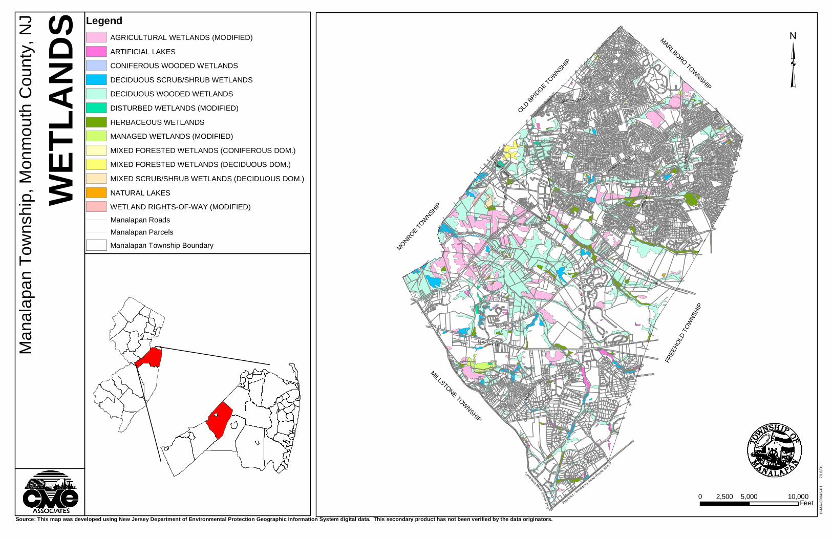
FRESHWATER WETLANDS
Wetlands are generally defined as areas that are inundated or saturated by surface
or ground waters at a frequency and duration sufficient to support vegetation adapted for life
in saturated soil conditions. The Freshwater Wetlands Map for Manalapan depicts wetlands
within the Township as interpreted by the New Jersey Department of Environmental
Protection from 1986 color aerial infra-red photography. These wetland areas are classified
according to the U.S. Geological Survey Land Use and Land Cover classification system
used for Land Use mapping. The wetlands map is intended for use as a planning guide to
indicate areas that may potentially contain regulated wetlands. Actual determination of
regulated areas is dependent on a field delineation of the wetland boundary.
Freshwater wetlands in Manalapan are commonly associated with stream corridors
and broad stream valleys. General wetland types found within the Township include:
Deciduous Wooded Wetlands – This map unit includes closed canopy swamps
associated with watercourses and marsh edges, as well as isolated wetlands. The
wetlands are dominated by deciduous tree species (>75%) with an average height
greater than 20 feet.
Coniferous Wooded Wetlands – This map unit includes closed canopy swamps
dominated by coniferous tree species (>75%) with an average height greater than 20
feet.
Mixed Forest, Deciduous Wetlands – This map unit includes forested swamps of
mixed deciduous and coniferous trees with deciduous trees prevalent (>50%), but
not dominant (<75%). Average tree height is greater than 20 feet.
S:\RPT\Environmental\46-01 Manalapan NRI 8-01.doc 34

Mixed Forest, Coniferous Wetlands – This map unit includes forested swamps of
mixed coniferous and deciduous trees with coniferous trees prevalent (>50%), but
not dominant (<75%). Average tree height is greater than 20 feet.
Deciduous Shrub/Scrub Wetlands – This map unit includes brush/shrubland swamps
with deciduous species less than 20 feet in height predominant (>75%).
Mixed Shrub/Scrub Wetlands – This map unit includes brush/shrubland swamps with
mixed deciduous and coniferous species less than 20 feet high predominant.
Herbaceous Wetlands – This map unit includes non-tidal swamps dominated by non-
woody plant species. Typical herbaceous wetlands may be located on open lake
edges and floodplains, and in abandoned wet agricultural fields.
Natural Lakes – This map unit includes naturally enclosed, non-flowing bodies of
water that are larger than 3 acres.
Artificial Lakes – This map unit includes impounded bodies of water larger than 3
acres.
Modified Agricultural Wetlands - This map unit includes cultivated lands that are
former natural wetlands. These areas generally have hydric soils.
Managed Wetlands – This map unit includes modified former natural wetland areas
that are managed for miscellaneous types of agriculture other than cropland and
pasture land. Included in this category may be orchards, nurseries, sod and seed
S:\RPT\Environmental\46-01 Manalapan NRI 8-01.doc 35

farms, cranberry and blueberry farms, live stock feed lots, poultry farms, horse farms,
and other specialty farms that have hydric soils.
Disturbed Wetlands – These areas are former natural wetlands that have been
disturbed by clearing, filling, or excavating. The soil shows signs of saturation, but
typical wetland vegetation is generally not supported.
Wetland Rights-of-Way – These areas are former natural wetlands in rights-of-way.
These areas have hydric soils but may not support the typical wetland vegetation
found in adjacent unaltered wetlands.
S:\RPT\Environmental\46-01 Manalapan NRI 8-01.doc 36
³M
anal
apan
Tow
nshi
p, M
onm
outh
Cou
nty,
NJ
WETL
ANDS
Source: This map was developed using New Jersey Department of Environmental Protection Geographic Information System digital data. This secondary product has not been verified by the data originators.
Gordon's Corner Road
Union Hi ll Road
Tenn
ent R
oad
US
Hw
y 9
Wood Avenue
Freehold Englishtown RoadMil lh urst R
o ad
State Hwy 33
Swee
tman
s Lane
H-M
A-0
0046
-01
7
/18/
01
MONROE TOW
NSHIP
OLD BRID
GE TOWNSHIP
MILLSTONE TOWNSHIP
FREE
HOLD
TOW
NSHI
P
MARLBORO TOWNSHIP
0 5,000 10,0002,500Feet
LegendAGRICULTURAL WETLANDS (MODIFIED)
ARTIFICIAL LAKES
CONIFEROUS WOODED WETLANDS
DECIDUOUS SCRUB/SHRUB WETLANDS
DECIDUOUS WOODED WETLANDS
DISTURBED WETLANDS (MODIFIED)
HERBACEOUS WETLANDS
MANAGED WETLANDS (MODIFIED)
MIXED FORESTED WETLANDS (CONIFEROUS DOM.)
MIXED FORESTED WETLANDS (DECIDUOUS DOM.)
MIXED SCRUB/SHRUB WETLANDS (DECIDUOUS DOM.)
NATURAL LAKES
WETLAND RIGHTS-OF-WAY (MODIFIED)
Manalapan Township Boundary
Manalapan Roads
Manalapan Parcels
Freehold - Smith
burg R
oad (Route 537)
Smithburg Road (Route 527 )
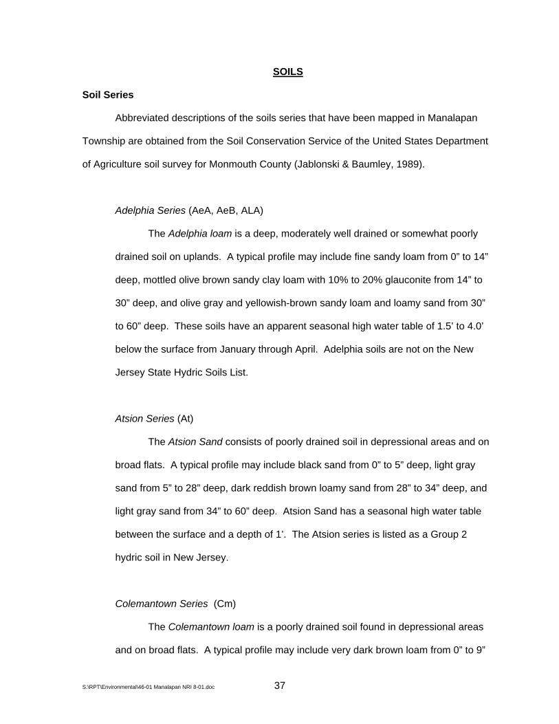
SOILS
Soil Series
Abbreviated descriptions of the soils series that have been mapped in Manalapan
Township are obtained from the Soil Conservation Service of the United States Department
of Agriculture soil survey for Monmouth County (Jablonski & Baumley, 1989).
Adelphia Series (AeA, AeB, ALA)
The Adelphia loam is a deep, moderately well drained or somewhat poorly
drained soil on uplands. A typical profile may include fine sandy loam from 0” to 14”
deep, mottled olive brown sandy clay loam with 10% to 20% glauconite from 14” to
30” deep, and olive gray and yellowish-brown sandy loam and loamy sand from 30”
to 60” deep. These soils have an apparent seasonal high water table of 1.5’ to 4.0’
below the surface from January through April. Adelphia soils are not on the New
Jersey State Hydric Soils List.
Atsion Series (At)
The Atsion Sand consists of poorly drained soil in depressional areas and on
broad flats. A typical profile may include black sand from 0” to 5” deep, light gray
sand from 5” to 28” deep, dark reddish brown loamy sand from 28” to 34” deep, and
light gray sand from 34” to 60” deep. Atsion Sand has a seasonal high water table
between the surface and a depth of 1’. The Atsion series is listed as a Group 2
hydric soil in New Jersey.
Colemantown Series (Cm)
The Colemantown loam is a poorly drained soil found in depressional areas
and on broad flats. A typical profile may include very dark brown loam from 0” to 9”
S:\RPT\Environmental\46-01 Manalapan NRI 8-01.doc 37

deep, mottled dark greenish-gray clay loam from 9” to 36” deep, and mottled dark
greenish-gray stratified sandy clay loam to sandy clay from 36” to 60” deep. The
seasonal high water table is generally perched and between the surface and 1’ deep.
The Colemantown series is listed as a Group 1 hydric soil in New Jersey, and nearly
always displays hydric conditions.
Collington Series (CnB, CnC2, CnD3, CRB)
The Collington sandy loam is a well-drained soil on divides and side slopes.
A typical profile may include dark brown sandy loam from 0” to 11” deep, dark brown
loam and sandy clay loam from 11” to 32” deep, and dark brown and brown sandy
loam to coarse sandy loam from 32” to 60” deep. The depth to the seasonal high
water table is greater than 72”. Collington soils are not included on the list of New
Jersey hydric soils.
Colts Neck Series (CtB, CtC, CtC2, CtD2, CtE2)
The Colts Neck series consists of well-drained sandy loam soils on uplands.
A typical profile may include a 10” thick dark reddish-brown plow layer, with reddish
brown to dark reddish-brown sandy loam or sandy clay loam containing less than
10% glauconite from 10” to 35” deep, and reddish brown stratified loamy sand from
35” to 60” deep. Iron concretions and iron-cemented sandstone are common in the
subsoil layers. The seasonal high water table is at a depth greater than 72”. The
Colts Neck series is not included on the list of New Jersey hydric soils.
Downer Series (DnA, DnC, DUB)
The Downer series consists of deep, well drained soils on uplands. A typical
soil profile may include dark brown loamy sand from 0” to 10” deep, strong brown
S:\RPT\Environmental\46-01 Manalapan NRI 8-01.doc 38
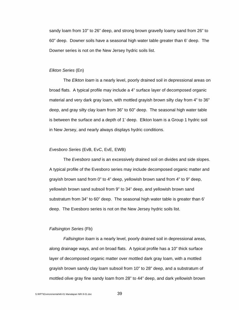
sandy loam from 10” to 26” deep, and strong brown gravelly loamy sand from 26” to
60” deep. Downer soils have a seasonal high water table greater than 6’ deep. The
Downer series is not on the New Jersey hydric soils list.
Elkton Series (En)
The Elkton loam is a nearly level, poorly drained soil in depressional areas on
broad flats. A typical profile may include a 4” surface layer of decomposed organic
material and very dark gray loam, with mottled grayish brown silty clay from 4” to 36”
deep, and gray silty clay loam from 36” to 60” deep. The seasonal high water table
is between the surface and a depth of 1’ deep. Elkton loam is a Group 1 hydric soil
in New Jersey, and nearly always displays hydric conditions.
Evesboro Series (EvB, EvC, EvE, EWB)
The Evesboro sand is an excessively drained soil on divides and side slopes.
A typical profile of the Evesboro series may include decomposed organic matter and
grayish brown sand from 0” to 4” deep, yellowish brown sand from 4” to 9” deep,
yellowish brown sand subsoil from 9” to 34” deep, and yellowish brown sand
substratum from 34” to 60” deep. The seasonal high water table is greater than 6’
deep. The Evesboro series is not on the New Jersey hydric soils list.
Fallsington Series (Fb)
Fallsington loam is a nearly level, poorly drained soil in depressional areas,
along drainage ways, and on broad flats. A typical profile has a 10” thick surface
layer of decomposed organic matter over mottled dark gray loam, with a mottled
grayish brown sandy clay loam subsoil from 10” to 28” deep, and a substratum of
mottled olive gray fine sandy loam from 28” to 44” deep, and dark yellowish brown
S:\RPT\Environmental\46-01 Manalapan NRI 8-01.doc 39

loamy sand from 44” to 60” deep. The Fallsington loam is a Group 2 hydric soil in
New Jersey, and displays consistent hydric conditions in most places.
Freehold Series (FnA, FnC, FrB, FrC, FrC2, FrD, FrD2, FrE2, FsA, FUB)
The Freehold series consists of well-drained soils on divides and side slopes.
A typical profile of the Freehold series may include dark yellowish brown loamy sand
to sandy loam plow layer from 0” to 9” deep, dark brown sandy loam and sandy clay
loam from 9” to 25” deep, brown sandy loam from 25” to 35” deep, and yellowish-
brown loamy sand from 35” to 70” deep. The seasonal high water table is greater
than 6’ deep. The Freehold series is not on the New Jersey hydric soils list.
Hammonton Series (HaB, HbA, HbB, HLA)
The Hammonton series consists of moderately well-drained and somewhat
poorly drained soil in depressional areas and on low divides. A typical Hammonton
series profile may include dark brown loamy sand to sandy loam from 0” to 10” deep,
brownish yellow and yellowish brown sandy loam to loamy sand from 10” to 19”
deep, mottled brownish yellow sandy loam from 19” to 31” deep, and light yellowish
brown stratified loamy sand and gravelly sandy loam from 31” to 60” deep. The
depth to the seasonal high water table is 1.5’ to 3.0’. Hammonton soils are listed as
Group 3 hydric soils in New Jersey, displaying hydric conditions in few places.
Holmdel Series (HnA, HnB, HUA)
The Holmdel sandy loam is a moderately well to somewhat poorly drained
soil in depressional areas and on low divides. A typical profile has a 10” thick dark
grayish brown sandy loam surface layer, yellowish brown sandy loam from 10” to 20”
deep, mottled yellowish brown sandy clay loam from 20” to 38” deep, and a mottled
S:\RPT\Environmental\46-01 Manalapan NRI 8-01.doc 40

yellowish brown and light olive brown sand and sandy loam substratum from 38” to a
depth of 60” or more. The depth to the seasonal high water table is between 0.5’ to
4.0’. Holmdel soils are not on the New Jersey hydric soils list.
Humaquepts (HV)
Humaquepts consist of nearly level, deep, somewhat poorly drained to very
poorly drained soils on flood plains along perennial and intermittent streams. These
soils are subject to frequent flooding. Characteristics vary greatly from site to site,
but Humaquepts generally consist of stratified loamy sand, sandy loam, loam, and
silt loam that may include gravelly or mucky layers. The water covering some areas
is several feet deep during flood stage. The seasonal high water table is between
the surface and 1.5’ deep. Humaquepts are Group 1 hydric soils in New Jersey, and
nearly always display consistent hydric conditions.
Keyport Series (KeA, KeB, KeC, KGB)
The Keyport sandy loam is a moderately well-drained soil in depressional
areas and on low divides and side slopes. A typical profile may include 0” to 10”
brown sandy loam, 10” to 18” yellowish brown silty clay loam, 18” to 44” mottled dark
yellowish brown silty clay loam, and 44” to 60” gray silty clay loam. These soils have
a seasonal high water table at 1.5’ to 4.0’ deep. The Keyport series is not listed on
the New Jersey hydric soils list.
Klej Series (KlA, KmB, KUA)
The Klej loamy sand is a moderately well to somewhat poorly drained soil on
low divides and in depressional areas. A typical Klej series profile may include an
11” thick surface layer of mottled organic material over very dark grayish brown
S:\RPT\Environmental\46-01 Manalapan NRI 8-01.doc 41
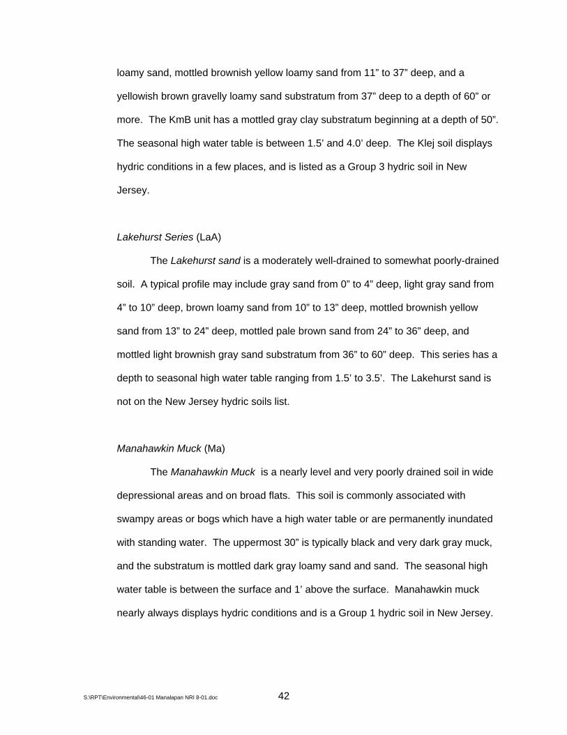
loamy sand, mottled brownish yellow loamy sand from 11” to 37” deep, and a
yellowish brown gravelly loamy sand substratum from 37” deep to a depth of 60” or
more. The KmB unit has a mottled gray clay substratum beginning at a depth of 50”.
The seasonal high water table is between 1.5’ and 4.0’ deep. The Klej soil displays
hydric conditions in a few places, and is listed as a Group 3 hydric soil in New
Jersey.
Lakehurst Series (LaA)
The Lakehurst sand is a moderately well-drained to somewhat poorly-drained
soil. A typical profile may include gray sand from 0” to 4” deep, light gray sand from
4” to 10” deep, brown loamy sand from 10” to 13” deep, mottled brownish yellow
sand from 13” to 24” deep, mottled pale brown sand from 24” to 36” deep, and
mottled light brownish gray sand substratum from 36” to 60” deep. This series has a
depth to seasonal high water table ranging from 1.5’ to 3.5’. The Lakehurst sand is
not on the New Jersey hydric soils list.
Manahawkin Muck (Ma)
The Manahawkin Muck is a nearly level and very poorly drained soil in wide
depressional areas and on broad flats. This soil is commonly associated with
swampy areas or bogs which have a high water table or are permanently inundated
with standing water. The uppermost 30” is typically black and very dark gray muck,
and the substratum is mottled dark gray loamy sand and sand. The seasonal high
water table is between the surface and 1’ above the surface. Manahawkin muck
nearly always displays hydric conditions and is a Group 1 hydric soil in New Jersey.
S:\RPT\Environmental\46-01 Manalapan NRI 8-01.doc 42

Marlton Series (MbC, MIB)
The Marlton series consists of well-drained to moderately well-drained soil on
side slopes and divides. A typical profile may include an 8” thick very dark grayish-
brown sandy loam or loam surface layer, a 38” thick very dark grayish-brown sandy
clay loam and mottled dark olive gray clay loam and clay subsoil, and a mottled dark
olive gray sandy loam substratum. The seasonal high water table is typically
perched, and is between 2’ to 5’ below the surface. The Marlton series is not on the
New Jersey hydric soils list.
Pemberton Series (PeA)
The Pemberton loamy sand is nearly level to gently sloping moderately well-
drained and somewhat poorly drained soil on low divides. A typical profile has a
brown loamy sand surface layer about 10” thick, a yellowish brown loamy sand
subsurface layer 15” thick, a mottled dark yellowish brown and yellowish brown
sandy clay loam subsoil 20” thick, and a mottled pale olive fine sandy loam
substratum to a depth of 60” or more. The seasonal high water table is 1.0’ to 4.0’
below the surface. Pemberton soils are not on the New Jersey hydric soils list.
Phalanx Series (PhB)
The Phalanx loamy sand is a well-drained soil on divides and side slopes. A
typical profile has a 2” thick dark brown loamy sand surface layer, a 5” thick brown
loamy sand subsurface layer, a 31” thick strong brown and yellowish red loamy sand
and sandy loam subsoil, and a yellowish red loamy sand substratum containing
indurated layers of iron cemented sandstone. The seasonal high water table is more
than 6’ below the surface. The Phalanx soils series is not on the New Jersey hydric
soils list.
S:\RPT\Environmental\46-01 Manalapan NRI 8-01.doc 43
Pits Sand and Gravel (PT)
This unit consists of disturbed areas that have historically been excavated for
sand and gravel. Soils in these areas are typically sandy with varying amounts of
gravel and fragments of iron cemented sandstone. The properties and
characteristics of this map unit vary from location to location, and onsite investigation
is generally required to determine suitability for an intended use.
Sassafras Series (SaB, SaC, SaD)
The Sassafras series consists of well-drained soils on divides and side
slopes. A typical profile has brown sandy loam from 0” to 11” deep, yellowish-brown
sandy loam and sandy clay loam from 11” to 30” deep, reddish yellow sandy loam
from 30” to 36” deep, and reddish yellow stratified loamy sand and sandy loam from
36” to a depth of 60” or more. Depth to the seasonal high water table is greater than
72”. The Sassafras series is not on the New Jersey hydric soils list.
Shrewsbury Series (Sn)
Shrewsbury sandy loam is a nearly level, poorly-drained soil in depressional
areas, along drainage ways, and on broad flats. A typical profile may include a 9”
thick surface layer with dark reddish brown, mottled partly decomposed organic
matter over black sandy loam, mottled dark gray sandy loam from 9” to 13” deep,
mottled grayish brown clay loam from 13” to 22” deep, mottled olive gray sandy clay
loam from 22” to 31”, and mottled dark greenish gray loamy sand from 31” to 60”
deep. The seasonal high water table is from 0’ to 1.0’ deep. Shrewsbury soils
display consistent hydric conditions in most places, and are listed as Group 2 hydric
soils in New Jersey.
S:\RPT\Environmental\46-01 Manalapan NRI 8-01.doc 44

Tinton Series (ToA, ToC, ToD, TUB)
Tinton loam sand is a well-drained soil on divides and side slopes. A typical
profile of the Tinton series may include dark brown loamy sand from 0” to 7” deep,
yellowish brown loamy sand from 7” to 32” deep, dark yellowish brown sandy clay
loam from 32” to 46” deep, and dark yellowish brown loamy sand from 46” to 60”
deep. Depth to the seasonal high water table is greater than 6’. The Tinton series is
not on the New Jersey hydric soils list.
Udorthents (UA, UD)
Areas mapped as Udorthents consist of soils that have been altered by
excavating or filling. In filled areas these soils typically consist of loamy material that
is more than 20” thick. The filled areas are on flood plains, in tidal marches, and on
areas of moderately well drained to very poorly drained soils. Included with these
soils in mapping are soils that may contain such materials as concrete, asphalt,
metal, and glass, as well as areas of undisturbed soils. The properties and
characteristics of these soils vary greatly from place to place, and onsite
investigation is needed to determine suitability for most uses.
Urban Land (UL)
The Urban land map unit consists of areas that are more than 85% covered
by impermeable surfaces. Urban land is typically covered by dwellings, roads,
shopping centers, parking lots, and industrial areas. Relatively small areas of
undisturbed soils and Udorthents may be included in this map unit. Properties and
characteristics vary from site to site, and field investigation is needed to determine
suitability for most intended uses. Urban land is mapped in complexes with various
S:\RPT\Environmental\46-01 Manalapan NRI 8-01.doc 45

S:\RPT\Environmental\46-01 Manalapan NRI 8-01.doc 46
undisturbed soil series where the areas of each are in an intricate pattern and it was
not practical to map them separately.
Woodstown Series (WnB, WoA)
The Woodstown series consists of moderately well-drained soil in
depressional areas, in swales, and on low divides. A typical profile may have a
brown sandy loam or loam surface layer 3” thick, a yellowish brown sandy clay loam
layer 15” thick, a mottled yellowish brown and light olive brown sandy clay loam and
fine sandy loam layer 11” thick, a mottled light yellowish brown loamy fine sand layer
9” thick, and a yellowish brown gravelly loamy sand to a depth of 60” or more. Depth
to the seasonal high water table is 1.5’ to 2.5’. The Woodstown series is not on the
New Jersey hydric soils list.
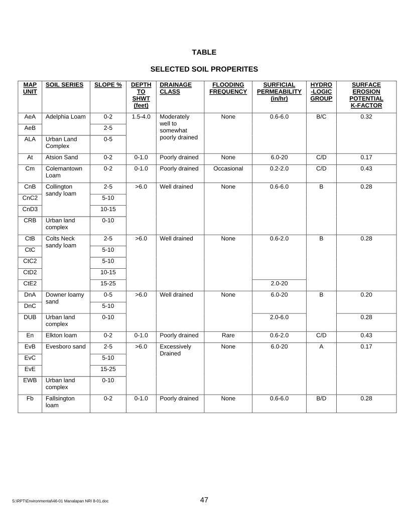
TABLE
SELECTED SOIL PROPERITES
MAP UNIT
SOIL SERIES SLOPE % DEPTH TO
SHWT (feet)
DRAINAGE CLASS
FLOODING FREQUENCY
SURFICIAL PERMEABILITY
(in/hr)
HYDRO-LOGIC GROUP
SURFACE EROSION
POTENTIAL K-FACTOR
AeA 0-2
AeB
Adelphia Loam
2-5
ALA Urban Land Complex
0-5
1.5-4.0 Moderately well to somewhat poorly drained
None 0.6-6.0 B/C 0.32
At Atsion Sand 0-2 0-1.0 Poorly drained None 6.0-20 C/D 0.17
Cm Colemantown Loam
0-2 0-1.0 Poorly drained Occasional 0.2-2.0 C/D 0.43
CnB 2-5
CnC2 5-10
CnD3
Collington sandy loam
10-15
CRB Urban land complex
0-10
>6.0 Well drained None 0.6-6.0 B 0.28
CtB 2-5
CtC 5-10
CtC2 5-10
CtD2 10-15
0.6-2.0
CtE2
Colts Neck sandy loam
15-25
>6.0 Well drained None
2.0-20
B 0.28
DnA 0-5
DnC
Downer loamy sand
5-10
6.0-20 0.20
DUB Urban land complex
0-10
>6.0 Well drained None
2.0-6.0
B
0.28
En Elkton loam 0-2 0-1.0 Poorly drained Rare 0.6-2.0 C/D 0.43
EvB 2-5
EvC 5-10
EvE
Evesboro sand
15-25
EWB Urban land complex
0-10
>6.0 Excessively Drained
None 6.0-20 A 0.17
Fb Fallsington loam
0-2 0-1.0 Poorly drained None 0.6-6.0 B/D 0.28
S:\RPT\Environmental\46-01 Manalapan NRI 8-01.doc 47
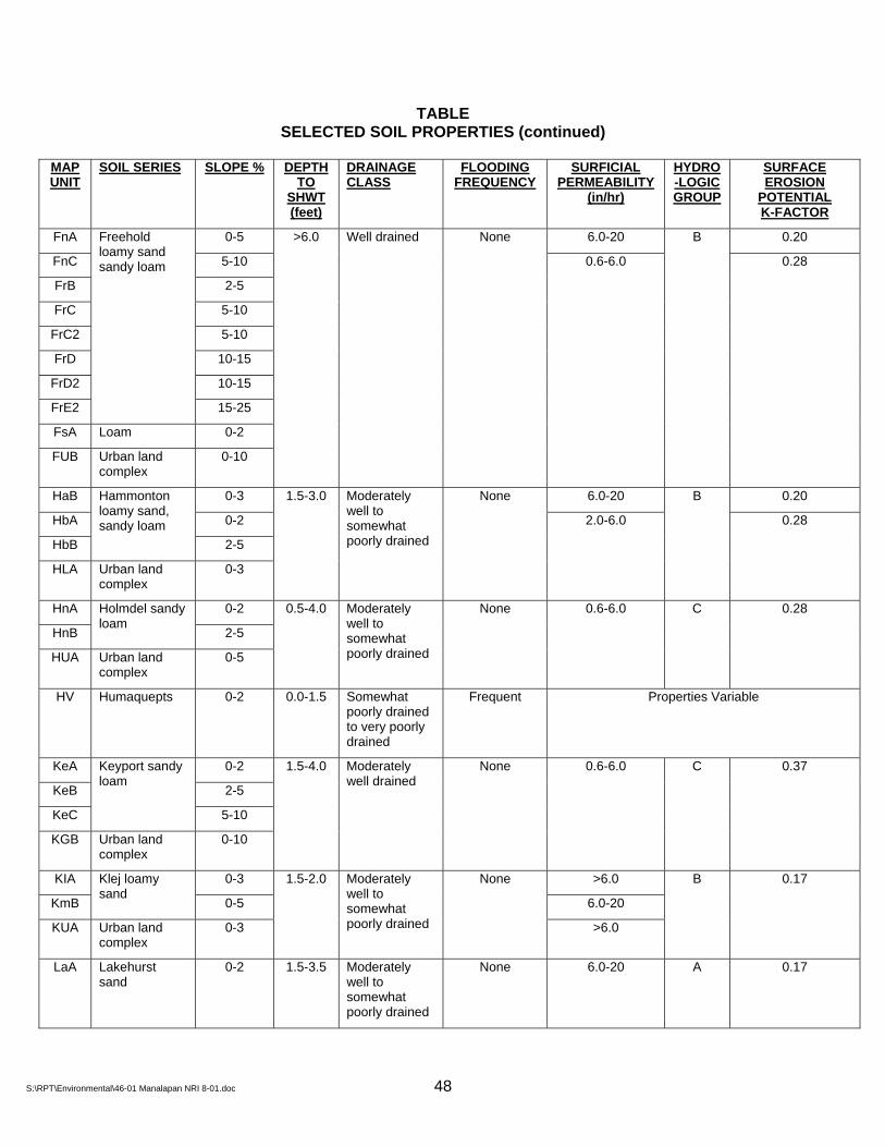
TABLE SELECTED SOIL PROPERTIES (continued)
MAP UNIT
SOIL SERIES SLOPE % DEPTH TO
SHWT (feet)
DRAINAGE CLASS
FLOODING FREQUENCY
SURFICIAL PERMEABILITY
(in/hr)
HYDRO-LOGIC GROUP
SURFACE EROSION
POTENTIAL K-FACTOR
FnA 0-5 6.0-20 0.20
FnC 5-10
FrB 2-5
FrC 5-10
FrC2 5-10
FrD 10-15
FrD2 10-15
FrE2
Freehold loamy sand sandy loam
15-25
FsA Loam 0-2
FUB Urban land complex
0-10
>6.0 Well drained None
0.6-6.0
B
0.28
HaB 0-3 6.0-20 0.20
HbA 0-2
HbB
Hammonton loamy sand, sandy loam
2-5
HLA Urban land complex
0-3
1.5-3.0 Moderately well to somewhat poorly drained
None
2.0-6.0
B
0.28
HnA 0-2
HnB
Holmdel sandy loam
2-5
HUA Urban land complex
0-5
0.5-4.0 Moderately well to somewhat poorly drained
None 0.6-6.0 C 0.28
HV Humaquepts 0-2 0.0-1.5 Somewhat poorly drained to very poorly drained
Frequent Properties Variable
KeA 0-2
KeB 2-5
KeC
Keyport sandy loam
5-10
KGB Urban land complex
0-10
1.5-4.0 Moderately well drained
None 0.6-6.0 C 0.37
KIA 0-3 >6.0
KmB
Klej loamy sand
0-5 6.0-20
KUA Urban land complex
0-3
1.5-2.0 Moderately well to somewhat poorly drained
None
>6.0
B 0.17
LaA Lakehurst sand
0-2 1.5-3.5 Moderately well to somewhat poorly drained
None 6.0-20 A 0.17
S:\RPT\Environmental\46-01 Manalapan NRI 8-01.doc 48

S:\RPT\Environmental\46-01 Manalapan NRI 8-01.doc 49
TABLE
SELECTED SOIL PROPERTIES (continued)
MAP UNIT
SOIL SERIES SLOPE % DEPTH TO
SHWT (feet)
DRAINAGE CLASS
FLOODING FREQUENCY
SURFICIAL PERMEABILITY
(in/hr)
HYDRO-LOGIC GROUP
SURFACE EROSION
POTENTIAL K-FACTOR
Ma Manahawkin Muck
0-2 +1.0-0.0 Very poorly drained
Frequent 6.0-20 D 0.17
MbC Marlton sandy loam
5-10 2.0-5.0
MlB Marlton loam 2-5 2.0-5.0
Well to moderately well drained
None 0.6-6.0 C 0.43
PeA Pemberton loamy sand
0-5 1.0-4.0 Moderately well to somewhat poorly drained
None 2.0-6.0 B 0.20
PhB Phalanx loamy sand
0-10 >6.0 Well drained None >6.0 B 0.20
PT Pits sand & gravel
Properties variable
SaB 2-5
SaC 5-10
SaD
Sassafras sandy loam
10-15
>6.0 Well drained None 0.6-6.0 B 0.28
Sn Shrewsbury sandy loam
0-2 0-1.0 Poorly drained None 0.6-6.0 C/D 0.32
ToA 0-5
ToC 5-10
ToD
Tinton loamy sand
10-25
TUB Urban land complex
0-5
>6.0 Well drained None 0.6-6.0 A 0.20
UA Udorthents smoothed
Properties variable
UD Urban land complex
Properties variable
WnB Woodstown sandy loam
2-5
WoA Woodstown loam
0-2
1.5-2.5 Moderately well drained
None 0.6-6.0 C 0.28
NOTES:
1. SHWT is apparent seasonal high water table; a ‘+’ sign indicates a water table above the surface of the soil.
2. Urban land complexes are undifferentiated areas of soil and urban land (impermeable surfaces). Properties for urban land vary greatly from site to site.

Soil Properties
The Soil Survey of Monmouth County, New Jersey (Jablonski & Baumley, 1989)
contains information on soil properties, characteristics, and limitations pertaining to
agriculture, woodland management, recreation, wildlife habitat, site development, sanitary
facilities, construction materials, water management, engineering, and hydrology. A table of
selected properties for the soil types occurring in Manalapan Township is included in this
document.
Texture
Textural classes are defined by the relative proportion of sand, silt, and clay
particles in a soil mass. Sand includes soil particles ranging in size from 2mm to
0.05mm; silt particles range from 0.05mm to 0.002mm; clay particles are smaller
than 0.002mm (U.S.D.A. System of Soil Textural Classification). The sand size
fraction may be subdivided into very coarse, coarse, medium, fine, and very fine
sand. Gravel includes particles greater than 2mm.
Slope
Slope is the inclination of the land surface from the horizontal. The slope
between two points on the land surface is thus the difference in elevation divided by
the horizontal distance between the points, which may be expressed as a
percentage. Moderate to severe limitations on site development are generally
associated with slopes in excess of 10% (slope classes D and E).
Seasonal High Water Table
The water table is the surface below which a soil is saturated. The elevation
of this surface varies spatially and with time, and is usually highest in the winter and
S:\RPT\Environmental\46-01 Manalapan NRI 8-01.doc 50

early spring. A perched water table occurs where a saturated zone overlies an
unsaturated zone, usually due to the presence of a low permeability layer impeding
the vertical movement of ground water. Moderate limitations on site development
are generally associated with a depth to the seasonal high water table less than 4
feet; severe limitations exist for groundwater shallower than 1 foot below the land
surface. A Depth to Water Table Map for Manalapan Township is included in this
document.
Drainage Class
Drainage is the removal of excess surface and subsurface water. The Soil
Conservation Service defines seven classes of natural soil drainage (Jablonski &
Baumley, 1989).
Excessively Drained: Water is removed from the soil very rapidly.
Excessively drained soils are commonly very coarse textured, rocky, or
shallow. Some are steep.
Somewhat Excessively Drained: Water is removed from the soil rapidly.
Many somewhat excessively drained soils are sandy and rapidly pervious.
Some are shallow. Some are so steep that much of the water they receive is
lost as runoff.
Well Drained: Water is removed from the soil readily, but not rapidly. Well
drained soils are commonly medium textured.
S:\RPT\Environmental\46-01 Manalapan NRI 8-01.doc 51

Moderately Well Drained: Water is removed from the soil somewhat slowly
during some periods. Moderately well drained soils are wet for only a short
time during the growing season. They commonly have a slowly pervious
layer within or directly below the solum, or periodically receive high rainfall, or
both.
Somewhat Poorly Drained: Water is removed slowly enough that the soil is
wet for significant periods during the growing season. Somewhat poorly
drained soils commonly have a slowly pervious layer, a high water table,
additional water from seepage, nearly continuous rainfall, or a combination of
these.
Poorly Drained: Water is removed so slowly that the soil is saturated
periodically during the growing season or remains wet for long periods. The
soil is not continuously saturated in layers directly below plow depth. Poor
drainage results from a high water table, a slowly pervious layer within the
profile, seepage, nearly continuous rainfall, or a combination of these.
Very Poorly Drained: Water is removed from the soil so slowly that free water
remains at or on the surface during most of the growing season. Very poorly
drained soils are commonly level or depressed and are frequently ponded.
Flooding
Flooding is the temporary covering of the soil surface by flowing water due to
overflowing streams or runoff from adjacent slopes. The Soil Conservation Service
S:\RPT\Environmental\46-01 Manalapan NRI 8-01.doc 52
has estimates of the frequency, duration, and probable period of occurrence of
flooding for each soil series. There are five categories for flooding frequency:
None Flooding is not probable;
Rare Flooding is unlikely but possible under unusual weather conditions (near 0 to 5 percent chance of flooding in any year);
Occasional Flooding occurs infrequently under normal weather conditions (5 to 50 percent chance of flooding in any year);
Common This term is used when classification as occasional or frequent does not affect interpretations;
Frequent Flooding occurs often under normal weather conditions (more than a 50 percent chance of flooding in any year).
Soil survey information on flooding is based on the physical characteristics and
typical landscape position of a soil series. The Federal Emergency Management
Association (FEMA) has more detailed information available as part of the National Flood
Insurance Program. FEMA delineated flood zones are based on detailed topographic
surveys and hydraulic engineering calculations. A Flood-Prone Areas Map for Manalapan
Township is included in this document.
Permeability
Permeability is the property that characterizes a soils ability to transmit water
or air. The permeability of a particular soil is dependent on the size, shape, and
structural arrangement of the soil particles. Soil Survey estimates of permeability are
reported as the number of inches per hour that water moves vertically downward
through saturated soil. The following terms are used to describe permeability in soil
descriptions:
S:\RPT\Environmental\46-01 Manalapan NRI 8-01.doc 53

Very Slow < 0.06 in/hr
Slow 0.06-0.2 in/hr
Moderately Slow 0.2-0.6 in/hr
Moderate 0.6-2.0 in/hr
Moderately Rapid 2.0-6.0 in/hr
Rapid 6.0-20 in/hr
Very Rapid > 20 in/hr
Surficial permeability refers to water movement through the surface of an
undisturbed soil profile. The Soil Survey of Monmouth County contains permeability
estimates for additional horizons in the profile of each soil type. Soil permeability can
be a critical parameter in the design of septic system disposal fields and certain
types of drainage systems. Soil survey estimates of permeability are typically used
as a planning guide to identify areas of potentially permeable soils. Actual
permeability is generally assessed by onsite investigation and evaluation or
laboratory testing.
Hydrologic Group
Soil series are assigned to one of four hydrologic groups according to the
estimated stormwater runoff that would occur during long-duration storms. The
groupings assume a soil to be unvegetated, and are determined by the rate at which
a soil intakes water when thoroughly wet.
Group A. Soils having a high infiltration rate (low runoff potential)
when thoroughly wet. These consist mainly of deep, well drained to
S:\RPT\Environmental\46-01 Manalapan NRI 8-01.doc 54
excessively drained sands or gravelly sands. These soils have a high rate of
water transmission.
Group B. Soils having a moderate infiltration rate when thoroughly
wet. These consist chiefly of moderately deep or deep, moderately well
drained or well drained soils that have moderately fine texture to moderately
coarse texture. These soils have a moderate rate of water transmission.
Group C. Soils having a slow infiltration rate when thoroughly wet.
These consist chiefly of soils having a layer that impedes the downward
movement of water or soils of moderately fine texture or fine texture. These
soils have a slow rate of water transmission.
Group D. Soils having a very slow infiltration rate (high runoff
potential) when thoroughly wet. These consist chiefly of clays that have high
shrink-swell potential, soils that have a permanent high water table, soils that
have a claypan or clay layer at or near the surface, and soils that are shallow
over nearly impervious material. These soils have a very slow rate of water
transmission.
If a soil is assigned to two groups, the first grouping refers to runoff when the
soil is drained (relatively low water table) and the second grouping refers to runoff
when the soil is undrained (relatively high water table). Hydrologic soil groupings are
used to estimate runoff in stormwater management design.
S:\RPT\Environmental\46-01 Manalapan NRI 8-01.doc 55

Erosion Potential
Soil erosion is the removal of soil material from the land surface by the action
of rainfall and surface runoff. The K-factor is used to indicate the susceptibility of a
soil to sheet and rill erosion (sheet erosion is the removal of a layer of soil material;
rill erosion is the removal of soil in a network of shallow, steep-sided channels).
Estimates of the K-factor are primarily based on the percentage of silt, sand, and
organic matter in a soil. Values of K range from 0.05 to 0.69, with higher values
indicating a greater susceptibility to sheet and rill erosion by water.
S:\RPT\Environmental\46-01 Manalapan NRI 8-01.doc 56

HV
HV
FUB
Sn
FrB
FrB
Sn
En
En
HV
FrB
ToA
Sn
FrBSn
HV
FrB
EnUD
At
FrB
KlA
Sn
AeB
ToA
MlB
Sn
FrB
HUA
UD
FrB
FrB
ToA
Fb
Cm
HaB
WnB
PeA
AeB
En
Fb
LaA
KmB
FrB
Sn
CnB
ToC
AeA
TUB
UD
Sn
EvC
FrB
FrB
Sn
FrB
Fb
Cm
FrB
KGB
WnB
HV
FrB
FrB
En
Cm
HbA
At
ToA
Sn
Cm
CnB
EWB
WnB
ToA
CnB
UA
PeA
CnB
En
CnB
HV
WnB
Sn
KlA
Sn
At
FrB EWB
Cm
ToD
HV
ToC
ToA
CtB
Sn
At
HaB
FrC
KUA
FrC
UA
ToC
FrB
KUA
Sn
HaB
WnB
At
EnKeB
En
KeB
CtE2
CtB
UD
Sn
At
UA
Cm
HUA
CnB
Ma
FnC
HV
UD
Sn
PeA
CnB
Sn
PeA
HbA
AeB
KlA
W
KlA
AeB
ToA
HnB
UD
Ma
EvB
EvE
Sn
Cm
FrC
FrB
ToA
EvB
Sn
Sn
HV
FrB
Sn
Sn
Fb
AeA
HnB
CnB FrB
ToD
DnA
Fb
ALA
CnC2
Sn
ToC
FrB
Sn
ALA
EvC HaB
FsA
PeA
SaB
Cm
FrB
ToA
FrB
AeA
En
FnA
At
Sn
At
ToD
ALA
Sn
WnB
Ma
UD
FnA
Sn
Sn
FrB
CnB
KeB
WnB
Fb
Sn
Cm
FrB
En
KeB ToA
HnB
EvB
Sn
AeB
ToA
ToA
CnB
Sn
AeA
WnB
ToC
FrC2
W
FrC
ToA
FrC
FrB
FnA
HUA
FrC
ToC
HLA
HUA
Sn
CtD2
KmB
Sn
En
KeB
KGB
CRB
Cm
HaB
Sn
ToA
HUA
ToA
EvD
ALA
CtB
Fb
CnB
FUB
EvC
KeA
CnB
Fb
ToA
ToA
AeA
Cm
KlA
LeB
PeA
CnC2
MlB
HnA
HbB
ToC
FrB
At
KeA
ToC
EvB
Sn
KlA
FrB
Sn
KGB
FUB
HnA
FrB
ToC
ALA
ALA
Sn
Sn
FnA
FrB
ToA
UA
UA
HnB
WoA
ToC
FnA
CtC
UA
FnA
KeB
LeB
MlB
HaB
CtD2
UD
EvC
FrB
En
HnA
KlA
CnB
AeA
ToAAeB
KeA
FsA
At
KeB
HLA
WnB
CtB
DnA
MlB
PeA
DnA
FrB
At
KeC
KmB
ToA
KeB
ToA
KlA
CnB
Sn
FrD
EvB
AeA
WnB
AeB
FrD
EvB
HnB
ToA
WnB
CnB
UA
Sn
AeA
Sn
HaB
ToA
EvC
HLA
Sn
FrB
ToA
HnA
FrC
Fb
AeB
HbB
WnB
WnB
CnB
FrB
EvB
FrB
CnB
KeB
ToA
AeA
FsA
ToC
ToA
FrB
WnB
KlA
HbA
CtB
ToC
HaB
AeA
Sn
Fb
FrB
WnB
WnB
ToA
HaB
CnB
FsA
KUA
AeA
W
WnB
WnB
En
FrB
EvB
WnB
KeB
ToC
AeA
HbB
FrB
FrB
CnB
KeB
Sn
FrB
KmB
FrB
CRB
Sn
FrB
AeA
CnB
CnB
HnA
FrB
AeA
FrB
ToA
FrB
HUA
Ma
KeA
CtC2
ToD
ToA
ToA
Sn
ToA
ToC
PT
FsA
En
EvB
Cm
Sn
FrB
AeB
AeB
HnA
ToA
PeA
SaB
ToD
WnB
KeB
FrB
Sn
KeB
At
FrB
FrB
At
FrC2
ToD
FrC2
CnB
DoA
AeA
FrB
ToC
FrC
AeB
KmB
AeA
PeA
FrC
FrB
EvE
FrC2
Sn
HV
Cm
EvD
CnC2
FrC2
KUA
EvB
AeA
CtD2
Sn
EvE
PeA
HbB
HnB
FrE2
FrB
KmB
ToD
HnA
FrC2
EvB
SaD
CnB
FrB
ToD
Cm
WnB
ToD
CnC2
CnB
CtE2
FrC
FrD2
CtD2
FrC2
FrC
KUA
FrC2
ToD
HnB
HUA
EvD
FrC2
ToC
ToC
ToC
Cm
Sn
FrC
FrC2
KlA
AeA
SnHaB
KeD
ToA
FrC
ToC
Sn
CtE2
FrE2
ToC
CoA
CnC2
ToC
EvC
FrC
ToA
CtC
FnC
CtD2
En
EvE
UNKN
ToA
ToC
Cm
FrC
ToD
EvE
AeB
FrC2
FsA
CtC
LaA
ToD
CnC2
AeA
KUA
CtD2
CtD2
ToA
ALA
FrC
ToC
Sn AeA
W
EvB
EvE
ToC
CnD3FrE2
CtE2
Sn
HV
CtC2
DnA
HaB
FUB
FrC
KmB
KeC
FsA
KeB
ToC
W
HnA
ToC
FnC
ToC
FrD2
FrC
ToA
PeA
HnA
FrC
ToA
Fb
EvC
KeB
AeB
ToD
Cm
Sn
FrC2
AeBToD
FrB
FrE2
ToA
FrB
Sn
FrC2
AeA
FrC
ToA
HnA
ToC
KeB
FrC
Sn
KlA
HnB
FrB
EvB
EvD
Sn
FnA
KmB
WnB
Sn
CnC2
FrE2
HLA
HLA
FrB
ToC
EvD
ToC
ToC
FrC2
HnA
CnB
ToC
HnB
FrB
ToC
FUB
ToD
FrD
ToC
Sn
Sn
AeA
ToC
AeA
CnC2
EvD
WnB
KlA
KmB
Sn
Sn
KeB
KlA
FrB
ToC
ToC
FrC2
FrC
FnC
FrC
KmB
FrD2
Sn
ToC
ToC
KeC
FrC
DnA
ToC
HnB
HnA
FrB
CnB
FrB
CtE2
FrC2
UA
FUB
CnB
FsA
CtE2
CtC2
CtB
HnB
ToA
ToA
ToA
FrC
ToA
WnB
ToC
CnC2
FnA
AeA
W
FrC2
CtB
ToA
FrD
KlA
CnB
Sn
Sn
KeC
FUB
EvB
FrC
ToA
ToC
FrE2
FrC
CnC2
ToD
FrD2
ToA
FrC2
KGB
FrC
FrB
CnC2
DUB
FrD2
FrC2
ToA
KeA
FrD2
Sn
W
WnB
CtB
ToC
ToC
FrB
ToA
ToC
FrD2
CtC2
FrB
ToC
ToA
ToA
PeA
EvB
FrC2
HnB
FUB
ToD
ToD
Sn
ToC
ToC
W
CtC2
SaC
WnB
FrB
AeA
ToC
CtC
FrE2
FrC2
CtD2
FrD2
W
Sn
FrD
ToC
At
FnA
FrC
FnA
ToA
ToA
HUA
EvB
Sn
FrD2
FnC
LeB
Sn
PhD
Mb C
Sn
SaB
EvB
FrC
FnA
EvD
LeB
HnA
HnA
FrD2
CnD3
Cm
ToD
Sn
FrD2
En
KUA
Sn
EvB
CtD2
FrC
AeB
ToA
FrC
CtD2
ToD
FrD2
TUB
PT
FrC2
FrB
FrB
Sn
FrB
CtB
EvB
FrD2
FrC
TUB
CtC2
FsA
EvC
KeC
Sn
At
CtE2
FrB
FrC2
KlA
FrB
CtC2
Sn
Cm
UA
CnB
FrC
CnB
KeC
ToD
AeA
DnA
Cm
EvD
CtB
Sn
Sn
CnC2
KlA
KeB
KeA
HnB
FUB
ToA
ToD
CtD2
ToC
FrD
ToA
FrB
CtB
ToA
At
KeB
FrC
FrD2
CnD3
ToC
FnA
ToA
ToA
FrB
KeC
FrB
HV
FrC2
W
FrB
FUB
ToD
KeB
PT
FrB
HaB
W
FrC2
PT
FrD2
KeB
Sn
FrC
ToD
ToD
TUB
FrB
W
FrC
ToA
KeA
FrC
FrC2
KeC
PhB
Sn
W
HnB
CtB
ToD
HaB
ToC
FrE2
PT
FrD
KeA
FrB
CnD3
DnA
ToD
DnC
FrB
HbA
FrC
CoA
CoA
Sn
Sn
CnD3
HaB
FnA
KeB
EvC
FrD2
FrC
FrC
ToC
ToC
W
W
CtB
AeA
ToD
EvB
CtC2
FrB
Mb C
EvB
Sn
UD
W
ToC
FrC
DnA
EvC
W
CtB
CtD2
HnA
AeA
KGB
ToC
KeB
CtC2
CnB
En
FrE2
FrC
CtB
AeA
CnD3
CtD2
FsA
CtB
Fb
ToA
FUB
CtB
ToC
DnA
CnC2
FrB
ToC
ToA
FrC
CnC2
FrB
KmB
ToC
ToC
CnC2
FrD
ToC
UA
FnA
CtC
Mb C
FrC2
FrE2
W
Cm
CtC2
HaB
DnC
FsA
W
FrC
FrB
HnBFrB
FrC2
KlA
CtD2
ToD
FrD2
AeB
CtC2
FrC2
FrC
HnB
CtC2
ToD
CnC2
KeD
ToA
Fb
PT
FrB
ToC
FrC2
FrC2
ToA
ToD
ToD
DnA
ToD
FrD
ToA
ToA
HnB
ToC
ToC
HnA
ToC
FrB
W
FrC2
FrD2
FrB
FrC2
FrC
UA
FrD2
AeA
AeA
EvB
Sn
CnB
CnC2
FrC2
EvB
CtC2
CtD2
Cm
FrB
FrD2
ToC
CtB
ToC
DUB
FrC2
CtC2
CnB
EvC
CtB
FrE2
W
CnC2
ToC
CtB
HnA
HnB
FrD
ToC
ToD
ToC
AeA
WoA
EvC
KeA
FrD2
W
ToA
CnC2
CnC2
EvB
FrB
EvC
FrC2
Sn
PT
FrB
FrB
W
W
ToA
FrC2
EvB
PT
ToC
CnC2
AeA
FUB
ToA
SaB
FrD
DnC
CtB
PeA
FrC
KUA
CnC2
ToD
ToA
PeA
FnC
CtC2
EWB
Sn
HnB
FrC2
Sn
FrB
WoA
KeB
W
DnC
HnA
FrC2
ToA
W
CnC2
FrD
Mb C
ToC
W
FrE2
FrC
Sn
AeB
CnC2
ToC
Sn
ToA
KeB
MlB
AeB
CtB
FnC
FrB
EvC
CnD3
ToC
ToA
FrB
CnD3
Sn
ToA
FrC
W
ToD
FrC2
CtC2 FrE2
FrC
W
CtB
EvB
ToD
W
CnD3
CnC2
HnA
CnC2
FrC
WnB
FrC
W
CnD3
SaB
CnC2
HV
ToC
ToD
FrB
FrC
KeB
FrC2
CtD2
Sn
FrC2
PeA
ToD
CtD2
ToD
FrC
ToA
FrD2
KeB
ToC
AeA
EvD
KeB
FrB
ToC
SaC
W
ToD
CnC2
HaB
HnB
W
DnC
UA
FrB
KmB
ToC
KeB
FrD2
ToA
ToA
W
FrC
Sn
CnC2
FrC
FrD
FrD2
FrD2
ToD
ToC
FrC2
W
FrC2
KlA
W
FnC
KeC
W
KeA
HaB
FrB
CnC2
ToC
Mb C
EvC
FrC
W
CnC2
TUB
W
Sn
KeB
W
FrC
FrD2
KeB
AeA
FrE2
CnC2
AeA
CtD2
W
HaB
FrC
W
W
FnC
KeB
W
EvE
FrE2
W
CoA
W
KmB
WW
CnD3
ToA
FrC2
KeB
ToA
Sn
W
ToA
W
HaB
EvB
CnC2
EvE
W
W
CnB
HV
W
ToA
FrD2
ToA
FnC
KeB
W
EvE
KeB
W
ToC
Sn
HVW
HV
W
W
PeA
W
CtD2
FrD2
FrCFrC
ToC
W
FrC
FrB
FrD
CnC2
Sn
TUB
HV
ToA
HV
Sn
FrC2
WnB
CnB
FrC
HLA
AeA
W
³M
anal
apan
Tow
nshi
p, M
onm
outh
Cou
nty,
NJ
SOILS
Source: This map was developed using New Jersey Department of Environmental Protection Geographic Information System digital data. This secondary product has not been verified by the data originators.
Gordon's Corner R
oad
Union Hi l l R oad
Tenn
ent R
oad
Wood Avenue
Freehold Englishtown Road
H-M
A-0
0046
-01
7
/18/
01
HV-Fluvaquentic Humaquepts (Alluvial Land)HaB-Hammonton Loamy SandHbA-Hammonton Sandy LoamHbB-Hammonton Sandy LoamHnA-Holmdel Sandy LoamHnB-Holmdel Sandy LoamKGB-Keyport Sandy LoamKUA-Klej Loamy SandKeA-Keyport Sandy LoamKeB-Keyport Sandy LoamKeC-Keyport Sandy LoamKeD-Keyport Sandy LoamKlA-Klej Loamy SandKmB-Klej Loamy SandLaA-Lakehurst SandLeB-Lakewood SandMa-Manahawkin MuckMbC-Marlton Sandy LoamMlB-Marlton LoamPT-Pits, Sand and GravelPeA-Pemberton Loamy SandPhB-Phalanx Loamy SandPhD-Phalanx Loamy SandSaB-Sassafrass Sandy LoamSaC-Sassafrass Sandy LoamSaD-Sassafrass Sandy LoamSn-Shrewsbury Sandy LoamTUB-Tinton Loamy Sand-Urban Land ComplexToA-Tinton Loamy SandToC-Tinton Loamy SandToD-Tinton Loamy SandUA-Udorthents-SmoothedUD-Udorthents-Urban Land ComplexUNKN-UnknownW-WaterWnB-Woodstown Sandy LoamWoA-Woodstown LoamManalapan RoadsManalapan ParcelsManalapan Township Boundary
Legend
AeA-Adelphia LoamAeB-Adelphia LoamAt-Atsion SandCRB-Collington Sandy LoamCm-Colemantown LoamCnB-Collington Sandy LoamCnC2-Collington Sandy LoamCnD3-Collington Sandy LoamCoA-Collington LoamCtB-Colts Neck Sandy LoamCtC-Colts Neck Sandy LoamCtC2-Colts Neck Sandy LoamCtD2-Colts Neck Sandy LoamCtE2-Colts Neck Sandy LoamDUB-Downer Sandy LoamDnA-Downer Loamy SandDnC-Downer Loamy SandDoA-Downer Sandy LoamEWB-Evesboro SandEn-Elkton LoamEvB-Evesboro SandEvC-Evesboro SandEvD-Evesboro SandEvE-Evesboro SandFUB-Freehold Sandy LoamFb-Fallsington LoamFnA-Freehold Loamy SandFnC-Freehold Loamy SandFrB-Freehold Sandy LoamFrC-Freehold Sandy LoamFrC2-Freehold Sandy LoamFrD-Freehold Sandy LoamFrD2-Freehold Sandy LoamFrE2-Freehold Sandy LoamFsA-Freehold LoamHLA-Hammonton Sandy LoamHUA-Holmdel Sandy Loam
ALA-Adelphia LoamUrban Land Complex
MONROE TOW
NSHIP
OLD BRID
GE TOWNSHIP
MILLSTONE TOWNSHIP
FREE
HOLD
TOW
NSHI
P
MARLBORO TOWNSHIP
0 5,000 10,0002,500Feet
US H
wy 9
Mi ll hurst R
oad
Sweetm
ans L
ane
State Hwy 33
Freehold - S
mithburg
Road (R
oute 537)
Smithburg Road (Route 527 )

PRIME FARMLAND
The Prime Farmland Map for Manalapan Township is based on data provided by the
Natural Resource Conservation Service (NRCS). Prime farmland is generally defined by the
U.S. Department of Agriculture as land with the soil quality, growing season, and moisture
supply needed to produce a sustained high yield of crops while employing conventional
farming methods. This mapping therefore identifies the location and extent of the most
suitable land for producing crops. Prime farmland will typically meet the following criteria
(Jablonski & Baumley, 1989):
• adequate and dependable moisture supply;
• favorable temperature and length of growing season;
• soils have acceptable levels of acidity or alkalinity;
• soils have few or no rocks;
• soils are permeable to water and air;
• soils are not excessively erodible;
• land is not saturated with water for long periods and does not flood frequently
during the growing season or is protected from flooding;
• slope is mainly 0 to 6 percent.
In addition, land classified as prime farmland is either in active agricultural production
or is available for that use. Areas of water or urban or built-up land are generally not
identified as prime farmland. The NRCS (formerly the SCS, Soil Conservation Service)
mapping does not reflect some relatively recent changes from agricultural to non-agricultural
land use that have occurred since the mapping was completed. Some areas shown as
prime farmland in Manalapan Township therefore overlap with developed residential or
commercial land and would not be currently classified as prime farmland.
S:\RPT\Environmental\46-01 Manalapan NRI 8-01.doc 57

Lands that meet the criteria for prime farmland are generally gently sloping with well
to moderately well drained, sandy loam and loamy sand soils. In Manalapan Township,
prime farmland generally corresponds to Collington, Colts Neck, Freehold, Hammonton,
Holmdel, Keyport, Marlton, Sassafras, and Woodstown soils in areas of agricultural land
use.
S:\RPT\Environmental\46-01 Manalapan NRI 8-01.doc 58
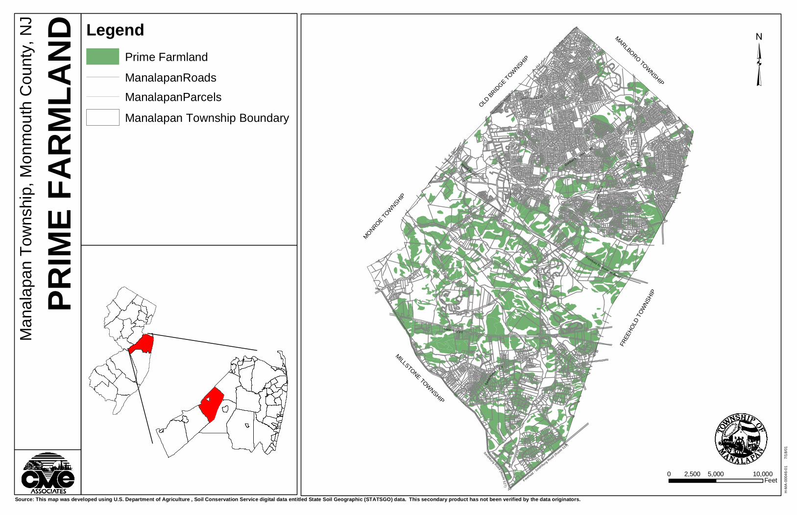
³M
anal
apan
Tow
nshi
p, M
onm
outh
Cou
nty,
NJ
PRIM
E FAR
MLAN
D
Source: This map was developed using U.S. Department of Agriculture , Soil Conservation Service digital data entitled State Soil Geographic (STATSGO) data. This secondary product has not been verified by the data originators.
Gordon's Corner Road
Union Hi ll R oad
Tenn
ent R
oad
US
Hw
y 9Wood Avenue
Freehold Englishtown Road
Mil l hurst R
o ad
State Hwy 33
Swee
tman
s Lane
H-M
A-0
0046
-01
7
/18/
01
0 5,000 10,0002,500Feet
LegendPrime Farmland
ManalapanRoadsManalapanParcels
Manalapan Township Boundary
Freehold - Smith
burg Road (R
oute 537)
Smithburg Road (R
oute 527)
MONROE TOW
NSHIP
OLD BRID
GE TOWNSHIP
MILLSTONE TOWNSHIP
FREE
HOLD
TOW
NSHI
P
MARLBORO TOWNSHIP

DEPTH TO WATER TABLE
The depth to water table map has been complied from data provided in the
Monmouth County Soil Survey. The ranges presented show the depths predicted for the
seasonal high water table, usually at its peak between January and late April. This
information can be used to identify limitations for the construction of individual subsurface
sewage disposal systems, building foundations, subsurface utility line installations,
agriculture, and stormwater management basins.
S:\RPT\Environmental\46-01 Manalapan NRI 8-01.doc 59
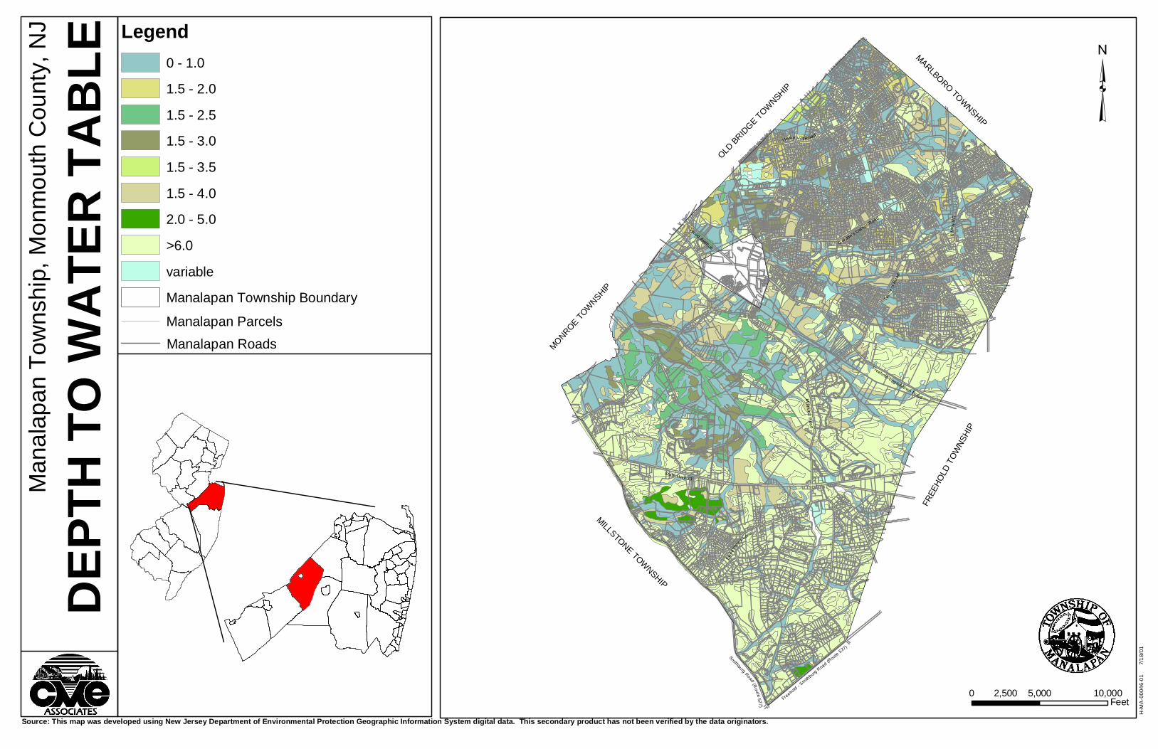
³M
anal
apan
Tow
nshi
p, M
onm
outh
Cou
nty,
NJ
DEPT
H TO
WAT
ER TA
BLE
Source: This map was developed using New Jersey Department of Environmental Protection Geographic Information System digital data. This secondary product has not been verified by the data originators.
Gordon's Corner R
oad
Union Hi l l R oad
Tenn
ent R
oad
US
Hw
y 9
Wood Avenue
Freehold Englishtown RoadMil lh urst R
oa d
State Hwy 33
Swee
tman
s Lane
H-M
A-0
0046
-01
7
/18/
01
0 5,000 10,0002,500Feet
Legend0 - 1.0
1.5 - 2.0
1.5 - 2.5
1.5 - 3.0
1.5 - 3.5
1.5 - 4.0
2.0 - 5.0
>6.0
variable
Manalapan Township Boundary
Manalapan ParcelsManalapan Roads
Freehold - Smith
burg Road (R
oute 537)
Smithburg Road (Route 527)
MONROE TOW
NSHIP
OLD BRID
GE TOWNSHIP
MILLSTONE TOWNSHIP
FREE
HOLD
TOW
NSHI
P
MARLBORO TOWNSHIP

FORESTS
There are four different types of forest coverage mapped in the Township:
coniferous forest, coniferous/deciduous forest, deciduous forest, and deciduous/coniferous
forest. Of these four forest types, the deciduous forest is by far the most abundant.
Coniferous forest exists mostly in the northwest portion of the Township, near the
Middlesex County border, and at scattered locations in the southeast section of the
Township. Only a single confined stand of coniferous/deciduous forest is identified within
the municipality, and is located in the northeast corner, near Route 9.
Deciduous forests within the upland portions of Manalapan commonly include the
following species:
Dominant Trees
White Oak (Quercus alba)
Red Oak (Quercus rubrum)
Black Locust (Robinia psuedoacacia)
Scarlet Oak (Quercus coccinea)
Black Oak (Quercus velutina)
Tulip (Liriodendron tulipifera)
American Beech (Fagus grandifolia)
Chestnut Oak (Quercus prinus)
Non-Dominant Trees
Shagbark Hickory (Carya ovata)
Pignut Hickory (Carya glabra)
Black Birch (Betula lenta)
White Ash (Fraxinus americana)
Red Cedar (Juniperus virginiana)
Black Cherry (Prunus serotina)
American Holly (Ilex opaca)
White Mulberry (Morus alba)
Sugar Maple (Acer saccharum)
S:\RPT\Environmental\46-01 Manalapan NRI 8-01.doc 60
Flowering Dogwood (Cornus florida)
Tree-of-Heaven (Ailanthus altissima)
Black Walnut (Juglans nigra)
The following tree species commonly occur in deciduous forests within the lowland
portions of the Township:
Dominant Trees
Red Maple (Acer rubrum)
Silver Maple (Acer saccharinum)
Pin Oak (Quercus palustris)
Gray Birch (Betula populifolia)
Sweetgum (Liquidambar styraciflua)
Blackgum (Nyssa sylvatica)
Non-Dominant Trees
Green Ash (Fraxinus pennsylvatica)
River Birch (Betula nigra)
Box Elder (Acer negundo)
American Hornbeam (Carpinus caroliniana)
Sweetbay Magnolia (Magnolia virginiana)
American Sycamore (Platanus occidentalis)
Black Willow (Salix nigra)
Within the limited areas identified as coniferous forest, the overall dominant conifer is
Pitch Pine (Pinus rigida). Minor occurrences of White Pine (Pinus strobus) can also be
expected, but these are most likely introduced by man. The coniferous-forested areas in the
Township exist as small clusters within larger deciduous forested areas in the southeastern
section of the Township, and as larger independent stands in the northwest portion of the
Township.
The G.I.S. coverage also includes mixed coniferous/deciduous forest and
deciduous/coniferous forest types within the Township. Woodlands mapped as
S:\RPT\Environmental\46-01 Manalapan NRI 8-01.doc 61

coniferous/deciduous forest are dominated by coniferous trees, and woodlands mapped as
deciduous/coniferous forest are dominated by deciduous trees.
This G.I.S. mapping is a general assessment of the Township’s woodlands, and is
intended for overall planning purposes. A site-specific assessment of forest types typically
requires an onsite inspection and evaluation.
S:\RPT\Environmental\46-01 Manalapan NRI 8-01.doc 62
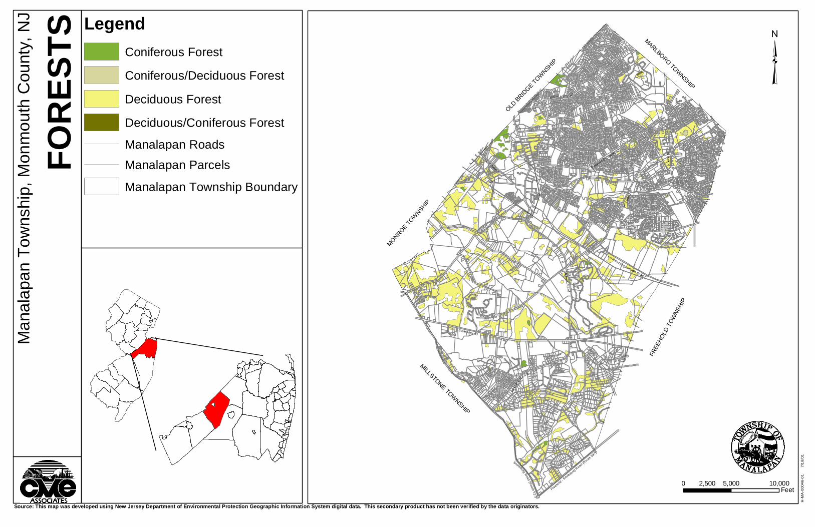
³M
anal
apan
Tow
nshi
p, M
onm
outh
Cou
nty,
NJ
FORE
STS
Source: This map was developed using New Jersey Department of Environmental Protection Geographic Information System digital data. This secondary product has not been verified by the data originators.
Gordon's Corner Road
Union Hi ll R oad
Tenn
ent R
oad
US
Hw
y 9
Wood Avenue
Freehold Englishtown Road
Mi ll hurst R
o ad
State Hwy 33
Swee
tman
s Lane
H-M
A-0
0046
-01
7
/18/
01
MONROE TOW
NSHIP
OLD BRID
GE TOWNSHIP
MILLSTONE TOWNSHIP
FREE
HOLD
TOW
NSHI
P
MARLBORO TOWNSHIP
0 5,000 10,0002,500Feet
LegendConiferous Forest
Coniferous/Deciduous Forest
Deciduous Forest
Deciduous/Coniferous Forest
Manalapan Roads
Manalapan Parcels
Manalapan Township Boundary
Freehold - S
mithburg R
oad (Route 537)
Smithburg Road (Route 527)
S:\RPT\Environmental\46-01 Manalapan NRI 8-01.doc 63
RARE SPECIES AND NATURAL COMMUNITIES
This map coverage has been provided by the N.J. Department of Environmental
Protection, Division of Parks and Forestry, Office of Natural Lands Management.
The term rare has been utilized by the Natural Lands Management Office to include
both endangered and threatened plant and animal species, and species that could
potentially become endangered or threatened if the population continues a downward trend.
Also included within this coverage are natural communities.

APPENDIX I
WILDLIFE
S:\RPT\Environmental\46-01 Manalapan NRI 8-01.doc
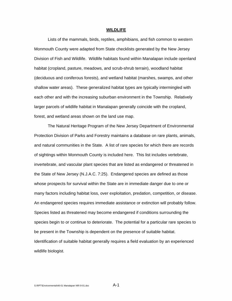
WILDLIFE
Lists of the mammals, birds, reptiles, amphibians, and fish common to western
Monmouth County were adapted from State checklists generated by the New Jersey
Division of Fish and Wildlife. Wildlife habitats found within Manalapan include openland
habitat (cropland, pasture, meadows, and scrub-shrub terrain), woodland habitat
(deciduous and coniferous forests), and wetland habitat (marshes, swamps, and other
shallow water areas). These generalized habitat types are typically intermingled with
each other and with the increasing suburban environment in the Township. Relatively
larger parcels of wildlife habitat in Manalapan generally coincide with the cropland,
forest, and wetland areas shown on the land use map.
The Natural Heritage Program of the New Jersey Department of Environmental
Protection Division of Parks and Forestry maintains a database on rare plants, animals,
and natural communities in the State. A list of rare species for which there are records
of sightings within Monmouth County is included here. This list includes vertebrate,
invertebrate, and vascular plant species that are listed as endangered or threatened in
the State of New Jersey (N.J.A.C. 7:25). Endangered species are defined as those
whose prospects for survival within the State are in immediate danger due to one or
many factors including habitat loss, over exploitation, predation, competition, or disease.
An endangered species requires immediate assistance or extinction will probably follow.
Species listed as threatened may become endangered if conditions surrounding the
species begin to or continue to deteriorate. The potential for a particular rare species to
be present in the Township is dependent on the presence of suitable habitat.
Identification of suitable habitat generally requires a field evaluation by an experienced
wildlife biologist.
S:\RPT\Environmental\46-01 Manalapan NRI 8-01.doc A-1

³M
anal
apan
Tow
nshi
p, M
onm
outh
Cou
nty,
NJ
Rare
Spec
ies an
d Natu
ral C
ommu
nities
Source: This map was developed using New Jersey Department of Environmental Protection Geographic Information System digital data and NJGS GIS digital data. This secondary product has not been verified by the data originators.
Gordon's Corner Road
Union Hi ll Road
Tenn
ent R
oad
US
Hw
y 9
Wood Avenue
Freehold Englishtown RoadMil lhu rst R
oa d
State Hwy 33
Swee
tman
s Lane
H-M
A-0
0046
-01
7
/18/
01
0 5,000 10,0002,500Feet
LegendPRECISION
Manalapan Township Boundary
Both - Location is Both Precise and/or Within 1.5 MilesM - Location of Rare Species and Natural Occurrences Within 1.5 Miles
None - No Documented Occurences of Rare Species or Natural Occurrences
S - Precise Location of Rare Species and Natural Occurrences
Manalapan ParcelsManalapan Roads
Freehold - Smith
burg Road (Route 537)
Smithburg Road (Route 527)
MONROE TOW
NSHIP
OLD BRID
GE TOWNSHIP
MILLSTONE TOWNSHIP
FREE
HOLD
TOW
NSHI
P
MARLBORO TOWNSHIP
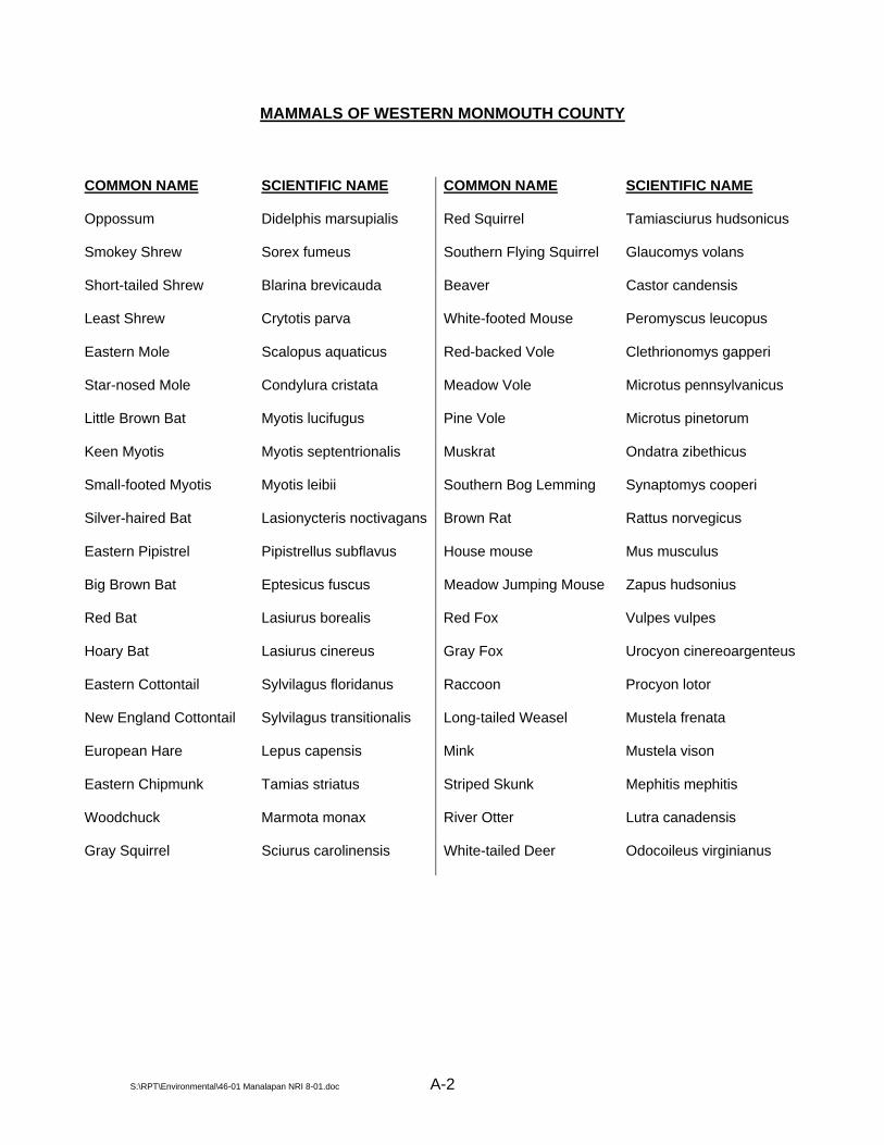
MAMMALS OF WESTERN MONMOUTH COUNTY
COMMON NAME SCIENTIFIC NAME COMMON NAME SCIENTIFIC NAME
Oppossum Didelphis marsupialis Red Squirrel Tamiasciurus hudsonicus
Smokey Shrew Sorex fumeus Southern Flying Squirrel Glaucomys volans
Short-tailed Shrew Blarina brevicauda Beaver Castor candensis
Least Shrew Crytotis parva White-footed Mouse Peromyscus leucopus
Eastern Mole Scalopus aquaticus Red-backed Vole Clethrionomys gapperi
Star-nosed Mole Condylura cristata Meadow Vole Microtus pennsylvanicus
Little Brown Bat Myotis lucifugus Pine Vole Microtus pinetorum
Keen Myotis Myotis septentrionalis Muskrat Ondatra zibethicus
Small-footed Myotis Myotis leibii Southern Bog Lemming Synaptomys cooperi
Silver-haired Bat Lasionycteris noctivagans Brown Rat Rattus norvegicus
Eastern Pipistrel Pipistrellus subflavus House mouse Mus musculus
Big Brown Bat Eptesicus fuscus Meadow Jumping Mouse Zapus hudsonius
Red Bat Lasiurus borealis Red Fox Vulpes vulpes
Hoary Bat Lasiurus cinereus Gray Fox Urocyon cinereoargenteus
Eastern Cottontail Sylvilagus floridanus Raccoon Procyon lotor
New England Cottontail Sylvilagus transitionalis Long-tailed Weasel Mustela frenata
European Hare Lepus capensis Mink Mustela vison
Eastern Chipmunk Tamias striatus Striped Skunk Mephitis mephitis
Woodchuck Marmota monax River Otter Lutra canadensis
Gray Squirrel Sciurus carolinensis White-tailed Deer Odocoileus virginianus
S:\RPT\Environmental\46-01 Manalapan NRI 8-01.doc A-2

REPTILES OF WESTERN MONMOUTH COUNTY
COMMON NAME SCIENTIFIC NAME COMMON NAME SCIENTIFIC NAME
Common Snapping Turtle Chelydra s. serpentina Eastern Garter Snake Thamnophis s. sirtalis
Stinkpot Sternotherus odoratus Eastern Ribbon Snake Thamnophis s. sauritus
Eastern Mud Turtle Kinosternon s. subrubrum Eastern Smooth Earth Snake Virginia v. valeriae
Spotted Turtle Clemmys guttata Eastern Hognose Snake Heterodon platyrhinos
Bog Turtle Clemmys muhlenbergi Northern Ringneck Snake Diadophis punctatus edwardsi
Wood Turtle Clemmys insculpta Eastern Worm Snake Carphophis a. amoenus
Eastern Box Turtle Terrapene c. carolina Northern Black Racer Coluber c. constrictor
N. Diamondback Terrapin Malaclemys t. terrapin Rough Green Snake Opheodrys aestivus
Red-eared Turtle Pseudemys scripta elegans Corn Snake Elaphe g. guttata
Eastern Painted Turtle Chrysemys p. picta Black Rat Snake Elaphe o. obsolete
Northern Fence Lizard Sceloporus undulates hyacinthinus Northern Pine Snake Pituophis m. melanoleucus
Five-lined Skink Eumeces fasciatus Eastern King Snake Lampropeltis g. getulus
Northern Water Snake Nerodia s. sipedon Eastern Milk Snake Lampropeltis t. triangulum
Northern Brown Snake Storeria d. dekayi Northern Scarlet Snake Cemophora coccinea copei
Northern Red-bellied Snake Storeria o. occipitomaculata Timber Rattlesnake Crotalus h. horridus
S:\RPT\Environmental\46-01 Manalapan NRI 8-01.doc A-3

AMPHIBIANS OF WESTERN MONMOUTH COUNTY
COMMON NAME SCIENTIFIC NAME
Marbled Salamander Ambystoma opacum
Spotted Salamander Ambystoma maculatum
Eastern Tiger Salamander Ambystoma t. tigrinum
Red-spotted Newt Notophthalmus v. viridescens
Northern Dusky Salamander Desmognathus f. fuscus
Red-backed Salamander Plethodon c. cinereus
Four-toed Salamander Hemidactylium scutatum
Northern Red Salamander Pseudotriton r. ruber
Eastern Mud Salamander Pseudotriton m. montanus
Northern Two-lined Salamander Eurycea b. bislineata
Eastern Spadefoot Toad Scaphiopus h. holbrookii
Fowler’s Toad Bufo woodhousii fowleri
Northern Cricket Frog Acris c. crepitans
Northern Spring Peeper Hyla c. crucifer
Pine Barrens Treefrog Hyla andersonii
Northern Gray Treefrog Hyla versicolor
New Jersey Chorus Frog Pseudacris triseriata kalmi
Bullfrog Rana catesbeiana
Carpenter Frog Rana virgatipes
Green Frog Rana clamitans melanota
Wood Frog Rana sylvatica
Pickerel Frog Rana palustris
Northern Leopard Frog Rana pipiens
S:\RPT\Environmental\46-01 Manalapan NRI 8-01.doc A-4
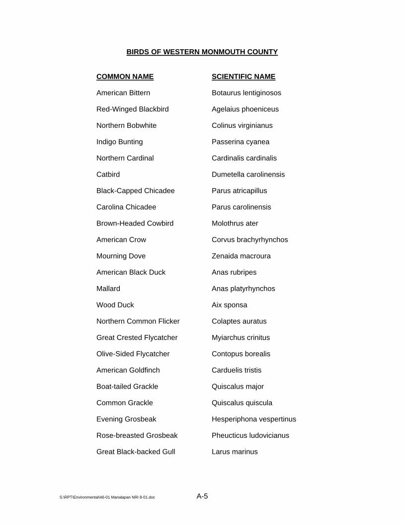
BIRDS OF WESTERN MONMOUTH COUNTY
COMMON NAME SCIENTIFIC NAME
American Bittern Botaurus lentiginosos
Red-Winged Blackbird Agelaius phoeniceus
Northern Bobwhite Colinus virginianus
Indigo Bunting Passerina cyanea
Northern Cardinal Cardinalis cardinalis
Catbird Dumetella carolinensis
Black-Capped Chicadee Parus atricapillus
Carolina Chicadee Parus carolinensis
Brown-Headed Cowbird Molothrus ater
American Crow Corvus brachyrhynchos
Mourning Dove Zenaida macroura
American Black Duck Anas rubripes
Mallard Anas platyrhynchos
Wood Duck Aix sponsa
Northern Common Flicker Colaptes auratus
Great Crested Flycatcher Myiarchus crinitus
Olive-Sided Flycatcher Contopus borealis
American Goldfinch Carduelis tristis
Boat-tailed Grackle Quiscalus major
Common Grackle Quiscalus quiscula
Evening Grosbeak Hesperiphona vespertinus
Rose-breasted Grosbeak Pheucticus ludovicianus
Great Black-backed Gull Larus marinus
S:\RPT\Environmental\46-01 Manalapan NRI 8-01.doc A-5
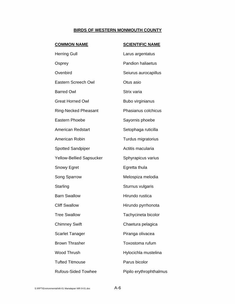
BIRDS OF WESTERN MONMOUTH COUNTY
COMMON NAME SCIENTIFIC NAME
Herring Gull Larus argentatus
Osprey Pandion haliaetus
Ovenbird Seiurus aurocapillus
Eastern Screech Owl Otus asio
Barred Owl Strix varia
Great Horned Owl Bubo virginianus
Ring-Necked Pheasant Phasianus colchicus
Eastern Phoebe Sayornis phoebe
American Redstart Setophaga ruticilla
American Robin Turdus migratorius
Spotted Sandpiper Actitis macularia
Yellow-Bellied Sapsucker Sphyrapicus varius
Snowy Egret Egretta thula
Song Sparrow Melospiza melodia
Starling Sturnus vulgaris
Barn Swallow Hirundo rustica
Cliff Swallow Hirundo pyrrhonota
Tree Swallow Tachycineta bicolor
Chimney Swift Chaetura pelagica
Scarlet Tanager Piranga olivacea
Brown Thrasher Toxostoma rufum
Wood Thrush Hylocichla mustelina
Tufted Titmouse Parus bicolor
Rufous-Sided Towhee Pipilo erythrophthalmus
S:\RPT\Environmental\46-01 Manalapan NRI 8-01.doc A-6

BIRDS OF WESTERN MONMOUTH COUNTY
COMMON NAME SCIENTIFIC NAME
Red-eyed Vireo Vireo olivaceus
Laughing Gull Larus atricilla
Ruffed Grouse Bonasa umbellus
Red-shouldered Hawk Buteo lineatus
Red-tailed Hawk Buteo jamaicensis
American Kestrel Falco sparverius
Green-backed Heron Butorides striatus
Great Blue Heron Ardea herodias
Ruby-throated Hummingbird Archilochus colubris
Blue Jay Cyanocitta cristata
Dark-eyed Junco Junco hyemalis
Killdeer Charadrius vociferus
Eastern Kingbird Tyrannus tyrannus
Belted Kingfisher Ceryle alcyon
White-breasted Nuthatch Sitta carolinensis
Northern Oriole Icterus galbula
Yellow-throated Vireo Vireo flavifrons
Turkey Vulture Cathartes aura
Black and White Warbler Miniotilta varia
Black-throated Blue Warbler Dendroica caerulescens
Blue-winged Warbler Vermivora pinus
Yellow-throated Warbler Dendroica dominica
Cedar Waxwing Bombycilla cedrorum
American Woodcock Philohela minor
S:\RPT\Environmental\46-01 Manalapan NRI 8-01.doc A-7
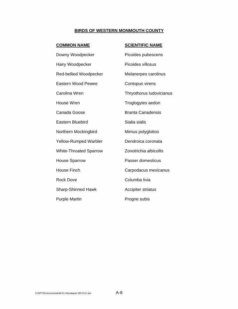
BIRDS OF WESTERN MONMOUTH COUNTY
COMMON NAME SCIENTIFIC NAME
Downy Woodpecker Picoides pubescens
Hairy Woodpecker Picoides villosus
Red-bellied Woodpecker Melanerpes carolinus
Eastern Wood Pewee Contopus virens
Carolina Wren Thryothorus ludovicianus
House Wren Troglogytes aedon
Canada Goose Branta Canadensis
Eastern Bluebird Sialia sialis
Northern Mockingbird Mimus polyglottos
Yellow-Rumped Warbler Dendroica coronata
White-Throated Sparrow Zonotrichia albicollis
House Sparrow Passer domesticus
House Finch Carpodacus mexicanus
Rock Dove Columba livia
Sharp-Shinned Hawk Accipiter striatus
Purple Martin Progne subis
S:\RPT\Environmental\46-01 Manalapan NRI 8-01.doc A-8

FISH OF WESTERN MONMOUTH COUNTY
COMMON NAME SCIENTIFIC NAME
Largemouth bass Micropterus salmoides
Chain pickerel Esox niger
Grass pickerel Esox spp.
Bluegill sunfish Lepomis macrochirus
Pumpkinseed sunfish Lepomis gibbosus
Bluespotted sunfish Enneacanthus gloriosus
Redbreast sunfish Lepomis auritus
Golden shiner Notemigonus crysoleucas
Brown bullhead Ictalurus nebulosus
Black crappie Pomoxis nigromaculatus
White sucker Catostomus commersoni
Creek chubsucker Erimyzon oblongus
Fallfish Semotilus corporalis
Johnny darter Etheostoma nigrum
Mudminnow Umbra pygmaea
American eel Anguilla rostrata
Brown trout Salmo trutta
Carp Cyprinus carpio
S:\RPT\Environmental\46-01 Manalapan NRI 8-01.doc A-9
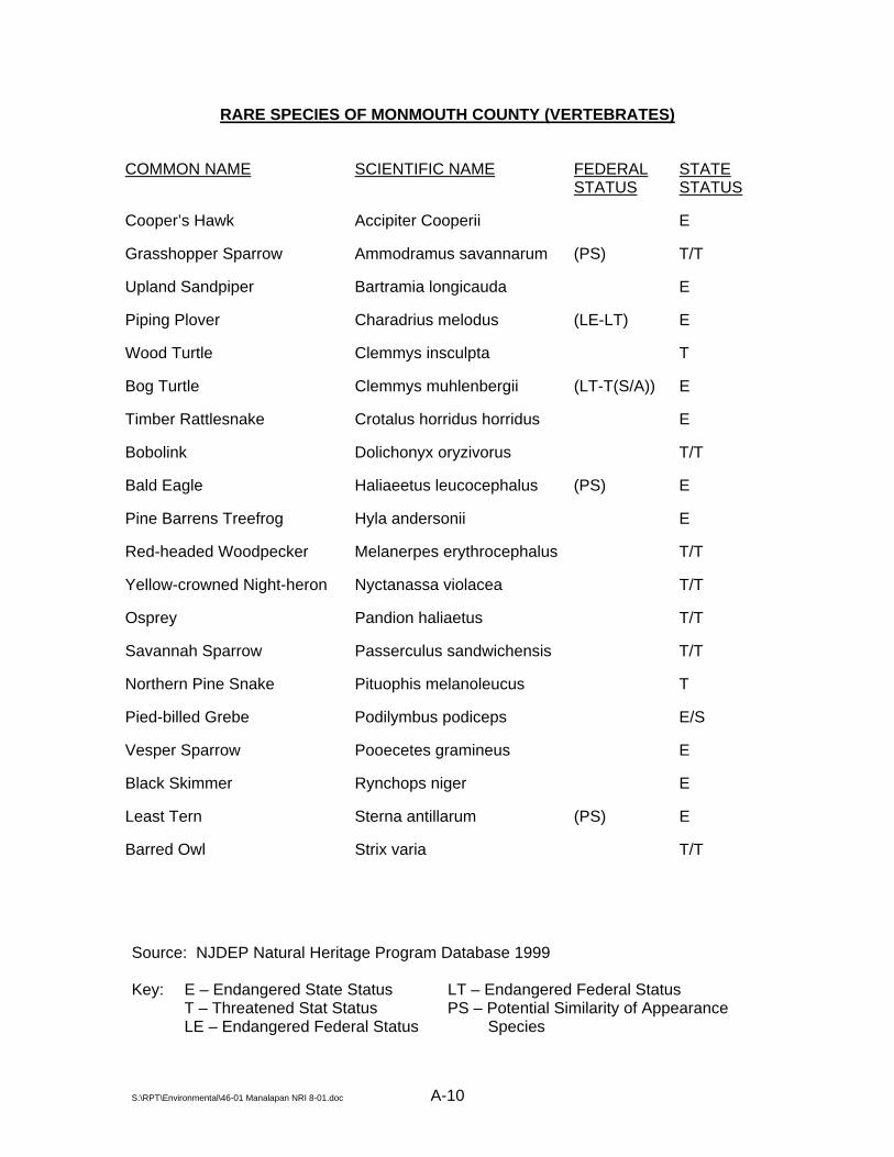
RARE SPECIES OF MONMOUTH COUNTY (VERTEBRATES)
COMMON NAME SCIENTIFIC NAME FEDERAL STATUS
STATE STATUS
Cooper’s Hawk Accipiter Cooperii E
Grasshopper Sparrow Ammodramus savannarum (PS) T/T
Upland Sandpiper Bartramia longicauda E
Piping Plover Charadrius melodus (LE-LT) E
Wood Turtle Clemmys insculpta T
Bog Turtle Clemmys muhlenbergii (LT-T(S/A)) E
Timber Rattlesnake Crotalus horridus horridus E
Bobolink Dolichonyx oryzivorus T/T
Bald Eagle Haliaeetus leucocephalus (PS) E
Pine Barrens Treefrog Hyla andersonii E
Red-headed Woodpecker Melanerpes erythrocephalus T/T
Yellow-crowned Night-heron Nyctanassa violacea T/T
Osprey Pandion haliaetus T/T
Savannah Sparrow Passerculus sandwichensis T/T
Northern Pine Snake Pituophis melanoleucus T
Pied-billed Grebe Podilymbus podiceps E/S
Vesper Sparrow Pooecetes gramineus E
Black Skimmer Rynchops niger E
Least Tern Sterna antillarum (PS) E
Barred Owl Strix varia T/T
Source: NJDEP Natural Heritage Program Database 1999 Key: E – Endangered State Status LT – Endangered Federal Status T – Threatened Stat Status PS – Potential Similarity of Appearance LE – Endangered Federal Status Species
S:\RPT\Environmental\46-01 Manalapan NRI 8-01.doc A-10

RARE SPECIES OF MONMOUTH COUNTY (INVERTEBRATES)
COMMON NAME SCIENTIFIC NAME FEDERAL STATUS
STATE STATUS
A Noctuid Moth Apamea apamiformis
A Noctuid Moth Chytonix sensilis
Northeastern Beach Tiger Beetle Cicindela dorsalis dorsalis LT E
Pine Barrens Bluet Enallagma recurvatum
Henry’s Elfin Incisalia henrici
Frosted Elfin Incisalia irus
Golden-winged Skimmer Libellula auripennis
Coastal Swamp Metarranthis Metarranthis pilosaria
A Satyr Neonympha areolata septentrionalis
Sunflower Borer Moth Papaipema necopina
Yellow edged pygarctia Pygarctia abdominalis
Regal Fritillary Speyeria idalia
A Noctuid Moth Zale curema
Source: NJDEP Natural Heritage Program Database 1999 Key: E – Endangered State Status LT – Endangered Federal Status T – Threatened Stat Status PS – Potential Similarity of Appearance LE – Endangered Federal Status Species
S:\RPT\Environmental\46-01 Manalapan NRI 8-01.doc A-11

RARE SPECIES OF MONMOUTH COUNTY (VASCULAR PLANTS)
COMMON NAME SCIENTIFIC NAME FEDERAL STATUS
STATE STATUS
Yellow Giant Hyssop Agastache nepetoides
Sea-Beach Pigweed Amaranthus pumilus LT E
Wild Wormwood Artemisia campestris ssp caudate
Red Milkweed Asclepias rubra
White Milkweed Asclepias variegata
Cornel-Leaved Aster Aster infirmus
Low Rough Aster Aster radula E
Pale Indian Plantain Cacalia atriplicifolia E
Pickering’s Reedgrass Calamagrostis pickeringii E
Pine Barren Reedgrass Calamovilfa brevipilis
Barratt’s Sedge Carex barrattii
Clustered Sedge Carex cumulata E
Variable Sedge Carex polymorpha E
Spiny Coontail Ceratophyllum echinatum E
Pear Hawthorn Crataegus calpodendron E
Fleshy Hawthorn Crataegus succulenta E
Lancaster Flatsedge Cyperus lancastriensis
Coast Flatsedge Cyperus polystachyos E
Trailing Tick-Trefoil Desmodium humifusum E
Larger Buttonweed Diodia virginiana E
Leatherwood Dirca palustris
Parker’s Pipewort Eriocaulon parkeri Source: NJDEP Natural Heritage Program Database 1999 Key: E – Endangered State Status LT – Endangered Federal Status T – Threatened Stat Status PS – Potential Similarity of Appearance LE – Endangered Federal Status Species
S:\RPT\Environmental\46-01 Manalapan NRI 8-01.doc A-12

RARE SPECIES OF MONMOUTH COUNTY (VASCULAR PLANTS CONTINUED)
COMMON NAME SCIENTIFIC NAME FEDERAL STATUS
STATE STATUS
Pumpkin Ash Fraxinus profunda E
Pine Barren Gentian Gentiana autumnalis
Sea-Beach Milkwort Glaux maritime E
Swamp-Pink Helonias bullata LT E
Whorled Pennywort Hydrocotyle verticillata
New Jersey Rush Juncus caesariensis E
Northern Blazing Star Liatris scariosa var novae-angliae E
Mudweed Limosella subulata E
Sandplain Flax Linum intercursum E
Southern Twayblade Listera australis
Hairy Woodrush Luzula acuminata E
Climbing Fern Lygodium palmatum
Slender Water-Milfoil Myriophyllum tenellum E
Virginia False-Gromwell Onosmodium virginianum E
Mistletoe Phoradendron serotinum
Sea-Side Plantain Plantago maritime
Slender Plantain Plantago pusilla E
Purple Fringeless Orchid Platanthera peramoena E
Sea-Beach Knotweed Polygonum glaucum E
Torrey’s Mountain Mint Pycnanthemum torrei E
Greenish-Flowered Wintergreen Pyrola chlorantha E
Sea-Side Crowfoot Ranunculus cymbalaria E Source: NJDEP Natural Heritage Program Database 1999 Key: E – Endangered State Status LT – Endangered Federal Status T – Threatened Stat Status PS – Potential Similarity of Appearance LE – Endangered Federal Status Species
S:\RPT\Environmental\46-01 Manalapan NRI 8-01.doc A-13
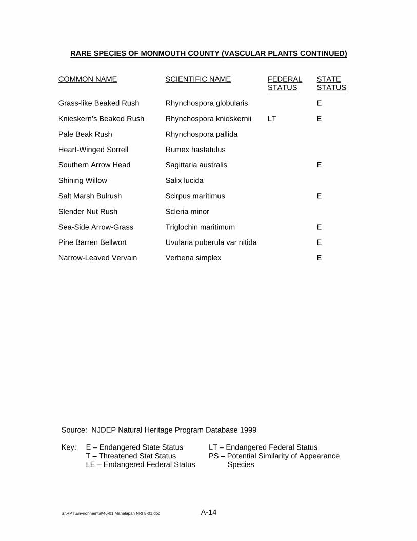
S:\RPT\Environmental\46-01 Manalapan NRI 8-01.doc A-14
RARE SPECIES OF MONMOUTH COUNTY (VASCULAR PLANTS CONTINUED)
COMMON NAME SCIENTIFIC NAME FEDERAL STATUS
STATE STATUS
Grass-like Beaked Rush Rhynchospora globularis E
Knieskern’s Beaked Rush Rhynchospora knieskernii LT E
Pale Beak Rush Rhynchospora pallida
Heart-Winged Sorrell Rumex hastatulus
Southern Arrow Head Sagittaria australis E
Shining Willow Salix lucida
Salt Marsh Bulrush Scirpus maritimus E
Slender Nut Rush Scleria minor
Sea-Side Arrow-Grass Triglochin maritimum E
Pine Barren Bellwort Uvularia puberula var nitida E
Narrow-Leaved Vervain Verbena simplex E
Source: NJDEP Natural Heritage Program Database 1999 Key: E – Endangered State Status LT – Endangered Federal Status T – Threatened Stat Status PS – Potential Similarity of Appearance LE – Endangered Federal Status Species

REFERENCES
Brown, James S. “Manalapan in Three Centuries”. Township of Manalapan, 1991 Charles, E.G., Behroozi, C., Schooley, J. & Hoffman, J.L. (1993). A Method for Evaluating
Ground-Water-Recharge Areas in New Jersey, New Jersey Geological Survey Report GSR-32.
Environmental Commission. Township of Manalapan (1976) Natural Resource Inventory,
prepared by Dames & Moore. Jablonski, C.F. & Baumley, R.J. (1989). Soil Survey of Monmouth County, New Jersey, Soil
Conservation Service, U.S. Department of Agriculture. Kümmel, H.B. (1940). The Geology of New Jersey, Bulletin 50, New Jersey Department of
Conservation and Development. Manalapan Township Planning Board (1991). Township of Manalapan Master Plan;
prepared by Townplan Associates, Middletown, New Jersey. Monmouth County Historical Association (1990). Monmouth County Historic Sites Inventory,
Summary Report; prepared by Gail Hunton and James C. McCabe, Office of New Jersey Heritage, Monmouth County Park System.
Monmouth County Planning Board (2000). Monmouth County Farmland Preservation Plan:
The Comprehensive Plan. August 2000 Draft. New Jersey Department of Environmental Protection (1996). New Jersey 1996 State Water
Quality Inventory Report; NJDEP Office of Environmental Planning. New Jersey Department of Environmental Protection (1998). Surface Water Quality
Standards, N.J.A.C. 7:9B; NJDEP Office of Environmental Planning. New Jersey Office of State Planning (2000). New Jersey State Development and
Redevelopment Plan; Draft Final Plan. Pucci, A.A., Gronberg J.A. & Pope, D.A. (1989). Hydraulic Properties of the Middle and
Upper Aquifers of the Potomac-Raritan-Magothy Aquifer System in the Northern Coastal Plain of New Jersey, Geological Survey Report 18, New Jersey Geological Survey, New Jersey Department of Environmental Protection, Division of Water Resources.
Robichaud, B. and Buell, M.F. (1973). Vegetation of New Jersey. Rutgers University Press. Tiner, R.W. (1985). Wetlands of New Jersey; U.S. Fish and Wildlife Service National
Wetlands Inventory, U.S. Department of the Interior. U.S. Geological Survey (1976). A Land Use and Land Cover Classification System for Use
with Remote Sensor Data; U.S.G.S. Professional Paper 964.
S:\RPT\Environmental\46-01 Manalapan NRI 8-01.doc

S:\RPT\Environmental\46-01 Manalapan NRI 8-01.doc
INTERNET REFERENCES
http://www.injersey.com/newcomersguide/townprofiles_mon/manalapan.html http://www.monmouthplanning.com