Natura Impact Report - Limerick.ie · Natura Impact Report January 2018 As part of the preparation...
92
Natura Impact Report January 2018 As part of the preparation of the Proposed Variation No. 6, Limerick County Development Plan 2010-2016 (as extended)
Transcript of Natura Impact Report - Limerick.ie · Natura Impact Report January 2018 As part of the preparation...
Natura Impact Report January 2018 As part of the preparation of the Proposed Variation No. 6, Limerick County Development Plan 2010-2016 (as extended)
Roughan & O’Donovan – AECOM Limerick City & County Council Consulting Engineers NIR for Variation No. 6
Ref: 14.131.311 Page i
Proposed Variation No. 6 to the Limerick County Development Plan 2010-2016 (as extended)
Natura Impact Report
TABLE OF CONTENTS
1.0 INTRODUCTION ................................................................................................ 1
1.1 Background ......................................................................................................... 1
1.2 Legislative Context .............................................................................................. 2
1.3 Stages of Appropriate Assessment ...................................................................... 3
1.4 Guidance and Methodology ................................................................................. 4
1.5 Relationship between AA and SEA ...................................................................... 5
1.6 Outcome of Stage 1 ............................................................................................. 5
1.7 Scope and Purpose of Stage 2 ............................................................................ 6
2.0 DESCRIPTION OF THE PROPOSED VARIATION ........................................... 7
2.1 The Proposed Variation ....................................................................................... 7
2.2 Reason for the Proposed Variation ...................................................................... 8
2.3 Background and Context to the Proposed Variation ............................................. 8
2.4 The Route Selection Process ............................................................................. 10
3.0 NATURA 2000 SITES LIKELY TO BE AFFECTED ......................................... 12
3.1 Determination of Likely Zone of Impact .............................................................. 12
3.2 Screening of Natura 2000 Sites ......................................................................... 16
3.3 Natura 2000 Site Descriptions ........................................................................... 16
3.4 Conservation Objectives .................................................................................... 22
3.5 Desk Study and Ecological Surveys ................................................................... 22
4.0 ASSESSMENT OF POTENTIAL IMPACTS ..................................................... 24
4.1 Risk to Qualifying Interests/ Special Conservation Interests ............................... 24
4.2 Potential Impacts on Qualifying Interests ........................................................... 49
4.3 Assessment of Likely Significant Effects ............................................................ 49
5.0 POTENTIAL IN-COMBINATION EFFECTS ..................................................... 55
5.1 Introduction ........................................................................................................ 55
5.2 In-combination effects from other relevant Plans ............................................... 55
5.3 Existing Policies and Objectives of the Plan ....................................................... 60
5.4 In-combination effects from other relevant Projects............................................ 62
5.5 Results of the In-Combination Assessment ........................................................ 64
6.0 MITIGATION ..................................................................................................... 65
6.1 Introduction ........................................................................................................ 65
6.2 Mitigation in the Existing Limerick County Development Plan ............................ 65
6.3 Mitigation Measures for the Proposed Variation ................................................. 66

Roughan & O’Donovan – AECOM Limerick City & County Council Consulting Engineers NIR for Variation No. 6
Ref: 14.131.311 Page ii
6.4 Additional Mitigation Measures .......................................................................... 69
6.5 Mitigation for Water Quality ................................................................................ 71
6.6 Mitigation Measures and Best Practice for Road Infrastructure Projects ............ 73
6.7 Invasive Alien Plant Species .............................................................................. 74
6.8 Mitigation for European Otter ............................................................................. 74
6.9 Mitigation for Lesser Horseshoe Bats ................................................................ 76
6.10 Consideration of Whooper Swans ...................................................................... 77
6.11 Mitigation for Fens ............................................................................................. 78
6.12 Incorporation of Mitigation Measures into the Proposed Variation ...................... 79
7.0 RESIDUAL EFFECTS ...................................................................................... 81
8.0 CONCLUSION AND FINAL DETERMINATION ............................................... 85
9.0 REFERENCES ................................................................................................. 86
Roughan & O’Donovan – AECOM Limerick City & County Council Consulting Engineers NIR for Variation No. 6
Ref: 14.131.311 Page 1
1.0 INTRODUCTION
1.1 Background
This Natura Impact Report (NIR) was prepared by Roughan & O’Donovan (ROD) on behalf of Limerick City & County Council. It assesses the implications of the proposed Variation No. 6, hereafter referred to as “the Proposed Variation”, to the Limerick County Development Plan 2010-2016 (as varied and extended), hereafter referred to as “the Plan”, for sites of [European] Community importance for nature conservation, i.e. Natura 2000 sites. This NIR is published alongside the Strategic Environmental Assessment (SEA) and Environmental Report (ER) for the Proposed Variation. The preparation of the Proposed Variation has regard to Directive 2001/42/EC of the European Parliament and of the Council of 27th June 2001 on the assessment of the effects of certain plans and programmes on the environment (the SEA Directive). Article 3(2) of the SEA Directive stipulates that, if a plan is likely to impact upon a European site protected by Council Directive 92/43/EEC of 21st May 1992 on the conservation of natural habitats and of wild fauna and flora (the Habitats Directive), i.e. a Natura 2000 site, SEA must be conducted. The preparation of the Proposed Variation also has regard to the Habitats Directive. Article 6(3) and (4) of the Habitats Directive establishes the requirement for an assessment of plans and/or projects likely to have a significant effect on Natura 2000 sites. Article 6(3) establishes the requirement to screen all plans and projects for the likelihood of such effects and, where such effects cannot be ruled out, to undertake an Appropriate Assessment (AA) of the implications of the plan or project for Natura 2000 sites. This requirement is transposed into Irish law by the European Communities (Birds and Natural Habitats) Regulations, 2011-2015 (the Habitats Regulations) and Part XAB of the Planning and Development Acts, 2000-2015. This requires Limerick City & County Council, as the competent authority in this case, to screen for and, if necessary, undertake an AA in respect of the Proposed Variation. The Proposed Variation is neither connected to nor necessary for the management of any Natura 2000 site. However, the text of the Proposed Variation implies that its functional area includes areas located in or adjacent to a number of Natura 2000 sites. AA Screening was carried out to assess the likelihood of significant effects on these Natura 2000 sites as a result of the Proposed Variation. The AA Screening determined that the likelihood of significant effects arising from the Proposed Variation could not be ruled out on the basis of objective information. Consequently, the process moved on to Stage 2 (full AA) and the preparation of this NIR. The purpose of this NIR is to provide an examination, analysis and evaluation of the implications of the Proposed Variation for Natura 2000 sites and to present complete, precise and definitive findings and a final determination in respect of the same in order to inform and assist Limerick City & County Council, as the competent authority, in carrying out its AA. This NIR intends to ascertain, in view of best scientific knowledge, whether or not the Proposed Variation, either alone or in combination with other plans and projects, will adversely affect the integrity of one or more Natura 2000 sites, in view of their Conservation Objectives. This NIR is also intended to inform the SEA of the Proposed Variation.
Roughan & O’Donovan – AECOM Limerick City & County Council Consulting Engineers NIR for Variation No. 6
Ref: 14.131.311 Page 2
1.2 Legislative Context
Natura 2000 Sites
The Habitats Regulations transpose into Irish law the Habitats Directive and Directive 2009/147/EC of the European Parliament and of the Council of 30 November 2009 on the conservation of wild birds (the Birds Directive), collectively referred to as “the Nature Directives”, and lists natural habitats and species of Community importance for conservation and requiring protection. his protection is afforded in part through the designation of sites that represent significant examples (in a European context) of habitats and populations of species specified in the Nature Directives. Sites selected for bird species are Special Protection Areas (SPAs) and sites selected for other protected species (Annex II of the Habitats Directive) and/or habitats (Annex I of the Habitats Directive) are Special Areas of Conservation (SACs). Together, SPAs and SACs comprise the Natura 2000 network of protected sites. Bird species listed on Annex I of the Birds Directive (Special Conservation Interests) and habitats and/or species listed on Annexes I and II, respectively, of the Habitats Directive (Qualifying Interests) have full European protection in Natura 2000 sites. Species listed on Annex IV of the Habitats Directive are protected wherever they occur, whether inside or outside the Natura 2000 network. Annex I habitats that occur outside of SACs are still considered to be of national and international importance and, under Regulation 27(4)(b) of the Habitats Regulations, public authorities have a duty to avoid the pollution or deterioration of these habitats. Appropriate Assessment
Article 6(3) and (4) of the Habitats Directive set out the legal decision-making tests for plans or projects likely to affect Natura 2000 sites. Article 6(3) establishes the requirement to screen all plans and projects and, where significant effects cannot be excluded, to carry out a further assessment. Article 6(3) states that:
“Any plan or project not directly connected with or necessary to the management of the site but likely to have a significant effect thereon, either individually or in combination with other plans or projects, shall be subject to appropriate assessment of its implications for the site in view of the site’s conservation objectives. In light of the conclusions of the assessment of the implications for the site and only after having ascertained that it will not adversely affect the integrity of the site concerned and, if appropriate, after having obtained the opinion of the general public.” Article 6(4) deals with alternative solutions and allows proposed plans and projects having adverse effects on Natura 2000 sites to be approved only in very limited circumstances, i.e. where there are imperative reasons of overriding public interest, no alternatives remain and compensatory measures can be taken. The European Court of Justice (ECJ) has made a relevant ruling in relation to when AA is required and its purpose1:
“Any plan or project not directly connected with or necessary to the management of the site is to be subject to an appropriate assessment of its implications for the site in view of the site’s conservation objectives if it cannot be excluded, on the basis of objective information, that it will have a significant effect on that site, either individually or in combination with other plans or projects [and the plan or project may only be authorised] where no reasonable scientific doubt remains as to the absence of such effects.”
1 Landelijke Vereniging tot Behoud van de Waddenzee and Nederlandse Vereniging tot Bescherming van Vogels
v. Staatssecretaris van Landbouw, Natuurbeheer en Visserij (Waddenzee) [2004] C-127/02 ECR I-7405.

Roughan & O’Donovan – AECOM Limerick City & County Council Consulting Engineers NIR for Variation No. 6
Ref: 14.131.311 Page 3
The ECJ has also made a relevant ruling on what should be contained within an AA2:
“[The AA] cannot have lacunae and must contain complete, precise and definitive findings and conclusions capable of removing all reasonable scientific doubt as to the effects of the works proposed on the protected site concerned.” The Irish High Court has also considered the application of the Habitats Directive and has provided clarity on how competent authorities should undertake valid and lawful AA3, directing that the AA:
“Must identify, in the light of the best scientific knowledge in the field, all aspects of the development project which can, by itself or in combination with other plans or projects, affect the European site in the light of its conservation objectives. This clearly requires both examination and analysis.”
“Must contain complete, precise and definitive findings and conclusions and may not have lacunae or gaps. The requirement for precise and definitive findings and conclusions appears to require examination, analysis, evaluation and decisions. Further, the reference to findings and conclusions in a scientific context requires both findings following analysis and conclusions following an evaluation of each in the light of the best scientific knowledge in the field.”
“May only include a determination that the proposed development will not adversely affect the integrity of any relevant European site where, upon the basis of complete, precise and definitive findings and conclusions made, the consenting authority decides that no reasonable scientific doubt remains as to the absence of the identified potential effects.”
1.3 Stages of Appropriate Assessment
The European Commission’s Assessment of plans and projects significantly affecting Natura 2000 sites: Methodological guidance on the provisions of Article 6(3) and (4) of the Habitats Directive 92/43/EEC (EC, 2001) prescribes a staged process, as set out below, the need for each stage being dependent on the outcome of the preceding stage. The sequence is designed to test the potential effects of plans and projects on European sites:
1. Screening for Appropriate Assessment
2. Appropriate Assessment
3. Assessment of Alternative Solutions
4. Assessment where no alternative solutions exist and adverse impacts remain, i.e. the Imperative Reasons of Overriding Public Interest test, and compensatory measures.
The Habitats Directive sets out a hierarchy of avoidance, mitigation and compensatory measures. Stage 1 of the process is referred to as Screening for Appropriate Assessment and identifies whether the plan or project, either on its own or in combination with other plans of projects, would be “likely to have a significant effect” upon any Natura 2000 site. A likely effect is one that cannot be ruled out on the basis of objective information. The test is a “likelihood” of effects rather than a certainty of effects. The test of significance is where a plan or project could undermine the site’s Conservation Objectives.
2 Sweetman v. An Bord Pleanála [2013] Case C-258/11.
3 Kelly v. An Bord Pleanála [2014] IEHC 422.
Roughan & O’Donovan – AECOM Limerick City & County Council Consulting Engineers NIR for Variation No. 6
Ref: 14.131.311 Page 4
In view of best scientific knowledge and the site’s Conservation Objectives, Screening is undertaken without the inclusion of mitigation, except where it is intrinsic to the design of the plan or project4. If effects are considered likely to be significant, potentially significant or uncertain, or if the Screening process becomes overly complicated, the process must proceed to Stage 2: Appropriate Assessment, with the preparation of a Natura Impact Statement (in the case of projects) or Natura Impact Report (in the case of plans) to inform the AA that is to be conducted by the Competent Authority.
1.4 Guidance and Methodology
This NIR has been prepared having regard to the following documents:
Managing Natura 2000 sites. The provisions of Article 6 of the ‘Habitats’ Directive 92/43/EEC. Environment Directorate-General of the European Commission, Brussels;
Assessment of plans and projects significantly affecting Natura 2000 sites. Methodological guidance on the provision of Article 6 (3) and (4) of the Habitats Directive 92/443/EEC. Environment Directorate-General of the European Commission, Brussels;
Circular Letter SEA 1/08 & NPWS 1/08 Appropriate Assessment of Land Use Plans. Department of the Environment, Heritage and Local Government, Dublin;
Appropriate Assessment of Plans and Projects in Ireland. Guidance for Planning Authorities. Department of the Environment, Heritage and Local Government, Dublin;
Guidance Document on Article 6(4) of the ‘Habitats Directive’ 92/43/EEC. Clarification of the Concepts of Alternative Solutions, Imperative Reasons of Overriding Public Interest, Compensatory Measures, Overall Coherence. Opinion of the European Commission; and,
Integrated Biodiversity Impact Assessment – Streamlining AA, SEA and EIS Processes: Practitioner’s Manual. Environmental Protection Agency, Wexford.
Best practice in AA promotes a site-led approach. This approach gives precedence to the environmental conditions that maintain site integrity. The first steps are to identify the Natura 2000 sites within the likely zone of impact and collect information on the Special Conservation Interest and Qualifying Interests. The site-led approach focuses on maintaining site integrity by avoiding impacts on the key environmental conditions and allows issues such as cumulative impacts to be identified. The approach is summarised as follows:
1. Which Natura 2000 sites lie within the Proposed Variation area and its likely zone of impact?
2. What are the Special Conservation Interests or Qualifying Interests for each Natura 2000 site?
3. What are the underpinning ecological and environmental conditions required to maintain these Special Conservation Interests or Qualifying Interests at Favourable Conservation Status?
4. What are the threats, actual or potential, that could affect those underpinning factors?
5. Are there aspects of the Proposed Variation that present these threats?
4 Killross and Rossmore Properties v. An Bord Pleanála [2014]
Roughan & O’Donovan – AECOM Limerick City & County Council Consulting Engineers NIR for Variation No. 6
Ref: 14.131.311 Page 5
A desk study was carried out to define the potential zone of impact by identifying the , location and Conservation Objectives of all Natura 2000 sites within a 15 km radius of the area described in the Proposed Variation. The data relating to the sites were determined from information obtained from the statutory consultee, the National Parks & Wildlife Service (NPWS).
1.5 Relationship between AA and SEA
The SEA of the Proposed Variation was carried out concurrently with the AA and the findings of both processes are documented separately, taking into account their statutory implications. This means that information obtained on the environmental impact of the SEA can cascade down through the AA and be incorporated into the SEA baseline to contribute to a comprehensive reference base. AA information on Special Conservation Interests, the Qualifying Interests, the Conservation Objectives and site integrity of European sites is, therefore, also used to inform impact assessment in SEA. There were several pathways of information flow between the SEA and AA and in accordance with good practice in terms of the following stages:
Sharing of baseline data on European sites and potential sensitivities and threats;
The Proposed Variation, along with the information available from the route selection process and Design Update (October 2017), was scrutinised by the AA team for potential adverse effects on integrity of the European sites, in terms of their Conservation Objectives, but also any other ecological impacts outside of the European site scale were highlighted to the SEA team for them to address in the SEA process; and,
SEA team was able to highlight potential interactions between other potential pathways of environmental risk related to the Proposed Variation and the sensitivities of European sites to the AA team.
1.6 Outcome of Stage 1
The AA Screening carried out by Limerick City & County Council determined that the Proposed Variation has the potential to have a significant effect on four Natura 2000 sites, namely the Lower River Shannon SAC, the Curraghchase Woods SAC, the Askeaton Fen Complex SAC and the River Shannon and River Fergus Estuaries SPA. Having considered the content of the Proposed Variation (and with due regard to the outcome of the route corridor selection process5), the Conservation Objectives of the Natura 2000 sites within the likely zone of impact, and having applied the Precautionary Principle, it was determined that the Proposed Variation has the potential to result in likely significant effects on the following Qualifying Interests or Special Conservation Interests of the following sites:
1. Lower River Shannon SAC
Alluvial forests with Alnus glutinosa and Fraxinus excelsior (Alno-Padion, Alnion incanae, Salicion albae) [91E0] (* priority habitat)
Floating River Vegetation - Water courses of plain to montane levels with the Ranunculion fluitantis and Callitricho-Batrachion vegetation [3260]
River Lamprey (Lampetra fluviatilis) [1099]
5 The route selection process identified Option 3 (the route assessed here) as the preferred option as, apart from
a crossing of the River Maigue, it avoided any direct impacts on designated sites and posed the least risk of causing indirect impacts.
Roughan & O’Donovan – AECOM Limerick City & County Council Consulting Engineers NIR for Variation No. 6
Ref: 14.131.311 Page 6
Atlantic Salmon (Salmo salar) [1106]
European Otter (Lutra lutra) [1355]
2. Curraghchase Woods SAC
Lesser Horseshoe Bat (Rhinolophus hipposideros) [1303]
3. Askeaton Fens Complex SAC
Calcareous fens with Cladium mariscus and species of the Caricion davallianae [7210]
Alkaline fens [7230]
4. River Shannon and River Fergus Estuaries SPA
Whooper Swan (Cygnus cygnus) [A038] Accordingly, a full (Stage 2) AA in respect of the Proposed Variation is required.
1.7 Scope and Purpose of Stage 2
The AA to be carried out by Limerick City & County Council must examine, analyse and evaluate the implications of the Proposed Variation, either individually or in combination with other plans or projects, for the Lower River Shannon SAC, the Curraghchase Woods SAC, the Askeaton Fen Complex SAC and the River Shannon and River Fergus Estuaries SPA, and make complete, precise and definitive findings in respect of the same. Where, on the basis of best scientific knowledge and in view of the Conservation Objectives of these Natura 2000 sites, the AA cannot ascertain that the Proposed Variation would not have an adverse effect on the integrity of these sites, it must prescribe appropriate mitigation to ensure beyond reasonable scientific doubt that such effects do not occur.
Roughan & O’Donovan – AECOM Limerick City & County Council Consulting Engineers NIR for Variation No. 6
Ref: 14.131.311 Page 7
2.0 DESCRIPTION OF THE PROPOSED VARIATION
2.1 The Proposed Variation
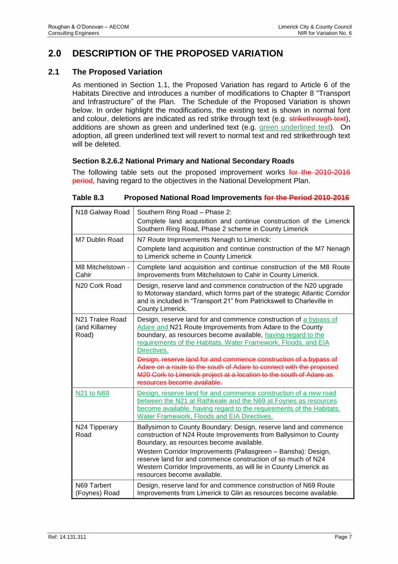
As mentioned in Section 1.1, the Proposed Variation has regard to Article 6 of the Habitats Directive and introduces a number of modifications to Chapter 8 “Transport and Infrastructure” of the Plan. The Schedule of the Proposed Variation is shown below. In order highlight the modifications, the existing text is shown in normal font and colour, deletions are indicated as red strike through text (e.g. strikethrough text), additions are shown as green and underlined text (e.g. green underlined text). On adoption, all green underlined text will revert to normal text and red strikethrough text will be deleted. Section 8.2.6.2 National Primary and National Secondary Roads
The following table sets out the proposed improvement works for the 2010-2016 period, having regard to the objectives in the National Development Plan. Table 8.3 Proposed National Road Improvements for the Period 2010-2016
N18 Galway Road Southern Ring Road – Phase 2:
Complete land acquisition and continue construction of the Limerick Southern Ring Road, Phase 2 scheme in County Limerick
M7 Dublin Road N7 Route Improvements Nenagh to Limerick:
Complete land acquisition and continue construction of the M7 Nenagh to Limerick scheme in County Limerick
M8 Mitchelstown - Cahir
Complete land acquisition and continue construction of the M8 Route Improvements from Mitchelstown to Cahir in County Limerick.
N20 Cork Road Design, reserve land and commence construction of the N20 upgrade to Motorway standard, which forms part of the strategic Atlantic Corridor and is included in “Transport 21” from Patrickswell to Charleville in County Limerick.
N21 Tralee Road (and Killarney Road)
Design, reserve land for and commence construction of a bypass of Adare and N21 Route Improvements from Adare to the County boundary, as resources become available, having regard to the requirements of the Habitats, Water Framework, Floods, and EIA Directives.
Design, reserve land for and commence construction of a bypass of Adare on a route to the south of Adare to connect with the proposed M20 Cork to Limerick project at a location to the south of Adare as resources become available.
N21 to N69 Design, reserve land for and commence construction of a new road between the N21 at Rathkeale and the N69 at Foynes as resources become available, having regard to the requirements of the Habitats, Water Framework, Floods and EIA Directives.
N24 Tipperary Road
Ballysimon to County Boundary: Design, reserve land and commence construction of N24 Route Improvements from Ballysimon to County Boundary, as resources become available.
Western Corridor Improvements (Pallasgreen – Bansha): Design, reserve land for and commence construction of so much of N24 Western Corridor Improvements, as will lie in County Limerick as resources become available.
N69 Tarbert (Foynes) Road
Design, reserve land for and commence construction of N69 Route Improvements from Limerick to Glin as resources become available.
Roughan & O’Donovan – AECOM Limerick City & County Council Consulting Engineers NIR for Variation No. 6
Ref: 14.131.311 Page 8
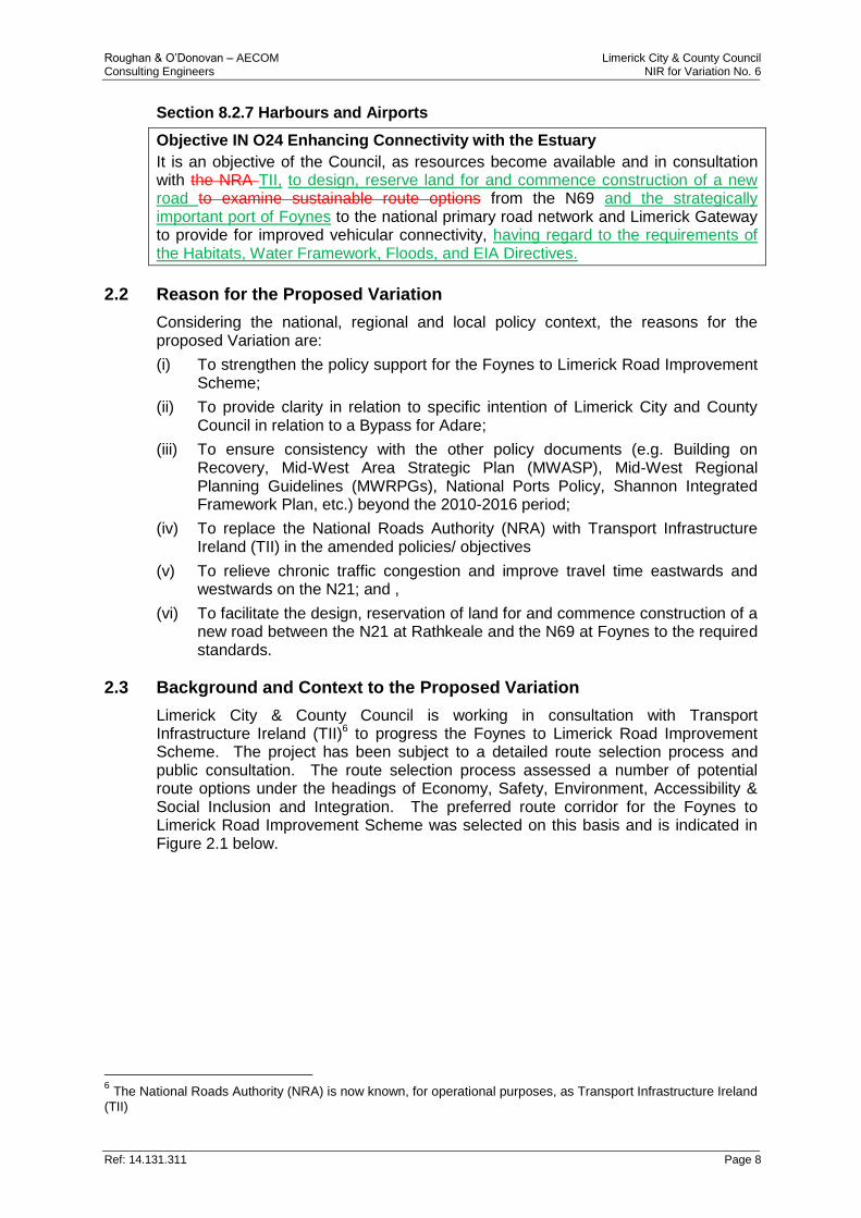
Section 8.2.7 Harbours and Airports
Objective IN O24 Enhancing Connectivity with the Estuary
It is an objective of the Council, as resources become available and in consultation with the NRA TII, to design, reserve land for and commence construction of a new road to examine sustainable route options from the N69 and the strategically important port of Foynes to the national primary road network and Limerick Gateway to provide for improved vehicular connectivity, having regard to the requirements of the Habitats, Water Framework, Floods, and EIA Directives.
2.2 Reason for the Proposed Variation
Considering the national, regional and local policy context, the reasons for the proposed Variation are:
(i) To strengthen the policy support for the Foynes to Limerick Road Improvement Scheme;
(ii) To provide clarity in relation to specific intention of Limerick City and County Council in relation to a Bypass for Adare;
(iii) To ensure consistency with the other policy documents (e.g. Building on Recovery, Mid-West Area Strategic Plan (MWASP), Mid-West Regional Planning Guidelines (MWRPGs), National Ports Policy, Shannon Integrated Framework Plan, etc.) beyond the 2010-2016 period;
(iv) To replace the National Roads Authority (NRA) with Transport Infrastructure Ireland (TII) in the amended policies/ objectives
(v) To relieve chronic traffic congestion and improve travel time eastwards and westwards on the N21; and ,
(vi) To facilitate the design, reservation of land for and commence construction of a new road between the N21 at Rathkeale and the N69 at Foynes to the required standards.
2.3 Background and Context to the Proposed Variation
Limerick City & County Council is working in consultation with Transport Infrastructure Ireland (TII)6 to progress the Foynes to Limerick Road Improvement Scheme. The project has been subject to a detailed route selection process and public consultation. The route selection process assessed a number of potential route options under the headings of Economy, Safety, Environment, Accessibility & Social Inclusion and Integration. The preferred route corridor for the Foynes to Limerick Road Improvement Scheme was selected on this basis and is indicated in Figure 2.1 below.
6 The National Roads Authority (NRA) is now known, for operational purposes, as Transport Infrastructure Ireland
(TII)
Roughan & O’Donovan – AECOM Limerick City & County Council Consulting Engineers NIR for Variation No. 6
Ref: 14.131.311 Page 9
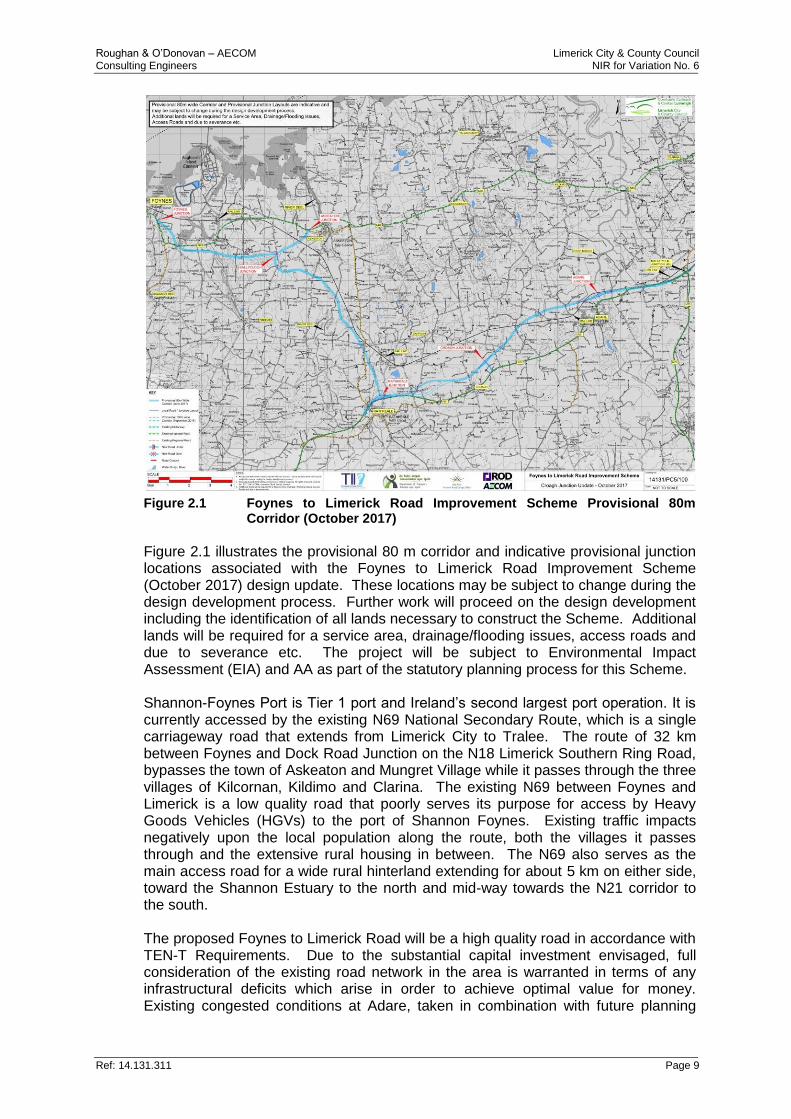
Figure 2.1 Foynes to Limerick Road Improvement Scheme Provisional 80m
Corridor (October 2017)
Figure 2.1 illustrates the provisional 80 m corridor and indicative provisional junction locations associated with the Foynes to Limerick Road Improvement Scheme (October 2017) design update. These locations may be subject to change during the design development process. Further work will proceed on the design development including the identification of all lands necessary to construct the Scheme. Additional lands will be required for a service area, drainage/flooding issues, access roads and due to severance etc. The project will be subject to Environmental Impact Assessment (EIA) and AA as part of the statutory planning process for this Scheme. Shannon-Foynes Port is Tier 1 port and Ireland’s second largest port operation. It is currently accessed by the existing N69 National Secondary Route, which is a single carriageway road that extends from Limerick City to Tralee. The route of 32 km between Foynes and Dock Road Junction on the N18 Limerick Southern Ring Road, bypasses the town of Askeaton and Mungret Village while it passes through the three villages of Kilcornan, Kildimo and Clarina. The existing N69 between Foynes and Limerick is a low quality road that poorly serves its purpose for access by Heavy Goods Vehicles (HGVs) to the port of Shannon Foynes. Existing traffic impacts negatively upon the local population along the route, both the villages it passes through and the extensive rural housing in between. The N69 also serves as the main access road for a wide rural hinterland extending for about 5 km on either side, toward the Shannon Estuary to the north and mid-way towards the N21 corridor to the south. The proposed Foynes to Limerick Road will be a high quality road in accordance with TEN-T Requirements. Due to the substantial capital investment envisaged, full consideration of the existing road network in the area is warranted in terms of any infrastructural deficits which arise in order to achieve optimal value for money. Existing congested conditions at Adare, taken in combination with future planning
Roughan & O’Donovan – AECOM Limerick City & County Council Consulting Engineers NIR for Variation No. 6
Ref: 14.131.311 Page 10
requirements for the road corridors to Cork and Tralee, were also considered in this regard. The N21 is a national primary road that connects Limerick City (via M20) to Tralee, County Kerry. It is approximately 84 km in length. From east to west, it travels through a number of settlements namely: Adare, Croagh, Newcastle West, Templeglatine and Abbeyfeale. It also bypasses the settlements of Rathkeale and Castleisland. As well as carrying local traffic, the road is typically used when travelling from Dublin, Limerick and Shannon Airport to Kerry, providing an important access to the south west, particularly for tourist traffic. Traffic on the N21 passing through the centre of Adare causes serious traffic congestion throughout the year. Congestion is particularly bad during daily peak times (morning and evening) and peak holiday periods where larger volumes of traffic cause tail-backs on the N21 on the approaches to Adare, resulting in significant delays to road users as well as journey time reliability issues. The need for a bypass for Adare has been identified as an infrastructure objective in national, regional and local policy documents.
2.4 The Route Selection Process
The purpose of the Route Selection Report (RSR) was to identify a suitable study area, to identify key constraints within that study area, to develop feasible route options and to carry out a systematic assessment of those options leading to the selection of a Preferred Route Corridor which is now the subject of the current Variation. The Route Selection Report was published in May 2016 and is available to the public online (https://www.foyneslimerick.ie/). It consists of three volumes: Volume 1 “Main Text”, Volume 2 “Drawings” and Volume 3 “Appendices”. Consideration of alternatives included considering the existing road characteristics of the N69, the N21 and the M20 and assessed the feasibility of the “Do-Nothing” and “Do-Minimum” alternatives for the Foynes to Limerick Road Improvement Scheme. The assessments addressed the deficiencies that these roads have in terms of modern road design standards and examined the potential for a Do-Minimum improvement of these roads. The Do-nothing and Do-Minimum alternatives were not deemed viable as they do not meet the scheme objectives to provide a core road network that meet the TEN-T Regulations. During the Route Selection process, four route corridors of 300 m in width were considered for assessment. These routes were compared against each other under the common appraisal headings of:
Environment;
Economy;
Safety;
Accessibility and Social Inclusion; and,
Integration. The examination of the route corridor options developed concluded that the general route identified in Figure 2.1 would permit a route to be developed which impacted least on the various categories while maintaining an optimal standard of geometric design. The main reasons for this choice include:
The existing N69 between Foynes and the Limerick Southern Ring Road is a low quality road that poorly serves its purpose for access by HGVs to the Port

Roughan & O’Donovan – AECOM Limerick City & County Council Consulting Engineers NIR for Variation No. 6
Ref: 14.131.311 Page 11
of Foynes due to deficient and inconsistent width, low speed and poor alignment with tight bends and restricted visibility;
There is a requirement to address the existing infrastructural deficit on the N21 corridor as evidenced by severe traffic delays in Adare. In this context, the preferred road development solution offers better value for money; and,
The selected route corridor option would permit a route to be developed which impacted least on the various categories including Natura 2000 and other ecological designations.
Roughan & O’Donovan – AECOM Limerick City & County Council Consulting Engineers NIR for Variation No. 6
Ref: 14.131.311 Page 12
3.0 NATURA 2000 SITES LIKELY TO BE AFFECTED
3.1 Determination of Likely Zone of Impact
Section 3.2.3 of the Guidance for Planning Authorities (DEHLG, 2010) details the procedure for selecting the Natura 2000 sites to be considered for Appropriate Assessment. It states that Natura 2000 sites potentially affected should be identified and listed, bearing in mind the potential for direct, indirect and/or cumulative effects. It also states that the specific approach in each case is likely to differ depending on the scale and likely effects of the plan or project. However, it advises that the following sites should generally be included:
All Natura 2000 sites within or immediately adjacent to the plan or project area;
All Natura 2000 sites within the likely zone of impact of the plan or project; and,
In accordance with the Precautionary Principle, all Natura 2000 sites for which there is doubt as to whether or not they might be significantly affected.
The “likely zone of impact” of a plan or project is the geographic extent over which significant ecological effects are likely to occur. In the case of plans, DEHLG (2010) recommends that this zone extend to a distance of 15km in all directions from the boundary of a plan area. In the case of projects, however, the guidance recognises that the likely zone of impact must be established on a case-by-case basis, with reference to the following key variables:
The nature, size and location of the project;
The sensitivities of the ecological receptors; and,
The potential for cumulative effects. For example, in the case of a project that could affect a watercourse, it may be necessary to include the entire upstream and/or downstream catchment in order to capture all Natura 2000 sites with water-dependent Special Conservation Interests or Qualifying Interests. Following the guidance provided in DEHLG (2010) and taking into account the reasons for the Proposed Variation, coupled with the route selection process and Design Update (October 2017) undertaken to date (as described in Section 2 above), the likely zone of impact was defined as the area within:
a 15 km buffer around the towns of Adare, Rathkeale and Foynes which have been named in the Proposed Variation, i.e. i) a bypass for the village of Adare and ii) a new road between Rathkeale and Foynes linking the N21 to the N69.
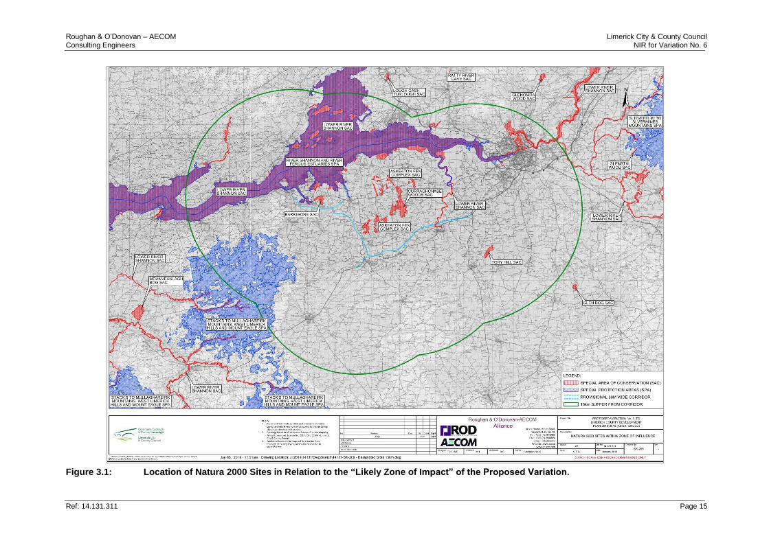
ArcView software was used in conjunction with publicly available Ordnance Survey Ireland maps and NPWS shapefiles to identify the boundaries of Natura 2000 sites in relation to the likely zone of impact. It was determined that seven Natura 2000 sites, namely the Lower River Shannon SAC, Curraghchase Woods SAC, Barrigone SAC, Askeaton Fen Complex SAC, Tory Hill SAC, River Shannon & River Fergus Estuaries SPA and Stack’s to Mullaghareirk Mountains, West Limerick Hills and Mount Eagle SPA, occur within the likely zone of impact. However as described in Section 1.6, the AA Screening carried out by Limerick City & County Council determined that the Proposed Variation has the potential to have a significant effect on only four Natura 2000 sites, namely the Lower River Shannon SAC, the Curraghchase Woods SAC, the Askeaton Fen Complex
Roughan & O’Donovan – AECOM Limerick City & County Council Consulting Engineers NIR for Variation No. 6
Ref: 14.131.311 Page 13
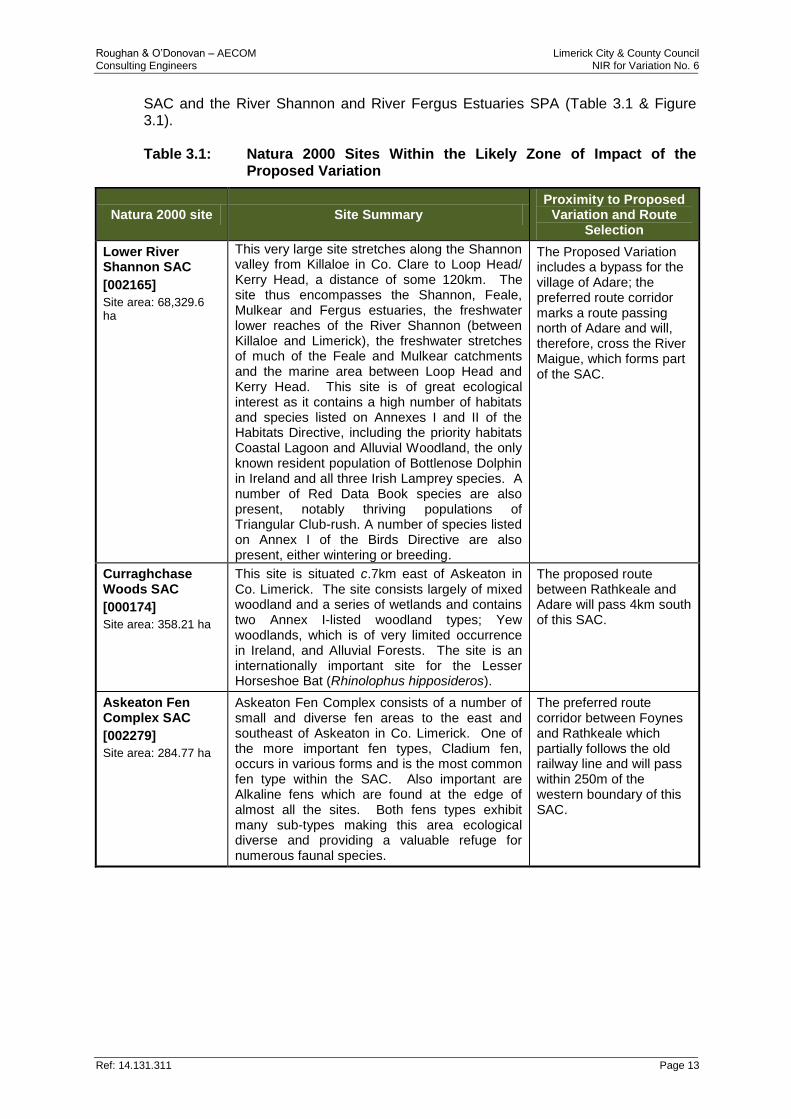
SAC and the River Shannon and River Fergus Estuaries SPA (Table 3.1 & Figure 3.1). Table 3.1: Natura 2000 Sites Within the Likely Zone of Impact of the
Proposed Variation
Natura 2000 site Site Summary Proximity to Proposed
Variation and Route Selection
Lower River Shannon SAC
[002165]
Site area: 68,329.6 ha
This very large site stretches along the Shannon valley from Killaloe in Co. Clare to Loop Head/ Kerry Head, a distance of some 120km. The site thus encompasses the Shannon, Feale, Mulkear and Fergus estuaries, the freshwater lower reaches of the River Shannon (between Killaloe and Limerick), the freshwater stretches of much of the Feale and Mulkear catchments and the marine area between Loop Head and Kerry Head. This site is of great ecological interest as it contains a high number of habitats and species listed on Annexes I and II of the Habitats Directive, including the priority habitats Coastal Lagoon and Alluvial Woodland, the only known resident population of Bottlenose Dolphin in Ireland and all three Irish Lamprey species. A number of Red Data Book species are also present, notably thriving populations of Triangular Club-rush. A number of species listed on Annex I of the Birds Directive are also present, either wintering or breeding.
The Proposed Variation includes a bypass for the village of Adare; the preferred route corridor marks a route passing north of Adare and will, therefore, cross the River Maigue, which forms part of the SAC.
Curraghchase Woods SAC
[000174]
Site area: 358.21 ha
This site is situated c.7km east of Askeaton in Co. Limerick. The site consists largely of mixed woodland and a series of wetlands and contains two Annex I-listed woodland types; Yew woodlands, which is of very limited occurrence in Ireland, and Alluvial Forests. The site is an internationally important site for the Lesser Horseshoe Bat (Rhinolophus hipposideros).
The proposed route between Rathkeale and Adare will pass 4km south of this SAC.
Askeaton Fen Complex SAC
[002279]
Site area: 284.77 ha
Askeaton Fen Complex consists of a number of small and diverse fen areas to the east and southeast of Askeaton in Co. Limerick. One of the more important fen types, Cladium fen, occurs in various forms and is the most common fen type within the SAC. Also important are Alkaline fens which are found at the edge of almost all the sites. Both fens types exhibit many sub-types making this area ecological diverse and providing a valuable refuge for numerous faunal species.
The preferred route corridor between Foynes and Rathkeale which partially follows the old railway line and will pass within 250m of the western boundary of this SAC.
Roughan & O’Donovan – AECOM Limerick City & County Council Consulting Engineers NIR for Variation No. 6
Ref: 14.131.311 Page 14
Natura 2000 site Site Summary Proximity to Proposed
Variation and Route Selection
River Shannon and River Fergus Estuaries SPA
[004077]
Site area: 32,252 ha
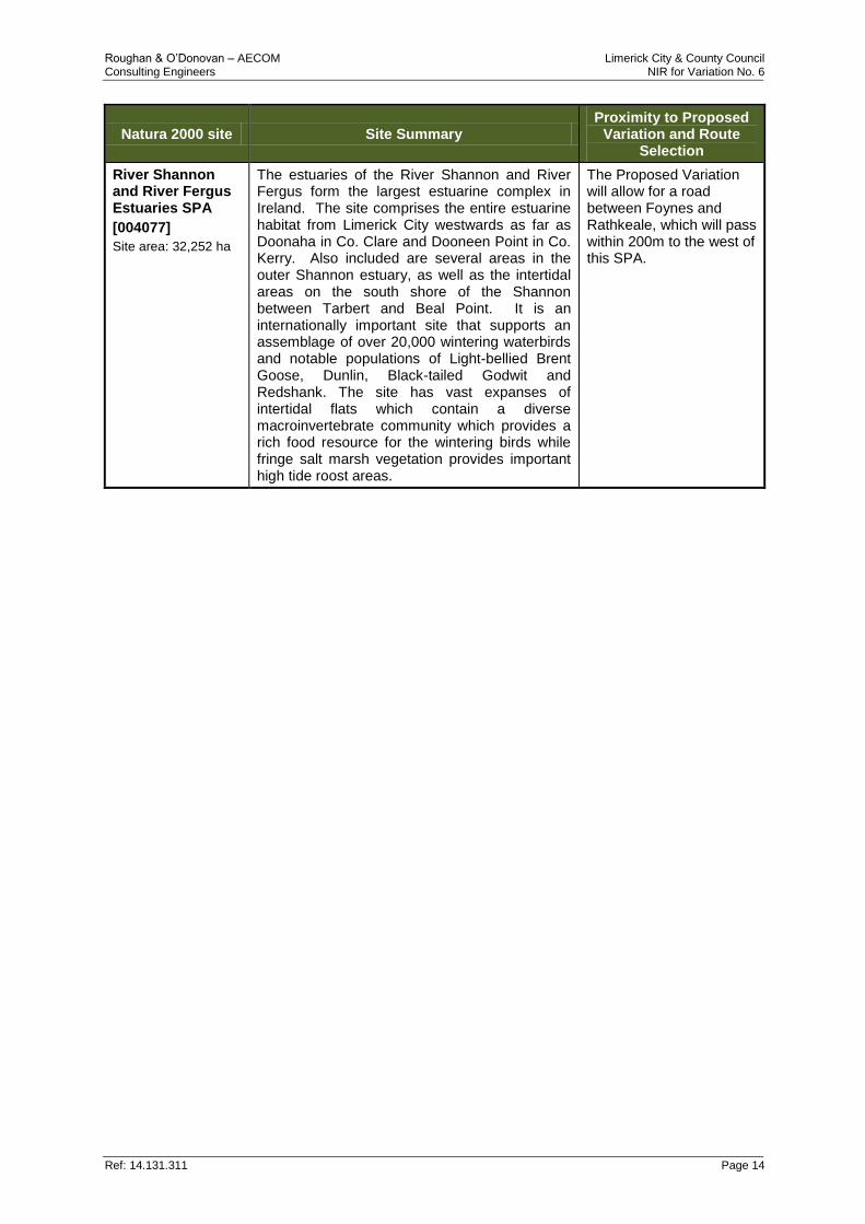
The estuaries of the River Shannon and River Fergus form the largest estuarine complex in Ireland. The site comprises the entire estuarine habitat from Limerick City westwards as far as Doonaha in Co. Clare and Dooneen Point in Co. Kerry. Also included are several areas in the outer Shannon estuary, as well as the intertidal areas on the south shore of the Shannon between Tarbert and Beal Point. It is an internationally important site that supports an assemblage of over 20,000 wintering waterbirds and notable populations of Light-bellied Brent Goose, Dunlin, Black-tailed Godwit and Redshank. The site has vast expanses of intertidal flats which contain a diverse macroinvertebrate community which provides a rich food resource for the wintering birds while fringe salt marsh vegetation provides important high tide roost areas.
The Proposed Variation will allow for a road between Foynes and Rathkeale, which will pass within 200m to the west of this SPA.
Roughan & O’Donovan – AECOM Limerick City & County Council Consulting Engineers NIR for Variation No. 6
Ref: 14.131.311 Page 15
Figure 3.1: Location of Natura 2000 Sites in Relation to the “Likely Zone of Impact” of the Proposed Variation.
Roughan & O’Donovan – AECOM Limerick City & County Council Consulting Engineers AA NIR Variation No. 6
Ref: 14.131.311 Page 16
3.2 Screening of Natura 2000 Sites
Each Qualifying Interest or Special Conservation Interest in each Natura 2000 site is assigned a Conservation Objective of either restoration or maintenance of its “favourable conservation condition”, as defined by a set of detailed Attributes with corresponding Targets that must be met if the Conservation Objective for that Qualifying Interest or Special Conservation Interest is to be achieved. The restoration and maintenance of the favourable conservation condition of habitats and species within Natura 2000 sites contributes to the overall conservation status of those habitats and species at a national level. What is meant by favourable conservation condition is described in more generic terms below. The favourable conservation condition of a habitat is achieved when:
Its natural range, and area it covers within that range, are stable or increasing;
The specific structures and functions necessary for its long-term maintenance exist and are likely to continue to exist for the foreseeable future; and,
The conservation condition of its typical species is favourable. The favourable conservation condition of a species is achieved when:
Population dynamics data on the species concerned indicate that it is maintaining itself on a long-term basis as a viable component of its natural habitats;
The natural range of the species is neither being reduced nor is likely to be reduced for the foreseeable future; and,
There is, and will probably continue to be, a sufficiently large habitat to maintain its populations on a long-term basis.
Site-specific Conservation Objectives for the Curraghchase Woods SAC, Barrigone SAC, Askeaton Fen Complex SAC, have not yet been developed, so generic Conservation Objectives apply. For the purposes of the AA, Conservation Objectives for the relevant Special Conservation Interests present in these SACs and SPAs were derived from the Killarney National Park SAC, Black Head-Poulsallagh Complex SAC and Lough Corrib SAC, an approach recommended by the NPWS in consultations on other plans and projects. The potential for likely significant effects on the Qualifying Interests of the Lower River Shannon SAC, the Curraghchase Woods SAC and the Askeaton Fen Complex SAC is assessed in view of the relevant Conservation Objectives in the Screening Matrices (Tables 4.1 to 4.3 in Section 4). The potential for likely significant effects on the Special Conservation Interests of the River Shannon and River Fergus Estuaries SPA is assessed in view of the relevant Conservation Objectives in the Screening Matrices (Table 4.4 in Section 4). Where potential pathways of risk between the Proposed Variation and the Qualifying Interest or Special Conservation Interest are identified, the likely effects on the relevant Conservation Objectives are assessed and their significance evaluated in view of their respective Attributes and Targets.
3.3 Natura 2000 Site Descriptions
3.3.1 Lower River Shannon SAC
This very large site stretches along the River Shannon from Killaloe to Loop Head/ Kerry Head, a distance of c. 120km. It encompasses the Shannon, Feale, Mulkear and Fergus estuaries, the freshwater lower reaches of the Shannon (between Killaloe and Limerick), the freshwater stretches of much of the Feale and Mulkear catchments
Roughan & O’Donovan – AECOM Limerick City & County Council Consulting Engineers AA NIR Variation No. 6
Ref: 14.131.311 Page 17
and the marine area between Loop Head and Kerry Head. The Shannon and Fergus Estuaries form the largest estuarine complex in Ireland. They form a unit stretching from the upper tidal limits of the Shannon and Fergus Rivers to the mouth of the Shannon Estuary. To the west of Foynes, a number of small estuaries form indentations in the predominantly hard coastline, namely Poulnasherry Bay, Ballylongford Bay, Clonderalaw Bay and the Feale or Cashen River estuary. This site is of great ecological interest as it contains a high number of habitats and species listed on Annexes I and II of the Habitats Directive, including the priority habitats Coastal Lagoon and Alluvial Woodland, and it also contains vast expanses of intertidal mudflats, often fringed with saltmarsh vegetation. The smaller estuaries also feature mudflats, but have their own unique characteristics with stony habitats and are unusually rich in species and biotopes. Saltmarsh vegetation frequently fringes the mudflats. Over twenty areas of estuarine saltmarsh have been identified within the site, the most important of which are around the Fergus estuary and at Ringmoylan Quay. Areas of Mediterranean salt meadows, characterised by clumps of Sea Rush (Juncus maritimus) occur occasionally. Two scarce species are found on saltmarshes in the vicinity of the Fergus estuary: a type of robust saltmarsh-grass (Puccinellia foucaudii), sometimes placed within the species Common Saltmarsh-grass (P. maritima) and Hard-grass (Parapholis strigosa). Saltmarsh vegetation also occurs around a number of lagoons within the site, two of which have been surveyed as part of a National Inventory of Lagoons; Cloonconeen Pool is a natural sedimentary lagoon impounded by a low cobble barrier. Seawater enters by percolation through the barrier and by overwash. This lagoon represents a type which may be unique to Ireland since the substrate is composed almost entirely of peat, and Shannon Airport Lagoon (2ha) is an artificial saline lake with an artificial barrier and sluiced outlet. However, it supports two Red Data Book species of stonewort (Chara canescens and Chara cf. connivens). The sea cliffs in the outer part of the site are sparsely vegetated with lichens, Red Fescue, Sea Beet (Beta vulgaris subsp. maritima), Sea Campion (Silene vulgaris subsp. maritima), Thrift and plantains (Plantago spp.). A rare endemic type of sealavender (Limonium recurvum subsp. pseudotranswallianum), occurs on sea cliffs One grassland type of particular conservation significance, Molinia meadows, occurs in semi-natural wet grassland, wet woodland and marsh that are found along the freshwater rivers in the site. Also present are distinct areas of floating river vegetation characterised by species of water-crowfoot (Ranunculus spp.), pondweeds (Potamogeton spp.) and the moss Fontinalius antipyretica. Alluvial woodland occurs on the banks of the Shannon and on islands near Limerick City, where the most prominent woodland type is gallery woodland has dominant White Willow (Salix alba) and a tree layer with occasional Alder (Alnus glutinosa). A number of plant species that are listed in the Irish Red Data Book occur within the site, and several of these are protected under the Flora (Protection) Order, 2015 (FPO). These include Triangular Club-rush (Scirpus triqueter), a species which is only found in Ireland only in the Shannon Estuary, where it borders creeks in the inner estuary. Opposite-leaved Pondweed (Groenlandia densa) is found in the Shannon where it passes through Limerick City, while Meadow Barley (Hordeum secalinum) is abundant in saltmarshes at Ringmoylan and Mantlehill. Hairy Violet (Viola hirta) occurs in the Askeaton/Foynes area. Golden Dock (Rumex maritimus) is noted as occurring in the River Fergus estuary.
Roughan & O’Donovan – AECOM Limerick City & County Council Consulting Engineers AA NIR Variation No. 6
Ref: 14.131.311 Page 18
This site is the most important coastal site in Ireland for a number of the waders including Lapwing, Dunlin, Snipe and Redshank. It also provides an important staging ground for species such as Black-tailed Godwit and Greenshank and other over-wintering wader and wildfowl include Greylag Goose, Shelduck, Wigeon, Teal, Mallard, Pintail, Shoveler, Tufted Duck, Scaup, Ringed Plover, Grey Plover, Lapwing, Knot, Dunlin, Snipe, Black-tailed Godwit, Curlew, Redshank, Greenshank and Turnstone. A number of species listed on Annex I of the E.U. Birds Directive breed within the site including Peregrine Falcon, Sandwich Tern, Common Tern, Chough and Kingfisher. This SAC has the only known resident population of Bottlenose Dolphin in Ireland and all three Irish Lamprey species. Two additional fish species of note, listed in the Irish Red Data Book, also occur, namely Smelt (Osmerus eperlanus) and Pollan (Coregonus autumnalis pollan). The Fergus is important in its lower reaches for spring salmon but while present Twaite Shad is not thought to spawn within the site. Other Annex II-listed species include the Otter, which is commonly found throughout the SAC and the Freshwater Pearl Mussel (Margaritifera margaritifera) which occurs abundantly in parts of the Cloon River. The site is a Special Area of Conservation (SAC) selected for the following habitats and/or species listed on Annex I / II of the E.U. Habitats Directive (* = priority; numbers in brackets are Natura 2000 codes):
[1110] Sandbanks
[1130] Estuaries
[1140] Tidal Mudflats and Sandflats
[1150] Coastal Lagoons*
[1160] Large Shallow Inlets and Bays
[1170] Reefs
[1220] Perennial Vegetation of Stony Banks
[1230] Vegetated Sea Cliffs
[1310] Salicornia Mud
[1330] Atlantic Salt Meadows
[1410] Mediterranean Salt Meadows
[3260] Floating River Vegetation
[6410] Molinia Meadows
[91E0] Alluvial Forests*
[1029] Freshwater Pearl Mussel (Margaritifera margaritifera)
[1095] Sea Lamprey (Petromyzon marinus)
[1096] Brook Lamprey (Lampetra planeri)
[1099] River Lamprey (Lampetra fluviatilis)
[1106] Atlantic Salmon (Salmo salar)
[1349] Bottle-nosed Dolphin (Tursiops truncatus)
[1355] Otter (Lutra lutra)
Roughan & O’Donovan – AECOM Limerick City & County Council Consulting Engineers AA NIR Variation No. 6
Ref: 14.131.311 Page 19
3.3.2 Curraghchase Woods SAC
This site is situated approximately 7km east of Askeaton in Co. Limerick. The area is characterised by glacial drift deposits over Carboniferous limestone. The site consists largely of mixed woodland and a series of wetlands. The site is a Special Area of Conservation (SAC) selected for the following habitats and/or species listed on Annex I / II of the E.U. Habitats Directive (* = priority; numbers in brackets are Natura 2000 codes):
[91E0] Alluvial Forests*
[91J0] Yew Woodlands*
[1303] Lesser Horseshoe Bat (Rhinolophus hipposideros) One of the main interests at the site is the presence of a hibernation site of the Lesser Horseshoe Bat (Rhinolophus hipposideros). The bats hibernate in the cellars of the former mansion Curraghchase House. The entrance to the cellar is now grilled and all other access points blocked to prevent disturbance. In recent years bats have remained within the cellar throughout the year. In winter 1995/96 more than 60 bats were recorded in the hibernation site, rating the site of international importance. It is considered that the number of bats will increase now that the site is protected from disturbance. This is the largest known site for this species in Co. Limerick. The woodland consists of both deciduous species and stands of commercial conifers. Beech (Fagus sylvatica) is the most frequent deciduous species, but Pedunculate Oak (Quercus robur), Ash (Fraxinus excelsior), Sycamore (Acer pseudoplatanus) and Hornbeam (Carpinus betulus) are also present. Spruce (Picea sp.) and Scots Pine (Pinus sylvestris) are the commonest conifers. Hazel (Corylus avellana) scrub and areas of wet woodland (Salix spp.) also occur. The alluvial forest occurs in the southern part of the site and occupies low ground in a stream valley and some areas adjacent to a small lake. The dominant canopy species include Rusty Willow (Salix cinerea subsp. oleifolia), Alder (Alnus glutinosa), Downy Birch (Betula pubescens) and Ash. A rich herb layer is found where the conifers are less dense, characterised by such species as Bugle (Ajuga reptans), Hemlock Water-dropwort (Oenanthe crocata), Yellow Iris (Iris pseudacorus), Meadowsweet (Filipendula ulmaria), Water-cress (Nasturtium officinale), Common Nettle (Urtica dioica) and Wood Sanicle (Sanicula europaea). The Yew wood occurs as a stand on a limestone ridge above a stream valley. It is associated with an Oak-Ash wood, but also has a range of commercial planted species. Nevertheless, Yew is well represented and is readily regenerating. Other species present include Holly (Ilex aquifolium), Ash, Pedunculate Oak, Hazel and Hawthorn (Crataegus monogyna). A series of small lakes and fens runs the length of the site. Some of these lakes are overgrown with vegetation. Black Bog-rush (Schoenus nigricans), Great Fen-sedge (Cladium mariscus), Greater Tussock-sedge (Carex paniculata), Carnation Sedge (Carex panicea) and Blunt-flowered Rush (Juncus subnodulosus) are some of the wetland species recorded. These wetlands, along with some wet grassland, add habitat diversity to the site.
Roughan & O’Donovan – AECOM Limerick City & County Council Consulting Engineers AA NIR Variation No. 6
Ref: 14.131.311 Page 20
The semi-natural habitats within the site provide ideal foraging habitat for the Lesser Horseshoe Bat. Further planting of conifer tree species at the expense of deciduous species should be avoided and attempts should be made to increase the area of deciduous woodland.
3.3.3 Askeaton Fen Complex SAC
The Askeaton fen complex consists of a number of small fen areas to the east and southeast of Askeaton in Co. Limerick. This area has a number of undulating hills, some of which are quite steep, and is underlain by Lower Carboniferous Limestone. At the base of the hills a series of fens/reedbeds/loughs can be found, often in association with marl or peat deposits. At the south-east of Askeaton, both Cappagh and Ballymorisheen fens are surrounded by large cliff-like rocky limestone outcrops. This site is selected for the following habitats and/or species listed on Annexes I and II of the Habitats Directive (* = priority; numbers in brackets = Natura 2000 codes):
[7210] Calcareous fens with Cladium mariscus and species of the Caricion davallianae*
[7230] Alkaline fens One of the more important fen types, Cladium fen, which contains Great Fen-sedge (Cladium mariscus), occurs in various forms and is the most common fen type within the SAC. It is associated with wet conditions generally not more than 25cm deep and can be found in mono-dominant stands growing on a marl base, such as at Feereagh and Mornane Loughs, and in the fen in the townland of Mornane. It can also be co-dominant with Common Reed in slightly drier conditions, such as in Deegerty, Blind Lough and Dromlohan. It is also found in association with alkaline fen species such as Black Bog-rush (Schoenus nigricans) where it grows on a peaty substrate. Cladium fen is indicative of extremely base rich conditions. Typical species seen growing with the Great Fen-sedge include pondweeds (Potamogeton spp.), Marsh Horsetail (Equisetum palustre), Water Horsetail (E. fluviatile), Lesser Water-parsnip (Berula erecta), Lesser Marshwort (Apium innundatum), Bottle Sedge (Carex rostrata), particularly where marl is present, and Water Mint (Mentha aquatica). One such area of fen within the site is the only known location in Ireland for the water beetle Hygrotus decoratus and is also known to contain Hydroporus scalesianus, a rare water beetle indicative of undisturbed fens. At the edge of some of the Great Fen-sedge fens, particularly where improved grassland is not present, there is typically found a gradation to wet marsh, which in turn grades into wet grassland. These transition habitats add to the ecological diversity of the site. Alkaline fen is characterised by the presence of Black Bog-rush in association with brown mosses and a small sedge community. The soil is permanently waterlogged but generally not flooded unless for a short period. Examples of this fen type are found at the edge of almost all the sites, but its extent is much less than the Great Fen-sedge fen type. The fen in the townlands of Moig West and Graigues is a good example of alkaline fen. Species seen growing with Black Bog-rush include Purple Moor-grass, Long-stalked Yellow-sedge (Carex lepidocarpa), Carnation Sedge (C. panicea), rushes (Juncus spp.) and an abundance of brown mosses, including Campylium stellatum, Ctenidium molluscum, Calliergon cuspidatum and Bryum pseudotriquetrum. This fen type also grades into marsh and wet grassland. Scrub and woodland is present on high ground in some areas, such as Ballymorisheen, Blind Lough, Ballyvogue, Dromlohan and Lough Feereagh. Species include Hawthorn, Blackthorn (Prunus spinosa), Gorse, Ash, Willow, Downy Birch and Hazel. This is a useful faunal habitat particularly as it is adjacent to reedbeds and fens.
Roughan & O’Donovan – AECOM Limerick City & County Council Consulting Engineers AA NIR Variation No. 6
Ref: 14.131.311 Page 21
A small area of limestone species-rich grassland is found to the north of Balinvirick Fen. Species found which are typically associated with the habitat include the Early Purple Orchid (Orchis mascula), Carline Thistle (Carlina vulgaris) and Mountain Everlasting (Antennaria dioica). Snipe use the tall marsh vegetation at the edge of the fens. Birds of prey such as Sparrowhawk feed over the reedbeds and scrubland areas of the site. Land-use in the area is quite intensive, with improved grassland extending down relatively steep slopes to the edge of the fens/loughs. New drainage or the deepening of existing drains poses a threat to the aquatic habitats at the site. In some instances, the fens appear to be drying out. This site is of conservation value as it supports two fen types, each of which exhibit many sub-types. Cladium fen is listed as an Annex I priority habitat. These wetland habitats of fen, reedbeds, open water, marsh and wet grassland are also valuable in that they supply a refuge for fauna in an otherwise intensively managed countryside.
3.3.4 River Shannon and River Fergus Estuaries SPA
This site comprises the entire estuarine habitat from Limerick City westwards as far as Doonaha in Co. Clare and Dooneen Point in Co. Kerry. The site has vast expanses of intertidal flats which contain a diverse macroinvertebrate community, e.g. Macoma-Scrobicularia-Nereis, which provides a rich food resource for the wintering birds. Saltmarsh vegetation frequently fringes the mudflats and this provides important high tide roost areas for the wintering birds. Elsewhere in the site, the shoreline comprises stony or shingle beaches. The site is of special conservation interest for the following (numbers in square brackets = Natura 2000 codes):
[A017] Cormorant (Phalacrocorax carbo);
[A038] Whooper Swan (Cygnus cygnus);
[A046] Light-bellied Brent Goose (Branta bernicla hrota);
[A048] Shelduck (Tadorna tadorna);
[A050] Wigeon (Anas penelope);
[A052] Teal (Anas crecca);
[A054] Pintail (Anas acuta);
[A056] Shoveler (Anas clypeata);
[A062] Scaup (Aythya marila);
[A137] Ringed Plover (Charadrius hiaticula);
[A140] Golden Plover (Pluvialis apricaria);
[A141] Grey Plover (Pluvialis squatarola);
[A142] Lapwing (Vanellus vanellus);
[A143] Knot (Calidris canutus);
[A149] Dunlin (Calidris alpina);
[A156] Black-tailed Godwit (Limosa limosa);
[A157] Bar-tailed Godwit (Limosa lapponica);
[A160] Curlew (Numenius arquata);
[A162] Redshank (Tringa totanus);
Roughan & O’Donovan – AECOM Limerick City & County Council Consulting Engineers AA NIR Variation No. 6
Ref: 14.131.311 Page 22
[A164] Greenshank (Tringa nebularia);
[A179] Black-headed Gull (Chroicocephalus ridibundus); and,
[A999] Wetlands and Waterbirds It is also of special conservation interest for holding an assemblage of over 20,000 wintering waterbirds. The site is the most important coastal wetland in the country and regularly supports in excess of 50,000 wintering waterfowl (a five-year mean of 57,133 for the period 1995/96 to 1999/2000), a concentration easily of international importance. The site has internationally important populations of Light-bellied Brent Goose (494), Dunlin (15,131), Black-tailed Godwit (2,035) and Redshank (2,645). A further 17 species have populations of national importance, i.e. Cormorant (245), Whooper Swan (118), Shelduck (1,025), Wigeon (3,761), Teal (2,260), Pintail (62), Shoveler (107), Scaup (102), Ringed Plover (223), Golden Plover (5,664), Grey Plover (558), Lapwing (15,126), Knot (2,015), Bar-tailed Godwit (460), Curlew (2,396), Greenshank (61) and Black-headed Gull (2,681). These figures are five-year mean peak counts for the period 1995/96 to 1999/2000. Of particular note is that three of the species that occur regularly, i.e. Whooper Swan, Golden Plover and Bar-tailed Godwit, are listed on Annex I of the Birds Directive. The site is among the most important in the country for several of these species, notably Dunlin (13 % of national total), Lapwing (6% of national total) and Redshank (9% of national total) and also supports a nationally important breeding population of Cormorant (93 pairs in 2010). Other species that occur include Mute Swan (103), Mallard (441), Red-breasted Merganser (20), Great Crested Grebe (50), Grey Heron (38), Oystercatcher (551), Turnstone (124) and Common Gull (445). These figures are also five-year mean peak counts for the period 1995/96 to 1999/2000. Apart from the wintering birds, large numbers of some species also pass through the site whilst on migration in spring and/or autumn. Parts of the River Shannon and River Fergus Estuaries SPA are Wildfowl Sanctuaries.
3.4 Conservation Objectives
The potential for likely significant effects on the Qualifying Interests and Special Conservation Interests of these SACs and SPAs is assessed in view of the relevant Conservation Objectives in the Screening Matrices Tables 4.1 to 4.7 below. Where potential impacts exist between the Proposed Variation and the Qualifying Interests or Special Conservation Interests are identified, the likely effects on the relevant Conservation Objectives are further assessed.
3.5 Desk Study and Ecological Surveys
In order to examine baseline ecological conditions and determine the presence and proximity of any Special Conservation Interests or Qualifying Interests of the Natura 2000 sites within the likely zone of impact for the Proposed Variation, data were obtained from statutory and non-statutory consultees and by a desk study. The results from the desk study undertaken throughout the Route Selection process were used to inform the design of initial multidisciplinary ecological surveys which have, in turn, been used to inform the ongoing design of the proposed Foynes to Limerick Road Improvement Scheme and the focus of the Proposed Variation. Many of the surveys are ongoing and will inform the Environmental Impact Assessment (EIA) and AA process as appropriate, at project level.
Roughan & O’Donovan – AECOM Limerick City & County Council Consulting Engineers AA NIR Variation No. 6
Ref: 14.131.311 Page 23
The desk study was undertaken in October 2017 and included reviews of reporting commissioned under Article 17 of the Habitats Directive7 (NPWS, 2013) and Article 12 of the Birds Directive8 (Eionet, 2017), Site Synopses, Standard Data Forms and Conservation Objectives for Natura 2000 sites, in particular for the Lower River Shannon SAC, Curraghchase Woods SAC, Barrigone SAC, Askeaton Fen Complex SAC, Tory Hill SAC, River Shannon and River Fergus Estuaries SPA and Stack’s to Mullaghareik Mountains, West Limerick Hills and Mount Eagle SPA, and the National Biodiversity Data Centre (NBDC) online database (NBDC, 2017). Records of rare and protected species within the areas implemented by the Proposed Variations to the Plan were obtained from the NPWS. As part of the route corridor selection phase, EirEco Environmental Consultants surveyed all key ecological receptors identified within the zone of influence of the Scheme (EirEco, 2015). Surveys were carried out in September 2014 to classify habitats present. Additional detailed botanical surveys were carried out in May 2015 on sites potentially supporting Annex I habitats outside of Natura 2000 sites. Major watercourses were also surveyed in May 2015. A number of bat surveys have been undertaken through the route selection process for the Foynes to Limerick Road Improvement Scheme in order to avoid and reduce significant impacts to these species particularly for the Annex II listed lesser horseshoe bat which is a qualifying interest for the Curraghchase SAC. Bat Surveys have been undertaken in accordance with the TII Guidelines for the eight route options in September and October, 2014. Further surveys of the four route options brought forward to the next stage of the Route Selection process were undertaken in May and September 2015, again in accordance with the TII Guidelines. A dusk-dawn summer and autumn survey of the preferred route option was undertaken in August and September 2016, while a winter and spring dusk-dawn of the same area is ongoing and results of this will feed into the EIAR at project level. Winter bird surveys have been conducted in the River Shannon and River Fergus Estuaries since the 1980s (Sheppard 1993) and more regularly since the mid 1990s (Crowe 2001). Whooper Swans are a winter migrant to Ireland and their presence in the area has been monitored through the winter bird surveys. Historically Whooper Swans are known to feed on the grass plains of the River Maigue during the period October – March. In recent monthly surveys undertaken for Whooper Swan in County Limerick by Gerry Murphy (Dec 2015 to March 2017), and from the latest report on waterfowl activity in the River Shannon and River Fergus Estuaries SPA (McCarthy Keville O’Sullivan Ltd. 2017) the favoured foraging areas are found to the north of the N69 road. However, in recent years (2016/17 winter survey) 19 Whooper Swans have been recorded near Cloonanna, approximately 5km north of the proposed crossing point (Figure 4.1), indicating that these birds can move south to utilise other suitable foraging areas. Similar grass plains are found in the Adare locality close to the proposed route which have the potential to be utilised by Whooper Swans. The data gathered and examined as part of the desk study and field surveys was used in the impact analysis in the following section (Section 4) of this NIR.
7 Every six years, Member States of the European Union are required by Article 17 of the Habitats Directive to
report on implementation of the Directive. The most recent reporting available is for the period 2007-2012. 8 Every three years, Member States of the European Union are required by Article 12 of the Birds Directive to
report on implementation of the Directive. The most recent reporting available is for the period 2008-2012.
Roughan & O’Donovan – AECOM Limerick City & County Council Consulting Engineers AA NIR Variation No. 6
Ref: 14.131.311 Page 24
4.0 ASSESSMENT OF POTENTIAL IMPACTS
4.1 Risk to Qualifying Interests/ Special Conservation Interests
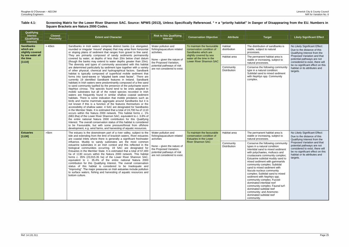
In Ecological and Environmental Impact Assessment, for an impact to occur there must be a risk enabled by having a “source”, e.g. construction works at a proposed development site, a “receptor”, e.g. an SAC or other ecologically sensitive feature, and a pathway between the source and the receptor, e.g. a watercourse connecting the proposed development site to the SAC. The risk of the impact does not automatically mean that it will occur or that it will be significant. However, identification of the risk does mean that there is a possibility of ecological or environmental damage occurring, with the level and significance of the impact depending upon the nature and exposure to the risk and the characteristics of the receptor. In the case of the Proposed Variation, sources of potential risk may include the loss and/or fragmentation of habitats, noise, vibration, lighting, pollution and mobilisation of sediment. Pathways that may convey these risks to ecological receptors include physical proximity, air, water and ecological interactions. The ecological receptors relevant to the AA are the Qualifying Interests of the Lower River Shannon SAC, the Curraghchase Woods SAC, the Askeaton Fen Complex SAC, and the River Shannon and River Fergus Estuaries SPA. The Screening Matrices (Tables 4.1 - 4.4 below) below identify the Qualifying Interests or Special Conservation Interests for each four Natura 2000 site within the likely zone of influence that are likely to be impacted and highlights all potential significant adverse impacts as a result of the Proposed Variation.
Roughan & O’Donovan – AECOM Limerick City & County Council Consulting Engineers NIR for Variation No. 6
Ref: 14.131.311 Page 25
Table 4.1: Screening Matrix for the Lower River Shannon SAC. Source: NPWS (2013), Unless Specifically Referenced. * = a “priority habitat” in Danger of Disappearing from the EU. Numbers in Square Brackets are Natura 2000 Codes.
Qualifying Interest
(Qualifying Interest)
Closest Proximity
Extent and Character Risk to this Qualifying
Interest Conservation Objective Attribute Target Likely Significant Effect
Sandbanks which are slightly covered by sea water all the time
[1110]
> 40km Sandbanks in Irish waters comprise distinct banks (i.e. elongated,
rounded or irregular ‘mound’ shapes) that may arise from horizontal or sloping plains of sediment that ranges from gravel to fine sand. They are primarily composed of sandy sediments permanently covered by water, at depths of less than 20m below chart datum (though the banks may extend to water depths greater than 20m). The diversity and types of community associated with this habitat are determined particularly by sediment type together with a variety of other physical, chemical and hydrographical factors. Sandbank habitat is typically composed of superficial mobile sediment that forms into sand-waves or “stippled bank crest facies”. There are currently 19 identified Sandbank features in Ireland. Sandbank habitats in Irish waters were predominantly composed of a fine sand to sand community typified by the presence of the polychaete worm Nephtys cirrosa. The species found tend to be ones adapted to mobile substrates but all of the noted species recorded in Irish waters are frequently found in similar shallow coastal sediment habitats. There is some indication that mobile predators such as birds and marine mammals aggregate around Sandbanks but it is not known if this is a function of the features themselves or the accessibility of shallow water. 4 SAC are designated for Sandbanks in the Member State. It is estimated that a total of 24,700 ha of 1110 occurs within the Natura 2000 network. This habitat forms c. 1% (683.3ha) of the Lower River Shannon SAC, equivalent to c. 3.8% of the entire national Natura 2000 contribution for this Qualifying Interest. The overall conservation status of this habitat is considered to be Favourable, but with some pressure/threat from offshore development, e.g. wind farms, and harvesting of aquatic resources.
Water pollution and fishing/aquaculture related activities.
None – given the nature of the Proposed Variation, potential pathways of risk are not considered to exist.
To maintain the favourable conservation condition of Sandbanks which are slightly covered by sea water all the time in the Lower River Shannon SAC
Habitat distribution
The distribution of sandbanks is stable, subject to natural processes.
No Likely Significant Effect:
Due to the distance of this Qualifying Interest from the Proposed Variation and that potential pathways are not considered to exist, there will be no significant effect on this habitat or its attributes and targets.
Habitat area The permanent habitat area is stable or increasing, subject to natural processes.
Community Distribution
Conserve the following community type in a natural condition: Subtidal sand to mixed sediment with Nephtys spp. Community complex.
Estuaries
[1130]
>5km The estuary is the downstream part of a river valley, subject to the tide and extending from the limit of brackish waters. River estuaries are coastal inlets where there is generally a significant freshwater influence. Muddy to sandy substrates are the most common estuarine substrates in an Irish context and this reflected in the biological communities occurring. 19 SAC are designated for Estuaries in the Member State. It is estimated that a total of 67,400 ha of 1130 occurs within the Natura 2000 network. This habitat forms c. 35% (23,915.35 ha) of the Lower River Shannon SAC, equivalent to c. 35.4% of the entire national Natura 2000 contribution for this Qualifying Interest. The overall conservation status of this habitat is considered to be Inadequate and “improving”. The major pressures on Irish estuaries include pollution to surface waters, fishing and harvesting of aquatic resources and bottom culture.
Water pollution and fishing/aquaculture related activities
None – given the nature of the Proposed Variation, potential pathways of risk are not considered to exist.
To maintain the favourable conservation condition of Estuaries in the Lower River Shannon SAC
Habitat area The permanent habitat area is stable or increasing, subject to natural processes.
No Likely Significant Effect:
Due to the distance of this Qualifying Interest from the Proposed Variation and that potential pathways are not considered to exist, there will be no significant effect on this habitat or its attributes and targets.
Community Distribution
Conserve the following community types in a natural condition: Intertidal sand to mixed sediment with polychaetes, molluscs and crustaceans community complex; Estuarine subtidal muddy sand to mixed sediment with gammarids community complex; Subtidal sand to mixed sediment with Nucula nucleus community
complex; Subtidal sand to mixed sediment with Nephtys spp. community complex; Fucoid-dominated intertidal reef community complex; Faunal turf-dominated subtidal reef community; and Anemone-dominated subtidal reef community.
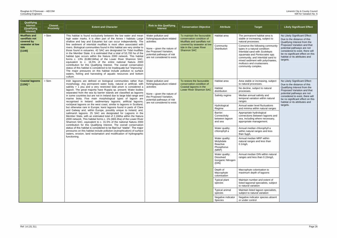
Roughan & O’Donovan – AECOM Limerick City & County Council Consulting Engineers NIR for Variation No. 6
Ref: 14.131.311 Page 26
Qualifying Interest
(Qualifying Interest)
Closest Proximity
Extent and Character Risk to this Qualifying
Interest Conservation Objective Attribute Target Likely Significant Effect
Mudflats and sandflats not covered by seawater at low tide
[1140]
> 5km This habitat is found exclusively between the low water and mean high water marks. It is often part of the Annex I habitats Large shallow and bay and Estuaries but can occur independently. The fine sediment of intertidal mudflats is most often associated with rivers. Biological communities found in this habitat are very similar to those found in estuaries. 42 SAC are designated for Tidal mudflats in the Member State. It is estimated that a total of 53,700 ha of the habitat type occurs within the Natura 2000 network. This habitat forms c. 13% (8,882.84ha) of the Lower River Shannon SAC, equivalent to c. 16.5% of the entire national Natura 2000 contribution for this Qualifying Interest. The overall conservation status of this habitat is considered to be Inadequate but “improving”. The major pressures on this habitat include pollution to surface waters, fishing and harvesting of aquatic resources and bottom culture.
Water pollution and fishing/aquaculture related activities
None – given the nature of the Proposed Variation, potential pathways of risk are not considered to exist.
To maintain the favourable conservation condition of Mudflats and sandflats not covered by seawater at low tide in the Lower River Shannon SAC
Habitat area The permanent habitat area is stable or increasing, subject to natural processes.
No Likely Significant Effect:
Due to the distance of this Qualifying Interest from the Proposed Variation and that potential pathways are not considered to exist, there will be no significant effect on this habitat or its attributes and targets.
Community Distribution
Conserve the following community types in a natural condition: Intertidal sand with Scolelepis squamata and Pontocrates spp. community; and Intertidal sand to mixed sediment with polychaetes, molluscs and crustaceans community complex.
Coastal lagoons
[1150] *
> 5km Irish lagoons are defined on biological communities rather than morphology. Any permanent water body, natural or artificial, with salinity > 1 psu and a very restricted tidal prism is considered a lagoon. The great majority have Ruppia sp. present. Water bodies separated from the sea by barrier islands are classified as lagoons in some countries but are not in Ireland due to large tidal range and marine biota. Five main morphological types of lagoon are recognised in Ireland: sedimentary lagoons; artificial lagoons; rock/peat lagoons on the west coast, similar to lagoons in Scotland, but otherwise rare in Europe; karst lagoons found in parts of Clare and Galway and, within Europe, possibly unique to Ireland; and, saltmarsh lagoons. 25 SAC are designated for Lagoons in the Member State, with an estimated total of 2,166ha within the Natura 2000 network. This habitat forms c. 1% (683.3ha) of the Lower River Shannon SAC, equivalent to c. 31.5% of the national Natura 2000 contribution for this Qualifying Interest. The overall conservation status of this habitat is considered to be Bad but “stable”. The major pressures on this habitat include pollution (eutrophication) of surface waters, erosion, land reclamation and modification of hydrographic functioning.
Water pollution and fishing/aquaculture related activities
None – given the nature of the Proposed Variation, potential pathways of risk are not considered to exist.
To restore the favourable conservation condition of Coastal lagoons in the Lower River Shannon SAC
Habitat area Area stable or increasing, subject to natural processes.
No Likely Significant Effect:
Due to the distance of this Qualifying Interest from the Proposed Variation and that potential pathways are not considered to exist, there will be no significant effect on this habitat or its attributes and targets.
Habitat distribution
No decline, subject to natural processes.
Salinity regime Median annual salinity and temporal variation within natural ranges
Hydrological Regime
Annual water level fluctuations and minima within natural ranges
Barrier: Connectivity between lagoon and sea
Appropriate hydrological connections between lagoons and sea, including where necessary, appropriate management.
Water quality: chlorophyll a
Annual median chlorophyll a within natural ranges and less than 5μg/L
Water quality: Molybdate Reactive Phosphorus (MRP)
Annual median MRP within natural ranges and less than 0.1mg/L
Water quality: Dissolved Inorganic Nitrogen (DIN)
Annual median DIN within natural ranges and less than 0.15mg/L
Depth of Macrophyte colonisation
Macrophyte colonisation to maximum depth of lagoons
Typical plant species
Maintain number and extent of listed lagoonal specialists, subject to natural variation
Typical animal species
Maintain listed lagoon specialists, subject to natural variation
Negative indicator Species
Negative indicator species absent or under control
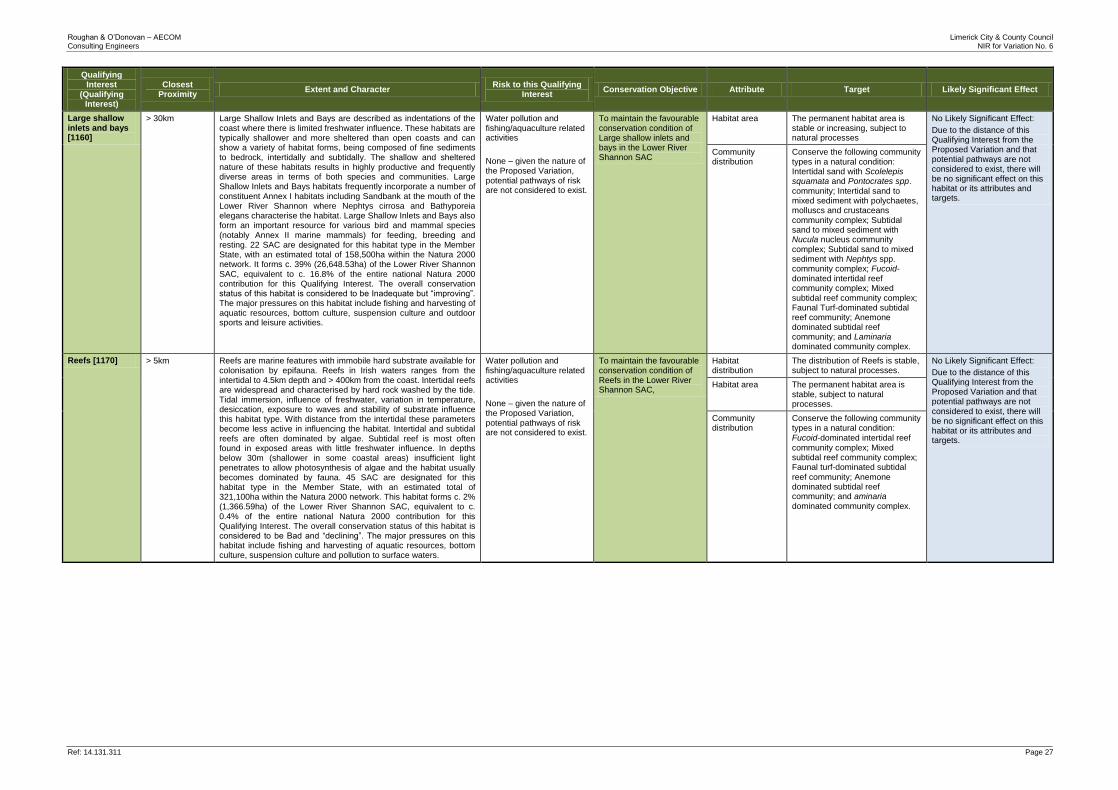
Roughan & O’Donovan – AECOM Limerick City & County Council Consulting Engineers NIR for Variation No. 6
Ref: 14.131.311 Page 27
Qualifying Interest
(Qualifying Interest)
Closest Proximity
Extent and Character Risk to this Qualifying
Interest Conservation Objective Attribute Target Likely Significant Effect
Large shallow inlets and bays [1160]
> 30km Large Shallow Inlets and Bays are described as indentations of the coast where there is limited freshwater influence. These habitats are typically shallower and more sheltered than open coasts and can show a variety of habitat forms, being composed of fine sediments to bedrock, intertidally and subtidally. The shallow and sheltered nature of these habitats results in highly productive and frequently diverse areas in terms of both species and communities. Large Shallow Inlets and Bays habitats frequently incorporate a number of constituent Annex I habitats including Sandbank at the mouth of the Lower River Shannon where Nephtys cirrosa and Bathyporeia elegans characterise the habitat. Large Shallow Inlets and Bays also form an important resource for various bird and mammal species (notably Annex II marine mammals) for feeding, breeding and resting. 22 SAC are designated for this habitat type in the Member State, with an estimated total of 158,500ha within the Natura 2000 network. It forms c. 39% (26,648.53ha) of the Lower River Shannon SAC, equivalent to c. 16.8% of the entire national Natura 2000 contribution for this Qualifying Interest. The overall conservation status of this habitat is considered to be Inadequate but “improving”. The major pressures on this habitat include fishing and harvesting of aquatic resources, bottom culture, suspension culture and outdoor sports and leisure activities.
Water pollution and fishing/aquaculture related activities
None – given the nature of the Proposed Variation, potential pathways of risk are not considered to exist.
To maintain the favourable conservation condition of Large shallow inlets and bays in the Lower River Shannon SAC
Habitat area The permanent habitat area is stable or increasing, subject to natural processes
No Likely Significant Effect:
Due to the distance of this Qualifying Interest from the Proposed Variation and that potential pathways are not considered to exist, there will be no significant effect on this habitat or its attributes and targets.
Community distribution
Conserve the following community types in a natural condition: Intertidal sand with Scolelepis squamata and Pontocrates spp. community; Intertidal sand to mixed sediment with polychaetes, molluscs and crustaceans community complex; Subtidal sand to mixed sediment with Nucula nucleus community complex; Subtidal sand to mixed sediment with Nephtys spp. community complex; Fucoid-dominated intertidal reef community complex; Mixed subtidal reef community complex; Faunal Turf-dominated subtidal reef community; Anemone dominated subtidal reef community; and Laminaria dominated community complex.
Reefs [1170] > 5km Reefs are marine features with immobile hard substrate available for colonisation by epifauna. Reefs in Irish waters ranges from the intertidal to 4.5km depth and > 400km from the coast. Intertidal reefs are widespread and characterised by hard rock washed by the tide. Tidal immersion, influence of freshwater, variation in temperature, desiccation, exposure to waves and stability of substrate influence this habitat type. With distance from the intertidal these parameters become less active in influencing the habitat. Intertidal and subtidal reefs are often dominated by algae. Subtidal reef is most often found in exposed areas with little freshwater influence. In depths below 30m (shallower in some coastal areas) insufficient light penetrates to allow photosynthesis of algae and the habitat usually becomes dominated by fauna. 45 SAC are designated for this habitat type in the Member State, with an estimated total of 321,100ha within the Natura 2000 network. This habitat forms c. 2% (1,366.59ha) of the Lower River Shannon SAC, equivalent to c. 0.4% of the entire national Natura 2000 contribution for this Qualifying Interest. The overall conservation status of this habitat is considered to be Bad and “declining”. The major pressures on this habitat include fishing and harvesting of aquatic resources, bottom culture, suspension culture and pollution to surface waters.
Water pollution and fishing/aquaculture related activities
None – given the nature of the Proposed Variation, potential pathways of risk are not considered to exist.
To maintain the favourable conservation condition of Reefs in the Lower River Shannon SAC,
Habitat distribution
The distribution of Reefs is stable, subject to natural processes.
No Likely Significant Effect:
Due to the distance of this Qualifying Interest from the Proposed Variation and that potential pathways are not considered to exist, there will be no significant effect on this habitat or its attributes and targets.
Habitat area The permanent habitat area is stable, subject to natural processes.
Community distribution
Conserve the following community types in a natural condition: Fucoid‐dominated intertidal reef
community complex; Mixed subtidal reef community complex; Faunal turf‐dominated subtidal
reef community; Anemone dominated subtidal reef community; and aminaria dominated community complex.
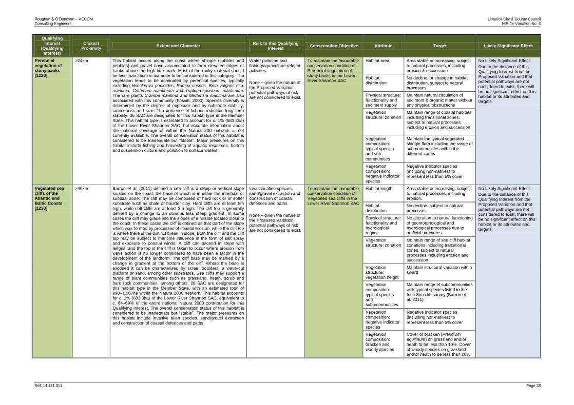
Roughan & O’Donovan – AECOM Limerick City & County Council Consulting Engineers NIR for Variation No. 6
Ref: 14.131.311 Page 28
Qualifying Interest
(Qualifying Interest)
Closest Proximity
Extent and Character Risk to this Qualifying
Interest Conservation Objective Attribute Target Likely Significant Effect
Perennial vegetation of stony banks [1220]
>24km This habitat occurs along the coast where shingle (cobbles and pebbles) and gravel have accumulated to form elevated ridges or banks above the high tide mark. Most of the rocky material should be less than 25cm in diameter to be considered in this category. The vegetation tends to be dominated by perennial species, typically including Honckenya peploides, Rumex crispus, Beta vulgaris ssp. maritima, Crithmum maritimum and Tripleurospermum maritimum. The rare plants Crambe maritima and Mertensia maritima are also
associated with this community (Fossitt, 2000). Species diversity is determined by the degree of exposure and by substrate stability, coarseness and size. The presence of lichens indicates long term stability. 36 SAC are designated for this habitat type in the Member State. This habitat type is estimated to account for c. 1% (683.3ha) of the Lower River Shannon SAC, but accurate information about the national coverage of within the Natura 200 network is not currently available. The overall conservation status of this habitat is considered to be Inadequate but “stable”. Major pressures on this habitat include fishing and harvesting of aquatic resources, bottom and suspension culture and pollution to surface waters.
Water pollution and fishing/aquaculture related activities
None – given the nature of the Proposed Variation, potential pathways of risk are not considered to exist.
To maintain the favourable conservation condition of Perennial vegetation of stony banks in the Lower River Shannon SAC
Habitat area Area stable or increasing, subject to natural processes, including erosion & succession
No Likely Significant Effect:
Due to the distance of this Qualifying Interest from the Proposed Variation and that potential pathways are not considered to exist, there will be no significant effect on this habitat or its attributes and targets.
Habitat distribution
No decline, or change in habitat distribution, subject to natural processes.
Physical structure: functionality and sediment supply
Maintain natural circulation of sediment & organic matter without any physical obstructions
Vegetation structure: zonation
Maintain range of coastal habitats including transitional zones, subject to natural processes including erosion and succession
Vegetation composition: typical species and sub‐ communities
Maintain the typical vegetated shingle flora including the range of sub-communities within the different zones
Vegetation composition: negative indicator species
Negative indicator species
(including non‐natives) to
represent less than 5% cover
Vegetated sea cliffs of the Atlantic and Baltic Coasts [1230]
>40km Barron et al. (2011) defined a sea cliff is a steep or vertical slope
located on the coast, the base of which is in either the intertidal or subtidal zone. The cliff may be composed of hard rock or of softer substrate such as shale or boulder clay. Hard cliffs are at least 5m high, while soft cliffs are at least 3m high. The cliff top is generally defined by a change to an obvious less steep gradient. In some cases the cliff may grade into the slopes of a hillside located close to the coast. In these cases the cliff is defined as that part of the slope which was formed by processes of coastal erosion, while the cliff top is where there is the distinct break in slope. Both the cliff and the cliff top may be subject to maritime influence in the form of salt spray and exposure to coastal winds. A cliff can ascend in steps with ledges, and the top of the cliff is taken to occur where erosion from wave action is no longer considered to have been a factor in the development of the landform. The cliff base may be marked by a change in gradient at the bottom of the cliff. Where the base is exposed it can be characterised by scree, boulders, a wave-cut platform or sand, among other substrates. Sea cliffs may support a range of plant communities such as grassland, heath, scrub and bare rock communities, among others. 28 SAC are designated for this habitat type in the Member State, with an estimated total of 990–1,067ha within the Natura 2000 network. This habitat accounts for c. 1% (683.3ha) of the Lower River Shannon SAC, equivalent to c. 64–69% of the entire national Natura 2000 contribution for this Qualifying Interest. The overall conservation status of this habitat is considered to be Inadequate but “stable”. The major pressures on this habitat include invasive alien species, sand/gravel extraction and construction of coastal defences and paths.
Invasive alien species, sand/gravel extraction and construction of coastal defences and paths.
None – given the nature of the Proposed Variation, potential pathways of risk are not considered to exist.
To maintain the favourable conservation condition of Vegetated sea cliffs in the Lower River Shannon SAC
Habitat length Area stable or increasing, subject to natural processes, including erosion.
No Likely Significant Effect:
Due to the distance of this Qualifying Interest from the Proposed Variation and that potential pathways are not considered to exist, there will be no significant effect on this habitat or its attributes and targets.
Habitat distribution
No decline, subject to natural processes
Physical structure: functionality and hydrological regime
No alteration to natural functioning of geomorphological and hydrological processes due to artificial structures
Vegetation structure: zonation
Maintain range of sea cliff habitat zonations including transitional zones, subject to natural processes including erosion and succession
Vegetation structure: vegetation height
Maintain structural variation within sward
Vegetation composition: typical species and sub‐communities
Maintain range of subcommunities with typical species listed in the Irish Sea cliff survey (Barron et al.,2011)
Vegetation composition: negative indicator species
Negative indicator species
(including non‐natives) to
represent less than 5% cover
Vegetation composition: bracken and woody species
Cover of bracken (Pteridium aquilinum) on grassland and/or
heath to be less than 10%. Cover of woody species on grassland and/or heath to be less than 20%
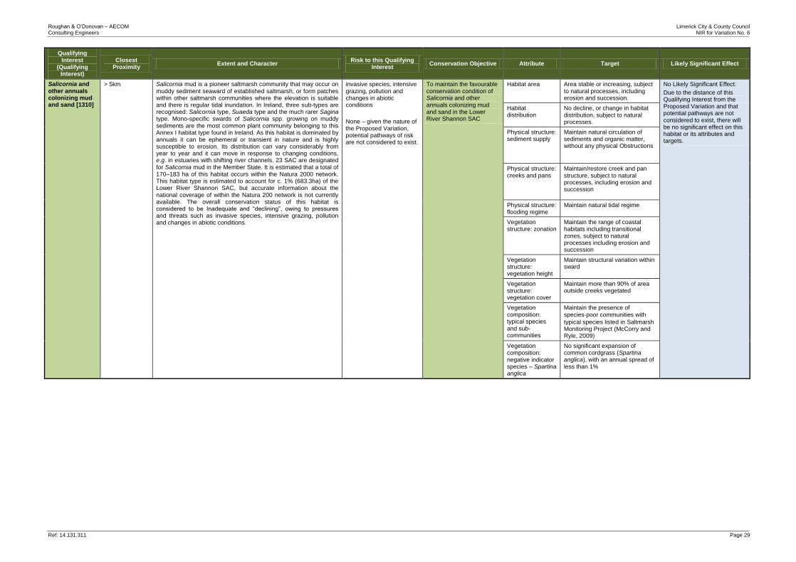
Roughan & O’Donovan – AECOM Limerick City & County Council Consulting Engineers NIR for Variation No. 6
Ref: 14.131.311 Page 29
Qualifying Interest
(Qualifying Interest)
Closest Proximity
Extent and Character Risk to this Qualifying
Interest Conservation Objective Attribute Target Likely Significant Effect
Salicornia and other annuals colonizing mud and sand [1310]
> 5km Salicornia mud is a pioneer saltmarsh community that may occur on
muddy sediment seaward of established saltmarsh, or form patches within other saltmarsh communities where the elevation is suitable and there is regular tidal inundation. In Ireland, three sub-types are recognised: Salicornia type, Suaeda type and the much rarer Sagina type. Mono-specific swards of Salicornia spp. growing on muddy sediments are the most common plant community belonging to this Annex I habitat type found in Ireland. As this habitat is dominated by annuals it can be ephemeral or transient in nature and is highly susceptible to erosion. Its distribution can vary considerably from year to year and it can move in response to changing conditions, e.g. in estuaries with shifting river channels. 23 SAC are designated for Salicornia mud in the Member State. It is estimated that a total of 170–183 ha of this habitat occurs within the Natura 2000 network. This habitat type is estimated to account for c. 1% (683.3ha) of the Lower River Shannon SAC, but accurate information about the national coverage of within the Natura 200 network is not currently available. The overall conservation status of this habitat is considered to be Inadequate and “declining”, owing to pressures and threats such as invasive species, intensive grazing, pollution and changes in abiotic conditions.
invasive species, intensive grazing, pollution and changes in abiotic conditions
None – given the nature of the Proposed Variation, potential pathways of risk are not considered to exist.
To maintain the favourable conservation condition of Salicornia and other annuals colonizing mud and sand in the Lower River Shannon SAC
Habitat area Area stable or increasing, subject to natural processes, including erosion and succession.
No Likely Significant Effect:
Due to the distance of this Qualifying Interest from the Proposed Variation and that potential pathways are not considered to exist, there will be no significant effect on this habitat or its attributes and targets.
Habitat distribution
No decline, or change in habitat distribution, subject to natural processes.
Physical structure: sediment supply
Maintain natural circulation of sediments and organic matter, without any physical Obstructions
Physical structure: creeks and pans
Maintain/restore creek and pan structure, subject to natural processes, including erosion and succession
Physical structure: flooding regime
Maintain natural tidal regime
Vegetation structure: zonation
Maintain the range of coastal habitats including transitional zones, subject to natural processes including erosion and succession
Vegetation structure: vegetation height
Maintain structural variation within sward
Vegetation structure: vegetation cover
Maintain more than 90% of area outside creeks vegetated
Vegetation composition: typical species and sub-communities
Maintain the presence of
species‐poor communities with
typical species listed in Saltmarsh Monitoring Project (McCorry and Ryle, 2009)
Vegetation composition: negative indicator species – Spartina anglica
No significant expansion of common cordgrass (Spartina anglica), with an annual spread of less than 1%
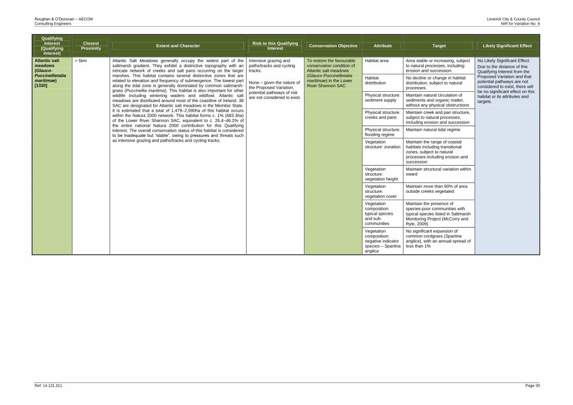
Roughan & O’Donovan – AECOM Limerick City & County Council Consulting Engineers NIR for Variation No. 6
Ref: 14.131.311 Page 30
Qualifying Interest
(Qualifying Interest)
Closest Proximity
Extent and Character Risk to this Qualifying
Interest Conservation Objective Attribute Target Likely Significant Effect
Atlantic salt meadows (Glauco-Puccinellietalia maritimae) [1330]
> 5km Atlantic Salt Meadows generally occupy the widest part of the saltmarsh gradient. They exhibit a distinctive topography with an intricate network of creeks and salt pans occurring on the larger marshes. This habitat contains several distinctive zones that are related to elevation and frequency of submergence. The lowest part along the tidal zone is generally dominated by common saltmarsh-grass (Puccinellia maritima). This habitat is also important for other wildlife including wintering waders and wildfowl. Atlantic salt meadows are distributed around most of the coastline of Ireland. 38 SAC are designated for Atlantic salt meadows in the Member State. It is estimated that a total of 1,479–2,590ha of this habitat occurs within the Natura 2000 network. This habitat forms c. 1% (683.3ha) of the Lower River Shannon SAC, equivalent to c. 26.4–46.2% of the entire national Natura 2000 contribution for this Qualifying Interest. The overall conservation status of this habitat is considered to be Inadequate but “stable”, owing to pressures and threats such as intensive grazing and paths/tracks and cycling tracks.
Intensive grazing and paths/tracks and cycling tracks.
None – given the nature of the Proposed Variation, potential pathways of risk are not considered to exist.
To restore the favourable conservation condition of Atlantic salt meadows (Glauco‐Puccinellietalia maritimae) in the Lower River Shannon SAC
Habitat area Area stable or increasing, subject to natural processes, including erosion and succession.
No Likely Significant Effect:
Due to the distance of this Qualifying Interest from the Proposed Variation and that potential pathways are not considered to exist, there will be no significant effect on this habitat or its attributes and targets.
Habitat distribution
No decline or change in habitat distribution, subject to natural processes.
Physical structure: sediment supply
Maintain natural circulation of sediments and organic matter, without any physical obstructions
Physical structure: creeks and pans
Maintain creek and pan structure, subject to natural processes, including erosion and succession
Physical structure: flooding regime
Maintain natural tidal regime
Vegetation structure: zonation
Maintain the range of coastal habitats including transitional zones, subject to natural processes including erosion and succession
Vegetation structure: vegetation height
Maintain structural variation within sward
Vegetation structure: vegetation cover
Maintain more than 90% of area outside creeks vegetated
Vegetation composition: typical species and sub-communities
Maintain the presence of
species‐poor communities with
typical species listed in Saltmarsh Monitoring Project (McCorry and Ryle, 2009)
Vegetation composition: negative indicator species – Spartina anglica
No significant expansion of common cordgrass (Spartina anglica), with an annual spread of less than 1%
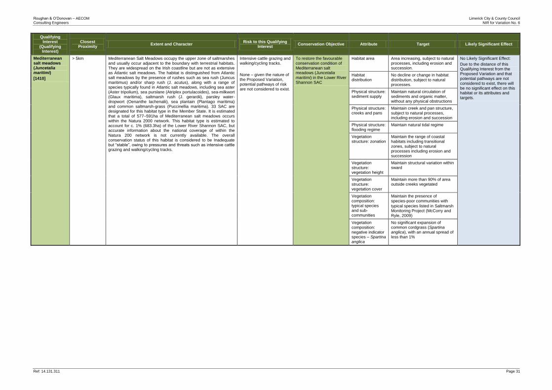
Roughan & O’Donovan – AECOM Limerick City & County Council Consulting Engineers NIR for Variation No. 6
Ref: 14.131.311 Page 31
Qualifying Interest
(Qualifying Interest)
Closest Proximity
Extent and Character Risk to this Qualifying
Interest Conservation Objective Attribute Target Likely Significant Effect
Mediterranean salt meadows (Juncetalia maritimi)
[1410]
> 5km Mediterranean Salt Meadows occupy the upper zone of saltmarshes and usually occur adjacent to the boundary with terrestrial habitats. They are widespread on the Irish coastline but are not as extensive as Atlantic salt meadows. The habitat is distinguished from Atlantic salt meadows by the presence of rushes such as sea rush (Juncus maritimus) and/or sharp rush (J. acutus), along with a range of species typically found in Atlantic salt meadows, including sea aster (Aster tripolium), sea purslane (Atriplex portulacoides), sea-milkwort (Glaux maritima), saltmarsh rush (J. gerardii), parsley water-dropwort (Oenanthe lachenalii), sea plantain (Plantago maritima) and common saltmarsh-grass (Puccinellia maritima). 33 SAC are designated for this habitat type in the Member State. It is estimated that a total of 577–591ha of Mediterranean salt meadows occurs within the Natura 2000 network. This habitat type is estimated to account for c. 1% (683.3ha) of the Lower River Shannon SAC, but accurate information about the national coverage of within the Natura 200 network is not currently available. The overall conservation status of this habitat is considered to be Inadequate but “stable”, owing to pressures and threats such as intensive cattle grazing and walking/cycling tracks.
Intensive cattle grazing and walking/cycling tracks.
None – given the nature of the Proposed Variation, potential pathways of risk are not considered to exist.
To restore the favourable conservation condition of Mediterranean salt meadows (Juncetalia maritimi) in the Lower River Shannon SAC
Habitat area Area increasing, subject to natural processes, including erosion and succession.
No Likely Significant Effect:
Due to the distance of this Qualifying Interest from the Proposed Variation and that potential pathways are not considered to exist, there will be no significant effect on this habitat or its attributes and targets.
Habitat distribution
No decline or change in habitat distribution, subject to natural processes.
Physical structure: sediment supply
Maintain natural circulation of sediments and organic matter, without any physical obstructions
Physical structure: creeks and pans
Maintain creek and pan structure, subject to natural processes, including erosion and succession
Physical structure: flooding regime
Maintain natural tidal regime
Vegetation structure: zonation
Maintain the range of coastal habitats including transitional zones, subject to natural processes including erosion and succession
Vegetation structure: vegetation height
Maintain structural variation within sward
Vegetation structure: vegetation cover
Maintain more than 90% of area outside creeks vegetated
Vegetation composition: typical species and sub-communities
Maintain the presence of
species‐poor communities with
typical species listed in Saltmarsh Monitoring Project (McCorry and Ryle, 2009)
Vegetation composition: negative indicator species – Spartina anglica
No significant expansion of common cordgrass (Spartina anglica), with an annual spread of less than 1%
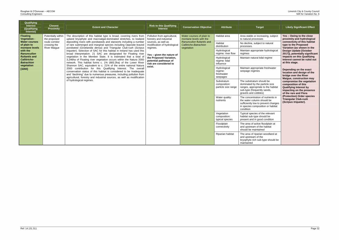
Roughan & O’Donovan – AECOM Limerick City & County Council Consulting Engineers NIR for Variation No. 6
Ref: 14.131.311 Page 32
Qualifying Interest
(Qualifying Interest)
Closest Proximity
Extent and Character Risk to this Qualifying
Interest Conservation Objective Attribute Target Likely Significant Effect
Floating Vegetation -Water courses of plain to montane levels with the Ranunculion fluitantis and Callitricho-Batrachion vegetation
[3260]
Potentially within the proposed route corridor crossing the River Maigue
The description of this habitat type is broad, covering rivers from upland bryophyte and macroalgal-dominated stretches, to lowland depositing rivers with pondweeds and starworts including a number of rare submerged and marginal species including Opposite-leaved pondweed (Groelandia densa) and Triangular Club-rush (Scirpus triqueter). Selection of SAC for this habitat in Ireland has used this broad interpretation. 21 SAC are designated for Floating river vegetation in the Member State. It is estimated that a total of 3,246ha of Floating river vegetation occurs within the Natura 2000 network. This habitat forms c. 1% (683.3ha) of the Lower River Shannon SAC, equivalent to c. 21% of the entire national Natura 2000 contribution for this Qualifying Interest. The overall conservation status of this habitat is considered to be Inadequate and “declining” due to numerous pressures, including pollution from agricultural, forestry and industrial sources, as well as modification of hydrological regimes.
Pollution from agricultural, forestry and industrial sources, as well as modification of hydrological regimes.
Yes – given the nature of the Proposed Variation, potential pathways of risk are considered to exist.
Water courses of plain to montane levels with the Ranunculion fluitantis and Callitricho‐Batrachion vegetation
Habitat area Area stable or increasing, subject to natural processes
Yes – Owing to the close proximity and hydrological connectivity of this habitat type to the Proposed Variation (as shown in the Design Update [October 2017]), potentially significant impacts on this Qualifying Interest cannot be ruled out at this stage.
Depending on the exact location and design of the bridge over the River Maigue, construction may compromise the vegetation composition of this Qualifying Interest by impacting on the presence of the rare and Flora (Protection) Order species Triangular Club-rush (Scirpus triqueter).
Habitat distribution
No decline, subject to natural processes.
Hydrological regime: river flow
Maintain appropriate hydrological regimes
Hydrological regime: tidal influence
Maintain natural tidal regime
Hydrological regime: freshwater seepages
Maintain appropriate freshwater seepage regimes
Substratum composition: particle size range
The substratum should be dominated by the particle size ranges, appropriate to the habitat sub‐type (frequently sands, gravels and cobbles)
Water quality: nutrients
The concentration of nutrients in the water column should be sufficiently low to prevent changes in species composition or habitat condition
Vegetation composition: typical species
Typical species of the relevant habitat sub‐type should be present and in good condition
Floodplain connectivity
The area of active floodplain at and upstream of the habitat should be maintained
Riparian habitat The area of riparian woodland at and upstream of the bryophyte‐rich sub‐type should be maintained
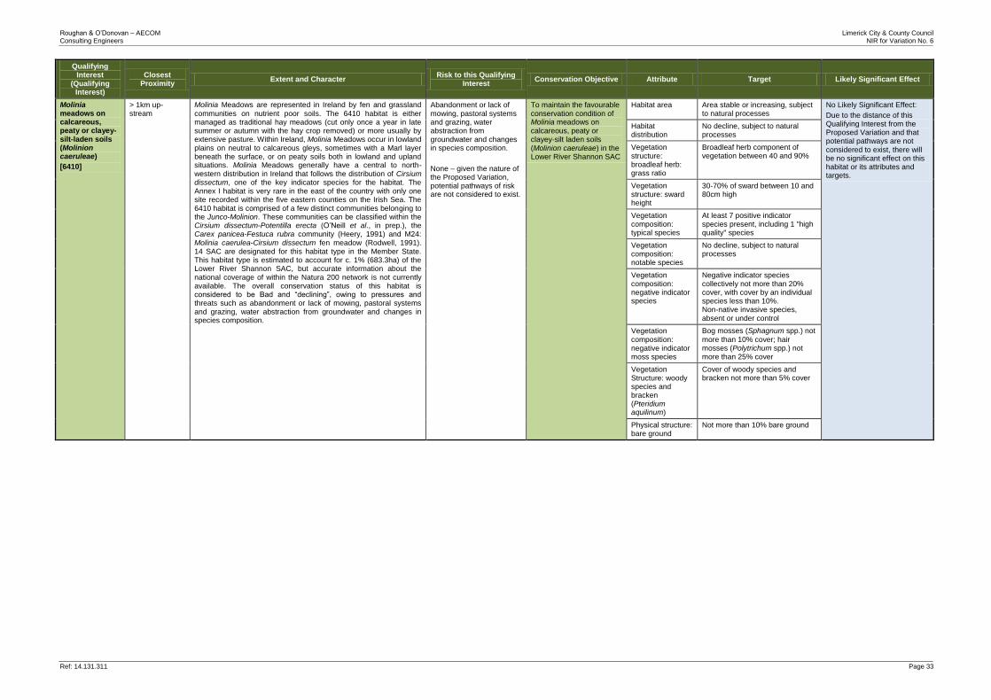
Roughan & O’Donovan – AECOM Limerick City & County Council Consulting Engineers NIR for Variation No. 6
Ref: 14.131.311 Page 33
Qualifying Interest
(Qualifying Interest)
Closest Proximity
Extent and Character Risk to this Qualifying
Interest Conservation Objective Attribute Target Likely Significant Effect
Molinia meadows on calcareous, peaty or clayey-silt-laden soils (Molinion caeruleae)
[6410]
> 1km up-stream
Molinia Meadows are represented in Ireland by fen and grassland
communities on nutrient poor soils. The 6410 habitat is either managed as traditional hay meadows (cut only once a year in late summer or autumn with the hay crop removed) or more usually by extensive pasture. Within Ireland, Molinia Meadows occur in lowland plains on neutral to calcareous gleys, sometimes with a Marl layer beneath the surface, or on peaty soils both in lowland and upland situations. Molinia Meadows generally have a central to north-western distribution in Ireland that follows the distribution of Cirsium dissectum, one of the key indicator species for the habitat. The Annex I habitat is very rare in the east of the country with only one site recorded within the five eastern counties on the Irish Sea. The 6410 habitat is comprised of a few distinct communities belonging to the Junco-Molinion. These communities can be classified within the Cirsium dissectum-Potentilla erecta (O’Neill et al., in prep.), the Carex panicea-Festuca rubra community (Heery, 1991) and M24: Molinia caerulea-Cirsium dissectum fen meadow (Rodwell, 1991). 14 SAC are designated for this habitat type in the Member State. This habitat type is estimated to account for c. 1% (683.3ha) of the Lower River Shannon SAC, but accurate information about the national coverage of within the Natura 200 network is not currently available. The overall conservation status of this habitat is considered to be Bad and “declining”, owing to pressures and threats such as abandonment or lack of mowing, pastoral systems and grazing, water abstraction from groundwater and changes in species composition.
Abandonment or lack of mowing, pastoral systems and grazing, water abstraction from groundwater and changes in species composition.
None – given the nature of the Proposed Variation, potential pathways of risk are not considered to exist.
To maintain the favourable conservation condition of Molinia meadows on calcareous, peaty or clayey‐silt laden soils (Molinion caeruleae) in the Lower River Shannon SAC
Habitat area Area stable or increasing, subject to natural processes
No Likely Significant Effect:
Due to the distance of this Qualifying Interest from the Proposed Variation and that potential pathways are not considered to exist, there will be no significant effect on this habitat or its attributes and targets.
Habitat distribution
No decline, subject to natural processes
Vegetation structure: broadleaf herb: grass ratio
Broadleaf herb component of vegetation between 40 and 90%
Vegetation structure: sward height
30‐70% of sward between 10 and 80cm high
Vegetation composition: typical species
At least 7 positive indicator species present, including 1 "high quality" species
Vegetation composition: notable species
No decline, subject to natural processes
Vegetation composition: negative indicator species
Negative indicator species collectively not more than 20% cover, with cover by an individual species less than 10%. Non‐native invasive species, absent or under control
Vegetation composition: negative indicator moss species
Bog mosses (Sphagnum spp.) not
more than 10% cover; hair mosses (Polytrichum spp.) not more than 25% cover
Vegetation Structure: woody species and bracken (Pteridium aquilinum)
Cover of woody species and bracken not more than 5% cover
Physical structure: bare ground
Not more than 10% bare ground
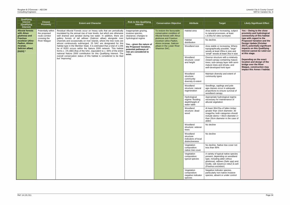
Roughan & O’Donovan – AECOM Limerick City & County Council Consulting Engineers NIR for Variation No. 6
Ref: 14.131.311 Page 34
Qualifying Interest
(Qualifying Interest)
Closest Proximity
Extent and Character Risk to this Qualifying
Interest Conservation Objective Attribute Target Likely Significant Effect
Alluvial forests with Alnus glutinosa and Fraxinus excelsior (Alno-Padion, Alnion incanae, Salicion albae)
[91E0] *
Potentially within the proposed route corridor crossing the River Maigue
Residual Alluvial Forests occur on heavy soils that are periodically inundated by the annual rise of river levels, but which are otherwise well drained and aerated during low water. In addition, there are gallery forests of tall willows (Salicion albae) alongside river
channels and occasionally on river islands, where the tree roots are almost continuously submerged. 25 SAC are designated for this habitat type in the Member State. It is estimated that a total of 1,046 ha of 91E0 occurs within the Natura 2000 network. This habitat forms c. 1% (683.3ha) of the SAC, equivalent to c. 65% of the entire national Natura 2000 contribution for this Qualifying Interest. The overall conservation status of this habitat is considered to be Bad but “improving”.
Inappropriate grazing, invasive species, clearance; changes to hydrological regime
Yes – given the nature of the Proposed Variation, potential pathways of risk are considered to exist.
To restore the favourable conservation condition of Alluvial forests with Alnus glutinosa and Fraxinus
excelsior (Alno‐Padion, Alnion incanae, Salicion albae) in the Lower River Shannon SAC,
Habitat area Area stable or increasing, subject to natural processes, at least c.8.5ha for sites surveyed.
Yes – Owing to the close proximity and hydrological connectivity of this habitat type with regard to the Proposed Variation and the Design Update [October 2017], potentially significant impacts on this Qualifying Interest cannot be ruled out at this stage.
Depending on the exact location and design of the bridge over the River Maigue, construction may impact this Annex I habitat.
Habitat distribution
No decline.
Woodland size Area stable or increasing. Where topographically possible, "large" woods at least 25ha in size and “small” woods at least 3ha in size
Woodland structure: cover and height
Diverse structure with a relatively closed canopy containing mature trees; sub-canopy layer with semi‐ mature trees and shrubs; and well‐developed herb layer
Woodland structure: community diversity & extent
Maintain diversity and extent of community types
Woodland structure: natural regeneration
Seedlings, saplings and pole age‐classes occur in adequate
proportions to ensure survival of woodland canopy
Hydrological regime: flooding depth/height of water table
Appropriate hydrological regime necessary for maintenance of alluvial vegetation
Woodland structure: dead wood
At least 30m³/ha of fallen timber greater than 10cm diameter; 30 snags/ha; both categories should include stems > 40cm diameter (> than 20cm diameter in the case of alder)
Woodland structure: veteran trees
No decline
Woodland structure: indicators of local distinctiveness
No decline
Vegetation composition: native tree cover
No decline. Native tree cover not less than 95%
Vegetation composition: typical species
A variety of typical native species present, depending on woodland type, including alder (Alnus glutinosa), willows (Salix spp) and, locally, oak (Quercus robur) & ash (Fraxinus excelsior)
Vegetation composition: negative indicator species
Negative indicator species, particularly non-native invasive species, absent or under control
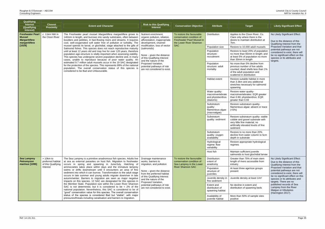
Roughan & O’Donovan – AECOM Limerick City & County Council Consulting Engineers NIR for Variation No. 6
Ref: 14.131.311 Page 35
Qualifying Interest
(Qualifying Interest)
Closest Proximity
Extent and Character Risk to this Qualifying
Interest Conservation Objective Attribute Target Likely Significant Effect
Freshwater Pearl Mussel Margaritifera margaritifera [1029]
c. 11km NW in the Cloon River
The Freshwater pearl mussel Margaritifera margaritifera grows to
140mm in length, and burrows into sandy substrates, often between boulders and pebbles, in fast-flowing rivers and streams. It requires cool, well-oxygenated soft water free of pollution or turbidity. The mussel spends its larval, or glochidial, stage attached to the gills of Salmonid fishes. This species does not reach reproductive maturity until at least 12 years old and may live for over 120 years, therefore population age-structure is vitally important when assessing viability. This species has undergone severe population decline and, in many cases, unable to reproduce because of poor water quality. An estimated 9.7 million adult mussels occur in the 19 SAC designated for the protection of the species. This represents 89% of the national population. The overall conservation status of this species is considered to be Bad and Unfavourable.
Nutrient enrichment, organic pollution, siltation, afforestation, inappropriate development, channel modification, loss of vector (salmonids)
None – given the distance of this Qualifying Interest and the nature of the Proposed Variation, potential pathways of risk are not considered to exist.
To restore the favourable conservation condition of Freshwater Pearl Mussel in the Lower River Shannon SAC
Distribution Applies to the Cloon River, Co. Clare only where there is the desire to maintain distribution at 7km.
No Likely Significant Effect:
Due to the distance of this Qualifying Interest from the Proposed Variation and that potential pathways are not considered to exist, there will be no significant effect on this species or its attributes and targets.
Population size Restore to 10,000 adult mussels
Population structure: recruitment
Restore to least 20% of population no more than 65mm in length; and at least 5% of population no more than 30mm in length
Population structure: adult mortality
No more than 5% decline from previous number of live adults counted; dead shells less than 1% of the adult population and scattered in distribution
Habitat extent Restore suitable habitat in more than 3.3km and any additional stretches necessary for salmonid spawning
Water quality: macroinvertebrate and phytobenthos (diatoms)
Restore water quality-macroinvertebrates: EQR greater than 0.90; phytobenthos: EQR greater than 0.93
Substratum quality: filamentous algae (macroalgae)
Restore substratum quality‐ filamentous algae: absent or trace (<5%)
Substratum quality: sediment
Restore substratum quality‐ stable
cobble and gravel substrate with very little fine material; no artificially elevated levels of fine sediment
Substratum quality: oxygen availability
Restore to no more than 20% decline from water column to 5cm depth in substrate
Hydrological regime: flow variability
Restore appropriate hydrological regimes
Host fish Maintain sufficient juvenile salmonids to host glochidial larvae
Sea Lamprey
Petromyzon marinus [1095]
> 10km to preferred habitat of this Qualifying Interest
The Sea Lamprey is a primitive anadromous fish species. Adults live at sea as external parasites on host fish. Migration to freshwater occurs in spring and spawning in June/July. Hatching of ammocoetes takes place within days and the immature lamprey swims or drifts downstream until it encounters an area of fine sediment into which it can burrow. Transformation to the adult stage occurs in late summer and young adults migrate downriver in late autumn/winter. Barriers to migration are seen as major negative impacts on this species. 12 SAC are designated for this species in the Member State. Population size within the Lower River Shannon SAC is not determined, but it is considered to be < 2% of the national population. Nevertheless, this SAC is considered to be of “good” conservation value for this species. The overall conservation status of the species is considered Bad but “stable”, with major pressures/threats including canalisation and barriers to migration.
Drainage maintenance works, barriers to migration, and pollution
None – given the distance from the preferred habitat of this Qualifying Interest and the nature of the Proposed Variation, potential pathways of risk are not considered to exist.
To restore the favourable conservation condition of Sea Lamprey in the Lower River Shannon SAC
Distribution: extent of anadromy
Greater than 75% of main stem length of rivers accessible from estuary
No Likely Significant Effect:
Due to the distance of this Qualifying Interest from the Proposed Variation and that potential pathways are not considered to exist, there will be no significant effect on this species or its attributes and targets. There are no published records of Sea Lamprey from the River Maigue or tributaries (Harrington 2017).
Population structure of juveniles
At least three age/size groups present
Juvenile density in fine sediment
Juvenile density at least 1/m²
Extent and distribution of spawning habitat
No decline in extent and distribution of spawning beds
Availability of juvenile habitat
More than 50% of sample sites positive
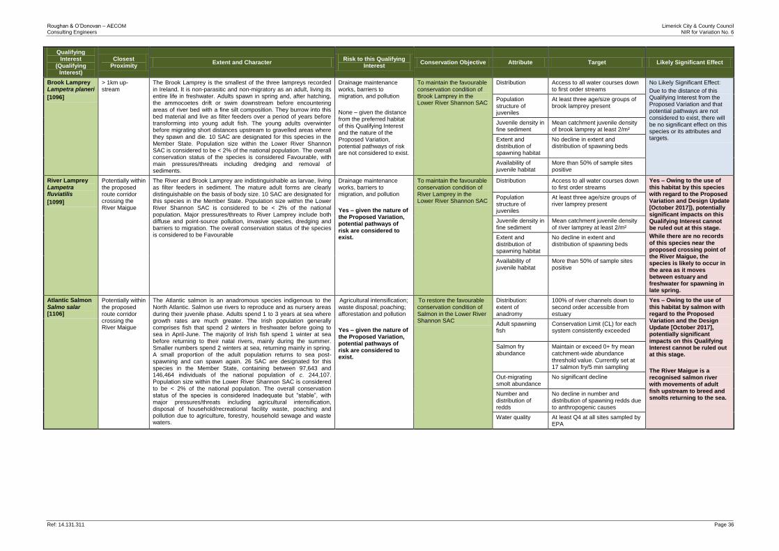
Roughan & O’Donovan – AECOM Limerick City & County Council Consulting Engineers NIR for Variation No. 6
Ref: 14.131.311 Page 36
Qualifying Interest
(Qualifying Interest)
Closest Proximity
Extent and Character Risk to this Qualifying
Interest Conservation Objective Attribute Target Likely Significant Effect
Brook Lamprey Lampetra planeri
[1096]
> 1km up-stream
The Brook Lamprey is the smallest of the three lampreys recorded in Ireland. It is non-parasitic and non-migratory as an adult, living its entire life in freshwater. Adults spawn in spring and, after hatching, the ammocoetes drift or swim downstream before encountering areas of river bed with a fine silt composition. They burrow into this bed material and live as filter feeders over a period of years before transforming into young adult fish. The young adults overwinter before migrating short distances upstream to gravelled areas where they spawn and die. 10 SAC are designated for this species in the Member State. Population size within the Lower River Shannon SAC is considered to be < 2% of the national population. The overall conservation status of the species is considered Favourable, with main pressures/threats including dredging and removal of sediments.
Drainage maintenance works, barriers to migration, and pollution
None – given the distance from the preferred habitat of this Qualifying Interest and the nature of the Proposed Variation, potential pathways of risk are not considered to exist.
To maintain the favourable conservation condition of Brook Lamprey in the Lower River Shannon SAC
Distribution Access to all water courses down to first order streams
No Likely Significant Effect:
Due to the distance of this Qualifying Interest from the Proposed Variation and that potential pathways are not considered to exist, there will be no significant effect on this species or its attributes and targets.
Population structure of juveniles
At least three age/size groups of brook lamprey present
Juvenile density in fine sediment
Mean catchment juvenile density of brook lamprey at least 2/m²
Extent and distribution of spawning habitat
No decline in extent and distribution of spawning beds
Availability of juvenile habitat
More than 50% of sample sites positive
River Lamprey
Lampetra fluviatilis
[1099]
Potentially within the proposed route corridor crossing the River Maigue
The River and Brook Lamprey are indistinguishable as larvae, living as filter feeders in sediment. The mature adult forms are clearly distinguishable on the basis of body size. 10 SAC are designated for this species in the Member State. Population size within the Lower River Shannon SAC is considered to be < 2% of the national population. Major pressures/threats to River Lamprey include both diffuse and point-source pollution, invasive species, dredging and barriers to migration. The overall conservation status of the species is considered to be Favourable
Drainage maintenance works, barriers to migration, and pollution
Yes – given the nature of the Proposed Variation, potential pathways of risk are considered to exist.
To maintain the favourable conservation condition of River Lamprey in the Lower River Shannon SAC
Distribution Access to all water courses down to first order streams
Yes – Owing to the use of this habitat by this species with regard to the Proposed Variation and Design Update [October 2017]), potentially significant impacts on this Qualifying Interest cannot be ruled out at this stage.
While there are no records of this species near the proposed crossing point of the River Maigue, the species is likely to occur in the area as it moves between estuary and freshwater for spawning in late spring.
Population structure of juveniles
At least three age/size groups of river lamprey present
Juvenile density in fine sediment
Mean catchment juvenile density of river lamprey at least 2/m²
Extent and distribution of spawning habitat
No decline in extent and distribution of spawning beds
Availability of juvenile habitat
More than 50% of sample sites positive
Atlantic Salmon
Salmo salar [1106]
Potentially within the proposed route corridor crossing the River Maigue
The Atlantic salmon is an anadromous species indigenous to the North Atlantic. Salmon use rivers to reproduce and as nursery areas during their juvenile phase. Adults spend 1 to 3 years at sea where growth rates are much greater. The Irish population generally comprises fish that spend 2 winters in freshwater before going to sea in April-June. The majority of Irish fish spend 1 winter at sea before returning to their natal rivers, mainly during the summer. Smaller numbers spend 2 winters at sea, returning mainly in spring. A small proportion of the adult population returns to sea post-spawning and can spawn again. 26 SAC are designated for this species in the Member State, containing between 97,643 and 146,464 individuals of the national population of c. 244,107. Population size within the Lower River Shannon SAC is considered to be < 2% of the national population. The overall conservation status of the species is considered Inadequate but “stable”, with major pressures/threats including agricultural intensification, disposal of household/recreational facility waste, poaching and pollution due to agriculture, forestry, household sewage and waste waters.
Agricultural intensification; waste disposal; poaching; afforestation and pollution
Yes – given the nature of the Proposed Variation, potential pathways of risk are considered to exist.
To restore the favourable conservation condition of Salmon in the Lower River Shannon SAC
Distribution: extent of anadromy
100% of river channels down to second order accessible from estuary
Yes – Owing to the use of this habitat by salmon with regard to the Proposed Variation and the Design Update [October 2017], potentially significant impacts on this Qualifying Interest cannot be ruled out at this stage.
The River Maigue is a recognised salmon river with movements of adult fish upstream to breed and smolts returning to the sea.
Adult spawning fish
Conservation Limit (CL) for each system consistently exceeded
Salmon fry abundance
Maintain or exceed 0+ fry mean catchment‐wide abundance
threshold value. Currently set at 17 salmon fry/5 min sampling
Out‐migrating smolt abundance
No significant decline
Number and distribution of redds
No decline in number and distribution of spawning redds due to anthropogenic causes
Water quality At least Q4 at all sites sampled by EPA
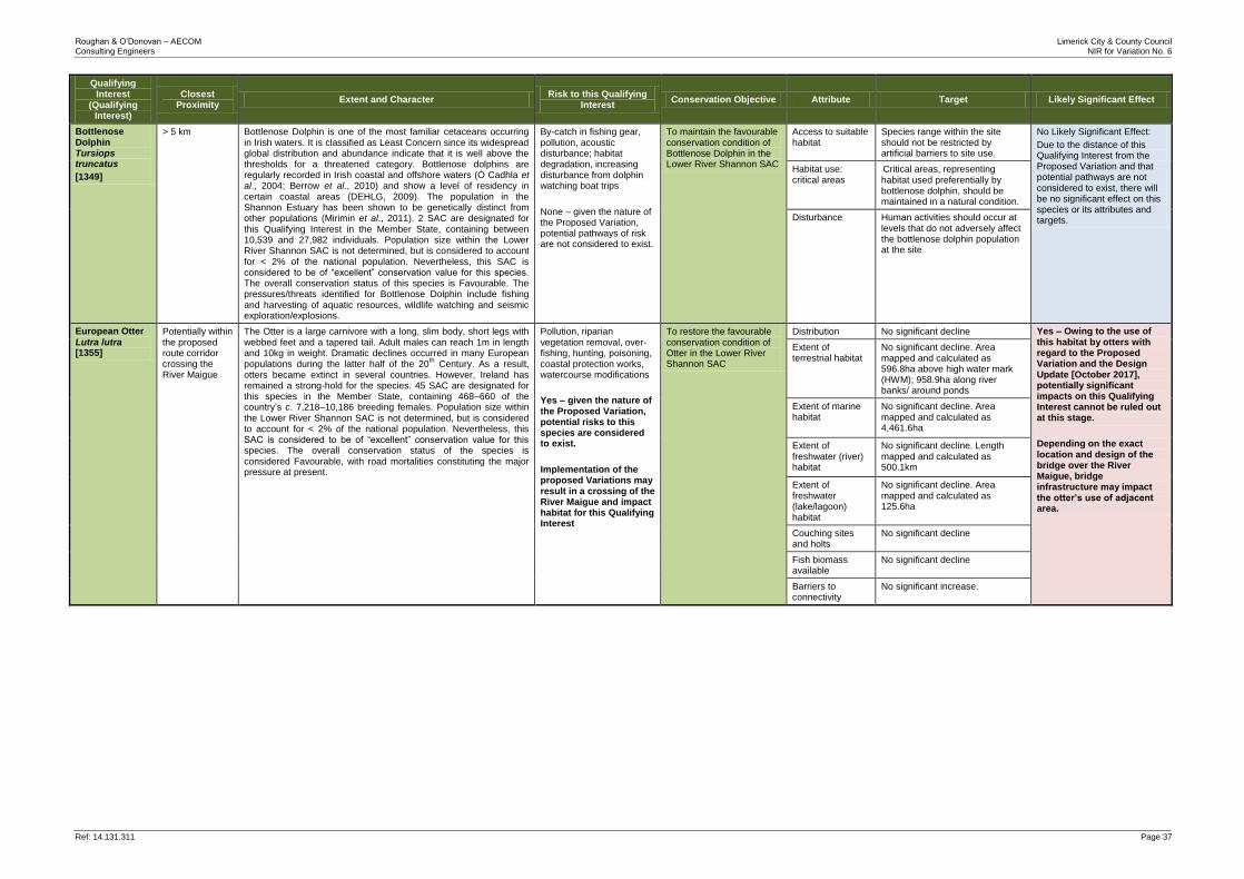
Roughan & O’Donovan – AECOM Limerick City & County Council Consulting Engineers NIR for Variation No. 6
Ref: 14.131.311 Page 37
Qualifying Interest
(Qualifying Interest)
Closest Proximity
Extent and Character Risk to this Qualifying
Interest Conservation Objective Attribute Target Likely Significant Effect
Bottlenose Dolphin Tursiops truncatus
[1349]
> 5 km Bottlenose Dolphin is one of the most familiar cetaceans occurring in Irish waters. It is classified as Least Concern since its widespread global distribution and abundance indicate that it is well above the thresholds for a threatened category. Bottlenose dolphins are regularly recorded in Irish coastal and offshore waters (Ó Cadhla et al., 2004; Berrow et al., 2010) and show a level of residency in certain coastal areas (DEHLG, 2009). The population in the Shannon Estuary has been shown to be genetically distinct from other populations (Mirimin et al., 2011). 2 SAC are designated for this Qualifying Interest in the Member State, containing between 10,539 and 27,982 individuals. Population size within the Lower River Shannon SAC is not determined, but is considered to account for < 2% of the national population. Nevertheless, this SAC is considered to be of “excellent” conservation value for this species. The overall conservation status of this species is Favourable. The pressures/threats identified for Bottlenose Dolphin include fishing and harvesting of aquatic resources, wildlife watching and seismic exploration/explosions.
By-catch in fishing gear, pollution, acoustic disturbance; habitat degradation, increasing disturbance from dolphin watching boat trips
None – given the nature of the Proposed Variation, potential pathways of risk are not considered to exist.
To maintain the favourable conservation condition of Bottlenose Dolphin in the Lower River Shannon SAC
Access to suitable habitat
Species range within the site should not be restricted by artificial barriers to site use.
No Likely Significant Effect:
Due to the distance of this Qualifying Interest from the Proposed Variation and that potential pathways are not considered to exist, there will be no significant effect on this species or its attributes and targets.
Habitat use: critical areas
Critical areas, representing habitat used preferentially by bottlenose dolphin, should be maintained in a natural condition.
Disturbance Human activities should occur at levels that do not adversely affect the bottlenose dolphin population at the site
European Otter
Lutra lutra [1355]
Potentially within the proposed route corridor crossing the River Maigue
The Otter is a large carnivore with a long, slim body, short legs with webbed feet and a tapered tail. Adult males can reach 1m in length and 10kg in weight. Dramatic declines occurred in many European populations during the latter half of the 20
th Century. As a result,
otters became extinct in several countries. However, Ireland has remained a strong-hold for the species. 45 SAC are designated for this species in the Member State, containing 468–660 of the country’s c. 7,218–10,186 breeding females. Population size within
the Lower River Shannon SAC is not determined, but is considered to account for < 2% of the national population. Nevertheless, this SAC is considered to be of “excellent” conservation value for this species. The overall conservation status of the species is considered Favourable, with road mortalities constituting the major pressure at present.
Pollution, riparian vegetation removal, over-fishing, hunting, poisoning, coastal protection works, watercourse modifications
Yes – given the nature of the Proposed Variation, potential risks to this species are considered to exist.
Implementation of the proposed Variations may result in a crossing of the River Maigue and impact habitat for this Qualifying Interest
To restore the favourable conservation condition of Otter in the Lower River Shannon SAC
Distribution No significant decline Yes – Owing to the use of this habitat by otters with regard to the Proposed Variation and the Design Update [October 2017], potentially significant impacts on this Qualifying Interest cannot be ruled out at this stage.
Depending on the exact location and design of the bridge over the River Maigue, bridge infrastructure may impact the otter’s use of adjacent area.
Extent of terrestrial habitat
No significant decline. Area mapped and calculated as 596.8ha above high water mark (HWM); 958.9ha along river banks/ around ponds
Extent of marine habitat
No significant decline. Area mapped and calculated as 4,461.6ha
Extent of freshwater (river) habitat
No significant decline. Length mapped and calculated as 500.1km
Extent of freshwater (lake/lagoon) habitat
No significant decline. Area mapped and calculated as 125.6ha
Couching sites and holts
No significant decline
Fish biomass available
No significant decline
Barriers to connectivity
No significant increase.
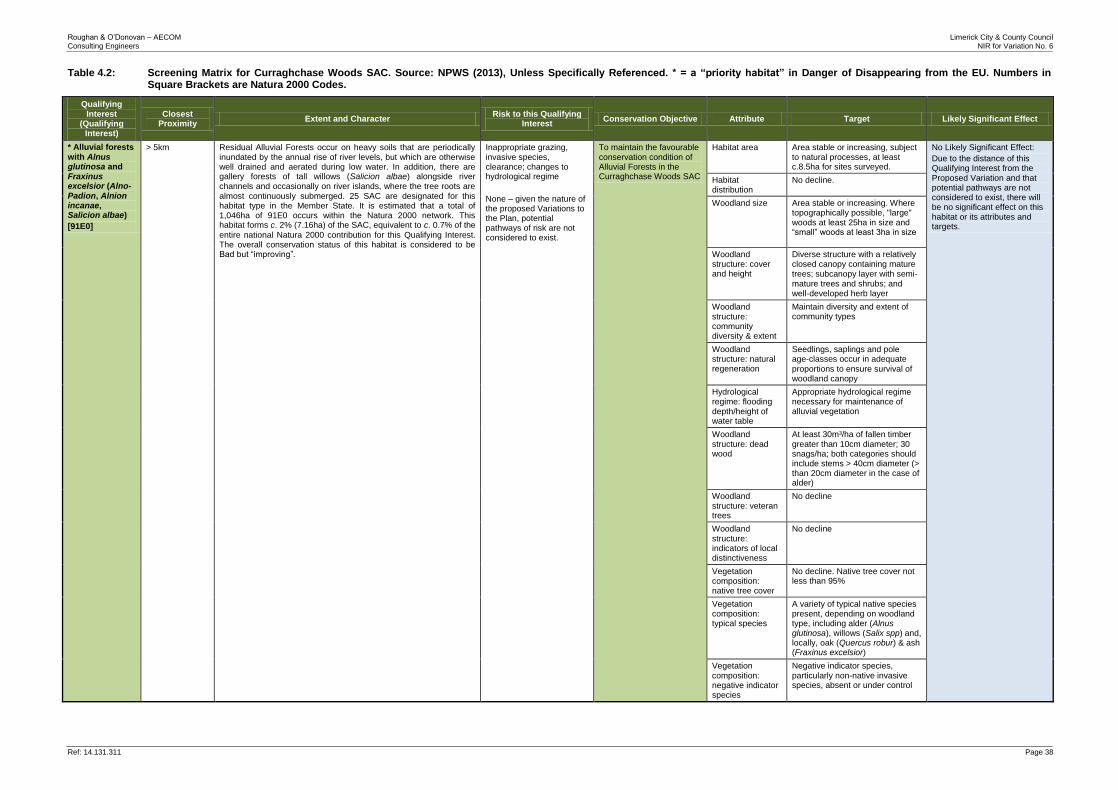
Roughan & O’Donovan – AECOM Limerick City & County Council Consulting Engineers NIR for Variation No. 6
Ref: 14.131.311 Page 38
Table 4.2: Screening Matrix for Curraghchase Woods SAC. Source: NPWS (2013), Unless Specifically Referenced. * = a “priority habitat” in Danger of Disappearing from the EU. Numbers in Square Brackets are Natura 2000 Codes.
Qualifying Interest
(Qualifying Interest)
Closest Proximity
Extent and Character Risk to this Qualifying
Interest Conservation Objective Attribute Target Likely Significant Effect
* Alluvial forests with Alnus glutinosa and Fraxinus excelsior (Alno-Padion, Alnion incanae, Salicion albae)
[91E0]
> 5km Residual Alluvial Forests occur on heavy soils that are periodically inundated by the annual rise of river levels, but which are otherwise well drained and aerated during low water. In addition, there are gallery forests of tall willows (Salicion albae) alongside river channels and occasionally on river islands, where the tree roots are almost continuously submerged. 25 SAC are designated for this habitat type in the Member State. It is estimated that a total of 1,046ha of 91E0 occurs within the Natura 2000 network. This habitat forms c. 2% (7.16ha) of the SAC, equivalent to c. 0.7% of the
entire national Natura 2000 contribution for this Qualifying Interest. The overall conservation status of this habitat is considered to be Bad but “improving”.
Inappropriate grazing, invasive species, clearance; changes to hydrological regime
None – given the nature of the proposed Variations to the Plan, potential pathways of risk are not considered to exist.
To maintain the favourable conservation condition of Alluvial Forests in the Curraghchase Woods SAC
Habitat area Area stable or increasing, subject to natural processes, at least c.8.5ha for sites surveyed.
No Likely Significant Effect:
Due to the distance of this Qualifying Interest from the Proposed Variation and that potential pathways are not considered to exist, there will be no significant effect on this habitat or its attributes and targets.
Habitat distribution
No decline.
Woodland size Area stable or increasing. Where topographically possible, "large" woods at least 25ha in size and “small” woods at least 3ha in size
Woodland structure: cover and height
Diverse structure with a relatively closed canopy containing mature trees; subcanopy layer with semi‐ mature trees and shrubs; and well‐developed herb layer
Woodland structure: community diversity & extent
Maintain diversity and extent of community types
Woodland structure: natural regeneration
Seedlings, saplings and pole age‐classes occur in adequate
proportions to ensure survival of woodland canopy
Hydrological regime: flooding depth/height of water table
Appropriate hydrological regime necessary for maintenance of alluvial vegetation
Woodland structure: dead wood
At least 30m³/ha of fallen timber greater than 10cm diameter; 30 snags/ha; both categories should include stems > 40cm diameter (> than 20cm diameter in the case of alder)
Woodland structure: veteran trees
No decline
Woodland structure: indicators of local distinctiveness
No decline
Vegetation composition: native tree cover
No decline. Native tree cover not less than 95%
Vegetation composition: typical species
A variety of typical native species present, depending on woodland type, including alder (Alnus glutinosa), willows (Salix spp) and, locally, oak (Quercus robur) & ash (Fraxinus excelsior)
Vegetation composition: negative indicator species
Negative indicator species, particularly non-native invasive species, absent or under control
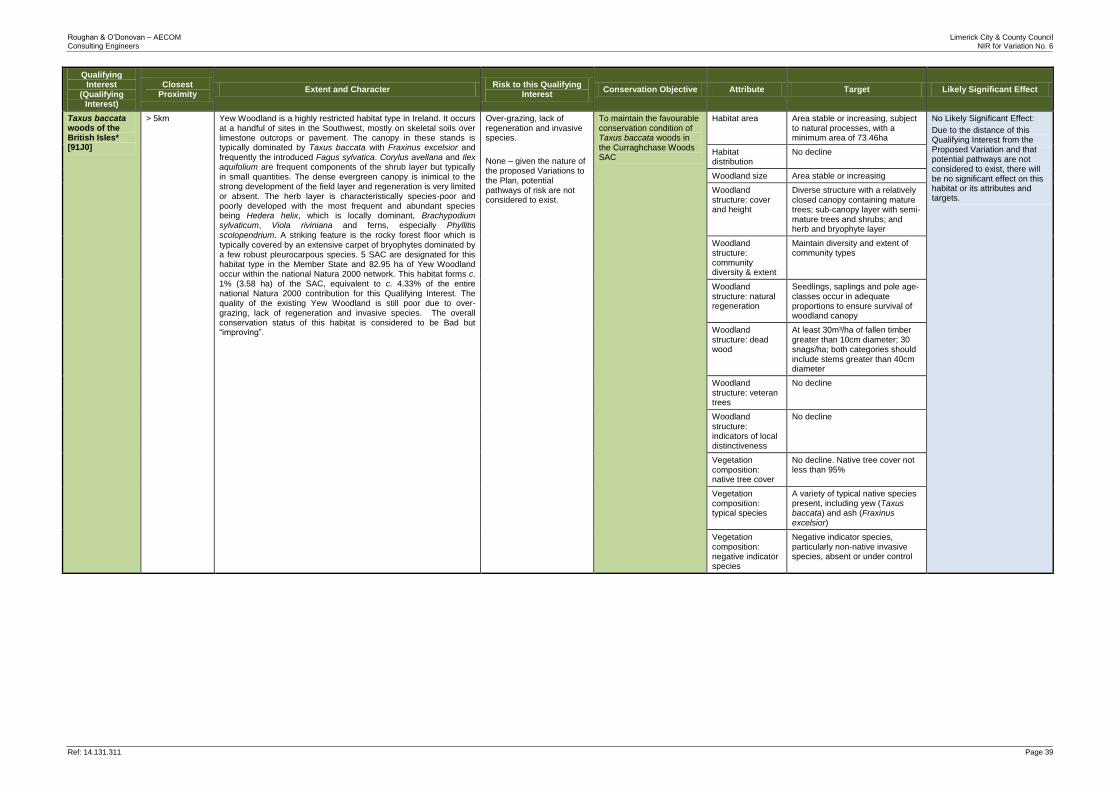
Roughan & O’Donovan – AECOM Limerick City & County Council Consulting Engineers NIR for Variation No. 6
Ref: 14.131.311 Page 39
Qualifying Interest
(Qualifying Interest)
Closest Proximity
Extent and Character Risk to this Qualifying
Interest Conservation Objective Attribute Target Likely Significant Effect
Taxus baccata woods of the British Isles* [91J0]
> 5km Yew Woodland is a highly restricted habitat type in Ireland. It occurs at a handful of sites in the Southwest, mostly on skeletal soils over limestone outcrops or pavement. The canopy in these stands is typically dominated by Taxus baccata with Fraxinus excelsior and frequently the introduced Fagus sylvatica. Corylus avellana and Ilex aquifolium are frequent components of the shrub layer but typically in small quantities. The dense evergreen canopy is inimical to the strong development of the field layer and regeneration is very limited or absent. The herb layer is characteristically species-poor and poorly developed with the most frequent and abundant species being Hedera helix, which is locally dominant, Brachypodium sylvaticum, Viola riviniana and ferns, especially Phyllitis scolopendrium. A striking feature is the rocky forest floor which is typically covered by an extensive carpet of bryophytes dominated by a few robust pleurocarpous species. 5 SAC are designated for this habitat type in the Member State and 82.95 ha of Yew Woodland occur within the national Natura 2000 network. This habitat forms c. 1% (3.58 ha) of the SAC, equivalent to c. 4.33% of the entire national Natura 2000 contribution for this Qualifying Interest. The quality of the existing Yew Woodland is still poor due to over-grazing, lack of regeneration and invasive species. The overall conservation status of this habitat is considered to be Bad but “improving”.
Over-grazing, lack of regeneration and invasive species.
None – given the nature of the proposed Variations to the Plan, potential pathways of risk are not considered to exist.
To maintain the favourable conservation condition of Taxus baccata woods in the Curraghchase Woods SAC
Habitat area Area stable or increasing, subject to natural processes, with a minimum area of 73.46ha
No Likely Significant Effect:
Due to the distance of this Qualifying Interest from the Proposed Variation and that potential pathways are not considered to exist, there will be no significant effect on this habitat or its attributes and targets.
Habitat distribution
No decline
Woodland size Area stable or increasing
Woodland structure: cover and height
Diverse structure with a relatively closed canopy containing mature trees; sub-canopy layer with semi-mature trees and shrubs; and herb and bryophyte layer
Woodland structure: community diversity & extent
Maintain diversity and extent of community types
Woodland structure: natural regeneration
Seedlings, saplings and pole age-classes occur in adequate proportions to ensure survival of woodland canopy
Woodland structure: dead wood
At least 30m³/ha of fallen timber greater than 10cm diameter; 30 snags/ha; both categories should include stems greater than 40cm diameter
Woodland structure: veteran trees
No decline
Woodland structure: indicators of local distinctiveness
No decline
Vegetation composition: native tree cover
No decline. Native tree cover not less than 95%
Vegetation composition: typical species
A variety of typical native species present, including yew (Taxus baccata) and ash (Fraxinus excelsior)
Vegetation composition: negative indicator species
Negative indicator species, particularly non-native invasive species, absent or under control
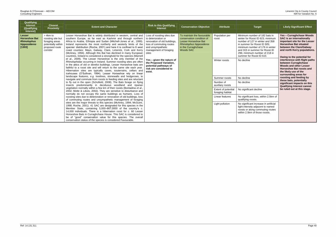
Roughan & O’Donovan – AECOM Limerick City & County Council Consulting Engineers NIR for Variation No. 6
Ref: 14.131.311 Page 40
Qualifying Interest
(Qualifying Interest)
Closest Proximity
Extent and Character Risk to this Qualifying
Interest Conservation Objective Attribute Target Likely Significant Effect
Lesser Horseshoe Bat Rhinolophus hipposideros [1303]
> 4km to roosting site but foraging areas potentially within proposed route corridor
Lesser Horseshoe Bat is widely distributed in western, central and southern Europe, as far east as Kashmir and through northern Africa to Arabia, Ethiopia and Sudan (Mitchell-Jones et al., 1999). Ireland represents the most northerly and westerly limits of the species’ distribution (Roche, 2001) and here it is confined to 6 west coast counties: Mayo, Galway, Clare, Limerick, Cork and Kerry (McAney, 1994). Although this Bat has declined in many European countries, Ireland is considered a stronghold for the species (Marnell et al., 2009). The Lesser Horseshoe is the only member of the Rhinolophidae occurring in Ireland. Summer roosting sites are often in the attics of old or derelict buildings. Lesser Horseshoe bats are faithful to a roost site and will return to the same site each year. Hibernation sites are typically caves, souterrains, cellars and icehouses (O’Sullivan, 1994). Lesser Horseshoe rely on linear landscape features, e.g. treelines, stonewalls and hedgerows, to navigate and commute from roosts to feeding sites and are reluctant to fly out in the open (Schofield, 2008). The Bats forage on flying insects predominantly in deciduous woodland and riparian vegetation normally within a few km of their roosts (Bontadina et al., 2002; Motte & Libois, 2002). They are sensitive to disturbance and normally do not occupy the same buildings as humans. Loss of roosting sites due to deterioration or renovation of old buildings, loss of commuting routes and unsympathetic management of foraging sites are the major threats to this species (McAney, 1994; McGuire, 1998; Roche, 2001). 41 SAC are designated for this species in the Member State, containing 5,000–667,0000 of the country’s c. 14,000 individuals. There is a hibernation roost for c. 60 Lesser Horseshoe Bats in Curraghchase House. This SAC is considered to be of “good” conservation value for this species. The overall conservation status of the species is considered Favourable.
Loss of roosting sites due to deterioration or renovation of old buildings, loss of commuting routes and unsympathetic management of foraging sites
Yes – given the nature of the Proposed Variation, potential pathways of risk are considered to exist.
To maintain the favourable conservation condition of Lesser Horseshoe Bat Rhinolophus hipposideros
in the Curraghchase Woods SAC
Population per roost
Minimum number of 182 bats in winter for Roost ID 623; minimum number of 127 in winter and 358 in summer for Roost ID 505; minimum number of 176 in winter and 315 in summer for Roost ID 296; minimum number of 218 in summer for Roost ID 615
Yes – Curraghchase Woods SAC is an internationally important site for the Lesser Horseshoe Bat situated between the Clare/Galway and north Kerry populations.
Owing to the potential for interference with flight paths between Curraghchase Woods and other Lesser Horseshoe Bat roosts and the likely use of the surrounding areas for roosting and feeding by these bats, potentially significant impacts on this Qualifying Interest cannot be ruled out at this stage.
Winter roosts No decline
Summer roosts No decline
Number of auxiliary roosts
No decline
Extent of potential foraging habitat
No significant decline
Linear features No significant loss, within 2.5km of qualifying roosts.
Light pollution No significant increase in artificial light intensity adjacent to named roosts or along commuting routes within 2.5km of those roosts.

Roughan & O’Donovan – AECOM Limerick City & County Council Consulting Engineers NIR for Variation No. 6
Ref: 14.131.311 Page 41
Table 4.3: Screening Matrix for Askeaton Fens Complex SAC. Source: NPWS (2013), Unless Specifically Referenced. * = a “priority habitat” in Danger of Disappearing from the EU. Numbers in Square Brackets are Natura 2000 Codes.
Qualifying Interest
Closest proximity
Extent and character Risk to this Qualifying
Interest Conservation Objective Attribute Target Likely Significant Effect
Calcareous fens with Cladium mariscus and species of the Caricion davallianae
[7210]
0.5km This fen type is often dominated by saw sedge (Cladium mariscus). Cladium fens occur in a variety of situations including fens found in valleys or depressions, floodplains, over-grown-ditches, extensive wet meadows, within tall reed beds, on the landward side of lakeshore communities, calcium rich flush areas in blanket bogs, dune slack areas, fens adjacent to raised and blanket bogs, in turloughs, wet hollows in machair and often in association with alkaline fen. The key ecological requirements are a high water table, a calcareous, low nutrient water supply and minimal water level fluctuation. The main pressures were identified as peat extraction, wetland reclamation and infilling. Wetland habitats are afforded additional protection under recent Agriculture Environmental Impact Assessment Regulations, however the Overall Status is considered to be Bad due to the pressures outlined; the overall trend is Unknown due to the absence of a national survey for this habitat.
Peat extraction, wetland reclamation and infilling.
Yes – given the nature of the Proposed Variation, potential pathways of risk are not considered to exist.
To maintain or restore the favourable conservation condition of Calcareous fens with Cladium mariscus and species of the Caricion davallianae in the
Askeaton Fen Complex SAC
Habitat area Area stable or increasing, subject to natural processes
Yes – Owing to the close proximity and hydrological connectivity of this habitat type with regard to the Proposed Variation and the Design Update [October 2017], potentially significant impacts on this Qualifying Interest cannot be ruled out at this stage.
Habitat distribution
No decline, subject to natural processes
Ecosystem function: hydrology
Maintain appropriate natural hydrological regimes necessary to support the natural structure and functioning of the habitat
Ecosystem function: peat formation
Maintain active peat formation, where appropriate
Ecosystem function: water quality
Maintain appropriate water quality, particularly nutrient levels, to support the natural structure and functioning of the habitat
Vegetation structure: typical species
Maintain vegetation cover of typical species including brown mosses and vascular plants
Vegetation composition: non-native species
Cover of non-native species less than 1%
Vegetation composition: trees and shrubs
Cover of scattered native trees and shrubs less than 10%
Physical structure: disturbed bare ground
Cover of disturbed bare ground not more than 10%. Where tufa is present, disturbed bare ground not more than 1%
Physical structure: drainage
Areas showing signs of drainage as a result of drainage ditches or heavy trampling not more than 10%
Indicators of local distinctiveness
No decline in distribution or population sizes of rare, threatened or scarce species associated with the habitat
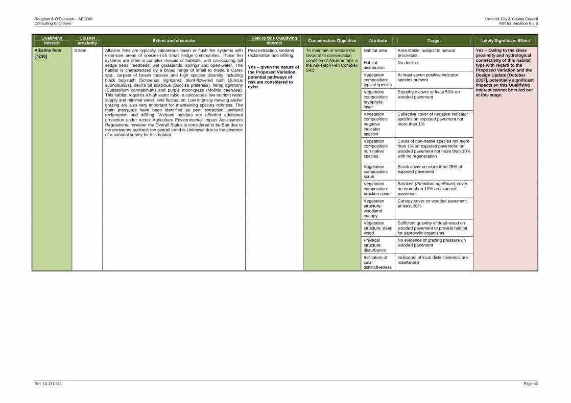
Roughan & O’Donovan – AECOM Limerick City & County Council Consulting Engineers NIR for Variation No. 6
Ref: 14.131.311 Page 42
Qualifying Interest
Closest proximity
Extent and character Risk to this Qualifying
Interest Conservation Objective Attribute Target Likely Significant Effect
Alkaline fens
[7230]
0.5km Alkaline fens are typically calcareous basin or flush fen systems with extensive areas of species-rich small sedge communities. These fen systems are often a complex mosaic of habitats, with co-occuring tall sedge beds, reedbeds, wet grasslands, springs and open-water. The habitat is characterised by a broad range of small to medium Carex spp., carpets of brown mosses and high species diversity including black bog-rush (Schoenus nigricans), blunt-flowered rush (Juncus subnodulous), devil’s bit scabious (Succisa pratensis), hemp agrimony (Eupatorium cannabinum) and purple moor-grass (Molinia caerulea). This habitat requires a high water table, a calcareous, low nutrient water supply and minimal water level fluctuation. Low intensity mowing and/or grazing are also very important for maintaining species richness. The main pressures have been identified as peat extraction, wetland reclamation and infilling. Wetland habitats are afforded additional protection under recent Agriculture Environmental Impact Assessment Regulations, however the Overall Status is considered to be Bad due to the pressures outlined; the overall trend is Unknown due to the absence of a national survey for this habitat.
Peat extraction, wetland reclamation and infilling.
Yes – given the nature of the Proposed Variation, potential pathways of risk are considered to exist.
To maintain or restore the favourable conservation condition of Alkaline fens in the Askeaton Fen Complex SAC
Habitat area Area stable, subject to natural processes
Yes – Owing to the close proximity and hydrological connectivity of this habitat type with regard to the Proposed Variation and the Design Update [October 2017], potentially significant impacts on this Qualifying Interest cannot be ruled out at this stage.
Habitat distribution
No decline.
Vegetation composition: typical species
At least seven positive indicator species present
Vegetation composition: bryophyte layer
Bryophyte cover at least 50% on wooded pavement
Vegetation composition: negative indicator species
Collective cover of negative indicator species on exposed pavement not more than 1%
Vegetation composition: non-native species
Cover of non-native species not more than 1% on exposed pavement; on wooded pavement not more than 10% with no regeneration
Vegetation composition: scrub
Scrub cover no more than 25% of exposed pavement
Vegetation composition: bracken cover
Bracken (Pteridium aquilinum) cover
no more than 10% on exposed pavement
Vegetation structure: woodland canopy
Canopy cover on wooded pavement at least 30%
Vegetation structure: dead wood
Sufficient quantity of dead wood on wooded pavement to provide habitat for saproxylic organisms
Physical structure: disturbance
No evidence of grazing pressure on wooded pavement
Indicators of local distinctiveness
Indicators of local distinctiveness are maintained
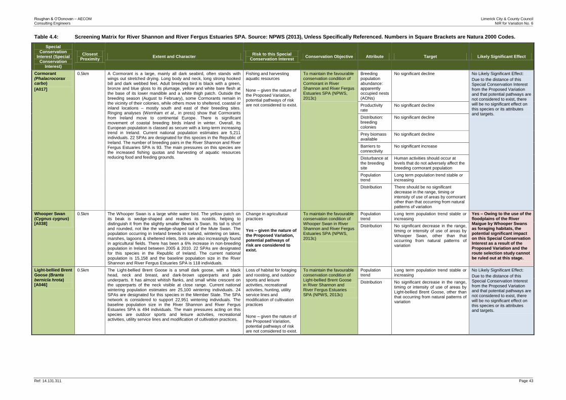
Roughan & O’Donovan – AECOM Limerick City & County Council Consulting Engineers NIR for Variation No. 6
Ref: 14.131.311 Page 43
Table 4.4: Screening Matrix for River Shannon and River Fergus Estuaries SPA. Source: NPWS (2013), Unless Specifically Referenced. Numbers in Square Brackets are Natura 2000 Codes.
Special Conservation
Interest (Special Conservation
Interest)
Closest Proximity
Extent and Character Risk to this Special
Conservation Interest Conservation Objective Attribute Target Likely Significant Effect
Cormorant
(Phalacrocorax carbo)
[A017]
0.5km A Cormorant is a large, mainly all dark seabird, often stands with wings out stretched drying. Long body and neck, long strong hooked bill and dark webbed feet. Adult breeding bird is black with a green, bronze and blue gloss to its plumage, yellow and white bare flesh at the base of its lower mandible and a white thigh patch. Outside the breeding season (August to February), some Cormorants remain in the vicinity of their colonies, while others move to sheltered, coastal or inland locations – mostly south and east of their breeding sites. Ringing analyses (Wernham et al., in press) show that Cormorants from Ireland move to continental Europe. There is significant movement of coastal breeding birds inland in winter. Overall, its European population is classed as secure with a long-term increasing trend in Ireland. Current national population estimates are 5,211 individuals. 22 SPAs are designated for this species in the Republic of Ireland. The number of breeding pairs in the River Shannon and River Fergus Estuaries SPA is 93. The main pressures on this species are the increased fishing quotas and harvesting of aquatic resources reducing food and feeding grounds.
Fishing and harvesting aquatic resources
None – given the nature of the Proposed Variation, potential pathways of risk are not considered to exist.
To maintain the favourable conservation condition of Cormorant in River Shannon and River Fergus Estuaries SPA (NPWS, 2013c)
Breeding population abundance: apparently occupied nests (AONs)
No significant decline No Likely Significant Effect:
Due to the distance of this Special Conservation Interest from the Proposed Variation and that potential pathways are not considered to exist, there will be no significant effect on this species or its attributes and targets.
Productivity rate
No significant decline
Distribution: breeding colonies
No significant decline
Prey biomass available
No significant decline
Barriers to connectivity
No significant increase
Disturbance at the breeding site
Human activities should occur at levels that do not adversely affect the breeding cormorant population
Population trend
Long term population trend stable or increasing
Distribution There should be no significant decrease in the range, timing or intensity of use of areas by cormorant other than that occurring from natural patterns of variation
Whooper Swan (Cygnus cygnus) [A038]
0.5km The Whooper Swan is a large white water bird. The yellow patch on its beak is wedge-shaped and reaches its nostrils, helping to distinguish it from the slightly smaller Bewick’s Swan. Its tail is short and rounded, not like the wedge-shaped tail of the Mute Swan. The population occurring in Ireland breeds in Iceland, wintering on lakes, marshes, lagoons & sheltered inlets, birds are also increasingly found in agricultural fields. There has been a 6% increase in non-breeding population in Ireland between 2005 & 2010. 22 SPAs are designated for this species in the Republic of Ireland. The current national population is 15,158 and the baseline population size in the River Shannon and River Fergus Estuaries SPA is 118 individuals.
Change in agricultural practices
Yes – given the nature of the Proposed Variation, potential pathways of risk are considered to exist.
To maintain the favourable conservation condition of Whooper Swan in River Shannon and River Fergus Estuaries SPA (NPWS, 2013c)
Population trend
Long term population trend stable or increasing
Yes – Owing to the use of the floodplains of the River Maigue by Whooper Swans as foraging habitats, the potential significant impact on this Special Conservation Interest as a result of the Proposed Variation and the route selection study cannot be ruled out at this stage.
Distribution No significant decrease in the range, timing or intensity of use of areas by Whooper Swan, other than that occurring from natural patterns of variation
Light-bellied Brent Goose (Branta bernicla hrota) [A046]
0.5km The Light-bellied Brent Goose is a small dark goose, with a black head, neck and breast, and dark-brown upperparts and pale underparts. It has almost whitish flanks, and small white crescent on the upperparts of the neck visible at close range. Current national wintering population estimates are 25,100 wintering individuals. 24 SPAs are designated for this species in the Member State. The SPA network is considered to support 22,951 wintering individuals. The baseline population size in the River Shannon and River Fergus Estuaries SPA is 494 individuals. The main pressures acting on this species are outdoor sports and leisure activities, recreational activities, utility service lines and modification of cultivation practices.
Loss of habitat for foraging and roosting, and outdoor sports and leisure activities, recreational activities, hunting, utility service lines and modification of cultivation practices
None – given the nature of the Proposed Variation, potential pathways of risk are not considered to exist.
To maintain the favourable conservation condition of Light-bellied Brent Goose in River Shannon and River Fergus Estuaries SPA (NPWS, 2013c)
Population trend
Long term population trend stable or increasing
No Likely Significant Effect:
Due to the distance of this Special Conservation Interest from the Proposed Variation and that potential pathways are not considered to exist, there will be no significant effect on this species or its attributes and targets.
Distribution No significant decrease in the range, timing or intensity of use of areas by Light-bellied Brent Goose, other than that occurring from natural patterns of variation
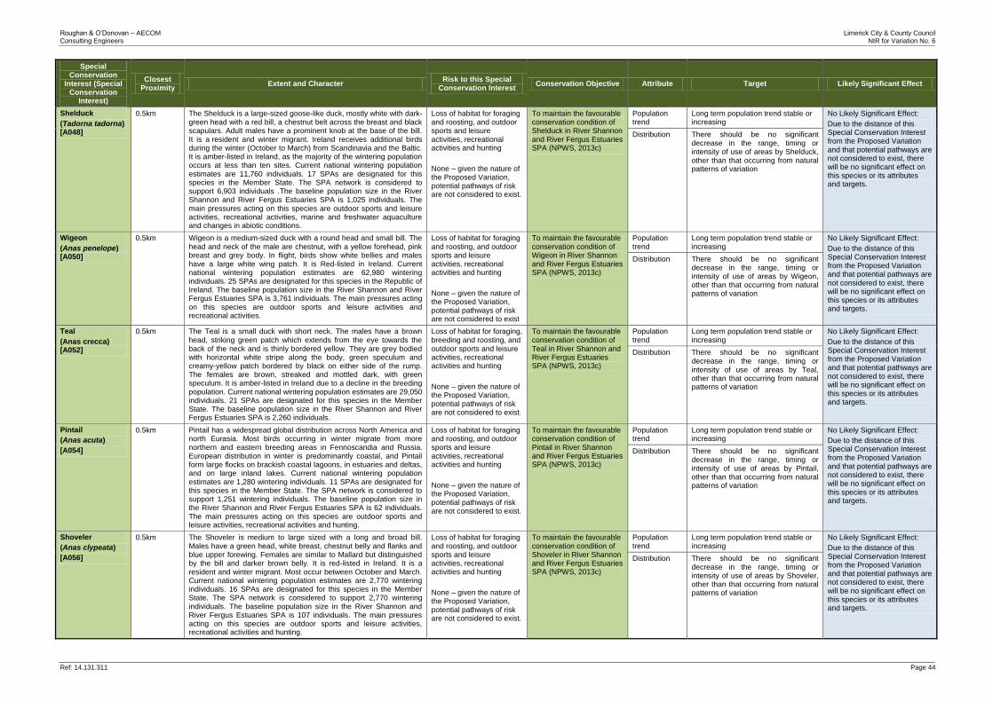
Roughan & O’Donovan – AECOM Limerick City & County Council Consulting Engineers NIR for Variation No. 6
Ref: 14.131.311 Page 44
Special Conservation
Interest (Special Conservation
Interest)
Closest Proximity
Extent and Character Risk to this Special
Conservation Interest Conservation Objective Attribute Target Likely Significant Effect
Shelduck
(Tadorna tadorna) [A048]
0.5km The Shelduck is a large-sized goose-like duck, mostly white with dark-green head with a red bill, a chestnut belt across the breast and black scapulars. Adult males have a prominent knob at the base of the bill. It is a resident and winter migrant. Ireland receives additional birds during the winter (October to March) from Scandinavia and the Baltic. It is amber-listed in Ireland, as the majority of the wintering population occurs at less than ten sites. Current national wintering population estimates are 11,760 individuals. 17 SPAs are designated for this species in the Member State. The SPA network is considered to support 6,903 individuals .The baseline population size in the River Shannon and River Fergus Estuaries SPA is 1,025 individuals. The main pressures acting on this species are outdoor sports and leisure activities, recreational activities, marine and freshwater aquaculture and changes in abiotic conditions.
Loss of habitat for foraging and roosting, and outdoor sports and leisure activities, recreational activities and hunting
None – given the nature of the Proposed Variation, potential pathways of risk are not considered to exist.
To maintain the favourable conservation condition of Shelduck in River Shannon and River Fergus Estuaries SPA (NPWS, 2013c)
Population trend
Long term population trend stable or increasing
No Likely Significant Effect:
Due to the distance of this Special Conservation Interest from the Proposed Variation and that potential pathways are not considered to exist, there will be no significant effect on this species or its attributes and targets.
Distribution There should be no significant decrease in the range, timing or intensity of use of areas by Shelduck, other than that occurring from natural patterns of variation
Wigeon
(Anas penelope) [A050]
0.5km Wigeon is a medium-sized duck with a round head and small bill. The head and neck of the male are chestnut, with a yellow forehead, pink breast and grey body. In flight, birds show white bellies and males have a large white wing patch. It is Red-listed in Ireland. Current national wintering population estimates are 62,980 wintering individuals. 25 SPAs are designated for this species in the Republic of Ireland. The baseline population size in the River Shannon and River Fergus Estuaries SPA is 3,761 individuals. The main pressures acting on this species are outdoor sports and leisure activities and recreational activities.
Loss of habitat for foraging and roosting, and outdoor sports and leisure activities, recreational activities and hunting
None – given the nature of the Proposed Variation, potential pathways of risk are not considered to exist
To maintain the favourable conservation condition of Wigeon in River Shannon and River Fergus Estuaries SPA (NPWS, 2013c)
Population trend
Long term population trend stable or increasing
No Likely Significant Effect:
Due to the distance of this Special Conservation Interest from the Proposed Variation and that potential pathways are not considered to exist, there will be no significant effect on this species or its attributes and targets.
Distribution There should be no significant decrease in the range, timing or intensity of use of areas by Wigeon, other than that occurring from natural patterns of variation
Teal
(Anas crecca) [A052]
0.5km The Teal is a small duck with short neck. The males have a brown head, striking green patch which extends from the eye towards the back of the neck and is thinly bordered yellow. They are grey bodied with horizontal white stripe along the body, green speculum and creamy-yellow patch bordered by black on either side of the rump. The females are brown, streaked and mottled dark, with green speculum. It is amber-listed in Ireland due to a decline in the breeding population. Current national wintering population estimates are 29,050 individuals. 21 SPAs are designated for this species in the Member State. The baseline population size in the River Shannon and River Fergus Estuaries SPA is 2,260 individuals.
Loss of habitat for foraging, breeding and roosting, and outdoor sports and leisure activities, recreational activities and hunting
None – given the nature of the Proposed Variation, potential pathways of risk are not considered to exist.
To maintain the favourable conservation condition of Teal in River Shannon and River Fergus Estuaries SPA (NPWS, 2013c)
Population trend
Long term population trend stable or increasing
No Likely Significant Effect:
Due to the distance of this Special Conservation Interest from the Proposed Variation and that potential pathways are not considered to exist, there will be no significant effect on this species or its attributes and targets.
Distribution There should be no significant decrease in the range, timing or intensity of use of areas by Teal, other than that occurring from natural patterns of variation
Pintail
(Anas acuta)
[A054]
0.5km Pintail has a widespread global distribution across North America and north Eurasia. Most birds occurring in winter migrate from more northern and eastern breeding areas in Fennoscandia and Russia. European distribution in winter is predominantly coastal, and Pintail form large flocks on brackish coastal lagoons, in estuaries and deltas, and on large inland lakes. Current national wintering population estimates are 1,280 wintering individuals. 11 SPAs are designated for this species in the Member State. The SPA network is considered to support 1,251 wintering individuals. The baseline population size in the River Shannon and River Fergus Estuaries SPA is 62 individuals. The main pressures acting on this species are outdoor sports and leisure activities, recreational activities and hunting.
Loss of habitat for foraging and roosting, and outdoor sports and leisure activities, recreational activities and hunting
None – given the nature of the Proposed Variation, potential pathways of risk are not considered to exist.
To maintain the favourable conservation condition of Pintail in River Shannon and River Fergus Estuaries SPA (NPWS, 2013c)
Population trend
Long term population trend stable or increasing
No Likely Significant Effect:
Due to the distance of this Special Conservation Interest from the Proposed Variation and that potential pathways are not considered to exist, there will be no significant effect on this species or its attributes and targets.
Distribution There should be no significant decrease in the range, timing or intensity of use of areas by Pintail, other than that occurring from natural patterns of variation
Shoveler
(Anas clypeata)
[A056]
0.5km The Shoveler is medium to large sized with a long and broad bill. Males have a green head, white breast, chestnut belly and flanks and blue upper forewing. Females are similar to Mallard but distinguished by the bill and darker brown belly. It is red-listed in Ireland. It is a resident and winter migrant. Most occur between October and March. Current national wintering population estimates are 2,770 wintering individuals. 16 SPAs are designated for this species in the Member State. The SPA network is considered to support 2,770 wintering individuals. The baseline population size in the River Shannon and River Fergus Estuaries SPA is 107 individuals. The main pressures acting on this species are outdoor sports and leisure activities, recreational activities and hunting.
Loss of habitat for foraging and roosting, and outdoor sports and leisure activities, recreational activities and hunting
None – given the nature of the Proposed Variation, potential pathways of risk are not considered to exist.
To maintain the favourable conservation condition of Shoveler in River Shannon and River Fergus Estuaries SPA (NPWS, 2013c)
Population trend
Long term population trend stable or increasing
No Likely Significant Effect:
Due to the distance of this Special Conservation Interest from the Proposed Variation and that potential pathways are not considered to exist, there will be no significant effect on this species or its attributes and targets.
Distribution There should be no significant decrease in the range, timing or intensity of use of areas by Shoveler, other than that occurring from natural patterns of variation
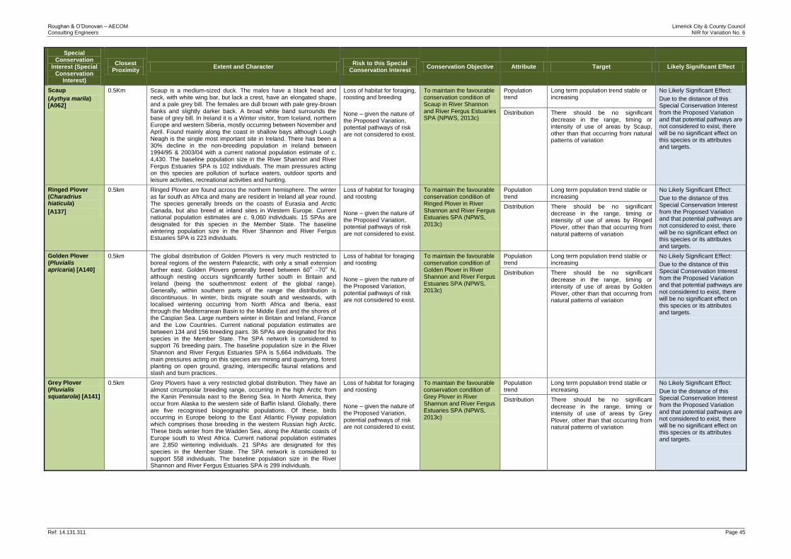
Roughan & O’Donovan – AECOM Limerick City & County Council Consulting Engineers NIR for Variation No. 6
Ref: 14.131.311 Page 45
Special Conservation
Interest (Special Conservation
Interest)
Closest Proximity
Extent and Character Risk to this Special
Conservation Interest Conservation Objective Attribute Target Likely Significant Effect
Scaup
(Aythya marila) [A062]
0.5Km Scaup is a medium-sized duck. The males have a black head and neck, with white wing bar, but lack a crest, have an elongated shape, and a pale grey bill. The females are dull brown with pale grey-brown flanks and slightly darker back. A broad white band surrounds the base of grey bill. In Ireland it is a Winter visitor, from Iceland, northern Europe and western Siberia, mostly occurring between November and April. Found mainly along the coast in shallow bays although Lough Neagh is the single most important site in Ireland. There has been a 30% decline in the non-breeding population in Ireland between 1994/95 & 2003/04 with a current national population estimate of c. 4,430. The baseline population size in the River Shannon and River Fergus Estuaries SPA is 102 individuals. The main pressures acting on this species are pollution of surface waters, outdoor sports and leisure activities, recreational activities and hunting.
Loss of habitat for foraging, roosting and breeding
None – given the nature of the Proposed Variation, potential pathways of risk are not considered to exist.
To maintain the favourable conservation condition of Scaup in River Shannon and River Fergus Estuaries SPA (NPWS, 2013c)
Population trend
Long term population trend stable or increasing
No Likely Significant Effect:
Due to the distance of this Special Conservation Interest from the Proposed Variation and that potential pathways are not considered to exist, there will be no significant effect on this species or its attributes and targets.
Distribution There should be no significant decrease in the range, timing or intensity of use of areas by Scaup, other than that occurring from natural patterns of variation
Ringed Plover (Charadrius hiaticula)
[A137]
0.5km Ringed Plover are found across the northern hemisphere. The winter as far south as Africa and many are resident in Ireland all year round. The species generally breeds on the coasts of Eurasia and Arctic Canada, but also breed at inland sites in Western Europe. Current national population estimates are c. 9,060 individuals. 15 SPAs are designated for this species in the Member State. The baseline wintering population size in the River Shannon and River Fergus Estuaries SPA is 223 individuals.
Loss of habitat for foraging and roosting
None – given the nature of the Proposed Variation, potential pathways of risk are not considered to exist.
To maintain the favourable conservation condition of Ringed Plover in River Shannon and River Fergus Estuaries SPA (NPWS, 2013c)
Population trend
Long term population trend stable or increasing
No Likely Significant Effect:
Due to the distance of this Special Conservation Interest from the Proposed Variation and that potential pathways are not considered to exist, there will be no significant effect on this species or its attributes and targets.
Distribution There should be no significant decrease in the range, timing or intensity of use of areas by Ringed Plover, other than that occurring from natural patterns of variation
Golden Plover (Pluvialis apricaria) [A140]
0.5km The global distribution of Golden Plovers is very much restricted to boreal regions of the western Palearctic, with only a small extension further east. Golden Plovers generally breed between 60
o –70
o N,
although nesting occurs significantly further south in Britain and Ireland (being the southernmost extent of the global range). Generally, within southern parts of the range the distribution is discontinuous. In winter, birds migrate south and westwards, with localised wintering occurring from North Africa and Iberia, east through the Mediterranean Basin to the Middle East and the shores of the Caspian Sea. Large numbers winter in Britain and Ireland, France and the Low Countries. Current national population estimates are between 134 and 156 breeding pairs. 36 SPAs are designated for this species in the Member State. The SPA network is considered to support 76 breeding pairs. The baseline population size in the River Shannon and River Fergus Estuaries SPA is 5,664 individuals. The main pressures acting on this species are mining and quarrying, forest planting on open ground, grazing, interspecific faunal relations and slash and burn practices.
Loss of habitat for foraging and roosting
None – given the nature of the Proposed Variation, potential pathways of risk are not considered to exist.
To maintain the favourable conservation condition of Golden Plover in River Shannon and River Fergus Estuaries SPA (NPWS, 2013c)
Population trend
Long term population trend stable or increasing
No Likely Significant Effect:
Due to the distance of this Special Conservation Interest from the Proposed Variation and that potential pathways are not considered to exist, there will be no significant effect on this species or its attributes and targets.
Distribution There should be no significant decrease in the range, timing or intensity of use of areas by Golden Plover, other than that occurring from natural patterns of variation
Grey Plover (Pluvialis squatarola) [A141]
0.5km Grey Plovers have a very restricted global distribution. They have an almost circumpolar breeding range, occurring in the high Arctic from the Kanin Peninsula east to the Bering Sea. In North America, they occur from Alaska to the western side of Baffin Island. Globally, there are five recognised biogeographic populations. Of these, birds occurring in Europe belong to the East Atlantic Flyway population which comprises those breeding in the western Russian high Arctic. These birds winter from the Wadden Sea, along the Atlantic coasts of Europe south to West Africa. Current national population estimates are 2,850 wintering individuals. 21 SPAs are designated for this species in the Member State. The SPA network is considered to support 558 individuals. The baseline population size in the River Shannon and River Fergus Estuaries SPA is 299 individuals.
Loss of habitat for foraging and roosting
None – given the nature of the Proposed Variation, potential pathways of risk are not considered to exist.
To maintain the favourable conservation condition of Grey Plover in River Shannon and River Fergus Estuaries SPA (NPWS, 2013c)
Population trend
Long term population trend stable or increasing
No Likely Significant Effect:
Due to the distance of this Special Conservation Interest from the Proposed Variation and that potential pathways are not considered to exist, there will be no significant effect on this species or its attributes and targets.
Distribution There should be no significant decrease in the range, timing or intensity of use of areas by Grey Plover, other than that occurring from natural patterns of variation
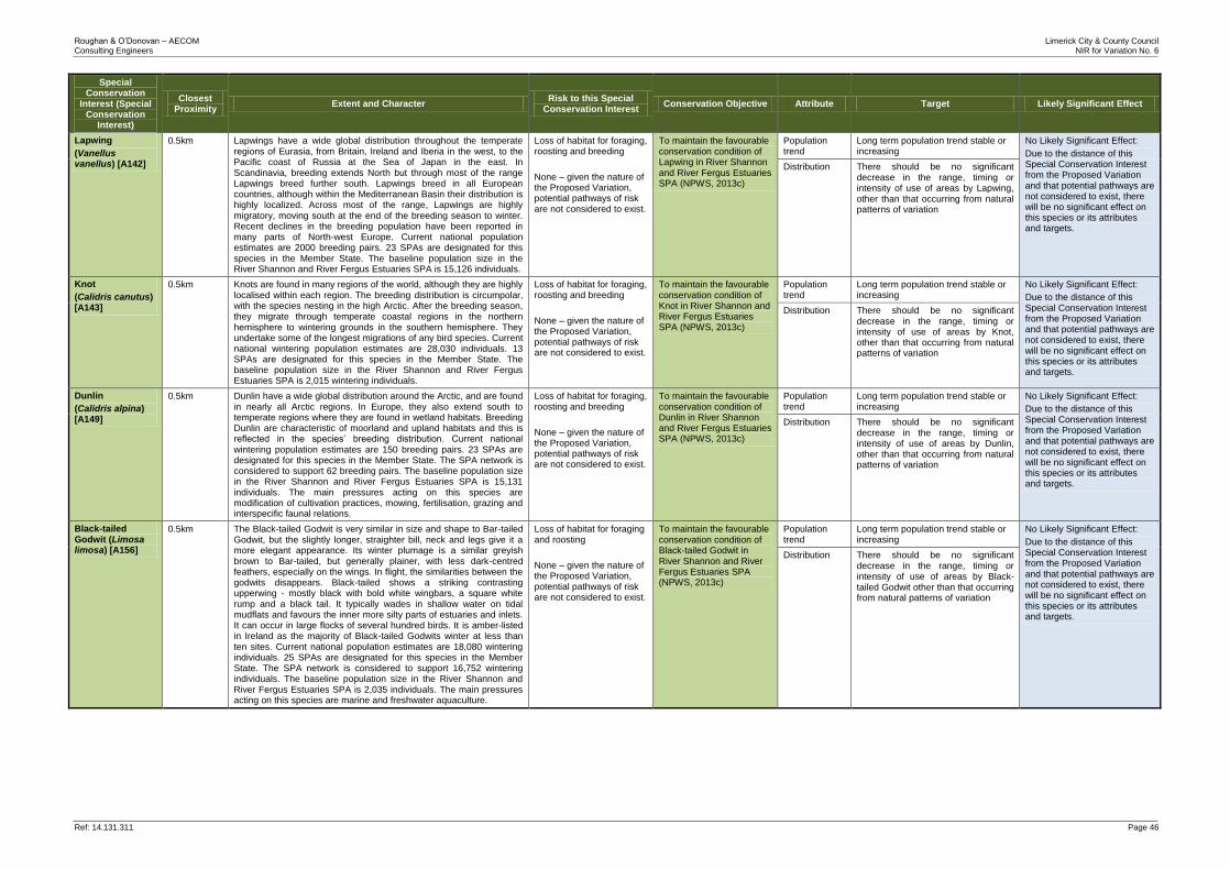
Roughan & O’Donovan – AECOM Limerick City & County Council Consulting Engineers NIR for Variation No. 6
Ref: 14.131.311 Page 46
Special Conservation
Interest (Special Conservation
Interest)
Closest Proximity
Extent and Character Risk to this Special
Conservation Interest Conservation Objective Attribute Target Likely Significant Effect
Lapwing
(Vanellus vanellus) [A142]
0.5km Lapwings have a wide global distribution throughout the temperate regions of Eurasia, from Britain, Ireland and Iberia in the west, to the Pacific coast of Russia at the Sea of Japan in the east. In Scandinavia, breeding extends North but through most of the range Lapwings breed further south. Lapwings breed in all European countries, although within the Mediterranean Basin their distribution is highly localized. Across most of the range, Lapwings are highly migratory, moving south at the end of the breeding season to winter. Recent declines in the breeding population have been reported in many parts of North-west Europe. Current national population estimates are 2000 breeding pairs. 23 SPAs are designated for this species in the Member State. The baseline population size in the River Shannon and River Fergus Estuaries SPA is 15,126 individuals.
Loss of habitat for foraging, roosting and breeding
None – given the nature of the Proposed Variation, potential pathways of risk are not considered to exist.
To maintain the favourable conservation condition of Lapwing in River Shannon and River Fergus Estuaries SPA (NPWS, 2013c)
Population trend
Long term population trend stable or increasing
No Likely Significant Effect:
Due to the distance of this Special Conservation Interest from the Proposed Variation and that potential pathways are not considered to exist, there will be no significant effect on this species or its attributes and targets.
Distribution There should be no significant decrease in the range, timing or intensity of use of areas by Lapwing, other than that occurring from natural patterns of variation
Knot
(Calidris canutus) [A143]
0.5km Knots are found in many regions of the world, although they are highly localised within each region. The breeding distribution is circumpolar, with the species nesting in the high Arctic. After the breeding season, they migrate through temperate coastal regions in the northern hemisphere to wintering grounds in the southern hemisphere. They undertake some of the longest migrations of any bird species. Current national wintering population estimates are 28,030 individuals. 13 SPAs are designated for this species in the Member State. The baseline population size in the River Shannon and River Fergus Estuaries SPA is 2,015 wintering individuals.
Loss of habitat for foraging, roosting and breeding
None – given the nature of the Proposed Variation, potential pathways of risk are not considered to exist.
To maintain the favourable conservation condition of Knot in River Shannon and River Fergus Estuaries SPA (NPWS, 2013c)
Population trend
Long term population trend stable or increasing
No Likely Significant Effect:
Due to the distance of this Special Conservation Interest from the Proposed Variation and that potential pathways are not considered to exist, there will be no significant effect on this species or its attributes and targets.
Distribution There should be no significant decrease in the range, timing or intensity of use of areas by Knot, other than that occurring from natural patterns of variation
Dunlin
(Calidris alpina) [A149]
0.5km Dunlin have a wide global distribution around the Arctic, and are found in nearly all Arctic regions. In Europe, they also extend south to temperate regions where they are found in wetland habitats. Breeding Dunlin are characteristic of moorland and upland habitats and this is reflected in the species’ breeding distribution. Current national wintering population estimates are 150 breeding pairs. 23 SPAs are designated for this species in the Member State. The SPA network is considered to support 62 breeding pairs. The baseline population size in the River Shannon and River Fergus Estuaries SPA is 15,131 individuals. The main pressures acting on this species are modification of cultivation practices, mowing, fertilisation, grazing and interspecific faunal relations.
Loss of habitat for foraging, roosting and breeding
None – given the nature of the Proposed Variation, potential pathways of risk are not considered to exist.
To maintain the favourable conservation condition of Dunlin in River Shannon and River Fergus Estuaries SPA (NPWS, 2013c)
Population trend
Long term population trend stable or increasing
No Likely Significant Effect:
Due to the distance of this Special Conservation Interest from the Proposed Variation and that potential pathways are not considered to exist, there will be no significant effect on this species or its attributes and targets.
Distribution There should be no significant decrease in the range, timing or intensity of use of areas by Dunlin, other than that occurring from natural patterns of variation
Black-tailed Godwit (Limosa limosa) [A156]
0.5km The Black-tailed Godwit is very similar in size and shape to Bar-tailed Godwit, but the slightly longer, straighter bill, neck and legs give it a more elegant appearance. Its winter plumage is a similar greyish brown to Bar-tailed, but generally plainer, with less dark-centred feathers, especially on the wings. In flight, the similarities between the godwits disappears. Black-tailed shows a striking contrasting upperwing - mostly black with bold white wingbars, a square white rump and a black tail. It typically wades in shallow water on tidal mudflats and favours the inner more silty parts of estuaries and inlets. It can occur in large flocks of several hundred birds. It is amber-listed in Ireland as the majority of Black-tailed Godwits winter at less than ten sites. Current national population estimates are 18,080 wintering individuals. 25 SPAs are designated for this species in the Member State. The SPA network is considered to support 16,752 wintering individuals. The baseline population size in the River Shannon and River Fergus Estuaries SPA is 2,035 individuals. The main pressures acting on this species are marine and freshwater aquaculture.
Loss of habitat for foraging and roosting
None – given the nature of the Proposed Variation, potential pathways of risk are not considered to exist.
To maintain the favourable conservation condition of Black-tailed Godwit in River Shannon and River Fergus Estuaries SPA (NPWS, 2013c)
Population trend
Long term population trend stable or increasing
No Likely Significant Effect:
Due to the distance of this Special Conservation Interest from the Proposed Variation and that potential pathways are not considered to exist, there will be no significant effect on this species or its attributes and targets.
Distribution There should be no significant decrease in the range, timing or intensity of use of areas by Black-tailed Godwit other than that occurring from natural patterns of variation
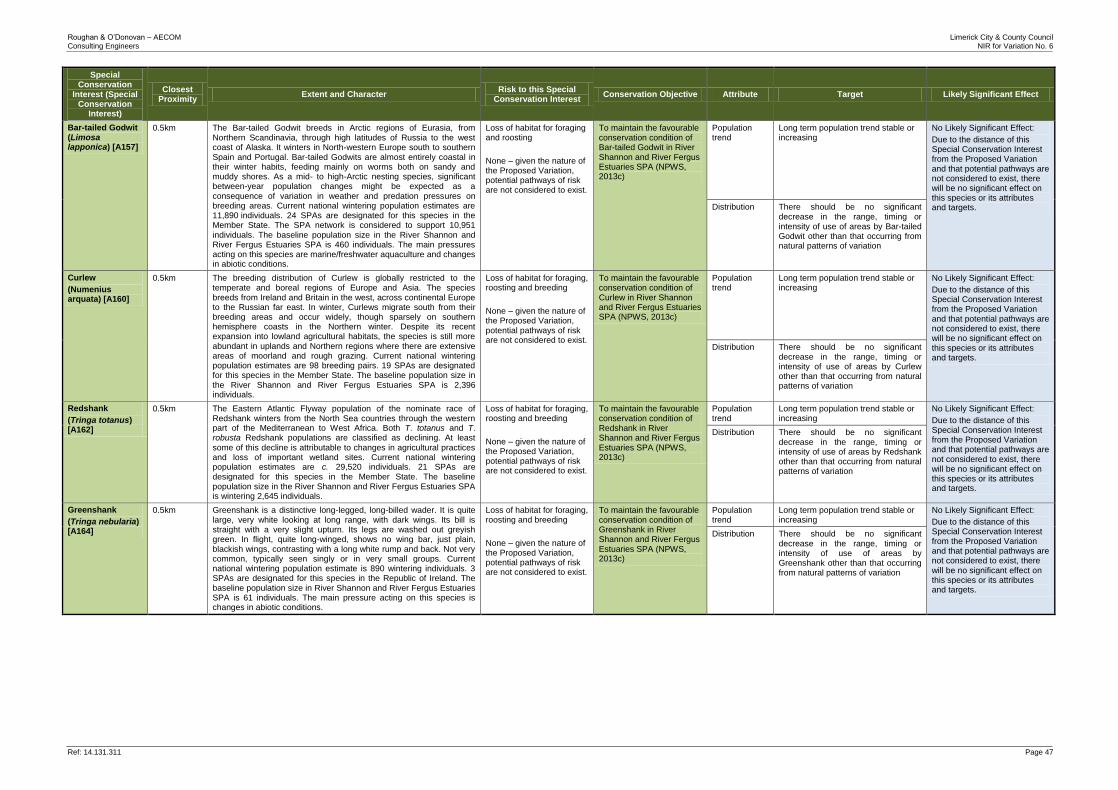
Roughan & O’Donovan – AECOM Limerick City & County Council Consulting Engineers NIR for Variation No. 6
Ref: 14.131.311 Page 47
Special Conservation
Interest (Special Conservation
Interest)
Closest Proximity
Extent and Character Risk to this Special
Conservation Interest Conservation Objective Attribute Target Likely Significant Effect
Bar-tailed Godwit (Limosa lapponica) [A157]
0.5km The Bar-tailed Godwit breeds in Arctic regions of Eurasia, from Northern Scandinavia, through high latitudes of Russia to the west coast of Alaska. It winters in North-western Europe south to southern Spain and Portugal. Bar-tailed Godwits are almost entirely coastal in their winter habits, feeding mainly on worms both on sandy and muddy shores. As a mid- to high-Arctic nesting species, significant between-year population changes might be expected as a consequence of variation in weather and predation pressures on breeding areas. Current national wintering population estimates are 11,890 individuals. 24 SPAs are designated for this species in the Member State. The SPA network is considered to support 10,951 individuals. The baseline population size in the River Shannon and River Fergus Estuaries SPA is 460 individuals. The main pressures acting on this species are marine/freshwater aquaculture and changes in abiotic conditions.
Loss of habitat for foraging and roosting
None – given the nature of the Proposed Variation, potential pathways of risk are not considered to exist.
To maintain the favourable conservation condition of Bar-tailed Godwit in River Shannon and River Fergus Estuaries SPA (NPWS, 2013c)
Population trend
Long term population trend stable or increasing
No Likely Significant Effect:
Due to the distance of this Special Conservation Interest from the Proposed Variation and that potential pathways are not considered to exist, there will be no significant effect on this species or its attributes and targets. Distribution There should be no significant
decrease in the range, timing or intensity of use of areas by Bar-tailed Godwit other than that occurring from natural patterns of variation
Curlew
(Numenius arquata) [A160]
0.5km The breeding distribution of Curlew is globally restricted to the temperate and boreal regions of Europe and Asia. The species breeds from Ireland and Britain in the west, across continental Europe to the Russian far east. In winter, Curlews migrate south from their breeding areas and occur widely, though sparsely on southern hemisphere coasts in the Northern winter. Despite its recent expansion into lowland agricultural habitats, the species is still more abundant in uplands and Northern regions where there are extensive areas of moorland and rough grazing. Current national wintering population estimates are 98 breeding pairs. 19 SPAs are designated for this species in the Member State. The baseline population size in the River Shannon and River Fergus Estuaries SPA is 2,396 individuals.
Loss of habitat for foraging, roosting and breeding
None – given the nature of the Proposed Variation, potential pathways of risk are not considered to exist.
To maintain the favourable conservation condition of Curlew in River Shannon and River Fergus Estuaries SPA (NPWS, 2013c)
Population trend
Long term population trend stable or increasing
No Likely Significant Effect:
Due to the distance of this Special Conservation Interest from the Proposed Variation and that potential pathways are not considered to exist, there will be no significant effect on this species or its attributes and targets.
Distribution There should be no significant decrease in the range, timing or intensity of use of areas by Curlew other than that occurring from natural patterns of variation
Redshank
(Tringa totanus) [A162]
0.5km The Eastern Atlantic Flyway population of the nominate race of Redshank winters from the North Sea countries through the western part of the Mediterranean to West Africa. Both T. totanus and T. robusta Redshank populations are classified as declining. At least
some of this decline is attributable to changes in agricultural practices and loss of important wetland sites. Current national wintering population estimates are c. 29,520 individuals. 21 SPAs are designated for this species in the Member State. The baseline population size in the River Shannon and River Fergus Estuaries SPA is wintering 2,645 individuals.
Loss of habitat for foraging, roosting and breeding
None – given the nature of the Proposed Variation, potential pathways of risk are not considered to exist.
To maintain the favourable conservation condition of Redshank in River Shannon and River Fergus Estuaries SPA (NPWS, 2013c)
Population trend
Long term population trend stable or increasing
No Likely Significant Effect:
Due to the distance of this Special Conservation Interest from the Proposed Variation and that potential pathways are not considered to exist, there will be no significant effect on this species or its attributes and targets.
Distribution There should be no significant decrease in the range, timing or intensity of use of areas by Redshank other than that occurring from natural patterns of variation
Greenshank
(Tringa nebularia) [A164]
0.5km Greenshank is a distinctive long-legged, long-billed wader. It is quite large, very white looking at long range, with dark wings. Its bill is straight with a very slight upturn. Its legs are washed out greyish green. In flight, quite long-winged, shows no wing bar, just plain, blackish wings, contrasting with a long white rump and back. Not very common, typically seen singly or in very small groups. Current national wintering population estimate is 890 wintering individuals. 3 SPAs are designated for this species in the Republic of Ireland. The baseline population size in River Shannon and River Fergus Estuaries SPA is 61 individuals. The main pressure acting on this species is changes in abiotic conditions.
Loss of habitat for foraging, roosting and breeding
None – given the nature of the Proposed Variation, potential pathways of risk are not considered to exist.
To maintain the favourable conservation condition of Greenshank in River Shannon and River Fergus Estuaries SPA (NPWS, 2013c)
Population trend
Long term population trend stable or increasing
No Likely Significant Effect:
Due to the distance of this Special Conservation Interest from the Proposed Variation and that potential pathways are not considered to exist, there will be no significant effect on this species or its attributes and targets.
Distribution There should be no significant decrease in the range, timing or intensity of use of areas by Greenshank other than that occurring from natural patterns of variation
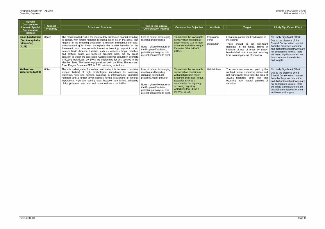
Roughan & O’Donovan – AECOM Limerick City & County Council Consulting Engineers NIR for Variation No. 6
Ref: 14.131.311 Page 48
Special Conservation
Interest (Special Conservation
Interest)
Closest Proximity
Extent and Character Risk to this Special
Conservation Interest Conservation Objective Attribute Target Likely Significant Effect
Black-headed Gull
(Chroicocephalus ridibundus)
[A179]
0.5km The Black-headed Gull is the most widely distributed seabird breeding in Ireland, with similar numbers breeding inland as on the coast. The majority of the breeding population is resident throughout the year. Black-headed gulls breed throughout the middle latitudes of the Palaearctic and have recently formed a breeding outpost in north eastern North America. Habitats such as wetlands, bogs, marshes and artificial ponds are favoured breeding sites, but dry areas adjacent to water are also used. Current national population estimate is 50,181 individuals. 19 SPAs are designated for this species in the Member State. The baseline population size in the River Shannon and River Fergus Estuaries SPA is 2,681 wintering individuals.
Loss of habitat for foraging, roosting and breeding
None – given the nature of the Proposed Variation, potential pathways of risk are not considered to exist.
To maintain the favourable conservation condition of Black-headed Gull in River Shannon and River Fergus Estuaries SPA (NPWS, 2013c)
Population trend
Long term population trend stable or increasing
No Likely Significant Effect:
Due to the distance of this Special Conservation Interest from the Proposed Variation and that potential pathways are not considered to exist, there will be no significant effect on this species or its attributes and targets.
Distribution There should be no significant decrease in the range, timing or intensity of use of areas by Black-headed Gull other than that occurring from natural patterns of variation
Wetland and Waterbirds [A999]
0.5km This site is designated for wetland and waterbirds because it contains wetland habitat of high ornithological importance for wintering waterfowl, with one species occurring in internationally important numbers and a further seven species having populations of national importance. High tide roosting sites, however, are limited. Wintering bird populations have been well monitored since the 1970s.
Loss of habitat for foraging, roosting and breeding, changing agricultural practices, water pollution
None – given the nature of the Proposed Variation, potential pathways of risk are not considered to exist.
To maintain the favourable conservation condition of wetland habitat in River Shannon and River Fergus Estuaries SPA as a resource for the regularly occurring migratory waterbirds that utilise it (NPWS, 2013c)
Habitat Area The permanent area occupied by the wetland habitat should be stable and not significantly less than the area of 32,261 hectares, other than that occurring from natural patterns of variation.
No Likely Significant Effect:
Due to the distance of this Special Conservation Interest from the Proposed Variation and that potential pathways are not considered to exist, there will be no significant effect on this habitat or species or their attributes and targets.
Roughan & O’Donovan – AECOM Limerick City & County Council Consulting Engineers AA NIR Variation No. 6
Ref: 14.131.311 Page 49
4.2 Potential Impacts on Qualifying Interests
Having considered the content of the Proposed Variation (and with due regard to the outcome of the route corridor selection process and Design Update (October 2017), the Conservation Objectives of the Natura 2000 sites within the likely zone of impact, and having applied the Precautionary Principle, it was determined that following Qualifying Interests or Special Conservation Interests in four Natura 2000 sites will be potentially significantly impacted:
1. Lower River Shannon SAC
Alluvial forests with Alnus glutinosa and Fraxinus excelsior (Alno-Padion, Alnion incanae, Salicion albae) [91E0] (* priority habitat)
Floating River Vegetation - Water courses of plain to montane levels with the Ranunculion fluitantis and Callitricho-Batrachion vegetation [3260]
River Lamprey (Lampetra fluviatilis) [1099]
Atlantic Salmon (Salmo salar) [1106]
European Otter (Lutra lutra) [1355]
2. Curraghchase Woods SAC
Lesser Horseshoe Bat (Rhinolophus hipposideros) [1303]
3. Askeaton Fens Complex SAC
Calcareous fens with Cladium mariscus and species of the Caricion davallianae [7210]
Alkaline fens [7230]
4. River Shannon and River Fergus Estuaries SPA
Whooper Swan (Cygnus cygnus) [A038]
4.3 Assessment of Likely Significant Effects
The assessment questions listed below have been sourced from Assessment of plans and projects significantly affecting Natura 2000 sites: Methodological guidance on the provisions of Article 6(3) and (4) of the Habitats Directive 92/43/EEC (EC, 2001) Figure 1: Describe the individual elements of the project (either alone or in combination with other plans or projects) likely to give rise to impacts on the Natura 2000 site:
Having had due regard to the route corridor selection process, the Proposed Variation is considered to have the potential to significantly impact the Lower River Shannon SAC, the Curraghchase Woods SAC, the Askeaton Fen Complex SAC and the River Shannon and River Fergus Estuaries SPA through the following: Lower River Shannon SAC: The Proposed Variation provides for a road by-pass of Adare town. The route selection process as part of the Foynes to Limerick Road Improvement Scheme, has informed the basis for continued work which has resulted in recommending a provisional 80m corridor to the north of Adare town (October 2017). The proposed corridor includes the construction of a bridge over the River Maigue to facilitate this bypass. The River Maigue is tidal at this point and lies within the Lower River Shannon SAC, the SAC does not extend south of the bridge at Adare. The Qualifying Interests of this SAC that have, in the absence of appropriate mitigation, the potential to be impacted include alluvial forests with Alnus glutinosa and Fraxinus excelsior (Alno-Padion, Alnion incanae, Salicion albae), water courses
Roughan & O’Donovan – AECOM Limerick City & County Council Consulting Engineers AA NIR Variation No. 6
Ref: 14.131.311 Page 50
of plain to montane levels with the Ranunculion fluitantis and Callitricho-Batrachion vegetation, River Lamprey (Lampetra fluviatilis), Atlantic Salmon (Salmo salar), and European Otter (Lutra lutra). Curraghchase Woods SAC: This SAC contains an important population of Lesser Horseshoe bats, an Annex II species. Viable populations of Lesser Horseshoe bats in Ireland are restricted to six western counties. The Curraghchase Woods population lies between the Clare/Galway and north Kerry populations and may be an important link between the two areas. The construction of a road south of this SAC has the potential to interrupt foraging and flight path of these bats residing in Curraghchase Woods, as well as potentially interrupting connectivity (migration) between the populations in neighbouring counties. Bat Conservation Ireland have been conducting bat surveys in the region for many years and recent surveys have revealed that the population of lesser horseshoe bats in the Adare area has crashed since the mid-1980s. The manor was a known summer and winter roosting site in the 1980s but this is no longer the case and, despite the continued existence of optimum habitat for the species in the area, only single bats have been recorded in Adare since the late 1990s (EirEco 2016). There remains a high potential and probability for movement of Lesser Horseshoe Bats between Adare and Curraghchase Woods SAC. Any new road will be required to accommodate the unimpeded passage of bats through appropriate mitigation. Askeaton Fens Complex SAC: The proposed development of a new road infrastructure between Foynes and Rathkeale will pass within 250m of some of the wetland fens listed as Conservation Objectives for this SAC. The proposed route has the potential to impact ground water movements in the area and, therefore, change ground water flow and levels within these fens and potentially affecting their integrity. The River Shannon and River Fergus Estuaries SPA: Whooper Swans are a Special Conservation Interest for this SPA. A Wintering Bird Survey was carried out by EirEco Ltd. during the months of December, January, February and March 2016 which targeted areas likely to be used for foraging by wintering Whooper Swan (EirEco 2016). The survey was preceded by a review of the known foraging areas utilised by Whooper Swan which have been regularly monitored by the Irish Whooper Swan Study Group and by Gerry Murphy (December 2015 to March 2017)(Figure 4.1). These studies showed that historically the improved grasslands along the floodplains of the River Maigue to the north of the N69 road are one of the prime potential habitats for foraging swans. However, recently (2016/17 winter survey) 19 Whooper Swans were been recorded near Cloonanna, approximately 5km north of the proposed crossing point, although there is no evidence yet of occurrence of Whooper Swan in the fields adjacent to the study area. However, these fields do provide suitable foraging areas which could be utilised should the swans be forced to move from their normal foraging areas further north by changes in land use practices for example. In the unlikely event that Whooper Swans do move further south from their current preferred habitat and into fields adjacent to the proposed crossing point, construction activities could cause disturbance and displacement of Whooper Swans from these foraging grounds.
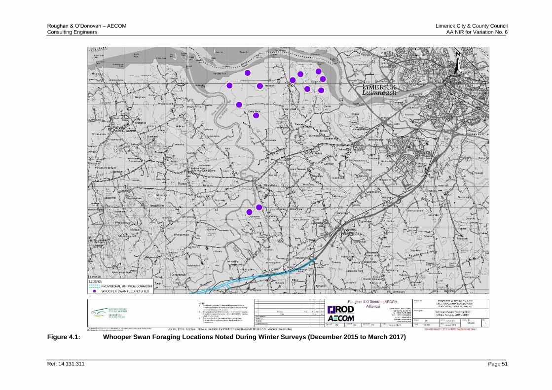
Roughan & O’Donovan – AECOM Limerick City & County Council Consulting Engineers AA NIR for Variation No. 6
Ref: 14.131.311 Page 51
Figure 4.1: Whooper Swan Foraging Locations Noted During Winter Surveys (December 2015 to March 2017)
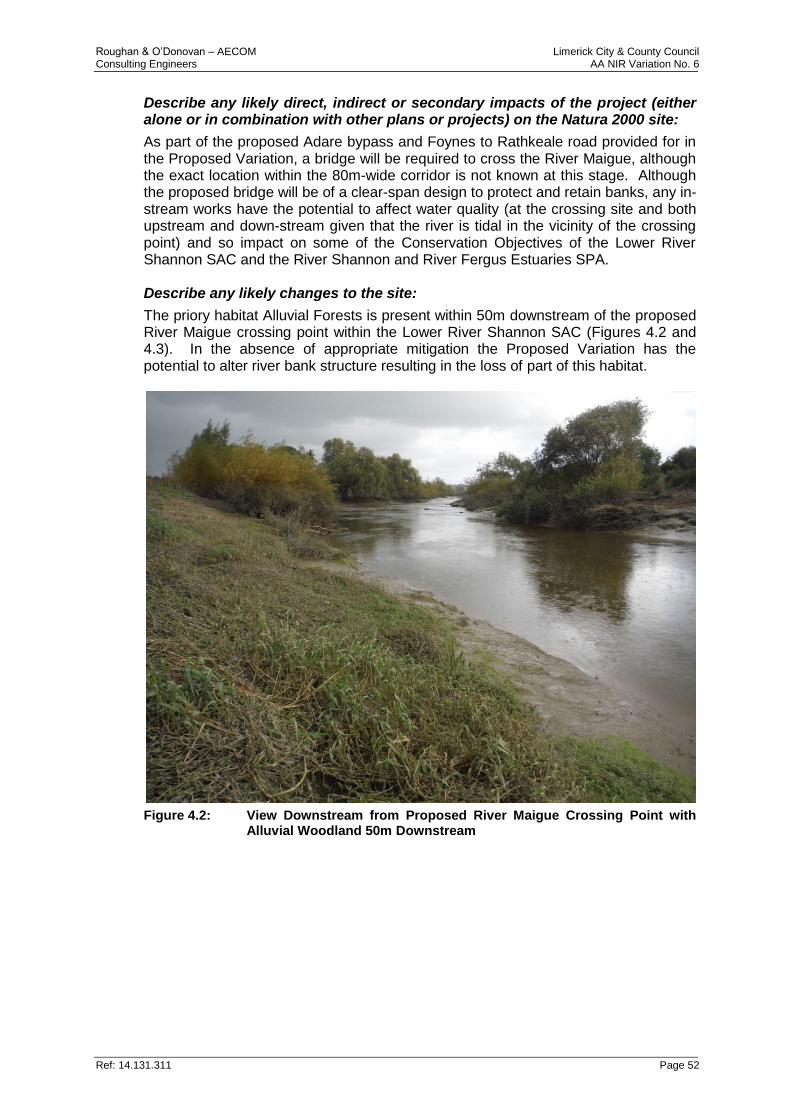
Roughan & O’Donovan – AECOM Limerick City & County Council Consulting Engineers AA NIR Variation No. 6
Ref: 14.131.311 Page 52
Describe any likely direct, indirect or secondary impacts of the project (either alone or in combination with other plans or projects) on the Natura 2000 site:
As part of the proposed Adare bypass and Foynes to Rathkeale road provided for in the Proposed Variation, a bridge will be required to cross the River Maigue, although the exact location within the 80m-wide corridor is not known at this stage. Although the proposed bridge will be of a clear-span design to protect and retain banks, any in-stream works have the potential to affect water quality (at the crossing site and both upstream and down-stream given that the river is tidal in the vicinity of the crossing point) and so impact on some of the Conservation Objectives of the Lower River Shannon SAC and the River Shannon and River Fergus Estuaries SPA. Describe any likely changes to the site:
The priory habitat Alluvial Forests is present within 50m downstream of the proposed River Maigue crossing point within the Lower River Shannon SAC (Figures 4.2 and 4.3). In the absence of appropriate mitigation the Proposed Variation has the potential to alter river bank structure resulting in the loss of part of this habitat.
Figure 4.2: View Downstream from Proposed River Maigue Crossing Point with
Alluvial Woodland 50m Downstream
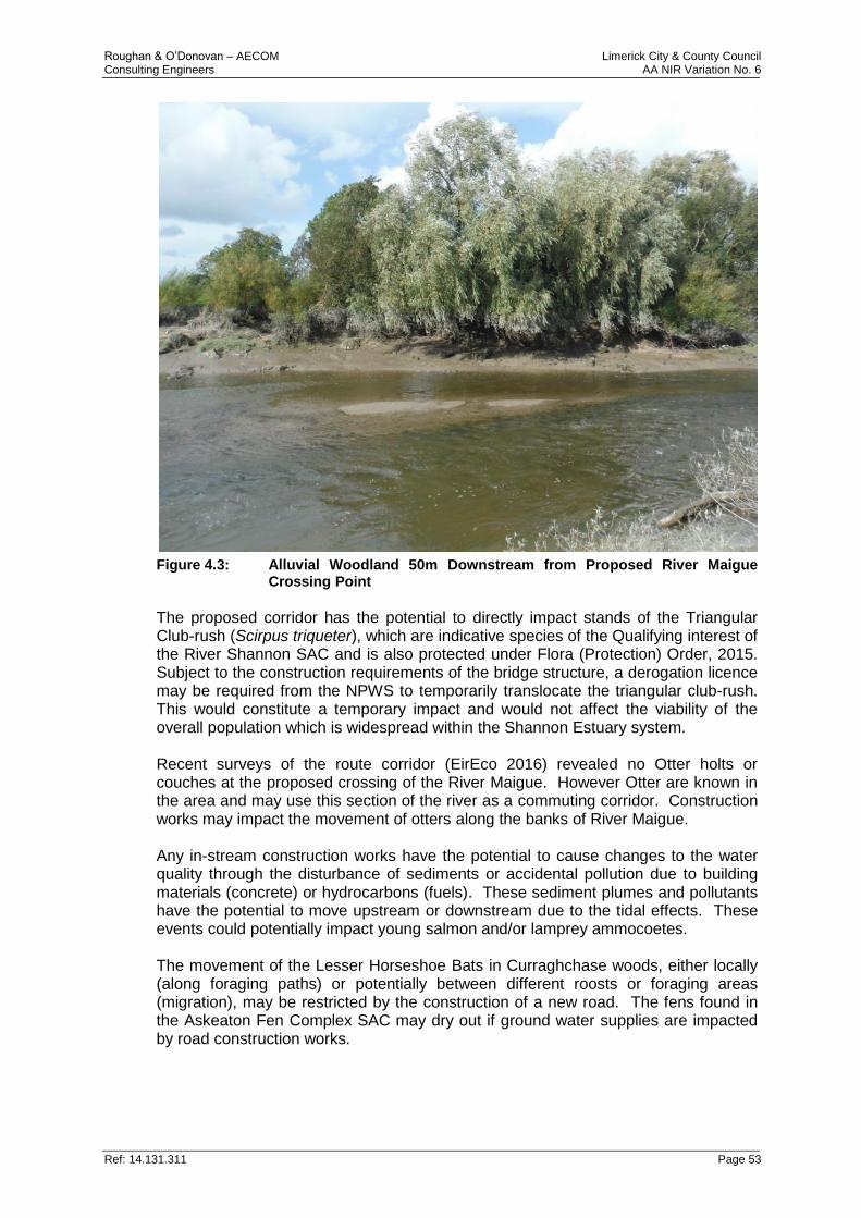
Roughan & O’Donovan – AECOM Limerick City & County Council Consulting Engineers AA NIR Variation No. 6
Ref: 14.131.311 Page 53
Figure 4.3: Alluvial Woodland 50m Downstream from Proposed River Maigue
Crossing Point
The proposed corridor has the potential to directly impact stands of the Triangular Club-rush (Scirpus triqueter), which are indicative species of the Qualifying interest of the River Shannon SAC and is also protected under Flora (Protection) Order, 2015. Subject to the construction requirements of the bridge structure, a derogation licence may be required from the NPWS to temporarily translocate the triangular club-rush. This would constitute a temporary impact and would not affect the viability of the overall population which is widespread within the Shannon Estuary system. Recent surveys of the route corridor (EirEco 2016) revealed no Otter holts or couches at the proposed crossing of the River Maigue. However Otter are known in the area and may use this section of the river as a commuting corridor. Construction works may impact the movement of otters along the banks of River Maigue. Any in-stream construction works have the potential to cause changes to the water quality through the disturbance of sediments or accidental pollution due to building materials (concrete) or hydrocarbons (fuels). These sediment plumes and pollutants have the potential to move upstream or downstream due to the tidal effects. These events could potentially impact young salmon and/or lamprey ammocoetes. The movement of the Lesser Horseshoe Bats in Curraghchase woods, either locally (along foraging paths) or potentially between different roosts or foraging areas (migration), may be restricted by the construction of a new road. The fens found in the Askeaton Fen Complex SAC may dry out if ground water supplies are impacted by road construction works.
Roughan & O’Donovan – AECOM Limerick City & County Council Consulting Engineers AA NIR Variation No. 6
Ref: 14.131.311 Page 54
Describe any likely impacts on the Natura 2000 site as a whole:
While it is recognised that, in the absence of appropriate mitigation some elements of the Proposed Variation have the potential to impact on the Qualifying Interests of some of the Natura 2000 sites, no element of the Proposed Variation is likely to result in significant impacts on the ‘overall structure and function’ of the any of the Natura 2000 sites identified. Provide indicators of significance as a result of the identification of the effects set out above:
Having had due regard to the route corridor selection process, and ongoing design stages of the proposed Foynes to Limerick Road Improvement Scheme, the Proposed Variation is considered to have the potential to result in likely significant effects on the Qualifying Interests or Special Conservation Interests of four Natura 2000 sites within the likely zone of impact. Indicators of significance include: land take (Lower River Shannon SAC), changes in water quality (Lower River Shannon SAC and Askeaton Fens Complex SAC), loss of priority habitat and disturbance to commuting corridors for Otter and Bat (Lower Shannon SAC and Curraghchase Woods SAC). Changes in ground water levels (Askeaton Fens Complex SAC) and reduction of foraging habitat for Whooper Swans (River Shannon and River Fergus Estuaries SPA). Describe from the above those elements of the project or plan, or combination of elements, where the above impacts are likely to be significant or where the scale or magnitude of impacts is not known:
The Proposed Variation has the potential, in the absence of appropriate mitigation, to give rise to likely significant effects in four Natura 2000 sites as described above. However, at this high-level, strategic stage of the process, the precise magnitude of these impacts cannot be known.
Roughan & O’Donovan – AECOM Limerick City & County Council Consulting Engineers AA NIR Variation No. 6
Ref: 14.131.311 Page 55
5.0 POTENTIAL IN-COMBINATION EFFECTS
5.1 Introduction
A key requirement of the Habitats Directive is to determine whether the Proposed Variation is likely to have a significant effect when considered in combination with other plans and projects. The main driver for addressing plans in combination is to ensure that cumulative effects are captured. For example, the effects of a plan on water quality may be insignificant when considered alone, but when combined with the effects of increased pollution from other plans or projects, may lead to significant adverse impacts on site integrity. To that end, the “in-combination test” is about addressing “cumulative effects”. Determining which plans and projects to consider requires a pragmatic approach given the nature and scale of development, proximity to Natura 2000 sites and the potential pathways of risk. Current best practice and available guidance suggests a staged approach, as follows:
If it can be clearly demonstrated that the plan will not result in any effects at all that are relevant to European site integrity, then the plan should proceed without considering the in-combination test requirement in the Screening further; or,
If there are identified effects arising from the plan, even if they are perceived as minor and not likely to have a significant effect on the European site alone, then these effects must be considered in combination with the effects arising from other plans and projects.
In the case of the Proposed Variation, the plan provides for potentially significant adverse effects on species listed as Qualifying Interests of the Lower River Shannon SAC, Curraghchase Woods SAC, Askeaton Fens Complex SAC and the Special Conservation Interests of the River Shannon and River Fergus Estuaries SPA. Therefore, an assessment of the potential cumulative impacts of the Proposed Variation with other plans or projects in the likely zone of impact must be undertaken. The sections below assess the in-combination effects from i) other relevant European, National, Regional and Local Plans, and ii) the potential in-combination effects with the existing Policies and Objectives of the current Limerick County Development Plan (LCDP) and iii) existing Projects which may also have potentially significant impacts on the same Natura 2000 sites highlighted in this assessment.
5.2 In-Combination Effects from Other Relevant Plans
An in-combination effect arises from incremental changes caused by other past, present or reasonably foreseeable future actions (plans or projects) together with the Proposed Variation. Having considered that the Proposed Variation, individually, has the potential to give rise to likely significant effects on the Lower River Shannon SAC, Curraghchase Woods SAC, Askeaton Fen Complex SAC and River Shannon and River Fergus Estuaries SPA, it is also considered that it has the potential to give rise to significant impacts in combination with other European, National, Regional and Local plans. Table 5.1 below shows the risk of significant in-combination effects of the Proposed Variation with other relevant plans on Natura 2000 sites.
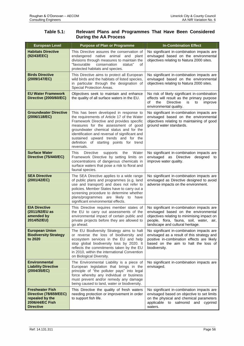
Roughan & O’Donovan – AECOM Limerick City & County Council Consulting Engineers AA NIR Variation No. 6
Ref: 14.131.311 Page 56
Table 5.1: Relevant Plans and Programmes That Have Been Considered During the AA Process
European Level Purpose of Plan or Programme In-Combination Effect
Habitats Directive (92/43/EEC)
This Directive assures the conservation of endangered native animal and plant divisions through measures to maintain the "favourable conservation status" of protected habitats and species.
No significant in-combination impacts are envisaged based on the environmental objectives relating to Natura 2000 sites.
Birds Directive (2009/147/EC)
This Directive aims to protect all European wild birds and the habitats of listed species, in particular through the designation of Special Protection Areas.
No significant in-combination impacts are envisaged based on the environmental objectives relating to Natura 2000 sites.
EU Water Framework Directive (2000/60/EC)
Objectives seek to maintain and enhance the quality of all surface waters in the EU.
No risk of likely significant in-combination effects will result as the primary purpose of the Directive is to improve environmental quality.
Groundwater Directive (2006/118/EC)
This has been developed in response to the requirements of Article 17 of the Water Framework Directive and provides specific measures for the assessment of good groundwater chemical status and for the identification and reversal of significant and sustained upward trends and for the definition of starting points for trend reversals.
No significant in-combination impacts are envisaged based on the environmental objectives relating to maintaining of good ground water standards.
Surface Water Directive (75/440/EC)
This Directive supports the Water Framework Directive by setting limits on concentrations of dangerous chemicals in surface waters that pose a risk to floral and faunal species.
No significant in-combination impacts are envisaged as Directive designed to improve water quality.
SEA Directive (2001/42/EC)
The SEA Directive applies to a wide range of public plans and programmes (e.g. land use and transport) and does not refer to policies. Member States have to carry out a screening procedure to determine whether plans/programmes are likely to have significant environmental effects.
No significant in-combination impacts are envisaged as Directive designed to avoid adverse impacts on the environment.
EIA Directive (2011/92/EU as amended by 2014/52/EU)
This Directive requires member states of the EU to carry out assessments of the environmental impact of certain public and private projects before they are allowed to go ahead.
No significant in-combination impacts are envisaged based on the environmental objectives relating to minimising impact on people, flora, fauna, soil, water, air, landscape and cultural heritage.
European Union Biodiversity Strategy to 2020
The EU Biodiversity Strategy aims to halt or reverse the loss of biodiversity and ecosystem services in the EU and help stop global biodiversity loss by 2020. It reflects the commitments taken by the EU in 2010, within the international Convention on Biological Diversity.
No significant in-combination impacts are envisaged as a result of this strategy and positive in-combination effects are likely based on the aim to halt the loss of biodiversity.
Environmental Liability Directive (2004/35/EC)
The Environmental Liability is a piece of European legislation that brings in the principle of “the polluter pays” into legal force whereby any individual or business must prevent and/or remedy any damage being caused to land, water or biodiversity.
No significant in-combination impacts are envisaged.
Freshwater Fish Directive (78/659/EEC) repealed by the 2006/44/EC Fish Directive
This Directive the quality of fresh waters needing protection or improvement in order to support fish life.
No significant in-combination impacts are envisaged based on objective to set limits on the physical and chemical parameters applicable to salmonid and cyprinid waters.

Roughan & O’Donovan – AECOM Limerick City & County Council Consulting Engineers AA NIR Variation No. 6
Ref: 14.131.311 Page 57
European Level Purpose of Plan or Programme In-Combination Effect
EU 2020 Climate and Energy package
This package is a set of binding legislation which aims to ensure the EU meets its climate and energy targets by 2020.
Potential for in-combination effects exist as development of renewable energy projects such as wind farms etc., may lead to habitat loss, disturbance of sensitive species and key feature of conservation.
Floods Directive (Directive 2007/60/EC
The Floods Directive is European legislation relating to the assessment and management of flood risks using a three-step approach of i) Preliminary Flood Risk Assessment, ii) Risk Assessment and iii) Flood Risk Management Plans. The management plans are to focus on prevention, protection and preparedness and take into account the relevant environmental objectives of the Water Framework Directive.
No significant in-combination impacts are envisaged based on the environmental objectives relating to prevention, protection and preparedness for flooding.
National Level Purpose of Plan or Programme In-Combination Effect
The National Spatial Strategy 2002 – 2020
This strategy aims to achieve a better balance of social, economic and physical development across the country through more effective planning.
Potential for in-combination effects exist as new transport services infrastructure may lead to habitat loss and impacts on sensitive habitats and species.
National Biodiversity Action Plan 2017-2021 (draft)
[3rd
iteration]
This plan is designed to conserve and restore Ireland’s biodiversity covering the period 2017-2021 by addressing issues ranging from improving the management of protected areas to increasing awareness and appreciation of biodiversity and ecosystem services.
No significant in-combination impacts are envisaged as plan is designed to improve biodiversity and environmental protection.
European Communities (Natural Habitats) Regulations, SI 94/1997, as amended S.I. 233/1998 and S.I. 378/2005
In 1997, the Habitats Directive (Directive 92/43/EC on the Conservation of Natural Habitats and of Wild Fauna and Flora) was transposed into Irish national law with the European Union (Natural Habitats) Regulations, SI 94/199. These Regulations have since been amended by SI 233/1998 & SI 378/2005. The European Communities (Birds and Natural Habitats) Regulations 2011 consolidate the European Communities (Natural Habitats) Regulations 1997 to 2005 and the European Communities (Birds and Natural Habitats)(Control of Recreational Activities) Regulations 2010.
No significant in-combination impacts are envisaged based on the environmental objectives relating to Natura 2000 sites.
Wildlife Act of 1976 & Wildlife (Amendment) Act, 2000
The Wildlife Act of 1976 is an Act protecting certain wildlife (including game) and flora in the country. The most recent amendment in 2000 (Act No. 38 of 2000)" provided statutory protection for Natural Heritage Areas as well as legislation relating to the management and conservation of forests, including the hunting and capture of birds in protected forests.
No significant in-combination impacts are envisaged as this Act is designed to protect protected habitats and species in the country.
Regional Spatial Economic Strategies (due to commence)
These strategies will replace the Regional Planning Guidelines so that formulation of new Spatial and Economic Strategies will be undertaken at sub-regional authority levels.
Potential for in-combination effects is unclear as each plan is not yet developed and will need to undergo AA when prepared. May result in habitat lost and fragmentation if new infrastructure developed as part of the Plans.
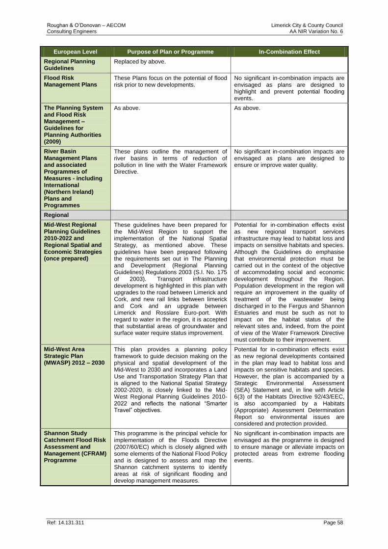
Roughan & O’Donovan – AECOM Limerick City & County Council Consulting Engineers AA NIR Variation No. 6
Ref: 14.131.311 Page 58
European Level Purpose of Plan or Programme In-Combination Effect
Regional Planning Guidelines
Replaced by above.
Flood Risk Management Plans
These Plans focus on the potential of flood risk prior to new developments.
No significant in-combination impacts are envisaged as plans are designed to highlight and prevent potential flooding events.
The Planning System and Flood Risk Management – Guidelines for Planning Authorities (2009)
As above. As above.
River Basin Management Plans and associated Programmes of Measures - including International (Northern Ireland) Plans and Programmes
These plans outline the management of river basins in terms of reduction of pollution in line with the Water Framework Directive.
No significant in-combination impacts are envisaged as plans are designed to ensure or improve water quality.
Regional
Mid-West Regional Planning Guidelines 2010-2022 and Regional Spatial and Economic Strategies (once prepared)
These guidelines have been prepared for the Mid-West Region to support the implementation of the National Spatial Strategy, as mentioned above. These guidelines have been prepared following the requirements set out in The Planning and Development (Regional Planning Guidelines) Regulations 2003 (S.I. No. 175 of 2003). Transport infrastructure development is highlighted in this plan with upgrades to the road between Limerick and Cork, and new rail links between limerick and Cork and an upgrade between Limerick and Rosslare Euro-port. With regard to water in the region, it is accepted that substantial areas of groundwater and surface water require status improvement.
Potential for in-combination effects exist as new regional transport services infrastructure may lead to habitat loss and impacts on sensitive habitats and species. Although the Guidelines do emphasise that environmental protection must be carried out in the context of the objective of accommodating social and economic development throughout the Region. Population development in the region will require an improvement in the quality of treatment of the wastewater being discharged in to the Fergus and Shannon Estuaries and must be such as not to impact on the habitat status of the relevant sites and, indeed, from the point of view of the Water Framework Directive must contribute to their improvement.
Mid-West Area Strategic Plan (MWASP) 2012 – 2030
This plan provides a planning policy framework to guide decision making on the physical and spatial development of the Mid-West to 2030 and incorporates a Land Use and Transportation Strategy Plan that is aligned to the National Spatial Strategy 2002-2020, is closely linked to the Mid-West Regional Planning Guidelines 2010-2022 and reflects the national “Smarter Travel” objectives.
Potential for in-combination effects exist as new regional developments contained in the plan may lead to habitat loss and impacts on sensitive habitats and species. However, the plan is accompanied by a Strategic Environmental Assessment (SEA) Statement and, in line with Article 6(3) of the Habitats Directive 92/43/EEC, is also accompanied by a Habitats (Appropriate) Assessment Determination Report so environmental issues are considered and protection provided.
Shannon Study Catchment Flood Risk Assessment and Management (CFRAM) Programme
This programme is the principal vehicle for implementation of the Floods Directive (2007/60/EC) which is closely aligned with some elements of the National Flood Policy and is designed to assess and map the Shannon catchment systems to identify areas at risk of significant flooding and develop management measures.
No significant in-combination impacts are envisaged as the programme is designed to ensure manage or alleviate impacts on protected areas from extreme flooding events.

Roughan & O’Donovan – AECOM Limerick City & County Council Consulting Engineers AA NIR Variation No. 6
Ref: 14.131.311 Page 59
European Level Purpose of Plan or Programme In-Combination Effect
River Basin Management Plans and Programme of Measures (2nd Cycle in preparation DCCAE)
While the objectives of the Water Framework Directive (WFD) is to seek to maintain and enhance the quality of all surface waters in the EU (see above), a key purpose of this plan is to identify and prioritise the challenges presented in achieving the objectives of the WFD and ensure that implementation of this plan is guided by this prioritisation.
No significant in-combination impacts are envisaged as this plan is designed to protect water-dependent habitats and species under the Birds and Habitats Directive and to contribute towards achieving water conditions that support Favourable Conservation Status.
Shannon-Foynes Port Company Masterplan – Vision 2041(2013)
SFPC has undertaken the preparation of a masterplan in order to promote and support the provision of port infrastructure and services in the Shannon Estuary over the next 30 years with a focus on its facilities at Foynes Port and Limerick. The priority objectives of this masterplan include the upgrade of the N69 road between Foynes and Askeaton as a strategic national route and the upgrade of the rail link between Foynes and Limerick.
The objectives of this masterplan with regard to the development of an improved national road between Foynes and Limerick and the potential environmental impacts are being addressed by this NIR. However the upgrade of the rail link between Foynes and Limerick is a project not covered by this NIR and which has the potential to further impact protected habitats and species in the area.
Strategic Integrated Framework Plan for the Shannon Estuary (SIFP) 2013 – 2020
This plan is an inter-jurisdictional land and marine based framework plan to guide the future development and management of the Shannon Estuary. However it is cognisant of the Lower River Shannon SAC and River Shannon and Fergus Estuaries SPA designations which will be a key determinant in the future development of the overall estuary.
Potential for in-combination effects exist as new regional developments contained in the plan may lead to habitat loss and impacts on sensitive habitats and species. However, the plan is accompanied by a Strategic Environmental Assessment (SEA) Statement and, in line with Article 6(3) of the Habitats Directive 92/43/EEC, is also accompanied by a Habitats (Appropriate) Assessment Report so environmental issues have been carefully considered and protection provided.
County & Local
Limerick County Development Plan 2010-2016 (As Extended)
See Section 5.3 below See Section 5.3 below
Adare Local Area Plan 2015-2021
The Adare LAP establishes a framework for the planned, coordinated and sustainable development of the village of Adare, including the conservation and enhancement of its natural and built environment over the period 2015 – 2021. In accordance with Articles 6(3) and (4) of the Habitats Directive the Planning Authority undertook an AA Screening Report of the plan which found that the plan would have no significant effects on Natura 2000 sites.
Potential in-combination effects include Land-take, habitat fragmentation, species disturbance and climate change, for a new Waste Water Treatment Plant, water abstraction, emission (disposal to land, water or air), and transportation requirements. However, the LAP has been formulated to ensure that land uses, developments and effects arising from permissions based upon this Plan (either individually or in combination with other plans or projects) will not give rise to significant adverse impacts on the integrity of any Natura 2000 site, in view of their Conservation Objectives.
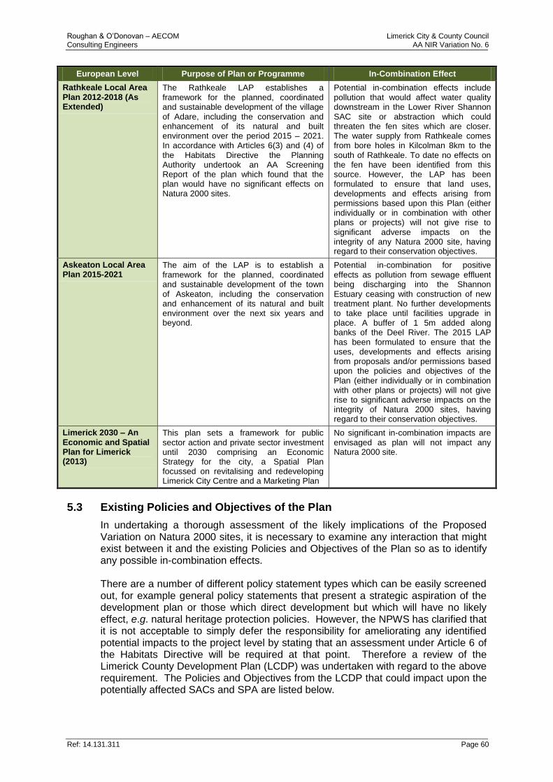
Roughan & O’Donovan – AECOM Limerick City & County Council Consulting Engineers AA NIR Variation No. 6
Ref: 14.131.311 Page 60
European Level Purpose of Plan or Programme In-Combination Effect
Rathkeale Local Area Plan 2012-2018 (As Extended)
The Rathkeale LAP establishes a framework for the planned, coordinated and sustainable development of the village of Adare, including the conservation and enhancement of its natural and built environment over the period 2015 – 2021. In accordance with Articles 6(3) and (4) of the Habitats Directive the Planning Authority undertook an AA Screening Report of the plan which found that the plan would have no significant effects on Natura 2000 sites.
Potential in-combination effects include pollution that would affect water quality downstream in the Lower River Shannon SAC site or abstraction which could threaten the fen sites which are closer. The water supply from Rathkeale comes from bore holes in Kilcolman 8km to the south of Rathkeale. To date no effects on the fen have been identified from this source. However, the LAP has been formulated to ensure that land uses, developments and effects arising from permissions based upon this Plan (either individually or in combination with other plans or projects) will not give rise to significant adverse impacts on the integrity of any Natura 2000 site, having regard to their conservation objectives.
Askeaton Local Area Plan 2015-2021
The aim of the LAP is to establish a framework for the planned, coordinated and sustainable development of the town of Askeaton, including the conservation and enhancement of its natural and built environment over the next six years and beyond.
Potential in-combination for positive effects as pollution from sewage effluent being discharging into the Shannon Estuary ceasing with construction of new treatment plant. No further developments to take place until facilities upgrade in place. A buffer of 1 5m added along banks of the Deel River. The 2015 LAP has been formulated to ensure that the uses, developments and effects arising from proposals and/or permissions based upon the policies and objectives of the Plan (either individually or in combination with other plans or projects) will not give rise to significant adverse impacts on the integrity of Natura 2000 sites, having regard to their conservation objectives.
Limerick 2030 – An Economic and Spatial Plan for Limerick (2013)
This plan sets a framework for public sector action and private sector investment until 2030 comprising an Economic Strategy for the city, a Spatial Plan focussed on revitalising and redeveloping Limerick City Centre and a Marketing Plan
No significant in-combination impacts are envisaged as plan will not impact any Natura 2000 site.
5.3 Existing Policies and Objectives of the Plan
In undertaking a thorough assessment of the likely implications of the Proposed Variation on Natura 2000 sites, it is necessary to examine any interaction that might exist between it and the existing Policies and Objectives of the Plan so as to identify any possible in-combination effects. There are a number of different policy statement types which can be easily screened out, for example general policy statements that present a strategic aspiration of the development plan or those which direct development but which will have no likely effect, e.g. natural heritage protection policies. However, the NPWS has clarified that it is not acceptable to simply defer the responsibility for ameliorating any identified potential impacts to the project level by stating that an assessment under Article 6 of the Habitats Directive will be required at that point. Therefore a review of the Limerick County Development Plan (LCDP) was undertaken with regard to the above requirement. The Policies and Objectives from the LCDP that could impact upon the potentially affected SACs and SPA are listed below.
Roughan & O’Donovan – AECOM Limerick City & County Council Consulting Engineers AA NIR Variation No. 6
Ref: 14.131.311 Page 61
Most of the Policies and Objectives contained within the LCDP are general policy objectives that set out the strategic aspirations for the development of the county during the lifetime of the plan. While it is not possible to identify where, when or how most of these Policies and Objectives will be implemented, where effects may occur or which, if any, Natura 2000 sites may be affected, all the current policies and objectives within the LCDP and variations thereof, have been subjected to AA and therefore there will be no in-combination effects at the plan level. However, a number of more specific Policies and Objectives were identified which could affect the highlighted Qualifying Interests/Special Conservation Interests of the potentially affected SACs and SPA. The potential for in-combination effects arising from these Policies and Objectives is reviewed below. LCDP Policies & Objectives with potential in-combination effects: ED P7: Integrated planning of the Shannon Estuary: Facilitate integrated planning to develop the capacity of the Shannon Estuary as a prime transport, industrial development and tourist asset. Limerick City and County Council will promote overall sustainable development within the Shannon Estuary and support all legislative environmental commitments provided in the Strategic Integrated Framework Plan for the Shannon Estuary, inter alia The EU Habitats Directive, The EU Birds Directive, The Floods Directive and the Water Framework Directive
- See Section 5.4, Variation No. 3.
ED O7: Appropriate marine related industrial development of Foynes and deep water facilities in the Shannon estuary: (a) It is the objective of the Council to ensure that the marine related industrial zoned land in Foynes is safeguarded for the accommodation of port related uses and other industrial activities. The lands indicated in the Shannon Integrated Framework Plan are also included in this zoning. The application of appropriate mitigation measures for this zone as detailed in SIFP Vol. 2 appendices C and D, the Environmental Report and Natura Impact Report of the variation to this plan to incorporate the SIFP will apply for proposed developments within this zone. (b) Support the expansion of the Port at Foynes and promote the economic and industrial development of the Shannon Estuary as a strategic transport, energy and logistics Hub serving the County and wider region by utilising naturally occurring deep water characteristics and by identifying and safeguarding existing and future strategic transportation links, subject to fulfilling the requirements of the Habitats Directive and the conservation objectives of the Lower River Shannon SAC site. (c) Support the consideration of new deep water berthage within the estuary to enhance the strategic economic function of the Port subject to compliance with the ecological objectives of the Lower River Shannon SAC site and other policies of the County Development Plan
- This Objective could have an in-combination effect on the Conservation Objectives of the Lower River Shannon SAC through negative impacts on water quality. However, this Objective contains safeguards and states that any future development will be subject to fulfilling the requirements of the Habitats Directive and the Conservation Objectives of the Lower River Shannon SAC. Therefore, it is thought that this consideration at the time of any future development in combination with the additional mitigation measures proposed in Section 6 of this report will eliminate any possible in-combination impacts.
SE O5: Harbours: to support the provision of harbours along the estuary, subject to the proper planning and sustainable development, while respecting the constraints of the Special Area of Conservation and Special Protection Area designations.
Roughan & O’Donovan – AECOM Limerick City & County Council Consulting Engineers AA NIR Variation No. 6
Ref: 14.131.311 Page 62
- This Objective supports the future development of harbours along the estuary. The development of these types of harbours may have an adverse effect on the integrity of the Lower River Shannon SAC in combination with the Proposed Variation. The Objective itself refers to the constraints imposed on development due to the proximity of surrounding SACs and SPAs but does not address direct, indirect or secondary effects on Qualifying Interests of Natura 2000 sites within the estuary.
SE O1: Strategic Integrated Framework Plan for the Shannon Estuary: It is a Policy of Limerick City and County Council to support and implement the inter-jurisdictional Strategic Integrated Framework Plan (SIFP) for the Shannon Estuary in conjunction with the other relevant local authorities and agencies. All proposed developments shall be in accordance with regional and national priorities and the SEA Directive, Birds and Habitats Directive, Water Framework Directive, Shellfish Waters Directive, Floods Directive and EIA Directive. All proposed developments shall be informed by the mitigation measures for ensuring the integrity of the Natura 2000 network outlined within the Limerick County Development Plan 2010-2016 (as varied).
SE O16: Water Quality: Development proposals in the Shannon Estuary Area will be required to have regard to the quality of the water resources in the area. They will be required to demonstrate that they will have no significant adverse consequences for water quality.
- These Objectives highlights the potential for negative impacts on water quality as a result of development within the Estuary. Although it states that developments will be required to demonstrate that they will not have a significant adverse impact on water quality, no specific measures are given that can be applied to Proposed Variation to ensure no in-combination effects. Therefore, additional mitigation measures must be considered. These additional measures are listed in Section 6 “Mitigation” of this NIR.
5.4 In-Combination Effects from Other Relevant Projects
In addition to relevant plans, major projects located within the 15km zone of influence of the Proposed Variation were assessed in terms of their potential to affect the integrity of the Natura 2000 sites in-combination with those impacted by the Proposed Variation. The major projects identified as having potential in-combination effects included: Table 5.2: Relevant Projects Within the 15km that have been Considered
for in-combination Effects During the AA Process
Project Development
(No.)
Project In-combination effect
Poultry Farm (12/181) – Camas, Newcastle West
The construction of a poultry house, a soiled water tank, the use of existing entrance and all associated site works - An EIS has been submitted with this application.
No cumulative impact. The proposed development is required by the planning authority to implement best practice to prevent and minimise impacts due to surface water run-off during construction and operation. Therefore, no cumulative impacts are expected.
Roughan & O’Donovan – AECOM Limerick City & County Council Consulting Engineers AA NIR Variation No. 6
Ref: 14.131.311 Page 63
Project Development
(No.)
Project In-combination effect
Poultry Farm (12/688) – Monlena, Newcastle West
The extension of existing poultry house, the construction of a poultry house, soiled water tank and associated site works (this application relates to development which comprises or is for the purposes of an activity requiring an integrated pollution management plan.
No cumulative impact. The proposed development is required by the planning authority to implement best practice to prevent and minimise impacts due to surface water run-off during construction and operation. Therefore, no cumulative impacts are expected.
Greenstar Environmental Services Ltd Ballykeeffe, Dock Road Limerick (13/300)
An increase in the amount of waste accepted annually to 130,000 tonnes. The proposed increase does not require the construction / provision of any new buildings or structures. The development will require a revision of the Waste Licence granted by the Council which will ensure management and control of water run-off and other environmental impacts.
No cumulative impact. The proposed development is in a discrete geographical area and required by the planning authority to implement best practice to prevent and minimise impacts due to surface water run-off during construction and operation. Therefore, no cumulative impacts are expected.
CPL Fuels Ireland Ltd (14/603) - Lands at Durnish, Internal Shannon Foynes Port, Foynes
Alterations and extension to the existing industrial building, erection of new buildings and new hardcore area for external storage, to accommodate the storage, screening, processing, binding and packaging of solid fuel briquettes by CPL.
No cumulative impact. The proposed development is required by the planning authority to implement best practice to prevent and minimise impacts due to fuel pollution of surface waters and prevent surface water run-off during construction and operation. Therefore, no cumulative impacts are expected.
Hanrahan Farms Ltd. Kilmore, Granagh (14/889)
Construction of a Mill and Feed store building to cover and update existing facilities. This application related to a development which is for the purposes of an activity requiring an IPPC Licence under part IV of the EPA Licensing Regulations 1994 to 2008
No cumulative impact. The proposed development is in a discrete geographical area and required by the planning authority to implement best practice to prevent and minimise impacts due to pollution of surface water run-off during construction and operation. Therefore, no cumulative impacts are expected.
Bord Na Mona Fuels Limited (15/468) – Durnish, International Port Road, Shannon Foynes Port
Project involves the ongoing smokeless and bio-mass based solid fuel manufacturing and packaging facility at and adjacent to existing coal storage and baggage facility. The development includes the demolition of existing buildings and storage structures, the upgrading, extension and refurbishment of existing buildings.
No Cumulative Impact. The proposed development is required by the planning authority to implement best practice to prevent and minimise pollution of surface water run-off impacts during construction and operation. Therefore, no cumulative impacts are expected.
Adare Manor Hotel & Golf Resort (15/920) - Tizzard Holdings Ltd
Large-scale refurbishment of existing hotel and golf club including internal refurbishment of the existing hotel; revisions to internal layout of lower ground floor level of hotel comprising re-arrangement and upgrade of the hotel.
No cumulative impact. In light of the mitigation measures proposed in the EIS there will be no impact on the mammalian interests of the Natura 200 sites in the area.
Roughan & O’Donovan – AECOM Limerick City & County Council Consulting Engineers AA NIR Variation No. 6
Ref: 14.131.311 Page 64
Project Development
(No.)
Project In-combination effect
Limerick Northern Distributor Road - 2015 Limerick City
This project involves the development of a new road from Knockalisheen Stream crossing the River Shannon (included within the Lower River Shannon SAC) before connecting to the R445 at the Cappamore Junction. The impact of this project on the Lower River Shannon SAC was assessed in an NIR relating to the inclusion of this project through a variation to the Limerick Country Development Area Plan 2010 – 2016.
No cumulative impact. On the basis of the objective information provided in the Natura Impact Report, the proposed Variation of the of the Limerick Country Development Area Plan 2010 – 2016, either alone or in-combination with other plans and projects, will have no adverse affect on any Natura 2000 site and therefore have no in-combination effects when considered with the Proposed Variation.
Poultry Farm (15/815) – Ballintubber East, Newcastle West
The project involves the construction of a new poultry house, meal bins wash water collection tank and associated site works (the development comprises of an activity in relation to which an Industrial Emissions Directive Licence (formerly IPPC Licence) currently operate).
No cumulative impact. The proposed development is required by the planning authority to implement best practice to prevent and minimise impacts due to surface water run-off during construction and operation. Therefore, no cumulative impacts are expected.
Irish Cement Limited (16/345) - Limerick Cement Works, Castlemungret
This project includes an application for 10 year permission for development to allow for the replacement of fossil fuels through the introduction of lower carbon alternative fuels and to allow for the use of alternative raw materials in their Limerick Cement Works.
No cumulative impact. The proposed development is required by the planning authority to implement best practice to prevent and minimise impacts due to hydrocarbon and fuel pollution of surface water run-off during construction and operation. Therefore, no cumulative impacts are expected.
5.5 Results of the In-Combination Assessment
Following the in-combination assessment it has been concluded that there is no potential for adverse effects arising as a consequence of the implementation of any element of the Proposed Variation acting in-combination with any other plan or projects located within the zone of influence of the Proposed Variation. This conclusion is reached based on the following reasons:
Any plan or project must adhere to the overarching policies and objectives of the LCDP as these will ensure the protection of the Natura 2000 sites within the zone of influence and stipulates the requirement for an AA to demonstrate that the plan or project will not significantly affect the integrity of the Natura 2000 sites.
National, regional or local plans contain specific policies and objectives ensuring the protection of Natura 2000 sites from significant impacts which may affect the integrity of the sites.
No adverse effects on the integrity of the Natura 2000 sites will arise from specific projects due to the project-specific mitigation measures detailed in their respective NIR/EIS, where available.
In conclusion, no adverse effects on the integrity of the Natura 2000 sites will arise from the Proposed Variation acting in-combination with any plans or projects located within the zone of influence of the Proposed Variation.
Roughan & O’Donovan – AECOM Limerick City & County Council Consulting Engineers AA NIR Variation No. 6
Ref: 14.131.311 Page 65
6.0 MITIGATION
6.1 Introduction
This section outlines both the mitigation which is currently in the Plan to safeguard the integrity of Natura 2000 sites through a number of dedicated Policies and Objectives, as well as the specific measures which have been developed to mitigate against the impacts that may arise from the proposed Foynes to Limerick Road Improvement Scheme, for which this Proposed Variation is being considered.
6.2 Mitigation in the Existing Limerick County Development Plan
There are a number of Policies and Objectives contained within the Plan which are designed and developed for the protection of the natural environment. These include Policies and Objectives with the specific purpose of protecting Natura 2000 sites within the county as follows: Section 6.12 Waterways and Recreation
COM O32: Accessibility to Waterways: a) Promote and protect and improve public accessibility to the County’s rivers and lakes, and b) Protect the Shannon Estuary, rivers, and lakes from ecological damage. c) Seek the provision of a riparian corridor/ buffer zone, where appropriate and subject to Article 6 of the Habitats Directive, along river banks and streams for the purposes of providing habitat, river maintenance, access for anglers, walkers and to not permit development encroaching on these corridors where appropriate. Section 7.2.5 Sites and Species Protection
EH O1: Nature Conservation Sites: a) Maintain the conservation value of those sites as defined in the Planning and Development Acts 2000 - 2010 (SPAs, SACs) or lands proposed for inclusion by the Department of Environment Heritage and Local Government, as well as any other sites that may be so designated during the lifetime of this plan. b) Ensure that development projects and development plans likely to have significant effects on European Sites (either individually or in combination with other plans or projects) are subject to an appropriate assessment and will not be permitted under this plan unless they comply with article 6 of the Habitats Directive. c) Maintain the conservation value of all Natural Heritage Areas and also Natural Heritage areas proposed for designation by the DEHLG as well as any other sites that may be so designated during the lifetime of the plan. EH O2: Species Protection: It is the objective of the Council to seek to protect plant, animal and bird species that have been identified by the Habitats Directive, Birds Directive, Wildlife Act and the Flora Protection Order in line with national and EU legislation. EH P1: Sustainable Management and Conservation: to ensure the sustainable management and conservation of areas of natural environmental and geological value within the County. Section 7.4.1.2 River Basin Management
EH O20: Ground Water and Surface Water Protection and River Basin Management Plans: a) it is the objective of the Council to protect ground water resources of the County and surface waters of the County. There will be a general prohibition on the filling of wetlands and surface water features. b) in assessing planning applications and their consequences for ground water the Council will
Roughan & O’Donovan – AECOM Limerick City & County Council Consulting Engineers AA NIR Variation No. 6
Ref: 14.131.311 Page 66
implement the measures put forward in the Limerick Groundwater Protection Plan and c) it is the objective of the Council to implement the measures recommended in the River Basin Management Plans Section 8.3.4 Strategic Policy
IN P12: Catchment Management: In seeking the proper development and use of water resources and associated activities the Council will work with relevant authorities to better secure a consistent management approach across river catchments and river basin districts. Particular regard shall be had to the following: a) The Draft Shannon River Basin Management Plan and the South-Western River Basin District Management Plan in their respective areas of coverage. b) The Geological Survey of Ireland (GSI) ground water survey, c) The Heritage Council Lower Shannon Waterway Corridor Study, 2006, and d) The OPW in respect of Flood risk data, assessments, and Flood Risk Management Plans. 8.3.5 Water Supply, Water Conservation and Sewerage
IN O34: Water Conservation: It is an objective of the Council to promote the awareness of sustainable water use and to encourage water conservation and demand minimisation by, inter alia, promoting Sustainable Urban Drainage Systems and grey water recycling in developments. IN O 39: Flood risk management and development: It is an objective of the Council to ensure that land uses are zoned, and developments allowed where there is minimum flood risk, prioritising the protection of certain land uses particularly vulnerable to the affects of flooding, including preserving riparian strips free of development and ensuring adequate width to permit access for river maintenance. Section 8.3.6 Flood Risk
IN O37: Manage river catchments and surface water run-off: It is the objective of the Council to assist in the sustainable management of river catchments to reduce both the quantity of water run-off and its speed and unpredictability, allow rivers to take their natural flow, and allow flooding only to occur in lower sensitivity areas.” IN O40: To minimise the impact of structures and earthworks on flood plains and river flow: not to permit development of the following types in or across flood plains or river channels unless it can be clearly demonstrated using flood impact assessments, that they would not create or exacerbate risk of flooding in sensitive locations such as: a) construction of embankments, wide bridge piers or similar structures. b) raising of ground levels where this would interfere with natural river flow or currents. Section 9.3 Environmental Issues in the Estuary
SE O15: Protected Areas: Development proposals within areas designated as nature conservation areas (Special Areas of Conservation, Special Protection Areas for wild birds or Natural Heritage Areas) shall be considered where it has been demonstrated that the proposal would not result in significant direct or indirect adverse impacts on the area, or on protected species and habitats and would fulfil the requirements of Article 6 of the Habitats Directive.
6.3 Mitigation Measures for the Proposed Variation
This NIR has shown that, in the absence of appropriate mitigation measures, the Proposed Variation is likely to adversely affect the Lower River Shannon SAC, the Curraghchase Woods SAC, the Askeaton Fens Complex SAC and the River
Roughan & O’Donovan – AECOM Limerick City & County Council Consulting Engineers AA NIR Variation No. 6
Ref: 14.131.311 Page 67
Shannon and River Fergus Estuaries SPA in view of their Conservation Objectives. In order for Limerick City & County Council to eliminate the possibility of these effects occurring or being significant with regard to the integrity of these sites, additional mitigation measures are required. These measures must address the following:
Potential direct impacts on the Annex I priority habitat Alluvial forests with Alnus glutinosa and Fraxinus excelsior (Alno-Padion, Alnion incanae, Salicion albae) within the Lower River Shannon SAC at the proposed River Maigue crossing north of Adare village;
Potential impacts on ground water levels and flows during the construction and operation of the proposed road, which would be likely to cause significant indirect impacts on the water levels in the Calcareous fens with Cladium mariscus and species of the Caricion davallianae and Alkaline Fens within the Askeaton Fens Complex SAC;
Potential impacts on Lesser Horseshoe Bats through habitat loss and fragmentation, loss of foraging and flight paths;
Potential impacts on water quality (due to sedimentation and/ or pollution events) during the construction and operation of a proposed bridge over the River Maigue, which would be likely to cause significant indirect impacts on River Lamprey and Atlantic Salmon;
Potential impacts on European Otter through habitat loss and fragmentation, as well as secondary impacts arising from impacts on water quality affecting availability of prey species; and,
Potential impacts on Whooper Swans utilising the area through foraging, and habitat loss and fragmentation.
Scottish Natural Heritage has produced a useful guidance document on plan-level mitigation measures. The document is entitled Habitats Regulations Appraisal (HRA) Advice Sheet: Screening general policies and applying simple mitigation measures (SNH, 2012) and outlines the means by which further mitigation measures can be introduced to a plan, e.g. policy restrictions, policy caveats and prescribing mitigation measures to be confirmed by a more detailed AA at project stage. Measures must be specific, explicit and part the wording of the Policy/Objective, not merely added to the explanatory text or commentary. The document states that, as a general rule, policy caveats, restrictions or qualifications should be:
a) Included in the plan and not just in the NIR or a supporting document;
b) Included in the policy wording where policies are distinguishable from the other text, or in the text of the plan where policies are not distinguished from other text;
c) Specific to the case, issue or proposal and/or the particular European site(s);
d) Related to the qualifying interests and/or the site potentially affected, and to the NIR and its findings, which must be available and accessible;
e) Explicit about the meaning and implications for decision-making, such as clearly indicating that “planning permission will be granted only where it can be ascertained that the proposal would not have an adverse effect on the integrity of [the case-specific] European site”; and,
f) Short and “tightly-worded”, the NIR can provide the context, explanation and purpose of the qualification.
As result of this AA the mitigation measures detailed in Sections 6.3.1 to 6.3.4 below have fed into the development of the Proposed Variation which are shown in Section 6.12.
Roughan & O’Donovan – AECOM Limerick City & County Council Consulting Engineers AA NIR Variation No. 6
Ref: 14.131.311 Page 68
6.3.1 River Maigue Crossing Mitigation
To avoid potential adverse effects on the Conservation Objectives of the Lower River Shannon SAC as a result of the proposed construction of a crossing point over the River Maigue, the design of the bridge structure is critical to ensure that i) there is no impact on the riparian or riverine habitats, ii) that bank works will not impact otter utilisation of the area, e.g. fragmentation of habitat, or iii) it does not cause a reduction in water quality (due to sedimentation and/or pollution events), and iv) that the habitat connectivity is maintained. The design of a structure of this magnitude is a significant undertaking and a balance has to be struck between the policies and objectives that restrict the design process and one that strengthens the protection of the SAC. The following mitigation measures shall be observed at the design and construction stage, and should also be considered in conjunction with the mitigation outlined in Sections 6.5, 6.6, 6.7 and 6.8:
The respective designs of the proposed River Maigue bridge shall be informed by the requirement to avoid adverse impacts on the integrity of the Lower River Shannon SAC.
Bridge abutments shall be set back a sufficient distance to allow riparian habitats or areas with potential to develop into Alluvial forests with Alnus glutinosa and Fraxinus excelsior (Alno-Padion, Alnion incanae, Salicion albae). This will also ensure the maintenance of habitat connectivity on both banks of the River Maigue.
Placement of bridge abutments will not impact any otter holts or couches, if present.
Should the construction of bridge infrastructure have the potential to impact on Triangular Club-rush populations and where it is not possible to avoid this habitat a derogation licence must be obtained from NPWS to allow for the translocation of this species away from the construction site and for it to be returned to the site when construction is complete.
Construction activities will not cause any sedimentation or accidental pollution through discharge of building materials (concrete) or hydrocarbons (fuels) into the river causing a reduction in water quality which may affect River Lamprey and Salmon populations.
6.3.2 Loss of Lesser Horseshoe Bat Habitat and Commuting Pathways
With consideration of the “Assessment of the effectiveness of Bat Mitigation Measures employed on Irish National Road Schemes” (TII 2010) and in line with the guidelines mentioned in Section 6.9, the following mitigation measures shall be observed at the design and construction stage of the proposed route:
avoid the loss of vegetation habitats and vegetated corridors (tree lines and hedgerows) used by Lesser Horseshoe bat as communication paths between foraging, roosting and/or breeding areas;
where there is the potential or actual bat movement in the area of the proposed route, provision will be made to avoid impeding bat flight paths by the design of appropriate vegetative landscaping and underpasses.
6.3.3 Changes in ground water levels and flows in the Askeaton Fens Complex SAC
To avoid potential adverse effects on the water levels and integrity of the fens within Askeaton Fens Complex SAC, the design of the proposed route will be such as to avoid significant impact on ground water levels or flows in or out of the fens.
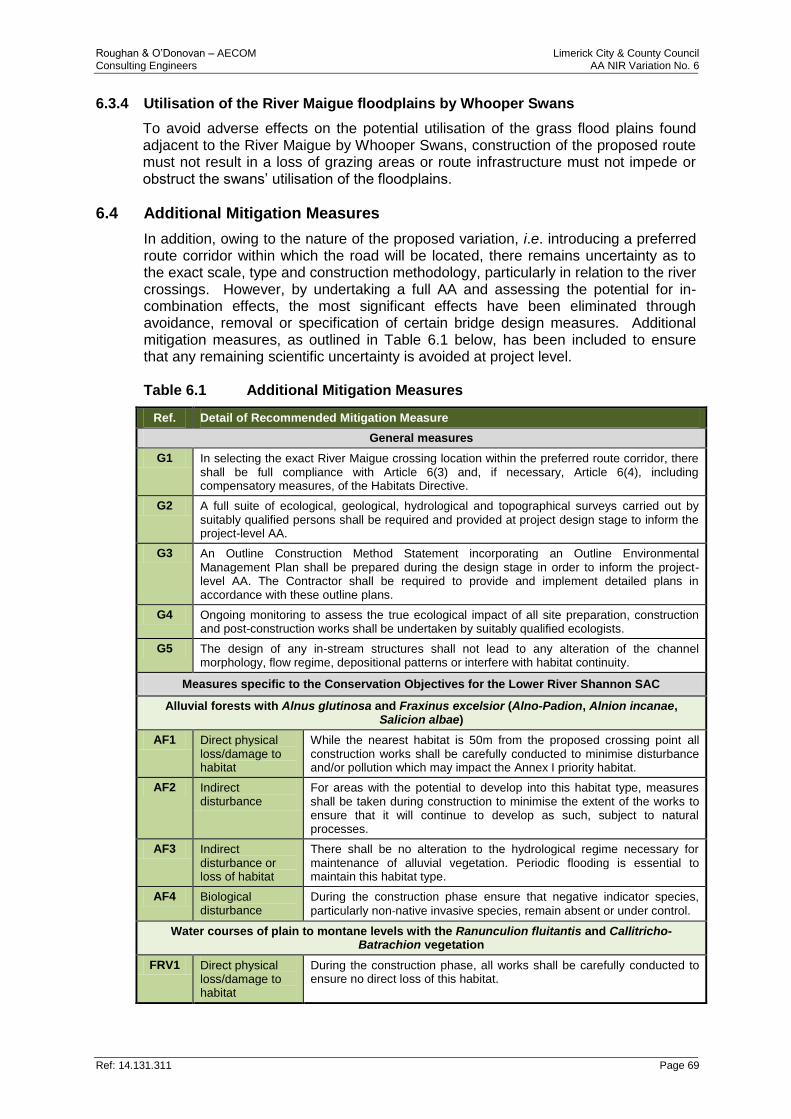
Roughan & O’Donovan – AECOM Limerick City & County Council Consulting Engineers AA NIR Variation No. 6
Ref: 14.131.311 Page 69
6.3.4 Utilisation of the River Maigue floodplains by Whooper Swans
To avoid adverse effects on the potential utilisation of the grass flood plains found adjacent to the River Maigue by Whooper Swans, construction of the proposed route must not result in a loss of grazing areas or route infrastructure must not impede or obstruct the swans’ utilisation of the floodplains.
6.4 Additional Mitigation Measures
In addition, owing to the nature of the proposed variation, i.e. introducing a preferred route corridor within which the road will be located, there remains uncertainty as to the exact scale, type and construction methodology, particularly in relation to the river crossings. However, by undertaking a full AA and assessing the potential for in-combination effects, the most significant effects have been eliminated through avoidance, removal or specification of certain bridge design measures. Additional mitigation measures, as outlined in Table 6.1 below, has been included to ensure that any remaining scientific uncertainty is avoided at project level. Table 6.1 Additional Mitigation Measures
Ref. Detail of Recommended Mitigation Measure
General measures
G1 In selecting the exact River Maigue crossing location within the preferred route corridor, there shall be full compliance with Article 6(3) and, if necessary, Article 6(4), including compensatory measures, of the Habitats Directive.
G2 A full suite of ecological, geological, hydrological and topographical surveys carried out by suitably qualified persons shall be required and provided at project design stage to inform the project-level AA.
G3 An Outline Construction Method Statement incorporating an Outline Environmental Management Plan shall be prepared during the design stage in order to inform the project-level AA. The Contractor shall be required to provide and implement detailed plans in accordance with these outline plans.
G4 Ongoing monitoring to assess the true ecological impact of all site preparation, construction and post-construction works shall be undertaken by suitably qualified ecologists.
G5 The design of any in-stream structures shall not lead to any alteration of the channel morphology, flow regime, depositional patterns or interfere with habitat continuity.
Measures specific to the Conservation Objectives for the Lower River Shannon SAC
Alluvial forests with Alnus glutinosa and Fraxinus excelsior (Alno-Padion, Alnion incanae, Salicion albae)
AF1 Direct physical loss/damage to habitat
While the nearest habitat is 50m from the proposed crossing point all construction works shall be carefully conducted to minimise disturbance and/or pollution which may impact the Annex I priority habitat.
AF2 Indirect disturbance
For areas with the potential to develop into this habitat type, measures shall be taken during construction to minimise the extent of the works to ensure that it will continue to develop as such, subject to natural processes.
AF3 Indirect disturbance or loss of habitat
There shall be no alteration to the hydrological regime necessary for maintenance of alluvial vegetation. Periodic flooding is essential to maintain this habitat type.
AF4 Biological disturbance
During the construction phase ensure that negative indicator species,
particularly non‐native invasive species, remain absent or under control.
Water courses of plain to montane levels with the Ranunculion fluitantis and Callitricho-Batrachion vegetation
FRV1 Direct physical loss/damage to habitat
During the construction phase, all works shall be carefully conducted to ensure no direct loss of this habitat.
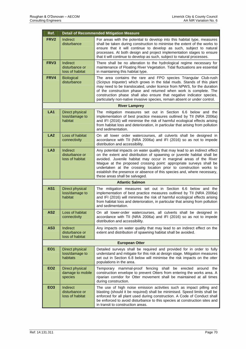
Roughan & O’Donovan – AECOM Limerick City & County Council Consulting Engineers AA NIR Variation No. 6
Ref: 14.131.311 Page 70
Ref. Detail of Recommended Mitigation Measure
FRV2 Indirect disturbance
For areas with the potential to develop into this habitat type, measures shall be taken during construction to minimise the extent of the works to ensure that it will continue to develop as such, subject to natural processes. At both design and project implementation stages to ensure that it will continue to develop as such, subject to natural processes.
FRV3 Indirect disturbance or loss of habitat
There shall be no alteration to the hydrological regime necessary for maintenance of Floating River Vegetation. Tidal fluctuations are essential in maintaining this habitat type.
FRV4 Biological disturbance
The area contains the rare and FPO species Triangular Club-rush (Scirpus triqueter) which grows in the tidal muds. Stands of this plant
may need to be translocated, under licence from NPWS, for the duration of the construction phase and returned when work is complete. The construction phase shall also ensure that negative indicator species, particularly non‐native invasive species, remain absent or under control.
River Lamprey
LA1 Direct physical loss/damage to habitat
The mitigation measures set out in Section 6.6 below and the implementation of best practice measures outlined by TII (NRA 2006a) and IFI (2016) will minimise the risk of harmful ecological effects arising from habitat loss and deterioration, in particular that arising from pollution and sedimentation.
LA2 Loss of habitat connectivity
On all lower order watercourses, all culverts shall be designed in accordance with TII (NRA 2006a) and IFI (2016) so as not to impede distribution and accessibility.
LA3 Indirect disturbance or loss of habitat
Any potential impacts on water quality that may lead to an indirect effect on the extent and distribution of spawning or juvenile habitat shall be avoided. Juvenile habitat may occur in marginal areas of the River Maigue at the proposed crossing point: appropriate surveys shall be undertaken at the crossing location prior to construction works to establish the presence or absence of this species and, where necessary, these areas shall be salvaged.
Atlantic Salmon
AS1 Direct physical loss/damage to habitat
The mitigation measures set out in Section 6.6 below and the implementation of best practice measures outlined by TII (NRA 2006a) and IFI (2016) will minimise the risk of harmful ecological effects arising from habitat loss and deterioration, in particular that arising from pollution and sedimentation.
AS2 Loss of habitat connectivity
On all lower-order watercourses, all culverts shall be designed in accordance with TII (NRA 2006a) and IFI (2016) so as not to impede distribution and accessibility.
AS3 Indirect disturbance or loss of habitat
Any impacts on water quality that may lead to an indirect effect on the extent and distribution of spawning habitat shall be avoided.
European Otter
EO1 Direct physical loss/damage to habitats
Detailed surveys shall be required and provided for in order to fully understand and mitigate for this risk at design stage. Mitigation measures set out in Section 6.8 below will minimise the risk impacts on the otter populations in the area.
EO2 Direct physical damage to mobile species
Temporary mammal-proof fencing shall be erected around the construction envelope to prevent Otters from entering the works area. A riparian corridor for Otter movement shall be maintained at all times during construction.
EO3 Indirect disturbance or loss of habitat
The use of high noise emission activities such as impact pilling and blasting (should it be required) shall be minimised. Speed limits shall be enforced for all plant used during construction. A Code of Conduct shall be enforced to avoid disturbance to this species at construction sites and in transit to construction areas.
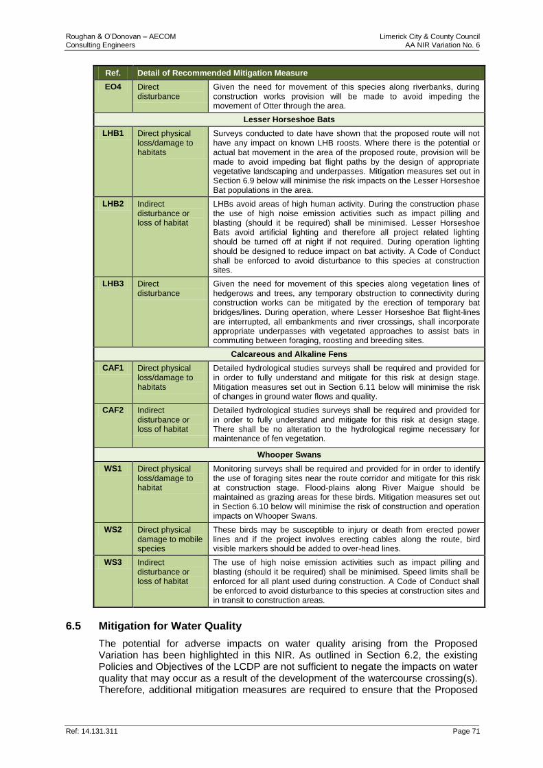
Roughan & O’Donovan – AECOM Limerick City & County Council Consulting Engineers AA NIR Variation No. 6
Ref: 14.131.311 Page 71
Ref. Detail of Recommended Mitigation Measure
EO4 Direct disturbance
Given the need for movement of this species along riverbanks, during construction works provision will be made to avoid impeding the movement of Otter through the area.
Lesser Horseshoe Bats
LHB1 Direct physical loss/damage to habitats
Surveys conducted to date have shown that the proposed route will not have any impact on known LHB roosts. Where there is the potential or actual bat movement in the area of the proposed route, provision will be made to avoid impeding bat flight paths by the design of appropriate vegetative landscaping and underpasses. Mitigation measures set out in Section 6.9 below will minimise the risk impacts on the Lesser Horseshoe Bat populations in the area.
LHB2 Indirect disturbance or loss of habitat
LHBs avoid areas of high human activity. During the construction phase the use of high noise emission activities such as impact pilling and blasting (should it be required) shall be minimised. Lesser Horseshoe Bats avoid artificial lighting and therefore all project related lighting should be turned off at night if not required. During operation lighting should be designed to reduce impact on bat activity. A Code of Conduct shall be enforced to avoid disturbance to this species at construction sites.
LHB3 Direct disturbance
Given the need for movement of this species along vegetation lines of hedgerows and trees, any temporary obstruction to connectivity during construction works can be mitigated by the erection of temporary bat bridges/lines. During operation, where Lesser Horseshoe Bat flight-lines are interrupted, all embankments and river crossings, shall incorporate appropriate underpasses with vegetated approaches to assist bats in commuting between foraging, roosting and breeding sites.
Calcareous and Alkaline Fens
CAF1 Direct physical loss/damage to habitats
Detailed hydrological studies surveys shall be required and provided for in order to fully understand and mitigate for this risk at design stage. Mitigation measures set out in Section 6.11 below will minimise the risk of changes in ground water flows and quality.
CAF2 Indirect disturbance or loss of habitat
Detailed hydrological studies surveys shall be required and provided for in order to fully understand and mitigate for this risk at design stage. There shall be no alteration to the hydrological regime necessary for maintenance of fen vegetation.
Whooper Swans
WS1 Direct physical loss/damage to habitat
Monitoring surveys shall be required and provided for in order to identify the use of foraging sites near the route corridor and mitigate for this risk at construction stage. Flood-plains along River Maigue should be maintained as grazing areas for these birds. Mitigation measures set out in Section 6.10 below will minimise the risk of construction and operation impacts on Whooper Swans.
WS2 Direct physical damage to mobile species
These birds may be susceptible to injury or death from erected power lines and if the project involves erecting cables along the route, bird visible markers should be added to over-head lines.
WS3 Indirect disturbance or loss of habitat
The use of high noise emission activities such as impact pilling and blasting (should it be required) shall be minimised. Speed limits shall be enforced for all plant used during construction. A Code of Conduct shall be enforced to avoid disturbance to this species at construction sites and in transit to construction areas.
6.5 Mitigation for Water Quality
The potential for adverse impacts on water quality arising from the Proposed Variation has been highlighted in this NIR. As outlined in Section 6.2, the existing Policies and Objectives of the LCDP are not sufficient to negate the impacts on water quality that may occur as a result of the development of the watercourse crossing(s). Therefore, additional mitigation measures are required to ensure that the Proposed
Roughan & O’Donovan – AECOM Limerick City & County Council Consulting Engineers AA NIR Variation No. 6
Ref: 14.131.311 Page 72
Variation does not impact upon water quality and, consequently, the integrity of the Lower River Shannon SAC. This mitigation is listed below and includes the application and strict adherence to best practice guidance in combination with the application of pollution prevention measures, which will ensure that there will be no adverse effect on water quality and no impact on the River Maigue or other watercourses at the proposed crossing points. It is not yet known whether any in-stream works will be required for the construction of the River Maigue bridge crossing. However, to ensure that all necessary precautions have been taken and that all possible impacts on the Qualifying Interests of the SAC have been considered, this issue is investigated further here. As outlined in Section 4, the River Maigue is utilised by River Lamprey or Atlantic Salmon moving from the estuary to spawning sites further up-stream, although the proposed crossing point itself is tidal and therefore unsuited as spawning habitat. In order to ensure that any in-stream works will not have any adverse impact on the water quality or the movement of River Lamprey or Atlantic Salmon, the following measures have been devised and which will be applicable if any in stream works are to be carried out as part of any future bridge design or construction:
1. In-stream works, including erection and dismantling of temporary bridges, pile driving etc., shall be undertaken during the period 1st July to 30th September to avoid the salmonid spawning season. Appropriate protection (such as a geotextile curtain suspended from a floating boom) shall be used, this will reduce the risk of accidental damage or siltation.
2. The pouring of concrete, sealing of joints, application of water-proofing paint or protective systems, curing agents etc. shall be completed in dry weather conditions to avoid pollution of the freshwater environment.
3. Design, construction and operation shall be in accordance with Guidelines for the Crossing of Watercourses During the Construction of National Road Schemes (NRA, 2006a) and Guidelines on Protection of Fisheries during Construction Works in and adjacent to Waters (IFI, 2016).
4. The risk of spreading invasive alien plant species will require adherence to current best practice protocol for avoiding the spread of species listed on the Third Schedule of the Nature Regulations, especially aquatic species such as Zebra Mussel (Dreissena polymorpha). These measures shall be enforced during construction to ensure accidental spread does not occur on machinery or materials from/to the site. The Contractor shall also adopt any modified or updated approaches to invasive alien plant species control.
5. Fluvial parameters including water depth and flow velocity shall be maintained within their natural range during construction and operation, having particular regard to the minimum flow requirements of River Lamprey and Atlantic Salmon.
6. Works shall not give rise to a significant pollution impact on the water or unduly impact on angling efforts. The deployment of silt curtains as a precautionary measure shall be considered. No works (except for emergency works) shall be permitted outside of daylight hours.
7. The design and Construction Method Statements will be submitted to Inland Fisheries Ireland (IFI) for approval prior to commencement of construction. All watercourse diversions, temporary or permanent, shall be carried out under the direction and supervision of Fisheries Officers.
Roughan & O’Donovan – AECOM Limerick City & County Council Consulting Engineers AA NIR Variation No. 6
Ref: 14.131.311 Page 73
6.6 Mitigation Measures and Best Practice for Road Infrastructure Projects
As well as the measures referred to above, the mitigation measures listed below will also apply to any further assessment of the proposed bridge crossing point and the future design, construction and operation of the bridge structure. The Proposed Variation shall have due regard of the following guidance documents:
1. TII Guidelines for the Crossing of Watercourses During the Construction of National Road Schemes. National Roads Authority, Dublin. (NRA 2006a)
2. IFI (2016) Guidelines on Protection of Fisheries during Construction Works in and adjacent to Waters. Inland Fisheries Ireland, Dublin.
At project stage, the proposed works shall comply with the following best practice water pollution prevention measures taken from IFI (2016) and guidance documents published by the former Regional Fisheries Boards:
1. All fuels, oils, greases and hydraulic fluids shall be stored in bunded areas well away from watercourses.
2. Refuelling of machinery etc. shall be carried out in bunded areas.
3. Run-off from the site shall not enter watercourse directly and shall be routed via suitably designed and sited settlement ponds and filter channels.
4. All settlement ponds shall be inspected daily and regularly maintained.
5. Wherever possible, the banks of watercourses shall be left intact. Otherwise, every effort shall be taken to prevent sediment from entering watercourses.
6. In-stream works using machinery shall be minimised and machinery working in watercourses shall be protected against leakages or spillage of fuels, oils greases and hydraulic fuels. Any in-stream earthworks shall be carried out in a manner such that mobilisation of the substratum is minimised.
7. In-stream works and bank-side clearance shall be minimised and measures to control the risk of siltation shall be implemented. These may include such measures as bunding and diversions of run-off to settlement ponds, surfacing of the site with granular material and covering of temporary stockpiles.
8. All construction machinery operating in-stream should be mechanically sound to avoid leaks of oils, hydraulic fluid etc. Machinery should be steam cleaned and checked prior to commencement of in-stream works.
9. Prior to the commencement of earthworks for the scheme, watercourses and drains shall be temporarily culverted to avoid movement of vehicles across watercourses.
10. Site surface drainage and silt control measures shall be established prior to the commencement earthworks. Run-off from the site or areas of exposed soil shall be channelled and intercepted at regular intervals for discharge to silt-traps or lagoons with over-flows directed to land rather than to a watercourse.
11. To avoid siltation of watercourses from crossing point locations, silt traps shall be placed beside temporary crossing points with an associated buffer strip. Silt-traps shall be maintained and cleaned regularly during construction.
12. A maintenance schedule and operational procedure shall be established by the Contractor for silt and pollution control measures during construction. This shall be undertaken in consultation with the relevant statutory authorities.
13. Pouring of concrete for aprons, sills, and other works shall be carried out in the dry and allowed cure for 48 hours before re-flooding. Pumped or tremied concrete shall be monitored carefully to ensure no accidental discharge into the
Roughan & O’Donovan – AECOM Limerick City & County Council Consulting Engineers AA NIR Variation No. 6
Ref: 14.131.311 Page 74
watercourse. Under no circumstances shall mixer washings or excess concrete be discharged to surface water.
14. Oil storage tanks and associated filling areas and distribution pipework shall be located at least 10m from watercourses (rivers, lakes, and streams, field drains) and at least 50m from wells or boreholes.
15. Storage tanks shall have secondary containment provided by means of an above ground bund to capture any oil leakage irrespective of whether it arises from leakage of the tank itself or from associated equipment such as filling and off-take points, sighting gauge etc., all of which shall be located within the bund. Bund specification should conform to the current best practice for oil storage (Enterprise Ireland, BPGCS005).
16. Oil booms and oil soakage pads shall be maintained on-site to enable a rapid and effective response to any accidental spillage or discharge.
17. Abstraction of water from watercourses for dust control should be from dedicated watering points, preferably from silt lagoons located on-site or from an excavated site, replenished by ground infiltration and not by stream infiltration. No abstraction should occur on small watercourses.
6.7 Invasive Alien Plant Species
The risk of spreading invasive alien plant species will require adherence to current best practice protocol for avoiding the spread of species (animals and plants and algae) and vector materials listed on the Third Schedule of the Nature Regulations, especially aquatic species such as Zebra Mussel (Dreissena polymorpha). These measures shall be enforced during construction to ensure accidental spread does not occur on machinery or materials from/to the site. The Contractor shall also adopt any modified or updated approaches to invasive alien plant species management. The following shall be adhered to in all cases:
1. All soil imported for landscaping purposes shall be screened and verified as free of noxious weeds and invasive alien plant species, e.g. Japanese Knotweed (Fallopia japonica). Due diligence shall apply to ensure that no invasive alien plant species are spread during the landscaping works.
2. In accordance with the TII manual on The Management of Noxious Weeds and Non-Native Invasive Plant Species on National Roads (NRA 2010a), a pre-construction survey shall be undertaken to map all locations of invasive alien plant species within or adjacent to the Compulsory Purchase Order (CPO) boundary. An Invasive Species Management Plan shall be prepared, detailing species distribution in relation to the scheme, the treatment required, a disposal protocol for all material and an assessment of the risk of re-infestation from surrounding land.
3. Monitoring of the effectiveness of the control measures prescribed by the Invasive Species Management Plan shall be undertaken in accordance with TII (NRA 2010a).
6.8 Mitigation for European Otter
The Proposed Variation has the potential to adversely affect Otter, which is a Qualifying Interest for the Lower River Shannon SAC. Although recent surveys have found no evidence of otter holts or couches at the proposed crossing point (Murphy 2016), otters are known in the area and potentially move along the banks of the River Maigue at the proposed bridge crossing. There is also the potential for otter holts or couches to appear between the time of the survey and commencement of construction works. Therefore the Proposed Variation shall have due regard of the
Roughan & O’Donovan – AECOM Limerick City & County Council Consulting Engineers AA NIR Variation No. 6
Ref: 14.131.311 Page 75
following guidance document; Guidelines for the Treatment of Otters prior to the Construction of National Road Schemes (TII, 2006). This document prescribes that pre-construction surveys will be carried out 10-12 months prior to the commencement of works and again 2-3 weeks prior to commencement. Any destruction of holts prior to the commencement of works will be carried out under a derogation licence procured from the NPWS in accordance with Regulation 30 of the Habitats Regulations and will adhere to the following guidelines contained in the above-referenced TII document:
For a holt confirmed to be inactive, to prevent its reoccupation, the entrances shall be lightly blocked with vegetation and a light application of soil (soft blocking). If the entrances remain undisturbed for five days, the holt will be destroyed immediately, under the supervision of the holder of the derogation licence, i.e. the Site Environmental Manager.
To evacuate otters from non-breeding holts, general disturbance (vegetation clearance) and use of approved chemical deterrents is recommended. After monitoring as above, holt entrances will be soft-blocked and the procedure for inactive holts followed. Should there be any delay in destruction, soft-blocked entrances (if remaining inactive) will be hard-blocked and the holt destroyed as soon as possible, under the supervision of the licensee. Hard-blocking is best achieved using buried fencing materials and compacted soil with further fencing materials laid across and firmly fixed to blocked entrances and surrounds.
Where breeding females and/or cubs are present, no evacuation of any kind will be undertaken until the holt is vacated (confirmed by the Site Environmental Manager). Once the Otters have vacated the holt, it will be monitored and Otters then permanently excluded following the procedures already outlined.
The possibility of Otters remaining within a holt will always be considered. Suitable equipment will be available to deal with Otters present within the holt or any Otters injured during destruction of the holt. Destruction shall commence c. 15m from outer entrances and work towards the centre of the holt. Exposed tunnels will be checked for recent activity with a view to ensuring the safety of any Otters remaining. Once it is confirmed that no Otters are present, the remainder of the holt will be destroyed and the entire area back-filled and made safe. Excavation of a holt will rarely require more than one day. A report detailing evacuation procedures, holt excavation and destruction and any other relevant issues will be submitted to the NPWS in fulfilment of licence conditions. Construction activities within the vicinity of directly impacted holts may commence once they have been evacuated and destroyed under licence.
Until such time as Otters have been successfully evacuated from active holts, the following provisions shall apply to all construction works:
o No works will be undertaken within 150m of any holts at which breeding females and/or cubs are present. Following consultation with the NPWS, works closer to natal holts may take place, provided appropriate mitigation measures are in place, e.g. screening and/or restricted working hours on site.
o No vehicles of any kind shall be used within 20m of active, non-breeding holts. Light work, such as digging by hand or scrub clearance will not take place within 15m of such holts, except under licence.
Roughan & O’Donovan – AECOM Limerick City & County Council Consulting Engineers AA NIR Variation No. 6
Ref: 14.131.311 Page 76
o The prohibited working area associated with holts will be temporarily fenced in accordance with Clause 303 of Specification for Road Works (TII, 2009) prior to any possibly invasive works.
o Appropriate awareness of the purpose of the enclosure will be conveyed through notification to site staff and sufficient signage will be placed on each fence. All site staff will be fully aware of the procedures for each affected holt.
These measures will significantly reduce the effects of short-term habitat loss and disturbance on European Otter in close proximity to the site. Potential indirect/secondary impacts on Otter through a localised reduction in food availability (fish and freshwater invertebrates) arising from impacts on water quality are already mitigated for by the general measures prescribed in Section 6.5 in relation to the protection of water quality and the measures prescribed in this sub-section in relation to the other Qualifying Interests of the SAC, which form part of the diet of Otter. Noise and light disturbance associated with construction works are predicted to arise during construction. These impacts will be mitigated for by, as far as practicable, restricting works within 150m of either the River Maigue to normal working hours and ensuring that any artificial lighting on site is minimised in that zone when works are undertaken outside of daylight hours. When works cease each day, artificial lighting will be switched off and the construction areas secured. Works outside of daylight hours will only be undertaken after consultation with the Site Environmental Manager. As Otter is a crepuscular species (OPW, 2006), i.e. one that is active primarily during twilight, this measure avoids the hours of greatest sensitivity for this species with regard to disturbance and ensures that connectivity is retained, rendering any residual effect insignificant.
6.9 Mitigation for Lesser Horseshoe Bats
The Proposed Variation has the potential to adversely affect populations of Lesser Horseshoe Bats (LHB) utilising the Curraghchase Woods SAC and potential commuting flight paths with other sites in the landscape. While surveys undertaken along the proposed route have found no evidence of LHB roosts in the vicinity of the route, the Proposed Variation may impact on commuting flight paths between roost sites. All proposed mitigation measures for the loss of roosts follow the TII “Guidelines for the Treatment of Bats during the Construction of National Road Schemes”, and the TII Best Practice Guidelines for the Conservation of Bats in the Planning of National Road Schemes (NRA 2006c) and are also cognisant of the TII “Assessment of the effectiveness of Bat Mitigation Measures employed on Irish National Road Schemes” (NRA 2010b). Where possible, treelines, woodland, hedgerows and mature trees which are located immediately adjacent to the line of the proposed route or are not directly impacted should be avoided and retained intact. Trees to be retained should be protected in accordance with the TII guidance on the preservation of trees and hedgerows, as mentioned above, by temporary fencing erected prior to any other construction works to ensure root systems remain undamaged. The loss of feeding areas and severance of commuting routes can be mitigated by several measures as outlined in the TII mentioned above. Habitat replacement and landscaping could compensate for or add to the wildlife value of the area and also provide areas of aesthetic as well as wildlife interest. In general, best practice design
Roughan & O’Donovan – AECOM Limerick City & County Council Consulting Engineers AA NIR Variation No. 6
Ref: 14.131.311 Page 77
should aim to retain the quality of the landscape where possible and ensure its protection within the landscaping programme. Existing hedgerows and treelines, woodland and semi-natural scrub or semi-natural grasslands should be retained where possible and incorporated into the landscaping programme. The overall design of the project should also include habitat replacement or enhancement of existing onsite woodland, hedgerow, treeline and scrub habitats and it is recommended that all landscape planting utilise native trees and shrubs in accordance with THE TII Guide to Landscape Treatments for National Road Schemes (NRA 2006b). Planting schemes should attempt to link in with existing wildlife corridors (hedgerows and treelines) to provide continuity of wildlife corridors. Severed linear features such as hedgerows and treelines will be reconnected using semi-mature trees under-planted with hedgerow species to compensate for the loss of treelines and hedgerows that are used by bats as commuting routes. These measures will also compensate for habitat loss and provide continuity in the landscape. The exact locations of such planting to ensure safe passage of commuting bats over the road will be designed at detailed landscaping stage. At locations along the proposed route which are identified as actual or potential flight corridors, provision will be made to avoid impeding the movement of bats by the provision of appropriate vegetative landscaping and underpasses. Watercourses present along the route corridor (i.e. the Deel and Maigue Rivers) should be enhanced by the planting of native trees and shrubs along one or both banks. The planting of shrubs in such areas provide shelter in which insect numbers can accumulate and also provide a corridor along which bats can commute. These measures would also enhance these areas for wildlife in general. Native species should be used to provide a vegetation belt of greater than 3m to act as shelter for foraging bats. At the proposed crossing point of the River Maigue existing vegetation should be retained as close as possible to the crossing point in order to maintain a corridor effect and encourage bats to cross under the bridge and utilise feeding habitat on both sides. Similarly where constructed road intersect known bat flight lines suitable underpasses should be included in the embankment design and entrances to these underpasses should be vegetated to encourage use. In general, bright lighting creates a barrier to commuting Lesser Horseshoe Bats, so lighting should be minimised along the proposed route. This will be done by either reducing the height of lamp standards or by using cowled lights to limit the light spread to the area required for illumination. At all watercourse crossings it is particularly important that lighting be avoided or kept to a minimum to ensure the surface of the water is not illuminated as such may disrupt bat commuting activity.
6.10 Consideration of Whooper Swans
The Proposed Variation has the potential to adversely affect Whooper Swans, who are a Qualifying Interest for the River Shannon and River Fergus Estuaries SPA. Whooper Swans are a winter migrant to Ireland and are known to feed on the grass plains of the River Maigue during the period October – March. It should be noted that in recent monthly surveys undertaken for Whooper Swan in County Limerick by Gerry Murphy (Dec 2015 to March 2017 – see Figure 6.1) and from the latest report on waterfowl activity in the River Shannon and River Fergus Estuaries SPA
Roughan & O’Donovan – AECOM Limerick City & County Council Consulting Engineers AA NIR Variation No. 6
Ref: 14.131.311 Page 78
(McCarthy Keville O’Sullivan Ltd. 2017), the improved grasslands along the floodplains of the River Maigue to the north of the N69 road are one of the prime potential habitats for foraging swans. In recent years (2016/17 winter survey) 19 Whooper Swans were been recorded near Cloonanna, approximately 5km north of the proposed crossing point, but there is no evidence of occurrence of Whooper Swan in the fields adjacent to the study area. While suitable habitat does exist in the vicinity of the proposed project route, and changes in land-use and farming practices may force these swans to seek out new foraging areas, the risk of the project impacting Whooper Swans is considered to be very low and mitigation is not been required at this stage.
6.11 Mitigation for Fens
The Proposed Variation and resulting road infrastructure development has the potential to pass within 250m of the Askeaton Fens Complex SAC and adversely impact on ground water levels and flow within this area and compromise the condition of the Calcareous and Alkaline Fens which are the Qualifying Interests for this SAC. Construction operation will be required to take cognisance of the following guidance documents for construction work on, over or near water.
Shannon Regional Fisheries Board – Protection and Conservation of Fisheries Habitat with particular Reference to Road Construction;
Requirements for the Protection of Fisheries Habitat during Construction and Development Works at River Sites (Eastern Regional Fisheries Board);
Central Fisheries Board Channels and Challenges – The enhancement of Salmonid Rivers;
CIRIA C532 Control of Water Pollution from Construction Sites Guidance for Consultants and Contractors;
CIRIA C648 Control of Water Pollution from Constructional Sites;
TII Guidelines for the Crossing of Watercourses during the Construction of National Road schemes (NRA, 2006); and,
Guidelines on Protection of Fisheries During Construction Works in and adjacent to Waters (IFI, 2016).
Based on the above guidance documents the following outlines the principal mitigation measures that will be prescribed for the construction phase in order to protect the fens features: Construction
The fen feature will be protected, in particular during the construction phase when it will be most at risk from site traffic, soiled water runoff and spillages of hydrocarbons. During the construction phase it will be necessary to ensure that the fen area is avoided by all groundworks and is protected from construction runoff. A grassed buffer area, small earthen berm feature or silt fence will be constructed along the boundary with the fen area so as to intercept and divert any surface water runoff from the working area into appropriate drainage area via suitable measures to remove suspended solids and potential contaminants (i.e. large settlement pond area).
Roughan & O’Donovan – AECOM Limerick City & County Council Consulting Engineers AA NIR Variation No. 6
Ref: 14.131.311 Page 79
In order to prevent longitudinal drainage in the road formation towards the natural low point of its profile, barriers should be installed in its foundation at 200m intervals to divert water off the road. The road has the potential to intercept recharge to the Fen. Mitigation in the form of permeable construction in the road formation layers will be provided to allow the interflow to transmit under the road to the fen system. The design of this section of road will include suitable drainage systems to prevent any operational phase surface runoff from the road pavement entering the fen area via overland flow. No direct surface outfall to the fen shall be permitted. Discharge shall be to the existing drainage channel downstream of the fen. A sealed drainage system will be provided along this ecologically sensitive section and the road drainage will pass through a lined wetland treatment system prior to outfall. Due to the topography of the area no cuttings are anticipated to be required for the road lay-out. However if required, road embankments adjacent to the fen will be constructed on a granular layer so as to maintain existing pathways for overland and interflow to continue discharging to the fen. If there are significant flows noted in the area then appropriate culverts may be required to ensure the normal flow of water in the area. It may be necessary to strip back overburden layer to shallow bedrock so as to ensure that the drainage layer functions appropriately. Where this occurs in the vicinity of the fens this granular layer will be wrapped in a geotextile to avoid infiltrating fines reducing its porosity over time. Importantly this granular layer shall be isolated from any existing or constructed surface drains so that it does not have the potential to drain the wetland as opposed to supply it.
6.12 Incorporation of Mitigation Measures into the Proposed Variation
To ensure that the above mitigation measures are taken into account in the Proposed Variation, the wording has been amended by the insertion of additional text in green underlined as follows. This is now the final proposed Variation wording. Section 8.2.6.2 National Primary and National Secondary Roads
The following table sets out the proposed improvement works having regard to the objectives in the National Development Plan. Table 10.1 Proposed National Road Improvements
N18 Galway Road Southern Ring Road – Phase 2:
Complete land acquisition and continue construction of the Limerick Southern Ring Road, Phase 2 scheme in County Limerick
M7 Dublin Road N7 Route Improvements Nenagh to Limerick:
Complete land acquisition and continue construction of the M7 Nenagh to Limerick scheme in County Limerick
M8 Mitchelstown - Cahir
Complete land acquisition and continue construction of the M8 Route Improvements from Mitchelstown to Cahir in County Limerick.
N20 Cork Road Design, reserve land and commence construction of the N20 upgrade to Motorway standard, which forms part of the strategic Atlantic Corridor and is included in “Transport 21” from Patrickswell to Charleville in County Limerick.
Roughan & O’Donovan – AECOM Limerick City & County Council Consulting Engineers AA NIR Variation No. 6
Ref: 14.131.311 Page 80
N21 Tralee Road (and Killarney Road)
Design, reserve land for and commence construction of a bypass of Adare and N21 Route Improvements from Adare to the County boundary, as resources become available, having regard to the requirements of the Habitats, Water Framework, Floods, and EIA Directives, and in accordance with the mitigation measures identified in the Appropriate Assessment, Strategic Flood Risk Assessment and Strategic Environmental Assessment of Variation No. 6 at project level.
N21 to N69 Design, reserve land for and commence construction of a new road between the N21 at Rathkeale and the N69 at Foynes as resources become available, having regard to the requirements of the Habitats, Water Framework, Floods and EIA Directives and in accordance with the mitigation measures identified in the Appropriate Assessment, Strategic Flood Risk Assessment and Strategic Environmental Assessment of Variation No. 6 at project level.
N24 Tipperary Road
Ballysimon to County Boundary: Design, reserve land and commence construction of N24 Route Improvements from Ballysimon to County Boundary, as resources become available.
Western Corridor Improvements (Pallasgreen – Bansha): Design, reserve land for and commence construction of so much of N24 Western Corridor Improvements, as will lie in County Limerick as resources become available.
N69 Tarbert (Foynes) Road
Design, reserve land for and commence construction of N69 Route Improvements from Limerick to Glin as resources become available.
Section 8.2.7 Harbours and Airports
Objective IN O24 Enhancing Connectivity with the Estuary
It is an objective of the Council, as resources become available and in consultation with TII, to design, reserve land for and commence construction of a new road from the N69 and the strategically important port of Foynes to the national primary road network and Limerick Gateway to provide for improved vehicular connectivity, having regard to the requirements of the Habitats, Water Framework, Floods, and EIA Directives and in accordance with the mitigation measures identified in the Appropriate Assessment, Strategic Flood Risk Assessment and Strategic Environmental Assessment of Variation No. 6 at project level.
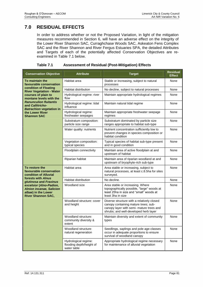
Roughan & O’Donovan – AECOM Limerick City & County Council Consulting Engineers AA NIR Variation No. 6
Ref: 14.131.311 Page 81
7.0 RESIDUAL EFFECTS
In order to address whether or not the Proposed Variation, in light of the mitigation measures recommended in Section 6, will have an adverse effect on the integrity of the Lower River Shannon SAC, Curraghchase Woods SAC, Askeaton Fens Complex SAC and the River Shannon and River Fergus Estuaries SPA, the detailed Attributes and Targets of each of the potentially affected Conservation Objectives are re-examined in Table 7.1 below. Table 7.1 Assessment of Residual (Post-Mitigation) Effects
Conservation Objective Attribute Target Residual
Effect
To maintain the favourable conservation condition of Floating River Vegetation - Water courses of plain to montane levels with the Ranunculion fluitantis and Callitricho-Batrachion vegetation in the Lower River Shannon SAC
Habitat area Stable or increasing, subject to natural processes
None
Habitat distribution No decline, subject to natural processes None
Hydrological regime: river flow
Maintain appropriate hydrological regimes None
Hydrological regime: tidal influence
Maintain natural tidal regime None
Hydrological regime: freshwater seepages
Maintain appropriate freshwater seepage regimes
None
Substratum composition: particle size range
Substratum dominated by particle size ranges appropriate to habitat sub-type
None
Water quality: nutrients Nutrient concentration sufficiently low to prevent changes in species composition or habitat condition
None
Vegetation composition: typical species
Typical species of habitat sub-type present and in good condition
None
Floodplain connectivity Maintain area of active floodplain at and upstream of habitat
None
Riparian habitat Maintain area of riparian woodland at and upstream of bryophyte-rich sub‐type
None
To restore the favourable conservation condition of Alluvial forests with Alnus glutinosa and Fraxinus excelsior (Alno-Padion, Alnion incanae, Salicion albae) in the Lower River Shannon SAC,
Habitat area Area stable or increasing, subject to natural processes, at least c.8.5ha for sites surveyed.
None
Habitat distribution No decline. None
Woodland size Area stable or increasing. Where topographically possible, "large" woods at least 25ha in size and “small” woods at least 3ha in size
None
Woodland structure: cover and height
Diverse structure with a relatively closed canopy containing mature trees; sub-canopy layer with semi- mature trees and shrubs; and well‐developed herb layer
None
Woodland structure: community diversity & extent
Maintain diversity and extent of community types
None
Woodland structure: natural regeneration
Seedlings, saplings and pole age-classes occur in adequate proportions to ensure survival of woodland canopy
None
Hydrological regime: flooding depth/height of water table
Appropriate hydrological regime necessary for maintenance of alluvial vegetation
None
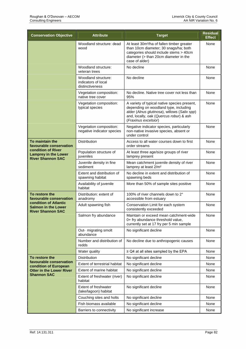
Roughan & O’Donovan – AECOM Limerick City & County Council Consulting Engineers AA NIR Variation No. 6
Ref: 14.131.311 Page 82
Conservation Objective Attribute Target Residual
Effect
Woodland structure: dead wood
At least 30m³/ha of fallen timber greater than 10cm diameter; 30 snags/ha; both categories should include stems > 40cm diameter (> than 20cm diameter in the case of alder)
None
Woodland structure: veteran trees
No decline None
Woodland structure: indicators of local distinctiveness
No decline None
Vegetation composition: native tree cover
No decline. Native tree cover not less than 95%
None
Vegetation composition: typical species
A variety of typical native species present, depending on woodland type, including alder (Alnus glutinosa), willows (Salix spp) and, locally, oak (Quercus robur) & ash (Fraxinus excelsior)
None
Vegetation composition: negative indicator species
Negative indicator species, particularly non-native invasive species, absent or under control
None
To maintain the favourable conservation condition of River Lamprey in the Lower River Shannon SAC
Distribution Access to all water courses down to first order streams
None
Population structure of juveniles
At least three age/size groups of river lamprey present
None
Juvenile density in fine sediment
Mean catchment juvenile density of river lamprey at least 2/m²
None
Extent and distribution of spawning habitat
No decline in extent and distribution of spawning beds
None
Availability of juvenile habitat
More than 50% of sample sites positive None
To restore the favourable conservation condition of Atlantic Salmon in the Lower River Shannon SAC
Distribution: extent of anadromy
100% of river channels down to 2° accessible from estuary
None
Adult spawning fish Conservation Limit for each system consistently exceeded
None
Salmon fry abundance Maintain or exceed mean catchment-wide 0+ fry abundance threshold value, currently set at 17 fry per 5 min sample
None
Out‐ migrating smolt abundance
No significant decline None
Number and distribution of redds
No decline due to anthropogenic causes None
Water quality ≥ Q4 at all sites sampled by the EPA None
To restore the favourable conservation condition of European Otter in the Lower River Shannon SAC
Distribution No significant decline None
Extent of terrestrial habitat No significant decline None
Extent of marine habitat No significant decline None
Extent of freshwater (river) habitat
No significant decline None
Extent of freshwater (lake/lagoon) habitat
No significant decline None
Couching sites and holts No significant decline None
Fish biomass available No significant decline None
Barriers to connectivity No significant increase None
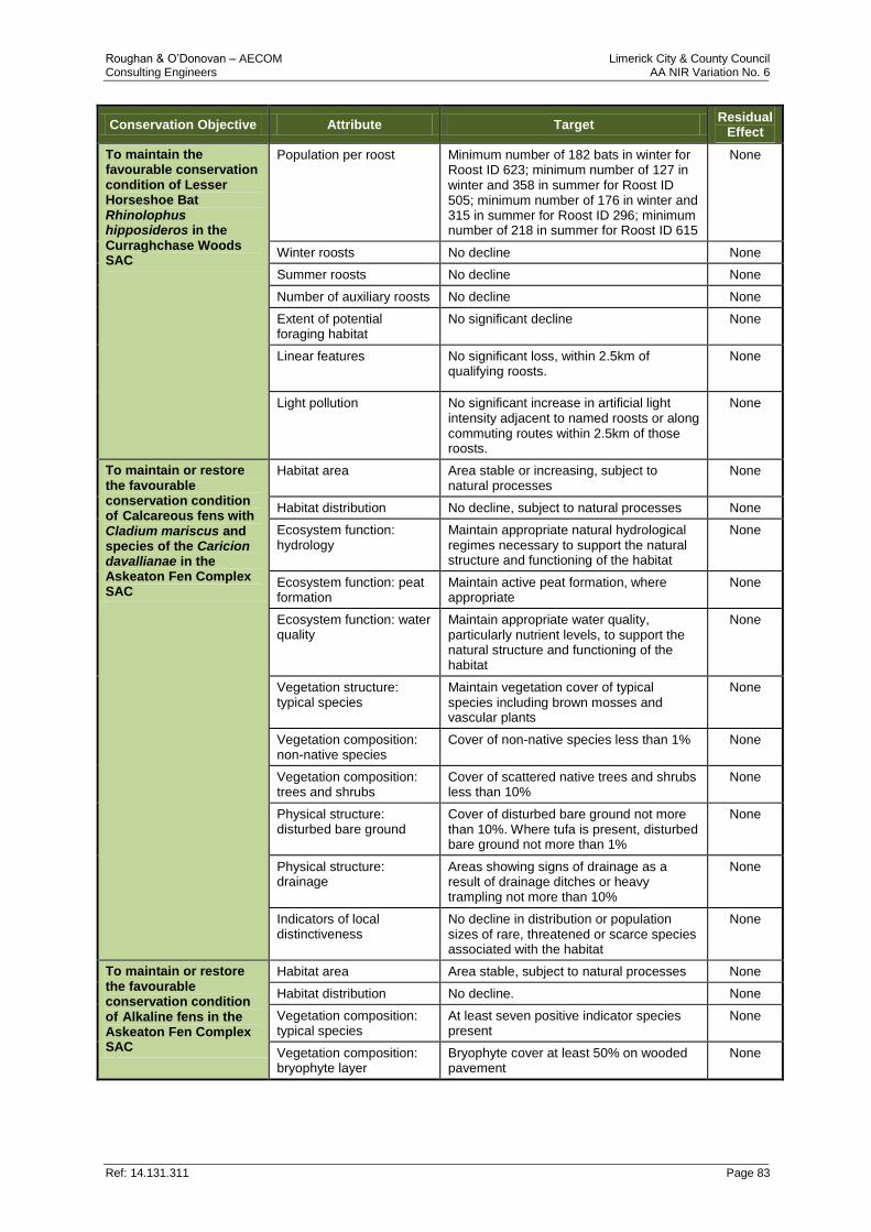
Roughan & O’Donovan – AECOM Limerick City & County Council Consulting Engineers AA NIR Variation No. 6
Ref: 14.131.311 Page 83
Conservation Objective Attribute Target Residual
Effect
To maintain the favourable conservation condition of Lesser Horseshoe Bat Rhinolophus hipposideros in the Curraghchase Woods SAC
Population per roost Minimum number of 182 bats in winter for Roost ID 623; minimum number of 127 in winter and 358 in summer for Roost ID 505; minimum number of 176 in winter and 315 in summer for Roost ID 296; minimum number of 218 in summer for Roost ID 615
None
Winter roosts No decline None
Summer roosts No decline None
Number of auxiliary roosts No decline None
Extent of potential foraging habitat
No significant decline None
Linear features No significant loss, within 2.5km of qualifying roosts.
None
Light pollution No significant increase in artificial light intensity adjacent to named roosts or along commuting routes within 2.5km of those roosts.
None
To maintain or restore the favourable conservation condition of Calcareous fens with Cladium mariscus and species of the Caricion davallianae in the Askeaton Fen Complex SAC
Habitat area Area stable or increasing, subject to natural processes
None
Habitat distribution No decline, subject to natural processes None
Ecosystem function: hydrology
Maintain appropriate natural hydrological regimes necessary to support the natural structure and functioning of the habitat
None
Ecosystem function: peat formation
Maintain active peat formation, where appropriate
None
Ecosystem function: water quality
Maintain appropriate water quality, particularly nutrient levels, to support the natural structure and functioning of the habitat
None
Vegetation structure: typical species
Maintain vegetation cover of typical species including brown mosses and vascular plants
None
Vegetation composition: non-native species
Cover of non-native species less than 1% None
Vegetation composition: trees and shrubs
Cover of scattered native trees and shrubs less than 10%
None
Physical structure: disturbed bare ground
Cover of disturbed bare ground not more than 10%. Where tufa is present, disturbed bare ground not more than 1%
None
Physical structure: drainage
Areas showing signs of drainage as a result of drainage ditches or heavy trampling not more than 10%
None
Indicators of local distinctiveness
No decline in distribution or population sizes of rare, threatened or scarce species associated with the habitat
None
To maintain or restore the favourable conservation condition of Alkaline fens in the Askeaton Fen Complex SAC
Habitat area Area stable, subject to natural processes None
Habitat distribution No decline. None
Vegetation composition: typical species
At least seven positive indicator species present
None
Vegetation composition: bryophyte layer
Bryophyte cover at least 50% on wooded pavement
None
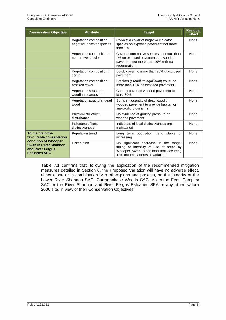
Roughan & O’Donovan – AECOM Limerick City & County Council Consulting Engineers AA NIR Variation No. 6
Ref: 14.131.311 Page 84
Conservation Objective Attribute Target Residual
Effect
Vegetation composition: negative indicator species
Collective cover of negative indicator species on exposed pavement not more than 1%
None
Vegetation composition: non-native species
Cover of non-native species not more than 1% on exposed pavement; on wooded pavement not more than 10% with no regeneration
None
Vegetation composition: scrub
Scrub cover no more than 25% of exposed pavement
None
Vegetation composition: bracken cover
Bracken (Pteridium aquilinum) cover no more than 10% on exposed pavement
None
Vegetation structure: woodland canopy
Canopy cover on wooded pavement at least 30%
None
Vegetation structure: dead wood
Sufficient quantity of dead wood on wooded pavement to provide habitat for saproxylic organisms
None
Physical structure: disturbance
No evidence of grazing pressure on wooded pavement
None
Indicators of local distinctiveness
Indicators of local distinctiveness are maintained
None
To maintain the favourable conservation condition of Whooper Swan in River Shannon and River Fergus Estuaries SPA
Population trend Long term population trend stable or increasing
None
Distribution No significant decrease in the range, timing or intensity of use of areas by Whooper Swan, other than that occurring from natural patterns of variation
None
Table 7.1 confirms that, following the application of the recommended mitigation measures detailed in Section 6, the Proposed Variation will have no adverse effect, either alone or in combination with other plans and projects, on the integrity of the Lower River Shannon SAC, Curraghchase Woods SAC, Askeaton Fens Complex SAC or the River Shannon and River Fergus Estuaries SPA or any other Natura 2000 site, in view of their Conservation Objectives.
Roughan & O’Donovan – AECOM Limerick City & County Council Consulting Engineers AA NIR Variation No. 6
Ref: 14.131.311 Page 85
8.0 CONCLUSION AND FINAL DETERMINATION The AA Screening undertaken in respect of the Proposed Variation determined that the Proposed Variation, either alone or in combination with other plans and projects, would be likely to have significant effects on four Natura 2000 sites: the Lower River Shannon SAC, Curraghchase Woods SAC, Askeaton Fens Complex SAC and the River Shannon and River Fergus Estuaries SPA. This NIR subsequently examined, analysed and evaluated the implications of the Proposed Variation, both individually and in combination with other plans and projects, including other Policies and Objectives of the Plan being varied, on these sites and found that, in the absence of appropriate mitigation, the Proposed Variation would adversely affect the integrity of the sites concerned, in view of their Conservation Objectives. These findings were made on the basis of objective information and the best available scientific knowledge in the field. The information presented in this NIR was gathered by a combination of consultation, desk studies and field surveys. The methodology of the assessment was informed by both EU and national guidelines on assessments under Article 6 of the Habitats Directive. The assessment identified the potential for direct, indirect and secondary impacts on certain Qualifying Interests and Special Conservation Interests of the four aforementioned Natura 2000 sites arising from impacts in relation to the construction of new road infrastructure. Having concluded that the existing Policies and Objectives of the Plan did not provide adequate protection against these impacts, this NIR has recommended mitigation measures with the proposal that they are referenced as part of additional wording to the text of the Proposed Variation. It is considered that these mitigation measures are sufficient to address impacts at the plan level and it is recognised that additional, more specific mitigation measures will be required at the project level having due regard to the statutory requirements and ecological assessments to be carried out during that separate project level planning process. Considering all of the above, it is hereby concluded that, subject to the full and proper implementation of the Policies and Objectives contained within the Plan itself and the mitigation measures detailed in Section 6 of this NIR, there will be no adverse effects on the integrity of any Natura 2000 site as a result of the adoption of the Proposed Variation, either individually or in combination with other plans and projects, and that no reasonable scientific doubt remains in this regard.
Roughan & O’Donovan – AECOM Limerick City & County Council Consulting Engineers AA NIR Variation No. 6
Ref: 14.131.311 Page 86
9.0 REFERENCES
Council Directive 92/43/EEC of 21 May 1992 on the conservation of natural habitats and of wild fauna and flora (the Habitats Directive). Official Journal of the European Communities, L206/7.
Crowe, O. (2005) Ireland’s Wetlands and their waterbirds: status and distribution. BirdWatch Ireland.
DEHLG (2010) Appropriate Assessment of Plans and Projects in Ireland. Guidance for Planning Authorities. Department of the Environment, Heritage and Local Government, Dublin.
EC (2001) Assessment of plans and projects significantly affecting Natura 2000 sites: Methodological guidance on the provisions of Article 6(3) and (4) of the Habitats Directive 92/43/EEC
EC (2007a) Guidance Document on Article 6(4) of the 'Habitats Directive' 92/43/EEC. Clarification of the Concepts of Alternative Solutions, Imperative Reasons of Overriding Public Interest, Compensatory Measures, Overall Coherence. Opinion of the European Commission.
EC (2007b) Interpretation manual of European Union habitats. EUR 27. Environment Directorate-General of the European Commission.
EC (2012) Commission Note on Setting Conservation Objectives for Natura 2000 sites. Doc. Hab. 12-04/06. European Commission, Luxembourg.
Eionet (2017) The status and trends of Ireland’s bird species. Reporting under Article 12 of Directive 2009/147/EC (the Birds Directive) for the period 2008-2012 <http://cdr.eionet.europa.eu/Converters/run_conversion?file=ie/eu/art12/envuvesya/IE_birds_reports-14328-144944.xml&conv=343&source=remote#A082_W> [Accessed 07/02/2017]. European Environment Information and Observation Network, European Environment Agency, Copenhagen.
EirEco (2016) Foynes to Limerick Road Improvement Scheme, Route Corridor Report, Ecology, Author - Paul Murphy.
European Communities (Birds and Natural Habitats) Regulations, 2011. SI No. 477/2011.
European Communities (Birds and Natural Habitats) (Amendment) Regulations, 2013. SI No. 499/2013.
European Communities (Birds and Natural Habitats) (Amendment) Regulations, 2015. SI No. 355/2015.
Flora (Protection) Order, 2015. SI No. 356/2015.
IFI (2016) Guidelines on Protection of Fisheries during Construction Works in and adjacent to Waters. Inland Fisheries Ireland, Dublin.
Kelly v. An Bord Pleanála (2014) IEHC 422.
Landelijke Vereniging tot Behoud van de Waddenzee and Nederlandse Vereniging tot Bescherming van Vogels v. Staatssecretaris van Landbouw, Natuurbeheer en Visserij (Waddenzee) [2004] C-127/02 ECR I-7405.
Limerick County Development Plan 2010-2016 (as amended): Referenced from https://www.limerick.ie/council/services/planning-and-property/development-plans/county-development-plan
Roughan & O’Donovan – AECOM Limerick City & County Council Consulting Engineers AA NIR Variation No. 6
Ref: 14.131.311 Page 87
McCarthy Keville O’Sullivan Ltd. (2017) Waterfowl numbers, usage and distribution on the River Shannon and River Fergus Estuaries - Interim Report October 2017.
NBDC (2017) Biodiversity Maps <http://maps.biodiversityireland.ie/> [Accessed 17/10/2017]. National Biodiversity Data Centre, Waterford.
NPWS (2012a) Conservation Objectives for the Lower River Shannon SAC [002165]. Version 1.0. National Parks & Wildlife Service, Department of Arts, Heritage and the Gaeltacht, Dublin.
NPWS (2012b) Conservation Objectives for the River Shannon and River Fergus Estuaries SPA [004077]. Version 1.0. National Parks & Wildlife Service, Department of Arts, Heritage and the Gaeltacht, Dublin.
NPWS (2013b) Site Synopsis for the Barrigone SAC [000432]. Revision 13. National Parks & Wildlife Service, Department of Arts, Heritage and the Gaeltacht, Dublin.
NPWS (2013c) The Status of EU Protected Habitats and Species in Ireland. Species Assessments Volume 3. Version 1.0. National Parks & Wildlife Service, Department of Arts, Heritage and the Gaeltacht, Dublin.
NPWS (2013d) The Status of EU Protected Habitats and Species in Ireland. Habitat Assessments Volume 2. Version 1.1. National Parks & Wildlife Service, Department of Arts, Heritage and the Gaeltacht, Dublin.
NPWS (2013e) Site Synopsis for the Lower River Shannon SAC [002165]. Revision13. National Parks & Wildlife Service, Department of Arts, Heritage and the Gaeltacht, Dublin.
NPWS (2014a) Site Synopsis for the Askeaton Fen Complex SAC [002279]. Revision 13. National Parks & Wildlife Service, Department of Arts, Heritage and the Gaeltacht, Dublin.
NPWS (2014b) Site Synopsis for the Tory Hill SAC [000439]. Revision 13. National Parks & Wildlife Service, Department of Arts, Heritage and the Gaeltacht, Dublin.
NPWS (2014c) Site Synopsis for the Curraghchase Woods SAC [000174]. Revision 13. National Parks & Wildlife Service, Department of Arts, Heritage and the Gaeltacht, Dublin.
NPWS (2014d) Site Synopsis for the Stack's to Mullaghareirk Mountains, West Limerick Hills and Mount Eagle SPA [004161]. Revision 13. National Parks & Wildlife Service, Department of Arts, Heritage and the Gaeltacht, Dublin.
NPWS (2015a) Hen Harrier Conservation and the Forestry Sector in Ireland. Version 3.2. Published 31/03/2015. National Parks & Wildlife Service, Department of Arts, Heritage and the Gaeltacht, Dublin.
NPWS (2015b) Site Synopsis for the River Shannon and River Fergus Estuary SPA [004077]. Published 30/05/2015. National Parks & Wildlife Service, Department of Arts, Heritage and the Gaeltacht, Dublin.
NPWS (2016) Conservation Objectives for the Askeaton Fen Complex SAC [002279]. Generic Version 5.0. National Parks & Wildlife Service, Department of Arts, Heritage, Regional, Rural and Gaeltacht Affairs, Dublin.
NPWS (2017) Map Viewer <http://webgis.npws.ie/npwsviewer/> [Accessed 13/01/2017]. National Parks & Wildlife Service, Department of Arts, Heritage, Regional, Rural and Gaeltacht Affairs, Dublin.
Roughan & O’Donovan – AECOM Limerick City & County Council Consulting Engineers AA NIR Variation No. 6
Ref: 14.131.311 Page 88
NRA (2006a) Guidelines for the Crossing of Watercourses During the Construction of National Road Schemes
NRA (2006b) Guide to Landscape Treatments for National Road Schemes in Ireland.
Best Practice Guidelines for the Conservation of Bats in the Planning of National Road Schemes (NRA 2006c)
NRA (2010a) The Management of Noxious Weeds and Non-Native Invasive Plant Species on National Roads
Planning and Development Act, 2000. No. 30 of 2000.
Rees, E.C., Bruce, J.H. & White, G.T. 2005. Variation in the behavioural responses of Whooper Swans Cygnus cygnus to different types of human activity. Waterbirds around the world. Eds G.C Boere, C.A. Galbraith & D.A. Stround. The Stationary Office, Edinburgh, UK Pp. 829-830.
Rossmore v. An Bord Pleanála (2014) IEHC 557.
Scott Cawley (2008) Pre-Construction Survey for Rare /Protected Flora and Habitats at Proposed River Maigue Crossing Point; Prepared for Jacobs Engineering December 2008.
Sheppard, R. (1993) Ireland’s Wetland Wealth. The report of the Winter Wetlands Survey 1984/85 to 1986/97. Irish Wildbird Conservancy.
SNH (2006) Guidance for Competent Authorities when dealing with proposals affecting SAC freshwater sites. Scottish Natural Heritage, Perth.
Sweetman v. An Bord Pleanála (2013) Case C-258/11.
TII (2010) “Assessment of the effectiveness of Bat Mitigation Measures employed on Irish National Road Schemes” (by Isobel Abbott, UCC September 2010).

PURPLE:PANTONE: 2622 COATEDC- 57 M-98 Y-0 K-46R-84 G-7 B-91
GREENPANTONE: 3455cC-100 M-0 Y-81 K-66R-0 G-80 B-47
REDPANTONE: 195CC-0 M-100 Y-60 K- 55R-130 G-0 B-36
BLUEPANTONE: 5395CC-100 M-44 Y-0 K-76R-0 G-39 B-77
YELLOWPANTONE: 392CC-7 M-0 Y-100 K-49R-141 G-139 B-0
Prepared by Roughan & O’Donovan Arena House, Arena Road, Sandyford, Dublin 18Tel: +353 1 2940800 Fax: +353 1 2940820Email: [email protected] www.rod.ie