Native Cutthroat Trout (Oncorhynchus clarki spp.) Conservation
56
Native Cutthroat Trout (Oncorhynchus clarki spp.) Conservation Activities in the Northern Region, 2003 by Paul Thompson Aquatics Biologist December 2003 Utah Division of Wildlife Resources 1594 West North Temple Salt Lake City, Utah 84414 An Equal Opportunity Employer Kevin K. Conway, Director
Transcript of Native Cutthroat Trout (Oncorhynchus clarki spp.) Conservation

Native Cutthroat Trout (Oncorhynchus clarki spp.) Conservation Activities in the
Northern Region, 2003
by
Paul ThompsonAquatics Biologist
December 2003
Utah Division of Wildlife Resources1594 West North Temple
Salt Lake City, Utah 84414
An Equal Opportunity Employer
Kevin K. Conway, Director

ii
TABLE OF CONTENTS
Page
INTRODUCTION................................................ 1Bonneville cutthroat trout............................. 1Colorado River cutthroat trout......................... 1Yellowstone cutthroat trout............................ 1
METHODS..................................................... 1
RESULTS..................................................... 3Bonneville cutthroat trout............................. 3
Bear Lake GMU..................................... 5Bear River GMU.................................... 5 Uinta Mountains/Upper Bear River subunit........ 5
Mill Creek................................... 5Deadman Creek................................ 8West Fork of the Bear River.................. 9Deer Creek................................... 11East Fork of the Bear River.................. 13Stillwater Fork.............................. 15Hayden Fork.................................. 17
Cache Valley Subunit............................ 19Beaver Creek................................. 19Davenport Creek.............................. 21Wellsville Creek............................. 23
Rich County subunit............................. 24Otter Creek.................................. 24South Branch of Otter Creek.................. 25Middle Branch of Otter Creek................. 26New Canyon................................... 28Big Creek.................................... 28Meachum Canyon............................... 32
Northern Bonneville GMU........................... 33 Ogden River subunit............................. 33
Middle Fork of the Ogden River............... 33 Weber River subunit............................. 36
Cottonwood Creek............................. 36Arbuckle Creek............................... 38
Colorado River cutthroat trout......................... 40West Fork of Beaver Creek......................... 40Gilbert Creek..................................... 42West Fork of the Smiths Fork...................... 43

iii
TABLE OF CONTENTS, continued
Yellowstone cutthroat trout............................ 44Wildcat Creek..................................... 44Goose Creek....................................... 44
DISCUSSION.................................................. 46Bonneville cutthroat trout............................. 46
Bear River GMU.................................... 46Uinta Mountains/Upper Bear River subunit..... 46Cache Valley subunit......................... 46Rich County subunit.......................... 47
Northern Bonneville GMU........................... 47Ogden River subunit.......................... 47Weber River subunit.......................... 47
Colorado River cutthroat trout......................... 48Northeastern GMU.................................. 48
North Slope of the Uinta Mountains subunit... 48Yellowstone cutthroat trout............................ 48
LITERATURE CITED............................................ 49

iv
LIST OF TABLES
PageTable 1. Streams/stream sections containing Bonneville
cutthroat trout during 2003 surveys............... 4
Table 2. Population statistics for species sampled in MillCreek, 1953, 1973, and 2003....................... 6
Table 3. Population statistics for species sampled in Deadman Creek, 1978 and 2003...................... 8
Table 4. Population statistics for species sampled in theWest Fork of the Bear River section 01, 1964, 1971, 1985, and 2003.............................. 10
Table 5. Population statistics for species sampled in Deer Creek, 1977, 1986, 1998, and 2003............ 12
Table 6. Population statistics for species sampled in theEast Fork of the Bear River section 01, 1965 and2003.............................................. 13
Table 7. Population statistics for species sampled in Stillwater Fork section 01, 1953 and 2003......... 15
Table 8. Population statistics for species sampled inHayden Fork, 1953, 1970, and 2003................. 17
Table 9. Population statistics for species sampled in Beaver Creek, 1967, 1968, 1999, and 2003.......... 20
Table 10. Population statistics for species sampled in Davenport Creek, 1976, 1978, and 2003............. 22
Table 11. Population statistics for species sampled inWellsville Creek, 1978 and 2003................... 23
Table 12. Population statistics for species sampled inOtter Creek, 1954 and 2003........................ 24
Table 13. Population statistics for species sampled in theSouth Branch of Otter Creek, 1954, 1968, and 2003. 25

v
LIST OF TABLES, continued
PageTable 14. Population statistics for species sampled in the
Middle Branch of Otter Creek, 1954 and 2003....... 26
Table 15. Population statistics for species sampled in BigCreek section 02, 1977, 1980, and 2003............ 30
Table 16. Population statistics for species sampled inMeachum Canyon, 2003.............................. 32
Table 17. Population statistics for species sampled in theMiddle Fork of the Ogden River section 02, 1975,1987, and 2003.................................... 34
Table 18. Population statistics for species sampled in Cottonwood Creek, 1979 and 2003................... 36
Table 19. Population statistics for species sampled in Arbuckle Creek, 1979, 1996, and 2003.............. 38
Table 20. Population statistics for species sampled in theWest Fork of Beaver Creek section 01, 1973 and 2003.............................................. 40
Table 21. Fish species and numbers reintroduced into Gilbert Creek, upstream from the border barrier,following the chemical reclamation in 2001 and 2002.............................................. 42
Table 22. Population statistics for species sampled inGoose Creek, 1957, 1971, 1996, and 2003........... 45
vi
LIST OF FIGURES
PageFigure 1 Size distribution of Bonneville cutthroat trout
and brook trout sampled in Mill Creek, Stations #1 and #2, 2003................................... 7
Figure 2. Size distribution of Bonneville cutthroat troutand brook trout sampled in the West Fork of theBear River section 01, 2003....................... 10
Figure 3. Size distribution of Bonneville cutthroat trout sampled in Deer Creek, 2003....................... 12
Figure 4. Size distribution of Bonneville cutthroat trout,brook trout, and mountain whitefish sampled in the East Fork of the Bear River section 01, 2003.. 14
Figure 5. Size distribution of Bonneville cutthroat trout,brook trout, and mountain whitefish sampled inStillwater Fork section 01, 2003.................. 16
Figure 6. Size distribution of Bonneville cutthroat trout,brook trout, rainbow trout, and rainbow trout xBonneville cutthroat trout sampled in Hayden Fork,2003.............................................. 18
Figure 7. Size distribution of Bonneville cutthroat troutsampled in Beaver Creek, 2003..................... 20
Figure 8. Size distribution of Bonneville cutthroat troutand brown trout sampled in Davenport Creek, 2003.. 22
Figure 9. Size distribution of brook trout sampled in theMiddle Branch of Otter Creek, 2003................ 27
Figure 10.Size distribution of Bonneville cutthroat trout,brook trout, and brown trout sampled in Big Creeksection 02, 2003.................................. 31
Figure 11.Size distribution of Bonneville cutthroat troutsampled in Meachum Canyon, 2003................... 32

vii
LIST OF FIGURES, continued
PageFigure 12.Size distribution of Bonneville cutthroat trout,
rainbow trout, and Bonneville cutthroat trout xrainbow trout sampled in the Middle Fork of the Ogden River section 02, 2003.................. 35
Figure 13.Size distribution of Bonneville cutthroat troutsampled in Cottonwood Creek, 2003................. 37
Figure 14.Size distribution of Bonneville cutthroat troutsampled in Arbuckle Creek, 2003................... 39
Figure 15.Size distribution of brook trout sampled in theWest Fork of Beaver Creek section 01, 2003........ 41
The Utah Department of Natural Resources receives federal aid andprohibits discrimination on the basis of race, color, sex, age,national origin, or handicap. For information or complaintsregarding discrimination, contact Executive Director, UtahDepartment of Natural Resources, 1636 West North Temple #316,Salt Lake City, Utah 84116-3193 or the Equal EmploymentOpportunity Commission, 1801 L Street, NW, Washington, D.C. 20507.

1
INTRODUCTION
BONNEVILLE CUTTHROAT TROUT (Oncorhynchus clarki utah)Bonneville cutthroat trout surveys in northern Utah during 2003focused primarily in the Bear River Geographic Management Unit(GMU) and a few stream surveys were completed in the NorthernBonneville GMU. Most of the major tributaries to the Upper BearRiver were surveyed in the Uinta Mountains/Upper Bear Riversubunit. A few streams were surveyed in the Rich County subunit,which completes the initial stream surveys for this subunit. Twostream surveys were completed in the Cache Valley subunit, whichleaves a few streams upstream from Porcupine Reservoir to besurveyed before the initial surveys are completed in thissubunit. The 2003 surveys provided needed data that will helptowards the objectives of long term conservation of Bonnevillecutthroat trout in Utah (Lentsch et al. 1997).
COLORADO RIVER CUTTHROAT TROUT (Oncorhynchus clarki pleuriticus)Work on Colorado River cutthroat trout primarily focused on re-establishing fish in the Utah portion of Gilbert Creek. Establishing a Colorado River cutthroat trout brood source forthe North Slope was an effort initiated in 2003 as well. Theonly stream survey completed in the North Slope of the UintaMountains subunit was on the West Fork of Beaver Creek section01. The work completed in the Northeastern GMU provided neededdata that will help towards the objectives of long termconservation of Colorado River cutthroat trout in Utah (Lentschand Converse 1997).
YELLOWSTONE CUTTHROAT TROUT (Oncorhynchus clarki bouvieri)Wildcat Creek on the North slope of the Raft River Mountain Rangeand Goose Creek were the only two streams examined during 2003. On Wildcat Creek, a wildfire burned the majority of the drainageoccupied by Yellowstone cutthroat trout in 2002. Spotelectrofishing was completed in 2003 to verify if Yellowstonecutthroat trout still persist.
METHODS
All stream surveys were completed during base flow conditions todetermine the extent of the resident cutthroat trout populationsin each stream/stream section. When possible, stream surveylocations were chosen as closely to previous Utah Division ofWildlife Resources (UDWR) survey locations. Sixty people dayswere required to complete the work on native cutthroat trout inthe Northern Region during 2003.

2
Universal Transverse Mercator (UTM) coordinates were recorded foreach stream survey location with a hand-held Global PositioningSystem (GPS).
For stream surveys, a 100 m reach, representing habitatconditions throughout the entire stream, was identified for eachsurvey. Stations were measured using a 100 m tape. On thelarger streams, a block net was placed at the upstream end of thestation to prevent fish from escaping before the twoelectrofishing passes were completed. On smaller streams, anatural habitat break (e.g., small waterfall/cascade) was chosenfor the upper end of each reach and when possible, the lower end. Two battery-powered backpack electrofishing units, manufacturedby Smith Root, were utilized side-by-side for surveys on thelarger streams (e.g., streams >2.5-3 m in width). On allremaining surveys, a single battery-powered backpackelectrofishing unit was used. Between three and six personnelwere utilized on these surveys. Electrofishing settings varieddepending on the stream conductivity. In general, the pulse wasset at J (70 Hz), the frequency was set at 4 (4 ms), and thevoltage was set at 300 V.
All captured fish were transferred to live cages placed in thestream. Fish collected from the first electrofishing pass werekept separate from the fish collected from the secondelectrofishing pass. Fish processing and data collectioncommenced immediately following electrofishing completion andfish not collected for genetic analyses were returned to thestream. All fish captured were measured to the nearestmillimeter (mm) TL and weighed to the nearest gram (g).
A modified Zippin multiple pass depletion electrofishing formulawas used to calculate the population estimates and ninety-fivepercent confidence limits for each site surveyed (Zippin 1958). The formulas used to calculate the estimates were:
N = C12 / C1 - C2
where,N = estimated fish population,C1 = the number of fish captured from the first pass, andC2 = the number of fish captured on the second pass.
SE = [C1 * C2 / (C1 - C2)2] * (C1 + C2)
½
95% C.I. = 2 * SE
Population estimates were calculated separately for age-1 and

3
older fish and age-0 fish because smaller fish are notimmobilized as effectively as larger fish while electrofishing(Reynolds 1989) and consequently, population estimates for age-0fish are usually not as meaningful. All cutthroat trout < 50 mmTL were considered to be age-0.
Condition factor (Ktl) was calculated using the formula:
K = W * 100,000/L3
where,W = weight in g, andL = TL in mm.
All cutthroat trout tissue samples were collected for geneticanalyses according to the cutthroat trout collection proceduralmanual (Toline and Lentsch 1999). These samples will besubmitted to the Salt Lake Office of the UDWR during the winterof 2003/2004. Samples will be processed with nuclear DNA andmitochondrial DNA.
Population estimates were not attempted for speckled dace(Rhinichthys osculus), longnose dace (Rhinichthys cataractae), orsculpin (Cottus spp.) because these species are difficult tocapture. An estimate of abundance was made for these species asfollows: >50 individuals/100 m station = abundant, 10-50individuals/100 m station = common, and <10 individuals/100 mstation = sparse.
RESULTS
BONNEVILLE CUTTHROAT TROUTAt least one complete two-pass depletion electrofishing surveywas completed on 15 streams and four streams were spotelectrofished. Bonneville cutthroat trout were present in 13 ofthe 19 streams/stream sections surveyed in 2003 (Table 1). Basedon the stream surveys in 2003, Bonneville cutthroat trout occupyapproximately 147.4 stream km (91.6 stream miles) in the streamssampled (Table 1).
Fish species encountered during the 2003 stream surveys included: Bonneville cutthroat trout (BCT), rainbow trout (RBT;Oncorhynchus mykiss), Bonneville cutthroat trout x rainbow trouthybrids, brown trout (BNT; Salmo trutta), brook trout (BKT;Salvelinus fontinalis), mountain whitefish (MWF; Prosopiumwilliamsoni), mountain sucker (MTS; Catostomus platyrhyncus),sculpin, Utah sucker (UTS; Catostomus ardens), redside shiner(RSS; Richardsonius balteatus hydrophlox), speckled dace (SPD),

4
longnose dace (LND), and leatherside chub (LSC; Gila copei).
Table 1. Streams/stream sections containing Bonneville cutthroattrout during 2003 surveys.
Stream/Section Approximate # ofstream km occupied(# stream milesoccupied)
# of $age-1cutthroat/km(#/mile)
Mill Creek, station #1 19.3 (12.0) 80 (129)
Mill Creek, station #2 130 (210)
Deer Creek 10.5 (6.5) 30 (48)
East Fork of the Bear River section 01 16.1 (10.0) 169 (272)
Stillwater Fork section 01 8.1 (5.0) 63 (101)
Hayden Fork 19.3 (12.0) 35 (57)
Beaver Creek 10.5 (6.5) 412 (664)
Davenport Creek 13.8 (8.6) 303 (488)
Wellsville Creek 4.8 (3.0) abundant
Big Creek section 02 19.3 (12.0) 30 (48)
Meachum Canyon 3.2 (2.0) 70 (113)
Middle Fork of the Ogden River section 02 16.1 (10.0) 27 (43)
Cottonwood Creek 4.8 (3.0) 1704 (2743)
Arbuckle Creek 1.6 (1.0) 106 (171)
Total 147.4 (91.6)

5
BEAR LAKE GMU
Bonneville cutthroat trout work in the Bear Lake GMU wascoordinated and completed by the Bear Lake Field Station. Results from 2003 activities can be found in the reports producedby this field station.
BEAR RIVER GMUUinta Mountains/Upper Bear River subunit
Mill Creek IVAQ230Mill Creek (Wyoming state line upstream to the headwaters) is atributary to the Bear River. Mill Creek is in Summit County(Deadman Mountain, Elizabeth Mountain, and Red Knob USGS Quads)with the lower portion of the drainage being privately owned. Fish species present in Mill Creek are Bonneville cutthroattrout, brook trout, mountain whitefish, leatherside chub,mountain sucker, Utah sucker, speckled dace, longnose dace,sculpin, and redside shiner.
Two stream surveys were completed on Mill Creek. Station #1 wascompleted near the Wyoming/Utah state line on August 18, 2003. This 112 m station was located at UTMs 4538074N and 0513154E. Station #2 was completed directly upstream from the confluencewith Deadman Creek. This 96 m station was located at UTMs4532483N and 0517568E.
Station #1Two-pass electrofishing resulted in the capture of eight $age-1Bonneville cutthroat trout (80 ± 35/stream km [129 ± 57/streammile]; 20 kg/ha [18 lb/acre]), seven $age-1 brook trout (75 ±56/stream km [120 ± 90/stream mile]; 5 kg/ha [5 lb/acre]) (Table2; Figure 1), five mountain whitefish (80 ± 231/stream km [129 ±373/stream mile]; 0.5 kg/ha [0 lb/acre]), nine leatherside chub(81 ± 9/stream km; 131 ± 15/stream mile), 23 redside shiner (215± 27/stream km; 346 ± 43/stream mile), and 10 Utah sucker (109 ±73/stream km; 176 ± 117/stream mile) (Table 2). Speckled dace,longnose dace, and sculpin were abundant. Mountain sucker weresparse (Table 2).
Station #2Two-pass electrofishing resulted in the capture of 12 $age-1Bonneville cutthroat trout (130 ± 20/stream km [210 ± 32/streammile]; 10 kg/ha [9 lb/acre]), 18 $age-1 brook trout (250 ±177/stream km [402 ± 285/stream mile]; 29 kg/ha [26 lb/acre])(Table 2; Figure 1), two leatherside chub (21 ± 0/stream km; 34 ±0/stream mile), and 8 mountain sucker (130 ± 211/stream km; 210 ±

6
339/stream mile) (Table 2). Two mountain whitefish werecaptured, however, one fish was captured on each electrofishingpass and a population estimate was not available. Longnose daceand sculpin were common (Table 2).
Mill Creek had been sampled twice previously by the UDWR. Bothsurveys were near the North Slope Road crossing. In 1973, a one-pass electrofishing survey in a 161 m reach resulted in thecapture of 38 Bonneville cutthroat trout (236/stream km;380/stream mile) and one brook trout (6/stream km; 10/streammile) (Table 2). Sculpin were sparse. In 1953, one-passelectrofishing in a 161 m reach resulted in the capture of fourBonneville cutthroat trout (25/stream km; 40/stream mile) andsculpin were sparse (Table 2).
Table 2. Population statistics for species sampled in MillCreek, 1953, 1973, and 2003.
Year Species #/km (#/mile)
kg/ha(lb/acre)
Avg TL(mm) Avg WT(g) AvgK
2003Station #1
$age-1 BCT$age-1 BKTMWFLSCRSSUTSMTSsculpinLNDSPD
802 (1292)752 (1202)802 (1292)812 (1312)2152 (3462)1092 (1762)sparseabundantabundantabundant
20 (18)5 (5)0.5 (0)
241 (189-328)141 (80-328)78 (71-85)70 (59-93)
143 (55-338)40 (4-81)4 (2-6)
0.941.21
2003Station #2
$age-1 BCT$age-1 BKTMWFLSCMTSsculpinLND
1302 (2102)2502 (4022)2 captured212 (342)1302 (2102)commoncommon
10 (9)29 (26)
142 (71-282)180 (120-270)169 (132-205)43 (41-45)
55 (4-231)83 (19-223)56 (22-89)
0.961.18
1973 BCTBKTsculpin
2361 (3801)61 (101)sparse
1954 BCTsculpin
251 (401)sparse
1 Based on one-pass electrofishing.2 Based on two-pass electrofishing.

7
Figure 1. Size distribution of Bonneville cutthroat trout andbrook trout sampled in Mill Creek, Stations #1 and #2,2003.

8
Deadman Creek IVAQ230BDeadman Creek (Mill Creek confluence upstream to the headwaters)is a tributary to Mill Creek. Deadman Creek is in Summit County(Deadman Mountain USGS Quad) with the lower portion of thedrainage being privately owned. Fish species present in DeadmanCreek are brook trout, leatherside chub, mountain sucker, andspeckled dace.
The 111 m stream survey was completed on Deadman Creek on July16, 2003 at UTMs 4531448N and 0517319E.
Two-pass electrofishing resulted in the capture of 131leatherside chub (1,306 ± 135/stream km; 2,102 ± 217/stream mile)and 42 mountain sucker (409 ± 64/stream km; 658 ± 102/streammile) (Table 3). Two $age-1 brook trout were captured, however,one fish was captured on each electrofishing pass and apopulation estimate was not available. Speckled dace wereabundant (Table 3).
Deadman Creek had been sampled once previously by the UDWR in1978. One-pass electrofishing in a 80 m reach resulted in thecapture of four Bonneville cutthroat trout (50/stream km;80/stream mile) and six brook trout (37/stream km; 60/streammile) (Table 3). Non-game fish species were not recorded forthis survey. The 1978 stream survey was completed at theboundary of USFS and private lands.
Table 3. Population statistics for species sampled in DeadmanCreek, 1978 and 2003.
Year Species #/km (#/mile)
kg/ha(lb/acre)
Avg TL(mm) Avg WT(g) AvgK
2003 $age-1 BKTLSCMTSSPD
2 captured13062 (21022)4092 (6582)abundant
248 (245-250)54 (27-111)
210 (196-224) 0.94
1978 BCTBKT
501 (801)371 (601)
1 Based on one-pass electrofishing.2 Based on two-pass electrofishing.

9
West Fork of the Bear River IVAQ240Section 01 The West Fork of the Bear River section 01 (Bear River confluenceupstream to Whitney Reservoir) is a tributary to the Bear River. The West Fork of the Bear River section 01 is in Summit County(Deadman Mountain, Seven Tree Flat, and Whitney Reservoir USGSQuads) with the lower portion of the drainage being privatelyowned. Fish species present in the West Fork of the Bear Riversection 01 are Bonneville cutthroat trout, brook trout, andsculpin.
The 123 m stream survey was completed on the West Fork of theBear River section 01 on August 20, 2003 at UTMs 4532083N and0511934E.
Two-pass electrofishing resulted in the capture of eight $age-1Bonneville cutthroat trout (66 ± 8/stream km [107 ± 13/streammile]; 8 kg/ha [7 lb/acre]) and one $age-1 brook trout (8 ±0/stream km [13 ± 0/stream mile]; 0 kg/ha [0 lb/acre]) (Table 4;Figure 2). Sculpin were abundant.
The West Fork of the Bear River section 01 had been sampled fivetimes previously by the UDWR. In 1985, the West Fork of the BearRiver section 01 was sampled in two localities. The 1985 lowerstation was the same stream reach as the 2003 stream survey. Theuse of cyanide pellets in this reach resulted in the capture of75 Bonneville cutthroat trout (820/stream km; 1320/stream mile)and two mountain whitefish (22/stream km; 35/stream mile). Mountain sucker were sparse and sculpin were common (Table 4). The use of cyanide pellets in the 1985 upper station (locateddownstream from the confluence with Humpy Creek) resulted in thecapture of 72 Bonneville cutthroat trout (787/stream km;1267/stream mile) and sculpin were abundant (Table 4). A 1971,one-pass electrofishing survey at the Whitney Road crossingresulted in the capture of 43 Bonneville cutthroat trout(267/stream mile; 430/stream km) and sculpin were common (Table4). Two one-pass electrofishing surveys were completed on theWest Fork of the Bear River section 01 in 1964. A stationlocated two miles below the Whitney Guard Station resulted in thecapture of 26 Bonneville cutthroat trout (161/stream km;260/stream mile) and sculpin were abundant (Table 4). The otherstream survey completed in 1964 was located directly downstreamfrom the confluence with Humpy Creek. This survey resulted inthe capture of 29 Bonneville cutthroat trout (180/stream km;290/stream mile) and sculpin were abundant (Table 4).

10
Table 4. Population statistics for species sampled in the WestFork of the Bear River section 01, 1964, 1971, 1985,and 2003.
Year Species #/km (#/mile)
kg/ha(lb/acre)
Avg TL(mm) Avg WT(g) AvgK
2003 $age-1 BCT$age-1 BKTsculpin
662 (1072)82 (132)abundant
8 (7)0 (0)
184 (76-277)76
84 (6-210)6
1.041.37
1985low
BCTMWFMTSsculpin
8203 (13203)223 (353)sparsecommon
34 (31) 138 (37-383)198 (156-239)
40 (1-525)95 (45-145)
0.921.12
1985high
BCTsculpin
7873 (12673) 66 (59) 139 (40-373) 44 (1-475) 0.96
1971 BCTsculpin
2671 (4301)common
143 (80-240) 38 (5-150) 1.12
1964high
BCTsculpin
1611 (2601)abundant
1964low
BCTsculpin
1801 (2901)abundant
1 Based on one-pass electrofishing.2 Based on two-pass electrofishing.3 Based on the use of cyanide pellets.
Figure 2. Size distribution of Bonneville cutthroat trout andbrook trout sampled in the West Fork of the Bear Riversection 01, 2003.
11
Deer Creek IVAQ240ADeer Creek (West Fork of the Bear River confluence upstream tothe headwaters) is a tributary to the West Fork of the BearRiver. Deer Creek is in Summit County (Deadman Mountain andSeven Tree Flat USGS Quads) with the entire drainage beingprivately owned. Fish species present in Deer Creek areBonneville cutthroat trout and sculpin.
The 100 m stream survey was completed on Deer Creek on July 15,2003 at UTMs 4530356N and 0510801E.
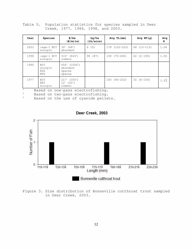
Two-pass electrofishing resulted in the capture of three $age-1Bonneville cutthroat trout (30 ± 0/stream km [48 ± 0/streammile]; 6 kg/ha [5 lb/acre]) (Table 5; Figure 3). Sculpin wereabundant.
Deer Creek had been sampled three times previously by the UDWR. A 1998 two-pass electrofishing survey located directly downstreamfrom the confluence with the two headwater forks resulted in thecapture of 44 Bonneville cutthroat trout (510 ± 120/stream km;824 ± 194/stream mile) and sculpin were common (Table 5). Cyanide was used in a 1986 survey, which was located near theconfluence with the West Fork of the Bear River. FortyBonneville cutthroat trout (656/stream km; 1056/stream mile) werecaptured during this survey. Mottled sculpin were abundant andmountain sucker and redside shiner were sparse (Table 5). In1977, 35 Bonneville cutthroat trout (217/stream km; 350/streammile) and two brook trout (12/stream km; 20/stream mile) werecaptured in a one-pass electrofishing survey located near theheadwaters. Mottled sculpin were common (Table 5).
12
Table 5. Population statistics for species sampled in DeerCreek, 1977, 1986, 1998, and 2003.
Year Species #/km (#/mile)
kg/ha(lb/acre)
Avg TL(mm) Avg WT(g) AvgK
2003 $age-1 BCTsculpin
302 (482)abundant
6 (5) 178 (122-222) 68 (19-113) 1.04
1998 $age-1 BCTsculpin
5102 (8242)common
98 (87) 158 (70-280) 62 (2-190) 1.04
1986 BCTsculpinRSSMTS
6563 (10563)abundantsparsesparse
1977 BCTBKTsculpin
2171 (3501)121 (201)common
140 (90-252) 32 (6-150) 1.01
1 Based on one-pass electrofishing.2 Based on two-pass electrofishing.3 Based on the use of cyanide pellets.
Figure 3. Size distribution of Bonneville cutthroat trout sampledin Deer Creek, 2003.
13
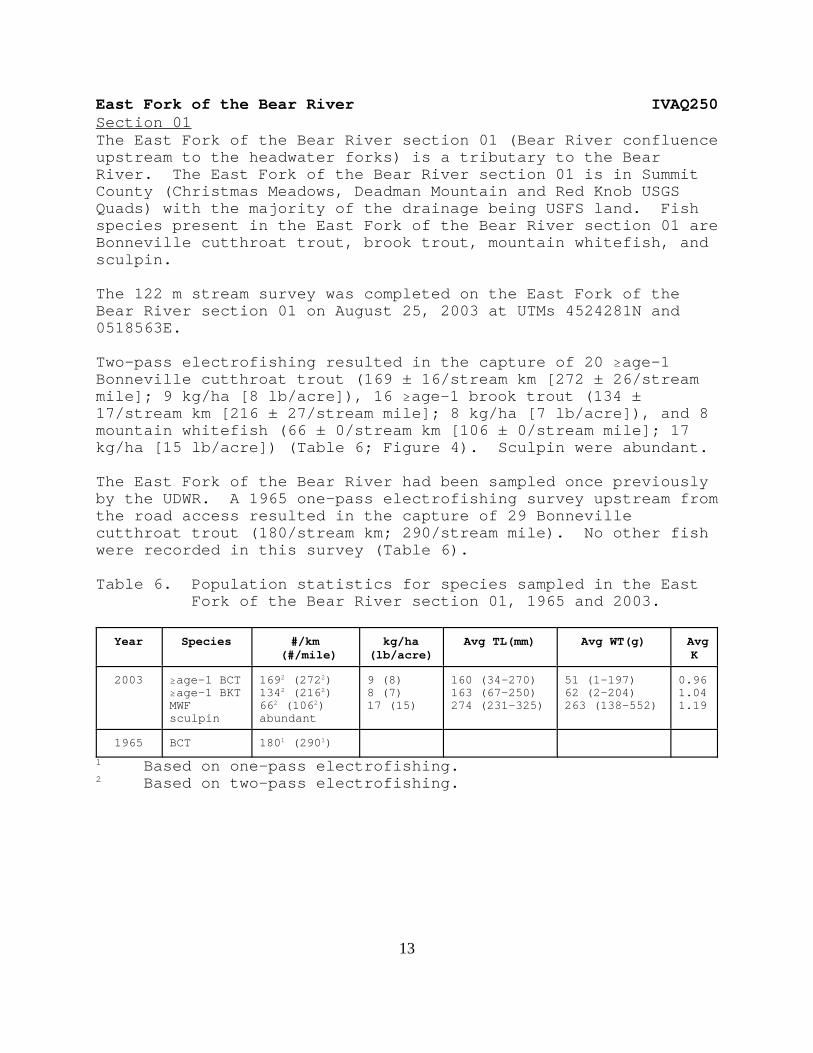
East Fork of the Bear River IVAQ250Section 01 The East Fork of the Bear River section 01 (Bear River confluenceupstream to the headwater forks) is a tributary to the BearRiver. The East Fork of the Bear River section 01 is in SummitCounty (Christmas Meadows, Deadman Mountain and Red Knob USGSQuads) with the majority of the drainage being USFS land. Fishspecies present in the East Fork of the Bear River section 01 areBonneville cutthroat trout, brook trout, mountain whitefish, andsculpin.
The 122 m stream survey was completed on the East Fork of theBear River section 01 on August 25, 2003 at UTMs 4524281N and0518563E.
Two-pass electrofishing resulted in the capture of 20 $age-1Bonneville cutthroat trout (169 ± 16/stream km [272 ± 26/streammile]; 9 kg/ha [8 lb/acre]), 16 $age-1 brook trout (134 ±17/stream km [216 ± 27/stream mile]; 8 kg/ha [7 lb/acre]), and 8mountain whitefish (66 ± 0/stream km [106 ± 0/stream mile]; 17kg/ha [15 lb/acre]) (Table 6; Figure 4). Sculpin were abundant.
The East Fork of the Bear River had been sampled once previouslyby the UDWR. A 1965 one-pass electrofishing survey upstream fromthe road access resulted in the capture of 29 Bonnevillecutthroat trout (180/stream km; 290/stream mile). No other fishwere recorded in this survey (Table 6).
Table 6. Population statistics for species sampled in the EastFork of the Bear River section 01, 1965 and 2003.
Year Species #/km (#/mile)
kg/ha(lb/acre)
Avg TL(mm) Avg WT(g) AvgK
2003 $age-1 BCT$age-1 BKTMWFsculpin
1692 (2722)1342 (2162)662 (1062)abundant
9 (8)8 (7)17 (15)
160 (34-270)163 (67-250)274 (231-325)
51 (1-197)62 (2-204)263 (138-552)
0.961.041.19
1965 BCT 1801 (2901)
1 Based on one-pass electrofishing.2 Based on two-pass electrofishing.

14
Figure 4. Size distribution of Bonneville cutthroat trout, brooktrout, and mountain whitefish sampled in the East Forkof the Bear River section 01, 2003.

15
Stillwater Fork IVAQ260Section 01 Stillwater Fork section 01 (Bear River confluence upstream to thetrailhead) is a tributary to the Bear River. Stillwater Forksection 01 is in Summit County (Christmas Meadows USGS Quad) withthe entire drainage being USFS land. Fish species present inStillwater Fork section 01 are Bonneville cutthroat trout, brooktrout, mountain whitefish, and sculpin.
The 115 m stream survey was completed on Stillwater Fork section01 on August 18, 2003 at UTMs 4519017N and 0516615E.
Two-pass electrofishing resulted in the capture of six $age-1Bonneville cutthroat trout (63 ± 9/stream km [101 ± 14/streammile]; 7 kg/ha [6 lb/acre]) and 28 $age-1 brook trout (255 ±35/stream km [411 ± 57/stream mile]; 23 kg/ha [21 lb/acre])(Table 7; Figure 5). Two mountain whitefish were captured onboth electrofishing passes, consequently, a population estimatewas not available. Sculpin were abundant (Table 7).
Stillwater Fork section 01 had been sampled twice previously bythe UDWR in 1953. Only sculpin were observed whileelectrofishing 4.8 km upstream from the confluence with the BearRiver and near the Stillwater Campground.
Table 7. Population statistics for species sampled in StillwaterFork section 01, 1953 and 2003.
Year Species #/km (#/mile)
kg/ha(lb/acre)
Avg TL(mm) Avg WT(g) AvgK
2003 $age-1 BCT$age-1 BKTMWFsculpin
632 (1012)2552 (4112)4 capturedabundant
7 (6)23 (21)
185 (114-292)167 (61-255)188 (126-255)
75 (11-220)66 (2-209)100 (46-165)
0.931.112.06
1953 sculpin common
2 Based on two-pass electrofishing.

16
Figure 5. Size distribution of Bonneville cutthroat trout, brooktrout, and mountain whitefish sampled in StillwaterFork section 01, 2003.

17
Hayden Fork IVAQ270Hayden Fork (Bear River confluence upstream to the headwaters) isa tributary to the Bear River. Hayden Fork is in Summit County(Christmas Meadows, Hayden Peak, and Whitney Reservoir USGSQuads) with the entire drainage being USFS land. Fish speciespresent in Hayden Fork are Bonneville cutthroat trout, rainbowtrout, Bonneville cutthroat trout x rainbow trout hybrids, brooktrout, mountain sucker, and sculpin.
The 113 m stream survey was completed on Hayden Fork on September16, 2003 at UTMs 4520842N and 0513112E.
Two-pass electrofishing resulted in the capture of four $age-1Bonneville cutthroat trout (35 ± 0/stream km [57 ± 0/streammile]; 2 kg/ha [2 lb/acre]), eight $age-1 rainbow trout (71 ±0/stream km [114 ± 0/stream mile]; 13 kg/ha [11 lb/acre]), and 24$age-1 brook trout (221 ± 27/stream km [356 ± 43/stream mile]; 9kg/ha [8 lb/acre]) (Table 8; Figure 6). One $age-1 Bonnevillecutthroat trout x rainbow trout was captured on bothelectrofishing passes, consequently, a population estimate wasnot available. Sculpin were abundant and mountain sucker weresparse (Table 8).
Hayden Fork had been sampled three times previously by the UDWR. In 1970, only catchable rainbow trout were observed. Two one-passelectrofishing stations in 1953 resulted in the capture ofsculpin, mountain sucker, and leatherside chub (Table 8).
Table 8. Population statistics for species sampled in HaydenFork, 1953, 1970, and 2003.
Year Species #/km (#/mile)
kg/ha(lb/acre)
Avg TL(mm) Avg WT(g) AvgK
2003 $age-1 BCT$age-1 RBT$age-1 BKT$age-1 BCTxRBTsculpinMTS
352 (572)712 (1142)2212 (3562)2 capturedabundantsparse
2 (2)13 (11)9 (8)
162 (105-241)266 (207-300)146 (65-240)252 (243-261)
52 (14-130)192 (98-230)46 (2-152)136 (102-170)
0.920.990.990.83
1970 RBT present
1953 sculpinMTSLSC
commonsparsesparse
2 Based on two-pass electrofishing.

18
Figure 6. Size distribution of Bonneville cutthroat trout, brooktrout, rainbow trout, and rainbow trout x Bonnevillecutthroat trout sampled in Hayden Fork, 2003.

19
Cache Valley subunit
Beaver Creek IVAQ040A16Beaver Creek (confluence with the Logan River upstream to theIdaho stateline) is a tributary of the Logan River. Beaver Creekis in Cache County (Tony Grove Creek USGS Quad) with the majorityof the drainage being USFS land. Fish species present in BeaverCreek are Bonneville cutthroat trout, brook trout, and sculpin.
The 100 m stream survey was completed on Beaver Creek on August21, 2003 at UTMs 4648117N and 0456612E.
Two-pass electrofishing resulted in the capture of 37 age-1 andolder Bonneville cutthroat trout (412 ± 81/stream km; 664 ±130/stream mile) and three Bonneville cutthroat trout <50 mm TL(Table 9; Figure 7).
Beaver Creek had been surveyed four times previously by the UDWR. Two electrofishing stations were completed in 1999. Station #1was located at UTMs 0453899E and 4642869N. Two-passelectrofishing in this station resulted in the capture of 76 age-1 and older Bonneville cutthroat trout (909 ± 137/stream km [1464± 221/stream mile]; 216 kg/ha [192 lb/acre]) and four age-1 andolder brook trout (Table 9). Station #2 was located at UTMs0456586E and 4648520N. Two-pass electrofishing in this stationresulted in the capture of 23 age-1 and older Bonnevillecutthroat trout (236 ± 30/stream km [380 ± 48/stream mile]; 76kg/ha [67 lb/acre]) (Table 9). One-pass electrofishing surveyswere also completed in 1967 and 1968. Bonneville cutthroat troutwere the predominant salmonid in these surveys and low densitiesof rainbow trout and brown trout were present in 1967 (Table 9).

20
Table 9. Population statistics for species sampled in BeaverCreek, 1967, 1968, 1999, and 2003.
Year Species #/km (#/mile)
kg/ha(lb/acre)
Avg TL(mm) Avg WT(g) AvgK
2003 $age-1 BCTage-0 BCT
4122(6642)3 captured
104 (50-300)48 (47-49)
1999st. #1
$age-1 BCT$age-1 BKTMSC
9092(14642)4 capturedabundant
216(192) 187 (80-275)129 (123-134)90 (51-124
83 (4-208)23 (18-29)12 (4-29)
1.071.08
1999st. #2
$age-1 BCT 2362(3802) 76(67) 190 (59-309) 100 (2-318) 1.18
1968 $age-1 BCTMSC
561(901)sparse
8(7) 151 (103-240) 45 (12-129) 1.12
1967 BCTBNTRBTMSC
1551(2501)121(201)61(101)sparse
1Based on one-pass electrofishing.
2 Based on two-pass electrofishing.
Figure 7. Size distribution of Bonneville cutthroat trout sampledin Beaver Creek, 2003.

21
Davenport Creek IVAQ040E01Davenport Creek (confluence with the South Fork of the LittleBear River upstream to the headwaters) is a tributary of theSouth Fork of the Little Bear River. Davenport Creek is in CacheCounty (James Peak, Paradise, and Sharp Mountain USGS Quads) withthe entire drainage being privately owned. Fish species presentin Davenport Creek are Bonneville cutthroat trout, brown trout,and sculpin are likely present in the lower reaches of thestream.
The 100 m stream survey was completed on Davenport Creek onAugust 21, 2003 at UTMs 4587146N and 0436207E.
Two-pass electrofishing resulted in the capture of 29 age-1 andolder Bonneville cutthroat trout (303 ± 40/stream km [488 ±65/stream mile]; 50 kg/ha [45 lb/acre]), five age-0 Bonnevillecutthroat trout, and 40 age-1 and older brown trout (437 ±70/stream km [703 ± 112/stream mile]; 83 kg/ha [74 lb/acre])(Table 10; Figure 8). Thirty Bonneville cutthroat trout (13whole; 17 fin clips) were collected for genetic analyses andfrozen according to the cutthroat trout collection proceduralmanual (Toline and Lentsch 1999).
Davenport Creek had been sampled twice previously by the UDWR. Aone-pass electrofishing survey on Davenport Creek in 1976 nearthe confluence with the South Fork of the Little Bear Riverresulted in the capture of nine Bonneville cutthroat trout(112/stream km; 180/stream mile) and two brown trout (25/streammile; 40/stream mile) (Table 10). In 1978, a one-passelectrofishing survey was completed at the 2003 station. Thissurvey resulted in the capture of eight Bonneville cutthroattrout (99/stream km; 160/stream mile), 14 brown trout (174/streamkm; 280/stream mile), and one sculpin (Table 10).

22
Table 10. Population statistics for species sampled in DavenportCreek, 1976, 1978, and 2003.
Year Species #/km (#/mile)
kg/ha(lb/acre)
Avg TL(mm) Avg WT(g) AvgK
2003 $age-1 BCTage-0 BCT$age-1 BNT
3032 (4882)5 captured4372 (7032)
50 (45)
83 (74)
156 (71-275)39 (35-42)145 (59-264)
55 (4-189)
63 (2-187)
0.94
1.19
1978 BCTBNTsculpin
991 (1601)1741 (2801)sparse
194 (90-270)134 (98-220)
104 (10-250)37 (10-120)
1.831.31
1976 BCTBNT
1121 (1801)251 (401)
165 (115-260)220 (100-340)
61 (14-185)220 (14-425)
1.051.24
1Based on one-pass electrofishing.
2 Based on two-pass electrofishing.
Figure 8. Size distribution of Bonneville cutthroat trout andbrown trout sampled in Davenport Creek, 2003.

23
Wellsville Creek IVAQ040E01EWellsville Creek (confluence with Davenport Creek upstream to theheadwaters) is a tributary to Davenport Creek. Wellsville Creekis in Cache County (James Peak USGS Quad) with the entiredrainage being privately owned. Fish species present inWellsville Creek are Bonneville cutthroat trout and sculpin. Brown trout likely are present in portions of the stream.
Wellsville Creek was spot electrofished on August 21, 2003 atUTMs 4586812N and 0435911E. The landowner reported that he hasangled Bonneville cutthroat trout in the stream for the entire 5km. Approximately 30 m of stream was electrofished, whichresulted in the capture of 15 Bonneville cutthroat trout rangingfrom 30-220 mm TL.
Wellsville Creek had been sampled once previously by the UDWR. In 1978, one-pass electrofishing in a 80 m station locateddirectly upstream from the confluence with Davenport Creekresulted in the capture of 15 Bonneville cutthroat trout(186/stream km; 300/stream mile) and eight brown trout (99/streamkm; 160/stream mile). Sculpin were common (Table 11).
Table 11. Population statistics for species sampled in WellsvilleCreek, 1978 and 2003.
Year Species #/km (#/mile)
kg/ha(lb/acre)
Avg TL(mm) Avg WT(g) AvgK
2003 $age-1 BCTage-0 BCT
presentpresent
1978 BCTBNTsculpin
1861 (3001)991 (1601)common
141 (82-253)161 (109-265)
45 (5-148)67 (16-230)
1Based on one-pass electrofishing.

24
Rich County subunit
Otter Creek IVAQ170Otter Creek (Sage Creek canal section 33 upstream to theheadwater spring) is a tributary to the Bear River. Otter Creekis in Rich County (Old Canyon and Randolph USGS Quads) withapproximately 50% of the drainage being BLM land and theremainder privately owned. Fish species present in Otter Creekare brook trout, brown trout, and sculpin.
Otter Creek was spot electrofished on September 30, 2003 at UTMs46194948N and 0478398E. Spot electrofishing resulted in thecapture of brook trout and sculpin.
Otter Creek had been sampled once previously by the UDWR. In1954, one-pass electrofishing at a 161 m station located 6 ½miles upstream from Highway 16 resulted in the capture of nineBonneville cutthroat trout (56/stream km; 90/stream mile), fourbrook trout (25/stream km; 40/stream mile), and sculpin wereabundant (Table 12).
Table 12. Population statistics for species sampled in OtterCreek, 1954 and 2003.
Year Species #/km (#/mile)
kg/ha(lb/acre)
Avg TL(mm) Avg WT(g) AvgK
2003 BKTsculpin
presentpresent
1954 BCTBKTsculpin
561 (901)251 (401)abundant
1Based on one-pass electrofishing.

25
South Branch of Otter Creek IVAQ170AThe South Branch of Otter Creek (Otter Creek confluence upstreamto the headwater spring) is a tributary to Otter Creek. TheSouth Branch of Otter Creek is in Rich County (Old Canyon andRandolph USGS Quads) with approximately 25% of the drainage beingBLM land and the remainder privately owned. Fish species presentin the South Branch of Otter Creek are brook trout, brown trout,and sculpin.
The South Branch of Otter Creek was spot electrofished onSeptember 30, 2003 at UTMs 4616548N and 0478670E. Spotelectrofishing resulted in the capture of brown trout, brooktrout and sculpin. Sculpin were the most abundant fish specieswith brown trout being the second most abundant.
The South Branch of Otter Creek had been sampled twice previouslyby the UDWR. In 1968, one-pass electrofishing at a 161 m stationlocated near the confluence with the Middle Branch and SouthBranch resulted in the capture of six brown trout (37/stream km;60/stream mile) and sculpin were abundant (Table 13). One-passelectrofishing in 1954 resulted in the capture of sculpin (Table13). This station was located approximately two miles upstreamfrom the confluence with the Middle Fork.
Table 13. Population statistics for species sampled in the SouthBranch of Otter Creek, 1954, 1968, and 2003.
Year Species #/km (#/mile)
kg/ha(lb/acre)
Avg TL(mm) Avg WT(g) AvgK
2003 BNTBKTsculpin
presentpresentpresent
1968 BNTsculpin
371 (601)abundant
1954 sculpin abundant
1Based on one-pass electrofishing.
26
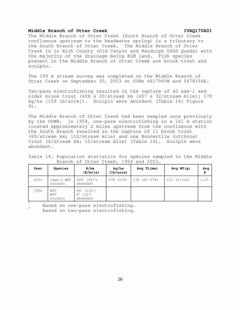
Middle Branch of Otter Creek IVAQ170A01The Middle Branch of Otter Creek (South Branch of Otter Creekconfluence upstream to the headwater spring) is a tributary tothe South Branch of Otter Creek. The Middle Branch of OtterCreek is in Rich County (Old Canyon and Randolph USGS Quads) withthe majority of the drainage being BLM land. Fish speciespresent in the Middle Branch of Otter Creek are brook trout andsculpin.
The 100 m stream survey was completed on the Middle Branch ofOtter Creek on September 30, 2003 at UTMs 4617940N and 0478156E.
Two-pass electrofishing resulted in the capture of 40 age-1 andolder brook trout (408 ± 20/stream km [657 ± 32/stream mile]; 178kg/ha [159 lb/acre]). Sculpin were abundant (Table 14; Figure9).
The Middle Branch of Otter Creek had been sampled once previouslyby the UDWR. In 1954, one-pass electrofishing in a 161 m stationlocated approximately 2 miles upstream from the confluence withthe South Branch resulted in the capture of 11 brook trout(69/stream km; 110/stream mile) and one Bonneville cutthroattrout (6/stream km; 10/stream mile) (Table 14). Sculpin wereabundant.
Table 14. Population statistics for species sampled in the MiddleBranch of Otter Creek, 1954 and 2003.
Year Species #/km (#/mile)
kg/ha(lb/acre)
Avg TL(mm) Avg WT(g) AvgK
2003 $age-1 BKTsculpin
4082 (6572)abundant
178 (159) 172 (61-372) 111 (3-512) 1.07
1954 BKTBNTsculpin
691 (1101)61 (101)abundant
1Based on one-pass electrofishing.
2Based on two-pass electrofishing.

27
Figure 9. Size distribution of brook trout sampled in the MiddleBranch of Otter Creek, 2003.

28
New Canyon IVAQ180ANew Canyon (Little Creek Reservoir confluence upstream to ClawsonSpring) is a tributary to Little Creek. New Canyon is in RichCounty (Old Canyon and Randolph USGS Quads) with the entiredrainage upstream to Clawson Spring being privately owned.
New Canyon was spot electrofished on September 30, 2003 at UTMs4614331N and 0477736E. Spot electrofishing resulted in thecapture of no fish. New Canyon had been sampled once previouslyby the UDWR. In 1981 no fish were observed.
Big Creek IVAQ190Section 02Big Creek section 02 (Big Ditch Diversion upstream to theheadwaters) is a tributary to the Bear River. Big Creek section02 is in Rich County (Birch Creek Reservoirs, Randolph, andWoodruff USGS Quads) with the majority of the drainage beingprivately owned and the remainder being BLM land. Fish speciespresent in Big Creek section 02 are Bonneville cutthroat trout,brook trout, brown trout, mountain sucker, and sculpin.
The 100 m stream survey was completed on Big Creek section 02 onSeptember 30, 2003 at UTMs 4602201N and 0470774E.
Two-pass electrofishing resulted in the capture of three age-1and older Bonneville cutthroat trout (30 ± 0/stream km [48 ±0/stream mile]; 5 kg/ha [4 lb/acre]), 13 age-1 and older brooktrout (131 ± 10/stream km [211 ± 16/stream mile]; 26 kg/ha [23lb/acre]), and two age-1 and older brown trout (20 ± 0/stream km[32 ± 0/stream mile]; 16 kg/ha [14 lb/acre]). Mountain suckerwere common and sculpin were abundant (Table 15; Figure 10).
Big Creek had been sampled six times previously by the UDWRbetween 1977 and 1980. Three two-pass electrofishing stationswere surveyed in 1977. Station #1 was located at the BLM/privatefence line. Electrofishing in this 161 m station resulted in thecapture of five age-1 and older Bonneville cutthroat trout (33 ±13/stream km [53 ± 21/stream mile]; 3 kg/ha [3 lb/acre]) andthree catchable rainbow trout (19 ± 0/stream km [30 ± 0/streammile]; 13 kg/ha [11 lb/acre]) (Table 15). Sculpin were abundant. Station #2 was located in the BLM exclosure fence. Electrofishing in this 161 m station resulted in the capture of27 age-1 and older Bonneville cutthroat trout (173 ± 19/stream km[278 ± 30/stream mile]; 28 kg/ha [25 lb/acre]) and 17 catchablerainbow trout (106 ± 6/stream km; 171 ± 10/stream mile) (Table15). Sculpin were common and mountain sucker were sparse. Station #3 was located near the old air force cabin. Electrofishing in this 161 m station resulted in the capture of

29
49 age-1 and older Bonneville cutthroat trout (307 ± 6/stream km[494 ± 10/stream mile]; 29 kg/ha [26 lb/acre]) and two age-1 andolder brook trout (12 ± 0/stream km [20 ± 0/stream mile]; 3 kg/ha[3 lb/acre]) (Table 15).
The same three electrofishing stations were sampled in 1980. Two-pass electrofishing in the 161 m station #1 resulted in thecapture of nine catchable rainbow trout (75 ± 75/stream km [120 ±120/stream mile]; 49 kg/ha [43 lb/acre]) (Table 15). Sculpinwere abundant and mountain sucker were sparse. Two-passelectrofishing in the 161 m station #2 resulted in the capture oftwo age-1 and older Bonneville cutthroat trout and two catchablerainbow trout. Equal numbers or more fish were captured on thesecond electrofishing pass, consequently, a population estimatewas not available for these two species. Sculpin were common andmountain sucker were sparse (Table 15). Two-pass electrofishingin the 161 m station #3 resulted in the capture of 22 age-1 andolder Bonneville cutthroat trout and two catchable rainbow trout(12 ± 0/stream km [20 ± 0/stream mile]; 7 kg/ha [6 lb/acre])(Table 15). Equal numbers of Bonneville cutthroat trout werecaptured on each electrofishing pass, consequently, a populationestimate was not available. Sculpin were abundant and mountainsucker were common.

30
Table 15. Population statistics for species sampled in Big Creeksection 02, 1977, 1980, and 2003.
Year Species #/km (#/mile)
kg/ha(lb/acre)
Avg TL(mm) Avg WT(g) AvgK
2003 $age-1 BCT$age-1 BKT$age-1 BNTMTSsculpin
302 (482)1312 (2112)202 (322)commonabundant
5 (4)26 (23)16 (14)
156 (126-200)149 (112-216)255 (214-295)
42 (21-79)53 (12-131)209 (119-299)
0.991.441.19
1980St.#1
$age-1 RBTsculpinMTS
752 (1202)abundantsparse
49 (43) 257 (213-287) 172 (100-226) 1.00
1980St.#2
$age-1 BCT$age-1 RBTsculpinMTS
2 captured2 capturedcommonsparse
185 (176-194)239 (230-247)
70 (64-76)125 (102-148)
1.140.91
1980St.#3
$age-1 BCT$age-1 RBTsculpinMTS
22 captured122 (202)abundantcommon
7 (6)164 (95-288)243 (225-262)
50 (10-244)146 (115-176)
0.990.99
1977St.#1
$age-1 BCT$age-1 RBTsculpin
332 (532)192 (302)abundant
3 (3)13 (11)
137 (107-190)257 (255-258)
25 (10-61)181 (180-184)
0.841.07
1977St.#2
$age-1 BCT$age-1 RBTsculpinMTS
1732 (2782)1062 (1712)commonsparse
28 (25) 133 (105-221) 133 (105-221) 1.86
1977St.#3
$age-1 BCT$age-1 BKT
3072 (4942)122 (202)
29 (26)3 (3)
132 (91-231)184 (183-184)
132 (91-231)70 (64-75)
0.871.13
2Based on two-pass electrofishing.

31
Figure 10. Size distribution of Bonneville cutthroat trout,brook trout, and brown trout sampled in Big Creeksection 02, 2003.

32
Meachum Canyon IVAQ210A01Meachum Canyon (Saleratus Creek confluence upstream to theheadwaters) is a tributary to Saleratus Creek. Meachum Canyon isin Rich County (Meachum Ridge and Peck Canyon USGS Quads) withthe entire drainage being owned by Deseret Land and Livestock. Bonneville cutthroat trout were introduced into Meachum Canyon onJuly 23, 1996. Approximately 100 fish were transplanted fromSugar Pine Creek. Meachum Canyon was spot electrofished in 1998and reproduction from the transplant was verified.
The 100 m stream survey was completed on Meachum Canyon onOctober 22, 2003 at UTMs 4580650N and 0473667E.
Two-pass electrofishing resulted in the capture of seven age-1and older Bonneville cutthroat trout (70 ± 0/stream km [113 ±0/stream mile]; 8 kg/ha [7 lb/acre]) (Table 16; Figure 11).
Table 16. Population statistics for species sampled in MeachumCanyon, 2003.
Year Species #/km (#/mile)
kg/ha(lb/acre)
Avg TL(mm) Avg WT(g) AvgK
2003 BCT 702 (1132) 8 (7) 106 (70-154) 11 (2-23) 0.782
Based on two-pass electrofishing.
Figure 11. Size distribution of Bonneville cutthroat trout
sampled in Meachum Canyon, 2003.

33
Northern Bonneville GMUOgden River subunit
Middle Fork of the Ogden River IVAP030CSection 02The Middle Fork of the Ogden River section 02 (diversion to theheadwaters) is a tributary to the Ogden River. The Middle Forkof the Ogden River section 02 is in Weber County (Browns Hole andHuntsville USGS Quads) with the majority of the drainage beingstate land. Fish species present in the Middle Fork of the OgdenRiver are rainbow trout, rainbow trout x Bonneville cutthroattrout hybrids, and Bonneville cutthroat trout.
The 150 m stream survey was completed on the Middle Fork of theOgden River section 02 on September 22, 2003 at UTMs 4574400N and0440525E.
Two-pass electrofishing resulted in the capture of 78 age-1 andolder rainbow trout (580 ± 80/stream km [934 ± 129/stream mile];63 kg/ha [56 lb/acre]), six age-1 and older rainbow trout xBonneville cutthroat trout hybrids (42 ± 14/stream km [67 ±22/stream mile]; 3 kg/ha [3 lb/acre]), and four age-1 and olderBonneville cutthroat trout (27 ± 0/stream km [43 ± 0/streammile]; 9 kg/ha [8 lb/acre]) (Table 17; Figure 12).
The Middle Fork of the Ogden River had been sampled three timespreviously by the UDWR. Two of the surveys were in 1987. Station #1 was located in the lower reaches of section 02. Two-pass electrofishing in a 161 m reach resulted in the capture ofnine age-1 and older Bonneville cutthroat trout (56 ± 0/stream km[90 ± 0/stream mile]; 5 kg/ha [4 lb/acre]), 12 age-1 and olderrainbow trout (78 ± 12/stream km [125 ± 19/stream mile]; 18 kg/ha[16 lb/acre]), 14 age-1 and older rainbow trout x Bonnevillecutthroat trout (88 ± 6/stream km [141 ± 10/stream mile]; 11kg/ha [10 lb/acre]), and one age-1 and older brown trout (Table17). The brown trout was captured on the second electrofishingpass, consequently a population estimate was not available. Sculpin were common. Station #2 was located at the road crossingdirectly downstream from Elk Creek. Two-pass electrofishing in a161 m station resulted in the capture of 14 age-1 and olderBonneville cutthroat trout (89 ± 13/stream km [144 ± 21/streammile]; 11 kg/ha [10 lb/acre]), 21 age-1 and older rainbow trout(132 ± 6/stream km [212 ± 10/stream mile]; 32 kg/ha [29lb/acre]), and 29 age-1 and older rainbow trout x Bonnevillecutthroat trout (193 ± 31/stream km [311 ± 50/stream mile]; 24kg/ha [22 lb/acre]) (Table 17). In 1975, one-pass electrofishingin a 161 m station resulted in the capture of 25 Bonnevillecutthroat trout (155/stream km; 250/stream mile) and four rainbow

34
trout (25/stream km; 40/stream mile (Table 17).
Table 17. Population statistics for species sampled in the MiddleFork of the Ogden River section 02, 1975, 1987, and2003.
Year Species #/km (#/mile)
kg/ha(lb/acre)
Avg TL(mm) Avg WT(g) AvgK
2003 $age-1 RBT$age-1 RBTxBCT$age-1 BCT
5802 (9342)422 (672)272 (432)
63 (56)3 (3)9 (8)
147 (59-277)157 (139-205)207 (136-244)
55 (1-218)38 (14-84)112 (24-220)
1.260.901.08
1987St. #1
$age-1 BCT$age-1 RBT$age-1 RBTxBCT$age-1 BNTsculpin
562 (902)782 (1252)882 (1412)1 capturedcommon
5 (4)18 (16)11 (10)
156 (70-245)192 (90-288)166 (65-262)370
45 (5-140)121 (10-290)67 (2-195)530
1.021.281.011.05
1987St. #2
$age-1 BCT$age-1 RBT$age-1 RBTxBCT
892 (1442)1322 (2122)1932 (3112)
11 (10)32 (29)24 (22)
161 (90-235)194 (92-285)163 (89-287)
58 (6-135)114 (8-265)58 (10-200)
1.291.331.25
1975 BCTRBT
1551 (2501)251 (401)
119 (85-240)169 (114-223)
41 (12-142)88 (36-157)
2.141.89
2Based on two-pass electrofishing.
1Based on one-pass electrofishing.

35
Figure 12. Size distribution of Bonneville cutthroat trout,rainbow trout, and Bonneville cutthroat trout xrainbow trout sampled in the Middle Fork of theOgden River section 02, 2003.

36
Weber River subunit
Cottonwood Creek IVAP080Cottonwood Creek (Weber River confluence upstream to theheadwaters) is a tributary to the Weber River. Cottonwood Creekis in Morgan County (Bybee Knoll, Durst Mountain, and Snow BasinUSGS Quads) with the majority of the drainage being privatelyowned and a small portion being state land. Fish species presentin Cottonwood Creek are Bonneville cutthroat trout, mountainsucker, and sculpin are likely present in portions of thedrainage.
The 100 m stream survey was completed on Cottonwood Creek onSeptember 10, 2003 at UTMs 4562005N and 0451824E.
Two-pass electrofishing resulted in the capture of 170 Bonnevillecutthroat trout $50 mm TL (1704 ± 60/stream km [2743 ± 97/streammile]; 109 kg/ha [97 lb/acre]) and 47 Bonneville cutthroat trout<50 mm TL (484 ± 31/stream km; 780 ± 50/stream mile) (Table 18;Figure 13). Thirty whole Bonneville cutthroat trout werecollected for genetic analyses and frozen according to thecutthroat trout collection procedural manual (Toline and Lentsch1999).
Cottonwood Creek had been sampled once previously by the UDWR. In 1979, a station was surveyed upstream from the confluence withArbuckle Creek. One-pass electrofishing resulted in the captureof three Bonneville cutthroat trout (37/stream km; 60/streammile), one rainbow trout (12/stream km; 20/stream mile), andmountain sucker were present (Table 18).
Table 18. Population statistics for species sampled in CottonwoodCreek, 1979 and 2003.
Year Species #/km (#/mile)
kg/ha(lb/acre)
Avg TL(mm) Avg WT(g) AvgK
2003 $age-1 BCTage-0 BCT
17042 (27432)4842 (7802)
109 (97) 89 (50-185)44 (38-49)
10 (1-55) 0.93
1979 BCTRBTMTS
371 (601)121 (201)present
1Based on one-pass electrofishing.
2Based on two-pass electrofishing.

37
Figure 13. Size distribution of Bonneville cutthroat troutsampled in Cottonwood Creek, 2003.
38
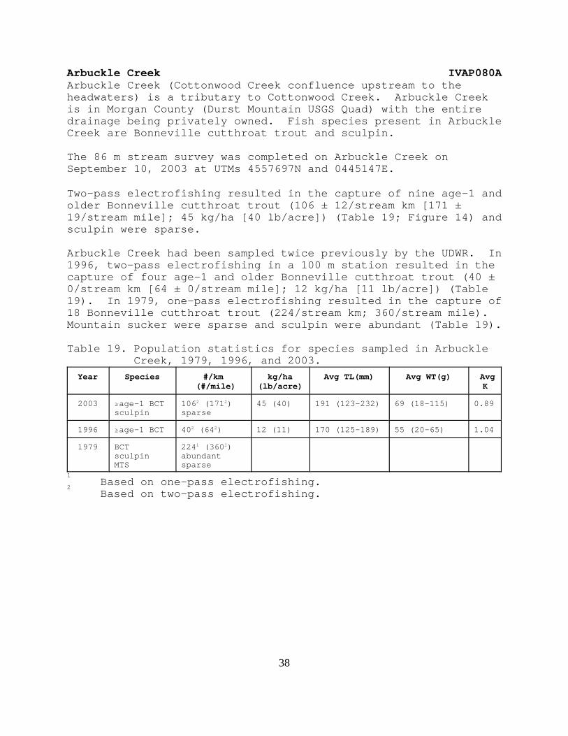
Arbuckle Creek IVAP080AArbuckle Creek (Cottonwood Creek confluence upstream to theheadwaters) is a tributary to Cottonwood Creek. Arbuckle Creekis in Morgan County (Durst Mountain USGS Quad) with the entiredrainage being privately owned. Fish species present in ArbuckleCreek are Bonneville cutthroat trout and sculpin.
The 86 m stream survey was completed on Arbuckle Creek onSeptember 10, 2003 at UTMs 4557697N and 0445147E.
Two-pass electrofishing resulted in the capture of nine age-1 andolder Bonneville cutthroat trout (106 ± 12/stream km [171 ±19/stream mile]; 45 kg/ha [40 lb/acre]) (Table 19; Figure 14) andsculpin were sparse.
Arbuckle Creek had been sampled twice previously by the UDWR. In1996, two-pass electrofishing in a 100 m station resulted in thecapture of four age-1 and older Bonneville cutthroat trout (40 ±0/stream km [64 ± 0/stream mile]; 12 kg/ha [11 lb/acre]) (Table19). In 1979, one-pass electrofishing resulted in the capture of18 Bonneville cutthroat trout (224/stream km; 360/stream mile). Mountain sucker were sparse and sculpin were abundant (Table 19).
Table 19. Population statistics for species sampled in ArbuckleCreek, 1979, 1996, and 2003.
Year Species #/km (#/mile)
kg/ha(lb/acre)
Avg TL(mm) Avg WT(g) AvgK
2003 $age-1 BCTsculpin
1062 (1712)sparse
45 (40) 191 (123-232) 69 (18-115) 0.89
1996 $age-1 BCT 402 (642) 12 (11) 170 (125-189) 55 (20-65) 1.04
1979 BCTsculpinMTS
2241 (3601)abundantsparse
1Based on one-pass electrofishing.
2Based on two-pass electrofishing.

39
Figure 14. Size distribution of Bonneville cutthroat troutsampled in Arbuckle Creek, 2003.

40
COLORADO RIVER CUTTHROAT TROUTOnly one two-pass depletion electrofishing survey was completedon the West Fork of Beaver Creek section 01.
West Fork of Beaver Creek IICJ040ASection 01The West Fork of Beaver Creek section 01 (Wyoming statelineupstream to the USFS boundary) is a tributary to the Henrys Fork. The West Fork of Beaver Creek section 01 is in Summit County(Hole in the Rock USGS Quad) with the entire section 01 beingprivately owned. Fish species present in the West Fork of BeaverCreek section 01 are brook trout and sculpin. Colorado Rivercutthroat trout are likely present in the upstream portions ofsection 01.
The 103 m stream survey was completed on the West Fork of BeaverCreek section 01 on October 2, 2003 at UTMs 4535559N and0568679E.
Two-pass electrofishing resulted in the capture of 24 age-1 andolder brook trout (238 ± 19/stream km [383 ± 31/stream mile]; 14kg/ha [12 lb/acre]) (Table 20; Figure 15) and sculpin wereabundant.
The West Fork of Beaver Creek section 01 had been sampled oncepreviously by the UDWR. In 1973, one-pass electrofishing in a161 m station located just South of the Wyoming statelineresulted in the capture of one Bonneville cutthroat trout6/stream km; 10/stream mile) (Table 20). Sculpin and longnosedace were common and mountain sucker were sparse.
Table 20. Population statistics for species sampled in the WestFork of Beaver Creek section 01, 1973 and 2003.
Year Species #/km (#/mile)
kg/ha(lb/acre)
Avg TL(mm) Avg WT(g) AvgK
2003 $age-1 BKTsculpin
2382 (3832)abundant
14 (12) 117 (64-215) 24 (2-72) 1.06
1973 $age-1 BKTsculpinMTSLND
61 (101)commonsparsecommon
1Based on one-pass electrofishing.
2Based on two-pass electrofishing.

41
Figure 15. Size distribution of brook trout sampled in theWest Fork of Beaver Creek section 01, 2003.

42
Gilbert Creek IICK020A01Gilbert Creek (Wyoming state line upstream to the headwaters) isa tributary to the East Fork of the Smiths Fork River. GilbertCreek is in Summit County (Bridger Lake USGS Quad) with themajority of the drainage being USFS land and the remainder beingprivately owned. Following the chemical reclamation of GilbertCreek in 2001 and 2002, fish species currently present (2003) inGilbert Creek are Colorado River cutthroat trout, sculpin, andmountain sucker.
Two attempts were made at moving Colorado River cutthroat troutfrom the West Fork of the Smiths Fork (wilderness boundary area)to Gilbert Creek during 2003. One May 28, 2003, 17 ColoradoRiver cutthroat trout were collected and released into GilbertCreek. On July 22, 2003, 258 Colorado River cutthroat trout werecollected and released into Gilbert Creek. Between the twoefforts, 275 Colorado River cutthroat trout were reintroducedinto Gilbert Creek during 2003 (Table 21). The Wyoming Game andFish Department stocked sculpin and mountain sucker into theWyoming portion of Gilbert Creek upstream from the border barrierduring 2002 (Table 21). These fish came from salvage efforts inthe Wyoming portion of Gilbert Creek prior to the chemicalreclamation of this section.
Table 21. Fish species and numbers reintroduced into GilbertCreek, upstream from the border barrier, following thechemical reclamation in 2001 and 2002.
Year Species Number
2002 sculpin >2,000
2002 mountain sucker 367
2003 Colorado River cutthroat trout 275

43
West Fork of the Smiths Fork IICK020BThe West Fork of the Smiths Fork (Wyoming state line upstream tothe headwaters) is a tributary to the East Fork of the SmithsFork River. The West Fork of the Smiths Fork is in Summit County(Bridger Lake USGS Quad) with the majority of the drainage beingUSFS land and the remainder being privately owned. Fish speciespresent in the West Fork of the Smiths Fork are Colorado Rivercutthroat trout, Colorado River cutthroat trout x rainbow trouthybrids, sculpin, and mountain sucker.
The West Fork of the Smiths Fork was spot electrofished on fourseparate occasions during 2003. On May 28th and July 22nd, 275Colorado River cutthroat trout were collected near the wildernessboundary and moved to Gilbert Creek (Table 21). Two portions ofthe West Fork of the Smiths Fork were spot electrofished onSeptember 3rd. Approximately 150 Colorado River cutthroat troutwere collected near the wilderness boundary area and moved toSheep Creek Lake as a start in establishing a brood source forthe North Slope. The fish were fin clipped to distinguish themfrom the South Slope brood source. On the same day, the lowerportion of the West Fork of the Smiths Fork was spotelectrofished and 60 fish were collected for diseasecertification. The Colorado River cutthroat trout in the WestFork of the Smiths Fork passed the disease inspection for thefourth straight year.
44
YELLOWSTONE CUTTHROAT TROUTWildcat Creek IIIAA040Wildcat Creek section 02 (USFS boundary upstream to theheadwaters) is a tributary to the Raft River. Wildcat Creeksection 02 is in Box Elder County (Yost and Buck Hollow USGSQuads) with a majority of section 02 being USFS land. Yellowstone cutthroat trout were documented to occupyapproximately 1.1 stream miles of Wildcat Creek section 02 duringsurveys completed in 2001 (Thompson 2002).
A wildfire in 2002 burned the entire 1.1 occupied stream miles. Spot electrofishing in this reach during 2003 resulted in thecapture of 11 age-1 and older Yellowstone cutthroat trout. Riparian habitat was virtually non-existent in 2003 and thesubstrate was primarily silt following spring runoff.
A genetic sample had been collected during 2001 survey efforts,however, this sample was lost. Fin clips were collected from the11 Yellowstone cutthroat trout during 2003. These samples werepreserved in alcohol according to the cutthroat trout collectionprocedural manual (Toline and Lentsch 1999).
Goose Creek IIIABGoose Creek (Idaho border to the Nevada border) is in Box ElderCounty (Nile Spring and Pole Creek USGS Quads). The entirestream corridor of Goose Creek is privately owned. Fish speciespresent in Goose Creek are mountain sucker, sculpin, speckleddace, redside shiner, longnose dace, and Utah sucker. Yellowstone cutthroat trout may occupy Goose Creek seasonally andleatherside chub may be present in the downstream reaches of theUtah portion of the stream (Thompson 2002).
The 100 m stream survey was completed on Goose Creek on September29, 2003 at UTMs 46550235N and 07445361E. This survey waslocated on the Utah side of the Utah/Nevada border.
Two-pass electrofishing resulted in the capture of 744 redsideshiner (7,788 ± 180/stream km; 12,539 ± 290/stream mile), 29 Utahsucker (322 ± 71/stream km; 519 ± 114/stream mile), and twomountain sucker (20 ± 0/stream km; 32 ± 0/stream mile). Speckleddace and longnose dace were abundant and sculpin were sparse(Table 22).
Goose Creek in Utah had been sampled three times previously bythe UDWR. In 1996, three age-1 and older Yellowstone cutthroattrout were captured at the Idaho/Utah border (Table 22). OneYellowstone cutthroat trout was captured in 1971 and none werecaptured in 1957 (Table 22).

45
Table 22. Population statistics for species sampled in GooseCreek, 1957, 1971, 1996, and 2003.
Year Species #/km (#/mile)
kg/ha(lb/acre)
Avg TL(mm) Avg WT(g) AvgK
2003 RSSUTSMTSSPDLNDsculpin
77882 (125392)3222 (5192)202 (322)abundantabundantsparse
1996 $age-1 YCTSPDRSSMTSsculpin
402 (642)abundantabundantcommonsparse
285 (253-320) 251 (153-383) 1.03
1971 $age-1 YCTRSSsuckers
61 (101)presentpresent
1957 RSSdacesuckerssculpin
presentpresentpresentpresent
1Based on one-pass electrofishing.
2Based on two-pass electrofishing.

46
DISCUSSION
BONNEVILLE CUTTHROAT TROUT
BEAR RIVER GMUUinta Mountains/Upper Bear River subunit
The lower reaches of most of the major tributaries to the UpperBear River were surveyed during 2003. In addition, the USFScompleted surveys on many of the upper reaches of these streamsand their tributaries in 2003. These survey efforts documentedthe range and population size of Bonneville cutthroat trout inthe Uinta Mountains/Upper Bear River subunit. The lower reachesof many of the larger streams that were surveyed in 2003 appearto be fairly unproductive, which is reflected in the low salmoniddensities. Future conservation efforts in this subunit shouldfocus on: 1) identifying streams/stream reaches where non-nativesalmonid control would be feasible, 2) continuing the program ofstocking sterile rainbow trout where there is a public demand forthis salmonid, 3) developing a sterile brook trout source forstocking where there is a public demand for this salmonid, 4)establishing Bonneville cutthroat trout monitoring stations in arepresentative portion of the streams in this subunit, and 5)completing the genetic testing of Bonneville cutthroat trout inthis subunit.
Cache Valley subunitBonneville cutthroat trout and brook trout both occupy the SouthFork of the Little Bear River and its’ tributaries. These twospecies appear to have coexisted in this drainage since the 1950s(Thompson 2003). A good population of Bonneville cutthroat troutstill remains in the headwaters of Davenport Creek (Table 10) andWellsville Creek (Table 11). Non-native removal efforts in thisdrainage would likely be hampered due to private land issues. The surveys on Davenport Creek were postponed for five yearsbecause access onto private lands was denied. Futureconservation efforts in this subunit should focus on: 1)completing the initial survey efforts, 2) identifyingstreams/stream reaches where non-native salmonid control would befeasible, 3) continuing the program of stocking sterile rainbowtrout where there is a public demand for this salmonid, 4)establishing Bonneville cutthroat trout monitoring stations in arepresentative portion of the streams in this subunit, and 5)completing the genetic testing of Bonneville cutthroat trout inthis subunit.
Rich County subunitFollowing the surveys completed in 2003, all streams in the RichCounty subunit have been surveyed for Bonneville cutthroat trout.

47
Future conservation efforts in this subunit should focus on: 1)identifying streams/stream reaches where non-native salmonidcontrol would be feasible, 2) continuing the program of stockingsterile rainbow trout where there is a public demand for thissalmonid, 3) establishing Bonneville cutthroat trout monitoringstations in a representative portion of the streams in thissubunit, and 4) completing the genetic testing of Bonnevillecutthroat trout in this subunit.
NORTHERN BONNEVILLE GMUOgden River subunit
Rainbow trout are the dominant salmonid in the lower reaches ofthe Middle Fork of the Ogden River. The headwater portions ofthis stream and its’ tributaries should be surveyed to determineif isolated reaches containing pure Bonneville cutthroat troutstill remain. If pure cutthroat trout remain in the drainage,this stream should be targeted for chemical reclamation because: 1) a majority of the drainage is owned by the UDWR and 2) thelower reaches of the stream are dewatered, which would create aneffective barrier to the upstream movement of salmonids. Otherconservation efforts in this subunit should focus on: 1)identifying other streams/stream reaches where non-nativesalmonid control would be feasible, 2) continuing the program ofstocking sterile rainbow trout where there is a public demand forthis salmonid, 3) establishing Bonneville cutthroat troutmonitoring stations in a representative portion of the streams inthis subunit, and 4) completing the genetic testing of Bonnevillecutthroat trout in this subunit.
Weber River subunit Of all the Bonneville cutthroat trout streams being managed bythe Northern Region Office of the UDWR, the Weber River subunithas the most streams remaining to be surveyed. As the initialsurveys are being completed in the other subunits in this region,more survey effort will be directed at this subunit. Otherconservation efforts in this subunit should focus on: 1)identifying streams/stream reaches where non-native salmonidcontrol would be feasible, 2) continuing the program of stockingsterile rainbow trout where there is a public demand for thissalmonid, 3) establishing Bonneville cutthroat trout monitoringstations in a representative portion of the streams in thissubunit, and 4) completing the genetic testing of Bonnevillecutthroat trout in this subunit.
COLORADO RIVER CUTTHROAT TROUT

48
NORTHEASTERN GMUNorth Slope of the Uinta Mountains subunit
The chemical renovation and reintroduction of Colorado Rivercutthroat trout is complete on the Utah portion of Gilbert Creek. The following still needs to be completed on this project: 1)yearly monitoring of the two established Utah stations to ensurethat the number of Colorado River cutthroat trout, sculpin, andmountain sucker reintroduced in 2002 and 2003 are sufficient, 2)a yearly inspection of the border barrier during spring runoffneeds to be completed to ensure the barrier is functioningproperly, and 3) removal of the border barrier after five yearsof brook trout free monitoring by the Wyoming Game and FishDepartment.
Future conservation efforts in this subunit should focus on: 1)identifying streams/stream reaches where other non-nativesalmonid control would be feasible, 2) continuing the program ofstocking sterile rainbow trout where there is a public demand forthis salmonid, 3) developing a sterile brook trout source forstocking where there is a public demand for this salmonid, 4)establishing Colorado River cutthroat trout monitoring stationsin a representative portion of the streams in this subunit, 5)completing the genetic testing of Colorado River cutthroat troutin this subunit, and 6) continue developing a North Slope broodsource.
YELLOWSTONE CUTTHROAT TROUTThe Yellowstone cutthroat trout population in Wildcat Creek maynot persist following the 2002 wildlife and subsequent runoffevents. This population should be monitored to determine if itwill persist post wildfire. If this population does not persist,a population of pure Yellowstone cutthroat trout from an adjacentstream on the Raft River Mountains should be reintroduced whenhabitat conditions allow. Future conservation efforts in thissubunit should focus on: 1) identifying streams/stream reacheswhere non-native salmonid control would be feasible, 2)establishing Yellowstone cutthroat trout monitoring stations inthe occupied streams, and 3) completing the genetic testing ofColorado River cutthroat trout in this subunit.
LITERATURE CITED
Lentsch, L., Y. Converse, and J. Perkins. 1997. Conservationagreement and strategy for Bonneville cutthroat trout(Oncorhynchus clarki utah) in the State of Utah. Publication Number 97-19. Utah Department of Natural

49
Resources, Division of Wildlife Resources, Salt Lake City,Utah.
Lentsch, L. and Y. Converse. 1997. Conservation agreement andstrategy for Colorado River cutthroat trout (Oncorhynchusclarki pleuriticus) in the State of Utah. PublicationNumber 97-20. Utah Department of Natural Resources,Division of Wildlife Resources, Salt Lake City, Utah.
Reynolds, J. B. 1989. Electrofishing. Pages 147-163 in L. A.Nielsen and D. L. Johnson, editors. Fisheries Techniques. American Fisheries Society, Bethesda, Maryland.
Thompson, P. 2002. Status of native Yellowstone cutthroat trout(Oncorhynchus clarki bouvieri) in Utah, 2001. PublicationNumber 02-16. Utah Department of Natural Resources,Division of Wildlife Resources, Salt Lake City, Utah.
Thompson, P. 2003. Bonneville cutthroat trout (Oncorhynchusclarki utah) surveys in the Northern Region, 2002. Publication Number 03-03. Utah Department of NaturalResources, Division of Wildlife Resources, Salt Lake City,Utah.
Toline, C. A. and L. D. Lentsch. 1999. Guidelines and protocolsfor identification and designation of populations of nativecutthroat trout. Final report submitted to the UtahDivision of Wildlife Resources. Utah State University,Logan, Utah.
Zippin, C. 1958. The removal method of population estimation. Journal of Wildlife Management 22:82-90.