NATIONAL WEATHER SERVICE INSTRUCTION 10-811 January … · • Section 6.1.1 to delete "an area of...
43
Department of Commerce • National Oceanic & Atmospheric Administration • National Weather Service NOTICE: This publication is available at: http://www.nws.noaa.gov/directives/. OPR: W/AFS24 (M. Graf) Certified by: W/AFS24 (B. Entwistle) Type of Issuance: Routine SUMMARY OF REVISIONS: This directive supersedes NWSI 10-811, “En-route Forecasts and Advisories,” dated August 27, 2013. Changes made to reflect NWS Headquarters reorganization effective April 1, 2015. Additional changes include: • Change CCFP references to TCF and make the description consistent with the PDD. • Section 5.1.1 Deletion of CONUS FA • Section 5.1.4 Changes to the FA issuance in Alaska • Section 6.1.1 to delete "an area of at least 3,000 square miles" • Section 6.2.1 to change "affecting at least 3,000 square miles" to "judged to have a significant impact on the safety of aircraft operations" • Section 6.3.1 to delete "greater than 3,000 square miles or", delete "an area", change "effect" to "impact", and delete "NOTE: Obscured, embedded, or squall line thunderstorms do not have to reach 3,000 square miles criteria." • Section 6.3.9 Addition of IWXXM • Section 7.1 to change "of at least 3,000 square miles" to "having a significant impact on the safety of aircraft operations" • Section 7.2 Changes in Alaska Region for AIRMET Bulletins, Issuance Times, and Valid Period signed December 18, 2018 __________________________ Andrew Stern Date Director, Analyze, Forecast, and Support Office NATIONAL WEATHER SERVICE INSTRUCTION 10-811 January 2, 2019 Operations and Services Aviation Weather Services, NWSPD 10-8 EN ROUTE FORECASTS AND ADVISORIES
-
Upload
duongkhuong -
Category
Documents
-
view
213 -
download
0
Transcript of NATIONAL WEATHER SERVICE INSTRUCTION 10-811 January … · • Section 6.1.1 to delete "an area of...

Department of Commerce • National Oceanic & Atmospheric Administration • National Weather Service
NOTICE: This publication is available at: http://www.nws.noaa.gov/directives/. OPR: W/AFS24 (M. Graf) Certified by: W/AFS24 (B. Entwistle) Type of Issuance: Routine SUMMARY OF REVISIONS: This directive supersedes NWSI 10-811, “En-route Forecasts and Advisories,” dated August 27, 2013. Changes made to reflect NWS Headquarters reorganization effective April 1, 2015. Additional changes include:
• Change CCFP references to TCF and make the description consistent with the PDD.
• Section 5.1.1 Deletion of CONUS FA
• Section 5.1.4 Changes to the FA issuance in Alaska
• Section 6.1.1 to delete "an area of at least 3,000 square miles"
• Section 6.2.1 to change "affecting at least 3,000 square miles" to "judged to have a significant impact on the safety of aircraft operations"
• Section 6.3.1 to delete "greater than 3,000 square miles or", delete "an area", change "effect" to "impact", and delete "NOTE: Obscured, embedded, or squall line thunderstorms do not have to reach 3,000 square miles criteria."
• Section 6.3.9 Addition of IWXXM
• Section 7.1 to change "of at least 3,000 square miles" to "having a significant impact on the safety of aircraft operations"
• Section 7.2 Changes in Alaska Region for AIRMET Bulletins, Issuance Times, and Valid Period
signed December 18, 2018 __________________________ Andrew Stern Date Director, Analyze, Forecast, and Support Office
NATIONAL WEATHER SERVICE INSTRUCTION 10-811 January 2, 2019
Operations and Services Aviation Weather Services, NWSPD 10-8
EN ROUTE FORECASTS AND ADVISORIES

NWSI 10-811 JANUARY 2, 2019
2
Table of Contents Pages 1 Purpose ................................................................................................................................... 5 2 General ................................................................................................................................... 5 3 Responsibility for Issuance .................................................................................................... 5 4 Standardization ...................................................................................................................... 6 5 Area Forecast (FA) ................................................................................................................ 6
5.1 FA Descriptions ............................................................................................................... 7 5.1.1 Hawaii FA .................................................................................................................. 7 5.1.2 Gulf of Mexico FA (FAGX) ...................................................................................... 7 5.1.3 Caribbean FA (FACA) ............................................................................................... 8 5.1.4 Alaska FA .................................................................................................................. 9
5.2 FA Amendments .......................................................................................................... 10 5.3 FA Corrections ............................................................................................................. 10
6 Significant Meteorological Information (SIGMET) ............................................................ 10 6.1 Non-Convective SIGMET Description ......................................................................... 10
6.1.1 Issuance Criteria....................................................................................................... 10 6.1.2 Issuance Time and Valid Period............................................................................... 10 6.1.3 SIGMET Format ...................................................................................................... 11 6.1.4 SIGMET Cancellations ............................................................................................ 11 6.1.5 SIGMET Amendments ............................................................................................ 11 6.1.6 SIGMET Corrections ............................................................................................... 11
6.2 Convective SIGMET Description .................................................................................. 11 6.2.1 Routine Issuance Criteria ......................................................................................... 11 6.2.2 Special Issuance Criteria .......................................................................................... 12 6.2.3 Issuance Time and Valid Period............................................................................... 12 6.2.4 Convective SIGMET Format ................................................................................... 12 6.2.5 Convective SIGMET Outlook .................................................................................. 12 6.2.6 Convective SIGMET Cancellations ......................................................................... 13 6.2.7 Convective SIGMET Amendments ......................................................................... 13 6.2.8 Convective SIGMET Corrections ............................................................................ 13
6.3 International, Alaska, and Hawaii SIGMET Description .............................................. 13 6.3.1 Issuance Criteria ....................................................................................................... 13 6.3.2 Format ...................................................................................................................... 14 6.3.3 International SIGMET Cancellations ....................................................................... 15 6.3.4 International SIGMET Amendments ....................................................................... 15 6.3.5 International SIGMET Corrections .......................................................................... 15 6.3.6 Interchange of SIGMETs between Adjacent U.S. Offices ....................................... 15 6.3.7 Continuous SIGMET Criteria across Adjacent Boundaries .................................... 15 6.3.8 SIGMET Naming Convention across the Pacific Basin and the Anchorage FIR .... 15 6.3.9 SIGMET Dissemination........................................................................................... 16
7 Airmen’s Meteorological Information (AIRMET) and Graphical AIRMET ....................... 16 7.1 AIRMET Criteria ........................................................................................................... 16 7.2 AIRMET Bulletins, Issuance Times, and Valid Period ................................................. 17 7.3 AIRMET Format ............................................................................................................ 17 7.4 AIRMET Updates and Amendments ............................................................................. 18 7.5 AIRMET Corrections .................................................................................................... 18

NWSI 10-811 JANUARY 2, 2019
3
8 Route Forecast (ROFOR) ..................................................................................................... 19 8.1 ROFOR Criteria ............................................................................................................. 19 8.2 ROFOR Issuance Time .................................................................................................. 19 8.3 ROFOR Amendments .................................................................................................... 19 8.4 ROFOR Corrections ...................................................................................................... 19 8.5 ROFOR Content ............................................................................................................ 19
9 Traffic Flow Management (TFM) Convective Forecast (TCF) ........................................... 19 9.1 TCF Criteria ................................................................................................................... 20 9.2 TCF Format .................................................................................................................... 20 9.3 TCF Issuance Times and Valid Period ........................................................................... 20 9.4 TCF Updates, Amendments, and Corrections ............................................................... 20
APPENDIX A - Examples .......................................................................................................... A-1 A1 SIGMET ............................................................................................................................. A-1
A1.1 CONUS Non-Convective SIGMET ............................................................................. A-1 A1.2 CONUS Convective SIGMET ..................................................................................... A-1 A1.3 Convective SIGMET with tropical cyclone remarks ................................................... A-1 A1.4 International SIGMET ................................................................................................. A-2 A1.5 International Tropical Cyclone SIGMET .................................................................... A-2 A1.6 International Volcanic Ash Cloud SIGMET ............................................................... A-2
A2 AIRMETs ........................................................................................................................... A-2 A2.1 CONUS AIRMET ......................................................................................................... A-2 A2.2 Hawaii AIRMET ........................................................................................................... A-3 A2.3 Alaska AIRMET ........................................................................................................... A-3
A3 FA ...................................................................................................................................... A-3 A3.1 Gulf of Mexico FA ...................................................................................................... A-3 A3.2 Caribbean FA ............................................................................................................... A-4 A3.3 Hawaii FA .................................................................................................................... A-5 A3.4 Alaska FA .................................................................................................................... A-6
A4 ROFOR .............................................................................................................................. A-7 A5 TCF .................................................................................................................................... A-8 APPENDIX B - WMO Headers ................................................................................................. B-1 B1 Aviation Weather Center (AWC) Products ....................................................................... B-1
B1.1 SIGMET ....................................................................................................................... B-1 B1.1.1 CONUS FIRs Non-Convective SIGMET .............................................................. B-1 B1.1.2 CONUS FIRs Convective SIGMET ...................................................................... B-1 B1.1.3 New York, Miami, Houston, and San Juan Oceanic FIRs..................................... B-1 B1.1.4 Oakland Oceanic FIR ............................................................................................. B-2
B1.2 AIRMET ...................................................................................................................... B-3 B1.3 TCF .............................................................................................................................. B-3 B1.4 FA ................................................................................................................................ B-3
B1.4.1 Gulf of Mexico FA................................................................................................. B-3 B1.4.2 Caribbean FA ......................................................................................................... B-4
B2 Alaska Aviation Weather Unit (AAWU) Products ............................................................ B-4 B2.1 SIGMET ....................................................................................................................... B-4

NWSI 10-811 JANUARY 2, 2019
4
B2.2 AIRMET ...................................................................................................................... B-4 B2.3 FA ................................................................................................................................ B-4 B2.4 VAA ............................................................................................................................. B-5 B2.5 VAG (VAA graphic).................................................................................................... B-5
B3 WFO Honolulu Products.................................................................................................... B-5 B3.1 SIGMET ....................................................................................................................... B-5 B3.2 AIRMET ...................................................................................................................... B-6 B3.3 FA ................................................................................................................................ B-6
APPENDIX C - Areas of Responsibility .................................................................................... C-1 C1 AWC SIGMET area of responsibility in the Atlantic Basin .............................................. C-1 C2 SIGMET Areas of Responsibility in the Pacific Basin ...................................................... C-2 C3 Convective SIGMETs Areas of Responsibility for the CONUS........................................ C-3 C4 FA Areas of Responsibility ................................................................................................ C-3
C4.1 Gulf of Mexico FA (AWC) .......................................................................................... C-3 C4.2 Caribbean FA (AWC) .................................................................................................. C-4 C4.3 AAWU Flight Advisory and FA Reference Points ..................................................... C-5 C4.4 Hawaiian FA areas ....................................................................................................... C-6
APPENDIX D - Definition of Terms.......................................................................................... D-1

NWSI 10-811 JANUARY 2, 2019
5
1 Purpose This instruction describes the content and preparation of aviation en route forecasts and advisories prepared and issued by National Weather Service (NWS) offices. En route forecasts and advisories include the Area Forecast (FA), Significant Meteorological Information (SIGMET), Airmen’s Meteorological Information (AIRMET), Tropical Cyclone Advisory (TCA), Volcanic Ash Advisory (VAA), Route Forecast (ROFOR), and Traffic Flow Management Convective Forecast (TCF). TCAs and VAAs provide coverage for their respective areas of responsibility per international agreements; please refer to NWSI 10-601 Tropical Cyclone Products and 10-1501 Volcanic Ash Advisory Centers respectively for information about these products. En route forecasts and advisories issued by Center Weather Service Units (CWSU) may be found in NWSI 10-803 Support to Air Traffic Control Facilities. Information on the Aviation Watch Notification Message issued by the Storm Prediction Center may be found in NWSI 10-512 National Severe Weather Products Specification. 2 General The FA, SIGMET, AIRMET, ROFOR, and TCF products provide forecast and advisory coverage for aviation forecast users operating within the U.S. domestic Flight Information Regions (FIRs). Some of these products also provide forecast and advisory service for Atlantic and Pacific oceanic FIRs and the Gulf of Mexico. General definitions of each product follow.
1. FA: An area forecast in abbreviated plain language concerning the occurrence or expected occurrence of specified en route weather phenomena.
2. AIRMET: An advisory in abbreviated plain language concerning the occurrence or expected occurrence of specified en route weather phenomena that may affect the safety of aircraft operations, but at intensities that do not meet SIGMET criteria.
3. SIGMET: A warning in abbreviated plain language concerning the occurrence or expected occurrence of hazardous en route weather phenomena that may affect the safety of aircraft operations. SIGMETs are of highest priority among all meteorological products provided to aviation users.
4. ROFOR: A route forecast in abbreviated plain language concerning the occurrence or expected occurrence of weather phenomena specific to a particular en route segment.
5. TCF: A collaboratively generated forecast graphic that outlines areas of high- topped convection for use in air traffic flow planning.
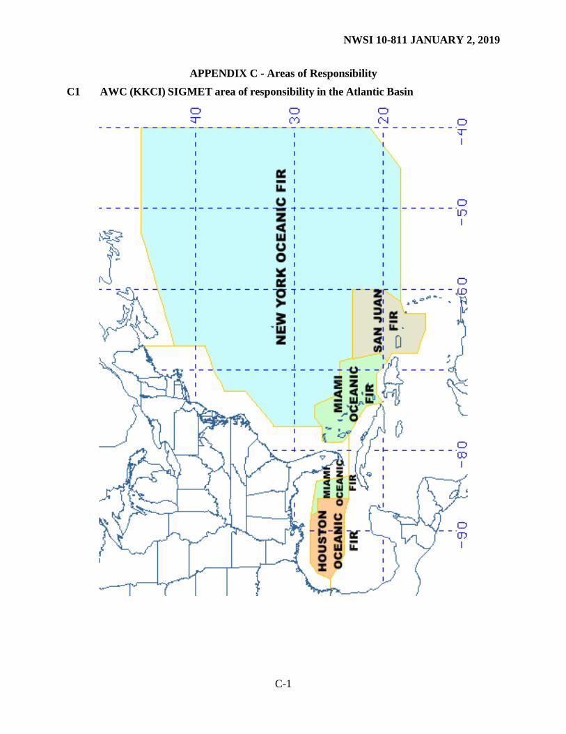
3 Responsibility for Issuance The NWS operates three Meteorological Watch Offices (MWO), the Aviation Weather Center (AWC), the Alaska Aviation Weather Unit (AAWU), and the Weather Forecast Office (WFO) in Honolulu. All FAs, SIGMETs, and AIRMETs included in this instruction are produced and issued by these MWOs; their areas of responsibility are shown in Appendix C and described below.
1. AWC: a. Twenty (20) domestic Air Route Traffic Control Center (ARTCC) Flight Information
Regions (FIRs) covering the conterminous U.S. and adjacent coastal waters
NWSI 10-811 JANUARY 2, 2019
6
b. New York, Houston, Miami, and San Juan Oceanic FIRs c. The portion of Oakland Oceanic FIR north of 30N latitude and east of 140W
longitude 2. AAWU:
a. Anchorage Continental FIR b. Anchorage Oceanic FIR c. Arctic Oceanic FIR
3. WFO Honolulu: a. The portion of Oakland Oceanic FIR south of 30N latitude and west of 140W
longitude 4 Standardization All forecasts and in-flight advisories use the following standards.
1. All referenced heights or altitudes will be referenced above mean sea level (MSL), unless otherwise noted, and annotated using the height in hundreds of feet, consisting of three digits (e.g., 040). For heights at or above 18,000 feet, the level will be preceded by FL (e.g., FL180).
2. References to latitude and longitude will be in degrees and minutes as follows: Nnn[nn] or Snn[nn], Wnnn[nn], or Ennn[nn]. Note: a space is placed between latitude and longitude values and a space-hyphen-space between successive points (e.g., N6030 W15030 – N5800 W15200 – N5930 W15100).
3. Messages will be prepared in abbreviated plain language using contractions from the current Federal Aviation Administration (FAA) Order 7340.1 for domestic products and International Civil Aviation Organization (ICAO) document 8400 for international products issued for Oceanic FIRs. A limited number of non-abbreviated words, geographical names and numerical values of a self-explanatory nature may also be used.
4. Weather and obstructions to visibility will be described using the weather abbreviations for surface airways observations (METAR or SPECI). See the Federal Meteorological Handbook (FMH) No. 1 - Surface Observations.
5. Heights will be identified as follows: (1) for heights below 3,000 feet, increments will be in 100s of feet; 2) for heights from 3,000 to 5,000 feet, increments will be in 500s of feet; and for heights greater than 5,000 feet, increments will be in 1,000s of feet.
5 Area Forecast (FA) The FA describes specific forecast conditions expected to affect at least a portion of the designated area of responsibility. The four designated areas include Hawaii, Gulf of Mexico, Caribbean, and Alaska, as outlined below. See Appendix C for area of responsibility maps.
1. Hawaii: WFO Honolulu will issue an FA for the main Hawaiian Islands and adjacent coastal waters extending out 40 nautical miles from the coastlines.

NWSI 10-811 JANUARY 2, 2019
7
2. Gulf of Mexico: The AWC will issue an FA for the northern Gulf of Mexico, to cover the Houston Oceanic FIR, the Gulf of Mexico portion of the Miami Oceanic FIR, and the coastal waters west of 85W longitude.
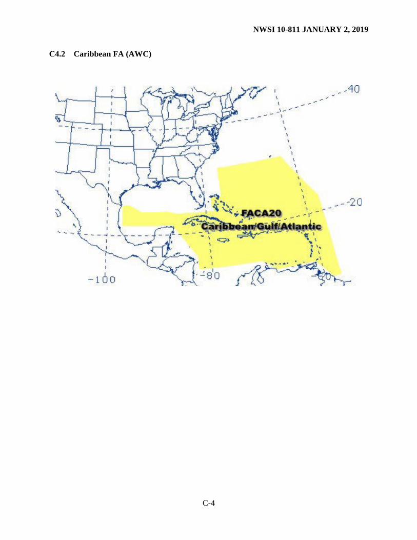
3. Caribbean FA: The AWC will issue an FA for portions of the Gulf of Mexico (south of the Houston Oceanic FIR to approximately 22N latitude), the Caribbean Sea and adjacent portions of the North Atlantic.
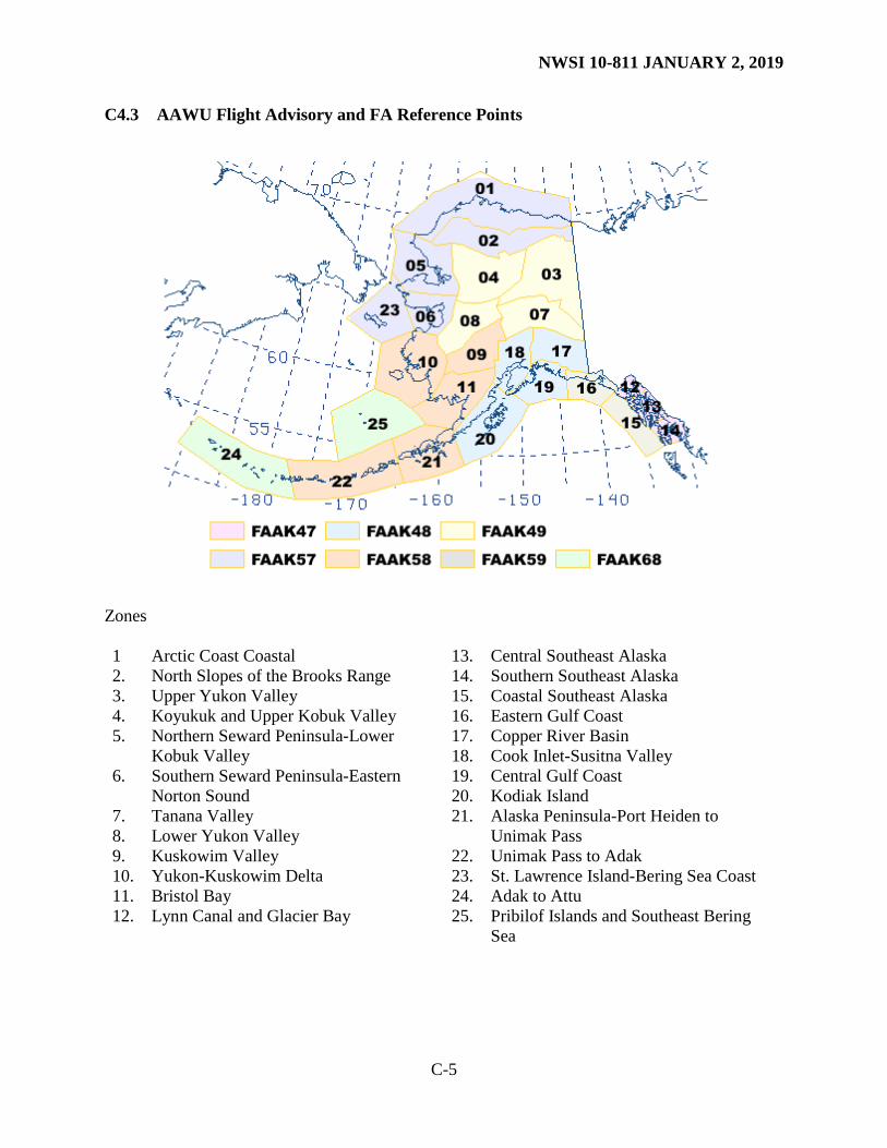
4. Alaska: The AAWU will issue seven (7) FAs covering separate geographical areas of Alaska and the adjacent coastal waters, including the Pribilof Islands and Southeast Bering Sea.
5.1 FA Descriptions 5.1.1 Hawaii FA
1. Vertical coverage: FA will cover the airspace between the surface and 45,000 feet MSL. 2. Horizontal coverage: The Hawaii FA (FAHW31 PHFO) will cover the main Hawaiian
Islands and adjacent coastal waters extending out 40 nautical miles from the coastlines. 3. Dissemination: The Hawaii FA will be issued four (4) times daily at 0340, 0940, 1540,
and 2140 UTC. 4. Content: Each FA will include the following elements.
a. Synopsis: This is a brief discussion of the significant synoptic weather affecting the FA area during the 18-hour valid period.
b. Clouds and Weather: This is a brief description of the clouds and weather for the first 12- hour period, including the following elements:
(1) Cloud amount (SCT, BKN, or OVC) with bases and tops
(2) Visibilities of 6 SM or less with obstruction(s) to visibility (3) Precipitation and thunderstorms (4) Sustained surface winds 20 knots or greater
c. 6-hour categorical outlook: IFR, MVFR, or VFR, including expected precipitation and/or obstructions to visibility
5.1.2 Gulf of Mexico FA (FAGX)
1. Vertical coverage: FAGX will cover the airspace between the surface and 45,000 feet MSL.
2. Horizontal coverage: FAGX coverage is shown in Appendix C. 3. Dissemination: FAGX will be issued three times daily at 0130, 1030 and 1830 UTC.
4. Content: FAGX will include the following elements. Each geographical section will
contain an entry. a. Synopsis: This is a brief discussion of the significant synoptic weather affecting the

NWSI 10-811 JANUARY 2, 2019
8
FAGX area during the entire 24-hour valid period. b. Significant Clouds and Weather: This is a description of the significant clouds and
weather for the first 12-hours including the following elements:
(1) Cloud amount (SCT, BKN, or OVC) for clouds with bases below FL180, or SKC.
(2) Cloud bases and tops associated with cloud amount. (3) Precipitation and thunderstorms. (4) Visibility below 7 SM and obstruction(s) to visibility. (5) Sustained surface winds greater than or equal to 20 knots.
c. 6-hour categorical outlook (LIFR, IFR, MVFR, or VFR).
d. Icing and Freezing Level: Moderate or severe icing and freezing level. For the coastal waters portion of the FAGX, users will be referred to the appropriate CONUS AIRMET.
e. Turbulence: Moderate or greater turbulence. For the coastal waters portion of the FAGX, users will be referred to the appropriate CONUS AIRMET.
5.1.3 Caribbean FA (FACA)
1. Vertical coverage: The FACA will cover the airspace between the surface and 24,000 feet MSL (approximately 400 millibars).
2. Horizontal coverage: FACA coverage is shown in Appendix C. 3. Dissemination: FACA will be issued four (4) times daily at 0330, 0930, 1530, and 2130
UTC. 4. Content: FACA will include the following elements. Each geographical section will
contain an entry. a. Synopsis: This is a brief discussion of the synoptic weather affecting the FACA area
during the 24-hour valid period. b. Significant Clouds and Weather: This is a brief description of the significant clouds
and weather for the first 12 hours including the following elements:
(1) Cloud amount (SCT, BKN, or OVC) for clouds with bases below FL180, or SKC
(2) Cloud bases and tops associated with cloud amount (3) Precipitation and thunderstorms (4) Visibility below 7 SM and obstruction(s) to visibility (5) Sustained surface winds greater than or equal to 20 knots
c. 6-hour categorical outlook (IFR, MVFR, or VFR)
d. Icing and Freezing Level: moderate or greater icing and freezing level e. Turbulence: moderate or greater turbulence

NWSI 10-811 JANUARY 2, 2019
9
5.1.4 Alaska FA 1. Vertical coverage: Each FA will cover the airspace between the surface and 45,000 feet
MSL. 2. Horizontal coverage: Seven (7) FAs will be issued covering 25 geographical zones of
Alaska and the adjacent coastal waters, including the Pribilof Islands and Southeast Bering Sea. See Appendix C.
3. Dissemination: Each FA will be issued three (3) times daily at 0415, 1215, and 2015 local Alaska Time or 0515, 1315, and 2115 UTC during standard time, and 0415, 1215, and 2015 UTC during daylight saving time.
4. Content: Each FA will include the following elements—Clouds and weather, turbulence, and icing information is included in each geographical zone. a. Synopsis: This is a brief description of the significant synoptic weather affecting the
FA area during the first 18 hours of the forecast period. b. Clouds and Weather: a description of the clouds and weather for each geographical
zone during the first 12 hours of the forecast period including the following elements: (1) AIRMET information for IFR ceiling and visibility, mountain obscuration, and
strong surface winds
(2) Cloud amount (FEW, SCT, BKN, or OVC) with bases and tops for BKN and OVC layers
(3) Visibilities of 6 SM or less with obstruction(s) to visibility (4) Precipitation and thunderstorms (5) Surface wind greater than 20 knots (6) Mountain pass conditions using categorical terms (for selected zones only)
(7) 6-hour categorical outlook (VFR, MVFR, and IFR)
c. Turbulence: a description of expected turbulence conditions including the following elements: (1) AIRMET information for turbulence or low level wind shear. (2) Turbulence not meeting AIRMET criteria.
(3) If no significant turbulence is forecast, NIL SIG will be entered. d. Icing and freezing level: a description of expected icing conditions including the
following elements: (1) AIRMET information for icing and freezing precipitation (2) Icing not meeting AIRMET criteria (3) Freezing level
(4) If no significant icing is forecast, NIL SIG will be entered followed by the freezing level.

NWSI 10-811 JANUARY 2, 2019
10
5.2 FA Amendments FAs will be under continuous review and amended at the discretion of the forecaster. An amended FA will contain “AAA” after the date/time group on the WMO heading line for the first amendment, “AAB” for the second, and continuing for all subsequent amendments. “AMD” will be included after the date/time group on the FAA product line. The date/time group on the WMO and FAA lines will be updated to indicate the time of the correction. The ending valid time will remain unchanged. 5.3 FA Corrections
FAs containing errors will be corrected. A corrected FA will contain “CCA” after the date/time group on the WMO heading line for the first correction, “CCB” for the second, and continuing for all subsequent corrections. “COR” will be included after the date/time group on the FAA product line. The date/time group on the WMO and FAA lines will be updated to indicate the time of the correction. The ending valid time will remain unchanged. NOTE: The FAA uses a time matching system to determine the most recent products. Therefore, amendments and corrections will carry the current time of the FA correction or amendment to ensure that the FA is updated in the FAA system. This is accomplished by manually changing the date/time group on the amended or corrected FA being issued. 6 Significant Meteorological Information (SIGMET) A SIGMET is a concise description of the occurrence or expected occurrence of specified en route weather phenomena which is expected to affect the safety of aircraft operations. SIGMETs are intended for dissemination to all pilots in flight to enhance safety. SIGMETs will be issued by the responsible MWO as soon as is practical to alert operators and aircrews of hazardous en route conditions. 6.1 Non-Convective SIGMET Description 6.1.1 Issuance Criteria The AWC will issue a Non-Convective SIGMET when any of the following conditions are affecting or, in the judgment of the forecaster, are expected to affect an area judged to have a significant impact on the safety of aircraft operations.
• Severe (or greater) turbulence (SEV TURB) • Severe icing (SEV ICE) • Widespread dust storm (WDSPR DS) • Widespread sandstorm (WDSPR SS) • Volcanic ash cloud (VA)
6.1.2 Issuance Time and Valid Period
1. A SIGMET is an unscheduled product issued any time conditions reaching SIGMET criteria are occurring or expected to occur within a 4-hour period.
2. A SIGMET will have a valid period up to, but not exceeding, four (4) hours. SIGMETs for continuing phenomena will be reissued at least every 4 hours as long as SIGMET

NWSI 10-811 JANUARY 2, 2019
11
conditions continue to occur in the area for responsibility. 6.1.3 SIGMET Format SIGMETs will be concise and not contain unnecessary descriptive information. See examples in Appendix A. The content and order of elements in the SIGMET will be as follows:
1. Series name and number. 2. Valid beginning and ending time (UTC). 3. List of states affected by the phenomena. 4. Location of phenomena delineated by high-altitude VHF (Very High Frequency)
Omnidirectional Radio Range (VOR) coordinates covering the affected area during the SIGMET valid time.
5. Phenomena description (e.g., SEV ICE).
6. Vertical extent (base, top), if appropriate. 7. Movement, if appropriate.
8. Intensity change (INTSF, WKN, or NC).
9. Indication of whether the condition will continue during the 4 hours beyond the valid time of the SIGMET.
6.1.4 SIGMET Cancellations A Non-Convective SIGMET will be canceled when the phenomena is no longer occurring, no longer expected to occur or has moved out of the area of responsibility. 6.1.5 SIGMET Amendments Amendments to Non-Convective SIGMETs will not be issued. Instead, a new SIGMET is issued using the next series number. 6.1.6 SIGMET Corrections Corrections to Non-Convective SIGMETs will be issued as necessary. NOTE: The FAA uses a time matching system to determine the most recent products. Therefore, corrections will carry the CURRENT time of the SIGMET to ensure the SIGMET is updated in the FAA system. 6.2 Convective SIGMET Description 6.2.1 Routine Issuance Criteria AWC will issue a Convective SIGMET when the following conditions are occurring or, in the judgment of the forecaster, are expected to occur.
• A line of thunderstorms at least 60 miles long with thunderstorms affecting at least 40 percent of its length.
• An area of active thunderstorms judged to have a significant impact on the safety of aircraft operations covering at least 40 percent of the area concerned and exhibiting a

NWSI 10-811 JANUARY 2, 2019
12
very strong radar reflectivity intensity or a significant satellite or lightning signature. • Embedded or severe thunderstorm(s) expected to occur for more than 30 minutes during
the valid period regardless of the size of the area. 6.2.2 Special Issuance Criteria A special Convective SIGMET may be issued when any of the following criteria are occurring or, in the judgment of the forecaster, are expected to occur for more than 30 minutes of the valid period.
• Tornado, hail greater than or equal to 3/4 inch, or wind gusts greater than or equal to 50 knots are reported.
• Indications of rapidly changing conditions, if in the forecaster’s judgment, they are not sufficiently described in existing Convective SIGMETs.
• Special issuance is not required for a valid Convective SIGMET. 6.2.3 Issuance Time and Valid Period The Convective SIGMET issuance time and valid period are as follows:
• Three (3) Convective SIGMET bulletins for the eastern, central, and western regions of the CONUS will be issued hourly on a scheduled basis.
• Convective SIGMETS are valid for 2 hours or until superseded by the next hourly issuance.
• A SIGMET bulletin will be transmitted each hour for each region. When conditions do not meet or are not expected to meet Convective SIGMET criteria within a region at the scheduled time of issuance a “CONVECTIVE SIGMET...NONE” message is transmitted.
6.2.4 Convective SIGMET Format Each Convective SIGMET bulletin will include one or more individually numbered Convective SIGMETs for the region. See examples in Appendix A. The content and order of each bulletin will be as follows:
1. CONVECTIVE SIGMET, series number, and region letter (E, W, or C) 2. Valid ending time (UTC) 3. List of states affected by the phenomena 4. Location of phenomena delineated by high-altitude VOR coordinates covering the
affected area during the SIGMET valid time 5. Phenomena description (e.g., AREA SEV EMBD TS) 6. Movement (e.g., MOV FROM 26030KT) 7. Cloud top (e.g., TOPS ABV FL450) 8. Remarks (e.g., TORNADOES...HAIL TO 2.5 IN...WIND GUSTS TO 70KT POSS).
Tropical Cyclone information will be added to remarks section when appropriate. 6.2.5 Convective SIGMET Outlook Each region will include a 2- to 6-hour convective SIGMET outlook at the end of the bulletin. The content and order of each bulletin will be as follows. See examples in Appendix A.
1. Beginning and ending valid times 2. Location of expected Convective SIGMET issuances delineated by high-altitude VOR

NWSI 10-811 JANUARY 2, 2019
13
coordinates for the outlook valid time. 6.2.6 Convective SIGMET Cancellations Convective SIGMETs are not cancelled but are superseded by the next SIGMET in the series. 6.2.7 Convective SIGMET Amendments Amended Convective SIGMETs will NOT be issued. Instead, a new Convective SIGMET will be issued for that region. 6.2.8 Convective SIGMET Corrections Corrections to Convective SIGMETs will be issued as necessary. NOTE: The FAA uses a time matching system to determine the most recent products. Therefore, corrections will carry the CURRENT time of the SIGMET to ensure the SIGMET is updated in the FAA system. 6.3 International, Alaska, and Hawaii SIGMET Description 6.3.1 Issuance Criteria International SIGMETs and SIGMETs issued by Alaska and Hawaii (referred to in total as International SIGMETs hence-forward in this directive) are not separated into convective and non-convective products, as with AWC SIGMETs issued for CONUS areas. Tropical Cyclone information is contained within the body of the product, not within remarks. NWS offices will issue International SIGMETs when any of the following phenomena occur or are expected to occur in an area, in the judgment of the forecaster, having the potential to have a significant impact on the safety of aircraft operations.
1. Thunderstorm - of type below*
a. Obscured OBSC TS
b. Embedded EMBD TS
c. Widespread WDSPR TS
d. Squall line SQL TS
e. Isolated severe ISOL SEV TS
2. Severe Turbulence SEV TURB
3. Severe Icing SEV ICE
a. With freezing rain SEV ICE (FZRA)
4. Widespread Dust storm WDSPR DS
5. Widespread Sandstorm WDSPR SS
6. Volcanic Ash VA
7. Tropical Cyclone TC
*Tornado (TDO), Funnel Cloud (FC), Waterspout (WTSPT), and Heavy Hail (HVY GR) may be

NWSI 10-811 JANUARY 2, 2019
14
used as a further description of the thunderstorm as necessary. 6.3.1.1 International SIGMET for Volcanic Ash Cloud A SIGMET for volcanic ash cloud will be issued for volcanic eruptions. A volcanic eruption is any volcanic activity that produces volcanic ash emissions, regardless of eruption magnitude. Offices preparing SIGMETs for volcanic ash should use the forecast position information available from advisories provided by the pertinent Volcanic Ash Advisory Center (VAAC). Initial Volcanic Ash Eruption SIGMETs may be issued based on credible pilot reports in the absence of a Volcanic Ash Advisory (VAA), but should be updated once a VAA is issued. Volcanic ash SIGMETs will continue to be issued until the ash cloud is no longer occurring or expected to occur over the area of responsibility. SIGMETs for volcanic ash cloud will be valid up to six (6) hours and provide an observed or forecast location of the ash cloud at the beginning of the SIGMET. A forecast position for the ash cloud, valid at the end of the validity period of the SIGMET message, will also be included. SIGMETs will be reissued at least every six (6) hours while the volcanic ash cloud hazard exists or is expected to exist. 6.3.1.2 International SIGMET for Tropical Cyclone A SIGMET for a tropical cyclone will be issued for non-frontal synoptic-scale cyclones meeting the following criteria.
1. Originates over tropical or sub-tropical waters with organized convection and definite cyclonic surface wind circulation.
2. Wind speeds reach 35 knots independent of the wind averaging time used by the Tropical Cyclone Advisory Center (TCAC).
MWOs preparing SIGMETs for tropical cyclones will use the Tropical Cyclone Advisory (FK bulletins) issued by the appropriate TCAC (Miami, Honolulu, or Tokyo) for forecast information. SIGMETs for tropical cyclones will be valid up to six (6) hours. SIGMETs for tropical cyclones will include two positions. The first position included will be the TCAC advisory position. The second position will be the forecast position valid at the end of the SIGMET period. In addition to the two storm positions, SIGMETs will include associated convection when applicable. SIGMETs will be reissued at least every six (6) hours while the tropical cyclone wind remains or are expected to remain above 34 knots. 6.3.2 Format International SIGMETs will contain the following information, related to the specific phenomena and in the order indicated. See examples in Appendix A.
1. Phenomenon and its description from Section 6 (e.g., SEV TURB).
2. An indication whether the information is observed, using OBS and/or FCST. The time of observation will be given in UTC.
3. Location of the phenomenon described by using latitude and longitude, or VORs, and flight levels (altitude) covering the affected area during the SIGMET valid time. SIGMETs for volcanic ash cloud and tropical cyclones will contain the positions of the

NWSI 10-811 JANUARY 2, 2019
15
ash cloud, tropical cyclone center and radius of convection at the start of the validity time of the SIGMET.
4. Movement towards or expected movement using sixteen points of the compass, with speed in knots, or stationary, if appropriate.
5. Thunderstorm maximum height as FL.
6. Changes in intensity; using as appropriate, the abbreviations INTSF (Intensifying), WKN (Weakening), or NC (No Change).
7. Forecast position of volcanic ash cloud or the center of the tropical cyclone at the end of the valid period of the SIGMET message.
6.3.3 International SIGMET Cancellations A SIGMET will be cancelled when the phenomena is no longer occurring or expected to occur in the area or responsibility. 6.3.4 International SIGMET Amendments SIGMET amendments will NOT be issued. Instead, the next SIGMET in the series is issued to accomplish the update. The valid time of the new SIGMET is reset to reflect the new four-hour valid period (six-hour for VA and TC SIGMETs). 6.3.5 International SIGMET Corrections Corrections to SIGMETs will be issued as necessary by issuing a new SIGMET in the series which advances the SIGMET number and supersedes the previous SIGMET. NOTE: The FAA uses a time matching system to determine the most recent products. Therefore, corrections will carry the CURRENT time to ensure that the SIGMET is updated in the FAA system. 6.3.6 Interchange of SIGMETs between Adjacent U.S. Offices The originating office will cancel an existing SIGMET when hazardous weather covered by the SIGMET moves from one office’s area of responsibility to the adjacent office’s area of responsibility. The adjacent MWO will issue a new SIGMET under a new SIGMET series identifier. 6.3.7 Continuous SIGMET Criteria across Adjacent Boundaries When an area of continuous hazardous weather meeting SIGMET criteria extends from one area of responsibility into another, the two offices will determine whether to issue two separate SIGMETs or have one office issue a single SIGMET for the hazardous weather in both areas. 6.3.8 SIGMET Naming Convention across the Pacific Basin and the Anchorage FIR To avoid duplication of valid SIGMET series names in the Pacific Basin, the MWOs have adopted a series naming convention where each uses a different portion of the ICAO Phonetic Alphabet.
• AWC: ALFA, BRAVO, CHARLIE, DELTA, ECHO, FOXTROT, GOLF, and HOTEL
• AAWU: INDIA, JULIETT, KILO, LIMA, and MIKE

NWSI 10-811 JANUARY 2, 2019
16
• WFO Honolulu: NOVEMBER, OSCAR, PAPA, QUEBEC, ROMEO, SIERRA, TANGO, UNIFORM, VICTOR, WHISKEY, XRAY, YANKEE, and ZULU
If the number of active SIGMETs exceeds the names assigned, the MWO will use the following SIGMET naming procedures:
• AWC: The AWC will cycle through the alpha names listed above. If all eight SIGMET alpha names are in use by the AWC, they will coordinate with the AAWU to temporarily use INDIA, JULIETT, KILO, LIMA, or MIKE. When the temporary need for the letter has ended, AWC will coordinate with AAWU to release the letter.
• AAWU: The AAWU will cycle through the alpha names listed above. If all five SIGMET alpha names are in use by the AAWU, they will coordinate with WFO Honolulu to temporarily use NOVEMBER, OSCAR, PAPA, or QUEBEC. If the AWC is using the ALFA name and the AAWU needs to issue another SIGMET, they will skip the ALFA name the AWC is using and issue the next available name in the series. When the temporary need for the letter has ended, AAWU will coordinate with WFO Honolulu to release the letter.
• WFO Honolulu: WFO Honolulu will cycle through the alpha names listed above. If the AAWU is using an alpha name and WFO Honolulu needs to issue another SIGMET, they will skip the alpha name the AAWU is using and issue the next available name in the series.
6.3.9 SIGMET Dissemination SIGMET dissemination over NWS and international circuits uses a text (Traditional Alphanumeric Code, TAC) convention. In accordance with International Civil Aviation Organization (ICAO) Annex 3 requirements (as amended), NWS will simultaneously disseminate SIGMETs using the ICAO Weather Information Exchange Model (IWXXM) data standard. IWXXM is a machine-readable language that enables digital communications, such that SIGMETs (and other TAC products) can be ingested and used digitally for visualizations and in decision tools. SIGMET conversion from TAC to IWXXM is done automatically within NWS production and telecommunications systems. 7 Airmen’s Meteorological Information (AIRMET) and Graphical AIRMET An AIRMET is a concise description of the occurrence or expected occurrence of specified en route weather phenomena which may affect the safety of aircraft operations, but at intensities lower than those which require the issuance of a SIGMET. AIRMETs are intended to inform all pilots, but especially Visual Flight Rules pilots and operators of sensitive aircraft, of potentially hazardous weather phenomena. Freezing level information is included. The Graphical-AIRMET (G-AIRMET), is a graphical forecast of en route weather hazards valid at discrete times no more than 3 hours apart for a period of up to 12 hours into the future (00, 03, 06, 09 and 12 hours). G-AIRMET is issued based on the same criteria as AIRMET. 7.1 AIRMET Criteria An AIRMET will be issued when any of the following weather phenomena is affecting or, in the judgment of the forecaster, is expected to affect an area having a significant impact on the safety of aircraft operations.

NWSI 10-811 JANUARY 2, 2019
17
1. Ceiling less than 1,000 feet and/or visibility less than 3 statute miles (IFR).
2. Weather phenomena restricting the visibility including, but not limited to, precipitation (PCPN), smoke (FU), haze (HZ), mist (BR), fog (FG), and blowing snow (BLSN).
3. Widespread mountain obscuration (MT OBSC).
4. Weather phenomena causing the obscuration can include, and are limited to, clouds (CLDS), precipitation (PCPN), smoke (FU), haze (HZ), mist (BR), and fog (FG).
5. Moderate turbulence (MOD TURB).
6. Top and bottom of MOD TURB layer are included.
7. Sustained surface wind greater than 30 knots (STG SFC WND).
8. Moderate icing (MOD ICE).
9. Top and bottom of MOD ICE are included.
10. Multiple freezing level (FRZLVL) altitudes may be given; the lowest level is the declared FRZLVL.
11. Areas with multiple freezing levels are included. 12. Range of freezing levels over the area is included. 13. Lowest freezing levels above ground level (AGL) at intervals of 500 feet AMSL (or SFC
as appropriate) are included.
14. Non-convective low-level wind shear potential below 2,000 feet AGL (LLWS POTENTIAL).
7.2 AIRMET Bulletins, Issuance Times, and Valid Period
1. AIRMETs will be issued as bulletins containing one or more AIRMET messages on the following schedule. Unscheduled AIRMETs are issued when conditions are occurring or expected to occur, but were not forecast.
a. CONUS: AIRMET bulletins will be issued on a scheduled basis every 6 hours around 0245, 0845, 1445, and 2045 UTC.
b. Hawaii: AIRMET bulletins will be issued on a scheduled basis every 6 hours at 0400, 1000, 1600, and 2200 UTC.
c. Alaska: AIRMET bulletins will be issued on a scheduled basis every 8 hours at at 0415, 1215, and 2015 local Alaska Time or 0515, 1315, and 2115 UTC during standard time, and 0415, 1215, and 2015 UTC during daylight saving time.
2. AIRMETs will be valid for no more than 6 hours in CONUS and Hawaii and no more than 8 hours in Alaska. The valid period of an AIRMET message will not exceed the valid time of the AIRMET bulletin.
7.3 AIRMET Format An AIRMET message will include the following information as appropriate and in the order indicated. See examples in Appendix A.

NWSI 10-811 JANUARY 2, 2019
18
1. Reference to appropriate active SIGMETs affecting the area of concern at the time of AIRMET issuance (e.g., SEE SIGMET BRAVO SERIES).
2. Beginning time of the AIRMET phenomenon if different from the AIRMET beginning valid time.
3. AIRMET name (SIERRA, TANGO, or ZULU), update number, weather phenomenon, and ending valid time. (Note: the AIRMET number is reset to zero (0) after 0000 UTC each day. The update numbering begins with any update, either regularly scheduled or amendment, after the issuance of the first regularly scheduled AIRMET of the UTC day. Corrections carry the same update number as the previous issuance being corrected.)
4. List of affected states (CONUS only). 5. Location of phenomenon using VORs or other well-known geographic features. The
AAWU may also use VORs or geographic location. 6. Description of phenomenon for the AIRMET issuance. 7. Vertical extent (bases and tops), as appropriate. 8. Ending time of phenomenon if different from the AIRMET ending time.
9. Alaska AIRMETs. Intensity change remarks (INTSF, WKN, or NC) concerning the continuance of the phenomenon following the 6 hour valid period.
10. CONUS and Hawaii AIRMETs: A separate AIRMET outlook will be included in the AIRMET bulletin when conditions meeting criteria are expected to occur during the 6-hour period after the valid time of the AIRMET bulletin.
11. Alaska AIRMETs: Outlook information will be included in the appropriate FA zone during the 6-hour period after the valid time of the AIRMET bulletin.
7.4 AIRMET Updates and Amendments
If an AIRMET is amended and issued out of the normal schedule, it will contain AAA at the end of WMO heading line for the first amendment, AAB for the second, and continuing for all subsequent amendments. AMD will be added after the date/time group on the FAA product line. The update number will be incremented (see 7.3 Item 3). UPDT will be added to end of the line with the list of affected states (CONUS only). The issuance time of the AIRMET bulletin is updated to reflect the time of the amendment. The ending valid time remains unchanged. 7.5 AIRMET Corrections
AIRMETs containing errors will be corrected. CCA will be added after the date/time group on the WMO heading line for the first correction, CCB for the second, and continuing for all subsequent corrections. COR will be added after the date/time group on the FAA product line. The issuance time of the AIRMET bulletin is updated to reflect the time of the correction. The ending valid time remains unchanged. NOTE: The FAA uses a time matching system to determine the most recent products. Therefore, amendments and corrections will carry the CURRENT time to ensure that the AIRMET is updated in the FAA system.

NWSI 10-811 JANUARY 2, 2019
19
8 Route Forecast (ROFOR) ROFORs predict conditions for specific flight routes several hours in advance to accommodate planning. The only NWS office that issues ROFORs is WFO Honolulu. 8.1 ROFOR Criteria WFO Honolulu prepares and issues ROFORs for flight paths that begin, end, or have most of their path within the Pacific Region area of responsibility, which extends from the equator to 30N, between 140W and 130E. 8.2 ROFOR Issuance Time ROFORs are issued for prescribed times, several hours in advance, for regularly scheduled flights. ROFOR requests for unscheduled flights will be prepared as soon as time allows. 8.3 ROFOR Amendments ROFORs are not required to be amended. 8.4 ROFOR Corrections ROFOR corrections will be issued as soon as possible when erroneous data has been transmitted. 8.5 ROFOR Content ROFORs contain some or all of the following forecast parameters:
• Winds and temperatures aloft
• Significant en route weather
• Zone weather
• Weather Synopsis At a minimum, ROFORs include winds and temperatures aloft and significant en route weather. ROFORs may contain data for multiple altitudes and include TAFs for destination points and/or alternates. 9 Traffic Flow Management (TFM) Convective Forecast (TCF) The TCF is a high confidence (greater than 50%) graphical representation of forecasted convection meeting specific coverage, intensity, and echo top criteria. The TCF is designed for use in the coordinated planning and strategic management of en route air traffic flow. The TCF is used by airline industry and FAA participants of the Collaborative Decision Making (CDM) NAS planning process led by the Federal Aviation Administration’s Air Traffic Control System Command Center. From approximately March 1 through October 31, the TCF is issued by AWC after collaboration with NWS offices, Meteorological Service of Canada, meteorological offices of airlines and service providers. Automated routines make the TCF available as a non-collaborated product from November through February. Lines of convection are not depicted when automated routines produce the TCF.

NWSI 10-811 JANUARY 2, 2019
20
9.1 TCF Criteria All of the following conditions will be met for an area of convection to be identified and included in the TCF.
1. The area will contain at least 25% coverage of: a. 40 dBZ or higher composite radar reflectivity echoes, and b. Echo tops at or above FL250
2. Forecaster confidence (of the above conditions occurring) of at least 50%. 9.2 TCF Format
1. Coverage a. Sparse 25–39% (sparse fill) b. Medium 40–74% (medium fill) c. Lines of coverage: Solid purple lines, either alone or within a polygon. The length of a
line will be at least 100 nm and coverage of 75–100%. 2. Maximum echo tops range:
a. 25,000–29,000 feet MSL (290) b. 30,000–34,000 feet MSL (340) c. 35,000–39,000 feet MSL (390) d. At or above 40,000 feet MSL (400)
3. Forecaster confidence: a. High: 50–100% (blue border and fill)
9.3 TCF Issuance Times and Valid Period
1. The TCF is issued daily from March 1 to October 31, every 2 hours, valid at 4-, 6-, and 8-hours after issuance time.
2. A portion of Canadian airspace is included April 1 to September 30. 3. The TCF ASCII coded text product is issued under these WMO headers:
a. 4-Hour: FAUS28 KKCI b. 6-Hour: FAUS29 KKCI c. 8-Hour: FAUS30 KKCI
9.4 TCF Updates, Amendments, and Corrections The TCF is updated every 2 hours and is not required to be amended or corrected.

NWSI 10-811 JANUARY 2, 2019
A-1
APPENDIX A - Examples A1 SIGMET A1.1 CONUS Non-Convective SIGMET WSUS01 KKCI 050600 WS1R BOSR WS 050600 SIGMET ROMEO 2 VALID UNTIL 051000 ME NH VT FROM CAR TO YSJ TO CON TO MPV TO CAR SEV TURB BLW 080. RPRTD BY ACFT. CONDS CONTG BYD 1000Z. A1.2 CONUS Convective SIGMET WSUS33 KKCI 091855 SIGW MKCW WST 091855 CONVECTIVE SIGMET...NONE . OUTLOOK VALID 092055-100055 TS ARE NOT EXPD. WSUS32 KKCI 091855 SIGC MKCC WST 091855 CONVECTIVE SIGMET 21C VALID UNTIL 2055Z AR OK FROM 20S RZC-40SSW FSM DMSHG LINE TS 25 NM WIDE MOV FM 27025KT. TOPS TO FL320. . OUTLOOK VALID 092055-100055 FROM 40NE BUM-60SE SGF-50WSW LIT-40W GGG-60ENE ABI-ADM-50WNW BUM-40NE BUM WST ISSUANCES EXPD. REFER TO MOST RECENT ACUS01 KWNS FROM STORM PREDICTION CENTER FOR SYNOPSIS AND METEOROLOGICAL DETAILS. A1.3 Convective SIGMET with tropical cyclone remarks WSUS31 KKCI 211355 SIGE MKCE WST 211355 CONVECTIVE SIGMET 1E VALID UNTIL 1555Z NC SC FL GA AND CSTL WTRS FROM 30SSE CLT-160SE ILM-140ENE OMN-60E TLH-ABY-30SSE CLT AREA SEV EMBD TS MOV FROM 21015KT. TOPS ABV FL450. TORNADOES...WIND GUSTS TO 60KT POSS. TS ASSOCD WITH TROPICAL STORM ALBERTO. . OUTLOOK VALID 211555-211955 FROM 30E RDU-180SE ECG-140SSE ILM-180E PBI-40SE PBI-40S EYW-90SW EYW-

NWSI 10-811 JANUARY 2, 2019
A-2
70W SRQ-50N CTY-40N MCN-30NW SPA-30E RDU REF WW 475. WST ISSUANCES EXPD. REFER TO MOST RECENT ACUS01 KWNS FROM STORM PREDICTION CENTER FOR SYNOPSIS AND METEOROLOGICAL DETAILS. REFER TO MOST RECENT WTNT21 KNHC FROM NATIONAL HURRICANE CENTER FOR DETAILS ON TROPICAL STORM ALBERTO. A1.4 International SIGMET WSPA07 PHFO 010358 SIGPAT KZAK SIGMET TANGO 1 VALID 010400/010800 PHFO- OAKLAND OCEANIC FIR EMBD TS OBS WI N2055 W15000 - N1950 W14945 - N1922 W15130 - N2027 W15048 – N2055 W15000. CB TOP FL400. MOV W 10KT. WKN. A1.5 International Tropical Cyclone SIGMET WSNT03 KKCI 081451 SIGA0C KZNY SIGMET CHARLIE 11 VALID 081500/082100 KKCI- NEW YORK OCEANIC FIR TC KYLE OBS N3106 W07118 AT 1500Z CB TOP FL500 WI 120NM OF CENTER MOV WSW 5 KT NC FCST 2100Z TC CENTER N3142 W07012 A1.6 International Volcanic Ash Cloud SIGMET WVAK01 PAWU 300600 PAZA SIGMET INDIA 1 VALID 300600/301200 PAWU- ANCHORAGE FIR VA ERUPTION PAVLOF VOLCANO PSN N5542 W16153 VA CLDS OBS AT 0600Z WI N5734 W16036 - N5609 W16027 - N5612 W15838 - N5530 W15838 - N5516 W16256 - N5719 W16406 - N5734 W16036 SFC/FL300. MOV E 5KT. NC. FCST 1200Z VA CLD WI N5616 W15836 - N5624 W15322 - N5519 W15332 - N5528 W15835 - N5616 W15836. A2 AIRMETs A2.1 CONUS AIRMET WAUS43 KKCI 091445 CHIZ WA 091445 AIRMET ZULU UPDT 4 FOR ICE AND FRZLVL VALID UNTIL 092100 AIRMET ICE...KS IA MO IL FROM 30WSW FOD TO DBQ TO 50NW DEC TO 50SW FAM TO OSW TO MKC TO 30WSW FOD MOD ICE BTN FRZLVL AND FL200. FRZLVL 060-100. CONDS ENDG BY 21Z. . OTLK VALID 2100-0300Z...ICE IA MO WI IL IN KY BOUNDED BY BAE-BVT-PXV-50SW FAM-50NW DEC-DBQ-BAE MOD ICE BTN FRZLVL AND FL200. FRZLVL 080-100. CONDS CONTG THRU 03Z. . FRZLVL...RANGING FROM SFC-120 ACRS AREA MULT FRZLVL 015-085 BOUNDED BY 40W INL-YQT-SSM-70NNE ASP-YVV-DXO-40NE FWA-40SSE BJI-40W INL SFC ALG 50NNW ISN-70W FAR-GFK-40NE ODI-40SW DXO 040 ALG ISN-70S BIS-30W ABR-30E ABR-60S FAR-30SW BRD-30NE FWA 080 ALG GLD-SLN-30W BDF-50S JOT-40SE IND-30SW CVG-40SW LOZ

NWSI 10-811 JANUARY 2, 2019
A-3
A2.2 Hawaii AIRMET WAHW31 PHFO 090945 WA0HI HNLT WA 091000 AIRMET TANGO UPDATE 1 FOR TURB VALID UNTIL 091600 AIRMET TURB...KAUAI OAHU MOLOKAI LANAI MAUI OVR AND IMTS THRU W OF MT. MOD TURB BLW 100. COND CONT BYD 1600Z. A2.3 Alaska AIRMET WAAK47 PAWU 011740 WA7O JNUS WA 011745 AIRMET SIERRA FOR IFR AND MT OBSC VALID UNTIL 012100 . LYNN CANAL AND GLACIER BAY JB PAGS W SPRDG E MTS OCNL OBSC IN CLDS/PCPN. DTRT. . CNTRL SE AK JC N PAGN OCNL CIGS BLW 010/VIS BLW 3SM –RA BR. IMPR. . CNTRL SE AK JC MTS OCNL OBSC IN CLDS/PCPN. NC. . ERN GLF CST JE MTS OCNL OBSC IN CLDS/PCPN. IMPR. . SE AK CSTL WTRS JF AAA OCNL CIG BLW 010 VIS BLW 3SM BR. ST/FOG TOPS 015. NC. A3 FA A3.1 Gulf of Mexico FA FAGX20 KKCI 091812 OFAGX SYNOPSIS VALID TIL 101900Z FCST...091900Z-100700Z OTLK...100700Z-101900Z INTERNATIONAL OPERATIONS BRANCH AVIATION WEATHER CENTER KANSAS CITY MISSOURI . CSTL WATERS FROM COASTLINE OUT TO HOUSTON OCEANIC FIR AND GLFMEX MIAMI OCEANIC FIR AND W OF 85W. HOUSTON OCEANIC FIR AND GLFMEX MIAMI OCEANIC FIR. . TS IMPLY SEV OR GTR TURB SEV ICE LLWS AND IFR CONDS. . 01 SYNOPSIS...HIGH PRES OVR NRN GLFMEX. .

NWSI 10-811 JANUARY 2, 2019
A-4
02 SIGNIFICANT CLD/WX... . CSTL WATERS... SCT020. OTLK...VFR. . HOUSTON OCEANIC FIR...SCT020. OTLK...VFR. . GLFMEX MIAMI OCEANIC FIR...SCT020. OTLK...VFR. . 03 ICE AND FRZLVL... CSTL WATERS…SEE AIRMETS ZULU WAUS44 KKCI AND WAUS42 KKCI. HOUSTON OCEANIC FIR...NO SGFNT ICE EXP OUTSIDE CNVTV ACT. GLFMEX MIAMI OCEANIC FIR...NO SGFNT ICE EXP OUTSIDE CNVTV ACT. FRZLVL...140 THRUT. 04 TURB... CSTL WATERS...SEE AIRMETS TANGO WAUS44 KKCI AND WAUS42 KKCI. HOUSTON OCEANIC FIR...NO SGFNT TURB EXP OUTSIDE CNVTV ACT. GLFMEX MIAMI OCEANIC FIR...NO SGFNT TURB EXP OUTSIDE CNVTV ACT. A3.2 Caribbean FA FACA20 KKCI 121530 OFAMKC INTERNATIONAL OPERATIONS BRANCH AVIATION WEATHER CENTER KANSAS CITY MISSOURI VALID 121600-130400 OUTLOOK...130400-131600 . ATLANTIC S OF 32N W OF 57W...CARIBBEAN...GULF OF MEXICO BTN 22N AND 24N. . ALL WNDS SFC. TS IMPLY SEV OR GTR TURB SEV ICE LLWS AND IFR CONDS. SFC TO 400 MB. . SYNOPSIS...WK CDFNT EXTDS FM NR 28N60W TO 23N63W TO THE MONA PASSAGE. CDFNT WL MOV EWD AND WKN TODAY. EXP NARROW BAND OF CLDS WITH ISOL SHRA INVOF CDFNT. . SIGNIFICANT CLD/WX... ERN MONTERREY FIR...NRN MERIDA FIR SCT025 SCT060. OTLK...VFR. . ATLC SWRN NEW YORK FIR...SAN JUAN FIR NW OF CDFNT...SCT025 SCT060. LYR OCNL BKN. TOP 120. ISOL SHRA. OTLK...VFR. VCNTY CDFNT...SCT025 BKN060. OCNL BKN025. TOP 120. WDLY SCT SHRA. ISOL TSRA TIL 20Z. OTLK...VFR SHRA. SE OF CDFNT...SCT025 SCT060. ISOL SHRA. OTLK...VFR. . ATLC MIAMI FIR SCT025 SCT060. LYR OCNL BKN. TOP 120. ISOL SHRA. OTLK...VFR. . WRN PIARCO FIR...NRN MAIQUETIA FIR...CURACAO FIR BTN 61W-63W...SCT025 BKN060. OCNL BKN025. TOP 120. WDLY SCT SHRA. OTLK...VFR SHRA.

NWSI 10-811 JANUARY 2, 2019
A-5
RMNDR...SCT025 SCT060. ISOL SHRA. OTLK...VFR. . SANTO DOMINGO FIR...PORT-AU-PRINCE FIR SCT025 SCT060. LYR OCNL BKN. TOP 120. ISOL SHRA. OTLK...VFR. . NRN BARRANQUILLA FIR...NRN PANAMA FIR SCT025 SCT060. ISOL SHRA. SFC WND NE 20-25KT. OTLK...VFR. . KINGSTON FIR...NERN CNTRL AMERICAN FIR...HABANA FIR SCT025 SCT060. ISOL SHRA. OTLK...VFR. . ICE AND FRZLVL... NO SGFNT ICE EXP OUTSIDE CNVTV ACT. FRZLVL... 145-170. . TURB... NO SGFNT TURB EXP OUTSIDE CNVTV ACT. A3.3 Hawaii FA FAHW31 PHFO 080940 FA0HI . HNLC FA 080940 SYNOPSIS AND VFR CLD/WX SYNOPSIS VALID UNTIL 090400 CLD/WX VALID UNTIL 082200...OUTLOOK VALID 082200-090400 . SEE AIRMET SIERRA FOR IFR CLD AND MT OBSC. TS IMPLY SEV OR GREATER TURB SEV ICE LOW LEVEL WS AND IFR COND. NON MSL HGT DENOTED BY AGL OR CIG. . SYNOPSIS...SFC HIGH FAR N PHNL NEARLY STNR. . BIG ISLAND ABOVE 060. SKC. 20Z SCT090. OUTLOOK...VFR. . BIG ISLAND LOWER SLOPES...COAST AND ADJ WATERS FROM UPOLU POINT TO CAPE KUMUKAHI TO APUA POINT. SCT030 BKN050 TOPS 080 TEMPO BKN030 VIS 3-5SM -SHRA BR. 21Z SCT030 SCT- BKN050 TOPS 080 ISOL BKN030 5SM -SHRA. OUTLOOK...VFR. . BIG ISLAND LOWER SLOPES…COAST AND ADJ WATERS FROM APUA POINT TO SOUTH CAPE TO UPOLU POINT. SKC. 21Z BKN-OVC060 TOPS 080 ISOL BKN030 - SHRA.N AND E FACING SLOPES...COAST AND ADJ WATERS OF THE REMAINING ISLANDS. SCT020 BKN045 TOPS 070 TEMPO BKN020 VIS 3-5SM -SHRA. 22Z SCT025 SCT-BKN050 TOPS 070 ISOL BKN025 3-5SM -SHRA. OUTLOOK...VFR. . REST OF AREA. FEW-SCT050 ISOL BKN040 TOPS 070 -SHRA. OUTLOOK...VFR.

NWSI 10-811 JANUARY 2, 2019
A-6
A3.4 Alaska FA FAAK48 PAWU 291739 FA8H ANCH FA 291315 AK SRN HLF EXCP SE AK... . AIRMETS VALID UNTIL 292115 CB IMPLY POSSIBLE SEV OR GREATER TURB SEV ICE LLWS AND IFR CONDS. NON MSL HEIGHTS NOTED BY AGL OR CIG. . SYNOPSIS VALID UNTIL 300700 998MB LOW 140NM SE PAKH MOV SE THRU PD. ASSOC SFC TROF SERN KODIAK ISLAND-SEWD ALSO MOV SE THRU PD. OCFNT WRN/CNTRL BERING SEA-PAAK MOV E TO LIE NR A ST MATTHEW ISLAND-PAPB-SEGUAM LN BY 18Z AND A PASA- PACZ-PADU LN BY END OF PD. . COOK INLET AND SUSITNA VLY AB...VALID UNTIL 300100 ...CLOUDS/WX... ***AIRMET IFR***TIL 19Z N PANC OCNL CIG BLW 010/VIS BLW 3SM -SHSN BR. IMPR... ***AIRMET MT OBSC***N PANC MTS OBSC IN CLDS/PCPN. IMPR... N PANC SCT005 BKN025 OVC045 TOP 120 LYRD TO FL250 VIS 5SM -SN. AFT 21Z ISOL -SN. ELSW BKN050 BKN120 CI ABV. OTLK VALID 300100-300700...TALKEETNA MTS MVFR CIG. ELSW VFR. PASSES...LAKE CLARK...MERRILL...RAINY...VFR. WINDY...IFR CIG/VIS SHSN. AFT 21Z MVFR CIG. PORTAGE...MVFR CIG. ...TURB... NIL SIG. ...ICE AND FZLVL... ***AIRMET ICE***TIL 16Z N PAUO OCNL MOD ICEIC 020-120. FZLVL SFC. WKN... 16Z TO 19Z N PATK ISOL MOD ICEIC 020-120. . COPPER RIVER BASIN AC...VALID UNTIL 300100 ...CLOUDS/WX... ***AIRMET IFR***VLYS OCNL CIGS BLW 010/VIS BLW 3SM BR. IMPR... ***AIRMET MT OBSC***MTS OCNL OBSC IN CLDS/PCPN. NC... FEW015 SCT045 BKN070 TOP 120. VCY MTS OCNL BKN045 ISOL -SHSN. OTLK VALID 300100-300700...VFR. PASS...TAHNETA...IFR VIS BR. ...TURB... NIL SIG. ...ICE AND FZLVL... AFT 19Z NE PAGK ISOL MOD ICEIC 020-120. FZLVL SFC. . CNTRL GLF CST AD...VALID UNTIL 300100 ...CLOUDS/WX... ***AIRMET MT OBSC***MTS OCNL OBSC IN CLDS/PCPN. IMPR... FEW005 SCT025 BKN045 TOP 110. OCNL BKN025 VIS 5SM -SHSN/SHRASN BR.

NWSI 10-811 JANUARY 2, 2019
A-7
CHUGACH MTS ISOL CIGS BLW 010/VIS BLW 3SM -SHSN BR. OTLK VALID 300100-300700...CHUGACH MTS MVFR CIG SHSN/SHRA. ELSW VFR. ...TURB... NIL SIG. ...ICE AND FZLVL... NIL SIG. FZLVL BLW 010. . KODIAK IS AE...VALID UNTIL 300100 ...CLOUDS/WX... TIL 18Z OFSHR SE PAKH BKN-OVC025 LYRD TO FL200. OCNL -SHRA/-SHRASN BR. ELSW/OTRW SCT035 BKN050 TOPS 090 ISOL -SHSN. OTLK VALID 300100-300700...VFR. ...TURB... NIL SIG. ...ICE AND FZLVL... NIL SIG. FZLVL SFC N TO 020 S. A4 ROFOR Santa Barbara and San Francisco to Honolulu Route: FRPN31 PHFO 061904 RFRKSF WINDS/TEMPERATURES AND WEATHER BY ZONE FOR ROUTE SFO/HNL VIA 31.3N/140W VALID AT 071200Z FLIGHT LEVELS ZONE FL050 FL100 FL180 FL240 ZONE WEATHER 25 9904 P05 3308 P00 3124 M17 3131 M29 4-6 CI FL250/FL350 26 2409 P06 2716 P03 2827 M16 2839 M29 2-4 SCCU 020-030 4-6 CI FL250/FL350 27 2619 P07 2527 P02 2547 M15 2657 M28 3-5 SCCU 020-050 4-6 CI FL250/FL400 28 2723 P09 2630 P00 2640 M14 2748 M27 5-7 LYRS 020/100 VIS 3-5SM SHRA 4-6 CI FL250/FL400 29 2615 P10 2727 P02 2726 M13 2638 M26 DO 30 3206 P10 2715 P03 2619 M12 2635 M25 DO 31 0611 P11 2106 P05 2715 M11 2633 M23 3-5 SCCU 020/060 ISOL VIS 5SM -SHRA 4-6 CI FL250/FL350 32 0817 P12 0908 P07 2618 M10 2730 M21 3-5 SCCU 020/080 ISOL VIS 5SM -SHRA OVERALL WIND FACTOR COMPONENTS M05 M14 M24 M34 ROUTE SFO/HNL VIA 31.3N/140W...OUTLOOK OVERALL WIND FACTOR COMPONENTS VALID AT M10 M12 M23 M31 08/1200Z M04 M14 M21 M21 09/1200Z P05 P01 M07 M13 10/1200Z

NWSI 10-811 JANUARY 2, 2019
A-8
ROUTE SBA/HNL VIA 29.5N/140W VALID AT 071200Z FLIGHT LEVELS ZONE FL050 FL100 FL180 FL240 ZONE WEATHER 25 3408 P06 3417 P00 3432 M17 3450 M28 1-3 CU 030/050 26 3206 P07 3015 P04 2926 M14 2946 M26 3-5 SCCU 020/040 4-6 CI FL300/FL400 27 2710 P09 2619 P05 2736 M13 2751 M25 DO 28 3113 P10 2624 P05 2639 M12 2652 M25 DO 29 3311 P10 2621 P04 2631 M12 2545 M25 DO 30 0310 P11 2612 P04 2722 M12 2536 M25 DO 31 0612 P11 9905 P05 2617 M11 2632 M23 3-5 SCCU 020/060 ISOL VIS 5SM -SHRA 4-6 CI FL250/FL350 32 0818 P13 1009 P07 2618 M10 2730 M20 3-5 SCCU 020/080 ISOL VIS 5SM -SHRA OVERALL WIND FACTOR COMPONENTS P02 M10 M23 M36 ROUTE SBA/HNL VIA 29.5N/140W...OUTLOOK OVERALL WIND FACTOR COMPONENTS VALID AT M02 M12 M20 M28 08/1200Z M02 M09 M19 M20 09/1200Z P04 M01 M13 M14 10/1200Z SYNOPSIS...COLD FRONT APPROACHING ZONES 28-30 WILL BRING SHRA AND LOWERED VIS TO LEVELS BELOW 10000 FT MSL. OTHERWISE SCT HIGH CLOUDS AND SCT LOW STRATUS WILL DOMINATE THE FLIGHT PATH. -SHRA MAY AFFECT FLIGHTS INBOUND OR OUTBOUND TO THE ISLANDS. A5 TCF FAUS28 KKCI 301700 CFP02 CCFP 20130430_1700 20130430_2100 AREA 3 3 3 3 0 0 5 326 773 299 792 301 775 326 764 326 773 312 777 AREA 3 3 3 3 0 0 19 282 897 285 889 293 884 298 883 303 875 312 869 321 872 324 886 325 904 319 924 315 935 315 953 307 954 300 947 301 938 297 929 291 920 282 923 282 897 292 916 AREA 3 1 3 2 0 0 16 282 912 287 902 294 898 297 908 306 911 317 910 320 898 320 886 320 876 314 872 302 878 302 888 293 887 287 892 282 902 282 912 265 897 AREA 3 1 3 2 0 0 7 288 817 283 824 264 816 254 805 264 802 286 811 288 817 272 812 AREA 3 3 3 2 0 0 13 297 819 281 828 269 824 259 814 252 811 252 804 263 800 268 795 275 795 278 805 286 807 296 814 297 819 290 818 CANADA ON

NWSI 10-811 JANUARY 2, 2019
A-9

NWSI 10-811 JANUARY 2, 2019
B-1
APPENDIX B - WMO Headers B1 Aviation Weather Center (AWC) Products B1.1 SIGMET B1.1.1 CONUS FIRs Non-Convective SIGMET
WMO Header AWIPS ID WCUS01 KKCI MKCWC1[N-Y]* WSUS01 KKCI MKCWS1[N-Y]* WVUS01 KKCI MKCWV1[N-Y]* WCUS02 KKCI MKCWC2[N-Y]* WSUS02 KKCI MKCWS2[N-Y]* WVUS02 KKCI MKCWV2[N-Y]* WCUS03 KKCI MKCWC3[N-Y]* WSUS03 KKCI MKCWS3[N-Y]* WVUS03 KKCI MKCWV3[N-Y]* WCUS04 KKCI MKCWC4[N-Y]* WSUS04 KKCI MKCWS4[N-Y]* WVUS04 KKCI MKCWV4[N-Y]* WCUS05 KKCI MKCWC5[N-Y]* WSUS05 KKCI MKCWS5[N-Y]* WVUS05 KKCI MKCWV5[N-Y]* WCUS06 KKCI MKCWC6[N-Y]* WSUS06 KKCI MKCWS6[N-Y]* WVUS06 KKCI MKCWV6(N-Y)*
*Omit Sierra (S), Tango (T), and Zulu (Z) B1.1.2 CONUS FIRs Convective SIGMET
WMO Header AWIPS ID WSUS31 KKCI MKCSIGE WSUS32 KKCI MKCSIGC WSUS33 KKCI MKCSIGW
B1.1.3 New York, Miami, Houston, and San Juan Oceanic FIRs
WMO Header AWIPS ID WSNT01 KKCI SIGA0A WSNT02 KKCI SIGA0B WSNT03 KKCI SIGA0C WSNT04 KKCI SIGA0D WSNT05 KKCI SIGA0E WSNT06 KKCI SIGA0F WSNT07 KKCI SIGA0G WSNT08 KKCI SIGA0H WSNT09 KKCI SIGA0I

NWSI 10-811 JANUARY 2, 2019
B-2
WSNT10 KKCI SIGA0J WSNT11 KKCI SIGA0K WSNT12 KKCI SIGA0L WSNT13 KKCI SIGA0M WCNT01 KKCI MKCWSTA0A WCNT02 KKCI MKCWSTA0B WCNT03 KKCI MKCWSTA0C WCNT04 KKCI MKCWSTA0D WCNT05 KKCI MKCWSTA0E WCNT06 KKCI MKCWSTA0F WCNT07 KKCI MKCWSTA0G WCNT08 KKCI MKCWSTA0H WCNT09 KKCI MKCWSTA0I WCNT10 KKCI MKCWSTA0J WCNT11 KKCI MKCWSTA0K WCNT12 KKCI MKCWSTA0L WCNT13 KKCI MKCWSTA0M WVNT01 KKCI MKCWSVA0A WVNT02 KKCI MKCWSVA0B WVNT03 KKCI MKCWSVA0C WVNT04 KKCI MKCWSVA0D WVNT05 KKCI MKCWSVA0E WVNT06 KKCI MKCWSVA0F WVNT07 KKCI MKCWSVA0G WVNT08 KKCI MKCWSVA0H WVNT09 KKCI MKCWSVA0I WVNT10 KKCI MKCWSVA0J WVNT11 KKCI MKCWSVA0K WVNT12 KKCI MKCWSVA0L WVNT13 KKCI MKCWSVA0M
B1.1.4 Oakland Oceanic FIR
WMO Header AWIPS ID WSPN01 KKCI MKCSIGP0A WSPN02 KKCI MKCSIGP0B WSPN03 KKCI MKCSIGP0C WSPN04 KKCI MKCSIGP0D WSPN05 KKCI MKCSIGP0E WSPN06 KKCI MKCSIGP0F WSPN07 KKCI MKCSIGP0G WSPN08 KKCI MKCSIGP0H WSPN09 KKCI MKCSIGP0I WSPN10 KKCI MKCSIGP0J WSPN11 KKCI MKCSIGP0K WSPN12 KKCI MKCSIGP0L WSPN13 KKCI MKCSIGP0M WCPN01 KKCI MKCWSTP0A WCPN02 KKCI MKCWSTP0B WCPN03 KKCI MKCWSTP0C
NWSI 10-811 JANUARY 2, 2019
B-3
WCPN04 KKCI MKCWSTP0D WCPN05 KKCI MKCWSTP0E WCPN06 KKCI MKCWSTP0F WCPN07 KKCI MKCWSTP0G WCPN08 KKCI MKCWSTP0H WCPN09 KKCI MKCWSTP0I WCPN10 KKCI MKCWSTP0J WCPN11 KKCI MKCWSTP0K WCPN12 KKCI MKCWSTP0L WCPN13 KKCI MKCWSTP0M WVPN01 KKCI MKCWSVP0A WVPN02 KKCI MKCWSVP0B WVPN03 KKCI MKCWSVP0C WVPN04 KKCI MKCWSVP0D WVPN05 KKCI MKCWSVP0E WVPN06 KKCI MKCWSVP0F WVPN07 KKCI MKCWSVP0G WVPN08 KKCI MKCWSVP0H WVPN09 KKCI MKCWSVP0I WVPN10 KKCI MKCWSVP0J WVPN11 KKCI MKCWSVP0K WVPN12 KKCI MKCWSVP0L WVPN13 KKCI MKCWSVP0M
B1.2 AIRMET
The AWC issues six sets of three AIRMETs (i.e., SIERRA, TANGO, and ZULU).
WMO HEADER AWIPS ID WAUS41 KKCI MKCWA1[STZ] WAUS42 KKCI MKCWA2[STZ] WAUS43 KKCI MKCWA3[STZ] WAUS44 KKCI MKCWA4[STZ] WAUS45 KKCI MKCWA5[STZ] WAUS46 KKCI MKCWA6[STZ]
B1.3 TCF WMO HEADER AWIPS ID FAUS28 KKCI CFP02 FAUS29 KKCI CFP03 FAUS30 KKCI CFP04
B1.4 FA B1.4.1 Gulf of Mexico FA
WMO HEADER AWIPS ID
FAGX20 KKCI MKCOFAGX

NWSI 10-811 JANUARY 2, 2019
B-4
B1.4.2 Caribbean FA WMO HEADER AWIPS ID
FACA20 KKCI MKCOFAMKC B2 Alaska Aviation Weather Unit (AAWU) Products B2.1 SIGMET
WMO HEADER AWIPS ID WSAK01 PAWU ANCSIGAK1 WSAK02 PAWU ANCSIGAK2 WSAK03 PAWU ANCSIGAK3 WSAK04 PAWU ANCSIGAK4 WSAK05 PAWU ANCSIGAK5 WSAK06 PAWU ANCSIGAK6 WSAK07 PAWU ANCSIGAK7 WSAK08 PAWU ANCSIGAK8 WSAK09 PAWU ANCSIGAK9 WVAK01 PAWU ANCWSVAK1 WVAK02 PAWU ANCWSVAK2 WVAK03 PAWU ANCWSVAK3 WVAK04 PAWU ANCWSVAK4 WVAK05 PAWU ANCWSVAK5 WVAK06 PAWU ANCWSVAK6 WVAK07 PAWU ANCWSVAK7 WVAK08 PAWU ANCWSVAK8 WVAK09 PAWU ANCWSVAK9
B2.2 AIRMET
The AAWU issues three sets of three AIRMETs (i.e., SIERRA, TANGO, and ZULU).
WMO HEADER AWIPS ID WAAK47 PAWU ANCWA7O WAAK48 PAWU ANCWA8O WAAK49 PAWU ANCWA9O
B2.3 FA
WMO HEADER AWIPS ID FAAK47 PAWU ANCFA7H FAAK57 PAWU ANCFA7W FAAK48 PAWU ANCFA8H FAAK58 PAWU ANCFA8W FAAK68 PAWU ANCFA8T FAAK49 PAWU ANCFA9H FAAK59 PAWU ANCFA9W

NWSI 10-811 JANUARY 2, 2019
B-5
B2.4 VAA WMO HEADER AWIPS ID
FVAK21 PAWU ANCVAAAK1 FVAK22 PAWU ANCVAAAK2 FVAK23 PAWU ANCVAAAK3 FVAK24 PAWU ANCVAAAK4 FVAK25 PAWU ANCVAAAK5
B2.5 VAG (VAA graphic)
WMO HEADER AWIPS ID PFXD21 PAWU not required PFXD22 PAWU not required PFXD23 PAWU not required PFXD24 PAWU not required PFXD25 PAWU not required
B3 WFO Honolulu Products B3.1 SIGMET
WMO HEADER AWIPS ID WSPA01 PHFO HFOSIGPAN WSPA02 PHFO HFOSIGPAO WSPA03 PHFO HFOSIGPAP WSPA04 PHFO HFOSIGPAQ WSPA05 PHFO HFOSIGPAR WSPA06 PHFO HFOSIGPAS WSPA07 PHFO HFOSIGPAT WSPA08 PHFO HFOSIGPAU WSPA09 PHFO HFOSIGPAV WSPA10 PHFO HFOSIGPAW WSPA11 PHFO HFOSIGPAX WSPA12 PHFO HFOSIGPAY WSPA13 PHFO HFOSIGPAZ WCPA01 PHFO HFOWSTPAN WCPA02 PHFO HFOWSTPAO WCPA03 PHFO HFOWSTPAP WCPA04 PHFO HFOWSTPAQ WCPA05 PHFO HFOWSTPAR WCPA06 PHFO HFOWSTPAS WCPA07 PHFO HFOWSTPAT WCPA08 PHFO HFOWSTPAU WCPA09 PHFO HFOWSTPAV WCPA10 PHFO HFOWSTPAW WCPA11 PHFO HFOWSTPAX WCPA12 PHFO HFOWSTPAY WCPA13 PHFO HFOWSTPAZ
NWSI 10-811 JANUARY 2, 2019
B-6
WVPA01 PHFO HFOWSVPAN WVPA02 PHFO HFOWSVPAO WVPA03 PHFO HFOWSVPAP WVPA04 PHFO HFOWSVPAQ WVPA05 PHFO HFOWSVPAR WVPA06 PHFO HFOWSVPAS WVPA07 PHFO HFOWSVPAT WVPA08 PHFO HFOWSVPAU WVPA09 PHFO HFOWSVPAV WVPA10 PHFO HFOWSVPAW WVPA11 PHFO HFOWSVPAX WVPA12 PHFO HFOWSVPAY WVPA13 PHFO HFOWSVPAZ
B3.2 AIRMET
WMO HEADER AWIPS ID
WAHW31 PHFO WA0HI
NOTE: Parsing is for geographical areas. B3.3 FA
WMO HEADER AWIPS ID FAHW31 PHFO FA0HI
NWSI 10-811 JANUARY 2, 2019
C-1
APPENDIX C - Areas of Responsibility C1 AWC (KKCI) SIGMET area of responsibility in the Atlantic Basin

NWSI 10-811 JANUARY 2, 2019
C-2
C2 SIGMET Areas of Responsibility in the Pacific Basin

NWSI 10-811 JANUARY 2, 2019
C-3
C3 Convective SIGMETs Areas of Responsibility for the CONUS
C4 FA Areas of Responsibility C4.1 Gulf of Mexico FA (AWC)
NWSI 10-811 JANUARY 2, 2019
C-4
C4.2 Caribbean FA (AWC)
NWSI 10-811 JANUARY 2, 2019
C-5
C4.3 AAWU Flight Advisory and FA Reference Points
Zones 1 Arctic Coast Coastal 2. North Slopes of the Brooks Range 3. Upper Yukon Valley 4. Koyukuk and Upper Kobuk Valley 5. Northern Seward Peninsula-Lower
Kobuk Valley 6. Southern Seward Peninsula-Eastern
Norton Sound 7. Tanana Valley 8. Lower Yukon Valley 9. Kuskowim Valley 10. Yukon-Kuskowim Delta 11. Bristol Bay 12. Lynn Canal and Glacier Bay
13. Central Southeast Alaska 14. Southern Southeast Alaska 15. Coastal Southeast Alaska 16. Eastern Gulf Coast 17. Copper River Basin 18. Cook Inlet-Susitna Valley 19. Central Gulf Coast 20. Kodiak Island 21. Alaska Peninsula-Port Heiden to
Unimak Pass 22. Unimak Pass to Adak 23. St. Lawrence Island-Bering Sea Coast 24. Adak to Attu 25. Pribilof Islands and Southeast Bering
Sea

NWSI 10-811 JANUARY 2, 2019
C-6
C4.4 Hawaiian FA areas

NWSI 10-811 JANUARY 2, 2019
D-1
APPENDIX D - Definition of Terms Embedded (EMBD) Thunderstorms or CB: Thunderstorms or CB clouds that are embedded in cloud layers or concealed by haze.
Extreme Turbulence (EXTREME TURB): Turbulence in which aircraft is violently tossed about and is practically impossible to control. It may cause structural damage.
Flight Information Region (FIR): An airspace of defined dimensions within which flight information service and alerting service are provided.
Flight Levels: A surface of constant atmospheric pressure which is related to a specific pressure datum, 1013.2 hectopascals (hPa), and is separated from other such surfaces by specific pressure intervals.
Frequent (FRQ) thunderstorms or CB: Consisting of elements with little or no separation between adjacent thunderstorms with a maximum spatial coverage greater than 75 percent of the area affected by the phenomena at a fixed time or during the period of validity.
Instrument Meteorological Conditions (IMC): Ceiling < 1,000 feet and/or visibility < 3 miles. When LIMC is used as a sub-category of IMC for a product, IMC conditions are ceiling ≥ 500 feet and < 1,000 feet and /or visibility ≥ 1 mile and < 3 miles.
Isolated (ISOL) thunderstorms or CB: Consisting of individual features affecting an area with a maximum spatial coverage < 50 percent of the area affected by the phenomena at a fixed time or during the period of validity.
Line (of thunderstorms) (LINE TS): For SIGMET is defined as being at least 60 miles long with thunderstorms affecting at least 40 percent of its length.
Low Instrument Meteorological Conditions (LIMC): Ceiling < 500 feet and/or visibility < 1 SM. LIMC is a sub-category of Instrument Meteorological Conditions.
Marginal Visual Meteorological Conditions (MVMC): Ceiling ≥ 1,000 feet to ≤ 3,000 feet and/or visibility ≥ 3 to ≤ 5 miles.
Moderate Icing (MOD ICE): The rate of accumulation is such that even short encounters become potentially hazardous and use of deicing/anti-icing equipment or diversion is necessary.
Moderate Turbulence (MOD TURB): Turbulence that causes changes in attitude (pitch, roll, yaw) and/or altitude, but the aircraft remains in positive control at all times. It usually causes variations in indicated airspeed.
A Turbulence Index ranging from 6 to 14, i.e., the peak value of the Eddy Dissipation Rate is between 0.1 and 0.3, reported from an aircraft during the en route phase of flight based on Eddy Dissipation Rate.

NWSI 10-811 JANUARY 2, 2019
D-2
Mountain Obscuration (MT OBSC): Conditions over significant portions of mountainous geographical areas are such that pilots in flight should not expect to maintain visual meteorological conditions or visual contact with mountains or mountain ridges near their route of flight.
Obscured (OBSC) thunderstorms or CB: Obscured by haze, smoke or cloud or cannot be readily seen due to darkness.
Occasional (OCNL) thunderstorms or CB: An area with a maximum spatial coverage between 50 and 75 percent of the area affected by the phenomena at a fixed time of during the period of validity.
Scattered (SCT): ≥ 25 percent to ≤ 50 percent of area affected.
Severe Icing (SEV ICE): The rate of accumulation is such that normal deicing/anti-icing equipment fails to reduce or control the hazard. Immediate diversion is necessary.
Severe Turbulence (SEV TURB): Turbulence that causes large, abrupt changes in altitude and/or attitude. It usually causes large variations in indicated airspeed. Aircraft may be momentarily out of control. A Turbulence Index ranging from 15 to 27, i.e., the peak value of the Eddy Dissipation Rate is exceeding 0.5, reported from an aircraft during the en-route phase of flight based on Eddy Dissipation Rate.
Visual Meteorological Conditions (VMC): Ceiling > 3,000 feet and visibility > 5 miles.
Volcanic Eruption: For this directive, a volcano eruption has occurred when an eruption report is received from a volcano observatory. A volcanic eruption is also considered to have occurred regardless of volcano observatory notification if reported by PIREP, or ground observer, or if remote sensing data indicates that an eruption has occurred based on satellite imagery or WSR- 88D radar data or any other reliable sources are identified.
Volcanic Ash: For the purpose of this chapter volcanic ash is any ash that can be seen by any one or more of the following: satellite imagery (visible, IR, or multi channel), PIREPs, ground observations, radar and ship reports.
Very High Frequency Omnidirectional Range (VOR): a type of short-range navigation system; an antenna location in this system is often referred to colloquially as a VOR.
Widely scattered (WDLY SCT): Less than 25 percent of area affected.
Widespread (WDSPR): 50 percent or greater of the area affected.