NATIONAL WEATHER SERVICE INSTRUCTION 10-806 June 21st
13
Department of Commerce ∙ National Oceanic & Atmospheric Administration ∙ National Weather Service NATIONAL WEATHER SERVICE INSTRUCTION 10-806 October 10, 2017 Operations and Services Aviation Weather Services, NWSPD 10-8 WORLD AREA FORECAST SYSTEM NOTICE: This publication is available at: http://www.nws.noaa.gov/directives/. OPR: W/AFS24 (M. Graf) Certified by: W/AFS24 (W. Bauman) Type of Issuance: Routine SUMMARY OF REVISIONS: This directive supersedes NWSI 10-806, “World Area Forecast System,” dated June 21, 2013. This revision was made to reflect the NWS Headquarters reorganization effective on April 1, 2015. No content changes have been made. Signed 9/26/2017 Andrew Stern Date Director Analyze, Forecast and Support Office
Transcript of NATIONAL WEATHER SERVICE INSTRUCTION 10-806 June 21st
Department of Commerce ∙ National Oceanic & Atmospheric Administration ∙ National Weather Service
NATIONAL WEATHER SERVICE INSTRUCTION 10-806
October 10, 2017
Operations and Services
Aviation Weather Services, NWSPD 10-8
WORLD AREA FORECAST SYSTEM
NOTICE: This publication is available at: http://www.nws.noaa.gov/directives/.
OPR: W/AFS24 (M. Graf) Certified by: W/AFS24 (W. Bauman)
Type of Issuance: Routine SUMMARY OF REVISIONS: This directive supersedes NWSI 10-806, “World Area Forecast
System,” dated June 21, 2013. This revision was made to reflect the NWS Headquarters
reorganization effective on April 1, 2015. No content changes have been made.
Signed 9/26/2017
Andrew Stern Date
Director
Analyze, Forecast and Support Office
NWSI 10-806 OCTOBER 10, 2017
2
World Area Forecast System
Table of Contents Page
1 Purpose ................................................................................................................................ 3
2 General ................................................................................................................................ 3
3 World Area Forecast System and World Area Forecast Centers ........................................ 3
4 World Area Forecast System Information .......................................................................... 3
4.1 Grid Point Data Forecasts ........................................................................................ 3
4.2 Significant Weather (SIGWX) Forecasts ................................................................. 4
High- and Medium-Level SIGWX Forecasts ........................................................... 4
Criteria for including items in SIGWX forecasts ..................................................... 5
4.2 SIGWX Corrections ................................................................................................. 5
SIGWX Text Correction Bulletin Information ........................................................ 5
Correction Message Templates ................................................................................ 6
5 Backup ................................................................................................................................ 6
5.1 WAFC SIGWX Chart Production Interruptions ...................................................... 6
5.2 Failure of WAFC Grid Production. .......................................................................... 6
6 WAFS Dissemination Systems (WIFS and SADIS) ........................................................... 6
7 Retention of Weather Documentation Materials ................................................................ 7
APPENDIX A - Fixed Areas of Coverage of WAFS Forecasts in Chart Form .......................... A-1
APPENDIX B - SIGWX Text Correction Samples .................................................................... B-1
APPENDIX C - WIFS and SADIS Coverage Areas ................................................................... C-1
NWSI 10-806 OCTOBER 10, 2017
3
1 Purpose
This instruction describes the World Area Forecast System (WAFS) and operational procedures
and services provided by the Washington World Area Forecast Center (WAFC) in support of
WAFS.
2 General
The WAFS was established in 1982 by the International Civil Aviation Organization (ICAO)
Communications/Meteorology (COM/MET) Divisional Meeting held conjointly with the seventh
session of the World Meteorological Organization (WMO) Commission for Aeronautical
Meteorology (CAeM) in Montreal.
The Federal Aviation Administration (FAA) is the meteorological authority, as defined by ICAO,
for the United States and has agreed to provide a WAFC within the WAFS framework. The
FAA designated the National Weather Service (NWS) as the meteorological provider with
responsibility for the WAFS broadcast. The Washington WAFC became operational in 1996.
3 World Area Forecast System and World Area Forecast Centers
The WAFS is defined in ICAO Annex 3, Meteorological Service for International Air
Navigation, as “…a worldwide system by which world area forecast centers provide aeronautical
meteorological enroute forecasts in uniform standardized formats.” A WAFC is “…a
meteorological center designated to prepare and issue significant weather forecasts and upper-air
forecasts in digital form on a global basis.” The two ICAO-sponsored WAFCs are provided by
the United States and United Kingdom, and are referred to as the Washington WAFC and the
London WAFC, respectively.
The Washington WAFC is comprised of three components of the National Weather Service: the
Aviation Weather Center (AWC) in Kansas City, Missouri; the NCEP Central Operations (NCO)
in College Park, Maryland; and the Telecommunications Operations Center (TOC) at NWS
Headquarters in Silver Spring, Maryland.
4 World Area Forecast System Information
WAFS information is provided to users as specified in ICAO Annex 3 through WAFS
broadcasts. WAFS information includes global grid point forecasts and significant weather
forecast products.
4.1 Grid Point Data Forecasts
WAFCs will prepare global grid point forecasts four times a day. Forecasts will be valid for
fixed valid times at 6h, 12h, 18h, 24h, 30h, and 36h after the time of the synoptic data on which
the forecasts were based (0000, 0600, 1200 and 1800 UTC). The dissemination of each forecast
should be in the above order and be completed as soon as technically feasible, but not later than
six hours after standard observation time. Details about the forecast elements and file formats
are available from ICAO’s website at:
http://www.icao.int/airnavigation/METP/MOG/Pages/WAFS.aspx
NWSI 10-806 OCTOBER 10, 2017
4
4.2 Significant Weather (SIGWX) Forecasts
WAFCs will prepare significant weather (SIGWX) global forecasts four times a day. Forecasts
will be valid for fixed valid times at 30 hours after the time of the synoptic data on which the
forecasts were based (0000, 0600, 1200 and 1800 UTC). The dissemination of SIGWX forecasts
will be completed as soon as technically feasible, but not later than 17 hours after the forecast
valid time. SIGWX forecasts will be issued in the Binary Universal Form for the Representation
of Meteorological Data (BUFR) code form as prescribed by the WMO. Note: The BUFR code
form is contained in WMO Publication No. 306, Manual on Codes, Volume I.2, Part B – Binary
Codes.
SIGWX forecasts will be issued as:
a. high-level SIGWX forecasts for flight levels between 250 and 630
b. medium-level SIGWX forecasts for flight levels between 100 and 450 for limited
geographical areas, as determined by regional air navigation agreement.
High- and Medium-Level SIGWX Forecasts
SIGWX forecasts for high and medium-levels will include the following elements:
a. Information from Tropical Cyclone Advisory Centers (TCACs) on significant
tropical cyclones provided the maximum of the 10-minute mean surface wind
speed is expected to reach or exceed 34 knots
b. Severe squall lines
c. Moderate or severe turbulence (in cloud or clear air)
d. Moderate or severe icing
e. Widespread sandstorm/duststorm
f. Cumulonimbus clouds associated with thunderstorms and with elements a) to e)
g. Flight level of tropopause
h. Jet streams
i. Information from Volcanic Ash Advisory Centers (VAACs) on the location of
volcanic eruptions producing ash clouds of significance to aircraft operations
comprising: volcanic eruption symbol at the location of the volcano and, at the
side of the chart, the volcano eruption symbol, the name of the volcano,
latitude/longitude, the date and time of first eruption, if known, and a reference to
Significant Meteorological Information (SIGMET) and Notice to Airmen
(NOTAM) issued for the area concerned; and
j. Information from WMO Regional Specialized Meteorological Centers (RSMCs)
on the location of an accidental release of radioactive materials into the
atmosphere, of significance to aircraft operations, comprising: the radioactivity
symbol at the site of the accident and, at the side of the chart, the radioactivity
symbol, latitude/longitude of the site of the accident, date and time of the accident
and a reminder to users to check NOTAM for the area concerned.
NWSI 10-806 OCTOBER 10, 2017
5
Criteria for including items in SIGWX forecasts
The following criteria should be applied for high-level and medium-level SIGWX forecasts.
Elements in a) through d), below, should only be included if expected to occur between the
lower- and upper-level boundaries of the SIGWX forecast.
a. The abbreviation “CB” should only be included when it refers to the occurrence or
expected occurrence of cumulonimbus clouds:
1. Affecting an area with a maximum spatial coverage of 50 percent or more
of the area concerned;
2. Along a line with little or no space between individual clouds; or
3. Embedded in cloud layers or concealed by haze.
b. The inclusion of “CB” should be understood to include all weather phenomena
normally associated with cumulonimbus clouds, i.e. thunderstorm, moderate or
severe icing, moderate or severe turbulence and hail;
c. Where a volcanic eruption or an accidental release of radioactive materials into
the atmosphere warrants the inclusion of the volcanic activity symbol or the
radioactivity symbol in SIGWX forecasts, the symbols should be included on
high-level and medium-level SIGWX forecasts regardless of the height to which
the ash column or radioactive material is reported or expected to reach; and
d. In the case of co-incident or the partial overlapping of elements a), i) and j) in
4.2.1, the highest priority should be given to element i), followed by element j)
and a). The item with the highest priority should be placed at the location of the
event, and an arrow should be used to link the location of the other element(s) to
its associated symbol or text box.
Note: The explanations for the abbreviations can be found in the Procedures for Air Navigation
Services – ICAO Abbreviations and Codes (PANS-ABC, Doc 8400).
4.2 SIGWX Corrections
In April 2016, the ICAO changed its SIGWX correction procedures to allow the reissuance of the
SIGWX BUFR and PNG charts. A set of charts may be corrected until the next set of charts is
issued. For example, the 00 UTC charts can be corrected until the 06 UTC charts are issued.
When a correction is necessary, all PNG and BUFR files will be reissued for the set, including
both the medium- and high-level charts. Two administrative messages will be issued to notify
users that a correction has been issued.
SIGWX Text Correction Bulletin Information
FXUS65 KKCI – free text message describing what was corrected.
FXUS66 KKCI – standardized format message meant to trigger automated downloads of
the corrected SIGWX charts.

NWSI 10-806 OCTOBER 10, 2017
6
Correction Message Templates
Examples of the SIGWX Text Correction Products can be found in Appendix B.
5 Backup
A WAFC will provide any or all of the WAFS services, as needed, when an interruption of the
operation of the other WAFC occurs. WAFC London and WAFC Washington have studied a
number of potential service interruption and outage scenarios, reviewed the current
communication links between the two WAFCs, and agreed upon the appropriate responses to
each interruption in service.
5.1 WAFC SIGWX Chart Production Interruptions
The two WAFCs can each produce the other WAFC’s SIGWX PNG and BUFR charts when
necessary. Should a WAFC experience difficulty producing their own charts, the other WAFC will
issue the charts for the stricken WAFC. The charts will be issued with their usual WMO headers, as
if they came from the stricken WAFC. Per ICAO agreement, an extra two hours of production time
is allowed if one WAFC has to produce SIGWX charts for both WAFCs.
5.2 Failure of WAFC Grid Production
While the method is not as transparent to the user as SIGWX chart backup, the two WAFCs can
provide backup service for their gridded forecasts. If a WAFC cannot update its gridded forecasts,
the users can download and use the other WAFC’s gridded forecasts. This requires that the users
have established an account on both WAFCs’ dissemination systems, and that their software be
configured to use the grids from both WAFCs.
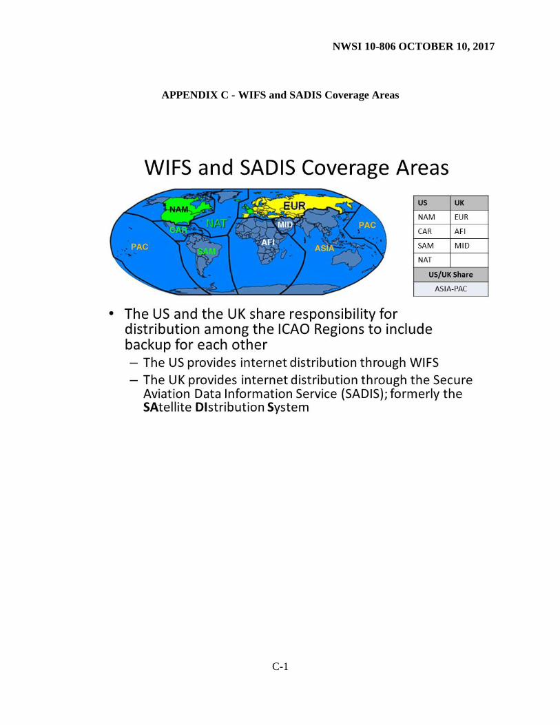
6 WAFS Dissemination Systems (WIFS and SADIS)
The United States’ WAFS Internet File Service (WIFS) and the United Kingdom’s Secure
Aviation Data Information Service (SADIS) provide access to WAFS forecasts and Operational
Meteorological (OPMET) data from everywhere in the world. Users should see Appendix C to
determine which service is the primary service for their area. After registering with the primary
service, all users can register with the other service for backup use only. Both services monitor
usage to ensure that the users are only downloading data from the appropriate primary service.
Note that WIFS and SADIS are additive components to the Aeronautical Fixed
Telecommunication Network (AFTN). The systems do not replace data acquisition and
distribution functions of the ICAO/AFTN.
WIFS - http://www.aviationweather.gov/wifs/
SADIS - http://www.metoffice.gov.uk/aviation/sadis
NWSI 10-806 OCTOBER 10, 2017
7
7 Retention of Weather Documentation Materials
In accordance with NWSI 10-2003, Records Retention, NWS forecast products will be
electronically transferred to the National Centers for Environmental Information (NCEI) to meet
retention requirements (five years). A limited short-term records retention responsibility resides
at the originating AWC. Each originating office will be able to electronically retrieve and print
hard copies of their forecast products issued within the first 14 days of issuance. Offices should
use caution in distributing copies of these records. However, if copies are distributed, a
disclaimer indicating the records are not certified should be provided, along with contact
information on how to obtain certified copies from NCEI.
NWSI 10-806 OCTOBER 10, 2017
A-1
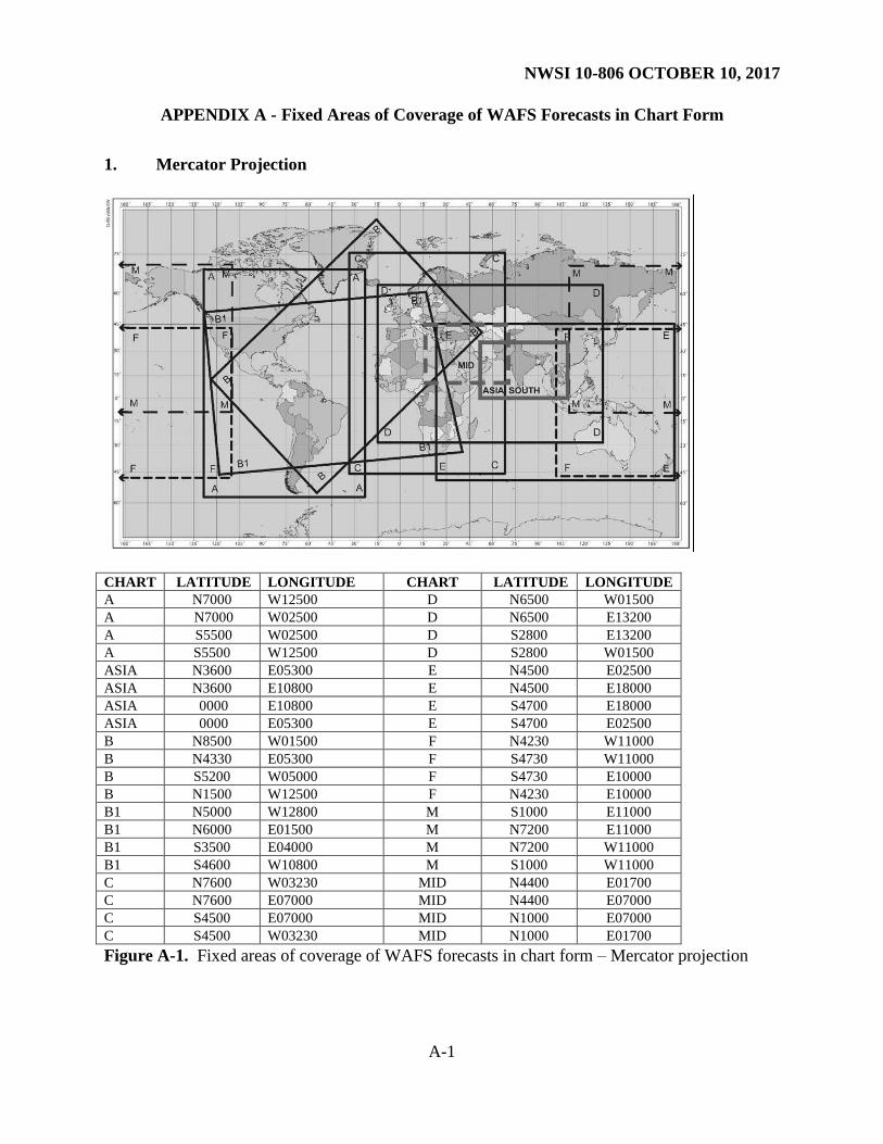
APPENDIX A - Fixed Areas of Coverage of WAFS Forecasts in Chart Form
1. Mercator Projection
CHART LATITUDE LONGITUDE CHART LATITUDE LONGITUDE
A N7000 W12500 D N6500 W01500
A N7000 W02500 D N6500 E13200
A S5500 W02500 D S2800 E13200
A S5500 W12500 D S2800 W01500
ASIA N3600 E05300 E N4500 E02500
ASIA N3600 E10800 E N4500 E18000
ASIA 0000 E10800 E S4700 E18000
ASIA 0000 E05300 E S4700 E02500
B N8500 W01500 F N4230 W11000
B N4330 E05300 F S4730 W11000
B S5200 W05000 F S4730 E10000
B N1500 W12500 F N4230 E10000
B1 N5000 W12800 M S1000 E11000
B1 N6000 E01500 M N7200 E11000
B1 S3500 E04000 M N7200 W11000
B1 S4600 W10800 M S1000 W11000
C N7600 W03230 MID N4400 E01700
C N7600 E07000 MID N4400 E07000
C S4500 E07000 MID N1000 E07000
C S4500 W03230 MID N1000 E01700
Figure A-1. Fixed areas of coverage of WAFS forecasts in chart form – Mercator projection
NWSI 10-806 OCTOBER 10, 2017
A-2
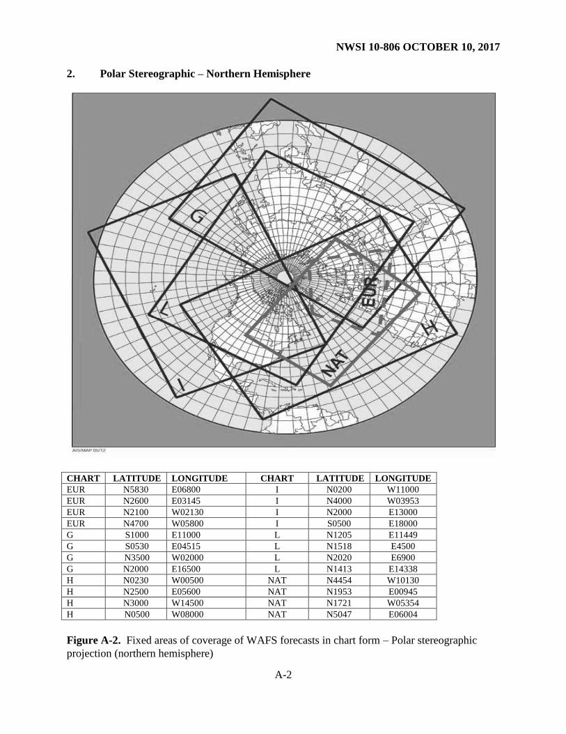
2. Polar Stereographic – Northern Hemisphere
CHART LATITUDE LONGITUDE CHART LATITUDE LONGITUDE
EUR N5830 E06800 I N0200 W11000
EUR N2600 E03145 I N4000 W03953
EUR N2100 W02130 I N2000 E13000
EUR N4700 W05800 I S0500 E18000
G S1000 E11000 L N1205 E11449
G S0530 E04515 L N1518 E4500
G N3500 W02000 L N2020 E6900
G N2000 E16500 L N1413 E14338
H N0230 W00500 NAT N4454 W10130
H N2500 E05600 NAT N1953 E00945
H N3000 W14500 NAT N1721 W05354
H N0500 W08000 NAT N5047 E06004
Figure A-2. Fixed areas of coverage of WAFS forecasts in chart form – Polar stereographic
projection (northern hemisphere)
NWSI 10-806 OCTOBER 10, 2017
A-3
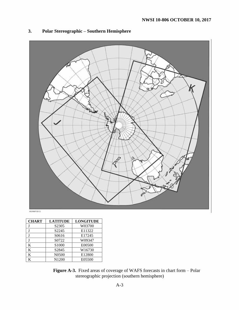
3. Polar Stereographic – Southern Hemisphere
CHART LATITUDE LONGITUDE
J S2305 W03700
J S2245 E11322
J S0616 E17245
J S0722 W09347
K S1000 E00500
K S2845 W16730
K N0500 E12800
K N1200 E05500
Figure A-3. Fixed areas of coverage of WAFS forecasts in chart form – Polar
stereographic projection (southern hemisphere)
NWSI 10-806 OCTOBER 10, 2017
B-1
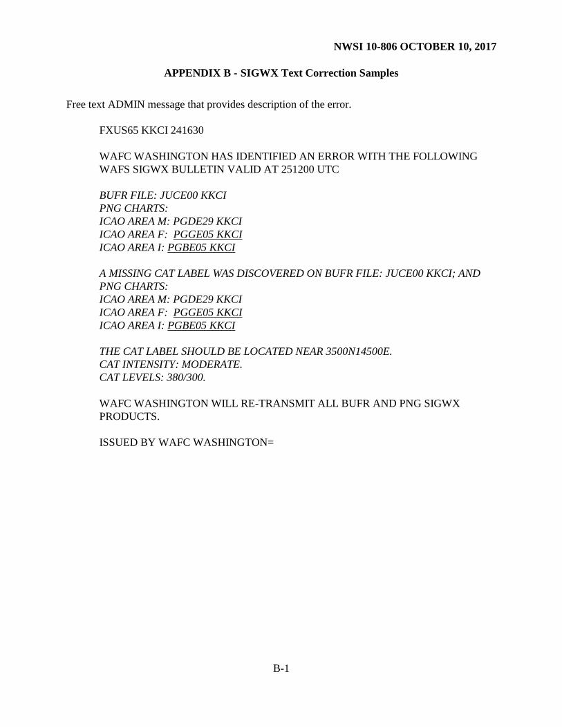
APPENDIX B - SIGWX Text Correction Samples
Free text ADMIN message that provides description of the error.
FXUS65 KKCI 241630
WAFC WASHINGTON HAS IDENTIFIED AN ERROR WITH THE FOLLOWING
WAFS SIGWX BULLETIN VALID AT 251200 UTC
BUFR FILE: JUCE00 KKCI
PNG CHARTS:
ICAO AREA M: PGDE29 KKCI
ICAO AREA F: PGGE05 KKCI
ICAO AREA I: PGBE05 KKCI
A MISSING CAT LABEL WAS DISCOVERED ON BUFR FILE: JUCE00 KKCI; AND
PNG CHARTS:
ICAO AREA M: PGDE29 KKCI
ICAO AREA F: PGGE05 KKCI
ICAO AREA I: PGBE05 KKCI
THE CAT LABEL SHOULD BE LOCATED NEAR 3500N14500E.
CAT INTENSITY: MODERATE.
CAT LEVELS: 380/300.
WAFC WASHINGTON WILL RE-TRANSMIT ALL BUFR AND PNG SIGWX
PRODUCTS.
ISSUED BY WAFC WASHINGTON=

NWSI 10-806 OCTOBER 10, 2017
B-2
Automated Fixed Format Administrative Message
FXUS66 KKCI 200343
RETRANSMITTED WAFC WASHINGTON DATA:
DATA TYPE: WAFC WASHINGTON SIGWX BUFR AND PNG
ORIGINAL WMO AHL: PG//// KKCI 191800
JU//// KKCI 191800
RETRANSMITTED WMO AHL: PG//// KKCI 191800 CCA
JU//// KKCI 191800 CCA
WHERE PG//// REPRESENTS ALL WAFC WASHINGTON SIGWX PNG FILES
AND JU//// REPRESENTS ALL WAFC WASHINGTON SIGWX BUFR FILES
ALL WAFC WASHINGTON SIGWX BUFR AND PNG FILES INDICATED ABOVE ARE
NOW BEING RE-TRANSMITTED.
ISSUED BY WAFC WASHINGTON=
NWSI 10-806 OCTOBER 10, 2017
C-1
APPENDIX C - WIFS and SADIS Coverage Areas


![JeffParrish [415]806-3817](https://static.fdocuments.in/doc/165x107/55c033a2bb61eb8a148b4676/jeffparrish-415806-3817.jpg)