National Spatial Data Infrastructure Framework Framework.pdfSri Lanka Spatial Data Infrastructure...
152
Sri Lanka Spatial Data Infrastructure Framework - June 2014 Geospatial Frameworks Pty Ltd i National Spatial Data Infrastructure Framework Government of Sri Lanka
Transcript of National Spatial Data Infrastructure Framework Framework.pdfSri Lanka Spatial Data Infrastructure...
Sri Lanka Spatial Data Infrastructure Framework - June 2014 Geospatial Frameworks Pty Ltd
i
National Spatial Data Infrastructure Framework Government of Sri Lanka

Sri Lanka Spatial Data Infrastructure Framework - June 2014 Geospatial Frameworks Pty Ltd
ii
PAGE LEFT INTENTIONALLY BLANK
Sri Lanka Spatial Data Infrastructure Framework - June 2014 Geospatial Frameworks Pty Ltd
iii
SRI LANKA SPATIAL DATA INFRASTRUCTURE FRAMEWORK
DRAFT REPORT JUNE 2014
This document has been reviewed by the NSDI Working Group 22-23 July 2014
Prepared by Dr Lesley Arnold
World Bank Consultant
Director Geospatial Frameworks
71 Darlington Road, Darlington,
Western Australia, 6070, Australia
Email: [email protected]
Telephone +61 (8) 9299 8918
Mobile: 0414 747 408
Sri Lanka Spatial Data Infrastructure Framework - June 2014 Geospatial Frameworks Pty Ltd
iv
This Spatial Data Infrastructure Framework document has been reviewed and approved by the NSDI Working Group:
Mr. Wasantha Deshapriya,
Director, Re-Engineering Government Program ………………………………………….…..date………………………..
Mr. S.M.P.P. Sangakkara
Additional Surveyor General (Central), Survey Department……………………………….date………………………..
Mrs. A. L. S. C. Perera
Deputy Surveyor General (LIS/GIS), Survey Department ……………………………………date………………………..
Mr. K Prasanna Chandith
Director, National Disaster Relief Service Centre …………………………………………….....date………………………..
Mr. Ajith Wijemanne,
Deputy Director, Department of Meteorology…………………………………………………….date………………………..
Mrs. Kumari Weerasinghe
Senior Scientist, National Building Research Organization……………………………….....date……………………….
Mr. Srimal Samansiri
Assistant Director, Disaster Management Centre………………………………………………..date………………………..
Mr. E. A. P. N. Edirisinghe
Deputy Conservator of Forests, Forest Department……………………………………………date………………………..
Mr. Ajith Silva
Director, Ministry of Environmental and Renewable Energy……………………………….date………………………..
Ms A.D.P.N. Attygalle
Assistant Secretary, Ministry of Land and Land Development……………………………..date……………………

Sri Lanka Spatial Data Infrastructure Framework - June 2014 Geospatial Frameworks Pty Ltd
i
TABLE OF CONTENTS
TABLE OF CONTENTS ........................................................................................................................ I EXECUTIVE SUMMARY .................................................................................................................... 1 ORGANISATION OF THIS DOCUMENT .............................................................................................. 3 SCOPE OF SLSDI FRAMEWORK ......................................................................................................... 4 KEY CONTRIBUTORS ........................................................................................................................ 4 LIST OF ABBREVIATIONS AND ACRONYMS ....................................................................................... 5
1. SPATIAL DATA INFRASTRUCTURE FRAMEWORK .......................................................................... 7 1.1 Background ..................................................................................................................................... 8 1.2 Vision Statement .......................................................................................................................... 10 1.3 Mission Statement ....................................................................................................................... 11 1.4 Goals ............................................................................................................................................. 11 1.5 Spatial Data Infrastructure Framework ........................................................................................ 12 1.6 Underpinning Principles ............................................................................................................... 13 1.7 Business Drivers ........................................................................................................................... 14 1.8 Strategic Context .......................................................................................................................... 15 1.9 Alignment to e-Government Initiative ......................................................................................... 16 1.10 Benefits....................................................................................................................................... 19 1.11 Barriers ....................................................................................................................................... 20 1.14 Recommendations ..................................................................................................................... 21
2. DATA FRAMEWORK ................................................................................................................... 23 2.1 Current State ................................................................................................................................ 23 2.2 Guiding Principles ......................................................................................................................... 25 2.3 Data Framework Components ..................................................................................................... 26 2.4 Data Classification and Structure ................................................................................................. 27 2.5 Custodianship Roles and Responsibilities .................................................................................... 31 2.6 Technology ................................................................................................................................... 33 2.7 Standards and Compliance ........................................................................................................... 35 2.8 Metadata ...................................................................................................................................... 37 2.9 Storage and Archiving .................................................................................................................. 41 2.10 Recommendations ..................................................................................................................... 42
3. SUPPLY CHAIN FRAMEWORK ..................................................................................................... 45 3.1 Current State ................................................................................................................................ 46 3.2 Guiding Principles ......................................................................................................................... 46

Sri Lanka Spatial Data Infrastructure Framework - June 2014 Geospatial Frameworks Pty Ltd
ii
3.3 Supply Chain Framework .............................................................................................................. 47 3.4 Local-National Vertical Supply Chains .......................................................................................... 48 3.5 Cross-government Supply Chains ................................................................................................. 50 3.6 Data Integration ........................................................................................................................... 52 3.7 Data Acquisition Program ............................................................................................................ 52 3.8 Community Participation Programs ............................................................................................. 53 3.9 Intellectual Property and Licensing .............................................................................................. 53 3.10 Financial Model .......................................................................................................................... 54 3.11 Recommendations ..................................................................................................................... 57
4. DATA ACCESS FRAMEWORK ...................................................................................................... 59 4.1 Current State ................................................................................................................................ 59 4.2 Strategic Benefits of a Shared Infrastructure ............................................................................... 61 4.3 Guiding Principles ......................................................................................................................... 62 4.4 Data Access Framework Components .......................................................................................... 63 4.5 Enabling Infrastructure Overview ................................................................................................ 65 4.6 User Tier ....................................................................................................................................... 69 4.7 Security Tier .................................................................................................................................. 70 4.8 Application Tier ............................................................................................................................ 70 4.9 Integration Tier ............................................................................................................................. 74 4.10 Core Services Tier ....................................................................................................................... 75 4.11 Custodian Tier ............................................................................................................................ 76 4.12 Recommendations ..................................................................................................................... 78
5. APPLICATION FRAMEWORK ....................................................................................................... 79 5.1 Current State ................................................................................................................................ 79 5.2 Application Framework Components........................................................................................... 80 5.3 Application Approaches ............................................................................................................... 81 5.4 Shared Technology Requirements ............................................................................................... 82 5.5 Thematic Areas ............................................................................................................................. 83 5.6 Disaster Management Pilot .......................................................................................................... 86 5.7 Commercial Opportunities ........................................................................................................... 88 5.8 Recommendations ....................................................................................................................... 89
6. GOVERNANCE FRAMEWORK ..................................................................................................... 91 6.1 Current State ................................................................................................................................ 92 6.2 Governance Framework Components ......................................................................................... 92 6.3 Guiding Principles ......................................................................................................................... 93
Sri Lanka Spatial Data Infrastructure Framework - June 2014 Geospatial Frameworks Pty Ltd
iii
6.4 SLSDI Governance Model ............................................................................................................. 93 6.5 NSDI Office ................................................................................................................................... 94 6.6 NSDI Steering Committee ............................................................................................................. 95 6.7 NSDI Council ................................................................................................................................. 96 6.8 NSDI Council Subcommittees ....................................................................................................... 97 6.9 Lead Agency Involvement ............................................................................................................ 98 6.10 Stakeholder Community ............................................................................................................. 99 6.11 Agreements with Stakeholders ................................................................................................ 103 6.12 Recommendations ................................................................................................................... 104
7. LEGAL AND POLICY FRAMEWORK ............................................................................................ 107 7.1 Current State .............................................................................................................................. 108 7.2 Legal and Policy Framework Components ................................................................................. 109 7.3 Guiding Principles ....................................................................................................................... 110 7.4 Legal and Policy Documents ....................................................................................................... 110 7.5 Policy Tools ................................................................................................................................. 117 7.6 Policy Implementation Plan ....................................................................................................... 119 7.7 Compliance Strategy .................................................................................................................. 124 7.8 Recommendations ..................................................................................................................... 125
8. SUMMARY OF RECOMMENDATIONS ....................................................................................... 127
9. REFERENCES ............................................................................................................................ 131
APPENDIX 1: MEMBERS OF THE NSDI WORKING GROUP ................................................................... 133 APPENDIX 2: WORKSHOP AGENDA 27 MAY 2014 ............................................................................... 134 APPENDIX 3: PEST ANALYSIS ............................................................................................................... 135 APPENDIX 4: SWOT ANALYSIS ............................................................................................................. 137 APPENDIX 5: LIST OF ORGANISATIONS INTERVIEWED ........................................................................ 139 APPENDIX 6: EXAMPLE THEME PROFILE ............................................................................................. 141 APPENDIX 7: EXAMPLE DATA SET PROFILE ......................................................................................... 142 APPENDIX 8: CHECKLIST FOR CREATING METADATA .......................................................................... 143 APPENDIX 9: FIT FOR PURPOSE CRITERIA ........................................................................................... 144
ANNEXURE 1: Custodianship Policy
ANNEXURE 2: Spatial Data Management Policy
ANNEXURE 3: Sensitive Data Policy

Sri Lanka Spatial Data Infrastructure Framework - June 2014 Geospatial Frameworks Pty Ltd
iv
PAGE LEFT INTENTIONALLY BLANK

Sri Lanka Spatial Data Infrastructure Framework - June 2014 Geospatial Frameworks Pty Ltd
1
EXECUTIVE SUMMARY The Sri Lanka Spatial Data Infrastructure (SLSDI) Framework is a companion manual to the SLSDI Strategy. It provides detailed information on how the Integrated Strategies outlined in that document will be put into effect. Extensive recommendations are made covering all key elements.
A further document – the NSDI Roadmap for Sri Lanka is the next stage in the development process and can be referred to for more detailed steps, timeframes and high level costs.
The primary role of this document is to spell out the framework that will support the Sri Lanka Spatial Data Infrastructure. SLSDI comprises the people, policies and technologies necessary to enable the use of spatially referenced data.
Why is a framework needed? It is evident that spatial information can play a decisive role in promoting economically and socially feasible solutions to problems faced by various sectors of the economy, where a variety of information needs to be collected from a variety of sources and must be integrated to plan, monitor, and evaluate development programs.
Providing this information in an efficient and timely fashion is an important function of government. The current mechanisms for collecting and disseminating spatial data are cumbersome and resource intensive and data is liable to become out of date very quickly. This leads to a lack of trust in its quality and usefulness. The answer to this problem has been a proliferation in the number of data sets being kept – an inherently inefficient process and poor use of government resources.
The proposal to develop a SLSDI is not new but there is now a determination at the highest levels of government to ensure that it is implemented.
One of the mechanisms for ensuring that any new system will be practical and fit for purpose is that a pilot project has been approved. This project will use the new framework in the context of Disaster Management. It will make use of multiple layers of information including environmental data in addition to other base data sets. This will provide a robust test of the whole framework and provide direction for refinements to the system.
The proposed framework fits into the strategic direction of government and various other e-government initiatives.
The benefits of establishing a spatial data infrastructure for Sri Lanka and National Map Portal are summarised in this document. They relate to improved information access for agencies and citizens, improved government processes and better government through improved data integrity, opportunities for revenue growth, improved communication with the public and easier access for citizens and increased agency collaboration.
Prior to the framework being developed an exercise in environmental scanning was conducted that provided helpful background to the formation of a national spatial data infrastructure and lessons learned from previous projects. This document explains previous initiatives and where we are today.

Sri Lanka Spatial Data Infrastructure Framework - June 2014 Geospatial Frameworks Pty Ltd
2
Recent workshops have contributed to analysis of the current situation and provide a vision goals and strategies to move forward.
To ensure that the spatial data infrastructure vision can be achieved, a number of overarching components need to be in place. The relationship between the various components of the framework is explained in summary form and then in comprehensive detail throughout the document with accompanying recommendations that provide a clear way forward. These essential components relate to:
• A Data Framework that provides for the orderly management of data and the information (metadata) necessary for users to access information via the National Map Portal.
• Data Access Framework that enables spatial information, stored in various agency systems, to be accessed through a single, integrated spatial information portal.
• Supply Chain Framework that ensures supply chains include automated processes, minimal manual data handling, single authoritative data sources, and effective inclusion of Volunteered Geographic Information (VGI) from community sources
• Application Framework that controls the purpose-specific systems that are built using the technologies and spatial data sets made available through the Data Access Framework.
• Governance Framework that brings together many government agencies to share spatial information, leads to the reform of cross-agency business processes and adopts modern information technology standards.
• Policy Framework that is required to provide guidelines for custodianship, data acquisition, spatial data management, data access and pricing, privacy, access to sensitive data and intellectual property management.
In addition to components of the framework, underpinning principles are established and business drivers and commercial opportunities explored. In addition, sets of guiding principles are described for critical elements of the new system relating to such things as custodianship issues, data acquisition, spatial data management, access and pricing, privacy, care with sensitive information and intellectual property management.
This document is designed to inform, inspire and provide practical mechanisms for the implementation of the Sri Lankan Data Framework. As such it is directed to spatial information professionals, government employees involved in information flows and interactions with members of the community and other stakeholders who need to know how spatial information will be collected, maintained and distributed in the future. In addition it will be of interest to those in public policy positions. An extensive and very detailed report follows.

Sri Lanka Spatial Data Infrastructure Framework - June 2014 Geospatial Frameworks Pty Ltd
3
ORGANISATION OF THIS DOCUMENT
Chapter 1: Introduction
This section introduces the reader to the need for a Sri Lanka Spatial Data Infrastructure and the strategic context of the SLSDI.
Chapter 2: Data Framework
The section examines the situation of spatial data management practices in Sri Lanka. It includes a review of existing data sets and the responsible agencies; and describes the progress to-date in achieving a SLSDI. A Data Framework for the SLSDI is proposed, with particular emphasis on the fundamental data themes. The section also introduces metadata and its importance to the SLSDI. Metadata describes the origin of geographic data and tracks the changes to a data set over time. This supports data accessibility and use.
Chapter 3: Supply Chain Framework
This section examines the Supply Chain Framework that considers the flow of spatial information from its collection point to its delivery as an integrated source of information. It includes the bi-directional flow of information between the various levels of government, across government organisations and to and from the community of users. The framework considers points along the supply chain where data are acquired and where they are integrated with other data.
Chapter 4: Data Access Framework
This section describes the architectural requirements for the Data Access Framework for the National Map Portal. It identifies the components necessary establishing the National Map Portal and the mechanisms to access spatial data held by various organisations across government.
Chapter 5: Application Framework
This section introduces thematic applications that leverage the SLSDI implementation with particular emphasis on Disaster Management and Environmental Management. It proposes several other future thematic applications that will contribute to the overall development of the SLSDI.
Chapter 6: Legal and Policy Framework
This section explains the Policy Framework outlining the essential components required within a cross-institutional context to support effective spatial data sharing across government. It can be extended to include the private sector and academia partnerships. The Policy Framework considers all aspects of the spatial data management life cycle: from creation and initial storage; its dissemination and use as an information product; to the time when it becomes obsolete.
Chapter 7: Governance Framework
The section addresses the need to establish a governance framework for the SLSDI and the entities which contribute to its development. This will allow the SLSDI to be managed and coordinated in an accountable and collaborative manner. The involvement of stakeholders is a key issue for the future

Sri Lanka Spatial Data Infrastructure Framework - June 2014 Geospatial Frameworks Pty Ltd
4
development of the SLSDI. This section addresses the needs of stakeholders by involving them in all SLSDI implementation phases. The importance for considering this approach is explained along with strategies for stakeholder engagement.
Chapter 8: Summary of Recommendations
This section brings together the recommendations made in subsequent chapters.
SCOPE OF SLSDI FRAMEWORK The SLSDI Framework is a companion manual to the SLSDI Strategy. It provides detailed information on the strategic pathways outlined in the strategy. Several recommendations are made and these are open to further consultation with stakeholders, and Government Ministers and Advisors. The SLSDI Strategy and SLSDI Framework are not to be considered as an Implementation Plan for the NSDI. A roadmap for achieving a NSDI for Sri Lanka is the next stage in the development process and will assign responsibility to tasks, and detail timeframes and high level costs.
Whilst areas for capacity building are identified and recommended in this SLSDI Framework, these are a subset of the anticipated activities required for building and sustaining a geospatially-enabled community. A comprehensive Capacity Building Study is required to compliment the NSDI Strategy.
Similarly, this document does not seek to develop policy relating to geospatial data management, sharing and access; nor is legislation adequately reviewed. Both policy and legislation require further consideration within an agreed Legal and Policy Framework (See Chapter 6).
KEY CONTRIBUTORS The NSDI strategy was developed over a 4 week period in consultation with Management and staff at various government agencies and the NSDI Working Group. All participants who have contributed to the SLSDI Framework must be congratulated for working collaboratively in reaching this significant milestone. In particular, delegates at the NSDI Workshop held on 27th May 2014 are thanked for their workshop discussions that contributed to the development of the goals and objectives outlined in this document. The process sets the scene for promoting a culture of integration and collaboration within and between agencies in Sri Lanka.
Special thanks go to the Mrs. S.M. Mohamed, Secretary for the Ministry of Disaster Management and Mr. Ashoka Pieris, Secretary for the Ministry of Land and Land Development. Their leadership and commitment has the potential to ‘pave the way’ for a new approach to the way spatial information business is conducted in the government arena.
Finally, but most importantly, the SLSDI will only be achieved with high-level support. The Hon. Tissa Vitharana, Senior Minister Science and Technology, is thanked for his guidance and insight into the economic, environmental and social benefits that can be achieved by opening up access to spatial information.

Sri Lanka Spatial Data Infrastructure Framework - June 2014 Geospatial Frameworks Pty Ltd
5
LIST OF ABBREVIATIONS AND ACRONYMS
CSW Catalogue Services for Web
DMC Disaster Management Centre
EM Emergency Management
ESRI Earth Science Research Institute
GDP Gross Domestic Product
GIS Geographic Information System
GSDI Global Spatial Data Infrastructure
ISO International Standards Organisation
ISO/TC International Standards Organisation/Technical Committee
IT Information Technology
LGN Lanka Government Network
NMP National Map Portal
NSDI National Spatial Data Infrastructure
OECD Organisation for Economic Cooperation and Development
OGC Open Geospatial Consortium
PDF Portable Document Format
RDBMS Relational Database Management System
SDE Spatial Data Engine
SDD Spatial Data Dictionary
SLSDI Sri Lanka Spatial Data Infrastructure
SDI Spatial Data Infrastructure
SME Subject Matter Expert
SOA Service Oriented Architecture
VGI Volunteered Geographic Information
WofG Whole-of-government
WFS Web File Server
WMS Web Map Server
XML Extensible Markup Language

Sri Lanka Spatial Data Infrastructure Framework - June 2014 Geospatial Frameworks Pty Ltd
6

Sri Lanka Spatial Data Infrastructure Framework - June 2014 Geospatial Frameworks Pty Ltd
7
1. SPATIAL DATA INFRASTRUCTURE FRAMEWORK Studies show that spatial information contributes to growth in gross domestic product, creates new business opportunities, boosts revenue generating capacity, and contributes to productivity related savings. There is also evidence indicating significant intangible benefits including an increase in employee satisfaction from improved work practises and increased community wellbeing through access to knowledge about location (ACIL Tasman, 2009).
Spatial information can play a decisive role in promoting economically and socially feasible solutions to the existing problems faced by various sectors of the economy, where a variety of information needs to be collected from a variety of sources and must be integrated to plan, monitor, and evaluate development programs.
The government of Sri Lanka has vast holdings of spatial information collected by various government departments, with the majority located with the Survey Department. Currently, this information is not able to be easily shared between organisations, nor is it accessible to the broader community. This means that the benefits of this information are not able to be fully realised.
Organisations across the government sector recognise that current processes are inefficient. Manual data sharing processes introduce delays in business practises and the effort required to manually integrate updates is labour intensive and time consuming.
The current mechanisms by which agencies share land and geographic data is to replicate the data via customised exchanges of bulk data. The approach is cumbersome, resource intensive and data is prone to becoming out-of-date. The methodology also limits the potential to capitalise on the true value of the Nations spatial information asset. It also results in inefficiencies, as limited awareness of existing datasets has lead organisations to duplicate data collection. A more practical solution is required.
In order to facilitate the exchange of spatial information, nations around the world are developing National Spatial Data Infrastructures (NSDI). A NSDI is an initiative that creates an environment where government organisations can cooperate, and thus improve, the management and sharing of spatial information. It allows people to discover, view and obtain spatial information online for a particular part of the country without needing to know the details of how the data is stored and maintained by independent organisations.
Having centralised access to spatial information also facilitates natural resource monitoring, flood mitigation, management of public infrastructures and disaster recovery for the betterment of the community. These and other applications rely on understanding the location of people, places and infrastructures.
In order to make the best use of current spatial information resources, a National Framework is required to link users with the providers of spatial information. This framework is to be known as the Sri Lanka Spatial Data Infrastructure (SLSDI) Framework. The SLSDI comprises the people, policies and technologies necessary to enable the use of spatially referenced data.

Sri Lanka Spatial Data Infrastructure Framework - June 2014 Geospatial Frameworks Pty Ltd
8
CONTEXT AND RATIONALE
The Sri Lankan government is experiencing financial and social pressures to deliver services more efficiently. Information technology is recognised as being central to redesigning the way in which organisations work together to deliver better services to the community. When combined with the commitment to collaborate and consider alternative ways of business, the potential for improvements to services can be significant.
The community of Sri Lanka, via a range of services, depends upon access to spatial information (maps) as a foundation for managing population growth, land use planning, infrastructure development, environmental sustainability and disaster management. These are critical priorities of government and the provision of maps, which underpin these services, requires a whole-of-government approach to be truly effective.
The government of Sri Lanka is working towards building a National Spatial Data Infrastructure, which includes a National Map Portal. This map portal will provide centralised access to spatially referenced data to all levels of government, the private sector, non-profit organisations, academia and the community.
The National Map Portal will provide an opportunity to improve government service delivery and provide equitable access to land and geographic information. Having ready access to information has the potential to stimulate economic development, as well as, create new markets for the use of spatial information.
1.1 BACKGROUND
The proposal to develop a SLSDI is not new. The first seminar was held in 1994 to establish a policy on spatial data for the country. Several follow on meetings and seminars were held, each contributing momentum towards establishing an NSDI.
In May 2007, a “National Workshop on Preparation of National Policy on Spatial Data” was held, co-hosted by Ministry of Nation Building and Estate Infrastructure Development and Ministry of Land and Land Development. There were 155 delegates in attendance. At this workshop it was identified that a policy on spatial data sharing for the consistent management of spatial information across government was required. A draft policy was published in the Daily News on 9 June 2008 for public consultation. This first attempt at a policy did not receive high level support and the associated cabinet paper was not approved.
In October 2011, UN-SPIDER carried out a Technical Advisory Mission (TAM). A key finding from this mission was the need to develop a Spatial Data Infrastructure and associated policies as a top priority in order to avoid huge wastage of resources resulting from current inadequate data sharing practices across government (UN-SPIDER, 2011).
In 2012, the development of the Sri Lanka Spatial Data Infrastructure (SLSDI) was formally proposed by the Secretary, Ministry of Land and Land Development, along with other key Ministries and organisations. A national committee was appointed and chaired by the Secretary, Ministry of Land and Land Development with the participation of members from Survey Department, Ministry of
Sri Lanka Spatial Data Infrastructure Framework - June 2014 Geospatial Frameworks Pty Ltd
9
Finance, Info-Communication Technology Agency, Disaster Management Centre, Ministry of Disaster Management (MDM), Ministry of Defence etc. A cabinet paper was drafted.
This cabinet paper was subsequently approved and a high level Committee headed by Hon. Tissa Vitharana, Senior Minister to the Cabinet was appointed in 2012. At the first meeting a decision was made to conduct a pilot project implementation of a SDI for the Disaster Management sector and include environmental data. The responsibility for this pilot was handed to the Secretary, Ministry of Disaster Management. A NSDI Working Group consisting of experts from a range of organisations (Appendix 1) was created to assist the Secretary, MDM and to obtain a consultant with the assistance of the World Bank.
The Secretary, Ministry of Land and Land development and Secretary Ministry of Disaster Management in conjunction with the NSDI Working Group organised a half a day workshop inviting all stakeholders to inform them of the future plan. Mr. Wasantha Deshapriya and Mr. Srimal Samansiri jointly presented the progress of the pilot implementation of NSDI and future arrangements, and a vision for the future.
In May 2014 a Consultant, Dr Lesley Arnold, was hired through the World Bank to develop (a) SLSDI Strategy, (b) SLSDI Framework and (b) SDI Road Map for Disaster Management.
A workshop was held on 27 May 2014 to progress the development of the SLSDI Strategy and SLSDI Framework. The Workshop agenda is included in Appendix 2. The Senior Minister Hon. Thissa Vithara, Minister Land and Land Development, and Minister of Disaster Management addressed delegates on the importance of establishing a NSDI for the Sri Lankan economy and gave examples of the benefits to the community.
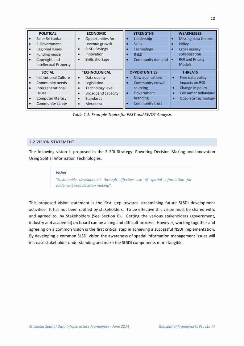
The workshop was participatory and delegates were asked to contribute knowledge that would create a meaningful and shared vision for the SLSDI, and establish clear strategic goals and pathways. To achieve this aim, a PEST analysis and SWOT analysis were conducted. The PEST Analysis considered the external environment and focused on the Political, Economic, Social and Technology issues that may have a positive or negative impact on the SLSDI implementation. The SWOT analysis considered the internal factors; namely the characteristics of government that are considered an advantage or disadvantage to the SLSDI project, those aspects that could be exploited to advantage through SLSDI implementation and those elements that were considered a threat to implementation and essentially out of peoples control.
An example of the PEST and SWOT discussion topics are presented below (Table 1.1). Each table was given one topic for discussion. The findings from each table were presented by the designated Table Leader to the entire workshop audience. The results from the PEST and SWOT Analysis are included in Appendices 3 and 4. This information, along with information obtained through interviews with relevant agencies (Appendix 5), underpins the assumptions and recommendations contained in this document.
Sri Lanka Spatial Data Infrastructure Framework - June 2014 Geospatial Frameworks Pty Ltd
10
Table 1.1: Example Topics for PEST and SWOT Analysis
1.2 VISION STATEMENT
The following vision is proposed in the SLSDI Strategy: Powering Decision Making and Innovation Using Spatial Information Technologies.
Vision
“Sustainable development through effective use of spatial information for evidence-based decision making”.
This proposed vision statement is the first step towards streamlining future SLSDI development activities. It has not been ratified by stakeholders. To be effective this vision must be shared with, and agreed to, by Stakeholders (See Section 6). Getting the various stakeholders (government, industry and academia) on board can be a long and difficult process. However, working together and agreeing on a common vision is the first critical step in achieving a successful NSDI implementation. By developing a common SLSDI vision the awareness of spatial information management issues will increase stakeholder understanding and make the SLSDI components more tangible.
POLITICAL • Safer Sri Lanka • E-Government • Regional Issues • Funding model • Copyright and
Intellectual Property
ECONOMIC • Opportunities for
revenue growth • SLSDI Savings • Innovation • Skills shortage
STRENGTHS • Leadership • Skills • Technology • R &D • Community demand
WEAKNESSES • Missing data themes • Policy • Cross agency
collaboration • ROI and Pricing
Models
SOCIAL • Institutional Culture • Community needs • Intergenerational
issues • Computer literacy • Community safety
TECHNOLOGICAL • Data quality • Legislation • Technology level • Broadband capacity • Standards • Metadata
OPPORTUNITIES • New applications • Community crowd-
sourcing • Government
branding • Community trust
THREATS • Free data policy
impacts on ROI • Change in policy • Consumer behaviour • Obsolete Technology

Sri Lanka Spatial Data Infrastructure Framework - June 2014 Geospatial Frameworks Pty Ltd
11
1.3 MISSION STATEMENT
Planning for the future is only one part of SLSDI journey. The most important aspect is taking ownership of the plan and bringing together all facets and undertaking the actions required to achieve the desired outcomes. Hence the following mission statement.
Mission
“Effective sharing and use of spatial information by the government, private sector and general public for business, research and innovation, to benefit the wider community.’’
The mission statement should be adopted by the NSDI Office (see Section 6.3.1) and delivered on behalf of the Government of Sri Lanka. The mission statement should be communicated to Stakeholders.
1.4 GOALS
There are 4 primary goals underpinning the development of the SLSDI. They are:
• GOAL 1: An accurate nationwide representation of the integrated with economic, social and environmental geographies. The objective of this goal is to improve the accuracy and coverage of the Nation’s spatial data so that it can be analysed to address economic, social and environmental challenges.
• GOAL 2: Greater efficiency and productivity in the management and sharing of spatial data. The objective of this goal is to increase the efficiency and effectiveness of spatial data management though improved data sharing practises, open standards and an agreed policy framework.
• GOAL 3: Evidence-based decision making in government, business and the wider community through the use of spatial information. The objective of this goal is to maximise the potential of spatial information by making it accessible to the broader community via a National Map Portal.
• GOAL 4: Spatial solutions readily available and widely used across Sri Lanka in response to emerging opportunities. The objective of this goal is to actively promote value, skills development and an entrepreneurial mindset the government, private and community sectors through awareness raising, capacity building, and research and innovation in spatial technologies.
For a detailed explanation of these goals and objectives, please refer to the SLSDI Strategy: Powering Decision-making and innovation using Spatial Information Technologies.

Sri Lanka Spatial Data Infrastructure Framework - June 2014 Geospatial Frameworks Pty Ltd
12
1.5 SPATIAL DATA INFRASTRUCTURE FRAMEWORK
To ensure that the spatial Data Infrastructure vision can be achieved, a number of components need to be in place. The relationship between these major implementation stages is depicted in Figure 1.1. These components are discussed in detail in the following chapters and are summarised below.
Figure 1.1 SLSDI Framework Components
• Data Framework: The Data Framework provides a way to organise map content so that it can be easily accessed by users, and managed by data custodians and system administrators. It also defines the data standards used and the extent of coverage for each dataset. A key component is the production of metadata which provides the orderly management of data and the information necessary for users to access information via the National Map Portal
• Supply Chain Framework: The Supply Chain Framework is a system of organisations, people, activities, information and resources that combine to move a product or service from supplier to customer. In the context of spatial information management, it is the process of transforming raw spatial data into a finished product. Best practise supply chains include automated processes, minimal manual data handling, single authoritative data sources, and effective inclusion of Volunteered Geographic Information (VGI) from community sources.
• Data Access Framework: The Data Access Framework enables spatial information, stored in various agency systems, to be accessed through a single, integrated spatial information portal. It provides governments with common tools to develop applications, which utilise spatial information. A key element of the Data Access Framework is the National Map Portal that gives access to layers of spatial information. System architecture components include the User, Security, Integration, Application, Core Services and Custodian Tiers. When combined, these system components provide services to allow applications to directly access data.
• Application Framework: The Application Framework refers to the purpose-specific systems that are built using the technologies and spatial data sets made available through the Data Access Framework. There are several thematic applications that can leverage the
TransportManagement
MarineProtection
EnvironmentalMonitoring
EmergencyCoordination
Health
TourismDisaster
Management
Policy Framework
Spatial Data Framework
Supply Chain Framework
Application Framework
Land Planning andDevelopment
Property
Governance Framework
Data Access ‘Enabling’ FrameworkData Access Framework
Data Framework
Sri Lanka Spatial Data Infrastructure Framework - June 2014 Geospatial Frameworks Pty Ltd
13
common capabilities including disaster management, environmental monitoring, tourism, resource management and planning.
• Legal and Policy Framework: There are a range of inter-related legislative and policy instruments required to achieve a robust SLSDI implementation. Without these the SLSDI governance will be difficult to administer and sustain, and stakeholder commitment and organisational conformity hard to achieve. Policies and guidelines are required for custodianship, data acquisition, spatial data management, data access and pricing, privacy, access to sensitive data and intellectual property management.
• Governance Framework: The SLSDI brings together many government agencies to share spatial information, reform cross-agency business processes and adopt modern information technology standards. A new governance model is required; one that is understood and accepted by all stakeholders and that considers the existing hierarchical structures of government institutions. In addition, the model should ensure that a large number of stakeholders are involved and be inclusive from the outset of the NSDI initiative. An active coordination body is required to co-ordinate tasks and provide leadership during the process of creating the SLSDI and managing its ongoing operation.
1.6 UNDERPINNING PRINCIPLES
The Spatial Data Infrastructure Framework proposed for Sri Lanka is based on a best practice approach for establishing and retaining consistency in the management of spatial information across all organisations. The objective is to make spatial information as accessible as possible. Following principles apply:
• Simplified access to the Government’s spatial information by providing online access using a common infrastructure.
• Provide a basis to improve the efficiency of the Government’s business processes involving spatial information, particularly those which span several agencies.
• Optimise investment and develop partnerships across the spatial information community (public, private and academic sectors).
• Deliver higher quality authoritative datasets through designated custodians.
• Make information accessible and available to all members of the community, except where confidentiality and commercially sensitive conditions apply.
• Combine various spatial information data themes for the purposes of analysis and decision making.
It is recommended that the principles underpinning the Spatial Data Infrastructure Framework are endorsed by stakeholders. This will generate understanding of the SLSDI Framework purpose and cement commitment across the government sector.

Sri Lanka Spatial Data Infrastructure Framework - June 2014 Geospatial Frameworks Pty Ltd
14
1.7 BUSINESS DRIVERS
Several factors are driving the development of a shared approach to the delivery and management of spatially-related information. These include:
• Achieve economic, social and environmental benefits from investment in spatially referenced information: Sustained growth in population and land development demands up-to-date spatial information. Sri Lanka’s population is expected to grow at an annual rate of around 0.86%, from its current population of 21 million. The most densely populated areas are Colombo and other large cities that are the industrial and economic hubs of the country (CIA World Factbook, 2014). This continued growth drives an increasing demand for spatial information in both planning and operational decision-making.
• Need for a coordinated and cost effective approach to spatial data management: In Sri Lanka, as in many countries, there is duplication in the production of spatial information across the government sector. This is primarily because the flow of spatial information between organisations is restricted by policies that inhibit data sharing. There is also a lack of standardisation and harmonisation of spatial databases, which makes data exchange problematic. A spatial data infrastructure that uses open source standards and interoperable technologies will enable the effective management and exchange of information leading to more streamlined processes and increased productivity.
• Need for financial efficiency when developing online capabilities: Government must look for ways to reduce future capital expenditure. If individual agencies implement their own spatial infrastructures to provide access to their spatial information holdings, then the total cost to government will be higher than if a shared infrastructure approach is adopted. This is because the fragmented approach to data sharing results in operational inefficiencies. In addition, smaller agencies do not have the capability or resources to establish their own online map services. With a National approach, there is an opportunity for the smaller agencies to leverage off the investments by larger agencies for minimal incremental cost, with economies of scale yielding further reduction in per-unit costs. New information technologies offer opportunities to deliver information and services electronically to improve internal efficiencies.
• Achieve improved service delivery from a citizen’s perspective: Governments at all levels are striving to simplify the delivery of information and services to their citizens in order to overcome dissatisfaction with fragmented service delivery. In Sri Lanka, business processes using spatial information often span several government agencies. A common approach will provide access to geographic information that is meaningful in the user’s context, and allows a user to complete an interaction with government without the need to visit individual agencies. This fosters transparent government.
• Understanding nationwide needs: A Spatial Data Infrastructure provides an information framework with which to collect, collate, and analyse nationwide needs. The government’s ability to readily understand regional issues will foster integration between provinces, districts, divisional secretaries and Grama Niladari. By providing information electronically, there is an opportunity to provide better services at the district level. Improved access to spatial information on a nationwide basis will provide inter-district cohesiveness, improved environmental management, improved regional infrastructure, and opportunities for regional development. It will also support corporations and other organisations in providing a basis for nationwide connectivity.
Sri Lanka Spatial Data Infrastructure Framework - June 2014 Geospatial Frameworks Pty Ltd
15
1.8 STRATEGIC CONTEXT
A National Spatial Data Infrastructure is a strategic enabler in delivering integrated spatial information to users. It enables improved planning for economic growth and delivery of better services, and supports strategies for poverty alleviation, engenders socially inclusive development, facilitates protection of the environment, reduces disaster response times, supports regional cooperation and promotes transparency in governance. The rationale for this is detailed in the following points. These examples stem from the PEST Analysis conducted at the NSDI Workshop on 27th May 2014 (Appendix 3). They are:
• Economic Growth: Managing the orderly development of land, and subsequent provision of a multitude of government and private services through infrastructure development, requires integrated planning. This is fundamental to a vibrant economy and community. Planning is underpinned by a good understanding of where things are and how they relate to each other. The range of services and infrastructure includes roads, rail, ports, utilities, and community services such as education, health, welfare and justice. By providing whole-of-government geographically-referenced data, the National Map Portal will allow optimal planning of infrastructure and services to meet future needs. This is particularly relevant to Tsunami affected areas where redevelopment is a key priority of government.
• Poverty Alleviation: Government’s ability to understand and recognise the geographic distribution of people throughout the country, and respond effectively to their needs, is dependent on having sound information on which to base planning and decision-making. This information comes from a wide variety of sources, and can become meaningless without a geographic context. The National Map Portal enables the integration of data in a geographic context to allow effective development of government policies and planning of government infrastructure and services for regionally balanced decision making.
• Socially Inclusive Development: The Government is targeting poverty reduction programs, and supporting special projects, such as health care, waste management and drinkable water (MENR, 2014). This will directly benefit the Districts by improving their socio-economic status. Spatial information can support project objectives by making planning far more effective. This in turn assists in the effective delivery of programs.
• Protection of the Environment: Sri Lanka faces a host of environmental problems such as land degradation, pollution and poor management of water resources, loss of biological diversity, coastal erosion, increasing scarcity of water for agriculture, waste disposal in urban areas, and traffic congestion in the main cities (MENR, 2014). The challenge is to balance increased development with sustainable environments. Management of natural resources requires accurate information to understand and manage the many competing factors in the environment. Various agencies have their specific areas of responsibility and each retains specific geographically-related information to support that responsibility. Conversely, each needs to access data from other agencies in establishing their own natural resource management plans. The development of the National Map Portal will provide an industrial-strength system for sharing data across government. This will allow better-informed natural resource management decisions. This is essential as economic growth may result in unsustainable use of natural resources and unintended environmental implications for local habitats.
• Water Resource Management: The government of Sri Lanka has an agenda to improve the accessibility of clean water supply and sanitation. Achievement of this goal will require an excellent foundation of spatial information. Currently, spatial information on water resources is maintained within several organisations with specific responsibilities including the Ministry of Irrigation and Water Resources Management, Ministry of Land and Land
Sri Lanka Spatial Data Infrastructure Framework - June 2014 Geospatial Frameworks Pty Ltd
16
Development and National Water Supply and Drainage Board. The National Map Portal will facilitate integrating the information collected by these Ministries transparently, so that agencies can focus on their core tasks rather than diverting resources into searching for, and retrieving, data.
• Disaster Response: Planning, preparing, responding to, and recovering from natural disasters, is crucial to providing a safe and secure Sri Lanka. Land-related information is critical in these processes. The National Map Portal will provide a common operating picture and up-to-date information from a wide variety of sources that can be shared across the spectrum of agencies that are managing the environment and dealing with emergency situations. In emergency management terms, the Spatial Data Infrastructure provides a means to deliver the ‘same Information at the same time’.
• Industry development: Spatial information supports the planning requirements for increasing industrial development and the growing demand for new infrastructure. In Sri Lanka, industrial activities have been increasing and many agricultural workers will seek higher-paid employment in industry and the services over the coming years. Many of these jobs will be in urban areas and this suggests an accelerating rural–urban transition. Achieving employment growth, while ameliorating potential adverse social and environmental impacts of urbanisation, will be a key development challenge for Sri Lanka.
• Agricultural productivity: Small-scale farms have declined over the past decades due to irregular rainfall, recurrent drought and poor irrigation infrastructure. Food security in terms of availability, accessibility and affordability is uncertain notably in the rural regions (MERN, 2014). Integrated spatial information can be analysed by government to assist smaller farm holders through yield monitoring and crop stress mapping, variable rate technologies (for applying fertilisers), soil condition mapping and salinity mapping, and the control of pests and disease outbreaks (ACIL Tasman, 2009). In the long term this will lead to achieving a higher productivity and profitability in agriculture.
1.9 ALIGNMENT TO E-GOVERNMENT INITIATIVE
The concept of a Spatial Data Infrastructure is aligned with Sri Lanka’s strategic e-Government initiative “eSriLanka”. This is because the shared infrastructure and map viewing capabilities allow users and systems to access the spatial information stored in mapping agencies as a single, integrated e-service. This directly supports the aims of e-Government by:
• Improving processes within and between agencies, and reducing data redundancy, leading to lower costs and higher potential sales.
• Providing a basis for more personalised and accessible services that are easy for the community to use by making available integrated, web-based access to land-related processes and information.
• Providing access to information in a timelier manner. The SLSDI data access technology will make it easier for people to make a more informed contribution to government.
E-Government in Sri Lanka is well underway. The official eSriLanka portal is Lanka Gate aptly referred to as “Enabling Next Generation Government”. The vision for “eSriLanka” is to develop the economy of Sri Lanka, reduce poverty and improve the quality of life of the people (ICTA, 2014). The Information Communication Technology Agency’s (ICTA) mission is to use the Internet as a platform

Sri Lanka Spatial Data Infrastructure Framework - June 2014 Geospatial Frameworks Pty Ltd
17
to provide information to the public about all government agencies and to streamline current administrative procedures.
In addition, the Lanka Government Network (LGN) has been established to create a government wide network with basic IT infrastructure under the eSriLanka Development Project. The objective of the LGN is to provide greater efficiency in the delivery of government services. The first phase of Lanka Government Network connected 325 government locations (including several Provincial Councils, District Secretariats and Divisional Secretariats) across the country. The second phase connected an additional 150 locations primarily in underserved areas.
ICTA was designated as the responsible Authority in 2012 by Cabinet decision. ICTAs role it to ensure that the operational activities of the LGN are in line with the goals and objectives of the eSriLanka Development Project, which has a long term objective of building sustainability measures so that all Government services can be eventually provided by electronic means to citizens in a more effective and transparent manner.
The infrastructure is now well established and has many commonalities with the infrastructure required for the SLSDI. It is therefore recommended that the Lanka Gate data access technology be considered as one of the options to develop the National Map Portal. This will maintain uniformity and common brand across e-Government services.
Lanka Gate includes a comprehensive collection of infrastructural mechanisms to easily 'plug-in' eServices and provide a wide range of citizen centric services with flexibility and accessibility. Many eServices will be generated as a result of various projects at the ICTA such as the Population Registry project, the ePensions project and the Samurdhi Services project. In addition, many other eServices can be generated by government, public and private sector organisations as well as by community groups.
The community is well prepared for new e-Government services. The number of internet connections in the country reached 2 million in 2013. The sharp growth in internet services was described as the key highlight in the telecommunications sector last year by the Central Bank in its 2013 Annual Report.
“Total internet connections grew by 47% during 2013 increasing internet penetration (connections per 100 persons) to 9.8%. This was largely supported by the accelerated growth in mobile internet connections, followed by the fixed internet connections,” Central Bank said.
The Spatial Data Infrastructure is an enabler to achieving broader policy and service delivery goals, broader public management reform processes and broader information society activity. It also supports the principles of e-Government and is aligned to the Organisation for Economic Co-Operation and Development (OECD) guiding principles for successful e-Government implementations. These are identified in Table 2.2 below:

Sri Lanka Spatial Data Infrastructure Framework - June 2014 Geospatial Frameworks Pty Ltd
18
e-Government Principles and SLSDI and National Map Portal e-Government Principle How the National Map Portal supports the e-Government Principle
Citizen-centric
Services and information will be designed and focused on the needs of Sri Lankans
The National Map Portal objectives include improved access to spatial information and the improved delivery of government land-related services. The intent is to provide a whole-of-government perspective on data and processes, rather than an agency-oriented perspective, to make it easier for Sri Lankans to interact with government.
Trust, Security and Confidence
The public sector must earn the trust and confidence of citizens that government is collecting, using and disclosing their information in a manner which is consistent, secure, ethical and which respects privacy, and that online transactions are secure.
Part of the drive for National Map Portal is to adopt a professionally architected, industrial-strength portal allowing properly controlled access to the Nations spatial information. The National Map Portal will be able to assist meeting the public’s need for better access to information, while ensuring that private information is secure. This approach will give the public confidence that government is both being open whilst balancing privacy concerns.
Better Governance
e-Government is an integral component in enabling government to improve its structures, governance frameworks and processes to better serve the citizens of Sri Lanka
The National Map Portal will improve the accessibility of spatial information and, in doing so; will improve the responsiveness of cross-agency land-related business processes. In this capacity, the National Map Portal will assist in facilitating community engagement and involvement in government decision-making processes.
Collaboration and Integration
Agencies will work in a more collaborative manner, prioritising the need for integration of government services
The National Map Portal is a whole-of-government approach to sharing land and geographic information. It includes a governance model which balances horizontal collaboration with vertical accountability.
Accountability
The tenets of transparency, accountability and ethically responsible governance will underpin e-Government initiatives to transform the operations of government.
The National Map Portal aims to provide a framework in which true end-to-end business processes can be conducted across agencies, thereby improving the transparency of the role of any one agency on the overall process. This approach optimises and improves service delivery.
Accessibility and Choice
The National Map Portal will enable agencies and citizens the accessibility and choice of spatial services to meet their individual needs and circumstances The National Map Portal will provide electronic access to integrated land and geographic information. This will give citizens greater choice of how they access services, and empower them by making information more readily accessible. The platform will also provide improved service delivery for those sectors of business community relying on land and geographic information.
Table 1.1: The SLSDI and National Map Portal supports e-Government principles.

Sri Lanka Spatial Data Infrastructure Framework - June 2014 Geospatial Frameworks Pty Ltd
19
1.10 BENEFITS
Open and transparent access to the Government’s spatial information is an important step to improving the nation’s spatial data service delivery and is a significant step towards transitioning to joined-up government.
The benefits of establishing a spatial data infrastructure for Sri Lanka and National Map Portal are summarised as:
Improved information access for agencies and citizens, resulting in -
• Better sharing and integration of land information across government, industry and the community;
• Improved quality of decision-making and reaction times; • Improved management of community-supplied information; • Reduced errors and subsequent rework at an agency level; and • Value-adding to an agency’s data by combining it with other “like” datasets in order to
provide context. Improved government processes, resulting in -
• Reduced government administrative effort and resources; • Greater responsiveness in land-related processes and more timely land supply thereby
promoting a competitive economy; • Reduced paperwork and run around between agencies; and • More streamlined government services and reduced transaction times.
Better government, through -
• Improved data integrity by accessing data directly and ensuring errors are corrected in the source data;
• Opportunities for revenue growth; • Improved communication with the public and easier access for citizens to participate in
government decision-making; and • Increased inter-agency collaboration.
Sri Lanka Spatial Data Infrastructure Framework - June 2014 Geospatial Frameworks Pty Ltd
20
1.11 BARRIERS
There are a number of barriers to achieving a SLSDI. However, none are insurmountable and can be overcome using good governance and policy, having a highly committed stakeholder base and capacity building strategies. Potential barriers to achieving the SLSDI are identified in the SWOT analysis from the NSDI Workshop held 27th May 2014 (Appendix 4). They are perceived as:
• Deficient institutional arrangements and user/ provider relationships: Lack of coordination at a national level can impose significant constraints on the development of the SLSDI. Impediments often include poor inter-organisational communication and lack of high level support. Specific steps need to be defined and implemented to ensure that government agencies work together to reduce costs, avoid duplication of effort, and recognise the role that the private sector and academia can play. User demands can trigger the necessary partnerships and alliances to produce and share information.
• Inconsistencies in the availability and quality of spatially referenced data: The provision of access to data is often obstructed because of concerns over data quality and the inappropriate use of data in the hands of end users with unknown interpretative abilities and lack of corporate awareness. Data quality issues and end user education are not easily resolved without first creating the spatial data access infrastructure and attempting to meet the priority needs of end-users for data access in the first instance. This can be closely followed by education awareness programs to ensure its appropriate use.
• Lack of consistent policies concerning access to and use of spatially referenced data: The lack of information management policies, such as data ownership, usage, pricing, data exchange, data access and security, and licensing and copyright, will have a critical impact on SLSDI development. The lack of a Legal and Policy framework can be addressed through preparation of draft documents and a consultative process.
• Incomplete knowledge about the availability and quality of existing spatially referenced data: The major technical obstacles to data sharing reside in the lack of application of a national standard for spatial data, incompatible classification schemes and absence of data documentation. If an information supplier’s data holdings are unclear, it becomes difficult to organise information for dissemination. As a result the value of the information is reduced as potential data users will have difficulty accessing relevant information.
• Lack of training in the utilisation of online technologies: A lack of people and capacity to build the infrastructure could impede the development of the SLSDI. This includes limited capacity in education, and lack of technical skills in enabling technologies, data management and standards. In addition, a lack of research and development skill and lack of knowledge about the geographic information market will hinder progress.
• Lack of commitment from key management and stakeholders: A lack of commitment from government organisations and other stakeholders is major constraint to SLSDI development, as is, a lack of a common vision. In addition, insufficient support can lead to financially unsustainable implementations.
• Limited computer literacy in user community: Limitations in computer literacy, low per capita income and insufficient human resources in information technology (IT) are an impediment to e-Government development. Limited computerisation and the low computer literacy among the user population, means that a large component of the intended user group will not realise the full benefits of being able to access integrated spatial information online.
Sri Lanka Spatial Data Infrastructure Framework - June 2014 Geospatial Frameworks Pty Ltd
21
1.14 RECOMMENDATIONS
Due to the need to underpin a National Spatial Data Infrastructure with strong policy positions and stakeholder support the following recommendations are made concerning consultation on a vision, mission and principles and the need for a comprehensive capacity building study to be undertaken.
Recommendation 1.1: That a shared NSDI Vision is developed through stakeholder consultation
It is recommended that a common NSDI vision with stakeholders is agreed. A suitable method to achieve this would be to convene a meeting and invite representatives from across sectors of the wider Spatial Information community. Consider appointing an independent facilitator. Alternatively, adopt the draft vision proposed in this document (and in the SLSDI Strategy) and seek feedback from the Stakeholder community.
Recommendation 1.2: That a NSDI Mission is adopted by the NSDI Office
It is recommended that the mission statement should be adopted by the NSDI Office (see Section 6.3.1) and delivered on behalf of the Government of Sri Lanka. The mission statement should be communicated to Stakeholders.
Recommendation 1.3: That NSDI Principles are endorsed
It is recommended that NSDI principles receive stakeholder endorsement before adoption as the accepted principles underpinning the Spatial Data Infrastructure Framework. This will generate understanding of the Framework purpose and cement commitment across the government sector.
Recommendation 1.4: That a comprehensive Capacity Building Study be undertaken
It is recommended that whilst areas for capacity building are identified and recommended in this SLSDI Framework, these are only a subset of the anticipated activities required for building and sustaining a spatially-enabled community. A comprehensive Capacity Building Study is recommended to compliment the NSDI Strategy.

Sri Lanka Spatial Data Infrastructure Framework - June 2014 Geospatial Frameworks Pty Ltd
22
Sri Lanka Spatial Data Infrastructure Framework - June 2014 Geospatial Frameworks Pty Ltd
23
2. DATA FRAMEWORK Central to developing the Sri Lanka Spatial Data Infrastructure is the data itself. This data needs to be organised into overlays of integrated spatial information.
The Data Framework provides a way to organise map content so that it can be easily accessed by users, and managed by data custodians and system administrators. It also defines the data standards used and the extent of coverage for each dataset. This information is encapsulated in metadata, which provides the orderly management of data and the information necessary for users to access information via the National Map Portal data catalogue.
Best Practice spatial data management ensures that institutions are able to meet their obligations to government, improve the efficiency of work processes, and make data available for sharing, validation and reuse. To support these obligations, it is imperative that data management is done properly from the outset; through the stages of planning, collection, analysis, publication, archiving and later reuse.
Good data management is integral to the development of the SLSDI. Institutions have shown a strong interest in improving data management policy and practice. This section is designed to provide a Data Framework to assist these organisations to achieve their goals.
CONTEXT AND RATIONALE
Currently, data collected by organisations is not accessible. It is difficult to know what information is available and where it is held. This has led to several organisations collecting the same information.
In addition to creating a costly overhead for government, the practise has seen organisations develop their own data standards and product specifications. This has meant that a substantial amount of spatial information is not cohesive and this is limiting integration and sharing strategies.
Information products and fundamental data themes built on a common standard will set a pathway towards being able to share and reuse spatial information; so too will the implementation of descriptive metadata, which will provide access to, and an understanding of, each data set and how it can be used reliably.
2.1 CURRENT STATE
Spatial data sets are collected by various government organisations. These data are managed in closed systems and this has created a multitude of information silos. Problems include data duplication, inefficient processes, inconsistent data versions, gaps in data coverage, and a lack of data integration.

Sri Lanka Spatial Data Infrastructure Framework - June 2014 Geospatial Frameworks Pty Ltd
24
2.1.1 DATA DUPLICATION
Organisations are not proactive in sharing spatial information. Data collection is primarily done to facilitate conduct of an organisation’s business and not with other agencies needs in mind. Data inaccessibility has led to organisations duplicating the collection of spatial data sets because they are unaware that the information already exists. For example there are three standalone ‘Grama Niladari Boundary’ data sets in use.
2.1.2 INEFFICIENT PROCESSES
Gathering data sets to produce higher value products is time consuming. Firstly, because it is not clear where the data can be sourced; secondly, because there is a significant paper trail of agreements that need to be processed before the data can be transferred from one organisation to another; and thirdly, because the data is not necessarily based on a recognised standard or uniform reference system and therefore a significant amount of reprocessing is required to make it usable.
2.1.3 INCONSISTENT DATA VERSIONS
As soon as data is transferred from one agency to another, the data becomes stand-alone and quickly becomes obsolete. There are very few data maintenance agreements between organisations in place to ensure the ongoing currency of the information. Exceptions include the Department of Environment and Department of Land Use and Policy Planning, which have an agreement with the Survey Department to share updated land use and other related information.
Information on data quality, map extent and coverage is generally only known within the confines of each data producing organisation. Descriptive information (metadata) is not accessible and many organisations continue to maintain paper versions of metadata. This means that it is not possible for the data receiving/purchasing organisation to understand the integrity of the information and its reliability for analysis and decision making. An exception is the Survey Department, which has made significant inroads in converting its paper-based metadata to digital form. There is a need for digital descriptive metadata across all government data sets to enable more efficient online data retrieval capabilities in the future.
2.1.4 GAPS IN DATA COVERAGE
Data collection is time consuming and expensive. Several focussed mapping projects have been funded and these have seen an increase in map coverage nationwide. For example, the Urban Development Authority and Survey Department conducted a joint project ‘Spatial Information Infrastructure for Reconstruction and Monitoring’ to update 1:10,000 maps of the Southern and Eastern Provinces from 2006-2009.
However, even with the best efforts of many organisations, there are still significant gaps in coverage across the nation. This is an issue. Incomplete and inaccurate data hampers business processes, creates administrative boundary disputes and may cause time delays in emergency response and evacuation. There is a need to progressively update the accuracy of map coverage across the nation focussing on significant areas and priority data themes. There are also data themes, such as address data and points of interest, needed for future intelligent location-based services.

Sri Lanka Spatial Data Infrastructure Framework - June 2014 Geospatial Frameworks Pty Ltd
25
2.1.5 LACK OF DATA INTEGRATION
Data sets are not able to be easily integrated with current methods. This is a problem. While data have significant value as a single information product; it is the integration of these data sets with other information that increases their value to government exponentially. For example, Landslide Hazard Maps (produced by NBRO) combined with census data showing the location of people; highlights areas of high risk for disaster management preparedness.
Data integration is problematic. It is difficult to align various data themes (forestry, land use, land slide etc.) to achieve a unified national representation. There are currently too few linkages across key data sets making the relationships between geographic features difficult to analyse. As a consequence, data are not meaningful in the user’s context. For example, it is not possible for a land developer to query information to understand what can be done on land (land use rights); what cannot be done (restrictions due to landslide risk), and what must be done (reforestation of cleared areas).
There is also the need to integrate data sets with similar function, such as the rainfall data sets collected by the Department of Meteorology, Irrigation department and National Building Research Organisation. These data sets are not a duplication of effort as such; the rain gauge locations are different. The problem is that there is no single integrated view of rain gauge systems across Sri Lanka. By combining the three rain gauge systems, each organisation will have three times the information available for decision-making. Data integration is a complex process. In the case of the rain gauge systems, the difficulty stems from having different systems of measurement and methods of portraying the information. In addition, rain gauge data is time critical, and this requires not only a single integrated view but also real time updates.
2.2 GUIDING PRINCIPLES
The principles underpinning the Data Framework are:
• Custodianship: Data custodians are defined for each data set and have responsibility for the integrity of the data in their care
• Identification: A common vocabulary and data dictionary is applied to the identification of data at the defined scale to enhance accessibility, manage effective use of data, and avoid duplicated collection or purchase.
• Quality Management: Best practice quality management processes are used to manage the currency, completeness, accuracy and consistency of data for a specified purpose.
• Metadata: Appropriate metadata is used to accurately define and describe spatial data including content, geographic extent, purpose, characteristics, currency and accessibility, together with contact details for further information.
• Maximise Integration: Appropriate standards for the collection, maintenance and transfer of data are adopted to enhance integration of individual and disparate data sets.
• Value Adding: Data is in a form suitable for further value-adding by internal and external customers.

Sri Lanka Spatial Data Infrastructure Framework - June 2014 Geospatial Frameworks Pty Ltd
26
• Legal Compliance: Data are compliant with laws and regulations, and managed in within approved guidelines.
• Storage and Archiving: Data are held in a secure environment and with adequate provision for long-term care including disaster recovery and backup procedures.
2.3 DATA FRAMEWORK COMPONENTS
The Data Framework outlines the basic components required within a cross-institutional context to support effective spatial data management and sharing. The Data Framework consists of six key components (Figure 2.1). These components represent major implementation stages in the development of the SLSDI Data Framework and comply with the underpinning principles. They include the classification and structuring of data in a way that enables efficient data access; responsibilities for data custodians, interoperable technologies, compliance with data standards enabling reuse of information, creation of descriptive metadata, and secure storage.
Custodianship Roles and Responsibilities
Storage and Archiving
Metadata
Technology
Data Classification and Structure
Standards and Compliance
Figure 2.1 Data Framework Components
There are several ‘best practice’ Data Frameworks in use worldwide. The essential components of each framework are the same. The main difference is the way spatial information is classified and structured as this aspect is influenced by data availability, country strategic context and cultural influences. The Australian and New Zealand Foundation Data Framework is a good example of the orderly structure of spatial information (ANZLIC, 2014). The United States Federal Geographic Data Committee (FGDC, 2014) demonstrates a framework that embraces public/private partnerships in the management and access of spatial information. The State of New South Wales (Australia) (NSW, 2013) and State of Connecticut (United States) (SOC, 2006) are examples that show the adoption of National Data Framework models for regional use.
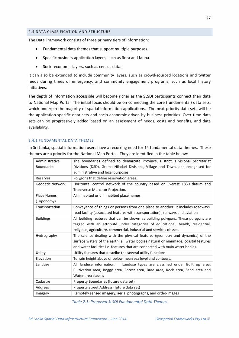
Sri Lanka Spatial Data Infrastructure Framework - June 2014 Geospatial Frameworks Pty Ltd
27
2.4 DATA CLASSIFICATION AND STRUCTURE
The Data Framework consists of three primary tiers of information:
• Fundamental data themes that support multiple purposes.
• Specific business application layers, such as flora and fauna.
• Socio-economic layers, such as census data.
It can also be extended to include community layers, such as crowd-sourced locations and twitter feeds during times of emergency, and community engagement programs, such as local history initiatives.
The depth of information accessible will become richer as the SLSDI participants connect their data to National Map Portal. The initial focus should be on connecting the core (fundamental) data sets, which underpin the majority of spatial information applications. The next priority data sets will be the application-specific data sets and socio-economic driven by business priorities. Over time data sets can be progressively added based on an assessment of needs, costs and benefits, and data availability.
2.4.1 FUNDAMENTAL DATA THEMES
In Sri Lanka, spatial information users have a recurring need for 14 fundamental data themes. These themes are a priority for the National Map Portal. They are identified in the table below:
Administrative Boundaries
The boundaries defined to demarcate Province, District, Divisional Secretariat Divisions (DSD), Grama Niladari Divisions, Village and Town, and recognised for administrative and legal purposes.
Reserves Polygons that define reservation areas. Geodetic Network Horizontal control network of the country based on Everest 1830 datum and
Transverse Mercator Projection. Place Names (Toponomy)
All inhabited or uninhabited place names.
Transportation Conveyance of things or persons from one place to another. It includes roadways, road facility (associated features with transportation) , railways and aviation
Buildings All building features that can be shown as building polygons. These polygons are tagged with an attribute under categories of educational, health, residential, religious, agriculture, commercial, industrial and services classes.
Hydrography The science dealing with the physical features (geometry and dynamics) of the surface waters of the earth; all water bodies natural or manmade, coastal features and water facilities i.e. features that are connected with main water bodies.
Utility Utility features that describe the several utility functions. Elevation Terrain height above or below mean sea level and contours. Landuse All landuse information. Landuse types are classified under Built up area,
Cultivation area, Boggy area, Forest area, Bare area, Rock area, Sand area and Water area classes
Cadastre Property Boundaries (future data set) Address Property Street Address (future data set) Imagery Remotely sensed imagery, aerial photographs, and ortho-images
Table 2.1: Proposed SLSDI Fundamental Data Themes

Sri Lanka Spatial Data Infrastructure Framework - June 2014 Geospatial Frameworks Pty Ltd
28
Cadastral data is collected by Survey Department and used by Bim Saviya Programme to issue a title certificates for the land parcels. It could also be linked with eSLIMS (Electronic State Land Information Management System) Project to manage government owned land and alienations.
Currently street address data is collected by various government agencies in the course of their business. This means there are several address data sets throughout government – each having different levels of accuracy and currency and different data standards and models for recording information.
These address data sets are not currently geocoded. Consideration should be given to creating a geocoded address as a future fundamental data set. This database will evolve to be an extremely valuable asset for government. The majority of business operations rely on knowing peoples address - house number, street name and street suffix (i.e. Road, Lane, and Avenue), Locality name and Postcode. It enables efficient billing services, location-based navigation, postal services, census collection and emergency dispatch.
Aerial photography is fundamental to the National Spatial Data Infrastructure. It is a valuable data source and underpins many spatial information applications. It also aids in rapid data capture of land related information and can be used to assist in the identification of land parcel boundaries. Imagery is costly to collect. It is recommended that data be freely available for viewing; however commercial rates should apply to imagery used by non-government organisations, else acquisition is not sustainable in the long term. At present, there is limited up-to-date high resolution aerial photography covering Sri Lanka. Consideration should be given to the capture and processing of aerial photography, particularly in the rural provinces where there is little surveyed data/knowledge. The benefits would far outweigh the initial expense of capture.
2.4.2 SPECIFIC BUSINESS APPLICATION DATA
There are various application data sets collected across government for specific business purposes. These provide a valuable source of information for planning and economic development. Consideration should be given to making these data available online. In order to do so, a catalogue of application data sets needs to be developed for each agency. These catalogues will combine to become the National Map Catalogue and be used to provide access to all government spatial data. The table below list some of the applications data sets available across government. A full inventory is required.
Hazard Risk Maps National hazard (risk) profiles (drought, flood, sea surge, cyclone, coastal hazards)
Transport Conveyance of things or persons from one place to another. It includes roadways, road facility (associated features with transportation) , railways and Aviation
Bio-diversity Location of flora and fauna excluding restricted species
Environmentally Sensitive Areas
Environmental Resource Profiles of environmentally sensitive areas and protection areas of Sri Lanka
Planning Schemes Land use planning schemas for each region
Table 2.2: Example application data sets collected by government organisations

Sri Lanka Spatial Data Infrastructure Framework - June 2014 Geospatial Frameworks Pty Ltd
29
2.4.3 SOCIO- ECONOMIC LAYERS
The majority of socio economic data is collected by the Department of Census and Statistics. Maps are generated from the statistical analysis of census data. These maps are available in PDF format on the department’s website (Table 2.3). However, the PDF format does not allow integration with other spatial information. Nonetheless, the Department of Census and Statistics use a standard GIS software package to map census data and this information can be converted to a standard format for inclusion in the National Map Portal. The main restrictions are limited GIS resources (human and computing) to undertake the conversion task. In addition, there is a requirement for more statistical information to be converted to map form.
Literacy rates for selected 119 DS divisions, 2001
Unemployment rates for selected 119 DS divisions, 2001
Percentage of households not using toilets exclusively for selected 119 DS divisions, 2001
Percentage of one roomed housing units for selected 119 DS divisions, 2001
Province, District and Divisional Secretary's (DS) division boundaries in Sri Lanka, 2005
Selected 119 Divisional Secretary's (DS) divisions
Head count index (Percentage of household population below poverty line) by DS division, 2002
Daily milk production in the selected 119 DS divisions, 2002
Number of industrial establishments with persons engaged less than 10 for selected 119 DS divisions, 2003/04
Percentage share of manufacture of food products and beverage industries for selected 119 DS divisions, 2003/04
Percentage of households not using safe drinking water for selected 119 DS divisions, 2001
Percentage of agricultural households for selected 119 DS divisions, 2002, activities for selected 119 DS divisions, 2002
Percentage of agricultural households with highest share of income from agricultural
Percentage of paddy holdings for selected 119 DS divisions, 2002
Percentage of households not using electricity for lighting for selected 119 DS divisions, 2001
Percentage of untrained teachers for selected 119 DS divisions, 2005
Number of industrial establishments with persons engaged 10 and more for selected 119 DS divisions, 2003/04
Percentage of schools with 1-50 students for selected 119 DS divisions, 2005
Table 2.3: Socio-economic statistics available in map form the Department of Census and Statistics

Sri Lanka Spatial Data Infrastructure Framework - June 2014 Geospatial Frameworks Pty Ltd
30
2.4.4 DATA SET INVENTORY
To achieve an understanding of the country’s data holdings and be able to fully document the classification system and structure, a full inventory of spatial data held by institutions is required. The investigation should identify spatial data format, metadata, currency, accuracy, ownership, and business needs. It will be important to differentiate what data sets are used by organisations as a reference only (thus highlighting the benefits of an online Map Portal for data viewing); and what data sets are collected and managed (thus identifying any areas of duplication). Importantly, the inventory will also serve to create the online catalogue required for the National Map Portal (see Chapter 4.9.1). An example of a data inventory profile for the Administrative Boundary Theme is included in Appendix 6, and an example of a data set profile for parishes (a data set within the Administrative Boundary Theme) is included in Appendix 7. The Profiles include the following:
• Theme Description: Defines the data them and provides a general overview.
• Theme Uses: Lists general applications the theme is suitable for.
• Relationships: Describes how a theme is related with other base map themes.
• Data content: Lists datasets included in the data theme.
• Status: Current and future state of data sets.
• Standards: Lists published standards wherever possible.
• Data Theme Stewardship: Organisation responsible for data theme content.
• Data Set Custodian: Organisation producing and managing the individual data sets.
• Primary Data Users & Stakeholders: agencies and other organisations actively using (or with the potential to use) the dataset.
Important Note: Not all government spatial information is currently in digital format. Some of the country’s wealth of knowledge is stored as paper-based documents/maps. This information will make a valuable contribution to the SLSDI when it is converted to digital form, and should be considered in the data inventory process.
2.4.5 ACCESSIBILITY LEVELS
In Sri Lanka, data have varying degrees of confidentiality. The National Map Portal has the capability to assign different access levels to different data sets based on what information should be released in the national interest. There needs to be a balance between making information openly available for public good and economic growth; with the need to restrict access for the protection of individual rights and national security.
There are times when certain classes of spatial data need to be withheld from public access and usage. For example, the location of gem deposits, defence establishments, detailed bathymetry of harbour approaches, culturally sensitive sites and the location of endangered species.
There are also times when withholding data can degrade decision-making processes, such as emergency planning and response, and environmental management. While it is recognised that some data cannot be made public because of its sensitivity; data should still form part of the National

Sri Lanka Spatial Data Infrastructure Framework - June 2014 Geospatial Frameworks Pty Ltd
31
Data Framework and managed by nominated custodians. Authorised users can be given access for business purposes and mechanisms can be introduced to ensure privacy, national security and other sensitivities are not compromised.
Importantly, the issue is not about whether spatial data should be collected and made accessible, but rather what restrictions will be applied to its usage and how this should be decided.
The increasing availability of high resolution imagery of the earth’s surface brings the issue of access to sensitive data into clear focus. New satellite imaging capabilities showing all visible features to high levels of resolution (anything bigger than half a metre) are available to any users on demand. These images are collected and held by both the public and private sectors. There are no existing laws or guidelines in Sri Lanka on how this imagery may be made available and used. Issues about access to sensitive data are not widely understood within either the public or private sectors.
Investigation of issues related to access to sensitive data is required to define:
• A Policy (or guideline) for agencies holding sensitive data ( See Section 7.4.6)
• A document that specifies a set of issues relating to potential national security restrictions on publicly available data.
• Ongoing access to sensitive data needed by emergency management and counter-terrorism agencies for operational purposes.
• A risk assessment tool that weights the risk to benefits of not providing open access, against the risk of possible damage to Sri Lanka economically, socially and environmentally.
The data access level categories are:
• Public access (including research and teaching)
• Government access only – all agencies
• Restricted content - Institutional/organisational access only
It is recommended that all fundamental data themes are publicly accessible; and that government spatial data is accessible to all organisations via the National Map Portal, unless it is considered confidential. Guidelines for managing sensitive data and determining access restrictions are included in Section 7.4.6 of this document.
2.5 CUSTODIANSHIP ROLES AND RESPONSIBILITIES
For each data set in the Data Framework there is a designated custodian responsible for its capture and maintenance. However, with duplication of data sets occurring across government, clear responsibility for data custodianship may not initially be possible for all data sets. For example, Administrative boundary data are collected by three organisations - Survey Department, Department of Census and Statistics and Urban Development Authority.
These Administrative Boundary data sets are updated as part of each organisations business process. To generate productivity improvement only one data set should be maintained and updated. In this

Sri Lanka Spatial Data Infrastructure Framework - June 2014 Geospatial Frameworks Pty Ltd
32
instance, the official data custodian is the Survey Department; however overtime the Administrative Boundary data has become out of synchronisation (in terms of accuracy and currency) with the Administrative Boundary data sets managed by the Department of Census and Statistics and the Urban Development Authority. This means that a single authoritative source is not known and the custodianship for the data set has become unclear.
Data custodians are generally the organisation (not the business unit) that has the best economic position to justify collection of the spatial information and usually acknowledged as the authoritative source. Custodians are often the agency which has the greatest operational need for the data and are the first to record changes. The choice of consideration is also given to the level of competency for data capture and maintenance.
It is recommended that the Survey Department establish a project in collaboration with the Department of Census and Statistics and Urban Development Authority to rationalise the three data sets to create a single source of truth data set.
In the SLSDI data custodians should consider the needs of the SLSDI community as a whole and not just their own organisation’s needs. This means consulting with the community in regard to:
• Data needs and areas of priority maintenance.
• Use of appropriate data and quality standards to ensure interoperability.
• Ensuring spatial information is both accessible and readily available.
• Ensuring appropriate storage, maintenance, security and archival procedures.
• Safeguarding the Government's interest in the use of its information through licensing agreements or letters of understanding to protect privacy and confidentiality and interpretation of the information.
• Discouraging duplication by other organisations through ignorance.
• Nominating a single point of contact for enquiries.
• Providing metadata statements describing the data.
In establishing the Data Framework, an invitation should be extended to organisations to become the recognised authority and custodian for an SLSDI data theme and data set. In this way each organisation will have the opportunity to take into account the roles and responsibilities of being a custodian, and whether it is appropriate for them to take on these responsibilities or not. If they cannot meet these requirements, or find that by meeting these requirements it constrains the operations of their activities, the agency should consider relinquishing their custodianship to another agency.
In the interests of maintaining completeness in the information holdings, the agency relinquishing its custodianship has the responsibility of finding another agency to take on the role of custodian. This responsibility is particularly important in the situation where the information is defined as a fundamental dataset.

Sri Lanka Spatial Data Infrastructure Framework - June 2014 Geospatial Frameworks Pty Ltd
33
2.6 TECHNOLOGY
2.6.1 SOFTWARE
There are various Geographic Information Systems (GIS) used by the government sector. For data capture the majority of organisations are using ArcGIS (ArcView and ArcEditor by ESRI), QGIS (free open source software) and MicroStation (Bentley Systems). Database formats are particular to each system. However, transfer between systems is possible with minimal loss to data structure.
For high-end users such as the Survey Department and those undertaking complex analysis; the ArcGIS solution is the most suitable and conforms to Open Geospatial Consortium (OGC) standards. It is also the most suited to managing large databases in an enterprise environment. However, the software is expensive and the cost of upgrades put the technology out-of-reach of most organisations. The pragmatic solution is to minimise the number of licenses required by allocating QGIS to low-end users and those undertaking basic GIS work.
An alternative approach that can be considered under the auspices of the SLSDI is for government to negotiate a whole-of-government Licencing approach. Vendors are often open to a change in their government arrangement if it simplifies their procurement and supply processes. The alternative options are:
• Option 1: Full licensing arrangements remain with each agency or business area to negotiate requirements and price (this is the current practise), or
• Option 2: A whole-of-government license arrangement administered by a central unit (or NSDI Office (see section 6.3.1); or
• Option 3: Licenses managed by agencies but with an agreed price schedule for all government agencies negotiated by the NSDI Office.
Option 3 is recommended. It is possible to negotiate a whole-of-government volume discount. This is especially beneficial to the smaller government organisations and it avoids individual agencies having to undertake the complicated negotiations with each vendor, as is the case with Option 1. While it is likely that a better price could be achieved with Option 2; there are difficulties for government in estimating, managing and monitoring the number of licenses allocated for use by each agency. This is because the central unit managing the licensing would not have an insight into the GIS requirements of each individual business unit across government.
2.6.2 SEAMLESS DATA COVERAGE
The Survey Department manages a 1: 50,000 Topographic Series which is stored as a seamless data set for the entire country. However, most other organisations store information in individual files based on administrative districts. They do this for three reasons:
• There is no enterprise-wide system in place and therefore multi-user editing of a single database is not possible.
• Central data storage is limited with many data editors working and storing data on personal computer hard drives.

Sri Lanka Spatial Data Infrastructure Framework - June 2014 Geospatial Frameworks Pty Ltd
34
• A seamless national dataset requires additional computer processing capacity, which some existing systems lack.
As a long term goal, consideration should be given to working towards seamless national coverage as data mismatching between individual map tiles is problematic. It will also simply the management, warehousing and access of data sets via the National Map Portal.
As an example, a seamless database can be achieved by moving to a Spatial Data Enterprise (SDE) environment that provides access to the underlying database for multi-user editing using transaction management processes. The software includes a catalogue for managing the collection of metadata entries and utilises a catalogue service to respond to requests for data with certain browse or search criteria. Key aspects of the SDE environment are shown in Figure 2.2. They are:
• Data Management Services: Provides storage of data in a database management system including a file-based repository and/or a data warehouse. This includes a catalogue service for accessing data.
• Job Tracker: This simplifies the management of data versions by tracking transactions performed by multiple users and enables multiple iterations of updates to be consistently posted back to the database.
• Application Services: These serve the data to clients. A client-server arrangement includes resources such as files, databases and printers that are managed by servers. Request for access to these managed resources is generated by clients. When a server fulfils the request of a client it is said to have serviced the client.
• Client Interfaces: These range from web services for ‘Thin Clients’, which use standard Internet/Web tools to access spatial information that is suitable for display as one or more layers in a map; and ‘Thick Clients’ that access data via a Web browser plug-in, or standalone customised or generic application where network access is via a distribution computing platform.
Figure 2.2 Components of an enterprise-wide environment
Sri Lanka Spatial Data Infrastructure Framework - June 2014 Geospatial Frameworks Pty Ltd
35
The task of bringing together all the map tiles (nationwide) will be a time consuming process, taking years of work to complete. The costs associated with the management of an enterprise system are also expensive and this is likely to prohibit use at the present time. A detailed cost/benefits analysis is required before progressing down this path. Some advantages include:
• Ability to manage large GIS databases
• Provides back-office processing of enterprise GIS databases
• Centrally hosts GIS functions that can be accessed by many users in an organisation
• Provides distributed GIS computing which will allow District offices and Divisional District Secretaries to update GIS data online directly into the primary source data.
• Enables end-specific user functionality, such as shared and saved bookmarks, shared and saved views, and saved queries.
• Allows direct publishing of maps to end-users through standardised map documents
• Supports database-driven searching of features, attribute information and other enterprise-level information
2.7 STANDARDS AND COMPLIANCE
2.7.1 ISO STANDARDS
The International Organisation for Standardization (ISO) has developed a group of International Standards called the ISO/TC211 19100 series that support data management, acquisition, processing, analysis, access, presentation and transfer of data between different users, systems and locations.
These standards are organised into themes for a Spatial Data Infrastructure Framework:
• Architecture and Framework • Metadata, Data Content and Definitions
• Core Data Model • Data Exchange Formats
• Data Interchange and Services • Data Quality
• Spatial Referencing • Imagery
The Standards that the spatial community mainly use are from the Metadata, Data Content and Definitions, and Data Exchange themes (See section 2.8). These assist in discovery and access to information. The Standards under this theme relevant to Sri Lanka are:
• ISO 19110 – Methodology for Feature Cataloguing: Defines the methodology for cataloguing feature types. It specifies how a classification of feature types are organised into a feature catalogue and presented to the users of a set of geographic data. It applies specifically to the cataloguing of feature types that are represented in digital form but its principles can be extended to the cataloguing of other forms of geographic data.
• ISO 19115 – Metadata: Defines metadata elements, provides a schema and establishes a common set of metadata terminology, definitions, and extension procedures. It also defines the schema required for describing spatial information and services and provides information

Sri Lanka Spatial Data Infrastructure Framework - June 2014 Geospatial Frameworks Pty Ltd
36
about the identification, the extent, the quality, the spatial and temporal schema, spatial reference, and distribution of digital geographic data.
• ISO 19115-2 – Metadata for Imagery and Gridded Data: Identifies the metadata required to describe digital geospatial imagery and gridded data.
• ISO 19126 – Feature Concept Dictionaries and Registers: Specifies a schema for geographic feature concept dictionaries managed as registers.
• ISO 19131 – Data Product Specifications: Describes requirements for the specification of geographic data products, based upon the concepts of other ISO 19100 International Standards. Examples include land use codes, surveyor codes, data dictionaries for cadastre, geographical place names, bathymetry etc. It describes the content and structure of a data product specification and it also provides help in the creation of data product specifications, so that they are easily understood and fit for their intended purpose.
• ISO 19139 – Metadata XML Schema Implementation: Defines Geographic Metadata XML encoding, an XML schema implementation derived from ISO 19115. It provides Extensible W3C Mark-up Language (XML) schemas that enhance interoperability by providing a common specification for describing, validating and exchanging metadata about geographic datasets, dataset series, individual geographic features, feature attributes, feature types, feature properties, software etc.
• ISO 19144-1 – Classification Systems-Part 1: Establishes the structure of a geographic information classification system, together with the mechanism for defining and registering the classifiers for such a system. It specifies the use of discrete coverage’s to represent the result of applying the classification system to a particular area and defines the technical structure of a register of classifiers in accordance with ISO 19135 (Procedures for Item Registration).
• ISO 19136 – Geography Markup Language: Used for data exchange including Geography Markup Language (GML), XML 3D (X3D), Uniform Resource Identifiers (URI).
Standards specifically dedicated to the quality of geographic Information include (ANZLIC, 2014):
• ISO 19113 on the specific concepts
• ISO 19114 on the principles for quality evaluation and, together with
• ISO 19138, on the description of quality assessment methodologies,
• ISO 19131 on specifications,
• ISO 19115 on the reporting of quality assessment results as metadata, and
• ISO 19139 on the implementation of metadata communication.
It is recommended that Sri Lanka adopt a standards-based approach to spatial data management in order to facilitate data sharing and increase interoperability among geographic information systems (GIS). It will then be possible for custodians to:
• provide detailed quality statements regarding source, reliability, accuracy, completeness and currency; and
• maintain the quality of the datasets assigned to them.
Sri Lanka Spatial Data Infrastructure Framework - June 2014 Geospatial Frameworks Pty Ltd
37
2.7.2 COMPLIANCE
Currently few organisations implement internationally recognised standards. This is partly because specialists in the actual production of spatial data are not experts in modelling, nor are they accustomed to the ISO “language”. There is a gap between the knowledge about standards and knowledge about how to use (implement) the standards. In order to fill the gap between standardisation specialists and production specialists; it is recommended that seminars and other training programs be held to educate and increase the knowledge of GIS professionals about implementing standards across the government sector. It is important that there are people within each organisation that have competency in both the application of standards and in GIS work processes. With educated staff, there is a stronger likelihood that organisations will comply with standards.
2.8 METADATA
Metadata describes the origin of geographic data and tracks the changes to a data set over time. Metadata refers to the ‘who’, ‘what’, ‘why’, ‘where’, ‘when’ and ‘how’ about individual geospatial data sets and how they have been collected (Nebert, 2004).
The concept of metadata can be likened to a library catalogue which includes metadata records that help a person discover, use and manage a collection of books, documents and other information. Metadata for digital spatial data is no different; except that the emphasis is on the spatial component and includes producer, extent, accuracy, datum and other characteristics.
Metadata for spatial information is required for a range of purposes. Among other things, metadata is used to provide:
• detailed information about data collection methods, integration and analysis techniques applied to source data that is required to support the preparation of scientific reports;
• information about the accuracy of source datasets, processing history, and archival procedures that is required to effectively manage consistency and utilise data within custodian organisations;
• information about projection specifications, scale, exchange format, compression and file system format that should accompany data transfers to other organisations;
• adequate descriptions of the content, quality and geographic extent of datasets that are required so potential users of existing data can assess its suitability for their own purposes;
• summary descriptions of content and quality, as well as, contact information that is required for inclusion in directory systems; and
• information about access software for datasets, as well as, software parameters that are needed for direct online display and query of data (ANZLIC, 2002).
Metadata is managed at different levels including ‘discovery’, ‘exploration’ and ‘exploitation’. Discovery metadata is used to find out what data sets are available and provides a mechanism by which an agency can publish their data holdings. Metadata also allows for user exploration so that a user can determine if the currency and accuracy of data are sufficient for data analysis. Exploitation

Sri Lanka Spatial Data Infrastructure Framework - June 2014 Geospatial Frameworks Pty Ltd
38
metadata includes those properties required to access, transfer, load, interpret and apply data in end applications where it can be exploited by the user.
Metadata is important information for spatial data management and access, and needs to be managed carefully to achieve a successful SDI implementation. Metadata is important from the perspective of an agency, user and system administrator/designer. Without metadata it is difficult to access geospatial data and, when located, impossible to determine its usefulness for mapping and analysis.
From an agency view point, metadata assists an agency to organise and maintain its investment in data and can be used to publicise information about an organisation's data holdings in catalogue form. This avoids duplication of effort by ensuring that the organisation and its stakeholders are aware of the existence of data sets.
From the perspective of users, metadata helps them to locate the geospatial and associated data relevant to an area of interest. Users also require metadata to gain an understanding of the accuracy, currency and resolution of data so that they can determine if it is fit for a particular purpose.
From a system design/administration perspective, having a reliable collection of metadata enhances the data management procedure for the entire geospatial community. Metadata can exist for datasets, web services and project information. Spatial metadata can be searched through a common web interface known as a Spatial Data Directory (SDD) or Data Catalogue.
2.8.1 METADATA CATEGORIES
The minimum metadata categories to enable efficient data access and use include:
• Identification: What is the name of the data set? Who developed the data set? What geographic area does it cover? What themes of information does it include? How current are the data? Are there restrictions on accessing or using the data?
• Data Quality: How good are the data? Is information available that allows a user to decide if the data are suitable for his or her purpose? What is the positional and attribute accuracy? Are the data complete? Was the consistency of the data verified? What data were used to create the data set, and what processes were applied to these sources?
• Spatial Data Organisation: What spatial data model was used to encode the spatial data? How many spatial objects are there? Are methods other than coordinates, such as street addresses, used to encode locations?
• Spatial Reference: Are coordinate locations encoded using longitude and latitude? Is a map projection or grid system used? What horizontal and vertical datums are used? What parameters should be used to convert the data to another coordinate system?
• Entity and Attribute Information: What geographic information (roads, houses, elevation, temperature, etc.) is included? How is this information encoded? Were codes used? What do the codes mean?

Sri Lanka Spatial Data Infrastructure Framework - June 2014 Geospatial Frameworks Pty Ltd
39
• Distribution: From whom can I obtain the data? What formats are available? What media are available? Are the data available online? What is the price of the data?
• Metadata Reference: When were the metadata compiled? By whom?
Example Metadata is available from the Federal Geographic Data Committee (FGDC, 1998). A Checklist for Creating Metadata is included in Appendix 7.
2.8.2 CURRENT METADATA MANAGEMENT PRACTICES
Many of the geographic datasets collected and maintained by central government have some form of metadata associated with them. The format of this metadata ranges from word documents (reports and spreadsheets) to GIS catalogues currently being developed by the Survey Department. Having this initial source of maintained metadata is a significant step towards establishing the online catalogue. In addition, some metadata in the form of notes have been collected at intervals during data processing and this information can be assembled at a later date into a clear statement of the history and processing of the dataset. Indeed, some valuable work has already been achieved by Survey Department during the preparation of maps at scale 1:10,000 and 1:50,000.
2.8.3 NEED FOR METADATA STANDARDS
Ideally, metadata structures and definitions should be referenced to an existing internationally recognised standard. These standards have been developed through a consultative process with experts in the field. They form the foundation from which a national Spatial Data Directory can be developed.
A standard provides a basis from which agencies and data custodians will be able to further develop individual profiles to meet their own detailed specific needs, particularly for data management within an organisation. It is also probable that if a standard is well accepted within the geospatial community, commercial tools will be developed to assist in its implementation (Nebert, 2004).
The International Standards Organisation (ISO), through its Technical Committee for Geographic Information/Geomatics (ISO/TC 211), has published an International Standard for Metadata (ISO 19115:2003). This standard is supported by the OpenGIS Consortium (OGC). ISO 19115 specifies the schema required for describing geographic information and services. It provides information about the identification, extent, quality, spatial and temporal schema, spatial reference, and distribution of digital geographic data (see also section 2.7.1).
Standardisation and consistency are necessary to ensure that comparisons can be made by data users about the suitability of data from different sources. The Government of Sri Lanka needs to give consideration to adopting the standard ISO 19115 standard and stay within its constructs.
2.8.4 METADATA CREATION
The form of metadata creation and its maintenance will depend on the size of organisations data holdings and the patterns of data management within the organisation. Traditionally, organisations with modest data holdings have stored metadata in conventional discrete word processing documents. This is the case with many of the application data sets developed and maintained by
Sri Lanka Spatial Data Infrastructure Framework - June 2014 Geospatial Frameworks Pty Ltd
40
agencies, such as the land use, forestry and environmental data sets. Data themes, capture dates and data resolution can be extracted from the word documents and stored in the GIS catalogue as part of the SLSDI implementation. This methodology is sufficient for the current size of data holdings and business requirements.
However, as the metadata holdings start to increase consideration needs to be given to investigating more advanced aspects of GIS to extract aspects of the metadata from the data itself. This is however, not essential to SLSDI implementation at the present time.
Metadata should be created with a view to supporting the implementation format within a database or software system; an export (encoding) format for transfer between computers and; presentation formats for viewing. In this way, the system will support business and operational requirements, standard encoding for data exchange and permit a number of ‘report’ views of the metadata that will satisfy the needs and experience of the different users.
Consideration should be given to using the Extensible Mark-up Language (XML). XML is a widely accepted encoding methodology with international software support. It can be used to create a structured exchange format and supports flexible presentation.
Metadata validation is an important business process. However, there are few tools available to automatically verify the accuracy of the metadata other than those tools for checking the syntactical structure of the metadata. Human review is required and should be incorporated into an organisations business process.
2.8.5 METADATA MANAGEMENT AND RESPONSIBILITY
There are several models for where catalogue services might be installed within or among organisations. Generally speaking, a catalogue server is usually installed at the level of organisation appropriate to the nature of the data or metadata, the organisational context or mandates, and the level at which a catalogue can be operationally supported.
The management of the metadata is best left with the agency that collects and maintains the data itself. However, the metadata catalogue for the National Map Portal is more appropriately managed by a central coordinating team (NSDI Office), which can ensure consistent metadata management across organisations and thus ensure a consistent means of data access via the National Spatial Data catalogue.
Currently, the Survey Department have the responsibility for creating the metadata catalogue for all the fundamental data. Metadata creation is a collaborative effort between the data producer and metadata creator. This is a ‘best practice’ corporate approach to metadata management - the data producer works with the catalogue producer to create metadata that meets the data producers needs for referencing data sets and the system designers needs for creating avenues for user access.
Sri Lanka Spatial Data Infrastructure Framework - June 2014 Geospatial Frameworks Pty Ltd
41
2.8.6 RISKS
There is a risk that data producers will consider the task of creating metadata for their data sets too hard or they may have insufficient time to complete the task. This is particularly the case for organisations that have hundreds of legacy data sets.
Managers of organisations may need to commit additional human resources to the task and be conscious of the fact that a day or two spent documenting each data set is small expense when compared to the months taken to produce the data set in the first place. Metadata based on International standards and incorporated into the Spatial Data Infrastructure will have far reaching ‘long term’ benefits for both data producers and the spatial information user community.
2.9 STORAGE AND ARCHIVING
The storage capacity within all government organisations is currently under capacity and data are at risk. Current procedures require urgent reform. Several organisations have anecdotal evidence of data loss through corrupted storage devices.
Many organisations store data on computer hard drives and this information is only accessible to computer owner/user. In many cases this is the only copy of the information and as such the risk of information loss is extremely high as hard drive failure is common.
ICTA has implemented cloud storage for government data. This provides much needed storage capacity for government. However, few organisations are connected; mainly due to a lack of awareness of the storage facility. Cost may also be a limiting factor.
Standard principles for data storage are:
• Data Security: Data are maintained in a secure environment and transmitted through secure methods.
• Storage: Data are held with adequate provision for long-term care including disaster recovery and backup procedures.
• Disposal: Data that are not required are disposed of, or archived in accordance with Government record keeping legislation.
Sri Lanka Spatial Data Infrastructure Framework - June 2014 Geospatial Frameworks Pty Ltd
42
2.10 RECOMMENDATIONS
Due to the fact that good data management is integral to the development of the SLSDI the following recommendations are made concerning developing an overarching framework, working with data sets, establishing standards and safeguarding information.
Recommendation 2.1: That a Data Framework is developed
It is recommended that a Data Framework be developed for the SLSDI. This document should include an inventory of available and future data sets. It should include profiles for data themes and data sets. Consideration should be given to employing a consultant to develop the SLSDI Data Framework template as a practical guide to best practise. This document can then be progressively populated by the NSDI Office as the inventory is conducted.
Recommendation 2.2: That a full Data Inventory is conducted
It is recommended that a full inventory of data sets across the government sector be conducted, as well as, an inventory of data holdings managed by the private sector.
Recommendation 2.3: That a Change Management Plan is developed
It is recommended that a Change Management Plan be developed for each data theme/data set in the SLSDI Data Framework. This document identifies the current state of each data set, the required future state and the detailed actions required to move from one state to another. This is a critical component in the SLSDI Road Map. Consideration should be given to employing a consultant to assist in the development of the Data Framework Change Management Road Map.
Recommendation 2.4: That Administrative Boundary Data Sets are rationalised
It is recommended that the Survey Department establish a project in collaboration with the Department of Census and Statistics and Urban Development Authority to rationalise the three Administration Boundaries data sets currently in use to create a single source of truth data set.
Recommendation 2.5:That a Cadastral Map Layer is included in the National Map Portal
Consideration should be given to including a cadastral map layer as a spatial information resource via the National Map Portal. Having access to land parcel boundaries will support future land use management, environmental reporting and disaster management strategies.
Recommendation 2.6: That Geocoded Address Data are created
Once the cadastral system has been progressed, consideration should be given to creating a geocoded address database linked. This database will evolve to be an extremely valuable data set for the Government of Sri Lanka as the business community rely on addresses data for their operations.

Sri Lanka Spatial Data Infrastructure Framework - June 2014 Geospatial Frameworks Pty Ltd
43
Recommendation 2.7: That aerial photography and satellite imagery is captured and processed
Consideration should be given to the capture and processing of aerial photography and satellite imagery, particularly in the outer lying provinces where there is little surveyed data/knowledge. Also, LIDAR imagery is required for coastal zone monitoring and modelling to understand the impacts of storm surge and coastal erosion. The benefits from being able to rapidly capture topographic data, analyse the terrain and monitor environmental change, will outweigh the initial expense of capture.
Recommendation 2.8: That Socio-economic Data be converted into map form
Consideration should be given to converting census information to map form and making it available in a standard format so that it can be integrated with other information.
Recommendation 2.9: That Custodianship Arrangements are agreed
In establishing the Data Framework, an invitation should be extended to organisations to become the recognised authority and custodian for an SLSDI data theme and data set. In this way each organisation will have the opportunity to take into account the roles and responsibilities of being a custodian, and whether it is appropriate for them to take on these responsibilities or not.
Recommendation 2.10: That GIS Software Licensing is negotiated
Consideration should be given to negotiating a whole-of-government volume discount for GIS software to reduce the cost of software purchases and maintenance contracts. The most suitable approach is for software licenses to be managed by organisations but with an agreed price schedule for all government agencies negotiated by the NSDI Office.
Recommendation 2.11: That progress is directed towards Seamless National Map Coverage
As a long term goal, consideration should be given to moving towards seamless national map coverage for data sets. This will require moving to an Enterprise GIS environment that permits multiuser access and updating. The major benefits are a reduction in overheads due to edge matching along District boundaries, and simplified access to nationwide information via the National Map Portal. Disadvantages are the time to join all individual map tiles and high costs associated with managing an Enterprise system.
Recommendation 2.12: That an urgent reassessment of Data Storage and Archiving is conducted
It is recommended, as a matter of urgency, that organisations reassess their current data storage and archival processes. The storage capacity within all government organisations is under capacity and there is a high level of risk to loss of data through corrupted devices. Cloud storage should be one of the options considered.

Sri Lanka Spatial Data Infrastructure Framework - June 2014 Geospatial Frameworks Pty Ltd
44
Recommendation 2.13: That a Standards-based approach to spatial data management is adopted
It is recommended that government organisations adopt a standards-based approach to spatial data management in order to facilitate data sharing and increase interoperability between systems.
Recommendation 2.14: That Metadata ISO Standards are adopted
It is recommended that a metadata standard ISO 19115 be adopted for the spatial data schema a national profile be built in line with the ISO 19139 Technical Specification to enable interoperability globally.
Recommendation 2.15: That a Master version of Metadata be Created and closely controlled
It is recommended that agency metadata managers prioritise their data sets starting with the framework data sets (as they are more frequently used) and proceeding to the purpose-specific application datasets. Each organisation should ensure that there is a clearly identified authoritative version of each of the data directories it maintains. Management of the master version should be closely controlled by the organisation.
Recommendation 2.16: That the NSDI Office be the custodian of a Sri Lanka Spatial Data Directory
The data dictionaries identified by each government institutions should be made available for inclusion in the Sri Lanka Spatial Data Directory (SLSDD). The NSDI Office is to be the custodian of the Sri Lanka Spatial Data directory and be responsible for its development and maintenance. The NSDI Office should maintain a list of participating organisations and make this list available online.
Recommendation 2.17: That training in Standards and Metadata Compliance be conducted
It is recommended that seminars and other training programs be held to educate and increase the knowledge of GIS professionals about implementing standards and metadata across the government sector.
Recommendation 2.18: That data access protocols be adopted to identify Access Levels
It is recommended that a document is prepared detailing data access protocols. This document will (a) identify data themes that are publicly accessible and free to view online via the National Map Portal; (b) specify a set of issues relating to potential national security restrictions on publicly available data (c) identify ongoing access to sensitive data needed by emergency management and counter-terrorism agencies for operational purposes; and (d) a risk assessment tool that weights the risk to benefits of not providing open access, against the risk of possible damage to Sri Lanka economically, socially and environmentally.
Sri Lanka Spatial Data Infrastructure Framework - June 2014 Geospatial Frameworks Pty Ltd
45
3. SUPPLY CHAIN FRAMEWORK Spatial information in Sri Lanka is managed by government organisations with offices at the national to local level. The supply chains are highly vertically integrated. Organisations handle everything from spatial data capture to the production of maps and survey plans, with bi-directional information flows between the various administrative units (levels of government).
Between government organisations spatial data supply chains are characterised by disintegration and as a consequence, spatial information management has become more complex.
There are four main challenges for the government of Sri Lanka.
• The first challenge is to effectively manage supply chain complexity and create sustainable solutions by automating the entire supply chain from upstream to downstream activities.
• The second challenge is to develop solutions that are consumer-centric, where the broader community has access to information that affords a knowledge proposition; not just a standard information offering. This means not only providing access to spatial information, but also providing the means to query and search information.
• The third challenge is to create solutions that embrace the online community as an integral part of the spatial data supply chain – locally, nationally and globally.
• The fourth challenge is to develop the required resources especially professional skills and technical infrastructure.
Solutions to these challenges will not be implemented overnight; and several components of the Spatial Data Infrastructure Framework will need to be in place before supply chain management can be improved. This includes a central access point for government spatial data holdings, a Legal and Policy Framework that supports data sharing, and a governance model with powers to drive government reform in spatial information exchange.
CONTEXT AND RATIONALE
There are three key problems driving the need to change the way spatial data supply chains are managed. These are (a) nationwide spatial information is not easily accessible; (b) the authoritative source of spatial information is not always clear; and (c) current data supply chains are inefficient - duplication occurs in data collection, maintenance and integration, product generation and delivery infrastructure.
These problems are compounded by parallel supply chains and the existence of several versions of spatial data managed independently across government. There is also a lack of clarity around the custodianship of some national spatial data sets and who owns and controls Intellectual Property Rights. Competing business priorities across government, combined with financial pressures and skills shortages, make agreements on national data acquisition priorities and maintenance programs difficult.

Sri Lanka Spatial Data Infrastructure Framework - June 2014 Geospatial Frameworks Pty Ltd
46
3.1 CURRENT STATE
The government sector has the will to change the way spatial information supply chains are managed; however there are several underlying issues that are currently impeding progress including:
• Resource limitations and lack of a sustainable funding model to assist data providers to fulfil their role in the broader National interest.
• Lack of coordination mechanism to identify common needs to define collective goals across the broader stakeholder group for national spatial data sets.
• No intellectual Property Rights Management (IPRM) model for national data sets that are made up of contributions from multiple parties, nor one that caters for the mix of different organisation business models – commercial, semi-commercial and public good.
• Limited understanding of the relative value of products produced from spatial information.
• Well entrenched technology and business processes (required to manage existing disconnected data sets) that are difficult to change - both culturally and financially.
• Cross-agency data sets are currently inconsistent in terms of currency and accuracy, and synchronisation is problematic.
• Information is not reaching the community in a timely manner, nor are there effective techniques to source local information from the community.
• There is no centralised procurement for imagery or planned approached to collecting fundamental and application data with respect to cross-government priorities.
3.2 GUIDING PRINCIPLES
The principles underpinning the Spatial Data Supply Chain Framework are:
• Single Source of Truth: Spatial information is managed responsibly by the designated data custodian to eliminate the proliferation of duplicate data sets.
• Timeliness: Spatial data are maintained as close to real-time as possible.
• Data Provenance: The origin and quality of data is readily accessible to the user so that they can determine if it is ‘Fit for Purpose”
• Data Integration: The interrelationships between data themes collected by multiple agencies are managed with topological integrity.
• Demand Planning: Data acquisition and maintenance is aligned to user needs to achieve optimal resource allocation.
• Data Customisation: Spatial Data Products are differentiated as close as possible to the customer to create more opportunities for reuse along the supply chain.

Sri Lanka Spatial Data Infrastructure Framework - June 2014 Geospatial Frameworks Pty Ltd
47
3.3 SUPPLY CHAIN FRAMEWORK
The Supply Chain Framework includes several components that consider the flow of spatial information from its collection point to its delivery as an integrated source of information (Figure 3.1).
Cross-Government Horizontal Supply Chains
Intellectual Property and Licensing
Community Participation Programs
Data Integration
Local-National Vertical Supply Chains
Data Acquisition Program
Financial Models
Figure 3.1 Supply Chain Framework Components
It includes the bi-directional flow of information between the various levels of government, across government organisations and to and from the community of users. Supply chains in Sri Lanka are currently characterised by duplicate data collection and maintenance. The Supply Chain Framework includes a Data Acquisition Program to coordinate cross-government data collection.
The Supply Chain Framework includes community participation programs, such as crowd-sourcing and Volunteered Geographic Information from trusted data providers.
The financial model, employed by government to manage spatial information resources is an important component in the management of information flows. The financial model specifies the flow of funds to collect, manage and maintain data and the flow of revenue from the sale of data products to the contributing organisations. The model used will either create parity between organisations or discriminate against data providing organisations, creating unworkable supply chains. A critical element of the supply chain is clear intellectual property management, and copyright and licensing methods. These play a significant role in managing the individual value chains that occur at intervals in the supply chain.
The Supply Chain itself includes steps where data are acquired and integrated with other data. Each step constitutes a value chain where data are improved, value-added and potentially generalised in some way according to a business need (Figure 3.2).

Sri Lanka Spatial Data Infrastructure Framework - June 2014 Geospatial Frameworks Pty Ltd
48
ValueChain
ValueChain
ValueChain
Primary Supplier
Supplier ProductManufacturer Customer
Final Customer
Flow of customer information or backhauls
Flow of Materials and information
Figure 3.2 Steps in the Primary Supply Chain
An important component of the supply chain is the linking of geographic elements across themes. This integration of data is what turns non-intelligent spatial data into a knowledge-base (or engine) from which location intelligence can be derived.
3.4 LOCAL-NATIONAL VERTICAL SUPPLY CHAINS
The flow of spatial information between the various levels of government is consistently managed. That is, the sharing of information between the National office (i.e. Survey Department) and Government offices located at the District and Divisional Secretaries. These vertical government supply chains are characterised by consistent data models and data standards particular to each institution (Figure 3.3).
Divisional Secretaries
District Office
Department(Data base creation)
Department(Product creation)
Final Customer
Crowdsourcing not currently deployed
Information Updating
Survey Office
Figure 3.3 Local to National Vertical Supply Chain
There are three main approaches currently employed to update spatial information: Periodic updating, theme focussed updating and business transaction updating. The approach used often depends on the type of information and frequency of data use and customer needs. A fourth method, referred to as Direct Editing, can be used to share updates across the various levels of government. This process is not currently in use, but explained below for completeness.

Sri Lanka Spatial Data Infrastructure Framework - June 2014 Geospatial Frameworks Pty Ltd
49
3.4.1 PERIODIC UPDATING
The most common way of updating fundamental data is through a periodic updating cycle. This is the process used by Survey Department to update topographic data sets. Generally speaking it is a full update, which means that all topographic features within a map tile are updated at the same time. Updates are shared between the various government levels as new data versions. The problem with this approach is that adopting a whole new updated version of the data sometimes requires re-customising local settings and this creates rework. In addition, periodic updates are compromised by the ability to acquire data in a timely fashion. Problems noted included aircraft mechanical problems and prevailing weather conditions, such as cloud cover, which restrict capture to a limited time period (January-March, November -December).
3.4.2 THEME FOCUSSED UPDATING
Theme focussed updating (or incremental updating) is generally used for those data sets that are subject to frequent changes in the environment, such as roads, railways, power lines and buildings. Rather than update all features in a given area, data maintenance is nationwide but for a specific theme. Updates are shared between the various government levels as change files (or incremental updates). Incrementally updating is often more cost effective than versioning.
However, tracking and incorporating incremental updates is essentially a manual process and one that is difficult to manage. Update frequency can vary, ranging from daily/weekly transactions to monthly/yearly cycles. Also, if the duration between updates is lengthy, geographic objects will often assume several different states. A road may be proposed, constructed, closed and possibly re-established. This means that changes need to be tracked carefully and integrated in the correct sequence in order to avoid invalid entries. Otherwise, duplicate updates or omitted entries will corrupt the integrity of the customer’s database.
3.4.3 BUSINESS TRANSACTION UPDATING
Business transaction updating (or continuous updating) is most common for application data themes, such as land use planning, land development, alienation of lands etc. Updates are applied in areas where a business transaction occurs. These updates are continuous with customer needs directing where and when updates are performed. The maintenance process is difficult to manage in decentralised environments. Automated update propagation is currently not possible because the National and District databases are not linked.
3.4.4 DIRECT EDITING
While current data sharing processes are effective between national offices and Districts, they are also extremely manual. It is recommended that current processes remain as is, while the SLSDI is being developed; however consideration should be given to moving to more automated processes in the future. This will require a closely integrated enterprise-wide GIS system (See section 2.6.1) that allows District offices to directly edit national data sets. This will eliminate manual data handling processes and move agencies towards real-time updating capabilities.

Sri Lanka Spatial Data Infrastructure Framework - June 2014 Geospatial Frameworks Pty Ltd
50
3.5 CROSS-GOVERNMENT SUPPLY CHAINS
While the various agencies are custodians for data sets they maintain, agencies must also source additional data sets from other agencies in order to assemble the depth of information they require to carry out their business activities effectively. The mechanisms for data exchange almost exclusively rely on acquiring copies of data. Consequently, there are inefficiencies in terms of the time taken to acquire data, difficulties in maintaining data currency, storage capacity problems, and significant effort required to integrate updated data within agency databases.
The current means of transferring spatial information is primarily by file transfer. Generally, this involves the requestor contacting someone in the custodial ‘provider’ organisation to send a copy of the data via CD-ROM or external hard drive. In many cases, the data received is then processed to integrate it with existing systems and data. This process has several deficiencies:
• Many copies of the data exist, resulting in agencies basing decisions on different, and possibly outdated, versions of the data.
• The processes for requesting and supplying data are often manual, which depends on staff resources and can introduce delays in accessing information.
• There is often effort to integrate each new copy of data into an agency’s system.
• There is a need for many bilateral data sharing agreements to be in place.
Cross-government supply chains are not as effective as ‘vertical’ supply chains. These supply chains are characterised by different data standards and irregular update cycles, and in some cases considerable rework is required to integrate new data. Data sharing is also hampered by restrictive licensing agreements and the cost to purchase data can be prohibitive, particularly when considering ongoing arrangements for updated data.
Links between each organisations database can become fragmented. This is because some agencies value-add the providers information creating different semantic interpretations and graphical representations. Therefore, spatial updates from the provider organisations are not consistent with updates required by the user organisation.
In the future consideration should be given to reforming cross-sector data maintenance. One example is to adopt online collaborative editing techniques where multiple agencies may update the single source of truth dataset. The overarching philosophy is to only update the authoritative source data and then this data is made available at regular intervals to all other agencies via the National Map Portal (See direct editing methods below).
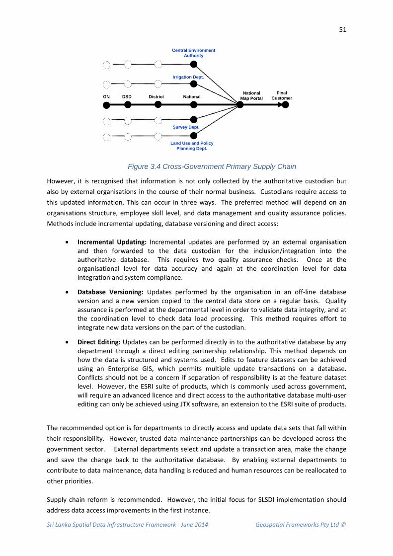
Sri Lanka Spatial Data Infrastructure Framework - June 2014 Geospatial Frameworks Pty Ltd
51
DSD District
Survey Dept.
NationalMap Portal
Final Customer
Irrigation Dept.
Central Environment Authority
Land Use and Policy Planning Dept.
GN National
Figure 3.4 Cross-Government Primary Supply Chain
However, it is recognised that information is not only collected by the authoritative custodian but also by external organisations in the course of their normal business. Custodians require access to this updated information. This can occur in three ways. The preferred method will depend on an organisations structure, employee skill level, and data management and quality assurance policies. Methods include incremental updating, database versioning and direct access:
• Incremental Updating: Incremental updates are performed by an external organisation and then forwarded to the data custodian for the inclusion/integration into the authoritative database. This requires two quality assurance checks. Once at the organisational level for data accuracy and again at the coordination level for data integration and system compliance.
• Database Versioning: Updates performed by the organisation in an off-line database version and a new version copied to the central data store on a regular basis. Quality assurance is performed at the departmental level in order to validate data integrity, and at the coordination level to check data load processing. This method requires effort to integrate new data versions on the part of the custodian.
• Direct Editing: Updates can be performed directly in to the authoritative database by any department through a direct editing partnership relationship. This method depends on how the data is structured and systems used. Edits to feature datasets can be achieved using an Enterprise GIS, which permits multiple update transactions on a database. Conflicts should not be a concern if separation of responsibility is at the feature dataset level. However, the ESRI suite of products, which is commonly used across government, will require an advanced licence and direct access to the authoritative database multi-user editing can only be achieved using JTX software, an extension to the ESRI suite of products.
The recommended option is for departments to directly access and update data sets that fall within their responsibility. However, trusted data maintenance partnerships can be developed across the government sector. External departments select and update a transaction area, make the change and save the change back to the authoritative database. By enabling external departments to contribute to data maintenance, data handling is reduced and human resources can be reallocated to other priorities.
Supply chain reform is recommended. However, the initial focus for SLSDI implementation should address data access improvements in the first instance.

Sri Lanka Spatial Data Infrastructure Framework - June 2014 Geospatial Frameworks Pty Ltd
52
3.6 DATA INTEGRATION
Data integration between data sets is best performed at the collection level where relationships between features and topology constructs can be embedded in to the data model using a high-end GIS system. These relationships can then be carried forward to the National Map Portal environment. Building complex topological relationships between layers at the portal level is more difficult and is the subject of current research.
Nonetheless, it is possible to incorporate tools that enable one of more data sets to be queried. These tools include queries on geocoded locations, proximity searching, and queries on intersecting polygons.
Research is focussing on the semantic web to improve the performance of user queries on unstructured data.
3.7 DATA ACQUISITION PROGRAM
Each year government agencies collect and/or purchase a wide range of spatial information such as satellite imagery. The cost of this information can run into millions of rupee per year. Given the potential for overlap, a coordinated Data Acquisition Program is proposed to ensure strategic investment and best use of resources. The program will be managed by the Survey Department.
The objective is to reduce costs associated with the capture, storage and management of information by:
• Planning, recording and acquiring spatial information through one channel. • Clear oversight of nationally/internationally funded Projects that acquire spatial information. • Acquiring multi-user licenses for imagery to enable reuse by many organisations. • Maintaining a single version of key government spatial information. • Leveraging greater value through economies of scale and consolidated spend. • Establishing an annual program of work where organisations can register their requirements
annually.
The effort to get information from another organisation is less expensive than if an organisation recollects information. However, in some cases it is not be possible to get the right information at the right time as the up-date cycle of the providing organisation may not be necessarily aligned with the receiving organisations business requirements. Nor can an organisation be assured that the quality of the information (data resolution/scale) they are receiving matches their required specifications.
It is suggested that the Survey Department have an annual capture program focussed on meeting cross-government needs. This program can be administered by calling for requests for new data to be collected and areas to be updated. While it is acknowledged that all requests will be difficult to administer with current resources in the first year; the program will provide a focus for priorities and enable the government to understand fundamental data needs, nationally.
Sri Lanka Spatial Data Infrastructure Framework - June 2014 Geospatial Frameworks Pty Ltd
53
3.8 COMMUNITY PARTICIPATION PROGRAMS
The collection of spatial information is time consuming and resourcing this task is often a problem for governments. However, technology today makes it possible to enlist a large number of non-technical people to do mapping tasks at significantly reduced cost. This community partnership is known as crowd-sourcing. It enables government to tap in to the collective intelligence of the community to assist in the collection of spatial information that organisations would otherwise collect.
The notion of this type of community input is not new. There are several excellent open-source solutions that demonstrate the value of engaging with the community, such as OpenStreetMap created by volunteers using local knowledge.
In establishing an effective community engagement processes there are three technical options that can be considered:
• Using existing solutions available such as Wikimapia, Google Map Maker, OpenStreetMap and Geo-wiki
• Establishing a capability within the National Map Portal itself that can also be used as an application on handheld devices
• Creating a purpose-specific application for a particular thematic domain, such as disaster management that is aimed at trusted partnerships and can be extended to direct editing of spatial data sets.
There are two key challenges that organisations will face:
• Being able to effectively integrate and validate crowd-sourced data for incorporation into the authoritative systems of government. Current verification processes are time consuming and research is still investigating ways to automate workflows; and
• The need to build awareness within the community so that it is taken-up and supported by a large number people. Building trusted partnerships with existing networks through education programs is one alternative.
3.9 INTELLECTUAL PROPERTY AND LICENSING
Intellectual Property Rights Management (IPRM) and licensing arrangements are intrinsically linked to custodianship and are closely interrelated with the effectiveness of the spatial data supply chain.
A lack of awareness of Intellectual Property Management processes across government is currently limiting data sharing, information flows and the confidence to develop value added products from data sourced from other organisations. Value adding organisations recognise they have some Intellectual Property Rights over the presentation aspects of their products, such as printed atlases, publications and maps, but are unsure how to differentiate these rights. A further complication is where one organisation adds new information to the data sourced from another organisation. A number of organisations queried whether they have some level of IP over the data they contribute, and thus could have a moral right to a percentage of the revenue from the data product.
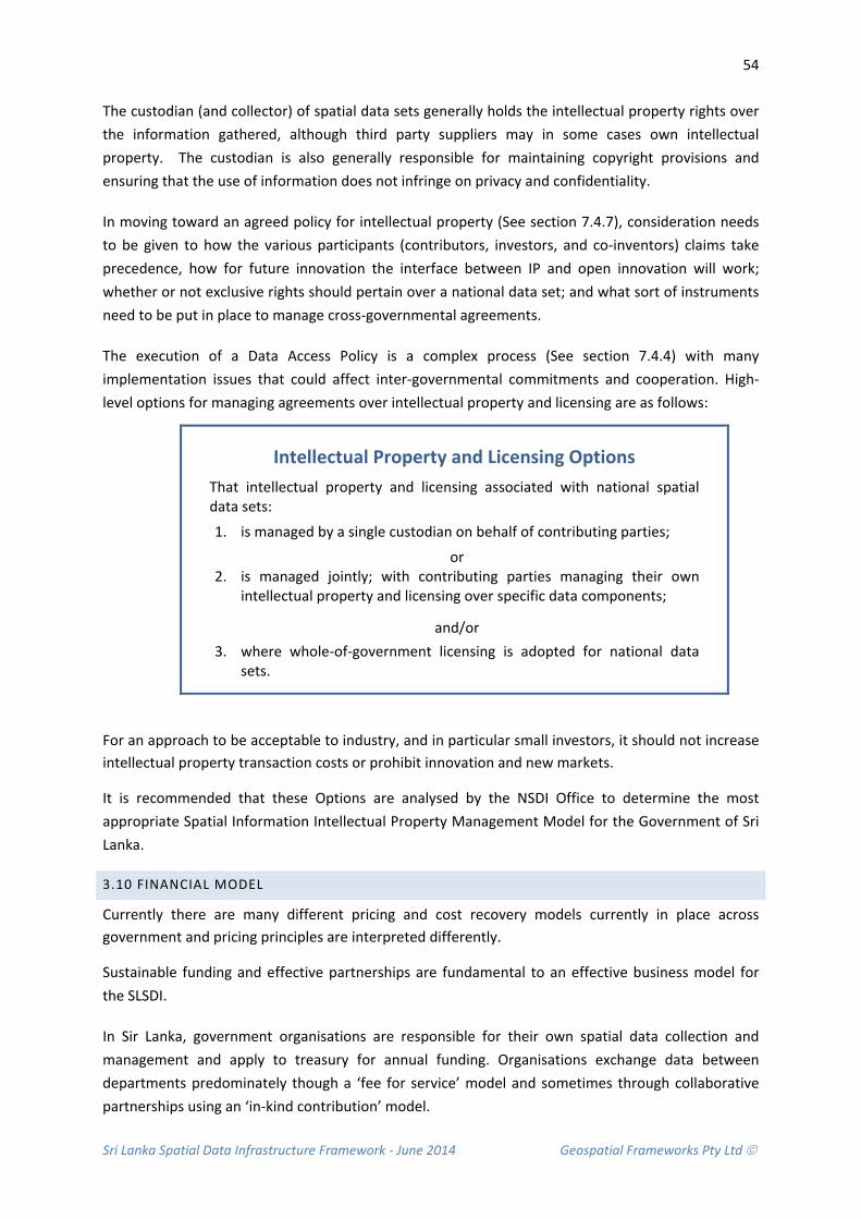
Sri Lanka Spatial Data Infrastructure Framework - June 2014 Geospatial Frameworks Pty Ltd
54
The custodian (and collector) of spatial data sets generally holds the intellectual property rights over the information gathered, although third party suppliers may in some cases own intellectual property. The custodian is also generally responsible for maintaining copyright provisions and ensuring that the use of information does not infringe on privacy and confidentiality.
In moving toward an agreed policy for intellectual property (See section 7.4.7), consideration needs to be given to how the various participants (contributors, investors, and co-inventors) claims take precedence, how for future innovation the interface between IP and open innovation will work; whether or not exclusive rights should pertain over a national data set; and what sort of instruments need to be put in place to manage cross-governmental agreements.
The execution of a Data Access Policy is a complex process (See section 7.4.4) with many implementation issues that could affect inter-governmental commitments and cooperation. High-level options for managing agreements over intellectual property and licensing are as follows:
Intellectual Property and Licensing Options That intellectual property and licensing associated with national spatial data sets:
1. is managed by a single custodian on behalf of contributing parties;
or 2. is managed jointly; with contributing parties managing their own
intellectual property and licensing over specific data components;
and/or 3. where whole-of-government licensing is adopted for national data
sets.
For an approach to be acceptable to industry, and in particular small investors, it should not increase intellectual property transaction costs or prohibit innovation and new markets.
It is recommended that these Options are analysed by the NSDI Office to determine the most appropriate Spatial Information Intellectual Property Management Model for the Government of Sri Lanka.
3.10 FINANCIAL MODEL
Currently there are many different pricing and cost recovery models currently in place across government and pricing principles are interpreted differently.
Sustainable funding and effective partnerships are fundamental to an effective business model for the SLSDI.
In Sir Lanka, government organisations are responsible for their own spatial data collection and management and apply to treasury for annual funding. Organisations exchange data between departments predominately though a ‘fee for service’ model and sometimes through collaborative partnerships using an ‘in-kind contribution’ model.
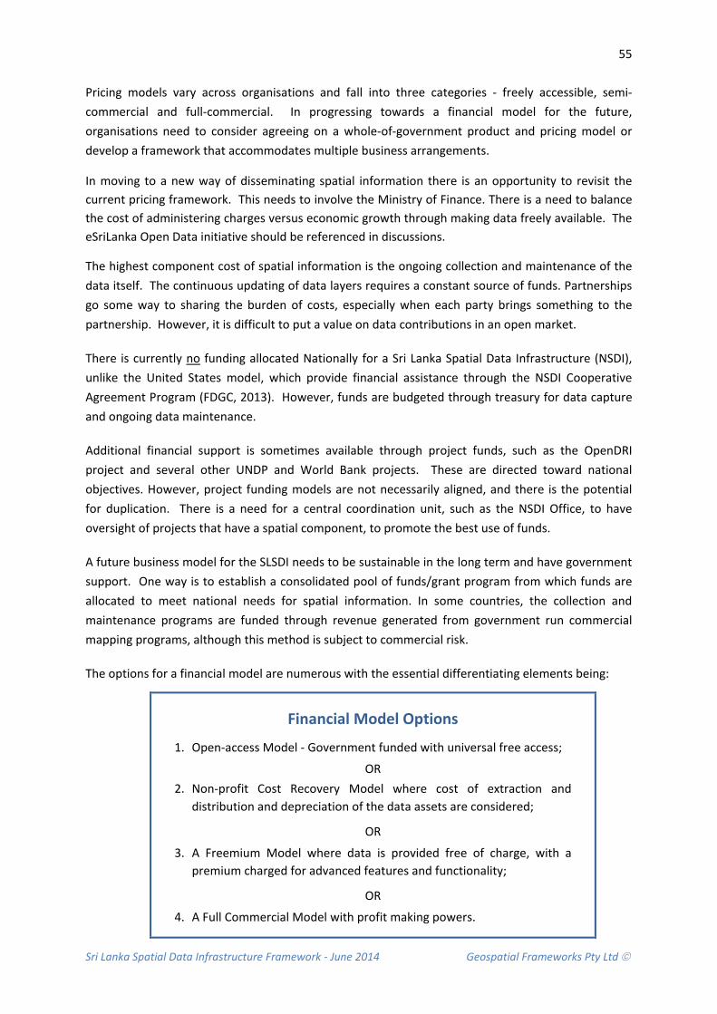
Sri Lanka Spatial Data Infrastructure Framework - June 2014 Geospatial Frameworks Pty Ltd
55
Pricing models vary across organisations and fall into three categories - freely accessible, semi-commercial and full-commercial. In progressing towards a financial model for the future, organisations need to consider agreeing on a whole-of-government product and pricing model or develop a framework that accommodates multiple business arrangements.
In moving to a new way of disseminating spatial information there is an opportunity to revisit the current pricing framework. This needs to involve the Ministry of Finance. There is a need to balance the cost of administering charges versus economic growth through making data freely available. The eSriLanka Open Data initiative should be referenced in discussions.
The highest component cost of spatial information is the ongoing collection and maintenance of the data itself. The continuous updating of data layers requires a constant source of funds. Partnerships go some way to sharing the burden of costs, especially when each party brings something to the partnership. However, it is difficult to put a value on data contributions in an open market.
There is currently no funding allocated Nationally for a Sri Lanka Spatial Data Infrastructure (NSDI), unlike the United States model, which provide financial assistance through the NSDI Cooperative Agreement Program (FDGC, 2013). However, funds are budgeted through treasury for data capture and ongoing data maintenance.
Additional financial support is sometimes available through project funds, such as the OpenDRI project and several other UNDP and World Bank projects. These are directed toward national objectives. However, project funding models are not necessarily aligned, and there is the potential for duplication. There is a need for a central coordination unit, such as the NSDI Office, to have oversight of projects that have a spatial component, to promote the best use of funds.
A future business model for the SLSDI needs to be sustainable in the long term and have government support. One way is to establish a consolidated pool of funds/grant program from which funds are allocated to meet national needs for spatial information. In some countries, the collection and maintenance programs are funded through revenue generated from government run commercial mapping programs, although this method is subject to commercial risk.
The options for a financial model are numerous with the essential differentiating elements being:
Financial Model Options
1. Open-access Model - Government funded with universal free access;
OR 2. Non-profit Cost Recovery Model where cost of extraction and
distribution and depreciation of the data assets are considered;
OR
3. A Freemium Model where data is provided free of charge, with a premium charged for advanced features and functionality;
OR
4. A Full Commercial Model with profit making powers.
Sri Lanka Spatial Data Infrastructure Framework - June 2014 Geospatial Frameworks Pty Ltd
56
Arguments for and against the various models differ depending on whether the information under question is considered fundamental or value-added data; and whether spatial data should be treated as a commodity or priced according to its role in society. The other aspect to consider is whether government has an unfair advantage, as a monopoly player, in an open market economy.
It is recommended that these Options are analysed by the NSDI Office to determine the most appropriate Financial Model for the Government of Sri Lanka.
In assessing these options, the position of the Survey Department within the new SLSDI Financial model requires due consideration. The Survey Department are the custodian and collectors of the majority of the fundamental spatial data sets. Currently, the Department relies on the revenue collected through sales of spatial data for its ongoing operations.
If Options 1, 2 or 3 are selected, fundamental data collected by Survey Department will be free-of-charge. This is in line with Open Data principles. However, consideration needs to be given to providing recurrent funds, in lieu of profit from sales of data, in order to continue mapping operations at the current level. Otherwise, the quality of the fundamental data sets will be adversely impacted due to a lack of resources to collect and maintain fundamental spatial data.
An important point to note is that the Government will realise savings across the public sector, as spatial data purchases by government departments will be reduced once data is made freely available.
It is recommended that the Financial Model includes an examination of current spatial data expenditure, including costs associated with current administration processes for marketing and sales of spatial data. This information can be compared with the new financial model to determine where savings will be made across the government sector. Funds can then be appropriately reallocated to those areas that will realise financial loss through a shift to a more open data policy.
Financial sustainability is essential to the success of the NSDI. Evidence from other countries show that government funded spatial data assets will realise an increase in return on investment when information is open and accessible (ACIL Tasman 2010).

Sri Lanka Spatial Data Infrastructure Framework - June 2014 Geospatial Frameworks Pty Ltd
57
3.11 RECOMMENDATIONS
Due to the need to effectively manage supply chain complexity and create sustainable solutions the following medium and long term recommendations are made concerning information flows, building capacity and conducting in depth analysis and research in key areas before moving forward.
Recommendation 3.1: That once the policy framework is in place that Supply Chain Reform be a future step.
It is recommended that future data management and maintenance practices will need to be considered. A direct editing approach is advocated, as it avoids duplicate data handling, assists in maintaining data integrity and conforms to the existing institutional frameworks. However, reforming the spatial data supply chain is not a SLSDI priority. SLSDI implementation should concentrate on establishing the Data Access Policy in the first instance.
Recommendation 3.2: That capacity building be undertaken in an orderly progression as needs become evident
In the future, the Survey Department workforce will require training in the area of transaction management and GIS workflows, such as multi-user editing, history management and checkout/check-in authorisations. This will require knowledge in Job tracking software. Eventually, training in workflow management will also need to be performed within each department to achieve.
Recommendation 3.3: That a comprehensive financial analysis is conducted to ascertain the most appropriate funding model.
It is recommended that the following Options are analysed by the NSDI Office to determine the most appropriate Funding Model for the Government of Sri Lanka. Consideration should be given to employing a consultant to provide an independent assessment. Options are:
1. Open-access Model - Government funded with universal free access; or
2. Non-profit Cost Recovery Model where cost of extraction and distribution and depreciation of the data assets are considered; or
3. A Freemium Model where data is provided free of charge, with a premium charged for advanced features and functionality; or
4. A Full Commercial Model with profit making powers.
Recommendation 3.4: That Fundamental Data Sets be resourced as a priority.
It is recommended that an assessment of the sustainability of the Survey Department operations be conducted to determine the level of impact from an Open Data Policy for spatial information. Open Data Principles are advocated to achieve increased economic benefits from the wider use of spatial information; however sustainable spatial data management must also be a priority.

Sri Lanka Spatial Data Infrastructure Framework - June 2014 Geospatial Frameworks Pty Ltd
58
Recommendation 3.5: That a comprehensive analysis is conducted to determine the most appropriate Intellectual Property Management model.
It is recommended that the following Options are analysed by the NSDI Office to determine the most appropriate Spatial Information Intellectual Property Management Model for the Government of Sri Lanka. Options for intellectual property and licensing associated with national spatial data sets are:
1. Is managed by a single custodian on behalf of contributing parties; or 2. Is managed jointly; with contributing parties managing their own intellectual property and
licensing over specific data components; and/or
3. Where whole-of-government licensing is adopted for national data sets.
Recommendation 3.6: That an annual Data Acquisition Program be conducted
It is suggested that the Survey Department have an annual Data Acquisition Program focussed on meeting cross-government needs. This program can be administered by calling for requests for new data to be collected and areas to be updated.
Sri Lanka Spatial Data Infrastructure Framework - June 2014 Geospatial Frameworks Pty Ltd
59
4. DATA ACCESS FRAMEWORK This section describes the requirements for the Data Access ‘Enabling’ Framework for the SLSDI, referred to from here on as the National Map Portal (NMP) Enabling Infrastructure. The framework enables spatial information, stored in various agency systems, to be accessed from a single integrated spatial information web portal.
The NMP Enabling Infrastructure provides government, private sector and general public with two key capabilities:
• Ready access to spatial information; and
• Common tools to develop applications, which utilise spatial information.
The NMP Enabling Infrastructure eliminates wasted effort by providing a centralised data access and delivery service. In addition, ad-hoc agency-centric expenditure on technology is avoided by taking a whole-of-government approach.
CONTEXT AND RATIONALE
The NMP Enabling Infrastructure needs to provide the infrastructure to enable access to the government’s spatial information resources, which are held in various formats and systems. This can be achieved by taking advantage of current internet-based technologies and standards, so that data can be accessed transparently as a single integrated environment.
Importantly, the NMP Enabling Infrastructure should allow the actual data to remain within the control of custodial agencies. This supports existing institutional frameworks. Information security can be managed efficiently through the infrastructure security management system even though access to data is opened up.
4.1 CURRENT STATE
There is currently no central information portal for spatial information. Each Ministry and many organisations have their own website. Some websites, such as the Department of Census and Statistics and the International Water Management Institute, include maps in PDF format that can be downloaded. Other agencies, such as the Ministry of Environment and Renewable Energy, supply data to customers via CD-ROM for a small fee.
A high-end infrastructure for e-Government services is provided by ICTA as part of the e-SriLanka initiative. The objective is to encourage the creation of innovative solutions, business models, communication models, pricing models and service mash-ups required by various stakeholders across the country (ICTA, 2014).
Electronic services are delivered via a comprehensive integrated platform called ‘Lanka Gate’. At present there is no facility to make spatial information available. However, Lanka Gate could be considered as the gateway to the National Map Portal for the broader community.
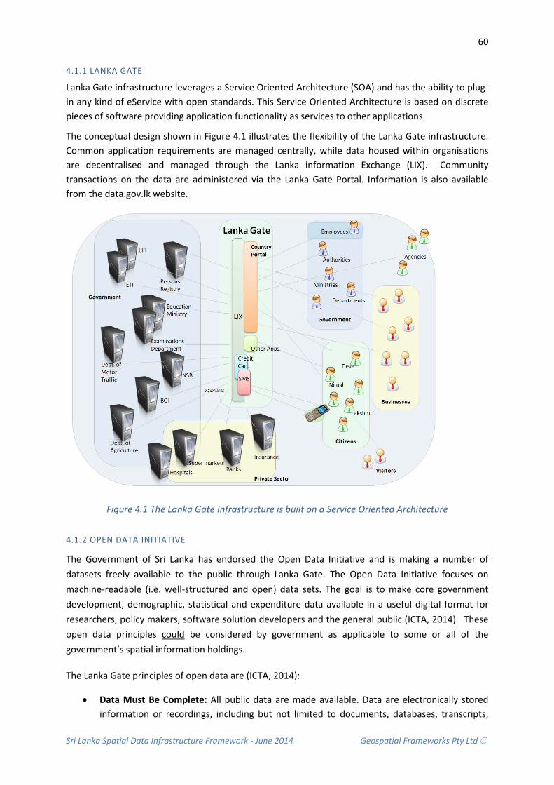
Sri Lanka Spatial Data Infrastructure Framework - June 2014 Geospatial Frameworks Pty Ltd
60
4.1.1 LANKA GATE
Lanka Gate infrastructure leverages a Service Oriented Architecture (SOA) and has the ability to plug-in any kind of eService with open standards. This Service Oriented Architecture is based on discrete pieces of software providing application functionality as services to other applications.
The conceptual design shown in Figure 4.1 illustrates the flexibility of the Lanka Gate infrastructure. Common application requirements are managed centrally, while data housed within organisations are decentralised and managed through the Lanka information Exchange (LIX). Community transactions on the data are administered via the Lanka Gate Portal. Information is also available from the data.gov.lk website.
Figure 4.1 The Lanka Gate Infrastructure is built on a Service Oriented Architecture
4.1.2 OPEN DATA INITIATIVE
The Government of Sri Lanka has endorsed the Open Data Initiative and is making a number of datasets freely available to the public through Lanka Gate. The Open Data Initiative focuses on machine-readable (i.e. well-structured and open) data sets. The goal is to make core government development, demographic, statistical and expenditure data available in a useful digital format for researchers, policy makers, software solution developers and the general public (ICTA, 2014). These open data principles could be considered by government as applicable to some or all of the government’s spatial information holdings.
The Lanka Gate principles of open data are (ICTA, 2014):
• Data Must Be Complete: All public data are made available. Data are electronically stored information or recordings, including but not limited to documents, databases, transcripts,
Sri Lanka Spatial Data Infrastructure Framework - June 2014 Geospatial Frameworks Pty Ltd
61
and audio/visual recordings. Public data are data that are not subject to valid privacy, security or privilege limitations, as governed by other statutes.
• Data Must Be Primary: Data are published as collected at the source, with the finest possible level of granularity, not in aggregate or modified forms.
• Data Must Be Timely: Data are made available as quickly as necessary to preserve the value of the data.
• Data Must Be Accessible: Data are available to the widest range of users for the widest range of purposes.
• Data Must Be Machine Processable: Data are reasonably structured to allow automated processing of it.
• Access Must Be Non-Discriminatory: Data are available to anyone, with no requirement of registration.
• Data Formats Must Be Non-Proprietary: Data are available in a format over which no entity has exclusive control.
• Data Must Be License-free: Data are not subject to any copyright, patent, trademark or trade secret regulation. Reasonable privacy, security and privilege restrictions may be allowed as governed by other statutes.
4.2 STRATEGIC BENEFITS OF A SHARED INFRASTRUCTURE
There is a huge benefit to the user community in having a single mechanism for accessing spatial information rather than agencies developing a profusion of access points and duplicating the underpinning infrastructure. Significant issues arising from a profusion of portals, each independently developed and governed include:
• Lack of consistency and ‘look and feel’, leading to lower levels of useability:
• A diversity in technology used - diluting knowledge and capabilities, and limiting opportunities to fully use and leverage best practice experiences;
• Lack of a common Government ‘brand’ across portals; and
• Limited inter-agency interactions and less ability to integrate information.
The NMP Enabling Infrastructure, which will allow interoperability and service integration, is complex and requires a range of information technology skills and capabilities. The issues which must be addressed go well beyond just information technology and include privacy, security, legal and legislative compliance, quality of service and useability. If organisations were to develop their own systems independently and in parallel, there would be significant duplication of effort, resources, and infrastructure; and the result would be a fragmented agency-oriented approach to service delivery.
The NMP Enabling Infrastructure will directly address these issues, and is one of the tools government can use to help the transition towards citizen-centric, whole-of-government, and online conduct of its spatial information related-business
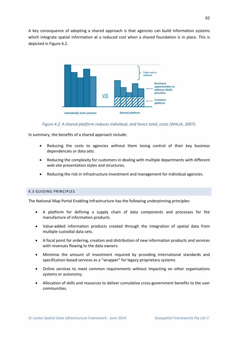
Sri Lanka Spatial Data Infrastructure Framework - June 2014 Geospatial Frameworks Pty Ltd
62
A key consequence of adopting a shared approach is that agencies can build information systems which integrate spatial information at a reduced cost when a shared foundation is in place. This is depicted in Figure 4.2.
VSCommon platform
Individually built systems Shared platform
Total cost is reduced
Business opportunities to address WofGpriorities
Figure 4.2: A shared platform reduces individual, and hence total, costs (WALIA, 2007).
In summary, the benefits of a shared approach include:
• Reducing the costs to agencies without them losing control of their key business dependencies or data sets.
• Reducing the complexity for customers in dealing with multiple departments with different web site presentation styles and structures.
• Reducing the risk in infrastructure investment and management for individual agencies.
4.3 GUIDING PRINCIPLES
The National Map Portal Enabling Infrastructure has the following underpinning principles:
• A platform for defining a supply chain of data components and processes for the manufacture of information products.
• Value-added information products created through the integration of spatial data from multiple custodial data sets.
• A focal point for ordering, creation and distribution of new information products and services with revenues flowing to the data owners.
• Minimise the amount of investment required by providing international standards and specification-based services as a “wrapper” for legacy proprietary systems
• Online services to meet common requirements without impacting on other organisations systems or autonomy;
• Allocation of skills and resources to deliver cumulative cross-government benefits to the user communities.
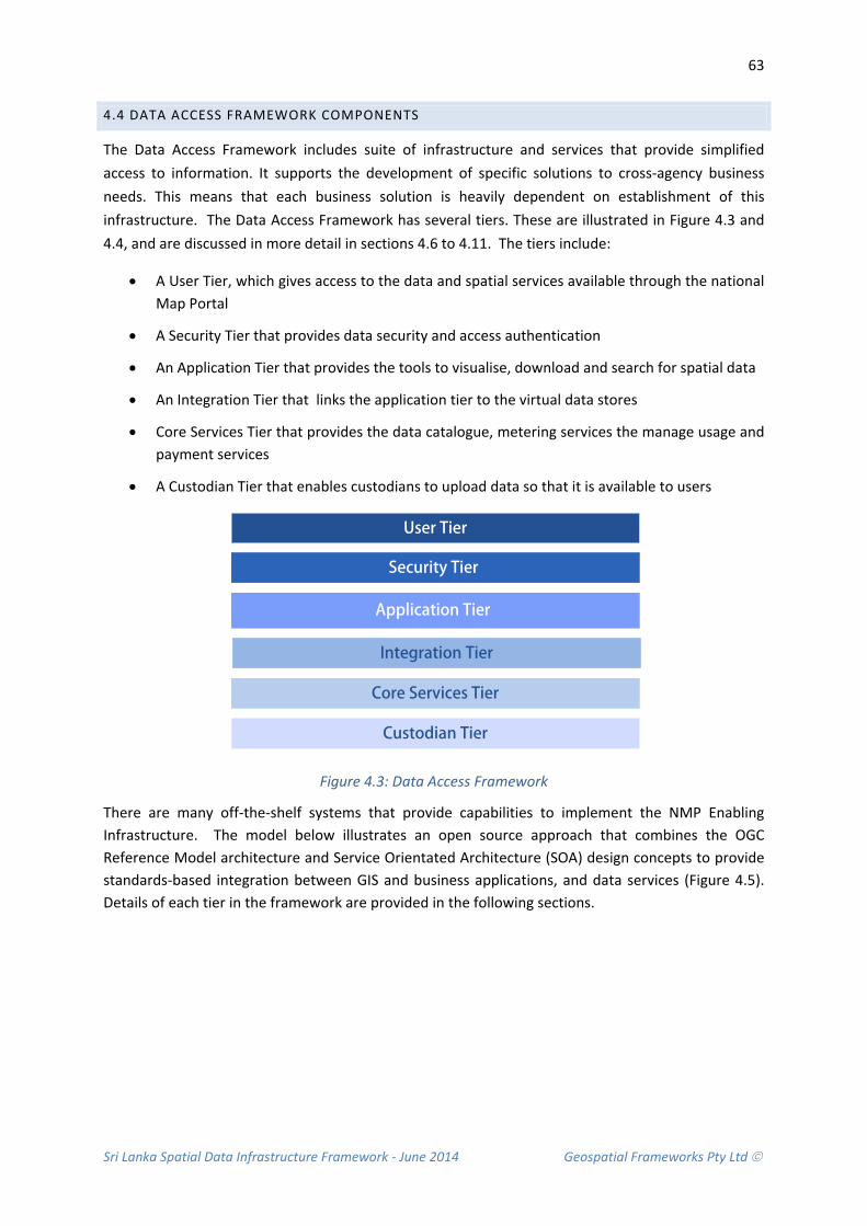
Sri Lanka Spatial Data Infrastructure Framework - June 2014 Geospatial Frameworks Pty Ltd
63
4.4 DATA ACCESS FRAMEWORK COMPONENTS
The Data Access Framework includes suite of infrastructure and services that provide simplified access to information. It supports the development of specific solutions to cross-agency business needs. This means that each business solution is heavily dependent on establishment of this infrastructure. The Data Access Framework has several tiers. These are illustrated in Figure 4.3 and 4.4, and are discussed in more detail in sections 4.6 to 4.11. The tiers include:
• A User Tier, which gives access to the data and spatial services available through the national Map Portal
• A Security Tier that provides data security and access authentication
• An Application Tier that provides the tools to visualise, download and search for spatial data
• An Integration Tier that links the application tier to the virtual data stores
• Core Services Tier that provides the data catalogue, metering services the manage usage and payment services
• A Custodian Tier that enables custodians to upload data so that it is available to users
Security Tier
Custodian Tier
Core Services Tier
Application Tier
User Tier
Integration Tier
Figure 4.3: Data Access Framework
There are many off-the-shelf systems that provide capabilities to implement the NMP Enabling Infrastructure. The model below illustrates an open source approach that combines the OGC Reference Model architecture and Service Orientated Architecture (SOA) design concepts to provide standards-based integration between GIS and business applications, and data services (Figure 4.5). Details of each tier in the framework are provided in the following sections.

Sri Lanka Spatial Data Infrastructure Framework - June 2014 Geospatial Frameworks Pty Ltd
64
Figure 4.4 Data Access Framework showing Architecture Tiers (Adapted from Landgate, 2007a)
The proposed NMP Enabling Infrastructure utilises services that enable access to geographic data and its associated attributes. Figure 4.5 provides an overview of the services, to demonstrate the context of the NMP Enabling Framework in relation to user access mechanisms and data sources.
Figure 4.5 Enabling framework services and user access mechanisms

Sri Lanka Spatial Data Infrastructure Framework - June 2014 Geospatial Frameworks Pty Ltd
65
4.5 ENABLING INFRASTRUCTURE OVERVIEW
The Enabling Framework has two broad functions, which are:
• Open up access to data stored on agency systems
• Provide services to allow applications to directly access data
In achieving these functions, the security of custodial organisations’ systems and information must be guaranteed. This means that the NMP Enabling Infrastructure must have a central data access gateway through which requests for information can be channelled securely.
Requests to access data can originate from people using web browsers or GIS packages, or directly from agency applications. A request must be validated and authorised before being passed to the middleware (or hosted on the cloud) located at organisations. The middleware, which can only be accessed by the NMP Enabling Infrastructure, should perform the data operation (i.e. viewing) on behalf of the user. This approach provides a range of common data access services, and a managed mechanism to provide secure access to data. This concept is depicted in Figure 4.6. This approach is similar to the Lanka Gate model depicted in Figure 4.1 above.
Figure 4.6 The NMP Enabling Infrastructure provides services to interconnect data
This approach has several advantages:
• The need to copy data is minimised – current data is accessed from the source agency.
• Security is managed, since only the NMP Enabling Infrastructure can access the servers behind agency firewalls.
• Agencies retain full control of their data systems.
• Since the NMP Enabling Infrastructure “knows” where the source data resides, users and applications do not have to manage links or references to specific data stores.
• The NMP Enabling Infrastructure data servers are the same – built once and replicated, so differences are minimised.
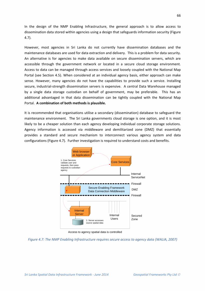
Sri Lanka Spatial Data Infrastructure Framework - June 2014 Geospatial Frameworks Pty Ltd
66
In the design of the NMP Enabling Infrastructure, the general approach is to allow access to dissemination data stored within agencies using a design that safeguards information security (Figure 4.7).
However, most agencies in Sri Lanka do not currently have dissemination databases and the maintenance databases are used for data extraction and delivery. This is a problem for data security. An alternative is for agencies to make data available on secure dissemination servers, which are accessible through the government network or located in a secure cloud storage environment. Access to data can be managed through access services and loosely coupled with the National Map Portal (see Section 4.5). When considered at an individual agency basis, either approach can make sense. However, many agencies do not have the capabilities to provide such a service. Installing secure, industrial-strength dissemination servers is expensive. A central Data Warehouse managed by a single data storage custodian on behalf of government, may be preferable. This has an additional advantaged in that data dissemination can be tightly coupled with the National Map Portal. A combination of both methods is plausible.
It is recommended that organisations utilise a secondary (dissemination) database to safeguard the maintenance environment. The Sri Lanka governments cloud storage is one option, and it is most likely to be a cheaper solution than each agency developing individual corporate storage solutions. Agency information is accessed via middleware and demilitarized zone (DMZ) that essentially provides a standard and secure mechanism to interconnect various agency system and data configurations (Figure 4.7). Further investigation is required to understand costs and benefits.
InternalServer Internal
Users
Access to agency spatial data is controlled
SecuredZone
Firewall
Firewall
DMZSecure Enabling FrameworkData Connection Middleware
Core Services
InternalServiceNet
Web browser or Application
1. Core Services validate user and requests, then pass requests to custodian agency
2. Server accesses source spatial data
Figure 4.7: The NMP Enabling Infrastructure requires secure access to agency data (WALIA, 2007)

Sri Lanka Spatial Data Infrastructure Framework - June 2014 Geospatial Frameworks Pty Ltd
67
4.5.1 ONLINE SPATIAL INFORMATION DISCOVERY AND DELIVERY PROCESSES
Figure 4.8 below, depicts the functionality provided by the proposed NMP Enabling Infrastructure to allow the discovery, viewing and delivery of spatial information. This process is common to many online applications involving spatial information.
In order to obtain information in the required context, a user firstly browses or searches the available data and services. Once retrieved, this information can be evaluated by visual inspection of the graphic display, by examining the associated metadata or by displaying data previews. Data are then accessed free of charge via an interactive viewing mechanism or downloaded for specific purposes. The latter is usually a chargeable service.
User Requiring
Spatial Information
DiscoverInformation
EvaluateInformation
AccessInformation
Browser Data and Services of suppliers
Search Data and Services of suppliers
Display Location
Graphically
Display Detailed
Reference Data
Preview Data Online
View Data Interactively
Registration and Authentication
Online ordering and purchasing
Electronic Delivery
Billing Payment to Supplier
SpatialInformation Provided
Free Data Subscription
Figure 4.8: Online information discovery and delivery process
(Adapted from Nebert, 2004; WALIA, 2007)
4.5.2 IMPLEMENTATION APPROACH
The NMP Enabling Infrastructure requires a detailed technical design and there are a whole host of questions that need to be addressed as part of this planning stage. For example:
• What GIS system and data formats are supported?
• What is the size of the organisations data holdings?
• Is the network bandwidth capacity functional?
• How many data downloads are anticipated?
Even though the answers to these questions are unknown at this time, there is a standard approach that can be considered for implementation. The following development stages are an example:

Sri Lanka Spatial Data Infrastructure Framework - June 2014 Geospatial Frameworks Pty Ltd
68
• Develop a detailed Requirements Design Statements that identifies the attributes, capabilities, characteristics, and qualities required of the NMP Enabling Infrastructure. This is the foundation for what shall be implemented. The Requirements Design can be used to tender for the overall development and installation of the systems by third party vendors.
• Produce the Architecture/Design: This is an overview of software and includes relations to current computing environment and the construction principles to be used in design of software components.
• Produce a detailed Technical Design of the Enabling Infrastructure in consultation with agencies. This should include the documentation of code, algorithms, interfaces and application user interfaces, and provide sufficient detail to allow development and implementation.
• Connect data services from external agencies to allow refinement of technology, testing of the system and development of prototypes.
• Develop a Pilot Project to demonstrate proof-of-concept and provide a basis for refinement of the solution for other Thematic Areas.
• Undertake the detailed design of solutions in order to define requirements and develop a clear road map for implementation, including a robust design, firm costs, and a clear business case.
• Identify interim solutions to deliver specific benefits in the short term, which do not distract significantly from the overall approach.
• Develop collaborative agreements between agencies (See Legal and Policy Framework).
• Check data quality against requirements, and identify the effort and approach required to resolve any differences.
• Connect data through to the Map Portal.
• Produce the manuals for the end-user, system administrators and support staff.
• Prepare marketing to best market the product.
4.5.3 TECHNOLOGY IMPACTS
Implementation of this type of Technology Framework can bring about a number of intended and unintended consequential impacts, which can be either positive or negative.
Potential negative impacts include:
• There may be an increase in data usage, which could place increased load on network and agency processing resources. The network capacity may need to be increased to cater for a moderate increase in network traffic, although the loads will need to be measured as part of on-going network capacity planning.
• With increased availability of services, there may be increased pressure to make online services available 24 hours a day, 7 days a week, which could lead to increased operating costs. This is a natural growth of e-Government strategies providing improved levels of services to the public. It should be noted that Lanka Gate e-Services currently operate 24/7.

Sri Lanka Spatial Data Infrastructure Framework - June 2014 Geospatial Frameworks Pty Ltd
69
• An agency which accesses data online has increased dependency on other agencies’ services being available. When copies of data are held within the user agency, the risks of non-availability of services remain within the agencies’ control. The degree of risk can be managed through Service Level Agreements, where expectations can be balanced against costs and a service delivery measurement framework established.
Potential positive impacts include:
• The ability to measure data usage will allow better management and prioritisation for data maintenance.
• Enables the government to demonstrate active participation in national initiatives.
• Open up data delivery services to stakeholders. Use of international open standards provides an opportunity to provide seamless integration of services between the government and private sector.
• Build on the County’s existing pool of expertise in geospatial information systems and associated technologies, extending it to current web-based technologies.
• Recognition of Sri Lanka as a leader in the provision of spatial information as a whole-of-government approach.
• Potential increased ranking on the UN eGov index due to improved scope and quality of online services, telecommunication connectivity and human capacity.
4.6 USER TIER
The proposed NMP Enabling Infrastructure needs four ways to access information including web browsers, Geographic Information Systems, Business Application solutions and Mobile Applications:
• Web Browser: For higher volume general audiences. With the ubiquity of browsers and integrated browser-based map viewer components (e.g. Google Earth), this is likely to become the most common means for public users to access spatial data.
• Geographic Information System (GIS) applications: For more advanced GIS users who want to undertake spatial analysis of the datasets from using GIS software such as ArcGIS, GeoMedia and MapInfo.
• Business Solution Applications: For specific spatial information applications that are built to meet a business need, e.g. Disaster Management.
• Mobile Applications: For general or application specific audiences using mobile applications on phones, iPads or other portable devices.
Each access method consumes the same underlying data access infrastructure and business services, but with varying degrees of functionality and compatibility to the end user.
Sri Lanka Spatial Data Infrastructure Framework - June 2014 Geospatial Frameworks Pty Ltd
70
4.7 SECURITY TIER
The security components need to identify a user to the system, and authenticate that the user is who they claim to be. Only authenticated and authorised users should be able to access information.
The key principles for the security component are:
• Attract and maintain customers and data providers by facilitating the delivery of new services in a secure manner.
• Minimise administrative costs associated with account administration, to enable future growth of the infrastructure and the introduction of new services without requiring an increase in identity related administrative costs.
• Sustain ongoing compliance with audit requirements that pertain to user management, will require a consistent and auditable data security and data access policy.
• Provide appropriate infrastructure to manage the security of the information, applications, users and infrastructure at the application level
• Provide user authentication and access management authorisation
• Automate identity provisioning.
• Provide self-service user administration – users should be able to reset their password and profile details
• Allow authorised organisations to act as delegated administrators for users and systems within their scope.
The OGC Reference Model includes authentication and authorisation services to provide a single secure entry point into the Data Access environment. The OGC authentication and authorisation service uses a reverse proxy, which hosts security web agents that provide a common set of identity and access management services to web applications and web service consumers.
4.8 APPLICATION TIER
4.8.1 NATIONAL MAP PORTAL
National Map Portal (or Map Viewer) will be the online web-based application that provides visualization and representations of spatial data originating from the various organisations spatial data repositories. The major requirements of the map viewer are:
• Preview maps composed of selected spatial datasets using a web a browser.
• Access the metadata for a spatial dataset or data service presented in the map viewer by integration with the Catalogue.
• Update the information displayed on the map by selecting or de-selecting additional spatial layers.
• Navigate the map using zoom and pan operations.
• Display the distance between designated points on the map.
• Display longitude and latitude co-ordinates for a designated point on the map.
Sri Lanka Spatial Data Infrastructure Framework - June 2014 Geospatial Frameworks Pty Ltd
71
• Retrieve and display map features that match spatial attribute criteria.
• Display location information for a designated spatial co-ordinate.
• Create a PDF or GIF image of the current map view, and print the map.
• Link to external OGC WMS sources to include additional spatial layers for display.
In addition, registered users should be able to access and view additional spatial layers contained within subscribed and restricted data services areas.
4.8.2 USER SERVICES
User services provide a series of user self-service functions, For example, self-registration, password reset and password prompts.
4.8.3 SPATIAL SERVICES
The recommended core spatial services are the OGC standard services - Web Map Service and Web Feature Service.
• Web Map Service (WMS) – A service that produces maps of spatially referenced data dynamically from spatial information. The OGC standard defines a "map" to be a portrayal of spatial information as a digital image file suitable for display on a computer screen.
• WMS-produced maps are rendered in a pictorial format such as PNG, GIF, TIFF or JPEG, the map is not the spatial data itself. The WMS service and implements:
− GetCapabilities − GetMap − GetFeatureInfo.
• A Web Feature Service (WFS) - Allows a client to retrieve spatial data encoded in Geography Markup Language (GML) which fully describes points and metadata for features. The GML data can then be used for display or querying purposes. The WFS service implements the following functions:
− GetCapabilities − DescribeFeatureType − GetFeature.
• A Web Processing Service (WPS) – Allows a client to invoke geospatial processing services, such as polygon overlay, as a Web service. The data required by the WPS can be delivered across a network or via a server. The WPS service implements the following functions:
− GetCapabilities − DescribeProcess − Execute
OGC Data Services are recommended as they allow consumers of spatial information to harness the wealth of distributed data provided via the NMP Enabling Infrastructure, whilst continuing to use their preferred GIS software and tools, regardless of where or how the original data is stored, or what implementation platform the data is based upon. OGC data services are used to portray (visualise) data, process data and extract (download) data (Table 4.1)

Sri Lanka Spatial Data Infrastructure Framework - June 2014 Geospatial Frameworks Pty Ltd
72
Service Category Components / Spatial Services
Portrayal Services
Provide visualisation and representations of data originating from data repositories and geodata processing services.
Web Map Service (WMS)
Map Viewer component i.e. Geoserver or equivalent
Geodata Processing Services
Provide service building blocks that operate on geospatial data and provide services that add value to applications.
Web Feature Service (WFS)
Web Processing Services (WPS)
Data Extraction Services
Provide the means by which users (including automated processes) acquire copies of data in either original or processed form.
Web Feature Service (WFS)
Table 4.1 User Services
4.8.4 PORTRAYAL SERVICES
The portal needs to provide unsecured and secured access to web content describing the services and the launch pad for the unsecured catalogue and map viewing services, as well as, access to the secured services for appropriately authorised people, e.g. data downloads and management reporting services.
4.8.5 DATA DOWNLOAD
Data Download services should provide registered users with the ability to extract a snapshot of specific spatial data in predefined file formats for use on their local systems, including:
• Pre-determined spatial data layers are available in a range of formats and include:
− Geography Mark-up Language (GML) − ESRI Shapefile − MapInfo Tab File
• Spatial data should be extracted into a single projection system.
• Data Layers should be checked nightly (or agreed timeframe) for updates which are automatically packaged and made available to users via the portal.
While a primary business driver of the overall NMP Enabling Infrastructure is to provide real-time access to distributed spatial data, there are some scenarios where there is a need to download a snapshot of spatial data, including:
• Access to data is required when a user’s Internet access is unavailable or unreliable.
• Using data in applications that cannot utilise the NMP Enabling Infrastructure Data Service protocols (i.e. No support for OGC WMS or WFS standards).

Sri Lanka Spatial Data Infrastructure Framework - June 2014 Geospatial Frameworks Pty Ltd
73
4.8.6 DISSEMINATION SERVICES
Dissemination Services provide data custodians with a facility to load data extracted from agency data stores to the NMP Enabling Infrastructure. The key services required of a Data Dissemination Solution are:
• Host data extracted from Agency production systems in a standards-compliant spatial database (the dissemination database) located on the NMP Enabling Infrastructure Agency infrastructure
• Configure application-level access control over the hosted data sets
• Provide a secure mechanism for an data custodian to upload a dataset
• Provide a scheduled, automated process that imports an uploaded dataset into the NMP Enabling Infrastructure
• Support a limited range of industry-standard import formats and import functionality using standards-based tools
• Perform a limited validation of an imported dataset against the import format and against the previous imported version
• Report errors in validating and importing a dataset, to data custodians and NMP Administration personnel
• Provide a 'roll back' facility to revert to a previously-imported version of a dataset
• Copy each successfully-imported dataset to the dissemination database on a failover / load balancing server
4.8.7 MANAGEMENT SERVICES
Managing IT for the NMP Enabling Infrastructure as a business and delivering the right level of service to customers, partners and employees is critical to meeting demands in a cost- and resource-effective manner. Better management and planning of future Information Technology needs is required to help Government achieve its goals to:
• Reduce cross-government IT costs by optimising capital and operating expenses.
• Mitigate risk from a security, data protection and compliance perspective.
• Ensure that the infrastructure is always available and is flexible enough to respond to business needs on-demand.
From an access perspective, three fundamental areas of system management require consideration. These are:
• The effective and efficient operation of the infrastructure in providing internal and external services.
• The support of the marketing and delivery activities for chargeable and non-chargeable products and services.
• Security through identity and access management for external customers and internal users.
Sri Lanka Spatial Data Infrastructure Framework - June 2014 Geospatial Frameworks Pty Ltd
74
Within each of these areas the business needs are:
• To efficiently and consistently receive, record and manage the resolution of all incidents, including incidents raised by system management and monitoring software.
• To provide incident data in a form suitable for Problem Management investigation and root cause analysis.
• To implement incident ownership, escalation and prioritisation processes.
• To support incident resolution in the form of a symptomatic repair and/or escalation to level 2, 3 or third party support.
• To record the resolution and closure of all incidents.
• To provide a database suitable for the collection, management and reporting of incident data.
4.9 INTEGRATION TIER
4.9.1 DATA STORES
Data resources are the files and relational databases that provide the persistent storage of geographic objects, temporal events, associated spatially linkable attribute data, user audit and management records, registry and catalogue metadata, and articulated service and data use policies and protocols.
The data warehouse itself, is the common repository for all information. Data are usually seamless and the warehouse provides efficient access to large volumes of data, has common data models and is application neutral, and enables direct access mechanisms and multi-temporal support.
4.9.2 AGENCY MIDDLEWARE
Wherever possible, consideration should be given to deploying a standard set of NMP Enabling Infrastructure middleware services and components for each data custodian. The configuration of the associated network components and the data services will typically depend on the configurations of the organisations existing infrastructure and data store.
The middleware will also need to provide a data storage capability onto which the organisation can “push” data. This includes providing a Lanka Government Network (LGN) client for communications to the NMP Enabling Infrastructure central services and the required middleware applications to deliver agency datasets to the various services.

Sri Lanka Spatial Data Infrastructure Framework - June 2014 Geospatial Frameworks Pty Ltd
75
4.10 CORE SERVICES TIER
Core services supply basic services to any other component of the NMP Enabling Infrastructure. Core services include:
• Catalogue Services
• Metering Services
• Payment Services
4.10.1 CATALOGUE
The Catalogue service allows clients to publish, find, and connect to datasets and web services. The catalogue contains metadata documents representing datasets and services, and is maintained by the custodians of the data and services themselves. The catalogue provides the ability for users to search collections of descriptive information (metadata) for data, services and related information provided by various government organisations.
The catalogue metadata should be based on the ISO 19139 Metadata profile, and provide an interface to metadata via OGC standards based services for Catalogue Services for Web (CSW).
The key principles of the Catalogue Service are:
• Improve accessibility to information by a delivery mechanism that connects users to spatial resources.
• Provide a consistent metadata management strategy.
• Facilitate the publication and discovery of spatial resource metadata using the “Publish-Find-Bind” pattern specified by the Open Geospatial Consortium (OGC) Reference Model.
• Introduce catalogue web service capabilities based on the OpenGIS Catalogue Service Implementation Specification.
• Convert existing metadata records from the various government organisations to a new central metadata profile (based on ISO 19139).
The Catalogue should enable users to:
• Search the catalogue of spatial data, by topic or keyword, to find spatial data matching the search criteria.
• Display summary details, or the full Metadata Record of each Data Service or individual Data Layer within the National Map Portal.
• Allow users to preview (“bind” to) a spatial data layer by directly linking to the Map Viewer.
• Enable Spatial Data Providers and the Catalogue Administrator to create Metadata in the catalogue via:
− Direct Manual Entry into an online form − Metadata document upload − Batch upload of metadata files − Metadata harvesting from an online resource

Sri Lanka Spatial Data Infrastructure Framework - June 2014 Geospatial Frameworks Pty Ltd
76
4.10.2 METERING
Metering provides the ability to monitor and measure the level of usage. This can be subsequently used to charge for usage, monitor loads and compile data usage reports on the health of all infrastructure elements. Metering should include:
• Availability Management: Exception based monitoring and reporting of all key NMP Enabling Infrastructure elements, including hardware, web servers, network activity, software processes as well as the spatial data services.
• Capacity Management: Monitoring against set threshold limits across all NMP Enabling Infrastructure elements and providing service usage details through Daily Usage Reports.
• Incident Management: Implementation of a standard policy for the receiving, recording and resolution management of all incidents, including incidents automatically raised by system management and monitoring software. Other key functions can include:
− provide incident data for root cause analysis − implement incident ownership − prioritisation and escalation processes, including level 2, 3 or third party support − provide a database for the collection, management and reporting of incident data.
• Configuration Management: Provide asset intelligence reporting (i.e. product details, installation location and incident history) of NMP Enabling Infrastructure hardware and software from inception until retirement; management of software licensing and enablement of automated software release processes which includes back-out mitigation plans.
4.10.3 PAYMENT SERVICES
Access to Data Services can be obtained at a number of different levels, with an option available for access to some data services to be charged. Charging models can be:
• Subscription Charging: The charging for access to services and facilities via an annual subscription charge.
• Data Download Charging: Per unit.
4.11 CUSTODIAN TIER
Data custodians can make their resources available by either:
• Direct connection from the NMP Enabling Infrastructure services to the agencies live data store or dissemination environment, providing real-time access to datasets
• In-direct access via a scheduled replication of agency datasets to the Enabling Infrastructure Data Store, providing near-time access to datasets.
The NMP Enabling Infrastructure should provide data custodians with a facility to load data to a Dissemination Service Area. The key services to consider are:
• Host data extracted from an organisations production systems in a standards-compliant spatial database (the dissemination database) located on the NMP Enabling Infrastructure in an area specified for the organisation.
Sri Lanka Spatial Data Infrastructure Framework - June 2014 Geospatial Frameworks Pty Ltd
77
• Configure application-level access control over the hosted data sets in the Dissemination Service Area
• Provide a secure mechanism for a data custodian to upload a dataset to the NMP Enabling Infrastructure Dissemination Service Area.
• Provide a scheduled, automated process that imports an uploaded dataset into the NMP Enabling Infrastructure Dissemination Service Area.
• Support a limited range of industry-standard import formats and import functionality using standards-based tools.
• Perform a limited validation of an imported dataset against the import format and against the previous imported version.
• Report errors in validating and importing a dataset, to data custodians and system managers.
• Provide a 'roll back' facility to revert to a previously-imported version of a dataset.
• Copy each successfully-imported dataset to the dissemination database on a failover / load balancing server.
Sri Lanka Spatial Data Infrastructure Framework - June 2014 Geospatial Frameworks Pty Ltd
78
4.12 RECOMMENDATIONS
Due to the fact that there is currently no central information portal for spatial information the following recommendations are made concerning a National map portal, technology solutions for developing an enabling infrastructure, detailed design requirements and other issues covering appropriate standards and suitable dissemination and storage methods.
Recommendation 4.1 That a feasibility study be conducted into the potential to extend Lanka Gate Portal
It is recommended that consideration be given to developing a National Map Portal and associated infrastructure. It is recommended that a detailed evaluation of the Lanka Gate Infrastructure be conducted for feasibility.
Recommendation 4.2 That a Services Oriented Architecture be considered as a plausible technology solution
It is recommended that consideration should be considered to using a Service Oriented Architecture (SOA) as a plausible technology solution for developing and implementing the NMP Enabling Infrastructure. The Lanka Gate solution conforms to SOA standards, and demonstrates this capability. Lanka Gate is largely built on interoperability allowing for integration with other off-the-shelf systems, such as those concerning security, online payment, metering and e-commerce.
Recommendation 4.3 That a detailed Requirements Design is prepared
It is recommended that a detailed Requirements Design is prepared by a vendor independent Consultant. The Requirements Design identifies the attributes, capabilities, characteristics and qualities required of the NMP Enabling Infrastructure. This is the foundation for what shall be implemented. The Requirements Design can be used to tender for the overall development and installation of the systems by third party vendors.
Recommendation 4.4: That Open Geospatial Consortium Standards be adopted
It is recommended that consideration needs to be given to adopting the standards defined by the Open Geospatial Consortium (OGC). The NMP Enabling Infrastructure needs to be based on open standards and specifications. This is an important strategic approach as the, benefit of adopting a services-oriented approach is that new components can be ‘plugged in’ and integrated into the framework as, and when, required.
Recommendation 4.5: That accessing spatial data be via Dissemination Databases
It is recommended that consideration should be given to accessing an organisations spatial data from their dissemination database and use middleware to interconnect the data with the NMP Enabling Infrastructure. If an organisation does not have a dissemination area, a dissemination area can be created in the government cloud storage. An organisation can upload data to the cloud via the Lanka Government Network.
Recommendation 4.6 That Open Data Principles be adopted
It is recommended that the Lanka Gate principles for open data be considered for spatial information access and delivery.

Sri Lanka Spatial Data Infrastructure Framework - June 2014 Geospatial Frameworks Pty Ltd
79
5. APPLICATION FRAMEWORK A top-down approach to NSDI development is where implementation is aligned with the socio-economic, environmental and political priorities of government. The alternative is to take a bottom-up approach to application development, taking advantage of where data, technology, funding and human resource capacity are available.
In order to implement the SLSDI, it is recommended that aspects of both a top-down and bottom-up approach be considered. Firstly, because development needs to be where benefits are most required; and secondly, where the development is most likely to demonstrate capability and realise a sub-set of benefits in the short term.
Both objectives can be achieved by defining Thematic Areas that; (a) meet the needs of government and; (b) are compatible with the data, technology, funds and technical skills available. In this way, Thematic Areas can be prioritised and SLSDI implementation achieved in well defined stages. Focussing on specific organisational business needs one step at a time is also a way to encourage buy-in from SLSDI participating organisations.
This section introduces Thematic Areas for consideration in the SLSDI implementation road map. Each Thematic Area is focussed on a specific-application that addresses government priorities. The Disaster Management Thematic Area will be used to test aspects of the SLSDI implementation.
CONTEXT AND RATIONALE
A staged approach is an appropriate course of action for SDI development. By nature SDI development is a long-term project and a country’s status is always evolving. With a staged approach it is possible to encompass the dynamic nature of a country’s strategic outlook with timely actions for data integration and system development.
In addition, new SDI priorities and requirements will be identified in the future and therefore, the NMP Enabling Framework should be extensible so new components can be incorporated as required. The cost of adding a component is significantly cheaper than developing a complete new system and the new components can be shared immediately across government.
5.1 CURRENT STATE
A number of government organisations have built business applications, such as the Ministry of Land and Land Development that has (or is in the process of developing) applications to streamline business processes. This includes e-Land Hub for processing land transactions, e-SLIMS for land alienation monitoring, and Bim Saviya for the registration of titles. The data that underpins these applications is collected through normal business processes.
Some of these applications would benefit from having other data sets available as a reference. For example, the risks associated with land alienation could be reduced through better knowledge about environmental constraints on land and knowing which land is subject to natural hazards.

Sri Lanka Spatial Data Infrastructure Framework - June 2014 Geospatial Frameworks Pty Ltd
80
Applications built using a shared infrastructure will have access to a range of information resources, such as land use plans and landslide hazard maps that provide additional context for land alienation decision making.
Similarly, a Flood Monitoring Application will require several data sets managed and maintained by various agencies (Table 5.1). Together these data sets provide valuable integrated knowledge for risk assessment, forecasting, scenario modelling and emergency response. This integrated knowledge is by far more powerful for decision-making than examining the data sets in isolation.
Organisation Role in Disaster Management Information
Primary Information Collected
Measuring Instrument
Disaster Management Centre
Warning / Information Dissemination up to local level
Feedback from citizen on “117” Disaster occurrences (www.desinventar.lk)
Crowd sourcing Manual observation
Department of Meteorology
Weather forecast Tsunami Warning Cyclone Warning
Rain, temperature and wind speed measurement
Rain gauges Weather stations
National Building Research Organisation
Landslide Warning Rain fall Rain gauges
Irrigation Department River Flood Warning River flaw Rain fall
River gauges Rain gauges
Mahaweli Authority Reservoir Water Level Information / Spill Gate Opening
Reservoir water level Water level sensors
Table 5.1 Flood related data for Disaster Management is managed by multiple organisations.
5.2 APPLICATION FRAMEWORK COMPONENTS
The Application Framework components include those aspects of the National Map Portal Enabling Infrastructure that are common to each thematic business application, identification of thematic areas and their strategic value, and commercial applications that would benefit from public/private partnerships.
Shared Infrastructure Components
Application Approach
Commercial Applications
Thematic Areas
Figure 5.1 Application Framework Components

Sri Lanka Spatial Data Infrastructure Framework - June 2014 Geospatial Frameworks Pty Ltd
81
Focussing on the applications as a stage in the SLSDI development means that:
• the core elements of the NMP Enabling Infrastructure can be implemented and tested for the Thematic Areas in a short time frame;
• early demonstration of the NMP Enabling Infrastructure capabilities, allowing for minor adjustments to technology to ensure the NMP Enabling Infrastructure delivers the required results; and
• opportunities for cross-agency collaboration, and adoption of a whole-of-government approach.
The key drivers to implement thematic applications early are to:
• eliminate wasted effort caused by current approaches to data sharing in government, where data sets are duplicated and managed by more than one agency;
• demonstrate support for national initiatives by providing a shared infrastructure and to ensure opportunities to participate in nationally funded projects are not overlooked; and
• avoid ad-hoc, agency-centric expenditure on technology which could be avoided by taking a whole-of-government approach.
5.3 APPLICATION APPROACHES
There are three approaches to developing applications that leverage the Spatial Data Infrastructure. They are Web browser, GIS Application and NMP Enabling Infrastructure (Figure 5.2)
Thematic Applications
Web Browsers GIS ApplicationsNational Map Portal Applications
National Map Portal Enabling Infrastructure Components
WMSWFSWeb Web Service
PUBLIC INTERFACES
(data consumed)
Agency Spatial Data
WMSWFS AGENCY INTERFACES(data services)
Live Data FeedsWeather
VideoCalls
Rain GaugeSensors
Figure 5.2 Application Framework Components
Sri Lanka Spatial Data Infrastructure Framework - June 2014 Geospatial Frameworks Pty Ltd
82
5.3.1 WEB BROWSERS
A Web Browser Application is simplest form of a Spatial Information Application. Essentially, it is software for retrieving, presenting and traversing spatial information resources on the Internet. The National Map Portal is identified by a Uniform Resource Identifier (URI/URL) on the World Wide Web. Hyperlinks present in National Map Portal web page enable users to easily navigate their browsers to access and view spatial information provided by the National Map Portal web servers.
5.3.2 GIS APPLICATIONS
GIS Applications are off-the-shelf systems that can be tailored to specific user solutions such as Disaster Management. GIS applications can be used to create and analyse maps or they can consume spatial data from directly from the NMP Enabling Infrastructure as Web Map Services (WMS) and Web Feature Services (WMS).
GIS applications are best suited to agencies that require real-time mapping capabilities, specific tools and the need to rapidly upload data to a platform for viewing. For example, in emergency response situations, the mapping teams are collecting data and producing maps in real-time. Having a tightly coupled system with the data collection and data analysis processes provides autonomy over system and data management functions.
At the same time organisations require constant access to up-to-date fundamental and thematic data themes collected by other agencies. These data are generally available in two forms; static web maps services (of government data holdings) as WMS and WFS; and dynamic data feeds, such as weather information, emergency call locations, video and rain gauge feeds.
5.3.3 NATIONAL MAP PORTAL APPLICATIONS
The NMP Enabling Infrastructure is made up of different services, such as the map catalogue, metering, map viewing and data query services. Thematic Applications can be built on top of the National Map Portal infrastructure by leveraging one or more of these services. Landgate, Western Australia (Landgate, 2010) and the Ordinance Survey, United Kingdom (OS, 2014) have developed government sponsored Innovation Programs that leverage the Enabling Infrastructure Application Tier services (See Section 4.8) of their Spatial Data Infrastructures. These programs are designed to increase the innovative use of spatial information in the commercial sector and generate new community applications.
5.4 SHARED TECHNOLOGY REQUIREMENTS
There are a number of common requirements for thematic Applications – be they web browsers, GIS applications or applications built using the NMP Enabling Infrastructure services.
This means solutions can be built once – and shared across all thematic applications.
A summary of these requirements and the solutions is detailed in the table below:

Sri Lanka Spatial Data Infrastructure Framework - June 2014 Geospatial Frameworks Pty Ltd
83
Requirement Solution
The ability to access current information. Provide Data Services which allow online access to data from each custodial agency.
The ability to find out what data is available across numerous agencies.
Provide an online Catalogue Service.
The ability for each agency to maintain their own information which is used by an online system.
Provide a Content Management System.
The ability to monitor and measure the use of systems, how data are accessed, and to charge for some functions.
Provide Logging and Metering services which measure access to data and integrate with a billing system.
Ensure that access to the systems and their data is secure.
Provide online Security Services which manage user access.
The ability to enhance existing systems to allow key datasets to be jointly maintained online.
Implement System Integration technology
Allow users to upload data to a central area for later quality assurance checking.
Provide a Data Upload Application.
Table 5.1: Requirements shared by Thematic Areas
5.5 THEMATIC AREAS
There are a number of government strategies that require spatial information, and will therefore, benefit from the development of a SLSDI. An agreement between stakeholders is required to determine where the NMP Enabling Infrastructure could provide the most opportunity for achieving increased access to data in terms of ‘government-to-government’, ‘government-to-community’ and ‘government-to-citizen’ initiatives.
A method of achieving SLSDI implementation is to break the implementation into manageable sections, referred to here as Thematic Areas. These Thematic Areas are aligned with government strategy but are also allied to a number of global development and environmental initiatives. This is an advantage when seeking eligibility for funding through global programmes.
An Implementation plan is required for each Thematic Area. This plan should include:
• Proposed solution • Business drivers • Deliverables • Benefits and opportunities for stakeholders • Dependencies and risks • Implementation schedule showing key milestones • Implementation costs, funding strategy and financial arrangements.
There is a need to specify the requirements in sufficient detail for implementation to progress. In addition, to develop a robust business case, the design and cost of implementation needs to be clarified.

Sri Lanka Spatial Data Infrastructure Framework - June 2014 Geospatial Frameworks Pty Ltd
84
The implementation plan should aim to deliver early results so that the concept of sharing spatial information is made visible and benefits accrued early. It is important that momentum is maintained towards the longer-term vision of open access to spatial information to underpin a more efficient public sector that delivers integrated services and improved opportunities for community participation. Potential Thematic Areas for achieving government’s strategic outcomes are detailed below. They include Disaster Management, Environmental Management, Resource Development, Infrastructure Planning, Emergency Management, Community Information, Health, Tourism Development, Marine Protection and Monitoring, and Road Infrastructure Management.
5.5.1 DISASTER MANAGEMENT
Sri Lanka is prone to a range of natural disasters including floods, typhoons, drought, landslides and salinity intrusion. The average economic loss potential from natural disasters estimated to be over US$200 million/year (World Bank, 2012). The impact of these disasters generally affects those people living near lowland areas – estimated to be about 72% of the nation’s population. Although the frequency of many natural disasters cannot be easily controlled, the magnitude of disasters are often exacerbated by improper land use such as clearing of shoreline protecting mangroves and coral reefs, and clearing soil protecting-forests (MENR, 2014).
Responding to, and recovering from these natural disasters, and providing pre-emptive mitigation strategies, is difficult without access to spatial information. In Sri Lanka, various agencies capture spatial data that can assist in disaster management. If this information is made more accessible to disaster response agencies, it means that more effective and immediate strategies can be put into action to reduce the impact of the disaster.
5.5.2 ENVIRONMENTAL MANAGEMENT
There is an increased emphasis on environmental management and monitoring at the district, provincial and national levels in Sri Lanka. The NMP Enabling Infrastructure will provide ready access to integrated NRE data and in doing so, streamline government agency processes, support provincial and national environment reporting and assist auditing of national land and water resources.
In addition, the provision of direct access to digital mapping data via the NMP Enabling Infrastructure will benefit natural resource monitoring agencies and the community by ensuring that the most current information is used for decision making. It will also enhance the ability of agencies to engage the community over decision making, monitoring and reporting activities.
5.5.3 RESOURCE DEVELOPMENT
The NMP Enabling Infrastructure supports coordinated management of land development within a sustainable context. This is because it has the potential to streamline the assessment of development proposals, leading to reduced turn-around times and therefore, a reduced risk for resource development projects. This will not only benefit individual resource developers, but also Sri Lanka as a whole through more effective use of the country’s exhaustible resources.
5.5.4 INFRASTRUCTURE PLANNING
Economic growth is leading to corresponding growth in the demand for energy and transport infrastructure. Major transport projects, rural road network development and dam reconstructions
Sri Lanka Spatial Data Infrastructure Framework - June 2014 Geospatial Frameworks Pty Ltd
85
are being undertaken. Long-term infrastructure planning spans many government agencies; with industry, communities and citizens, having a keen interest in finding information about potential future developments. The NMP Enabling Infrastructure assists with the sharing of information between agencies at all levels of government, and with citizens. Infrastructure planning, whilst closely aligned with land development, should also be considered in the broader context and include road/rail/air transport, telecommunications, electricity, gas, water, industrial land, health facilities, schools, technology parks, ports, tourism and emergency services.
5.5.5 EMERGENCY MANAGEMENT
Successful Emergency Management (EM) requires the ability to quickly visualise patterns of activity in real-time and to understand the location-based context of emergency situations. This is dependent on the provision of timely, accurate spatial information to personnel across districts.
The organisations involved in EM require various spatial data sets for their activities. This information is currently distributed across several government organisations and there is a lack of sufficient coordination to allow access to fit for purpose information by all organisations involved in EM. The use of, and expertise with systems that display and interrogate information varies greatly between agencies.
5.5.6 COMMUNITY INFORMATION
Local governments wish to combine information from the national level with information pertinent to their districts in order to provide a comprehensive picture of their community and the location of government services within districts. The NMP Enabling Infrastructure can provide the foundation information, which District Offices can use to provide their own information services.
5.5.7 HEALTH
Geographic information, combined with a changing demographic distribution, plays an important role in the analysis of patterns in health issues, in health services planning, and targeted health education. The NMP Enabling Infrastructure can assist by providing access to base information on which such analysis can be performed.
5.5.8 TOURISM DEVELOPMENT
Tourism is increasingly realised as an important contributor to socio-economic development. The turnover from tourism increased by 20.3 % in May 2014 compared to the same period in year 2013. The increasing level of tourism activity is putting a strain on physical and natural resources. Key environmental management issues include the effects of infrastructure development, solid and liquid waste management, disturbance and social impacts on isolated communities and stress on natural areas (MFP, 2013). Spatial information is an investment needed to maintain the quality natural assets that support tourism industry.
5.5.9 MARINE PROTECTION AND MONITORING
Sri Lanka’s marine and coastal resources provide economic livelihoods for a large proportion of the nation’s population. Fisheries production plays an important role in Sri Lankan economy. Besides being a rich source of protein it provides income and direct and indirect employment opportunities.
Sri Lanka Spatial Data Infrastructure Framework - June 2014 Geospatial Frameworks Pty Ltd
86
In order to explore untapped fisheries potentials the Ministry of Fisheries and Aquatic Resources Development (MFARD) has placed much importance in participation of local and foreign private sectors. It is also increasing environmental monitoring assessment of the coastal and marine eco- system and Sustainable Management of the Bay of Bengal Large Marine Ecosystem. The Ministry is currently restoring traditional fisheries and non-fisheries economic activities in the areas affected by Tsunami and to re-establish the livelihoods of the people affected by Tsunami by alleviating poverty through the restoration of economic and social conditions of affected areas. The Ministry has also introduced vessel monitoring to enhance the sustainability of fisheries sector by introducing satellite technology to monitor the location of vessels, prevent illegal fishing, prevent boats drifting beyond the Sri Lankan Exclusive Economic Zone, identifying fishing grounds and bringing weather condition notices to fishermen (MFARD, 2014). The coordination of these activities can be supported through access to spatial information.
5.5.10 ROAD INFRASTRUCTURE MANAGEMENT
The management of roads is shared between various levels of government and funded through various national Projects. The sharing of information is fundamental to integrated management the alienation of lands for road construction. It is also essential to transport and haulage industries and emergency services, which need to be informed of transport routes for hazardous materials.
5.6 DISASTER MANAGEMENT PILOT
The Thematic Area proposed for early adoption is the Disaster Management Thematic Area, which includes environmental data. This initiative is achievable in the medium-term and has been identified with consideration to national strategic requirements and the existence of spatial data sets related to disaster management across government organisations. Having access to existing spatial data is a large step toward achieving business outcomes.
The Disaster Management System will pilot the spatial data sharing methods that will be implemented in the Sri Lanka Spatial Data Infrastructure. It will include a range of spatial data sets including environmental management data, and build technical and policy skills required for the implementation and ongoing management of the SLSDI.
The Disaster Management System will use spatial information obtained from several organisations across the government sector. The pilot will test the following:
• Data availability and accessibility • Spatial Data Sharing Policies • Multilayer approach to visualising
data • Ability to consume Web Map
Services • User access methods and
restrictions • Gap analysis on National
capabilities • Data storage and retrieval • Metadata creation • Implementation Road Map • Resource capacity and
capabilities
The Disaster Management System is the first of many thematic applications that will leverage the Spatial Data Infrastructure. Lessons learned will be adopted for other thematic areas.

Sri Lanka Spatial Data Infrastructure Framework - June 2014 Geospatial Frameworks Pty Ltd
87
Figure illustrates the conceptual model for the Disaster Management Pilot. The model includes:
• Shared technology resources: Access to current government data via the SLSDI Data Warehouse and the use of the data catalogue to find out what information is available.
• Data Upload: Ability to upload Disaster Management Spatial Data to the National Map Portal for viewing by the community.
• GIS Capabilities: Ability to capture and analyse spatial data pertinent to mitigation, preparedness, and response and recovery operations. This can be conducted in the office or field during an incident. Data can be consumed as web services or downloaded for complex analysis.
• Predefined Views: Ability to create map views for specialised user needs. For example the mitigation view will include the location of National Projects where infrastructure renewal is taking place; the Hazards View will show flood and landslide risk zones, evacuation routes and location of people and critical infrastructure; the Response View will provide the location of response teams during an event; and the Recovery View will show damage assessment and recovery effort priorities for monitoring purposes.
• GIS Map Viewer: A platform by which maps can be served out to a range of users (both internal and external) for viewing.
• Field/Mobile Data Capture Capabilities: Tools to capture and edit data in the field.
• Community Data: Volunteered Geographic Information (VGI) is conducted via the map portal as a shared service. This information can be consumed via WFS/WFS.
• Dynamic Data Feeds: The GIS can consume live data feeds from external websites or databases i.e. meteorological data showing the location of storms.
Figure 5.3 Disaster Management System Conceptual Model

Sri Lanka Spatial Data Infrastructure Framework - June 2014 Geospatial Frameworks Pty Ltd
88
5.7 COMMERCIAL OPPORTUNITIES
The private sector has a major role to play in developing social and business applications for the Sri Lankan community. Exploring avenues for such opportunities will be far simpler with a shared infrastructure in place. Private/public partnerships underpinned by the SLSDI reduce the risk associated with economic investment in new products and services. Potential commercial applications using spatial information and Global Navigation Satellite Systems (GNSS) include the following:
• Agriculture: Applications include variable rate application of fertilisers, yield monitoring, whole farm planning, natural resources management and pest and disease management.
• Timber Industry: Inventory management, remote assessment of forest attributes yield estimation, canopy health mapping and operations management.
• Fisheries: Recording fishing tracks, fisheries management, commercial fishing operations, and habitat mapping.
• Mining and Resources: Exploration and planning, developing and managing operations, and robotic mining. Operation and upgrade of mines with 3D techniques, selection and management of infrastructure, and airborne geophysics to identify and characterise potential commercial resources.
• Property and Services: Advertising and market research, property management and sales, planning, engineering, architecture, development approvals, retail and trade.
• Urban land and infrastructure development: Route and site selection, noise and air pollution monitoring.
• Construction: Accelerated planning and design coordination of contractors and subcontractors, management of projects over multiple sites, an aid for architects, engineers, and fabricators during construction and in the maintenance phase. Road works and road asset management.
• Transport and Storage: Logistics management, route selection and itinerary planning, transport planning, vehicle tracking, in car navigation systems, traffic and congestion management, transport operations in rail and air and intelligent transport systems. Applications include taxi location services, lower congestion and road hazard management, improved supply chain transport planning and in air navigation.
• Utilities (electricity, gas and water): Asset management, management of supply and demand, and planning and construction of new pipelines, power lines, generators and storages. Wider applications include operations management, market planning and hazard management.
• Communications: Network planning, asset management and address management and route planning in the case of postal services.
• Insurance: Risk mapping, location of customers within damage zones and spatial analysis to identify what risks to insure and where.

Sri Lanka Spatial Data Infrastructure Framework - June 2014 Geospatial Frameworks Pty Ltd
89
5.8 RECOMMENDATIONS
Due to the fact that multiple data sets provide valuable integrated knowledge for risk assessment purposes and are a more powerful tool for decision makers than examining data sets in isolation, the following recommendations are made concerning the need to ensure the system can be used for practical application in the field.
Recommendation 5.1 That a Disaster Management Pilot is conducted to demonstrate SLSDI capabilities
It is recommended that a pilot be conducted based on the Disaster Management and Environment Application to demonstrate the SLSDI capabilities. An implementation road map is required. This should be aligned with the SLSDI Road Map.
Recommendation 5.2: That Thematic Areas aligned to government strategy be established as a component of the SLSDI implementation plan.
It is recommended that consideration be given to establishing well-defined Thematic Areas as a component of the SLSDI implementation plan. These Thematic Areas should be aligned to government strategy. The priorities of the Thematic Areas should be decided in consultation with stakeholders. This collaborative approach will ensure that each SLSDI initiative achieves recognition and support and, in doing so, will achieve the aims of government in establishing a SLSDI.

Sri Lanka Spatial Data Infrastructure Framework - June 2014 Geospatial Frameworks Pty Ltd
90
Sri Lanka Spatial Data Infrastructure Framework - June 2014 Geospatial Frameworks Pty Ltd
91
6. GOVERNANCE FRAMEWORK The section addresses the need to establish a governance framework for the implementation and ongoing operation of the SLSDI and the communication with stakeholders and entities which contribute to its development. Good governance will enable the SLSDI to be managed and coordinated in an accountable and collaborative manner for years to come.
Globally there is a shift to more inclusive models for NSDI Governance Frameworks. These models often include restructuring within existing national and local governments, creation of new public bodies external to government structures, consortiums of data producers, joint ventures by key data users or joint ventures by a wide range of data producers and users.
Whatever the approach, it is important that priority is given to the need for a governance structure that is understood and accepted by all stakeholders and that considers the existing hierarchical structures of government institutions. In addition, the model should ensure that a large number of stakeholders are involved and be inclusive from the outset of the NSDI initiative.
The NSDI implementation process should be approached in a multi-disciplinary and multi-sectoral way. All related organisations will have their role to play in the NSDI development process. However, it is not necessary to establish new organisations or institutions in Sri Lanka. Instead, existing ones can be strengthened to conduct SLSDI operations. This may require a revision of some mandates to ensure that organisations are well equipped to deliver.
An active coordination body is required to co-ordinate tasks and provide leadership during the process of creating the SLSDI and managing its ongoing operation. This coordination body needs to be sufficiently empowered to carry out the coordination task.
The governance of collaborative projects that contribute to shared outcomes across government, possess a unique set of challenges, particularly in respect to clear lines of accountability. The governance and accountability challenges surrounding cross-government projects are compounded even further when trying to initiate, develop and subsequently maintain such initiatives.
CONTEXT AND RATIONALE
Institutional coordination and collaboration will need to be strengthened in order to support the development of the SLSDI. Currently, institutional arrangements are based on official channels of information flows. The approach it subject to a high degree of bureaucracy for data requests, preparation and signing of agreements, and data transfers. Delays are frequent and the process is costly.
Fast tracking procedures is possible in the event of emergencies. However, the process is reliant on personal relationships, which while assisting with communication and action, can collapse when changes in personnel occur.
Sri Lanka Spatial Data Infrastructure Framework - June 2014 Geospatial Frameworks Pty Ltd
92
There is a need to develop enduring underpinning structures. The emerging changes in the spatial information industry require new governance arrangements that take into account the balance between public and private sectors, data sources and data users. It is also important to recognise the potential contribution from research and development bodies. The following framework supports such an approach.
6.1 CURRENT STATE
A high level Committee headed by Hon. Tissa Vitharana, Senior Minister to the Cabinet was appointed in 2013 to direct the development of the SLSDI. Subsequently, two committees were created - A NSDI Steering Committee chaired by the Secretary for the Ministry of Land and Land Development to provide the strategic direction for the SLSDI; and a NSDI Working Group consisting of experts from a range of organisations (Appendix 1) to deliver on the development of the SLSDI Strategy and to conduct a pilot project implementation for the Disaster Management sector and include environmental data. The responsibility for this pilot was handed to the Secretary, Ministry of Disaster Management.
There is currently no clear responsibility for the SLSDI implementation. The Survey Department was mandated by Cabinet in 2008 to undertake the development of the SLSDI; however lack of resources and other priorities waylaid development.
While there is necessarily the need for a SLSDI policy owner and agency data custodians, the NSDI is essentially a cross-organisation initiative and as such, needs to be governed in a way that considers the needs of all participating organisations. The perception of neutrality is crucial to achieving buy-in across the government sector. Organisations must be able to trust in the SLSDI governance to provide them with an equal voice in delivering the spatial information priorities of government.
To move forward, the SLSDI governance framework needs to be formalised. This chapter proposes a governance model that clearly defines SLSDI responsibilities and recommends an approach that supports impartiality and objectivity.
6.2 GOVERNANCE FRAMEWORK COMPONENTS
The objective of the NSDI Governance Framework is to ensure that representatives of all spatial data suppliers, service providers and users in government agencies, business enterprises, academic institutions and community groups are involved in implementation and use of the NSDI. The Governance Framework lays solid foundations for management and oversight. It consists of six key components (Figure 6.1).

Sri Lanka Spatial Data Infrastructure Framework - June 2014 Geospatial Frameworks Pty Ltd
93
Coordinating (NSDI) Office
Agreements
Lead Agency
Governance Model
Stakeholder Community
Terms of Reference
Accountability and Delegations
Code of Conduct
Committees
Members
Relationship to other
Committees Reporting Arrangements
Figure 6.1 Governance Framework Components
6.3 GUIDING PRINCIPLES
The principles underpinning the Governance Framework are designed to deliver:
• an approach that focuses on strategic national imperatives, as well as, institutional requirements;
• a governance model that is easily accessible and credible to participating institutions;
• a model that is driven from the top, so that participating institutions are well supported and guided in their daily tasks and decisions where the SLSDI mandate is concerned;
• an alertness to inter-agency cost-shifting where SLSDI programs and projects complement changing cross-government practises; and
• regular cross-sector and cross-committee SLSDI reporting and monitoring, complemented by re-evaluation of performance expectations and adjustments where necessary.
6.4 SLSDI GOVERNANCE MODEL
A key outcome of the NSDI is the identification and acceptance by agencies of an agreed governance model. This model needs to meet accountability and outcome provisions of government and, at the same time, balance the need for effective collaboration across institutions in order to achieve the best outcome from a whole-of-government perspective.
In order to achieve these requirements the following SLSDI Governance Model is recommended for Sri Lanka (Figure 6.2). It will require support from stakeholders before being submitted to Cabinet for approval.
It includes the creation of a NSDI Office, NSDI Steering Committee, NSDI Council and subcommittees with subject matter expertise. From time to time the NSDI Office will implement spatial information

Sri Lanka Spatial Data Infrastructure Framework - June 2014 Geospatial Frameworks Pty Ltd
94
related projects in collaboration with other institutions/organisations. This will require the establishment of short-term project teams through joint collaboration with lead agencies. The roles and responsibilities and the relationships between these groups are included in the sections below.
NSDI OFFICEReports to Sec. MLLD
NationalMap Portal
Project
NSDI Council
NSDI Steering CommitteeChaired by Secretary for MLLD
Ministry of Land and Land Development
Directs
Chairs
NSDIProjectTeams
Lead Agency
NSDIPolicy
Subcommittee
NSDITechnical
Subcommittee
NSDIData
Subcommittee
Reports to
MinisterReports to
LeadAgency
Stakeholder Community
Industry, academia, Commercial
Organisations, Professional Bodies
andInterest Groups
Figure 6.2 SLSDI Governance Model
6.5 NSDI OFFICE
The NSDI Office is proposed as the central hub for the coordination and accountability for all NSDI activities. The NSDI Office formulates strategies and produces general standards, policies and guidelines for cross-government data management and access.
The mission of the NSDI Office is to build networks of people to continually improve the sharing of spatial information across the government sector and promote its use for the sustainable development of Sri Lanka.
The NSDI office should be an independent body representing whole-of-government needs and not just the needs of a single Ministry. Operationally however, the NSDI Office needs to be accountable to and situated within a Ministry to be able to take full advantage of Ministry powers, financial services and human resource management.
It is recommended that the NSDI Office be located in the Ministry of Land and Land Development (MLLD). The reason being is that MLLD is the provider of the majority of foundation spatial information. As such, it has a recognised mandate as a provisioning organisation for spatial information and this can be extended to the provisioning of spatial data for cross government benefit.
The NSDI Office should be managed by a Senior Director (or equivalent) reporting directly to the Secretary MLLD and have the status and powers to collaborate effectively with leaders from other institutions on SLSDI issues.
Sri Lanka Spatial Data Infrastructure Framework - June 2014 Geospatial Frameworks Pty Ltd
95
The NSDI Office will require approximately 6 staff including, project managers, policy officers and administrative support. Their main role will be to coordinate SLSDI initiatives and as such will require the skill sets to drive collaboration and sharing in relation to spatial information programs and projects at a cross-agency or whole-of-government level.
Importantly, the NSDI Office is not a spatial data producing agency, nor does it build the access technology to deliver data to the broader community. Instead, the NSDI Office works with other organisations to achieve the SLSDI goals.
The roles and responsibilities of the NSDI Office include:
• Organises activities, formulates strategies and produces general standards and policies to facilitate the access and transfer of spatial information in Sri Lanka.
• Discourages duplication and, thereby, reduces the costs associated with using spatial information held by the SLSDI community
• Responsible for engaging stakeholders in policy development, leading strategic SLSDI projects and communicating and marketing the benefits and activities of the SLSDI.
• Responsible for delivering on SLSDI strategic goals and pathways, and coordination of SLSDI Road Map activities
• Foster and strengthen cooperation and collaboration among SLSDI member organisations and with the community, industry and the private sector.
• Contribute toward increasing the quality, accuracy, reliability and currency of government spatial information.
• Develop and implement the principles for formal custodianship of datasets and the frameworks for their maintenance and management
• Proactively build the Spatial Information community through a concerted effort to engage new users, maintain relevance with traditional users and increase SLSDI profile with private organisations
• Develop and manage the Data Framework, including an inventory of spatial data sets and coordination of the Data Catalogue.
• Monitor compliance of data standards and metadata compilation by SLSDI contributing organisations.
• Provides compliance management and support to lead agencies implementing Thematic Areas.
• Monitor the policy compliance and improvement in the capture, management and sharing of spatial information for the benefit of Sri Lanka.
• Communication with Stakeholders through SLSDI website, e-newsletters, marketing and event coordination related to SLSDI activities.
• Chairs the NSDI Council and NSDI Subcommittees – Legal and Policy, Technical and Data.
6.6 NSDI STEERING COMMITTEE
The proposed NSDI Steering Committee provides strategic direction and endorses overall policy and strategic plans, ensuring alignment with whole-of-government policies and strategic priorities.
It is proposed that the Committee be chaired by Secretary Minister for Land and Land Development, reporting directly to the Minister for Science and Technology.
Sri Lanka Spatial Data Infrastructure Framework - June 2014 Geospatial Frameworks Pty Ltd
96
The Steering Committee should be appropriately mandated by Cabinet. This can be achieved through a cabinet decision paper (MOU) establishing the principles of spatial information sharing across government and binding institutions to work towards achieving common interests.
The Steering Committee representatives should be drawn from the SLSDI Member Community (e.g. those institutions that either collect or use spatial information for business or research).
The NSDI Office will provide administrative services for the NSDI Steering Committee. The Director of the NSDI Office should attend the NSDI Steering Committee meetings and report on NSDI activities.
The primary responsibilities of the NSDI Steering Committee are: • Setting policy direction and approving/endorsing NSDI policies, strategies and plans; • Make recommendations to the Minister and members of government on policy issues
relating to spatial information. • Deliver whole-of-government strategic outcomes in relation to the management of spatial
information. • Develop SLSDI strategic plans ensuring alignment with the National priorities. • Identify and/or assess projects and business opportunities and, where appropriate, provide
direction on alignment, prioritisation, funding strategies and critical success factors. • Monitor the performance of SLSDI projects. • Provide advice and direction in the management of significant issues and where required
lead in attaining a resolution.
6.7 NSDI COUNCIL
The proposed NSDI Council is the operational body of expects for the NSDI interagency collaboration. The primary responsibilities of the NSDI Council are to discuss operational aspects of the SLSDI; manage stakeholder relations; and provide direction and advice on policy, technical and data aspects of the SLSDI. The council has a key role in implementing the strategies that underpin the SLSDI Strategy.
The NSDI Council should comprise representatives of all NSDI member agencies (Government institutions/organisations (that either collect or use spatial information for business or research), a Local Government representative and academia.
The NSDI Council Chair is the Director, NSDI Office. Council meetings are recommended as being bi-monthly and the NSDI Office will provide executive support to the NSDI Council. Council members may bring to the attention of Council any agency specific experience and information that could be leveraged for the benefit of whole-of-government outcomes.
The NSDI Council is responsible to the NSDI Steering Committee and shall report on progress towards implementing the strategies that underpin the SLSDI Strategy, and provide policy and technical advice as required.
The NSDI Council should also provide aggregated reporting on a regular basis, including high-level details on project progress, issues, risks identified, and assessment and management risk mitigation strategies.
Sri Lanka Spatial Data Infrastructure Framework - June 2014 Geospatial Frameworks Pty Ltd
97
The NSDI Council roles and responsibilities are:
• Contributes towards the delivery of whole-of-government strategic outcomes through the delivery of the NSDI Office work plan and the implementation of operational strategies within member organisations.
• Represent the views of member organisations in relation to SLSDI implementation and its ongoing operation.
• Actively seek opportunities to reduce duplication of efforts in the areas of spatial data collection, management and maintenance.
• Provide technical and policy advice to NSDI Steering Committee to address significant issues.
• Recommend to NSDI Steering Committee operational plans, policies and guidelines to prioritise and develop a well coordinated, outcomes-oriented SLSDI.
• Promote the use of spatial information to foster sustainable development of Sri Lanka.
6.8 NSDI COUNCIL SUBCOMMITTEES
Sub-Committees of the NSDI Council shall be convened as required. The subcommittees focus on specific aspects of the SLSDI implementation and include members with specific subject matter expertise in legal and policy issues, technical knowledge in Information technology and an in-depth understanding of spatial data creation and management.
6.8.1 LEGAL AND POLICY COMMITTEE
The Legal and Policy Subcommittee will prepare the draft SLSDI policies and legal documents. The committee will also have an ongoing role of reviewing the policies within agreed timeframes. A member of the NSDI Office will chair the meetings and report back to the NSDI Council on progress. The actual Policy consultation will be conducted by the NSDI Office, which will also monitor policy adoption rates. These are not roles for the Policy Subcommittee.
The Terms of Reference for the Legal and Policy Committee may include:
• Providing advice to the NSDI Office on matters relating to the SLSDI Legal and Policy Framework and its implementation.
• Review Legal and Policy documents and provide advice on the development, approval, and promulgation of policies.
• Provide reports to NSDI Office against the Committee Work Plan or as required. • Regularly review membership of the Legal and Policy Committee.
6.8.2 TECHNICAL COMMITTEE
The Technical Subcommittee is the operational-level (development and post implementation maintenance) interagency group responsible for coordinating the efforts to implement the SLSDI technical infrastructure. This subcommittee will have an ongoing role for system enhancement and improved capabilities. In addition, the Technical Subcommittee will be consulted in relation to the development and implementation of NSDI Projects as well as the maintenance and support of operational data services associated with the National Map Portal.
Sri Lanka Spatial Data Infrastructure Framework - June 2014 Geospatial Frameworks Pty Ltd
98
The Terms of Reference for the Technical Committee may include: • Provide advice on effective processes for the development of National Map Portal and
associated Enabling Infrastructure. • Provide advice on the ongoing operational components of the National Map Portal and
associated Enabling Infrastructure. • Provide reports to NSDI Working Group against the Technical Committee Work Plan. • Regularly review membership of the Technical Committee.
6.8.3 DATA COMMITTEE
The Data Subcommittee is responsible for dealing with specific data issues. They advise on data standards, data schema and metadata collection to enable the development of the Sri Lanka Spatial Data Dictionary, and the National Map Portal catalogue. This committee will focus on reducing the duplication of spatial data sets across the government sector and the adoption and compliance of the custodianship policy.
The Terms of Reference for the Data Committee may include: • Provide advice on the management, organisation, scope and development of the SLSDI Data
Framework. • Monitor issues associated with spatial data collection and management. • Develop and monitor the adoption of data standards for access to and use of SLSDI Data
Themes and data sets. • Identification and reporting of trends in spatial data management. • Provide reports to NSDI Working Group against the Work Plan or as required. • Regularly review membership of Data Committee.
6.9 LEAD AGENCY INVOLVEMENT
At the various SLSDI implementation stages, there will be a lead agency focussed toward achieving a project objective or Thematic Area. Within the Governance Framework, it is proposed that for the purposes of accountability and funding, the NMP Enabling Infrastructure and each of the Thematic Areas be recognised as discrete projects and that accountability be assigned to a lead agency. The NSDI Office will adopt a coordination and reporting role, and take responsibility for benefits realisation across the government sector. In this way a standard governance approach can be applied within the context of institutional frameworks to support each of the Thematic Areas and any changes to the NMP Enabling Infrastructure, as there are common elements to these arrangements.
A special project is required to enable the delivery of the National Map Portal component of the SLSDI. Given the significance of this body of work, a separate National Map Portal (NMP) Steering Committee may be warranted. This NMP Steering Committee will ensure the best outcome from a whole-of-government perspective through strategically aligning business opportunities, optimise synergies, manage interdependencies, and avoid duplication or misaligned effort. This is a critical success factor in best-practice ‘cross-cutting’ governance models and is reflected in the governance principles proposed in the SLSDI Governance Model (Figure 6.1).

Sri Lanka Spatial Data Infrastructure Framework - June 2014 Geospatial Frameworks Pty Ltd
99
6.10 STAKEHOLDER COMMUNITY
This section identifies key SLSDI stakeholders and engagement processes. This is critical step in the development of the SLSDI Governance Framework. People are the key to transaction processing and decision-making. All decisions require data, and as data becomes more valuable and sensitive, human issues of data sharing, security, accuracy and access, forge the need for more defined relationships between people and data.
Stakeholders are integral to the development of the SLSDI and therefore buy-in and commitment from all stakeholders, and particularly senior management, is critical to the success of the SLSDI as a whole. It is therefore important to develop a supportive governance environment. Potential stakeholders will only become active participants if they see advantages for their organisations and if they do not feel threatened by the governance arrangements.
6.10.1 SLSDI STAKEHOLDERS
As in any development it is important to understand who the stakeholders are and what roles each will play.
The NSDI has four important stakeholder groups:
• Organisations responsible for generating data, such as the Survey Department, Land and Land Use Policy Development, Forest Department, Department of Census and Statistics.
• Government departments and commercial enterprises who add value to the data by extracting information from the data collection, such as Disaster Management Centre and Ministry of Environment and Renewable Energy.
• Information users including administrators, managers, agriculture co-operatives, retailers and the general public who acquire benefits from the availability of information by way of economic growth.
• Community groups with a special interest in spatial information and its use, such as professional bodies and institutes, such as the Geoinformatics Society of Sri Lanka (GISSL), volunteered geographic information providers and hobbyists.
In Sri Lanka, the majority of key stakeholders are the government data suppliers and users. Their role in the development and operation of the data access component of the infrastructure depends largely on government policies regarding data management, distribution and access, and cost recovery.
Commercial entities will play a strong role as providers of tools and services that leverage the development of the Data Access Framework; however they may also be suppliers of primary and value added data.
The consumer or end-user is more concerned about data access, functionality of the infrastructure tools, the amount and quality of the content accessible, data access fees and usage policies.
Sri Lanka Spatial Data Infrastructure Framework - June 2014 Geospatial Frameworks Pty Ltd
100
6.10.2 IDENTIFYING STAKEHOLDERS
A fundamental requirement of all development projects is that the objectives reflect the needs of the society and the interest groups, and not merely the internal needs of institutions.
Identifying stakeholders can be assisted using an existing spatial information community profile, but it is best driven by common sense and some networking and investigation. It is best to begin by being inclusive. Care must be taken to include groups who traditionally are underrepresented in planning efforts.
One of the first steps to stakeholder engagement is to identify those organisations that have a role to play in the SLSDI. Organisations and authorities at different levels and interest groups have different motives and interests. It is of fundamental importance to analyse these interests and expectations both early on in the planning process and later again during the implementation of the SLSDI.
All parties should be listed, including those likely to be affected by the development, both positively and negatively, directly or indirectly. This procedure is generally carried out in a workshop setting, with representatives of key participants in a program.
The procedure used can include:
• List all the names of interest groups, institutions, individuals, organisations and authorities
• Group the parties involved into ‘type’ of organisation
• Use a stakeholder requirements matrix to determine common, essential and aspirational requirements.
• Select the most important stakeholders - those expected to have particularly strong influence over the SLSDI implementation.
• Analyse these groups according to a set of priorities and decide whose interests and views are to be given priority in addressing the SLSDI opportunities and problems.
6.10.3 STAKEHOLDER ENGAGEMENT
It is important that ways be sought to encourage cooperation, collaboration and communication among as many NSDI stakeholders as possible. This is a key responsibility of the NSDI Office. A participative approach is advocated. It makes good sense to bring the up-to-now independent system owners, stakeholders, donors, representatives of international organisations active in the field of GIS, soft- and hardware suppliers, and database managers, including their technical staff, to sit together at a round table in order to develop a common concept of the SLSDI.
Stakeholders will need to agree on common standards and procedures. This may be difficult as the standards and procedures may not fit into their existing database set up. However, a participative approach and a transparent decision making process will help to convey the need for consistent processes and standards and lead to an acceptance of the need for change.
Participative processes and transparent decision making are strong arguments to motivate the independent parties to invest their resources in a common project. This means that the SLSDI vision

Sri Lanka Spatial Data Infrastructure Framework - June 2014 Geospatial Frameworks Pty Ltd
101
needs to be communicated widely; and ideally, using a range of media types in order to reach all stakeholders.
Collaboration is a key principle underpinning the SLSDI Strategy and the National Map Portal. During development of the Implementation Plan, the cross-agency project teams need to engage with key stakeholders to:
• Establish a partnering relationship with agencies;
• Gain valuable input to identify and validate whole-of-government business opportunities to facilitate the development of a the SLSDI implementation plan, and guide definition of the Data Access Framework;
• Improve the quality of the final decision/output through access to relevant information and stakeholder views;
• Develop a working model for the ongoing management of the SLSDI and National Map Portal;
• Enhance the understanding and acceptance of the project during the planning phase; and
• Provide transparency, accountability and integrity to the planning process and implementation plan.
Director NSDI Office needs to initiate meetings with senior agency representatives to discuss how the SLSDI will assist agencies in addressing their business needs, as well as, whole-of-government opportunities. In the first instance those agencies that are likely to have a direct involvement in the National Map Portal should be approached.
As part of the process of re-affirming opportunities, agencies should be invited to appoint a lead representative to act for the interests of the agency and facilitate communication on SLSDI related matters. The role of representatives will involve the authorisation of input on critical documents, such as the SLSDI Strategy and Road Map, and submissions on expenditure.
To facilitate the scoping of business opportunities where agencies have a direct interest in the outcome, agencies should also be asked to nominate one or more representatives with subject matter expertise. The Subject Matter Experts (SME) should participate in workshops to plan the SLSDI activities and be involved in NSDI Subcommittees.
The involvement of agencies during the SLSDI planning process is essential to ensure the integrity of the process and to realise a result that represents the best outcomes for whole-of-government.
Table 6.1 below reflects a typical example of a consultation process that needs to be adopted for the SLSDI and shows an example of the range of stakeholders that need to be engaged:
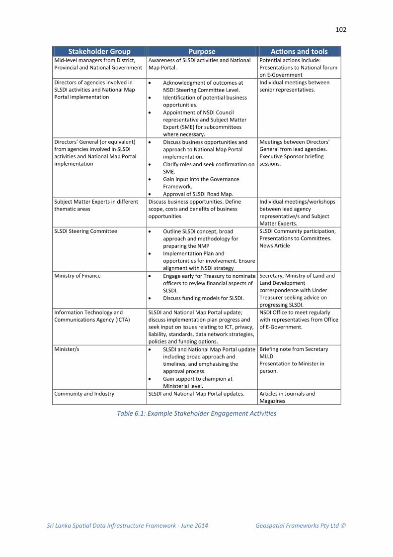
Sri Lanka Spatial Data Infrastructure Framework - June 2014 Geospatial Frameworks Pty Ltd
102
Stakeholder Group Purpose Actions and tools Mid-level managers from District, Provincial and National Government
Awareness of SLSDI activities and National Map Portal.
Potential actions include: Presentations to National forum on E-Government
Directors of agencies involved in SLSDI activities and National Map Portal implementation
• Acknowledgment of outcomes at NSDI Steering Committee Level.
• Identification of potential business opportunities.
• Appointment of NSDI Council representative and Subject Matter Expert (SME) for subcommittees where necessary.
Individual meetings between senior representatives.
Directors’ General (or equivalent) from agencies involved in SLSDI activities and National Map Portal implementation
• Discuss business opportunities and approach to National Map Portal implementation.
• Clarify roles and seek confirmation on SME.
• Gain input into the Governance Framework.
• Approval of SLSDI Road Map.
Meetings between Directors’ General from lead agencies. Executive Sponsor briefing sessions.
Subject Matter Experts in different thematic areas
Discuss business opportunities. Define scope, costs and benefits of business opportunities
Individual meetings/workshops between lead agency representative/s and Subject Matter Experts.
SLSDI Steering Committee • Outline SLSDI concept, broad approach and methodology for preparing the NMP
• Implementation Plan and opportunities for involvement. Ensure alignment with NSDI strategy
SLSDI Community participation, Presentations to Committees. News Article
Ministry of Finance • Engage early for Treasury to nominate officers to review financial aspects of SLSDI.
• Discuss funding models for SLSDI.
Secretary, Ministry of Land and Land Development correspondence with Under Treasurer seeking advice on progressing SLSDI.
Information Technology and Communications Agency (ICTA)
SLSDI and National Map Portal update; discuss implementation plan progress and seek input on issues relating to ICT, privacy, liability, standards, data network strategies, policies and funding options.
NSDI Office to meet regularly with representatives from Office of E-Government.
Minister/s • SLSDI and National Map Portal update including broad approach and timelines, and emphasising the approval process.
• Gain support to champion at Ministerial level.
Briefing note from Secretary MLLD. Presentation to Minister in person.
Community and Industry SLSDI and National Map Portal updates. Articles in Journals and Magazines
Table 6.1: Example Stakeholder Engagement Activities

Sri Lanka Spatial Data Infrastructure Framework - June 2014 Geospatial Frameworks Pty Ltd
103
6.10.4 STAKEHOLDER COMMUNICATION PLAN
It is important that the SLSDI vision is communicated to stakeholders in order to convey progress and obtain stakeholder feedback on SLSDI implementation. This should initially be achieved through preliminary workshops and seminars to identify the need and advantages of a shared approach to spatial information; followed by the development of a Communication Plan. The Communication Plan includes:
• Activities that are currently underway.
• Information about NSDI components.
• Contemporary technological best practices.
• The need for compliance with data standards to support SLSDI development.
• Agreed reporting arrangements including delivery mechanism, frequency and the responsibilities of stakeholder groups.
The communication plan should also identify the frequency and format of communications, such as meetings of the NSDI Steering Committee and NSDI Council, weekly updates to a SLSDI website and/or bi-monthly reports to regional stakeholders where Internet connections are limited.
6.11 AGREEMENTS WITH STAKEHOLDERS
The program to develop the NSDI should consider placing particular emphasis on partnerships between the institutions and the private sector and academia. This will advance the amount of information accessible through ‘data warehouse’ systems and the development of data frameworks to ease data integration. It will also foster advanced technology and application development, and the building of supportive policies to speed industry growth. To this end, the following guiding principles should be considered in stakeholder agreements:
• Data should be collected once, closest to the source and in the most efficient way possible, with a view towards increasing the vertical integration of the data.
• Spatial data should be as seamless as possible, with co-ordination across administrative boundaries.
• Data should be collected, processed and maintained according to international standards to maintain data integrity across databases, and to enable the addition of value, further enhancement and easy access and use.
• Partnerships between agencies should be simple and support the principles of the SLSDI, open to the participation of interested stakeholders within any level of government, the education communities or the private sector.
• Upon agreement, partners should contribute equitably to the costs of collecting and managing the data, and should be allowed to integrate the resulting information into their own databases, for their own use and for further distribution to their stakeholders.

Sri Lanka Spatial Data Infrastructure Framework - June 2014 Geospatial Frameworks Pty Ltd
104
6.12 RECOMMENDATIONS
Due fact that the SLSDI does not belong to one organisation and it clearly needs a policy owner and data custodians decisions need to be made that ensure that it is governed in a way that considers the needs of all participating organisations. The following recommendations are therefore made in relation to a governance model and agency agreements that will ensure all stakeholders are represented and there is strong leadership from the top.
Recommendation 6.1: That a Governance Model and agency agreements are established
It is recommended that consideration is given to establishing a governance model and agency agreements that are realistic, with measurable outcomes. It is recommended that the proposed model be adopted. This model advocates the creation of a NSDI Office, NSDI Steering Committee, and NSDI Council and subcommittees with subject matter expertise. It also recognises the role of lead agencies implementing cross-government NSDI collaborative projects. The proposed model will require support from stakeholders before being submitted to Cabinet for approval.
Recommendation 6.2: That a NSDI Office is set up to coordinate activities
It is recommended that a NSDI Office is set up to coordinate the NSDI activities on behalf of government. It is recommended that the Ministry of Land and Land Development have this responsibility. Allocation of responsibility to the Ministry will ensure that performance levels are met in regards to the implementation of the SLSDI.
Recommendation 6.3: That NSDI Office Terms of Reference are defined
It is recommended that consideration be given to employing a consultant to define the Terms of Reference for the NSDI Office to ensure whole-of-government requirements are met. This includes defining the information coordination strategies, organisational structure and reporting arrangements required to achieve effective relationships between the committees within the SLSDI community, the Ministry and the SLSDI participating agencies. This includes the need for communication plans, stakeholder engagement processes and job description profiles for the Senior Director Position, spatial information coordination, and communication and project management positions. This will ensure that duplication of NSDI roles and overlapping (or misunderstanding) of duties is not propagated across government.
Recommendation 6.4: That a NSDI Steering Committee be established
It is recommended that consideration be given to establishing the NSDI Steering Committee to provide strategic direction and endorsement of overall policy to ensure alignment with whole-of-government policies and strategic priorities. It is recommended that this Committee be chaired by Secretary for Ministry for Land and Land Development.
Recommendation 6.5: That a NSDI Council be established
It is recommended that consideration be given to establishing the NSDI Council to provide leadership during the process of creating the SLSDI and manage its ongoing operation on behalf of the government sector. This coordination body needs to be sufficiently empowered to carry out the

Sri Lanka Spatial Data Infrastructure Framework - June 2014 Geospatial Frameworks Pty Ltd
105
coordination task. A representative from each of the SLSDI Member community should be included on Council, as the tasks will involve the authorisation of input on critical documents such as the SLSDI Strategy and Implementation Plan, and submissions on expenditure.
Recommendation 6.6: That NSDI Subcommittees be established
It is recommended that consideration be given to establishing three NSDI subcommittee; (1) Legal and Policy, (2) Technical and (3) Data Subcommittees. These committees consist of subject matter experts that provide advice to the NSDI Working Group during the process of creating the NSDI and its ongoing operation. To facilitate the scoping of business opportunities, where agencies have a direct interest in the outcome, agencies should also be asked to nominate one or more representatives with subject matter expertise. The Subject Matter Experts (SME) should participate in the NSDI Subcommittees to plan the SLSDI activities and implement the SLSDI. The Terms of Reference for these committees will need to be developed.
Recommendation 6.7: That NSDI Project Lead Agencies be established
It is recommended that within the Governance Framework, for the purposes of accountability and funding, the Data Access ‘Enabling’ Framework and each of the Thematic Areas be recognised as discrete projects and that accountability be assigned to a lead agency for each. The NSDI Office should adopt a coordination and reporting role, and take responsibility for benefits realization across the government sector.
Recommendation 6.8: That a National Map Portal Steering Committee be established
A special project is required to enable the delivery of the National Map Portal component of the SLSDI. Given the significance of this body of work, a separate National Map Portal (NMP) Steering Committee is warranted.
Recommendation 6.9: That Agreements with SLSDI Member Community are developed
It is recommended that agreements targeted at relationship management and consensus building for the SLSDI (e.g. Memorandums of understandings) amongst the SLSDI Community as needed be developed. Priority should be given to develop agreements with organisations represented on the NSDI Steering Committee and NSDI Council).
Recommendation 6.10: That Stakeholders are engaged in the process at an early stage
It is recommended that those organisations that have a role to play in the NSDI are identified. Organisations and interest groups have different motives and interests. It is of fundamental importance to analyse these interests and expectations both early on in the planning process and later again during the implementation of the SLSDI. Potential stakeholders will only become active participants if they see advantages for their organisations and if they do not feel threatened by the infrastructure.
Sri Lanka Spatial Data Infrastructure Framework - June 2014 Geospatial Frameworks Pty Ltd
106
Recommendation 6.11: That a SLSDI Communication plan is developed and implemented
It is recommended that a NSDI Communications Plan be implemented to communicate progress and obtain stakeholder feedback on SLSDI implementation. A participative approach to cooperation and coordination should be considered in order to build on common interests. This entails initiating meetings with system owners, stakeholders, donor organisations, representatives of international organisations active in the field of GIS, soft- and hardware suppliers, and database managers and their technical staff.
Recommendation 6.12: That the Disaster Management and Environment Thematic Areas be developed
It is recommended that the Disaster Management and Environment Thematic Areas be used as a demonstration project on the use of spatial data that requires multi-jurisdictional data access. This will highlight the effectiveness of the governance model and robustness of the policy framework.

Sri Lanka Spatial Data Infrastructure Framework - June 2014 Geospatial Frameworks Pty Ltd
107
7. LEGAL AND POLICY FRAMEWORK A Legal and Policy Framework is the logical organisation of policy documentation into groupings and categories. In a spatial data infrastructure policies are organised according to the spatial data supply chain. This makes it easier for government employees to find and understand the contents of various policy documents as it reflects a well-recognised and understood workflow management.
In the development stage of a Spatial Data Infrastructure, a Legal and Policy Framework assists in the planning and development of the actual policies for the Spatial Data Infrastructure.
The central Government in Sri Lanka is largely responsible for policy development. Policy development is continually evolving, particularly in the areas of information technology. However, with the exception of a policy on Information Technology, there are no policies that relate to the field of spatial information management, use and access.
This lack of policy has negative implications for the development of the NSDI and therefore one of the first priorities for government is to foster policy development in order to support best practice in the development of the NSDI.
The policy/organisation environment varies from country to country and will need to be worked out with the NSDI stakeholder community. Best practice infrastructure implementations have only been achieved when they include broad stakeholder participation.
Some of the issues that need to be considered in the development of a supportive policy/organisational environment for the NSDI are:
• Allow for multiple levels of buy-in to the data access infrastructure and provide a low barrier to entry (low cost option with limited benefits), such as basic advertising of products and services, to higher cost options that offer increased benefits, such as distributed search connections to the supplier’s inventory. This allows suppliers to choose a level of participation that best meets their business and operational objectives. This is especially important in the early operation of the access component, as many suppliers will want to “try” it out and hence may not be prepared to expend much effort until they see how it works.
• Ensure key government, commercial, and value-added data/related service providers are represented as key stakeholder in the development and implementation of a national spatial data infrastructure
• Collaboration of government data suppliers on coordinated, supportive policies that relate to spatial data access and distribution including: availability of free data, pricing, copyright, and use/integration of electronic commerce
• An access infrastructure and policy that is non-threatening to stakeholder mandates. Commercial and government stakeholders need to feel comfortable as active participants in the infrastructure. They should not feel threatened by infrastructure business models or policies.
• The access component of an infrastructure must provide an environment that supports a variety of supplier business models. The development of a sustainable business model for the operation of the access component is critical to the long term success of the entire infrastructure.

Sri Lanka Spatial Data Infrastructure Framework - June 2014 Geospatial Frameworks Pty Ltd
108
• Early and clear indication of the role of the private sector is warranted. Early marketing and promotion of the entire Spatial Data Infrastructure program is required to build up the level of awareness and participation as quickly as possible. This can be achieved through policy development. It is important to get a critical mass of suppliers so potential participants will see the benefits of joining the infrastructure.
CONTEXT AND RATIONALE
Policies are a useful mechanism to promote best practice in spatial data infrastructure development, particularly in the areas of accessibility to, and usability of spatial information.
In addition, when developed in conjunction with all government organisations and the private sector, they can be used to overcome many barriers to information access, such as organisational boundaries; lack of consistent information standards; and use of incompatible or inappropriate technologies. By removing these barriers, the spatial information industry can improve the confidence of users, as they will have an understanding that the information they are using is suitable for their needs.
7.1 CURRENT STATE
Currently there is no Policy or Legal Act for the management and sharing of spatial information in Sri Lanka.
A single policy, decree or Act cannot be implemented in isolation. The Legal and Policy Framework needs to be aligned to SLSDI Strategy so that stakeholders are able to visualise the bigger picture. There is also a requirement to have the Spatial Data Infrastructure in place for organisations to comply with the essential components of the policies.
The policy development process requires effective stakeholder engagement to be successful. Currently organisations have questions relating to how the new spatial data sharing policies will supersede current inter-organisational agreements, memoranda of understanding, data licenses and procedures. They also need a clearer understanding of how new policies will impact on existing data standards, systems, data maintenance, ownership and use; and on the relationships they have with other organisations.
The Policy Framework proposed here addresses the concerns of government agencies through an integrated policy approach that:
• Explains the organisations role within the broader context of the SDSDI by designating roles and responsibilities for data custodians.
• Includes guiding principles for data collection that can be readily adopted to ensure data collection is not duplicated.
• Identifies how data should be managed by an organisation in terms of their existing operations. The principles are broad enough to allow organisation flexibility balanced with the need to harmonise practises in the interests of the SLSDI. The intent is to enable organisations to progressively move towards the adoption of standards, formats, metadata collection, and storage and archiving of data without having to reinvent workflows or build databases from scratch.

Sri Lanka Spatial Data Infrastructure Framework - June 2014 Geospatial Frameworks Pty Ltd
109
• Addresses the concerns of data security and sensitivity by providing guiding principles that can be adopted by organisations in the course of their normal operations.
• Specifies the requirements for data access and allows organisations to set their own pricing conditions.
• Importantly, it leaves the control of spatial data in the hands of the data producing organisation. This alleviates concerns associated with change, as change can be managed within the control of each participating organisation.
7.2 LEGAL AND POLICY FRAMEWORK COMPONENTS
The Legal and Policy Framework (below) outlines the essential components required within a cross-institutional context to support effective spatial data sharing across government. It can be extended to include the private sector and academia partnerships.
The Legal and Policy Framework considers all aspects of the spatial data management life cycle: from creation and initial storage; its dissemination and use as an information product; to the time when it becomes obsolete and is deleted. The data life-cycle management approach involves institutional in-house procedures and practices for policy compliance.
The Legal and Policy Framework consists of four key components – the actual Legal and Policy documents, the Policy Tools that support the implementation of the Legal and Policy documents , the implementation plan for policy development and approval, and the compliance strategy that defines how policy is to be adopted (Figure 7.1).
Policy Implementation Plan
Legal and Policy Documents
Compliance Strategy
Policy Tools
Guidelines and procedures
Standards and Metadata
Policy Instruments
Policy Management
Tools
Figure 7.1 Legal and Policy Framework Components
Sri Lanka Spatial Data Infrastructure Framework - June 2014 Geospatial Frameworks Pty Ltd
110
7.3 GUIDING PRINCIPLES
The Spatial Data Infrastructure Legal and Policy Framework is intended to guide spatial data management activities and programs and improve accessibility of information and the interoperability of systems.
In particular, the Legal and Policy Framework is intended to promote the responsible management of spatial data as a critical resource for the benefit of the government organisations and the broader community a whole. The following principles apply:
• Custodianship: Data custodians manage spatial data as trustees for the community and enable its integration with other information.
• Data Acquisition: The planning, recording and acquisition of spatial data achieves the most strategic use of resources and avoids duplication of effort.
• Spatial Data Management: Spatial data management is conducted in a way that maximises its value and optimises resources.
• Data Access: Easy, efficient and equitable access to spatial data where technology, data formats, organisational arrangements, location, costs and conditions do not inhibit its use.
• Maximise Benefits: Data access and pricing regimes maximise net benefits to the community.
• Respected Rights: Confidentiality, privacy, security and intellectual property rights of data custodians and all sectors of the community, are preserved.
• Industry Engagement: Public/private partnerships are promoted to foster the development of an innovative and competitive value-adding industry.
• Common Interests: Spatial data are compatible and consistent with, internationally recognised standards and guidelines.
• Data Security: Data are maintained in a secure environment and transmitted through secure methods.
• Storage and disposal: Data are held with adequate provision for long-term care including disaster recovery and backup procedures, and are disposed or archived in accordance with ICT regulations.
7.4 LEGAL AND POLICY DOCUMENTS
Policies should be based on international best practice and be relevant to conditions found by practitioners and users of spatial information in Sri Lanka. There are a range of inter-related policies and guidelines that can be adopted to assist central government to achieve ‘best practice’ in spatial data management, including guidelines for custodianship, spatial data management, metadata protocols and standards, data access and pricing, privacy guidelines and access to sensitive data.

Sri Lanka Spatial Data Infrastructure Framework - June 2014 Geospatial Frameworks Pty Ltd
111
7.4.1 CUSTODIANSHIP
The principle of custodianship is that the government assigns, to an agency, certain rights and responsibilities for the collection and management of spatial information on behalf of the community. The rights and responsibilities include the right to set marketing conditions for the information and responsibilities regarding the maintenance and quality of the information. It also ensures accessibility of the information and provides a recognised contact point for the distribution, transfer and sharing of the information.
The overriding philosophy associated with custodianship is that custodians manage spatial information as trustees for the community to enable its integration with other spatial data. An example of the Custodianship Policy is included in Annexure 1.
Guiding Principles for Custodianship
• Trusteeship: Custodians do not ‘own’ data but hold it in trusteeship on behalf of the community.
• Standard Setting: Custodians, in consultation with Stakeholder community and users, are responsible for defining appropriate standards and proposing them for ratification.
• Maintenance of Information: Data custodians must maintain plans for information collection, conversion and maintenance in consultation with other government institutions and the user community.
• Authoritative Source: The custodian is the authoritative source for the spatial dataset in its care and is recognised as the preferred supplier of this information.
• Accountability: The custodian is accountable for the integrity of the data in its care.
• Maintain Access: The custodian must maintain access to the spatial datasets in its care at the highest level for all users.
• Safeguard Rights: Externally provided spatial information, intellectual property rights and copyright associated with data must be safeguarded
• Obligations: Spatial data are compliant with statutory and non-statutory obligations relevant to its business.
• Data Ownership: Clear identification of data ownership (metadata) and use of memorandum of understanding or licence agreement are used to effectively manage the legal rights over data exploitation, distribution, use and destruction.

Sri Lanka Spatial Data Infrastructure Framework - June 2014 Geospatial Frameworks Pty Ltd
112
7.4.2 DATA ACQUISITION
Data acquisition refers to the planning, recording and acquiring spatial information in a way that ensures the most strategic use of resources. The intention is to eliminate duplicate collection of the same data and providing provisions for reuse.
Guiding Principles for Data Acquisition
• Avoid Duplication: All projects and activities that give rise to substantial datasets will establish at the outset whether suitable data already exist in a potentially usable form, or whether new data need to be acquired.
• Assign Custodianship: Prior to approval of new data collection activities, organisations will establish how the acquired data will be exploited for maximum benefit, identify who will be responsible for full exploitation of the data, and how the benefits will be shared.
• Plan Ahead: Data handling and storage needs are planned in order to manage and maintain databases in a way that maximises data investments and benefits and meets business priorities.
• Consult: Consultation is carried out with relevant authorities to determine the correct protocols, methodologies and classification procedures to use for newly acquired data.
• Determine Point of Truth: Work with relevant agencies to determine the authoritative ‘point-of-truth’ dataset to ensure clarity of custodianship and ownership.
• Compliance: Provide external contractors with compliance standards for the acquisition of data including, but not limited to, procedural guidelines, data standards and metadata standards.
• Records Lodgement: All spatial data collected by external providers on behalf of government organisations to be lodged within an agreed timeframe and specified quality as per contractual arrangements.
• Assess Fit for Purpose: All new datasets are assessed for their appropriateness against specified criteria including, scale, resolution, accuracy, reliability, classification and integrity.
• Acquisition justification: All new data acquired is justified for an organisations business.
7.4.3 SPATIAL DATA MANAGEMENT
The Spatial Data Management Policy is a set of principles for the responsible management of spatial data as a critical national resource. This policy is required to gain commitment from all institutions to cooperate in the implementation of the SLSDI. The policy includes agreed principles on access, data conformity and quality, content, industry engagement, avoidance of data duplication and data sensitivity.
The overriding philosophy is that Spatial Data Management is conducted in a way that maximises its value and optimises resources. An example of the Spatial Data Management Policy is included in Annexure 2.

Sri Lanka Spatial Data Infrastructure Framework - June 2014 Geospatial Frameworks Pty Ltd
113
Guiding Principles for Spatial Data Management • Quality Management: Best practice guidelines and standards are used to manage the
currency, completeness, accuracy and consistency of data for a specified purpose.
• Maximise Integration: Appropriate standards for the collection, maintenance and transfer of data are adopted to enhance integration of individual and disparate data sets.
• Recognition of Value: The performance and impact of spatial data is measured and communicated as contributions to economic prosperity, environmental quality and social well-being.
• Data Sharing: Data is shared across enterprise functions and with external agencies so that users have access to the data necessary to perform their duties.
• Cooperation: Data duplication is avoided and spatial data investments maximised by identifying and exploiting opportunities for cooperation and sharing of spatial data.
• Identification: A common vocabulary and data dictionary is applied to the identification of data to enhance accessibility, manage effective use of data, and avoid duplicated collection or purchase.
• Metadata: Appropriate metadata is used to accurately define and describe spatial data including content, geographic extent, purpose, characteristics, currency and accessibility, together with contact details for further information.
• Standards Compliance: National and International spatial data standards are applied appropriately.
• Maintenance and Revision: Data are revised and maintained according to a program of work that meets agency business priorities and broader government commitments.
• Data Transfer: Use standard spatial data formats for publishing data including formats required by the National Map Portal.
• Value Adding: Data is in a form suitable for further value-adding by internal and external users.
• Legal Compliance: Data is compliant with law and regulations and is managed in accordance within approved guidelines.
• Quality Assurance: Appropriate audit processes are applied to each dataset to produce data that are fit for purpose before release.
• Data Security: Data are maintained in a secure environment and transmitted through secure methods.
• Storage: Data are held with adequate provision for long-term care including disaster recovery and backup procedures.
• Disposal: Data that are not required are disposed or archived in accordance with state record keeping legislation.
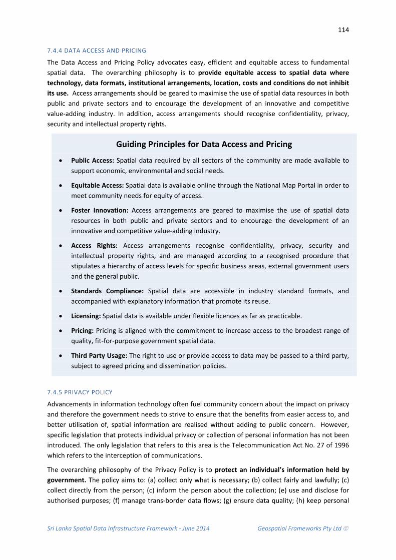
Sri Lanka Spatial Data Infrastructure Framework - June 2014 Geospatial Frameworks Pty Ltd
114
7.4.4 DATA ACCESS AND PRICING
The Data Access and Pricing Policy advocates easy, efficient and equitable access to fundamental spatial data. The overarching philosophy is to provide equitable access to spatial data where technology, data formats, institutional arrangements, location, costs and conditions do not inhibit its use. Access arrangements should be geared to maximise the use of spatial data resources in both public and private sectors and to encourage the development of an innovative and competitive value-adding industry. In addition, access arrangements should recognise confidentiality, privacy, security and intellectual property rights.
Guiding Principles for Data Access and Pricing
• Public Access: Spatial data required by all sectors of the community are made available to support economic, environmental and social needs.
• Equitable Access: Spatial data is available online through the National Map Portal in order to meet community needs for equity of access.
• Foster Innovation: Access arrangements are geared to maximise the use of spatial data resources in both public and private sectors and to encourage the development of an innovative and competitive value-adding industry.
• Access Rights: Access arrangements recognise confidentiality, privacy, security and intellectual property rights, and are managed according to a recognised procedure that stipulates a hierarchy of access levels for specific business areas, external government users and the general public.
• Standards Compliance: Spatial data are accessible in industry standard formats, and accompanied with explanatory information that promote its reuse.
• Licensing: Spatial data is available under flexible licences as far as practicable.
• Pricing: Pricing is aligned with the commitment to increase access to the broadest range of quality, fit-for-purpose government spatial data.
• Third Party Usage: The right to use or provide access to data may be passed to a third party, subject to agreed pricing and dissemination policies.
7.4.5 PRIVACY POLICY
Advancements in information technology often fuel community concern about the impact on privacy and therefore the government needs to strive to ensure that the benefits from easier access to, and better utilisation of, spatial information are realised without adding to public concern. However, specific legislation that protects individual privacy or collection of personal information has not been introduced. The only legislation that refers to this area is the Telecommunication Act No. 27 of 1996 which refers to the interception of communications.
The overarching philosophy of the Privacy Policy is to protect an individual’s information held by government. The policy aims to: (a) collect only what is necessary; (b) collect fairly and lawfully; (c) collect directly from the person; (c) inform the person about the collection; (e) use and disclose for authorised purposes; (f) manage trans-border data flows; (g) ensure data quality; (h) keep personal
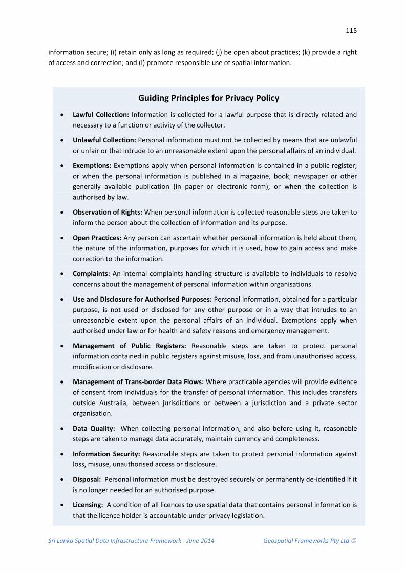
Sri Lanka Spatial Data Infrastructure Framework - June 2014 Geospatial Frameworks Pty Ltd
115
information secure; (i) retain only as long as required; (j) be open about practices; (k) provide a right of access and correction; and (l) promote responsible use of spatial information.
Guiding Principles for Privacy Policy
• Lawful Collection: Information is collected for a lawful purpose that is directly related and necessary to a function or activity of the collector.
• Unlawful Collection: Personal information must not be collected by means that are unlawful or unfair or that intrude to an unreasonable extent upon the personal affairs of an individual.
• Exemptions: Exemptions apply when personal information is contained in a public register; or when the personal information is published in a magazine, book, newspaper or other generally available publication (in paper or electronic form); or when the collection is authorised by law.
• Observation of Rights: When personal information is collected reasonable steps are taken to inform the person about the collection of information and its purpose.
• Open Practices: Any person can ascertain whether personal information is held about them, the nature of the information, purposes for which it is used, how to gain access and make correction to the information.
• Complaints: An internal complaints handling structure is available to individuals to resolve concerns about the management of personal information within organisations.
• Use and Disclosure for Authorised Purposes: Personal information, obtained for a particular purpose, is not used or disclosed for any other purpose or in a way that intrudes to an unreasonable extent upon the personal affairs of an individual. Exemptions apply when authorised under law or for health and safety reasons and emergency management.
• Management of Public Registers: Reasonable steps are taken to protect personal information contained in public registers against misuse, loss, and from unauthorised access, modification or disclosure.
• Management of Trans-border Data Flows: Where practicable agencies will provide evidence of consent from individuals for the transfer of personal information. This includes transfers outside Australia, between jurisdictions or between a jurisdiction and a private sector organisation.
• Data Quality: When collecting personal information, and also before using it, reasonable steps are taken to manage data accurately, maintain currency and completeness.
• Information Security: Reasonable steps are taken to protect personal information against loss, misuse, unauthorised access or disclosure.
• Disposal: Personal information must be destroyed securely or permanently de-identified if it is no longer needed for an authorised purpose.
• Licensing: A condition of all licences to use spatial data that contains personal information is that the licence holder is accountable under privacy legislation.

Sri Lanka Spatial Data Infrastructure Framework - June 2014 Geospatial Frameworks Pty Ltd
116
7.4.6 ACCESS TO SENSITIVE DATA
There are times when certain classes of spatial data need to be withheld from public access and usage for example, culturally sensitive sites, and the location of endangered tree species, gem deposits, and defence installations. However, there are also times when withholding data can degrade decision-making processes, including areas such as emergency planning and response, and environmental management, especially in time-critical situations.
This policy creates an environment for encouraging open access to data and, at the same time, gives consideration to issues of privacy, national security and commercial sensitivity. An example of the Access to Sensitive Data Policy is included in Annexure 3.
Guiding Principles for Access to Sensitive Data
• Open Access: Open access to spatial data takes precedence over restricted access unless there are specific, compelling reasons to restrict access.
• Restricted Access: Decisions on restricting access are based on privacy, commercial sensitivity, national security, environmental sensitivity or legislative requirements.
• Discretionary Access: Sensitive data may be generalised to meet user needs while not compromising any sensitive issues.
• Controlled Access: Controlled access guidelines are used in cases where sensitive information is in the public interest, such as for emergency management and national security.
• Public Scrutiny: Data restrictions are explicitly defined in a policy, legislation or regulations that are open to public scrutiny and not left to individual employees to decide on a case by case basis.
• Metadata Management: Data custodians will advise of any access restrictions through accessible metadata records.
7.4.7 INTELLECTUAL PROPERTY MANAGEMENT
There is a high degree of inconsistency in intellectual property management across government institutions and various licensing agreements in place. This policy is designed to create a higher level of uniformity. The overarching philosophy of the Intellectual Property Management Policy is to maximise the value of spatial information through protected rights.
The intent is to grant rights to its intellectual property, as a public asset, in a manner that maximises its impact, value, accessibility and benefit consistent with the public interest; and acquires or uses third party intellectual property in a transparent and efficient way, while upholding the law and managing risk appropriately.
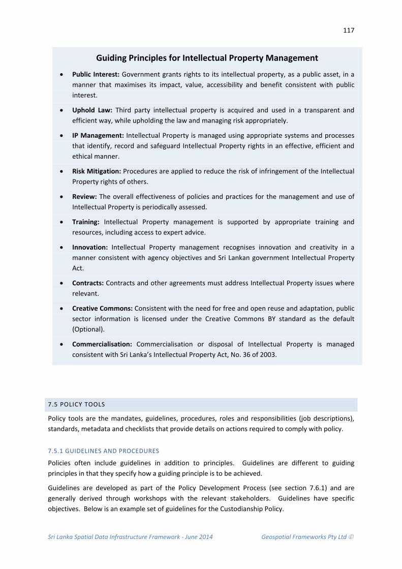
Sri Lanka Spatial Data Infrastructure Framework - June 2014 Geospatial Frameworks Pty Ltd
117
Guiding Principles for Intellectual Property Management
• Public Interest: Government grants rights to its intellectual property, as a public asset, in a manner that maximises its impact, value, accessibility and benefit consistent with public interest.
• Uphold Law: Third party intellectual property is acquired and used in a transparent and efficient way, while upholding the law and managing risk appropriately.
• IP Management: Intellectual Property is managed using appropriate systems and processes that identify, record and safeguard Intellectual Property rights in an effective, efficient and ethical manner.
• Risk Mitigation: Procedures are applied to reduce the risk of infringement of the Intellectual Property rights of others.
• Review: The overall effectiveness of policies and practices for the management and use of Intellectual Property is periodically assessed.
• Training: Intellectual Property management is supported by appropriate training and resources, including access to expert advice.
• Innovation: Intellectual Property management recognises innovation and creativity in a manner consistent with agency objectives and Sri Lankan government Intellectual Property Act.
• Contracts: Contracts and other agreements must address Intellectual Property issues where relevant.
• Creative Commons: Consistent with the need for free and open reuse and adaptation, public sector information is licensed under the Creative Commons BY standard as the default (Optional).
• Commercialisation: Commercialisation or disposal of Intellectual Property is managed consistent with Sri Lanka’s Intellectual Property Act, No. 36 of 2003.
7.5 POLICY TOOLS
Policy tools are the mandates, guidelines, procedures, roles and responsibilities (job descriptions), standards, metadata and checklists that provide details on actions required to comply with policy.
7.5.1 GUIDELINES AND PROCEDURES
Policies often include guidelines in addition to principles. Guidelines are different to guiding principles in that they specify how a guiding principle is to be achieved.
Guidelines are developed as part of the Policy Development Process (see section 7.6.1) and are generally derived through workshops with the relevant stakeholders. Guidelines have specific objectives. Below is an example set of guidelines for the Custodianship Policy.

Sri Lanka Spatial Data Infrastructure Framework - June 2014 Geospatial Frameworks Pty Ltd
118
Example Guidelines
• Criteria for spatial data requiring custodianship
• Criteria for selecting a custodian
• Responsibilities of custodians • Responsibilities of users
• Assignment of custodianship • Review of custodianship
Procedures are not included in policy documents but can be referred to if necessary. A procedure describes the Who, What, Where, When, and Why to establish corporate accountability in support of policy implementation. The How is documented by each business unit/institution in the form of Work Procedures and generally includes greater detail. These procedures are used to explain to employees the process to comply with policy.
7.5.2 STANDARDS AND METADATA
Data standards, regulations and metadata serve as an efficient mechanism to ensure policy compliance. A standard is a document that provides requirements and specifications that can be used consistently to ensure that materials, products, processes and services are fit for their purpose. Best practice standards in spatial data management are available.
Standards can include those develop by institutions to conduct business, such as Survey Regulations for cadastral surveying or internationally recognised standards such as Creative Commons for copyright management, ICT standards for storage and archiving, and Data Exchange standards for data transfer between systems. The key is to ensure these standards are referenced in policy where applicable.
7.5.3 POLICY INSTRUMENTS
Policy Instruments are the laws and regulations created to mandate methods for achieving the required policy outcomes. They also include economic incentives, such as payment credits, used as an incentive to influence policy compliance.
7.5.4 POLICY MANAGEMENT
Policy management requires a set of tools to assist in the implementation, management and review of policy. These tools include:
• Policy Register: Provides a single and authoritative source for all records management policy documents produced by the government. The register contains information on and links to the current versions of all policies.
• Communication Strategy: Strategic Communication during policy-making is required for guidance and to ensure consistent information flows and activities within an organisation and between organisations.
• Quality Audit: Quality audits can be performed to understand if an institution is complying with government policy and defined quality system processes.
• Policy Analysis (Measures): Policy analysis provides decision makers with important information on how policies work in practice and their effects on economic, environmental, social and other factors.

Sri Lanka Spatial Data Infrastructure Framework - June 2014 Geospatial Frameworks Pty Ltd
119
7.6 POLICY IMPLEMENTATION PLAN
7.6.1 STAGE 1: BUSINESS CASE DEVELOPMENT
There are a number of key steps to developing a robust policy document.
Policy justification:
• Be clear about the purpose of the policy and how the policy will help to resolve the problems currently faced.
• Be clear about the boundaries of what a policy will and will not be able to resolve and to consider what this may mean for other areas such as training, performance information and quality assurance tools.
• Depending upon the nature and scale of the policy it may be useful to select an advisory group to contribute to this early 'scoping' of the policy. It is at this early planning stage when it may be appropriate to develop a business case.
Research, analysis and direction setting:
• Gather and analyse information about what is currently known about the nature of the problem to be resolved.
• Gain views, ideas and analyse information from Institutions as well as looking for lessons learnt and good practice that can apply from other countries.
• Test out any assumptions that have been made at this stage. This stage will usually run alongside the business case development stage.
Policy design:
• Policy design can be progressed once it is understood how the policy will support the organisations overall strategic direction and resolve the problem or difficulties in question.
• Identify the guiding principles of the policy.
• Define the vision, and clear aims and objectives of the policy.
• Depending on the complexity of the issues involved it may be necessary to develop several policy options – a single policy or several interrelated policies managed within a policy framework.
• It is important that legal advice is embedded in the development process and Legal Teams should be involved from an early stage and throughout the stages of development.
• Observe government rules for formatting the document. There may be an existing template with pre-defined fonts, headers, footers etc.

Sri Lanka Spatial Data Infrastructure Framework - June 2014 Geospatial Frameworks Pty Ltd
120
7.6.2 STAGE 2: POLICY DEVELOPMENT
Importantly, there is a need to be aware of how different policy documents operate and what it is intended they will deliver. The relationship between policy and strategy is very interactive and the two are often interwoven. Close integration is important to make sure that strategies are implemented by using the most suitable policies and that different policies are not contradictory.
7.6.3 MANAGING THE POLICY DEVELOPMENT PROCESS
• Once the SLSDI draft policies are reasonably advanced and have agreement from the policy sponsor, it is important to create the opportunity for others to scrutinize and make suggestions on the draft document. In this way the policy will become more robust as it benefits from a wider range of views, knowledge and challenges.
• The nature and complexity of the SLSDI policies means they are likely to require change to take into account the users, staff and other stakeholders likely to be impacted.
• All consultation exercises will require careful planning and well formulated questions that make it possible to analyse the responses.
• The policy author should review all responses and compile a report for the policy owner to consider. This needs to include the key themes drawn from responses, important issues as well as a record of all received responses.
• Observe a procedure for document control - such a procedure defines not only the format of the document, but also the rules for its approval, distribution and versioning.
• Once the policies are close to finalisation it is important to conduct an equality impact assessment to identify if there are any adverse impacts for one group over another. If there are impacts and these cannot be justified on the grounds of promoting equality, then the policies need to be further developed and a second assessment undertaken once changes to the policies have been made.
Explanation of Differences
• A Strategy is a high level policy which describes the overall process of deciding where you want to get to and how you are going to get there. (For example, SLSDI Strategy 2020).
• A Policy Framework describes the overall strategic approach and desired future. It sets out what needs to be achieved in order to bring about change. It is often an 'umbrella' strategy' to which a number of policies relate.
• A Policy identifies how to achieve a particular strategic outcome. It clarifies what needs to be done and by whom. The policy instrument that will be suitable to deliver a particular outcome will vary depending upon the issue. It is likely to include a policy position followed by a set of practice standards, or detailed procedures supported by guidelines or toolkit).
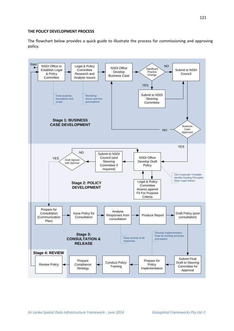
Sri Lanka Spatial Data Infrastructure Framework - June 2014 Geospatial Frameworks Pty Ltd
121
THE POLICY DEVELOPMENT PROCESS
The flowchart below provides a quick guide to illustrate the process for commissioning and approving policy.
NSDI Office Develop
Business Case
Submit to NSDI Council
Submit to NSDI Steering
Committee
NSDI Office Develop Draft
Policy
Submit to NSDI Council (and
Steering Committee if
required)
Significant Practice Change
Business Case
Approved
Draft Agreed with Sponsor
Prepare for Consultation
(Communication Plan)
Issue Policy for Consultation
Analyse Responses from
consultationProduce Report Draft Policy (post
consultation)
Submit Final Draft to Steering Committee for
Approval
Prepare for Policy
Implementation
YES
Prepare Compliance
Strategy
Conduct Policy Training
Legal & Policy Committee
Assess against Fit For Purpose
Criteria
Legal & Policy Committee
Research and Analyse Issues
NSDI Office to Establish Legal
& Policy Committee
NO
YES
NO
Use Corporate TemplateIdentify Guiding PrinciplesSeek Legal Advice
Clear purpose, boundaries and scope
Workshop issues and test assumptions
Stage 1: BUSINESS CASE DEVELOPMENT
Stage 2: POLICY DEVELOPMENT
Keep records of all responses
Develop Implementation Pack for briefing seminars and papers
Stage 3: CONSULTATION &
RELEASE
Stage 4: REVIEW
Review Policy
Start NO
YES
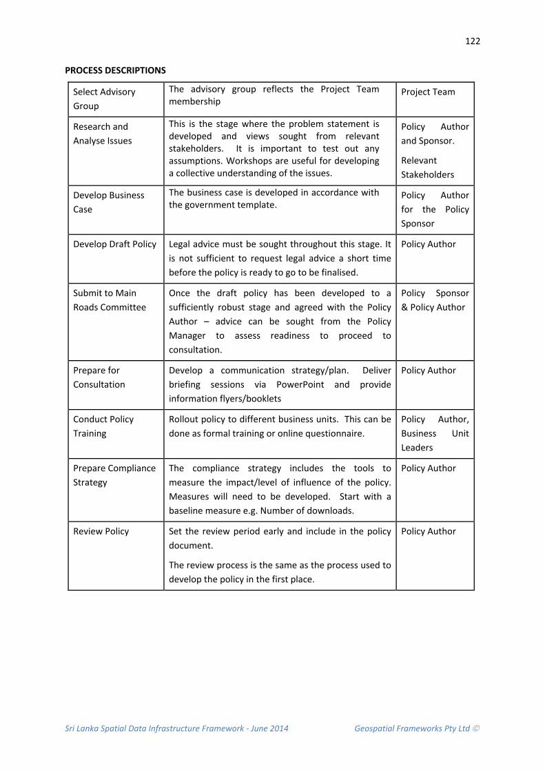
Sri Lanka Spatial Data Infrastructure Framework - June 2014 Geospatial Frameworks Pty Ltd
122
PROCESS DESCRIPTIONS
Select Advisory Group
The advisory group reflects the Project Team membership
Project Team
Research and Analyse Issues
This is the stage where the problem statement is developed and views sought from relevant stakeholders. It is important to test out any assumptions. Workshops are useful for developing a collective understanding of the issues.
Policy Author and Sponsor.
Relevant Stakeholders
Develop Business Case
The business case is developed in accordance with the government template.
Policy Author for the Policy Sponsor
Develop Draft Policy Legal advice must be sought throughout this stage. It is not sufficient to request legal advice a short time before the policy is ready to go to be finalised.
Policy Author
Submit to Main Roads Committee
Once the draft policy has been developed to a sufficiently robust stage and agreed with the Policy Author – advice can be sought from the Policy Manager to assess readiness to proceed to consultation.
Policy Sponsor & Policy Author
Prepare for Consultation
Develop a communication strategy/plan. Deliver briefing sessions via PowerPoint and provide information flyers/booklets
Policy Author
Conduct Policy Training
Rollout policy to different business units. This can be done as formal training or online questionnaire.
Policy Author, Business Unit Leaders
Prepare Compliance Strategy
The compliance strategy includes the tools to measure the impact/level of influence of the policy. Measures will need to be developed. Start with a baseline measure e.g. Number of downloads.
Policy Author
Review Policy Set the review period early and include in the policy document.
The review process is the same as the process used to develop the policy in the first place.
Policy Author

Sri Lanka Spatial Data Infrastructure Framework - June 2014 Geospatial Frameworks Pty Ltd
123
7.6.4 STAGE 3: CONSULTATION AND RELEASE
Policy Approval and Launch
• Good governance requires that all Institutions have the opportunity to make final comments, changes and improvements to a policy before it is released. A formal sign off process can be used to engage key staff routinely.
• The policy sponsor (which will in most cases be the NSDI Steering Committee Chair) will circulate the new policy to the relevant institutions that will be consulted on specific issues.
• An electronic paper trail should be kept in case of requests for access, or a Freedom of Information Request, and the trail should be held by the lead manager/policy author and should include evidence of consultation and approvals.
• Following formal sign off, the policy should be prepared for publication. This will require a communication plan and include communication channels, such as newsletters, agency-wide emails etc.
Communicating the Policy Release
• The Policy Sponsor should inform institutions and other external stakeholders of the new policy/s in preparation for implementation.
• The Policy Sponsor should inform Senior Officials about the timescale within which their organisation will be expected to implement the policy.
• The decision about what is an appropriate timescale for policy implementation will be made by the policy sponsor in consultation with the Policy Author and Project Team. The timescale will reflect amongst other things: legislative requirements, business priorities, access to the appropriate technology and risk to the organisation/s.
• The Policy Author should prepare an implementation pack to accompany the launch; this could include a briefing for institutions and a PowerPoint presentation which can be used to introduce the policy to their staff to support implementation.
• The Policy Author should monitor the rate of policy implementation and identify any potential delays or issues. Where issues are being raised such as confusion around the meaning of certain text then these should be referred to the Policy Sponsor. A report on the level of policy compliance should be circulated amongst institutions.

Sri Lanka Spatial Data Infrastructure Framework - June 2014 Geospatial Frameworks Pty Ltd
124
7.6.5 STAGE 4: POLICY REVIEW
Reviewing Policy
• All policies should be subject to review, as the review date approaches it is important to plan the process. To some extent it can help to see this as a shortened version of the full development process because it is important to ask many of the same fit for purpose questions (see Appendix 9). Inevitably the demands of the organisation will change over time and it is important to consider whether the policy needs to be amended to reflect these changes. It is also essential to galvanise views from across the institutions about the success of the policy, what has worked, what hasn’t; and consider where there may be gaps or newly emerging needs or issues.
• It may be necessary to plan a communications exercise using the Internet to generate discussion and feedback.
• If as a result of the review essential aspects of the policy are changed, it will be important to run a similar communications exercise as occurred in the initial implementation.
7.7 COMPLIANCE STRATEGY
When designing a policy or procedure, it is important to include an accompanying Compliance Strategy that defines how people will be encouraged to comply and how compliance will be monitored.
The type of compliance strategy will depend on how clearly the policy or procedure defines the expected outcome/action/decision, and how this can be monitored by the Policy Manager.
The approach will also depend on the relationship and authority that the Policy Manager has with the people identified in scope of the policy and procedure.
Encouraging Compliance for SLSDI Policies
• Clearly define the implications for not complying with the policy. It is important that non-compliance can be monitored and implications for non-compliance are achievable. For example a user’s access to an organisations spatial system may be suspended if they have breached the ICT Appropriate Use or Information Security Policies.
• Provide a motivation (positive acknowledgement or reward) to institutions that comply with policy.
• Put check points in place to encourage policy compliance as part of a process. For example: Introducing the need for users of spatial data to accept terms and conditions via the portal before they can proceed to the next step.
• Fast track compliance processes to make it easier for institutions to comply with policy, such as staff briefing for new policies to fast track the knowledge transfer of the policy content.
• Help institutions to understand why they should comply by framing policy outcomes and benefits in their institutional context.

Sri Lanka Spatial Data Infrastructure Framework - June 2014 Geospatial Frameworks Pty Ltd
125
7.8 RECOMMENDATIONS
Due to the fact that a Legal and Policy Framework assists in the planning and development of a Spatial Data Infrastructure, the following recommendations are made in relation to the Policy Framework and impact on legal documentation.
Recommendation 7.1 That a Legal and Policy Framework is developed for the production, management, distribution and use of spatial information
It is recommended that consideration be given to providing a Legal and Policy Framework for the production, management, distribution and use of spatial information. Policies should be developed in conjunction with policies for custodianship, spatial data management, metadata protocols and standards, spatial data access and pricing, privacy and access to sensitive data.
Recommendation 7.2 That existing legal documents are reviewed for applicability to spatial information management
It is recommended that existing legal documents are reviewed for applicability to spatial information management: These include:
• Policy and Procedures for ICT Usage in Government (e-Government Policy) Circular SP/SB/03/10
• Computer Crime Act, No. 24 of 2007
• Electronic Transactions Act, No. 19 of 2006
• Information and Communication Technology Act, No. 27 of 2003
• Intellectual Property Act, No. 36 of 2003
• Payment Devices Frauds Act, No. 30 of 2006
• Payment and Settlement Systems Act, No. 28 of 2005
Recommendation 7.3: That Spatial Data Infrastructure Policies are developed with assistance of an industry expert
It is recommended that a consultant be employed to review exiting government IT policies and assist the NSDI Working Group with the development of Spatial Data Infrastructure Policies. There is a considerable amount of work to be done in the area of policy formulation. Difficulties in achieving effective policy are anticipated. These relate to a limited understanding by stakeholders in the vision of the NSDI as a whole, limited knowledge regarding usage policies and potential anxiety of stakeholders with the impact of new data sharing processes and data management requirements.

Sri Lanka Spatial Data Infrastructure Framework - June 2014 Geospatial Frameworks Pty Ltd
126

Sri Lanka Spatial Data Infrastructure Framework - June 2014 Geospatial Frameworks Pty Ltd
127
8. SUMMARY OF RECOMMENDATIONS The following recommendations are made to achieve a consistent spatial data infrastructure for Sri Lanka in order to promote economic development, stimulate open government and foster environmental sustainability.
No RECOMMENDATION RESPONSIBLE TIMEFRAME
Spatial Data Infrastructure Framework
1.1 That a shared NSDI Vision is developed through stakeholder consultation
1.2 That a NSDI Mission is adopted by the NSDI Office
1.3 That NSDI Principles are endorsed
1.4 That a comprehensive Capacity Building Study be undertaken
Data Framework
2.1 That a Data Framework is developed
2.2 That a full Data Inventory is conducted
2.3 That a Change Management Plan is developed
2.4 That Administrative Boundary Data sets are rationalised
2.5 That a Cadastral Map Layer is included in the National Map Portal
2.6 That Geocoded Address Data are created
2.7 That aerial photography and satellite imagery is captured and processed
2.8 That Socio-economic Data be converted to map form
2.9 That Custodianship Arrangements are agreed
2.10 That GIS Software Licensing is negotiated
2.11 That progress is directed towards Seamless National Map Coverage

Sri Lanka Spatial Data Infrastructure Framework - June 2014 Geospatial Frameworks Pty Ltd
128
2.12 That an urgent reassessment of Data Storage and Archiving is conducted
2.13 That a standards based approach to spatial data management is adopted
2.14 That Metadata ISO Standards are adopted
2.15 That a Master version of Metadata be Created and closely controlled
2.16 That the NSDI Office be the custodian of a Sri Lanka Spatial Data Directory
2.17 That training in Standards and Metadata Compliance be conducted
2.18 That data access protocols be adopted to identify Access Levels
Supply Chain Framework
3.1 That once the policy framework is in place that Supply Chain Reform be a future step.
3.2 That capacity building be undertaken in an orderly progression as needs become evident
3.3 That a comprehensive financial analysis is conducted to ascertain the most appropriate funding model.
3.4 That Fundamental Data Sets be resourced as a priority
3.5 That a comprehensive analysis is conducted to determine the most appropriate Intellectual Property Management model.
3.6 That an annual Data Acquisition Program be conducted

Sri Lanka Spatial Data Infrastructure Framework - June 2014 Geospatial Frameworks Pty Ltd
129
Data Access Framework
4.1 That a feasibility study be conducted into the potential to extend Lanka Gate Portal
4.2 That a Services Oriented Architecture be considered as a plausible technology solution
4.3 That a detailed Requirements Design is prepared
4.4 That Open Geospatial Consortium Standards be adopted
4.5 That accessing spatial data be via Dissemination Databases
4.6 That Open Data Principles be adopted
Application Framework
5.1 That a Disaster Management Pilot is conducted to demonstrate SLSDI capabilities
5.2 That Thematic Areas aligned to government strategy be established as a component of the SLSDI implementation plan.
Governance Framework
6.1 That a Governance Model and agency agreements are established
6.2 That a NSDI Office is set up to coordinate activities
6.3 That NSDI Office Terms of Reference are defined
6.4 That a NSDI Steering Committee be established
6.5 That a NSDI Council be established
6.6 That NSDI Subcommittees be established
6.7 That NSDI Project Lead Agencies be established
6.8 That a National Map Portal Steering Committee be established

Sri Lanka Spatial Data Infrastructure Framework - June 2014 Geospatial Frameworks Pty Ltd
130
6.9 That Agreements with SLSDI Member Community are developed
6.10 That Stakeholders are engaged in the process at an early stage
6.11 That a SLSDI Communication plan is developed and implemented
6.12 That the Disaster Management Thematic Area be developed
Legal and policy framework
7.1 That a Legal and Policy Framework is developed for the production, management, distribution and use of spatial information
7.2 That existing legal documents are reviewed for applicability to spatial information management
7.3 That Spatial Data Infrastructure Policies are developed with assistance of an industry expert
Sri Lanka Spatial Data Infrastructure Framework - June 2014 Geospatial Frameworks Pty Ltd
131
9. REFERENCES ANZLIC (2002) Metadata Guidelines: Core Metadata for Elements for Geographic Data in Australia
and New Zealand, available at http://www.anzlic.org.au/infrastructure_metadata.html#standards, access date 14 March 2007.
ANZLIC (2014) ANZ Foundation Data Framework, available at http://spatial.gov.au/anzlic/anz-foundation-spatial-data-framework, accessed May 2014.
CIA World Factbook (2007) Sri Lanka Population Growth Rate, available at https://www.cia.gov/cia/publications/factbook/geos/vm.html#People, access date 22 March 2007
FGDC (1998) Content Standard for Digital Geospatial Metadata Workbook, Version 2.0, Federal Geographic Data Committee, May 1, 2000
FGDC (2013) NSDI Cooperative Agreement Program, available at http://www.fgdc.gov/grants, accessed May, 2013.
FGDC (2014) NSDI Framework, available at http://www.fgdc.gov/framework/frameworkoverview, accessed May 2014.
Government of New South Wales (NSW), Australia (2013) NSW Data Framework, available at http://finance.nsw.gov.au/ict/sites/default/files/NSW%20Government%20Foundation%20Spatial%20Data%20Framework.pdf, accessed May 2014.
ICTA (2014a) eSriLanka, available at http://www.icta.lk/e-sri-lanka.html, accessed June 2014
ICTA (2014b) Transforming a Nation through Information Technology, available at http://www.icta.lk/en/e-sri-lanka.html, accessed June 2014.
International Standards Organisation (ISO) ISO 19100 Geographic Information Standards accessed March 2014, available at (http://spatial.gov.au/sites/default/files/legacy/osdm.gov.au/Metadata/Standards/ISO%2019100%20Geographic%20Information%20Standards%20-%20Full.pdf/index.pdf,
MFARD (2014) Ministry of Fisheries and Aquatic Resources Development Projects, available http://www.fisheries.gov.lk, accessed June 2014.
State of Connecticut (2006) Connecticut Geographic Framework Data, available at www.ct.gov/gis/.../gis/Connecticut_Framework_Data_Themes_Final_Report_ 120407_12-6-07.doc, access June 2014.
Western Australian Land Information Authority (2007) SLIP-EF Executive Overview, Unpublished works, pp. 16
Ministry of Economic Development (2010) National Tourism Development Strategy 2011-2016, available at http://srilanka.travel/catalog/view/theme/default/image/pdf/English.pdf, accessed June 2014.
Ministry of Environment (2009) National Action Plan for Harita Lanka Programme available at http://www.environmentmin.gov.lk/web/pdf/Harita_Lanka_Book_small.pdf, accessed June 2014

Sri Lanka Spatial Data Infrastructure Framework - June 2014 Geospatial Frameworks Pty Ltd
132
Ministry of Environment and Natural Resources (MENR) (2014) National Sustainable Development Strategy, under development, available at http://www.un.org/esa/agenda21/natlinfo/countr/slanka/nsds.pdf, draft accessed June 2014.
Nebert, D.D (2004) GSDI Cookbook, Version 2.0, available at http://www.gsdi.org/docs2004/Cookbook/cookbookV2.0.pdf, accessed May 2014.
Ordnance Survey (OS) 2104 Developer Challenge 2014, available at http://www.ordnancesurvey.co.uk/innovate/developers/developer-challenge.html, accessed July 2014.
Parliament of The Democratic Socialist Republic of Sri Lanka (2003) Intellectual Property Act, No. 36 of 2003, Published as a Supplement to Part II of the Gazette of the Democratic Socialist Republic of Sri Lanka of November 14, 2003, available at http://www.wipo.int/wipolex/en/details.jsp?id=6705, accessed June 2014.
Sri Lanka, Wonder of Asia (2014) Sri Lanka Tourism Arrivals Increase 20.3% in May 2014, available at http://www.srilanka.travel/travel_news, accessed June 2014.
Western Australian Land Information Authority (2010) SLIP Portal: Innovation Program, available at https://www2.landgate.wa.gov.au/web/guest/innovation, accessed July 2014.
World Bank Group (2012) Disaster Risk Management in South Asia, available at http://reliefweb.int/sites/reliefweb.int/files/resources/Disaster%20Risk%20Management%20in%20South%20Asia%20-%20A%20Regional%20Overview.pdf, accessed July 2014.
General Reference Documents
• ANZLIC is the Australian and New Zealand Spatial Information Council. Policies and standards can be accessed at http://www.anzlic.org.au/policies.html.
• WALIS is the Western Australian Land Information System. Policies and procedures are available at http://www.walis.wa.gov.au/resources/policies
• FGDC is the Federal Geographic Data Committee, United States of America. Policies are available at http://www.fgdc.gov/policyandplanning
• Creative Commons Australia, available at https://creativecommons.org/
• United States Environmental Protection Agency (EPA), available at (http://www.epa.gov/geospatial/policies.html)
• United States Geological Survey (USGS) available at http://www.usgs.gov/aboutusgs/who_we_are/laws.asp
• Ordnance Survey Policies available at http://www.ordnancesurvey.co.uk/about/governance/policies/
• National Policies on Spatial Data Infrastructure, United Nations Member Countries, available at http://ggim.un.org/sdi.html
• The 8 Principles of Open Government Data, available at http://www.opengovdata.org/home/8principles)

Sri Lanka Spatial Data Infrastructure Framework - June 2014 Geospatial Frameworks Pty Ltd
133
APPENDIX 1: MEMBERS OF THE NSDI WORKING GROUP
Name Designation of the Committee
Designation Institute
01 Mr. Wasantha Deshapriya
Chairman Director Re-Engineering Government Program
02 Mr. S.M.P.P. Sangakkara,
Member Additional Surveyor General (Central)
Survey Department
03 Mrs. A. L. S. C. Perera Member Deputy Surveyor General (LIS/GIS)
Survey Department
04 Mr. M D Dayananda Member Director Department of Meteorology
05 Mr. K Prasanna Chandith Member Director National Disaster Relief Service Centre
06 Mrs. Kumari Weerasinghe
Member Senior Scientist National Building Research Organisation
07 Mr. Srimal Samansiri Member Assistant Director Disaster Management Centre
08 Mr. E A P N Edirisinghe Member Assistant Conservator
Department of Forest
09 Mr. Ajith De Silva Member Director Ministry of Environmental and Renewable Energy
10 Ms A.D.P.N.Attygalle Member Assistant Secretary Ministry of Land and Land Development

Sri Lanka Spatial Data Infrastructure Framework - June 2014 Geospatial Frameworks Pty Ltd
134
APPENDIX 2: WORKSHOP AGENDA 27 MAY 2014 Sri Lanka Spatial Data Infrastructure – Stakeholder Workshop
Date: 27th May 2014 Venue: Hotel Galadhari
Inaugural Session
Time Agenda Item
8.30 – 9.00 Registration
9.00 – 10.45 Inaugural Session Organized jointly with Ministry of Land and Land Development, Ministry of Disaster Management
Lightning Oil Lamp National Anthem
Welcome Address by Mr. Ashoka Pieris, Secretary, Ministry of Land and Land Development Keynote Address on “Need of NSDI for the National Development”, Prof. Ranjith Premalal De
Silva, Vice Chancellor, University of Uva Wellassa Address by “Building a National Spatial Data Infrastructure”, Dr. Lesley Arnold, Consultant,
World Bank Address by Chief Guest Hon. Tissa Vitharana, Senior Minister to the Cabinet Q&A Session Vote of Thanks by Mr. Wasantha Deshapriya, Director ICTA
10.45 – 11.30
Refreshments
Technical Sessions
11.30 – 13.00
Session 01: Part 1: What is A NSDI?; A case study of a NSDI from a developing country; (40 minutes) Part 2: What to expect from the Study? Overall NSDI Study Work Plan; (40 minutes) Presentation / Speech by Dr. Lesley Arnold Discussion (10 minutes)
13.00 – 14.00
Lunch
14.00 – 15.30
Session 02: Group Work: What do you expect from SLSDI. Members from different domains to discuss and their expectations/outcomes Group Activities
• Discuss Political, Economic, Social and Technology drivers for change • Discuss strengths, weaknesses, opportunities and threats
Presentation / facilitation by Lesley Arnold 15.00 _ 15.15
(Working) Refreshment
15.15 – 16.15
Session 03: Major Challenges in setting up of a NSDI; (What government should be worried about; Key success factors) Agree on key points: Ownership; Sub Committees; National Data Sharing Act & Policy; Sharing Data; Way Forward; Vision and 5-7 major goals Wrap up by Dr. Lesley Arnold

Sri Lanka Spatial Data Infrastructure Framework - June 2014 Geospatial Frameworks Pty Ltd
135
APPENDIX 3: PEST ANALYSIS Workshop 27th May 2014. Delegate responses to the political, economic, social and technology issues that may have a positive or negative impact on the SLSDI strategy.
Political:
• Issues of National security may mean that some information is not available.
• Opportunity to leverage data for economic development and emergency management.
• Political boundaries as defined in legislation do not match the position in spatial information data sets. Digital data accuracy is a problem.
• Not all politicians understand the importance of spatial information.
Economic:
• Savings can be achieved through sharing data – ability to reuse data is important.
• Need to avoid costly data duplication, particularly for national projects such as irrigation projects, road projects, water resources planning and flood management.
• Need to allow public to access data. This is currently not easy.
• Data needs to be accessible form one location.
• We need data to understand damage estimation from drought.
• We need spatial data to better manage our resources.
• Spatial data should be interoperable with global standards.
• There are limited funds available to advance technologies.
• High cost of hardware/software for developing the infrastructure and high maintenance costs in keeping systems up-to-date.
• Limited human resource capacity in GIS across government with many qualified people transitioning to private sector.
• Concerns about system security i.e. data hacking.
• There is a broad area that SDI can contribute but what these opportunities are is not understood.
• Data integration, particularly thematic data, is seen as supporting evidence-based decision making.
• Agricultural resources have not been classified.
• There is a lot of statistical information but this has not been mapped.
• The social benefits of spatial information have not been quantified – not even a summary map.
• We need to understand investment patterns – where can SDI add the most value, i.e. fishing operations
• Not sell data but open it up to make it freely available and leverage economically.
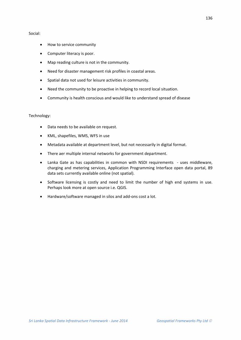
Sri Lanka Spatial Data Infrastructure Framework - June 2014 Geospatial Frameworks Pty Ltd
136
Social:
• How to service community
• Computer literacy is poor.
• Map reading culture is not in the community.
• Need for disaster management risk profiles in coastal areas.
• Spatial data not used for leisure activities in community.
• Need the community to be proactive in helping to record local situation.
• Community is health conscious and would like to understand spread of disease
Technology:
• Data needs to be available on request.
• KML, shapefiles, WMS, WFS in use
• Metadata available at department level, but not necessarily in digital format.
• There aer multiple internal networks for government department.
• Lanka Gate as has capabilities in common with NSDI requirements - uses middleware, charging and metering services, Application Programming Interface open data portal, 89 data sets currently available online (not spatial).
• Software licensing is costly and need to limit the number of high end systems in use. Perhaps look more at open source i.e. QGIS.
• Hardware/software managed in silos and add-ons cost a lot.
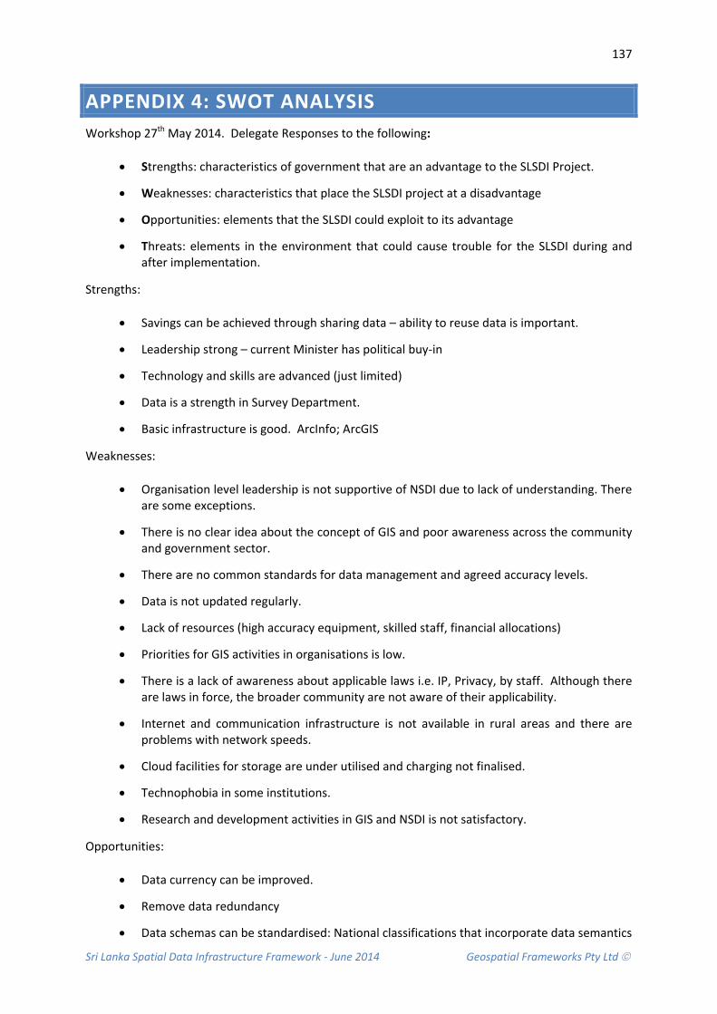
Sri Lanka Spatial Data Infrastructure Framework - June 2014 Geospatial Frameworks Pty Ltd
137
APPENDIX 4: SWOT ANALYSIS Workshop 27th May 2014. Delegate Responses to the following:
• Strengths: characteristics of government that are an advantage to the SLSDI Project.
• Weaknesses: characteristics that place the SLSDI project at a disadvantage
• Opportunities: elements that the SLSDI could exploit to its advantage
• Threats: elements in the environment that could cause trouble for the SLSDI during and after implementation.
Strengths:
• Savings can be achieved through sharing data – ability to reuse data is important.
• Leadership strong – current Minister has political buy-in
• Technology and skills are advanced (just limited)
• Data is a strength in Survey Department.
• Basic infrastructure is good. ArcInfo; ArcGIS
Weaknesses:
• Organisation level leadership is not supportive of NSDI due to lack of understanding. There are some exceptions.
• There is no clear idea about the concept of GIS and poor awareness across the community and government sector.
• There are no common standards for data management and agreed accuracy levels.
• Data is not updated regularly.
• Lack of resources (high accuracy equipment, skilled staff, financial allocations)
• Priorities for GIS activities in organisations is low.
• There is a lack of awareness about applicable laws i.e. IP, Privacy, by staff. Although there are laws in force, the broader community are not aware of their applicability.
• Internet and communication infrastructure is not available in rural areas and there are problems with network speeds.
• Cloud facilities for storage are under utilised and charging not finalised.
• Technophobia in some institutions.
• Research and development activities in GIS and NSDI is not satisfactory.
Opportunities:
• Data currency can be improved.
• Remove data redundancy
• Data schemas can be standardised: National classifications that incorporate data semantics

Sri Lanka Spatial Data Infrastructure Framework - June 2014 Geospatial Frameworks Pty Ltd
138
• NSDI leads to Business Process reform
• Applications can be built to hep protect the environment
• Data can be used for food security, better cultivation of crops
• Assist in studies of disease out breaks.
• Risk assessment modelling in disaster prone areas.
Threats:
• Change in political direction.
• NSDI is a new concept and stakeholders will take time to adapt.
• We could publish data but not get any benefit.
• Some data is sensitive and need to manage this.
• Some organisations so not like to publish data because of the lack of quality and accuracy. There is a fear of public/user backlash and litigation.
• Data currency will be time consuming to improve.

Sri Lanka Spatial Data Infrastructure Framework - June 2014 Geospatial Frameworks Pty Ltd
139
APPENDIX 5: LIST OF ORGANISATIONS INTERVIEWED
Date / Time Activity Objective / Deliverable 19th May 10.00 – 11.00 Hrs
Meeting with Secretary, Ministry of Land and Land Development, Heads of Department
Brief meeting to discuss high level expectation, and overall project implementation
19th May 10.30 – 12.00 Hrs
Meeting with Secretary, Ministry of Environment and Renewable Energy, Heads of Department
Brief meeting to discuss high level expectation, and overall project implementation
19th May 14.30 – 16.00 Hrs
Meeting with ICTA officers Update e-Government initiatives of Sri Lanka
20TH May 9.00 – 15.00 Hrs
Meeting with officers of Survey Department
Data gathering, identify business process of SD, organisation policies, standards, expectations etc
20th May 15.00 – 16.00 Hrs
NSDI Deliverable and Review Committee Meeting
Introduce Dr. Lesley Arnold to the Committee. Discuss arrangement of the national consultative workshop which held on 27th May 2014
21th May 9.30 – 15.30 Hrs
One to one meetings with Land Commissioner General’s Department, Land Title Settlement Department
Register General’s Department,
Ministry of Lands & Land Development
Data gathering, identify business process of SD, organisation policies, standards, expectations etc
23th May 9.30 – 12.30 Hrs
Meeting with officers of Central Environment Authority
Data gathering, identify business process of SD, organisation policies, standards, expectations etc
26th May 9.00 – 10.00 Hrs
Meeting with Secretary, Ministry of Disaster Management, Heads of Department
Brief meeting to discuss high level expectation, and overall project implementation
26th May 11.00 – 12.00 Hrs
Meeting with Hon. Senior Minister Prof. Tissa Vitarana
Brief meeting to discuss high level expectation, and overall project implementation
27th May 9.00 – 17.00 Hrs
National Consultative Workshop jointly organized by MLLD and MDM
Workshop to discuss cross-agency needs and vision for a future SLSDI.
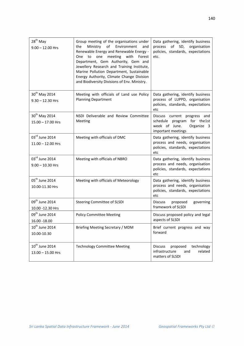
Sri Lanka Spatial Data Infrastructure Framework - June 2014 Geospatial Frameworks Pty Ltd
140
28th May 9.00 – 12.00 Hrs
Group meeting of the organisations under the Ministry of Environment and Renewable Energy and Renewable Energy - One to one meeting with Forest Department, Gem Authority, Gem and Jewellery Research and Training Institute, Marine Pollution Department, Sustainable Energy Authority, Climate Change Division and Biodiversity Divisions of Env. Ministry.
Data gathering, identify business process of SD, organisation policies, standards, expectations etc.
30th May 2014 9.30 – 12.30 Hrs
Meeting with officials of Land use Policy Planning Department
Data gathering, identify business process of LUPPD, organisation policies, standards, expectations etc
30th May 2014 15.00 – 17.00 Hrs
NSDI Deliverable and Review Committee Meeting
Discuss current progress and schedule program for the1st week of June. Organize 3 important meetings
03rd June 2014 11.00 – 12.00 Hrs
Meeting with officials of DMC Data gathering, identify business process and needs, organisation policies, standards, expectations etc
03rd June 2014 9.00 – 10.30 Hrs
Meeting with officials of NBRO Data gathering, identify business process and needs, organisation policies, standards, expectations etc
05th June 2014 10.00-11.30 Hrs
Meeting with officials of Meteorology Data gathering, identify business process and needs, organisation policies, standards, expectations etc
09th June 2014 10.00 -12.30 Hrs
Steering Committee of SLSDI Discuss proposed governing framework of SLSDI
09th June 2014 16.00 -18.00
Policy Committee Meeting Discuss proposed policy and legal aspects of SLSDI
10th June 2014 10.00-10.30
Briefing Meeting Secretary / MDM Brief current progress and way forward
10th June 2014 13.00 – 15.00 Hrs
Technology Committee Meeting Discuss proposed technology infrastructure and related matters of SLSDI

Sri Lanka Spatial Data Infrastructure Framework - June 2014 Geospatial Frameworks Pty Ltd
141
APPENDIX 6: EXAMPLE THEME PROFILE The following table is an example theme profile for the NSW Data Framework Administrative Boundary Theme (NSW, 2013).
Name Administrative Boundaries Theme Description The Administrative Boundaries theme is a collection of legislative, regulatory, political,
maritime and general administrative boundaries sourced from local and state boundary datasets.
Datasets Parish County Suburb Local Government Area State Electoral District State Border
Purpose The Administrative Boundaries theme is used to visualise administrative areas that represent voting districts, redistributions, zoning, socio-economic analysis, regional planning, service distribution and local and state government boundaries. In addition, Administrative Boundaries can also be used to aggregate information for analytical purposes and geographically stable boundaries (over time) can be used to establish and analyse time series trends. Administrative boundary data in combination with geo-coded address data, demographic information and agency specific business information underpins the ability to perform high quality spatial analysis. The aggregation and analysis of data includes:
• Evidence-based development and assessment of government policy • Providing the ability to undertake spatial accounting • Regional analysis for government, health, education, business and a range of
other purposes • Support for emergency management • Market catchment analysis, micromarketing, customer analysis and market
segmentation • Emergency management.
Status Within the database, the position of feature instance will be within the feature’s reported value for 90% of the well-defined points The position of the feature instance will be within 0.5mm at map scale for 90% of the well-defined points. That is, based on the scale of the source documents, the positional accuracy of the cadastral points will be 1:500 = 0.25m, 1:2000 = 1m, 1:4000 = 2m, 1:25000 = 12.5m, 1:50000 =25m and 1:100000 =50m. Quality assurance/conformance testing and reporting of the data accuracy, completeness and consistency to the defined specification is required. The datasets in this are updated daily as a component of the DCDB update process.
Standards Metadata for the relevant LPI datasets complies with AS/NZS ISO 19115 ANZLIC Metadata Profile v1.1 and 19139 National Mapping Council of Australia, Standards of Map Accuracy (1975).
Version Version 0.5
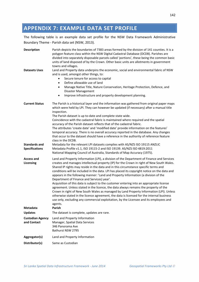
Sri Lanka Spatial Data Infrastructure Framework - June 2014 Geospatial Frameworks Pty Ltd
142
APPENDIX 7: EXAMPLE DATA SET PROFILE The following table is an example data set profile for the NSW Data Framework Administrative Boundary Theme - Parish data set (NSW, 2013).
Description Parish depicts the boundaries of 7383 areas formed by the division of 141 counties. It is a polygon feature class within the NSW Digital Cadastral Database (DCDB). Parishes are divided into separately disposable parcels called ‘portions’, these being the common basic units of land disposed of by the Crown. Other basic units are allotments in government towns and villages.
Datasets Uses Land and Property data underpins the economic, social and environmental fabric of NSW and is used, amongst other things, to:
• Secure tenure for access to capital • Define allowable use of land • Manage Native Title, Nature Conservation, Heritage Protection, Defence, and
Disaster Management • Improve infrastructure and property development planning.
Current Status The Parish is a historical layer and the information was gathered from original paper maps
which were held by LPI. They can however be updated (if necessary) after a manual title inspection. The Parish dataset is up to-date and complete state wide. Coincidence with the cadastral fabric is maintained where required and the spatial accuracy of the Parish dataset reflects that of the cadastral fabric. The attributes ‘create date’ and ‘modified date’ provide information on the features’ temporal accuracy. There is no overall accuracy reported in the database. Any changes that occur to the dataset should have a reference in the authority of reference feature class in the DCDB.
Standards and Specifications
Metadata for the relevant LPI datasets complies with AS/NZS ISO 19115 ANZLIC Metadata Profile v1.1, ISO 19115-2 and ISO 19139. AS/NZS ISO 4819:2011 National Mapping Council of Australia, Standards of Map Accuracy (1975).
Access and Licensing
Land and Property Information (LPI), a division of the Department of Finance and Services creates and manages intellectual property (IP) for the Crown in right of New South Wales. Shared IP rights may reside in the data and in this circumstance specific terms and conditions will be included in the data. LPI has placed its copyright notice on the data and appears in the following manner: ’Land and Property Information (a division of the Department of Finance and Services) year’. Acquisition of this data is subject to the customer entering into an appropriate license agreement. Unless stated in the licence, the data always remains the property of the Crown in right of New South Wales as managed by Land Property Information (LPI). Unless otherwise stated in the licence agreement, the data is licensed for the internal business use only, excluding any commercial exploitation, by the Licensee and its employees and agents.
Metadata Parish Updates The dataset is complete, updates are rare.
Custodian Agency and Contact
Land and Property Information Manager, Spatial Data Services 346 Panorama Ave Bathurst NSW 2795
Aggregator(s) Land and Property Information
Distributor(s) Same as Custodian
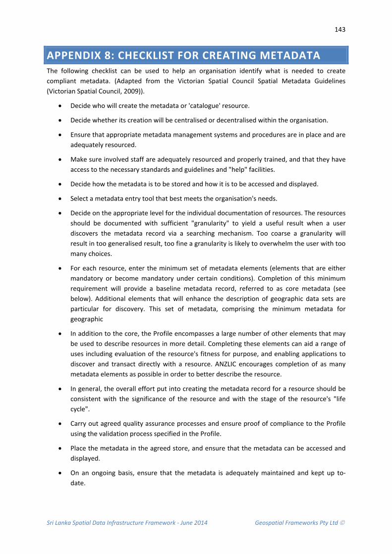
Sri Lanka Spatial Data Infrastructure Framework - June 2014 Geospatial Frameworks Pty Ltd
143
APPENDIX 8: CHECKLIST FOR CREATING METADATA The following checklist can be used to help an organisation identify what is needed to create compliant metadata. (Adapted from the Victorian Spatial Council Spatial Metadata Guidelines (Victorian Spatial Council, 2009)).
• Decide who will create the metadata or 'catalogue' resource.
• Decide whether its creation will be centralised or decentralised within the organisation.
• Ensure that appropriate metadata management systems and procedures are in place and are adequately resourced.
• Make sure involved staff are adequately resourced and properly trained, and that they have access to the necessary standards and guidelines and "help" facilities.
• Decide how the metadata is to be stored and how it is to be accessed and displayed.
• Select a metadata entry tool that best meets the organisation's needs.
• Decide on the appropriate level for the individual documentation of resources. The resources should be documented with sufficient "granularity" to yield a useful result when a user discovers the metadata record via a searching mechanism. Too coarse a granularity will result in too generalised result, too fine a granularity is likely to overwhelm the user with too many choices.
• For each resource, enter the minimum set of metadata elements (elements that are either mandatory or become mandatory under certain conditions). Completion of this minimum requirement will provide a baseline metadata record, referred to as core metadata (see below). Additional elements that will enhance the description of geographic data sets are particular for discovery. This set of metadata, comprising the minimum metadata for geographic
• In addition to the core, the Profile encompasses a large number of other elements that may be used to describe resources in more detail. Completing these elements can aid a range of uses including evaluation of the resource's fitness for purpose, and enabling applications to discover and transact directly with a resource. ANZLIC encourages completion of as many metadata elements as possible in order to better describe the resource.
• In general, the overall effort put into creating the metadata record for a resource should be consistent with the significance of the resource and with the stage of the resource's "life cycle".
• Carry out agreed quality assurance processes and ensure proof of compliance to the Profile using the validation process specified in the Profile.
• Place the metadata in the agreed store, and ensure that the metadata can be accessed and displayed.
• On an ongoing basis, ensure that the metadata is adequately maintained and kept up to-date.

Sri Lanka Spatial Data Infrastructure Framework - June 2014 Geospatial Frameworks Pty Ltd
144
APPENDIX 9: FIT FOR PURPOSE CRITERIA
What is meant by fitness for purpose?
Fitness for purpose for a policy means that the policy is clear about what outcomes it should achieve and sets out how these outcomes will be delivered.
To do this effectively the policy must support the work of government and its overall direction and vision and it must be easily understandable and accessible to the people who will use it.
Assessment Criteria: 1. Is the policy clear about what outcome it is intended to deliver and how it supports the
organisation in its overall direction?
2. Is it easy to understand what you must do to implement and follow this policy?
3. Does the policy take account of the wider agenda of Government policy for spatial information management?
4. Does the policy make clear reference to and fit within the appropriate legislative requirements?
5. Does the policy make clear links to other relevant policies so that it ‘fits’ with the overall direction of government and avoids giving out contradictory messages?
6. Is the policy clear and concise? (Is the policy written in a style that is simple and direct and avoids longwinded language or becomes difficult to follow)?
7. Has the policy been subject to a diversity impact assessment?
8. Is it clear who owns the policy and the date that it was issued?
9. Has the policy been shaped by the involvement and consultation of a range of stakeholders?
10. Does the policy draw on a relevant evidence base to support assertions?