Denali National Park and Preserve Final South Denali Implementation Plan And Environmental
Upload
duonghuongCategory
view
215download
0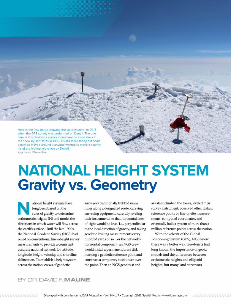
BY DR. DAVID F. MAUNE
Here is the first image showing the clear weather in 2015 when the GPS survey was performed on Denali. The one item in this photo is a survey monument on a rod stuck in the snow by Jeff Yates in 1989. It’s still there today but could easily be moved around if anyone wanted to move it slightly. It’s at the highest elevation on Denali. Image courtesy of CompassData.
NATIONAL HEIGHT SYSTEM Gravity vs. Geometry
N ational height systems have long been based on the rules of gravity to determine
orthometric heights (H) and model the directions in which water will flow across the earth’s surface. Until the late 1990s, the National Geodetic Survey (NGS) had relied on conventional line-of-sight survey measurements to provide a consistent, accurate national network for latitude, longitude, height, velocity, and shoreline delineation. To establish a height system across the nation, crews of geodetic
surveyors traditionally trekked many miles along a designated route, carrying surveying equipment, carefully leveling their instruments so that horizontal lines-of-sight would be level, i.e., perpendicular to the local direction of gravity, and taking geodetic leveling measurements every hundred yards or so. For the network’s horizontal component, an NGS crew would install a permanent brass disk marking a geodetic reference point and construct a temporary steel tower over the point. Then an NGS geodesist and
assistant climbed the tower, leveled their survey instrument, observed other distant reference points by line-of-site measure-ments, computed coordinates, and eventually built a system of more than a million reference points across the nation.
With the advent of the Global Positioning System (GPS), NGS knew there was a better way. Geodesists had long known the importance of geoid models and the differences between orthometric heights and ellipsoid heights, but many land surveyors
Displayed with permission • LiDAR Magazine • Vol. 6 No. 7 • Copyright 2016 Spatial Media • www.lidarmag.com
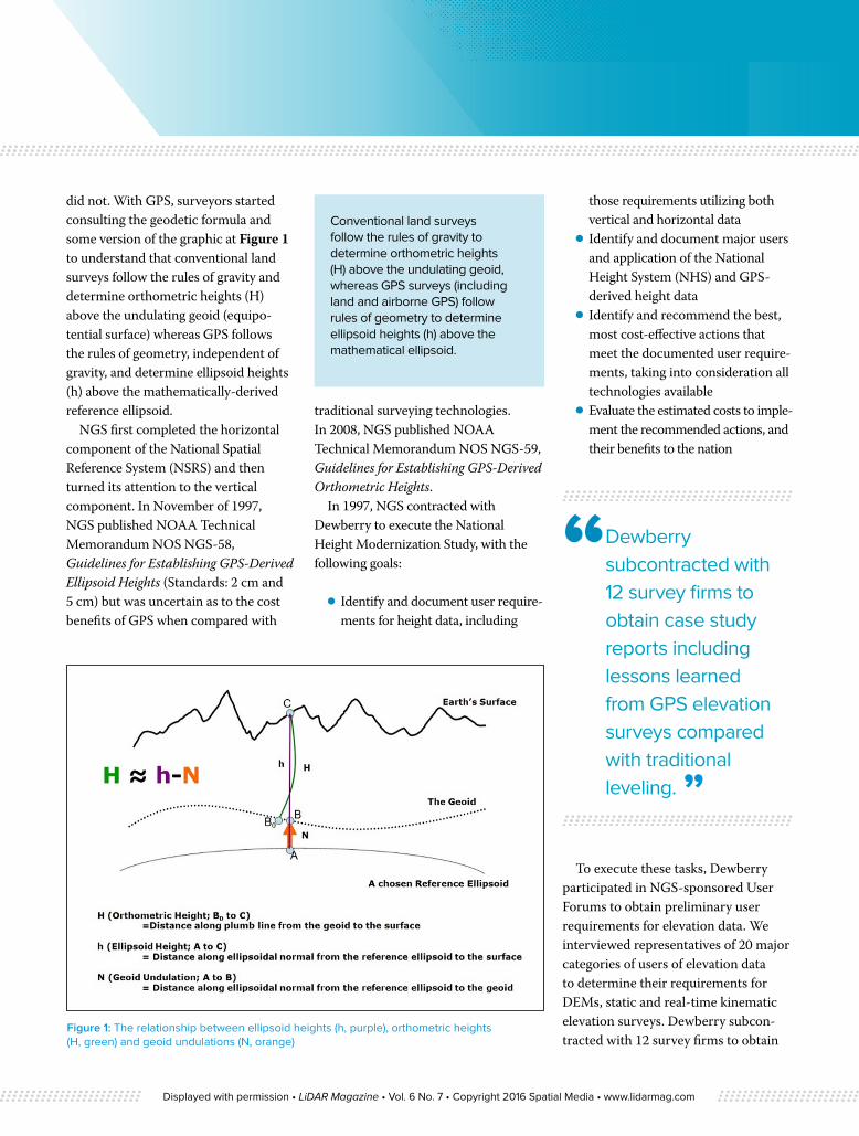
did not. With GPS, surveyors started consulting the geodetic formula and some version of the graphic at Figure 1 to understand that conventional land surveys follow the rules of gravity and determine orthometric heights (H) above the undulating geoid (equipo-tential surface) whereas GPS follows the rules of geometry, independent of gravity, and determine ellipsoid heights (h) above the mathematically-derived reference ellipsoid.
NGS first completed the horizontal component of the National Spatial Reference System (NSRS) and then turned its attention to the vertical component. In November of 1997, NGS published NOAA Technical Memorandum NOS NGS-58, Guidelines for Establishing GPS-Derived Ellipsoid Heights (Standards: 2 cm and 5 cm) but was uncertain as to the cost benefits of GPS when compared with
traditional surveying technologies. In 2008, NGS published NOAA Technical Memorandum NOS NGS-59, Guidelines for Establishing GPS-Derived Orthometric Heights.
In 1997, NGS contracted with Dewberry to execute the National Height Modernization Study, with the following goals:
⦁ Identify and document user require-ments for height data, including
those requirements utilizing both vertical and horizontal data
⦁ Identify and document major users and application of the National Height System (NHS) and GPS-derived height data
⦁ Identify and recommend the best, most cost-effective actions that meet the documented user require-ments, taking into consideration all technologies available
⦁ Evaluate the estimated costs to imple-ment the recommended actions, and their benefits to the nation
To execute these tasks, Dewberry participated in NGS-sponsored User Forums to obtain preliminary user requirements for elevation data. We interviewed representatives of 20 major categories of users of elevation data to determine their requirements for DEMs, static and real-time kinematic elevation surveys. Dewberry subcon-tracted with 12 survey firms to obtain
Conventional land surveys follow the rules of gravity to determine orthometric heights (H) above the undulating geoid, whereas GPS surveys (including land and airborne GPS) follow rules of geometry to determine ellipsoid heights (h) above the mathematical ellipsoid.
Figure 1: The relationship between ellipsoid heights (h, purple), orthometric heights (H, green) and geoid undulations (N, orange)
“ Dewberry subcontracted with 12 survey firms to obtain case study reports including lessons learned from GPS elevation surveys compared with traditional leveling. ”
Displayed with permission • LiDAR Magazine • Vol. 6 No. 7 • Copyright 2016 Spatial Media • www.lidarmag.com
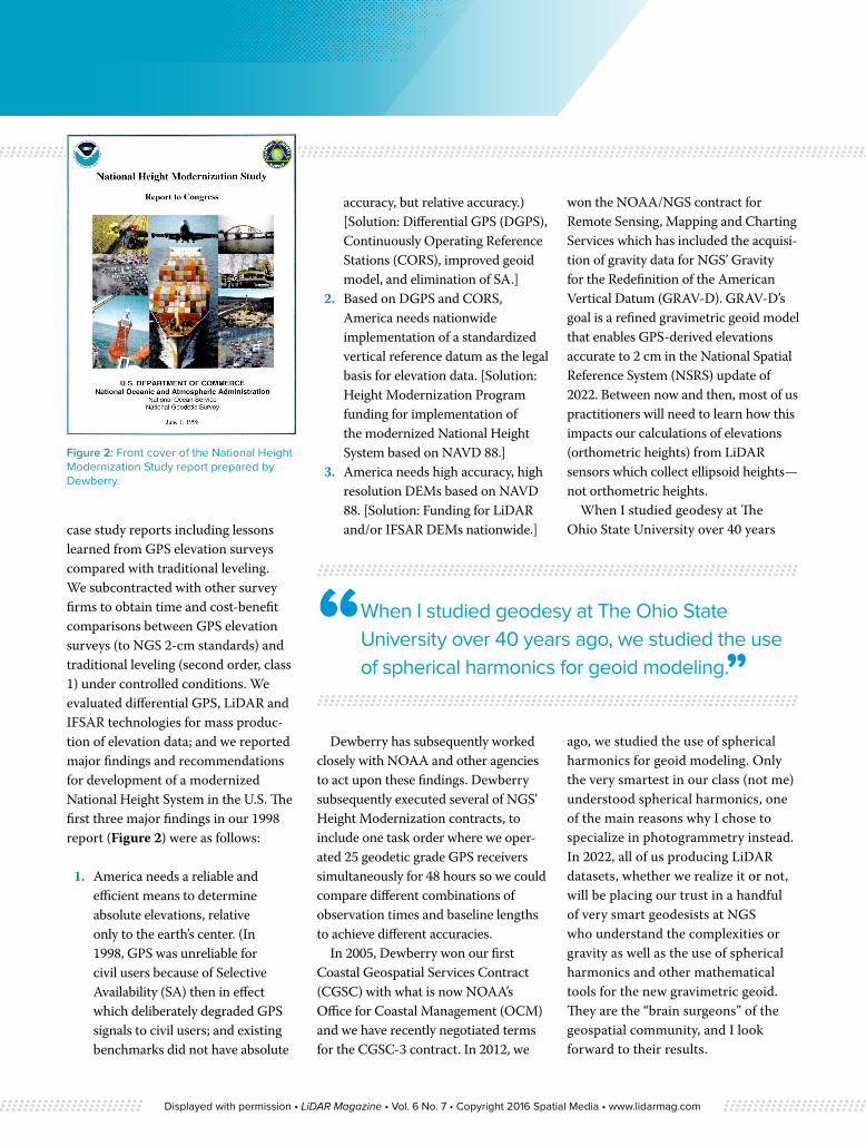
case study reports including lessons learned from GPS elevation surveys compared with traditional leveling. We subcontracted with other survey firms to obtain time and cost-benefit comparisons between GPS elevation surveys (to NGS 2-cm standards) and traditional leveling (second order, class 1) under controlled conditions. We evaluated differential GPS, LiDAR and IFSAR technologies for mass produc-tion of elevation data; and we reported major findings and recommendations for development of a modernized National Height System in the U.S. The first three major findings in our 1998 report (Figure 2) were as follows:
1. America needs a reliable and efficient means to determine absolute elevations, relative only to the earth’s center. (In 1998, GPS was unreliable for civil users because of Selective Availability (SA) then in effect which deliberately degraded GPS signals to civil users; and existing benchmarks did not have absolute
accuracy, but relative accuracy.) [Solution: Differential GPS (DGPS), Continuously Operating Reference Stations (CORS), improved geoid model, and elimination of SA.]
2. Based on DGPS and CORS, America needs nationwide implementation of a standardized vertical reference datum as the legal basis for elevation data. [Solution: Height Modernization Program funding for implementation of the modernized National Height System based on NAVD 88.]
3. America needs high accuracy, high resolution DEMs based on NAVD 88. [Solution: Funding for LiDAR and/or IFSAR DEMs nationwide.]
Dewberry has subsequently worked closely with NOAA and other agencies to act upon these findings. Dewberry subsequently executed several of NGS’ Height Modernization contracts, to include one task order where we oper-ated 25 geodetic grade GPS receivers simultaneously for 48 hours so we could compare different combinations of observation times and baseline lengths to achieve different accuracies.
In 2005, Dewberry won our first Coastal Geospatial Services Contract (CGSC) with what is now NOAA’s Office for Coastal Management (OCM) and we have recently negotiated terms for the CGSC-3 contract. In 2012, we
won the NOAA/NGS contract for Remote Sensing, Mapping and Charting Services which has included the acquisi-tion of gravity data for NGS’ Gravity for the Redefinition of the American Vertical Datum (GRAV-D). GRAV-D’s goal is a refined gravimetric geoid model that enables GPS-derived elevations accurate to 2 cm in the National Spatial Reference System (NSRS) update of 2022. Between now and then, most of us practitioners will need to learn how this impacts our calculations of elevations (orthometric heights) from LiDAR sensors which collect ellipsoid heights— not orthometric heights.
When I studied geodesy at The Ohio State University over 40 years
ago, we studied the use of spherical harmonics for geoid modeling. Only the very smartest in our class (not me) understood spherical harmonics, one of the main reasons why I chose to specialize in photogrammetry instead. In 2022, all of us producing LiDAR datasets, whether we realize it or not, will be placing our trust in a handful of very smart geodesists at NGS who understand the complexities or gravity as well as the use of spherical harmonics and other mathematical tools for the new gravimetric geoid. They are the “brain surgeons” of the geospatial community, and I look forward to their results.
“ When I studied geodesy at The Ohio State University over 40 years ago, we studied the use of spherical harmonics for geoid modeling.”
Figure 2: Front cover of the National Height Modernization Study report prepared by Dewberry.
Displayed with permission • LiDAR Magazine • Vol. 6 No. 7 • Copyright 2016 Spatial Media • www.lidarmag.com
Today, if you ask Google: “What is the National Height System in the U.S.?” you will be directed to the NGS page on vertical datums which states: “A vertical datum is a surface of zero elevation to which heights of various points are referred in order that those heights be in a consistent system. More broadly, a vertical datum is the entire system of the zero elevation surface and methods of determining heights relative to that surface.” In just six years from now, all of us in the LiDAR industry will be adjust-ing our processes so as to correctly use the refined gravimetric geoid model. Stay tuned. You will be hearing a lot more on this subject in the years ahead.
Dr. David Maune is an Associate Vice President at Dewberry Consultants LLC where he is an elevation specialist and manages photogrammetric, LiDAR, IFSAR and sonar projects for USGS, NOAA, FEMA, USACE, and other federal, state and county governments. He authored the National Height Modernization Study referenced in this article. He is a member of NOAA’s Hydrographic Services Review Panel (HSRP). He specializes in independent QA/QC of LiDAR data produced by others and is perhaps best known as the editor and primary author of the 1st and 2nd editions of Digital Elevation Model Technologies and Applications: The DEM Users Manual published by ASPRS. He is a retired Army Colonel, last serving as Commander and Director of the U.S. Army Topographic Engineering Center (TEC), now the Army Geospatial Center (AGC).
Did you know?
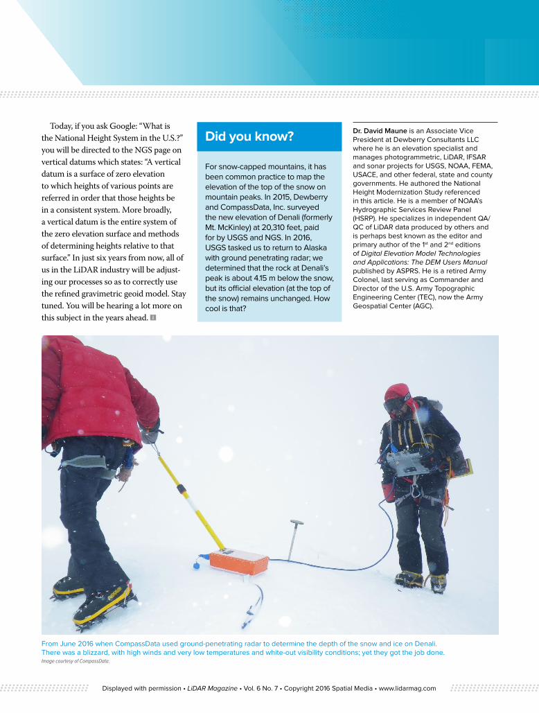
For snow-capped mountains, it has been common practice to map the elevation of the top of the snow on mountain peaks. In 2015, Dewberry and CompassData, Inc. surveyed the new elevation of Denali (formerly Mt. McKinley) at 20,310 feet, paid for by USGS and NGS. In 2016, USGS tasked us to return to Alaska with ground penetrating radar; we determined that the rock at Denali’s peak is about 4.15 m below the snow, but its official elevation (at the top of the snow) remains unchanged. How cool is that?
From June 2016 when CompassData used ground-penetrating radar to determine the depth of the snow and ice on Denali. There was a blizzard, with high winds and very low temperatures and white-out visibility conditions; yet they got the job done.Image courtesy of CompassData.
Displayed with permission • LiDAR Magazine • Vol. 6 No. 7 • Copyright 2016 Spatial Media • www.lidarmag.com