Nashville DOWNTOWN CODE - Daniel R. Mandelkerlanduselaw.wustl.edu/ordinances/A Nashville...
101
Attachment to Ordinance No. BL2009-586 as adopted on February 02, 2010 Nashville DOWNTOWN CODE Amended by Ordinance No. BL2011-896 as adopted on May 26, 2011
Transcript of Nashville DOWNTOWN CODE - Daniel R. Mandelkerlanduselaw.wustl.edu/ordinances/A Nashville...

Attachment to Ordinance No. BL2009-586as adopted on February 02, 2010
N a s h v i l l eD O W N T O W N C O D E
Amended by Ordinance No. BL2011-896as adopted on May 26, 2011

Document Contact Information
Planning Department staff provides consultations for developing within the Downtown Code. Call (615) 862-6886 or email [email protected] to schedule a meeting.
The Planning Department does not discriminate on the basis of age, race, sex, color, national origin, religion or disability in access to, or operation of, its programs, services, and activities, or in its hiring or employment practices. For ADA inquiries, contact Josie Bass, ADA Compliance Coordinator, at 862-7150 or e-mail her at [email protected]. For Title VI inquiries contact Shirley Sims-Saldana or Denise Hopgood of Human Relations at 880-3370. For all employment-related inquiries call 862-6640.
3Attachment to Ordinance No. BL2009-586as adopted on February 02, 2010
Section I: Introduction
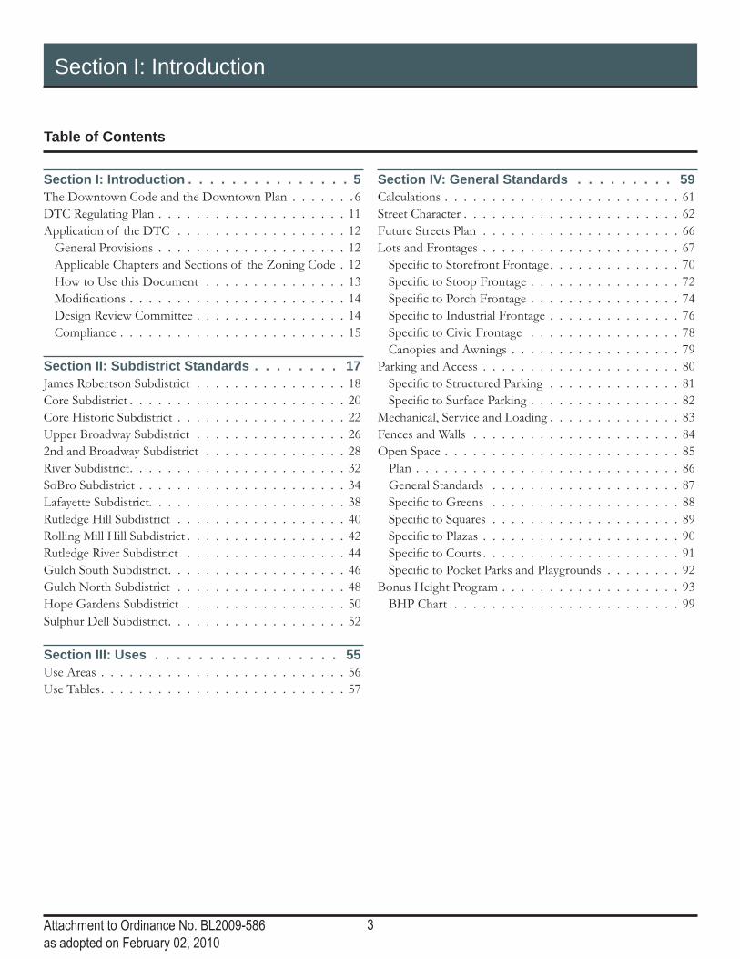
Table of Contents
Section I: Introduction . . . . . . . . . . . . . . . 5The Downtown Code and the Downtown Plan . . . . . . . 6DTC Regulating Plan . . . . . . . . . . . . . . . . . . . . 11Application of the DTC . . . . . . . . . . . . . . . . . . 12
General Provisions . . . . . . . . . . . . . . . . . . . . 12Applicable Chapters and Sections of the Zoning Code . 12How to Use this Document . . . . . . . . . . . . . . . 13Modifi cations . . . . . . . . . . . . . . . . . . . . . . . 14Design Review Committee . . . . . . . . . . . . . . . . 14Compliance . . . . . . . . . . . . . . . . . . . . . . . . 15
Section II: Subdistrict Standards . . . . . . . . 17James Robertson Subdistrict . . . . . . . . . . . . . . . . 18Core Subdistrict . . . . . . . . . . . . . . . . . . . . . . . 20Core Historic Subdistrict . . . . . . . . . . . . . . . . . . 22Upper Broadway Subdistrict . . . . . . . . . . . . . . . . 262nd and Broadway Subdistrict . . . . . . . . . . . . . . . 28River Subdistrict . . . . . . . . . . . . . . . . . . . . . . . 32SoBro Subdistrict . . . . . . . . . . . . . . . . . . . . . . 34Lafayette Subdistrict. . . . . . . . . . . . . . . . . . . . . 38Rutledge Hill Subdistrict . . . . . . . . . . . . . . . . . . 40Rolling Mill Hill Subdistrict . . . . . . . . . . . . . . . . . 42Rutledge River Subdistrict . . . . . . . . . . . . . . . . . 44Gulch South Subdistrict . . . . . . . . . . . . . . . . . . . 46Gulch North Subdistrict . . . . . . . . . . . . . . . . . . 48Hope Gardens Subdistrict . . . . . . . . . . . . . . . . . 50Sulphur Dell Subdistrict . . . . . . . . . . . . . . . . . . . 52
Section III: Uses . . . . . . . . . . . . . . . . . 55Use Areas . . . . . . . . . . . . . . . . . . . . . . . . . . 56Use Tables . . . . . . . . . . . . . . . . . . . . . . . . . . 57
Section IV: General Standards . . . . . . . . . 59Calculations . . . . . . . . . . . . . . . . . . . . . . . . . 61Street Character . . . . . . . . . . . . . . . . . . . . . . . 62Future Streets Plan . . . . . . . . . . . . . . . . . . . . . 66Lots and Frontages . . . . . . . . . . . . . . . . . . . . . 67
Specifi c to Storefront Frontage . . . . . . . . . . . . . . 70Specifi c to Stoop Frontage . . . . . . . . . . . . . . . . 72Specifi c to Porch Frontage . . . . . . . . . . . . . . . . 74Specifi c to Industrial Frontage . . . . . . . . . . . . . . 76Specifi c to Civic Frontage . . . . . . . . . . . . . . . . 78
Canopies and Awnings . . . . . . . . . . . . . . . . . . 79Parking and Access . . . . . . . . . . . . . . . . . . . . . 80
Specifi c to Structured Parking . . . . . . . . . . . . . . 81Specifi c to Surface Parking . . . . . . . . . . . . . . . . 82
Mechanical, Service and Loading . . . . . . . . . . . . . . 83Fences and Walls . . . . . . . . . . . . . . . . . . . . . . 84Open Space . . . . . . . . . . . . . . . . . . . . . . . . . 85
Plan . . . . . . . . . . . . . . . . . . . . . . . . . . . . 86General Standards . . . . . . . . . . . . . . . . . . . . 87Specifi c to Greens . . . . . . . . . . . . . . . . . . . . 88Specifi c to Squares . . . . . . . . . . . . . . . . . . . . 89Specifi c to Plazas . . . . . . . . . . . . . . . . . . . . . 90Specifi c to Courts . . . . . . . . . . . . . . . . . . . . . 91Specifi c to Pocket Parks and Playgrounds . . . . . . . . 92
Bonus Height Program . . . . . . . . . . . . . . . . . . . 93BHP Chart . . . . . . . . . . . . . . . . . . . . . . . . 99

4Attachment to Ordinance No. BL2009-586as adopted on February 02, 2010
This page left intentionally blank

5Attachment to Ordinance No. BL2009-586as adopted on February 02, 2010
Section I: Introduction

6Attachment to Ordinance No. BL2009-586as adopted on February 02, 2010
Section I: Introduction
The Downtown Code and the Downtown Plan
The Downtown Code (DTC) implements the community vision set forth in the Downtown Community Plan: 2007 Update. Through the community planning process, stakeholders reached a common vision for the future of Downtown. The Plan envisions multiple distinct neighborhoods within Downtown, each with its own character and scale, which contribute to the vitality of Downtown as the center of the city and the region.
The DTC regulates the physical form of buildings to ensure each makes a positive contribution to a complete urban environment. By ensuring a specifi c and predictable urban form, the DTC ensures that all new construction makes a positive contribution to the public realm – streets and open space – and that all investments are held to the same standard.
While the DTC is a regulating document, the Downtown Plan contains placemaking tools and guidelines and should be used as a companion document to the DTC.
The Guiding Principles of the Downtown Plan have directed the standards in the DTC and are as follows:
Ensure that Downtown remains the civic, commercial and entertainment center for Nashville, Middle Tennes-see and the Southeast.
The regulations of the DTC clarify the vision for each neighborhood in Downtown. Under the DTC, certain areas are allowed to have high-rise towers, while others are zoned for neighborhood-scale development, while still others are allowed to be more transitional with support uses necessary to sustain urban business.
In recent years, nearly all projects in Downtown have sought rezoning or variances to existing zoning. The DTC alleviates this need by allowing signifi cantly greater develop-ment rights, in forms based on construction norms and ur-ban design objectives, than existing zoning. The DTC also allows the modifi cation of standards for site-specifi c issues.
Provide opportunities for continued growth while preserving and enhancing the character that inspires residents and businesses to move Downtown.
The Downtown Plan called for areas of increased height and density within Downtown. The Plan extended the boundaries of the Core – the tallest and most intense neighborhood – and provided guidance regarding addi-tional height in other neighborhoods. The DTC codifi es these opportunities in the subdistrict standards for these neighborhoods.
Similarly, the Downtown Plan acknowledged the diffi culty of developing within the sky exposure plane in some neigh-borhoods. The DTC modifi ed the allowable form of build-
ings by allowing additional height at the street in exchange for an overall height-cap. The result is that properties, and thus neighborhoods, will have the same intensity as in CF zoning but in a form that is aligned with typical construc-tion methods and creates a more predictable urban environ-ment.
The form and shape of development under CC and CF zoning is unpredictable. The DTC provides clear direction on minimum development and maximum development. For instance, the Gulch is zoned for a specifi c character, while Sulphur Dell is zoned for something different. This ensures certainty about the character and scale of develop-ment in each neighborhood.
In an urban environment, the street level design and function of a building is of the utmost importance. The interaction of the building with the street should enliven the street, making it comfortable, safe and interesting for pedestrians. The DTC is based on frontage design – store-front, stoop, porch, industrial, and civic – and includes standards on glazing, vehicular access, landscaping, and active uses on the ground level. Correctly designed, these attributes will contribute to safe and interesting streets to result in vibrant neighborhoods and a healthy Downtown.
A safe and interesting urban environment attracts people. People who feel comfortable in Downtown – enjoying available activities, prospering from the businesses and services, and lingering in the spaces and places – want to be Downtown. The DTC fosters this desirable urban environ-ment through the attention to pedestrian-oriented design, appropriate scale and massing, and neighborhood creation.

7Attachment to Ordinance No. BL2009-586as adopted on February 02, 2010
Section I: Introduction
The Downtown Code and the Downtown Plan
Create strategic mixed use to facilitate Downtown’s transformation into a 24/7 community.
The Plan calls for a “thoughtful mixture of uses includ-ing residential, retail and offi ce, to ensure that Downtown doesn’t close at 5 p.m. or even after the concert ends or the restaurants close, but is instead a welcoming home for a diverse residential population.” Multiple stories encourage multiple uses within each building, increasing the likelihood that one of the uses will be active at any given hour. Com-pare this to one story buildings which lack activity during the off-hours of the single use.
To be viable, Downtown must accommodate numerous services and functions. By promoting form over use, the DTC allows for a mixture of uses. Because various func-tions occur at different times of the day – working, shop-ping and recreating during the day, entertainment and home-life at night – mixed-use, 24/7 neighborhoods use existing infrastructure more effi ciently and function in a more sustainable way.
Create and nurture urban neighborhoods.
As stated in the Plan, “While residential development has fl ourished in recent years, the creation and enhancement of urban neighborhoods is still a goal. Residential living will thrive in Downtown when residents feel that they are part of a neighborhood, supported by shared public spaces and the services and amenities needed for daily life.” The DTC directly addresses the development characteristics of neigh-borhood design: building mass and scale, frontage design, and open space design.
To create these distinctive urban neighborhoods, the DTC aligns the regulations of each subdistrict with the intended character of the neighborhood. For instance, the South Gulch is envisioned to continue as a high-rise and mid-rise, mixed-use neighborhood. The DTC codifi es mid-rise height in the general subdistrict and allows high-rise build-ings on key intersections and along important streets. In contrast, the North Gulch is envisioned to be a low-rise neighborhood – to preserve Capitol views and transition into the Hope Gardens and John Henry Hale neighbor-hoods. The DTC codifi es this vision by capping the overall
height, allowing for less intense development such as two story houses and townhouses, and encouraging porch and stoop frontages. These are two examples of how the DTC aligns the zoning of neighborhoods with the vision cast during the community planning process.
“Since 2000, Downtown has experienced an unprecedented residential boom. In 2000, there were approximately 1500 dwelling units in Downtown. As of 2006, over 2600 new residential units were under construction, planned or proposed…Since 2000 there has been over $500 million in capital investments in residential construction, with another $400 million planned or proposed.” In addition, “since 2000, Downtown offi ce building development has grown modestly with $140 million of development completely or under construction.” These strong numbers increase the viability of Downtown. To continue this good momentum, the emphasis must be on place-making as well as develop-ment. The DTC encourages the creation of mixed-use, sustainable neighborhoods that have fl exibility to address the needs of citizens over time.
Create active, attractive streets and streetscapes.
“…the Downtown Plan encourages walking as a primary mode of transportation in Downtown. Walking is en-couraged in the Downtown Plan by making the walk safe, interesting, and comfortable...” Streets are the most plen-tiful open space in Downtown and should prioritize the pedestrian experience while appropriately accommodating vehicular traffi c. The DTC emphasizes frontage design, requires active ground level uses, and sets standards for vehicular activity.
The DTC prioritizes the location of vehicular access points per street type – Primary, Secondary, Tertiary, Other, and Alley. By prioritizing, instead of regulating, the DTC allows fl exibility for site-specifi c solutions to be reached in col-laboration between the developer and Metro departments.
While the DTC sets standards on the development of private property, active and attractive streets must be cre-ated by a collaborative process with all Metro Departments. As development proposals are offered, Metro will retain a commitment to creating a strong pedestrian-oriented urban

8Attachment to Ordinance No. BL2009-586as adopted on February 02, 2010
Section I: Introduction
The Downtown Code and the Downtown Plan
environment. “As Downtown becomes home to many of its workers, and mass transit options into Downtown im-prove, providing welcoming routes for pedestrians will pro-vide benefi ts in terms of improved mobility and reduced traffi c congestion.”
The DTC references the Downtown Streetscape Design Guide-lines, created by Metro Public Works and Metro Planning, and encourages its use.
Protect and reuse historic structures and districts.
The DTC has a subdistrict for 2nd Avenue and Lower Broadway that reinforces the historic zoning overlay for these streets. To encourage the adaptive reuse of the his-toric structures, this subdistrict is eligible for transfer of development rights through the Bonus Height Program.
The creation of the Core Historic subdistrict encourages the preservation of the existing historic buildings between 3rd and 5th Avenues North, while allowing for appropriately scaled and appropriately detailed infi ll.
The creation of the Rutledge Hill subdistrict encourages the preservation of the existing historic buildings in this historic residential area, while allowing for appropriately scaled and appropriately detailed infi ll.
During the community planning process, the preservation of views to the Capitol building was identifi ed as important to the development of neighborhoods north of Capitol Hill. The maximum building heights in subdistricts north of Capitol Hill are limited to the elevation of the base of the Capitol building to ensure this that this important civic view is preserved.
Create environmentally sustainable and energy effi cient development.
In order to meet the sustainability goals of the Downtown Plan and to achieve Metro Government’s vision of Nash-ville as the greenest city in the US, the DTC encourages urban infi ll and energy effi cient development.
By location alone, urban infi ll is more energy effi cient than green-fi eld development because it utilizes existing streets and infrastructure. By emphasizing mixed-use, walkable neighborhoods within Downtown, the DTC reinforces Metro Government’s commitment to sustainability and responsible use of resources. Part of being sustainable is
using existing under-utilized infrastructure – water lines, sewer lines, electricity, and streets – in lieu of creating new infrastructure and continuing green-fi eld consumption.
Location, however, does not ensure sustainability. The creation of the DTC emphasizes the need for a denser Downtown to provide citizens with all daily needs within walking distance, the need for buildings that can be adapted for new uses over time, the preservation and adaptive reuse of existing buildings, and the addition of street trees and open spaces.
In addition to encouraging sustainable urbanity, the DTC encourages the measurement of energy effi cient develop-ment through the US Green Building Council’s LEED pro-gram. (LEED may be substituted for a different nationally-recognized, third-party system of overseeing green building and/or sustainable development practices.)
The Bonus Height Program of the DTC provides height bonuses for new construction that meets the standards of LEED silver, gold or platinum. LEED takes credits a project for its urban environment, but also for the sustain-ability of the building itself. The public benefi t associated with LEED certifi cation is signifi cant. The lighter the building treads on the infrastructure of the city, the lighter the burden on the city to maintain the infrastructure. This helps the city function better as a whole. The bonuses are appropriately scaled for each subdistrict and are offered in exchange for the level of contribution of this important public benefi t.
Create “great spaces” throughout Downtown for the enjoyment of citizens and visitors.
In some areas of Downtown, open space is appropriately scaled and designed for the envisioned intensity of the neighborhood. In most areas, however, open space is dra-matically lacking. The DTC identifi es ¼ mile radius neigh-borhoods (about a fi ve minute walk from edge to center) within Downtown to show the open space defi ciencies. For every quarter mile neighborhood, there should be at least a quarter acre of well-designed public open space. This open space may be provided by public or private initiatives.
The Downtown Plan recommended that Downtown have unique types of open space available to meet the needs of citizens. The DTC provides standards for the creation
9Attachment to Ordinance No. BL2009-586as adopted on February 02, 2010
Section I: Introduction
The Downtown Code and the Downtown Plan
of these open spaces: greens, squares, plazas, courts and pocket parks/playgrounds. The open spaces will serve as important “great spaces” to help create the vital and func-tioning neighborhoods envisioned by the Downtown Plan.
The Bonus Height Program of the DTC provides height bonuses for the development of public open spaces. To be eligible for the height bonus, the development must fol-low the standards for open space design. The bonuses are appropriately scaled for each subdistrict and are offered in exchange for this important public amenity.
Provide for improved mobility in and through Down-town to support other principles for healthy growth in Downtown.
“The Downtown Plan encourages walking as a primary mode of transportation in Downtown.” The DTC stan-dards focus on the interaction between the building and street – the frontage of the building – to make the pedestri-an realm safe, comfortable and interesting. This goal will be reached when public and private entities remain committed to creating a pedestrian-oriented Downtown.
The Downtown Plan notes that “as Downtown becomes home to many of its workers, and mass transit options into Downtown improve, providing welcoming routes for pedestrians will provide benefi ts in terms of improved
mobility and reduced traffi c congestion.” While the DTC sets standards on the development of private property, improved transportation options must be created by a col-laborative process between the public and private sectors.
The Downtown Plan sets forth the common vision for the future of Downtown, and acknowledges that “the creation of the Downtown envisioned by the community can only be achieved through cooperative efforts of the public and private sectors and through the informed involvement of residents, businesses and investors in Downtown. Adherence to these guiding principles in the development actions of both the public and private sector will create the Downtown Nashville that the community has envisioned – an expanding, vibrant Downtown with opportunities for growth and development that embody the urban experience of a great city.” The DTC is one of several tools to strengthen Downtown through public and private investments.
By focusing on the creation of distinctive neighborhoods, pedestrian-oriented development, the DTC reaches toward the goal of an economically healthy, socially vibrant, and sustainable Downtown.

10Attachment to Ordinance No. BL2009-586as adopted on February 02, 2010
This page left intentionally blank

11Attachment to Ordinance No. BL2009-586as adopted on February 02, 2010
Section I: Introduction
JEFFERSON ST
DEMONBREUN ST
LAFAYETTE ST
BROADWAY
2N
D A
VE
N
CHARLOTTE AVE
RO
SA L
PA
RK
S A
VE
DIVISION ST
Core
Sulphur Dell
Core Historic
2nd and Broadway
SoBro
River
Rolling Mill HillRutledge River
Rutledge Hill
Lafayette
Gulch South
Gulch North
Hope Gardens
James Robertson
Upper Broadway
Rutledge HillSubdistrict - page 40
LafayetteSubdistrict - page 38
Rolling MIl HillSubdistrict - page 42
Gulch SouthSubdistrict - page 48
Gulch NorthSubdistrict - page 46
DTC Regulating Plan: Subdistrict Boundaries
N
LegendJames Robertson Subdistrict - page 18
CoreSubdistrict - page 20
Core HistoricSubdistrict - page 22
2nd and BroadwaySubdistrict - page 28
Upper BroadwaySubdistrict - page 26
SoBroSubdistrict - page 34
RiverSubdistrict - page 32
Rutledge RiverSubdistrict - page 44
Hope GardensSubdistrict - page 50
Sulphur DellSubdistrict - page 52
DTC Boundary

12Attachment to Ordinance No. BL2009-586as adopted on February 02, 2010
Section I: Introduction
Application of the DTC
General ProvisionsIf necessary, to adhere to the laws and regulations of Federal, State, or local departments or agencies, the regulations in this chapter may be modifi ed. Such modifi cations may be approved by the Planning Commission, the DTC Design Review Com-mittee or Planning Staff, in accordance with the Modifi cations section of this Chapter.
To the extent that the provisions of the Downtown Code is inconsistent or in confl ict with the provisions of the Gateway Urban Design Overlay District that is also zoned DTC, the provisions of the DTC zoning shall be controlling; however, any provisions of the Gateway UDO may be used provided that the standards of the DTC zoning are met.
Applicable Chapters and Sections of the Zoning CodeIn addition to the standards set forth within this document, the following Chapters and Sections of the Metro Zoning Code shall apply to properties with DTC zoning.
• All of Chapter 17.04 GENERAL PROVISIONS AND DEFINITIONS
• Within Chapter 17.08 ZONING DISTRICTS AND LAND USE TABLES ▫ Section - 17.08.010 Zoning districts established. ▫ Section - 17.08.020 Zoning districts described. ▫ Section - 17.12.120 Transfer of development rights.
• All of Chapter 17.16 LAND USE DEVELOPMENT STANDARDS
• Within Chapter 17.20 PARKING, LOADING AND AC-CESS ▫ Section - 17.20.050 Handicapped parking. ▫ Section - 17.20.060 Parking area design standards. ▫ Section - 17.20.070 Queuing requirements for drive-through facilities.
▫ Section - 17.20.130 Loading space requirements.
• Within Chapter 17.24 LANDSCAPING, BUFFERING AND TREE REPLACEMENT ▫ Section - 17.24.010 Purpose and intent. ▫ Section - 17.24.020 Landscape plan required. ▫ Section - 17.24.030 Standards for form and quality of plants.
▫ Section - 17.24.040 Spacing standards. • Article II. Tree Protection and Replacement
▫ Section - 17.24.090 Removal of protected trees. ▫ Section - 17.24.100 Replacement of trees. ▫ Section - 17.24.110 Protection of trees during develop-ment activities.
▫ Section - 17.24.120 Less desirable trees. ▫ Section - 17.24.160 Interior planting requirements. ▫ Section - 17.24.170 Nonconforming parking areas.
• All of Chapter 17.28 ENVIRONMENTAL AND OP-ERATIONAL PERFORMANCE STANDARDS
• All of Chapter 17.32 SIGN REGULATIONS • All of Chapter 17.36 OVERLAY DISTRICTS, except Article XII, Urban Zoning Overlay (UZO) District.
• All of Chapter 17.40 ADMINISTRATION AND PRO-CEDURES, except as otherwise provided for within this document.

13Attachment to Ordinance No. BL2009-586as adopted on February 02, 2010
Section I: Introduction
Application of the DTC: How to Use this Document
How to Use this DocumentThe Downtown Code is organized by Subdistricts and Street Types, as identifi ed on the Regulating Plan.
To determine the standards which apply to a particular prop-erty:
On the Regulating Plan, identify the Subdistrict in which the property is located and on what type of street(s) it fronts.
Consult the Building Regulations for development stan-dards relevant to the Subdistrict.
Consult the Use Table for uses allowed in each Area. Consult the General Standards section for guidance on
development standards for all Subdistricts.
Subdistricts and AreasDowntown Nashville consists of numerous neighbor-
hoods with unique character. The development standards for the DTC are organized by Subdistricts, which establish
Arts Center
Capitol Mall
Rutledge Hill
Capitol Hill
Phillips-Jackson Street
Second and Broadway
Preservation District
Lower Broadway
Preservation District
Rutledge Hill
Preservation District
the zoning of each neighborhood to create or maintain the envisioned character.
The DTC is divided into 4 Areas (North, South, West and Central), which establish the allowed uses.
The DTC includes General Standards that apply to all Subdistricts.
Regulating PlanThe Regulating Plan is the offi cial zoning map of the DTC.
The Subdistrict boundaries are shown on the series of maps which comprise the Regulating Plan.
Overlapping PlansWithin the area governed by the DTC, there exist other regu-lations and design guidelines intended to work in conjunc-tion with the DTC. The DTC does not exempt development from complying with the regulations of other Federal, State, and Local departments and agencies. These departments and agencies should be contacted during the development process to address their rules, regulations and policies.
MDHA redevelopment districts and Historic overlays at the time of adoption of the DTC.

14Attachment to Ordinance No. BL2009-586as adopted on February 02, 2010
Section I: Introduction
Application of the DTC: Modifi cations and Design Review
Modifi cations to the StandardsBased on site-specifi c issues, an applicant may seek modi-fi cations to the standards of this document. Any standard within the DTC may be modifi ed, insofar as the intent of the standard is being met, the modifi cation results in better urban design for the neighborhood as a whole, and the modifi cation does not impede or burden existing or future development of adjacent properties.
The DTC, the Downtown Plan and any other policies and regulations from governing agencies shall be consulted when considering modifi cations. Any standards that shall not be modifi ed are explicitly noted in this document.
Modifi cations may be approved by Planning staff, the Down-town Code Design Review Committee (DTC DRC) or the Planning Commission.
• Minor modifi cations – deviations of 20 percent or less – may be approved by Planning Staff.
• Any determination made by the Planning Staff may be ap-pealed to the DTC DRC.
• Major modifi cations – deviations of more than 20 percent – and modifi cations of standards without numbers may be approved by the DTC DRC. Within MDHA redevelop-ment districts, the MDHA DRC shall act as the DTC DRC.
• Any determination made by the DTC DRC or the MDHA DRC regarding standards of the DTC may be appealed to the Planning Commission.
Variances and special exceptions Variances and special exceptions that are not specifi cally for standards of the DTC zoning district shall follow the proce-dures of Chapter 17.40, Articles VII and VIII of the zoning code.
Additionally, variances and special exceptions to the DTC standards on height at the street and overall height shall fol-low the procedures of Chapter 17.40, Articles VII and VIII. The DTC DRC shall provide a recommendation to the Board of Zoning Appeals (BZA) on such cases.
Standards specifi c to the DTC zoning district may be modi-fi ed based on the modifi cations section of this document.
Design Review Committee
Applications that meet all applicable standards of the DTC shall be reviewed by staff before building permits are grant-ed. Such “by-right” applications will not be reviewed by the DTC DRC. The DTC DRC will review applications seeking modifi cations.
The DTC DRC is subject to the rules and procedures adopt-ed by the Planning Commission. The DTC DRC will consist of eight (8) voting members.
One member shall be nominated by each of the following with confi rmation by the Planning Commission:
• Chamber of Commerce • Civic Design Center • Downtown Partnership • Urban Residents Association
One member shall be appointed by the following: • Mayor • Vice-Mayor, on behalf of the Metro Council • Historic Commission • Planning Commission
Each member shall be a design professional, with a degree or several years of experience in architecture, landscape architec-ture, planning or urban design. The members nominated by the Nashville Area Chamber of Commerce and the Nashville Downtown Partnership shall be exempt from this require-ment.
Each term shall be four years, with the appointees of the Mayor, Vice-Mayor and Planning Commission serving an initial two-year term upon adoption of the DTC.
15Attachment to Ordinance No. BL2009-586as adopted on February 02, 2010
Section I: Introduction
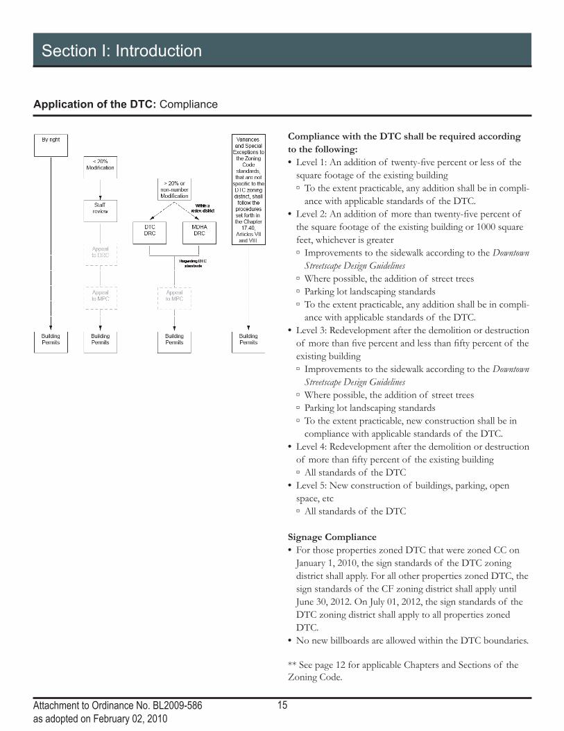
Application of the DTC: Compliance
Compliance with the DTC shall be required according to the following: • Level 1: An addition of twenty-five percent or less of the
square footage of the existing building ▫ To the extent practicable, any addition shall be in compli-
ance with applicable standards of the DTC • Level 2: An addition of more than twenty-five percent of
the square footage of the existing building or 1000 square feet, whichever is greater ▫ Improvements to the sidewalk according to the Downtown Streetscape Design Guidelines
▫ Where possible, the addition of street trees ▫ Parking lot landscaping standards ▫ To the extent practicable, any addition shall be in compli-
ance with applicable standards of the DTC • Level 3: Redevelopment after the demolition or destruction
of more than five percent and less than fifty percent of the existing building ▫ Improvements to the sidewalk according to the Downtown Streetscape Design Guidelines
▫ Where possible, the addition of street trees ▫ Parking lot landscaping standards ▫ To the extent practicable, new construction shall be in
compliance with applicable standards of the DTC • Level 4: Redevelopment after the demolition or destruction
of more than fifty percent of the existing building ▫ All standards of the DTC
• Level 5: New construction of buildings, parking, open space, etc ▫ All standards of the DTC
Signage Compliance • For those properties zoned DTC that were zoned CC on
January 1, 2010, the sign standards of the DTC zoning district shall apply For all other properties zoned DTC, the sign standards of the CF zoning district shall apply until June 30, 2012 On July 01, 2012, the sign standards of the DTC zoning district shall apply to all properties zoned DTC
• No new billboards are allowed within the DTC boundaries
** See page 12 for applicable Chapters and Sections of the Zoning Code

16Attachment to Ordinance No. BL2009-586as adopted on February 02, 2010
This page left intentionally blank

17Attachment to Ordinance No. BL2009-586 as adopted February 02, 2010
Sect ion I I :Subd is t r i c t S tandards

18Attachment to Ordinance No. BL2009-586 as adopted February 02, 2010
Section II: Subdistrict Standards
James Robertson Subdistrict: Regulating Plan
N
5TH
AV
E
2N
D A
VE
N
GAY ST
4T
H A
VE
N
TTE AVE
JAMES ROBERTSON P
KWY
MAN ST
COMM
ERCE ST
10TH
AV
E N
7TH
AV
E N
10T
H C
IR N
RO
SA L
PA
RK
S B
LV
D
STON AVE
MC
DEADERICK S
T
ST
RO
SA L
PA
RK
S A
VE
UNION S
T
PO
LK
AV
BANK ST
AR
CA
DE
ALY
PR
INTE
RS
ALY
CA
PIT
OL B
LV
D
CR
IDD
LE
ST
AY ST
TH
AV
E N
2N
D A
VE
N
10TH
AV
E N
6TH
AV
E N
JO JOHNSTON AVE
CHURCH ST
HARRISON S
T
CHARLOTTE AVE
GAY ST
5TH
AV
E N
3R
D A
VE
N
2N
D A
VE
N
1S
T A
VE
N
3R
D A
VE
N4TH
AV
E N
NELSON MERRY S
T
JAM
ES
ROBERTSONBOULEVARD
8TH
AV
E N
5TH
AV
E N
UNION
N
The James Robertson Subdistrict is the primarily civic area sur-rounding Capitol Hill. The Downtown Plan emphasizes “preserving the James Robertson neighborhood’s treasured civic and open space resources, while encouraging redevelopment to offer a mixture of uses…while recognizing that the area’s uses will continue to be dominated by government activities.” The importance of the State Capitol as a Nashville and Tennessee landmark also warrants maintaining views of the Capitol from all vantage points to the west, north and east. The DTC allows a maximum height of 560’ above sea level (the elevation of the base of the capitol building) to preserve these views.
LegendJames Robertson Subdistrict
Primary Street
Secondary Street
Tertiary Street
Other Street
Alley

19Attachment to Ordinance No. BL2009-586 as adopted February 02, 2010
Section II: Subdistrict Standards
James Robertson Subdistrict: Building Regulations
C
E
A
F
Building Section
D
Building Plan
Street
Parking Placement
Sidewalk
Planting Strip
Stre
et
Side
walk
Plan
ting S
trip
A
C
B
A
C
B
Frontage
Allowed Frontage Types with Required Build-to Zone
Primary Street• Storefront Frontage
▫ James Robertson BoulevardWest of 3rd Ave 20’-30’East of 3rd Ave 0’-10’
▫ Charlotte Avenue 0’-10’• Stoop Frontage
▫ James Robertson BoulevardWest of 3rd Ave 20’-30’East of 3rd Ave 5’-10’
▫ Charlotte Avenue 5’-10’Secondary Street• Storefront Frontage 0’-10’• Stoop Frontage 5’-10’Tertiary Street• Storefront Frontage 0’-10’• Stoop Frontage 5’-10’
Facade width
Primary Street 80% of lot frontage min.Secondary Street 80% of lot frontage min.Tertiary Street 60% of lot frontage min.Remaining lot frontage may be used for pedestrian amenities and shall not be used for parking.
Min. building depth 15’ from building facadeA building liner is required surrounding parking structures on the all fl oors facing James Robertson Blvd.
Height
Max. elevation of 560’
Step-back
Step-back required on all public streets and Open SpaceStep-back after 7 storiesMin. step-back depth 15’
A
C
D
E
F
B

20Attachment to Ordinance No. BL2009-586 as adopted February 02, 2010
Section II: Subdistrict Standards
Core Subdistrict: Regulating Plan
CHURCH ST
5TH
AV
E N
2
8
4TH
AV
E S
3R
D A
VE
S
BROADWAY
JAMES RO
7TH
AV
E S
COMMERCE ST
10TH
AV
E N
9TH
AV
E N
10T
H C
IR N
ALM
ON
D S
RO
SA L
PA
RK
S B
LV
D
MO
MC
LE
MO
RE
ST
DEADERICK S
TO
PR
Y P
L
DY S
T
RO
SA L
PA
RK
S A
VE
UNION S
T
PO
LK
AV
E
BANK ST
AR
CA
DE
ALY
LIFEW
AY PLZ
PR
INTE
RS
ALLE
Y
CA
PIT
OL B
LV
D
PORTER ST
SYMPHON
1S
T A
VE
N
AVOCK ST
6TH
AV
E N
9T
H A
V
2N
D A
VE
N
BROADWAY
12
7TH
AV
E N
CHURCH ST
HAV
E N
CHARLOTTE AVE
GAY ST
H A
VE
N
3R
D A
VE
N
RO
SA L
PA
RK
S A
VE
4TH
AV
E N
NELSON MERRY S
T
10TH
AV
E N
5TH
AV
E S
6TH
AV
E S
UNION
COMMERCECHURCH ST
RTERST
ORTER ST
ORTTERSSST
NLegend
CoreSubdistrict
Primary Street
Secondary Street
Tertiary Street
Other Street
Alley
The Core is the heart of the Downtown business district, the economic engine of the Middle Tennessee region, and a signifi cant economic force in the Southeast. It is the densest neighborhood in Downtown and has the greatest height allowances. Pedestrian comfort and safety should be prioritized with an interesting side-walk realm, activity on the ground level of buildings, and controlled vehicular access.

21Attachment to Ordinance No. BL2009-586 as adopted February 02, 2010
Section II: Subdistrict Standards
Frontage
Allowed Frontage Types with Required Build-to Zone
Primary Street• Storefront Frontage 0’-10’• Stoop Frontage 5’-10’Secondary Street• Storefront Frontage 0’-10’• Stoop Frontage 5’-10’Tertiary Street• Storefront Frontage 0’-10’• Stoop Frontage 5’-10’
Facade width
Primary Street 80% of lot frontage min.Secondary Street 80% of lot frontage min.Tertiary Street 60% of lot frontage min.Remaining lot frontage may be used for pedestrian amenities and shall not be used for parking.
Min. building depth 15’ from building facade
Height
Max. 30 stories Additional height available through the Bonus Height Program
Core Subdistrict: Building Regulations
C
D
A
Building Section
Building Plan
Street
Parking Placement
Sidewalk
Planting Strip
Stre
et
Side
walk
Plan
ting S
trip
A
C
B
A
C
B
A
C
D
B

22Attachment to Ordinance No. BL2009-586 as adopted February 02, 2010
Section II: Subdistrict Standards
Core Historic Subdistrict: Regulating Plan
5TH
AV
E COMMERCE ST
DEADERICK S
T
UNION S
T
BA
AR
CA
DE
ALY
PR
INTE
RS
ALLE
Y
CA
PIT
OL B
LV
D
CHURCH ST
3R
D A
VE
N4TH
AV
E N
BLVV
DDDDDDDDDDDDD
N LegendCore HistoricSubdistrict
Primary Street
Secondary Street
Tertiary Street
Other Street
Alley
Pedestrian Frontage
The Core Historic neighborhood has two historic urban spaces – the Arcade and Printers’ Alley. This neighborhood is comprised several historic buildings, many of which have been recently renovated. The height maximums for this subdistrict refl ect historic urban design features – lower buildings mid-block and taller build-ings to “book-end” the blocks at the corners. The adaptive reuse of historic buildings is encouraged and new construction should be of appropriate scale and detailing, maintaining the existing storefront rhythm. Pedestrian comfort and safety should be prioritized with an interesting sidewalk realm, activity on the ground level of buildings, and controlled vehicular access.

23Attachment to Ordinance No. BL2009-586 as adopted February 02, 2010
Section II: Subdistrict Standards
Core Historic Subdistrict: Building Regulations
Building Plan
Street
Parking Placement
Sidewalk
Planting Strip
Stre
et
Side
walk
Plan
ting S
trip
A
C
B
A
C
B
Frontage
Allowed Frontage Types with Required Build-to Zone
Primary Street• Storefront Frontage 0’• Stoop Frontage 5’-10’Secondary Street• Storefront Frontage 0’• Stoop Frontage 5’-10’
Facade width
Primary Street 95% of lot frontage min.Secondary Street 95% of lot frontage min.
Min. building depth 15’ from building facadeA building liner is required surrounding parking structures on all fl oors facing public streets and Open Space.
A
C
B
24Attachment to Ordinance No. BL2009-586 as adopted February 02, 2010
Section II: Subdistrict Standards
Core Historic Subdistrict: Building Regulations
C
D
A
IG
J
Block Corner Section
C
A
E
Mid-Block Section
FJ
Printer’s Alley
Height
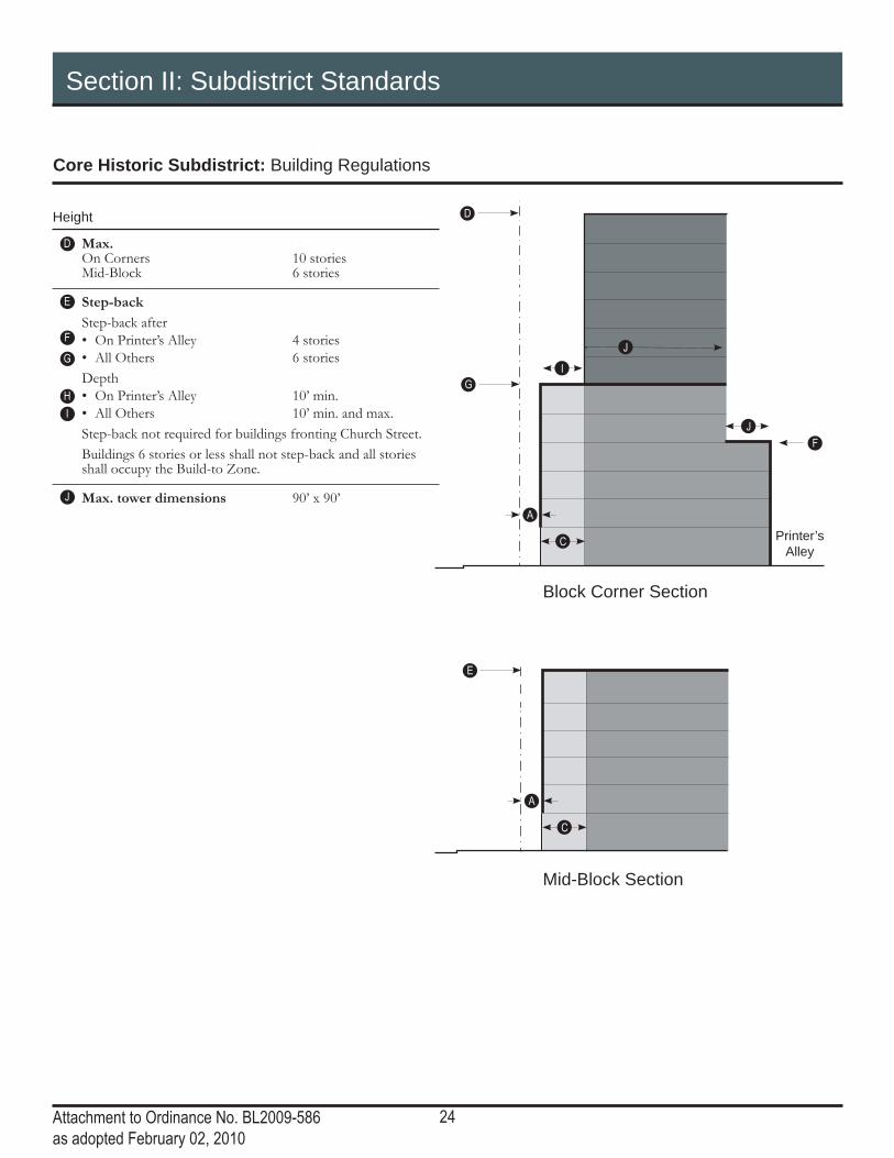
Max. On Corners 10 stories Mid-Block 6 stories
Step-back
Step-back after• On Printer’s Alley 4 stories• All Others 6 storiesDepth• On Printer’s Alley 10’ min.• All Others 10’ min. and max.Step-back not required for buildings fronting Church Street.Buildings 6 stories or less shall not step-back and all stories shall occupy the Build-to Zone.
Max. tower dimensions 90’ x 90’
D
E
F
G
IH
J

25Attachment to Ordinance No. BL2009-586 as adopted February 02, 2010
Section II: Subdistrict Standards
Core Historic Subdistrict: Building design and Facade articulation
L
N
L
M MM
O
Q
Q
O
P P
M M
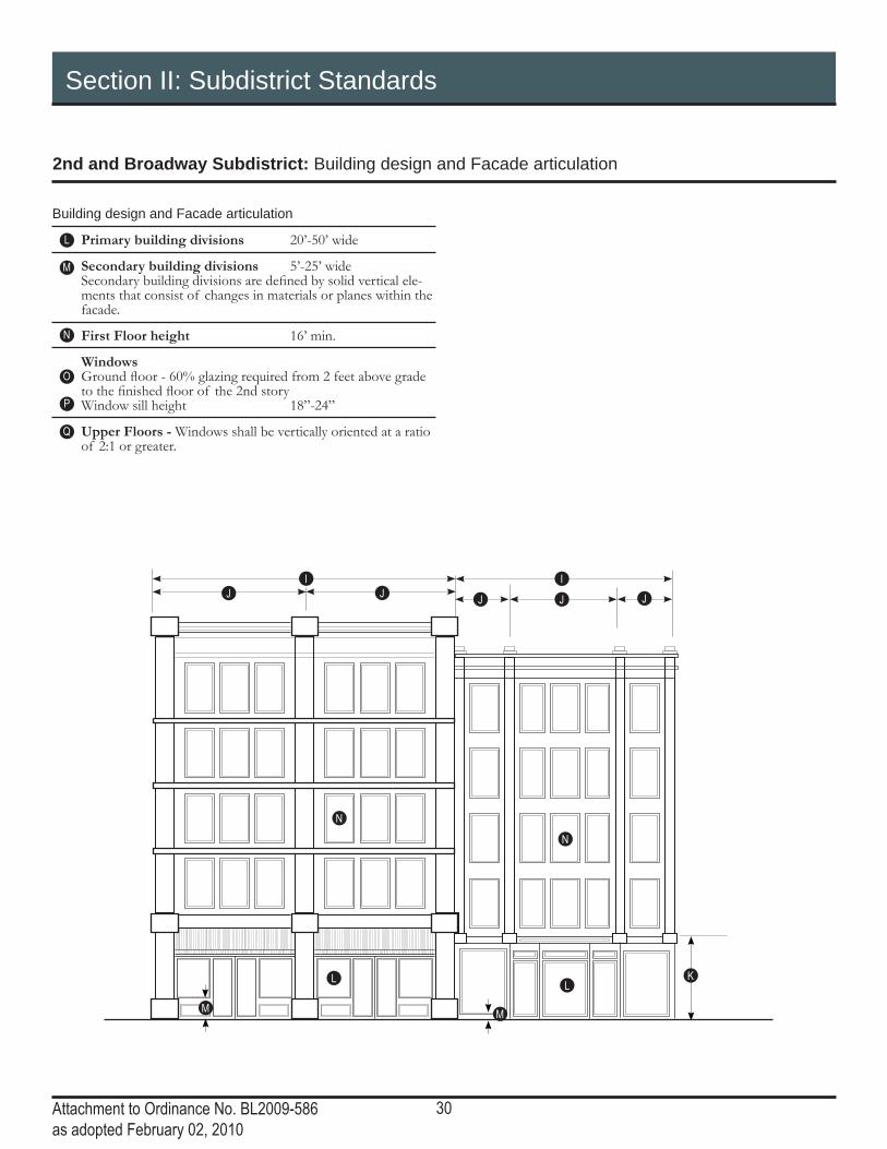
Building design and Facade articulation
Primary building divisions 20’-50’ wide
Secondary building divisions 5’-25’ wide Secondary building divisions are defi ned by solid vertical ele-ments that consist of changes in materials or planes within the facade.
First Floor height 16’ min.
Windows Ground fl oor - 60% glazing required from 2 feet above grade to the fi nished fl oor of the 2nd story Window sill height 18”-24”
Upper Floors - Windows shall be vertically oriented at a ratio of 2:1 or greater.
L
M
N
O
Q
P
26Attachment to Ordinance No. BL2009-586 as adopted February 02, 2010
Section II: Subdistrict Standards
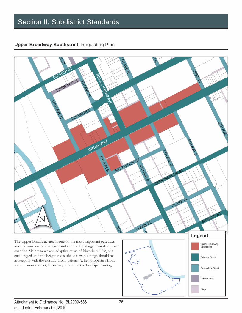
Upper Broadway Subdistrict: Regulating Plan
CHURCH ST
8T
H A
VE
S
DEMONBREUN ST
BROADWAY
7TH
AV
E S
9TH
AV
E N
10TH
RE
ST
OP
RY
PL
CLARK PL SHIR
LEY ST
ST
9T
LIFEW
AY PLZ
T
MCGAVOCK ST
VE
N
9T
H A
VE
S
CLARK PL
7TH
AV
E N
RO
SA L
PA
RK
S A
VE
10TH
AV
E N
5TH
AV
E S
6TH
AV
E S
COMMERCE
N
LegendUpper BroadwaySubdistrict
Primary Street
Secondary Street
Other Street
Alley
The Upper Broadway area is one of the most important gateways into Downtown. Several civic and cultural buildings front this urban corridor. Maintenance and adaptive reuse of historic buildings is encouraged, and the height and scale of new buildings should be in-keeping with the existing urban pattern. When properties front more than one street, Broadway should be the Principal frontage.

27Attachment to Ordinance No. BL2009-586 as adopted February 02, 2010
Section II: Subdistrict Standards
Upper Broadway Subdistrict: Building Regulations
27
C
D
A
27
Building Section
Building Plan
Street
Parking Placement
Sidewalk
Planting Strip
Stre
et
Side
walk
Plan
ting S
trip
A
C
B
A
C
B
Frontage
Allowed Frontage Types with Required Build-to Zone
Primary Street• Storefront Frontage 0-5’Secondary Street• Storefront Frontage 0’-5’ ** Civic Frontages are encouraged in this subdistrict.
Facade width
Primary Street 80% of lot frontage min.Secondary Street 80% of lot frontage min.Remaining lot frontage may be used for pedestrian amenities and shall not be used for parking.
Min. building depth 15’ from building facadeA building liner is required surrounding parking structures on all fl oors facing Broadway and Open Space.
Height
Max. 100’
A
C
B
D

28Attachment to Ordinance No. BL2009-586 as adopted February 02, 2010
Section II: Subdistrict Standards
2nd and Broadway Subdistrict: Regulating Plan
28
5TH
AV
E N
2N
D A
VE
S
4TH
AV
E S
3R
D A
VE
S
1S
T A
VE
S
COMMERCE ST
SHELB
Y S
TREET P
EDESTRIA
N
T
DEADERICK S
T
OP
RY
PL
UNION S
T
BANK ST
AR
CA
DE
ALY
PR
INTE
RS
ALLE
Y
SYMPHONY P
L
1S
T A
VE
N
6TH
AV
E N
2N
D A
VE
N
BROADWAY
CHURCH ST
3R
D A
VE
N4TH
AV
E N
5TH
AV
E
NLegend
2nd and BroadwaySubdistrict
Primary Street
Secondary Street
Other Street
Alley
Pedestrian Frontage
Second and Broadway is the heart of Downtown; where the main street of the city meets the Cumberland River. The Downtown Plan encourages maintaining “the low-scale, pedestrian-friendly historic character” and adaptively reusing existing historic structures “in order to respect, maintain, and enhance not only individual structures, but the existing character of the Second and Broadway neighborhood as a whole.” With the exception of the Stahlman building on the northeast corner of 3rd and Union, this neighbor-hood is overseen by of two historic zoning overlays: The Second Avenue Historic Zoning Overlay and The Broadway Historic Zoning Overlay. Property owners must contact the Metro Historic Commission for additional details.

29Attachment to Ordinance No. BL2009-586 as adopted February 02, 2010
Section II: Subdistrict Standards
2nd and Broadway Subdistrict: Building Regulations
C
D
A
E
Building Section
F
Building Plan
Street
Parking Placement
Sidewalk
Planting Strip
Stre
et
Side
walk
Plan
ting S
trip
A
C
B
A
C
B
G
Frontage
Allowed Frontage Types with Required Build-to Zone
Primary Street• Storefront Frontage 0’Secondary Street• Storefront Frontage 0’
Facade width
Primary Street 100% of lot frontage min.Secondary Street 100% of lot frontage min.
Min. building depth 15’ from building facade
Height
Min. 40’
Max. at the street • On Broadway 5 stories to a max. height
of 65’• On 2nd Ave 8 stories to a max. height
of 105’• On Union St 12 stories to a max.
height of 180’
Min. step-back depth • On Broadway 30’• On all other streets 20’
Max. height 1 additional story• Within 150’ of the right-of-way of Broadway, height shall
not exceed 6 stories or 80’• Between 150’ and 200’ of the right-of-way of Broadway,
height shall not exceed 7 stories or 90’.
A
C
D
B
E
F
G
30Attachment to Ordinance No. BL2009-586 as adopted February 02, 2010
Section II: Subdistrict Standards
2nd and Broadway Subdistrict: Building design and Facade articulation
I
K
IJ JJ
L
N
N
L
M M
J J
Building design and Facade articulation
Primary building divisions 20’-50’ wide
Secondary building divisions 5’-25’ wide Secondary building divisions are defi ned by solid vertical ele-ments that consist of changes in materials or planes within the facade.
First Floor height 16’ min.
Windows Ground fl oor - 60% glazing required from 2 feet above grade to the fi nished fl oor of the 2nd story Window sill height 18”-24”
Upper Floors - Windows shall be vertically oriented at a ratio of 2:1 or greater.
L
M
N
O
Q
P

31Attachment to Ordinance No. BL2009-586 as adopted February 02, 2010
This page left intentionally blank
32Attachment to Ordinance No. BL2009-586 as adopted February 02, 2010
Section II: Subdistrict Standards
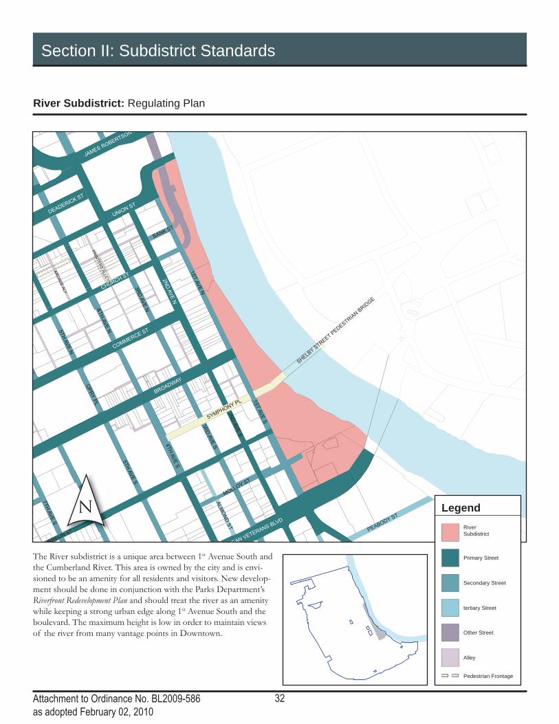
River Subdistrict: Regulating Plan
5TH
AV
E N
2N
D A
VE
S
4TH
AV
E S
3R
D A
VE
S
ONBREUN ST
JAMES ROBERTSON P
1S
T A
VE
S
7TH
AV
E S
COMMERCE ST
SHELB
Y S
TREET P
EDESTRIA
N B
RID
GE
PEABODY ST
ALM
ON
D S
T
MOLLOY S
T
DEADERICK S
T
OP
RY
PL
UNION S
T
BANK ST
AR
CA
DE
ALY
PR
INTE
RS
ALLE
Y
SYMPHONY P
L
1S
T A
VE
N
N
2N
D A
VE
N
BROADWAY
CHURCH ST
REAN VETERANS B
LVD
3R
D A
VE
N4TH
AV
E N
5TH
AV
E S
6TH
AV
E S
ST
6TH
AV
E S
6TH
AV
E S
VE
SN LegendRiverSubdistrict
Primary Street
Secondary Street
tertiary Street
Other Street
Alley
Pedestrian Frontage
The River subdistrict is a unique area between 1st Avenue South and the Cumberland River. This area is owned by the city and is envi-sioned to be an amenity for all residents and visitors. New develop-ment should be done in conjunction with the Parks Department’s Riverfront Redevelopment Plan and should treat the river as an amenity while keeping a strong urban edge along 1st Avenue South and the boulevard. The maximum height is low in order to maintain views of the river from many vantage points in Downtown.

33Attachment to Ordinance No. BL2009-586 as adopted February 02, 2010
Section II: Subdistrict Standards
River Subdistrict: Building Regulations
D
D
A
F
C
E
Building Section
Building Plan
Street
Parking Placement
Sidewalk
Planting Strip
Stre
et
Side
walk
Plan
ting S
trip
A
C
B
A
C
B
Frontage
Allowed Frontage Types with Required Build-to Zone
Primary Street• Storefront Frontage 0’-10’• Stoop Frontage 5’-10’Secondary Street• Storefront Frontage 0’-10’• Stoop Frontage 5’-10’Tertiary Street• Storefront Frontage 0’-10’• Stoop Frontage 5’-15’
Facade width
Primary Street 80% of lot frontage min.Secondary Street 80% of lot frontage min.1st Avenue 70% of lot frontage min.Tertiary Street 60% of lot frontage min.Remaining lot frontage may be used for pedestrian amenities and shall not be used for parking.
Min. building depth 15’ from building facade
Height
Max. 10 stories to a max. height of 145’
Step-back
Step-back required on 1st Avenue frontageStep-back after 8 stories within a max. height of 105’Min. step-back depth 15’
A
C
D
E
F
B

34Attachment to Ordinance No. BL2009-586 as adopted February 02, 2010
Section II: Subdistrict Standards
SoBro Subdistrict: Regulating Plan
CHURCH ST
5TH
AV
E N
2N
D A
VE
S
8TH
AV
E S
4TH
AV
E S
5TH
AV
E S
ST
3R
D A
VE
S
DEMONBREUN ST
LAFAYETTE ST
DIVISION ST
BROADWAY
AV
E S
1S
T A
VE
S
7TH
AV
E S
COMMERCE ST
SHELB
Y S
TREET P
ED
ELM ST
PEABOD
9TH
AV
E N
LEA AVE
ALM
ON
D S
T
EW
ING
AV
E
VD
MOLLOY S
T
10TH
AV
E S
PINE S
T
MC
LE
MO
RE
ST
11TH
AV
E S
GLEAVES ST
RU
TLE
DG
E S
T
FRANKLIN S
T
OP
RY
PL
T
CLARK PL SHIR
LEY ST
PALMER PL
PO
LK
AV
E
9TH
AV
E S
LIFEW
AY PLZ
DREXEL ST
OV
ER
TO
N S
T
D
MA
GA
ZIN
E S
T
CANNERY ROW
SYMPHONY P
L
LEA AVE
6TH
AV
E S
7T
H A
VE
S
MIDDLETON ST
LEA A
MCGAVOCK ST
PEABODY ST
6TH
AV
E N
9TH
AV
E S
9T
H A
VE
S
LEA AVE
BROADWAY
CLARK PL
LEA AVE
7TH
AV
E N
KOREAN VETERANS B
LVD
RO
SA L
PA
RK
S A
VE
N
10TH
AV
E N
5TH
AV
E S
8T
H A
VE
S
4TH
AV
E N
3R
D A
VE
N
2N
D A
VE
N
HERMITAG
E AV
6TH
AV
E S
COMMERCE
LAFAYETTE ST
12T
H A
VE
S
MA
GA
ZIN
E S
T
12T
H A
VE
AAS N
LegendSoBroSubdistrict
Primary Street
Secondary Street
Tertiary Street
Other Street
Alley
Pedestrian Frontage
West Second Frontage
East Second West First Frontage
The SoBro neighborhood is intended to be a high-intensity, mixed-use neighborhood emphasizing cultural and entertainment uses with a mix of residential and offi ce uses. SoBro is an extension of the Core in height and intensity, but it is also a transition to the lower, mid-rise Lafayette neighborhood.
Properties with frontage on the boulevard, and Transitional Proper-ties that consolidate to have frontage on the boulevard, shall be part of the SoBro Subdistrict. Properties south of the boulevard – Transitional Properties – without frontage on the boulevard, shall be part of the Lafayette Subdistrict.
8th Avenue Frontage
Transitional Properties

E
A
G
C
F
D
35Attachment to Ordinance No. BL2009-586 as adopted February 02, 2010
Section II: Subdistrict Standards
Frontage
Allowed Frontage Types with Required Build-to Zone
Primary Street• Storefront Frontage 0’-10’• Stoop Frontage 5’-10’Secondary Street• Storefront Frontage 0’-10’• Stoop Frontage 5’-10’Tertiary Street• Storefront Frontage 0’-10’• Stoop Frontage 5’-15’
Facade width
Primary Street 80% of lot frontage min.Secondary Street 80% of lot frontage min.Tertiary Street 60% of lot frontage min.Remaining lot frontage may be used for pedestrian amenities and shall not be used for parking.
Min. building depth 15’ from building facade
Height
Min. • On the Boulevard 3 stories or 35’
Max. • West side of 1st Ave and
east side of 2nd Ave unless fronting the Boulevard 15 stories to a max. height of 220’
• 8th Avenue Frontage, 8 stories within 100’ south of the roundabout of 8th Ave; 30 stories beyond 100’ of 8th Ave stories
• Subdistrict general 30 storiesAdditional height available through the Bonus Height Program
Step-back
Step-back after• Buildings taller than 150’ 105’ feet• Properties on 1st Ave, 2nd Ave,
and the Boulevard 8 stories within 105’Min. step-back depth 15’
Notes
All standards of the Gateway UDO shall apply to develop-ment along the boulevard except maximum height at the street, step-back depth, overall height, and fl oor area ratio. The review process for the DTC and the UDO will be consoli-dated.
A
C
D
E
F
B
G
SoBro Subdistrict: Building Regulations
Building Section
Building Plan
Street
Parking Placement
Sidewalk
Planting Strip
Stre
et
Side
walk
Plan
ting S
trip
A
C
B
A
C
B

3636
Building Regulations - Fronting Roundabout
SECTION III SoBro Subdistrict
• Buildings fronting the future roundabout shall respond to the circle with a facade perpendicular to the radius of the roundabout or a curved facade concentric with the roundabout.
• Curvilinear architectural elements such as arcades are encouraged.• Only Storefront Frontage shall be permitted fronting the
roundabout.
8TH
AV
E S
E S
DEMONBREUN ST
WAY
7TH
AV
E S
LEA AVE
VE
10TH
AV
E S
FRANKLIN S
T
CLARK PL SHIR
LEY ST
PALMER PL
9TH
AV
E S
CANNERY ROW
MCGAVOCK ST
PEABO
9TH
AV
E S
CLARK PL
5TH
AV
E S
8T
H A
VE
S
6TH
AV
E S
LAFAYETTE ST
N
Legend
Primary Street
Secondary Street
tertiary Street
Other Street
Alley
Roundabout Frontage

37Attachment to Ordinance No. BL2009-586as adopted on February 02, 2010
This page left intentionally blank

38Attachment to Ordinance No. BL2009-586as adopted on February 02, 2010
Section II: Subdistrict Standards
Lafayette Subdistrict: Regulating Plan
8T
H A
VE
S
5TH
AV
E S
ASH ST
DEMONBREUN ST
LAFAYETTE ST
E S
ELM ST
PEABODY S
LEA AVE
ND
ST
EW
ING
AV
E
FOGG ST
MULBERRY ST
10TH
AV
E S
GLEAVES ST
RU
TLE
DG
E S
T
FRANKLIN S
T
CLARK PL SHIR
LEY ST
PALMER PL
VIN
E S
T
9TH
AV
E S
INTERSTATE 40
DREXEL ST
OV
ER
TO
N S
T
CANNERY ROW
LEA AVE
6TH
AV
E S
7T
H A
VE
S
MIDDLETON ST
LEA AVE
MCGAVOCK S
PEABODY ST
ALLEY
AV
E S
9T
H A
VE
S
LEA AVE
CLARK PL
LEA AVE
KOREAN VETERANS B
LVD
8T
H A
VE
S
DIVISION ST
4TH
AV
E N
3R
D A
VE
N
2N
D A
VE
N
HERMITAG
E AVE
LAFAYETTE ST
INTERSTATE 40
8T
H A
VE
S
RSTATE 40NLegend
LafayetteSubdistrict
Primary Street
Secondary Street
Tertiary Street
Other Street
Alley
The Lafayette neighborhood is currently a primarily industrial and business services environment with strong transportation connec-tions to the Gulch, SoBro, Midtown, and South Nashville neighbor-hoods. This neighborhood will likely retain many of the industrial and business service uses while accommodating a greater variety of uses. The neighborhood is primarily low-rise and should act as a transition from the height of the Core and SoBro to the single-family neighborhoods to the South.
Transitional properties that consolidate to have frontage on the boulevard shall be part of the SoBro Subdistrict. Transitional proeprties that do not consolidate to have frontage on the boule-vard shall be part of the Lafayette Subdistrict.
TransitionalProperties
39Attachment to Ordinance No. BL2009-586as adopted on February 02, 2010
Section II: Subdistrict Standards
Lafayette Subdistrict: Building Regulations
B
D
Building Section
Building Plan
Street
Parking Placement
Sidewalk
Planting Strip
Stre
et
Side
walk
Plan
ting S
trip
A
C
B
A
C
B
E
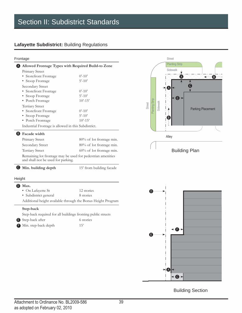
Frontage
Allowed Frontage Types with Required Build-to Zone
Primary Street• Storefront Frontage 0’-10’• Stoop Frontage 5’-10’Secondary Street• Storefront Frontage 0’-10’• Stoop Frontage 5’-10’• Porch Frontage 10’-15’Tertiary Street• Storefront Frontage 0’-10’• Stoop Frontage 5’-10’• Porch Fromtage 10’-15’Industrial Frontage is allowed in this Subdistrict.
Facade width
Primary Street 80% of lot frontage min.Secondary Street 80% of lot frontage min.Tertiary Street 60% of lot frontage min.Remaining lot frontage may be used for pedestrian amenities and shall not be used for parking.
Min. building depth 15’ from building facade
Height
Max. • On Lafayette St 12 stories• Subdistrict general 8 storiesAdditional height available through the Bonus Height Program
Step-back
Step-back required for all buildings fronting public streetsStep-back after 6 storiesMin. step-back depth 15’
A
D
C
E
F
B
C
A
F

40Attachment to Ordinance No. BL2009-586as adopted on February 02, 2010
Section II: Subdistrict Standards
Rutledge Hill Subdistrict: Regulating Plan
LAFAYETTE ST
ELM ST
LINDSLEY AVE
PEABODY ST
T
MID
DLE
TO
N S
T
LLOY ST
AN
TH
ES
DR
RU
TLE
DG
E S
T
AC
AD
EM
Y P
L
NANCE AVE
0
ROLLING MILL
BE
RR
IEN
ST
UN
IVE
RS
ITY
ST
LEA AVE LEA AVE
LEA AVE
AC
AD
EM
Y P
L
1S
T A
VE
S
REAN VETERANS B
LVD
4TH
AV
E N
3R
D A
VE
N
2N
D A
VE
N
HERMITAG
E AVE
HERMITAGE AVE
RDHILL
LAFAYEEEFF
TTTTTTTTTTTTTTTTTTTTEEE E E E SE
SEEEE
T
N LegendRutledge HillSubdistrict
Primary Street
Secondary Street
Tertiary Street
Alley
Rutledge Hill HistoricSubdistrict
The Rutledge Hill neighborhood includes a variety residential and civic historic buildings. This area is largely intact and new buildings of complimentary height, scale and massing.
Some of these properties are governed by a National Register District that regulates development, restoration and demolition. Property owners must contact the Metro Historic Commission for additional details.
41Attachment to Ordinance No. BL2009-586as adopted on February 02, 2010
Section II: Subdistrict Standards
Rutledge Hill Subdistrict: Building Regulations
B
A
Building Section
Building Plan
Street
Parking Placement
Sidewalk
Planting Strip
Stre
et
Side
walk
Plan
ting S
trip
A
C
B
A
C
B
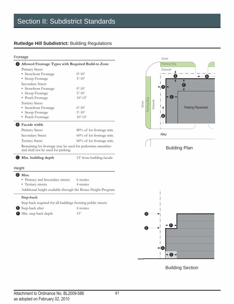
Frontage
Allowed Frontage Types with Required Build-to Zone
Primary Street• Storefront Frontage 0’-10’• Stoop Frontage 5’-10’Secondary Street• Storefront Frontage 0’-10’• Stoop Frontage 5’-10’• Porch Frontage 10’-15’Tertiary Street• Storefront Frontage 0’-10’• Stoop Frontage 5’-10’• Porch Fromtage 10’-15’
Facade width
Primary Street 80% of lot frontage min.Secondary Street 60% of lot frontage min.Tertiary Street 60% of lot frontage min.Remaining lot frontage may be used for pedestrian amenities and shall not be used for parking.
Min. building depth 15’ from building facade
Height
Max. • Primary and Secondary streets 6 stories• Tertiary streets 4 storiesAdditional height available through the Bonus Height Program
Step-back
Step-back required for all buildings fronting public streetsStep-back after 4 storiesMin. step-back depth 15’
A
D
C
E
F
B
C
D
EF
42Attachment to Ordinance No. BL2009-586as adopted on February 02, 2010
Section II: Subdistrict Standards
Rolling Mill Hill Subdistrict: Regulating Plan
4242
LINDSLEY AVE
PEABODY ST
MID
DLE
TO
N S
T
AN
TH
ES
DR
RU
TLE
DG
E S
T
AC
AD
EM
Y P
L
NANCE AVE
ROLLING MILL
BE
RR
IENU
LEA AVE LEA AVE
AC
AD
EM
Y P
L
3R
D A
VE
N
2N
D A
VE
N
HERMITAG
E AVE
HERMITAGE AVE
RDHILL
N
LegendRolling Mill HillSubdistrict
Primary Street
Secondary Street
Tertiary Street
Alley
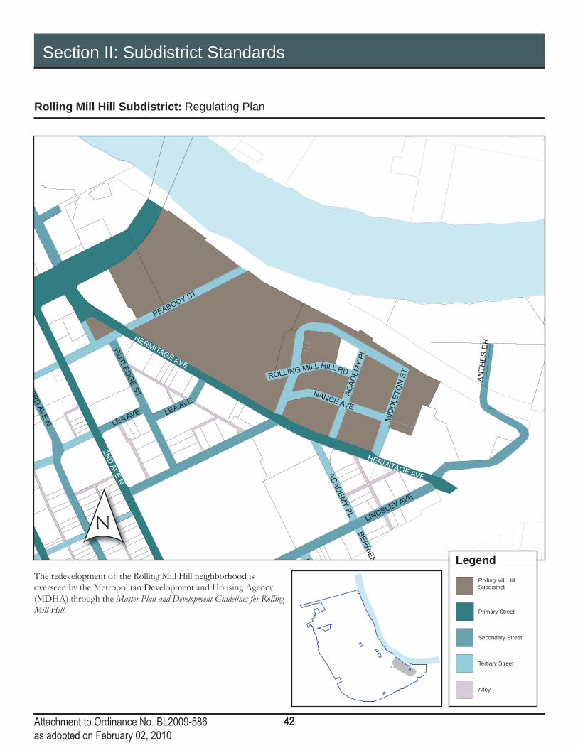
The redevelopment of the Rolling Mill Hill neighborhood is overseen by the Metropolitan Development and Housing Agency (MDHA) through the Master Plan and Development Guidelines for Rolling Mill Hill.

43Attachment to Ordinance No. BL2009-586as adopted on February 02, 2010
Section II: Subdistrict Standards
Rolling Mill Hill Subdistrict: Building Regulations
B
A
Building Section
C
D
E
Building Plan
Street
Parking Placement
Sidewalk
Planting Strip
Stre
et
Side
walk
Plan
ting S
trip
A
C
B
A
C
B
Frontage
Allowed Frontage Types with Required Build-to Zone
All streets 0-20’
Facade width
Minimum 25% of the lot frontage or 25’, which ever is greater.Remaining lot frontage may be used for pedestrian amenities and shall not be used for parking.
Min. building depth 15’ from building facadeA building liner is required surrounding parking structures on the ground fl oor facing public streets and Open Space.
Height
Max. height at the street 65’
Height Control Plane Applies from all streets and Open Space.1 foot horizontal to 1.5 feet vertical
A
D
C
E
B
44Attachment to Ordinance No. BL2009-586as adopted on February 02, 2010
Section II: Subdistrict Standards
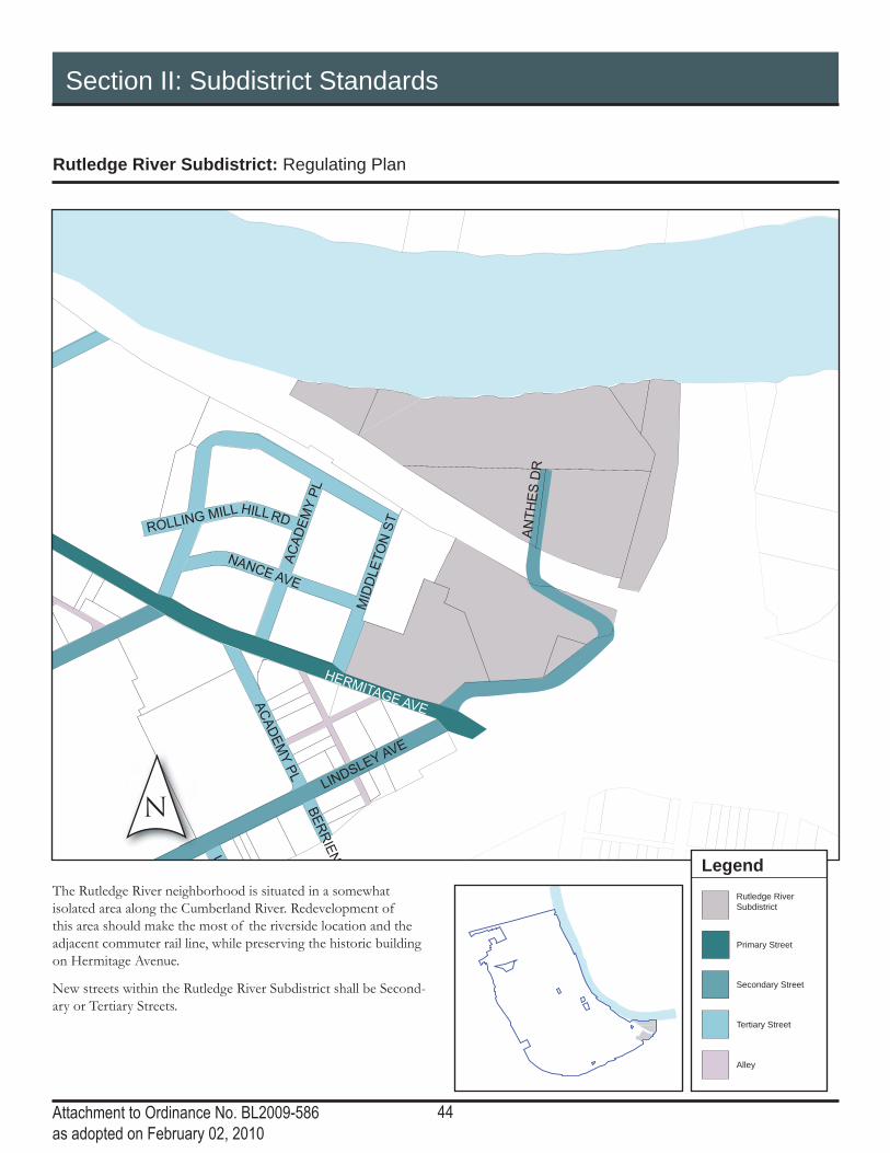
Rutledge River Subdistrict: Regulating Plan
LINDSLEY AVE
MID
DLE
TO
N S
T
AN
TH
ES
DR
AC
AD
EM
Y P
L
NANCE AVE
ROLLING MILL
BE
RR
IENU
AC
AD
EM
Y P
L
HERMITAGE AVE
RDHILL
N
LegendRutledge RiverSubdistrict
Primary Street
Secondary Street
Tertiary Street
Alley
The Rutledge River neighborhood is situated in a somewhat isolated area along the Cumberland River. Redevelopment of this area should make the most of the riverside location and the adjacent commuter rail line, while preserving the historic building on Hermitage Avenue.
New streets within the Rutledge River Subdistrict shall be Second-ary or Tertiary Streets.

45Attachment to Ordinance No. BL2009-586as adopted on February 02, 2010
Section II: Subdistrict Standards
Rutledge River Subdistrict: Building Regulations
B
A
Building Section
Building Plan
Street
Parking Placement
Sidewalk
Planting Strip
Stre
et
Side
walk
Plan
ting S
trip
A
C
B
A
C
B
C
D
EF
Frontage
Allowed Frontage Types with Required Build-to Zone
Primary Street• Storefront Frontage 0’-10’• Stoop Frontage 5’-10’Secondary Street• Storefront Frontage 0’-10’• Stoop Frontage 5’-10’• Porch Frontage 10’-15’Tertiary Street• Storefront Frontage 0’-10’• Stoop Frontage 5’-10’• Porch Fromtage 10’-15’Industrial Frontage is allowed in this Subdistrict.
Facade width
Primary Street 80% of lot frontage min.Secondary Street 80% of lot frontage min.Tertiary Street 60% of lot frontage min.Remaining lot frontage may be used for pedestrian amenities and shall not be used for parking.
Min. building depth 15’ from building facade
Height
Max. 9 storiesAdditional height available through the Bonus Height Program
Step-back
Step-back required for all buildings fronting public streetsStep-back after 6 storiesMin. step-back depth 15’
A
D
C
E
F
B
46Attachment to Ordinance No. BL2009-586as adopted on February 02, 2010
Section II: Subdistrict Standards
Gulch North: Regulating Plan
NCHURCH S
T
CHARLOTTE AVE
INTE
RS
TATE
40
HERMAN ST
10TH
AV
E N
7TH
AV
E N
9TH
AV
E
10T
H C
IR N
J
N S
T
RO
SA L
PA
RK
S B
LV
D
JO JOHNSTON AVE
MC
LE
MO
RE
ST
LOCKLAYER ST
IRELAND S
T
RO
SA L
PA
RK
S A
VE
MO
RR
ISO
N S
T
SHANKLAND ST P
OLK
AV
E
LIFEW
AY PLZ
CA
PIT
OL B
LV
CR
IDD
LE
ST
MEHAR
GAY ST
11TH
AV
E N
VE
N
ALY
10TH
AV
E N
6TH
AV
E N
7TH
DESHA ST
CLINTON S
T
HARRISON S
T
11T
CHARLOTTE AVE
GAY ST
5TH
AV
E N
RO
SA L
PA
RK
NELSON MERRY S
T
11th
AV
E N
13th A
VE
N
11TH
AV
E N
JAM
ES
ROBERTSONBOULEVARD
8TH
AV
E N
5TH
AV
E N
UNION
UNKNOW
N ALY
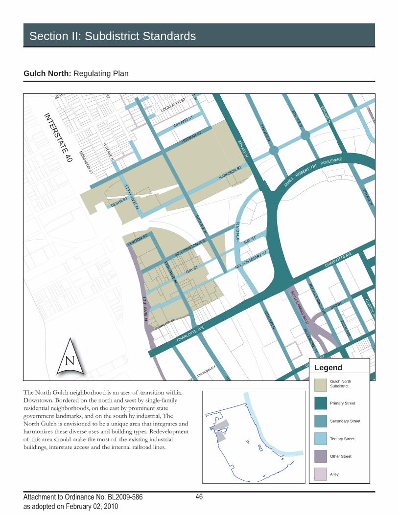
The North Gulch neighborhood is an area of transition within Downtown. Bordered on the north and west by single-family residential neighborhoods, on the east by prominent state government landmarks, and on the south by industrial, The North Gulch is envisioned to be a unique area that integrates and harmonizes these diverse uses and building types. Redevelopment of this area should make the most of the existing industrial buildings, interstate access and the internal railroad lines.
LegendGulch NorthSubdistrict
Primary Street
Secondary Street
Tertiary Street
Other Street
Alley

47Attachment to Ordinance No. BL2009-586as adopted on February 02, 2010
Section II: Subdistrict Standards
Gulch North: Building Regulations
47
B
D
4747
Building Section
Building Plan
Street
Parking Placement
Sidewalk
Planting Strip
Stre
et
Side
walk
Plan
ting S
trip
A
C
B
A
C
B
Frontage
Allowed Frontage Types with Required Build-to Zone
Primary Street• Storefront Frontage 0’-10’• Stoop Frontage 5’-10’Secondary Street• Storefront Frontage 0’-10’• Stoop Frontage 5’-10’• Porch Frontage 10’-15’Tertiary Street• Storefront Frontage 0’-10’• Stoop Frontage 5’-10’• Porch Fromtage 10’-15’Industrial Frontage is allowed in this Subdistrict on streets north of Harrison Street, including Harrison Street.
Facade width
Primary Street 80% of lot frontage min.Secondary Street 60% of lot frontage min.Tertiary Street 60% of lot frontage min.Remaining lot frontage may be used for pedestrian amenities and shall not be used for parking.
Min. building depth 15’ from building facade
Height
Max. 7 stories• Buildings fronting Herman St 4 storiesAdditional height available through the Bonus Height Program
A
D
C
B
C
A

48Attachment to Ordinance No. BL2009-586as adopted on February 02, 2010
Section II: Subdistrict Standards
Gulch South: Regulating Plan
INTE
RS
TATE
40
CHURCH ST
5TH
AV
E N
2N
D A
VE
S
8T
H A
VE
S
4TH
AV
E S
5TH
AV
E S
ASH ST
3R
D A
VE
S
DEMONBREUN ST
LAFAYETTE ST
DIVISION ST
BROADWAY
CHARLOTTE AVE
12TH
AV
E S
1S
T A
VE
S
7TH
AV
E S
COMMERCE ST
10TH
AV
E N
SHELB
Y S
TREET P
EDESTRIA
N B
RID
ELM ST
9TH
AV
E N
GE
OR
GE
L D
AV
IS B
LV
D
LEA AVE
ALM
ON
D S
T
EW
ING
AV
E
FOGG ST
RO
SA L
PA
RK
S B
LV
D
MULBERRY ST
MOLLOY S
T
JO
10TH
AV
E S
PINE S
T
MC
LE
MO
RE
ST
11TH
AV
E S
13TH
AV
E S
GLEAVES ST
RU
TLE
DG
E S
T
FRANKLIN S
T
OP
RY
PL
LAUREL ST
CLARK PL
GR
UN
DY S
T
SHIRLEY S
T
PALMER PL
RO
SA L
PA
RK
S A
VE
MCGAVOCK S
T
SHANKLAND ST P
OLK
AV
E
VIN
E S
T
9TH
AV
E S
INTERSTATE 40
BA
AR
CA
DE
ALY
LIFEW
AY PLZ
DREXEL ST
OV
ER
TO
N S
T
PR
INTE
RS
ALLE
Y
CA
PIT
OL B
LV
D
MA
GA
ZIN
E S
T
PORTER ST
CANNERY ROW
SYMPHONY P
L
LEA AVE
6TH
AV
E S
GAY ST
7T
H A
VE
S
MIDDLETON ST
1S
T A
VE
N
MCGAVOCK ST
PEABODY ST
ALLEY
6TH
AV
E N
9T
H A
VE
S
9T
H A
VE
S
LEA AVE
2N
D A
VE
N
BROADWAY
12TH
AV
E N
UNKNOW
N ALY
CLARK PL
LEA AVE
7TH
AV
E N
CHURCH ST
12TH
AVE N
11TH
AV
E N
KOREAN VETERANS B
LVD
CHARLOTTE AV
3R
D A
VE
N
RO
SA L
PA
RK
S A
VE
4TH
AV
E N
NELSON MERRY S
11th
AV
E N
13th A
VE
N
10TH
AV
E N
5TH
AV
E S
8T
H A
VE
S
DIVISION ST
4TH
AV
E N
3R
D A
VE
N
2N
D A
VE
N
HERM
6TH
AV
E S
UNION
COMMERCE
LAFAYETTE ST
INTERSTATE 40
CHURCH ST
BROADWAY
DEMONBREUN ST
12T
H A
VE
S
8T
H A
VE
S
UNKNOW
N ALY
N
The Gulch South neighborhood is an eclectic neighborhood of business services, restaurant, and retail with many new residential buildings. The area is a link between Downtown and Midtown and is envisioned to be mixed-use mid-rise buildings with opportunities for additional height at key intersections and along important streets. Connectivity – vehicular, rail, bicycle and pedestrian – should be preserved and additional connectivity is strongly encouraged.
LegendGulch SouthSubdistrict
Primary Street
Secondary Street
Tertiary Street
Other Street
Alley

49Attachment to Ordinance No. BL2009-586as adopted on February 02, 2010
Section II: Subdistrict Standards
Gulch South: Building Regulations
Frontage
Allowed Frontage Types with Required Build-to Zone
Primary Street• Storefront Frontage 0’-10’• Stoop Frontage 5’-10’Secondary Street• Storefront Frontage 0’-10’• Stoop Frontage 5’-10’• Porch Frontage 10’-15’Tertiary Street• Storefront Frontage 0’-10’• Stoop Frontage 5’-10’• Porch Fromtage 10’-15’
Facade width
Primary Street 80% of lot frontage min.Secondary Street 80% of lot frontage min.Tertiary Street 60% of lot frontage min.Remaining lot frontage may be used for pedestrian amenities and shall not be used for parking.
Min. building depth 15’ from building facade
Height
Max. • On Church St, Broadway 15 stories
and Demonbreun St• At the intersection of 20 stories
12th Ave and Demonbreun, 12th Ave and Division, 8th Ave and Division
• Subdistrict general 10 storiesAdditional height at intersections applies to frontage within 150 feet of the intersectionAdditional height available through the Bonus Height Program
Step-back
Step-back required along all frontages in Subdistrict general and along Broadway.Step-back after 7 storiesMin. step-back depth 15’
A
D
C
E
F
B
B
E
Building Section
C
F-
D
A
Building Plan
Street
Parking Placement
Sidewalk
Planting Strip
Stre
et
Side
walk
Plan
ting S
trip
A
C
B
A
C
B

50Attachment to Ordinance No. BL2009-586as adopted on February 02, 2010
Section II: Subdistrict Standards
Hope Gardens Subdistrict: Regulating Plan
JEFFERSON ST
INTE
RS
TATE
40
HERMAN ST
JACKSON ST
WA
RR
EN
ST
PHILLIP
S ST
LOCKLAYER ST
IRELAND S
T
MO
RR
ISO
N S
T
MEHARRY B
LVD
11TH
AV
E N
9TH
AV
E N
ST
HARRISON S
T
11TH
AV
8TH
AV
NLegend
Property lines adjacent to single family neighborhood
Primary Street
Secondary Street
Tertiary Street
Alley
Hope GardensSubdistrict
The Hope Gardens subdistrict includes the commercial and multi-family areas surrounding the single-family residential at the center of the Hope Gardens neighborhood. Development along the major streets – Jefferson Street and Rosa Parks Boulevard – should be low-rise and should transition in height and mass near the single-family areas. The existing commercial, residential and industrial uses are all important factors within this area and can be maintained while providing opportunities for mixed-use. The harmonization of these many uses – through the regulation of the building forms – will ensure the vitality of this mixed-use neighborhood.
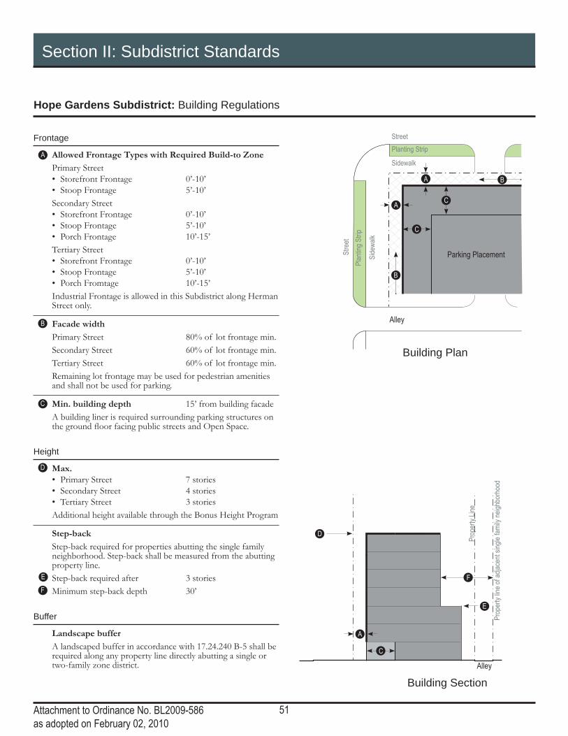
51Attachment to Ordinance No. BL2009-586as adopted on February 02, 2010
Section II: Subdistrict Standards
Hope Gardens Subdistrict: Building Regulations
B
D
Building Section
Building Plan
Street
Parking Placement
Sidewalk
Planting Strip
Stre
et
Side
walk
Plan
ting S
trip
A
C
B
A
C
B
Prop
erty
Line
Prop
erty
line o
f adja
cent
single
fami
ly ne
ighbo
rhoo
d
Frontage
Allowed Frontage Types with Required Build-to Zone
Primary Street• Storefront Frontage 0’-10’• Stoop Frontage 5’-10’Secondary Street• Storefront Frontage 0’-10’• Stoop Frontage 5’-10’• Porch Frontage 10’-15’Tertiary Street• Storefront Frontage 0’-10’• Stoop Frontage 5’-10’• Porch Fromtage 10’-15’Industrial Frontage is allowed in this Subdistrict along Herman Street only.
Facade width
Primary Street 80% of lot frontage min.Secondary Street 60% of lot frontage min.Tertiary Street 60% of lot frontage min.Remaining lot frontage may be used for pedestrian amenities and shall not be used for parking.
Min. building depth 15’ from building facadeA building liner is required surrounding parking structures on the ground fl oor facing public streets and Open Space.
Height
Max. • Primary Street 7 stories• Secondary Street 4 stories• Tertiary Street 3 storiesAdditional height available through the Bonus Height Program
Step-back
Step-back required for properties abutting the single family neighborhood. Step-back shall be measured from the abutting property line.Step-back required after 3 storiesMinimum step-back depth 30’
Buffer
Landscape buffer
A landscaped buffer in accordance with 17.24.240 B-5 shall be required along any property line directly abutting a single or two-family zone district.
A
D
C
E
F
B
C
E
A
F

52Attachment to Ordinance No. BL2009-586as adopted on February 02, 2010
Section II: Subdistrict Standards
Sulphur Dell: Regulating Plan
3R
D A
VE
N
2N
D A
VE
N
1S
T A
VE
N
GAY ST
4T
H A
VE
N
JAMES ROBERTSON P
KWY
HERMAN ST
7TH
AV
E N
R N
ACKSON ST
ST
LOCKLAYER ST
IRELAND S
T
STOCKYARD ST
JACKSON CT
CR
IDD
LE
ST
JACKSON ST
9TH
AV
E N
10TH
AV
E
JA
CK
SO
N S
T
6TH
AV
E N
JO JOHNSTON AVE
HARRISON S
T
5TH
AV
E N
3R
D A
VE
N
2N
D A
VE
N
1S
T A
VE
N
JAM
ES
ROBERTSONBOULEVARD
8TH
AV
E N
5TH
AV
E N
10TH
N
Legend
Primary Street
Secondary Street
Tertiary Street
Alley
Sulphur DellSubdistrict
The Sulphur Dell neighborhood is a mixed-use neighborhood surrounding the Bicentennial Mall on the north side of Downtown. This area includes many state-owned properties and is envisioned to be a cultural and civic destination within the State. Mixed-use and residential buildings will diversify the neighborhood and provide a transition in height and use into neighborhoods to the north.

53Attachment to Ordinance No. BL2009-586as adopted on February 02, 2010
Section II: Subdistrict Standards
Sulphur Dell Subdistrict: Building Regulations
B
D
Building Section
Building Plan
Street
Parking Placement
Sidewalk
Planting Strip
Stre
et
Side
walk
Plan
ting S
trip
A
C
B
A
C
B
C
A
Frontage
Allowed Frontage Types with Required Build-to Zone
Primary Street• Storefront Frontage 0’-10’• Stoop Frontage 5’-10’Secondary Street• Storefront Frontage 0’-10’• Stoop Frontage 5’-10’• Porch Frontage 10’-15’Tertiary Street• Storefront Frontage 0’-10’• Stoop Frontage 5’-10’• Porch Fromtage 10’-15’
Facade width
Primary Street 80% of lot frontage min.Secondary Street 80% of lot frontage min.Tertiary Street 60% of lot frontage min.Remaining lot frontage may be used for pedestrian amenities and shall not be used for parking.
Min. building depth 15’ from building facade
Height
Max. • Primary Street 7 stories• Secondary Street 5 stories• Tertiary Street 4 storiesAdditional height available through the Bonus Height Program
A
D
C
B

5454
This page left intentionally blank

55Attachment to Ordinance No. BL2009-586as adopted on February 02, 2010
Sect ion I I I :Uses

56Attachment to Ordinance No. BL2009-586as adopted on February 02, 2010
Section III: Uses
Use Areas
Land uses within the DTC are determined by Area – Central, South, West, and North. To create a sustainable and mixed-used Downtown, the form-based zoning of each subdistrict regulates the shape, scale, and placement of the buildings, and allows a variety of uses.
Uses Area boundaries are the same as Subdistrict boundaries. To determine the allowed land uses, locate the property on the Area Plan, and refer to the Area column on the Land Use Chart for the allowed uses.
Uses Permitted with Conditions or Permitted by Special Exceptions or Accessory shall follow the standards of Chapter 17.16. If standards within Chapter 17.16 and the DTC confl ict, the stricter shall apply.
N
CentralWest
North
South

57Attachment to Ordinance No. BL2009-586as adopted on February 02, 2010
Section III: Uses
Use Tables
P Permitted by rightPC Permitted with conditions SE Special Exception A Accessory O Overlay District N
orth
Sout
h
Wes
t
Cen
tral
Single-family P P P PTwo-family P P P PMulti-Family P P P PMobile home dwellingAccessory apartment P P P PBoarding house P P P PConsignment sale P P P PGarage sale A A A AHistoric bed and breakfast homestay P P P PHistoric home events P P P PHome occupation P P P PRural bed and breakfast homestaySecurity residence
Correctional facility P P P PCultural center P P P PDay care center (up to 75) P P P PDay care center (over 75) P P P PDay care home P P P PDay care--parent’s day out A A A ASchool day care P P P PMonastery or convent P P P POrphanage P P P PReligious institution P P P P
Business school P P P PCollege or university P P P PCommunity education P P P PDormitory P P P PFraternity/sorority house P P P PPersonal instruction P P P PVocational school P P P P
Financial institution P P P PGeneral office P P P PLeasing/sales office P P P P
Animal hospitalAssisted-care living P P P PHospice P P P PHospital P P P PMedical appliance sales P P P PMedical office P P P P
Residential Uses:
Institutional Uses:
Educational Uses:
Office Uses:
Medical Uses:
Medical or scientific lab P P P PNonresidential drug treatment facility P P P PNursing home P P P POutpatient clinic P P P PRehabilitation services P P P PResidence for handicapped (8 or more) P P P PVeterinarian P P P P
After-hours establishment PC PC PC PCAnimal boarding facility P P P PATM P P P PAutomobile convenience PC PC PC PCAutomobile parking P P P PAutomobile repair PAutomobile sales, new P P PAutomobile sales, usedAutomobile service P P P PBar or nightclub P P P PBed and breakfast inn P P P PBusiness service P P P PCarpet cleaning P P PCar wash PC Community garden (commercial) P P P PCommunity garden (non-commercial) P P P PCustom assembly P P P PDonation center, drop-off PC PC PC PCFuneral home P P P PFurniture store P P P PHome improvement sales P P P PHotel/motel P P P PInventory stock A A A AKennel/stableLaundry plants P PLiquor sales P P P PMajor appliance repair P P PMicrobrewery P P P PMobile storage unit PC PC PC PCMobile vendorPersonal care services P P P PRestaurant, fast-food P P P PRestaurant, full-service P P P PRestaurant, take-out P P P PRetail P P P PSelf-service storage P P P PVehicular rental/leasing PC PC PC PC
Commercial Uses:
P Permitted by rightPC Permitted with conditions SE Special Exception A Accessory O Overlay District N
orth
Sout
h
Wes
t
Cen
tral
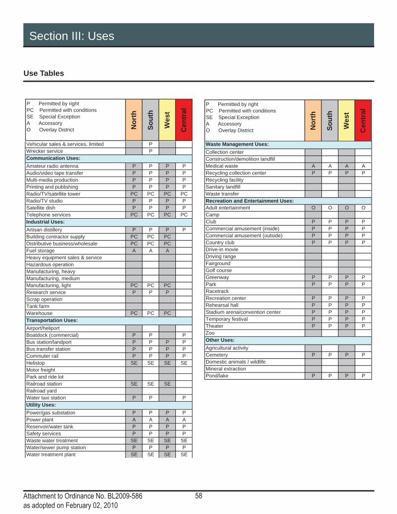
58Attachment to Ordinance No. BL2009-586as adopted on February 02, 2010
Section III: Uses
Use Tables
P Permitted by rightPC Permitted with conditions SE Special Exception A Accessory O Overlay District N
orth
Sout
h
Wes
t
Cen
tral
P Permitted by rightPC Permitted with conditions SE Special Exception A Accessory O Overlay District N
orth
Sout
h
Wes
t
Cen
tral
Vehicular sales & services, limited PWrecker service P
Amateur radio antenna P P P PAudio/video tape transfer P P P PMulti-media production P P P PPrinting and publishing P P P PRadio/TV/satellite tower PC PC PC PCRadio/TV studio P P P PSatellite dish P P P PTelephone services PC PC PC PC
Artisan distillery P P P PBuilding contractor supply PC PC PCDistributive business/wholesale PC PC PCFuel storage A A AHeavy equipment sales & serviceHazardous operationManufacturing, heavyManufacturing, mediumManufacturing, light PC PC PCResearch service P P PScrap operationTank farmWarehouse PC PC PC
Airport/heliportBoatdock (commercial) P P PBus station/landport P P P PBus transfer station P P P PCommuter rail P P P PHelistop SE SE SE SEMotor freightPark and ride lotRailroad station SE SE SERailroad yardWater taxi station P P P
Power/gas substation P P P PPower plant A A A AReservoir/water tank P P P PSafety services P P P PWaste water treatment SE SE SE SEWater/sewer pump station P P P PWater treatment plant SE SE SE SE
Communication Uses:
Industrial Uses:
Transportation Uses:
Utility Uses:
Collection centerConstruction/demolition landfillMedical waste A A A ARecycling collection center P P P PRecycling facilitySanitary landfillWaste transfer
Adult entertainment O O O OCampClub P P P PCommercial amusement (inside) P P P PCommercial amusement (outside) P P P PCountry club P P P PDrive-in movieDriving rangeFairgroundGolf courseGreenway P P P PPark P P P PRacetrackRecreation center P P P PRehearsal hall P P P PStadium arena/convention center P P P PTemporary festival P P P PTheater P P P PZoo
Agricultural activityCemetery P P P PDomestic animals / wildlifeMineral extractionPond/lake P P P P
Recreation and Entertainment Uses:
Other Uses:
Waste Management Uses:

59Attachment to Ordinance No. BL2009-586as adopted on February 02, 2010
Sect ion IV:Genera l S tandards

60Attachment to Ordinance No. BL2009-586as adopted on February 02, 2010
This page left intentionally blank

61Attachment to Ordinance No. BL2009-586as adopted on February 02, 2010
Section IV: General Standards
Calculations
Measurement from “Grade”• Unless otherwise indicated, reference to measurements from “grade” shall be calculated using the average elevation along the public right-of-way fronting the property. Thus, grade will generally be measured from the public sidewalk, not from grade on site. • When buildings are set back from the property line more than 15 feet, grade shall be measured as the average existing elevation at the building facade.• In the event that the base fl ood elevation, as established by FEMA, is higher than the sidewalk or grade elevations, the height of the fi rst story, shall be measured from 1 foot above the base fl ood elevation.
Measurement of Height • Unless otherwise specifi ed herein, the height of buildings shall be measured in stories. • The maximum height for an individual story shall not exceed 25 feet from fi nished fl oor to fi nished fl oor for each of the fi rst 2 stories, 18 feet fl oor to fl oor above the second story, and 25 feet for the top story of buildings greater than 5 stories.• The minimum building height shall be 25 feet. This applies to all buildings except those designed for single-family use, two-family use, or multi-family use with residential on the ground fl oor.• The maximum height for a raised foundation is 6 feet above grade.• Basements are not considered stories for the purposes of determining building height.• Building height shall be measured from each Street Frontage (excluding Other streets alleys) or Open Space.• The height of a parking structure concealed by a building liner may be equal to the height of the liner, regardless of the number of stories. If there is no liner to conceal the parking structure, its height is limited by the maximum number of stories allowed.• The height of fences, walls and hedges shall be measured in feet from the average sidewalk elevation.
Fenestration and Glazing• Except as specifi cally referenced herein, façade glazing and opening standards shall include windows, doors and openings in parking structures and shall apply to all areas of the building façade facing a public street or open space (excluding Other streets and alleys) as follows: ▫ First Floor: façade area measured from the fi nished fl oor to a height 14 feet above the fi nished fl oor.
▫ Upper Floors: façade area from fi nished fl oor to fi nished fl oor.
▫ Openings for vehicular access to parking structures on the fi rst fl oor shall not be included in calculation of total façade area or glazed area.
▫ The DTC recognizes the need for building systems and functionality including interior mechanical systems, fi re safety egress, other building code issues and their impact of the feasibility of building fenestration. Areas of the façade affected by these elements shall not be counted toward minimum glazing requirements.

62Attachment to Ordinance No. BL2009-586as adopted on February 02, 2010
Section IV: General Standards
Street Character
The public right-of-way, including streets, sidewalks and public utility infrastructure, plays both a functional and social role in the life of the city and its citizens. Streets organize the city, help to defi ne space, and link destinations. The street is also a public place where people congregate, shop, socialize and live. Active, attractive streets are critical to the continued growth and success of Downtown. The DTC includes urban design tools to make working, living and playing in Downtown lively, safe and comfortable.
The DTC uses Street Types as an urban design and organizing tool. All streets are classifi ed on the Regulating Plan as Primary, Secondary, Tertiary, Other, or Alley.
Where alleys exist and are in working condition, or where new alleys can be created, the DTC prioritizes alleys for access and loading. The location of vehicular access from all other streets shall be determined on a case-by-case basis.
The Downtown Plan: 2007 Update calls for “a strong emphasis on expanding other modes of transportation including walking, cycling and transit.” The DTC emphasizes walking, cycling and transit as primary modes of transportation within Downtown through the urban design of individual buildings, blocks, and neighborhoods.
All Streets• Streets refer to publicly or privately owned right-of-way. They are intended for use by pedestrian, bicycle, transit and vehicular traffi c and provide access to property.• Streets consist of vehicular lanes and the Sidewalk Corridor. The vehicular lanes, in a variety of widths, provide traffi c and parking capacity and may include bicycle paths. The Sidewalk Corridor contributes to the urban character of each neighborhood. It may include pedestrian paths, landscaped planters, street furnishings and street trees. • Pedestrian safety, comfort, and accessibility should be a primary consideration of street design and dimensioning. • When alleys are present, vehicular access from alleys is preferred. Vehicular access from public streets shall be considered in the following order: Other Streets, Secondary Streets, Tertiary Streets and then Primary Streets as approved by Metro departments.
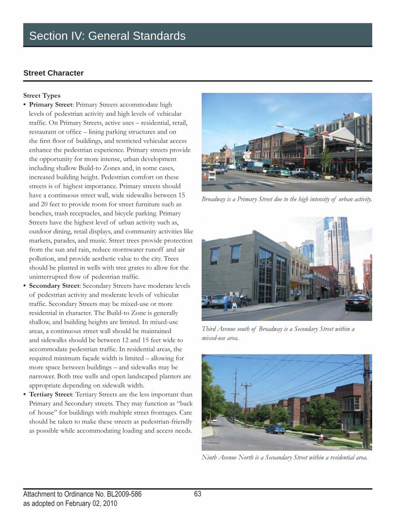
63Attachment to Ordinance No. BL2009-586as adopted on February 02, 2010
Section IV: General Standards
Street Character
Street Types• Primary Street: Primary Streets accommodate high levels of pedestrian activity and high levels of vehicular traffi c. On Primary Streets, active uses – residential, retail, restaurant or offi ce – lining parking structures and on the fi rst fl oor of buildings, and restricted vehicular access enhance the pedestrian experience. Primary streets provide the opportunity for more intense, urban development including shallow Build-to Zones and, in some cases, increased building height. Pedestrian comfort on these streets is of highest importance. Primary streets should have a continuous street wall, wide sidewalks between 15 and 20 feet to provide room for street furniture such as benches, trash receptacles, and bicycle parking. Primary Streets have the highest level of urban activity such as, outdoor dining, retail displays, and community activities like markets, parades, and music. Street trees provide protection from the sun and rain, reduce stormwater runoff and air pollution, and provide aesthetic value to the city. Trees should be planted in wells with tree grates to allow for the uninterrupted fl ow of pedestrian traffi c.• Secondary Street: Secondary Streets have moderate levels of pedestrian activity and moderate levels of vehicular traffi c. Secondary Streets may be mixed-use or more residential in character. The Build-to Zone is generally shallow, and building heights are limited. In mixed-use areas, a continuous street wall should be maintained and sidewalks should be between 12 and 15 feet wide to accommodate pedestrian traffi c. In residential areas, the required minimum façade width is limited – allowing for more space between buildings – and sidewalks may be narrower. Both tree wells and open landscaped planters are appropriate depending on sidewalk width.• Tertiary Street: Tertiary Streets are the less important than Primary and Secondary streets. They may function as “back of house” for buildings with multiple street frontages. Care should be taken to make these streets as pedestrian-friendly as possible while accommodating loading and access needs.
Ninth Avenue North is a Secoandary Street within a residential area.
Broadway is a Primary Street due to the high intensity of urban activity.
Third Avenue south of Broadway is a Secondary Street within a mixed-use area.

64Attachment to Ordinance No. BL2009-586as adopted on February 02, 2010
Section IV: General Standards
Street Character
• Other Street: Other Streets are streets that do not fall into any of the other street categories. They may have high or moderate levels of vehicular traffi c, but often have no access to property and limited pedestrian activity. Building height along these streets is regulated by the other property frontages. Buildings do not front on these streets and may be built up to the property line. • Alley: Alleys are service roads that provide shared access to property. Public utilities as well as access to mechanical equipment and trash should be located off an alley whenever possible. Where alleys exist and are in working condition, or where new alleys can be created through the dedication of new right-of-way, alleys are prioritized for access and loading.
Sidewalk Corridor• The Sidewalk Corridor is the portion of the right-of-way between the vehicular lanes and the property line or building façade. ▫ The primary function of the Sidewalk Corridor is to provide a safe, comfortable, and convenient route for pedestrian travel that is separated from vehicular movements.
▫ The Sidewalk Corridor is a public space that should include pedestrian amenities such as seating, shade trees, places to congregate, trash receptacles and outdoor dining.
▫ The Sidewalk Corridor may accommodate public utilities such as electric poles and vaults, water and sewer lines, bus stops and traffi c signals.
• As property develops within the DTC boundaries, property owners shall consult with Public Works to make the necessary improvements to the streetscape in accordance with the Downtown Streetscape Elements Design Guidelines, the Strategic Plan for Sidewalks and Bikeways and Title 17.20.120 Provision of sidewalks.
Other Streets are less traveled by pedestrians and have limited access for vehicles from adjoining lots.
Alleys provide access for parking and service areas.

65Attachment to Ordinance No. BL2009-586as adopted on February 02, 2010
Section IV: General Standards
Street Character
Street TreesShade-producing street trees shall be planted in the public right-of-way along the length of the lot frontage at a maximum spacing of fi fty feet or in accordance with the regulations of Metro departments and agencies.
Tree QualityTree species shall be chosen from the Urban Forestry Recommended and Prohibited Tree and Shrub List based on tree size and plant-ing area provided or an alternative species deemed appropriate by the Urban Forester.
• At planting trees, shall meet the requirements for street trees set out in the American Standard for Nursery Stock.• All nursery stock used as street trees shall be vigorous, healthy and free of diseases or infestation.• Planting Area Dimension
▫ The following standards are minimum standards. All development is encouraged to provide street trees with the largest area of pervious surface and volume of soil that can be accommodated.
▫ Trees shall be accommodated in planting areas with a minimum depth of 3 feet and a minimum soil volume of 400 cubic feet.
▫ The minimum pervious opening at grade shall be 25 square feet. ▫ Tree vaults shall have the capability to drain water.
▫ Planting areas shall not inhibit ingress/egress from buildings or pedestrian traffi c along the Sidewalk Corridor.
Future StreetsDowntown thrives on a connected system of streets which allow easy access within neighborhoods and to other parts of the city. There are, however, places for improvement. The Future Streets Plan show how streets could be realigned, connected and created in the future to improve mobility within Downtown.
Properties near an area highlighted for change on the Future Streets Plan shall consult with the Planning Department and the Department of Public Works to discuss the potential change.

66Attachment to Ordinance No. BL2009-586as adopted on February 02, 2010
Section IV: General Standards
Future Streets Plan
INTE
RS
TATE
40
CHURCH ST
3R
D A
VE
N
5TH
AV
E N
2N
D A
VE
S
8T
H A
VE
S
JEFFERSON ST
4TH
AV
E S
2N
D A
VE
N
5TH
AV
E S
1S
T A
VE
NGAY S
T
ASH ST
3R
D A
VE
S
DEMONBREUN ST
4T
H A
VE
N
LAFAYETTE ST
INT
ER
STA
TE
65
DIVISION ST
BROADWAY
CHARLOTTE AVE
12TH
AV
E S
JAMES ROBERTSON P
KWY
INTE
RS
TATE
40
HERMAN ST
1S
T A
VE
S
7TH
AV
E S
COMMERCE ST
10TH
AV
E N
SHELB
Y S
TREET P
EDESTRIA
N B
RID
GE
7TH
AV
E N
ELM ST
LINDSLEY AVE
PEABODY ST
9TH
AV
E N
GE
OR
GE
L D
AV
IS B
LV
D
10T
H C
IR N
JACKSON ST
LEA AVE
ALM
ON
D S
T
WA
RR
EN
ST
EW
ING
AV
E
FOGG ST
MID
DLE
TO
N S
T
RO
SA L
PA
RK
S B
LV
D
MULBERRY ST
MOLLOY S
T
JO JOHNSTON AVE
10TH
AV
E S
PINE S
T
MC
LE
MO
RE
ST
PHILLIP
S ST
AN
TH
ES
DR
DEADERICK S
T
11TH
AV
E S
13TH
AV
E S
GLEAVES ST
RU
TLE
DG
E S
T
FRANKLIN S
T
OP
RY
PL
LAUREL ST
CLARK PL
GR
UN
DY S
T
LOCKLAYER ST
AC
AD
EM
Y P
L
SHIRLEY S
T
PALMER PL
NANCE AVE
IRELAND S
T
RO
SA L
PA
RK
S A
VE
MCGAVOCK S
T
MO
RR
ISO
N S
T
SHANKLAND ST
UNION S
TP
OLK
AV
E
VIN
E S
T
9TH
AV
E S
INTERSTATE 40
BANK ST
STOCKYARD ST
AR
CA
DE
ALY
LIFEW
AY PLZ
DREXEL ST
OV
ER
TO
N S
T
PR
INTE
RS
ALLE
Y
CA
PIT
OL B
LV
D
MA
GA
ZIN
E S
T
PORTER ST
JACKSON CT
CANNERY ROW
CR
IDD
LE
ST
SYMPHONY P
L
MEHARRY B
LVD
ROLLING MILL
BE
RR
IEN
ST
UN
IVE
RS
ITY
ST
LEA AVE
6TH
AV
E S
GAY ST
11TH
AV
E N
7T
H A
VE
S
MIDDLETON ST
1S
T A
VE
N
LEA AVE
MCGAVOCK ST
PEABODY ST
ALLEY
6TH
AV
E N
JACKSON ST
9TH
AV
E N
9T
H A
VE
S
9T
H A
VE
S
LEA AVE
2N
D A
VE
N
BROADWAY
AC
AD
EM
Y P
L
12TH
AV
E N
1S
T A
VE
S
UNKNOW
N ALY
10TH
AV
E N
JA
CK
SO
N S
T
CLARK PL
LEA AVE
6TH
AV
E N
JO JOHNSTON AVE
7TH
AV
E N
CHURCH ST
DESHA ST
CLINTON S
T
HARRISON S
T
12TH
AVE N
11TH
AV
E N
KOREAN VETERANS B
LVD
CHARLOTTE AVE
GAY ST
5TH
AV
E N
3R
D A
VE
N
2N
D A
VE
N
1S
T A
VE
N
3R
D A
VE
N
RO
SA L
PA
RK
S A
VE
4TH
AV
E N
NELSON MERRY S
T
11th
AV
E N
13th A
VE
N
11TH
AV
E N
10TH
AV
E N
5TH
AV
E S
8T
H A
VE
S
DIVISION ST
4TH
AV
E N
3R
D A
VE
N
2N
D A
VE
N
HERMITAG
E AVE
6TH
AV
E S
JAM
ES
ROBERTSONBOULEVARD
8TH
AV
E N
5TH
AV
E N
UNION
COMMERCE
LAFAYETTE ST
HERMITAGE AVE
INTERSTATE 40
CHURCH ST
BROADWAY
DEMONBREUN ST
12T
H A
VE
S
8T
H A
VE
S
UNKNOW
N ALY
RDHILL
N
Legend
Secondary Street
Tertiary Street
Primary Street
Future Street Connection
Future Alley
Other Street
Alley
Street Closure

67Attachment to Ordinance No. BL2009-586as adopted on February 02, 2010
Section IV: General Standards
Lots and Frontages
FrontagesA Frontage is the specifi c way in which the building face addresses the street. It is the transition and interaction between the private and public realms. Building Frontages defi ne the character and form of the public spaces within each neighborhood. The following standards shall apply to all development within the DTC.
• Buildings shall front a street (excluding alleys), open space, or a pedestrian passage.• Principal and Minor Frontages
▫ Every property shall establish one Principal Frontage along a street.
▫ When a lot fronts more than one street the following priority shall be given when establishing the Principal Frontage: Primary Street, Secondary Street, Tertiary Street, Other Street.
▫ Any other frontage(s) shall be treated as a Minor Frontage.
▫ In the instance a property fronts multiple Primary streets, any may be chosen as the Principal Frontage or all may be treated as the Principal Frontages.
▫ Along a Minor Frontage, the façade width may be reduced to the maximum depth of the building along the Principal Frontage. The remaining lot width shall be defi ned with a knee-wall according to the Walls and Fences section of the DTC.
▫ Along a Minor Frontage, modifi cations may be granted for the reduction of ground level garage liners and/or glazing requirements.
• Façade Width ▫ The minimum façade width is the minimum amount of the frontage that must be defi ned by a building and is designated as a percentage of the frontage.
▫ If a single lot frontage is greater than two hundred feet, the façade width may be reduced to a minimum of one hundred and fi fty feet in length.
• Open Space Frontages ▫ When building facades front on open space the standards of the adjacent street type (excluding Tertiary) shall apply.
▫ All buildings fronting open space shall have a minimum of one primary pedestrian entrance on the open space.
• Pedestrian Passage Frontages ▫ When building facades front on a pedestrian passage the standards of the adjacent street type (excluding Tertiary) shall apply.
▫ All buildings fronting a pedestrian passage shall have a minimum of one primary pedestrian entrance on the pedestrian passage.
Build-to Zone • The Build-to Zone is the specifi ed depth along a property’s street frontage(s) in which the required minimum façade width must be located. The depth is Subdistrict and Street Type specifi c.• Depending on site conditions the front of the Build-to Zone may begin at different locations. ▫ When the existing sidewalk meets with the Downtown Streetscape Design Guideline standards for sidewalk width, the Build-to Zone begins at the back of the sidewalk/property line.
▫ When the existing sidewalk does not meet with the Downtown Streetscape Design Guideline standards for sidewalk width, the sidewalk should be widened on site and the Build-to Zone begin at the back of the new sidewalk.
▫ When utility easements exist along the street frontage of a property the Build-to Zone shall begin at the back of the easement.
▫ When buildings front an open space the Build-to Zone shall begin at the back of the open space.
• Attachments ▫ Structures, including porches, stoops, and balconies shall not encroach beyond the front of the Build-to Zone.
▫ Elements such as stairs, awnings, and landscaping may encroach beyond the front of the Build-to Zone. Any encroachments into the right-of-way must follow the Mandatory Referral process.
• Entrances ▫ All buildings shall have at least one pedestrian entrance on the Principal Building Frontage. This may be access to a lobby shared by individual tenants.
▫ Corner entrances are appropriate on corner lots.

68Attachment to Ordinance No. BL2009-586as adopted on February 02, 2010
Section IV: General Standards
Lots and Frontages
• Glazing ▫ All street level exterior windows must have a minimum light transmission of 60 percent.
▫ Modifi cations may be permitted insofar as it is determined that tinting does not substantially diminish the effect of the building wall or the pedestrian character of the street.
• Vehicular Access ▫ When calculating the minimum façade width, access to structured parking shall be counted as part of the required façade width, and access to surface parking shall not be counted part of the required façade width. That is, access to surface parking is allowed in the “remaining” area, after the façade width requirement has been met. Surface parking is not allowed in the “remaining” area.
Active Use• An active ground fl oor use requirement shall mean a habitable space occupied by retail, offi ce, residential, institutional or recreational uses, specifi cally excluding parking and mechanical uses. • An active use is required on the ground fl oor of all Primary streets, Secondary streets, Open Space and pedestrian passages. An active use is encouraged on Tertiary streets, particularly if the Tertiary street is the only street frontage, but is not required. • Any references to the requirement of an active use on the ground fl oor on “streets” or “public streets” shall exclude Tertiary streets, Other streets, and alleys and shall include Open Space and pedestrian passages. • The term “active use” and “building liner” are synonymous.
Auto-oriented canopies and awnings• Auto-oriented canopies and awnings, for uses such as drive-thrus and gas station pumps, may be attached to a building according to the following: ▫ The building shall comply with all Frontage standards. ▫ The canopy and/or awning shall be lower in height than the primary building.
▫ The setback of the canopy and/or awning shall be a minimum of 15 feet from the back of the Build-to Zone.
• Exteriors ▫ Any new roof or complete resurfacing of an existing roof must use a roofi ng material having an SRI of 29 or greater for roof slopes greater than 2:12 or SRI of 78 for slopes less than or equal to 2:12.

69Attachment to Ordinance No. BL2009-586as adopted on February 02, 2010
This page left intentionally blank

70Attachment to Ordinance No. BL2009-586as adopted on February 02, 2010
Section IV: General Standards
Lots and Frontages: Specifi c to Storefront Frontage
The Storefront Frontage has a limited Build-to Zone that is close to the street, with building entrances accessible at side-walk grade. The Storefront Frontage has substantial glazing on the facade at ground level, space for pedestrian-oriented signage, awnings, retail display, and other design features con-ducive with creating an active commercial streetscape.
The Storefront Frontage is commonly used for general com-mercial, offi ce, retail, restaurant, lobby, etc.
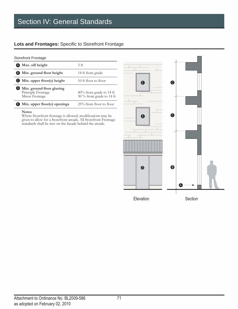
71Attachment to Ordinance No. BL2009-586as adopted on February 02, 2010
Section IV: General Standards
Lots and Frontages: Specifi c to Storefront Frontage
Elevation
D
E
E
Storefront Frontage
Max. sill height 3 ft
Min. ground fl oor height 14 ft from grade
Min. upper fl oor(s) height 10 ft fl oor to fl oor
Min. ground fl oor glazing Principle Frontage 40% from grade to 14 ft Minor Frontage 30 % from grade to 14 ft
Min. upper fl oor(s) openings 25% from fl oor to fl oor
Notes Where Storefront frontage is allowed, modifi cations may be given to allow for a Storefront arcade. All Storefront Frontage standards shall be met on the facade behind the arcade.
A
B
C
D
E
Section
B
C
C
A

72Attachment to Ordinance No. BL2009-586as adopted on February 02, 2010
Section IV: General Standards
Lots and Frontages: Specifi c to Stoop Frontage
The Stoop Frontage has a limited to moderate Build-to Zone with the fi rst fl oor elevated from the sidewalk grade. This frontage type utilizes a stoop - a small landing connecting a building entrance to the sidewalk by a stair or ramp - to transition from the public sidewalk or open space into the building.
Stoops are generally provided externally, but may be provided internally as necessitated for ADA compliance.
The Stoop Frontage is generally used for residential and live-work buildings, but may be appropriate for other uses.

73Attachment to Ordinance No. BL2009-586as adopted on February 02, 2010
Section IV: General Standards
Lots and Frontages: Specifi c to Stoop Frontage
SectionElevation
A
D
Plan
D
C
B
E
E
F
F
Fron
t of B
uild-
to Zo
ne
Prop
erty
Line
Fron
t of B
uild-
to Zo
ne
Prop
erty
Line
Stoop Frontage
First fl oor elevation
Min. 18” from gradeMax. 5 ft from grade
Min. ground fl oor openings 30% fl oor to fl oor
Min. upper fl oor(s) openings 25% from fl oor to fl oor
Stoop
Min. stoop width 5 ftStoops may not extend beyond the front of the Build-to Zone.Steps may extend beyond Build-to Zone, but may not encroach into the public Right-of-Way.
Notes
Greater fi rst fl oor elevation allowed by modifi cation for:• Property with signifi cant elevation change across the site at
the street frontage.• Development that incorporates below grade basement fl oors
that are accessible from the exterior of the building.Transition to fi rst fl oor elevation may be accommodated on the interior of the building to allow for compliance with ADA accessibility requirements.Entries shall not be recessed more than 4 feet from the facade of the building.Doors shall face the street.
A
B
C
DE
F
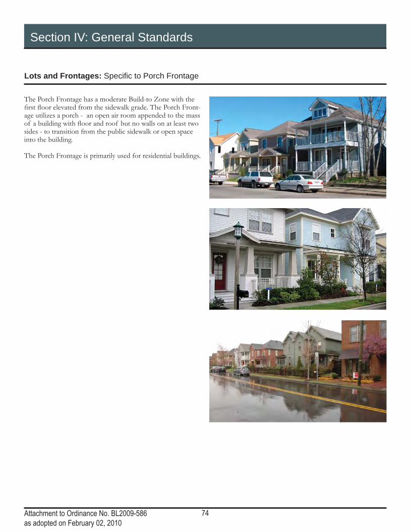
74Attachment to Ordinance No. BL2009-586as adopted on February 02, 2010
Section IV: General Standards
Lots and Frontages: Specifi c to Porch Frontage
The Porch Frontage has a moderate Build-to Zone with the fi rst fl oor elevated from the sidewalk grade. The Porch Front-age utilizes a porch - an open air room appended to the mass of a building with fl oor and roof but no walls on at least two sides - to transition from the public sidewalk or open space into the building.
The Porch Frontage is primarily used for residential buildings.

75Attachment to Ordinance No. BL2009-586as adopted on February 02, 2010
Section IV: General Standards
Lots and Frontages: Specifi c to Porch Frontage
Elevation
E
Section
A
B
C
F
Fron
t of B
uild-
to Zo
ne
Prop
erty
Line
D
Plan
E F
Fron
t of B
uild-
to Zo
ne
Prop
erty
Line
Porch Frontage
First fl oor elevation
Min. 18” from gradeMax. 5 ft from grade
Min. ground fl oor openings 30% fl oor to fl oor
Min. upper fl oor(s) openings 25% from fl oor to fl oor
Porch
Min. porch depth 5 ftStoops may not extend beyond the front of the Build-to Zone.Steps may extend beyond Build-to Zone, but may not encroach into the public Right-of-Way.
Notes
Greater fi rst fl oor elevation allowed by modifi cation for:• Property with signifi cant elevation change across the site at
the street frontage.• Development that incorporates below grade basement fl oors
that are accessible from the exterior of the building.Transition to fi rst fl oor elevation may be accommodated on the interior of the building to allow for compliance with ADA accessibility requirements.Entries shall not be recessed more than 4 feet from the facade of the building.Doors shall face the street.
A
B
C
DE
F

76Attachment to Ordinance No. BL2009-586as adopted on February 02, 2010
Section IV: General Standards
Lots and Frontages: Specifi c to Industrial Frontage
The Industrial Frontage shall be used to adapt existing build-ings to the standards of the DTC and for new construction of buildings intended for industrial uses. The Industrial Frontage shall be allowed only in specifi ed subdistricts on specifi ed streets and shall be prohibited on Primary Streets.
The Industrial Frontage mitigates the negative impact of the “blank wall” on the street by requiring the Build-to Zone to be entirely landscaped with drought-resistant plantings. All landscaping shall be in a funcitoning bioswale, or irrigated using drip irrigation or sub-surface irrigation. If drought-tolerant species are used, no irrigation is require.
A primary pedestrian entrance is required on the Principle Facade.
Associated vehicular entrances shall comply with the Parking and Access and Mechanical, Screening and Loading standards.

77Attachment to Ordinance No. BL2009-586as adopted on February 02, 2010
Section IV: General Standards
Lots and Frontages: Specifi c to Industrial Frontage
Industrial Frontage
Front door Required on Principle Facade
Min. Building Height 25 ft from grade
Build-to Zone 5-10 ft
Landscaping Entire Build-to Zone shall be landscaped with drought resistant species; in a bioswale or irrigated Min. landscaping height 2’-6”
Notes Industrial Frontage is prohibited on Primary streets. A build-ing intended for an industrial use, with frontage on a Primary street shall comply with the standards of another frontage type on the Primary street.
Elevation
A
D
E
Section
B
E
A
B
C
C
Plan
Fron
t of B
uild-
to Zo
ne
Prop
erty
Line
D
D

78Attachment to Ordinance No. BL2009-586as adopted on February 02, 2010
Section IV: General Standards
Lots and Frontages: Specifi c to Civic Frontage
Civic buildings are designed and constructed for community use or benefi t by governmental, cultural, educational, public welfare, or religious organizations. Civic buildings are inherently unique structures that present opportunities for unusual and iconic design within the urban fabric. Civic buildings should be designed with prominence and monumentality.
A Civic building shall be oriented to streets and public spaces and follow the intent of the particular subdistrict in which it is located with regard to pedestrian orientation, massing, and articulation.
Key architectural features should act as community focal points. Where possible, street axes should be terminated by the primary building form or architectural feature. Towers, spires, and other vertical forms are encouraged.
Civic buildings may include the following: community buildings, libraries, post offi ces, schools, religious institutions, publicly owned recreational facilities, museums, performing arts buildings, and municipal buildings.
Civic buildings shall be reviewed by modifi cation.

79Attachment to Ordinance No. BL2009-586as adopted on February 02, 2010
Section IV: General Standards
Canopies and Awnings
Section
Section
C
B
See the Lots and Frontages section for details on auto-oriented canopies and awnings.
Encroachments in the public right-of-way must meet Metropolitan Government’s current clearance standards and be approved under the mandatory referral process prior to installation.
B
C
B
Canopies
Clearance
Minimum from sidewalk 8’Minimum with ROW encroachment 14’
Maximum projection First fl oor 4’ from facadeUpper fl oors 2’ from facade
Maximum awning height 5’
A
B
C
A
A
Canopies
Clearance
Minimum from sidewalk 8’Minimum with ROW encroachment 14’Maximum 25’
Maximum projection within 2’ of curb
Maximum canopy height 4’
Notes Canopies shall be permitted only over pedestrian and vehicular building entrances, and shall not be permitted above windows. Canopies shall be constructed as a roof-like structure. Fabrics and non-rigid plastic are prohibited.
A
B
C

80Attachment to Ordinance No. BL2009-586as adopted on February 02, 2010
Section IV: General Standards
Parking and Access: General
Parking Requirements• No parking is required within the boundary of the DTC.
Parking and Access General Standards• In addition to the Parking and Access standards of the DTC the following shall apply: ▫ 17.20.050 Handicapped parking, 17.20.060 Parking area design standards, and 17.20.130 Loading space requirements.
• When alleys are present, vehicular access from alleys is preferred. Access from public streets shall be considered in the following order: Other Streets, Secondary Streets, Neighborhood Streets and then Primary Streets as approved by Metro departments. Reviewers shall consider the public safety, street character, and pedestrian experience. • Vehicular / Pedestrian Confl ict
▫ Valet and “drop-off ” areas shall be located within the right-of-way when space allows.
▫ Where driveways to parking facilities or drop-off areas cross the Sidewalk Corridor the following design elements shall be required:
▫ Bollards or other protective device shall be used to separate pedestrian and vehicular areas.
▫ Distinction between vehicular lane and pedestrian areas shall be indicated through changes in grade, color, texture and/or material.
• To reduce stormwater fees and impact, utilize Low Impact Development strategies published in Metro Water Services Stormwater BMPs for hardscaping, including parking and drive lanes.

81Attachment to Ordinance No. BL2009-586as adopted on February 02, 2010
Section IV: General Standards
Parking and Access: Specifi c to Structured Parking
Vehicular Access• Vehicular openings to parking structures shall not exceed thirty-fi ve feet in width.• Vehicular openings shall have a minimum spacing of thirty-fi ve feet.
Pedestrian Access• All parking structures with parking available to the public shall have a clearly marked pedestrian entrance, separate from vehicular access, on street frontages. A publicly accessible building lobby may meet this requirement.
Location and Lining• On the ground level, parking structures shall be located behind a liner building with an active use that is a minimum of fi fteen feet deep.• Upper level habitable liners are encouraged on all streets and are required on the south side of Division Street and on James Robertson Parkway. See the Bonus Height Program for more information on incentives for upper level garage liners.• Underground parking that is visible from the street, shall not extend beyond the façade of the building. Underground parking that is completely below grade may extend beyond the façade of the building. Underground parking may not encroach into the right-of-way.

82Attachment to Ordinance No. BL2009-586as adopted on February 02, 2010
Section IV: General Standards
Parking and Access: Specifi c to Surface Parking
General Standards for Surface Parking • Parking area screening and landscaping standards shall apply to all surface parking lots including, but not limited to, public and private parking facilities, driveways and access aisles, the outdoor display of automobiles and other vehicles that are for sale or lease.
Perimeter Screening Standards for Surface Parking• Parking areas adjacent to public streets and open space shall be separated from the edge of the right-of-way and/or property line by a perimeter landscape strip a minimum of fi ve feet in width which shall be landscaped per the standards of this section. ▫ All perimeter landscape strips adjacent to public streets and open space shall include a fence or wall in accordance with the Fence and Wall Standards.
• Parking areas shall be separated from adjacent side lot lines by a perimeter landscape strip a minimum of 5 feet in width, which shall be landscaped per the standards of this section. ▫ A two and one-half foot landscape strip may be provided if the required trees are to be planted in tree islands located adjacent to the property line.
▫ Two adjacent properties may share equally in the establishment of a seven-foot (minimum) planting strip along the common property line. In instances where the common perimeter planting strip is part of a plan for shared access, each owner may count the respective area contributed toward that common planting strip toward the interior planting area requirements for the lot.
• Berms are not permitted in any landscape strips.
Interior Planting Requirements• Parking areas shall be landscaped in accordance with the interior planting requirements of Title 17.24.160.• Parking areas with less than twelve thousand square feet in total area shall be exempt from the interior and side lot line planting requirements.
Landscape Materials• Perimeter landscape strips along public streets, open space and side lot lines. ▫ Trees shall be installed at a rate of one tree for every thirty feet of frontage. Spacing may be adjusted with the approval of the Urban Forester based upon tree species, the presence of utilities, and the dimensions of the planting strip.
▫ Evergreen shrubs and trees shall be installed at appropriate spacing to fully screen vehicles to a minimum height of two and one-half feet.
▫ Plantings within fi fteen feet of driveways or street intersections shall be maintained to a maximum height of two and one-half feet.
▫ Plantings shall not obstruct views onto site as to impede the security of users.
• Tree and shrub species shall be chosen from the Urban Forestry Recommended and Prohibited Tree and Shrub List or an alternative species deemed appropriate by the Urban Forester.• At planting, trees shall be a minimum of six feet in height and two caliper inches.• All landscaping shall be in a functioning bioswale, or irritated using drip irrigation or sub-surface irrigation. If drought-tolerant species are used, no irrigation is required.• At planting, all landscaping shall meet the standards for size, form and quality set out in the American Standard for Nursery Stock (ANSI Z60.1, latest edition).• All nursery stock shall be vigorous, healthy and free of diseases or infestation.

83Attachment to Ordinance No. BL2009-586as adopted on February 02, 2010
Section IV: General Standards
Mechanical, Service, and Loading
staggered fashion. ▫ All trees shall be evergreen with a minimum height at time of planting of at least six feet above the root ball.
▫ All shrubs shall be evergreen with the minimum height and spacing necessary to fully screen the item intended for screening (but no less than thirty inches in height) at the time of planting.
▫ Vegetative material shall be located immediately adjacent to the element being screened in a planting area a minimum of four feet wide.
• Fencing and Walls ▫ Screening is permitted through the use of a fence or wall constructed in accordance with the Fences and Walls Standards of the DTC.
• Parapet Walls ▫ Parapet walls or other techniques included as an integral part of the building design shall be used to totally screen any rooftop mechanical equipment from view from adjacent public rights-of-way or open space.
• Integrated Building Elements or Features ▫ Building design or other structural features (e.g., knee walls, alcoves, wing walls, roof extensions, etc.) may also be used to fully or partially enclose site features required to be screened.
• Alternative Screening Methods ▫ Alternative screening methods or materials that are not listed may be used following approval by the Planning Commission or its designee, provided that they are determined to be comparable to screening methods described in this subsection.
** In order to properly locate and screen mechanical equipment, approval may be required from applicable Metro departments and agencies.
ApplicabilityThe following elements shall be shielded from view from adjacent public streets, pedestrian corridors, and open spaces.
• Refuse collection, dumpsters, recycling bins, and refuse handling areas that accommodate a dumpster or fi ve or more trash or recycling cans.• Building or ground-mounted mechanical equipment, including, but not limited, to transformers, backfl ow preventors, telephone risers, equipment cabinets, generators, or similar devices.• Mechanical equipment on roofs.• Air conditioning or similar HVAC equipment.• Loading docks, berths, or similar spaces including, but not limited, to service entrances and maintenance areas.• Outdoor storage of materials, equipment, and vehicles.
Location and Access• Applicable site elements shall be located along the alley, along an interior property line, or internal to the property.• Service elements, such as loading docks and trash collection locations, should not be accessible from Primary streets, unless a Primary street is the only frontage.
Screening Standards• Applicable site elements shall be fully screened at all times, including immediately following planting if vegetative materials are to be used.• Refuse collection and refuse handling areas shall be screened by a walled enclosure with gates in accordance with the Fence and Wall Standards of the DTC.
Screening Methods• Vegetative Materials:
▫ Vegetative materials shall be planted in two rows in

84Attachment to Ordinance No. BL2009-586as adopted on February 02, 2010
Section IV: General Standards
Fences and Walls
Location• Permitted Locations: Fences and walls constructed in accordance with the standards in this section may be constructed within: ▫ The Build-to Zone. ▫ A utility easement only through the express written consent from the utility or entity holding the easement.
▫ A required landscape area, Tree Protection Zone, or open space.
• Prohibited Locations: No fence or wall shall be installed that: ▫ Encroaches into a right-of-way (without approval through the Mandatory Referral process).
▫ Blocks or diverts a natural drainage fl ow on to or off of any other land.
▫ Compromises safety by blocking vision at street intersections or obstructs the visibility of vehicles entering or leaving driveways or alleys.
▫ Blocks access to any above ground or pad-mounted electrical transformer, equipment vault, fi re hydrant or similar device.
Appearance• All fences shall be installed so that the fi nished side shall face outward; all bracing shall be on the inside of the fence.• Fences and walls shall be constructed of any combination of brick, stone, masonry materials, treated wood posts and planks, rot-resistant wood, or metal. Chain link fencing shall be coated with dark green or black vinyl when visible from a public street or open space (excluding alleys).• Chain-link fences are prohibited within the Build-to Zone.• Razor wire is prohibited within the Build-to Zone.• Fences and walls used to screen refuse areas shall be opaque and include gates that prohibit unauthorized users to access the area.
Standards by function and location• Fences and walls within the Build-to Zone shall not exceed four feet in height. ▫ Modifi cations may be made in order to properly secure playgrounds and parks.
▫ The height of fences and walls along a sidewalk shall be measure from sidewalk grade.
• Fences and walls within the Build-to Zone that are greater than three feet high shall be a minimum of thirty percent transparent to allow visibility into the property. • Fences and walls used to screen parking shall be a minimum of two and one-half feet above the grade of the parking lot. ▫ When a fence or wall is combined with plantings the majority of the plantings shall be between the right-of-way and the fence or wall.
• Fences and walls used to screen mechanical, loading and refuse elements shall be a minimum of two feet taller than the element being screened.• All other fences and walls shall have a maximum height of ten feet measured from grade. • Fences surrounding athletic fi elds and courts may exceed the previous height limitations.

85Attachment to Ordinance No. BL2009-586as adopted on February 02, 2010
Section IV: General Standards
Open Space
The Downtown Community Plan: 2007 Update envisions accessible, enjoyable open spaces to help create vital and functioning neighborhoods within Downtown. To meet this goal, the DTC encourages many types of open spaces to serve the needs of both citizens and visitors for passive and active recreation. Public art, other amenities, and interactive features are encouraged in open spaces. Buildings conducive with the use of the Open Space and for public use may be approved by the Planning Commission and Parks Department.
It is a goal of the DTC to have open space within each ¼ mile radius neighborhood in Downtown. All public and private open spaces, greater than one-half acre have been mapped in order to determine the areas within the DTC that are in need of neighborhood open space. The one-quarter mile radius buffer area around existing open spaces is indicated in green on the Open Space Map. The areas that lack open space within –one-quarter mile radius (defi ciency areas) are shown in yellow. Public open space developed in any portion of a defi ciency area will count toward fulfi lling the open space need of that area. The development of the needed open space may be done by public or private entities.
The open space types and standards listed in the DTC shall be utilized by property owners in the development of public open space. The following standards shall apply to open space that is accessible to the public, including open space developed for credit under the Bonus Height Program. Private open space or amenity areas shall not be counted toward fulfi lling the open space need and shall not be eligible for the Bonus Height Program.
Open Space developed within the defi ciency areas are eligible for greater bonuses through the Bonus Height Program then those developed in non-defi ciency areas. See the Bonus Height Program section for more details.
The Open Space Plan also includes the existing and planned urban greenways.
Parks and greenways are publicly owned open space and shall follow the standards set out by the Parks Department.
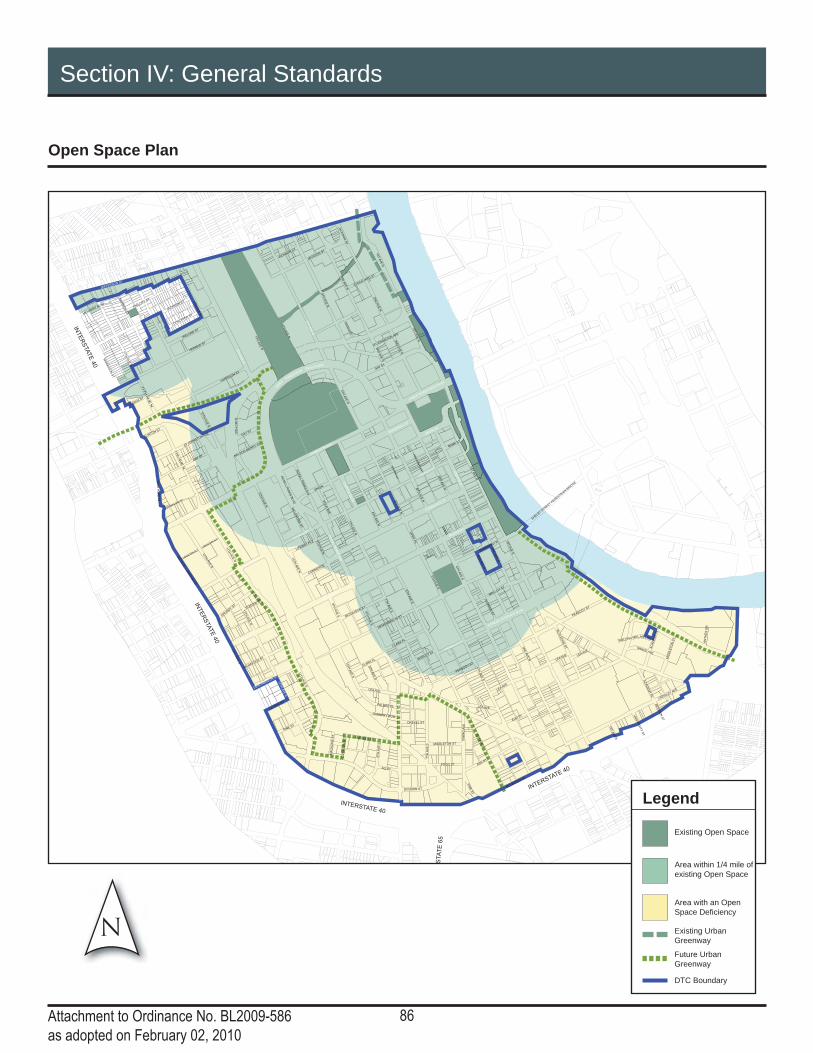
86Attachment to Ordinance No. BL2009-586as adopted on February 02, 2010
Section IV: General Standards
Open Space Plan
INTE
RS
TATE
40
CHURCH ST
3R
D A
VE
N
5TH
AV
E N
2N
D A
VE
S
8T
H A
VE
S
JEFFERSON ST
4TH
AV
E S
2N
D A
VE
N
5TH
AV
E S
1S
T A
VE
N
GAY ST
ASH ST
3R
D A
VE
S
DEMONBREUN ST
4T
H A
VE
N
LAFAYETTE ST
STA
TE
65
DIVISION ST
BROADWAY
CHARLOTTE AVE
12TH
AV
E S
JAMES ROBERTSON P
KWY
INTE
RS
TATE
40
HERMAN ST
1S
T A
VE
S
7TH
AV
E S
COMMERCE ST
10TH
AV
E N
SHELB
Y S
TREET P
EDESTRIA
N B
RID
GE
7TH
AV
E N
ELM ST
LINDSLEY AVE
PEABODY ST
9TH
AV
E N
GE
OR
GE
L D
AV
IS B
LV
D
10T
H C
IR N
JACKSON ST
LEA AVE
ALM
ON
D S
T
WA
RR
EN
ST
EW
ING
AV
E
FOGG ST
MID
DLE
TO
N S
T
RO
SA L
PA
RK
S B
LV
D
MULBERRY ST
MOLLOY S
T
JO JOHNSTON AVE
10TH
AV
E S
PINE S
T
MC
LE
MO
RE
ST
PHILLIP
S ST
AN
TH
ES
DR
DEADERICK S
T
11TH
AV
E S
13TH
AV
E S
GLEAVES ST
RU
TLE
DG
E S
T
FRANKLIN S
T
OP
RY
PL
LAUREL ST
CLARK PL
GR
UN
DY S
T
LOCKLAYER ST
AC
AD
EM
Y P
L
SHIRLEY S
T
PALMER PL
NANCE AVE
IRELAND S
T
RO
SA L
PA
RK
S A
VE
MCGAVOCK S
T
MO
RR
ISO
N S
T
SHANKLAND ST
UNION S
T
PO
LK
AV
E
VIN
E S
T
9TH
AV
E S
INTERSTATE 40
BANK ST
STOCKYARD ST
AR
CA
DE
ALY
LIFEW
AY PLZ
DREXEL ST
OV
ER
TO
N S
T
PR
INTE
RS
ALLE
Y
CA
PIT
OL B
LV
D
MA
GA
ZIN
E S
T
PORTER ST
JACKSON CT
CANNERY ROW
CR
IDD
LE
ST
SYMPHONY P
L
MEHARRY B
LVD
ROLLING MILL
BE
RR
IEN
ST
UN
IVE
RS
ITY
ST
LEA AVE
6TH
AV
E S
GAY ST
11TH
AV
E N
7T
H A
VE
S
MIDDLETON ST
1S
T A
VE
N
LEA AVE
MCGAVOCK ST
PEABODY ST
ALLEY
6TH
AV
E N
JACKSON ST
9TH
AV
E N
9T
H A
VE
S
9T
H A
VE
S
LEA AVE
2N
D A
VE
N
BROADWAY
AC
AD
EM
Y P
L
12TH
AV
E N
1S
T A
VE
S
UNKNOW
N ALY
10TH
AV
E N
JA
CK
SO
N S
T
CLARK PL
LEA AVE
6TH
AV
E N
JO JOHNSTON AVE
7TH
AV
E N
CHURCH ST
DESHA ST
CLINTON S
T
HARRISON S
T
12TH
AVE N
11TH
AV
E N
KOREAN VETERANS B
LVD
CHARLOTTE AVE
GAY ST
5TH
AV
E N
3R
D A
VE
N
2N
D A
VE
N
1S
T A
VE
N
3R
D A
VE
N
RO
SA L
PA
RK
S A
VE
4TH
AV
E N
NELSON MERRY S
T
11th
AV
E N
13th A
VE
N
11TH
AV
E N
10TH
AV
E N
5TH
AV
E S
8T
H A
VE
S
DIVISION ST
4TH
AV
E N
3R
D A
VE
N
2N
D A
VE
N
HERMITAG
E AVE
6TH
AV
E S
JAM
ES
ROBERTSONBOULEVARD
8TH
AV
E N
5TH
AV
E N
UNION
COMMERCE
LAFAYETTE ST
HERMITAGE AVE
INTERSTATE 40
CHURCH ST
BROADWAY
DEMONBREUN ST
12T
H A
VE
S
8T
H A
VE
S
UNKNOW
N ALY
RDHILL
N
Legend
Area within 1/4 mile of existing Open Space
Area with an Open Space Defi ciency
DTC Boundary
Existing Open Space
Existing Urban Greenway
Future Urban Greenway

87Attachment to Ordinance No. BL2009-586as adopted on February 02, 2010
Section IV: General Standards
Open Space: General Standards
Standards of Title 17 not varied by the following Open Space Standards shall apply within the DTC.
Calculation• When calculating the open space square footage or acreage, the footprint of any building, whether public or private, shall be subtracted fi rst. The remaining square footage shall be used for all calculations and percentages.
Access• Every open space shall have a minimum of one primary pedestrian entrance along each street frontage and pedestrian frontage. • All publicly accessible open space shall meet the appropriate standards of the American’s with Disabilities Act.
Building frontage• Buildings that are part of the same development as the open space and abut the open space shall have a minimum of one pedestrian entrance on the open space.
Seating• Permitted types of seating include but are not limited to, moveable, fi xed individual seats, fi xed benches, seat walls, planter ledges and seating steps.
Paving Materials• Asphalt may be approved by the Planning Commission or its designee for recreational jogging or bicycle paths only.
Landscaping• Ground level green space shall consist of turf grass, shrubbery, perennial and annual beds, mulched areas and generally areas with “natural” material planted within six inches of grade. ▫ Ground level green space does not include container plantings.
• Pervious surfaces include green space, porous concrete and modular pavers, areas with tree grates or areas that otherwise allow water to infi ltrate into the soil.• Trees shall be accommodated in planting areas with a minimum of 600 cubic feet of soil. When using structural soil, the planting area may be reduced to 300 cubic feet. The minimum opening at grade shall be 25 square feet.• Planting areas shall not impede ingress/egress from buildings or pedestrian traffi c. • Tree Grates
▫ When used, tree grates shall be modular and allow for removal as tree grows.
▫ Tree grates shall be fl ush with grade to allow for unobstructed movement of pedestrian traffi c.
• Tree and shrub species shall be chosen from the Urban Forestry Recommended and Prohibited Tree and Shrub List based on tree size and planting area provided or an alternative species deemed appropriate by the Urban Forester.
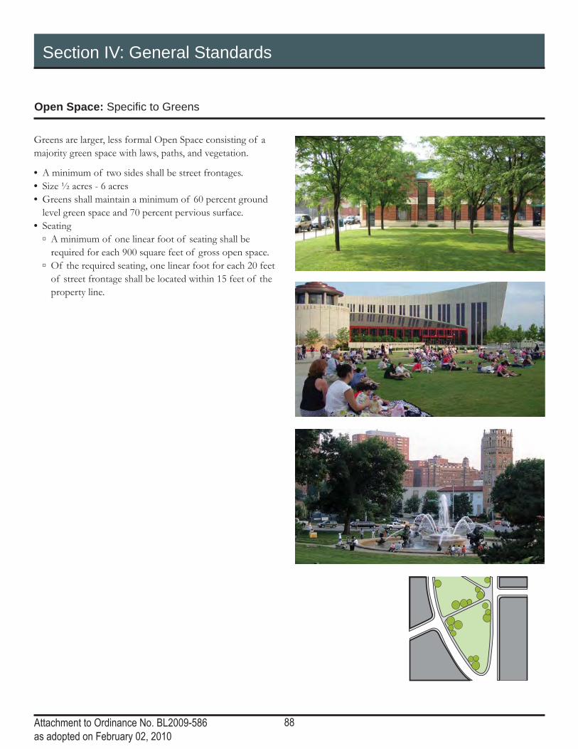
88Attachment to Ordinance No. BL2009-586as adopted on February 02, 2010
Section IV: General Standards
Open Space: Specifi c to Greens
Greens are larger, less formal Open Space consisting of a majority green space with laws, paths, and vegetation.
• A minimum of two sides shall be street frontages.• Size ½ acres - 6 acres• Greens shall maintain a minimum of 60 percent ground level green space and 70 percent pervious surface.• Seating
▫ A minimum of one linear foot of seating shall be required for each 900 square feet of gross open space.
▫ Of the required seating, one linear foot for each 20 feet of street frontage shall be located within 15 feet of the property line.

89Attachment to Ordinance No. BL2009-586as adopted on February 02, 2010
Section IV: General Standards
Open Space: Specifi c to Squares
Squares are Open Space used for unstructured recreational or civic uses. Landscaping consisting of lawns and trees is formally composed.
• A minimum of two sides shall be street frontages.• Size: ½ acre – 5 acres• Squares shall be required to maintain a minimum of 30 percent ground level green space and 50 percent pervious surface.• Seating
▫ A minimum of one linear foot of seating shall be required for each 700 square feet of gross open space.
▫ Of the required seating, one linear foot for each 20 feet of street frontage shall be located within 15 feet of the property line.
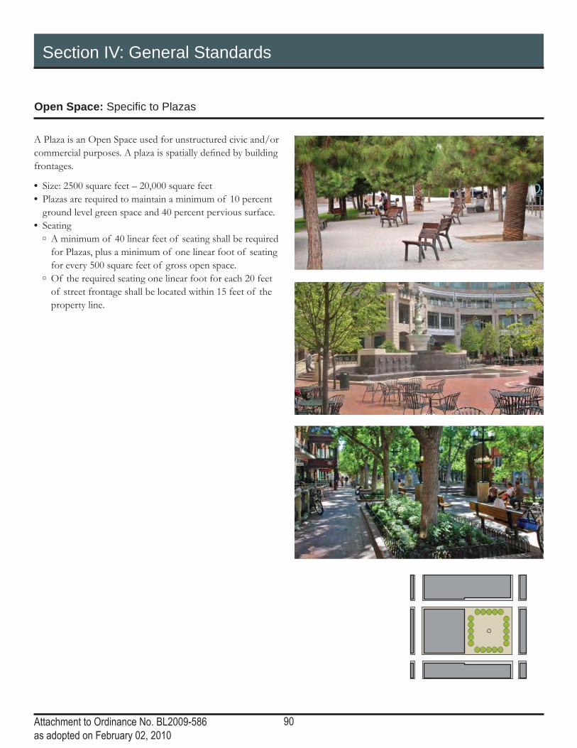
90Attachment to Ordinance No. BL2009-586as adopted on February 02, 2010
Section IV: General Standards
Open Space: Specifi c to Plazas
A Plaza is an Open Space used for unstructured civic and/or commercial purposes. A plaza is spatially defi ned by building frontages.
• Size: 2500 square feet – 20,000 square feet • Plazas are required to maintain a minimum of 10 percent ground level green space and 40 percent pervious surface.• Seating
▫ A minimum of 40 linear feet of seating shall be required for Plazas, plus a minimum of one linear foot of seating for every 500 square feet of gross open space.
▫ Of the required seating one linear foot for each 20 feet of street frontage shall be located within 15 feet of the property line.

91Attachment to Ordinance No. BL2009-586as adopted on February 02, 2010
Section IV: General Standards
Open Space: Specifi c to Courts
A Court is Open Space accessible from the street and used for entry into a building. A Court is spatially defi ned by building frontages and is generally tucked back into the building.
• Size: 400 square feet – 2,500 square feet• Seating
▫ A minimum of 10 linear feet of seating shall be required for Courts, plus one linear foot of seating for each 300 square feet of open space minimum.
• Accessibility ▫ Courts are permitted to be closed to the public by use of a gate. See the Fence and Wall Standards for details.

92Attachment to Ordinance No. BL2009-586as adopted on February 02, 2010
Section IV: General Standards
Open Space: Specifi c to Pocket Parks and Playgrounds
Pocket Parks and Playgrounds are Open Space that are accessible from the street and used for structured recreation, gardening or other community use.
• Size: 800 square feet – 1 acre• Pocket Parks shall provide a community benefi t such as a garden or playground. • Pocket Parks are required to maintain a minimum of 20 percent ground level green space. ▫ Additional ground area may be impervious provided space is structured for active recreation.
• Seating: ▫ A minimum of one linear foot of seating shall be required for every 300 square feet of gross open space.
• Trees ▫ The tree requirement may be waived for pocket parks that are designed for structured active recreation, such as basketball or tennis courts.
• Accessibility ▫ Pocket Parks may be fenced for safety but shall remain open to the public during daylight hours.

93Attachment to Ordinance No. BL2009-586as adopted on February 02, 2010
Section IV: General Standards
Bonus Height Program
The Bonus Height Program (BHP) allows additional building height in Downtown in exchange for contribution to specifi ed programs that provide benefi ts to the public. The Bonus Height shall be permitted if the proposed development contributes to specifi c public benefi ts in the amount and manner set forth herein.
Bonus Height shall be permitted in exchange for the following public benefi t contributions: Leadership in Energy and Environmental Design (LEED) certifi cation of individual buildings, LEED for Neighborhood Development, pervious surface, publicly-accessible Open Space, Workforce Housing, Civil Support Space, upper level garage liners, and underground parking.
Density bonuses for the preservation of historic buildings are given through the Transfer of Development Rights Program as outlined in Section 17.12.120 of the zoning code.
Bonus Height Standards• Upon providing a binding commitment for the specifi ed public benefi t, the proposed development project shall be allowed to build within the restrictions of the Subdistrict, up to the Bonus Height Maximum as established within this section. • Multiple height bonuses may be compounded insofar as the total additional height does not exceed the Bonus Height Maximum for the Subdistrict. • Additional development rights achieved through the BHP may be transferred to another site within the DTC, provided the transferred height does not exceed the Bonus Height Maximum of the receiving site. By-right height may not be transferred; only bonus height received through the BHP may be transferred. • Bonus height transfers shall be based on the square footage of the sending site, not the receiving site.• No building permit shall be issued for bonus height until the Planning Commission has certifi ed compliance with the provisions of this section, upon referral and assurance of compliance from applicable departments.

94Attachment to Ordinance No. BL2009-586as adopted on February 02, 2010
Section IV: General Standards
Bonus Height Program
LEED and LEED NDThe U.S. Green Building Council (USGBC) is a non-profi t organization that oversees the Leadership in Energy and Environmental Design (LEED) Green Building Rating System.
LEED for Neighborhood Development integrates the principles of smart growth, urbanism and green building into the fi rst national system for neighborhood design. LEED ND goes beyond the building to address sustainability on a neighborhood-wide basis.
The bonuses are specifi c to each Subdistrict. See the BHP Chart for details.
A different nationally-recognized, third-party system of overseeing green building and/or sustainable development practices may be substituted for LEED. Bonuses will be determined by the Planning Commission based on ratings equivalent to LEED silver, gold, and platinum.
Bonuses for individual buildings are given upon pre-certifi cation of LEED silver, gold and platinum. Bonuses for neighborhoods are given upon pre-certifi cation of LEED ND. Every property within the LEED ND neighborhood may utilize the bonus height. The bonuses are specifi c to each Subdistrict. See the BHP Chart for details.
The following shall apply to all new construction that utilizes the Bonus Height Program for LEED:
• Prior to issuance of a temporary certifi cate of occupancy for any use of the development, a report shall be provided for the review of the Department of Codes Administration and the Planning Commission by a LEED accredited professional. The report shall certify that all construction practices and building materials used in the construction are in compliance with the LEED certifi ed plans and shall report on the likelihood of certifi cation. If certifi cation appears likely, temporary certifi cates of occupancy (as set forth below) may be issued. Monthly reports shall be provided as to the status of certifi cation and the steps
being taken to achieve certifi cation. Once certifi cation is achieved, the initial certifi cate of LEED compliance, as set forth herein, and a fi nal certifi cate of occupancy (assuming all other applicable conditions are satisfi ed) shall be issued. • To ensure that LEED certifi cation is attained the Department of Codes Administration is authorized to issue a temporary certifi cate of occupancy once the building is otherwise completed for occupancy and prior to attainment of LEED certifi cation. A temporary certifi cate of occupancy shall be for a period not to exceed three (3) months (with a maximum of two extensions) to allow necessary time to achieve fi nal certifi cation. Fees for the temporary certifi cate (and a maximum of two extensions) shall be $100 or as may otherwise be set by the Metro Council. Once two extensions of the temporary certifi cate of occupancy are granted, any additional extensions shall be granted only in conjunction with a valid certifi cate of LEED noncompliance as set forth herein. • If the property fails to achieve LEED certifi cation, the Department of Codes Administration is authorized to issue a short-term certifi cate of LEED noncompliance. This certifi cate will allow the building to retain its certifi cate of occupancy pending attainment of LEED certifi cation. A certifi cate of LEED noncompliance shall be for a period not to exceed three (3) months and may be renewed as necessary to achieve certifi cation. The fee for noncompliance shall be issued every time the certifi cate is issued for up to ten years. • The fee for a certifi cate of LEED noncompliance shall be based on the following formula: F = [(CN-CE)/CN] × CV × 0.0075, where: ▫ F is the fee; ▫ CN is the minimum number of credits to earn the level of LEED certifi cation for which the project was pre-certifi ed;
▫ CE is the number of credits earned as documented by the report; and
▫ CV is the Construction Value as set forth on the building permit for the structure.
95Attachment to Ordinance No. BL2009-586as adopted on February 02, 2010
Section IV: General Standards
Bonus Height Program
Pervious SurfaceThe integration of pervious surfaces into site design and building design benefi ts the individual development, the neighborhood and the city. Pervious surfaces can reduce stormwater runoff, fl ood risk, irrigation needs and the burden on infrastructure. Examples of pervious surfaces include impervious pavement, green roofs, bio-swales, landscaping, and green screens. As technology in this fi eld advances, additional pervious surfaces may meet the intent of this standard.
• The number of square feet of Bonus Height shall be twice that of the number of square feet of Pervious Surface. The additional square footage may be used to the Bonus Height Maximum as determined on the BHP Chart. • Green roofs that are utilized to meet LEED certifi cation may not be “double counted” for both the LEED height bonus and the Pervious Surface height bonus. If the level of LEED certifi cation would be met without the green roof, then the green roof may be counted for the Pervious Surface height bonus.
Publicly-Accessible Open SpaceAccessible, enjoyable open spaces are essential for vital and functioning neighborhoods. Open space provides the community with opportunities to be in an outdoor setting, while encouraging social interaction. See the BHP Chart for details for a list of Subdistricts in which the Open Space bonus may be utilized.
Open Space must be designed to the open space standards of the DTC. To be eligible for the Height Bonus, open space must be a minimum of ¼ acre in area.
• Plazas are not eligible for the BHP.• In Open Space defi ciency areas (See the Open Space section of the General Standards), the number of square feet of Bonus Height shall be seven times that of the number of square feet in open space. Outside of Open Space defi ciency areas, the number of square feet of Bonus Height shall be four times that of the number of square feet in open space. The additional square footage may be used to the Bonus Height Maximum as determined on the BHP Chart.• Bonuses are available only for publicly accessible (whether publicly or privately owned) open space.

96Attachment to Ordinance No. BL2009-586as adopted on February 02, 2010
Section IV: General Standards
Bonus Height Program
Workforce HousingHousing encompassing a range of sizes, costs and tenure (both rental and owner-occupied), to accommodate the diverse range of employees and their families, is key to Downtown’s continued economic health and to sustainable development patterns for Nashville/Davidson County.
Metro Government shall require the developer to execute an agreement, restrictive covenant, or other binding restriction on land use that preserves affordability and establishes the manner in which the affordability will be monitored for the required period before fi nal site plan review.
As listed below, the specifi ed percentage of total units shall be reserved for ownership or rental by households with incomes below the specifi ed percentage of the current Average Median Income (AMI) in Davidson County, as determined by MDHA.
Height bonuses are based on a percentage of the Maximum Height allowed on the property as dictated by the Subdistrict. In all cases, fi fty percent (50%) of the additional stories shall be dedicated to Workforce Housing with twenty-fi ve percent (25%) of the height bonus provided as housing for persons below one hundred percent (100%) of AMI and twenty-fi ve percent (25%) of the height bonus provided as housing for persons below one hundred-twenty percent (120% ) of AMI.
Workforce Housing Height Bonuses are:
• Level 1 - 10% increase in stories• Level 2 - 20% increase in stories• Level 3 - 30% increase in stories• Level 4 - 40% increase in stories
Not all Levels are available in every Subdistrict. See the BHP Chart for details.
When percentage calculations result in a fraction of a story, the number of stories shall be rounded up.
The following shall apply to all construction that utilizes the BHP for Workforce Housing:• Owner-occupied units shall remain affordable or 30 years. • Renter-occupied units shall remain affordable for 30 years. • Units that are converted from renter-occupied to owner-occupied shall remain affordable (as determined above) for 30 years beyond conversion.• The size of all Workforce Housing units shall be at least 80% of the average size of market rate units.

97Attachment to Ordinance No. BL2009-586as adopted on February 02, 2010
Section IV: General Standards
Bonus Height Program
Upper Level Garage Liner and Underground ParkingThe public realm of the streetscape is improved by providing parking in underground structures and lining above ground parking structures with habitable space. See the BHP Chart for a list of Subdistricts in which the Garage Liner and Underground Parking bonuses may be utilized.
• Height bonuses are given for upper levels of habitable space, a minimum of 15’ in depth, which masks a parking structure from view along public streets and open space. The minimum depth may be reduced by the Planning Commission provided the intent of an active streetscape is met.• The number of square feet of Bonus Height shall be twice that of the number of square feet in Garage Liners. The additional square footage may be used to the Bonus Height Maximum as determined on the BHP Chart.• The number of square feet of Bonus Height shall be equal to the number of square feet in Underground Parking. The additional square footage may be used to the Bonus Height Maximum as determined on the BHP Chart.• Height bonuses are not given for ground level liners, or upper level liners that are required by the DTC.
Public ParkingParking accessible to the general public is important to the continued growth and vitality of Downtown. See the BHP Chart for a list of Subdistricts in which the Public Parking bonuses may be utilized.
• The number of square feet of Bonus Height shall be twice that of the number of square feet in Public Parking. The additional square footage may be used to the Bonus Height Maximum as determined on the BHP Chart.• Public Parking shall be clearly marked as public, and shall be accessible to the public, at all hours that the garage is open, for the lifetime of the building.
Civil Support SpaceThe dedication of Civil Support Space offers height bonus for the developer’s contribution of space to a specifi c use or entity that serves to better the neighborhood or community. See the BHP Chart for details for a list of Subdistricts in which the Civil Support Space bonus may be utilized.
• Civil Support Space is typically on the ground level. Upper levels may be appropriate depending on the intended use. • The number of square feet of Bonus Height shall be twice that of the number of square feet donated to Civil Support Space. The additional square footage may be used to the Bonus Height Maximum as determined on the BHP Chart.• Civil Support Space shall be dedicated to the chosen use or uses for 15 years. Adherence to this standard shall be checking yearly by the Planning Commission or its designee.
The Planning Commission may require the developer to execute an agreement, restrictive covenant, or other binding restriction on land use that preserves the use of Civil Support Space for the required period before fi nal site plan review.
The following uses are appropriate for Civil Support Spaces:
• Institutional Uses ▫ Cultural center ▫ Day care center ▫ School day care
• Education ▫ Community education
• Transportation Uses ▫ Water taxi station
• Waste Management Uses ▫ Recycling collection center
• Recreational and Entertainment Uses ▫ Community playground
• Other Uses ▫ Community garden
Other uses may be appropriate for Civil Support Space. The applicant may propose a different use for Civil Support Space to be approved by the Planning Commission.

98Attachment to Ordinance No. BL2009-586as adopted on February 02, 2010
This page left intentionally blank

Bonus Height Chart
Section IV: General Standards
Attachment to Ordinance No. BL2009-586as adopted on February 02, 2010
99
Maximum
height within
the
Subdistrict
LEED
LEED ND
Pervious
Surface
Open Space
Workforce
Housing
Civil Support
Space
Upper Level
Garage Liner
Public Parking
Bonus Height
Maximum
Central
James Robertsonelevation of 560' Any = 2 stories 2 stories 2 stories 2 stories All Levels to a maximum of elevation
above sea level of 560'2 stories below 560' elevation 2 stories below 560' elevation 2 stories elevation 560'
Core30 stories Silver = 4 stories; Gold = 8 stories
Platinum = 12 stories 2 stories 2 stories 8 stories All Levels 8 stories 8 stories 2 stories Unlimited
Core-historic6 stories on the interior of blocks; 10
stories on the cornersNo bonus No bonus No bonus No bonus No bonus No bonus No bonus No bonus 6 stories on the interior of blocks; 10
stories on the corners
Upper Broadway100' No bonus No bonus No bonus No bonus No bonus No bonus No bonus No bonus 100'
Second and BroadwaySecond 8 stories within 105' 8 stories within 105'Broadway 5 stories within 65' 5 stories within 65'
SoBroGeneral 30 stories Silver = 4 stories; Gold = 8 stories
Platinum = 12 stories 2 stories 2 stories 8 stories All Levels 8 stories 8 stories 2 stories Unlimited
west side of 1st and east side of 2nd 15 stories within 220' Silver = 4 stories; Gold or Platinum = 5 stories
2 stories 2 stories 5 stories Levels 1, 2, and 3 5 stories 5 stories 2 stories 20 stories within 300'
Central River10 stories within 145' No bonus No bonus No bonus No bonus No bonus No bonus No bonus No bonus 10 stories within 145'
South
LafayetteGeneral 8 stories Any = 2 stories 2 stories 2 stories 2 stories Levels 1, 2, and 3 2 stories 2 stories 2 stories 11 stories
Lafayette Street 12 stories Any = 2 stories 2 stories 2 stories 3 stories Levels 1, 2, and 3 3 stories 3 stories 2 stories 16 stories
Rutledge HillPrimary and Secondary 6 stories Any = 1 story 1 story 1 story 1 story Levels 1, and 2 1 story 1 story 2 stories 7 storiesNeighborhood 3 stories No bonus No bonus No bonus No bonus No bonus No bonus No bonus No bonus 3 stories
Rolling Mill Hill65 feet with an SEP of 1:1.5 No bonus No bonus No bonus No bonus No bonus No bonus No bonus No bonus 65 feet with an SEP of 1:1.5
Rutledge River9 stories Any = 2 stories 2 stories 2 stories 2 stories Levels 1, 2, 3 and 4 2 stories 2 stories 2 stories 12 stories
West
Gulch NorthGeneral 7 stories Any = 2 stories 2 stories 2 stories 2 stories All Levels 2 stories 2 stories 2 stories 10 stories below 560' elevation
fronting Herman Street 4 stories No bonus No bonus No bonus No bonus No bonus No bonus No bonus 2 stories 4 storiesGulch South
General 10 stories Any = 2 stories 2 stories 2 stories 2 stories All Levels 2 stories 2 stories 2 stories 16 storiesfronting Church, Broadway, Demonbreun 15 stories Any = 2 stories 2 stories 2 stories 3 stories All Levels 3 stories 3 stories 2 stories 21 stories
at key intersections 20 stories Silver or Gold = 2 stories; Platinum = 3 stories
2 stories 2 stories 4 stories All Levels 4 stories 4 stories 2 stories 28 stories
North
Hope GardensPrimary 7 stories Any = 1 story 1 story 1 story 1 story Level 1 1 story 1 story 1 story 8 storiesSecondary 4 stories Any = 1 story 1 story 1 story 1 story Level 1 1 story 1 story 1 story 5 storiesNeighborhood 3 stories No bonus No bonus No bonus No bonus No bonus No bonus No bonus 1 story 3 stories
Sulphur DellPrimary 7 stories Any = 1 story 1 story 1 story 1 story Level 1 Any = 1 story 1 story 1 story 8 storiesSecondary 5 stories Any = 1 story 1 story 1 story 1 story Level 1 Any = 1 story 1 story 1 story 6 storiesNeighborhood 4 stories Any = 1 story 1 story 1 story 1 story Level 1 Any = 1 story 1 story 1 story 5 stories
No bonusNo bonusNo bonus No bonus No bonus No bonusNo bonusNo bonus

ORDINANCE NO. BL2011-896
An ordinance to amend Sections 17.37 (Downtown Code) of the Metropolitan Zoning Code byrevising the Signage Compliance deadline (Proposal No. 2011Z-002TX-001).
WHEREAS the Metropolitan Planning Commission has recently hired a consulting group to conduct astudy of the existing signage and signage regulations in Downtown Nashville; and
WHEREAS the consultants have been hired to produce a comprehensive sign code for implementation inthe Downtown Code (DTC) district; and
WHEREAS the current Signage Compliance standards of the Downtown Code (DTC) will take affectbefore the consultant has completed the study;
NOW, THEREFORE, BE IT ENACTED BY THE COUNCIL OF THE METROPOLITAN GOVERNMENT OFNASHVILLE AND DAVIDSON COUNTY:
Section 1. Section 17.37. (Downtown Code) is hereby amended by deleting on page 15 under theheading Signage Compliance the phrase “June 30, 2011. On July 1, 2011” and replacing it with thefollowing new phrase:
“December 31, 2011. On January 1, 2012”
Section 2. Be it further enacted, that this ordinance take effect immediately after its passage and suchchange be published in a newspaper of general circulation, the welfare of The Metropolitan Governmentof Nashville and Davidson County requiring it.
Sponsored by: Mike Jameson, Erica Gilmore
AMENDMENT NO. 1TO
ORDINANCE NO. BL2011-896
Madam President:
I move to amend Ordinance No. BL2011-896 by modifying it as follows:
By deleting Section 3 in its entirety and replacing it with the following new Section 3:
“Section 1. Section 17.37. (Downtown Code) is hereby amended by deleting on page 15 under theheading Signage Compliance the phrase “June 30, 2011. On July 1, 2011” and replacing it with thefollowing new phrase:
“June 30, 2012. On July 1, 2012”
Sponsored by: Mike Jameson
LEGISLATIVE HISTORY
Introduced: April 5, 2011
Passed First Reading: April 5, 2011
Referred to: Planning Commission - Approved 9-0(March 24, 2011)Planning & Zoning Committee
ORDINANCE NO. BL2011-896 http://www.nashville.gov/mc/ordinances/term_2007_2011/bl2011_896.htm
1 of 2 10/17/2011 2:19 PM

Passed Second Reading: May 3, 2011
Amended: May 17, 2011
Passed Third Reading: May 17, 2011
Approved: May 20, 2011
By:
Effective: May 26, 2011
Agenda | Minutes |Resolutions | Ordinances | Boards & CommissionsCharitable Solicitations | Lobbyists | Committee Meeting Schedule | Home
Metro Home Page | Metro Department Listings
Send comments or suggestions to the [email protected] error reports to [email protected]
2005, Metropolitan Government of Nashville and Davidson CountyLast Modified 05/27/2011 12:40:45
ORDINANCE NO. BL2011-896 http://www.nashville.gov/mc/ordinances/term_2007_2011/bl2011_896.htm
2 of 2 10/17/2011 2:19 PM