Nashua, Squannacook, and Nissitissit Rivers Stewardship Plan they work in partnership to take...
273
Nashua, Squannacook, and Nissitissit Rivers Stewardship Plan
Transcript of Nashua, Squannacook, and Nissitissit Rivers Stewardship Plan they work in partnership to take...

Squannacook River. Photo: Joan Wotkowicz
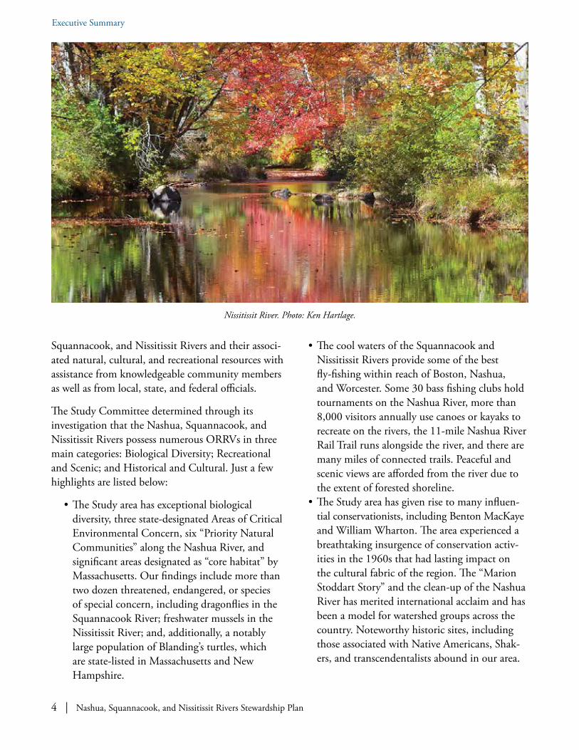
Nissitissit River. Photo: Cindy Knox Photography
Nashua River. Photo: Ken Hartlage
Nashua, Squannacook, and Nissitissit Rivers
Stewardship Plan
Nashua River Wild and Scenic River Study Committeec/o Nashua River Watershed Association592 Main Street, Groton, Massachusetts 01450
978-448-0299 | www.WildandScenicNashuaRivers.org
February 15, 2018
Nashua, Squannacook, and N
issitissit Rivers Stew
ardship Plan – February 15, 2018

Some value the river for its enriching qualities, and some for its
abundant water power, and some because they can idle away their time
in catching pout and pickerel. There are some also who delight in it as a
“thing of beauty” and a “joy forever.” They love to wander on its banks, to
plunge into its depths and float upon its surface. They return again and
again to gaze on its flow when it shimmers in the sun, or is mottled by the
rain-drops, or ruffled by the breeze. They are never tired of watching it from
some high bank, …or crumbling bluffs, and see it winding back and forth
in the broad valley, like the convolutions of a mighty serpent, gleaming in
the light with silvery scales.
Nashua River at the Petapawag site in Groton, original oil painting by Heather Stoddart Barros, created in honor of the 85th birthday of her mother, Marion Stoddart, a founder of the Nashua River Watershed Association
and a champion of permanently protecting a greenway along both sides of the rivers and their tributaries.
Rev. Abijah P. Marvin, History of the Town of Lancaster: From the First Settlement to the Present Time, 1643–1879, (Lancaster: Published by the town, 1879).
Nashua River. Photo: Cindy Knox Photography.

Nashua, Squannacook, and Nissitissit Rivers Stewardship Plan | i
The logo for the Nashua River Wild and Scenic River Study Committee was designed by Kristen Mann.
Graphic Design service for the final print version of the Stewardship Plan was provided by Geralyn Miller Design - www.GeralynMillerDesign.com.
Nashua, Squannacook, and Nissitissit Rivers Stewardship Plan
February 15, 2018
Nashua River Wild and Scenic River Study Committeec/o Nashua River Watershed Association
592 Main StreetGroton, Massachusetts 01450
978-448-0299www.WildandScenicNashuaRivers.org
ii | Nashua, Squannacook, and Nissitissit Rivers Stewardship Plan
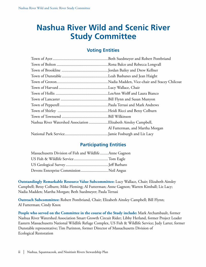
Nashua River Wild and Scenic River Study Committee
Nashua River Wild and Scenic River Study Committee
Voting Entities
Town of Ayer .......................................................Beth Suedmeyer and Robert Pontbriand Town of Bolton ...................................................Rona Balco and Rebecca Longvall Town of Brookline ..............................................Jordan Bailey and Drew Kellner Town of Dunstable ..............................................Leah Basbanes and Jean Haight Town of Groton ...................................................Nadia Madden, Vice-chair and Stacey Chilcoat Town of Harvard .................................................Lucy Wallace, Chair Town of Hollis ....................................................LeeAnn Wolff and Laura Bianco Town of Lancaster ...............................................Bill Flynn and Susan Munyon Town of Pepperell ................................................Paula Terrasi and Mark Andrews Town of Shirley ..................................................Heidi Ricci and Betsy Colburn Town of Townsend ..............................................Bill Wilkinson Nashua River Watershed Association ...................Elizabeth Ainsley Campbell, Al Futterman, and Martha Morgan National Park Service ...........................................Jamie Fosburgh and Liz Lacy
Participating Entities
Massachusetts Division of Fish and Wildlife ........Anne Gagnon US Fish & Wildlife Service ..................................Tom Eagle US Geological Survey ..........................................Jeff Barbaro Devens Enterprise Commission ...........................Neil Angus
Outstandingly Remarkable Resource Value Subcommittee: Lucy Wallace, Chair; Elizabeth Ainsley Campbell; Betsy Colburn; Mike Fleming; Al Futterman; Anne Gagnon; Warren Kimball; Liz Lacy; Nadia Madden; Martha Morgan; Beth Suedmeyer; Paula Terrasi
Outreach Subcommittee: Robert Pontbriand, Chair; Elizabeth Ainsley Campbell; Bill Flynn; Al Futterman; Cindy Knox
People who served on the Committee in the course of the Study include: Mark Archambault, former Nashua River Watershed Association Smart Growth Circuit Rider; Libby Herland, former Project Leader Eastern Massachusetts National Wildlife Refuge Complex, US Fish & Wildlife Service; Judy Larter, former Dunstable representative; Tim Purinton, former Director of Massachusetts Division of Ecological Restoration

Nashua, Squannacook, and Nissitissit Rivers Stewardship Plan | iii
Nashua River Wild and Scenic River Study Committee
Questions:
For questions about the Nashua River Wild and Scenic River Study Committee or this “Nashua, Squannacook, and Nissitissit Rivers Stewardship Plan” please contact:
Al FuttermanNashua River Wild and Scenic River Study Committeec/o Nashua River Watershed Association592 Main StreetGroton, Massachusetts [email protected]
For questions about the Partnership Wild and Scenic Rivers Program, please contact:
Jamie FosburghNational Park ServiceManager, Northeast Region Rivers Program15 State Street Boston, Massachusetts 02109617-223-5191 [email protected]
This Plan is also available on our website www.WildandScenicNashuaRivers.org (and once a final draft is produced, hard copies will be made available in the Town Clerks’ offices and town libraries). Additional information and electronic copies of this plan are available on our website www.WildandScenicNashuaRivers.org or by sending a request to [email protected].

iv | Nashua, Squannacook, and Nissitissit Rivers Stewardship Plan
Nashua, Squannacook, & Nissitissit Rivers in the Stewardship Plan Map
Nashua, Squannacook, & Nissitissit Rivers in the Stewardship Plan.

Nashua, Squannacook, and Nissitissit Rivers Stewardship Plan | v
Letter
February 15, 2018
Greetings–
We are pleased to present the “Nashua, Squannacook, and Nissitissit Rivers Stewardship Plan” for your consideration. Three years in the making, the Stewardship Plan is intended as a guide for local communities as they work in partnership to take voluntary actions to protect and enhance the outstandingly remarkable resource values of these rivers in the years to come.
The Congressionally-authorized Nashua River Wild and Scenic River Study Committee identified the resources and developed the voluntary Stewardship Plan with much public input. Representatives appointed to the Committee by the eleven participating riverfront towns—Ayer, Bolton, Brookline, Dunstable, Groton, Harvard, Hollis, Lancaster, Pepperell, Shirley, and Townsend—worked together with the Nashua River Watershed Association and National Park Service to explore whether sections of the rivers were eligible and suitable for federal designation as Partnership Wild and Scenic Rivers. Many experts from state agencies and conservation organizations assisted with this effort, and the conclusion is a resounding affirmation that our rivers merit designation.
It is up to the townspeople in the eleven participating communities to vote at their 2018 spring Town Meetings to accept the Stewardship Plan and its recommendation that the rivers be designated Partnership Wild and Scenic Rivers. If the votes are affirmative, as the Study Committee anticipates, legislation will be submitted to Congress. After designation, a local Stewardship Council will be formed—much like our current Study Committee—to implement the Stewardship Plan. Designation will not stop development, rezone private land, or change property rights. Land use controls on private lands continue to be solely a matter of state and local jurisdiction.
Acknowledgements: We have many people and organizations to thank for their assistance over the past three years, first and foremost the boards and committees of the participating towns and all those who served at one point or another on the Study Committee. As can be seen from the list of Experts Consulted, we have been very fortunate throughout our work to have the benefit of their expertise. We also appreciated being able to consult with leaders of the Stewardship Councils of the New England rivers that have already been designated Wild and Scenic: Eight Mile; Farmington; Lamprey; Sudbury, Assabet, and Concord; Upper

vi | Nashua, Squannacook, and Nissitissit Rivers Stewardship Plan
Nashua, Squannacook, & Nissitissit Rivers in the Stewardship Plan Map
Missisquoi and Trout; and Westfield. We appreciated being able to utilize template sections of the plans developed by their Stewardship Councils as appropriate.
Many friends from throughout the watershed have contributed a wide variety of photographs. Several individuals have contributed extraordinary pro bono services, including Cindy Knox, who designed our website and provided an initial set of stunning photographs, Diane Carson of Nashoba Paddler, LCC who provided canoes and kayaks for our on-river outreach tours, and Joan Wotkowicz, who helped edit and format the Stewardship Plan.
We greatly appreciate the financial and technical support provided by the National Park Service, including attention from both Liz Lacy, who joined the team more recently, and from Jamie Fosburgh, who has been a tremendous and steady presence since the inception of the project. The Nashua River Watershed Association staff’s leadership and diligent work in coordinating the study activities and development of the Stewardship Plan have enabled us to bring this project to fruition, and we especially thank Elizabeth Ainsley Campbell, Al Futterman, Martha Morgan, and Wynne Treanor-Kvenvold.
In conclusion, we look forward to hearing from the townspeople at their 2018 spring Town Meetings when they accept the Stewardship Plan and its recommendation to seek designation for sections of the Nashua, Squannacook, and Nissitissit Rivers as Partnership Wild and Scenic Rivers. Furthermore, we look forward to using this locally-driven Stewardship Plan as a guide to voluntary actions that can be taken to protect and enhance our magnificent rivers.
Lucy B. WallaceChair, Nashua River Wild and Scenic River Study Committee
Nashua, Squannacook, and Nissitissit Rivers Stewardship Plan | vii
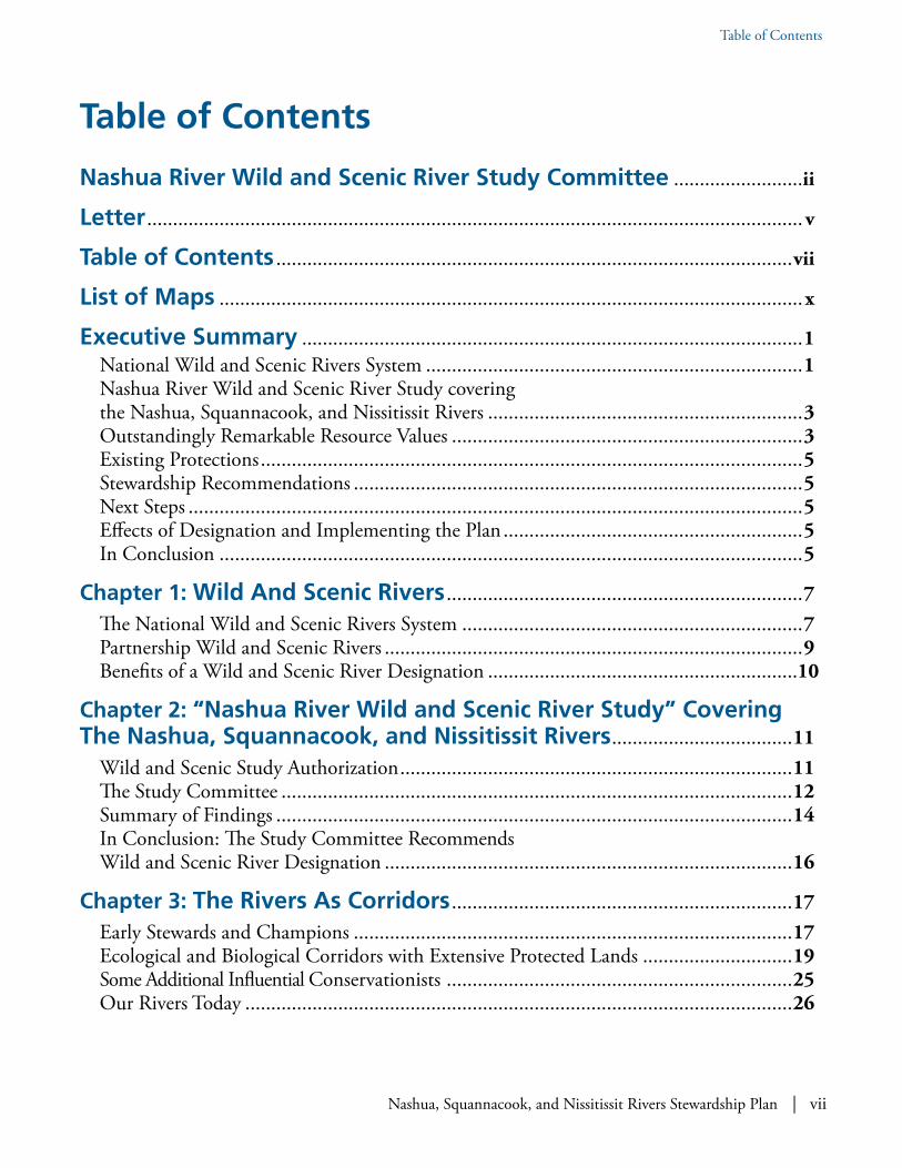
Table of Contents
Nashua River Wild and Scenic River Study Committee .........................ii
Letter ...............................................................................................................................v
Table of Contents ....................................................................................................vii
List of Maps .................................................................................................................x
Executive Summary .................................................................................................1National Wild and Scenic Rivers System .........................................................................1Nashua River Wild and Scenic River Study covering the Nashua, Squannacook, and Nissitissit Rivers .............................................................3Outstandingly Remarkable Resource Values ....................................................................3Existing Protections .........................................................................................................5Stewardship Recommendations .......................................................................................5Next Steps .......................................................................................................................5Effects of Designation and Implementing the Plan ..........................................................5In Conclusion .................................................................................................................5
Chapter 1: Wild And Scenic Rivers .....................................................................7The National Wild and Scenic Rivers System ..................................................................7Partnership Wild and Scenic Rivers .................................................................................9Benefits of a Wild and Scenic River Designation ............................................................10
Chapter 2: “Nashua River Wild and Scenic River Study” Covering The Nashua, Squannacook, and Nissitissit Rivers ...................................11
Wild and Scenic Study Authorization ............................................................................11The Study Committee ...................................................................................................12Summary of Findings ....................................................................................................14In Conclusion: The Study Committee Recommends Wild and Scenic River Designation ...............................................................................16
Chapter 3: The Rivers As Corridors ..................................................................17Early Stewards and Champions .....................................................................................17Ecological and Biological Corridors with Extensive Protected Lands .............................19Some Additional Influential Conservationists ...................................................................25Our Rivers Today ..........................................................................................................26
Table of Contents

viii | Nashua, Squannacook, and Nissitissit Rivers Stewardship Plan
Table of Contents
Chapter 4: Outstandingly Remarkable Resource Valuesand Action Plans ......................................................................................................27
The Shaping Forces: Geology, Aquifers, and Ecoregions ................................................27ORRV CATEGORY: BIOLOGICAL DIVERSITY ...................................................35Some Key Findings on the Exemplary Status of Biodiversity Features ............................55Biological Diversity Action Plan ....................................................................................57ORRV Category: RECREATIONAL AND SCENIC VALUES ...................................84Some Key Findings on the Exemplary Status of Recreational and Scenic Features..........96Recreation and Scenic Action Plan ................................................................................97ORRV CATEGORY: HISTORICAL AND CULTURAL RESOURCES ................108Some Key Findings on the Exemplary Status of Historical and Cultural Features ........122Historical and Cultural Action Plan .............................................................................123
Chapter 5: Post-Designation .............................................................................133Town Votes and Next Steps .........................................................................................133Post-Designation Stewardship Council ........................................................................134What if Designation Does Not Occur .........................................................................140
References, Resources, and Experts Consulted ......................................141References ...................................................................................................................141Resources ....................................................................................................................154Experts and Individuals Consulted .............................................................................155
Acronyms and Abbreviations .........................................................................157
APPENDIX A: DamsWorking DamsNon-Working Dams
APPENDIX B: Regulatory ReviewState Regulations for Resource ProtectionMunicipal Regulations for Resource Protection in the Study AreaTown-by-Town Review of Regulatory FrameworkRegulatory Summary Tables
APPENDIX C: History of Water Quality in the Nashua River and Tributaries
Water Quality StandardsWater Quality Report CardsEarly Water Quality HistoryWater Quality in the Early 1970sWater Quality in the Early 1980sWater Quality in the Mid 1990sWater Quality in the Early 2000s

Nashua, Squannacook, and Nissitissit Rivers Stewardship Plan | ix
Table of Contents
APPENDIX D: Special Designations in the Massachusetts Portion of the Nashua River Watershed
Outstanding Resource WatersColdwater Fisheries ResourcesAreas of Critical Environmental ConcernThe Squannacook and Nissitissit Rivers Sanctuary
APPENDIX E: Special Designations of Massachusetts Rivers and Tributaries
APPENDIX F: Noteworthy Federal Involvement in the Nashua River Watershed
APPENDIX G: Existing Major Protected Conservation Areas in the Towns in the Stewardship Plan
Appendix H: Lists of Endangered, Threatened, and Special Concern Species in the Watershed Wild and Scenic Communities by State
APPENDIX I: List of Canoe Launches by TownMassachusettsNew Hampshire
APPENDIX J: Archaeological Sites in the Former Fort Devens Area
APPENDIX K: Historic Flood Crests
APPENDIX L: Highlights of Outreach Events, Forums, and Activities January 12, 2015 through February 15, 2018
NOTE: The printed book versions of this Stewardship Plan do not include the Appendices. These can be found online at www.WildandScenicNashuaRivers.org.

x | Nashua, Squannacook, and Nissitissit Rivers Stewardship Plan
List of Maps
List of Maps
Nashua River from Ice House Dam at Harvard-Shirley town line with contrails in the sky. Photo: Rich Soar.
List of Maps Prepared for the Nashua River Wild & Scenic River Study Committee Pertaining to Resources Discussed in the “Nashua, Squanna-cook, and Nissitissit Rivers Stewardship Plan”
Nashua, Squannacook, & Nissitissit Rivers .............iv
Conserved Lands ...................................................20
Aquifers ................................................................30
MA BioMap2 Core Habitat and Critical Natural Landscape .............................37
MA BioMap2 Priority Natural Communities .......38
MA ACECs in Stewardship Plan ...........................40
MA Coldwater Fisheries Resources .......................43
Hydrology in MA & NH and Outstanding Resource Waters in MA ..............46
Merrimack Conservation Plan Focus Areas ............54
NRWA Water Quality Monitoring Sites 2018 .......68
FEMA Floodways .................................................75
Nashua River Watershed Greenway 2013 ..............78
MA and NH Trails ...............................................86
Scenic Inventory in MA .......................................94
Visual Resource Inventory ..................................130
Historical Sites and Districts in MA ....................131

Nashua, Squannacook, and Nissitissit Rivers Stewardship Plan | 1
Executive Summary
The Plan is intended to guide stewardship of the rivers in the event that they are designated by Congress as Partnership Wild and Scenic Rivers. Through this partnership, many entities representing local, state, and federal interests all voluntarily agree to participate in the Plan’s implementation and the realization of its goals. Its implementation through Wild and Scenic designation potentially offers a net financial gain for municipalities and local partners, as costs associated with implementing the Plan can be funded through federal monies (subject to Congressional approval) allotted for that purpose. Regardless of designation, the Plan is intended to be
a valuable resource and important tool for citizens, local organizations, and state and local officials concerned with managing, protecting, and enhanc-ing the Nashua, Squannacook, and Nissitissit Rivers and the special resources associated with them.
National Wild and Scenic Rivers SystemCongress established the National Wild and Scenic Rivers System in 1968 following a decade of wide-spread dam building and hydroelectric development.
Executive Summary
Nashua River. Photo: Cindy Knox Photography.
The Nashua, Squannacook, and Nissitissit Rivers are valued by local communities and merit national recognition. This Stewardship Plan (Plan) was created by the
locally-appointed Nashua River Wild and Scenic River Study Committee during a three-year study that explored the possible designation of the rivers under the National Wild and Scenic Rivers System.
2 | Nashua, Squannacook, and Nissitissit Rivers Stewardship Plan
Executive Summary
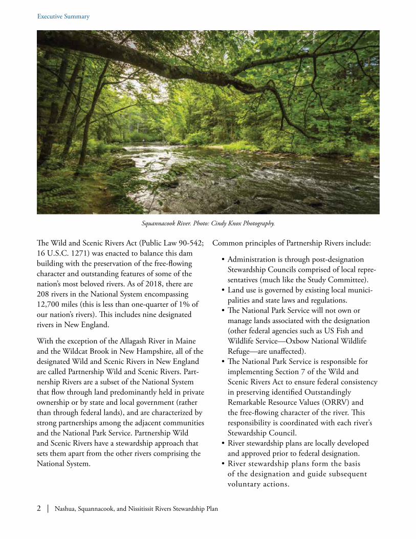
The Wild and Scenic Rivers Act (Public Law 90-542; 16 U.S.C. 1271) was enacted to balance this dam building with the preservation of the free-flowing character and outstanding features of some of the nation’s most beloved rivers. As of 2018, there are 208 rivers in the National System encompassing 12,700 miles (this is less than one-quarter of 1% of our nation’s rivers). This includes nine designated rivers in New England.
With the exception of the Allagash River in Maine and the Wildcat Brook in New Hampshire, all of the designated Wild and Scenic Rivers in New England are called Partnership Wild and Scenic Rivers. Part-nership Rivers are a subset of the National System that flow through land predominantly held in private ownership or by state and local government (rather than through federal lands), and are characterized by strong partnerships among the adjacent communities and the National Park Service. Partnership Wild and Scenic Rivers have a stewardship approach that sets them apart from the other rivers comprising the National System.
Common principles of Partnership Rivers include:
• Administration is through post-designation Stewardship Councils comprised of local repre-sentatives (much like the Study Committee).
• Land use is governed by existing local munici-palities and state laws and regulations.
• The National Park Service will not own or manage lands associated with the designation (other federal agencies such as US Fish and Wildlife Service—Oxbow National Wildlife Refuge—are unaffected).
• The National Park Service is responsible for implementing Section 7 of the Wild and Scenic Rivers Act to ensure federal consistency in preserving identified Outstandingly Remarkable Resource Values (ORRV) and the free-flowing character of the river. This responsibility is coordinated with each river’s Stewardship Council.
• River stewardship plans are locally developed and approved prior to federal designation.
• River stewardship plans form the basis of the designation and guide subsequent voluntary actions.
Squannacook River. Photo: Cindy Knox Photography.

Nashua, Squannacook, and Nissitissit Rivers Stewardship Plan | 3
Executive Summary
• Stewardship responsibilities are shared among local, state, federal, and non-profit partners.
• Voluntary participation is essential to the partnership and viewed as the key to success.
• Partnership Wild and Scenic Rivers are not considered units of the National Park System, and are not subject to regulations that govern Park units.
Nashua River Wild and Scenic River Study covering the Nashua, Squannacook, and Nissitissit RiversThe Nashua River Wild and Scenic River Study was initiated following passage of a bill introduced by US Representative Niki Tsongas, at the request of local advocates with the support of municipalities. The bill was signed into law by President Barack Obama on December 19, 2014 (Public Law 113–291); it authorized a Study of the Nashua River, Squanna-cook River, and Nissitissit River.
The locally-appointed Study Committee was convened in 2015 to investigate the eligibility and suitability of the inclusion of the Nashua, Squannacook, and Nissitissit Rivers into the National Wild and Scenic River System. The Study Committee was comprised of voting representatives appointed by each of the participating riverfront municipalities—Ayer, Bolton, Dunstable, Groton, Harvard, Lancaster, Pepperell, Shirley, and Townsend in Massachusetts and Brookline and Hollis in New Hampshire—as well as the Nashua River Watershed Association and the National Park Service. Repre-sentatives from US Fish and Wildlife Service, US Geological Survey, Massachusetts Department of Fish and Wildlife, Massachusetts Division of Ecolog-ical Restoration, and Devens Enterprise Commission also participated in the Study Committee.
The role of the Study Committee was to determine whether the Nashua, Squannacook, and Nissitissit Rivers are eligible for federal designation, to assess the level of local support for such designation, and to summarize the Committee’s findings and recommendations in this voluntary Stewardship Plan. The Study Committee received financial and technical support from the National Park Service for the Study process.
The segments being recommended for designation include:
• The Nashua River at the confluence of the North and South Nashua Rivers in Lancaster, Massa-chusetts up to the New Hampshire state line.
• The Squannacook River at its confluence with the Nashua River in Groton, Massachusetts up to its headwaters in Townsend, Massachusetts.
• The Nissitissit River at its confluence with the Nashua River in Pepperell, Massachusetts up to its headwaters in Brookline, New Hampshire.
Three working dams in the Massachusetts portions of the Nashua and Squannacook Rivers—the Ice House Dam in Harvard, the Hollingsworth & Vose Dam in Groton, and the Pepperell Dam in Pepperell, —will be “grandfathered” as existing facilities compatible with the designation. Designa-tion will not impact their existing operations.
Outstandingly Remarkable Resource ValuesTo be eligible for Wild and Scenic designation, a river must be free flowing (without dams) and pos-sess at least one “outstandingly remarkable” natural, cultural or recreational resource value (deemed ORRVs in this Plan). An ORRV is a unique, rare, or exemplary river-related feature that is significant at a comparative regional or national scale. The Study Committee gathered information about the Nashua,
4 | Nashua, Squannacook, and Nissitissit Rivers Stewardship Plan
Executive Summary
Squannacook, and Nissitissit Rivers and their associ-ated natural, cultural, and recreational resources with assistance from knowledgeable community members as well as from local, state, and federal officials.
The Study Committee determined through its investigation that the Nashua, Squannacook, and Nissitissit Rivers possess numerous ORRVs in three main categories: Biological Diversity; Recreational and Scenic; and Historical and Cultural. Just a few highlights are listed below:
• The Study area has exceptional biological diversity, three state-designated Areas of Critical Environmental Concern, six “Priority Natural Communities” along the Nashua River, and significant areas designated as “core habitat” by Massachusetts. Our findings include more than two dozen threatened, endangered, or species of special concern, including dragonflies in the Squannacook River; freshwater mussels in the Nissitissit River; and, additionally, a notably large population of Blanding’s turtles, which are state-listed in Massachusetts and New Hampshire.
• The cool waters of the Squannacook and Nissitissit Rivers provide some of the best fly-fishing within reach of Boston, Nashua, and Worcester. Some 30 bass fishing clubs hold tournaments on the Nashua River, more than 8,000 visitors annually use canoes or kayaks to recreate on the rivers, the 11-mile Nashua River Rail Trail runs alongside the river, and there are many miles of connected trails. Peaceful and scenic views are afforded from the river due to the extent of forested shoreline.
• The Study area has given rise to many influen-tial conservationists, including Benton MacKaye and William Wharton. The area experienced a breathtaking insurgence of conservation activ-ities in the 1960s that had lasting impact on the cultural fabric of the region. The “Marion Stoddart Story” and the clean-up of the Nashua River has merited international acclaim and has been a model for watershed groups across the country. Noteworthy historic sites, including those associated with Native Americans, Shak-ers, and transcendentalists abound in our area.
Nissitissit River. Photo: Ken Hartlage.

Nashua, Squannacook, and Nissitissit Rivers Stewardship Plan | 5
Executive Summary
Existing ProtectionsFor each ORRV identified, the Study Committee considered the protections existing for these resources and evaluated whether the protections are sufficient. The Committee then made suggestions for voluntary stewardship recommendations, which are included in this Plan. Existing laws, regulations, and ordinances at the federal, state, and local levels afford a high degree of protection for many of the ORRVs found along the Nashua, Squannacook, and Nissitissit Rivers.
An extraordinary proportion of the land along the Nashua, Squannacook, and Nissitissit Rivers is permanently protected by a mosaic of federal, state, and local entities. The result is increased biodiversity, increased scenic value, and increased recreational pleasure associated with our rivers.
Stewardship RecommendationsThis Stewardship Plan presents a series of recom-mendations that can be voluntarily implemented by local landowners, municipalities, and state and federal agencies working together to help protect river-related resources and maintain and enhance the quality and way of life valued by so many people (see Chapter 4). The recommendations in this local-ly-developed Stewardship Plan can be implemented by a post-designation, locally-appointed Stewardship Council working with communities and partners on a voluntary basis.
Next StepsThe Study Committee is engaging with the river-front communities in a dialogue about the Plan, its recommendations, and potential Wild and Scenic designation. This dialogue will culminate in the spring of 2018 with Town Meeting votes in eleven participating towns on the Stewardship Plan and the Wild and Scenic River designation. The Study Committee and the National Park Service will only recommend designation if the Plan and designation are supported by favorable community votes in the participating towns.
Effects of Designation and Implementing the PlanDesignation will result in establishment of a Steward-ship Council comprised of representatives appointed by the eleven participating municipalities plus the Nashua River Watershed Association and the National Park Service. The Stewardship Council will guide the administration of the designation and implementation of the locally-developed Stewardship Plan. Desig-nation will also likely result in an appropriation of federal funds (subject to Congressional approval) to support implementation of the Stewardship Plan.
Existing state and local laws will continue to gov-ern—private lands and activities will not be subject to increased federal control. Land use decisions will continue to be made by local planning and zoning boards, not federal agencies. The federal government will not acquire lands to implement the designation. Licensed, pre-existing hydroelectric facilities can continue to operate; other existing dams can be retrofitted for non-hydroelectric power purposes. Hunting and fishing laws and regulations will be unaffected, and rules governing agricultural practices will not change. If the rivers are designated, the designation would also give the local municipalities a voice, through the Stewardship Council and the National Park Service, in protecting ORRVs from any harmful effects of new federally funded or permitted construction or development of water resource projects affecting the designated portions of the rivers.
In ConclusionWorking together, participating local, state, and federal partners can steward the outstandingly remarkable resources of the Nashua, Squannacook, and Nissitissit Rivers through voluntary actions.

6 | Nashua, Squannacook, and Nissitissit Rivers Stewardship Plan

Nashua, Squannacook, and Nissitissit Rivers Stewardship Plan | 7
When was this Established and Why? The National Wild and Scenic Rivers System was established by the US Congress on October 2, 1968 with the passage of the Wild and Scenic Rivers Act (Public Law 90-542; 16 U.S.C. 1271) to protect free-flowing, outstanding rivers from the harmful effects of new federally assisted projects such as dams and hydroelectric facilities. The Act states:
It is hereby declared to be the policy of the United States that certain selected rivers of the Nation which, with their immediate environments, possess outstandingly remarkable scenic, recreational, geologic, fish and wildlife, historic, cultural, or other similar values, shall be preserved in free-flowing condition, and that they and their immediate environments shall be protected for the benefit and enjoyment of present and future generations. The Congress declares that
1 Wild and Scenic Rivers Act of 1968, Public Law 90-542, 16 U.S.C. 1271 (1968).
the established national policy of dam and other construction at appropriate sections of the rivers of the United States needs to be complemented by a policy that would preserve other selected rivers or sections thereof in their free-flowing condition to protect the water quality of such rivers and to fulfill other vital national conservation purposes.1
What Rivers are Eligible? To be eligible for designation as “Wild and Scenic,” a river or river segment must have at least one Outstandingly Re-markable Resource Value (ORRV). The ORRVs are river-related scenic, recreational, geologic, fish and wildlife, historic, cultural, or other similar values. The locally-identified ORRVs must have unique, rare, or exemplary qualities at a comparative regional or national scale. The ORRVs identified during this Study process are extensively discussed in Chapter 4.
Chapter 1:
Wild And Scenic Rivers
Bertozzi Rapids on the Squannacook River at Groton-Shirley town line. This is also the site of a USGS stream gage. Photo: Cindy Knox Photography.
The National Wild and Scenic Rivers System

8 | Nashua, Squannacook, and Nissitissit Rivers Stewardship Plan
Chapter 1: Wild And Scenic Rivers
To be eligible for designation, a river or river seg-ment must also be free flowing. The term “free-flow-ing” refers to flow within the designated river segment and is not the same as naturally flowing. The free-flowing status of our rivers was evaluated during this Study process and is extensively discussed in Appendix A.
Are There Special Protections? Designation provides communities with special federal protection of the river. Section 7(a) of the Wild and Scenic Rivers Act describes the specific protections provided to designated rivers resource-rich:
The Federal Power Commission [Federal Regulatory Commission] shall not license the construction of any dam, water conduit, reservoir, powerhouse, transmission line, or other project works under the Federal Power Act . . . on or directly affecting any river which is designated . . . and no department or agency of the United States shall assist by any loan, grant, license, or otherwise in the construction of any water resources project that would have a direct and adverse effect on the values for which such river was established . . . No department or agency of the United States shall recommend authorization of any water resources project that would have a direct or adverse effect on the values for which such river was established . . .2
The intention of Section 7 of the Wild and Scenic Rivers Act is to protect the designated rivers from new federal projects that would adversely affect the free-flowing character or Outstandingly Remarkable Resource Values for which the rivers are designated. Section 7 requires the evaluation of partially or fully federally funded or permitted construction and development water resources projects within the designated area. This Section prevents licensing or exemption by the Federal Energy Regulatory Com-mission (FERC) of new dams or hydropower facili-ties on or directly affecting the designated area; prevents federal projects which have a direct or
2 Ibid.
adverse effect on the free-flowing character, Outstandingly Re-markable Resource Values, or water quality of the designated area; and limits federal projects that would invade the designat-ed area or unreasonably diminish the free-flowing character, Out-standingly Remarkable Resource Values, or water quality of the designated area.
Although this section is the regulatory arm of the Act, it applies only to specific federal projects and does not impact local zoning or the land use of private landowners, as this remains governed by local and state laws regardless of designation.
How Many Rivers Have Been Designated? As of 2018, fifty years after the passage of the Act, there are 208 rivers in the National Wild and Scenic Rivers System encompassing 12,700 miles. While this at first may seem like many miles, it is less than one-quarter of 1% of our nation’s rivers. In Massachusetts, there are 8,229 miles of rivers, of which only 147.1 are designated as Wild and Scenic. Of New Hampshire’s 10,874 miles of rivers, only 38 miles are currently designated Wild and Scenic.
There are nine designated rivers in New England: Allagash (Maine); Lamprey (New Hampshire); Wildcat Brook (New Hampshire); Concord, Sudbury, and Assabet Rivers (Massachusetts); Taunton (Massachusetts); Upper Missisquoi and Trout Rivers (Vermont); Westfield (Massachusetts); Eightmile (Connecticut); and Farmington (Connecticut).

Nashua, Squannacook, and Nissitissit Rivers Stewardship Plan | 9
Chapter 1: Wild And Scenic Rivers
Partnership Wild and Scenic RiversWhat Are Partnership Wild and Scenic Rivers? Partnership Rivers are a subset of the National Sys-tem that flow through land predominantly held in private ownership or by state and local government. Seven of the nine designated Wild and Scenic Rivers in New England are Partnership Wild and Scenic Rivers. They are managed through partnerships among the adjacent communities and the National Park Service.Partnership Wild and Scenic Rivers have a man-agement approach that sets them apart from the other rivers comprising the National System. The common principles of the Partnership Wild and Scenic Rivers include:
• No federal ownership or management of lands (federal ownership is excluded by Congress).
• Administration is through post‐designation Stewardship Councils comprised of local repre-sentatives (much like the Study Committee).
• Adjacent land use continues to be governed by existing local municipalities and state laws and regulations.
• The National Park Service is responsible for implementing Section 7 of the Wild and Scenic Rivers Act to ensure federal consis-tency in preserving identified ORRVs and the free-flowing character of the river. This responsibility is coordinated with each river’s Stewardship Council.
• River stewardship plans are locally-developed and approved prior to federal designation.
• River stewardship plans form the basis of the designation and guide subsequent stewardship actions.
• Stewardship responsibilities are shared among local, state, federal, and nonprofit partners.
• Voluntary participation is essential to the partnership and viewed as the key to success.
The Nashua, Squannacook, and Nissitissit Rivers are being considered for possible designation as Partnership Wild and Scenic Rivers, a subset of the National Wild and Scenic Rivers system.
Nissitissit River. Photo: Ken Hartlage.
10 | Nashua, Squannacook, and Nissitissit Rivers Stewardship Plan
Chapter 1: Wild And Scenic Rivers
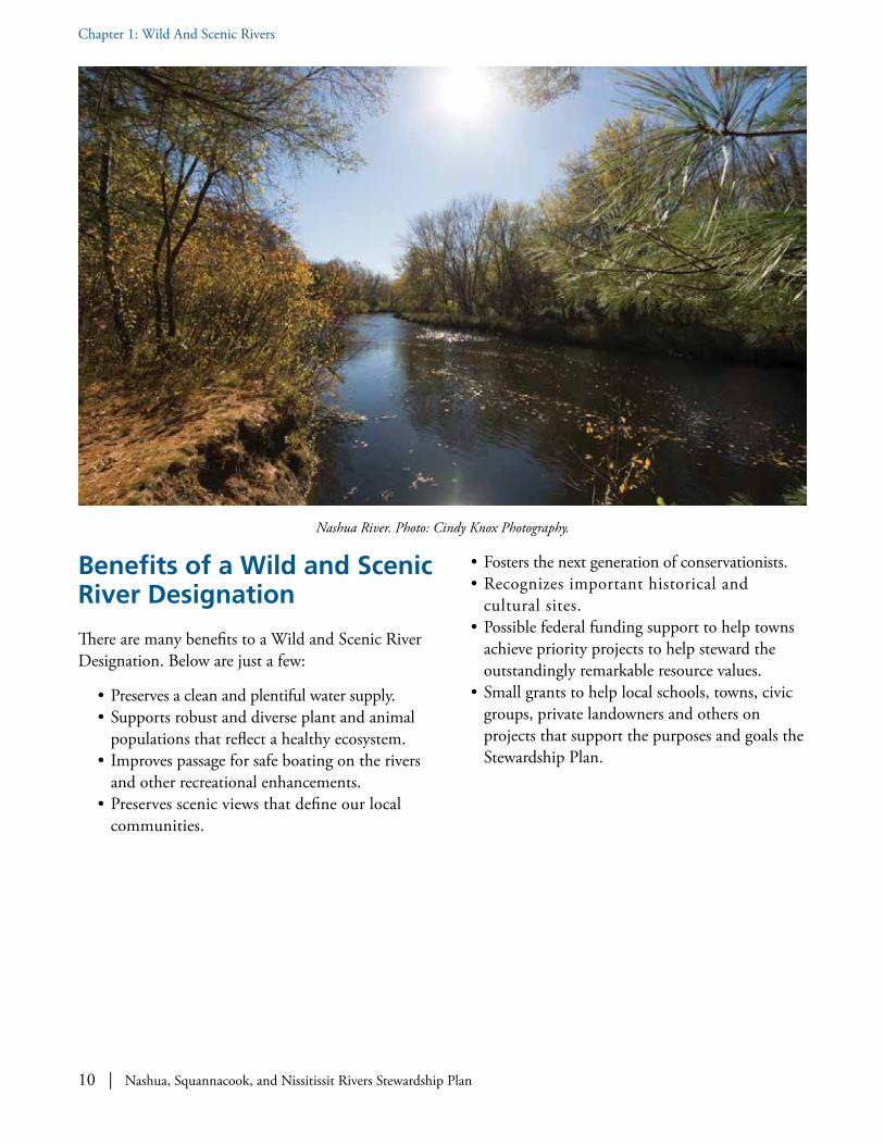
Benefits of a Wild and Scenic River Designation
There are many benefits to a Wild and Scenic River Designation. Below are just a few:
• Preserves a clean and plentiful water supply.• Supports robust and diverse plant and animal
populations that reflect a healthy ecosystem.• Improves passage for safe boating on the rivers
and other recreational enhancements.• Preserves scenic views that define our local
communities.
• Fosters the next generation of conservationists.• Recognizes important historical and
cultural sites.• Possible federal funding support to help towns
achieve priority projects to help steward the outstandingly remarkable resource values.
• Small grants to help local schools, towns, civic groups, private landowners and others on projects that support the purposes and goals the Stewardship Plan.
Nashua River. Photo: Cindy Knox Photography.
Nashua, Squannacook, and Nissitissit Rivers Stewardship Plan | 11
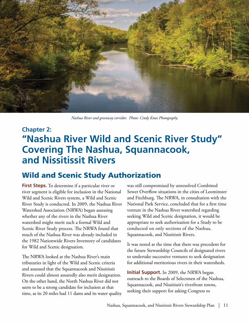
First Steps. To determine if a particular river or river segment is eligible for inclusion in the National Wild and Scenic Rivers system, a Wild and Scenic River Study is conducted. In 2009, the Nashua River Watershed Association (NRWA) began assessing whether any of the rivers in the Nashua River watershed might merit such a formal Wild and Scenic River Study process. The NRWA found that much of the Nashua River was already included in the 1982 Nationwide Rivers Inventory of candidates for Wild and Scenic designation.
The NRWA looked at the Nashua River’s main tributaries in light of the Wild and Scenic criteria and assessed that the Squannacook and Nissitissit Rivers could almost assuredly also merit designation. On the other hand, the North Nashua River did not seem to be a strong candidate for inclusion at that time, as its 20 miles had 11 dams and its water quality
was still compromised by unresolved Combined Sewer Overflow situations in the cities of Leominster and Fitchburg. The NRWA, in consultation with the National Park Service, concluded that for a first time venture in the Nashua River watershed regarding seeking Wild and Scenic designation, it would be appropriate to seek authorization for a Study to be conducted on only sections of the Nashua, Squannacook, and Nissitissit Rivers.
It was noted at the time that there was precedent for the future Stewardship Councils of designated rivers to undertake successive ventures to seek designation for additional meritorious rivers in their watersheds.
Initial Support. In 2009, the NRWA began outreach to the Boards of Selectmen of the Nashua, Squannacook, and Nissitissit’s riverfront towns, seeking their support for asking Congress to
Chapter 2:
“Nashua River Wild and Scenic River Study” Covering The Nashua, Squannacook, and Nissitissit Rivers
Nashua River and greenway corridor. Photo: Cindy Knox Photography.
Wild and Scenic Study Authorization
12 | Nashua, Squannacook, and Nissitissit Rivers Stewardship Plan
Chapter 2: “Nashua River Wild and Scenic River Study” Covering The Nashua, Squannacook, and Nissitissit Rivers
authorize a formal Study of sections of the rivers for potential inclusion as Partnership Rivers in the National Wild and Scenic Rivers System. Assured of broad local support for the study, US Representative Niki Tsongas first introduced legislation to Congress in 2011, and, as is typical, the legislative process took several years.
NPS Reconnaissance Survey. In 2013, at the request of Representative Tsongas, the Northeast Region of the National Park Service (NPS) conducted a reconnaissance survey3 of the Nashua, Squannacook, and Nissitissit Rivers
to evaluate them as candidates for potential Wild and Scenic River designation and as a step toward a full Wild and Scenic River Study. The preliminary findings were that eligibility and suit-ability criteria were likely to be met, and that a Wild and Scenic River Study would be appropriate and productive.
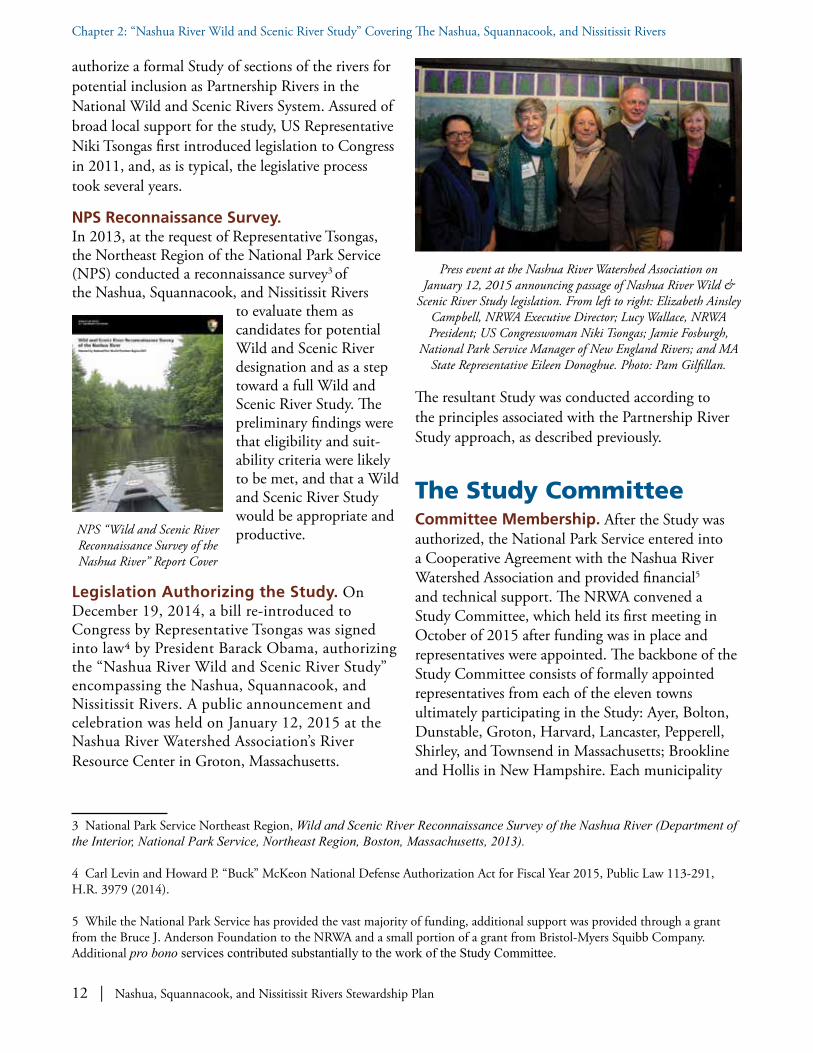
Legislation Authorizing the Study. On December 19, 2014, a bill re-introduced to Congress by Representative Tsongas was signed into law4 by President Barack Obama, authorizing the “Nashua River Wild and Scenic River Study” encompassing the Nashua, Squannacook, and Nissitissit Rivers. A public announcement and celebration was held on January 12, 2015 at the Nashua River Watershed Association’s River Resource Center in Groton, Massachusetts.
3 National Park Service Northeast Region, Wild and Scenic River Reconnaissance Survey of the Nashua River (Department of the Interior, National Park Service, Northeast Region, Boston, Massachusetts, 2013).
4 Carl Levin and Howard P. “Buck” McKeon National Defense Authorization Act for Fiscal Year 2015, Public Law 113-291, H.R. 3979 (2014).
5 While the National Park Service has provided the vast majority of funding, additional support was provided through a grant from the Bruce J. Anderson Foundation to the NRWA and a small portion of a grant from Bristol-Myers Squibb Company. Additional pro bono services contributed substantially to the work of the Study Committee.
The resultant Study was conducted according to the principles associated with the Partnership River Study approach, as described previously.
The Study CommitteeCommittee Membership. After the Study was authorized, the National Park Service entered into a Cooperative Agreement with the Nashua River Watershed Association and provided financial5 and technical support. The NRWA convened a Study Committee, which held its first meeting in October of 2015 after funding was in place and representatives were appointed. The backbone of the Study Committee consists of formally appointed representatives from each of the eleven towns ultimately participating in the Study: Ayer, Bolton, Dunstable, Groton, Harvard, Lancaster, Pepperell, Shirley, and Townsend in Massachusetts; Brookline and Hollis in New Hampshire. Each municipality
NPS “Wild and Scenic River Reconnaissance Survey of the Nashua River” Report Cover
Press event at the Nashua River Watershed Association on January 12, 2015 announcing passage of Nashua River Wild &
Scenic River Study legislation. From left to right: Elizabeth Ainsley Campbell, NRWA Executive Director; Lucy Wallace, NRWA President; US Congresswoman Niki Tsongas; Jamie Fosburgh,
National Park Service Manager of New England Rivers; and MA State Representative Eileen Donoghue. Photo: Pam Gilfillan.

Nashua, Squannacook, and Nissitissit Rivers Stewardship Plan | 13
Chapter 2: “Nashua River Wild and Scenic River Study” Covering The Nashua, Squannacook, and Nissitissit Rivers
has a vote on the Committee, as does the Nashua River Watershed Association and the National Park Service. Representatives from US Fish and Wildlife Service, US Geological Survey, Massachusetts Department of Fish and Wildlife, Massachusetts Division of Ecological Restoration, and Devens Enterprise Commission also participate in the Study Committee. Additional stakeholders with resource expertise regularly participate in the Committee as well, providing invaluable assistance.
The full Study Committee has been meeting regular-ly on the third Thursday of each month, with all meetings open to the public. Notes of the meetings are posted on the Committee’s website: www.WildandScenicNashuaRivers.org along with a wealth of related information. Two subcommittees were formed: the Outstandingly Remarkable Re-source Value Subcommittee and the Outreach Subcommittee. Throughout the process, the knowl-edge of numerous federal, state, and local experts was drawn on and extensive public input was sought.
Responsibilities of the Study Committee. Consistent with the approach taken in exploring all Partnership rivers, over the course of the approxi-mate three-year study process, the Study Commit-tee’s main responsibilities have been to:
• Determine whether the Nashua, Squannacook, and Nissitissit Rivers are eligible for inclusion in the Wild and Scenic Rivers System; assess the rivers’ free-flowing characters, document ORRVs; and determine the specific sections for which to seek designation.
• Serve as the focal point for local community, citizen, and stakeholder involvement through-out the study process; determine whether there is suitable local support and commitment for designation.
• Review local, state, and federal protections
that are already in place for the ORRVs; assess current threats to the ORRVs; and identify opportunities for stewardship.
• Develop a locally-driven Stewardship Plan to serve as a blueprint for improved stewardship of the identified natural, recreational and scenic, and historical and cultural values, with technical assistance from the National Park Service. The recommended actions can be undertaken voluntarily in the future, regardless of whether designation occurs.
NPS Study Report to Congress. Upon fulfill-ment of the main Study Committee responsibilities outlined above, the National Park Service summariz-es the research and findings in a NPS Study Report to Congress. The finalized Study Report is a separate document from this Stewardship Plan and is present-ed to Congress. The presentation of the NPS Study Report to Congress, anticipated to be in June or July of 2018, is followed by a public comment period. Designation requires that a bill be passed by Congress and signed by the President.
Lucy Wallace, chair of Study Committee and Outstandingly Remarkable Resource Values Subcommittee, and Al Futterman,
NRWA staff and Study Committee Coordinator, at NRWA River Resource Center. Photo: Wynne Treanor-Kvenvold.
14 | Nashua, Squannacook, and Nissitissit Rivers Stewardship Plan
Chapter 2: “Nashua River Wild and Scenic River Study” Covering The Nashua, Squannacook, and Nissitissit Rivers
Summary of FindingsSections and Boundaries. The sections being recommended by the Study Committee for designa-tion include:
• The Nashua River at the confluence of the North and South Nashua Rivers in Lancaster, Massa-chusetts up to the New Hampshire state line.
• The Squannacook River at its confluence with the Nashua River in Groton, Massachusetts up to its headwaters in Townsend, Massachusetts.
• The Nissitissit River at its confluence with the Nashua River in Pepperell, Massachusetts up to its headwaters in Brookline, New Hampshire.
The National Park Service is recommending that small sections be excluded from the designation upstream and downstream from the three working dams in Massachusetts—the Ice House Dam in Harvard, the Hollingsworth and Vose Dam in Groton, and the Pepperell Dam in Pepperell.
The Wild and Scenic Rivers Act does not contain specific requirements regarding lateral boundaries or the minimum width of the river corridor after designation. Consistent with the established Partner-ship Wild and Scenic River model, which involves no federal land acquisition or management, there are no distinct lateral boundaries or corridors established within this Stewardship Plan or for the Partnership Wild and Scenic designation of sections of the Nashua, Squannacook, and Nissitissit Rivers.
The Stewardship Plan focuses its stewardship efforts on the rivers themselves, their tributaries and headwaters, and their immediate riparian corridors. Lands within the floodplain, immediately adjacent to the rivers’ banks, or which are noteworthy in their scenic character receive the greatest attention. For uplands outside of this area—indeed throughout the entire watershed—the Plan identifies beneficial actions relating to water quality maintenance and improvement and other issues best addressed by taking a watershed approach.
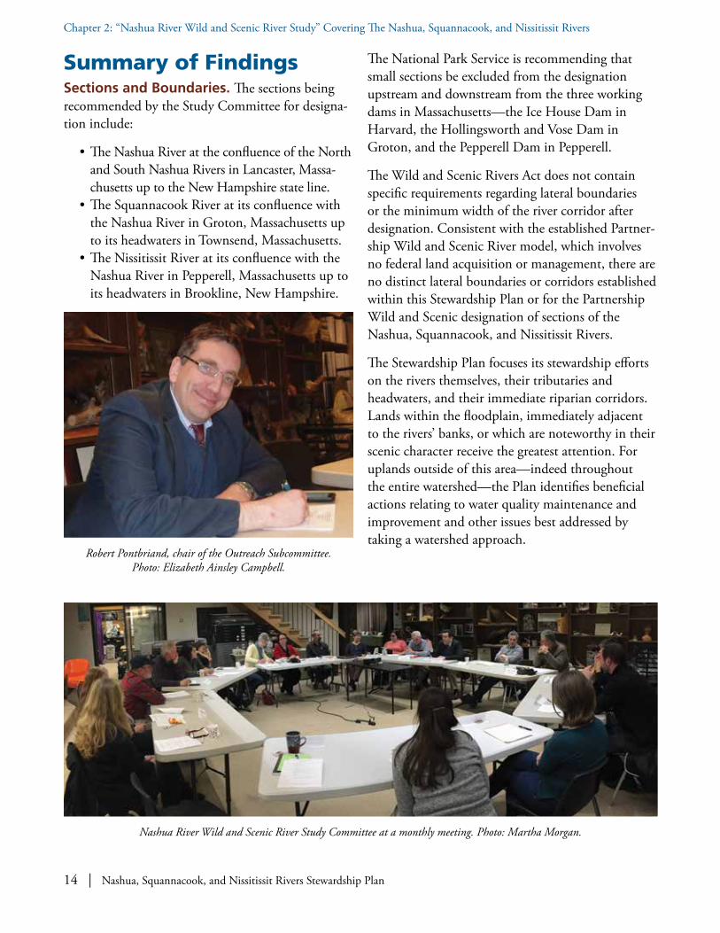
Robert Pontbriand, chair of the Outreach Subcommittee. Photo: Elizabeth Ainsley Campbell.
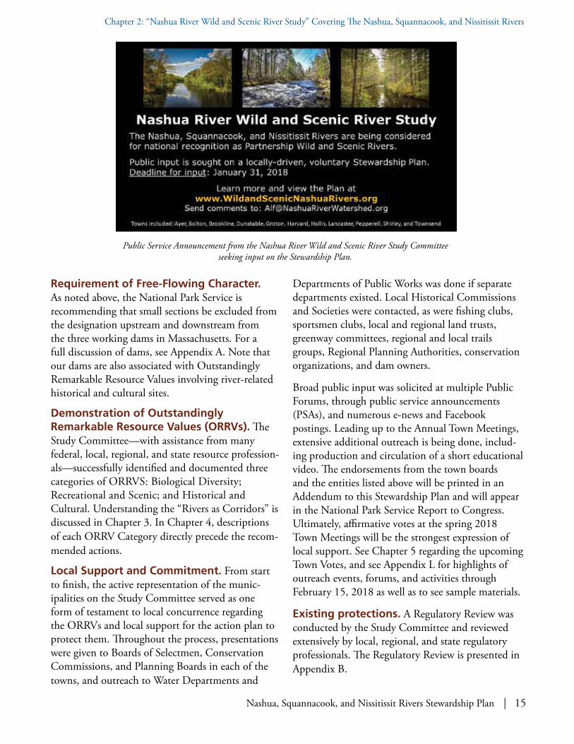
Nashua River Wild and Scenic River Study Committee at a monthly meeting. Photo: Martha Morgan.
Nashua, Squannacook, and Nissitissit Rivers Stewardship Plan | 15
Chapter 2: “Nashua River Wild and Scenic River Study” Covering The Nashua, Squannacook, and Nissitissit Rivers
Requirement of Free-Flowing Character. As noted above, the National Park Service is recommending that small sections be excluded from the designation upstream and downstream from the three working dams in Massachusetts. For a full discussion of dams, see Appendix A. Note that our dams are also associated with Outstandingly Remarkable Resource Values involving river-related historical and cultural sites.
Demonstration of Outstandingly Remarkable Resource Values (ORRVs). The Study Committee—with assistance from many federal, local, regional, and state resource profession-als—successfully identified and documented three categories of ORRVS: Biological Diversity; Recreational and Scenic; and Historical and Cultural. Understanding the “Rivers as Corridors” is discussed in Chapter 3. In Chapter 4, descriptions of each ORRV Category directly precede the recom-mended actions.
Local Support and Commitment. From start to finish, the active representation of the munic-ipalities on the Study Committee served as one form of testament to local concurrence regarding the ORRVs and local support for the action plan to protect them. Throughout the process, presentations were given to Boards of Selectmen, Conservation Commissions, and Planning Boards in each of the towns, and outreach to Water Departments and
Departments of Public Works was done if separate departments existed. Local Historical Commissions and Societies were contacted, as were fishing clubs, sportsmen clubs, local and regional land trusts, greenway committees, regional and local trails groups, Regional Planning Authorities, conservation organizations, and dam owners.
Broad public input was solicited at multiple Public Forums, through public service announcements (PSAs), and numerous e-news and Facebook postings. Leading up to the Annual Town Meetings, extensive additional outreach is being done, includ-ing production and circulation of a short educational video. The endorsements from the town boards and the entities listed above will be printed in an Addendum to this Stewardship Plan and will appear in the National Park Service Report to Congress. Ultimately, affirmative votes at the spring 2018 Town Meetings will be the strongest expression of local support. See Chapter 5 regarding the upcoming Town Votes, and see Appendix L for highlights of outreach events, forums, and activities through February 15, 2018 as well as to see sample materials.
Existing protections. A Regulatory Review was conducted by the Study Committee and reviewed extensively by local, regional, and state regulatory professionals. The Regulatory Review is presented in Appendix B.
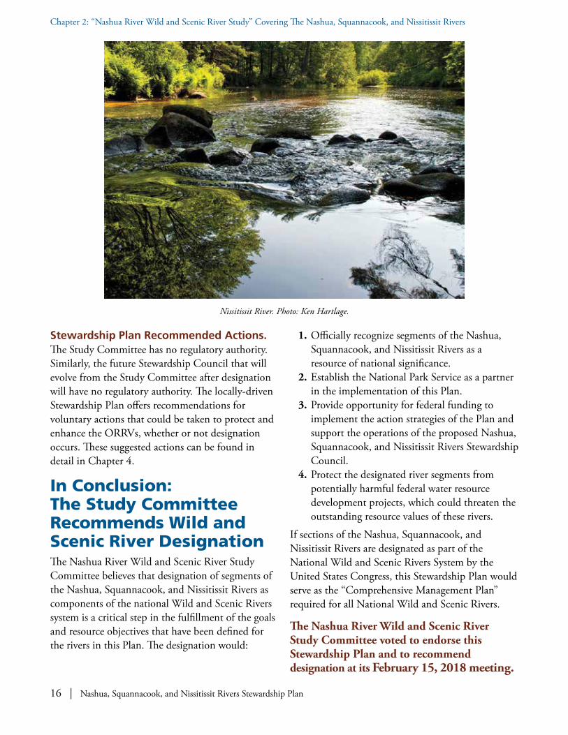
Public Service Announcement from the Nashua River Wild and Scenic River Study Committee seeking input on the Stewardship Plan.
16 | Nashua, Squannacook, and Nissitissit Rivers Stewardship Plan
Chapter 2: “Nashua River Wild and Scenic River Study” Covering The Nashua, Squannacook, and Nissitissit Rivers
Stewardship Plan Recommended Actions. The Study Committee has no regulatory authority. Similarly, the future Stewardship Council that will evolve from the Study Committee after designation will have no regulatory authority. The locally-driven Stewardship Plan offers recommendations for voluntary actions that could be taken to protect and enhance the ORRVs, whether or not designation occurs. These suggested actions can be found in detail in Chapter 4.
In Conclusion: The Study Committee Recommends Wild and Scenic River DesignationThe Nashua River Wild and Scenic River Study Committee believes that designation of segments of the Nashua, Squannacook, and Nissitissit Rivers as components of the national Wild and Scenic Rivers system is a critical step in the fulfillment of the goals and resource objectives that have been defined for the rivers in this Plan. The designation would:
1. Officially recognize segments of the Nashua, Squannacook, and Nissitissit Rivers as a resource of national significance.
2. Establish the National Park Service as a partner in the implementation of this Plan.
3. Provide opportunity for federal funding to implement the action strategies of the Plan and support the operations of the proposed Nashua, Squannacook, and Nissitissit Rivers Stewardship Council.
4. Protect the designated river segments from potentially harmful federal water resource development projects, which could threaten the outstanding resource values of these rivers.
If sections of the Nashua, Squannacook, and Nissitissit Rivers are designated as part of the National Wild and Scenic Rivers System by the United States Congress, this Stewardship Plan would serve as the “Comprehensive Management Plan” required for all National Wild and Scenic Rivers.
The Nashua River Wild and Scenic River Study Committee voted to endorse this Stewardship Plan and to recommend designation at its February 15, 2018 meeting.
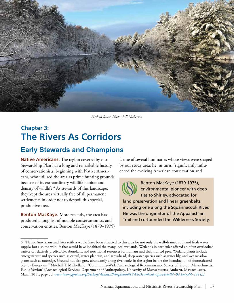
Nissitissit River. Photo: Ken Hartlage.
Nashua, Squannacook, and Nissitissit Rivers Stewardship Plan | 17
Native Americans. The region covered by our Stewardship Plan has a long and remarkable history of conservationists, beginning with Native Ameri-cans, who utilized the area as prime hunting grounds because of its extraordinary wildlife habitat and density of wildlife.6 As stewards of this landscape, they kept the area virtually free of all permanent settlements in order not to despoil this special, productive area.
Benton MacKaye. More recently, the area has produced a long list of notable conservationists and conservation entities. Benton MacKaye (1879–1975)
6 “Native Americans and later settlers would have been attracted to this area for not only the well-drained soils and fresh water supply, but also the wildlife that would have inhabited the many local wetlands. Wetlands in particular offered an often overlooked variety of relatively predictable, abundant, and nutritional resources for humans and their hunted prey. Wetland plants include emergent wetland species such as cattail, water plantain, and arrowhead, deep water species such as water lily, and wet meadow plants such as nutsedge. Ground nut also grew abundantly along riverbanks in the region before the introduction of domesticated pigs by Europeans.” Mitchell T. Mulholland, “Community-Wide Archaeological Reconnaissance Survey of Groton, Massachusetts. Public Version” (Archaeological Services, Department of Anthropology, University of Massachusetts, Amherst, Massachusetts, March 2011, page 30, www.townofgroton.org/DesktopModules/Bring2mind/DMX/Download.aspx?PortalId=0&EntryId=14113).
is one of several luminaries whose views were shaped by our study area; he, in turn, “significantly influ-enced the evolving American conservation and
Benton MacKaye (1879-1975), environmental pioneer with deep ties to Shirley, advocated for
land preservation and linear greenbelts, including one along the Squannacook River. He was the originator of the Appalachian Trail and co-founded the Wilderness Society.
Chapter 3:
The Rivers As CorridorsEarly Stewards and Champions
Nashua River. Photo: Bill Nickerson.

18 | Nashua, Squannacook, and Nissitissit Rivers Stewardship Plan
Chapter 3: The Rivers As Corridors
environmental movements.” MacKaye is well known as the visionary7 inspiration behind and proponent of the Appalachian Trail and a co-founder of the Wilderness Society. His home terrain in Shirley Center provided the model and the muse for many of his ideas about forestry, recreational trails, regional planning, conservation, transportation, wilderness preservation, and habitable and sustainable commu-nities.8 MacKaye helped pioneer the idea of land preservation for recreation and conservation purpos-es, and was a strong advocate of balancing human needs and those of nature.
Nearly one hundred years ago, MacKaye urged Massachusetts’s state officials and conservationists to develop a linear park along the full length of the Squannacook River9 and Willard Brook, one of the Squannacook’s main tributaries. He proposed a south-north recreational greenbelt that he called a "Wachusett/Watatic Wilderness Way." As a consul-
7 Larry Anderson, Benton MacKaye: Conservationist, Planner, and Creator of the Appalachian Trail (Johns Hopkins University Press, November 12, 2002), page 1.
8 Benton MacKaye was also the first graduate of Harvard College’s School of Forestry, as well as an incorporator of the Nashua River Watershed Association, along with Marion Stoddart, in 1969.
9 The 1952 Conservation Land Use Plan for the Town of Groton Massachusetts recommends “…acquiring land for a Squannacook River Park,” pages 9-10.
10 Larry Anderson, “Benton MacKaye and Freedom’s Way: The ‘New Exploration’ of a Regional Environment” (PowerPoint presentation at Annual Meeting of Freedom’s Way Heritage Association, Lunenburg, Massachusetts, March 17, 2003).
tant for the 1929 Governor's Committee on the Needs and Uses of Open Spaces, he promoted a statewide network of such wilderness ways that would serve "to control the flow of metropolitan civilization."
A most important element of MacKaye’s ideas and visions that are well worth heeding today, is the notion of using corridors following natural features, such as linear mountain ranges and rivers, …for controlling and limiting growth, while providing recreational opportunities and protecting natural resources. Greenways, the conversion of abandoned railroad beds to trails, urban growth boundaries, the activities of local land trusts, and, of course, the creation of heritage areas exemplify today's approach to “linking up” separate corridor projects into larger regional networks. In combination, these river corridors form not just a key habitat network but more importantly provide for landscape-level ecosystem requirements.10
Benton MacKaye (1879-1975). Photo: Appalachian Trail Conservancy.
Book cover for Larry Anderson’s book on Benton MacKaye.

Nashua, Squannacook, and Nissitissit Rivers Stewardship Plan | 19
Chapter 3: The Rivers As Corridors
Hand-drawn map of a proposed “Nashua–Squannacook River Reservation” by Benton MacKaye, 1945. Nearly 100 years ago,
Benton MacKaye recognized the value of linear wilderness preserves as a natural control of expanding development, similar to
mountain ranges.11
11 “Possible Layout for a Nashua-Squannacook Reservation,” hand-drawn map by Benton MacKaye (1945), from Larry Anderson archives.
12 Massachusetts Audubon Society, Focus Areas for Wildlife Habitat Protection in the Nashua River Watershed (Ecological Extension Service of the Massachusetts Audubon Society, September 2000).
Ecological and Biological Corridors with Extensive Protected Lands
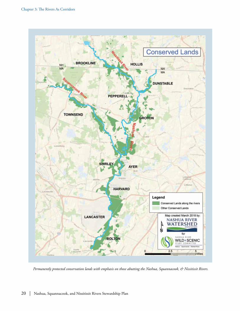
Extensive Protected Lands: Including Oxbow National Wildlife Refuge and Bolton Flats Wildlife Management Area. The Nashua, Squannacook, and Nissitissit Rivers are ecological and biological corridors; animals use them as habitat and for passage. The Massachusetts Audubon Society, in a report entitled “Focus Areas for Wildlife Habitat Protection in the Nashua River Watershed,” points out that the river valleys serve as both wildlife habitat corridors and natural south-north migration routes for terrestrial and aquatic fauna and flora set within a context of contiguous undeveloped and, in many cases, permanently protected land.12
Efforts to protect major tracts of riparian land have already met with significant success in the region covered by our Stewardship Plan. The various
Squannacook River. Photo: Joan Wotkowicz.
20 | Nashua, Squannacook, and Nissitissit Rivers Stewardship Plan
Chapter 3: The Rivers As Corridors
Permanently protected conservation lands with emphasis on those abutting the Nashua, Squannacook, & Nissitissit Rivers.

Nashua, Squannacook, and Nissitissit Rivers Stewardship Plan | 21
Chapter 3: The Rivers As Corridors
conservation lands in our study area are crucial stepping-stones for wildlife movement north from the anchor that is the Oxbow National Wildlife Refuge (ONWR).13
The “Oxbow/Intervale/Bolton Flats” area is also cited in a report, Focus Areas for Wildlife Habitat Protection in the Nashua River Watershed, as a large wildlife habitat focus area of ~8,500 acres. These areas with large amounts of little-disturbed interior are “cornerstones of a habitat reserve design for the Nashua River Watershed….Tracks of bobcat, black bear and moose have been recorded within this focus area. Bobcats are particularly sensitive to human disturbance and their presence in an area is a very strong indicator of high quality habitat.”14
13 For example, the ONWR beneath the Route 2 Bridge over the Nashua River is one of the few locations for wildlife to cross the barrier created by that heavily trafficked highway.
14 Harvard Open Space and Recreation Plan, 2016, page 35.
Additional Protected Lands. In addition to the Oxbow National Wildlife Refuge—which alone protects eight miles along the Nashua River—the Nashua, Squannacook, and Nissitissit River corridors provide linear linkages among several other sizeable public conservation lands in the region covered by our Stewardship Plan. Noteworthy examples are
Eight miles of the Nashua River run through the Oxbow National Wildlife Refuge. The
Refuge serves as an anchor in a series of substantial conservation lands in our area that are crucial stepping-stones for wildlife movement northward.
Map of “Proposed Preserve Area” for the Nissitissit River in Brookline and Hollis, NH and in Pepperell, MA by NH Division of Economic Development, 1967. At the time of this proposal, it was suggested that protecting “this river in a joint project with
Massachusetts….would be comparable to some of the ‘Wild River’ projects of the national government.”

22 | Nashua, Squannacook, and Nissitissit Rivers Stewardship Plan
Chapter 3: The Rivers As Corridors
the Ayer State Game Area, Bolton Flats Wildlife Management Area (WMA), Groton Town Forest, J. Harry Rich State Forest, Sabine Woods, Squanna-cook and Nissitissit River WMAs, Surrenden Farm, and Townsend State Forest.
Much of the remaining unprotected riparian land enjoys partial protection under the 1996 Massachusetts Rivers Protection Act and under local floodplain zoning bylaws.
A draft GIS analysis of the one quarter mile corridor of the three rivers (in Massachusetts only) shows a total of approximately 16,825 acres of floodplains, of which approximately 15,715 acres is permanently protected; that is, more than 93% of all floodplains are protected and only less than 7% (~1,100 acres) is unprotected to date.15
The focus of the very first Nashua River Watershed Association “Greenway Committees” (circa 1969) was to encourage each town to have a greenway committee and “floodplain protection” zoning bylaws. Lancaster was the first town to have such a
15 Nissitissit River (in Massachusetts only): ~3,200 acres floodplain total in corridor with ~3,135 acres protected and ~65 acres unprotected (98% protected or 2% unprotected). Squannacook River: ~4,800 acres floodplain corridor total in corridor with ~4,570 acres protected and ~230 acres unprotected (95% protected or 4.75% unprotected). Nashua River (mainstem in Massachusetts only): ~ 8,825 acres floodplain corridor total in corridor with ~8,010 acres protected and ~815 acres unprotected (91% protected or 9% unprotected).
greenway committee. The largely protected corridors of the Nashua, Squannacook, and Nissitissit Rivers continue into New Hampshire through holdings of
The Boards of Selectmen from Ayer, Harvard, Lancaster and Shirley said it best in their 1991 mission statement relating
to the closure of Fort Devens:
“We recognize the unique and valuable natural resources within the region. Future open space for scenic, natural resources, or recreational purposes is an integral part of our overall objectives. Natural resources, including wetlands, rivers, aquifers, soils and wildlife, are interconnected systems knowing no town borders. Development activities in one town can have dramatic impact on a neighboring town. Therefore, effective natural resource protection within reuse planning can only be achieved through multi-town cooperation.”
Nissitissit River and greenway corridor. Photo: Cindy Knox Photography.
Nashua, Squannacook, and Nissitissit Rivers Stewardship Plan | 23
Chapter 3: The Rivers As Corridors
the Brookline Conservation Commission, Nissitissit River Land Trust, and Beaver Brook Association (~2,200 acres) in Hollis16 and Brookline. As far back as 1963, the New Hampshire Natural Preserves Forum wrote, “An attempt should be made to protect this [Nissitissit] River in a joint project with Massachusetts. On a small scale, this would be comparable to some of the `Wild River’ projects of the national government.”17
16 Beaver Brook, a significant tributary to the Nissitissit River, flows through Beaver Brook Association’s lands and has its confluence with the Nissitissit River at the Hollis, New Hampshire and Pepperell, Massachusetts state line.
17 New Hampshire Natural Preserves Forum, 1963.
Hollis, New Hampshire is fortunate to contain what is probably the largest concentration of conservation land in the south central New Hampshire region. Extensive conservation holdings are located throughout the town. This category includes private conservation lands held by Beaver Brook Association, the Nissitissit River Land Trust, homeowners associations, and other groups as well as the town. Beaver Brook Association owns the largest concentration of land in Hollis with 1,643 acres (out of a total of ~2,200 acres). The Nissitissit River Land Trust owns 65 acres, forming a protective corridor along the Nissitissit River. The town owns most of the remaining conservation land. The acquisition of most of the conservation and recreation land in Hollis has resulted in the formation of a greenway system that connects natural areas.
A semi-circular pattern has emerged that stretches from the Nissitissit River in the town’s southwestern
Hollis contains a large concentration of conservation land in the south central New Hampshire region.
A greenway system has been established that includes a protective corridor along the Nissitissit River in Hollis and Brookline. Brookline’s recent purchase of 75 acres with a half mile of river frontage does much to complete the Nissitissit River greenway.
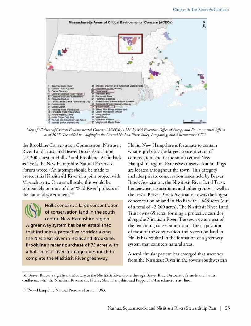
Map of all Areas of Critical Environmental Concern (ACECs) in MA by MA Executive Office of Energy and Environmental Affairs as of 2017. The added box highlights the Central Nashua River Valley, Petapawag, and Squannassit ACECs.

24 | Nashua, Squannacook, and Nissitissit Rivers Stewardship Plan
Chapter 3: The Rivers As Corridors
extreme, northerly through the vast holdings of the Beaver Brook Association toward Silver Lake State Park and Spalding Park Town Forest north of Town Center. In recent years, the pattern has been recognized and efforts have been made to fill in the remaining gaps.
Importance of Connectivity. Throughout our area, extensive open spaces connected by riparian corridors create a synergistically larger, unified entity from what would otherwise be fragmented areas.18 In other words, maintaining the connectivity of ecologically and biologically diverse open spaces and habitats is important at the regional scale because connectivity gives the components of our shared landscape the resilience needed to survive challenges, such as warming weather patterns, better than isolated areas can. Importantly, the extensive riparian corridors of the Nashua, Squannacook, and Nissitissit Rivers are further extended by greenways along each of their tributaries.
In a 1992 survey, the US Fish and Wildlife Service stated "...the value of large, contiguous undeveloped areas for species longterm protection outweighs exponentially that of an equal area of disjunct refugia spread among suburban environs.”19 The quantity of rare species found in our area confirms this.
The science of landscape ecology tells us that where lands are still interconnected, ecological processes are more likely to persist in a continuous system to provide dispersal corridors, which protect local pop-
18 R.J. Naiman, “The Role of Riparian Corridors in Maintaining Regional Biodiversity,” (Ecological Applications Vol. 3, No. 2, May 1993).19 US Fish and Wildlife Service, “Survey and Evaluation of Wetlands and Wildlife Habitat,” (Fort Devens Massachusetts, 1992, page 71).20 South to north corridors in New England are particularly important in a time of warming weather patterns as species must evolve their ranges northward; see https://climateactiontool.org.21 ACECs are a formal designation made by the Massachusetts Secretary of Energy and Environmental Affairs to protect and preserve areas of environmental significance. [There is no comparable New Hampshire program.] The designation notifies regulatory agencies and the public that most development activities under State jurisdiction within ACECs must meet high environmental quality standards. The fundamental reason for these designations is the need to protect both open spaces and the interconnections that are essential to maintaining the biological diversity of the entire region.22 Nashua River Watershed Association, “Regional Plan for the Nashua River Greenway,” (1970).
ulations from chance extinction events, and provide opportunities for regional recolonization and genetic flow to outside populations. Here in New England, that is primarily from the south to the north.20 The region covered by our Stewardship Plan has high ecological integrity and is a resource-rich unit that has been recognized by the State of Massachusetts as three unique Areas of Critical Environmental Con-cern (ACEC): the Central Nashua River Valley, the Squannassit, and the Petapawag ACECs. These three contiguous ACECs together comprise 76,000 acres or 118 square miles—a full 28% of the total existing ACECs throughout Massachusetts.21
The connectivity of the three ACECs via the Nashua River provides significant linkages between important wildlife areas. Indeed, when one includes MassWildlife’s Bolton Flats Wildlife Management Area, the amount of open space along the Nashua River creates what could be the largest, least hu-man-impacted habitat in the entire 530+ square mile Nashua River watershed.
Efforts to protect our key resources go back many decades. Prepared by the Nashua River Watershed Association, the first Regional Plan for the Nashua River Greenway called for “protecting the watershed; providing habitat for wildlife; conserving the ecology; preventing future river pollution; providing open space and outdoor recreation opportunities; maintaining high water quality; increasing property values; enhancing the general economy; and provid-ing a population buffer zone.”22

Nashua, Squannacook, and Nissitissit Rivers Stewardship Plan | 25
Chapter 3: The Rivers As Corridors
Some Additional Influential Conservationists
William P. Wharton. Benton MacKaye was not the only influen-tial conservationist with roots in our area who recognized the importance of river corridors. William P. Wharton (1880–1976) of Groton, Massachu-setts, a contemporary and friend of Benton MacKaye, was an incorporator of both the Nashua River Watershed Association and the New England Forestry Foundation, as well as a President of the National Parks Association. Wharton was an advocate of numerous local as well as national conservation projects. He, along with his friend Harris Reynolds, is also credited with introduc-ing the idea of the Town Forest into the United States.23
Ellen Swallow Richards. Ellen Swallow Richards of Dunstable is another important conservationist; she is credited with establishing the field of ecology in the 1890s. The area was also the home of the Lowthorpe School, the second school of Landscape Architecture in the United States, where numerous leading landscape architects studied. Noted land-scape architect and Harvard professor Charles Eliot II was a patron of the school. In 1963, Eliot also wrote Groton’s first Master Plan as well as Harvard’s in 1969, both of which introduced advanced con-cepts of environmental protection and planning.
23 Massachusetts Forest and Park (Association) News, (August 1970, page 98).
24 1964 was also the year that the Town of Hollis was the first in New Hampshire to form a municipal Conservation Commission.
Jeffrey P. Smith. In 1923, Jeffrey P. Smith (1902–1987) inherited the ne-glected “Buttonwood Farm” in Hollis, New Hampshire and devoted the next 40 years to dairy farming. After retiring, he began championing limited growth and conservation, having become troubled about rapid population growth in Hollis and surrounding communities. Smith’s cousin, Hollis Nichols, joined with him in acting on their shared interest: acquiring land for conservation. Beginning with Hollis’s own estate, in 1964 Smith and Nichols organized Beaver Brook Association to protect local land from development.24 During the next decade and a half, with help from gifts of money, they were able to negotiate 86 different purchases totaling 1,500 acres, including Smith’s own 200 acres gifted to Beaver Brook Association. Today, Beaver Brook Association has more than 2,200 acres.
William P. Wharton (1880-1976). Photo: www.williampwhartontrust.org.
Jeffrey P. Smith (1902–1987). Photo: www.beaverbrook.org.
Ellen Swallow Richards (1842-1911). Photo: The Life of Ellen H. Richards by Caroline L. Hunt.
26 | Nashua, Squannacook, and Nissitissit Rivers Stewardship Plan
Chapter 3: The Rivers As Corridors
Jeffrey P. Smith also influenced the formation of other land trusts. He helped organize the Nissitissit River Land Trust founded in 1968,25 which is dedicated to protecting all of the land along the Nissitissit River, much of which has now been protected. Smith additionally joined with three Pepperell residents to form the Nashoba Conserva-tion Trust in 1969 and is the Smith of the epony-mous Nichols-Smith Land Trust. The “Jeff Smith Trail”—eight miles over parcels of land in Hollis and Pepperell that are owned by organizations helped by Smith—was created to permanently honor Smith’s life-long efforts. Smith also helped establish the Hollis Conservation Commission, which in 1966 petitioned New Hampshire’s Governor Peterson to stop the pollution of the Nashua River. The Commission then contacted Massachusetts conservation commissions along the Nashua River to describe what Hollis had done and to ask them to do the same.
Marion Stoddart. Marion Stoddart is recognized by many to be our area’s most influential champion of the rivers and the river corridors. Moving to Groton in 1962, Stoddart was appalled by the befouled condition of the Nashua River. In 1965, she formed the Nashua River Clean-Up Committee and galvanized a grassroots movement to address the situation. The Clean-Up Committee evolved to become the Nashua River Watershed Association (NRWA), formalized in 1969 with Benton MacKaye, Lee P. “Bill” Farnsworth, Jeffrey P. Smith, Marion Stoddart, and William Wharton, among others, as incorporators.
25 “It so happened that in 1962 a group called the New England Wildflower Preservation Society conducted a field trip along those 9 miles [of the Nissitissit River]. The field trip led the New Hampshire Natural Preserves Forum to list the river as ‘worthy of preservation.’ That in turn led to the formation of the Nissitissit River Land Trust, incorporated in 1968.” www.brookline.nh.us/conservation-commission/pages/nissitissit
From its outset, the NRWA took a collaborative watershed approach to protecting natural resources and highlighted the inextricable link between water quality and land use in all its initiatives. The NRWA’s earliest plans called for the establishment of permanently protected greenway along the river and its major tributaries.
Our Rivers Today
Today, the Nashua, Squannacook, and Nissitissit river corridors support outstandingly remarkable biological and ecological diversity. They also support outstandingly remarkable opportunities for recre-ation, for enjoyment of scenic views, and for appreci-ation of historical events that shaped our region. This Stewardship Plan for the Nashua, Squannacook, and Nissitissit Rivers, developed through a locally-driven process, outlines voluntary actions that can be taken to maintain and enhance our outstandingly remark-able resource values.
Marion Stoddart, together with others, has worked for over five decades to fulfill the vision of
permanently protected greenway along the river and its major tributaries. Today, more than 50% of the greenway along the Nashua, Squannacook, and Nissitissit Rivers is permanently protected.
Marion Stoddart (born 1928) with her three children, circa early 1960s. Photo: NRWA Archives.

Nashua, Squannacook, and Nissitissit Rivers Stewardship Plan | 27
Nissitissit River in Brookline, NH. The properties on either side of the river were purchased in 2017 by the Town of Brookline with the help of several local and regional land trusts, thereby adding 75 acres of permanently protected land to the Nissitissit River greenway.
Photo: Birch Three Photography.
Geography. The Nashua River watershed includes parts of 32 communities in Massachusetts and New Hampshire, with a total drainage area of approximately 538 square miles. The mainstem Nashua River flows for a total of 37 miles before joining with the Merrimack River at Nashua, New Hampshire. The Nashua River and its tributaries have some highly unusual characteristics. The majority of the tributaries that feed the mainstem of
the Nashua River flow in a southerly direction, while the mainstem flows in a northerly direction. The North Nashua River begins in the former industrial centers of Fitchburg and Leominster before flowing southeast-wardly into Lancaster. The South Nashua River flows from the Wachusett Reservoir, which serves as part of the water supply for Boston. The two main branches of the river join in Lancaster to form the mainstem, which then flows to its terminus in New Hampshire.
Chapter 4:
Outstandingly Remarkable Resource Valuesand Action Plans
To be included in the National Wild and Scenic Rivers System, a river must meet certain eligibility criteria, including possessing at least one “outstandingly
remarkable resource value” (ORRV in this Plan). An ORRV must be natural, historical, cultural, recreational or scenic in character, be river-dependent, and have unique, rare, or exemplary qualities on a regional or national scale. The Nashua, Squannacook, and Nissitissit Rivers possess a great many such resources that meet these criteria. This chapter describes these resources, which include aspects of biological and ecological diversity, recreational and scenic values, and historical and cultural resources.
The Shaping Forces: Geology, Aquifers, and Ecoregions

28 | Nashua, Squannacook, and Nissitissit Rivers Stewardship Plan
Chapter 4: Outstandingly Remarkable Resource Values and Action Plans
Geology. The bedrock underpinning our study area is made up of two types of rock: granite and other igneous types; and metamorphic, primarily schist and gneiss. Over ten thousand years ago, the Nashua River valley was carved by moving glacial ice that was over one mile thick. The Nashua River itself was once Glacial Lake Nashua, an enormous lake that extended from Boylston, Massachusetts north to Nashua, New Hampshire. At that time, the mainstem river flowed southward through the Worcester area.
Bedrock and a thin layer of glacial till “hardpan” dominate the higher elevations of the watershed, especially to the west and northwest, where the main tributaries to the mainstem Nashua River rise: the Squannacook and Nissitissit as well the North Nashua, Quinapoxet, and Stillwater Rivers. These relatively cooler (with the exception of the North
26 Reference in the History of Lancaster, regarding the shape of Pine Hill: Rev. Abijah P. Marvin, History of the Town of Lancaster: From the First Settlement to the Present Time, 1643–1879, (Lancaster: Published by the town, 1879).
Nashua River), higher-gradient rivers all flow from the northwest to the southeast and meet the Nashua River at sharp angles, turning to join the mainstem which flows in a northeasterly direction. The flow of the tributaries is additional evidence that the Nashua River used to flow south.26 The river’s course was reversed as the edge of the last ice age glacier melted away, leaving Glacial Lake Nashua to drain to the north. There are many sand and gravel deposits
This map, taken from Abijah Marvins's 1879 History of Lancaster, shows some of that town’s early roads and bridges – at Five Corners and at Lane's Crossing -- on the Nashua River. It also shows a for-mer course of the river meandering in a sinuous manner, which is produced by the river’s swinging from side to side as it flows across its floodplain or shifts its channel within the valley. Also note the “Ancient River Road to Groton,” which may imply that the road followed pre-historic foot paths. Image: Digital Commonwealth,
www.digitalcommonwealth.org/search/commonwealth:02871f57x.
The Nashua River’s course was reversed as the last ice age glacier melted away: it is unusual in
flowing in a northerly direction, while its tributaries flow in a southerly direction.
Map of Glacial Lake Nashua, an enormous lake that extended from Boylston, MA north to Nashua, NH, that flowed southward through the Worcester area. The Nashua River’s course to the South
was reversed as the edge of the last ice age glacier melted away, leaving what remained of Glacial Lake Nashua to drain to the
north. Image: Campbell, Marius R. (Marius Robinson), 1858-1940; Geological Survey (U.S.).

Nashua, Squannacook, and Nissitissit Rivers Stewardship Plan | 29
Chapter 4: Outstandingly Remarkable Resource Values and Action Plans
dating from the glacial period in the central part of the valley. These porous deposits often have accessi-ble groundwater used as municipal water supplies.
There is considerable landscape-level geomorpholog-ic variation within our focus area, which is character-ized by topography dominated by glacially-shaped geological forms and river valleys underlain by aquifers. Not surprisingly, it has many glacial arti-facts: kettlehole ponds with fluctuating water levels; spruce bogs, kame terraces, and eskers; and sandy outwash soils. Such soils act as a recharge area in large floodplains, which support many types of rare flora. Not only is the area especially rich in diverse wetland habitats because of the meandering Nashua River, but there is also an unusual amount of field, floodplain grassland, and wet meadow habitat due to the river’s oxbows and wide floodplains.
Glacially-shaped river valleys underlain by aquifers characterize our landscape, which has many
glacial artifacts such as kettle ponds and drumlin swarms. Red Maple - Birch Wood Swamp along Squannacook River.
Photo: Kim King.
Name Registration* Volume (mgd)
Current Permit Volume (mgd)
Total Authorized Volume (mgd)
Ayer DPW Water Division 0.82 0.5 1.32Groton Water Department NA 0.3 0.3Devens 1.35 3.45 4.8MCI Shirley 0 0.54 0.54Pepperell Water Department 0.74 0.56 1.3Shirley Water District NA 0.31 0.31Townsend Water Department 0.76 0 0.76West Groton Water District 0.27 0 0.27Epic Enterprises, Inc. (Ayer) 0 0.15 0.15Hollingsworth & Vose (Groton) 2.42 0 2.42International, Inc. (Bolton) 0.2 0.15 0.35
MA Water Withdrawals (2017)
* Registration Volume is the volume of water registered with the MA Department of Environmental Protection. Since 1988, persons planning to withdraw water from ground or surface sources for purposes in excess of an annual average of 100,000 gallons per day or 9 million gallons in any three-month period must apply for a Water Management Act Permit. Withdrawers with a Water Management Registration do not need a permit if they do not increase withdrawals over their registered volumes or add any new withdrawal points to their system.

30 | Nashua, Squannacook, and Nissitissit Rivers Stewardship Plan
Chapter 4: Outstandingly Remarkable Resource Values and Action Plans
Aquifers in MA (gallons/minute yield) & in NH (feet/day transmissivity). Note how the river valleys correspond to underlying aquifers.

Nashua, Squannacook, and Nissitissit Rivers Stewardship Plan | 31
Chapter 4: Outstandingly Remarkable Resource Values and Action Plans
Note: There are other considerable “ecosystem service” benefits associated with wetlands and floodplain grasslands: because of their high rates of production they are second only to rainforests in removing carbon from the atmosphere, thereby moderating warming temperatures; removing surplus nutrients from overland runoff; and preventing these and other pollutants from entering our rivers.
Aquifers. High-yield, high-productivity aquifers, defined as more than 300 gallons per minute, are found under several of our communities and are tapped as municipal sources of public drinking water supplies. For example, Pepperell depends on ground-water for both public and private wells, with 80% of the households dependent on its three municipal public wells. The Devens Regional Enterprise Zone (former Fort Devens military base) has three grav-el-packed wells that provide nearly five million gallons per day of potable drinking water to the more than 90 businesses and 100 families that call Devens home. The West Groton Water Supply District operates wells on the bank of the Squanna-cook River. The Shirley Water District is Massachu-setts’s first ever Water District; it manages four gravel packed wells, supplying over 4,500 customers in Shirley and surrounding communities.
In Townsend, recognition of the importance of its high-yield aquifer came with the passage of the 1986 Aquifer Protection Overlay District Bylaw, which protects the aquifer from new structures and uses considered hazardous. The Wekepeke aquifer under portions of Lancaster is another high-yield aquifer, which provides a municipal backup well and could be a potential public water source for a larger region.
In Hollis, two districts provide direct protection to groundwater resources. The first district, the Water Supply Conservation Zone, includes the entire stratified drift aquifer between Federal Hill Road and Proctor Hill Road (Route 130). The intent of the
27 Hollis, New Hampshire, “1998 Master Plan Update,” (Adopted by Hollis Planning Board on March 16, 1999).
28 Dianne Timmins, personal communication on February 11, 2018.
zone is to protect the drinking water supply for the school system and the town center area. The second district is the Aquifer Protection Overlay Zone. This district encompasses those areas designated as stratified drift by the United States Geological Survey in its 1986 study of the region. The district prohibits uses that would have a potential negative impact on groundwater quality. The Nissitissit River Valley aquifer, in the southwestern corner of Hollis, has a saturated thickness of only 20 feet; however, this aquifer has a transmissivity greater than 8,000 square feet per day and potential for induced infiltration from the Nissitissit River.27
Groundwater and surface water is closely linked in the glaciated terrain of New England. Ground-water provides vital recharge to streams and other water-dependent areas, such as wetlands. Dianne Timmins, Coldwater Fisheries Biologist, New Hampshire Fish and Game Department: “[ground-water is] critical to brook trout spawning success. We are studying this more in depth as we speak but preliminary data from the Dead Diamond watershed indicates increased success in areas with groundwater influence. The documented spawning sites all have groundwater plumes where the brook trout are building their redds (nests).”28
As a major aquifer recharge area, the Nashua River valley stores floodwaters and precipitation in its nu-merous wetlands and sandy glacial soils. Maintaining flood storage capacity within the Nashua River valley is critical to preventing flooding downstream. Where the valley broadens, the river and stream beds have a flatter slope than areas upstream; where the flood-plains and associated wetlands widen, the permeable
Two overlapping forest types in our region create a transition zone that supports especially rich biodiversity.

32 | Nashua, Squannacook, and Nissitissit Rivers Stewardship Plan
Chapter 4: Outstandingly Remarkable Resource Values and Action Plans
sand and gravel floodplains percolate the floodwaters and act as a giant holding tank, minimizing flood damage downstream.29
Ecoregions. Our focus area occurs in an area of overlap of two major forest types: the Northern Hardwoods (a mixed group of sugar maple, ash, beech, and birch) and Central Hardwoods (a group dominated by oaks with some hickories). Thus, the forest vegetation of the study area is a mix of northern and central hardwoods interspersed with hemlock and white pine. These two forest types now mingle in the Nashua River watershed in what is called the transition zone, giving us a wonder-fully diverse array of forest types to enjoy today. Additionally, the varied topography ranges from the “Worcester Monadnock Plateau” sub-ecoregion30 in the steeper headwater sections, to more gently rolling terrain, to generally flat lowland river valleys in the east in the large “Gulf of Maine (Southern New England) Coastal Plain” sub-ecoregion. Because of this elevation and topographical differ-ence, the change in habitat over a small distance
29 ACEC Nomination Report, “Central Nashua River Valley,” pages 5-6.30 In southcentral New Hampshire this same ecoregion is described as “Hillsboro Inland Hills and Plains” (see www.wildlife.state.nh.us/wildlife/images/wap11x17-habitat2015.jpg).31 G. Motzkin et al., “Controlling site to evaluate history: vegetation patterns of a New England sand plain,” Ecological Monographs, 66: 345-365 (1996).
can be dramatic.
Grassland habitats decreased in New England with farm abandonment in the late 1800s and have become increasingly less common with suburban sprawl and the regeneration of our forests. Yet within portions of our area, especially along the Nashua and Squannacook River floodplains, open fields are relatively widespread because farming is still active. Some areas are deliberately maintained as early successional habitats in order to preserve wildlife diversity. Examples of this can be found in several conservation parcels in our focus area that are mowed annually to maintain an herbaceous community, such as the Watt Farm, which is part of the Oxbow National Wildlife Refuge.
It is interesting to note that historically untilled patches of forest are more likely to have higher native biodiversity than areas that were tilled and supported row crops. Dense patches of wintergreen (Gaultheria procumbens) have been shown to be more abundant in unplowed than plowed lands.31 Wintergreen
Map of Massachusetts ecoregions by MassAudubon. The red circle highlights the location of our region.

Nashua, Squannacook, and Nissitissit Rivers Stewardship Plan | 33
Chapter 4: Outstandingly Remarkable Resource Values and Action Plans
patches in large areas, for example as can readily be found along the Squannacook River, suggest that these lands have been continuously forested and likely support a greater biodiversity of microflora and fauna, as well as vascular plants, than nearby areas that were tilled.
The geology, aquifers, and ecoregions are shaping forces that give rise to many aspects of our three categories of Outstandingly Remarkable Resource Values: Biological Diversity, Recreational and Scenic, and Historical and Cultural.
Also, K. Donohue et al., “Effects of the past and the present on species distributions: land-use history and demography of wintergreen,” Journal of Ecology 88: 303-316 (2000). Thanks to Pat Swain Rice, recently retired natural community ecologist for the Massachusetts Natural Heritage Endangered Species Program (NHESP) and author of Classification of Natural Communities of Massachusetts, for bringing this to our attention.
Wintergreen (Gaultheria procumbens) can be an indicator that the soils where this plant grows in dense patches have never been
plowed under. Photo: Dryas Wikimedia Commons.

34 | Nashua, Squannacook, and Nissitissit Rivers Stewardship Plan
Chapter 4: Outstandingly Remarkable Resource Values and Action Plans
Potential Threats to Our Three ORRVs
The Study Committee also identified some existing and future threats that could degrade the quality of each of the three ORRVs of the Nashua, Squannacook, and Nissitissit Rivers.
Potential threats to Biological Diversity ORRVs include, but are not limited to:• Habitat loss and fragmentation• Significant riparian corridor land use alterations• Non-point source pollution• Terrestrial and aquatic non-native invasive species• Changes in local weather patterns such as increased intensity of drought and severe rain events
Potential threats to Recreational and Scenic ORRVs include, but are not limited to:• Insufficient maintenance of access points on the rivers• Increase of invasive aquatics such as the water chestnut infestation at Pepperell Pond• Loss of opportunities to connect trails and expand the trail network• Insufficient public signage in some communities regarding the existing trail network• Increased inappropriate siting of alternative energy installations
Potential threats to Historical and Cultural ORRVs include, but are not limited to:• Lack of on-going education regarding early conservationists• Under-utilization of the “Marion Stoddart Story” as inspiration and as a model• Potential lack of continuity on collection of water quality monitoring data to document
river renewal• Inadequate attention to some river-related historical and cultural sites• Need for additional education of both adults and youth regarding watershed health
Why Some Recommended Actions Appear in the Suggested Strategies for Multiple ORRVs
The three categories of Outstandingly Remarkable Resource Values that have been identified for the Nashua, Squannacook, and Nissitissit Rivers are inextricably linked with each other. Thus it is not
surprising that a recommended action item that might protect a biological diversity value could be the same, or very similar, to a recommended action item suggested to protect a recreational and scenic value, and indeed also a historical and cultural value. Suggested actions to maintain or expand a naturally vege-tated buffer along the rivers is an example of a recommended action fitting in all categories. The Nashua River Wild and Scenic River Study Committee decided to support this seeming duplication, especially as there might be instances where a user of the Plan would, for their own interests, focus on only one category. We would want the set of recommended actions considered by such a user to be “complete.”

Outstandingly Remarkable Resource Values
Nashua, Squannacook, and Nissitissit Rivers Stewardship Plan | 35
Chapter 4 | Outstandingly Remarkable Resource Values and Action Plans
Biodiversity. Biological and ecological diversity in the area can be measured by the sheer number of species and by the number of species assemblages (natural communities of plant and animal species that share a common environment and occur togeth-er repeatedly on the landscape). Abundant wetlands, grasslands, and uplands shelter many rare species, most of which need more than one habitat to sur-vive, or depend upon increasingly rare habitats.
Another benefit of the protected areas around our area’s several aquifers is that many Massachusetts Natural Heritage and Endangered Species Program (NHESP) Priority and Estimated Habitats are found overlying them.
Having a high number of state-listed rare species in the focus area is largely a function of the existence of intact special habitats and/or natural communities and the large extent of contiguous open space. The
ORRV Category: BIOLOGICAL DIVERSITY
A consequence of the confluence of distinct ecoregions and transitions between them, as described in the preceding “Shaping Forces” section of this Chapter, is that our
area supports outstanding overall biodiversity. While area residents delight in sightings of a vast array of flora and fauna—including cardinal flowers along the shores, a bobcat refreshing itself with a drink of river water, and bald eagles soaring above the water-ways—it is the turtles, fish, mussels, and dragonflies, in part, that help define our rivers as having rare, unique, or exemplary features meriting Wild and Scenic designation.
Bobcat along Nashua River in Pepperell, MA -- the only wild cat still found in MA and NH. Photo: Andrew Padla and Deb Taylor.
Cardinal flower (Lobelia cardinalis), a common wetland plant often seen along our rivers. Photo: Elizabeth Ainsley Campbell.
Bald eagle. Once extirpated from our region and declared a federally-protected Endangered Species, this bird has made a
remarkable recovery to the point where it has been relisted from “Endangered” to “Threatened” status. Photo: Christine Guertin.

36 | Nashua, Squannacook, and Nissitissit Rivers Stewardship Plan
Chapter 4 | Outstandingly Remarkable Resource Values and Action Plans
Nashua, Squannacook, and Nissitissit Rivers—as well as the Unkety Brook tributary to the Nashua River—are described by NHESP in its 2012 “Bio-Map2: Conserving the Biodiversity of Massachusetts in a Changing World” report as:
…the watery framework for a complex landscape that supports an exceptionally high number of rare and uncommon species. Forty-one such turtles, dragonflies, freshwater mussels, salamanders, plants and other species inhabit these rivers, brooks, and vernal pools. Good populations of the globally rare Brook Floater mussel inhabit the Nissitissit River, while the equally rare Ringed Boghaunter dragonfly can be found in four boggy sites across this large Core Habitat.32
32 Natural Heritage and Endangered Species Program, BioMap2: Conserving the Biodiversity of Massachusetts in a Changing World (2012).
33 NHESP Priority Types of Natural Communities at www.mass.gov/eea/docs/dfg/nhesp/natural-communities-facts/priority-natural-commun.pdf and Natural Community Fact Sheets at www.mass.gov/eea/agencies/dfg/dfw/natural-heritage/natural-communities/natural-community-fact-sheets.html. Note that there are no corresponding state designations of either Priority Natural Communities or BioMap in New Hampshire.
Priority Natural Communities. The Nashua River corridor consists of significant portions of terrestrial habitat designated by the Commonwealth’s BioMap2 project as “core habitat,” representing the highest priority for biodiversity conservation and protection. (www.mass.gov/eea/agencies/dfg/dfw/natural-heritage/land-protection-and-management/biomap2/)
Additionally, six Massachusetts NHESP exemplary or “Priority Natural Communities”33 occur along the Nashua River:
• Kettlehole Level Bog (Groton)• Pitch Pine–Scrub Oak Community (Lancaster)• Red Maple–Black Ash Swamp (Ayer)• Alluvial Red Maple Swamp (Harvard)• Small-River Floodplain Forest (Ayer)• High-Terrace Floodplain Forest (Bolton
and Lancaster)
“Pitch Pine – Scrub Oak Community” in the Bolton Flats State Wildlife Management Area in Lancaster, MA: a MA state-designated “Priority Natural Community,” which is state-ranked as “S2: imperiled.” This is a globally rare, fire-dependent shrub-dominated
community with scattered trees and occasional openings, occurring on dry, poor, usually sandy, soils, which provides habitat for many rare species. Photo: Chris Buelow.
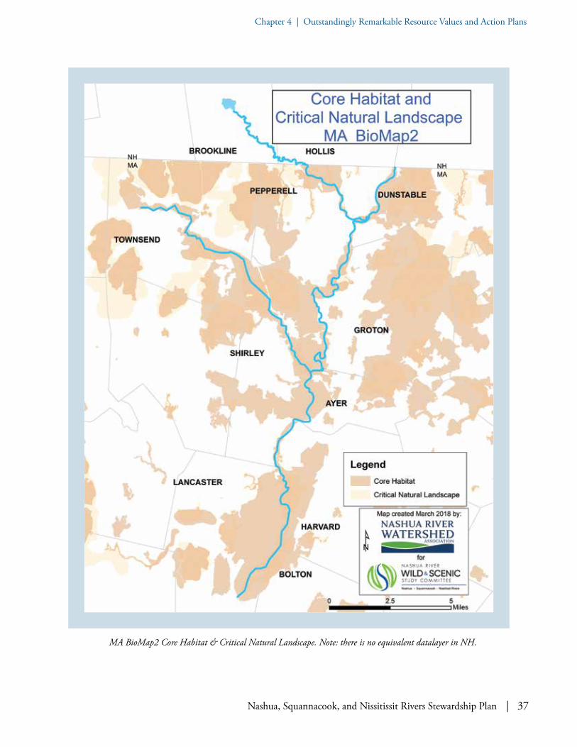
Nashua, Squannacook, and Nissitissit Rivers Stewardship Plan | 37
Chapter 4 | Outstandingly Remarkable Resource Values and Action Plans
MA BioMap2 Core Habitat & Critical Natural Landscape. Note: there is no equivalent datalayer in NH.

38 | Nashua, Squannacook, and Nissitissit Rivers Stewardship Plan
Chapter 4 | Outstandingly Remarkable Resource Values and Action Plans
MA BioMap2 Priority Natural Communities along the Nashua River. Note: there is no equivalent datalayer in NH.

Nashua, Squannacook, and Nissitissit Rivers Stewardship Plan | 39
Chapter 4 | Outstandingly Remarkable Resource Values and Action Plans
Since few intact floodplain forests remain in New England, these are considered to be among the rarest forest type in the region.34 Also, MassWildlife has made the Pine Hill area, adjacent to the Nashua River in Lancaster, a priority to preserve and to protect because it has some of Central Massachu-setts’s last remaining Pitch Pine–Scrub Oak (PP/SO) patches. PP/SOs are a unique habitat—threatened by forest fragmentation—that occur on outwash sand-plains, which are themselves much reduced in the focus area (and statewide) because of their ease of develop-ment and attractive for sand and gravel mining.
ACECs. There are three Areas of Critical Environ-mental Concern (ACECs) in our focus area: the Central Nashua River Valley ACEC (12,900 acres, 1996); the Squannassit ACEC (37,450 acres, 2002); and Petapawag ACEC — “swamps on a hill” — (25,630 acres, 2002). Massachusetts’s ACECs “…receive special recognition because of the quality, uniqueness and significance of their natural and cultural resource.”35 For example, Petapawag ACEC is most important for the diversity of wildlife and rare species: the NHESP database indicates that there are sixteen state-listed36 rare species and one federally-listed threatened species in this one ACEC.
More specifically, within the Squannassit ACEC, the Nissitissit River sub-watershed includes sightings of American bittern (bird, MA state–listed endan-gered), brook snaketail (dragonfly, MA state–listed Special Concern), spotted turtle (formerly of MA
34 See The Nature Conservancy, New Hampshire: A Question of Flow at www.nature.org/ourinitiatives/regions/northamerica/unitedstates/newhampshire/freshwater/a-question-of-flow-for-floodplain-forests.xml. For more see University of New Hampshire’s Habitat Stewardship Series: Floodplain Forests at https://extension.unh.edu/resources/files/Resource000414_Rep436.pdf .
35 For an overview of the ACEC program, see www.mass.gov/service-details/acec-program-overview.
36 As listed in 321 CMR 10.90, March 10, 2017 “There are 169 species of animals and 258 species of plants that are protected under the Massachusetts Endangered Species Act. These 427 native species are state-listed as Endangered, Threatened, or of Special Concern and are tracked in a database. These species are either at risk, or may become at risk, of extinction. Rarity in the state, population trend, and overall threat are the main criteria used to determine extinction risk.” (www.mass.gov/service-details/list-of-endangered-threatened-and-special-concern-species).
37 Mike Jones, personal communication on December 19, 2016.
38 In speaking of occurrence of wood turtles in Lancaster, Massachusetts, Agassiz says it “is so common in the neighborhood. ... that I have at times collected over one hundred specimens in an afternoon ...” Louis Agassiz, Contributions to the Natural History of the United States, (Little Brown and Company, vol. 1, 1857) page 294.
state–listed Special Concern and NH state-listed threatened), and wood turtle (MA and NH state–listed Special Concern). The Squannacook River corridor has several records of rare species including the marble salamander (threatened), Blanding’s turtle (threatened in Massachusetts and petitioned for federal listing; see https://ecos.fws.gov/ecp0/profile/speciesProfile?spcode=C05M ), creeper (mussel, MA state–listed Special Concern), bridle shiner (fish, MA state–listed Special Concern), and wood turtles (MA state–listed Special Concern).
Note: According to Mike Jones, Massachusetts State Herpetologist:37
…the Nashua [River] is also the site of some of the earliest scientific observations on wood turtles, which need restoration efforts….Beginning in 1854, Sanborn Tenney and Louis Agassiz studied a population in Lancaster, described in Agassiz’ Contributions to the Natural History of the United States.38
The Nashua River corridor has significant terrestrial habitat designated as “core habitat” by
the Commonwealth’s BioMap 2 project, and there are six “Priority Natural Communities” along the Nashua River.

40 | Nashua, Squannacook, and Nissitissit Rivers Stewardship Plan
Chapter 4 | Outstandingly Remarkable Resource Values and Action Plans
MA Areas of Critical Environmental Concern (ACECs) in our area. Note: there is no equivalent program and designation in NH.

Nashua, Squannacook, and Nissitissit Rivers Stewardship Plan | 41
Chapter 4 | Outstandingly Remarkable Resource Values and Action Plans
The Nashua River corridor provides breeding and migration habitat for listed bird species such as king rail, pied-billed grebes, and common moorhens, and provides potential habitat for American and least bittern as well as the blue spotted salamander and the water shrew, both of which are dependent on the interspersion of wetland and terrestrial habitats.
Turtles. Our focus area is also the home of the largest known population of state-listed Blanding’s turtle: according to herpetologist Brian Butler, ours is the only core Blanding’s habitat in Massachusetts. Mike Jones, Massachusetts State Herpetologist, writes, “the Nashua River watershed supports the largest contiguous and unfragmented population of Blanding’s in Massachusetts.”39 NHESP calls it “…a very significant population, possibly the largest
39 Mike Jones, personal communication on December 19, 2016.
40 See Area of Critical Environmental Concern: Designation of the Central Nashua Valley ACEC.
41 www.fws.gov/northeast/ecologicalservices/turtle/species/blandingsturtle.html.
42 From 1998 through 2000, the Massachusetts NHESP surveyed sites across the state for state-listed rare reptiles and amphibians, eventually choosing nine areas as potential “herp reserves” because of the presence of multiple rare herptile species, relative lack of habitat fragmentation, and diversity of wetland types interspersed with undeveloped uplands. The reserve areas were delineated around known rare species sites based on dispersal distances and habitat use for each rare herptile species represented at a site, so that the population of each species could have a high likelihood of long-term persistence. The proposed 6,700-acre Squannacook Herp Reserve would have been almost completely incorporated into the eastern portion of the Squannassit ACEC,
in New England.”40 According to the Commonwealth’s BioMap2, Blanding’s turtles use many parts of this landscape throughout their decades-long lives, from feeding and over-wintering in deep vernal pools and buttonbush shrub swamps to nesting in open, sunny, well-drained fields and abandoned gravel pits. Because of their extensive movements over the course of the year, Blanding’s turtles require larger landscapes than many other turtle species.41
Loss of only a few adults annually can cause popu-lations to decline as they do not reproduce until late in life (14–20 years), and they have low replacement rates due to low nest and juvenile survivorship. Roads are the primary cause of adult mortality. Despite concerns about the ongoing decline attributable to the lack of suitable nesting sites and continued road mortality, this local population appears to be healthy and growing—it is a regional stronghold—and will continue to do so as long as their travel corridors and habitats are protected. Indeed, in 2002, the region was being considered as having two of only nine “state herpetofauna reserves” due to the “presence of multiple rare herptile species, relative lack of habitat fragmentation, and diversity of wetland types.”42
Despite concerns about
the decline of the state-listed Blanding’s turtle, our population appears to be healthy and growing. It will continue to do so as long as travel corridors are protected.
Wood turtle (Glyptemys insculpta), which has “Special Concern” status in both MA and NH. Their preferred habitat is riparian areas; they favor slower moving mid-sized streams with sandy
bottoms and densely vegetated stream banks. The stream bottom and muddy banks provide hibernating sites for overwintering,
and open areas with sandy soils near the stream’s edge are used for nesting. Photo: William G. Wilkinson.

42 | Nashua, Squannacook, and Nissitissit Rivers Stewardship Plan
Chapter 4 | Outstandingly Remarkable Resource Values and Action Plans
with a small part in the Petapawag ACEC. This reserve was delineated to protect populations of Blanding’s and spotted turtles and appears to contain the highest density of vernal pools of all nine contemplated herp reserves in Massachusetts. www.mass.gov/eea/docs/dcr/stewardship/acec/acecs/petwag.pdf .
The proposed 18,000-acre Unkety Brook Herp Reserve was to include the northern half of the proposed Petapawag ACEC, plus additional areas. This herp reserve was delineated to protect popula-tions of Blanding’s turtles, spotted turtles (at that time on Massachusetts’s rare species list), and blue-spotted salamanders. Only three of the nine proposed herp reserves were known to harbor more than two of the targeted rare reptiles and amphibians; the proposed Unkety Brook Herp Reserve was one of those three. This herp reserve would have been the largest of the herp reserves delineated across the Commonwealth, if that project had gone forward.
As the Natural Heritage report – unpublished – on the project stated, “...the Unkety site may be key to the persistence of Blanding’s turtles in Massachusetts and may be essential to maintaining connectivity with populations of target species in New Hamp-shire and Maine.”
Additionally, two dozen other state-listed threatened, endangered, or species of special concern exist in the focus area. The majority of fauna on the Massachu-setts List of Endangered, Threatened, or Special
Nissitissit River. Photo: Ken Hartlage.
Blanding’s turtle (Emydoidea blandingii), which has “Threatened” status in MA; conservation status of “State Endangered” in NH.
Image: Arthur C. Wikimedia Commons.

Nashua, Squannacook, and Nissitissit Rivers Stewardship Plan | 43
Chapter 4 | Outstandingly Remarkable Resource Values and Action Plans
MA Coldwater Fisheries Resources (CFR) in our area highlighted in yellow. Note: there is no equivalent datalayer in NH.

44 | Nashua, Squannacook, and Nissitissit Rivers Stewardship Plan
Chapter 4 | Outstandingly Remarkable Resource Values and Action Plans
Concern Species are so designated because of loss of habitat to development. Without places to breed, nest, and find food, they have little chance of longterm survival. Part of the goal of this Steward-ship Plan is to help educate the public about the value of identifying and protecting large contiguous areas of undeveloped land as wildlife habitat.
Fish and Mussels. In 1974, a stream survey of the Nashua River system found only aquatic species most tolerant of pollution. Today, the Nashua River, which is heavily used by recreational anglers, sup-ports a substantial warmwater game fishery including large-mouth bass, chain pickerel, brown trout, fallfish, carp, blacknose dace, black crappie, common and golden shiner, brown bullhead, tesselated darter, yellow and white perch, white sucker, slimy sculpin, and bluegill.43 It is also “fished” by mink, otter, mergansers, bald eagles, osprey, and great blue heron. Brook trout spawn in the tributaries and travel to the Nashua River for part of each year. The burgeoning fish population in the mainstem Nashua River is sus-tained by all the surrounding open water wetlands.
43 Ibid, www.mass.gov/eea/docs/dcr/stewardship/acec/acecs/petwag.pdf.
44 A Coldwater Fisheries Resource (CFR) is a waterbody where reproducing coldwater fish use such waters to meet one or more of their life history requirements. CFRs are particularly sensitive habitats. Changes in land and water use can reduce the ability of these waters to support trout and other kinds of coldwater fish. Identification of CFRs is based on fish samples collected annually by staff biologists and technicians. See: www.mass.gov/service-details/what-is-a-cfr .
45 One may hear that the Native American (Nipmuc) name Squannacook means “place for taking salmon.”
46 USFWS Oxbow National Wildlife Refuge, Final Comprehensive Conservation Plan, February 2005. www.fws.gov/refuge/Oxbow/what_we_do/conservation.html.
American eel exist in the Nashua and Squannacook Rivers, and upstream eel (elvers) passage has been installed at Ice House Dam on the Nashua River, though there is no fish passage.
The Nissitissit River and its tributaries—particularly, Gulf, Mine, and Sucker Brooks—are coldwater fisheries resources44 (“CFR”; Massachusetts Depart-ment of Fish and Game 2015) containing native brook trout. There are over twenty tributaries to the Nashua, Squannacook, and Nissitissit Rivers that are state-defined coldwater fisheries resources—as are the Squannacook and Nissitissit Rivers themselves. The Squannacook River45 supports a native trout population in its upper end, and its main tributaries, Willard, Trapfalls, and Locke Brook, support native brook trout. It is likely that some of these trout find their way into the mainstem Nashua River.46
The Squannacook-Nissitissit Rivers Sanctuary Act (MGL 132A:17, 1975) was passed to protect the Outstanding Resource Waters (ORWs) of these two rivers and associated named tributaries from degradation by new discharges of pollution. Therese Beaudoin, Massachusetts Department of Environ-mental Protection (DEP) Watershed Coordinator, stated in a personal communication:
Native brook trout are found in the Nissitissit and Squannacook Rivers and their tributaries. Twenty
tributaries to the Nashua, Squannacook, and Nissitissit Rivers are state-defined coldwater fisheries resources.
American eel (Anguilla rostrate) was once an abundant species in rivers, and was an important fishery for Native Americans.
Image: Duane Raver, USFWS.

Nashua, Squannacook, and Nissitissit Rivers Stewardship Plan | 45
Chapter 4 | Outstandingly Remarkable Resource Values and Action Plans
The 1975 Squannacook and Nissitissit River Sanctuary Act, Massachusetts General Laws Chapter 132A, Section 17.

46 | Nashua, Squannacook, and Nissitissit Rivers Stewardship Plan
Chapter 4 | Outstandingly Remarkable Resource Values and Action Plans
Hydrology (brooks, streams, and rivers) in both MA & NH; and state-designated Outstanding Resource Waters (ORW) in the Squannacook River and Nissitissit River subwatersheds in MA. Note: there is no equivalent datalayer in NH.

Nashua, Squannacook, and Nissitissit Rivers Stewardship Plan | 47
Chapter 4 | Outstandingly Remarkable Resource Values and Action Plans
The Massachusetts DEP has studied water quality in the Nashua Watershed since the late 1960s. The Squannacook River has provided an ideal location for establishing least impacted conditions for both water quality and flow, and has served as a reference river for decades. A long term monitoring station was established here in 1998, with sampling conducted every two months; available data show that water quality and aesthetics in the Squannacook River have been consistently among the cleanest in Central Massachusetts.
47 “University of New Hampshire zoologist Don Chandler and his students have found that riffle beetles, a species that lives in fresh water, are especially sensitive to water quality. When the water is clean, they thrive. In the Nissitissit River Chandler’s team found 13 out of the 17 species of the insect known to exist in the state, a sign that the river is unusually clean.” http://unhmagazine.unh.edu/f99/finickybugs.html.
48 Pat Swain Rice, personal communication in 2016.
The Nissitissit River is home to five species of fresh-water mussel—one of the most highly endangered animal groups in North America—which require clean water.47 In Massachusetts, freshwater mussels are a Species of Greatest Conservation Need (SGCN) by MassWildlife and good sites need to be protected.48 Two listed under the Massachusetts Endangered Species Act (MESA) are: the creeper (Special Concern) and the brook floater (endangered and also listed as endangered under New Hamp-shire’s Endangered Species Conservation Act), notable as one of just four populations in the Com-monwealth. In fact, “the Nissitissit River was ranked as a conservation priority stream based on its rela-
Mussels have benefitted from the 2015 removal of the Turner Dam on the Nissitissit River in Pepperell
and include rare species requiring especially clean water.
Brook floater (Alasmidonta varicose) and northern lance (Elliptio fisheriana). The globally rare brook floater freshwater mussel on the left is a state-listed Endangered Species in both MA and NH that can be found in the Nissitissit River (and otherwise occurs in only four rivers in MA). It is interesting to compare its size and
shape to that of the northern lance on the right hand side, which is not from New England. Photo: Erianna Wikimedia Commons.
Native brook trout from Gulf Brook in Pepperell, MA. The Squann-a-Tissit Chapter of Trout Unlimited was instrumental in replacing old pipe culverts which helped provide trout passage between Heald Pond and the Nashua River. Photo: Russ Schott.

48 | Nashua, Squannacook, and Nissitissit Rivers Stewardship Plan
Chapter 4 | Outstandingly Remarkable Resource Values and Action Plans
tively healthy A. varicosa population [brook floater]” [and additionally] “…named as a conservation priority because of immediate threats to A. varicosa populations.” (Confirmed Occurrences and Population Assessment of the Brook Floater in Massachusetts, draft report, unpublished, February 2016).
The recent 2015 removal of the Millie Turner Dam on the Nissitissit River in Pepperell is believed to have a beneficial impact on the mussels in the river, as it will both cool the water and reconnect populations up and downstream of the former dam. In 1750, Turner Dam was constructed and associated with grist and sawmills. In 1838, Blake and Ballard machine shop was established on site. In 1864, Blake Brothers produced “Improved Turbine Water Wheel,” a “belt fastener” that they invented and patented; the turbine is sold nationally and internationally. In 1942, Robert and Millie Turner purchased property and razed the industrial buildings on site (ca. 1947). Dam failure occurred in 1954 caused by upstream dam breach (Lake Potanipo) and heavy ice flows. In 1956, the dam was reconstructed by Paugus Rod and Gun Club and a group of local volunteers. The property was conveyed to David Babin by Millie Turner in 2008. And in 2010, Massachusetts Department of Fish and Game purchased 17 acres from Mr. Babin for conservation purposes; the dam and underlying land (0.47 acre) was excluded. Massachusetts Division of Ecological Restoration accepted dam removal as a state Priority Project for river restoration in 2013.
49 See US Fish and Wildlife Service Environmental Conservation Online System at https://ecos.fws.gov/ecp0/profile/speciesProfile?sId=784.
50 Biodrawversity, LLC, “Freshwater Mussel Survey in the Nashua River in the Bypass Reach, Tailrace, and Impoundment of the East Pepperell Dam Pepperell, Massachusetts,” (May 2013) page 1.
The dam was removed with mussel relocation, and completion of 0.47-acre property transfer to the Commonwealth in 2015.
The dwarf wedge mussel is a federally-listed species49 found in the Nissitissit River. Eastern pearlshell, also in the Nissitissit River, and the creeper mussel, present in the Squannacook River in Townsend, are listed as Species of Conservation Need in the Massachusetts State Wildlife Action Plan. In addi-tion, the creeper (mussel, MA state-listed Special Concern) and triangle floater (mussel, MA and NH state-listed Species of Greatest Conservation Need) are present in the Nashua River.50
As part of Trout Unlimited’s “Brook Trout Initiative”, the Squan-a-Tissit Chapter of Trout Unlimited assessed the Nissitissit River and its tributaries to identify areas where restoration or protection efforts would most help protect the native brook trout populations.
Dragonflies. The ringed boghaunter, designated as Massachusetts state-threatened, is found along the Nashua River in the vicinity of the Oxbow National Wildlife Refuge. Five species of state-listed dragonfly species—brook snaketail, forcipate emerald, Ken-nedy’s emerald, spine-crowned clubtail, and umber
The ringed boghaunter (Williamsonia lintner), designated as Mas-sachusetts state-threatened, is found along the Nashua River in the vicinity of the Oxbow National Wildlife Refuge. Photo: mass.gov.
Seventy-one species of dragonflies have been collected on a single day on the Squannacook River
or its adjacent wetlands, and likewise 57 species on the Nissitissit River, including state-listed species.

Nashua, Squannacook, and Nissitissit Rivers Stewardship Plan | 49
Chapter 4 | Outstandingly Remarkable Resource Values and Action Plans
shadowdragon—occur in the Squannacook River corridor. The spine-crowned clubtail is found in the Nissitissit River corridor as well. Such a multiplicity of dragonflies and freshwater mussel species present in the Squannacook emphasize the high water quality of that river and its importance in providing habitat for a variety of other species, common and rare.51
Ophiuchus aspersus, the Brook Snaketail, is an indicator of high quality small/medium sized rivers/streams. I have collected this species in both the Nissitissit and Squannacook Rivers. This species is characteristic of clean, sandy-bottomed rivers and streams that flow through forests and they thrive in medium gradient rivers/streams with abundant riffles and sandy substrate…. The Bertozzi Wildlife Management Area has been well known among Odonotists in Massachusetts for its odonate diversity: there are records going back decades. It’s hard to find a single location in MA where one can find as many species of odonates in one day during late spring/early summer when the adult odonates are at their peak abundance. I have personally collected 71 species of odonates either on the Squannacook River proper or in adjacent wetlands, and likewise 57 species on the Nissitissit.52
51 Townsend Open Space and Recreation Plan, 2013, page 29.
52 Michael Veit, personal communication on Dec. 19, 2016.
53 Harold Herrill, “Fall and Winter Birds of the Lancaster Area,” The Bird Observer of Eastern Massachusetts (Vol. 5, No. 61977).
54 NHESP, “An Action Plan for the Conservation of State-listed Obligate Grassland Birds in Massachusetts,” 2013.
55 Chris Buelow, email communication on June 19, 2014.
56 Mass Audubon Society Important Bird Area (IBA) at www.massaudubon.org/our-conservation-work/wildlife-research-conservation/statewide-bird-monitoring/massachusetts-important-bird-areas-iba/important-bird-area-sites/nashua-river-watershed.
Birds. During the spring and fall bird migrations, the Nashua River is the second most commonly followed Atlantic flyway in Massachusetts, after the coast. This migratory bird mecca has over 230 bird species, half of them nesting.53 In particular, the open field grassland habitat—found at the Bolton Flats Wildlife Management Area and in Devens at the Moore Airfield and Shepley Landfill—provides nesting sites for the MA state-listed Endangered upland sandpiper and the Threatened grasshopper sparrow.54 Additionally, the Pine Hill area in Lancast-er, mentioned above with regard to its exemplary
Pitch Pine–Scrub Oak natural community, has docu-mented vesper and grasshopper sparrow territories on it according to Chris Buelow, NHESP Resto-ration Ecologist.55 See Audubon Society’s “Nashua River Watershed Important Bird Area (IBA) Site for further discussion of this site.”56 Continuing along
Grasshopper sparrow, a MA state-listed Threatened Species. Photo: Dominic Sherony.

50 | Nashua, Squannacook, and Nissitissit Rivers Stewardship Plan
Chapter 4 | Outstandingly Remarkable Resource Values and Action Plans
Map of MassAudubon’s “Nashua River Watershed” Important Bird Area (IBA). IBAs provide essential habitat to one or more species of breeding, wintering, and/or migrating birds.

Nashua, Squannacook, and Nissitissit Rivers Stewardship Plan | 51
Chapter 4 | Outstandingly Remarkable Resource Values and Action Plans
the Atlantic flyway into New Hampshire, migra-tory birds would follow the Nashua River north to the Merrimack River to or from their breeding areas. Some birds, like the common redpoll, stop in New Hampshire, as this is their northern breeding ground.57 This Nashua River Watershed IBA is composed of the Oxbow National Wildlife Refuge, Devens Reserve Forces Training Area (Devens RFTA), Bolton Flats Wildlife Management Area, the Nashua Greenway, Lancaster State Forest, and private lands along the Nashua River that are contig-uous with the publicly owned areas. Much of this land was part of the former Fort Devens. A large portion of the former Fort Devens was transferred to the US Fish and Wildlife Service and is now the Oxbow National Wildlife Refuge. The area between the wildlife refuge, Devens RFTA, and Bolton Flats is known as the Intervale Region and is primarily privately owned, except for a small parcel of Lancast-er conservation land. The public portion is com-posed of Lancaster conservation land called the Nashua Greenway and the Lancaster State Forest.
The diverse habitats are reflected in a rich avifauna. The habitats include a large grassland, extensive wetlands, forested uplands, and a riverine corridor. The forest communities are Appalachian oak-pine forest, hemlock-northern hardwood forest, red maple hardwood swamps, and pitch pine-scrub oak bar-rens. The wetland communities present are equally diverse and include New England floodplain forest, dwarf shrub bogs, a black spruce-tamarack bog, oxbow ponds, and sandy bottom kettlehole ponds.The grassland is particularly important as
Cont'd 56 ... This IBA includes large areas of upland and wetland habitats including grassland, wetlands, forest, and the riparian corridor. Much of the land in the IBA is owned by the federal government. It provides important habitat for upland species including declining grassland birds and a wide diversity of migratory songbirds, as well as wetland dependent species like waterfowl, rails, and bitterns. Raptors of concern known to utilize the area include the bald eagle, peregrine falcon, northern harrier, and sharp-shinned hawk. The IBA has no specific regulatory significance or authority; the program identifies areas of particularly significant bird habitat to educate people about the importance of these areas and draw attention to the need to consider the avian resources in land management plans and decisions.” (Personal communication with Heidi Ricci, Mass Audubon, Oct. 25, 2017)57 Pamela D. Hunt et al., “The State of New Hampshire’s Birds–A Conservation Guide,” (New Hampshire Audubon, Concord, NH 2010).
the site hosting the Commonwealth’s third largest breeding population of grasshopper sparrows as well as supporting vesper sparrows, upland sandpipers, and bobolinks.
Over 230 bird species, half of them nesting, can be found in the migratory bird mecca of the
Nashua River, which is the second most commonly followed Atlantic flyway in Massachusetts.
Upland Sandpiper, a MA state-listed Endangered Species. Photo: Dawn Scranton.

52 | Nashua, Squannacook, and Nissitissit Rivers Stewardship Plan
Chapter 4 | Outstandingly Remarkable Resource Values and Action Plans
Map of “Significant Wildlife Areas Adjacent to Oxbow National Wildlife Refuge,” U.S. Fish and Wildlife Service "Survey and Evaluation of Wetlands and Wildlife Habitat, Fort Devens MA," 1992. All the green-colored areas to the north of Route 2
have been incorporated into the Oxbow National Wildlife Refuge; the South Post of Fort Devens which has not been surplused is still actively used and is strictly off limits.

Nashua, Squannacook, and Nissitissit Rivers Stewardship Plan | 53
Chapter 4 | Outstandingly Remarkable Resource Values and Action Plans
Excerpt from the 1996 US Defense Authorization Act pertaining to the “Transfer of Jurisdiction and Land Conveyance, Fort Devens Military reservation, Massachusetts” if the property is determined to be excess to the needs of the Department of Defense.

54 | Nashua, Squannacook, and Nissitissit Rivers Stewardship Plan
Chapter 4 | Outstandingly Remarkable Resource Values and Action Plans
Merrimack Conservation Plan Focus Areas (highlighting 3 highest tiers). “Conservation Focus Areas are geographic areas where undeveloped land provides a combination of three core natural values: clean water, wildlife habitat, and good soils for growing
food and forests.” For more info see https://merrimackconservationpartnership.org/resources/conservation-plan.

Nashua, Squannacook, and Nissitissit Rivers Stewardship Plan | 55
Chapter 4 | Outstandingly Remarkable Resource Values and Action Plans
Some Key Findings on the Exemplary Status of Biodiversity Features
• The Oxbow National Wildlife Refuge, which has 1,667 acres and approximately eight miles of Nashua River frontage, is the crown jewel of permanently protected land in our area.
• The Nashua River corridor consists of significant portions of terrestrial habitat designated by the Massachusetts BioMap2 project as “core habitat,” representing the highest priority for biodiversity conservation and protection. There are six “Priority Natural Communities” along the Nashua River, according to Massachusetts Natural Heritage and Endangered Species Program (NHESP).
• Three state-designated ACECs are in our area covering a total of approximately 76,000 acres: the Central Nashua River Valley, Squannassit, and Petapawag ACECs. Together these three contiguous ACECs comprise approximately 28% of total existing ACECs throughout the Com-monwealth. ACECs are “areas where unique clusters of natural and human resource values exist and which are worthy of a high level of concern and protection.”
• The 1975 Squannacook-Nissitissit Rivers Sanctuary Act was passed to protect the Outstand-ing Resource Waters of these two rivers and associated named tributaries from degradation by new discharges of pollution.
• The Squannacook River has served for decades as a Massachusetts state reference (or “baseline”) river for least-altered flow patterns58 and was used to develop the state’s water withdrawal policy. A longterm monitoring station was established there in 1998, with sampling conducted every two months; available data show that water quality and aesthetics in the Squan-nacook River have been consistently among the cleanest in Central Massachusetts.
• “Many of the tributaries connected to the lower Nashua River (i.e., downstream from Wachusett Reservoir), together with the Nissitissit River, Squannacook River, and associated tributaries, represent the most substantial concentration of coldwater fisheries resources in the eastern third of Massachusetts. The location of these resources also makes this complex of coldwater streams the closest significant recreational stream trout fishery to the Boston metropolitan area.”59
• The Nissitissit River is unique in eastern Massachusetts for having both a “Fly Fishing Only” and “Catch and Release” section. The recent removal of the Millie Turner Dam in Pepperell is expected to improve flows and benefit the river’s wild brook trout population. Further, due to conservation efforts, nearly 50% of the entire length of the Nissitissit River has a 300-foot vegetated buffer strip.60
58 US Geological Survey, “Characteristics and classification of least altered streamflows in Massachusetts,” (Scientific Investigations Report 2007-5291, 2008).
59 Adam Kautza, Coldwater Fisheries Project Leader at MassWildlife, personal communication on June 1, 2017.
60 Note: Harvard has a Nashua River Watershed Greenspace Buffer District. See the Zoning Bylaw, 125-42. B(9). This is 300-foot-wide from the Nashua River in Harvard.
56 | Nashua, Squannacook, and Nissitissit Rivers Stewardship Plan
Chapter 4 | Outstandingly Remarkable Resource Values and Action Plans
Some Key Findings on the Exemplary Status of Biodiversity Features, continued
• Twenty-five tributaries to the Nashua, Squannacook, and Nissitissit Rivers are Massachusetts coldwater fisheries resources (CFR), as are the Squannacook and Nissitissit Rivers.
• The US Fish and Wildlife Service has stocked alewife and American shad in an impounded pond on the Nissitissit River in New Hampshire and is pursuing a goal to reintroduce same species to the Nashua River in the next ten years.
• The Nashua River is the second most commonly followed Atlantic flyway in Massachu-setts, after the coast61 The Oxbow National Wildlife Refuge is listed as a priority for protec-tion under the North American Waterfowl Management Plan and the Emergency Wetlands Resources Act of 1986.
• As a major aquifer recharge area, the Nashua River valley stores floodwaters and precipitation in its numerous wetlands and sandy glacial soils. Another benefit of our focus area’s several aquifers is that many Massachusetts NHESP Priority and Estimated Habitats are found overlying them.
• Some two dozen state-listed Massachusetts NHESP threatened, endangered, or species of special concern exist in this region. Five species of state-listed dragonfly species occur in the Squannacook River corridor. The Nissitissit River is home to six species of freshwater mussel—one of the most highly endangered animal groups in North America—which require clean water. The river was ranked as a conservation priority stream because of such. The entire length of the Nissitissit in Massachusetts is identified as Natural Heritage Priority Habitat for five listed species. Such a multiplicity of dragonflies and freshwater mussel species present in the Squannacook and Nissitissit emphasizes the high water quality of those rivers.
• Our focus area is also the home of the largest known population of Massachusetts-listed and New Hampshire-listed Blanding’s turtle: Massachusetts NHESP calls it “…a very significant population, possibly the largest in New England.”62
• Nearly the entire Nashua River watershed has been included as the “Nashua River Greenway Forest Legacy Area” under the US Forest Service administered Forestry Legacy Program in partnership with Massachusetts Department of Conservation and Recreation’s Bureau of Forestry. Two outstanding tracts protected by Forest Legacy in our study area are the Belmont Springs tract (255 acres in Pepperell) and the Pumpkin Brook Link tract (174 acres in Shirley).
61 Dunstable Open Space and Recreation Plan 2010-2017.
62 Mike Jones, personal communication on December 19, 2016.

Nashua, Squannacook, and Nissitissit Rivers Stewardship Plan | 57
Chapter 4 | Outstandingly Remarkable Resource Values and Action PlanChapter 4 | Outstandingly Remarkable Resource Values and Action Plan
A: BIOLOGICAL DIVERSITY
GOAL A.1: Sustain and enhance existing biological diversity along and within the rivers and their tributaries.
OBJECTIVE: Ensure that the outstanding existing biological richness of the rivers’ aquatic and bordering terrestrial communities will be sustained and enhanced into the future, that common species will remain common, and that populations of rare and threatened species are not extirpated.
• Engage the public - Use a variety of media to help audiences from youth to senior citizens learn about the rich biological legacy along the region’s rivers and streams; the relationships between human activities, wildlife, and plant habitat needs; and conservation actions and outcomes. Provide rich field experiences and programs to help residents and visitors to the region develop and increase their con-nections with the natural world of the rivers and their shores.
• Address nonpoint source pollution - Work with communities and landowners to address issues of nonpoint source pollution, especially stormwater runoff and flows from disturbed ar-eas, septic system discharges, and other sources of water quality impairment. Develop strategies to help mitigate effects of climate disturbance.
• Protect riparian zones - Work with commu-nities and landowners to protect riparian zones
Blanding’s turtle (Emydoidea blandingii) has Threatened status in MA; Conservation status of “State Endangered” in NH. Photo: Arthur Wikimedia Commons.
BIOLOGICAL DIVERSITY ACTION PLAN

58 | Nashua, Squannacook, and Nissitissit Rivers Stewardship Plan
Chapter 4 | Outstandingly Remarkable Resource Values and Action PlanChapter 4 | Outstandingly Remarkable Resource Values and Action Plan
from unnecessary clearing and land alteration.• Conserve contiguous habitat - Help com-
munities identify conservation strategies that will provide contiguous habitat, corridors, and linkages among habitat types to address the needs of diverse plant and wildlife populations.
• Conserve critical habitat - Work with local land trusts; local, state, and federal officials; and landowners to conserve critical habitats along the rivers and nearby uplands.
• Conserve targeted species - Carry out tar-geted activities focused on species and communities of particular conservation interest, as detailed below.
63 MassWildlife is encouraging landowners to create young forest on their land to benefit wildlife. MassWildlife Habitat Specialists can provide technical advice and guidance to qualified landowners. https://www.mass.gov/news/masswildlife-can-help-landowners-create-young-forests.
64 Britta Timpane-Padgham et al., “A systematic review of ecological attributes that confer resilience to climate change in
GOAL A.2: Protect Priority Natural Communities & rare species habitats.
OBJECTIVE: Protect habitats and corridors identified as high priority by Massachusetts Natural Heritage and Endangered Species Program (NHESP) and by New Hampshire Natural Heritage Bureau (NHB), and by doing so, sustain and enhance important biological communities and species.
• Inform the public - Provide a variety of information through many media and pro-grams to inform residents and visitors about unique/special communities and rare species, and their needs.
• Encourage best practices for habitat manage-ment - Encourage habitat management, such as according to MassWildlife recommendations, for early successional/young forest.63
• Protect endangered species - Help munici-palities and land trusts permanently protect all occurrences of state-recognized NHESP Priority Natural Communities along the Nashua River, according to Massachusetts NHESP Program.
• Protect land corridors - Focus on creating “south to north” land protection corridors—dispersal and migratory wildlife routes through which terrestrial and aquatic flora and fauna will be able to move and adapt, as climate disturbance increasingly impacts biological processes and drives species north.64
• Report rare species sightings - Report rare species to Massachusetts NHESP and
Top: Public walk on Keyes Trail beside Nissitissit River in Brook-line and Hollis, NH during outreach phase of our study, spring 2018. Photo: Jordan Bailey. Bottom: Public walk on the Squan-nacook River Rail Trail in Townsend, MA during outreach phase of study, fall 2017. Photo: Bill Rideout.

Nashua, Squannacook, and Nissitissit Rivers Stewardship Plan | 59
Chapter 4 | Outstandingly Remarkable Resource Values and Action PlanChapter 4 | Outstandingly Remarkable Resource Values and Action Plan
New Hampshire NHB to ensure the habitat of rare species is identified and protected.
• Follow a comprehensive approach to large woody material - Develop a comprehensive approach to large woody material (LWM) management in rivers and streams by working with stakeholders, including the Squan-a-Tissit Chapter of Trout Unlimited, local Conservation Commissions, recreational paddlers, the Massa-chusetts Division of Fisheries and Wildlife, and others. A comprehensive approach allows for safe paddling, but also recognizes that LWM provides important ecological benefits, and should be left in place whenever possible.65 The goal should be the judicious pruning of downed trees in rivers to provide for both recreational use and aquatic ecological habitat.66
• Prepare for future land protection - Ensure that if the South Post of Fort Devens is ever sur-plused that the land is permanently protected and/or becomes incorporated into the Oxbow National Wildlife Refuge (less the one hundred acres to Lancaster). Inform all current Boards of Selectman and Conservation Commissions in Lancaster and Harvard of this legislation.
environmental restoration,” (PLOS, March 16, 2017), https://doi.org/10.1371/journal.pone.0173812.65 Large woody material (LWM) provides habitat, improves water quality, supports invertebrate life cycles, creates physical complexity and stabilizes banks and bed so there have been concerns about clearing such from the rivers. An excellent approach to LWM management can be found in “Recreation Enhancement of the Lamprey River: Final Report to the Lamprey River Wild and Scenic 2015 Small Grants Program,” www.lampreyriver.org/UploadedFiles/Files/woody_obstacles_report.pdf.
66 The “Trees, Paddlers, and Wildlife” guide produced by the Massachusetts Division of Ecological Restoration (DER) and the companion video “Trees, Paddlers and Wildlife” produced by the Appalachian Mountain Club and Massachusetts DER should be starting references for such efforts.
67 Protecting Blanding’s turtle habitat will protect a wide variety of other species in the process.
GOAL A.3: Protect state-listed Blanding’s turtles (Threatened in Massachusetts and Endangered in New Hampshire).
OBJECTIVE: Protect existing turtle populations and help expand populations for the future.67
• Reduce turtle mortality in roads - Determine road mortality “hot spots” and reduce such through public educational signage located at “turtle crossings.” Report Massachusetts road mortality at Linking Landscapes: www.linking-landscapes.info/turtle-roadkill-surveys.html See www.blandingsturtle.org/up-loads/3/0/4/3/30433006/nebtwg_recreation.pdf.
• Provide habitat - Create turtle nesting habi-tat—a limiting factor—to encourage turtles to nest in areas that will not require them to cross roads. Work with MassWildlife and Massachu-setts NHESP to evaluate prime habitat.
• Protect vernal pools - Defend integrity of specific vernal pools, which are vital Blanding’s turtle habitat, by prohibiting vernal pool (VP) modification. Protecting VPs by certifying them is key, but buffers around and connections between all wetlands and upland aestivating (dormancy) and nesting areas used by blanding turtles are critical. Encourage certification of potential vernal pools (PVPs) as appropriate.
“Trees, Paddlers, and Wildlife: Safeguarding Ecological and Recreational Values on the River” brochure jointly produced by Appa-lachian Mountain Club and MA Division of Ecological Restoration (former Riverways Program). See video at www.youtube.com/watch?v=UTTewlOS304.
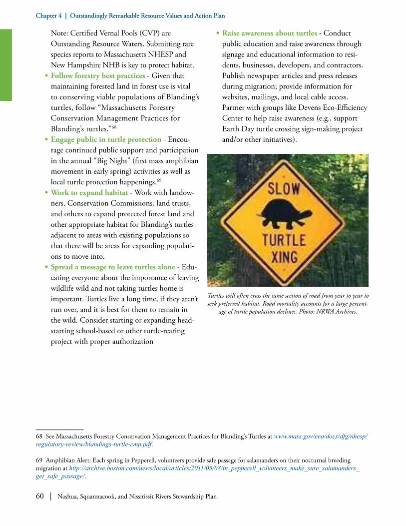
60 | Nashua, Squannacook, and Nissitissit Rivers Stewardship Plan
Chapter 4 | Outstandingly Remarkable Resource Values and Action PlanChapter 4 | Outstandingly Remarkable Resource Values and Action Plan
Note: Certified Vernal Pools (CVP) are Outstanding Resource Waters. Submitting rare species reports to Massachusetts NHESP and New Hampshire NHB is key to protect habitat.
• Follow forestry best practices - Given that maintaining forested land in forest use is vital to conserving viable populations of Blanding’s turtles, follow “Massachusetts Forestry Conservation Management Practices for Blanding’s turtles.”68
• Engage public in turtle protection - Encou-rage continued public support and participation in the annual “Big Night” (first mass amphibian movement in early spring) activities as well as local turtle protection happenings.69
• Work to expand habitat - Work with landow-ners, Conservation Commissions, land trusts, and others to expand protected forest land and other appropriate habitat for Blanding’s turtles adjacent to areas with existing populations so that there will be areas for expanding populati-ons to move into.
• Spread a message to leave turtles alone - Edu-cating everyone about the importance of leaving wildlife wild and not taking turtles home is important. Turtles live a long time, if they aren’t run over, and it is best for them to remain in the wild. Consider starting or expanding head-starting school-based or other turtle-rearing project with proper authorization
68 See Massachusetts Forestry Conservation Management Practices for Blanding’s Turtles at www.mass.gov/eea/docs/dfg/nhesp/regulatory-review/blandings-turtle-cmp.pdf.
69 Amphibian Alert: Each spring in Pepperell, volunteers provide safe passage for salamanders on their nocturnal breeding migration at http://archive.boston.com/news/local/articles/2011/05/08/in_pepperell_volunteers_make_sure_salamanders_get_safe_passage/.
• Raise awareness about turtles - Conduct public education and raise awareness through signage and educational information to resi-dents, businesses, developers, and contractors. Publish newspaper articles and press releases during migration; provide information for websites, mailings, and local cable access. Partner with groups like Devens Eco-Efficiency Center to help raise awareness (e.g., support Earth Day turtle crossing sign-making project and/or other initiatives).
Turtles will often cross the same section of road from year to year to seek preferred habitat. Road mortality accounts for a large percent-
age of turtle population declines. Photo: NRWA Archives.

Nashua, Squannacook, and Nissitissit Rivers Stewardship Plan | 61
Chapter 4 | Outstandingly Remarkable Resource Values and Action PlanChapter 4 | Outstandingly Remarkable Resource Values and Action Plan
GOAL A.4: Protect and enhance coldwater fisheries resources.
OBJECTIVE: Maintain existing populations of coldwater fish through actions that help mitigate thermal effects of a warming climate; maintain riparian forests; ensure baseflows provided by cold, clean groundwater discharges; sustain diverse aquatic invertebrate populations; and prevent nonpoint source pollution, especially sedimentation into coldwater streams.
• Raise awareness about streams - Collaborate with anglers’ organizations, aquatic biologists, naturalists, local school systems, and others to increase public awareness and appreciation of how headwater streams “work.” Focus on baseflows and storm flows, the life of coldwater streams, the recreational value of coldwater fisheries, and the ways that individuals can both enjoy and contribute to sustaining these re-markable resources. Conduct outreach focused on engineers who develop stormwater systems for projects, municipal members of planning
70 “It is imperative to maintain appropriate flow regimes and water levels (e.g., [streams are] reliant on groundwater inputs during much of the year; groundwater withdrawal or limited infiltration hampers this, impervious surfaces and drainage systems create higher than normal flows during rain events), access (e.g., dams, perched culverts, etc. cut off many kilometers of important habitat), and maintain suitable water temperatures (e.g., riparian vegetation provides shade among other important benefits to small brooks, runoff into streams from dark impervious surfaces is very warm): while accommodating demands for water supply, waste assimilation, commercial, industrial and agricultural uses. Small, coldwater brooks also buffer the temperature of the larger streams and rivers they flow into as well as some distance downstream from their confluence. The larger streams and rivers in the Nashua-Nissitissit-Squannacook complex could likely serve as overwintering habitat for trout and other coldwater species in their deeper pools.” (Adam Kautza, Coldwater Fisheries Project Leader at MassWildlife, personal communication on June 1, 2017).
71 See “Restore or Maintain Watershed Connectivity to Provide Areas for Fish and Wildlife Passage and the Ability to Compensate for Increased Storm Events,” pages 5-32 in New Hampshire State Wildlife Action Plan. New or replacement bridges and culverts should ideally have openings which pass the bankfull width without constriction. Bridges and culverts should be designed to cross the river without creating channel approaches at an angle to structures. Such sharp angles can lead to undermining of fill materials and structural components. The historic channel migration pattern of the river should be considered when installing new or replacement crossing structures, and when constructing new roads, driveways, and buildings. Planned build-out for watershed communities and resultant channel enlargement (from increased percent imperviousness) should be considered when designing new or replacement bridges and crossing structures.
and conservation boards, and others whose decisions affect stormwater management and land use change.
• Protect brooks - Protect small, cold, headwater brooks, which are necessary for reproduction, rearing of juveniles, thermal refuge during periods of high temperatures, and as year-round habitat for some CFR species.70
• Improve culverts and crossings - Improve stream habitat by replacing and/or up-grading poorly designed culverts and other stream crossings.71
• Preserve canopies - Preserve forest canopies over coldwater fisheries resources to ensure streams remain shaded. Pay special attention to, and provide comments on, any proposed utility or natural gas pipeline construction that cross CFRs as well as adjacent solar farms with an eye toward potential negative impacts resulting therefrom.
• Protect water flow - Maintain, protect, and enhance water flow regimes that support the needs of native river flora and fauna, while accommodating demands for water supply, waste assimilation, commercial, and industrial and agricultural uses.
• Maintain riverbanks - Conduct stream assess-ments to identify and repair man-made bank disturbance and/or erosion impacting natural structure and reducing riparian vegetative cover.
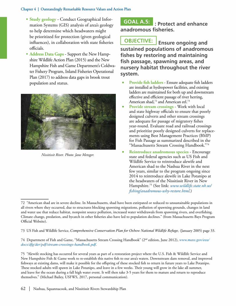
62 | Nashua, Squannacook, and Nissitissit Rivers Stewardship Plan
Chapter 4 | Outstandingly Remarkable Resource Values and Action PlanChapter 4 | Outstandingly Remarkable Resource Values and Action Plan
• Study geology - Conduct Geographical Infor-mation Systems (GIS) analysis of area’s geology to help determine which headwaters might be prioritized for protection (given geological influences), in collaboration with state fisheries officials.
• Address Data Gaps - Support the New Hamp-shire Wildlife Action Plan (2015) and the New Hampshire Fish and Game Department’s Coldwa-ter Fishery Program, Inland Fisheries Operational Plan (2017) to address data gaps in brook trout population and status.
Nissitissit River. Photo: Jane Metzger.
72 “American shad are in severe decline. In Massachusetts, shad have been extirpated or reduced to unsustainable populations in all rivers where they occurred, due to structures blocking spawning migrations, pollution of spawning grounds, changes in land and water use that reduce habitat, nonpoint source pollution, increased water withdrawals from spawning rivers, and overfishing. Climate change, predation, and bycatch in other fisheries also have led to population declines.” (from Massachusetts Bays Program Official Website).
73 US Fish and Wildlife Service, Comprehensive Conservation Plan for Oxbow National Wildlife Refuge, (January 2005) page 33.
74 Department of Fish and Game, “Massachusetts Stream Crossing Handbook” (2nd edition, June 2012), www.mass.gov/eea/docs/dfg/der/pdf/stream-crossings-handbook.pdf.
75 “Alewife stocking has occurred for several years as part of a restoration project where the U.S. Fish & Wildlife Service and New Hampshire Fish & Game work to re-establish this native fish to our area’s waters. Downstream dam removal, and improved fishways at existing dams, will make it possible for the offspring of these stocked fish to return in future years to Lake Potanipo. These stocked adults will spawn in Lake Potanipo, and leave in a few weeks. Their young will grow in the lake all summer, and leave for the ocean during a fall high water event. It will then take 3-5 years for them to mature and return to reproduce themselves.” (Michael Bailey, USFWS, 2017, personal communication).
GOAL A.5: : Protect and enhance anadromous fisheries.
OBJECTIVE: Ensure ongoing and sustained populations of anadromous fishes by restoring and maintaining fish passage, spawning areas, and nursery habitat throughout the river system.
• Provide fish ladders - Ensure adequate fish ladders are installed at hydropower facilities, and existing ladders are maintained for both up and downstream effective and efficient passage of river herring, American shad,72 and American eel.73
• Provide stream crossings - Work with local and state highway officials to ensure that poorly designed culverts and other stream crossings are adequate for passage of migratory fishes year-round. Evaluate road and railroad crossings and prioritize poorly designed culverts for replace-ments using Best Management Practices (BMP) for Fish Passage as summarized described in the “Massachusetts Stream Crossing Handbook.”74
• Reintroduce anadromous species - Encourage state and federal agencies such as US Fish and Wildlife Service to reintroduce alewife and American shad to the Nashua River in the next few years, similar to the program ongoing since 2014 to reintroduce alewife in Lake Potanipo at the headwaters of the Nissitissit River in New Hampshire.75 (See link: www.wildlife.state.nh.us/fishing/anadromous-why-restore.html.)

Nashua, Squannacook, and Nissitissit Rivers Stewardship Plan | 63
Chapter 4 | Outstandingly Remarkable Resource Values and Action PlanChapter 4 | Outstandingly Remarkable Resource Values and Action Plan
GOAL A.6: Sustain and improve populations of freshwater mussels.
OBJECTIVE: Protect existing populations of freshwater mussels, and work toward restoration of extirpated populations, per Massachusetts NHESP recommendations.
• Improve habitat for endangered mussels - Improve habitat condition for the recovery of extirpated and declining mussel populations. Freshwater mussels in Massachusetts and in New Hampshire are of special conservation interest as one of the most highly endangered animal groups in North America and are well represented at good sites such as in Nissitissit River, which need to be protected.
• Avoid threat from sediment - Protect freshwa-ter mussels from construction projects, which have the potential for sediment release that could suffocate the mussels by insuring erosion control BMPs are in place for all work sites.76
• Improve stream connectivity - Work to improve stream connectivity throughout the watershed to allow passage of host fish species
76 While not all of the BMPs will be appropriate for or accepted by every municipality, they are meant to be a guideline of some of the technologies currently available. Also, see “New Hampshire Best Management Practices for Erosion Control on Timber Harvesting Operations” at https://extension.unh.edu/resources/representation/Resource000247_Rep266.pdf.
on which mussel populations depend. Ensure that construction involving road and railroad crossings includes installation of adequate culverts to allow year-round fish passage. Survey small dams to ensure that they do not impair the upstream passage of a wide array of potential host fish species (not just anadro-mous fishes).
• Preserve habitat - As with coldwater fisheries, work with communities, landowners, Con-servation Commissions, fisheries managers, and state regulators to minimize non-point source pollution, including sedimentation and temperature changes. Maintain as much forested cover as possible in riparian and upland contributing areas to minimize thermal impacts. Manage stormwater to minimize surface flows of warmwater, to maintain year-round baseflows of cool groundwater, and to minimize changes in forested cover.
• Monitor for invasive mollusks - Monitor streams to ensure that invasive mollusks do not become established, potentially competing with native species for food and altering the benthic substrate needed by mussels. In the event of invasive mollusks being documented, establish a targeted removal program promptly to attempt to prevent adverse effects on native species.
Removal of the Millie Turner Dam in Pepperell, MA by the Mass-Wildlife, MA Division of Ecological Restoration, and several other partners has helped the river return to a healthier and more natu-ral state. In this photo, ecologists relocate stranded mussels after the dam has been taken out and the former impoundment drained.
Since 2014 the American alewife has been restored to the Nissitis-sit River headwaters by US Fish and Wildlife Service by annual
releases into Lake Potanipo. Photo: Jordan Bailey.

64 | Nashua, Squannacook, and Nissitissit Rivers Stewardship Plan
Chapter 4 | Outstandingly Remarkable Resource Values and Action PlanChapter 4 | Outstandingly Remarkable Resource Values and Action Plan
Disturbances Over the Law Relative to the Killing of Salmon and Other Fishes, 1784
In 1781 the Great and General Court passed an act prohibiting “The Killing or destroying any salmon, shad or alewives in the Merrimack River or any waters falling thereinto in this state, except
on Tuesdays, Wednesdays and Thursdays, under a penalty of 2 lbs [pounds]”; and further- “That no person shall erect or build annually within the months of May, June, September and October, any dams or other obstructions across said steams, nor continue said mill-dams or other obstructions under a penalty of 20 pounds.”
This act, according to tradition, because of its provisions for keeping the dams open during certain months of the year, was the cause of no little commotion in Raby [Brookline], where the project of damming the Nissitissit River at or below its outlet from the pond [Lake Potanipo] was already being seriously considered. It divided the people into two factions. It was a question of “To dam or not to dam.” One faction was opposed to the act, claiming that to build a dam across the river with the obligation of keeping it open during four months of the year, two of which, at least, were spring months when mill business was most active, was prohibitive to that extent that it reduced to a minimum the chances of making even a living profit in the mill business and therefore cut out all inducements for capital to invest in building mill-dams. The men who argued as above were, of course, the town’s capitalists; many of them passing rich with a mortgaged farm and an income of five pounds a year. Thus it happened that they opposed the damming of the river and instead d---d the General Court for passing the law.
The other faction favored the act because, as they claimed, if the dams were not kept open during the spring months, the pond itself, as well as all the streams which flowed into it, would no longer furnish the inhabitants with their annual spring supply of brain food in the form of lamprey eels and alewives; a species of nutrition of which they openly hinted the brains of their opponents were sadly in need. This latter faction, therefore, was in favor of damming the river and obeying the law.
A few years later and while the foregoing act was still operative, a dam was built across the river at its outlet from the pond; and for many years after the seafish continued to make their annual migrations up and down the Nissitissit and its tributary streams. Indeed, that ancient “chestnut” of alewives crowding into brooks so thickly as to enable one to cross upon their backs from shore to shore, continued to be told of Douglass Brook in the village well into the nineteenth century.
Edward Parker, History of Brookline, New Hampshire (1914), pages 100-101.

Nashua, Squannacook, and Nissitissit Rivers Stewardship Plan | 65
Chapter 4 | Outstandingly Remarkable Resource Values and Action PlanChapter 4 | Outstandingly Remarkable Resource Values and Action Plan
GOAL A.7: Minimize the effect of non-native invasive species.
OBJECTIVE: Control or diminish the prevalence of aquatic and terrestrial and/or riparian invasive plants and animals.
• Monitor invasive species - Monitor the presence of species that have the ability to thrive and spread aggressively outside their native range, both aquatic and land-based. Learn about methods for control and eradication. Communicate with and educate the public for prevention and control.
• Follow stewardship practices - Follow the recommendations in the Aquatic Invasive Plant Management Plan for the Nashua River,77 nota-bly water chestnut (Trapa natans) infestation in the Groton and Pepperell sections of the Nashua River, which has the potential to spread downstream. Continue with hand-pulling events from canoe and kayaks to control the spread of water chestnuts.
• Raise awareness about invasives - Post signs warning of non-native invasive aquatics at launch sites, reminding boaters to check their boats for hitchhiking plants. Provide educa-tional materials for lake and pond associations on invasive terrestrial and aquatic flora and fauna, including the proper cleaning boats and
77 Nashua River Watershed Association for the Nashua River Regional Aquatic Invasives Alliance, “Aquatic Invasive Plant Management Plan for the Nashua River,” (2017).
78 Per Pepperell Hydro’s FERC license (P 12721-006), an Invasive Species Monitoring and Control Plan (ISMCP) is to be implemented by the Licensee. The objectives of the ISMCP will be: (1) to document the species composition of invasive plants from the upstream end of the Pepperell impoundment downstream to the tailrace (i.e., the project area); (2) to implement an early detection/rapid response program to identify and control new invasive species infestations within the Pepperell project area; (3) to conduct surveys and associated reporting of the project area’s infestation status on a five-year cycle; and (4) to identify potential means (regional programs) to maintain or reduce the existing infestations.
79 See an example Devens: 974 CMR 3.04(8)(n)(g).
80 “Invasive or Overabundant Species: Common reed has invaded a portion of wetlands of Oxbow NWR. Planning to determine its rate of spread and the most effective means of control has been initiated. Purple loosestrife is another extremely invasive plant
of motors to prevent transport and spread of invasives. Present programs and prepare articles for local media to educate the broader public about aquatic invasives, how to identify them, and things individuals can do to prevent the establishment and spread of invasives.
• Monitor invasive aquatic weeds - Where feasible as time and funding permit, conduct baseline mapping of aquatic invasive weeds along the rivers (other than in those sections already done in the Oxbow NWR); addition-ally, those areas previously mapped should be periodically revisited to determine if any invasive plant growth has occurred.
• Follow through on local plan - Ensure the completion of the Invasive Species Monitoring and Control Plan by Pepperell Hydro for the Pepperell Pond Impoundment.78
• Incorporate controls in municipal processes - Work with municipalities to incorporate invasive species control as part of the approval and permitting process for land development. Invasive species identification and manage-ment during permitting, construction, and operations can help reduce the spread of invasives and support greater biodiversity along the river corridors.79
• Evaluate control methods - Attempt to control non-native, exotic invasives—such as purple loosestrife, for example—by releasing host-spe-cific beetles: insects that feed only on this invasive plant and pose no threat to the wetland ecosystem. Evaluate results of such past efforts, and if established that this is effective, expand beetle release program.80

66 | Nashua, Squannacook, and Nissitissit Rivers Stewardship Plan
Chapter 4 | Outstandingly Remarkable Resource Values and Action PlanChapter 4 | Outstandingly Remarkable Resource Values and Action Plan
• Encourage native plantings - Encourage native landscaping, at home and at businesses, to support wildlife ecology and to reduce escapes of potential new invasive species into the wild.
• Enlist volunteers - Sponsor hand-pulls of invasive species such as purple loosestrife, especially in areas where the populations of the plant are small. Annual pulling has been shown to be effective in controlling this species when started early after initial appearance of the plants.
• Consider smothering methods - Control of some riparian and wetland invasives such as Japanese bamboo (aka knotweed), purple loose-strife, and non-native common phragmites by smothering with black plastic or burlap has been found to be effective over the long term if the treatment is carried out consistently over time. Once established, Japanese knotweed becomes a major problem, and floodplains are highly susceptible; thus, attack it before it becomes well established anywhere along the river corridors. Initiate experimental efforts to document effec-tiveness of this approach in the Nashua River basin and, if promising, promote such controls by watershed groups and river users.
• Organize clean-up efforts - Support biodi-versity in riparian habitat by organizing river clean-up days with local volunteers to hand pull target common terrestrial non-native invasive species such as Japanese knotweed, Japanese barberry, Asian bittersweet, and glossy buckthorn. Consider the use of herbicides, if necessary, to control the spread of terrestrial invasives. Herbicides are only to be used where safe and appropriate, after obtaining the required approvals from state and local boards and committees.
species which threatens portions of the wetland habitats of the refuge. No formal surveys to determine the rate of spread have been conducted. The refuge has released Galerucel beetles and Hylobius transversovittatus weevils as biological control agents. The Galerucella beetles are leaf-eating beetles which feed on the leaves and the new shoot growth of purple loosestrife, weakening the plant until it eventually is removed or reduced. Hylobius tansversovittatus is a root-boring weevil that deposits its eggs in the lower stem of purple loosestrife plants. The hatched larvae feed on the root tissue, destroying the plant’s nutrient source for leaf development, which in turn leads to the destruction of the mature plant. Additional plant species that are considered to be invasive, and that require monitoring on the refuge include: spotted knapweed, glossy buckthorn, Asian bittersweet, and autumn olive.” From “Oxbow National Wildlife Refuge Comprehensive Conservation Plan,” (2013).
B: WATER QUALITY AND QUANTITY
GOAL B.1: Maintain and improve our rivers’ water quality so that it supports the needs of native wildlife, aquatic resources, and water supplies.
OBJECTIVE: Collect data, make plans, and take actions that support improved water quality.
• Study water quality - Ensure NRWA’s volun-teer, citizen-based water monitoring program
Volunteers pull out aquatic invasive water chestnut (Trapa natans) plants by hand for disposal. This “hand-pull” method of
eradication works best in small alcoves and other confined zones but cannot make any significant mark where the infestation has spread to dozens if not hundreds of acres as it has upstream of the
Pepperell Dam. Photo: Martha Morgan.
Nashua, Squannacook, and Nissitissit Rivers Stewardship Plan | 67
Chapter 4 | Outstandingly Remarkable Resource Values and Action PlanChapter 4 | Outstandingly Remarkable Resource Values and Action Plan
continues and captures data from geographically representative sites. Collect streamflow and water quality data as needed to support the protection of these resources.
• Address impaired waters - Consider devel-oping an approved plan for impaired sections of rivers in the designated reaches. Apply for federal Section 319 Clean Water Act grants to improve water quality.
• Conserve land - Conserve undeveloped and sensitive land within the area to limit impervious cover and mitigate the effects of urbanization.81 Corridor protection strategies that prevent or limit placement of infrastructure within the corridor will protect structures from future erosion and flood losses.82
• Increase green canopy - Increase street tree and urban/suburban forest canopy cover within developed areas of the watersheds to aid in stormwater quantity and quality management, while decreasing runoff temperatures. Also, promote the use of other green infrastructure techniques, such as vegetated roofs and walls in the built environment, to better manage runoff in the watersheds.
• Protect drainage - Protect and restore natural drainage patterns where feasible through stream daylighting and tributary restoration projects (for example, consider appropriate sections of
81 Several key management challenges affect the ecological integrity of the river corridor. These include increasing development, invasive species, habitat fragmentation, water withdrawals, and stormwater, sediment, and nutrient runoff into the river. “The CFRs in this region suffer from the effects of excessive development and its associated issues (e.g., loss of riparian forest, dams/impoundments, perched culverts and other road crossings, impervious surfaces, water withdrawal, etc.).” Adam Kautza, Coldwater Fisheries Project Leader at MassWildlife, personal communication on June 26, 2016. 82 According to Vermont Department of Environmental Conservation: One of the primary objectives of river corridor planning is to identify the key flood and sediment attenuation areas, where human land uses may be in constant conflict with the channel evolution of particularly dynamic and sensitive stream reaches. Key attenuation reaches are prime candidates for the acquisition of river corridor conservation easements because they are critical to the capture and storage of water, sediment, nutrients, and organic material. Functioning attenuation reaches serve to reduce excess erosion, reduce the fine sediment and nutrient loading that otherwise impairs water quality, and retain the coarser sediment and organic material important as cover habitats to aquatic organisms. http://dec.vermont.gov/sites/dec/files/wsm/rivers/docs/rv_RiverCorridorEasementGuide.pdf.83 Bioretention is the process in which contaminants and sedimentation are removed from stormwater runoff. Stormwater is collected into the treatment area, which consists of a grass buffer strip, sand bed, ponding area, organic layer or mulch layer, planting soil, and plants. Bioretention cells are depressed areas, generally about six inches, with specific soils and plants to help naturally attenuate and filter stormwater runoff used as infiltration filter. Plants used in the cells should tolerate wet and dry conditions84 NPDES is a permit program that controls water pollution by regulating point sources that discharge pollutants into waters of the United States as authorized by the federal Clean Water Act.
Varnum Brook in Pepperell). Improve water quality by using low-impact development techniques to pre-treat runoff prior to discharg-ing to any tributaries.
• Practice bioretention – Publicize the benefits of bioretention83 areas and promote the use of these and other green infrastructure and/or low-impact development (LID) techniques for managing runoff from nearby farms and devel-oped areas. Consider identifying a candidate site in the proposed designated area for installing a bioretention area to demonstrate its benefits and functions.
• Review NPDES - Review National Pollutant Discharge Elimination System84 (NPDES) permits for municipal, industrial and private entities to ensure water quality standards can be maintained or achieved.
• CSO notification - Ensure stakeholders in des-ignated downstream reaches from municipalities with Combined Sewer Overflows (CSOs) are notified of CSO incidents in a timely manner.
• Participate in collaborations - Participate in networking collaborations with upstream and downstream communities, as appropriate, to improve water quality, including regional storm-water collaboratives and wastewater utilities.
• Promote the Rivers Sanctuary Act - Review whether the 1975 Squannacook-Nissitissit

68 | Nashua, Squannacook, and Nissitissit Rivers Stewardship Plan
Chapter 4 | Outstandingly Remarkable Resource Values and Action PlanChapter 4 | Outstandingly Remarkable Resource Values and Action Plan
Nashua River Watershed Association Water Quality Monitoring Sites for 2018 sampling season. For more info see http://nashuariverwatershed.org/what-we-do/protect-water-and-land/river-water-quality-overview/wqm.html.

Nashua, Squannacook, and Nissitissit Rivers Stewardship Plan | 69
Chapter 4 | Outstandingly Remarkable Resource Values and Action PlanChapter 4 | Outstandingly Remarkable Resource Values and Action Plan
Rivers Sanctuary Act, which was intended to protect the state-designated Massachusetts Outstanding Resource Waters of these two rivers (and associated named tributaries in Shirley, Pepperell, Ashby and Townsend) from degradation by new discharges of pollution, is still being honored today. Work with towns to ensure compliance with the Act.
• Review stormwater permits - Review NPDES Permit renewals and work with towns and regional stormwater collaboratives to help meet NPDES permit requirements.85
• Promote best practices for wastewater treatment - Consider advocating for Best Management Practices at wastewater treatment facilities to remove endocrine disrupting chemicals, pharmaceutical contaminants, and harmful household products as yet untreated in the waste stream. The community is en-
85 The Municipal Separate Stormwater Sewer Systems (MS4) permit, which will regulate stormwater in more than 250 municipalities in Massachusetts, was scheduled to take effect on July 1, 2017, with the first action item for municipalities to comply due in September. The stay delays permit implementation until July 1, 2018 and it postpones the due date for communities to file their Notice of Intent as well. Under the MS4 permit, municipalities must develop, implement and enforce a stormwater management program that controls pollutants to the maximum extent practicable, protects water quality, and satisfies appropriate requirements of the federal Clean Water Act. The MS4 permit requires implementation of six minimum control measures. Updated permit requirements include the need to address identified water quality problems, including stormwater discharges to water bodies with approved total maximum daily loads for bacteria, phosphorus and nitrogen.
couraged to properly dispose of medications at “drop boxes” available at most police stations. Prescription medications, vitamins, and similar products should not be disposed of in toilets or sinks. Wastewater treatment plants and septic systems are not designed to remove these products from waste streams, so they can contaminate water resources.
• Practice continuous improvement for wastewater treatment - Keep current on the performance of existing wastewater treatment facilities to assure the continued protection of water quality. As funding becomes available or is sought, promote upgrades to the maximum extent practicable of our water pollution control facilities whose effluent makes up a majority of the river’s baseflow at certain low-flow times of the year.
• Monitor for contaminant discharges - Con-
Name of Wastewater Facility Point of Discharge Permitted Volume (mgd)1
Average per monthFacilities Within Proposed Designated ReachesAyer Nashua 1.79Groton School Nashua 0.07Devens Groundwater2 4.69Pepperell Nashua 1.13Hollingsworth & Vose Squannacook 2.4Facilities Upriver from Proposed Designated ReachesEast Fitchburg North Nashua 12.4Leominster North Nashua 9.3Clinton (MWRA)3 South Nashua 3.01
1. Million gallons per day 2. Devens facility discharges to surface filter beds that drain into groundwater 3. MWRA: Massachusetts Water Resource Authority operates the Clinton facility
Discharges at Wastewater Facilities
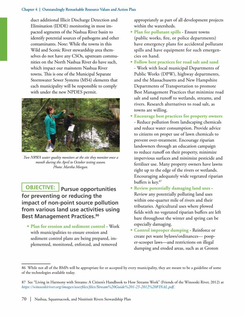
70 | Nashua, Squannacook, and Nissitissit Rivers Stewardship Plan
Chapter 4 | Outstandingly Remarkable Resource Values and Action PlanChapter 4 | Outstandingly Remarkable Resource Values and Action Plan
duct additional Illicit Discharge Detection and Elimination (IDDE) monitoring in most im-pacted segments of the Nashua River basin to identify potential sources of pathogens and other contaminants. Note: While the towns in this Wild and Scenic River stewardship area them-selves do not have any CSOs, upstream commu-nities on the North Nashua River do have such, which impact our mainstem Nashua River towns. This is one of the Municipal Separate Stormwater Sewer Systems (MS4) elements that each municipality will be responsible to comply with under the new NPDES permit.
OBJECTIVE: Pursue opportunities for preventing or reducing the impact of non-point source pollution from various land use activities using Best Management Practices.86
• Plan for erosion and sediment control - Work with municipalities to ensure erosion and sediment control plans are being prepared, im-plemented, monitored, enforced, and removed
86 While not all of the BMPs will be appropriate for or accepted by every municipality, they are meant to be a guideline of some of the technologies available today.
87 See “Living in Harmony with Streams: A Citizen’s Handbook to How Streams Work” (Friends of the Winooski River, 2012) at https://winooskiriver.org/images/userfiles/files/Stream%20Guide%201-25-2012%20FINAL.pdf.
appropriately as part of all development projects within the watersheds.
• Plan for pollutant spills - Ensure towns (public works, fire, or police departments) have emergency plans for accidental pollutant spills and have equipment for such emergen-cies on hand.
• Follow best practices for road salt and sand - Work with local municipal Departments of Public Works (DPW), highway departments, and the Massachusetts and New Hampshire Departments of Transportation to promote Best Management Practices that minimize road salt and sand runoff to wetlands, streams, and rivers. Research alternatives to road salt, as towns are willing.
• Encourage best practices for property owners - Reduce pollution from landscaping chemicals and reduce water consumption. Provide advice to citizens on proper use of lawn chemicals to prevent over-treatment. Encourage riparian landowners through an education campaign to reduce runoff on their property, minimize impervious surfaces and minimize pesticide and fertilizer use. Many property owners have lawns right up to the edge of the rivers or wetlands. Encouraging adequately wide vegetated riparian buffers is key.87
• Review potentially damaging land uses - Review any potentially polluting land uses within one-quarter mile of rivers and their tributaries. Agricultural uses where plowed fields with no vegetated riparian buffers are left bare throughout the winter and spring can be especially damaging.
• Control improper dumping - Reinforce or create pet waste bylaws/ordinances— poop-er-scooper laws—and restrictions on illegal dumping and eroded areas, such as at Groton
Two NRWA water quality monitors at the site they monitor once a month during the April to October testing season.
Photo: Martha Morgan.

Nashua, Squannacook, and Nissitissit Rivers Stewardship Plan | 71
Chapter 4 | Outstandingly Remarkable Resource Values and Action PlanChapter 4 | Outstandingly Remarkable Resource Values and Action Plan
Place “dog park” along the Nashua River.88 www.nashobavalleyvoice.com/groton_news/ci_18007525?source=rss.
• Create green landscapes - Encourage the creation of green infrastructure networks—systems of connected natural, constructed or restored landscape features—that help preserve ecosystem services.89
• Share stormwater resources - Encourage towns to join regional stormwater collaboratives to share the resources necessary to meet stormwa-ter management goals.
• Consider water in land use planning - Ensure that land use planning includes adequate water supply resources, stormwater drainage systems, and wastewater treatment systems (both onsite and centralized wastewater treatment systems) as well as permanent and temporary soil stabili-zation techniques and groundcover for all disturbed areas.
• Identify threats from septic systems - Partner with towns to identify the degree of threat from potential faulty and/or illicitly discharging septic systems, which may result in bacterial and nutrient contami-nation of nearby streams and groundwater.
88 “Animal sources of pathogens are both urban and rural in nature: pet droppings on municipal streets delivered by stormwater runoff, livestock wandering into waterways, and wildlife such as beaver and moose. Some communities are installing pet waste gathering stations in public parks. While contamination by native wildlife is impossible to control, contamination by livestock is not. A single cow produces approximately 5.4 billion fecal coliforms a day, and two cows allowed unrestricted access to a stream for 24 hours can contaminate as much water as the city of Keene, N.H., uses in one day. Currently, the state of New Hampshire do not require farmers to keep livestock from entering streams, although a number of federal programs provide grants for fencing and alternative water sources.” http://crjc.org/pdffiles/Connecticut_River_Rec_Management_Plan-Web.pdf.
89 See: www.devensec.com/development/Green_Infrastructure_Guidelines_Final_8-12-14.pdf for an example education and awareness tool.
OBJECTIVE: Preserve and protect important high- and medium-yield aquifers.
• Promote aquifer protection - Promote extended aquifer protection through land use regulations and acquisition. As a major aquifer recharge area, the Nashua, Squannacook, and Nissitissit River valleys store floodwaters and precipitation in their numerous wetlands and sandy glacial soils.
• Conserve water - Actively promote water con-servation. Encourage communities to consider mandatory conservation measures to augment volunteer efforts during droughts. Develop homeowner incentives to conserve water.
• Encourage rainwater reuse - Actively promote rainwater harvesting and reuse. Encourage communities to consider requirements for
“Begin No Salt Area” road signs instruct state and local road crews to not apply salt in areas where road run-off would likely drain into
nearby freshwater streams resulting in degraded water quality.

72 | Nashua, Squannacook, and Nissitissit Rivers Stewardship Plan
Chapter 4 | Outstandingly Remarkable Resource Values and Action PlanChapter 4 | Outstandingly Remarkable Resource Values and Action Plan
capture and storage of rainfall for non-potable water uses on development projects to help better manage stormwater runoff and reduce the use of potable water. Encourage all landowners in methods of returning water to the ground instead of running off the property, including the use of rain barrels and rain garden installa-tion. (See Massachusetts Drought Management Plan90 and New Hampshire 2016 Drought Management Plan.91)
• Follow best practices for water withdrawal - Encourage towns with registered92 (not permitted) water withdrawals to also follow best practices and conservation measures: e.g., 65 residential gallons per capita day (RGPCD), 10% unaccounted for water,93 and Best Management Practices, such as leak detection, pricing, public education, etc.
• Adhere to regulations for water withdrawal - Ensure Massachusetts’s Water Management Act regulations (310 CMR 36.00) are followed in the evaluation of new water withdrawals, and for requests for increased water withdrawals.94
• Preserve hydrology - Work with Planning Boards, Town Engineers, Conservation Com-
90 Massachusetts Drought Management Plan, http://www.mass.gov/eea/docs/eea/wrc/droughtplan.pdf.91 See www.des.nh.gov/organization/divisions/water/dam/drought/documents/drought-management-plan-for-web.pdf and New Hampshire Drought Program link www.des.nh.gov/organization/divisions/water/dam/drought/categories/overview.htm.92 Registration Volume is the volume of water registered with the Massachusetts Department of Environmental Protection. Since 1988, persons planning to withdraw water from ground or surface sources for purposes in excess of an annual average of 100,000 gallons per day or 9 million gallons in any three-month period must apply for a Water Management Act Permit. Withdrawers with a Water Management Registration do not need a permit if they do not increase withdrawals over their registered volumes or add any new withdrawal points to their system.93 Unaccounted-for water (UFW) represents the difference between “net production” (the volume of water delivered into a network) and “consumption” (the volume of water that can be accounted for by legitimate consumption, whether metered or not).94 “…[P]roduction (water supply) wells can cause streamflow depletion by intercepting groundwater that would have discharged to nearby rivers, or inducing direct infiltration of river water to the well, causing low-flow issues.” Jeffrey Barbaro, USGS, personal communication on October 5, 2017.95 Fluvial geomorphic assessments are studies of the physical condition of river systems. The assessments evaluate how, to what extent, and why river channels have become unstable. Causes ranging from major flood events to human activity are assessed. Data show that given the time and space, rivers eventually “evolve” to a channel form that is in equilibrium, or at balance, with the water and sediment inputs of their watersheds.96 It is important to recognize that rivers and floodplains need to operate as a connected system. Flooding is necessary to maintain the floodplain biological community and to relieve the erosive force of flood discharges by reducing the velocity of the water. Flooding and bankfull flows—the water level stage that just begins to spill out of the channel into the floodplain -- are also essential for maintaining the instream physical structure. These events scour out pools, clean coarser substrates (gravel, cobbles, and boulders) of fine sediment, and redistribute or introduce woody material. (NWCC Technical Note 99–1, Stream Visual Assessment Protocol, 1998 www.nrcs.usda.gov/Internet/FSE_DOCUMENTS/stelprdb1044776.pdf.
missions and developers, and landowners to consider maintaining or restoring predevelop-ment hydrology in order to protect groundwater recharge capability. Appropriate techniques include limiting impervious surfaces, rainwater harvesting, the use of swales and other LID measures, and Best Management Practices that assist infiltration. Runoff from pre-development cannot increase post-development, which is why each town needs staff that is capable of interpreting stormwater calculations.
• Protect floodplains and wetlands - Maintain the ability of floodplains and wetlands to efficiently absorb water and protect the river from runoff related pollution. Assess floodplain and wetland mapping for the corridors and determine ways to improve it, coordinating with state and federal agencies. Consider conducting fluvial geomorphic assessments95 of the three rivers beginning with locations that have histori-cal flooding and bank erosion issues. Work with town boards to inform them of the importance of floodplains96 for floodwater storage and to encourage protection of floodplains and wetlands when considering development proposals.

Nashua, Squannacook, and Nissitissit Rivers Stewardship Plan | 73
Chapter 4 | Outstandingly Remarkable Resource Values and Action PlanChapter 4 | Outstandingly Remarkable Resource Values and Action Plan
• Assess watershed geomorphology - Consider conducting watershed geomorphic assessments that would enable knowledgeable decisions to guide the management of stable river corridors. Assessments will be useful in guiding land use, development, and infrastructure planning and design as well as flood hazard prevention. They can play an important role in the protection or restoration of the economic, aesthetic, and ecological values of river corridors. Through understanding of the relationships between watershed processes and human investments, we are able to make wise decisions about river corridor management.97
97 See http://dec.vermont.gov/sites/dec/files/wsm/rivers/docs/rv_rcprotectmanagefactsheet.pdf , page 5
98 The single most important natural system critical to maintaining the integrity of the entire Nashua River watershed is a forested riparian buffer.
OBJECTIVE: Educate public about
the river ecology and ways to keep rivers healthy.
• Engage town and state agencies - Work with town DPW road crews and appropriate state Department of Transportation agencies who could help alert the public to the significance of Wild and Scenic Rivers. For example, signs could be posted at bridge crossings or other appropriate locations.
• Raise awareness through events - Sponsor local events to raise public understanding about native wildlife and the impacts of development patterns on habitat and ecosystem integrity. For example, provide Wild and Scenic River outreach information at community events, fairs, festivals, canoe races, fishing events, and other public gatherings.
• Engage utility companies - Work with private and public utility companies on creating and updating utility corridor management plans that recognize the importance of maintaining healthy wetlands, stream and river riparian buffers, and reducing the use of chemical pesticides in or near these sensitive areas.
• Engage the public - Engage with residents and others in the watershed on ecological issues, particularly with regard to recognizing that the streams, streambanks, and riparian areas, including riparian buffers and corridors, are sensitive places that might be conserved, restored, and protected.98
• Pursue education opportunities - Pursue opportunities to educate landowners, developers, and local land use boards about the causes of non-point source pollution, its potential impacts on water quality and instream resources, and methods—such as Best Man-
The flood of 2010 on the Nashua River inundated Route 119 in Pepperell, MA. Photo: Wynne Treanor-Kvenvold.

74 | Nashua, Squannacook, and Nissitissit Rivers Stewardship Plan
Chapter 4 | Outstandingly Remarkable Resource Values and Action PlanChapter 4 | Outstandingly Remarkable Resource Values and Action Plan
agement Practices—for reducing or eliminating it. Pursue opportunities to demonstrate the use of Best Management Practices in controlling non-point source pollution such as expanding riparian native vegetation buffers (to an ideal of 300 feet).99
C: HABITAT
GOAL C.1: Maintain and enhance high-quality riparian habitat.
OBJECTIVE: Protect intact and functional riparian buffers.
• Protect vegetative buffers - Work to maintain or expand riparian native vegetated buffers to
99 Buffer Width: “There is not one generic buffer size which will keep the water clean, stabilize the bank, protect fish and wildlife, and satisfy human demands on the land. The minimum acceptable width is one that provides acceptable levels of all needed benefits at an acceptable cost for a particular site. The basic bare-bones buffer is generally 50 feet from the top of the bank. To filter dissolved nutrients and pesticides from runoff a width of up to 100 feet or more may be necessary on steeper slopes and less permeable soils to allow runoff to soak in sufficiently…. on coldwater fisheries, the stream channel should be shaded completely. Studies show that that at least up to 100 feet, the wider the buffer, the healthier the aquatic food web. To protect against flood damage a smaller stream may require only a narrow width of trees or shrubs; a larger stream or river may require a buffer that covers a substantial portion of its flood plain. A 100-foot buffer will generally remove 60% or more of pollutants, depending on local conditions. It will also provide food, cover and breeding habitat for many kinds of wildlife but only fulfill few needs for others, such as travel cover.” (Connecticut River Joint Council Report, 1998). Also see Eightmile River Wild and Scenic Study Committee, “Riparian Buffer Zones: Functions and Recommended Widths,” (April 2005).
maintain lower water temperatures. Note that clear, coldwater supplied by the Squannacook and Nissitissit Rivers to the Nashua River provides a refuge for temperature-sensitive fish in all three rivers.
• Restore streambeds - Restore streambeds impacted by road sand deposition and seek solutions to reduce future road sand and other sedimentation. Involve town DPWs and state Departments of Transportation as appropriate.
• Consider riparian buffers in town plans - Give high priority protection to riparian buffers. This can be reflected in each town’s Open Space and Recreation Plan “Inventory of Lands of Conservation and Recreation Interest,” as well as their land use and subdivision bylaws and regulations.
NRWA’s environmental education programs in classrooms frequently utilize an EnviroScape®, a portable, interactive model that
demonstrates point and non-point source water pollution concepts and their prevention. Photo: Gaynor Bigelbach
As part of a NRWA/Merrimack River Watershed Council project funded by the US Forest Service, “Expanding Riparian Buffers,” and
with the help of a local Eagle Scout, the eroding banks at Bertozzi Conservation Area in Groton, MA were restored with plantings of
native shrubs and grasses. Photo: Al Futterman.

Nashua, Squannacook, and Nissitissit Rivers Stewardship Plan | 75
Chapter 4 | Outstandingly Remarkable Resource Values and Action PlanChapter 4 | Outstandingly Remarkable Resource Values and Action Plan
Federal Emergency Management Agency (FEMA) floodways in MA (2017) & NH (2007). For more info see www.fema.gov/floodway.

76 | Nashua, Squannacook, and Nissitissit Rivers Stewardship Plan
Chapter 4 | Outstandingly Remarkable Resource Values and Action PlanChapter 4 | Outstandingly Remarkable Resource Values and Action Plan
OBJECTIVE: Support protection of important wildlife habitat areas and migration corridors as identified and prioritized through habitat studies and assessments such as “Universal Stream Assessment.”100
• Encourage land conservation easements and restrictions - Educate and encourage land-owners to consider Conservation Easements (CE) in New Hampshire—aka Conservation Restrictions (CR) in Massachusetts101—and the importance of maintenance and enforcement of these restrictions. Consider providing funding to budget-strapped local land trusts whose lack of capacity makes it difficult to do required annual monitoring of all CEs. Also, consider training volunteers to conduct annual moni-toring of CRs/CEs, such as is done by Sudbury Valley Trustees (see www.svtweb.org/properties/stewardship#Coordinate).
• Encourage current use programs - Encourage conservation and the preservation of existing forest, farm, and recreational land. Increase the likelihood of permanent forestland protection by increasing the number of landowners enrolled in current use programs (Chapter 61, 61A and 61B in Massachusetts). These programs can be used by landowners who want to keep their land in open space but are not able or willing to execute a permanent conservation restriction/easement agreement.
• Support deer population control - Encourage
100 A Universal Stream Assessment is a survey of rivers and streams based on physical, chemical and biological data collected and analyzed using standardized field and laboratory methods. The goals are to determine the extent to which rivers and streams support a healthy biological condition and the extent of major stressors that affect them. The assessment supports a longer-term goal: to determine whether our rivers and streams are getting cleaner and how we might best invest in protecting and restoring them. www.epa.gov/national-aquatic-resource-surveys/what-national-rivers-and-streams-assessment.
101 Massachusetts Land Trust Coalition, Conserving Land in Your Community, www.massland.org/conserving-land-your-community.
102 Nearly all Massachusetts Department of Fish and Game (DFG) properties are required to allow hunting, as the vast majority of their land purchases are made possible because of funds collected for hunting and fishing licenses.
103 Additionally, Massachusetts DFG has a policy of minimizing trails (see www.mass.gov/eea/agencies/dfg/dfw/wildlife-habitat-conservation/wildlife-lands-trail-policy.html).
state agencies to include hunting102
as a technique to reduce overpopulations of deer, which can be ecologically destructive. For ex-ample, MassWildlife Management Areas, which are a draw for birders and other nature watchers, have a mission of prioritizing wildlife habitat.103
For more see Massachusetts Audubon Society’s “Nashua River Watershed Important Bird Area Site” at www.massaudubon.org/our-conservation-work/wildlife-re-search-conservation/statewide-bird-monitoring/massachu-setts-important-bird-areas-iba/important-bird-area-sites/
nashua-river-watershed.
Interior forest adjacent to a river. Photo: Kim King.

Nashua, Squannacook, and Nissitissit Rivers Stewardship Plan | 77
Chapter 4 | Outstandingly Remarkable Resource Values and Action PlanChapter 4 | Outstandingly Remarkable Resource Values and Action Plan
OBJECTIVE: Protect and expand “Green Infrastructure” networks and linkages; protect and enhance con-nectivity through attention to dams, culverts, streambank modifications, and bottom alterations.
• Connect greenways - Increase land protection efforts to focus on connecting existing protected greenways (for example, between Bolton Flats WMA and Oxbow National Wildlife Refuge as well as a connector between Sucker Brook and Gulf Brook, and elsewhere).
• Support linear greenways - Restore and sustain lands along all water bodies, including wetlands and their surrounding lands, as linear greenways for their natural resource values, as well as along all headwaters throughout the stewardship area, as opportunities arise.
• Encourage voluntary land conservation - Continue to assist and support private landown-ers and local land trusts in their voluntary land conservation measures that protect important riverfront—and watershed—lands. Encourage all land protection agencies to pursue the purchase (in fee or conservation easements) of important river-related lands from willing sellers if parcels come on the market and if funding is available. Give high protection priority to headwaters and tributaries of the rivers.
• Explore multi-use opportunities - Continue to look for connections to points of regional recreation and open space interest, such as the Oxbow National Wildlife Refuge, the Shirley Shaker Village, Fruitlands Museum, Ayer State Game Farm, and the Squannacook State Wildlife Management Area in Shirley, as well as connections to the Nashua River corridor, as stated in the 2008 Devens Open Space and Recreation Plan in reference to its Multi-Use Trail Network Plan.
OBJECTIVE: Minimize loss of valued habitat.
• Protect stream habitat - Assist with protection of small, prioritized headwater streams that supply coldwater downstream.
• Protect priority land habitat - Assist local land trusts and Conservation Commissions to plan for priority land protection, especially of our three rivers and their tributaries.
• Prevent erosion - Minimize loss of habitat values coincident with land use practices that cause erosion.
• Preserve the greenway buffer - Work with involved parties to ensure that the Squannacook River greenway buffer—and its important turtle habitat—is not degraded by inadvertent misuse.
• Encourage land management for wildlife habitat - Work with and educate landowners to encourage continued and longterm man-agement of the already protected open spaces in ways that are conducive to maintaining wildlife habitat.
• Plan for future habitat protection - Ensure that if the South Post of Fort Devens is ever surplused, the land is permanently protected and/or becomes incorporated into the Oxbow National Wildlife Refuge (less the one hundred acres to Lancaster). Inform current Boards of Selectmen and Conservation Commissions in Lancaster and Harvard of this legislation.
• Provide technical resources - Provide technical assistance to municipalities, landowners, and private organizations seeking to protect and conserve floodplains, wetlands, forests, mead-ows, riparian vegetated buffers, and other fish and wildlife habitats.
• Avoid in-stream crossings - Avoid all utility (gas and electric) in-stream crossings unless the project proposal can show that there is no other feasible alternative.
• Design culverts and road crossings to allow wildlife passage - Replacement of poorly

78 | Nashua, Squannacook, and Nissitissit Rivers Stewardship Plan
Chapter 4 | Outstandingly Remarkable Resource Values and Action PlanChapter 4 | Outstandingly Remarkable Resource Values and Action Plan
Nashua River Watershed Greenway in 2013. Note that this map highlights protected lands along the rivers and tributaries throughout the entire watershed. Since that time, there has been substantial progress in protecting additional greenway lands. As of 2018, nearly 50% of
lands along the Nashua and its major tributaries are permanently protected. Work continues.

Nashua, Squannacook, and Nissitissit Rivers Stewardship Plan | 79
Chapter 4 | Outstandingly Remarkable Resource Values and Action PlanChapter 4 | Outstandingly Remarkable Resource Values and Action Plan
designed culverts104 and other road-crossing structures should follow the most up-to-date guidelines for stream crossing design, in order to reduce the incidence of destructive erosion, washouts, and scouring at stream crossings, and to allow for unimpeded wildlife passage under roads. Where possible, work in partnership with Massachusetts Division of Ecological Restoration and the New Hampshire agencies involved in the New Hampshire Stream Cross-ing Initiative.105
• Design bridges and culverts to prevent chan-nel disruption - New or replacement bridges and culverts should ideally have openings that pass the bankfull width without constriction. Bridges and culverts should be designed to cross the river without creating channel approaches at an angle to structures. Such sharp angles can lead to undermining of fill materials and structural components. The historic channel migration pattern of the river and changing weather and precipitation patterns should be considered when installing new or replacement crossing structures, and when constructing new roads, driveways, and buildings. Planned build-out for watershed communities and resultant channel enlargement (from increased
104 “The biggest challenge with replacing culverts with a culvert that is bottomless, is cost. It is far less expensive to use a piece of high density polyethylene pipe (HDPE), which is why most DPW’s use this material.” (Paula Terrasi, personal communication on May 30, 2017) Information on costs associated with maintaining/replacing culverts and potential funding sources should be distributed to towns, DPWs, and select boards. Incentives should be provided for removal or modification of infrastructure identified as barriers to ecosystem services integrity. (See New Hampshire State Wildlife Action Plan, pages 5-32.)105 New Hampshire Department of Environmental Services Stream Crossing Initiative, www.des.nh.gov/organization/divisions/water/wetlands/streams_crossings.htm.106 Flow devices are man-made solutions to beaver-related flooding problems. Traditional solutions have involved the trapping and removal of all the beavers in an area. While this is sometimes necessary, it is typically a short-lived solution, as beaver populations have made a remarkable comeback in New England. Flow devices are relatively cost-effective, low-maintenance solutions that regulate the water level of beaver dams and keep culverts open.107 Massachusetts State Wildlife Action Plan, (2015) page 121; New Hampshire Wildlife Action Plan (2015) page 5-12)108 “No anadromous fish are currently found in the Ice House Dam project area, and upstream and downstream passage facilities are not yet in place at the next downstream dam, the Pepperell Dam in Pepperell. Ice House Partners will be responsible for constructing, operating, maintaining, and evaluating upstream and downstream anadromous fish passage facilities when requested by the Massachusetts Division of Fish and Wildlife or the US Fish & Wildlife Service.” (Federal Energy Regulatory Commission FERC Order Granting Exemption from Licensing (5 Mw or less) Ice House Partners, Inc. Project No. 12769-000, March 31, 2008.)109 From Pepperell Hydro Settlement Agreement: Federal Energy Regulatory Commission Order Issuing Original License to Pepperell Hydro Company, LLC; Project number P-12721, Appendix B, September 8, 2015: All upstream eel passage facilities shall be operational within three (3) years of license issuance. Downstream Adult Eel Passage. To protect adult silver eels during outmigration, the Licensee shall either: (1) cease operating the Project from dusk to dawn from August 15 through November 30, annually. Or (2) operate a passage and protection system that meets the following criteria:
percent imperviousness) should be considered when designing new or replacement bridges and crossing structures.
• Properly size stream crossings - Work with and help town DPWs properly size stream crossings at bridges and culverts, and prioritize worst ones. “These and beaver deceivers106 are often undersized for the size of the stream and result in impounding of water and sediments upstream of the crossing, and which may limit habitat connectivity and passage of fish and other aquatic fauna.”107
• Enhance in-stream habitat - Reestablish and protect riparian zones and enhance in-stream habitat conditions. For example, locate beaver deceivers at poorly designed culverts that do not have fish passage.
• Consider fish passage at dams - Consider the effect of the two mainstem Nashua River dams, Pepperell and Ice House108, on fish passage. Establish and maintain adequate upstream and downstream fish passage facili-ties. Upstream fish and eel passage is required under the Federal Energy Regulatory Commis-sion (FERC) license for the Pepperell Dam.109

80 | Nashua, Squannacook, and Nissitissit Rivers Stewardship Plan
Chapter 4 | Outstandingly Remarkable Resource Values and Action PlanChapter 4 | Outstandingly Remarkable Resource Values and Action Plan
Ice House Dam has eel passage for elvers going upstream.110
• Evaluate obsolete dams - Consider removal of obsolete dams on a case-by-case basis if
Downstream adult eel passage and protection measures or facilities shall be operational eight (8) years after juvenile eels are first documented using the upstream eel passage facilities. This timeframe may be adjusted by the Fisheries Agencies pursuant to the results of monitoring the upstream passage of juvenile eels. Alternative passage and protection measures may be proposed by the Licensee, and considered by the Fisheries Agencies, if the Fisheries Agencies determine if sufficient data exist documenting their effectiveness. Notwithstanding the foregoing, Massachusetts DFW has documented eels present in waterways upstream of the Project. Accordingly, in order to protect such eels during their outmigration, and prior to the provision of permanent adult eel passage facilities, the Licensee shall implement interim passage measures at the dam and/or forebay. Such interim passage measures shall be designed in consultation with, and require approval by, the Fisheries Agencies and (1) The licensee must install the interim downstream eel passage facility by August 1, 2018, and (2) shall operate until permanent passage facilities are implemented. Approvable interim passage systems may include either use of the existing forebay drain system or the installation of a siphon system in the same general forebay location. a. Downstream Fish Passage The Licensee shall construct, operate, maintain and evaluate the effectiveness of downstream fish bypass passage facilities for Targeted Migrants when the upstream fish passage system begins operation. Said passage facilities shall be operational the first downstream passage season after the beginning of upstream fish passage operation. b. Upstream Fish Passage Within three (3) years of license issuance, the Licensee shall develop and submit for Commission approval, functional design plans for upstream fish passage facilities. The upstream fish passage must be installed at the Project after a minimum of 5,000 river herring have successfully and volitionally passed through the Mine Falls’ (FERC Project No. 3442) upstream fish passage system for a minimum of two (2) consecutive years (Trigger Level). Installation of the fish passage system shall occur within three (3) years of achieving this Trigger Level, but in no event shall the fish passage system be installed before the year 2026, regardless of the number of migrants passing the downstream Mine Falls Project. Should the Trigger Level occur before the year 2026, the Licensee shall provide interim upstream fish passage through the use of a commercial aquaculture fish pump with a temporary collection chamber installed at a location to be determined in consultation with the Fisheries Agencies. The Licensee shall seasonally operate the upstream fish passage facility in concert with upstream fish passage facilities located at the Mines Falls Project (i.e., same operational dates).
110 Liisa Grady Marino, Grady Research, Personal communication on August 29, 2017.
determined to be appropriate, supported by local community, and consistent with state dam removal guidelines.
Poorly or undersized culverts can create high water velocity, turbulence, and/or inadequate water depths within the culvert
leading to migration barriers for fish and other aquatic species. They also restrict natural stream flows, particularly during floods.
Photo: NRWA Archives.
Replacing old pipe culverts with new bottomless, three-sided culverts helps provide passage for fish and other aquatic species. Such projects often necessitate the efforts of multiple partners to accomplish, such as here with Trout Unlimited’s involvement with a Gulf Brook culvert
in Pepperell, MA. Photo: NRWA Archives.

Nashua, Squannacook, and Nissitissit Rivers Stewardship Plan | 81
Chapter 4 | Outstandingly Remarkable Resource Values and Action PlanChapter 4 | Outstandingly Remarkable Resource Values and Action Plan
GOAL C.2: Preserve, protect, and improve wildlife habitat and migration corridors.
OBJECTIVE: Promote completion of a permanently protected greenway along the rivers and their tributaries as the rivers and their banks provide key dispersal and migratory routes for wildlife, both aquatic and terrestrial.
• Conduct greenway inventories - Coordinate with towns to complete a greenway inventory of protected and unprotected lands. Evaluate if Massachusetts lands thought to be protected are indeed fully “Article 97” protected111 and are deed recorded.
• Develop subdivision standards - Assist town boards and work with municipal officials to develop subdivision standards that require proponents to devote a significant and sizeable portion of land (not including already-undevel-opable wet or steep land) for open space conser-vation, and encourage mixed-use development and cluster zoning by-right bylaws.
• Remove barriers to wildlife passage - Consider removal of extraneous and abandoned chain link fencing where feasible on Devens and elsewhere, which creates a barrier for wildlife passage. Examples of such fencing can be seen at and around the Nashua River by West Main Street; and at the Nonacoicus Brook wetland on the North Post south of and adjacent to the Ayer Wastewater Treatment Plant and north of the rail line.
111 See Massachusetts Executive Office of Energy and Environmental Affairs, Article 97 Land Disposition Policy at www.mass.gov/eea/agencies/mepa/about-mepa/eea-policies/eea-article-97-land-disposition-policy.html.
D: MUNICIPALITIES AND LAND USE PLANNING STRATEGIES
GOAL D.1: Promote balanced growth, which preserves property values and protects and enhances the riparian resources for future generations.
OBJECTIVE: Engage with landowners on these issues.
• Promote native vegetative buffers - Educate and encourage landowners to plant and maintain native vegetative buffers in order to protect aquatic and riparian life by maintaining critical water temperatures, preventing soil erosion and sedi-mentation, stabilizing stream banks, slowing down runoff, and filtering pollutants from stormwater runoff. Coordinate this effort through the local municipal Open Space and Recreational Plan committees and with Planning, Zoning, Con-servation Commissions as well as Public Works, Engineering, and Parks Departments.
Bobcat in Groton, MA wetland. Bobcats tend to exhibit crepuscular (dawn and dusk) activity which makes a daytime sighting extremely rare. Photo: JP Gillard.

82 | Nashua, Squannacook, and Nissitissit Rivers Stewardship Plan
Chapter 4 | Outstandingly Remarkable Resource Values and Action PlanChapter 4 | Outstandingly Remarkable Resource Values and Action Plan
OBJECTIVE: Engage with municipalities and developers on these issues.
• Encourage low impact and green design - Encourage communities to plan development so that natural and community resources are protected. Encourage local boards to require developers to use low-impact design and other green infrastructure elements/construction methods to minimize runoff.
• Promote environmental compatibility in development projects - Encourage towns to focus development in environmentally compat-ible areas through natural resource inventory assessment and mapping overlays112 (geology, soils, wetlands and watercourses, habitat map-ping, topography, microclimate, Massachusetts NHESP and New Hampshire Fish and Game). Encourage multi-town cooperation where appropriate. Review and comment on proposed state and private development projects to assure water quality will not be degraded. Maintain or restore predevelopment hydrology in order to protect groundwater recharge capability.
• Pro-actively plan for redevelopment - Be alert for opportunities to work with towns
112 See Ian McHarg’s Design with Nature: https://en.wikipedia.org/wiki/Ian_McHarg.
pro-actively to redevelop priority sites in an environmentally compatible and creative way. For example, there may be opportunities to include river parks in plans for the reuse of former mill sites.
• Promote wetland preservation - Encourage no net loss of wetlands and where possible, re-establish, restore, and enhance wetlands as part of new development or renovation projects. Assess where this has already been done and is effective.
• Share information on river protection - Establish a clearinghouse of information on river protection techniques that have been used successfully in other areas.
• Consider integrating a watershed plan - Each town could consider integrating the recommen-dations of the last NRWA Five-year Watershed Plan and/or similar plans into its land use regulations and design standards.
• Consider adopting this Stewardship Plan - Request the Planning Boards and Conservation Commissions of each participating Study Committee town to incorporate the Nashua, Squannacook, and Nissitissit Rivers Stewardship Plan into each of their master plans by reference or formal incorporation.
• Foster watershed stewardship - Develop a mechanism to monitor this Stewardship Plan, implement such a mechanism, and foster watershed stewardship.
Example of rain garden used to filter road runoff. Photo: Aaron Volkening via Flickr Creative Commons License.
This US EPA graphic addresses the issue of sufficient riparian buf-fers. Although no specific measurements are given herein, a general rule of thumb is that a 200- to 300-foot zone of native vegetation is ideal for the purposes of keeping surface waters clean. The grasses,
shrubs, and tress slow down and intercept potentially polluting overland storm run-off.

Nashua, Squannacook, and Nissitissit Rivers Stewardship Plan | 83
Chapter 4 | Outstandingly Remarkable Resource Values and Action PlanChapter 4 | Outstandingly Remarkable Resource Values and Action Plan
GOAL D.2: Restore, protect, and enhance water quality and associated aquatic resources and water supplies.
OBJECTIVE: Take actions to protect and improve streambank and related conditions that negatively impact water quality.
• Prevent stream enrichment and contamina-tion - Prevent the accelerated enrichment of streams and contamination of waterways from runoff containing nutrients, pathogens, organ-ics, heavy metals, and toxic substances.
• Preserve natural vegetative canopy - Educate and encourage landowners to maintain or restore a natural vegetative canopy along streams to ensure that mid-summer stream temperatures do not exceed tolerance limits of desirable aquatic organisms.
• Minimize trash - Maintain the stream or waterway free of litter, trash, and other debris by supporting the organization of river clean-up days sponsored by local businesses, groups and/or organizations that share an interest and/or stake in the river. Also, support education and awareness campaigns on the impacts of trash by partnering with local schools to develop and disseminate information throughout the communities.
• Minimize erosion and stream disturbance - Minimize the disturbance of the streambed and prevent streambank erosion and, where practical, restore eroding streambanks to a natural or stable condition; for example, at the canoe launch parking lot at West Hollis Road/Brookline Street crossing of Nissitissit River.
• Consider forming Stream Teams - Consider putting together Stream Teams for the subject rivers and their tributaries to focus on river restoration and streambank stabilization and provide a venue for communication among stakeholders.
Paddling on the Nissitissit River. Having a shaded canopy over the river is key to keeping water temperatures cool throughout the summer. Photo: Ken Hartlage.

Outstandingly Remarkable Resource Values
84 | Nashua, Squannacook, and Nissitissit Rivers Stewardship Plan
Chapter 4 | Outstandingly Remarkable Resource Values and Action Plans
Hiking Adjacent Conserved Lands. Among the many major riparian conservation lands (“open spaces”) are: Oxbow National Wildlife Refuge (1,667-acres with almost eight miles of Nashua River frontage),113 Bolton Flats State Wild-life Management Area (~1,000 acres), Squannacook River State Wildlife Management Area (1,934 acres), Nissitissit River State Wildlife Management Area (625 acres), Townsend State Forest (3,082 acres), Nashua River Rail Trail (11 linear miles one-way), and J. Harry Rich State Forest (~500 acres). The J.
113 There are over 13 miles of trails connecting Devens trails and the Oxbow National Wildlife Refuge trails: these trails run along the Nashua River and also along many tributaries.
Harry Rich State Forest was the first state-owned tree farm in the nation and the most intensively managed forest acreage in New England according to Hugh Putnam, former chief forester for the New England Forestry Foundation.
Significantly, there are more than one thousand addi-tional acres of locally owned land trust and munici-pal conservation properties, such as Groton Town Forest (~500 acres) along the river, which had originally been the site of the town’s “Poor Farm”. Furthermore, there are extensive conservation
ORRV Category: RECREATIONAL AND SCENIC VALUES
Kayaker on the Nashua River. Photo: Christine Guertin.
R iver-related recreational pursuits are greatly valued in our area. This was not always so; in the 1960s, excessive water pollution and foul smells kept recreationalists far
from the Nashua River corridor. The story of the remarkable recovery of the river is also detailed as one of our Historical and Cultural values. Today, high quality water supports water-based recreation as well as the enjoyment of numerous greenway trails by the banks of our rivers. The extraordinary amount of protected greenway—beautiful forests along vast stretches of the Nashua, Squannacook, and Nissitissit Rivers—give many paddlers and hikers a “sense of being in the wilderness” and assure them of rewarding scenic views in all directions.

Nashua, Squannacook, and Nissitissit Rivers Stewardship Plan | 85
Chapter 4 | Outstandingly Remarkable Resource Values and Action Plans
Public walk along the Squannacook River. Photo: Ward Baxter.
properties along important tributaries to our rivers. The Montachusett Regional Planning Commission (MRPC) has put considerable effort into creating an interactive web mapping application “MR Mapper” which has more than a dozen data layers including all existing formal trails (and trailhead parking) in six of our focus area towns. This valuable information is available on mobile devices for locational use in the field: see https://mrmapper.mrpc.org.
A fact contributing to the success of so much pro-tected land in the focus area is the large number of varied organizations with different focuses working here to protect land, and often working together. These organizations range from federal US Fish and Wildlife Service (Oxbow NWR) to state (Massachu-setts Department of Fish and Game/Division of Fisheries and Wildlife – Wildlife Management Areas), (Massachusetts Department of Conservation and Recreation – state forests and rail trails), (Massa-chusetts Department of Agricultural Resources – agricultural preservation restrictions), (New Hamp-
shire Fish and Game Department) to municipal (Conservation Commissions, Town Forest Commit-tees, Open Space Committees, etc.) and regional and local land trusts and conservation organizations (Beaver Brook Association, Bolton Land Trust, Dunstable Rural Land Trust, Groton Conservation Trust, Harvard Conservation Trust, Lancaster Land Trust, Mass Audubon, Nashoba Conservation Trust, Nashua River Watershed Association (coordinating US Forest Legacy Grants and facilitating protection by others), New England Forestry Foundation, Nichols-Smith Land Trust, Nissitissit River Land Trust, North County Land Trust, Piscataquog Land Conservancy, Society for the Protection of New Hampshire Forests, the Trustees of Reservations, the Trust for Public Land, and Townsend Land Trust) as well as others such as sportsmen’s clubs, religious and educational institutions, MassDevelopment, and the Devens Enterprise Commission.
It is worth noting that Massachusetts currently has the second highest number of land trusts in the country after California. It is also the first state in the nation to have had a land trust, the Trustees of Reservations. The New England Forestry Foundation had its first headquarters in Groton, Massachusetts: it was located there from its founding in 1944 until 2003. And, over fifty years ago in 1967, the Hollis, Conservation Commission – the first town in New Hampshire to have a conservation commission --
Dozens of land trusts and conservation organizations work together with municipal, state, and
federal entities to protect riparian lands and provide extensive trails for hiking, biking, and horseback riding.
The Nissitissit River Wildlife Management Area is a multiple use area that attracts many angler enthusiasts as well as other recre-ationalists throughout the four seasons. Photo: Max McCormick.

86 | Nashua, Squannacook, and Nissitissit Rivers Stewardship Plan
Chapter 4 | Outstandingly Remarkable Resource Values and Action Plans
Formal trails in our area in MA & NH: datalayer sources are Montachusetts Regional Planning Commission, Nashua Regional Planning Commission, and Northern Middlesex Council of Governments.

Nashua, Squannacook, and Nissitissit Rivers Stewardship Plan | 87
Chapter 4 | Outstandingly Remarkable Resource Values and Action Plans
was already noting “the importance of `open-space rural character versus development,’ and stressed the importance of acquiring land, `preferably along a water course'.”114
Beaver Brook Association is a non-profit nature center with over 2,200-acre conservation area in Hollis, Brookline, and Milford, New Hampshire. It takes its name from Beaver Brook, a tributary of the Nissitissit River, which is protected by the Associa-tion’s vast undeveloped land holdings.
Horseback rider in J. Harry Rich State Forest in Groton, MA. Photo: Robin Hebert.
Nashua River Rail Trail in Groton, MA. Photo: Michael W. White.
114 Hollis, New Hampshire. “2014 Annual Report Hollis NH: 50 Years of Land Conservation: 1965 – 2015,” page 127. See page 5 for prioritization of the sidewalk/trail projects. See page 17 for a map. Projects #1, 5, and 6 all include either the Nissitissit River or rail trail connectivity.
115 www.brookline.nh.us/sites/brooklinenh/files/2017_sidewalk_trail_final_report.pdf
Riparian Rail Trials for Biking, Roller-blading and Horseback Riding. Many dozens of miles of trails that can be used for biking and horseback riding are located along these three rivers. Most prominently, the singularly popu-lar Nashua River Rail Trail (NRRT), owned by the Massachusetts Department of Conservation and Recreation, which runs more than 11 miles from Ayer north to the Massachusetts-New Hampshire state line, travels parallel to the Nashua River for a considerable distance. User counts taken in 2008 indicate that more than one thousand people take advantage of the NRRT on a typical summer week-end and a 2008 estimate by the Massachusetts Department of Conservation and Recreation indicates over 382,000 visitations to the NRRT for that year. The number is estimated to have grown substantively over the decade.
Also, in development for more than a decade, a Squannacook River Rail Trail is scheduled to begin construction in 2018. Phase 1 will travel approxi-mately four miles in close proximity to the Squan-nacook River from Groton to Townsend Center. Additionally, there is an abandoned rail bed turned walking trail along much of the Nissitissit River in Massachusetts in the Nissitissit River State Wildlife Management Area. And, in New Hampshire, the “2017 Brookline Sidewalk and Trail Development Plan” details possible opportunities to pursue, including linking the Potanipo Rail Trail from the Hollis border to Lake Potanipo.115
The eleven mile, very popular Nashua River Rail Trail parallels the Nashua River for a considerable
distance. A Squannacook River Rail Trail is being developed to parallel the Squannacook River for about four miles.

88 | Nashua, Squannacook, and Nissitissit Rivers Stewardship Plan
Chapter 4 | Outstandingly Remarkable Resource Values and Action Plans
Boating. The Nashua River for the most part flows relatively slowly, and so is generally appropriate for boaters, including beginners. A local canoe, kayak, and stand-up paddle rental and outfitter, Nashoba Paddler, LLC—an economically successful, family-owned business—on the Nashua River in West Groton rents boats to more than 8,000 differ-ent visitors each year: their customers come from near and far. Nashoba Paddler also offers tours and a summer River Camp.
It is also possible to launch one’s own car-top boat at over a dozen access points; several of these sites are boat ramps also suitable for trailered boats. (See listing of such in Appendix I.) The NRWA’s Canoe and Kayak Guide 6th Edition,116 updated and republished in 2017, is a greatly-in-demand, pocket-sized book
116 See http://nashuariverwatershed.org/component/content/article/12-recreation/433-nashua-river-paddling-guide.html.
117 Andy Anderson is rowing coach at the Groton School and a well-known American rower. He is a member of the National Rowing Hall of Fame and author of the best-selling rowing book The Compleat Dr. Rowing.
that provides maps and descriptions for river outings on 72 miles of the Nashua and its main tributaries, including the Squannacook and Nissitissit Rivers. The guide also details access points and portages.
Additionally, the Townsend Lions Club holds an annual canoe race—the 34th such in 2017—on the Squannacook River and canoe races have been held on the Nashua River as well. The Groton School has always used the Nashua River for their crew team (~75 students each year participate in their rowing pro-gram)117 with a 133-year history of rowing as of 2018.
A canoe/kayak access to the Nashua River at the Oxbow National Wildlife Refuge’s Bill Ashe Visitor Facility in Devens, MA.
Photo: Wynne Treanor-Kvenvold.Historic photo of the Groton School crew team.

Nashua, Squannacook, and Nissitissit Rivers Stewardship Plan | 89
Chapter 4 | Outstandingly Remarkable Resource Values and Action Plans
The Groton Greenway Committee puts on an annual spring Greenway Festival at which a featured event is a cardboard boat race and there are often free boat rentals available provided by Nashoba Paddler. The Lancaster Friends of the Nashua River has held several river festivals at which Nashoba Paddler has also offered free boat rentals. Finally, the Boston, Worcester, and New Hampshire Appalachian Moun-tain Club chapters and other paddling groups (formal and informal such as meet-ups) organize numerous trips on the Nashua River and to some lesser extent on the Nissitissit River every year.
Fishing. The Nissitissit River and two of its tributaries, Sucker and Gulf Brooks, are stocked with brown, brook, and rainbow trout by MassWildlife. Unkety Brook, a tributary to the Nashua River, in Dunstable is also stocked. Some of these stocked trout are known to reproduce and persist in the coldwater sections of our rivers. The Nissitissit and Squannacook Rivers are widely regarded as providing some of the best fly-fishing within reach of Boston, Nashua, and Worcester area anglers, and have been for a long time. A 1973 Massachusetts Division of Fisheries and Wildlife (DFW) Creel Census found that almost 20,000 people spent more than 60,000 hours fishing on the Squannacook River. The NRWA’s 1984 Squanna-
Local outfitter Nashoba Paddler, LLC rents canoes and kayaks to 8,000 individuals a year. A
cardboard boat race is a featured event at the Annual Greenway Festival in Groton; boating of all varieties is widely enjoyed.
Paddlers on the Nashua River at the Oxbow National Wildlife Refuge. Photo: Tom and Andrea Laford.
Fishing from a bass boat on Nashua River. Photo: Cindy Knox Photography.
Fishing along the banks of Nashua River in Bolton, MA. Photo: Martha Morgan.

90 | Nashua, Squannacook, and Nissitissit Rivers Stewardship Plan
Chapter 4 | Outstandingly Remarkable Resource Values and Action Plans
cook River Protection Plan, says: “Although readily accessible from major roads and population centers, the Squannacook River is considered by DFW to be 'one of the three best trout fishing streams in eastern Massachusetts and is heavily stocked'”118—the Nissitissit being one of the other three rivers—as it continues to be to this day. As noted earlier, the high water quality is in very large part attributable to the high percentage of forest in their respective sub-watersheds.
The Squan-a-Tissit Chapter of Trout Unlimited is active in the watershed, engaging in projects such as constructing a universal access facility on the Squan-nacook River and assisting MassWildlife staff when they conduct electro-shocking and fish sampling. The Squan-a-Tissit Chapter has also adopted the Nissitissit River under the Massachusetts Adopt-A-Stream program. In the early 1990s, the Chapter was instru-mental in the designation of the Henry Colombo area, a nearly two-mile reach of the river that extends from the New Hampshire border to the Prescott Street Bridge in Pepperell, as a Fly-fishing Only–Catch and Release area (Massachusetts’s first so designated).
118 NRWA “Squannacook River Protection Plan,” 1984, reprinted November 4, 1996.
119 Small, coldwater brooks also buffer the temperature of the larger streams and rivers they flow into as well as some distance downstream from their confluence. The larger streams and rivers in the Nashua-Nissitissit-Squannacook complex could likely serve as overwintering habitat for trout and other larger-bodied coldwater species in their deeper pools. To the angling community, these larger waters also provide more desirable fishing opportunities with chances to catch larger fish, both wild and stocked. It is imperative to protect the entire network of flowing waters to ensure continued integrity of coldwater fish assemblages and a robust recreational trout fishery.” (Personal communication with Adam Kautza, MassWildlife Coldwater Fisheries Project Leader, June 1, 2017.
Chapter members have long been active in the Nashua River Watershed Association volunteer water quality monitoring program and the University of Massachusetts Acid Rain Monitoring Program. As part of the Trout Unlimited Brook Trout Initiative, the Squan-a-Tissit Chapter is currently conducting an assessment of the Nissitissit River and its tributaries to identify areas where restoration or protection efforts would most help protect the native brook trout populations. This assessment includes a reconnaissance survey of tributaries to identify reaches with native brook trout, a temperature survey of the Nissitissit and its tributaries, and an assessment of the connectivity of the tributaries to the mainstem.119 (See http://easternbrooktrout.org/ news/newsletters/2008/ebtjv-northeast-april-2008)
The warmwater sections of our rivers have also become popular for fishing since water quality improved. Over thirty different angling groups, such as Yankee Bassmasters and Freedom Bass, sponsor fishing tournaments in the Pepperell Pond impoundment of the Nashua River. Largemouth bass are found in the Nashua River, with many six pounders caught.
Opportunities for fishing abound, with high quality fly-fishing on the Squannacook & Nissitissit
Rivers and bass fishing on the Nashua River. Thirty angling groups hold bass fishing tournaments on the Nashua River annually.
Historic postcard: Nashua River Lancaster, MA.

Nashua, Squannacook, and Nissitissit Rivers Stewardship Plan | 91
Chapter 4 | Outstandingly Remarkable Resource Values and Action Plans
Hunting. The Pepperell Pond section of the Nashua River is a much-frequented waterfowl hunting location; the Nashua River chapter of Ducks Unlimited is a proponent for hunting on this river segment. Several of our communities sportsmen’s clubs are riparian landowners or abutters including: the Shirley Rod and Gun Club (~200 acres) situated on the Squannacook River,120 and the Townsend Rod and Gun Club (~300 acres) and the South Fitchburg Hunting and Fishing Club (68 acres), which are located on tributaries to the Squannacook River.
Environmental Education. Additionally, the numerous open spaces and waterways provide environmental educational venues utilized by Beaver Brook Association, NRWA, and others. NRWA’s on-water River Classroom® brings approximately 3,000 students and adults every year to the Nashua and Squannacook Rivers.121 River Classroom®, conducted in partnership with Nashoba Paddler, has received the Massachusetts Executive Office of Environmental Affairs Secretary’s Award for Excel-lence in Environmental Education.
120 The beginning of the Squannacook River Wildlife Management Area was created when the Middlesex League of Sportsmen’s Clubs purchased and donated 259 acres along the river to the state in 1966. On the lower Squannacook, over 160 acres has been dedicated to conservation by the Shirley Rod and Gun Club.
121 For example, the school year 2016-2017 participant numbers are: 20 schools; 105 classes, 2,382 students, 1,177 chaperones (thus a total of 3,559 participants); and a total of 14,292 student hours for the school season. Since fall of 2001, a total of 51 different schools have participated; 1,243 classes; 30,543 individual students; and 14,522 adult chaperones (thus a total of 45,065 participants). In terms of “student hours”, it totals 183,258 student hours.
Additionally, there are four schools conveniently situated to use the Squannacook River as a nature study site: Spaulding Memorial Elementary School, Hawthorne Brook Middle School, North Middlesex
Environmental education along a river shoreline, part of the NRWA’s River Classroom® Program. Photo: Gaynor Bigelbach.
Fifty-one different schools have participated in NRWA’s River Classroom® since 2001; approximately 1,240 classes;
and 45,000 participants. Photo: Brett Hall.
A student participating in the on-river component of the NRWA’s River Classroom® Program. Photo: Nancy Ohringer.

92 | Nashua, Squannacook, and Nissitissit Rivers Stewardship Plan
Chapter 4 | Outstandingly Remarkable Resource Values and Action Plans
Regional High School, and the Tarbell Elementary School. Venues such as the Williams Barn in Groton and the Bill Ashe Visitor Facility in the Oxbow National Wildlife Refuge in Devens offer indoor and outdoor classroom facilities. The Bill Ashe Visitor Center, dedicated in 2016, is sited by the Nashua River and has direct trail and water access for season-al on-water environmental education opportunities.
Scenic Views. The Massachusetts legislature passed the Scenic and Recreational Rivers Act in 1971. “The driving motivation behind this program was to protect, preserve and acknowledge the rivers as significant recreational and scenic resources….[t]o safeguard water quality on and along the watercours-es, maintain a healthy and safe environment, and enhance recreational opportunities for people.”122
The Massachusetts Department of Environmental Management (now Department of Conservation and Recreation) Scenic Rivers Program prioritized the Nashua and Squannacook Rivers as meriting addi-tional protection. In order to attain this Scenic River status, it was necessary for the governing bodies of the riverfront communities to approve the goals of the 1984 Nashua River Greenway Management Plan123. Local approval was gained through a series of public meetings held by the Selectmen of each river
122 From www.umass.edu/greenway/Ma/Existing/MA-EG-nat.html.
123 Nashua River Watershed Association, “Nashua River Greenway Management Plan,” 1984.
124 Also, once called “Makamachekamuck Hill” prior to 1800 (see photo page 93).
125 The inventory was based on the subjective opinions of professionals guided by a series of objective factors. The entire Commonwealth was subject to the study, which identified the best landscapes greater than one square mile in area. Do note that there is no equivalent survey in New Hampshire.
town. To this day, these rivers’ shorelines are remark-ably undeveloped, and their scenery is exquisite.
One of the most famous views in central Massachu-setts is of the Nashua River valley from Prospect Hill124 at Fruitlands Museum – it looks much as it might have a century ago -- and is listed in the 1982 Massachusetts Scenic Landscape Inventory.
This Inventory,125 which focused on the Common-wealth’s very best landscapes, found that high scenic quality often coincides with, and depends on, the presence of a healthy natural environment, agriculture,
NRWA’s River Classroom® has received the Massachusetts Executive Office of Environmental Affairs Secretary’s Award for Excellence in Environmental Education.
Historic postcard: “View of Nashua Valley and Mt. Wachusett from Prospect Hill, Harvard Mass.”
Image: Elizabeth Ainsley Campbell postcard collection.
The scenic view of the Nashua River valley from Prospect Hill at Fruitlands Museum in Harvard is one of the most famous views in Central Massachusetts.

Nashua, Squannacook, and Nissitissit Rivers Stewardship Plan | 93
Chapter 4 | Outstandingly Remarkable Resource Values and Action Plans
historic features, and a lack of intensive, uncontrolled contemporary development. It advised: “Existing or future efforts in these areas should be linked with a program for regional preservation”126. Long stretches of the Squannacook and Nashua Rivers are rated as “distinctive scenic resources” in the Inventory.
Just above the confluence of the Nissitissit and Nashua Rivers is a scenic, historic attraction that many tourists photograph each year: Pepperell’s “Chester Waterous Covered Bridge,” which stands at the site of Blood’s Fordway, where a bridge has spanned the river since 1742.127 First erected in 1847, it is the only remaining covered bridge in Massachusetts east of the Connecticut River.128 In Brookline, New Hampshire, the Nissitissit River Covered Bridge is a 110-foot-long pedestrian covered footbridge that is a popular place to view the river near its headwaters at Lake Potanipo.
The Nashua, Squannacook, and Nissitissit Rivers abound with scenic vistas, both from the rivers toward the shores and of the rivers from the land. This is evidenced by the number of people who recreate on or alongside the rivers, by the anecdotal
126 Massachusetts Department of Environmental Management. The Massachusetts Landscape Inventory: A Survey of the Commonwealth’s Scenic Areas. Boston, MA: Department of Environmental Management, 1982.
127 Pepperell, Massachusetts, “Pepperell Open Space and Recreation Plan,” pages 42-43.
128 NRWA, “Pepperell Greenway and Conservation Plan” (1982), page 48.
comments they share with us, and by the comments found within the survey sections of each town’s Open Space and Recreation Plans. The majority of residents feel that maintaining their towns’ “rural character” is of pre-eminent importance and is
Chester Waterous Covered Bridge over the Nashua River in Pepperell, MA. Photo: John Phelan.
Historic postcard: “Makamachekamuck Hill (Old Indian Name) Name changed to Prospect Hill about 1800.”
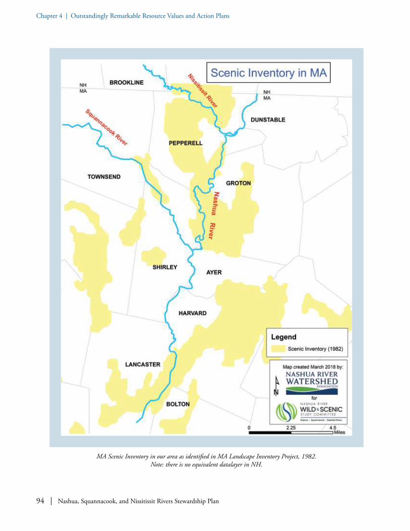
94 | Nashua, Squannacook, and Nissitissit Rivers Stewardship Plan
Chapter 4 | Outstandingly Remarkable Resource Values and Action Plans
MA Scenic Inventory in our area as identified in MA Landscape Inventory Project, 1982. Note: there is no equivalent datalayer in NH.

Nashua, Squannacook, and Nissitissit Rivers Stewardship Plan | 95
Chapter 4 | Outstandingly Remarkable Resource Values and Action Plans
worthy of their expending tax dollars toward preserv-ing remaining undeveloped parcels of land. Scenic vistas play a strong role in “rural character.” Most all the towns’ Open Space and Recreation Plans also specifically enumerate riparian lands to be of greatest importance.
The Nashua River Wild and Scenic Rivers Study Committee is nonetheless sensitive to the fact that evaluation of “scenic” resources can be a highly subjective and dependent on many aesthetic factors.
129 The National Park Service Visual Resource Inventory (VRI) is a systematic process to identify scenic values for views within and extending beyond NPS units, see http://blmwyomingvisual.anl.gov/docs/NPS_VRI_Factsheet-08-2016.pdf.
Thus, several Committee members accepted, when offered, the opportunity to participate in a National Park Service training in “Visual Resource Assessment and Inventorying.”129 As a result, a Visual Resource Inventory was conducted on November 17, 2017. Four sites were completed out of the initial two dozen identified by the Study Committee. The Committee believes this will be a valuable exercise to continue.
Pedestrian covered bridge over the Nissitissit River near Lake Potanipo in Brookline, NH. Photo: Ken Hartlage.

96 | Nashua, Squannacook, and Nissitissit Rivers Stewardship Plan
Chapter 4 | Outstandingly Remarkable Resource Values and Action Plans
Some Key Findings on the Exemplary Status of Recreational and Scenic Features
• Eight thousand unique visitors use canoes and kayaks from Nashoba Paddler, LLC -- a locally owned outfitter – to explore the Nashua and Squannacook Rivers each year, in addition to the many who bring their own boats to over 20 access sites. Nashoba Paddler additionally offers tours and a summer River Camp.
• Award-winning NRWA River Classroom®, an on-water environmental education program, brings approximately three thousand students and adults every year to the Nashua and Squannacook Rivers.
• The Nissitissit and Squannacook Rivers are widely regarded as providing some of the best fly-fishing within reach of metro-Boston anglers.
• Over 30 bass fishing clubs hold tournaments on the Nashua River.• The Groton School has always used the Nashua River for their crew team. The Groton Greenway
Committee puts on an annual spring River Festival at which a featured event is a cardboard boat race. The Lions Club holds an annual canoe race on the Squannacook River.
• The eleven mile Nashua River Rail Trail (NRRT), paralleling the river for several miles, receives more than one thousand users on any given summer weekend day with people enjoying walking, running, bicycling, roller-blading, and horseback riding. A 2008 estimate by the Massachusetts Dept. of Conservation and Recreation indicates over 382,000 visitations to the NRRT for that year.
• The ~13,900 acres of permanently conserved lands that abut the rivers provide unparalleled opportunities for hiking and wildlife viewing, and, in many areas, hunting. The Nashua River is a prime area for hunting waterfowl in season.
• The Massachusetts Scenic Rivers Program prioritized the Nashua and Squannacook Rivers as scenic rivers in need of protection. The 1982 Massachusetts Scenic Landscape Inventory included long stretches of the Squannacook and Nashua Rivers as “distinctive scenic resources” including Pepperell's much-photographed “Chester Waterous Covered Bridge”.
• A significant factor in designating three contiguous Massachusetts ACECs in the watershed is for the preservation of the scenic and recreational values of the Nashua River corridor.
• The many miles of permanently protected greenway along the rivers provide recreationists on shore or water with a serene and breathtakingly beautiful “wilderness” experience within an hour’s drive of three metropolitan cities with a combined population of over 3,000,000. 130
130 New Hampshire Department of Resources and Economic Development (DRED), “Nissitissit River NH and MA - A Preliminary Report on Proposals to Preserve” (1967).

Nashua, Squannacook, and Nissitissit Rivers Stewardship Plan | 97
Chapter 4 | Outstandingly Remarkable Resource Values and Action PlansChapter 4 | Outstandingly Remarkable Resource Values and Action Plans
A: PROTECTED GREENWAY LANDS
GOAL A.1: Promote continued protection of “temporarily protected” greenway lands (Chapter 61, 61A and 61B lands in Massachusetts; “Current Use” lands in New Hampshire).
OBJECTIVE: Enourage municipalities to plan ahead.
• Inventory greenways - Coordinate with towns to maintain an up-to-date greenway inventory of temporarily protected, permanently pro-tected, and unprotected lands along the three
rivers and their tributaries and headwaters. Encourage community officials to work with private, state, or federal partners and to apply for grants as appropriate to help finance selected land acquisitions as unprotected properties become available and the public supports their acquisition; similarly encourage officials to seek help with funding for stewardship improve-ments as appropriate.
• Pursue opportunities - Encourage Conserva-tion Commissions and Boards of Selectmen to prioritize parcels in Chapter 61 and Current Use properties so that the towns could be ready to act quickly when rights of first refusal (which in Massachusetts afford 120 days to act) are triggered by sale.
Angler in the Nissitissit River. Trout are found throughout the Squannacook and Nissitissit Rivers and their tributary streams. Photo: Ken Hartlage.
Recreation and Scenic Action Plan

98 | Nashua, Squannacook, and Nissitissit Rivers Stewardship Plan
Chapter 4 | Outstandingly Remarkable Resource Values and Action PlansChapter 4 | Outstandingly Remarkable Resource Values and Action Plans
Drone aerial photo of the Nissitissit River in Brookline, NH showing the location of the 2017 municipal purchase of two
abutting parcels for conservation purposes. Photo: Justin Adam Photography.
GOAL A.2: Promote additional permanently protected greenway lands and continued protection and completion of the “Nashua River Greenway” – the vision of a greenway along both sides of the rivers and their tributaries.
OBJECTIVE: Provide proactive encouragement and support of greenway vision.
• Prepare for the future - Ensure that if the Fort Devens South Post is ever surplused, the land is incorporated into the Oxbow National Wildlife Refuge as stipulated by 1996 Defense Authorization Act (less the 100 acres to the Town of Lancaster). Inform all current and incoming Boards of Selectmen and Conserva-tion Commissions in Lancaster and Harvard of this legislation.
131 As identified in the Massachusetts Audubon Society, “Focus Areas for Wildlife Habitat Protection in the Nashua River Watershed”, September 2000.
• Support landowners and land trusts - Con-tinue to assist and support private landowners and local land trusts in their voluntary land conservation measures that protect important riverfront and associated watershed lands. Encourage all land buying agencies to pursue the purchase in fee or conservation easements or through gifting of important river-related lands from willing sellers, if parcels come on the market and if funding is available. The New Hampshire Legislature could provide adequate funding for Land and Community Heritage Investment Program (LCHIP) to help protect wildlife habitat and to keep land open for public recreation. Towns could take advantage of opportunities to protect land, especially on the riverfront, for public recreation and open space.
• Identify connectors - Identify greenway gaps and pay special attention to land protection efforts that provide “connectors,” especially including between Bolton Flats Wildlife Man-agement Area and Oxbow National Wildlife Refuge, and the connection between Sucker Brook and Gulf Brook.131
• Prioritize headwaters - Give high protection priority to headwaters and tributaries of the three rivers, especially those of primary concern (as identified in municipal Open Space and Recreation Plans).
Nissitissit River. As one travels upstream towards a river’s origin (or headwaters) the stream channel narrows, the velocity of the current increases, water temperature decreases, dissolved oxygen
levels increase, and often aquatic habitat and water quality improves. Photo: Cindy Knox Photography.

Nashua, Squannacook, and Nissitissit Rivers Stewardship Plan | 99
Chapter 4 | Outstandingly Remarkable Resource Values and Action PlansChapter 4 | Outstandingly Remarkable Resource Values and Action Plans
GOAL A.3: Support existing greenways.
OBJECTIVE: Maintain and restore greenways.
• Support healthy greenways - Maintain the greenways in a healthy state.132 Restore natural or man-made “degraded” lands,133 particularly those visible from the rivers, for example by maintaining and expanding vegetated riparian buffer to an ideal 300 feet from riverbank, where possible.
132 Greenways are considered “healthy” when they serve their function as important ecological tools for the protection and enhancement of the natural environment. They improve water quality by establishing buffers along waterways and providing habitat. These buffers serve as natural filters, trapping stormwater pollutants from urban runoff, eroding areas, lawns and agricultural lands.
133 “Land degradation is a process in which the value of the biophysical environment is affected by a combination of human-induced processes acting upon the land. It is viewed as any change or disturbance to the land perceived to be deleterious or undesirable.” (Wikipedia)
134 https://squanatissit.org.
GOAL B.1: Ensure healthy ecosystems to support recreational fisheries.
OBJECTIVE: Support both warm and coldwater fisheries.
• Protect riparian land - Keep riparian forests intact so that their shade helps keep water temperature cool, which holds more dissolved oxygen than warmwater. Support and promote pavement reduction strategies within water-sheds (narrower roads, porous pavements, and surfaces that absorb runoff) to reduce stormwater runoff and water temperatures through education and awareness and chang-ing of local subdivision and development codes. Reduce impervious surfaces when and wherever possible.
• Protect water flow - Maintain, protect, and enhance water flow regimes that support needs of native river fauna, while accommodating demands for water supply, waste assimilation, commercial, industrial, and agricultural uses. (In Biodiversity section above see Goal A.4 Pro-tect and enhance coldwater fisheries resources, for more information.)
• Support native fish - Work with local, state and federal partners to keep healthy populations of native brook trout and other native sport fish for recreational fishing in the Squannacook and Nissitissit Rivers. One notable example of this is the work of the Squann-a-Tissit chapter of Trout Unlimited134 to conduct an
Restoring degraded river banks is important to greenway health. Photo: Al Futterman.
B: FISHING USE
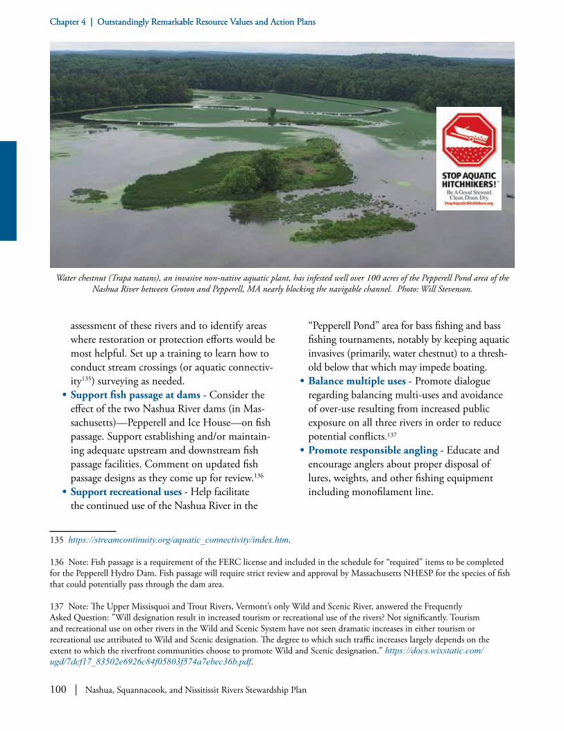
100 | Nashua, Squannacook, and Nissitissit Rivers Stewardship Plan
Chapter 4 | Outstandingly Remarkable Resource Values and Action PlansChapter 4 | Outstandingly Remarkable Resource Values and Action Plans
assessment of these rivers and to identify areas where restoration or protection efforts would be most helpful. Set up a training to learn how to conduct stream crossings (or aquatic connectiv-ity135) surveying as needed.
• Support fish passage at dams - Consider the effect of the two Nashua River dams (in Mas-sachusetts)—Pepperell and Ice House—on fish passage. Support establishing and/or maintain-ing adequate upstream and downstream fish passage facilities. Comment on updated fish passage designs as they come up for review.136
• Support recreational uses - Help facilitate the continued use of the Nashua River in the
135 https://streamcontinuity.org/aquatic_connectivity/index.htm.
136 Note: Fish passage is a requirement of the FERC license and included in the schedule for “required” items to be completed for the Pepperell Hydro Dam. Fish passage will require strict review and approval by Massachusetts NHESP for the species of fish that could potentially pass through the dam area.
137 Note: The Upper Missisquoi and Trout Rivers, Vermont’s only Wild and Scenic River, answered the Frequently Asked Question: "Will designation result in increased tourism or recreational use of the rivers? Not significantly. Tourism and recreational use on other rivers in the Wild and Scenic System have not seen dramatic increases in either tourism or recreational use attributed to Wild and Scenic designation. The degree to which such traffic increases largely depends on the extent to which the riverfront communities choose to promote Wild and Scenic designation." https://docs.wixstatic.com/ugd/7dcf17_83502e6926c84f05803f574a7ebec36b.pdf.
“Pepperell Pond” area for bass fishing and bass fishing tournaments, notably by keeping aquatic invasives (primarily, water chestnut) to a thresh-old below that which may impede boating.
• Balance multiple uses - Promote dialogue regarding balancing multi-uses and avoidance of over-use resulting from increased public exposure on all three rivers in order to reduce potential conflicts.137
• Promote responsible angling - Educate and encourage anglers about proper disposal of lures, weights, and other fishing equipment including monofilament line.
Water chestnut (Trapa natans), an invasive non-native aquatic plant, has infested well over 100 acres of the Pepperell Pond area of the Nashua River between Groton and Pepperell, MA nearly blocking the navigable channel. Photo: Will Stevenson.

Nashua, Squannacook, and Nissitissit Rivers Stewardship Plan | 101
Chapter 4 | Outstandingly Remarkable Resource Values and Action PlansChapter 4 | Outstandingly Remarkable Resource Values and Action Plans
C: BOATING USE
GOAL C.1: Preserve and enhance opportunities for boating.
OBJECTIVE: Provide and maintain public boating access.
• Maintain existing access for boaters - Main-tain the current appropriate public access sites for boaters.
• Facilitate private access - Secure continued public use through formal agreements with private landowners at informal boat launches regularly used by the public.
• Support new access points - Support creation of additional appropriate public access sites for canoe and kayak users, including those planned for the Pepperell Dam.138
• Involve Public Access Board - Identify appro-priate areas for additional car-top public access utilizing the Massachusetts Public Access Board (PAB) staff and criteria139 for potential car-top sites, if determined that such are needed.
• Set site standards - When new river access sites are desired, first develop criteria for siting such riverside public recreation areas.
• Support handicapped access - Support development of appropriate handicapped accessible sites.
138 Pepperell Hydro, LLC. “Recreation Plan for Pepperell Hydroelectric Project,” prepared by Kleinschmidt (June 2017).
139 PAB’s criteria are: site must be publically owned; demonstrated recreational need for the project; safe access into and out of the water; potential for adequate parking; a responsive municipal managing authority to maintain the site; and, consistency with the mission of the Massachusetts Division of Fish and Wildlife.
140 A recently created and close-by “blue trail” is on the North Nashua River in Lancaster, Massachusetts.
141 Consult MassWildlife’s “Trees, Paddlers and Wildlife-Safeguarding Ecological and Recreational Values on the River” and/or New Hampshire DES’s Fact sheet “Managing Large Woody Material in Rivers and Streams”. https://www.des.nh.gov/organization/commissioner/pip/factsheets/rl/documents/rl-21.pdf . Here a key take-away is: “If the large woody material is not a threat to human health, human safety, or river integrity: Let the Sleeping Log Lie.” Large woody material provides habitat, improves water quality, supports invertebrate life cycles, creates physical complexity and stabilizes banks and bed so there have been concerns about clearing such from the rivers.
• Consider boat access with road projects - Consider requiring provisions for appropriate public access when bridges or culverts (espe-cially on state roads) are upgraded.
• Support water-based recreation - Encourage the planning of water-based recreational oppor-tunities. Encourage “blue (water) trails”140 and their canoe access sites, where appropriate (for example, Pellechia launch site).
• Improve parking and signage - Encourage adequate parking and signage at existing and new sites, notably at Petapawag launch site.
• Improve boating passage - Improve rivers for safe boating passage given large woody material obstructions while maintaining habitat by obtaining input and state approvals from Massachusetts Natural Heritage and Endan-gered Species Program (Massachusetts NHESP) and Massachusetts Division of Fisheries and Wildlife.141
• Evaluate woody material - Utilize a recre-ational and ecological evaluation documenta-tion process to consider alteration of woody material blocking boat passage under summer conditions similar to that used in 2015 by the Lamprey River Watershed Association, see www.lampreyriver.org/UploadedFiles/Files/woody_obstacles_report.pdf.
• Maintain stream flows - Maintain stream flow to enhance recreational and scenic qualities, while accommodating demands for water supply, waste assimilation, commercial,

102 | Nashua, Squannacook, and Nissitissit Rivers Stewardship Plan
Chapter 4 | Outstandingly Remarkable Resource Values and Action PlansChapter 4 | Outstandingly Remarkable Resource Values and Action Plans
industrial, and agricultural uses. • Regard speed limits - Re-evaluate appropriate
speed limits for the Pepperell Pond area of the Nashua River. Speeding motorboats can conflict with non-motorized uses on the river and can cause bank erosion due to large wakes. Post speed limits as appropriate (see www.mass.gov/orgs/boat-and-recreation-vehicle-safety-bureau ).
• Encourage clean boating - Educate boaters to make sure boat hulls are clean before putting in as a way to limit the spread of aquatic invasive “hitchhikers” (see http://stopaquatichitchhikers.org/). Keep aquatic invasives to a threshold below that which may impede boating, for example at Pepperell Pond.
• Publicize canoe guide - Publicize NRWA’s 2017 Canoe and Kayak Guide to encourage boaters to select trips compatible with their skill level. Update as appropriate. Consider smart-phone app of this guide.
• Work with paddling groups - Interface and coordinate with regional paddling groups such as the Boston, Worcester, and New Hampshire Appalachian Mountain Club (AMC) chapters, which organize numerous trips on the Nashua River and occasionally the Squannacook and Nissitissit Rivers.
D: SWIMMING USE
GOAL D.1: Provide opportunities for safe swimming in our rivers.
OBJECTIVE: Be attentive to both river and riverbank conditions in evaluation of swimming opportunities.
• Confront bacterial pollution - Look for opportunities to reduce or eliminate sources of bacterial contamination and pollution so that swimming is safe in the three rivers, such as stormwater controls where appropriate and where sanctioned. Determine such possible non-point pollution sources through monthly water quality sampling/monitoring, or more frequent targeted sampling if funding allows.
• Provide health warnings - Educate public about public health threats regarding swimming within several days after intensive rainstorms. Alert the public through social media when bacteria levels at water monitor-ing sites have been exceeded for safe swimming or boating (primary and secondary contact recreation, respectively).
• Consider a warning system - Consider designing an on-line regularly updated “flagging” system to alert swimmers of any immediate water quality threats that would make primary contact with the water unad-visable in those public areas most frequently used for swimming.
• Monitor and address high use areas - Monitor most heavily used swimming areas to minimize or repair erosion problems on steep sandy banks (for example, notably at Black Rock in Townsend and Bertozzi Conservation Area in West Groton) where appropriate and where sanctioned. Guide pedestrian access to such sites onto paths that are least destructive.
• Increase public access - Increase public access to the rivers where appropriate and where
Front cover of NRWA’s 2017 Canoe and Kayak Guide.

Nashua, Squannacook, and Nissitissit Rivers Stewardship Plan | 103
Chapter 4 | Outstandingly Remarkable Resource Values and Action PlansChapter 4 | Outstandingly Remarkable Resource Values and Action Plans
sanctioned while protecting the riparian integ-rity and the surrounding river environment.
• Consider Harbor Pond restoration - Consider restoring Harbor Pond in Townsend, which is heavily eutrophied and filling in, due to sediment transport,142 to a level that supports increased recreational use, possibly including swimming where appropriate and where sanctioned.
GOAL E.1: Maintain and enhance regional trail systems.
OBJECTIVE: Provide opportunities for hikers and walkers along the rivers and on inter-connecting trails.
• Promote trail upkeep and signage - Encourage maintenance of existing trails and signage; add additional signage as appropriate.
• Work with volunteer groups - Increase access
142 Sediment transport is the movement of solid particles (sediment), typically due to a combination of gravity acting on the sediment, and/or the movement of the fluid in which the sediment is entrained. (Wikipedia)
143 Nashoba Conservation Trust (NCT) and Town of Pepperell, together, created a trail guide with details about 16 properties including land protection history (donation, purchase, etc.), details/GPS location of the parking for the property, flora, and fauna. The free guide can be downloaded from the Pepperell and NCT websites and is available in iBooks.
to existing trails and provide information for trail users143 via coordination with local trail committees, such as those in Groton and Shirley, and reliance on local volunteers and aspiring Eagle Scouts as in Pepperell.
• Practice trail stewardship - Increase monitor-ing and maintenance of rail trails—notably the existing Nashua River Rail Trail, the soon-to-be constructed Squannacook River Rail Trail, and the undeveloped riverside trails along the Nissitissit River in Pepperell, Massachusetts (these trails are owned by DFW, which has strict regulations for trail maintenance) and in Hollis and Brookline, New Hampshire—as well as other pedestrian-only river access areas. Be attentive to minimizing littering, parking problems, all-terrain-vehicle (ATV) abuses, vandalism, and trespassing on adjacent private lands. Encourage “Adopt-a-Trail”-style projects. For example, the Town of Pepperell has a volunteer-based trail monitoring and mainte-nance program for town-owned trails available on its Conservation Commission website (see: www.town.pepperell.ma.us/172/Trail-Monitor-ing-and-Maintenance-Program).
• Teach multi-use principles - Help users of the various trails learn how to safely navigate multiple types of concurrent use, for example horses, pedestrians, and cyclists simultaneously using the rail trails. Help users identify trails appropriate to their form of recreation, e.g., bi-cyclists on Nashua River Rail trail; fishing access trails along the rivers; and a canoe portage along the Nashua River Rail Trail in Pepperell.
• Publish trail guides - Develop riverside trails guide books or maps, both print and on-line, for the public to encourage trail use and assist
Good water quality is important for recreation. Youth enjoying the Nashua River. Photo: Gaynor Bigelbach.
E: REGIONAL TRAIL SYSTEM

104 | Nashua, Squannacook, and Nissitissit Rivers Stewardship Plan
Chapter 4 | Outstandingly Remarkable Resource Values and Action PlansChapter 4 | Outstandingly Remarkable Resource Values and Action Plans
in exploration of such trails144. Support and promote regional community trail mapping145 such as done by Montachusett Regional Planning Commission.
• Promote regional trail system - Promote additional use of trail easements and linkages to further extend existing formal146 regional trail system for passive recreational use.
• Look for ways to add to rail trails - Explore opportunities for extending/connecting rail trails (in all directions) for multi-uses and accessibility, while maintaining wildlife habitat.
• Support regional trail groups - Encourage the work of regional trails groups such as Monta-chusett Regional Trails Coalition (see: www.facebook.com/MontachusettTrails).
• Stay informed about Thoreau Trail - Follow development of potential “Thoreau Trail” pro-posed by Freedom’s Way Heritage Association (FWHA) that would cross the Nashua River on its 50+ mile course connecting Walden Pond and Wachusett Mountain.
• Encourage universal accessibility - Encour-age Americans with Disabilities Act (ADA) accessible trails and wildlife viewing areas where feasible.
• Consider trails in town planning - Update municipal by-laws to include trails and greenways as part of site development process. Encourage inter-municipal planning of trails
144 For one such example see: www.americantrails.org/NRTDatabase/trailDocuments/3846_QuinebaugRiverPaddleGuide2012a.pdf.
145 www.mrpc.org/home/pages/community-trail-maps.
146 Formal trails are those on existing protected lands: governmental or private (i.e., land trust holdings or registered Conservation Easements) versus informal trails. Many towns have the following “Trail Use Disclaimer: It is the personal responsibility of the trail user to verify that the trail is designated for the specific use of interest. Respect property owners’ rights. Conservation areas are generally open to hunting in accordance the Massachusetts law, unless POSTED otherwise. Be aware of hunting seasons and regulations. ATV use is generally not permitted in municipal conservation areas.” (www.shirley-ma.gov/sites/shirleyma/files/uploads/trails.pdf) Additionally, note that Massachusetts DFG has a policy of minimizing walking trails.
and greenways to encourage cross-regional linkages. There are many opportunities to link trails including at river crossing sites on rail trails.
Participants on public hike along Keyes Trail besides the Nissitissit River in Brookline and Hollis, NH during outreach phase of our
study, spring 2018. Photo: LeeAnn Wolff.
The Montachusett Regional Trails Coalition, founded in 2012, promotes and supports the development of an interconnected trail
system in the Montachusett region.

Nashua, Squannacook, and Nissitissit Rivers Stewardship Plan | 105
Chapter 4 | Outstandingly Remarkable Resource Values and Action PlansChapter 4 | Outstandingly Remarkable Resource Values and Action Plans
F: THE RECREATIONAL ACTIVITIES
GOAL F.1: Encourage other recreational activities as appropriate.
OBJECTIVE: Be responsive to an existing and evolving variety of recreational interests.
• Formalize pet policies - Clarify appropriate recreational areas for dog owners. Reinforce or create pet waste ordinances (pooper-scooper laws) and restrictions on illegal dumping, such as at Groton Place informal “dog park” along the Nashua River, or otherwise secure and maintain pet waste disposal containers.
• Consider deer population management - Conduct browse studies to determine where deer overpopulation is occurring. Encourage deer hunting where setbacks allow to reduce overpopulations that impact wildlife habitat and which also lead to increased tick numbers and result in increased cases of Lyme disease and other tick-borne illnesses in humans. Consider developing town-specific Deer Management Plans to control exploding deer populations unchecked by other predators since deer are the primary vector for such diseases.
• Engage public in nature-focused wildlife viewing and events - Encourage continued public support and participation in: a) the annual Groton-Oxbow National Wildlife Refuge Circle’s “Christmas Bird Count”, ongoing since 2000); b) “Big Night”: early spring first mass amphibian movement activi-ties; and c) local turtle protection happenings. Encourage development of “wildlife viewing and photography platforms” where appropriate.
Note: See Mass Audubon Society’s “Nashua River Watershed Important Bird Area (IBA) Site”, www.massaudubon.org/our-conserva-tion-work/wildlife-research-conservation/state-wide-bird-monitoring/massachusetts-import-ant-bird-areas-iba/important-bird-area-sites/nashua-river-watershed.
Wildlife viewing on the Nashua River. Photo: Al Futterman.
Birding events at the Surrenden Farm fields in Groton, MA are a popular recreational activity. Photo: Pam Gilfillan.

106 | Nashua, Squannacook, and Nissitissit Rivers Stewardship Plan
Chapter 4 | Outstandingly Remarkable Resource Values and Action PlansChapter 4 | Outstandingly Remarkable Resource Values and Action Plans
GOAL F.2: Maintain contact with the public regarding their enjoyment of the rivers.
OBJECTIVE: Inform the public and be informed.
• Publicize Wild and Scenic River program - Provide Wild and Scenic River program infor-mation at community events, fairs, canoe races, fishing events, and other public gatherings.
• Host a Wild and Scenic River event - Con-sider developing a signature event, which would annually help further inform the public on the value of the rivers, their outstanding resources, the value of their designation as Wild and Scenic Rivers, and opportunities to engage in stewardship activities.
• Watch future trends - Track new types of recreational activities and equipment that cannot be foreseen in the future – such as drone aircrafts emerging today -- to make sure they are compatible with managing and protecting our rivers’ ORRVs.
• Study economic benefits of recreation - Con-sider analyzing the economic benefits of recre-ation in the proposed designated area, possibly in partnership with the Freedom’s Way Heritage Association, the regional planning commissions, or others.
147 A reference/example of Devens Viewshed Overlay District containing regulations to limit the visual impact of new development on the Prospect Hill Overlook can be found at www.devensec.com/rules-regs/decregs304.html - see Section (8)(i) . Also, see www.nashobavalleyvoice.com/groton_news/ci_31402152/at-devens-planners-must-consider-view-business-builds.
G: SCENIC VALUES
GOAL G.1: Protect scenic views related to our rivers.
OBJECTIVE: Recognize the importance of views from the rivers and help preserve them.
• Protect viewshed - Encourage protection of traditional New England landscape patterns and scenic visual resources such as the viewshed across the Nashua River valley from the vicinity of Fruitlands Museum. This may include, for example, concerns regarding steep slopes, building heights, and outdoor lighting.147
• Protect traditional New England landscape patterns - Support resource-based economic activities—“working landscapes”—including sustainable farming, forestry, and ecotourism.
• Assess exceptional views - Consider conduct-ing a formal scenic assessment of exceptional views (such as National Park Service’s “Visual
Mural depicting multiple uses of the Nashua River Rail Trail near the Trail in Groton, MA. Photo: NRWA Archives.

Nashua, Squannacook, and Nissitissit Rivers Stewardship Plan | 107
Chapter 4 | Outstandingly Remarkable Resource Values and Action PlansChapter 4 | Outstandingly Remarkable Resource Values and Action Plans
Resource Inventory”)148 to identify resources in need of protection that also include views from on the rivers toward undeveloped shoreline banks as the forested corridor or greenway is a much appreciated aesthetic resource.
• Consider aesthetics in management plans - Pay special attention as relates to aesthetics, in addition to forest health, when first drafting Forest Management Plans on Massachusetts public lands along the rivers.149 The natural, “wild” appearance of the greenways as one recreates on the river is a key component of the special enjoyment the public derives on these rivers.
148 www.ncptt.nps.gov/blog/nps-visual-resource-protection/.
149 There is no requirement that public lands in New Hampshire have a Forest Management Plan.
• Adopt scenic river provisions - Encourage mu-nicipalities to adopt and enforce “Scenic River Protection” type bylaws (similar to Townsend’s Squannacook River Protection bylaw and, at the Massachusetts state level, the Squannacook and Nissitissit Rivers Sanctuary Act passed in 1975).
Plein air painting at Fruitlands Museum in Harvard, MA. Photo: www.fruitlands.thetrustees.org.

108 | Nashua, Squannacook, and Nissitissit Rivers Stewardship Plan
Chapter 4 | Outstandingly Remarkable Resource Values and Action Plans
Early Settlers. The rivers’ abundant food sources and their usefulness for travel made them important to Native Americans, whose presence has been documented by numerous investigations of stream-side archaeological sites. One such site suggests a large semi-permanent Nashaway village just south of the Meeting of the Waters, where the North and South Branch of the Nashua join. A second example is a native encampment along the Nashua River in Pepperell (the “Reedy Meadow Brook” site), near its confluence with the Nissitissit River, which is considered a major prehistoric resource.
Nipmuc groups, who called the area Petapawag or a “swampy place,” occupied Groton for many thousands of years. The many wetlands of Groton have played a big part in all of the town’s history, from the earliest settlers many millennia ago to the most recent decades. Wetlands and rivers have served as transportation corridors, life-sustaining sources of drinking water for people, plants, and animals, as well as sources of power and places for recreation.
The locations and types of wetlands spread across Groton have influenced how the town has developed and continue to be important to the different themes that make up Groton. The
ORRV Category: Historical and Cultural Resources
T he historic significance of our rivers in the landscape—and in the relationship of peo-ple to the landscape—is evident across the centuries. Our outstandingly remarkable
resource values in the Historical and Cultural category range from sites and buildings to nationally noteworthy social experiments. The “Rivers as Corridors” Chapter details the influence of early conservationists, and this chapter shines a spotlight on “The Marion Stoddart Story.” The arc of historical significance that we are tracing starts with the early settlers along the rivers.
Squannacook River at Townsend Harbor Dam in West Townsend, MA. Photo: William Rideout.

Nashua, Squannacook, and Nissitissit Rivers Stewardship Plan | 109
Chapter 4 | Outstandingly Remarkable Resource Values and Action Plans
interpretive themes presented in the following section refer back to the role of water and its influence on history within the town.150
It has been suggested that the region’s geography resulted in unique human settlement patterns. Former Archaeological Curator of Fruitlands Muse-um, Michael Volmar, described the extensive, 1,000+ acre freshwater estuary at the present Oxbow Na-tional Wildlife Refuge as being communally used for hunting and gathering by Native Americans. The natural resources—including seasonal shad, salmon, and alewife fish runs—were so abundant as to be a place where different bands could utilize such without concern for the usual territorial boundaries.
While evidence of some settlements has been found, one might have expected more. Local history buffs have pondered if “the lack of settlements was because
150 University of Massachusetts, “Groton Community-Wide Archaeological Reconnaissance Survey,” (March 2011), page 32.
151 Robert Pine, Director of Environmental Planning and Engineering at Pine and Swallow Environmental in Groton, Massachusetts, personal communication, September 6, 2017.
152 "It is expected that the town [Groton] includes large Native American sites that would have spanned many millennia. Petapawag [Ameri-Indian (Nipmuc) place-name for present-day Groton] would have been attractive to such early settlers, as it is located along one of the area’s major rivers, and it is considered likely that such sites exist in the town. One or more of these sites may contain evidence of Paleoindian occupation that has not yet been recognized, or has been lost." (“Groton Community-wide Archaeological Reconnaissance Survey,” pages 35-6) There is one other pre-historic site located just across the Squannacook River from Groton, the “Herfco Knoll” site, referenced on page 43 of this same Survey.
the Native Americans considered the area sacred. This was their prime hunting ground so they took special care to protect it and keep it wild, [thus] settlements would have degraded it.”151 There is a high probability of potential Native American archaeologic sites in our area that have not yet been identified, according to the Massachusetts Historical Commission (MHC) and local professional historian Michael Roberts of Timelines, Inc.152
There is one confirmed Native American Graves Protection and Repatriation Act (NAGPRA) site in the Lake Potanipo area of Brookline, which was found when the ice harvesting facility (Fresh Pond Ice Company) was being constructed in 1905. The remains went through a NAGPRA review managed by Harvard University, and the remains were returned to the Abenaki native tribes in 2001.
Due to the presence of prime agricultural soils in the large floodplains along the banks of the river, there is a longterm agricultural history. Agrarian history dates back to the prehistoric Late Woodland Period. Native Americans burned the land to keep it open, which made it attractive to European settlers who arrived in the 17th century.
Beaver lodges abound in the Oxbow National Wildlife Refuge. Photo: Mary Marro.
In 1653, the first grant to buy land for a town—Lancaster—was along the Nashua River from the
Nipmuck Tribe, known as the “fresh water people.”

110 | Nashua, Squannacook, and Nissitissit Rivers Stewardship Plan
Chapter 4 | Outstandingly Remarkable Resource Values and Action Plans
First Towns, Trading Posts, and Mills. Lan-caster was one of the first inland towns established in Colonial America; a Native American trading post was set up near the Nashua River in 1643. Soon after, other European settlers followed to farm the rich soils of the Nashua Valley and, in time, the Squannacook Valley. Originally, it was “first begun for love of the Indians’ trade, but since the fertility of the soil and pleasantness of the river hath invited many more.”153
In 1653, the first grant to buy land for a town—Lancaster—was along the Nashua River from the Nipmuck Tribe, known as the “fresh water people.” This tribe was associated with the Nashua, or the Nashaway, the “river with the beautiful pebbled bottom.” Over time, the Native Americans did not
153 Massachusetts Historical Commission, Historic and Archaeological Resources of Central Massachusetts, (1985), page 62.
154 The town of Lancaster was officially incorporated in 1653 as “Lancaster on the Nashua,” summarizing the importance of that water resource to the citizens. See Town of Lancaster’s town seal.
relinquish this land readily and there were many struggles. Mary Rowlandson wrote the first book written by a woman in America, A Narrative of the Captivity and Restoration of Mrs. Mary Rowlandson, records her experience in 1676 as an “Indian” captive taken from Lancaster to Canada.
By the 1770s, Lancaster154 was the wealthiest agricultural town in the area, largely as a result of
Map of “Native American Archaeological Site Potential” from Groton Community-wide Archaeological Reconnaissance Survey.

Nashua, Squannacook, and Nissitissit Rivers Stewardship Plan | 111
Chapter 4 | Outstandingly Remarkable Resource Values and Action Plans
the productive lands of the “Nashua interval,” the low-lying, rich bottom lands along the river. Similar-ly, Ash Swamp, the headwaters of the Squannacook River in Townsend, would become a “highly prized meadowland in colonial times, adjoining lowlands still in agriculture.”155
The Nashua River served as barrier to westward settlement for 100 years after the European settlers arrived. A monument near the river in Pepperell marks the site of the last attack by Native Americans in the area in 1745.
In Townsend, a sawmill was established at the Harbor in 1733, and a gristmill was added shortly thereafter. In Ayer, circa 1770, a grist and sawmill (Pierce’s) was built on Nonacoicus Brook, a tributary to the Nashua River in Ayer. Other early mills include a 1739 clothier mill on the Squannacook River (present day “Cooperage”).
Fessenden Mill, on the Squannacook River, at the precursor site of present Sterilite Corporation, consumed 25,000 board feet of lumber daily in the making of barrels. At its heyday, ~1900-1929, the factory employed about 300 people; it closed in 1960. In 1875, Townsend had 11 barrel factories. Townsend’s present state forest once belonged to Fessenden’s; the land was sold to the state after the devastating fire of 1927, which rendered it useless as a source of material for that barrel factory.156
The Petapawag Canoe Launch in Groton is situated on another Native American settlement site. The same spot was later a trading post and witnessed an early 17th century skirmish between English settlers and Native Americans. Another trading post in the vicinity dates back to 1656, where the owner John Tinker would use the river to transport goods from his home upriver in Lancaster. Groton’s first Euro-pean settlement was located in the nearby J. Harry Rich State Forest, and numerous cellar holes remain from that time. The old stagecoach road from
155 NRWA "Squannacook River Protection Plan,” 1984, reprinted November 4, 1996, page 33.
156 Ibid, pages 41-42.
Boston to Keene, New Hampshire ran through the forest to a ford in the river at the present site of the Route 119 Bridge known as the “Stoney Fordway” or “Stoney-wading-place.”
The first settlement of Groton by European Americans was heavily shaped by the water resources of Petapawag. The rivers were used for travel. The wetlands were filled with abundant flora and fauna, and the many wetlands frequently flooded nearby plains, richly fertilizing the soils. This initial European American settlement was also influenced by their predecessors, the Nashaway Nipmuc. In the same way that the primary transportation route was along the Nashua River for the Nipmuc, the first reported permanent settlement was situated on the Nashua River. This first settlement was a trading house established in 1656 to conduct business with the Nipmuc. The trading post focused on commerce in furs. Around 1655 the trading post was operated by John Tinker (Michael Roberts, 2010), and was situated at the
The Petapawag Boat Launch on Nashua River in Groton, MA. Photo: Cindy Knox Photography.
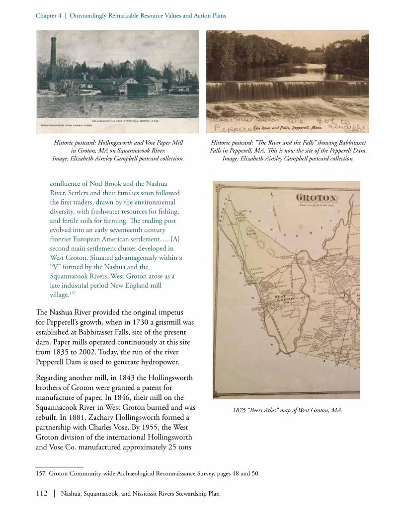
112 | Nashua, Squannacook, and Nissitissit Rivers Stewardship Plan
Chapter 4 | Outstandingly Remarkable Resource Values and Action Plans
confluence of Nod Brook and the Nashua River. Settlers and their families soon followed the first traders, drawn by the environmental diversity, with freshwater resources for fishing, and fertile soils for farming. The trading post evolved into an early seventeenth century frontier European American settlement…. [A] second main settlement cluster developed in West Groton. Situated advantageously within a “V” formed by the Nashua and the Squannacook Rivers, West Groton arose as a late industrial period New England mill village.157
The Nashua River provided the original impetus for Pepperell’s growth, when in 1730 a gristmill was established at Babbitasset Falls, site of the present dam. Paper mills operated continuously at this site from 1835 to 2002. Today, the run of the river Pepperell Dam is used to generate hydropower.
Regarding another mill, in 1843 the Hollingsworth brothers of Groton were granted a patent for manufacture of paper. In 1846, their mill on the Squannacook River in West Groton burned and was rebuilt. In 1881, Zachary Hollingsworth formed a partnership with Charles Vose. By 1955, the West Groton division of the international Hollingsworth and Vose Co. manufactured approximately 25 tons
157 Groton Community-wide Archaeological Reconnaissance Survey, pages 48 and 50.
1875 “Beers Atlas” map of West Groton, MA.
Historic postcard: Hollingsworth and Vose Paper Mill in Groton, MA on Squannacook River.
Image: Elizabeth Ainsley Campbell postcard collection.
Historic postcard: ”The River and the Falls” showing Babbitasset Falls in Pepperell, MA. This is now the site of the Pepperell Dam.
Image: Elizabeth Ainsley Campbell postcard collection.
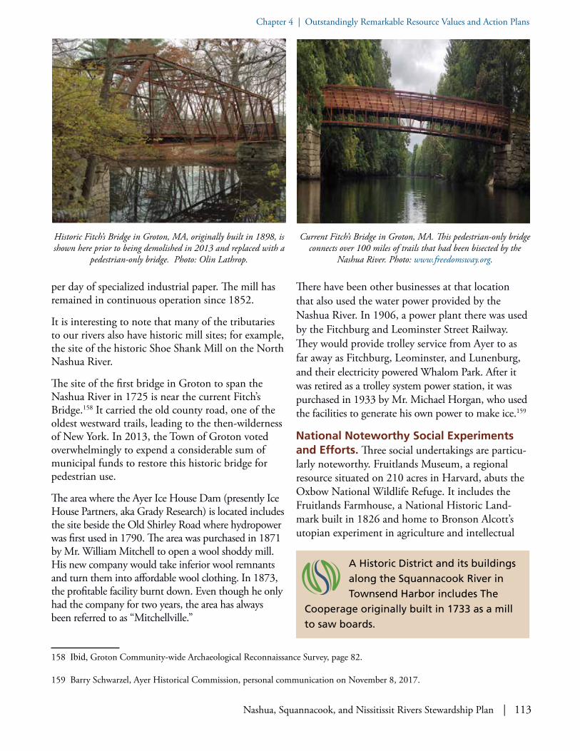
Nashua, Squannacook, and Nissitissit Rivers Stewardship Plan | 113
Chapter 4 | Outstandingly Remarkable Resource Values and Action Plans
per day of specialized industrial paper. The mill has remained in continuous operation since 1852.
It is interesting to note that many of the tributaries to our rivers also have historic mill sites; for example, the site of the historic Shoe Shank Mill on the North Nashua River.
The site of the first bridge in Groton to span the Nashua River in 1725 is near the current Fitch’s Bridge.158 It carried the old county road, one of the oldest westward trails, leading to the then-wilderness of New York. In 2013, the Town of Groton voted overwhelmingly to expend a considerable sum of municipal funds to restore this historic bridge for pedestrian use.
The area where the Ayer Ice House Dam (presently Ice House Partners, aka Grady Research) is located includes the site beside the Old Shirley Road where hydropower was first used in 1790. The area was purchased in 1871 by Mr. William Mitchell to open a wool shoddy mill. His new company would take inferior wool remnants and turn them into affordable wool clothing. In 1873, the profitable facility burnt down. Even though he only had the company for two years, the area has always been referred to as “Mitchellville.”
158 Ibid, Groton Community-wide Archaeological Reconnaissance Survey, page 82.
159 Barry Schwarzel, Ayer Historical Commission, personal communication on November 8, 2017.
There have been other businesses at that location that also used the water power provided by the Nashua River. In 1906, a power plant there was used by the Fitchburg and Leominster Street Railway. They would provide trolley service from Ayer to as far away as Fitchburg, Leominster, and Lunenburg, and their electricity powered Whalom Park. After it was retired as a trolley system power station, it was purchased in 1933 by Mr. Michael Horgan, who used the facilities to generate his own power to make ice.159
National Noteworthy Social Experiments and Efforts. Three social undertakings are particu-larly noteworthy. Fruitlands Museum, a regional resource situated on 210 acres in Harvard, abuts the Oxbow National Wildlife Refuge. It includes the Fruitlands Farmhouse, a National Historic Land-mark built in 1826 and home to Bronson Alcott’s utopian experiment in agriculture and intellectual
Historic Fitch’s Bridge in Groton, MA, originally built in 1898, is shown here prior to being demolished in 2013 and replaced with a
pedestrian-only bridge. Photo: Olin Lathrop.
Current Fitch’s Bridge in Groton, MA. This pedestrian-only bridge connects over 100 miles of trails that had been bisected by the
Nashua River. Photo: www.freedomsway.org.
A Historic District and its buildings along the Squannacook River in Townsend Harbor includes The
Cooperage originally built in 1733 as a mill to saw boards.

114 | Nashua, Squannacook, and Nissitissit Rivers Stewardship Plan
Chapter 4 | Outstandingly Remarkable Resource Values and Action Plans
living in 1843. While short-lived, the experiment was influential in the Transcendentalist movement. Second, a Shaker Village existed along Nashua River in Shirley from the late 1700s to the early 1900s. Third, a Historic District along the Squannacook River in Townsend Harbor is known as a “safe harbor” due to the local Abolitionists who participat-ed in the Underground Railroad network. The Conant House, reputed to be the oldest house in Townsend, is also reputed to be a “safe house.” Another source indicates that the name “Harbor” derives from the earliest days of the colonial settle-ment, when four fortified garrison houses were located in the area to provide refuge during Native American attacks.160
Historic Properties, Districts, and Army Camps. Harvard has three properties that are listed in the National Register of Historic Places: Fruitlands Museum (which is also a National Historic Landmark), Still River Baptist Church, and the Fiske Warren House, now part of Saint Benedict’s Abbey abutting the Nashua River. There are four National Register Districts: Vicksburg Square at Fort Devens, Fruitlands Museum, Harvard Center, and Shaker Village.
160 See the Townsend Historical Society at www.townsendhistoricalsociety.org/ths.html.
161 Shirley Historical Society, “Most Historic Small Town in the Nation” at www.shirleyhistory.org/mosthistoric.htm.
Harvard has two local historic districts, Harvard Center and Shaker Village. Another National Register District is the Shirley Shaker Village (now part of Massachusetts Department of Corrections MCI-Shirley) near the banks of the Nashua River. Shirley was named “the Most Historic Small Town in the Nation.”161 Devens has a Fort Devens Historic District and 89 properties listed on the National Register of Historic Places, four historic archaeologi-cal sites, and one prehistoric archaeological site.
A highlight of mid-19th century cultural history in our area is the former Civil War Camp called “Camp Stevens.” It was built on the banks of the Nashua River along a stretch of the old Fitchburg Road. (The KTR European Motor Sports business occupies the
Historic postcard: “Air View of Barracks at Fort Devens, Mass” with the Nashua River in the background.
Back of previous historic postcard of Barracks at Fort Devens, Mass.
Historic postcard: “`Fruitlands: The Home of the Alcotts, Harvard, Mass.” Image: Elizabeth Ainsley Campbell postcard collection.

Nashua, Squannacook, and Nissitissit Rivers Stewardship Plan | 115
Chapter 4 | Outstandingly Remarkable Resource Values and Action Plans
old camp property today.) A memorial on the proper-ty commemorates the 950 men who served there and in the 53rd Regiment Massachusetts Volunteer Infantry. On November 2, 2013, the memorial was re-dedicated, following extensive work funded by the town of Ayer and a grant from the Massachusetts Sesquicentennial Committee to improve the site and allow easier access to the memorial.
A related component of 20th century cultural history is that parts of Ayer, Harvard, Lancaster, and Shirley were chosen as US Army Post Fort “Camp” Devens during World War I, where over 100,000 soldiers trained. It was substantially expanded during World War II to approximately 5,220 acres to become the largest military installation in New England. Notoriously, Fort Devens was the epi-center of the 1918 Influenza Pandemic. A Fort Devens Museum (incorporated in 2001) is dedicated to preserving the history of Camp Devens and Fort Devens.162
While Fort Devens was active, the US Government conducted many studies of Devens and the sur-rounding region; indeed, Plow Shop Pond in Ayer is considered one of the most well-documented ponds
162 See www.fortdevensmuseum.org.
Historic photo: Workers harvesting ice blocks at Fresh Pond Ice Co. on Lake Potanipo (source of the
Nissitissit River) in Brookline, NH. Photo: www.brooklineice-breakers.com/brookline-history-tour/fresh-pond-ice-company.
Historic postcard: Fresh Pond Ice Co. on Lake Potanipo in Brookline, NH.
Senator Edward Kennedy at the public dedication in 1994 of conveyance of additional lands to the Oxbow National Wildlife
Refuge from the North and Main Posts of Fort Devens. Photo: NRWA Archives.
Devens, sited on the Nashua River, has a Fort Devens Historic District and 89 properties listed
on the National Register of Historic Places, 4 historical archaeological sites, and 1 prehistoric archaeological site. Devens also has a Fort Devens Historical Museum.
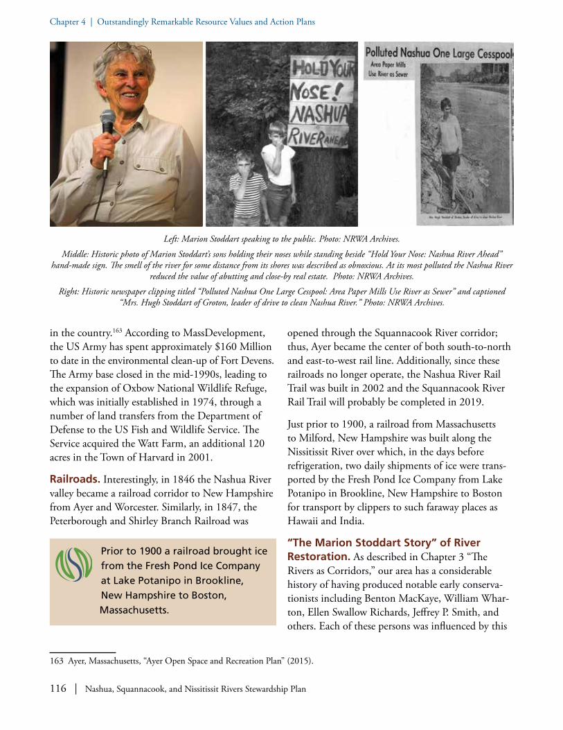
116 | Nashua, Squannacook, and Nissitissit Rivers Stewardship Plan
Chapter 4 | Outstandingly Remarkable Resource Values and Action Plans
in the country.163 According to MassDevelopment, the US Army has spent approximately $160 Million to date in the environmental clean-up of Fort Devens. The Army base closed in the mid-1990s, leading to the expansion of Oxbow National Wildlife Refuge, which was initially established in 1974, through a number of land transfers from the Department of Defense to the US Fish and Wildlife Service. The Service acquired the Watt Farm, an additional 120 acres in the Town of Harvard in 2001.
Railroads. Interestingly, in 1846 the Nashua River valley became a railroad corridor to New Hampshire from Ayer and Worcester. Similarly, in 1847, the Peterborough and Shirley Branch Railroad was
163 Ayer, Massachusetts, “Ayer Open Space and Recreation Plan” (2015).
opened through the Squannacook River corridor; thus, Ayer became the center of both south-to-north and east-to-west rail line. Additionally, since these railroads no longer operate, the Nashua River Rail Trail was built in 2002 and the Squannacook River Rail Trail will probably be completed in 2019.
Just prior to 1900, a railroad from Massachusetts to Milford, New Hampshire was built along the Nissitissit River over which, in the days before refrigeration, two daily shipments of ice were trans-ported by the Fresh Pond Ice Company from Lake Potanipo in Brookline, New Hampshire to Boston for transport by clippers to such faraway places as Hawaii and India.
“The Marion Stoddart Story” of River Restoration. As described in Chapter 3 “The Rivers as Corridors,” our area has a considerable history of having produced notable early conserva-tionists including Benton MacKaye, William Whar-ton, Ellen Swallow Richards, Jeffrey P. Smith, and others. Each of these persons was influenced by this
Prior to 1900 a railroad brought ice from the Fresh Pond Ice Company at Lake Potanipo in Brookline, New Hampshire to Boston, Massachusetts.
Left: Marion Stoddart speaking to the public. Photo: NRWA Archives.
Middle: Historic photo of Marion Stoddart’s sons holding their noses while standing beside “Hold Your Nose: Nashua River Ahead” hand-made sign. The smell of the river for some distance from its shores was described as obnoxious. At its most polluted the Nashua River
reduced the value of abutting and close-by real estate. Photo: NRWA Archives.
Right: Historic newspaper clipping titled “Polluted Nashua One Large Cesspool: Area Paper Mills Use River as Sewer” and captioned “Mrs. Hugh Stoddart of Groton, leader of drive to clean Nashua River.” Photo: NRWA Archives.

Nashua, Squannacook, and Nissitissit Rivers Stewardship Plan | 117
Chapter 4 | Outstandingly Remarkable Resource Values and Action Plans
region’s natural resources and took steps to conserve such. Marion Stoddart, who moved to Groton in the 1960s, is renowned for her conservation efforts.
In the 1960s when there were no laws against dumping pollutants into waterways, a group of concerned citizens set out to restore the Nashua River, one of the nation’s ten most polluted rivers. They dared to envision the unthinkable: “sparkling blue water with a ribbon of green along its banks.” They advocated for a revitalized river corridor that would be safe for people and wildlife alike. Led by Marion Stoddart, they galvanized the attention of towns, government agencies, businesses, and other residents—and soon all joined in pursuing the ambi-tious restoration goal.164
Although the Nashua River is thought to be a native word for “river with a clear- or pebbled-bottom,”
164 “How a Housewife Transformed an Open Sewer into a Swimmable River,” Huffington Post, 7/07/2014 www.huffingtonpost.com/ellen-moyer-phd/nashua-river-transformed-_b_5552680.html.
165 Nashua River Watershed Association, “Plan for the Nashua River Watershed” (1972), page 40.
by the 1960s its recovery seemed an impossible task as the river—known locally as the “Nauseous River” because of its awful smell—was all but biologically dead. One could smell the river from more than a mile away, riparian real estate was worthless, it noto-riously ran various colors from dyes dumped into the river by the paper mills, and the only wildlife were rats and sludge worms. Sludge banks along the Nashua exceeded five-foot depth in places.
Visually, the Nashua is, in short, revolting. Sludge and scum fill the stream, and discoloration and turbidity resulting from paper mill discharges and other wastes can be found throughout most of the river’s length. Fermentation bubbles are ubiquitous and obnoxious odors constitute a widespread nuisance.165
Historic photo of paper sludge and colored dye in North Nashua River in the 1960s. Photo: NRWA Archives.
Historic photo of paper mill sludge in North Nashua River and hanging from trees in the 1960s. Photo: NRWA Archives.
“The Marion Stoddart Story” of River Restoration has garnered international recognition, served as a model to groups across the
country, and inspired countless individuals.

118 | Nashua, Squannacook, and Nissitissit Rivers Stewardship Plan
Chapter 4 | Outstandingly Remarkable Resource Values and Action Plans
The river was so grossly polluted in 1969 that Fort Devens military personnel were warned to stay away from it. It was locally thought that if you fell into the river you should go to the hospital for inoculations. It had a “U” designation signifying “unsuitable,” meaning its condition did not meet any of the existing water quality standards classifi-cations.166 Even the 1952 Conservation Land Use Plan for the Town of Groton MA stated “…the Nashua River and the lower end of the Squanna-cook River, are so badly polluted that they have little value to Groton for any purpose.”167
In 1962, having rallied friends, neighbors, and local officials to work with her, Marion Stoddart and oth-ers formed the Nashua River Clean-up Committee. That Committee advocated for higher water quality standards for the river through the Massachusetts
166 “Class A waters were designated as sources of public water supply. Class B waters were designated for aquatic life, recreation (swimming and boating) and aesthetics. Class C waters were designated for indigenous aquatic life, limited recreation (boating) and aesthetics. Class D waters were designated for aesthetic enjoyment only.” From Appendix C: Warren Kimball, History of Water Quality in the Nashua River and Tributaries.
167 The Groton plan went on to say “There is not much that any town below the source of pollution can do to correct this condition beyond cooperation with the other towns affected, the industries concerned, and the State Department of public Health, which is working on the problem. We can make no recommendation other than the full cooperation of the town with the above agencies.” 1952 Conservation Land Use Plan for the Town of Groton Massachusetts.
Water Quality Standards established in 1967 (see Appendix B), and she even delivered a bottle of dirty river water to the then-Governor of Massachusetts, John A. Volpe. The Committee worked tirelessly for the passage of the federal Clean Water Act, solicited support for the clean-up from federal, state, and local government officials, engaged mill and other business owners in the cause, and educated citizens in every watershed town about the need to restore the river.
As the work of the Clean-up Committee progressed and drew more support, the decision was made to establish a non-profit environmental organization. In 1969, the Nashua River Watershed Association was formed. The Incorporators of the Association included community leaders from throughout the watershed, including Lee P. “Bill” Farnsworth, Benton MacKaye, Jeffrey P. Smith, William Wharton;
The now iconic “before and after” photos of the North Nashua River in Fitchburg, MA. Photos: NRWA Archives.
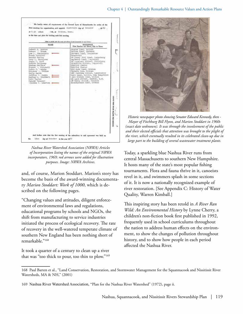
Nashua, Squannacook, and Nissitissit Rivers Stewardship Plan | 119
Chapter 4 | Outstandingly Remarkable Resource Values and Action Plans
and, of course, Marion Stoddart. Marion’s story has become the basis of the award-winning documenta-ry Marion Stoddart: Work of 1000, which is de-scribed on the following pages.
“Changing values and attitudes, diligent enforce-ment of environmental laws and regulations, educational programs by schools and NGOs, the shift from manufacturing to service industries initiated the process of ecological recovery. The rate of recovery in the well-watered temperate climate of southern New England has been nothing short of remarkable.”168
It took a quarter of a century to clean up a river that was “too thick to pour, too thin to plow.”169
168 Paul Barten et al., “Land Conservation, Restoration, and Stormwater Management for the Squannacook and Nissitissit River Watersheds, MA & NH,” (2001)
169 Nashua River Watershed Association, “Plan for the Nashua River Watershed” (1972), page ii.
Today, a sparkling blue Nashua River runs from central Massachusetts to southern New Hampshire. It hosts many of the state’s most popular fishing tournaments. Flora and fauna thrive in it, canoeists revel in it, and swimmers splash in some sections of it. It is now a nationally recognized example of river restoration. [See Appendix C: History of Water Quality, Warren Kimball.]
This inspiring story has been retold in A River Ran Wild: An Environmental History by Lynne Cherry, a children’s non-fiction book first published in 1992, frequently used in school curriculums throughout the nation to address human effects on the environ-ment, to show the changes of pollution throughout history, and to show how people in each period affected the Nashua River.
Historic newspaper photo showing Senator Edward Kennedy, then - Mayor of Fitchburg Bill Flynn, and Marion Stoddart in 1960s
(exact date unknown). It was through the involvement of the public and their elected officials that attention was brought to the plight of the river, which eventually resulted in its celebrated clean-up due in
large part to the building of several wastewater treatment plants.
Nashua River Watershed Association (NRWA) Articles of Incorporation listing the names of the original NRWA
incorporators, 1969; red arrows were added for illustration purposes. Image: NRWA Archives.

120 | Nashua, Squannacook, and Nissitissit Rivers Stewardship Plan
Chapter 4 | Outstandingly Remarkable Resource Values and Action Plans
In 1993, National Geographic magazine spotlighted the Nashua River’s recovery in an article entitled “The Promise of Restoration: New Ideas, New Understanding, New Hope” in its special edition “The Power, Promise, and Turmoil of North Ameri-ca’s Fresh Water.” The article used dramatic “before and after” images of the North Nashua River, which continue to attract the most attention at the NRWA River Resource Center.
In 1987, the United Nations honored Marion Stoddart, naming her to the “Global 500 Roll of Honor.” National Geographic’s 2010 “Water: Mes-sages of Hope for Earth’s Most Precious Resource” contains an essay on the Nashua River clean-up by Marion Stoddart. Most recently, her story and that of the Nashua River were made into an independent, critically acclaimed documentary film, Marion Stoddart: The Work of 1000,170 which speaks to a model for effective leadership, advocacy, grassroots organizing, and coalition building to achieve one’s vision. Our locally celebrated natural resources are also a symbol of success.
The river’s recovery has sparked recreational use at places like the Oxbow National Wildlife Refuge; J. Harry Rich State Forest; Townsend State Forest;
170 Susan Edwards and Dorie Clark, “Marion Stoddart: The Work of 1000” (2010). See Documentary Educational Resources at http://www.der.org/films/work-of-1000.html.
the Bolton Flats, Squannacook River, and Nissitissit River Wildlife Management Areas; and the Groton and Shirley Town Forests, to name but some of the conserved lands abutting the rivers and protecting their shorelines.
Front cover of National Geographic magazine Special Edition titled: “Water: The Power, Promise, and Turmoil of North America’s Fresh Water” which had a two-page spread of the now iconic “before
and after” photos of the North Nashua River in Fitchburg, MA, which was labeled “The Promise of Restoration.”
Kayaking on the Nashua River. Photo: Jim Kay.
Front cover of “A River Ran Wild” by Lynne Cherry.

Nashua, Squannacook, and Nissitissit Rivers Stewardship Plan | 121
Chapter 4 | Outstandingly Remarkable Resource Values and Action Plans
Marion Stoddart kayaking on the Nashua River. Photo: Nancy Ohringer.

122 | Nashua, Squannacook, and Nissitissit Rivers Stewardship Plan
Chapter 4 | Outstandingly Remarkable Resource Values and Action Plans
Some Key Findings on the Exemplary Status of Historical and Cultural Features
• The story of the Nashua River clean-up has merited international acclaim and has served as a model for watershed groups across the nation. The Nashua River, once one of the top ten most polluted rivers in the country, was revitalized due to the efforts of internationally recognized Marion Stoddart and others.
• The polluted “before” and revitalized “after” iconic photos of the North Nashua River instantly communicate this story, which has been recounted in the children’s book A River Ran Wild by Lynne Cherry. The book has sold more than 1,000,000 copies and is often used in classroom curriculums.
• Marion Stoddart was recognized by the United Nations Environmental Program in 1987. The story of the clean-up was featured in National Geographic magazine.
• The story of the clean-up and Stoddart’s role was documented in Susan Edward’s award-winning film Marion Stoddart: Work of 1000, which has been shown in over two dozen film festivals across the country.
• Several notable early conservationists including Benton MacKaye, William P. Wharton, Ellen Swallow Richards, and Jeffrey P. Smith, among others, were influenced by this region’s natural resources and took steps to conserve these resources.
• Parts of Ayer, Harvard, Lancaster, and Shirley were chosen as US Army Post Fort “Camp” Devens during World War I and expanded during World War II to ~5,220 acres to become the largest military installation in New England.
• Fruitlands Museum is a regional resource on 210 acres in Harvard that abuts Oxbow National Wildlife Refuge. The Museum includes the site of a former Transcendentalist community, Bronson Alcott’s 1843 short-lived utopian experiment in agriculture and intellectual living.
• The Nashua, Squannacook, and Nissitissit Rivers are all included in the federally- designated Freedom’s Way National Heritage Area. A few of the many outstanding resources acknowledged by this designation include: the site of a major prehistoric resource, a Nashaway village, by the Meeting of the Waters where the North and South Branch of the Nashua join, and a native encampment near the confluence of the Nashua and Nissitissit Rivers in Pepperell. In addition, the 1,000+ acre freshwater estuary at the present Oxbow National Wildlife Refuge is noteworthy as being so rich in natural resources as to be communally used for hunting and gathering by the indigenous Native Americans, irrespective of territorial boundaries.
• The first book written by a woman in America, A Narrative of the Captivity and Restoration of Mrs. Mary Rowlandson, records her experience as an “Indian” captive taken from Lancaster to Canada and later ransomed back home.
• The presence of prime agricultural soils in the large floodplains along the banks of the Nashua River were historically significant to the founding of the first colonial towns and are still heavily utilized to this day.

Nashua, Squannacook, and Nissitissit Rivers Stewardship Plan | 123
Chapter 4 | Outstandingly Remarkable Resource Values and Action PlansChapter 4 | Outstandingly Remarkable Resource Values and Action Plans
A: REGIONAL CONSERVATION ETHIC
GOAL A.1: Celebrate the roles of influential conservationists inspired by the Nashua, Squannacook, and Nissitissit Rivers.
OBJECTIVE: Deepen our understanding of local conservationists.
• Learn from the legacy of conservationists - Encourage further research into the lives, legacy, and impact of local conservationists Benton MacKaye, William Wharton, Jeffrey P. Smith, Lee P. “Bill” Farnsworth, Ellen Swallow Rich-ards, Marion Stoddart, and others. (For more information on these notables, see Chapter 3 "The Rivers as Corridors".)
• Use their legacy to teach conservation - Encourage displays and programs that draw the public’s attention to the work of these early conservationists and their connection to our region
Lee Pierce "Bill" Farnsworth (1921-1995), longtime Lancaster resident who initiated the Nashua River Study Committee in 1962.
Historical and Cultural Action Plan
Historic postcard: “The Old Covered Bridge,” the site of the current Chester Waterous Covered Bridge over the Nashua River in
Pepperell, MA. On April 19, 1775 Prudence Wright led a group of Pepperell women to guard this bridge and captured a British spy.
Image: Pepperell Historical Society.
Current Chester Waterous Covered Bridge over the Nashua River in Pepperell, MA. Photo: Jane Metzger.

124 | Nashua, Squannacook, and Nissitissit Rivers Stewardship Plan
Chapter 4 | Outstandingly Remarkable Resource Values and Action PlansChapter 4 | Outstandingly Remarkable Resource Values and Action Plans
GOAL A.2: Foster, stimulate, and support the next generation of con-servationists.
OBJECTIVE: Inspire youth stewardship.
• Teach youth conservation - Develop and support programming that introduces youth to the concept of a conservation ethic and helps deepen their own conservation ethic.
• Teach watershed planning and management - Work with local educational institutions within the Nashua River watershed and Squan-nacook and Nissitissit River sub-watersheds to incorporate watershed planning and manage-ment into existing school curriculums and activities.
GOAL B.1: Preserve the history of the clean-up of the Nashua River as a national model and preserve “The Marion Stoddart Story.”
OBJECTIVE: Assure continued access to the historic story.
• Preserve the history of the Nashua River clean-up - Support the NRWA in maintaining and adding to the materials in its Conservation Clearinghouse regarding the historic clean-up of the Nashua River, including Marion Stoddart’s efforts to control discharge into the river.
• Celebrate A River Ran Wild - Encourage the continued use of A River Ran Wild in schools and groups for youth; recognize and celebrate the impact the book has had across the country and internationally.
Marion Stoddart speaks with youth circa early 2000s. Photo: NRWA Archives.
B: RIVER RENEWAL
Marion Stoddart reads to youth from “A River Ran Wild” circa early 2000s. Photo: Nancy Ohringer.
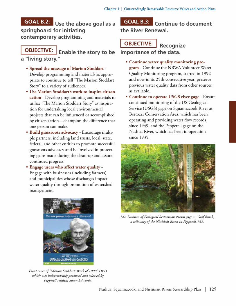
Nashua, Squannacook, and Nissitissit Rivers Stewardship Plan | 125
Chapter 4 | Outstandingly Remarkable Resource Values and Action PlansChapter 4 | Outstandingly Remarkable Resource Values and Action Plans
GOAL B.2: Use the above goal as a springboard for initiating contemporary activities.
OBJECTIVE: Enable the story to be a “living story.”
• Spread the message of Marion Stoddart - Develop programming and materials as appro-priate to continue to tell “The Marion Stoddart Story” to a variety of audiences.
• Use Marion Stoddart’s work to inspire citizen action - Develop programming and materials to utilize “The Marion Stoddart Story” as inspira-tion for undertaking local environmental projects that can be influenced or accomplished by citizen action—champion the difference that one person can make.
• Build grassroots advocacy - Encourage multi-ple partners, including land trusts, local, state, federal, and other entities to promote successful grassroots advocacy and be involved in protect-ing gains made during the clean-up and assure continued progress.
• Engage users who affect water quality - Engage with businesses (including farmers) and municipalities whose discharges impact water quality through promotion of watershed management.
GOAL B.3: Continue to document the River Renewal.
OBJECTIVE: Recognize importance of the data.
• Continue water quality monitoring pro-gram - Continue the NRWA Volunteer Water Quality Monitoring program, started in 1992 and now in its 25th consecutive year; preserve previous water quality data from other sources as available.
• Continue to operate USGS river gage - Ensure continued monitoring of the US Geological Service (USGS) gage on Squannacook River at Bertozzi Conservation Area, which has been operating and providing water flow records since 1949, and the Pepperell gage on the Nashua River, which has been in operation since 1935.
Front cover of “Marion Stoddart: Work of 1000” DVD which was independently produced and released by
Pepperell resident Susan Edwards.
MA Division of Ecological Restoration stream gage on Gulf Brook, a tributary of the Nissitissit River, in Pepperell, MA.

126 | Nashua, Squannacook, and Nissitissit Rivers Stewardship Plan
Chapter 4 | Outstandingly Remarkable Resource Values and Action PlansChapter 4 | Outstandingly Remarkable Resource Values and Action Plans
GOAL B.4: Educate and engage the public in the ongoing story of the renewal of the river and what needs to be done to keep the rivers as healthy as possible.
OBJECTIVE: Encourage public engagement and action.
• Teach watershed science - Educate citizens about the geographic extent and functions of the Nashua, Squannacook, and Nissitissit Rivers watersheds, the specific needs for protection of and improvement to the rivers systems, and the benefits of a healthy watershed to individuals and communities.
• Promote stewardship - Encourage the public to speak out on issues and to participate in the stewardship of the proposed designated area.
• Build an educational network - Encourage organizations with existing education and outreach programs to continue and expand their efforts, through cooperation among those organizations. Develop methods to provide information and education about the Nashua, Squannacook, and Nissitissit River watersheds.
• Champion the river as a classroom - Support “on-water education,” notably NRWA’s River Classroom® program with Nashoba Paddler, which was started in 1998.
• Inspire Greenway Heroes - Promote the Greenway Heroes: Profiles in Land Conservation® short inspirational film on local land protection and similar materials to be produced in the future.
GOAL C.1: Identify, protect, and enhance important historical and cultural features, sites, and pathways related to the rivers and recognize the importance of the rivers to the development of the communities.
OBJECTIVE: Stimulate additional engagement with historical and cultural features.
• Study our historical relationship with the river - Encourage local historical societies and other entities as appropriate to undertake further research into the historical relation-ship between the adjacent communities and the rivers (such as, Babbitassit Falls, aka Pepperell Dam).
• Emphasize our connection with the river - Develop materials and public programming to highlight the connection between the com-munities and the rivers and to foster increased appreciation.
Three teachers involved in hands-on water quality monitoring of Nashua River conducted as part of a teacher training course held
by NRWA. Photo by Mary Marro.
C: HISTORICAL AND CULTURAL FEATURES

Nashua, Squannacook, and Nissitissit Rivers Stewardship Plan | 127
Chapter 4 | Outstandingly Remarkable Resource Values and Action PlansChapter 4 | Outstandingly Remarkable Resource Values and Action Plans
• Consider economic benefits of historical-cul-tural focused tourism - Consider doing an “economic benefits” analysis of historical-cul-tural focused tourism in the subject region, possibly in cooperation with Freedoms Way Heritage Association and regional planning commissions or others.
• Consider maintenance and restoration of sites - Consider maintenance and restoration of historical and cultural sites, for example, the Cooperage in Townsend Harbor.
• Work on tributaries - Consider similar work on features located on tributaries as well, such as Ponakin Bridge, an 1871 post truss bridge on the North Nashua River in Lancaster, in the National Register of Historic places.
171 “Lancaster’s rivers, its riverfront land, its traditional settlement pattern, and its extensive natural resources also are at the centerpiece of its historic heritage. Early settlers built homes and hamlets at the confluence of the rivers. Access in and out of town depended upon the bridges over these rivers.” www.ci.lancaster.ma.us/sites/lancasterma/files/uploads/plan_historic_pres_element_vi.pdf.
GOAL C.2: Recognize and protect important landscape features related to the rivers.
OBJECTIVE: Take protective actions as appropriate.
• Expand greenways - Continue the expansion of a protected greenway along the rivers, their tributaries, and their headwaters.
• Preserve agricultural soil - Protect prime agricultural soils in the large floodplains along the banks of the rivers, which were historically significant to the founding of the first colonial towns and are still utilized to this day.
• Protect historical and cultural character - Raise awareness so that new development along the river corridors is compatible with the histor-ical and cultural character of the surroundings and fully reflects the need to protect those amenities, including mill redevelopment (for example, RiverCourt Residences in West Groton).
• Protect traditional landscapes - Protect traditional New England visual resources and landscape patterns171—typified by colonial mills along rivers, leading to creation of a road system to connect the mills with town centers and farms, and in time by the presence of smaller villages which grew around mills—by supporting resource-based economic activities or “working landscapes” including sustainable farming, forestry, and ecotourism, in any way possible.
• Nominate historic sites - Develop documen-tation leading to the nomination of historic sites, an example of which is Surrenden Farm’s nomination to the National Register of Historic Places as a “Rural Historic Landscape.”
Harbor Pond and Squannacook River as seen from Townsend Harbor Dam in Townsend, MA. Photo: Cindy Knox Photography.

128 | Nashua, Squannacook, and Nissitissit Rivers Stewardship Plan
Chapter 4 | Outstandingly Remarkable Resource Values and Action PlansChapter 4 | Outstandingly Remarkable Resource Values and Action Plans
• Conduct a visual inventory - Conduct a National Park Service “Visual Resource Inven-tory”172 for important sites on all three rivers.
• Protect prehistoric resources - Investigate and protect all major prehistoric resources, includ-ing but not limited to the following sites: a Nashaway village by the Meeting of the Waters where the North and South Branches of the Nashua join, and a native encampment near the confluence of the Nashua and Nissitissit Rivers in Pepperell.
• Consider interpretive signage - Pursue suggestions in regards to interpretive signage of prehistoric resources.173
• Protect post-colonial sites - Protect post-co-lonial sites such as the Shaker Village along Nashua River (described on the National Register of Historic Places as an “ethnographic Shirley landscape”), which functioned from the late 1700s to the early 1900s.174 Encour-age further protection of the Shirley Shaker Village and prevent further degradation of remaining buildings.
• Develop compatibly - For any new develop-ment along the river corridors that towns have accepted, encourage compatibility with existing historic development.
• Study and document historical and cultural resources - Encourage further study of historical and cultural resources cited in the three Areas of Critical Environmental Concern to better understand, manage, and protect
172 National Park Service, National Center for Preservation Technology and Training, NPS Visual Resource Protection at www.ncptt.nps.gov/blog/nps-visual-resource-protection/.173 The “Groton Community-wide Archaeological Reconnaissance Survey” suggests: “Several locations have been established along the Nashua River where large Native American settlements might have existed. Therefore, a suitable location for a sign would be a roadside view with a vista of the Nashua River or other scenic area to provide a sense of landscape…Content should also describe the Nipmuc homeland over the 12,000 years of occupation including that they were mobile people who moved with the seasons and made heavy use of the river for transportation, water, and food.” University of Massachusetts, “Groton Community-Wide Archaeological Reconnaissance Survey,” March 2011, page 82.174 Historical and archaeological information is sensitive in nature; therefore, specific site locations are not identified in public documents.175 The survey also recommends informational signage at the remains of paper mills and other archeological / historical sites. University of Massachusetts, “Groton Community-Wide Archaeological Reconnaissance Survey,” March 2011, page 84.176 Be mindful of the August 23, 2016 Massachusetts Division of Fisheries and Wildlife “Walking Trails Policy” which states their intention to keep MassWildlife properties in a natural state, in light of the possibility that the “Thoreau Trail” might bisect the Bolton Flats Wildlife Management Area.
them (for example, post-colonial river fords like Union Turnpike in present-day Harvard). Document such historic sites, even if lacking structures, and landmark them with plaques175 (for example, Thompsonville in West Gro-ton and the riverside trading post of John Tinker, Groton’s first settler, in J. Harry Rich State Forest).
• Consider restoring Grist Mill for operation - Consider rehabilitation of the Grist Mill (owned by the Townsend Historical Society), immediately downstream of the dam at Harbor Pond in Townsend, to allow for public demon-stration of an historic mill operation.
• Address structural needs of dams - Pay attention to opportunities for comment and input on structural issues surrounding dams, particularly the Canal Street (aka Mason Road) Dam in Townsend.
• Support a Thoreau Trail - Support develop-ment of potential “Thoreau Trail,” proposed by Freedom’s Way Heritage Association, which would cross the Nashua River on its 50+ mile course connecting Walden Pond and Wachu-sett Mountain.176
• Encourage participation in Freedom’s Way Heritage Association - Encourage greater participation in Freedom’s Way Heritage Associ-ation activities, as a community’s sense of place depends in part upon knowledge of its history, especially when historical sites and documents can be enjoyed first-hand.
Nashua, Squannacook, and Nissitissit Rivers Stewardship Plan | 129
Chapter 4 | Outstandingly Remarkable Resource Values and Action PlansChapter 4 | Outstandingly Remarkable Resource Values and Action Plans
• Support preservation at Fruitlands Museum - Encourage Fruitlands Museum to perma-nently protect undeveloped portions of its 200+ acre campus and its historic view.
• Provide environmental education - Provide continued environmental educational opportunities for a broad audience. Develop methods to provide information and educa-tion about the subject rivers.
• Pursue archaeological investigations - Support grant applications and efforts by the towns to undertake archaeological investiga-tions as appropriate.177
177 For example, the Town of Groton efforts to plan and implement an Intensive Archaeological Survey on Surrenden Farm, as there are known cultural resources of moderate archaeological potential therein consisting of historic period features including standing structures, cellar holes, stone walls, field drainage systems and other remains of the past not yet located and analyzed. “Surrenden Farm Resource Management Plan DRAFT,” October 2016, page 24.

130 | Nashua, Squannacook, and Nissitissit Rivers Stewardship Plan
Chapter 4 | Outstandingly Remarkable Resource Values and Action PlansChapter 4 | Outstandingly Remarkable Resource Values and Action Plans
Potential sites for Visual Resource Inventory based on NPS VRI Program. For more info see http://blmwyomingvisual.anl.gov/vr-inventory/nps/index.cfm.

Nashua, Squannacook, and Nissitissit Rivers Stewardship Plan | 131
Chapter 4 | Outstandingly Remarkable Resource Values and Action PlansChapter 4 | Outstandingly Remarkable Resource Values and Action Plans
Historical Sites and Districts in MA: datalayer source is Massachusetts Historical Commission. For more info see Massachusetts Cultural Resource Information System (MACRIS) at http://mhc-macris.net.

132 | Nashua, Squannacook, and Nissitissit Rivers Stewardship Plan

Nashua, Squannacook, and Nissitissit Rivers Stewardship Plan | 133
Chapter 5: Post-Designation
In the spring of 2018, the eleven participating towns will vote at their Annual Town Meetings on essen-tially the same warrant article.
In New Hampshire, the towns of Brookline and Hollis will vote on the following warrant article:
“To see if the town will accept the locally developed River Stewardship Plan drafted by the Nashua River Wild and Scenic Study Committee and its recommendation that the portion of the Nissitissit River flowing through {Brookline}{Hollis} be designated a Wild and Scenic River with the understand-ing it would not involve Federal acquisition or management of lands."
In Massachusetts, the towns of Ayer, Bolton, Dunstable, Groton, Harvard, Lancaster, Pepperell, Shirley, and Townsend will vote on the following warrant article:
"To see if the town of X____ will accept the Nashua, Squannacook, and Nissitissit Rivers Stewardship Plan developed by the Nashua River Wild and Scenic River Study Com-mittee, together with its recommendation to seek Wild and Scenic River designation."
If the town votes are affirmative, legislation will be submitted to Congress. For the rivers to be designat-ed, the US Congress must pass the legislation and the President of the United States must sign it. Once designation occurs, the Study Committee will begin to morph into a Stewardship Council, as defined in the following section.
Nashua River. Photo: Ken Hartlage.
Chapter 5:
Post-DesignationTown Votes and Next Steps

134 | Nashua, Squannacook, and Nissitissit Rivers Stewardship Plan
Chapter 5: Post-Designation
Post-Designation Stewardship Council
Following designation, the Nashua, Squannacook, and Nissitissit Rivers Wild and Scenic Stewardship Council (Stewardship Council) will succeed the Study Committee and continue its efforts to create a participatory and cooperative stewardship framework.
Organizational Structure. The purpose of the Stewardship Council is to promote the longterm protection of the Nashua, Squannacook, and Nissitissit Rivers by:
• Bringing together on a regular basis various parties responsible for river stewardship.
• Facilitating coordination among them.• Providing a focus and a forum for all river
interests to discuss and make recommenda-tions regarding issues of concern.
• Coordinating implementation of the Nashua, Squannacook, and Nissitissit Rivers Steward-ship Plan.
The Stewardship Council will ensure that there is communication among all partners in the protection of the designated sections of the Nashua, Squannacook, and Nissitissit Rivers, and will provide a forum for discussion of river issues, priorities, and proposed actions.
The Stewardship Council will be the principal enti-ty devoted to the implementation of the Nashua, Squannacook, and Nissitissit Rivers Stewardship Plan, and will establish priorities, work plans, action plans, and similar strategies to advance implementation of the Plan.
Advisory Function. The Stewardship Council will work to complement and support the roles and activities of partners working to implement the Stewardship Plan. It will not have regulatory authority. It will act as an advisor to existing entities that have management or regulatory authority on the rivers, including the individual member entities of the Stewardship Council. The Stewardship Council may undertake projects directly or sponsor projects in partnership with its individual member entities and partners.
The Nissitissit River begins here at the outflow of Lake Potanipo in Brookline, NH. Photo: Ken Hartlage.

Nashua, Squannacook, and Nissitissit Rivers Stewardship Plan | 135
Chapter 5: Post-Designation
Responsibilities. The Nashua, Squannacook, and Nissitissit Rivers Stewardship Council will have the following responsibilities:
• Meet on a regular basis, with all meetings of the Stewardship Council open to the public.
• Develop annual action plans and work plans based on the Nashua, Squannacook, and Nissitissit Rivers Stewardship Plan and the priorities set by the Stewardship Council to advance those work plans.
• Establish the approach and/or metrics for evaluation and assessment of progress towards its goals.
• Report annually to the member entities of the Stewardship Council on Council activities, accomplishments, and plans.
• Advise the National Park Service, participating member communities, and state and federal agencies, as well as other stakeholder entities, regarding issues and concerns related to the Nashua, Squannacook, and Nissitissit Rivers.
• Periodically review the Stewardship Plan and consider revisions and updates as appropriate. (See “Revision of the Plan” below.)
Establishment. If the participating towns vote at Town Meetings to accept the Stewardship Plan and its recommendation to seek designation, the Nashua River Wild and Scenic River Study Committee intends to remain active until desig-nation is achieved. Once designation occurs, the Stewardship Council will be established. This will provide continuity and continued momentum between the completion of the study process and a formal designation. It demonstrates the high level of partner commitment to the longterm protection of the rivers.
With the continued presence of the Study Committee while pursuing designation, a number of actions recommended in the Stewardship Plan can be undertaken without delay, through local participation and volunteerism. In the event of no designation, the Plan will be a significant asset for planning and stewardship.
Membership. The Stewardship Council will consist of not more than 15 voting member entities. Core member entities will include the participating towns of Ayer, Bolton, Brookline,
Nashua River. Photo: Cindy Knox Photography.

136 | Nashua, Squannacook, and Nissitissit Rivers Stewardship Plan
Chapter 5: Post-Designation
Dunstable, Harvard, Hollis, Groton, Lancaster, Pepperell, Shirley, and Townsend; the Nashua River Watershed Association; and the National Park Service. Each core voting member entity will have one vote. Two additional voting member entities may be elected by the core membership from not-for-profit or government entities that the Council feels will provide specialized knowledge and expertise to support the work of the Council.Appointments. Each voting member entity will be encouraged to appoint one Representative and one Alternate. As stated above, each entity shall have only one vote. Appointments shall be made by each entity as appropriate, and are expected to be as follows: Boards of Selectmen (for towns); Regional Director or designee (for National Park Service); Boards of Directors or designee (for non-profits); and Division Director and/or District Supervisor or designee (for Massachusetts or New Hampshire Divisions or Departments).Terms. It is recommended that Stewardship Council members be appointed for three years, if that length of time is compatible with the rules of the appointing entity. Stewardship Council mem-bers may be reappointed to serve additional terms.
Conflict of Interest. All Stewardship Council members will be required to fill out a Conflict of Interest form and follow conflict of interest laws as applicable.
Suggested Appointees. Appointees to represent the voting member entities could be selected from members of local government boards, riverfront landowners, local experts about a specific outstanding resource, and those who would provide active and informed committee representation.
Advisory Committee. The Stewardship Council may also form a non-voting Advisory Committee whose members may participate in committee deliberations without a vote. Members of the Advisory Committee might include repre-sentatives from:
• Devens, an Enterprise Zone, represented by the Devens Enterprise Committee
• Commonwealth of Massachusetts (for example, Division of Fisheries and Wildlife, Northeast and Central Districts; and, Divi-sion of Ecological Restoration)
Squannacook River. Photo: Cindy Knox Photography.
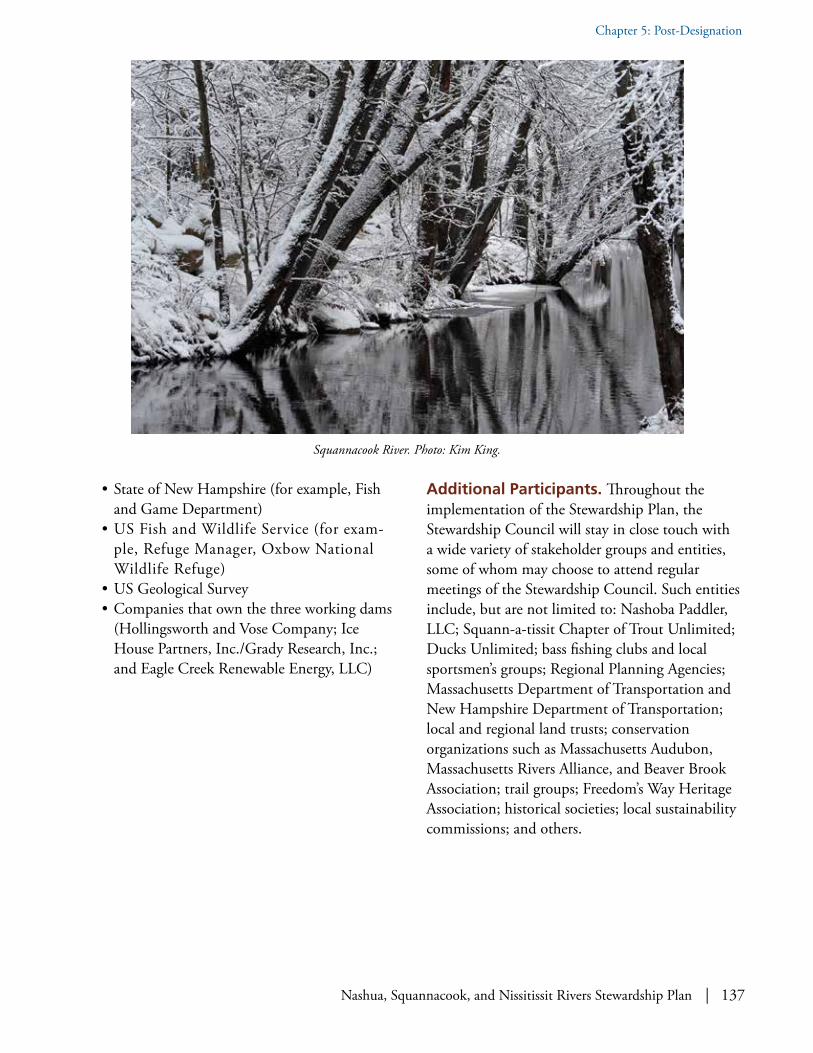
Nashua, Squannacook, and Nissitissit Rivers Stewardship Plan | 137
Chapter 5: Post-Designation
• State of New Hampshire (for example, Fish and Game Department)
• US Fish and Wildlife Service (for exam-ple, Refuge Manager, Oxbow National Wildlife Refuge)
• US Geological Survey• Companies that own the three working dams
(Hollingsworth and Vose Company; Ice House Partners, Inc./Grady Research, Inc.; and Eagle Creek Renewable Energy, LLC)
Additional Participants. Throughout the implementation of the Stewardship Plan, the Stewardship Council will stay in close touch with a wide variety of stakeholder groups and entities, some of whom may choose to attend regular meetings of the Stewardship Council. Such entities include, but are not limited to: Nashoba Paddler, LLC; Squann-a-tissit Chapter of Trout Unlimited; Ducks Unlimited; bass fishing clubs and local sportsmen’s groups; Regional Planning Agencies; Massachusetts Department of Transportation and New Hampshire Department of Transportation; local and regional land trusts; conservation organizations such as Massachusetts Audubon, Massachusetts Rivers Alliance, and Beaver Brook Association; trail groups; Freedom’s Way Heritage Association; historical societies; local sustainability commissions; and others.
Squannacook River. Photo: Kim King.
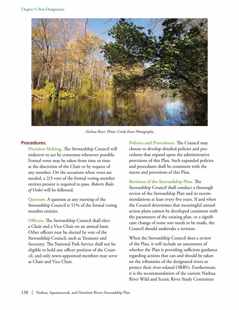
138 | Nashua, Squannacook, and Nissitissit Rivers Stewardship Plan
Chapter 5: Post-Designation
Nashua River. Photo: Cindy Knox Photography.
Procedures.Decision Making. The Stewardship Council will endeavor to act by consensus whenever possible. Formal votes may be taken from time to time at the discretion of the Chair or by request of any member. On the occasions when votes are needed, a 2/3 vote of the formal voting member entities present is required to pass. Roberts Rules of Order will be followed.
Quorum. A quorum at any meeting of the Stewardship Council is 51% of the formal voting member entities.
Officers. The Stewardship Council shall elect a Chair and a Vice-Chair on an annual basis. Other officers may be elected by vote of the Stewardship Council, such as Treasurer and Secretary. The National Park Service shall not be eligible to hold any officer position of the Coun-cil, and only town-appointed members may serve as Chair and Vice Chair.
Policies and Procedures. The Council may choose to develop detailed policies and pro-cedures that expand upon the administrative provisions of this Plan. Such expanded policies and procedures shall be consistent with the intent and provisions of this Plan.
Revision of the Stewardship Plan. The Stewardship Council shall conduct a thorough review of the Stewardship Plan and its recom-mendations at least every five years. If and when the Council determines that meaningful annual action plans cannot be developed consistent with the parameters of the existing plan, or a signifi-cant change of some sort needs to be made, the Council should undertake a revision.
When the Stewardship Council does a review of the Plan, it will include an assessment of whether the Plan is providing sufficient guidance regarding actions that can and should be taken on the tributaries of the designated rivers to protect their river-related ORRVs. Furthermore, it is the recommendation of the current Nashua River Wild and Scenic River Study Committee

Nashua, Squannacook, and Nissitissit Rivers Stewardship Plan | 139
Chapter 5: Post-Designation
that the future Stewardship Council give careful consideration as to whether there are additional segments of the designated rivers, their tribu-taries, and their headwaters that might merit a future effort to seek expansion of Wild and Scenic Rivers designation. Examples include, but are not limited to, the North Nashua River.
Funding/Staff. The Stewardship Council will be responsible to secure funding for its work and staffing. Member entities will not be assessed or responsible for funding. That said, it is anticipated that the National Park Service (NPS) will provide a basic level of staff support and funding to the Stewardship Council and its operations through the Partnership National Wild and Scenic River designation, dependent upon congressional appro-priations.
It is likely that the NPS may enter into a Coop-erative Agreement with an incorporated member entity of the Council—as was done during the Study through the Nashua River Watershed Association—as the vehicle through which to provide such funding and staff support. Cooper-
ative Agreements are formal written agreements between NPS and a local partner to create the ability to designate federal funding or other federal assistance for supporting the implementation of the Stewardship Plan. The local partner would act, in essence, as the fiscal agent for the Stewardship Council and NPS. It is not anticipated that the NPS could enter into Cooperative Agreements directly with the Stewardship Council as an entity, as it lacks the sufficient legal foundation. It has been typical of Partnership Wild and Scenic Rivers in New England for the Cooperative Agreement to be established with a local non-profit organization, such as a land conservation group or a watershed association. Decisions about how available funding is to be spent are made by the Stewardship Council.
Roles of the Partners
Towns. The Stewardship Plan calls for each town to be an active, voluntary participant in the Stewardship Council and in stewarding the ORRVs. As described above, each town will appoint a member and alternate to represent their interests and be responsible for communi-
Let our rivers be an inspiration. Photo: Cindy Knox Photography.

140 | Nashua, Squannacook, and Nissitissit Rivers Stewardship Plan
Chapter 5: Post-Designation
cation between the town and the Council. It is expected that the Conservation Commissions and Planning Boards will continue to play important roles.
Nashua River Watershed Association. The Nashua River Watershed Association (NRWA), nearing the 50th anniversary of its founding, offers comprehensive knowledge of local issues associated with the ORRVs and has been work-ing actively to steward them. The NRWA played a coordinating role in the Study Committee, and is available to play a similar role in the Steward-ship Council if Council members so desire. The NRWA will appoint a member and an alternate to the Council.
National Park Service. If the Wild and Scenic River designation occurs, the NPS will coordi-nate any funding that is authorized by Congress for use in implementing the Stewardship Plan. The NPS will take an active role on the Stew-ardship Council, and, as funding allows, provide staff support and technical advice.
In addition, the NPS will represent the Secre-tary of the Interior in fulfilling the legislative mandates of the Wild and Scenic Rivers Act: the NPS will review proposed projects that require a federal permit or use federal funding. Any such projects will be evaluated for consistency in protecting and enhancing the ORRVs, which make the rivers appropriate as components of the Wild and Scenic Rivers System.
There are no new regulatory permits associated with the designation. NPS conducts its reviews through existing federal regulatory programs, such as permitting under the Clean Water Act by the US Army Corps of Engineers or the US Environmental Protection Agency, and through the processes required by the National Environmental Policy Act, which provides for environmental impact reviews of proposed federal actions.
Commonwealth of Massachusetts and State of New Hampshire. Both states have departments that are active in managing water quality, sup-porting open space conservation, planning roads, and interfacing in innumerable ways with the anticipated activities of the Stewardship Council.
Landowners. There are no new regulations or rules associated with designation that impact private landowners. Private landowners, especially riverfront landowners, will be kept informed through a variety of means regarding the activities of the Stewardship Council, the many avenues to offer input, and ways in which they can help steward the ORRVs.
Dam Owners. The owners of the Hollingsworth and Vose Dam, the Ice House Dam, and the Pepperell Dam are important stakeholders. Over the years, they have partnered with member entities of the Study Committee on impactful projects benefitting the ORRVs, such as river-bank restoration and management of aquatic invasives. Their continued partnership will be important to the success of the Stewardship Plan.
Other Stakeholders. There are many other engaged stakeholders, as the list of entities who offered input and support attests, and they each will play an important voluntary role in steward-ing the ORRVs as we go forward.
What if Designation Does Not OccurIf designation never occurs, this Stewardship Plan can nonetheless serve as a blueprint for how the local towns and stakeholders can work together to maintain and enhance the Outstandingly Remark-able Resource Values of the rivers. That said, in the opinion of the current Study Committee, it would be enormously beneficial for the rivers to be desig-nated as Partnership Wild and Scenic Rivers and to be eligible for federal funding and assistance to work in partnership to steward these spectacular rivers for generations to come.

Nashua, Squannacook, and Nissitissit Rivers Stewardship Plan | 141
References, Resources, and Experts ConsultedReferences, Resources, and Experts Consulted
References
Agassiz, Louis. Contributions to the Natural History of the United States. (Little Brown and Company, vol. 1, 1857)
Anderson, Larry. "Benton MacKaye and Freedom's Way: The 'New Exploration' of a Regional Environ-ment." PowerPoint presentation at Annual Meeting of Freedom's Way Heritage Association, Lunenburg, Massachusetts, March 17, 2003.
Anderson, Larry. Benton MacKaye: Conservationist, Planner, and Creator of the Appalachian Trail. Johns Hopkins University Press, November 12, 2002.
Appalachian Mountain Club (video). “Trees, Paddlers, and Wildlife: Safeguarding Ecological and Recre-ational Values on the River." https://www.youtube.com/watch?v=UTTewlOS304
Archey, Warren E., Massachusetts Forest Legacy Committee (online PDF). "Nashua River Greenway Forest Legacy Area," (approved June 1, 2001) http://www.mass.gov/eea/docs/dcr/stewardship/forestry/other-reforest/nashua-river-greenway-expansion-2001.pdf
References, Resources, and Experts Consulted
Bridge over Squannacook River. Photo: Kim King.

142 | Nashua, Squannacook, and Nissitissit Rivers Stewardship Plan
References, Resources, and Experts ConsultedReferences, Resources, and Experts Consulted
Area of Critical Environmental Concern Nomination Report. "Central Nashua River Valley,” 1993.
Armstrong, David S., Gene W. Parker, and Todd A. Richards. "US Geological Survey Scientific Investiga-tions Report 2007-5291: Characteristics and Classification of Least Altered Streamflows in Massachusetts.” U.S. Geological Survey, Reston, Virginia: 2008.
Ayer, Harvard, Lancaster, and Shirley, Massachusetts (online PDF). "Devens Reuse Plan," November 14, 1994. www.devensec.com/development/Devens_Reuse_plan.pdf
Ayer, Harvard, Lancaster, and Shirley, Massachusetts (online PDF). "Devens Water Resources Protection Report," November 1994. www.devensec.com/development/Water_Resources_Protection_Report.pdf
Ayer, Massachusetts. “Ayer Open Space and Recreation Plan,” 2015.
Barten, Paul, Yanli Zhang, and Avril de la Crétaz. “Land Conservation, Restoration, and Stormwater Management Priorities for the Squannacook and Nissitissit River Watersheds, Massachusetts and New Hampshire,” (University of Massachusetts–Amherst Department of Natural Resources Conservation, 2001).
Biodrawversity, LLC. “Freshwater Mussel Survey in the Nashua River in the Bypass Reach, Tailrace, and Impoundment of the East Pepperell Dam Pepperell, Massachusetts,” submitted with FERC License, May 2013.
Boston.com (website, accessed Feb 2018). "Amphibian alert: Each spring in Pepperell, volunteers provide safe passage for salamanders on their nocturnal breeding migration." http://archive.boston.com/news/local/articles/2011/05/08/in_pepperell_volunteers_make_sure_salamanders_get_safe_passage/
Brookline, New Hampshire (website). "2017 Brookline Sidewalk & Trail Development Plan." (Adopted by Selectboard on January 30, 2017) www.brookline.nh.us/sites/brooklinenh/files/2017_sidewalk_trail_final_re-port.pdf
Brookline, New Hampshire (website). "Nissitissit River Land Trust." www.brookline.nh.us/conservation-com-mission/pages/nissitissit
Camp, Dresser and McKee Inc., prepared for New England Interstate Water Pollution Control Commission. “Water Quality Management Plan Nashua River Basin,” December 1975.
Carl Levin and Howard P. “Buck” McKeon, National Defense Authorization Act for Fiscal Year 2015, Public Law 113-291, H.R. 3979, 2014.
Cherry, Lynne. A River Ran Wild: An Environmental History, (HMH Books for Young Readers, April 1, 2002).
Code of Massachusetts Regulations. 321 CMR 10.00: Massachusetts Endangered Species Act, March 10, 2017.
Community Preservation Coalition (website). “Community Preservation Committees -- Composition and Duties." http://communitypreservation.org/CPCs

Nashua, Squannacook, and Nissitissit Rivers Stewardship Plan | 143
References, Resources, and Experts ConsultedReferences, Resources, and Experts Consulted
Community Preservation Coalition (website). “Where Does CPA Funding Come From?” http://www.communitypreservation.org/CPAFunding
Comtois, Pierre. "Landowners to close popular walking trail," Nashoba Valley Voice, May 6, 2011. (Website archive accessed Feb 2018) www.nashobavalleyvoice.com/groton_news/ci_18007525?source=rss
Connecticut River Joint Commissions. "Connecticut River Recreation Management Plan: Riverwide Over-view -- 2009." http://crjc.org/pdffiles/Connecticut_River_Rec_Management_Plan-Web.pdf
Connecticut River Joint Council Report, 1998.
Devens Enterprise Commission (online PDF). "Eco-Industrial Development in Devens." www.devensec.com/sustain/EID_As_a Sustainable_Development_Approach.pdf
Devens Enterprise Commission (online PDF). "Green Infrastructure Guidelines for Devens Projects."
www.devensec.com/development/Green_Infrastructure_Guidelines_Final_8-12-14.pdf
Devens Enterprise Commission (online PDF). "Overview of the Devens Transportation Management Initiative." www.devensec.com/development/TMI_Overview.pdf
Devens Enterprise Commission (website). "Rules and Regulations," November 2013. www.devensec.com/rules-regs/decregstoc.html
Devens Enterprise Commission (website). "Rules and Regulations 974 CMR 2.00 Subdivision 2.07 Street and Road Design Standards," November 2013. www.devensec.com/rules-regs/decregs207.html
Devens Enterprise Commission (website). "Rules and Regulations 974 CMR 3.00 Site Plan 3.04: Design Standards," November 2013. www.devensec.com/rules-regs/decregs304.html
Devens Enterprise Commission (website), “Rules and Regulations 974 CMR 3.00
Site Plan 3.04(8)(n)(g) Design Standards, Landscape Treatment, Maintenance, Invasive Plants,” November 2013. www.devensec.com/rules-regs/decregs304.html
Devens Enterprise Commission (website). "Rules and Regulations 974 CMR 3.00 Site Plan 3.06 Steep Slope Protection," November 2013. www.devensec.com/rules-regs/decregs306.html
Devens Enterprise Commission (website). "Rules and Regulations 974 CMR 4.00 Industrial Performance Standards and General Regulations 4.06 General: Wetlands Protection," June 2012. www.devensec.com/rules-regs/decregs406.html
Devens Enterprise Commission (website). "Rules and Regulations 974 CMR 4.00 Industrial Performance Standards and General Regulations 4.08 General: Stormwater Management," June 2012. www.devensec.com/rules-regs/decregs408.html

144 | Nashua, Squannacook, and Nissitissit Rivers Stewardship Plan
References, Resources, and Experts ConsultedReferences, Resources, and Experts Consulted
Devens Enterprise Commission (website). "Rules and Regulations 974 CMR 4.00 Industrial Performance Standards and General Regulations 4.09 General: Water Resource Protection Overlay Districts (WRPs)," June 2012.
Devens Enterprise Commission (website). "Rules and Regulations 974 CMR 4.00 Industrial Performance Standards and General Regulations 4.11 General: Greenhouse Gas Mitigation," June 2012. www.devensec.com/rules-regs/decregs411.html
Devens Enterprise Commission (website). "Rules and Regulations 974 CMR 5.00 Residential 5.02 Innova-tive Development," November 2013. www.devensec.com/rules-regs/decregs502.html
Devens Enterprise Commission (website). "Rules and Regulations 974 CMR 8.00 Public Health 8.09 Outdoor Water Use Restrictions," June 2012. www.devensec.com/rules-regs/decregs809.html
Devens Enterprise Commission (website). "Zoning By-Laws: Devens Regional Enterprise Zone." www.devensec.com/bylaws/bylawstoc.html
Donohue, Kathleen, David R. Foster, and Glenn Motzkin. “Effects of the past and the present on species distributions: land-use history and demography of wintergreen.” Journal of Ecology 88, 2000.
Donta, Christopher, Mitchell T. Mulholland, Sheila Charles, Brian Jones. "Community-Wide Archaeological Reconnaissance Survey of Groton, Massachusetts. Public Version." Archaeological Services, Department of Anthropology, University of Massachusetts, Amherst, Massachusetts, March 2011. http://www.townofgroton.org/DesktopModules/Bring2mind/DMX/Download.aspx?PortalId=0&EntryId=14113
Dunstable, Massachusetts. “Open Space and Recreation Plan,” 2010-2017.
Eastern Blanding’s Turtle Technical Committee (online PDF-20 MB). Draft "Guidelines for Recreational Areas within High Priority Blanding’s Turtle Sites in the Northeastern United States." www.blandingsturtle.org/uploads/3/0/4/3/30433006/nebtwg_recreation.pdf
Eastern Brook Trout Joint Venture (website). "The Eastern Brook Trout Newsletter: North Eastern Divi-sion." http://easternbrooktrout.org/news/newsletters/2008/ebtjv-northeast-april-2008/view
Edwards, Susan and Dorie Clark. “Marion Stoddart: The Work of 1000,” 2010. See: Documentary Educa-tional Resources at http://www.der.org/films/work-of-1000.html
Eightmile River Wild and Scenic Study Committee. “Riparian Buffer Zones: Functions and Recommended Widths,” April 2005.
Emergency Wetlands Resources Act of 1986, Massachusetts Public Law 99-645 (100 Stat. 3582).
Federal Energy Regulatory Commission (online PDF). “122 FERC ¶ 62,262 Order Granting Exemption From Licensing (5 MW or Less), Ice House Partners, Inc.," March 31, 2008. https://lowimpacthydro.org/assets/files/lihi-cert-app-files/APPENDIX-OrderGrantingExemption.pdf

Nashua, Squannacook, and Nissitissit Rivers Stewardship Plan | 145
References, Resources, and Experts ConsultedReferences, Resources, and Experts Consulted
Federal Energy Regulatory Commission. “Order Issuing Original License to Pepperell Hydro Company, LLC; Project No. P-12721, Appendix B,” September 8, 2015.
Fitchburg, Massachusetts. “Report to the Board of Water Commissioners of the City of Fitchburg upon Water Power Privileges affected by the diversion of the waters of Ashby Reservoir,” August 12, 1915.
Fort Devens Museum (website). www.fortdevensmuseum.org
Freedom’s Way National Heritage Area (website). http://freedomsway.org/
Friends of the Winooski River (online PDF). "Living in Harmony with Streams: A Citizen’s Handbook to How Streams Work,” 2012. https://winooskiriver.org/images/userfiles/files/Stream%20Guide%201-25-2012%20FINAL.pdf
Google maps (online map). "Nashua River Launch Sites." https://www.google.com/maps/d/viewer?mid=14jI-r9h4POKSFESqlGeqwnswU8M0&ll=42.58325225055194%2C-71.71002070263063&z=10
Groton Historical Commission (online PDF). "Hollingsworth and Vose Industrial Area." http://books.gpl.org/GPLDL3/HollingsworthVoseAreaFormA.pdf
Groton Historical Society. "Images of America: Groton," Arcadia Publishing, 2009.
Groton, Massachusetts. "Conservation Land Use Plan for the Town of Groton Massachusetts," 1952.
Groton, Massachusetts. "Squannacook River Dam Phase I Inspection/Evaluation, Haley and Aldrich," October 17, 2017.
Groton, Massachusetts. "Surrenden Farm Resource Management Plan DRAFT," October 2016.
Harvard, Massachusetts. Zoning Bylaw, 125-42.B(9).
Harvard, Massachusetts. "Harvard Open Space and Recreation Plan," 2016.
Herrill, Harold. "Fall and Winter Birds of the Lancaster Area," The Bird Observer of Eastern Massachusetts, Vol. 5, No. 6, 1977.
Hollis, New Hampshire. “2014 Annual Report Hollis NH: 50 Years of Land Conservation: 1965 – 2015.”
Hollis, New Hampshire. 1998 Master Plan Update. (Adopted by Hollis Planning Board on March 16, 1999).
Huffington Post (website archive, accessed Feb 2018). “How a Housewife Transformed an Open Sewer into a Swimmable River,” July 7, 2014. www.huffingtonpost.com/ellen-moyer-phd/nashua-river-trans-formed-_b_5552680.html
Hunt, Pamela D., Margaret B. Watkins, and Rebecca W. Suomala. The State of New Hampshire’s Birds–A Conservation Guide. New Hampshire Audubon, Concord, New Hampshire, 2011.
146 | Nashua, Squannacook, and Nissitissit Rivers Stewardship Plan
References, Resources, and Experts ConsultedReferences, Resources, and Experts Consulted
Kleinschmidt. "Pepperell Hydro, LLC. Recreation Plan for Pepperell Hydroelectric Project,” FERC Project No. P-12721, June 2017.
Kline, Mike (online PDF), Vermont Agency of Natural Resources. "A Guide to River Corridor Easements," 2010. http://dec.vermont.gov/sites/dec/files/wsm/rivers/docs/rv_RiverCorridorEasementGuide.pdf
Lamprey River Watershed Association (online PDF). “Recreation Enhancement of the Lamprey River Between Route 87 and Wadleigh Falls: Final Report to the Lamprey River Wild and Scenic 2015 Small Grants Program.” www.lampreyriver.org/UploadedFiles/Files/woody_obstacles_report.pdf
Lancaster, Massachusetts (online PDF). "Master Plan: Chapter 8 - Historic and Cultural Resources," (adopt-ed December 2007) www.ci.lancaster.ma.us/sites/lancasterma/files/uploads/plan_historic_pres_element_vi.pdf
Lennon, Heather Maurer. "Images of America: Lancaster," Arcadia Publishing, July 15, 2001.
Low Impact Hydropower Institute (website). "LIHI Certificate #44 – Ice House Hydropower Project, Mas-sachusetts." http://lowimpacthydro.org/lihi-certificate-44-ice-house-hydropower-project-massachusetts-ferc-12769/
MacKaye, Benton. “Possible Layout for a Nashua-Squannacook Reservation.” Hand-drawn map (1945) from the archives of Larry Anderson.
Marvin, Rev. Abijah P. History of the Town of Lancaster: From the First Settlement to the Present Time, 1643–1879. (Lancaster: Published by the town, 1879).
Mass.gov (online PDF). "Petapawag Area of Critical Environmental Concern (ACEC)." www.mass.gov/eea/docs/dcr/stewardship/acec/acecs/petwag.pdf
Mass.gov (website). "ACEC Program Overview." www.mass.gov/service-details/acec-program-overview
Mass.gov (website). "Becoming a Designated Green Community." https://www.mass.gov/guides/becom-ing-a-designated-green-community
Mass.gov (website). "BioMap2: Conserving the Biodiversity of Massachusetts in a Changing World." https://www.mass.gov/service-details/biomap2-conserving-the-biodiversity-of-massachusetts-in-a-changing-world
Mass.gov (website). "Boat and Recreation Vehicle Safety Bureau: Massachusetts Boating Safety Guide." www.mass.gov/orgs/boat-and-recreation-vehicle-safety-bureau
Mass.gov (website). "List of Endangered, Threatened, and Special Concern species." www.mass.gov/ser-vice-details/list-of-endangered-threatened-and-special-concern-species
Mass.gov (website). "Massachusetts Bays Program: Diadromous Fish." http://www.mass.gov/envir/massbays/bhha_diadromous.htm
Mass.gov (website). "Massachusetts State Wildlife Action Plan." https://www.mass.gov/service-details/state-wildlife-action-plan-swap

Nashua, Squannacook, and Nissitissit Rivers Stewardship Plan | 147
References, Resources, and Experts ConsultedReferences, Resources, and Experts Consulted
Mass.gov (website). "MassWildlife's trails policy." www.mass.gov/eea/agencies/dfg/dfw/wildlife-habitat-conserva-tion/wildlife-lands-trail-policy.html
Mass.gov (website). "Natural Community Fact Sheets." https://www.mass.gov/service-details/natural-communi-ty-fact-sheets
Mass.gov (website). "Natural Heritage & Endangered Species Program: MA Endangered Species Act (MESA) Overview," www.mass.gov/service-details/ma-endangered-species-act-mesa-overview
Massachusetts Audubon Society. "Focus Areas for Wildlife Habitat Protection in the Nashua River Water-shed." Ecological Extension Service of the Massachusetts Audubon Society, September 2000.
Massachusetts Audubon Society (website). "Massachusetts Important Bird Area (IBA): Nashua River Water-shed." www.massaudubon.org/our-conservation-work/wildlife-research-conservation/statewide-bird-monitoring/massachusetts-important-bird-areas-iba/important-bird-area-sites/nashua-river-watershed
Massachusetts Audubon Society (website). "Nashua River Watershed Important Bird Area Site.” www.massaudubon.org/our-conservation-work/wildlife-research-conservation/statewide-bird-monitoring/massachu-setts-important-bird-areas-iba/important-bird-area-sites/nashua-river-watershed
Massachusetts Department of Environmental Protection. 314 CMR: Division of Water Pollution Control 314 CMR 4.00: Massachusetts Surface Water Quality Standards.
Massachusetts Department of Environmental Protection (website). “Massachusetts Clean Water Toolkit: A Guide to the Prevention and Control of Nonpoint Source Pollution in Massachusetts." http://prj.geosyntec.com/npsmanual/default.aspx
Massachusetts Department of Environmental Protection. “Nashua River Watershed 2003 Water Quality Assessment Report.”
Massachusetts Department of Environmental Management. “The Massachusetts Landscape Inventory: A Survey of the Commonwealth’s Scenic Areas.” Boston, MA: Massachusetts Department of Environmental Management, 1982.
Massachusetts Department of Fish and Game, “Massachusetts Stream Crossing Handbook,” 2nd edition, June 2012.
Massachusetts Department of Revenue, Division of Local Services, Technical Assistance Section, (online PDF) “What is Home Rule” www.mass.gov/dor/docs/dls/mdmstuf/technical-assistance/best-practices/homerule.pdf
Massachusetts Department of Transportation, Massachusetts Natural Heritage and Endangered Species Program, and University of Massachusetts (website). "Linking Landscapes for Massachusetts Wildlife." www.linkinglandscapes.info/turtle-roadkill-surveys.html
Massachusetts Division of Ecological Restoration (online PDF PowerPoint presentation). "Trees, Paddlers and Wildlife: Safeguarding Ecological and Recreational Values on the River." www.mass.gov/eea/docs/dfg/der/pdf/trees-paddlers-wildlife-presentation.pdf
148 | Nashua, Squannacook, and Nissitissit Rivers Stewardship Plan
References, Resources, and Experts ConsultedReferences, Resources, and Experts Consulted
Massachusetts Division of Fisheries and Wildlife (online PDF). "NHESP Priority Types of Natural Commu-nities," 2016. www.mass.gov/eea/docs/dfg/nhesp/natural-communities-facts/priority-natural-commun.pdf
Massachusetts Executive Office of Environmental Affairs 301 CMR 12.00, Areas of Critical Environ-mental Concern.
Massachusetts Executive Office of Energy and Environmental Affairs (online PDF). "Area of Critical Envi-ronmental Concern: Designation of the Central Nashua River Valley." www.mass.gov/eea/docs/dcr/stewardship/acec/acecs/cnr-des.pdf
Massachusetts Executive Office of Energy and Environmental Affairs and Massachusetts, Emergency Man-agement Agency (online PDF). "Massachusetts Drought Management Plan," May 2013. http://www.mass.gov/eea/docs/eea/wrc/droughtplan.pdf
Massachusetts Executive Office of Energy and Environmental Affairs (website). "EEA Article 97 Land Disposition Policy," February 19, 1998. www.mass.gov/eea/agencies/mepa/about-mepa/eea-policies/eea-arti-cle-97-land-disposition-policy.html
Massachusetts Forest and Park (Association) News, August 1970.
Massachusetts Historical Commission. "Historic and Archaeological Resources of Central Massachusetts: A Framework for Preservation Decisions," 1985.
Massachusetts Land Trust Coalition (website). "Conserving Land in Your Community." www.massland.org/conserving-land-your-community
Massachusetts Rivers Protection Act, Chapter 258 of the Acts of 1996.
Massachusetts Surface Water Quality Standards 314 CMR 4, December 6, 2013.
Massachusetts Municipal Separate Stormwater Sewer Systems (MS4) Permit.
Massachusetts Wetlands Protection Act, Massachusetts General Law Chapter 131 Section 40.
MassWildlife (website). "MassWildlife can help landowners create young forests: Get technical and financial assistance to create young forest on your property." https://www.mass.gov/news/masswildlife-can-help-landown-ers-create-young-forests
MassWildlife (website). "What is a CFR?" www.mass.gov/service-details/what-is-a-cfr
McHarg, Ina L. Design With Nature. (John Wiley & Sons, February 20, 1995).
Montachusett Regional Planning Commission (website). "Community Trail Maps." www.mrpc.org/home/pages/community-trail-maps
Montachusett Regional Planning Commission (website). "MRMapper: The Montachusett Region Web Mapping Site." https://mrmapper.mrpc.org

Nashua, Squannacook, and Nissitissit Rivers Stewardship Plan | 149
References, Resources, and Experts ConsultedReferences, Resources, and Experts Consulted
Montachusett Regional Trails Coalition. www.facebook.com/MontachusettTrails
Motzkin, Glenn, David Foster, Arthur Allen, Jonathan Harrod, and Richard Boone. Controlling Site to Evaluate History: Vegetation Patterns of a New England Sand Plain. Ecological Monographs 66, no. 3, 1996.
Naiman, Robert J., Henri Decamps, and Michael Pollock. "The Role of Riparian Corridors in Maintaining Regional Biodiversity." Ecological Applications Vol. 3, No. 2, May 1993.
Nashoba Conservation Trust and Pepperell Conservation Commission. "Pepperell Trail Guide," 2016. http://nashobatrust.org/trail-guide/
Nashua River Watershed Association. "Canoe and Kayak Guide.” (6th Edition). http://nashuariverwatershed.org/component/content/article/12-recreation/433-nashua-river-paddling-guide.html
Nashua River Watershed Association. “Nashua River Greenway Management Plan,” 1984.
Nashua River Watershed Association. “Pepperell Greenway and Conservation Plan,” 1982.
Nashua River Watershed Association. “Plan for the Nashua River Watershed,” 1972.
Nashua River Watershed Association. “Regional Plan for the Nashua River Greenway,” 1970.
Nashua River Watershed Association for the Nashua River Regional Aquatic Invasives Alliance. “Aquatic Invasive Plant Management Plan for the Nashua River,” 2016.
Nashua River Watershed Association, Montachusett Regional Planning Commission, and Massachusetts Development Finance Agency (online PDF). "Devens Open Space and Recreation Plan 2008–2013," January 23, 2008.
Nashua River Watershed Association (website). "Hiking and Walking in the Nashua River Watershed." http://www.nashuariverwatershed.org/recreation/hiking-walking.html
Nashua River Watershed Association (website). "Nashua River Watershed 5 Year Action Plan 2003-2007." www.nashuariverwatershed.org/5yr_plan/watershed/executive.html
Nashua River Watershed Association, Montachusett Regional Planning Commission, and Massachusetts Development Finance Agency (online PDF). "Devens Open Space and Recreation Plan 2008–2013," January 23, 2008. www.devensec.com/development/Devens_OSRP_1-23-08.pdf
Nashua River Wild and Scenic River Study Committee (website). https://www.wildandscenicnashuarivers.org/
National Geographic Society. Written in Water: Messages of Hope for Earth's Most Precious Resource. February 16, 2010.
National Park Service (online PDF). “Visual Resources Program: Inventory Factsheet." http://blmwyomingvi-sual.anl.gov/docs/NPS_VRI_Factsheet-08-2016.pdf
150 | Nashua, Squannacook, and Nissitissit Rivers Stewardship Plan
References, Resources, and Experts ConsultedReferences, Resources, and Experts Consulted
National Park Service (website). “National Center for Preservation Technology and Training: NPS Visual Resource Protection,” www.ncptt.nps.gov/blog/nps-visual-resource-protection/
National Park Service Northeast Region. Wild and Scenic River Reconnaissance Survey of the Nashua River. Department of the Interior, National Park Service, Northeast Region, Boston, Massachusetts, 2013.
Natural Heritage and Endangered Species Program. “An Action Plan for the Conservation of State-listed Obligate Grassland Birds in Massachusetts,” 2013.
Natural Heritage and Endangered Species Program (online PDF). "Massachusetts Forestry Conservation Management Practices for Blanding’s Turtles." (August 2007, revised 2016). www.mass.gov/eea/docs/dfg/nhesp/regulatory-review/blandings-turtle-cmp.pdf
Nature Conservancy (website). "New Hampshire: A Question of Flow." www.nature.org/ourinitiatives/regions/northamerica/unitedstates/newhampshire/freshwater/a-question-of-flow-for-floodplain-forests.xml
New Hampshire. "New Hampshire State Wildlife Action Plan: Restore or Maintain Watershed Connectivity to Provide Areas for Fish and Wildlife Passage and the Ability to Compensate for Increased Storm Events.”
New Hampshire (online PDF). "Drought Management Plan," July 2016. www.des.nh.gov/organization/divisions/water/dam/drought/documents/drought-management-plan-for-web.pdf
New Hampshire Department of Environmental Services (online PDF). “Environmental Fact Sheet: Man-aging Large Woody Material in Rivers and Streams.” https://www.des.nh.gov/organization/commissioner/pip/factsheets/rl/documents/rl-21.pdf
New Hampshire Department of Environmental Services (online PDF). "Environmental Fact Sheet: Vege-tation Management for Water Quality," 2017. http://des.nh.gov/organization/commissioner/pip/factsheets/sp/documents/sp-5.pdf
New Hampshire Department of Environmental Services (online PDF). "New Hampshire Stream Crossing Initiative." https://www.des.nh.gov/organization/commissioner/pip/publications/documents/stream-crossings.pdf
New Hampshire Department of Environmental Services (website). "Designated Rivers." https://www.des.nh.gov/organization/divisions/water/wmb/rivers/desigriv.htm
New Hampshire Department of Environmental Services (website). "Drought Management Program." www.des.nh.gov/organization/divisions/water/dam/drought/categories/overview.htm
New Hampshire Department of Environmental Services (website). "Lakes Management and Protection: Overview." https://www.des.nh.gov/organization/divisions/water/wmb/lakes/categories/overview.htm
New Hampshire Department of Environmental Services (website). "Rivers Management and Protection Program." http://des.nh.gov/organization/divisions/water/wmb/rivers/index.htm
New Hampshire Department of Environmental Services (website). "Streams and Stream Crossings." www.des.nh.gov/organization/divisions/water/wetlands/streams_crossings.htm
Nashua, Squannacook, and Nissitissit Rivers Stewardship Plan | 151
References, Resources, and Experts ConsultedReferences, Resources, and Experts Consulted
New Hampshire Department of Resources and Economic Development (DRED). “Nissitissit River NH and MA: A Preliminary Report on Proposals to Preserve,” 1967.
New Hampshire Division of Forests and Lands and University of New Hampshire Cooperative Extension (online PDF). “New Hampshire Best Management Practices for Erosion Control on Timber Harvesting Operations.” https://extension.unh.edu/resources/representation/Resource000247_Rep266.pdf
New Hampshire Fish and Game Department (online PDF). "New Hampshire Wildlife Action Plan," 2015. http://www.wildlife.state.nh.us/wildlife/documents/wap/introandfrontpages.pdf
New Hampshire Fish and Game Department (website). Map of New Hampshire Wildlife Habitat Land Cover 2015. www.wildlife.state.nh.us/wildlife/images/wap11x17-habitat2015.jpg
New Hampshire Fish and Game Department (website). "Why Restore Anadromous Fish?" www.wildlife.state.nh.us/fishing/anadromous-why-restore.html
New Hampshire Natural Heritage Bureau DRED - Division of Forests and Lands (online PDF), “Rare Plants, Rare Animals, and Exemplary Natural Communities in New Hampshire Towns,” July 2013. www.nhdfl.org/library/pdf/Natural%20Heritage/Townlist.pdf
New Hampshire Natural Preserves Forum, 1963.
New Hampshire Rivers Management and Protection Program, New Hampshire Statutes, Chapter 483. See: http://www.gencourt.state.nh.us/rsa/html/NHTOC/NHTOC-L-483.htm
New Hampshire Statutes Chapter 482-A: Fill and Dredge in Wetlands.
New Hampshire Statutes Chapter 483: New Hampshire Rivers Management and Protection Program, 1988.
New Hampshire Statutes Chapter 483-B: Shoreland Water Quality Protection Act.
North Atlantic Aquatic Connectivity Collaborative (website). "What is Aquatic Connectivity?" https://streamcontinuity.org/aquatic_connectivity/index.htm
O'Connor, Anne. "At Devens, planners must consider the view as business builds," Nashoba Valley Voice, Oc-tober 25, 2017. (Website archive, accessed Feb 2018) www.nashobavalleyvoice.com/groton_news/ci_31402152/at-devens-planners-must-consider-view-business-builds
Parfit, Michael. “Restoration: New Ideas, New Understanding, New Hope.” National Geographic Special Edition “Water: The Power, Promise, and Turmoil of North America’s Fresh Water.” (Vol. 184, No. 5A, 1993)
Parker, Edward. History of Brookline, New Hampshire, 1914.
Pepperell, Massachusetts. "Pepperell Open Space and Recreation Plan," 2016.
Pepperell, Massachusetts (website). "History of the Town." http://www.town.pepperell.ma.us/131/History-of-the-Town

152 | Nashua, Squannacook, and Nissitissit Rivers Stewardship Plan
References, Resources, and Experts ConsultedReferences, Resources, and Experts Consulted
Pepperell, Massachusetts Conservation Commission (website). "Trail Monitoring and Maintenance Pro-gram." www.town.pepperell.ma.us/172/Trail-Monitoring-and-Maintenance-Program
Quinebaug River Water Trail (online PDF). "Quinebaug River Paddle Guide." (First Edition, May 2012) www.americantrails.org/NRTDatabase/trailDocuments/3846_QuinebaugRiverPaddleGuide2012a.pdf
RiverLink, Inc. (website)."Stormwater Problems and Impacts: Why All The Fuss?" http://riverlink.org/wp-con-tent/uploads/2014/01/stormwaterseriesfinal1.pdf
Rowlandson, Mary. A Narrative of the Captivity and Restoration of Mrs. Mary Rowlandson, 1682.
Shirley Historical Society (website). "Most Historic Small Town in the Nation." www.shirleyhistory.org/mosthistoric.htm
Shirley, Massachusetts (website). "Shirley Trails Information." www.shirley-ma.gov/Pages/ShirleyMA_ConCom/trails.pdf
Squannacook and Nissitissit Rivers Sanctuary, Massachusetts Gen Law Chap. 132A Section 17 (1975)
Stop Aquatic Hitchhikers (website). http://stopaquatichitchhikers.org/
Sudbury Valley Trustees (website). "Stewardship." www.svtweb.org/properties/stewardship#Coordinate
The Trust for Public Land and American Water Works Association. The Source Protection Handbook: Using Land Conservation to Protect Local Drinking Water Supplies, 2005. See: https://www.tpl.org/sites/default/files/cloud.tpl.org/pubs/water_source_protect_hbook.pdf
Timpane-Padgham, Britta, Tim Beechie, and Terrie Klinger. “A systematic review of ecological attributes that confer resilience to climate change in environmental restoration.” (PLOS, March 16, 2017). https://doi.org/10.1371/journal.pone.0173812
Townsend Historical Society (website). "Townsend Historical Society Properties." http://www.townsendhistor-icalsociety.org/properties.html
Townsend Historical Society (website). www.townsendhistoricalsociety.org/ths.html
Townsend Open Space and Recreation Plan. 2013.
Trout Unlimited, Squann-A-Tissit chapter (website). https://squanatissit.org
United Nations World Commission on Environment and Development. "Report of the World Commission on Environment and Development: Our Common Future" (Brundtland Report), 1987.
United States Department of Agriculture (online PDF). "National Water and Climate Center NWCC Technical Note 99–1: Stream Visual Assessment Protocol," 1998. www.nrcs.usda.gov/Internet/FSE_DOCU-MENTS/stelprdb1044776.pdf
Nashua, Squannacook, and Nissitissit Rivers Stewardship Plan | 153
References, Resources, and Experts ConsultedReferences, Resources, and Experts Consulted
United States Fish and Wildlife Service. Comprehensive Conservation Plan for Oxbow National Wildlife Refuge, January 2005.
United States Fish and Wildlife Service. Oxbow National Wildlife Refuge: Final Comprehensive Conservation Plan, February 2005.
United States Fish and Wildlife Service. Oxbow National Wildlife Refuge Comprehensive Conservation Plan, 2013.
United States Fish and Wildlife Service. "Survey and Evaluation of Wetlands and Wildlife Habitat, Fort Devens, MA," 1992.
United States Fish and Wildlife Service (website). "ECOS Environmental Conservation Online System: Blanding's turtle (Emydoidea blandingii)." https://ecos.fws.gov/ecp0/profile/speciesProfile?spcode=C05M
United States Fish and Wildlife Service (website). "ECOS Environmental Conservation Online System: Dwarf wedgemussel (Alasmidonta heterodon)." https://ecos.fws.gov/ecp0/profile/speciesProfile?sId=784
United States Environmental Protection Agency (website). "What is the National Rivers and Streams Assess-ment?" www.epa.gov/national-aquatic-resource-surveys/what-national-rivers-and-streams-assessment
United States Fish and Wildlife Service (website). "Year of the Turtle: Blanding's Turtle." www.fws.gov/northeast/ecologicalservices/turtle/species/blandingsturtle.html
United States Geological Survey (website). "National Water Information System: Web Interface - USGS 01096000 Squannacook River near West Groton, MA." https://waterdata.usgs.gov/nwis/uv?site_no=01096000
United States Geological Survey (website). "National Water Information System: Web Interface - USGS 01096500 Nashua River at East Pepperell, MA." https://waterdata.usgs.gov/ma/nwis/uv/?site_no=01096500&PARAmeter_cd=00065,00060
University of Massachusetts (website). "Existing Greenways: Natural Resources - Twentieth Century Green Spaces and Greenways." www.umass.edu/greenway/Ma/Existing/MA-EG-nat.html
University of Massachusetts, Amherst (website). "Massachusetts Wildlife Climate Action Tool." https://climateactiontool.org
University of New Hampshire Cooperative Extension (online PDF). "Habitat Stewardship Series–New Hampshire Wildlife Action Plan: Floodplain Forests." https://extension.unh.edu/resources/files/Resource000414_Rep436.pdf
University of New Hampshire Magazine (website). "Finicky Bugs." http://unhmagazine.unh.edu/f99/finicky-bugs.html
Upper Missisquoi and Trout Rivers Wild and Scenic River Study Committee (online PDF)." FAQs About Wild and Scenic Designation." https://docs.wixstatic.com/
Vallee, David. "Climate Trends in New England and Their Impact on Our Rivers." PowerPoint presentation at Nashua River Watershed Association 2017 Annual Meeting, Devens, Massachusetts, Nov. 2, 2017. See: http://nashuariverwatershed.org/images/pdf/Vallee_NashuaRvrBasin_Climotalk_Nov2.pdf

154 | Nashua, Squannacook, and Nissitissit Rivers Stewardship Plan
References, Resources, and Experts ConsultedReferences, Resources, and Experts Consulted
Vermont Department of Environmental Conservation (online PDF). "Vermont DEC River Management Program: River Management Program River Corridor Protection and Management Fact Sheet." http://dec.vermont.gov/sites/dec/files/wsm/rivers/docs/rv_rcprotectmanagefactsheet.pdf
Volmar, Michael. Images of America: Harvard, MA. Arcadia Publishing, June 25, 2003.
Wicklow, B.J., Cormier, T.A., Bishop, J.B., Devers, J., von Ottingen, S., 2017. “The conservation status of the brook floater mussel, Alasmidonta varicose, in the United states: trend in distribution, occurrence, and condition of populations.” Northeast Association of Fish and Wildlife Agencies (NEAFWA) Regional Conservation Needs Grant Program. 225 pages.
Wikipedia (website)."Ina McHarg." https://en.wikipedia.org/wiki/Ian_McHarg
Wild and Scenic Rivers Act of 1968, Public Law 90-542, 16 U.S.C. 1271 (1968).
Resources
Central Nashua River, Squannassit, and Petapawag ACEC Nomination Reports
Ecological Inventory of Town-owned Properties Brookline, NH, Jeffry N. Littleton, September 29, 2015
Fort Devens Supplemental Environmental Information for Fort Devens Realignment III-c-45
History of Nashaway - Marge Darby, Millie Chandler
Lancaster’s Trail Vision, 2016 – Montachusetts Regional Planning Commission
Massachusetts 2015 State Wildlife Action Plan
New Hampshire 2015 Wildlife Action Plan
Open Space and Recreation Plans and Master Plans in all participating towns
Ayer https://issuu.com/conwaydesign/docs/ayer_2015_osrp
Dunstable www.dunstable-ma.gov/Pages/DunstableMA_Bcomm/Conservation/open.pdf
Groton www.townofgroton.org//DesktopModules/Bring2mind/DMX/ Download.aspx?PortalId=0&Entry-Id=13519
Harvard www.harvard.ma.us/Pages/HarvardMA_BComm/Conservation/ 2008%20OSRP%20Final.pdf
Lancaster www.ci.lancaster.ma.us/Pages/LancasterMA_WebDocs/osrp
Pepperell www.pepperell-mass.com/DocumentCenter/View/103
Shirley www.shirley-ma.gov/Pages/ShirleyMA_ConCom/shirleyosrp_2014.pdf
Townsend www.townsend.ma.us/Pages/TownsendMA_Bcomm/ConCom/OpenspaceDocs/ OSRPSection/
Massachusetts Historical Commission Reconnaissance Survey Town Report for the following towns: Ayer; Dun-stable; Groton; Harvard; Lancaster; Pepperell; Shirley; Townsend
Massachusetts Heritage Landscape Inventory Program’s Freedom’s Way Landscape Inventory, June 2006: “Ayer Reconnaissance Report”; “Dunstable Reconnaissance Report”; and “Harvard Reconnaissance Report.”

Nashua, Squannacook, and Nissitissit Rivers Stewardship Plan | 155
References, Resources, and Experts ConsultedReferences, Resources, and Experts Consulted
Experts and Individuals Consulted Larry Anderson – Author, Benton MacKaye: Conservationist, Planner and Creator of the Appalachian Trail
Neil Angus – Environmental Planner, Devens Enterprise Commission
Mark Archambault – former Smart Growth Circuit Rider, Nashua River Watershed Association
Dave Armstrong – Director, Squan-a-Tissit Chapter of Trout Unlimited and Hydrologist, Surface Water Quality Studies, USGS New England Water Science Center
Jordan Bailey – Stewardship Coordinator, Piscataquog Land Conservancy
Michael Bailey – Assistant Project Leader, Central New England Fish and Wildlife Conservation Office, US Fish and Wildlife Service
Jeffrey Barbaro – Chief, Groundwater Hydrology Studies, USGS New England Water Science Center
Celeste Philbrick Barr – Education & Community Affairs Director, Beaver Brook Association
John Barrett -- Townsend Historical Society
Therese Beaudoin -- Watershed Coordinator, Massachusetts Department of Environmental Protection
Roger Breeze – Bolton Historical Society
Chris Buelow -- Restoration Ecologist, Natural Heritage and Endangered Species Program, Massachusetts Division of Fisheries and Wildlife
Suzanne Cherau, MA, RPA -- Senior Archaeologist, The Public Archaeology Laboratory, Inc.
Betsy Colburn, Ph.D. -- Aquatic Ecologist, Harvard Forest
Marge Darby – Co-Author, History of Nashaway
Tom Delaney -- Director, Department of Public Works, Groton
Cindy Delpapa -- Riverways Program Manager, Massachusetts Division of Ecological Restoration
Peter DiPasca, Jr. P.E. -- Environmental Compliance Manager, Hollingsworth & Vose
Michael Fleming – former Massachusetts Department of Conservation and Recreation
Anne Gagnon -- Land Agent, Massachusetts Division of Fisheries and Wildlife
Lynn Harper -- Habitat Protection Specialist, Natural Heritage and Endangered Species Program, Massachu-setts Division of Fisheries and Wildlife
Richard Hartley – Fisheries Biologist, Massachusetts Division of Fisheries and Wildlife
Dr. Peter Hazelton -- Aquatic Ecologist, Massachusetts Division of Fisheries and Wildlife
Libby Herland – former Project Leader, US Fish and Wildlife Service, Eastern Massachusetts National Wildlife Refuge Complex, including Oxbow National Wildlife Refuge
Eino Kauppi – Angler, Townsend

156 | Nashua, Squannacook, and Nissitissit Rivers Stewardship Plan
References, Resources, and Experts ConsultedReferences, Resources, and Experts Consulted
Adam Kautza -- Coldwater Fisheries Project Leader, Massachusetts Division of Fisheries and Wildlife
Tim Red Loon Kelly -- Lead Singer, Big Hill Singers, Nipmuc Nation
Drew Kellner – former President, Beaver Brook Association
Warren Kimball – former Massachusetts Department of Environmental Protection
Michael Jones -- State Herpetologist, Massachusetts Natural Heritage & Endangered Species Program
John Magee -- Fish Habitat Program Leader, New Hampshire Fish and Game Department
Liisa Grady Marino – Owner, Vice President, Grady Research
Meredith Marcinkewicz – Curator, Shirley Historical Society
Robert Pine -- Director of Environmental Planning and Engineering and Principal, Pine and Swallow Environmental
Tim Purinton – former Director, Massachusetts Division of Ecological Restoration
Kathleen Puff -- Environmental & Safety Manager, Hollingsworth & Vose
Rebecca Quinones – Rivers and Streams Project Leader, Massachusetts Division of Fisheries and Wildlife
Martha Remington – Bolton Historical Society
E. Heidi Ricci – Senior Policy Analyst, Massachusetts Audubon
Todd Richards -- Assistant Director of Fisheries, Massachusetts Division of Fisheries and Wildlife
Michael E. Roberts – Historian, Timelines, Inc.
Mike Rosser – Director, Squan-a-Tissit Chapter of Trout Unlimited
Barry Schwarzel -- Ayer Historical Commission
Russ Schott – Director, Squan-a-Tissit Chapter of Trout Unlimited
Peter Smith – Director of Natural Resources, Beaver Brook Association
Bobbie Spiegelman – President, Groton Historical Society
Marion Stoddart – Founding Director Emeritus, Nashua River Watershed Association
Patricia Swain, Ph.D. -- retired Natural Community Ecologist, Natural Heritage and Endangered Species Program, Massachusetts Division of Fisheries and Wildlife
Paula Terrasi – Conservation Agent, Town of Pepperell
Dianne Timmins -- Coldwater Fisheries Program Leader, New Hampshire Fish and Game Department
Michael Veit -- Entomologist and Biology Teacher, Lawrence Academy
Michael Volmar -- former Archaeological Curator, Fruitlands Museum
Nicholas L. Venti -- Postdoctoral Research Fellow, The Massachusetts Geological Survey

Nashua, Squannacook, and Nissitissit Rivers Stewardship Plan | 157
Acronyms and Abbreviations
Acronym DefinitionACEC Area of Critical Environmental ConcernADA Encourage Americans with Disabilities ActAMC Appalachian Mountain ClubATM Annual Town MeetingATV All-terrain vehicleBMP Best Management PracticeCE Conservation EasementCFR Coldwater Fisheries ResourceCMR Code of Massachusetts RegulationsCPA Community Preservation ActCPC Community Preservation CommitteeCR Conservation RestrictionCRM Cultural Resource Management CSO Combined Sewer OverflowsCSPA New Hampshire Comprehensive Shoreland Protection ActCVP Certified Vernal PoolDCR Massachusetts Department of Conservation and RecreationDEP Massachusetts Department of Environmental ProtectionDER Massachusetts Division of Ecological Restoration
Acronyms and Abbreviations
Memorial Day commemoration on Squannacook River in Townsend, MA. Photo: Cindy Knox Photography.

158 | Nashua, Squannacook, and Nissitissit Rivers Stewardship Plan
Acronyms and Abbreviations
Acronym DefinitionDES New Hampshire Department of Environmental ServicesDFG Massachusetts Department of Fish and GameDFW Massachusetts Division of Fisheries and WildlifeDOR Department of RevenueDOT Department of TransportationDPW Department of Public WorksDRED New Hampshire Department of Resources and Economic
DevelopmentDWPC Division of Water Pollution ControlEID Massachusetts Eco Industrial DevelopmentEOEEA Massachusetts Executive Office of Energy and
Environmental AffairsEPA US Environmental Protection AgencyFEMA Federal Emergency Management AgencyFERC Federal Energy Regulatory CommissionFIRM Flood Insurance Rate MapsFWHA Freedom’s Way Heritage AssociationFWNHA Freedom’s Way National Heritage AreaFWS US Fish and Wildlife ServiceGIS Geographical Information SystemsGPS Global Positioning SystemH&V Hollingsworth and Vose CompanyHDPE High density polyethylene pipeHOSPD Hollis Open Space Planned Development IBA Important Bird AreaIDDE Illicit Discharge Detection and EliminationISMCP Invasive Species Monitoring and Control PlanLCHIP Land and Community Heritage Investment ProgramLED Light-emitting diodeLID Low Impact DevelopmentLWCF Land and Water Conservation FundLWM Large woody materialMA MassachusettsMCI Massachusetts Correctional InstitutionMESA Massachusetts Endangered Species ActMHC Massachusetts Historical CommissionMRPC Montachusett Regional Planning CommissionMS4 Municipal Separate Stormwater Sewer SystemsMWRA Massachusetts Water Resource AuthorityNAGPRA Native American Graves Protection and Repatriation ActNCT Nashoba Conservation Trust

Nashua, Squannacook, and Nissitissit Rivers Stewardship Plan | 159
Acronyms and Abbreviations
Acronym DefinitionNEFF New England Forestry FoundationNGO Non-Governmental OrganizationNH New HampshireNHB New Hampshire Natural Heritage BureauNHESP Massachusetts Natural Heritage and Endangered Species
ProgramNMCOG Northern Middlesex Council of GovernmentsNOI Notice of IntentNPDES National Pollutant Discharge Elimination SystemNPS National Park ServiceNRPC Nashua Regional Planning CommissionNRRT Nashua River Rail TrailNRWA Nashua River Watershed AssociationNWCC National Water and Climate CenterNWR National Wildlife RefugeONWR Oxbow National Wildlife RefugeORRV Outstandingly Remarkable Resource ValuesORW Outstanding Resource WatersOSD-PRD Open Space Conservation and Planned Residential
DevelopmentOSPD Open Space Planned DevelopmentOSRD Open Space Residential DevelopmentOSRP Open Space and Recreation PlanPAB Public Access BoardPHC Pepperell Hydro Company, LLCPP/SO Pitch Pine/Scrub OakPSA Public Service AnnouncementsPVP Potential Vernal PoolRFTA Refuge Devens Reserve Forces Training Area DevensRGPCD Residential Gallons Per Capita DayRPA Rivers Protection ActRPC Regional Planning CommissionRSA Revised Statutes AnnotatedSGCN Species of Greatest Conservation NeedSNRS Squannacook and Nissitissit Rivers SanctuarySP Special ExceptionSWQS Surface Water Quality StandardsUFW Unaccounted for waterURL Uniform Resource LocatorUSFWS US Fish and Wildlife ServiceUSGS US Geological Service

160 | Nashua, Squannacook, and Nissitissit Rivers Stewardship Plan
Acronyms and Abbreviations
Acronym DefinitionVP Vernal PoolVRI Visual Resource InventoryWCE Wildlife Conservation EasementWCR Wildlife Conservation RestrictionWMA Massachusetts Wildlife Management AreaWPB Wetland Protection BylawWRPOD Water Resource Protection Overlay DistrictWWTF Wastewater Treatment Facility
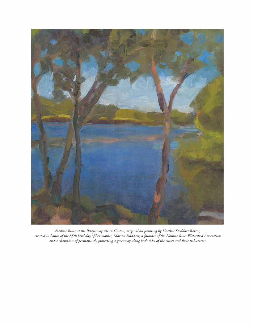
Some value the river for its enriching qualities, and some for its
abundant water power, and some because they can idle away their time
in catching pout and pickerel. There are some also who delight in it as a
“thing of beauty” and a “joy forever.” They love to wander on its banks, to
plunge into its depths and float upon its surface. They return again and
again to gaze on its flow when it shimmers in the sun, or is mottled by the
rain-drops, or ruffled by the breeze. They are never tired of watching it from
some high bank, …or crumbling bluffs, and see it winding back and forth
in the broad valley, like the convolutions of a mighty serpent, gleaming in
the light with silvery scales.
Nashua River at the Petapawag site in Groton, original oil painting by Heather Stoddart Barros, created in honor of the 85th birthday of her mother, Marion Stoddart, a founder of the Nashua River Watershed Association
and a champion of permanently protecting a greenway along both sides of the rivers and their tributaries.
Rev. Abijah P. Marvin, History of the Town of Lancaster: From the First Settlement to the Present Time, 1643–1879, (Lancaster: Published by the town, 1879).
Nashua River. Photo: Cindy Knox Photography.

Squannacook River. Photo: Joan Wotkowicz
Nissitissit River. Photo: Cindy Knox Photography
Nashua River. Photo: Ken Hartlage
Nashua, Squannacook, and Nissitissit Rivers
Stewardship Plan
Nashua River Wild and Scenic River Study Committeec/o Nashua River Watershed Association592 Main Street, Groton, Massachusetts 01450
978-448-0299 | www.WildandScenicNashuaRivers.org
February 15, 2018
Nashua, Squannacook, and N
issitissit Rivers Stew
ardship Plan – February 15, 2018
Squannacook River. Photo: Joan Wotkowicz
Nissitissit River. Photo: Cindy Knox Photography
Nashua River. Photo: Ken Hartlage
Nashua, Squannacook, and Nissitissit Rivers
Stewardship Plan Appendices
Nashua River Wild and Scenic River Study Committeec/o Nashua River Watershed Association592 Main Street, Groton, Massachusetts 01450
978-448-0299 | www.WildandScenicNashuaRivers.org
February 15, 2018
Nashua, Squannacook, and N
issitissit Rivers Stew
ardship Plan – February 15, 2018

Nashua, Squannacook, and Nissitissit Rivers Stewardship Plan | 1
Appendix A: Dams
Two historic run-of-river hydropower dams are located on the reach of the Nashua River proposed for designation: Ice House Dam in Ayer, owned by Ice House Partners, Inc. and Pepperell Dam in Pepperell, MA, owned by Pepperell Hydro Co. (a subsidiary of Eagle Creek Renewable Energy).
On the Squannacook River, there is one working run-of-river dam owned by Hollingsworth and Vose in West Groton, and four non-working historic run-of-river dams, including: the Squannacook Dam in West Groton and the Townsend Dam, Adams Dam and Mason Road Dam in Townsend.
The Turner Dam on the Nissitissit River was removed in 2015 with federal, state, local and private funding and partnerships. The only other dam on the Nissitissit, the Guarnottas Dam, is breached; only remnants remain below the waterline.
All of the existing dams have important historical and cultural values deeply rooted in the history of the communities and their early development.
1 Pepperell “History of the Town,” http://www.town.pepperell.ma.us/131/History-of-the-Town.
2 Pepperell Hydro Company, LLC; FERC Order Issuing Original License Project, P-12721-006, Sept. 8, 2015.
Working Dams
Pepperell Dam
The first paper mill was established at the site near the current Pepperell Dam in either 1834 or 1835.1 Historical documents indicate the first dam was built at Babbitasset Falls (on the Nashua River) in the early 1860s. The location and layout of the dam changed over the years, and the current dam and powerhouse were built in 1920 by the Pepperell Pa-per Company.2 The Pepperell Paper Company closed in the early 2000s, and Pepperell Hydro Company, LLC (PHC) purchased the property in 2004. The power plant was grandfathered for operation under the Federal Energy Regulatory Commission (FERC) until upgrades were begun in 2007 by PHC, trigger-ing the need for a FERC license.
At the request of the NPS, the PHC project area was excluded from the Nashua River Wild and Scenic Rivers Study Act, so as not to have the Wild and Scenic River Study efforts interfere with PHC obtaining a FERC license. Subsequently, the NPS confirmed to FERC by letter dated July 17, 2015 that the licensing of the Pepperell Project would
Appendix A: Dams
Ayer Ice House (now Grady Research) on the Nashua River in Harvard, MA.
Falls at Ayer Ice House Dam.

2 | Nashua, Squannacook, and Nissitissit Rivers Stewardship Plan
Appendix A: Dams
not be in conflict with the Wild and Scenic River Study. PHC received a FERC license in 2015 (FERC Project Number P-12721), and in 2016 PHC was sold to Eagle Creek Renewable Energy (retaining the PHC name for the project).
The dam operates as run-of-river (outflow from the project equals inflow at all times) and is 23.5-feet high, with 3-foot-high flashboards, and is 251-feet long. Flow from the Nashua River flows through a gated intake structure to a 565.5-foot long penstock. Pepperell Hydro releases a minimum flow of 15 cubic feet per second (cfs) or inflow (whichever is less) into the bypassed reach over the spillway year round. The project includes a partially constructed permanent downstream passage facility for river herring.3
A Recreational Plan for the dam project area has been accepted by the FERC, and will include canoe and kayak portage areas around the dam as well as new parking facilities for paddlers. The FERC licensing requires eel passage and fish passage facili-ties, once enough anadromous fish have reached the dam from downriver.
There are numerous cultural, recreational, and scenic values associated with the river above and below the Pepperell Dam. These include the Nashua River Rail Trail, which follows the river on the east side; J. Harry Rich State Forest, which also abuts the river on the east; the historic Covered Bridge downriver from the dam; and the Petapawag Conservation Area and boat launch in Groton. Each year, approximate-ly 1,200 students and adult chaperones paddle the Nashua River in the dam project area as part of the Nashua River Watershed Association’s River Class-room® activities. The river is the site of numerous yearly bass fishing tournaments, and is a popular destination for hunting waterfowl. Thousands of canoeists and kayakers take to the river to enjoy the quiet and scenery, and it is a destination for birders to witness osprey and bald eagles fishing the river.
3 ibid4 Low Impact Hydropower Institute Certificate #44–Ice House Hydropower Project, Massachusetts, http://lowimpacthydro.org/lihi-certificate-44-ice-house-hydropower-project-massachusetts-ferc-12769/.5 ibid
Challenges upriver from the dam include the nearly one hundred acres of invasive water chestnut plants and four other invasive aquatic plants that have taken hold there. As part of the FERC licensing for the dam, PHC reached a Settlement Agreement with Stakeholders and is providing funding to address the invasive plants through the established Nashua River Regional Aquatic Invasives Alliance.
The Study Committee and the National Park Service (consistent with the NPS letter of 7-2015) deem the facility to be compatible with a Wild and Scenic River designation as currently licensed and operating. The NPS Report to Congress will further document this finding. As such, the Pepperell Project will effectively be “grandfathered” as concerns the Wild and Scenic River designation, and the NPS will recommend a technical “exclusion” area be incorporated into the designation legislation to further codify this. This will in no way hinder the post-designation Stewardship Council from working cooperatively with Pepperell Hydro Company to protect and enhance river values consistent with the intent of the Stewardship Plan, including maintaining and improving river access, controlling invasive plants in the area above the dam, preventing migration of invasive plants below the dam, and otherwise enhancing the already remarkable values associated with the river into the future for the benefit of public use.
Ice House Dam
The first dam at the current site of Ice House Dam dates back to the 1790s. The dam was used as a reference marker in laying out the towns, probably due to the rock outcrop in the riverbed, which served to anchor the dam.4 In 1907, a powerhouse was built to power trolley cars, and ice production began in the 1920s. Power production for ice manufacturing was stopped mid-cen-tury when refrigerators became popular.5

Nashua, Squannacook, and Nissitissit Rivers Stewardship Plan | 3
Appendix A: Dams
Ice House Partners, Inc. restored the hydropower facility in the early 2000s, and received a FERC license exemption in 2008 (FERC Project Number P-12769). The facility is operated as run-of-river and consists of a 190-foot long, 12-foot high dam topped with 24-inch stoplogs. The Nashua River reach that is bypassed by operating the project (measured from the dam to the tailrace outlet) is about 300 feet long. A million gallon per day flow to the Nashua River is maintained in the bypassed reach year-round. 6
The Ice House project lies fully within the Oxbow National Wildlife Refuge. The river immediately up and down from the dam is riverine in nature, and affords paddlers and anglers every opportunity to enjoy the serene benefits of the Nashua River within the ONWR. Ice House Partners maintains a canoe put-in and take-out and fishing access on the opposite side of the river from the project works. Eel passage is maintained for elvers traveling upriver, but fish passage has not been required at the facility due to the existence of downstream fish blockages at other dam projects. The NRWA has hosted canoe and kayak-guided hand-pulls of small patches of invasive water chestnut plant upriver from the dam the past three years, which has nearly eliminated the plant from the reach.
The Study Committee and the National Park Service deem the facility to be compatible with a Wild and Scenic River designation as currently licensed and operating. The NPS Report to Congress will further document this finding. As such, the Ice House Project will effectively be “grandfathered” as concerns the Wild and Scenic River designation, and the NPS will recommend a technical “exclusion” area be incorporated into the designation legislation to further codify this. The exclusion area begins 700 feet upriver of the dam (latitude 42.55185; longitude -71.62135) and concludes 500 feet downriver of the dam (latitude 42.55325; longitude -71.61735). This
6 Federal Energy Regulatory Commission, 122 FERC 62,262, Order Granting Exemption From Licensing, https://lowimpacthydro.org/assets/files/lihi-cert-app-files/APPENDIX-OrderGrantingExemption.
7 Groton Historical Commission, http://books.gpl.org/GPLDL3/HollingsworthVoseAreaFormA.pdf.
will in no way hinder the post-designation Steward-ship Council from working cooperatively with Ice House Partners to protect and enhance river values consistent with the intent of the Stewardship Plan, including maintaining and improving river access, controlling invasive plants in the area above the dam, and otherwise enhancing the already remarkable values associated with the river into the future for the benefit of public use. The dam is deeded to Ice House Partners, Inc. and includes historical water rights, which will not be extinguished, impaired or interfered with by this designation.
Hollingsworth and Vose Dam
The West Groton village, known as the Holling-sworth and Vose area mill village, was originally the site of a Federal Period starch mill. Paper man-ufacturing began at the site before the original mill burned in 1846, and continues today.7 The village, consisting of the mill and approximately 20 houses, grew up around this industry.
H&V is now a specialty filter paper manufacturing company. The company maintains a small impound-ment for process water. The dam was first constructed in the 1840s for the previous starch factory, but no original construction records are available. The dam’s hydraulic height is 15 feet, and is 225 feet long, with the impounded volume of 350 acre-feet. Each year, 15-inch flashboards are installed in May and removed again in November. Water is withdrawn from the impounded area, and returned to the river down-stream through a water treatment facility. H&V holds a National Pollutant Discharge Elimination System (NPDES) permit for this discharge.
Upriver of the dam, the H&V impoundment provides access to the Squannacook River for the NRWA’s River Classroom® activities. Over 1,100 students and adult chaperones each year paddle north from the impoundment to learn about the

4 | Nashua, Squannacook, and Nissitissit Rivers Stewardship Plan
Appendix A: Dams
natural environment of the Squannacook River and its environs.
The Study Committee and the National Park Service deem the facility to be compatible with a Wild and Scenic River designation. The NPS Report to Congress will further document this finding, and although this project is not licensed by FERC, it does have a federal permit in the form of its NPDES discharge permit. As such, the H&V dam, together with its NPDES permit, will effectively be “grand-fathered” as concerns the Wild and Scenic River designation, and the NPS will recommend a similar technical “exclusion” area be incorporated into the designation to further codify this. The exclusion area for the H&V dam is proposed to be approxi-mately 2,665 feet downriver from the dam (latitude 42.60791; longitude -71.63240) and approximately 1,200 feet upriver to the shore of the impounded area (latitude 42.61421; longitude -71.63899). This will in no way hinder the post-designation Steward-ship Council from working cooperatively with H&V to protect and enhance river values consistent with the intent of the Stewardship Plan into the future for the benefit of the public.
Non-Working Dams
All the dams described below are run-of-river dams with no active current use.
8 Townsend Historical Society Properties, http://www.townsendhistoricalsociety.org/properties.html.
9 Haley & Aldrich, “Squannacook River Dam Phase I Inspection/Evaluation,” for the Town of Groton (October 17, 2017).
Townsend Dam
Dams have been recorded on this site back to the 1730s. The adjacent building called the Cooperage was built in 1733 as a mill for sawing boards.8 An historic gristmill is located at the site. The current dam, owned by Hollingsworth and Vose, was con-structed in the 1870s and has no current active use. The dam’s hydraulic height is 8.3 feet and its length is 93 feet.
The impoundment created by the dam is Harbor Pond, which is the end-point for the Squannacook River Canoe Race held each year by the Townsend Lions Club. Paddlers can maneuver up the Squanna-cook River above the dam, or put in below the dam and paddle down to Bertozzi Wildlife Management Area. The Squannacook River is a popular coldwater fishery. Groundbreaking for the Squannacook River Rail Trail will be held in late 2018, and will run alongside the river for three miles.
Squannacook River Dam
Straddling the Groton-Shirley line in West Groton, this dam powered the former Groton Leatherboard Company. Currently having no active use, the dam is maintained by the Town of Groton. The dam is approximately 150 feet long and 18 feet high. It includes a concrete spillway on the left side that leads to a concrete outlet works.9 A low-level wooden outlet structure about 40 inches square is operated once each year, and is generally kept open a couple of inches. River Court Residences, a senior housing facility, abuts the dam on the eastern downriver side.

Nashua, Squannacook, and Nissitissit Rivers Stewardship Plan | 5
Appendix A: Dams
Adams Dam
The run-of-river Adams dam was built in the early 1800s, and was used by Adams Mill. A mill building was present on the site until the 1970s, when it was torn down. The dam is currently owned by the Town of Townsend.
Mason Road Dam
The Mason Road run-of-river dam was built in the early 1800s or earlier, and has no current active use. The stone dam is approximately 7.5 high. A 1915 Report to the Board of Water Commissioners of the City of Fitchburg, Massachusetts mentions this dam was no longer in active use at that time.10
Non-working Dams Recommendation
These non-working run-of-river dams need not be excluded from the proposed designation because they have little impact on the free-flowing character of the river and have important historical character that contributes to the proposed Wild and Scenic River designation. No federal permits or licenses exist related to these facilities. The Wild and Scenic River designation would not inhibit the maintenance and/or repair of these structures, nor would it inhibit dam removal in the event that a dam owner chose to pursue such removal. Any dam removal consid-eration must be consistent with state dam removal guidance and local interests.
10 Fitchburg, Massachusetts, “Report to the Board of Water Commissioners of the City of Fitchburg upon Water Power Privileges affected by the diversion of the waters of Ashby Reservoir” (August 12, 1915).

Nashua, Squannacook, and Nissitissit Rivers Stewardship Plan | 1
Appendix B: Regulatory Review
State Regulations for Resource Protection
This chapter is a snapshot review of existing laws, regulations, programs and policies in Massachusetts and New Hampshire that enable and inform planning and resource protection efforts in the towns within this Stewardship Plan. It is designed to be useful as an information resource to communities and the future Stewardship Council.
Municipalities have important regulatory powers authorized under state laws governing land use that impact water quality and habitat. These include the framework to produce local Master Plans and Open Space Plans, as well as authority to adopt local by-laws including those addressing zoning, subdivision, Low Impact Development (LID), and wetlands.
1 Wetlands Protection Act, Massachusetts General Law Chapter 131 Section 40.
Wetland Protection
The Commonwealth of Massachusetts, through its Wetlands Protection Act, regulates all activities within a 100-foot buffer zone to all wetlands as defined in the Act. These include “…bank, riverfront area, fresh water wetland, coastal wetland, beach, dune, flat, marsh, meadow, or swamp bordering on the ocean or on any estuary, creek, river, stream, pond or lake, or any land under said waters of any land subject to tidal action, coastal storm flowage, or flooding.”1
The Rivers Protection Act protects all land within 200 feet of the high water mark of rivers and perennial streams. Isolated lands subject to flooding greater than one-quarter acre with a water depth of six inches are also protected.
Appendix B: Regulatory Review
So-called “nursery log” in a local wetland is a miniature ecosystem. Photo: Kim King.

2 | Nashua, Squannacook, and Nissitissit Rivers Stewardship Plan
Appendix B: Regulatory Review
The Massachusetts Wetlands Protection Act identifies eight interests, which ideally all projects proposed within wetland resource areas must meet:
1. Protection of public and private water supplies
2. Protection of groundwater
3. Flood control
4. Prevention of storm damage
5. Prevention of pollution
6. Protection of land containing shellfish
7. Protection of wildlife habitat
8. Protection of fisheries
Home Rule powers under Article 892 of the Massachusetts Constitution have allowed more than half of Massachusetts’s 351 cities and towns to adopt general (non-zoning) local wetland bylaws or ordinances. These bylaws and ordinances give Conservation Commissions further power to protect wetlands through enhanced buffer zones and other means.
The State of New Hampshire, on the other hand, has no statewide official buffer zone, although its Department of Environmental Services has a Wetlands Bureau that regulates activities in wetlands themselves. The New Hampshire legislature, through Revised Statutes Annotated RSA 482-A, allows municipalities to adopt local wetland protection ordinances, which can include provisions for buffer zones of various widths to provide additional pro-tection above and beyond that afforded by the State. About 84 New Hampshire cities and towns have local wetland protection ordinances.
Since towns in both states can adopt local wetland protection bylaws and ordinances, the question then arises as to what width a buffer zone should be. Several studies have been conducted through the years to determine just how wide a buffer zone needs to be to protect certain values and functions of wetlands. These studies have shown that different
2 Massachusetts Department of Revenue, Division of Local Services, Technical Assistance Section, (online PDF) “What is Home Rule” http://www.mass.gov/dor/docs/dls/mdmstuf/technical-assistance/best-practices/homerule.pdf.
wetland values and functions require buffer zones of varying width. For instance, in order to filter out sediments and pollutants that would reach water bodies, wetlands may require a modest buffer zone of only 50 to 100 feet.
In order to protect the widest possible diversity of wildlife species that breed and live in wetlands, in-cluding amphibians that breed in wetlands but spend part of their life cycle in adjacent uplands, a wider buffer zone up to 700 feet wide is recommended. However, as such extremely wide buffers are often difficult to implement in many towns, the general practice is that a buffer of 100 feet provides a good deal of protection to wetlands and their associated wildlife habitat functions, while being a reasonable width to regulate.
In both Massachusetts and New Hampshire, the lo-cal Conservation Commissions are on the front lines of wetlands protection. In New Hampshire, their function is more advisory, whereas in Massachusetts they have the ability to issue permits for activities in and adjacent to wetlands. In both states, the Conservation Commissions are likely to draft local wetland protection bylaws and ordinances, although adoption requires approval of Town Meeting.
In each town, the Conservation Commission must weigh the environmental threats to wetlands against the political will to protect them. Some towns have public support for a reasonably wide buffer zone, whereas in others that is currently politically imprac-tical. In the latter case, the Conservation Commis-sion can set out to educate citizens on the important functions of wetlands and their contribution to our quality of life. Once people fully understand how valuable wetlands are, they are more likely to vote to approve a local wetlands bylaw or ordinance that provides more protection than state law provides.

Nashua, Squannacook, and Nissitissit Rivers Stewardship Plan | 3
Appendix B: Regulatory Review
River and Shoreland Protection
In the Commonwealth of Massachusetts, the Rivers Protection Act (RPA), Chapter 258 of the laws of 1996, protects the shoreland areas along rivers and streams. The RPA creates a 200-foot wide riverfront area that extends along both banks of perennial rivers and streams. In certain urban areas where it is recognized that a natural buffer is no longer possible, a riverfront area of 25 feet has been designated.
The RPA does not set up a new permitting process or reviewing authority, but is administered by local Conservation Commissions and the Massachusetts Department of Environmental Protection, under the same procedures as the Wetlands Protection Act. Projects proposed within the riverfront area must meet the eight (8) purposes of the Massachusetts Wetlands Protection Act, which are listed in the preceding discussion of wetlands. The following figures illustrate the jurisdictional areas under the Massachusetts Rivers Protection Act.
9/17/2010 15
CROSS-SECTION OF A RIVER
RIVERFRONT AREA200’ OR 25’
Top of Bank
Base Flow
Mean Annual High-Water Line
Along a “River” No Buffer Zone Extends 200 Ft from Mean Annual High
Water 25 Ft in Densely Developed Areas
May Overlap Other Wetland Resources
RiverfrontArea
9/17/2010 14
Riverfront Area - Definition, CriticalCharacteristics, and Boundaries
RFA
RFA
RFA
At the point where a stream becomes perennial, the riverfront area begins at a line drawn as a semicircle with a 200 foot radius around the point and connects to the parallel line perpendicular to the mean annual high-water line which forms the outer boundary.
200 ft.
Figures 1 and 2 Riverfront areas in the Massachusetts Rivers Protection Act. Source: Philip Nadeau, Massachusetts Dept. of Environmental Protection

4 | Nashua, Squannacook, and Nissitissit Rivers Stewardship Plan
Appendix B: Regulatory Review
In Massachusetts, the 1975 Squannacook and Nissitissit Rivers Sanctuary Act provides some ad-ditional protection to land adjoining those rivers in several of the participating towns in Massachusetts. The Act prohibits direct discharges of pollutants and stormwater into the waters of the two rivers. The short text of the act (MA Gen Law Chap. 132A § 17) follows:
Section 17. There is hereby established in the towns of Ashby, Groton, Pepperell, Shirley, Townsend and Lunenburg a protected area to be known as the Squannacook and Nissitissit Rivers Sanctuary. Said Squannacook and Nissitissit Rivers Sanctuary shall be comprised of the waters of the Squannacook River and its tributaries, to wit: Ash swamp, Ashby reservoir, Bayberry Hill Brook, Bixby Brook, Flat pond, Flat Pond Brook, Fitchburg reservoir, Locke Brook, Mason Brook, Pearl Hill Brook, Pumpkin Brook, Trap Fall Brook, Trout Brook, Walker Brook, Willard Brook, Witch Brook with the exclusion of that section of the Squannacook River from the Hollingsworth and Vose Dam at West Groton located approximately North 42° 36" 450, West 71° 38" 70 on the U. S. Geological Survey map Shirley quadrangle to the confluence of the Nashua River; and the waters of the Nissitissit River and its tributaries to wit: Coon Tree Pond, Gulf Brook, Heald Pond, Mine Brook, Pork Barrel Pond, Park Barrel Pond Brook, Stewart Brook, Sucker Brook, Wolf Brook. After the effective date of this act, no new discharge of treated or untreated sewage or other wastewater will be permitted to be discharged to the Squannacook and Nissitissit Rivers Sanctuary. For the purpose of this section, sewage shall mean the water-carried waste products or discharges from human beings, sink wastes, wash water, laundry wastes
3 Massachusetts Gen Law Chap. 132A § 17.
and similar so-called domestic waters; wastewater shall mean sewage, liquid or water-carried waste products or discharges from human beings, sink wastes, wash water, laundry wastes and similar so-called domestic wastes, and also sewage, liquid or water-carried waste from industrial, commercial, municipal, private or other sources; and person shall mean any individual, association, partnership, corporation, company, business, organization, trust, estate, the commonwealth or any political subdivision thereof, any administrative agency, public or quasi-public corporation or body or any other legal entity or the legal representatives, agents, or assignees thereof. No person shall install or construct, or cause to be installed or constructed, any new outfall, drainage pipe, ditch, channel or other conveyance to carry stormwater runoff, either directly or indirectly from any structure, parking lot, or storage yard, other than from a one- or two-family residence and appurtenant parking and storage facilities, into the Squannacook and Nissitissit Rivers Sanctuary or any tributaries thereof until plans have been approved by the planning board and conservation commission of the affected town in which the pipe, ditch, channel or other conveyance is located. Said town may require the construction of any structure or structures or treatment works which it deems necessary to prevent the pollution of the Squannacook and Nissitissit Rivers Sanctuary by matter carried by such storm water runoff. The attorney general shall take such action as may be necessary from time to time to enforce the provisions of this section. The superior court shall have jurisdiction in equity to enforce the provisions of this section. 3

Nashua, Squannacook, and Nissitissit Rivers Stewardship Plan | 5
Appendix B: Regulatory Review
In New Hampshire, the Comprehensive Shore-land Protection Act (CSPA), RSA 483-B, is the State’s regulatory approach to shoreland protec-tion. It applies to all streams of fourth order4 and greater, designated rivers, tidal waters and lakes, ponds and impoundments over 10 acres. The State maintains a directory of water bodies that are subject to the CSPA.
The CSPA applies to all development and land-use activities within 250 feet of the water’s edge or the high water mark, which is called the “reference line.” This entire 250-foot wide area is termed the pro-tected shoreland. Within this protected shoreland, levels of protection vary, depending on the distance between the proposed impact and the reference line.
The most restrictive area is the “waterfront buffer,” which extends from the reference line 50 feet landward. Within this zone, a natural buffer of native vegetation and natural ground cover must be maintained, with only minimal disturbance allowed. The next area out is the “natural woodland buffer,” which must maintain a certain percentage of native vegetation and natural ground cover between 50 and 150 feet from the reference line. In order to de-termine the quantity of trees to remain within the waterfront buffer, the State has developed a point system that applies different scores to trees based on their diameter at breast height. A description of how this point system works can be found at the linked documents below. Between 150 and 250 feet of the reference line, there are no limitations on vegetation removal.
The CSPA places restrictions on impervious surfaces, lot subdivision, excavation, and filling within the protected shoreland. Lots may not have greater than 30% impervious cover. Developments proposing more than 20% impervious surfaces must install a stormwater management system to the satisfaction of the State. The guidance document prepared by the New Hampshire Department of Environmental
4 Stream order is a measure of the relative size of streams. The smallest tributaries are referred to as first-order streams, while the largest river in the world, the Amazon, is a twelfth-order waterway. First- through third-order streams are called headwater streams.
Services (NH DES) emphasizes low-impact develop-ment (LID) systems as the preferred stormwater management methodology. The New Hampshire DES recently published an environmental fact sheet detailing how vegetation must be maintained within the various areas of the protected shoreland: http://des.nh.gov/organization/commissioner/pip/factsheets/sp/docu-ments/sp-5.pdf
Figure: Jurisdictional areas in New Hampshire Comprehensive Shoreland Protection Act. Source: Jay Aube, Shoreland Protection Specialist, New Hampshire DES.
In addition to the Comprehensive Shoreland Protection Act, New Hampshire also has a Rivers Management and Protection Program, which was established in 1988 with the passage of RSA 483 to protect certain rivers, called designated rivers, for their outstanding natural and cultural resources. The program is administered by New Hampshire DES. More information on the New Hampshire statute, the Rivers Management and Protection Program, and a list of Designated Rivers can be found at the following URLs:
http://www.gencourt.state.nh.us/rsa/html/NHTOC/NHTOC-L-483.htm
http://des.nh.gov/organization/divisions/water/wmb/rivers/index.htm
https://www.des.nh.gov/organization/divisions/water/wmb/rivers/desigriv.htm
Reference Line50’ Primary Building Setback
150’ Natural Woodland Buffer
250 feet
The Protected Shoreland
Always determine local setbacks. Many towns have greater setbacks.Always determine local setbacks. Many towns have greater setbacks.
50’ Waterfront Buffer

6 | Nashua, Squannacook, and Nissitissit Rivers Stewardship Plan
Appendix B: Regulatory Review
A similar program, called the Lakes Management and Protection Program, is applicable to New Hampshire lakes.
http://des.nh.gov/organization/divisions/water/wmb/lakes/categories/overview.htm
Municipal Regulations for Resource Protection in the Study Area
This review summarizes the existing municipal regulations and planning documents in the towns participating in the Nashua, Squannacook, and Nis-sitissit Rivers Stewardship Plan. It shows how each town addresses the protection of the Outstandingly Remarkable Resource Values (ORRVs) and assesses the town’s capacity to enforce and enhance regulatory measures to protect the ORRVs and the river corri-dors proposed for inclusion in the Nashua River Wild and Scenic River Corridor. Low Impact Development also helps retain and protect natural habitat for native plants and animals. The narrative analyzes the relevant municipal land use regulations, Master Plans, Open Space Plans, Recreation Plans, and other plans and policies of the participating towns.
The following major subjects and aspects of regulatory land-use controls are described for each participating towns:
a. Master Planning - The municipal Master Plan, Open Space and Recreation Plans, and other related pertinent plans.
b. Land-Use Controls - Provisions in munici-pal zoning bylaws (called ordinances in New Hampshire) and regulations
c. Water Resources Zoning and Regulations – Provisions for local wetland protection and stormwater management.
d. Protection of Key Habitat and Natural Communities – Relevant land protection and natural resource protection.
e. Planning Capacity – The town’s resources in terms of a Town Planner or other planning
official, Wetland or Conservation Agent or Administrator and other staff, and whether towns have adopted programs, such as the Community Preservation Act in Massachu-setts, that can provide some funding for conservation efforts.
Master Planning
In both Massachusetts and New Hampshire, the municipal Master Plan serves as the framework that supports a town’s regulatory measures, goals, and objectives relating to land use and development. Ideally, Master Plans are updated on a regular basis, with ten years considered the desired interval for assessing whether such Plans or sections of Plans are still current or need to be revised. For purposes of this Stewardship Plan, town Master Plans with a chapter devoted to the protection of water resources are considered superior to Plans in which water resources are described more generally under the chapter devoted to Natural Resource protection.
In Massachusetts, but not New Hampshire, towns are required to adopt State-approved “Open Space and Recreation Plans” if they want to be eligible for certain state-funded grant programs for the acquisition and improvement of open space and the development of recreational facilities.
The Community Preservation Act (CPA) is a smart growth tool that helps Massachusetts communities preserve open space and historic sites, create affordable housing, and develop outdoor recreational facilities.
CPA allows communities to create a local Commu-nity Preservation Fund for open space protection, historic preservation, affordable housing and outdoor recreation. Community preservation monies are raised locally through the imposition of a surcharge of not more than 3% of the tax levy against real property, and municipalities must adopt CPA by ballot referendum. To date, 172 municipalities in Massachusetts have adopted CPA. (See “Where Does CPA Funding Come From?” at http://www.communi-typreservation.org/CPA_Funding.)
The CPA statute also creates a statewide Commu-nity Preservation Trust Fund, administered by the
Nashua, Squannacook, and Nissitissit Rivers Stewardship Plan | 7
Appendix B: Regulatory Review
Department of Revenue (DOR), which provides distributions each year to communities that have adopted CPA. These annual disbursements serve as an incentive for communities to pass CPA.
Each CPA community creates a local Community Preservation Committee (CPC) upon adoption of the Act, and this five-to-nine member board makes recommendations on CPA projects to the commu-nity’s legislative body. This report will not describe each committee, but will note which towns have qualified and are participating in these programs as a wider indicator of their conservation-mindedness. (See “Community Preservation Committees - Com-position and Duties” at http://communitypreservation.org/CPCs.)
Land-Use Controls
Rather than examine the entirety of the scope of each town’s zoning ordinance or bylaw, this Stew-ardship Plan focuses on those types of zoning and regulations that are most directly related to or can be used to enhance the protection of the ORRVs identified in this Stewardship Plan.
The first zoning tool that is examined is Open Space Residential Development (OSRD), also known as Natural Resource Protection Zoning, which is re-lated to older, more basic approaches such as cluster zoning, conservation subdivision, or flexible zoning. Under this variation of subdivision development, a certain percentage of the entire parcel subject to development must be preserved as permanently protected open space, while generally permitting a similar number of housing units to be developed as in a conventional “grid” subdivision.
Over the years, the practice and standards for OSRD have evolved. The amount of open space preserved in early OSRDs was often low, in the range of 25% to 30% of the total tract area, often including large areas of wetlands and other undevelopable areas. The most recent standards for OSRD call for the preservation of at least 50% of the total tract being developed as open space, with no more than 50% of it, sometimes less, allowed to be wetlands or other undevelopable land. The open space areas thus set
aside can be linked to other protected land, preserv-ing networks of open space across an entire town or on a regional level.
Early OSRD bylaws usually required that such developments obtain both subdivision and special permit approval, which can be a time-consuming, expensive, and uncertain permitting process for landowners and applicants. As a result, such bylaws often are not utilized for most development. Best practice now calls for OSRDs to be allowed “by right,” meaning they are considered a preferred form of subdivision development that need only obtain subdivision approval.
Another important land-use control subject to reg-ulation is development on steep slope areas, usually defined as slopes in excess of 15% or 20%. Develop-ment on steep slopes often leads to erosion problems that require expensive engineering solutions to prevent or correct. Development on slopes also often requires more extensive clearing and grading than development in more level areas, thereby removing more natural habitat and reducing the capacity of plants and soils to absorb precipitation.
Most towns do not specify a maximum slope for development per se (although some do), but rather limit the percentage maximum slope of roads and driveways, which indirectly helps to minimize development of such steep areas. These maximum permissible road and driveway slopes are often in the range of 10% to 15%. Some towns do a better job of addressing erosion control measures in their subdivision and site plan regulations. In general, the more specific such provisions are, the greater the erosion control.
Another important land use control is the maximum percent of a lot that may be rendered impervious to water. Hard surfaces such as asphalt, concrete, and even hard packed gravel can prevent water from infiltrating into the soil, resulting in rainwater running off the impervious surfaces. The runoff often is contaminated with petroleum products, road salt, pesticides, herbicides, lawn fertilizers, and other pollutants, which are then released into nearby

8 | Nashua, Squannacook, and Nissitissit Rivers Stewardship Plan
Appendix B: Regulatory Review
water bodies. Increased imperviousness also reduces recharge of groundwater, which is important to maintain stream flows and water supplies. Reducing impervious surfaces by specifying a maximum lot coverage for buildings and parking lots can help to prevent stormwater runoff, which is now a leading cause of surface water pollution5 according to the US Environmental Protection Agency. Parking require-ments that reduce the number of required parking spaces or allow for shared parking between adjacent lots can also help reduce stormwater pollution.
Many towns have adopted aquifer protection overlay districts to protect their most important ground-water resource areas from pollution. These bylaws often prohibit the most risky land-uses, such as gas stations, underground storage tanks, certain indus-trial processes, dry cleaning, etc. from being sited over porous sand and gravel deposits (aquifers) that can supply a clean source of public drinking water. For other land uses, such overlay districts require a greater degree of care when building or undertaking certain activities.
As groundwater often supplies a large degree of “baseflow” to rivers and streams, especially in summer, protecting groundwater aquifers can help to safeguard water quality in coldwater streams hosting many of the ORRVs identified in this Stewardship Plan.
Floodplain overlay districts are used to restrict development in low-lying areas subject to flooding or adjacent to rivers and streams in upland areas that can also be subject to flash flooding. While not often prohibiting development outright, such districts can require that any building in a floodplain be elevated above the base flood level and require such buildings to have flood insurance. To prevent aggravated flood-ing in adjoining areas, filling is generally prohibited in regulated floodplains.
5 “Stormwater Problems and Impacts: Why All The Fuss?” http://riverlink.org/wp-content/uploads/2014/01/stormwaterseriesfinal1.pdf.
6 See presentation by David Vallee, Hydrologist-in-Charge of National Weather Service’s Northeast River Forecast Center, on the topic of "Climate Trends in New England and Their Impact on Our Rivers" at the 2017 NRWA Annual Meeting at http://nashuariverwatershed.org/images/pdf/Vallee_NashuaRvrBasin_Climotalk_Nov2.pdf.
Changes in the hydrological cycle resulting from climate disturbance are leading to a greater number of intense rainfall events in many regions, including New England6. It is important that towns make sure they are using up-to-date floodplain maps and stormwater calculations that reflect this new reality. Because the standardized mapping only considers historic flood data, communities should consider including additional safety factors to plan for future flood events.
Water Resource Zoning and Regulations
In both Massachusetts and New Hampshire, towns can adopt local Wetland Protection bylaws/ordinances that supplement and expand upon the protection offered wetlands through the respective State Acts. As New Hampshire does not set a minimum regulatory buffer zone of 100 feet, as does Massachusetts, such bylaws are perhaps of even greater value in that state. However, bylaws are also important in Massachusetts, where the buffer zone is subject to review but not actual protection. Such bylaws can specify no-build and no-disturbance buffers, within which new buildings or disturbances to the land are prohibited within a specific distance to the edge of wetlands. Recent science on the performance of such buffers in protecting both wet-lands and surface waters from degradation supports making the buffers as wide as possible, up to several hundred feet in some studies. The summary table and town descriptions provided in this document list the buffers, if any, of each town within the Nashua River Wild and Scenic area.
Stormwater management programs are also a vital part of water resource protection. The leading cause of water pollution today comes not from point sources such as outfall pipes of factories, but from runoff from impervious surfaces such as roads and parking lots, which carry loads of sediment

Nashua, Squannacook, and Nissitissit Rivers Stewardship Plan | 9
Appendix B: Regulatory Review
and pollution into surface water bodies. Many of the larger towns within the Nashua River Wild and Scenic area are subject to the Federal National Pollutant Discharge Elimination System (NPDES) Phase II program. As such, they must prepare local stormwater management bylaws as well as institute programs to clean catch basins, inspect for illegal (illicit) discharges, and otherwise educate municipal authorities and the public on how they can help to minimize stormwater pollution.
Low-Impact Development (LID) is an approach to development design that minimizes disruption of natural vegetation and soils and maintains water flow and infiltration patterns as much as possible. LID for stormwater management relies predominantly on vegetative approaches, such as rain gardens, as well as the use of natural features and naturalized areas like grassed swales, to both reduce the amount of and treat stormwater runoff. The table and town summaries describe the LID provisions, if any, of each of the participating Wild and Scenic towns.
Protection of Key Habitats and Natural Communities
The protection of key habitats and natural commu-nities is usually addressed at the Master Planning level (including Open Space Plans) and is reflected in each town’s efforts to protect the resources thus identified. Identification of such features in local plans is an important first step. Actual protection requires further actions; such as acquisition for conservation purposes or imposition of regulatory protections. The majority of participating towns in both Massachusetts and New Hampshire place a high priority on conservation and the protection of wildlife habitat, even if their regulatory framework currently needs to catch up to the Master Plan goals and objectives.
Various resources to assist with this include Bio-Map2 and the rare species Priority Habitat maps available by town and periodically updated by the Massachusetts Natural Heritage and Endangered
7 www.mass.gov/service-details/ma-endangered-species-act-mesa-overview
Species Program (NHESP).7 Note the importance of reporting rare species observation to NHESP and certifying vernal pools. Advance documentation is required to ensure regulatory jurisdiction.
Planning Capacity
This analysis describes the ability of a town, by having appropriate staff and by participating in pro-grams that provide funding for planning and con-servation, to implement the planning and regulatory tools that have been previously mentioned. Having either a full-time or a part-time Town Planner greatly enhances a town’s ability to implement all types of planning, such as programs related to water resource and wildlife habitat protection. A Conser-vation Agent is someone trained in wetland science and management who assists local Conservation Commissioners with their responsibilities under state and local law. Conservation Agents can also assist their Commissions with identifying high value lands for conservation and in preparing and implementing Open Space and Recreation Plans.
Town-by-Town Review of Regulatory Framework
This section presents a town-by-town narrative description of the municipal regulations in the towns participating in the Nashua, Squannacook, and Nissitissit Rivers Stewardship Plan. It describes the plans, policies, local planning capacity, zoning and regulations, and opportunities for potential improve-ment for each of the following communities:
• Ayer, Massachusetts• Bolton, Massachusetts• Brookline, New Hampshire• Devens Enterprise Zone, Massachusetts• Dunstable, Massachusetts• Groton, Massachusetts• Harvard, Massachusetts• Hollis, New Hampshire• Lancaster, Massachusetts
10 | Nashua, Squannacook, and Nissitissit Rivers Stewardship Plan
Appendix B: Regulatory Review
• Pepperell, Massachusetts• Shirley, Massachusetts• Townsend, Massachusetts
Ayer, MassachusettsAyer is a small to medium-size town on the outskirts of the greater Boston area, about 35 miles from Boston, with easy access to interstate Route 495 and Route 2. As of 2016, Ayer’s
population stood at ~8,119. Ayer is fortunate in being situated on the Boston - Fitchburg Commuter Rail Line, which not only provides a commuting alternative to local residents, but can also serve as an incentive to economic development. The former Fort Devens Army Base abuts the town. Devens has since been turned into an Enterprise Zone and is a regional employment center.
Plans, Policies and Local Planning CapacitySummary of Master Planning. The town of Ayer is in the process of revising its master planning docu-ments, including the Master Plan itself, as well as its Open Space and Recreation Plan. Approval of both master planning documents is anticipated in early 2018. These Plans will serve as the basis for future planning efforts for many years. Ayer is a designated Massachusetts Green Community8.
Local Planning Capacity. The town of Ayer has a full-time Planner and a full-time Conservation Administrator. The Town is part of the Montachusett Regional Planning Commission. Ayer was an early adopter of the CPA, which the town approved in 2002. A Community Preservation Committee over-sees the acquisition and preservation of open space, the creation and support of affordable housing, the acquisition and preservation of historic resources,
8 “The MA Green Community Designation and Grant Program provides a road map along with financial and technical support to municipalities that 1) pledge to cut municipal energy use by an ambitious and achievable goal of 20 percent over 5 years and 2) meet four other criteria established in the Green Communities Act. The benefits of designation extend beyond the program itself, inspiring cities and towns to undertake additional energy-related initiatives, improve coordination between municipal staff and departments, and increase messaging with the public at large about energy-related issues and actions.” https://www.mass.gov/guides/becoming-a-designated-green-community
and the creation and support of outdoor recreational uses. The Ayer Community Preservation Committee has a mission to maximize the benefits of the CPA funds for the citizens of Ayer.
Zoning and RegulationsAyer has an Open Space Residential Development bylaw, which allows this type of development by Special Permit from the Planning Board. It requires that 50% of the total tract area be preserved as permanently protected open space, which is in line with the most recent recommendations from the Massachusetts Executive Office of Energy and Environmental Affairs for this type of bylaw.
Although the town does not set a maximum slope for development per se, it does set a maximum slope of 12% for new subdivision roads, which helps to keep development out of particularly steep areas subject to erosion. Ayer has good zoning provisions for the regulation of land clearing and grading. The erosion control section of the bylaw addresses disturbances over 10,000 square feet or approximately ¼ acre. The town sets maximum building coverage as a percentage of lot area, as well as requiring a minimum percentage of open space or vegetated area on a lot, both of which help minimize impervious surfaces.
Directly defining and limiting impervious surfaces in all zoning districts may be even more effective in safeguarding water quality impacts resulting from development and redevelopment. Ayer has both floodplain and aquifer protection overlay districts, both of which date back to 1999 and as such should be reviewed in light of the latest science and models for these districts.
The town is in the process of a comprehensive update of its Zoning Bylaw, with a Town Meeting vote anticipated in March of 2018. This new bylaw

Nashua, Squannacook, and Nissitissit Rivers Stewardship Plan | 11
Appendix B: Regulatory Review
will provide the framework for greater protection of natural resources in the development review process. Ayer’s subdivision and site plan regulations are also in need of updating. Revising those parts of these regulations that pertain to reducing impervious surfaces, limiting the cutting of vegetation, encour-aging shared parking, and otherwise retaining green space in the development process will help to reduce stormwater runoff and its attendant impacts on water resources. Ayer’s floodplain maps date to 1982 and are out of date. The Town should contact the Federal Emergency Management Agency (FEMA) and state agencies responsible for updating the flood insurance maps to determine when Ayer is scheduled for a map update.
The Ayer Conservation Commission attempted to pass a new local wetlands protection bylaw in 2017, but decided to withdraw it. Ayer is subject to the federal NPDES Phase II stormwater permit, and has both a standard Stormwater Management Bylaw and a bylaw addressing illicit discharges. Low-impact development techniques are mentioned and encour-aged in the bylaw, but are not required. Activities disturbing greater than 40,000 square feet (about one acre) or disturbing more than 1,000 square feet on slopes greater than 15% require a stormwater permit to be issued by the Department of Public Works. This latter requirement is a good measure to help prevent and address erosion on steep slopes.
Opportunities for Potential ImprovementThe Ayer Conservation Commission should complete the process of revising the local Wetland Protection Bylaw and bringing it to Town Meeting for a vote in the near future. Additional public education and outreach may help to ensure a positive outcome to this effort.
The town should check on when the 1982 Flood Insurance Rate Maps (FIRM) are scheduled to be revised and then consider rewriting its existing floodplain overlay district provisions in light of the latest science and practices for floodplain protection.
Those sections of the subdivision and site plan regulations that pertain to reducing impervious
surfaces, encouraging shared parking, and retaining green space in the development process should be added or enhanced.
Bolton, MassachusettsBolton is a small town on the outskirts of the greater Boston area, just south of the town of Harvard and northeast of Worcester. Bolton is bisected by interstate Route 495, which benefits commuters but also
has increased development pressure in towns along its route. Between 1984 and 2004, Bolton’s population increased by 80%, making it one of the fastest growing towns in Massachusetts. As of 2010, Bolton’s population stood at 4,897. Most of Bolton is zoned for low-density residential use, although there are a small central business district and other non-residential zones. The western one-third of Bolton is within the Nashua River watershed, while most of central and eastern Bolton is within the Concord River watershed.
Plans, Policies and Local Planning Capacity Summary of Master Planning. The town of Bolton Master Plan dates back to 2006, which makes it just over 10 years old. Bolton may want to consider revising this Plan in the near future, as ideally Master Plans should be revisited every ten years or so in order to stay current and reflect the latest available planning tools. Bolton’s most recently approved Open Space and Recreation Plan (OSRP) dates to 2005, though the town has recently completed a new draft OSRP that has yet to be approved by the Massachusetts Division of Conservation Resources. Bolton is a designated Green Community (see last footnote above).
Local Planning Capacity. Bolton has a full-time Planner as well as a Conservation Agent, which positions it well in terms of addressing the resource protection and planning efforts needed to safeguard the outstanding resource and recreational values of the Nashua River. Bolton is the only town in the

12 | Nashua, Squannacook, and Nissitissit Rivers Stewardship Plan
Appendix B: Regulatory Review
eleven town area that is part of the Metropolitan Area Regional Planning Commission based in Boston. Bolton has not yet adopted the Community Preservation Act, which could provide needed funds to help protect open space and cultural and historic resources. The Capital Planning Committee oversees land acquisition in the town. Bolton has a Trails Committee as well as an all-volunteer Conservation (Land) Trust.
Zoning and RegulationsBolton has a “Farmland and Open Space Planned Residential Development” bylaw, which is basi-cally an OSRD-type bylaw that allows this type of development by Special Permit from the Planning Board. It requires that 33% of the total tract area be preserved as permanently protected open space, less than the 50% recommended by the Massachusetts Executive Office of Energy and Environmental Affairs for this type of bylaw.
Although the town does not set a maximum slope for development per se, it does set a maximum slope of 10% for minor subdivision roads and 5% for major roads, which helps to keep development out of particularly steep areas subject to erosion. Bolton’s subdivision regulations were last revised in 2015.
The town of Bolton has a Local Wetlands Protection Bylaw, which is administered by the Conservation Commission. This bylaw features a 75-foot upland jurisdictional area, within which land-disturbing activities must be approved by the Commission. The bylaw also contains a 25-foot no-build area from wetlands and river areas subject to the Massachusetts Wetlands Protection Act.
Bolton is not subject to the federal NPDES Phase II stormwater permit and currently has no local Storm-water Management Bylaw or Regulations. However, the use of Low-Impact Development stormwater techniques is strongly encouraged in Section 5230.3 of the Subdivision Regulations. This section is quite comprehensive in addressing stormwater manage-ment in new subdivisions.
The Bolton Zoning Bylaw, in Section 250.23,
features provisions that go into detail on environ-mental protection and design standards for business, commercial, and industrial development. Bolton has a Floodplain Overlay District, which was most recently revised in 2011. It also has a general town-wide performance-based bylaw for groundwater protection (Chapter 147 of the General Bylaws), which lists Best Management Practices to safeguard the town’s groundwater resources. This bylaw is administered by the Board of Health.
Opportunities for Potential ImprovementDirectly defining and limiting impervious surfaces in all of Bolton’s zoning districts may be even more effective than the current regulations in safeguarding water quality impacts resulting from development and redevelopment.
Brookline, New HampshireBrookline is a small town of approximately 5,260 people located to the west of Hollis, New Hampshire, and north of Townsend, Massachusetts. State Route 13 that extends south
through Townsend to Fitchburg and State Route 130 that extends west from Hollis, New Hampshire are the main routes serving Brookline. The Nissitissit River flows from Lake Potanipo in central Brookline, through the town, to its confluence with the Nashua River in Pepperell, Massachusetts.
Plans, Policies and Local Planning Capacity Summary of Master Planning. Brookline’s most recent Master Plan update dates to 2012. This Master Plan contains very detailed chapters on the protection of natural and water resources. Unlike in Massachusetts, towns in New Hampshire are not re-quired to have up-to-date Open Space and Recreation Plans in order to qualify for State conservation funds. Nonetheless, Conservation Commissions often adopt their own land acquisition and stewardship plans to guide them in their conservation efforts.
Brookline’s Conservation Commission has been

Nashua, Squannacook, and Nissitissit Rivers Stewardship Plan | 13
Appendix B: Regulatory Review
proactive in protecting valuable riparian and wildlife habitat in the town, which for many decades was one of the fastest growing in New Hampshire. The Con-servation Commission has a stated goal of conserving 25% of the land in town and has made substantial progress toward this goal over the past 20 years.
Local Planning Capacity. Brookline has both a full-time Town Planner and Conservation staff person, which positions the town well for planning and conservation efforts aimed at better protecting the outstanding resources associated with the Nis-sitissit River and other valuable riparian areas. The Town updates its Zoning Ordinance, Subdivision Regulations and Site Plan Regulations on a regular basis. The town belongs to the Nashua Regional Planning Commission, which serves the towns in south-central New Hampshire.
Zoning and RegulationsBrookline has an OSRD ordinance, termed “Open Space Development.” Under Open Space Develop-ment, proposed subdivisions must preserve at least 35% of their area as permanently protected open space. Unless it is not feasible due to topography and the character of the land, all subdivisions on tracts greater than 20 acres must be submitted to the Planning Board as Open Space Developments.
Brookline’s Local Wetlands Protection ordinance features a 50-foot regulatory buffer, within which there is twenty-five foot no-build zone. Unlike the Commonwealth of Massachusetts, the State of New Hampshire does not set a mandatory 100-foot wide regulatory buffer. While wetlands themselves are protected from development, it is up to New Hampshire towns to decide whether to have a local wetlands protection bylaw and how strict it will be. Local Conservation Commissions can also designate “Prime Wetlands,” which can be afforded greater local protections. Brookline has designated 11 such prime wetlands since 1992.
The Zoning Ordinance also features a very de-tailed Aquifer Protection section, which oversees development over the town’s widespread stratified drift aquifers. Several high-risk land uses such as
new underground petroleum tanks are prohibited. The Aquifer Protection zone has limits on imper-vious surfaces.
The town has previously not been subject to the fed-eral NPDES Phase II stormwater permit, although it has detailed Stormwater Management provisions in Section 6.4 of the Planning Board’s Site Plan Regula-tions. This section places strong emphasis on the use of “green” LID stormwater control techniques. LID is considered the default practice, unless applicants can demonstrate that it will not be effective in a particular case.
Brookline has a floodplain overlay district and the floodplain maps were updated in 2009.
Opportunities for Potential ImprovementThe first recommendation is for Brookline to consider increasing the 50-foot wetland protection regulatory buffer to 100 feet, and if possible, increas-ing the no-build zone from 25 to 50 feet. Doing so would provide even greater protection to wetlands and riparian habitats associated with the Nissitissit River. The Planning Board may also want to consider increasing the amount of permanently protected open space in Open Space Developments from 35% to 45% or 50%, in line with best practices for this planning technique. Directly defining and limiting impervious surfaces in all zoning districts may be even more effective in safeguarding water quality impacts resulting from development and redevelopment.
Devens, MassachusettsThe Massachusetts Legislature established the De-vens Regional Enterprise Zone in 1993 to guide and foster the successful reuse of the former Fort Devens military installation in a sustainable manner, achiev-ing a balance of economic, social and environmental needs while maintaining and enhancing the natural resource base. Devens is located 35 miles outside of Boston, with a population of 1,840 as of the 2010 US Census. A focus on job re-creation, to make up for the over 7,000 military jobs that were lost since the closure of the US Army Base, has resulted in approximately 5,000 jobs.

14 | Nashua, Squannacook, and Nissitissit Rivers Stewardship Plan
Appendix B: Regulatory Review
GovernanceChapter 498 of the Acts of 1993 established a legal framework for the governance and development of a Devens Regional Enterprise Zone to promote the expeditious and orderly clean-up, conversion, and redevelopment of Fort Devens for non-military uses. This includes but was not limited to housing, industrial, institutional, educational, governmental, recreational, conservation, and commercial or manufacturing uses. Objectives were to prevent further blight, economic dislocation, and additional unemployment, while helping to strengthen the local economy, the regional economy, and the economy of the Commonwealth.
Chapter 498 also established the Devens Enterprise Commission (DEC), the regulatory and permit granting authority for the redevelopment of Devens. The DEC acts as a local planning board, conserva-tion commission, board of health, zoning board of appeals, historic district commission and in certain instances, as a board of selectmen. The DEC carries out these duties in the context of a unique and innovative one-stop, expedited Unified Development Permit System, which greatly streamlines the local regulatory process. Under this system, complete permit reviews for development projects are to take place within 75 days.
MassDevelopment is the state economic develop-ment agency that manages real estate, assessment, taxation, utilities and public works in Devens. Together MassDevelopment and the DEC share the municipal government functions of a typical city or town.
Plans, Policies and Local Planning CapacityMaster Planning:
• Devens Reuse Plan (1994): www.devensec.com/development/Devens_Reuse_plan.pdf - Master Plan for the orderly and sustainable redevelop-ment of Devens Regional Enterprise Zone.
• Devens Open Space and Recreation Plan (2008-2013): www.devensec.com/development/Devens_OSRP_1-23-08.pdf -. 1,800 acres of the 4,400 acres to be permanently protected as
open space (natural resource protection, green infrastructure connections, recreation). To date, over 1,400 acres have been permanently protected, including over 900 acres along the Nashua River (US Fish and Wildlife Service and Massachusetts Division of Fisheries and Wildlife). Devens Open Space and Recreation Advisory Committee is comprised of represen-tatives from MassDevelopment, DEC, Ayer, Harvard, Shirley, US Fish and Wildlife Service (USFWS), Massachusetts FWS, NRWA and Massachusetts Executive Office of Energy and Environmental Affairs (EOEEA).
• Devens Water Resource Protection Report: www.devensec.com/development/Water_Re-sources_Protection_Report.pdf - Focus on specific strategies for development to ensure groundwa-ter protection for a high quality and drinking water source.
Local Planning Capacity. Devens Enterprise Commission is a regional board appointed by the governor with representatives from Ayer, Devens, Harvard, Shirley, and the surrounding region. The DEC has a full-time Director of Planning and an Environmental Planner.
Zoning and RegulationsDevens Bylaws (1994): www.devensec.com/bylaws/bylawstoc.html - Provide broad authority to help achieve reuse plan objectives, including 25% afford-able and special-needs housing.
Devens Rules and Regulations (2013): www.devensec.com/rules-regs/decregstoc.html - Detailed development regulations use innovative approaches for:
1. Stormwater management (LID and green infrastructure): www.devensec.com/rules-regs/decregs408.html
2. Energy efficient, smart and sustainable residen-tial development: www.devensec.com/rules-regs/decregs502.html
3. Natural resource protection (Massachusetts Department of Environmental Protection SMS

Nashua, Squannacook, and Nissitissit Rivers Stewardship Plan | 15
Appendix B: Regulatory Review
apply to all areas defined as resource areas – not just wetlands) www.devensec.com/rules-regs/decregs406.html
4. Landscape preservation, viewshed preservation and construction management: www.devensec.com/rules-regs/decregs304.html
5. Green building incentives.
6. Water resource protection districts: www.deven-sec.com/rules-regs/decregs409.html
7. Water use and water efficiency regulations: www.devensec.com/rules-regs/decregs809.html
8. Greenhouse Gas Mitigation regulations: www.devensec.com/rules-regs/decregs411.html
9. Renewable Energy regulations: www.devensec.com/rules-regs/decregs411.html
10. Steep slope regulations: www.devensec.com/rules-regs/decregs306.html
11. Complete Street Standards (narrow road widths, connectivity, multi-modal, universal accessibility) www.devensec.com/rules-regs/decregs207.html
12. Transportation demand management programs: www.devensec.com/development/TMI_Overview.pdf
13. Parking maximums as opposed to minimums (pavement reduction).
Eco-Industrial Development (EID). Devens is internationally recognized as an Eco-Industrial Park, a sustainable development approach to traditional industrial parks. The “eco” of eco‐industrial relates to its key concept, which is to learn from and model industrial development on natural systems ecology. Natural systems use resources so efficiently that there is no waste; all byproducts produced by nature are consumed or reused by other plants, animals or organisms. By applying this efficiency/no-waste model to industrial parks, EID can decrease or eliminate pollution and waste, while improving our economy and quality of life at the same time. www.devensec.com/sustain/EID_As_a_Sustainable_Develop-ment_Approach.pdf
Dunstable, MassachusettsDunstable is a small town on the Massachusetts/New Hampshire border, located north of Groton and east of Pepperell, Massachusetts. As of 2017, Dunstable’s population stood at
3,199. Dunstable’s current land use consists mainly of forest, agriculture and low-density residential use. The zoning is primarily residential, with a few very small areas devoted to commercial development.
Plans, Policies and Local Planning CapacitySummary of Master Planning. The town of Dunstable’s Planning Board is in the process of updating its 1999 Master Plan. The town’s Master Plan Committee is overseeing the process. Much of the new Master Plan exists in draft form and is very comprehensive. The Master Plan Committee is aiming for approval of the Master Plan at the 2018 Annual Town Meeting. Dunstable’s most recently approved Open Space and Recreation Plan (OSRP) dates up to 2017, though the town has begun the process of updating this Plan. Dunstable is not a designated “Green Community.”
Local Planning Capacity. Dunstable does not have any professional planning and zoning or conserva-tion staff beyond an Administrative Assistant and therefore relies on the work of citizen volunteers in addressing local permitting and planning. The town belongs to the Northern Middlesex Council of Governments (NMCOG), which functions as a regional planning commission. The town adopted the Community Preservation Act in 2006, which provides additional funding for land acquisition.
Zoning and RegulationsDunstable has an OSRD bylaw, which allows this type of development by Special Permit from the Planning Board on tracts of at least 14 acres. It requires that 35% of the total tract area be preserved as permanently protected open space, less than the 50% recommended by the Massachusetts Executive Office of Energy and Environmental Affairs for this type of bylaw.

16 | Nashua, Squannacook, and Nissitissit Rivers Stewardship Plan
Appendix B: Regulatory Review
Dunstable has a Local Wetlands Protection Bylaw, administered by the Conservation Commission. The bylaw features a sixty-foot (60) wide setback from wetland resource areas for new permanent structures. This is a good measure, one that could be enhanced by an accompanying no-disturbance buffer of 40 feet or more.
Although Dunstable is not currently subject to the federal NPDES Phase II stormwater permit, it will be subject to the 2016 permit for the “Urbanized Ar-eas” in town. Dunstable is preparing the Municipal Separate Stormwater Sewer Systems (MS4) permit application. Dunstable also has a local Stormwater Management Bylaw in its general bylaws. This bylaw has two tiers of permitting; one for relatively minor projects (“Tier 1”) disturbing from 22,000 to 40,000 square feet of area and one for major projects (“Tier 2”) disturbing more than 40,000 square feet of area. Any activity disturbing land on slopes greater than 15% that results in greater than 200 square feet of disturbance is also subject to a (major) stormwater permit. Dunstable also has a Water Supply Protec-tion Bylaw, administered as an overlay district with permitting through the Planning Board.
The town has a floodplain overlay district in the Zoning Bylaws [15.2. Floodplain District [Amended ATM May 10, 2010] 15.2.1]. The Floodplain District is established as an overlay district effective in all districts. The uses permitted in the underlying district are allowed with the provision that they meet additional requirements. The Floodplain District includes all special flood hazard areas designated as Zone A or Zone AE on the town of Dunstable Floodplain District Overlay Map.
Opportunities for Potential Improvement Dunstable should adopt its updated Master Plan as soon as possible, which will enable the town to better propose and adopt innovative land-use controls to protect its outstanding resources. The Planning Board may also wish to increase the amount of permanently protected open space in OSRD subdivisions from 35% to 50%, and perhaps require permanent protection in environmentally sensitive zones that could be regulated as overlay districts (aquifer, riparian, etc.).
Dunstable’s Local Wetlands Protection Bylaw has a 60-foot setback for new permanent structures, which could be enhanced by a somewhat less wide no-dis-turbance buffer, perhaps 40 feet or greater.
Directly defining and limiting impervious surfaces in all zoning districts may be even more effective in safeguarding water quality impacts resulting from development and redevelopment.
Groton, MassachusettsGroton is a mid-sized town near the Massachusetts/New Hampshire border, located north of Ayer and south of Dunstable, Massachusetts. As of 2012, Gro-ton’s population stood at 10,873. Groton’s diverse mix of land uses
includes substantial active agricultural lands, forests, and residential and commercial development in its downtown. Groton has a very comprehensive set of zoning bylaws and regulations, reflecting the impor-tance the town places on planning and conservation.
Plans, Policies and Local Planning CapacitySummary of Master Planning. The town of Groton completed its most recent Master Plan in 2011. This Master Plan is organized around the concept of sustainability, as reflected in the three-legged stool of sustainable environmental, economic, and societal factors. As described in the introduction, “Sustainability is the overarching focus of Groton’s Master Plan and a common thread in all of the plan’s elements. To facilitate a wide-ranging discussion of sustainability, the Groton Planning Board adopted the well-known Brundtland Commission’s definition of sustainable development, originally published in Our Common Future (1987): “Sustainable develop-ment is development that meets the needs of the present without compromising the ability of future generations to meet their own needs.”
Groton’s most recently approved Open Space and Recreation Plan (OSRP) dates to 2012. The 2011 Master Plan has a comprehensive chapter devoted to open space and recreation. Groton has protected

Nashua, Squannacook, and Nissitissit Rivers Stewardship Plan | 17
Appendix B: Regulatory Review
about 7,790 acres of land, representing about 30% of its land area.
Local Planning Capacity. Groton has had a full-time Town Planner for several decades, as well as a full-time Conservation Agent/Administrator. The town belongs to the Montachusett Regional Plan-ning Commission. The town adopted the Com-munity Preservation Act in 2004 and has an active Community Preservation Committee to oversee and plan projects using CPA funds. Groton has always placed strong emphasis on municipal planning and as such has a very strong planning capacity to address the aims of Wild and Scenic River designation.
Zoning and RegulationsGroton has an OSRD bylaw, termed “Flexible Development,” which provides for this type of development through Special Permit from the Planning Board. The bylaw requires that 35% of the total tract area be preserved as permanently protected open space, less than the 50% recommended by the Massachusetts EOEEA for this type of bylaw.
Groton recently revised its Local Wetlands Protection Bylaw, which is administered by the Conservation Commission. This bylaw features a 50-foot combined no-disturbance/no-build buffer from all wetland resource areas. The bylaw also treats upland areas within the 100-foot regulatory buffer as resource areas, affording them and adja-cent wetlands greater protection from the adverse impacts of land disturbance.
The town addresses erosion control measures in Sec-tion 352-19 of its Stormwater Regulations. Limits on impervious surfaces are specified in Section 218-20 of the Groton Zoning Bylaws. These limits range from a low of 25% for low-density residential uses to a high of 75% for industrial uses. Section 218-23 of the Zoning Bylaws contains provisions for shared parking for non-competing abutting uses, which can also reduce the creation of new impervious surfaces.
Groton also has thorough groundwater and aquifer protection measures in its zoning bylaws. The town is subject to the federal NPDES Phase II
stormwater permit and does have a local Stormwater Management Bylaw, both for land disturbing activities and illicit discharges to the storm drain system and receiving waters. This bylaw has two tiers of permitting: one for relatively minor projects disturbing from 20,000 to 40,000 square feet of area and one for major projects disturbing more than 40,000 square feet of area. LID techniques must be incorporated into development and redevelopment projects unless it can be demonstrated that the use of such techniques is not feasible in a given situation. LID must also be used for stormwater management in the Town Center Overlay District centered on Station Avenue.
The Town does have a floodplain overlay district that the Building Inspector shall review for reason-able utilization toward meeting the elevation or floodproofing requirements and that no building or structure shall be erected in the one-hundred-year floodplain designated as Zones A and Zone A and AE on the Flood Insurance Rate Map.
Opportunities for Potential ImprovementDirectly defining and limiting impervious surfaces in all zoning districts may be even more effective in safeguarding water quality impacts resulting from development and redevelopment.
Harvard, Massachusetts Harvard is a small to mid-sized town in north-central Massachu-setts, with State Route 2 running through the town from east to west and Interstate Route 495 slicing its eastern border. As of
2017, Harvard’s population stood at 6,021.
Plans, Policies and Local Planning CapacitySummary of Master Planning. Harvard most recently updated and approved its Master Plan in 2016, making it one of the most recent Master Plans of the Nashua River Wild and Scenic River area towns. This Master Plan contains a very detailed water resources protection chapter. Harvard has a very comprehensive set of zoning bylaws and regulations, reflecting the importance
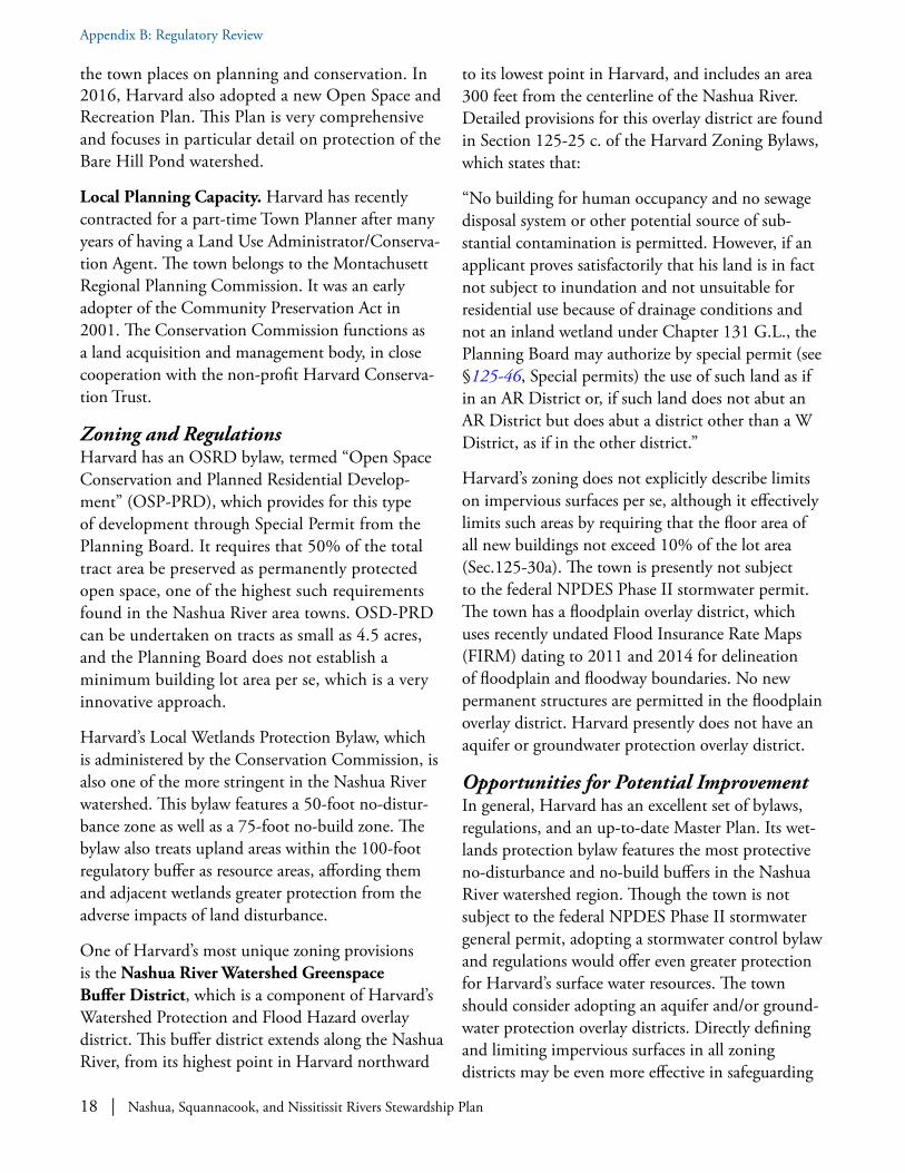
18 | Nashua, Squannacook, and Nissitissit Rivers Stewardship Plan
Appendix B: Regulatory Review
the town places on planning and conservation. In 2016, Harvard also adopted a new Open Space and Recreation Plan. This Plan is very comprehensive and focuses in particular detail on protection of the Bare Hill Pond watershed.
Local Planning Capacity. Harvard has recently contracted for a part-time Town Planner after many years of having a Land Use Administrator/Conserva-tion Agent. The town belongs to the Montachusett Regional Planning Commission. It was an early adopter of the Community Preservation Act in 2001. The Conservation Commission functions as a land acquisition and management body, in close cooperation with the non-profit Harvard Conserva-tion Trust.
Zoning and RegulationsHarvard has an OSRD bylaw, termed “Open Space Conservation and Planned Residential Develop-ment” (OSP-PRD), which provides for this type of development through Special Permit from the Planning Board. It requires that 50% of the total tract area be preserved as permanently protected open space, one of the highest such requirements found in the Nashua River area towns. OSD-PRD can be undertaken on tracts as small as 4.5 acres, and the Planning Board does not establish a minimum building lot area per se, which is a very innovative approach.
Harvard’s Local Wetlands Protection Bylaw, which is administered by the Conservation Commission, is also one of the more stringent in the Nashua River watershed. This bylaw features a 50-foot no-distur-bance zone as well as a 75-foot no-build zone. The bylaw also treats upland areas within the 100-foot regulatory buffer as resource areas, affording them and adjacent wetlands greater protection from the adverse impacts of land disturbance.
One of Harvard’s most unique zoning provisions is the Nashua River Watershed Greenspace Buffer District, which is a component of Harvard’s Watershed Protection and Flood Hazard overlay district. This buffer district extends along the Nashua River, from its highest point in Harvard northward
to its lowest point in Harvard, and includes an area 300 feet from the centerline of the Nashua River. Detailed provisions for this overlay district are found in Section 125-25 c. of the Harvard Zoning Bylaws, which states that:
“No building for human occupancy and no sewage disposal system or other potential source of sub-stantial contamination is permitted. However, if an applicant proves satisfactorily that his land is in fact not subject to inundation and not unsuitable for residential use because of drainage conditions and not an inland wetland under Chapter 131 G.L., the Planning Board may authorize by special permit (see §125-46, Special permits) the use of such land as if in an AR District or, if such land does not abut an AR District but does abut a district other than a W District, as if in the other district.”
Harvard’s zoning does not explicitly describe limits on impervious surfaces per se, although it effectively limits such areas by requiring that the floor area of all new buildings not exceed 10% of the lot area (Sec.125-30a). The town is presently not subject to the federal NPDES Phase II stormwater permit. The town has a floodplain overlay district, which uses recently undated Flood Insurance Rate Maps (FIRM) dating to 2011 and 2014 for delineation of floodplain and floodway boundaries. No new permanent structures are permitted in the floodplain overlay district. Harvard presently does not have an aquifer or groundwater protection overlay district.
Opportunities for Potential ImprovementIn general, Harvard has an excellent set of bylaws, regulations, and an up-to-date Master Plan. Its wet-lands protection bylaw features the most protective no-disturbance and no-build buffers in the Nashua River watershed region. Though the town is not subject to the federal NPDES Phase II stormwater general permit, adopting a stormwater control bylaw and regulations would offer even greater protection for Harvard’s surface water resources. The town should consider adopting an aquifer and/or ground-water protection overlay districts. Directly defining and limiting impervious surfaces in all zoning districts may be even more effective in safeguarding

Nashua, Squannacook, and Nissitissit Rivers Stewardship Plan | 19
Appendix B: Regulatory Review
water quality impacts resulting from development and redevelopment.
Hollis, New Hampshire
Hollis is a small town of 7,817 people located west of Nashua, New Hampshire and to the east of Brookline, New Hampshire, with Pepperell, Massachusetts bordering on the south. The
Nissitissit River flows through southwestern Hollis after entering the town from Brookline before flowing into the Nashua River in Pepperell. Southern and central Hollis contain extensive agricultural land encouraged by the presence of agricultural soils of extensive prime and statewide importance, while northern Hollis is more forested.
Plans, Policies and Local Planning CapacitySummary of Master Planning. Hollis’s most recent Master Plan update dates to 1998. Though not up to date, this Master Plan contains very detailed chapters on the protection of natural and water resources.
Unlike in Massachusetts, towns in New Hampshire are not required to have up-to-date Open Space and Recreation Plans to qualify for state conservation funds. Nonetheless, Conservation Commissions often adopt their own land acquisition and man-agement plans to guide them in their conservation efforts. Hollis’s Conservation Commission and Land Protection Study Committee have been proactive in protecting valuable riparian and wildlife habitat in the town. Approximately one-third of Hollis’s land area is protected open space, much of it held by the non-profit Beaver Brook Association.
Local Planning Capacity. Hollis has a part-time Town Planner as well as a Conservation Commission staff person, which enables the Town to better implement its plans and enforce the provisions of the zoning ordinance and related regulations. The
9 From Hollis, New Hampshire wetland ordinance definitions: PRIME WETLAND: Under the New Hampshire statute (RSA 482-A) for protecting wetlands from “despoliation and unregulated alteration", municipalities are able to designate some of their high value wetlands as "Prime Wetlands" (RSA 482-A:15). These designated wetlands are given special consideration by the Wetlands Board in permit application reviews.
town updates its Zoning Ordinance, Subdivision Regulations, and Site Plan Regulations on a regular basis. The town belongs to the Nashua Regional Planning Commission, which serves the towns in south-central New Hampshire.
Zoning and RegulationsHollis has an OSRD ordinance, termed “Hollis Open Space Planned Development” (HOSPD). Un-der HOSPD, all proposed major subdivisions must preserve from 40-50% of their area as permanently protected open space, depending on the density of units proposed on the tract. Major subdivisions are those creating five or more new building lots.
Hollis’s Local Wetlands Protection ordinance features a 100-foot regulatory buffer zone. While wetlands themselves are protected from development, it is up to New Hampshire towns to decide whether to have a local wetlands protection bylaw and how strict it will be. The wetlands ordinance prohibits new primary structures that are not “grandfathered” by virtue of being proposed on lots predating the wetland ordinance.
Local Conservation Commissions can also designate “Prime Wetlands”9 through a state-approved process that affords these wetlands additional scrutiny in the permitting process. Although Hollis has not designated Prime Wetlands meeting the State defi-nition, it has designated certain wetlands as sensitive environmental areas that should be given special consideration and protection during the permit application process.
The Zoning Ordinance also features a very detailed Aquifer Protection section, which oversees development over the town’s widespread stratified drift aquifers. Several high-risk land uses such as new underground petroleum tanks are prohibited. Limits on impervious surfaces are found in the Aquifer Protection zone. The town has previously

20 | Nashua, Squannacook, and Nissitissit Rivers Stewardship Plan
Appendix B: Regulatory Review
not been subject to the federal NPDES Phase II stormwater permit, although it has had a Stormwater Management Committee. Hollis has a floodplain overlay district and the floodplain maps were updated in 2009.
Lancaster, MassachusettsLancaster is a small to mid-size town in north central Massachu-setts that is close to Routes 2, I-190, and I-495, and has been growing steadily for more than 10 years. Lancaster aims to shape
and guide its growth so that the town retains its character and identity, while fostering the expansion of the tax base and citizen services. As of 2016, Lancaster’s population stood at 8,186.
Plans, Policies and Local Planning CapacitySummary of Master Planning. Lancaster completed its most recent Master Plan in 2007, its first new Master Plan in 40 years. Although 10 years old, this plan is extremely comprehensive and still suitable as the basis for current and future planning, zoning and regulatory efforts. The Master Plan does not have a dedicated Water Resources chapter, as these are discussed in the more comprehensive Open Space and Natural Resources chapter. The town will begin the process of updating the Plan in 2018, to reflect new planning practices and trends.
Lancaster’s most recently approved Open Space and Recreation Plan (OSRP) dates to 2010. This Plan includes detailed chapters on water resource and wildlife habitat protection. Massachusetts recommends that OSRPs be revised every seven years in order to serve as the basis for state-funded grant applications. Lancaster’s Open Space and Recreation Committee have been working on an update since January 2017 and expects to have a copy ready for re-certification by the end of 2017.
The 2014 Lancaster Green Belt Vision Plan was created to form a continuous, contiguous greenway of parcels that run from south Lancaster, along the Nashua River, to north Lancaster. The Green Belt
will provide town-wide recreational trails, as well as a corridor for migratory wildlife.
Local Planning Capacity. Lancaster has a full-time Town Planner as well as a Conservation Agent. The Town land use boards and commissions (Planning Board, Conservation Commission, and Zoning Board of Appeals) regularly update their respective bylaws and regulations. Lancaster is also a member of the Montachusett Regional Planning Commission (MRPC), which is chartered to carry out compre-hensive regional planning. MRPC offers technical and professional services to its members, including planning in the areas of community development, economic development, transportation, housing, environment, and geographic information systems.
Zoning and RegulationsFlexible Development Bylaw. Lancaster’s open space residential development bylaw provides for this type of development through a Special Permit from the Planning Board. This bylaw, called “Flexible Development,” requires that 40% of the total tract area be preserved as permanently protected open space, in exchange for smaller lot sizes in a clustered arrangement.
Wetlands Protection Bylaw. Lancaster’s local Wetlands Protection Bylaw was last revised in 2007. The bylaw features a 25-foot no-disturbance buffer from all wetland resource areas. Although this is certainly better than not having a no-disturbance buffer, the latest science on wetland buffer zones supports a wider no-disturbance buffer for adequate protection of water quality and habitat values of wetlands adjacent to development.
Stormwater Management Bylaw. The town is subject to the federal NPDES Phase II stormwater permit. As such, the town adopted a Stormwater Management Bylaw in 2007, an Illicit Discharge Bylaw in 2007, and a Water Withdrawal Bylaw in 2010. All of the bylaws serve the town well in the protection of its rivers and water bodies, as they are heavily enforced.
Overlay Districts. Lancaster has a Water Resource

Nashua, Squannacook, and Nissitissit Rivers Stewardship Plan | 21
Appendix B: Regulatory Review
Protection Overlay District in the Zoning Bylaw. This bylaw primarily addresses the protection of groundwater, most specifically the stratified drift aquifers in town. Any use that would render any lot in the overlay district with 15% or greater impervious surfaces requires a special permit from the Planning Board. The Town also has a Floodplain Overlay District and Bylaw that was recently revised in 2011, coincident with the town’s floodplain (FIRM) map revisions by FEMA.
Other InitiativesGreen Community. In 2010, Lancaster was desig-nated as a Green Community by the Massachusetts Department of Energy Resources, one of the first municipalities in the state to receive that distinc-tion. The designation mandates that the town’s municipal facilities and vehicles must reduce energy consumption by 20%. The town has undertaken several actions to meet this goal, such as new heating systems, upgraded lighting, insulation and weather-ization measures, LED street lighting, and electric vehicles with a docking station.
Complete Streets. In 2017, Lancaster was designat-ed as a “Complete Streets”’ community by the Mas-sachusetts Department of Transportation (DOT). The Complete Streets program provides funding to municipalities for construction of pedestrian- and bicycle-friendly roads, sidewalks, and connections to places of public interest. A prioritization plan was adopted, and in its first year the town will start sidewalk reconstruction on Main Street, along with curb ramps and cross walks. Bicycle racks will also be installed at the library, Community Center, and elementary and middle schools.
Land and Water Conservation Fund Grant. In 2016, a Land and Water Conservation Fund (LWCF) grant was received from the National Park Service and administered by the Massachusetts Department of Conservation Services, for the construction of a multi-purpose, multi-generational park space called the Nathaniel Thayer Memorial Park. Phase 1 of the park project, a playground with a splash pad and bathroom facility, will be construct-ed in 2018. Other pieces of the park will include
athletic fields, passive recreation fields, a basketball court, tennis courts, dog park, walking paths, and an amphitheater.
Bartlett Pond Dam Removal. In 2014, the dam at the Bartlett Pond Recreation Area was removed. The dam removal has improved the water quality of the Wekepeke Brook, which was classified as a distressed waterbody. The removal of the dam and concrete impoundment has allowed for the replacement of warm still water with free-flowing, oxygenated, cooler, deeper water, which has had a large-scale benefit for local habitat.
Designated Blue Trail. In 2016, the Lancaster Friends of the Nashua River officially designated the Town’s first “blue trail,” or water trail, on the North Nashua River. The blue trail runs from a launch point at I-190 to a take-out point some miles down-stream at the Pellechia Recreation Area, south of the Cook Conservation Area along the North Nashua River. Signs along the roadside and riverside direct the public to these locations.
Opportunities for Potential ImprovementThe first recommendation is that Lancaster should consider updating its 2007 Master Plan. Although the existing Master Plan reflects the first major revision in decades, several sections would likely benefit from updating. The town should continue its efforts to update the 2010 Open Space and Recre-ation Plan, which is due to be completed by the end of 2017. The town should also continue its efforts to plan for the Green Belt as outlined in the 2014 Green Belt Vision Plan.
The Conservation Commission may also want to consider increasing the no-disturbance buffer in its local Wetlands Protection Bylaw to greater than 25 feet. The science supports having much more extensive no-disturbance buffers, especially for the protection of riparian habitats and their associated assemblage of species. Finally, directly defining and limiting impervious surfaces in all zoning districts may be even more effective in safeguarding water quality impacts resulting from development and redevelopment.

22 | Nashua, Squannacook, and Nissitissit Rivers Stewardship Plan
Appendix B: Regulatory Review
Pepperell, Massachusetts Pepperell is a mid-sized town on the Massachusetts/New Hampshire border, located north of Groton and south of Brookline and Hollis, New Hampshire. As of 2016, Pepperell’s population
stood at 12,152. Like other older mill towns once dependent on waterpower for industry, Pepperell has several villages within its borders, including East Pepperell near the Pepperell Dam on the Nashua River, Pepperell Center, and Pepperell’s Historic Dis-trict to the west of the center. Over the decades, the Pepperell Conservation Commission and other land protection entities such as MassWildlife, Nashoba Conservation Trust, and Nissitissit River Land Trust have protected several thousand acres of land, much of it centered on Gulf Brook, a trout stream that flows into the Nissitissit River. This conservation land forms a linear network of protected land, which can serve as a good model for effective protection of wildlife habitat.
Plans, Policies and Local Planning CapacitySummary of Master Planning. Pepperell—desig-nated a Green Community in 2015—completed its most recent Master Plan in 2007. This plan, although now 10 years old, is very comprehensive and still suitable as the basis for future planning and zoning and regulatory efforts. This Master Plan does not have a Water Resources chapter per se, though water resources are described in the Natural Resources chapter. The Northern Middlesex Council of Governments (NMCOG) has been contracted to update Pepperell’s Master Plan. A Master Plan Committee has been organized as of 2018 and a new Master Plan should be ready for adoption by Town Meeting in the near future.
Pepperell recently updated its Open Space and Recreation Plan (OSRP) in 2016, which has been approved by the State. OSRPs are considered current for seven years. This Plan includes detailed chapters on water resource and wildlife habitat protection.
Local Planning Capacity. Pepperell has a full-time
Town Planner as well as a part-time Conservation Administrator. The Town Land Use Boards (Plan-ning, Conservation Commission, and Zoning Board) regularly update their respective bylaws and regulations. Unlike most of the other towns in the Nashua River Wild and Scenic area that belong to the MRPC, Pepperell, along with Dun-stable, are members of the NMCOG, a regional planning agency.
Zoning and RegulationsPepperell’s OSRD bylaw provides for this type of development through Special Permit from the Planning Board. It requires that 40% of the total tract area be preserved as permanently protected open space, slightly less than the 50% recommended by the Massachusetts Executive Office of Energy and Environmental Affairs for this type of bylaw.
Pepperell’s Local Wetlands Protection Bylaw, last revised in 2002, features a combined 50-foot no-dis-turbance/no-build buffer from all wetland resource areas. This is one of the wider such no-disturbance buffers within the Nashua River watershed region.
Pepperell also has a thorough groundwater and aquifer protection bylaw, termed the Water Resource Protection Overlay District (WRPOD). The WRPOD covers much of the western part of the town and an area around the Jersey Street wells and the Nashua Road well, which is on the Hollis, New Hampshire state line.
Section 5530 of Pepperell’s Zoning Bylaw has a good section on erosion control. The town is subject to the revised federal NPDES Phase II stormwater permit, which it will need to address in 2018, if the current federal schedule holds. The town was able to obtain an exemption from the previous version of the permit issued in 2004. Pepperell will need to adopt a local Stormwater Management Bylaw and undertake the other minimum controls specified in the stormwater permit. The town will need to comply with the new stormwater permit, which is currently under appeal. Pepperell has contracted with a consulting firm to assist in preparing its Notice of Intent (NOI).

Nashua, Squannacook, and Nissitissit Rivers Stewardship Plan | 23
Appendix B: Regulatory Review
The town is a member of the Northern Middlesex Stormwater Collaborative and participates in meetings and training sessions related to stormwater regularly. Pepperell is planning to adopt a Storm-water Bylaw and exploring ways to fund efforts (perhaps a stormwater utility) to comply with the permit. All zoning regulations will be reviewed to determine which regulations will require updating, changes, etc. for compliance with the Permit or to address minimizing impervious surface impacts.
The town floodplain overlay district, included in the Code of the town of Pepperell, was adopted on June 7, 1993 and amended on May 3, 2010. This floodplain bylaw only addresses construction in the floodway, however, and not within the wider 100 and 500-year floodplain zones.
Opportunities for Potential ImprovementPepperell might consider revising its floodplain protection bylaw and/or regulations to address all impacts within the 100 and 500-year floodplains, not just within the floodway itself.
Directly defining and limiting impervious surfaces in all zoning districts may be even more effective in safeguarding water quality impacts resulting from development and redevelopment. This will be addressed as part of the review process under stormwater.
Shirley, MassachusettsShirley is a small to mid-sized town of approximately 5,700 town residents and 1,458 prison inmates located to the west of Ayer and Harvard and adjacent to Devens in north-central
Massachusetts.
Plans, Policies and Local Planning CapacitySummary of Master Planning. The Shirley Planning Board adopted a revised Master Plan in late 2017. The town’s Open Space and Recreation Plan (OSRP) has also recently been updated; it was approved by EOEEA and accepted by the Shirley
Town Meeting voters in late 2017. The OSRP includes detailed chapters on water resources and wildlife habitat protection as well as broad recommendations in regard to recreation. Shirley is a designated “Green Community.”
Local Planning Capacity. Shirley currently lacks a Town Planner. A part-time or full-time Planner would be very useful in ensuring the successful implementation of recommendations made in the revised Master Plan. The town is part of the Monta-chusett Regional Planning Commission. Shirley has not adopted the Community Preservation Act.
Zoning and RegulationsShirley has an OSRD bylaw, termed “Low-Impact Development,” not to be confused with stormwa-ter-related low-impact development. It requires that 35% of the total tract area be preserved as permanently protected open space, less than the 50% recommended by the Massachusetts Executive Office of Energy and Environmental Affairs for this type of bylaw. LID is allowed through Special Permit from the Planning Board. Amendments to the bylaw are recommended in the new Open Space and Recreation Plan.
Shirley’s Non-Zoning Wetlands Bylaw was originally adopted in 2005 and was amended March 16, 2015. This bylaw features a 25-foot no-disturbance and a 40-foot no-build buffer from all wetland resource areas. Lots in existence when the bylaw was adopted are exempt from its provisions. Shirley also has a Water Supply and Wellhead Protection Overlay District for the protection of its groundwa-ter resources.
The Town is subject to the federal NPDES Phase II stormwater permit and does have a local Stormwater Management Control Bylaw, adopted March 16, 2015, both for land-disturbing activities and illicit discharges to the storm drain system and receiving waters. Activities disturbing one or more acres of land are required to obtain a stormwater manage-ment permit. Shirley has a floodplain overlay district and the floodplain maps were updated in 2010.

24 | Nashua, Squannacook, and Nissitissit Rivers Stewardship Plan
Appendix B: Regulatory Review
Opportunities for Potential ImprovementThere are many opportunities to meet goals of this Stewardship Plan through implementing recommendations found in Shirley's new Master Plan and Open Space and Recreation Plan. One of these recommendations includes considering revisions to the town's Low Impact Development bylaw to protect more open space, and perhaps to rename the bylaw to alleviate confusion with the stormwater management use of the term. Revisions to the Shirley Non-zoning Wetlands Bylaw are also recommended. A no disturbance zone wider than 25 feet in the Local Wetlands Protection Bylaw would provide better protection to Shirley’s wetlands and surface waters. Directly defining and limiting impervious surfaces in all zoning districts may be even more effective in safeguarding water quality impacts resulting from development and redevelopment. Review of all of the town’s land-use and resource-protection bylaws and regulations in the next few years is anticipated. Opportunities for increasing public and town officials' awareness about natural resources, especially the protection of water quality, have also been identified, as have measures to increase public access to and recreational use of conservation lands and waterways. Alternative economic uses for undeveloped forest land, such as outdoor recreation and forest management, and options for land protection by entities other than the town, are also being discussed.
Townsend, MassachusettsTownsend is a mid-sized town on the Massachusetts/New Hampshire border, located north of Lunenburg and south of Brookline and Mason, New Hampshire. As of 2010,
Townsend’s population stood at 8,926. Townsend features several villages within its borders, such as the Harbor Pond area on an impoundment of the Squannacook River, West Townsend near the Ashby border, and Townsend Center with its classic town common at the intersection of Routes 13 and 119. Much of Townsend’s land area is protected
land within the Townsend and Willard Brook State Forests, which are administered by Massachusetts Department of Conservation and Recreation.
Plans, Policies and Local Planning CapacitySummary of Master Planning. Townsend com-pleted its most recent Master Plan in 2001. An attempt to update the Master Plan in 2008 was not brought to completion. The 2001 Master Plan should be revised as soon as practicable. Townsend’s most recently approved Open Space and Recreation Plan (OSRP) dates to 2013. This Plan includes detailed chapters on water resource and wildlife habitat protection. Townsend is a designated Green Community.
Local Planning Capacity. Townsend has a full-time Planning Administrator as well as a Conservation Agent. Much of the Planning Administrator’s function is related to plan review and the clerical functions of the Planning Board rather than Master Planning and other long-range projects. The town is part of the Montachusett Regional Planning Com-mission. The town attempted, but failed, to adopt the Community Preservation Act in the mid-2000s.
Zoning and RegulationsTownsend has an OSRD Bylaw, termed “Open Space Preservation Development,” which provides for this type of development through Special Permit from the Planning Board. It requires that 30% of the total tract area be preserved as permanently protect-ed open space, less than the 50% recommended by Massachusetts Executive Office of Energy and Envi-ronmental Affairs for this type of bylaw. The bylaw also requires applicants to demonstrate that an Open Space Planned Development (OSPD) is at least as good as or superior to a conventional development, which is a burden of proof that could discourage this type of development. The bylaw dates to 1986, with some revisions since then, and should be revisited in light of current recommended planning practices.
Townsend’s Local Wetlands Protection Bylaw was originally adopted in 1983 and has been revised periodically since then. This bylaw features a 35-foot no-disturbance buffer from all wetland resource

Nashua, Squannacook, and Nissitissit Rivers Stewardship Plan | 25
Appendix B: Regulatory Review
areas. This no-disturbance buffer is a good provision, although the latest wetland science supports a wider buffer to protect water quality and riparian wildlife habitat. Townsend has thorough groundwater and aquifer protection measures in its zoning bylaws.
The town is subject to the federal NPDES Phase II stormwater permit and does have a local Stormwater Management Bylaw, both for land disturbing activities and illicit discharges to the storm drain system and receiving waters. Activities disturbing 40,000 square feet or more of land, or 1,000 square feet or more on slopes greater than 15%, require a stormwater management permit. LID techniques are recommended but not absolutely required in the Stormwater Management Bylaw.
The town does have a floodplain overlay district, although the Building Inspector must check on whether construction is proposed in a floodplain and whether flood insurance is required. Townsend does have a floodplain overlay district and the floodplain maps were updated in 2010.
Opportunities for Potential ImprovementThe first recommendation is to update the Master Plan, which dates to 2001 and is perhaps no longer an effective basis for zoning and other regulatory amendments that could help to safeguard the outstanding resource values identified in this report. Secondly, Townsend’s Open Space Planned Development Bylaw should be revised to reflect the latest planning practices such as protecting a greater amount of open space and providing for more flexible dimensional requirements. Directly defining and limiting impervious surfaces in all zoning districts may be even more effective in safeguarding water quality impacts resulting from development and redevelopment.

26 | Nashua, Squannacook, and Nissitissit Rivers Stewardship Plan
Appendix B: Regulatory Review
Cat
egor
yB
rook
line
Hol
lisR
egul
ator
y Mea
sure
Vale
rie R
earic
k, T
own
Plan
ner,
603
-673
-88
55 x
215
Wen
dy T
rimbl
e, P
B Se
cret
ary;
603
-465
-220
9 x
108
Mas
ter P
lann
ing
Cur
rent
Mas
ter P
lan?
YES
– 20
12.
NO
– d
ates
to 1
998.
Wat
er R
esou
rces
Pro
tect
ion
Cha
pter
?YE
SYE
SC
urre
nt O
pen
Spac
e Pl
an?
YES
YES
Has
the
Zoni
ng B
ylaw
bee
n re
vise
d in
the
last
five
yea
rs?
YES
YES
Land
-Use
Con
trol
sD
oes
the
tow
n ha
ve O
SRD
zon
ing?
YES
YES
If so
, wha
t is
prot
ecte
d op
en s
pace
req
uire
-m
ent?
35%
40%
- 50
% d
epen
ding
on
over
all d
ensi
ty o
f hou
sing
.
Is O
SRD
allo
wed
by
right
or S
peci
al P
erm
it?By
righ
t – fo
llow
sub
divi
sion
Pro
cess
.Sp
ecia
l Exc
eptio
n (S
P).
Doe
s th
e to
wn
have
a m
axim
um s
lope
for
deve
lopm
ent?
Not
per
se
– lim
its o
n ne
w ro
ad a
nd
driv
eway
slo
pes.
Not
per
se
– lim
its o
n ne
w ro
ad a
nd d
rivew
ay s
lope
s.
Doe
s th
e to
wn
have
Ero
sion
Con
trol m
ea-
sure
s fo
r con
stru
ctio
n on
ste
ep s
lope
s?It
has
a St
orm
wat
er M
anag
emen
t sec
tion
6.4
in S
ite P
lan
Reg
s.
LID
is d
efau
lt m
etho
d. V
ery
good
.
Goo
d st
anda
rds
for c
onst
ruct
ion
on s
teep
slo
pes
and
hill-
side
s in
“Rur
al C
hara
cter
Pre
serv
atio
n O
rd.”
Follo
w B
MPs
.
Doe
s th
e zo
ning
lim
it th
e %
or a
rea
of
impe
rvio
us s
urfa
ces?
Indu
stria
l – C
omm
erci
al D
istri
ct N
ot >
75%
im
perv
ious
;
Aqui
fer p
rote
ctio
n D
istri
ct N
ot >
15%
or
2,50
0 sq
uare
feet
or a
sto
rmw
ater
pla
n is
re
quire
d.
Max
. Bui
ldin
g co
vera
ge in
Com
mer
cial
Zon
e; E
xcep
t for
In
dust
rial Z
one,
impe
rmea
ble
surfa
ce m
ay c
over
Not
>15
%
of a
ny lo
t in
the
Aqui
fer P
rote
ctio
n O
verla
y Are
a an
d W
etla
nd
Con
serv
atio
n O
verla
y Zo
ne. A
ll oth
er d
istri
cts
Not
>25
%.
Reg
ula
tory
Su
mm
ary
Tab
les
This
revi
ew p
rovi
des t
able
s for
New
Ham
pshi
re a
nd M
assa
chus
etts
that
sum
mar
ize th
e pl
anni
ng a
nd re
gula
tory
mat
ters
for e
ach
tow
n pa
rtic
ipat
ing
in th
e St
ewar
dshi
p Pl
an.
New
Ham
psh
ire
Reg
ula
tory
Su
mm
ary
for
Bro
okl
ine
and
Ho
llis

Nashua, Squannacook, and Nissitissit Rivers Stewardship Plan | 27
Appendix B: Regulatory Review
Cat
egor
yB
rook
line
Hol
lisD
o pa
rkin
g re
quire
men
ts fo
r com
mer
cial
de
vt. p
rovi
de fo
r sha
red
or a
ltern
ativ
e pa
rkin
g?
YES
– go
od p
rovi
sion
s fo
r suc
h in
Site
Pl
an R
egs
sec.
4.6
.01.
YES
– sh
ared
par
king
is e
ncou
rage
d w
hen
poss
ible
.
Any
reso
urce
pro
tect
ion
over
lay
zone
s (b
esid
es w
etla
nds)
?YE
S –
Aqu
ifer P
rote
ctio
n an
d Fl
oodp
lain
.YE
S –
Aqu
ifer P
rote
ctio
n O
verla
y Zo
ne a
nd W
etla
nd C
on-
serv
atio
n O
verla
y Zo
ne.
Wat
er R
esou
rce
Zoni
ng a
nd R
egul
atio
nsD
oes
the
tow
n ha
ve a
loca
l Wet
land
s Pr
otec
-tio
n By
law
?YE
S (Z
onin
g O
rdin
ance
).YE
S
If so
, are
ther
e no
-dis
turb
ance
or n
o-bu
ild
setb
acks
?Th
ere
is a
50
foot
no-
build
are
a.N
ot p
er s
e –
but t
he b
ylaw
is o
ther
wis
e co
mpr
ehen
sive
.
If ye
s to
a W
PB, a
re u
plan
d ar
eas
adja
cent
to
wet
land
s co
nsid
ered
reso
urce
are
as?
NO
– m
ay n
ot b
e ap
plic
able
in N
H la
w?
NO
– m
ay n
ot b
e ap
plic
able
in N
H la
w?
Doe
s th
e to
wn
have
an
Aqui
fer o
r gen
eral
gr
ound
wat
er p
rote
ctio
n by
law
?YE
SYE
S
Doe
s th
e to
wn
have
wel
lhea
d pr
otec
tion
as
part
of th
is?
YES
YES
Doe
s th
e to
wn
have
a S
torm
wat
er C
ontro
l By
law
with
LID
pro
visi
ons?
YES
– Se
ctio
n 6.
4 of
Site
Pla
n R
egul
a-tio
ns. P
retty
goo
d ex
ampl
e.Th
ere
was
a s
torm
wat
er c
omm
ittee
that
has
sin
ce d
isba
nded
.
Wha
t are
a of
land
dis
turb
ance
trig
gers
St
orm
wat
er R
evie
w?
NO
> 1a
cre.
If p
ropo
sal w
ill im
pact
wet
land
s or
res
ourc
es a
reas
<
1 ac
re tr
igge
rs s
torm
wat
er r
evie
w.Is
min
imiz
ing
impe
rvio
us s
urfa
ces
a go
al o
f th
e st
orm
wat
er b
ylaw
or r
egs?
YES
– rig
ht u
p fro
ntYE
S
Is th
e us
e of
LID
requ
ired
in c
erta
in c
ircum
-st
ance
s?YE
S –
it is
the
defa
ult m
etho
dN
O
Prot
ectio
n of
key
wild
life
habi
tat a
nd n
atur
al c
omm
uniti
es?
Is p
rote
ctio
n of
wild
life
habi
tat a
nd n
atur
al
com
mun
ities
spe
cifie
d in
OSR
D o
r oth
er
zoni
ng?
YES
YES
Is s
uch
addr
esse
d in
Ope
n Sp
ace
or M
aste
r Pl
ans?
YES
YES
If so
, wha
t are
as a
re c
alle
d ou
t in
such
pl
ans?
See
Nat
ural
Res
ourc
e C
hapt
erG
ood
prov
isio
n fo
r “W
ildlif
e H
abita
t Inv
ento
ry a
nd A
sses
s-m
ent”
in S
ite P
lan
Reg
s (p
age
4)

28 | Nashua, Squannacook, and Nissitissit Rivers Stewardship Plan
Appendix B: Regulatory Review
Cat
egor
yB
rook
line
Hol
lisPl
anni
ng C
apac
ityN
H p
rogr
ams?
Doe
s th
e To
wn
have
a fu
ll or
par
t-tim
e To
wn
Plan
ner o
r Pla
nnin
g Ad
min
istra
tor?
YES
YES
- Ful
l-tim
e Pl
anni
ng S
ecre
tary
and
par
t- tim
e Pl
anne
r.
Doe
s th
e To
wn
have
a fu
ll or
par
t-tim
e C
onse
rvat
ion
Adm
inis
trat
or?
YES
– Kr
istin
Aus
tin 6
03-6
73-8
855
x 21
6YE
S –
Con
nie
Cai
n 60
3-46
5-22
09 x
105
Doe
s th
e To
wn
have
a la
nd a
cqui
sitio
n C
omm
ittee
and
/or f
und
for o
pen
spac
e?YE
S to
bot
h:
100%
of L
and-
Use
cha
nge
tax
goes
to
fund
YES
to b
oth:
50%
of L
and-
Use
cha
nge
tax
goes
to fu
nd.
Whi
ch R
PC d
oes
the
Tow
n be
long
to?
NR
PCN
RPC
OTH
ERH
ollis
has
a “R
ural
Cha
ract
er P
rese
rvat
ion
Ord
inan
ce” t
hat i
s qu
ite in
nova
tive.

Nashua, Squannacook, and Nissitissit Rivers Stewardship Plan | 29
Appendix B: Regulatory Review
Mas
sach
use
tts
Reg
ula
tory
Su
mm
ary
for
Aye
r, B
olt
on
, Dev
ens,
Du
nst
able
, an
d G
roto
n
Cat
egor
yAy
erB
olto
nD
even
sD
unst
able
Gro
ton
Reg
ulat
ory M
easu
reH
eath
er H
amps
on,
Plan
ning
Adm
in.
978-
772-
8218
Mar
k Arc
ham
baul
t, To
wn
Plan
ner
978-
772-
8218
Eric
a U
riarte
, Tow
n Pl
anne
r
978-
779-
3308
Pete
r Low
itt, D
irect
or
Nei
l Ang
us, P
lann
er
Dev
ens
Ente
rpris
e C
omm
issi
on
Che
ryl M
ann,
Sec
reta
ry
978-
649-
4514
x 2
30
Taka
shi T
ada,
Tow
n Pl
anne
r
978-
448-
1105
Mas
ter P
lann
ing
C
urre
nt M
aste
r Pla
n?YE
S –
it is
in th
e pr
oces
s of
bei
ng
upda
ted
as o
f 201
7.
Set f
or a
dopt
ion
in
2018
.
YES
– re
vise
d in
20
06.
YES
- 199
4 D
even
s R
euse
Pla
n, R
evis
ed
mos
t rec
ently
in 2
016.
YES-
in th
e pr
oces
s of
bei
ng
upda
ted.
Expe
cted
to b
e ap
prov
ed
at fa
ll ST
M 2
017.
Pre
viou
s M
aste
r Pl
an d
ates
to 1
999.
YES
– re
vise
d in
201
1.
Wat
er R
esou
rces
Pr
otec
tion
Cha
pter
?YE
SN
O –
thou
gh w
ater
re
sour
ce p
rote
ctio
n is
m
entio
ned.
YES
– in
Reu
se P
lan,
By
law
s, R
ules
and
R
egul
atio
ns, a
nd O
pen
Spac
e an
d R
ecre
atio
n Pl
an.
NO
– b
ut w
ater
res
ourc
es
cove
red
in N
atur
al R
esou
rc-
es.
YES
Cur
rent
Ope
n Sp
ace
and
Rec
reat
ion
Plan
NO
– th
ough
it is
sl
ated
for a
dopt
ion
in
2018
.
YES
YES
– Pl
an is
200
8 to
20
13 b
ut is
stil
l act
ive
(2
parc
els
rem
aini
ng fo
r pe
rman
ent p
rote
ctio
n).
Will
be u
pdat
ed in
201
8.
YES
– co
vers
the
perio
d 20
10 –
201
7. W
ill be
up
date
d th
is y
ear.
YES
– re
vise
d in
201
2.
Des
igna
ted
“Gre
en
Com
mun
ity”?
YES
YES
N/A
NO
NO
Has
the
Zoni
ng
Byla
w b
een
revi
sed
rece
ntly
?
YES
– in
the
proc
ess
of b
eing
com
preh
en-
sive
ly u
pdat
ed a
s of
20
17 a
nd s
ched
uled
fo
r a T
own
Mee
ting
vote
in 2
018.
YES
YES
– as
rece
ntly
as
2016
.YE
S –
as re
cent
ly a
s 20
16.
YES

30 | Nashua, Squannacook, and Nissitissit Rivers Stewardship Plan
Appendix B: Regulatory Review
Cat
egor
yAy
erB
olto
nD
even
sD
unst
able
Gro
ton
Land
-Use
Con
trol
sD
oes
the
tow
n ha
ve
OSR
D z
onin
g?YE
SYE
S - c
alle
d “F
arm
-la
nd a
nd O
pen
Spac
e Pl
anne
d R
es. D
evt.”
YES
– ca
lled
‘Inno
vativ
e R
esid
entia
l Dev
elop
-m
ent’
YES
– se
ctio
n 6.
6 M
in o
f 14
acre
s.YE
S –
calle
d “F
lexi
ble
Dev
elop
men
t”.
If so
, wha
t is
prot
ecte
d op
en s
pace
req
uire
-m
ent?
50%
33%
(Mas
ter P
lan
reco
mm
ends
incr
eas-
ing
to 5
0%)
Not
fixe
d35
%35
%
Is O
SRD
allo
wed
by
rig
ht o
r Spe
cial
Pe
rmit?
Spec
ial P
erm
it.
(OSR
D is
opt
iona
l)Sp
ecia
l Per
mit.
‘Uni
fied
Perm
it’ –
OSR
D
is o
ptio
nal b
ut in
cent
iv-
ized
thou
gh th
is p
roce
ss
YES
– by
Spe
cial
Per
mit.
(O
SRD
is o
ptio
nal)
Spec
ial P
erm
it.
Doe
s th
e to
wn
have
a
max
imum
slo
pe fo
r de
velo
pmen
t?
NO
Max
imum
slo
pe o
f 10
% f
or th
e sm
alle
st
subd
iv. la
nes,
oth
er
max
. slo
pes
spec
ified
in
Sec
. 522
0.4
Subd
iv.
Reg
s.
YES
– St
eep
Slop
e Pr
otec
tion
Reg
ulat
ions
(9
74 C
MR
3.0
6)
http
://w
ww.
deve
nsec
.c
om/ru
les-
regs
/de-
creg
s306
.htm
l
YES
– un
der S
torm
wat
er
and
Eros
ion
Con
trol B
ylaw
(in
Gen
eral
byl
aw) ≥
15%
sl
ope
and
>200
squ
are
feet
dis
tur-
banc
e in
slo
pe
Max
imum
slo
pe o
f 10%
fo
r sub
divi
sion
road
s an
d dr
ivew
ays
Doe
s th
e to
wn
have
Er
osio
n C
ontro
l mea
-su
res
for
cons
truct
ion
on s
teep
slo
pes?
YES
– A
yer h
as g
ood
zoni
ng p
rovi
sion
s fo
r re
gula
tion
of la
nd
clea
ring
and
grad
ing.
C
over
s di
stur
banc
es
over
10,
000
squa
re
feet
.
NO
– N
ot p
er s
e.YE
S –
Stee
p Sl
ope
Prot
ectio
n R
egul
atio
ns
(974
CM
R 3
.06)
http
://w
ww.
deve
nsec
.c
om/ru
les-
regs
/de
creg
s306
.htm
l and
Er
osio
n an
d Se
dim
ent
Con
trol R
equi
rem
ents
[9
74 C
MR
3.0
2(3)
(e)]
ww
w.de
vens
ec.c
om/ru
l es
- reg
s/de
creg
s302
.ht
ml
Reg
ulat
ions
for
Stor
mw
ater
an
d er
osio
n co
ntro
l byl
aw
are
curre
ntly
be
draf
ted.
YES
– Se
ctio
n 35
2-19
in
Sto
rmw
ater
Reg
ula-
tions

Nashua, Squannacook, and Nissitissit Rivers Stewardship Plan | 31
Appendix B: Regulatory Review
Cat
egor
yAy
erB
olto
nD
even
sD
unst
able
Gro
ton
Doe
s th
e zo
ning
lim
it th
e %
or a
rea
of
impe
rvio
us s
urfa
ces?
Perc
enta
ge o
f ‘op
en
spac
e’ (n
on-
impe
r-vi
ous)
requ
ired
on a
lo
t spe
cifie
d in
Dim
. Ta
ble.
Als
o m
ax.
build
ing
cove
rage
.
YES
– th
ere
is a
max
-im
um 5
0% im
perv
ious
in
Com
m.
Zone
.
YES
– va
ried
prov
isio
ns
in th
e D
ensi
ty /
Inte
nsity
R
egul
atio
ns
Ther
e is
a 2
5% lo
t cov
erag
e re
qt. F
or b
uild
ings
. (Se
c.
11.4
)
YES
– de
scrib
ed in
the
Sche
dule
of I
nten
sity
R
egul
atio
ns: S
ec.
218-
20.
Do
park
ing
requ
ire-
men
ts fo
r co
mm
erci
al
devt
. pro
vide
for
shar
ed o
r al
tern
ativ
e pa
rkin
g?
YES,
by
Spec
ial
Perm
it. S
ee S
ec. 9
.1.5
(D) i
n zo
ning
byl
aw.
NO
YES
– pa
rkin
g re
gula
-tio
ns e
mph
asiz
e sh
ared
pa
rkin
g as
wel
l as
alte
rnat
ive
pave
men
t.
No
com
mer
cial
dev
elop
men
t in
tow
n.YE
S –
good
gui
delin
es
for s
hare
d pa
rkin
g in
Se
ctio
n 21
8-23
.
Any
reso
urce
pro
tec-
tion
over
lay
zone
s (b
esid
es w
etla
nds)
?
Floo
dpla
in a
nd A
quife
r Pr
otec
tion
Ove
rlay
Dis
trict
s
Floo
dpla
in a
nd M
ixed
- U
se V
illage
Ove
rlay
Dis
trict
s
Floo
dpla
in a
nd W
ater
R
esou
rces
Pro
tect
ion.
Sect
ion
15.2
.1 o
f Zon
ing
byla
w-
Floo
dpla
in D
istri
ct
Ove
rlay
Floo
dpla
in a
nd W
ater
R
esou
rces
Pro
tect
ion.
DAT
E of
FIR
M m
aps
flood
zon
ing
is b
ased
on
1982
2011
2011
2010
2010
Wat
er R
esou
rce
Zoni
ng a
nd R
egul
atio
nsD
oes
the
tow
n ha
ve
a lo
cal W
etla
nds
Prot
ectio
n By
law
to
supp
lem
ent t
he W
PA?
NO
YES
YES
YES
– th
e w
etla
nd p
rote
c-tio
n by
law
was
rev
ised
in
2013
.
YES
If so
, are
ther
e no
- di
stur
banc
e or
no
- bu
ild s
etba
cks?
The
Byla
w p
ropo
ses
a 10
0 fo
ot re
gula
tory
bu
ffer.
100
foot
regu
lato
ry
buffe
r with
a 2
5 fo
ot
wid
e no
dis
turb
ance
zo
ne fr
om th
e ed
ge o
f W
PA ju
ris. w
etla
nds.
100
foot
regu
lato
ry
buffe
r with
a 5
0 fo
ot
no-b
uild
zon
e an
d a
25 fo
ot n
o-di
stur
banc
e zo
ne.
100
feet
regu
lato
ry
buffe
r zon
e.
60’ N
o ne
w p
erm
anen
t st
ruct
ure
setb
ack.
YES
– th
ere
is a
50
foot
com
bine
d no
- di
stur
banc
e / n
o-bu
ild
zone
.
If ye
s to
a W
PB, a
re
upla
nd a
reas
adj
acen
t to
wet
land
s co
nsid
-er
ed re
sour
ce a
reas
?
YES
– w
ithin
the
100
foot
buf
fer z
one.
YES
– la
nd w
ithin
75
feet
of a
wet
land
is
cons
ider
ed a
reso
urce
ar
eas
subj
ect t
o re
view
and
per
mitt
ing.
YES
– la
nd w
ithin
100
fe
et o
f wet
land
s ar
e pr
e-su
med
impo
rtant
to t
he
prot
ectio
n of
Res
ourc
e Ar
eas
and
any
activ
ity
requ
ires
perm
ittin
g.
NO
YES

32 | Nashua, Squannacook, and Nissitissit Rivers Stewardship Plan
Appendix B: Regulatory Review
Cat
egor
yAy
erB
olto
nD
even
sD
unst
able
Gro
ton
Doe
s th
e to
wn
have
an
Aqu
ifer o
r gen
eral
gr
ound
wat
er p
rote
c-tio
n by
law
?
YES
– Se
ctio
n 8.
1YE
S –
ther
e is
a
gene
ral t
own-
wid
e by
law
for g
roun
dwat
er
prot
ectio
n. G
ener
al
good
pra
ctic
es li
sted
.
YES
– D
even
s By
law
s C
hapt
er X
I: W
ater
R
esou
rce
Prot
ectio
n R
equi
rem
ents
http
://w
ww.
deve
nsec
.c o
m/
byla
ws/
byla
wst
oc.h
tm
l
YES
– W
ater
Sup
ply
Prot
ec-
tion
Byla
w.
Aqui
fer p
rote
cted
und
er th
is.
YES
Doe
s th
e to
wn
have
w
ellh
ead
prot
ectio
n as
pa
rt of
this
?
YES
YES
YES
YES
– Zo
ne 1
and
2 w
ell-
head
del
inea
tion
prot
ectio
n.YE
S
Doe
s th
e to
wn
have
a
Stor
mw
ater
Con
trol
Byla
w w
ith L
ID
prov
isio
ns?
YES
and
NO
– h
as
stor
mw
ater
con
trol
byla
w, b
ut L
ID n
ot
emph
asiz
ed.
NO
– th
ough
Sec
.
5230
.3 o
f the
Sub
div.
R
egs.
Has
goo
d pr
ovis
ions
for s
uch.
YES
– 20
12 –
exc
elle
nt
Stor
mw
ater
Man
age-
men
t Sec
tion
in 9
74
CM
R 3
.04(
4)
and
974
CM
R 4
.08.
ww
w.de
vens
ec.c
om/ru
l es
-egs
/dec
regs
toc.
htm
l
Has
Sto
rmw
ater
and
Ero
-si
on c
ontro
l byl
aw b
ut d
oes
not i
nclu
de L
ID.
YES
Wha
t are
a of
land
di
stur
banc
e tri
gger
s St
orm
wat
er R
evie
w?
Typi
cally
40,
000
sq.ft
. ex
cept
for s
lope
s >
15%
then
1,0
00 s
q.ft.
N/A
All d
evel
opm
ent i
s su
bjec
t to
stor
mw
ater
re
view
.
>20,
000
squ
are
feet
re
quire
s La
nd d
istu
rban
ce
perm
it fro
m P
B
> 20
,000
squ
are
feet
re
quire
s m
inor
per
mit
/
> 40
,000
squ
are
feet
m
ajor
per
mit
Is m
inim
izin
g im
perv
i-ou
s su
rface
s a
goal
of
the
stor
mw
ater
byl
aw
or re
gula
tions
?
NO
N/A
YES
In W
ater
Sup
ply
Prot
ectio
n By
law
15%
or 2
500
squa
re
feet
(w
hich
ever
gre
ater
) im
-pe
rv. r
equi
res
auth
oriz
atio
n if
the
wat
er s
uppl
y ar
ea.
YES

Nashua, Squannacook, and Nissitissit Rivers Stewardship Plan | 33
Appendix B: Regulatory Review
Cat
egor
yAy
erB
olto
nD
even
sD
unst
able
Gro
ton
Is th
e us
e of
LID
re
quire
d in
cer
tain
ci
rcum
stan
ces?
NO
LID
is re
quire
d in
the
Com
mer
cial
Zon
e an
d is
stro
ngly
enc
oura
ged
in S
ectio
n 52
30.3
of
the
Subd
iv. R
egs.
YES
– em
phas
is o
n bi
oret
entio
n an
d bi
ofil-
tratio
n.
LID
is c
onsi
dere
d th
e de
faul
t sto
rmw
ater
m
anag
emen
t tec
hniq
ue
in S
ec. 4
.08
2 ix
.
NO
YES
- Low
-impa
ct
deve
lopm
ent
(LID
)/gr
een
infra
stru
ctur
e te
chni
ques
mus
t be
inco
rpor
ated
into
de
velo
pmen
t and
re
deve
lopm
ent p
roje
cts
in th
e To
wn
unle
ss it
ca
n be
sho
wn
per
§ 35
2-9A
(1) t
hat t
he
use
of L
ID te
chni
ques
is
not
feas
ible
Prot
ectio
n of
key
wild
life
habi
tat a
nd n
atur
al c
omm
uniti
es?
Is p
rote
ctio
n of
wild
life
habi
tat a
nd n
atur
al
com
mun
ities
spec
ified
in
OSR
D o
r oth
er
zoni
ng?
YES
– in
the
Eros
ion
Con
trol s
ectio
n.N
OYE
S –
in S
ite P
lan
desi
gn s
tand
ards
ther
e ar
e re
quire
men
ts to
pr
eser
ve tr
ees
and
redu
ce e
dge
habi
tat o
n ne
w d
evel
opm
ent s
ites.
YES
– p
urpo
se in
OSR
D to
pr
eser
ve n
atur
al f
eatu
res
and
cond
ition
s.
Not
spe
cific
for w
ildlif
e ha
bita
t tho
ugh.
YES
Is s
uch
addr
esse
d in
O
pen
Spac
e or
Mas
ter
Plan
s?
YES
YES
– O
pen
Spac
e an
d R
ecre
atio
n Pl
an
(OSR
P) is
cur
rent
ly
bein
g re
vise
d. T
own
has
exce
llent
pla
nnin
g pr
oces
s.
YES
– es
peci
ally
the
Ope
n Sp
ace
and
Rec
reat
ion
Plan
.
Pres
ervi
ng o
pen
spac
e, p
ro-
tect
ing
natu
ral c
omm
uniti
es
and
reso
urce
con
serv
atio
n ar
e pr
imar
y ob
ject
ives
in
bot
h O
pen
Spac
e an
d M
aste
r pla
ns.
YES
If so
, doe
s it
desc
ribe
area
s re
com
men
ded
for f
urth
er p
rote
ctio
n in
de
tail?
YES
The
OSR
P go
es
into
gre
at d
etai
l on
reco
mm
ende
d la
nd fo
r pr
otec
tion.
See
Dev
ens
Ope
n Sp
ace
and
Rec
reat
ion
Plan
.
YES
- end
ange
red
wild
life
habi
tat,
grou
ndw
ater
and
aq
uife
rs, fi
elds
and
fore
sts,
riv
er g
reen
way
s, sh
orel
ines
, sc
enic
road
s an
d vi
ews,
etc
.
YES

34 | Nashua, Squannacook, and Nissitissit Rivers Stewardship Plan
Appendix B: Regulatory Review
Cat
egor
yAy
erB
olto
nD
even
sD
unst
able
Gro
ton
Plan
ning
Cap
acity
Has
the
Tow
n ad
opte
d th
e C
omm
unity
Pr
eser
vatio
n Ac
t (C
PA)?
YES
– ad
opte
d in
20
02.
NO
N/A
YES
YES
– ad
opte
d in
20
04.
Doe
s th
e To
wn
have
a
full o
r par
t-tim
e To
wn
Plan
ner o
r Pla
nnin
g Ad
min
istra
tor?
YES
YES
YES
NO
YES
Doe
s th
e To
wn
have
a
full o
r par
t-tim
e C
onse
rvat
ion
Agen
t?
YES
YES
– R
ebec
ca
Long
vall
YES
NO
YES
Doe
s th
e To
wn
have
a
land
acq
uisi
tion
com
mitt
ee a
nd/o
r fun
d fo
r ope
n sp
ace?
Ther
e is
a C
omm
unity
Pr
otec
tion
Advi
sory
C
omm
ittee
(CPA
C).
Cap
ital P
lann
ing
Com
mitt
ee o
vers
ees
land
acq
uisi
tion
YES
– D
even
s O
pen
Spac
e an
d R
ecre
atio
n Ad
viso
ry C
omm
ittee
. D
EC a
ctin
g as
loca
l C
onse
rvat
ion
Com
mis
-si
on h
as a
fund
for m
ain-
tain
ing
open
spa
ces
that
it h
olds
CR
’s o
n bu
t no
t a s
epar
ate
fund
for
acqu
isiti
on o
f lan
d).
Nei
ther
. Tow
n ha
s a
loca
l la
nd tr
ust,
the
Dun
stab
le
Rur
al L
and
Trus
t.
YES
– a
Con
serv
atio
n Fu
nd.
No
sepa
rate
land
ac
quis
ition
com
mitt
ee
as th
is is
don
e by
C
onse
rvat
ion
Com
mis
-si
on.
Whi
ch R
egio
nal
Plan
ning
Com
mis
sion
is
the
tow
n pa
rt of
?
Doe
s it
activ
ely
enga
ge w
ith th
e R
PC?
Mon
tach
uset
t R
egio
nal P
lann
ing
Com
mis
sion
(M
RPC
)
Met
ropo
litan
Are
a R
egio
nal P
lann
ing
Com
mis
sion
(MAP
C)
MR
PCN
orth
ern
Mid
dles
ex C
ounc
il of
Gov
ts.
MR
PC
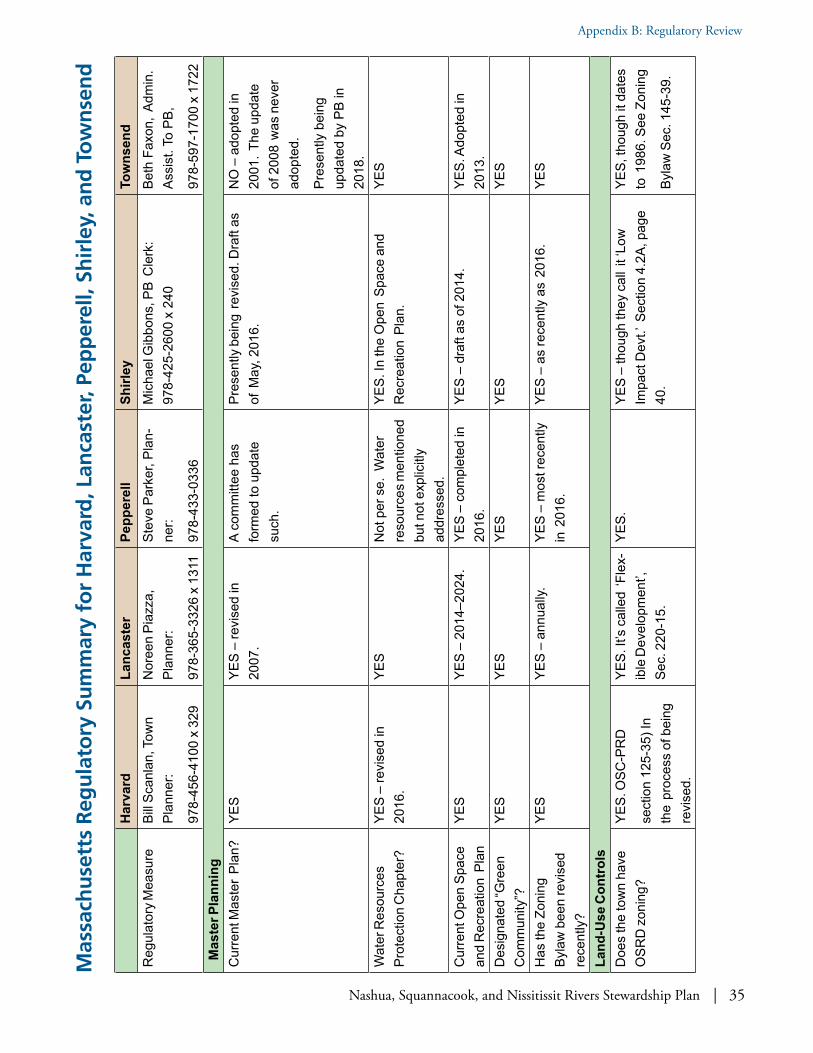
Nashua, Squannacook, and Nissitissit Rivers Stewardship Plan | 35
Appendix B: Regulatory Review
Mas
sach
use
tts
Reg
ula
tory
Su
mm
ary
for
Har
vard
, Lan
cast
er, P
epp
erel
l, Sh
irle
y, a
nd
To
wn
sen
d
Har
vard
Lanc
aste
rPe
pper
ell
Shirl
eyTo
wns
end
Reg
ulat
ory M
easu
reBi
ll Sca
nlan
, Tow
n Pl
anne
r:
978-
456-
4100
x 3
29
Nor
een
Piaz
za,
Plan
ner:
978-
365-
3326
x 1
311
Stev
e Pa
rker
, Pla
n-ne
r:
978-
433-
0336
Mic
hael
Gib
bons
, PB
Cle
rk:
978-
425-
2600
x 2
40Be
th F
axon
, Ad
min
. As
sist
. To
PB,
978-
597-
1700
x 1
722
Mas
ter P
lann
ing
C
urre
nt M
aste
r Pl
an?
YES
YES
– re
vise
d in
20
07.
A co
mm
ittee
has
fo
rmed
to u
pdat
e su
ch.
Pres
ently
bei
ng r
evis
ed. D
raft
as
of M
ay, 2
016.
NO
– a
dopt
ed in
20
01. T
he u
pdat
e of
200
8 w
as n
ever
ad
opte
d.
Pres
ently
bei
ng
upda
ted
by P
B in
20
18.
Wat
er R
esou
rces
Pr
otec
tion
Cha
pter
?YE
S –
revi
sed
in
2016
.YE
SN
ot p
er s
e. W
ater
re
sour
ces m
entio
ned
but n
ot e
xplic
itly
addr
esse
d.
YES.
In th
e O
pen
Spac
e an
d R
ecre
atio
n Pl
an.
YES
Cur
rent
Ope
n Sp
ace
and
Rec
reat
ion
Plan
YES
YES
– 20
14–2
024.
YES
– co
mpl
eted
in
2016
.YE
S –
draf
t as
of 2
014.
YES.
Ado
pted
in
2013
.D
esig
nate
d “G
reen
C
omm
unity
”?YE
SYE
SYE
SYE
SYE
S
Has
the
Zoni
ng
Byla
w b
een
revi
sed
rece
ntly
?
YES
YES
– an
nual
ly.YE
S –
mos
t rec
ently
in
201
6.YE
S –
as re
cent
ly a
s 20
16.
YES
Land
-Use
Con
trol
sD
oes
the
tow
n ha
ve
OSR
D z
onin
g?YE
S. O
SC-P
RD
sect
ion
125-
35) I
n th
e pr
oces
s of
bei
ng
revi
sed.
YES.
It’s
cal
led
‘Fle
x-ib
le D
evel
opm
ent’,
Se
c. 2
20-1
5.
YES.
YES
– th
ough
they
cal
l it ‘
Low
Im
pact
Dev
t.’ S
ectio
n 4.
2A, p
age
40.
YES,
thou
gh it
dat
es
to 1
986.
See
Zon
ing
Byla
w S
ec. 1
45-3
9.

36 | Nashua, Squannacook, and Nissitissit Rivers Stewardship Plan
Appendix B: Regulatory Review
Har
vard
Lanc
aste
rPe
pper
ell
Shirl
eyTo
wns
end
If so
, wha
t is
pro-
tect
ed o
pen
spac
e re
quire
men
t?
50%
40%
40%
35%
30%
Is O
SRD
allo
wed
by
rig
ht o
r Spe
cial
Pe
rmit?
Spec
ial P
erm
it.
(OSR
D is
opt
iona
l)Sp
ecia
l Per
mit.
Spec
ial P
erm
itSp
ecia
l Per
mit
(OSR
D is
opt
iona
l)Sp
ecia
l Per
mit
(OSP
D is
opt
iona
l)
Doe
s th
e to
wn
have
a
max
imum
slo
pe fo
r de
velo
pmen
t?
Max
imum
slo
pe
for
new
road
s an
d dr
ivew
ays
/ not
de
velo
pmen
t per
se
Max
imum
slo
pe fo
r su
bdiv
isio
n ro
ads
of
10%
.
Has
a g
ood
Eros
ion
Con
trol s
ectio
n in
the
Zoni
ng B
ylaw
: Sec
. 55
30
Byla
ws
sect
ion
4.,4
.0.1
Des
ign
Gui
des:
1.b.
: …sh
all r
educ
e, to
the
exte
nt r
easo
nabl
y pos
sibl
e, la
nd
havi
ng a
slo
pe o
f mor
e th
an 1
5%.
15%
slo
pes
with
>
1,00
0 sq
.ft. o
f di
stur
banc
e re
quire
st
orm
wat
er p
erm
it.D
oes
the
tow
n ha
ve
Eros
ion
Con
trol m
ea-
sure
s fo
r co
nstru
ctio
n on
ste
ep s
lope
s?
NO
Ther
e is
an
Eros
ion
and
Stor
mw
ater
C
ontro
l sec
tion
of th
e Zo
ning
Byl
aw: S
ec.
220-
37.2
.
YES
– Se
ctio
n 55
30:
Byla
ws
sect
ion
4., 4
.0.1
Des
ign
Gui
des:
1. L
. …re
duce
to th
e ex
tent
rea
sona
bly p
ossi
ble,
soi
l lo
ss o
r ins
tabi
lity
durin
g an
d af
ter
cons
truct
ion.
20%
max
imum
im-
perv
ious
sur
face
s in
O
SPD
. Als
o a
sect
ion
in S
torm
wat
er B
ylaw
re
gard
ing
eros
ion
cont
rol a
nd s
lope
s.D
oes
the
zoni
ng
limit
the
% o
r are
a of
im
perv
ious
sur
face
s?
Not
exp
licitl
y. T
here
is
a m
axim
um fl
oor /
ar
ea r
atio
of .
1.
NO
Yes
– 1.
5% in
Wat
er
Res
ourc
e Pr
otec
tion
Ove
rlay
Dis
trict
.
No
mor
e th
an 1
5%
of a
lot s
hall
be
impe
rvio
us.
YES
-- fo
r dev
elop
men
ts in
the
WH
POD
. See
Sec
. 4.1
3.4
cYE
S
Do
park
ing
requ
ire-
men
ts fo
r co
mm
erci
al
devt
. pro
vide
for
shar
ed o
r al
tern
ativ
e pa
rkin
g?
See
the
Com
mun
ity
Des
ign
Gui
delin
es
for
the
Com
mer
cial
D
istri
ct o
ff PB
pag
e.
NO
YES,
and
par
king
re
quire
men
ts c
an b
e re
duce
d by
Spe
cial
Pe
rmit.
YES
– Se
e pa
ge 1
48 in
Mas
ter
Plan
.C
heck
Zon
ing
Byla
w
Sect
ion
145-
33
Prov
isio
ns A
pplic
able
to
All
Dis
trict
s.
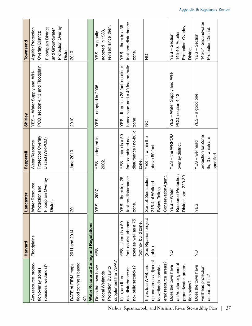
Nashua, Squannacook, and Nissitissit Rivers Stewardship Plan | 37
Appendix B: Regulatory Review
Har
vard
Lanc
aste
rPe
pper
ell
Shirl
eyTo
wns
end
Any
reso
urce
pro
tec-
tion
over
lay
zone
s (b
esid
es w
etla
nds)
?
Floo
dpla
ins
Wat
er R
esou
rce
Prot
ectio
n an
d Fl
oodp
lain
Ove
rlay
Dis
trict
Wat
er R
esou
rce
Prot
ectio
n O
verla
y D
istri
ct (W
RPO
D)
YES
– W
ater
Sup
ply
and
WH
-PO
D, s
ectio
n 4.
13 a
nd F
lood
plai
n.Aq
uife
r Pro
tect
ion
Ove
rlay
Dis
trict
;
Floo
dpla
in D
istri
ct
and
Gro
undw
ater
Pr
otec
tion
Ove
rlay
Dis
trict
.D
ATE
of F
IRM
map
s flo
od z
onin
g is
bas
ed
on
2011
and
201
420
11Ju
ne 2
010
2010
2010
Wat
er R
esou
rce
Zoni
ng a
nd R
egul
atio
nsD
oes
the
tow
n ha
ve
a lo
cal W
etla
nds
Prot
ectio
n By
law
to
supp
lem
ent t
he W
PA?
YES
YES
– 2
007
YES
– a
dopt
ed in
20
02.
YES
– ad
opte
d in
200
5.YE
S –
orig
inal
ly
adop
ted
in 1
983,
re
vise
d si
nce
then
.
If so
, are
ther
e no
- di
stur
banc
e or
no
- bu
ild s
etba
cks?
YES
– th
ere
is a
50
foot
no-
dist
urba
nce
zone
as
wel
l as
a 75
fo
ot n
o- b
uild
zon
e.
YES
– th
ere
is a
25
foot
no-
dist
urba
nce
zone
.
YES
– th
ere
is a
50
foot
com
bine
d no
- di
stur
banc
e / n
o-bu
ild
zone
.
YES
– th
ere
is a
25
foot
no-
dist
ur-
banc
e zo
ne a
nd a
40
foot
no-
build
zo
ne.
YES
– th
ere
is a
35
foot
non
-dis
turb
ance
zo
ne.
If ye
s to
a W
PB, a
re
upla
nd a
reas
adj
acen
t to
wet
land
s co
nsid
-er
ed re
sour
ce a
reas
?
(See
Rip
aria
n pr
ojec
t ta
ble)
Sort
of. S
ee s
ectio
n 21
5-4
of W
etla
nd
Byla
w. T
alk
to
Con
serv
atio
n Ag
ent.
YES
– if
with
in th
e ab
ove
50 fe
et.
NO
NO
Doe
s th
e to
wn
have
an
Aqu
ifer o
r gen
eral
gr
ound
wat
er p
rote
c-tio
n by
law
?
NO
YES
– W
ater
R
esou
rce
Prot
ectio
n D
istri
ct, s
ec.
220-
39.
YES
– th
e W
RPO
D
over
lay
dist
rict.
YES
– W
ater
Sup
ply
and
WH
-PO
D, s
ectio
n 4.
13YE
S –
Sect
ion
145-
40. A
quife
r Pr
otec
tion
Ove
rlay
Dis
trict
.D
oes
the
tow
n ha
ve
wel
lhea
d pr
otec
tion
as p
art o
f thi
s?
NO
YES
YES
– w
ellh
ead
prot
ectio
n fo
r Zon
e IIs
, 3 o
f whi
ch a
re
spec
ified
.
YES
– a
good
one
.YE
S –
Sect
ion
145-
54 G
roun
dwat
er
Prot
ectio
n D
istri
ct.

38 | Nashua, Squannacook, and Nissitissit Rivers Stewardship Plan
Appendix B: Regulatory Review
Har
vard
Lanc
aste
rPe
pper
ell
Shirl
eyTo
wns
end
Doe
s th
e to
wn
have
a
Stor
mw
ater
Con
trol
Byla
w w
ith L
ID
prov
isio
ns?
NO
– n
ot s
ubje
ct to
Ph
ase
II.YE
SN
O –
thou
gh s
ubje
ct
to n
ew p
erm
itYE
SYE
S –
for P
hase
II
stor
mw
ater
con
trol.
Wha
t are
a of
land
di
stur
banc
e tri
gger
s St
orm
wat
er R
evie
w?
One
acr
e un
der S
tate
pe
rmit
only.
One
acr
e or
43,
560
squa
re fe
et.
Not
app
licab
le y
etO
ne a
cre
(43,
560
squa
re fe
et).
40,0
00 s
quar
e fe
et.
Is m
inim
izin
g im
perv
i-ou
s su
rface
s a
goal
of
the
stor
mw
ater
byl
aw
or r
egul
atio
ns?
N/A
YES
Not
app
licab
le y
etYE
S –
See
Gen
eral
Tow
n By
-La
ws,
Arti
cle
XXXI
I. S
torm
wat
er
Mgm
t. C
ontro
l Byl
aw, S
ec.
1.0.
P
urpo
se
Not
exp
licitl
y.
Is th
e us
e of
LID
re
quire
d in
cer
tain
ci
rcum
stan
ces?
N/A
– N
ON
ON
ot y
et a
pplic
able
.YE
S --
See
Prot
ectiv
e Zo
ning
By-
law
s (N
ovem
ber
2015
) in
sect
ion
4.2A
. Low
Impa
ct D
evel
opm
ent.
Not
requ
ired
but
enco
urag
ed. (
See
SW b
y-la
w).
Prot
ectio
n of
key
wild
life
habi
tat a
nd n
atur
al c
omm
uniti
es?
Is p
rote
ctio
n of
wild
life
habi
tat a
nd n
atur
al
com
mun
ities
spe
cifie
d in
OSR
D o
r ot
her
zoni
ng?
YES
YES
YES
YES
-- Se
e Pr
otec
tive
Zoni
ng B
y-la
ws
(Nov
embe
r 20
15) i
n se
ctio
n 4.
2A. L
ow Im
pact
Dev
elop
men
t.
YES
– Se
e Zo
ning
By
law
Sec
tion
145-
41.
Is s
uch
addr
esse
d in
Ope
n Sp
ace
or
Mas
ter P
lans
?
YES
– in
the
Mas
ter
Plan
and
201
6 O
pen
Spac
e &
Rec
reat
ion
Plan
.
YES
YES
YES
YES
-- in
OS
Plan
; ap
prov
ed in
201
4.
If so
, doe
s it
desc
ribe
area
s re
com
men
ded
for f
urth
er p
rote
ctio
n in
det
ail?
YES
- 201
6 O
pen
Spac
e &
Rec
reat
ion
Plan
.
YES
Gul
f Bro
ok, S
ucke
r Br
ook,
Nas
hua
Riv
er,
Nis
sitis
sit R
iver
w
ater
shed
s an
d Bi
o-
map
2 co
re a
reas
.
In th
e re
cent
ly u
pdat
ed O
pen
Spac
e Pl
an it
incl
udes
sev
eral
re
mai
ning
larg
e bl
ocks
of f
ores
t an
d ha
bita
t co
nnec
tions
E-W
ac
ross
the
mid
dle
part
of to
wn
and
N-S
alo
ng th
e w
este
rn b
ound
ary.
Not
incl
uded
in O
S Pl
an, b
ut s
ee A
ppen
-di
x B
re: e
ndan
gere
d sp
ecie
s.

Nashua, Squannacook, and Nissitissit Rivers Stewardship Plan | 39
Appendix B: Regulatory Review
Har
vard
Lanc
aste
rPe
pper
ell
Shirl
eyTo
wns
end
Plan
ning
Cap
acity
Has
the
Tow
n ad
opte
d th
e C
omm
unity
Pre
s-er
vatio
n Ac
t (C
PA)?
YES
– ad
opte
d in
20
01.
NO
NO
NO
NO
Doe
s th
e To
wn
have
a
full
or p
art-t
ime
Tow
n Pl
anne
r or
Plan
ning
Ad
min
istra
tor?
YES
YES
YES
NO
YES
Doe
s th
e To
wn
have
a
full
or p
art-t
ime
Con
serv
atio
n Ag
ent?
YES
YES
YES
YES
YES
Doe
s th
e To
wn
have
a
land
acq
uisi
tion
com
mitt
ee a
nd/o
r fun
d fo
r ope
n sp
ace?
Con
serv
atio
n C
om-
mis
sion
.
Ther
e is
als
o a
loca
l la
nd tr
ust -
Har
vard
C
onse
rvat
ion
Trus
t.
Con
serv
atio
n C
omm
issi
on, C
on-
serv
atio
n Tr
ust
Fund
Con
serv
atio
n C
om-
mis
sion
.YE
S –
Con
serv
atio
n C
omm
issi
on
has
a de
dica
ted
"Con
serv
atio
n La
nd A
cqui
sitio
n Fu
nd".
No
dedi
cate
d la
nd a
cqui
sitio
n co
m-
mitt
ee. L
and
acqu
isiti
on h
andl
ed
by C
onse
rvat
ion
Com
mis
sion
at
pres
ent.
YES
-- C
onse
rva-
tion
Land
Fun
d.
Con
tribu
tions
vot
ed
at T
own
Mee
ting
inte
rmitt
ently
.
Whi
ch R
egio
nal
Plan
ning
Com
mis
sion
is
the
tow
n pa
rt of
? D
oes
it ac
tivel
y en
gage
with
the
RPC
?
MR
PCM
RPC
Nor
ther
n M
iddl
esex
C
ounc
il of
Gov
ts.
MR
PCM
RPC
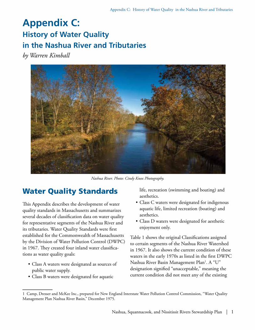
Nashua, Squannacook, and Nissitissit Rivers Stewardship Plan | 1
Appendix C: History of Water Quality in the Nashua River and Tributaries
Appendix C: History of Water Quality in the Nashua River and Tributariesby Warren Kimball
Water Quality Standards
This Appendix describes the development of water quality standards in Massachusetts and summarizes several decades of classification data on water quality for representative segments of the Nashua River and its tributaries. Water Quality Standards were first established for the Commonwealth of Massachusetts by the Division of Water Pollution Control (DWPC) in 1967. They created four inland water classifica-tions as water quality goals:
• Class A waters were designated as sources of public water supply.
• Class B waters were designated for aquatic
1 Camp, Dresser and McKee Inc., prepared for New England Interstate Water Pollution Control Commission, “Water Quality Management Plan Nashua River Basin,” December 1975.
life, recreation (swimming and boating) and aesthetics.
• Class C waters were designated for indigenous aquatic life, limited recreation (boating) and aesthetics.
• Class D waters were designated for aesthetic enjoyment only.
Table 1 shows the original Classifications assigned to certain segments of the Nashua River Watershed in 1967. It also shows the current condition of these waters in the early 1970s as listed in the first DWPC Nashua River Basin Management Plan1. A “U” designation signified “unacceptable,” meaning the current condition did not meet any of the existing
Nashua River. Photo: Cindy Knox Photography.

2 | Nashua, Squannacook, and Nissitissit Rivers Stewardship Plan
Appendix C: History of Water Quality in the Nashua River and Tributaries
Classifications. Waters in the Nashua River Water-shed not listed here were Classified either A or B and were generally thought to meet those Classifications.
It can be seen that the condition of the main body of the Nashua River was grossly polluted at the time. Furthermore, the expectation for the river’s future was below Class B. Class B coincided with the national “fishable/swimmable” goal established in the Federal Clean Water Act of 1972.
During the public hearing process for the 1967 Massachusetts Water Quality Standards, Marion Stoddart testified on behalf of the Nashua River Clean-Up Committee. She presented a compre-hensive package prepared by the Committee that showed overwhelming evidence for support of a B classification for the river. She also called for the elimination of Class D from the Standards.
When the Water Quality Standards were revised in 1974, Class D was eliminated. Also, Class C segments on the mainstem of the Nashua River, the South Branch, and the lower Squannacook River were reclassified to a new Class B1 designation. Class B1 had all the same criteria as Class B except for dissolved oxygen, which was held at a Class C level. The North Branch of the River remained at Class C.
The Standards were revised again in 1978. In this revision, all Class C and B1 segments of the river were upgraded to Class B. This was to reflect the desire to attain the national “fishable/swimmable” goal and did not indicate the current condition of the river.
The Squannacook and Nissitissit Rivers are both designated Class B, coldwater fisheries. This affords these rivers more stringent dissolved oxygen and temperature criteria within the B Classification. Other waters in this discussion are designated warmwater fisheries and have less stringent criteria than coldwater fisheries. Class C waters are not assigned a “fisheries” designation and have less stringent dissolved oxygen and temperature criteria than warmwater fisheries.
Water Quality Report Cards
In order to show the history of water quality of the Nashua River Watershed, the DWPC created water quality report cards to graphically display the water quality of the river at a point in time. Four report cards were created in order to show the existing water quality during each decade from the early 1970s to the early 2000s. They display the results of water quality surveys conducted primarily by the DWPC (and its successor agencies) during this time.
Reports selected for this Appendix single out the information on historically polluted portions of the river including the South Branch, North Branch, and mainstem of the Nashua River as well as two relatively clean tributaries, the Squannacook and Nissitissit Rivers. These rivers were divided into nine segments for the sake of discussion. Information on fish tissue was available only in the more recent assessments, and was spotty. Therefore, for the sake of trend analysis it is shown as “not assessed” on all the report cards in order to make the assessment more comparable.
For each of the nine segments, eight categories of pollutants are assessed for the aquatic life use and three categories of pollutants for the recreational uses. The level of pollution is color coded to verbal categories of “good,” “fair,” “poor,” and “very poor,” “Good” means meeting Class B criteria and the other categories roughly coincide with Class C, Class D, and U respectively. In order to provide a uniform basis of comparison, all water quality was assessed using criteria for a modern Class B water, meaning the criteria that would be used today.
Severity points were also assigned to these categories (1, 2, and 3 respectively) indicating the level of impacts depending on the degree to which Class B criteria are violated. Severity points in a segment can be totaled to compare with other segments or to the same segment over time. Total severity points can be further weighted by multiplying by the segment’s length. In this manner, the number of parameters
Nashua, Squannacook, and Nissitissit Rivers Stewardship Plan | 3
Appendix C: History of Water Quality in the Nashua River and Tributaries
violated, the severity of the violation, and the river miles affected can be tallied to glean additional useful information.
Caution should be used in viewing the report cards so that they are not afforded a degree of precision that is unwarranted. Water quality is highly variable and the data sets used to fill out the report card were seldom uniformly comparable. In a few instances, the information was contradictory. Additionally, the criteria used to assess the segments have changed over time as well as the Classifications of the waters. Considerable judgment was used in formulating the report cards. The use of broad verbal categories such as “good,” “fair,” and “poor” water quality and “slight,” “moderate,” and “severe” impacts is inten-tional and meant to envelop all the above consider-ations and sources for error. These same terms were often used in the source material to describe the river, the levels of pollution and the judgments used in the report cards.
The report cards are aimed at showing the relative change in water quality over time. For this purpose they are quite demonstrative.
Early Water Quality History
The Nashua River watershed was once settled by the Nashaway native members of the Algonquin Tribe. One commonly accepted translation for their name for the river is “the river with the beautiful pebbled bottom.” They harvested plentiful salmon and alewives from the river. The area was subsequently settled and cleared by Massachusetts Bay colonists for farming and raising livestock.
During the 19th century, the watershed experienced extensive industrial development including grist-mills, textile mills and paper manufacturing mills. It seems water quality at this time met the fishable/swimmable goal, according to a nineteenth century account from the history of the Town of Lancaster:
2 Rev. Abijah Marvin, History of the Town of Lancaster: From the First Settlement to the Present Time, 1643–1879, (Lancaster: Published by the town, 1879).
“Some value the river for its enriching qualities, and some for its abundant water power, and some because they can idle away their time catching pout and pickerel. There are some also who delight in it as ‘a thing of beauty’ and a ‘joy forever.” They love to wander on its banks, to plunge into its depths and float upon its surface. They return again and again to gaze on its flow when its shimmers in the sun, or is mottled by the raindrops, or ruffled by the breeze”. 2
Unfortunately, the increased industrial development profoundly impacted the river. Paper manufacturing became the leading industry in the basin and numer-ous dams were built along the river and its tributaries to create storage impoundments for industrial process and cooling water and hydroelectric power. The paper mills discharged untreated process wastes to the river that coated the bottom with paper sludge. The use of dyes in the Fitchburg Mills made the river notorious for changing color downstream in accord with the color of paper being manufactured that day.
The City of Fitchburg installed one of the first wastewater treatment plants in the United States (1915). The plant provided secondary treatment, a degree of treatment rare at that time. In 1932, the City of Leominster installed an activated sludge treatment plant for its municipal wastes. However, the industries did little or nothing to treat their discharges, largely negating the attempts by Fitch-burg and Leominster to improve water quality. These two towns have combined sewer systems, a type that is purposely designed to overflow to the river during heavy rainfall, further exacerbating pollution prob-lems. The severity of this pollution gave the river the dubious distinction of being the most polluted stream in Massachusetts.
By the 1970s, the Division of Water Pollution Control listed 40 municipal and industrial discharges to the river and its tributaries. There were also numerous potential nonpoint sources of pollution

4 | Nashua, Squannacook, and Nissitissit Rivers Stewardship Plan
Appendix C: History of Water Quality in the Nashua River and Tributaries
such as urban storm water from Fitchburg, Leomin-ster, Clinton, and Ayer; agricultural runoff (apple orchards); malfunctioning on-site disposal systems; as well as landfills and open dumps near the river-banks. However, nonpoint source pollution was largely masked by the much more prominent point sources of pollution.
The table above is a ranking of the most significant pollutant loads to the river in the early 1970s.
As can be seen, by the 1970s municipal treatment plants contributed high levels of pollution to the river. These treatment plants were antiquated, overloaded, and provided inadequate treatment of municipal wastewater.
Dams are another factor affecting water quality. They can increase water temperature, increase sedimenta-tion of sludge, decrease oxygen levels and, in some cases, stimulate eutrophication. The North Branch of the Nashua is punctuated by eleven dams. The South Branch has two dams. The Wachusett Reservoir Dam is the largest in the watershed and has been implicated in contributing to water quality problems due to the meager minimum release of water. The mainstem has two dams: the Ayer Ice Company Dam and the Pepperell Pond Dam. The Pepperell Pond impoundment is long (over four river miles) and shallow. River velocities slow in this segment and pollutants settle to the bottom, affording time for biochemical reactions.
3 “Water Quality Management Plan Nashua River Basin,” December 1975.
Water Quality in the Early 1970s
The figure on page 8 shows the Report Card for water quality in the Nashua River in the early 1970s. The information for this report card comes primarily from a water quality survey conducted by Massachu-setts Division of Water Pollution Control 1973 and its Management Plan from 1975. It also draws from a 1975 Management Plan by Camp, Dresser, and McKee Inc., prepared for New England Interstate Water Pollution Control Commission3.
Data from the early 1970s serves as a snapshot of water quality before major clean-up efforts were initiated by state and federal programs. Municipal treatment plants in Fitchburg, Leominster, Clinton and Ayer were present, but they were antiquated and ineffective. Industrial pollution was largely unabated.
The report card shows that the Nashua River in the early 1970s is biologically dead. Fish cannot live in the river. Dissolved oxygen, necessary for the survival of aquatic life, has been depleted by oxygen-demand-ing paper waste and sewage. Aquatic habitat has been destroyed by the coating of the river bottom with paper sludge and in the water column with turbidity. Even if fish could survive in the water column, they would not be able to lay eggs and propagate in this degraded habitat. Domestic wastewater has added levels of ammonia to the water column that were toxic to fish.
Rank WasteLoad ReceivingWater1 FitchburgPaperMills NorthBranch2 FitchburgWastewaterTreatmentPlant NorthBranch3. LeominsterWastewaterTreatmentPlant NorthBranch4. ClintonWastewaterTreatmentPlant SouthBranch5. AyerWastewaterTreatmentPlant Mainstem6. FitchburgCombinedSewers NorthBranch7. PepperellPaperMills Mainstem8. LeominsterCombinedSewers NorthBranch

Nashua, Squannacook, and Nissitissit Rivers Stewardship Plan | 5
Appendix C: History of Water Quality in the Nashua River and Tributaries
The most severe pollution is to the North Nashua Branch from the paper mills, municipal systems, and combined sewer overflows. The South Branch also has similar, but not quite as severe, water quality problems. Industrial cooling water discharges on the North and South Branches contribute to high instream water temperature, unsuitable for fish survival. Together, the North and South Branches combine to pollute the Mainstem. The Mainstem shows signs of recovery along its length as the river’s natural processes attempted to clean the river, only to be insulted again below Pepperell Pond by more paper mill wastewater.
Recreational uses on the river fare no better than the aquatic life. Bacteria from urban runoff and combined sewer over overflows on the North Branch combined with dyes, turbidity, odors, and paper sludge repel people from the river. The South Branch contributes to bacterial problems because the Clin-ton Treatment Plant is not practicing chlorination at the time. Again, the North and South Branches combine to pollute the Mainstem, with effects lingering through Pepperell Pond. Below Pepperell Pond, more discharges of paper mill wastewater and malfunctioning onsite private septic systems contrib-ute to more degraded conditions.
Compared with the Nashua River, the Squannacook and Nissitissit Rivers are relatively pristine. There are slight excursions from the stringent dissolved oxygen and temperature criteria for coldwater fisheries and occasional elevated bacteria levels from faulty onsite septic systems. A paper company downstream on the Squannacook River provides generally good treat-ment for its wastewater, but occasionally contributes to some slight turbidity. These rivers are considered fishable and swimmable in stark contrast to the rest of the assessed waters.
Water Quality in the Early 1980s
In 1975, the City of Fitchburg completed construc-tion of two new wastewater treatment plants. The Westerly Plant was designed primarily to process paper manufacturing waste. The Easterly Plant was designed to treat domestic wastewater at an ad-vanced level that included both phosphorus removal and nitrification (ammonia removal). Leominster was rebuilding its treatment facility at the turn of the decade to increase its capacity and add phosphorus removal. Pepperell was also constructing a modern facility. Clinton and Ayer were planning upgrades to their facilities.
The upgrades of the Fitchburg treatment facilities make a huge difference in pollution loads to the North Branch. DWPC estimates that total suspend-ed solids are decreased by 90% and oxygen-demand-ing wastes are decreased by 50%. Bottom deposits of sludge are replaced by pollution-tolerant insects. The river’s habitat is recovering but still not up to water quality goals. The dissolved oxygen levels begin to recover in the lower portion of the North Branch but are again depressed when it joins the South Branch. They then recover in Pepperell Pond and remain good in the lower portion of the river. Temperature problems in the river are largely eliminated.
Recreational uses of the river remain impaired. Urban runoff and combined sewer overflows keep bacterial levels high on the North Branch. In the South Branch, bacterial levels remain high until the Clinton Treatment Plant adds chlorination to its treatment process. Start-up problems with this upgrade, however, contribute to toxicity problems in the river. The removal of sludge in the North Branch reduces aesthetic nuisance conditions considerably. The North Branch recovers considerably in its lower segment and even the turbidity from South Branch does not diminish the recovery.
Aesthetic problems are less severe in the Mainstem. However, as Pepperell Pond recovers from one type of pollution, it becomes susceptible to another. The

6 | Nashua, Squannacook, and Nissitissit Rivers Stewardship Plan
Appendix C: History of Water Quality in the Nashua River and Tributaries
abundance of nutrients compiled in the sediments contributes to sever eutrophication of the pond. Nuisance vegetation, such as duckweed, covers the surface of the impoundment, impairing recreational uses.
In the Squannacook River, nutrients in the lower part of the river create some slight aesthetic issues. Faulty septic systems continue to be an issue. The Nissitissit River is referred to by DWPC in 1977 as one of the cleanest rivers in the state. Minor temperature and bacteria excursions form criteria are noted in the survey data.
In the Nashua River Watershed, the recovery from the 1970s is evident. Two segments, the South Branch above Clinton and the Mainstem below Pepperell Pond, are largely fishable and approaching swimmable. The rest of the river is still not fishable/swimmable but improvements are evident. The total weighted severity points for the system drop from 1027.9 to 808.4, a better than 20% improvement. The appearance of more green areas on the report card shows that most of these improvements were to the aquatic life use (see page 9).
Water Quality in the Mid 1990s
The information for this report card (page 10) comes from a comprehensive survey conducted in 1998 by the Massachusetts Division of Watershed Manage-ment, the Massachusetts Water Resources Authority, the Nashua River Watershed Association and the U.S Environmental Protection Agency.
In the South Branch, urban runoff causes slight problems above the Clinton treatment plant, but problems below the plant persist because of lack of instream dilution and high nutrient loadings from the facility. Recreational uses continue to be impaired by urban runoff.
Remarkably, the North Branch, once the most pol-luted system in the Nashua River watershed, now has recovered to pollution levels equal to or below other
portions of the river. This can be seen by examining the total severity points in the various segments. Above Leominster, the two Fitchburg facilities have drastically reduced pollution in the river, but the combined sewer overflow problems have not been addressed. The aquatic life is impacted by apparent instream toxicity, perhaps from a legacy of pollutants trapped in the sediments. Recreational uses are impaired by the bacteria, turbidity, and odors from the combined sewer overflows. Below Leominster, nutrients from the treatment facility and continued impacts by combined sewers impair uses.
In the mainstem of the river, carryover pollution from the North and South Branches and high nutrient levels from the Ayer treatment facility contribute to water quality problems above Pep-perell Pond. Within the pond, recycling of nutri-ents creates a highly eutrophic condition with the water becoming choked with nuisance vegetation. This, in turn, reduces benthic dissolved oxygen and adversely affected aquatic life. Very poor aesthetic conditions adversely affect recreation. In terms of total severity points, Pepperell Pond now becomes the most polluted segment of the river. Below Pepperell Pond, carryover pollution from the pond and rapid flow fluctuations from the hydropower operation are sources of problems but these are characterized as slight.
Both the Nissitissit and the Squannacook Rivers have slight temperature and pH perturbations causing slight impacts to aquatic life. The water quality problems of the Nashua River are shifting from the impacts from paper companies and municipal wastewater on the North Branch to the impacts of combined sewer overflows (CSO) on the North Branch.
CSO’s were once ranked sixth most important source of pollution. These impacts carry over to the mainstem of the river. Nutrients remain high through most of the watershed due to inadequate removal at municipal facilities and from the combined sewer overflows. The focus of abatement actions in the watershed is shifting from the North Branch to the Clinton facility and to Pepperell Pond.
Nashua, Squannacook, and Nissitissit Rivers Stewardship Plan | 7
Appendix C: History of Water Quality in the Nashua River and Tributaries
The weighted severity points for the watershed show an approximate 50% reduction in pollution from the early 1970s—a remarkable achievement.
Water Quality in the Early 2000s
The information for this report card (page 11) comes primarily from the Massachusetts Department of Environmental Protection’ 2003 Assessment Report or the Nashua River Watershed Association. The South Branch above the Clinton wastewater facility was assessed as fishable/swimmable, although there are some lingering concerns about flow releases from Wachusett Reservoir. Below the facility, phosphorus concentrations are still high due to the discharge and there are slight impacts to recreational uses from urban runoff.
In the North Branch, evidence of instream toxicity persists in the segment above Leominster, impairing aquatic life. Recreational uses suffer from the contin-ued discharge of combined sewer overflows. Below Leominster, nutrients levels are high due to munici-pal wastewater discharges and aesthetic concerns are derived from odors from combined sewer overflows. The severity points show that the pollution level on the North Branch is about a third of the level of the early 1970s.
In the Mainstem of the river, nutrient levels remain high due to carryover from upstream sources and recycling from the sediments in Pepperell Pond. The adverse effect of these nutrients are largely shown in Pepperell Pond, in the form of massive blooms of nuisance and nonnative vegetation. This condition impairs both the aquatic life and recreational uses of the waterbody. Pepperell Pond continues to be the focus of pollution issues in the river with other sections of the Mainstem generally reaching fishable/swimmable status.
The most recent fish sampling both the Squan-nacook and Nissitissit Rivers displays a lack of coldwater species. This is disturbing, for these rivers are thought to be relatively pristine. Water quality
monitoring reveals higher-than-desired temperatures for coldwater populations. The source of this im-pairment is unknown and suspected sources include dams, beaver activity or climate change.
The South Branch, North Branch, and Mainstem of the Nashua River have undergone an approximate 70% reduction in pollution levels during the period of the early 1970s to the early 2000s, as demonstrated by the weighted score on the report cards. This dramatic reduction is largely brought about by the treatment of industrial and municipal wastewater mandated by the National Pollutant Discharge Elimination System permit program. The problems that persist are largely due to high phosphorus levels and untreated combined sewer overflows. The phosphorus levels are from several municipal wastewater sources but adverse effects are largely exerted in Pepperell Pond. The combined sewer overflows are on the North Branch but effects carryover to the Mainstem.

8 | Nashua, Squannacook, and Nissitissit Rivers Stewardship Plan
Appendix C: History of Water Quality in the Nashua River and Tributaries
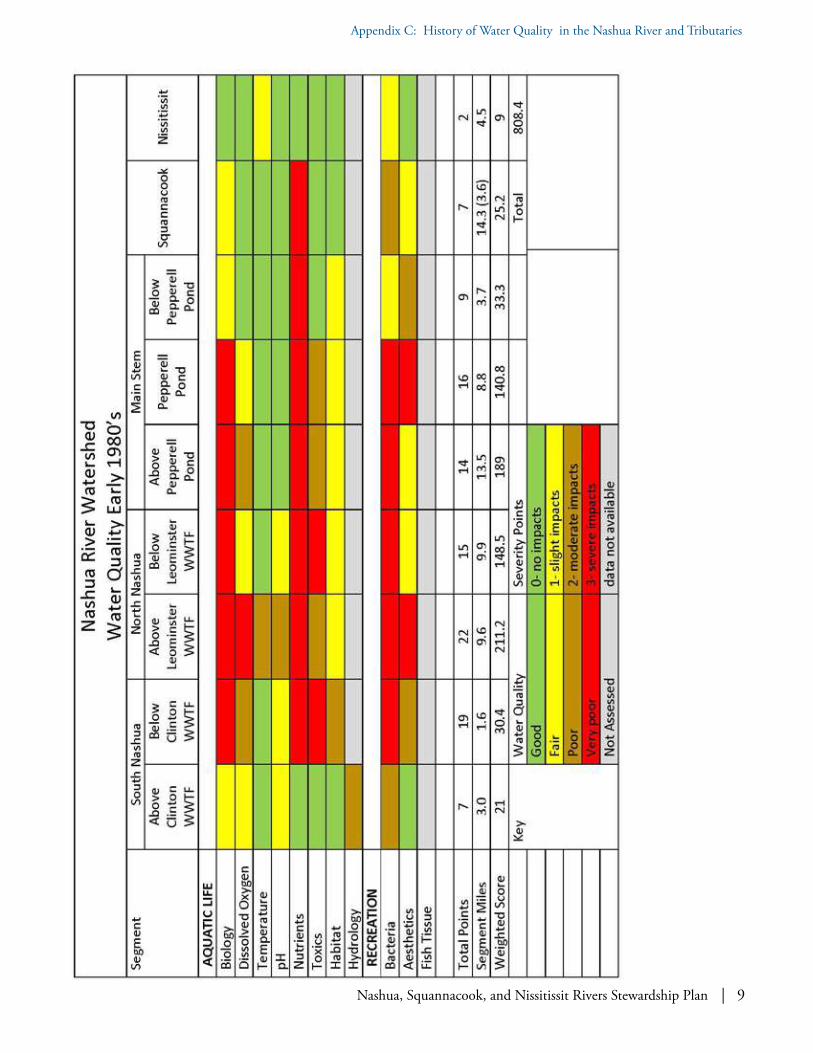
Nashua, Squannacook, and Nissitissit Rivers Stewardship Plan | 9
Appendix C: History of Water Quality in the Nashua River and Tributaries

10 | Nashua, Squannacook, and Nissitissit Rivers Stewardship Plan
Appendix C: History of Water Quality in the Nashua River and Tributaries

Nashua, Squannacook, and Nissitissit Rivers Stewardship Plan | 11
Appendix C: History of Water Quality in the Nashua River and Tributaries

12 | Nashua, Squannacook, and Nissitissit Rivers Stewardship Plan
Appendix C: History of Water Quality in the Nashua River and Tributaries
Segment Number
DescriptionRiver Miles
ClassificationEarly 1970’s Condition
1967 1974 1978
1South Branch
Outlet Lancaster Mill Pond, Clinton, to Clinton WWTF, Clinton
3.0 B B B U
2Clinton WWTF to confluence with North Nashua River, Lancaster
1.6 C B1 B
U
3
North Branch
Fitchburg Paper Co. Dam #1, Fitchburg to Leominster WWTF, Leominster
8.4 C C B
U
4Leominster WWTF to confluence with the Main Stem Nashua River, Lancaster
9.9 C C B U
5
Main Stem Nashua River
Confluence of North and South Branches, Lancaster to Confluence with Squannacook River, Shirley/Groton
13.5 C B1 B U
6Confluence with Squannacook River to Pepperell Pond Dam, Pepperell
8.8 C B1 B U
7Pepperell Pond Dam to New Hampshire State Line
3.7 C B1 B U
8Squannacook River
Entire length14.3 B/C B/B1 B B/C
9Nissitissit River
Massachusetts portion4.5 B B B B
Table 1: Nashua River Watershed Water Use Classifications (by Warren Kimball)

Nashua, Squannacook, and Nissitissit Rivers Stewardship Plan | 13
Appendix C: History of Water Quality in the Nashua River and Tributaries
Indicator 1 slightly impacted 2 impacted 3 severely impactedI. Aquatic Life
A. Biology Invertebrates
Diversity-mediumDensity-low/medium54-79% reference
Diversity-lowDensity-medium/high21-50% reference
Diversity-low/absentDensity-high/absent17% reference
B. ChemistryBaselineDissolved Oxygen minimum daily averageTemperature maximum weekly averagepH standard units
< 5.0 mg/l< 75% saturation > 80.6℉>75 ℉6.0-6.5 or8.0-8.5
< 3.0 mg/l< 5.0 mg/l >83℉>77℉5.5-6.0 or8.5-9.0
< 2.0 mg/l > 90 ℉ < 5.5> 9.0
Nutrients Total Phosphate-P
> 0.05 mg/l > 0.10 mg/l > 0.20 mg/l
Toxics Ammonia-N
> 0.5 mg/l > 1.0 mg/l > 2.0 mg/l
Sediments > threshold effects > probable effects > 2 x probable effects
C. Hydrology Criteria not available-BPJ
D. Habitat Suspended Solids Sludge Deposits
> 10 mg/lrare
> 25 mg/loccasional
> 80 mg/lcommon
II. Recreation
A. Bacteria (Geometric mean) Total Coliform Fecal Coliform E. coli
> 1000/100 ml> 200/100 ml> 126/100 ml
> 5,000/100 ml> 1000/100 ml> 630/100 ml
> 10,000/100ml> 2,000/100ml> 1260/100 ml
B. Aesthetics Color/odor/turbidity Nuisance conditions
rare occasional common
C. Fish Flesh Limited Advisory Full Advisory Best Professional Judgment (BPJ)
Table 2: Nashua River Report Card Severity Point Criteria
(by Warren Kimball)

14 | Nashua, Squannacook, and Nissitissit Rivers Stewardship Plan
Appendix C: History of Water Quality in the Nashua River and Tributaries
Bibliography:
Massachusetts Water Resources Commission, Division of Water Pollution Control.
-"The Nashua River Water Quality Monitor Data, August 1968–September 1969." Boston MA (1969).
-"The Nashua River 1973 Water Quality Data." Westborough MA, (December 1973).
-"Nashua River Basin 1975, Water Quality Management Plan." Westborough, MA (March 1975).
Massachusetts Department of Environmental Quality Engineering, Division of Water Pollution Control.
-"Nashua River Water Quality Data 1977." Westborough MA. (April 1978).
-"Nashua River Basin, Water Quality Survey Data 1978-1981." Westborough MA. (August 1983).
-"Nashua River Basin, 1982 Water Quality Survey Data and Wastewater Discharge Data." Westborough MA. (November 1983).
-"Nashua River Basin, Water Quality Survey Data, Wastewater Discharge Survey Data." Westborough MA. (1986).
-"The Nashua River 1989 Water Quality Data, Wastewater Discharge Data and Analysis." Westborough MA. (September 1990).
-"Nashua River Basin, Water Quality Analysis 1977, Westborough." (September 1979).
-"1977 Nashua River Macroinvertebrate Water Quality Survey." Westborough MA. (August 1978).
-"A Biological Assessment of Water Quality Conditions in the Nashua River and Selected Tributaries, Results of the 1985 Survey." Westborough, MA. (June 1990).
-"The Nashua River Basin Water Quality Management plan 1981." Westborough MA. (September 1981).
Massachusetts Department of Environmental Quality Engineering, Division of Watershed Management.
-"1983 Nashua River Watershed Biological Monitoring Survey." Westborough MA. (May 1977).
-"Nashua River Basin 1998 Water Quality Assessment Report." Worcester MA. (January 2001).

Nashua, Squannacook, and Nissitissit Rivers Stewardship Plan | 1
Appendix D: Special Designations in the Massachusetts Portion
Appendix D: Special Designations in the Massachusetts Portion of the Nashua River Watershedby Warren Kimball
The Nashua River and its tributaries have received numerous designations by Massachusetts agencies that substantiate its significant resource value. This Appen-dix describes several special designations that are most relevant to this Wild and Scenic Rivers study.
Outstanding Resource Waters
Outstanding Resource Waters (ORWs) are desig-nated in the Massachusetts Surface Water Quality Standards [314 CMR 4.04(3)]. These waters are determined by the Massachusetts Department of Environmental Protection based on their outstand-ing socio-economic, recreational, ecological and/or aesthetic values. These are waters whose high quality will be protected and maintained. With minor exceptions new or increased discharges of pollutants are prohibited to these waters assuring that existing high water quality is preserved. Those waterways
designated in the Squannacook and Nissitissit Rivers Sanctuary (see below) are designated as ORW’s.
Coldwater Fisheries Resources
A Coldwater Fisheries Resource (CFR) is a body of water that is used by coldwater fish species to fulfill one or more of their life history requirements. These species include trout and slimy sculpin, among others. These fish require cold, well-oxygenated water and suitable habitat for spawning, feeding and refuges. Such requirements make these habitats particularly sensitive to alterations or pollution. Changes in land and water use can reduce the ability of these waters to support coldwater fish. The Massa-chusetts Division of Fisheries and Wildlife identifies CFR’s and maintains a list that is updated annually.
Coldwater Fisheries are also designated in the Massachusetts Surface Water Quality Standards
Two anglers on the Nissitissit River. Photo: Cindy Knox Photography.

2 | Nashua, Squannacook, and Nissitissit Rivers Stewardship Plan
Appendix D: Special Designations in the Massachusetts Portion
(SWQS) and are given more stringent temperature and dissolved oxygen criteria than other inland waters. However, these SWQS regulations (314 CMR 4.00) are updated less frequently and do not reflect the most recent information available from Massachusetts Fish and Wildlife. There are 90 CFR’s in the Nashua River watershed, although many are unnamed streams, since naming a water body as a CFR is generally considered to include its unnamed tributaries.
Areas of Critical Environmental Concern
Areas of Critical Environmental Concern (ACEC) are designated by the Massachusetts Executive Office of Environmental Affairs pursuant to 301 CMR 12.00. ACECs are those areas within the Common-wealth where unique clusters of natural and human resource values exist and which are worthy of a high level of concern and protection. The aim is to pre-serve and restore these areas and all EOEEA agencies are directed to take actions with this in mind.
Three ACECs exist in the Nashua River Watershed:
• The Squannassit ACEC includes over 37,000 acres on the west side of the Nashua River in Ashby, Ayer, Groton, Harvard, Lancaster, Lunenburg, Pepperell, Shirley and Townsend.
• The Petapawag ACEC includes over 25,000 acres in Ayer, Dunstable, Groton, Pepperell and Tyngsborough on the east side of the Nashua River.
• The Central Nashua River valley ACEC con-tains nearly 13,000 acres in Bolton, Harvard, Lancaster and Leominster.
It is important to state that the Nashua River corri-dor is a central feature of all three ACEC’s.
The Squannacook and Nissitissit Rivers Sanctuary
The Massachusetts General Laws Chapter 132A, Section 17 establishes the Squannacook and Nissitissit Rivers Sanctuary (SNRS). The sanctuary comprises the surface waters of both rivers and their tributaries. A small section of the Squannacook River is excluded: from the Hollingsworth and Vose Dam to the confluence with the Nashua River.
In these sanctuary waters, no new discharge of treated or untreated sewage or other wastewater is permitted. Storm water discharges and conveyances must be approved by the planning board and conservation commissions of the affected towns. The Attorney General has the authority to enforce these rules. This sanctuary was subsequently designated as an ORW in the Surface Water Quality Standards underscoring the desire to preserve these waters.
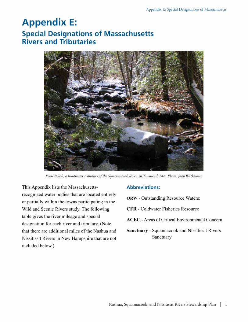
Nashua, Squannacook, and Nissitissit Rivers Stewardship Plan | 1
Appendix E: Special Designations of Massachusetts
Appendix E: Special Designations of Massachusetts Rivers and Tributaries
This Appendix lists the Massachusetts-recognized water bodies that are located entirely or partially within the towns participating in the Wild and Scenic Rivers study. The following table gives the river mileage and special designation for each river and tributary. (Note that there are additional miles of the Nashua and Nissitissit Rivers in New Hampshire that are not included below.)
Abbreviations:
ORW - Outstanding Resource Waters:
CFR - Coldwater Fisheries Resource
ACEC - Areas of Critical Environmental Concern
Sanctuary - Squannacook and Nissitissit Rivers Sanctuary
Pearl Brook, a headwater tributary of the Squannacook River, in Townsend, MA. Photo: Joan Wotkowicz.
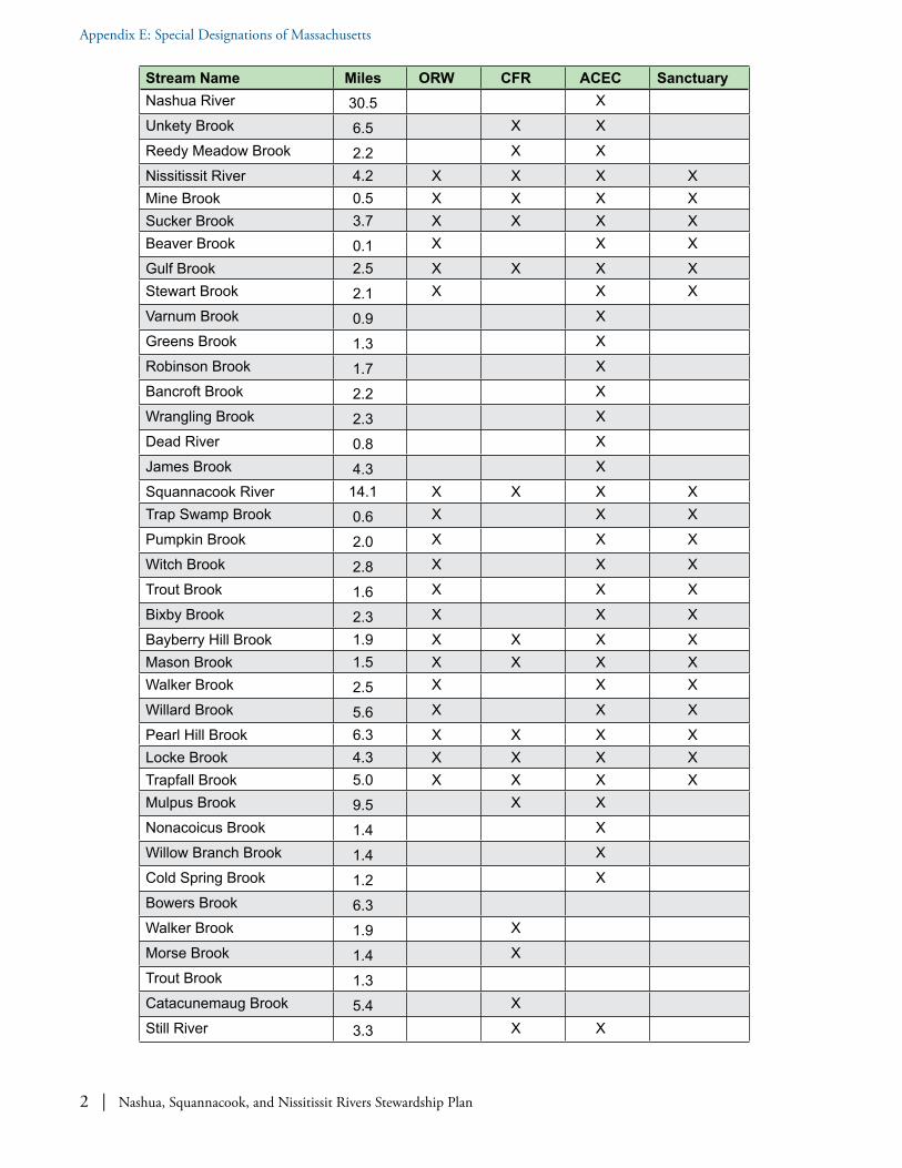
2 | Nashua, Squannacook, and Nissitissit Rivers Stewardship Plan
Appendix E: Special Designations of Massachusetts
Stream Name Miles ORW CFR ACEC SanctuaryNashua River 30.5 XUnkety Brook 6.5 X XReedy Meadow Brook 2.2 X XNissitissit River 4.2 X X X XMine Brook 0.5 X X X XSucker Brook 3.7 X X X XBeaver Brook 0.1 X X XGulf Brook 2.5 X X X XStewart Brook 2.1 X X XVarnum Brook 0.9 XGreens Brook 1.3 XRobinson Brook 1.7 XBancroft Brook 2.2 XWrangling Brook 2.3 XDead River 0.8 XJames Brook 4.3 XSquannacook River 14.1 X X X XTrap Swamp Brook 0.6 X X XPumpkin Brook 2.0 X X XWitch Brook 2.8 X X XTrout Brook 1.6 X X XBixby Brook 2.3 X X XBayberry Hill Brook 1.9 X X X XMason Brook 1.5 X X X XWalker Brook 2.5 X X XWillard Brook 5.6 X X XPearl Hill Brook 6.3 X X X XLocke Brook 4.3 X X X XTrapfall Brook 5.0 X X X XMulpus Brook 9.5 X XNonacoicus Brook 1.4 XWillow Branch Brook 1.4 XCold Spring Brook 1.2 XBowers Brook 6.3Walker Brook 1.9 XMorse Brook 1.4 XTrout Brook 1.3Catacunemaug Brook 5.4 XStill River 3.3 X X

Nashua, Squannacook, and Nissitissit Rivers Stewardship Plan | 1
Appendix F: Noteworthy Federal Involvement in the Nashua River Watershed
Appendix F: Noteworthy Federal Involvement in the Nashua River Watershed
The Nashua River as a tributary of the Merrimack River is listed as part of the North American Atlantic Salmon Anadromous Fish Program. The Nashua River is also recognized as having international importance as a migratory flyway as it provides breeding and migration habitat for migratory water-fowl in the form of open palustrine and emergent wetlands. The extensive and regionally significant wetlands occurring on and adjacent to the Oxbow National Wildlife Refuge (ONWR), including its associated tributary headwaters, have been listed as a priority for protection under the Emergency Wetlands Resources Act of 1986 (P.L.) 99-645 (100 Stat. 3582). It is also named as a priority for protec-tion due to their importance to the Atlantic Flyway for migrating birds under the North American Waterfowl Management Plan: an agreement between Canada, Mexico, and the United States. Indeed, the
ONWR was initially created to support the national migratory bird management program. In 2016 the “Bill Ashe Visitor Facility” at ONWR and associated boat launch on the Nashua River were built.
The Nashua River is listed in the 1987 US Environ-mental Protection Agency (EPA) Priority Wetlands of New England, in recognition of the value of its wetland habitats to northeast waterfowl populations (Central Nashua River ACEC Nomination Report, pg. 10). As we understand it, the US Fish and Wildlife Service (USFWS) is pursuing a goal to reintroduce alewife and American shad to the Nashua River in the next ten years (personal communication with Michael Bailey, USFWS Assistant Project Leader, 2016) and has a river herring restoration program in place on the Nashua River; passage for river herring may be required in the future. The USFWS has already stocked alewife and American shad in Lake
Wood ducks can be found on beaver ponds and river floodplains, along slow-moving streams, and in deep marshes throughout the state. Photo: Gaynor Bigelbach.

2 | Nashua, Squannacook, and Nissitissit Rivers Stewardship Plan
Appendix F: Noteworthy Federal Involvement in the Nashua River Watershed
Potanipo, Brookline, New Hampshire headwaters of the Nissitissit River since 2014.
As part of the large scale plan for fish restoration in the Merrimack River, the Nashua River Watershed is a current and future release location for river herring. Anadromous fish restoration is a cooperative effort among state agencies including the Massachusetts Division of Marine Resources, MassWildlife, and federal agencies including the Service, National Marine Fisheries Service and U.S. Forest Service. The Nashua River is considered a self-sustaining river in that it has existing fish passage facilities at dams which need to be modified or improved as part of the plan. This watershed will also be monitored and evaluated to ensure effective and efficient upstream and downstream passage of fish. Fish that would benefit from this effort include the river herring (Alosa pseudoharengus), American shad (Alosa sapidissima) and American eel (Anquilla rostrata).1
Nearly the entire Nashua River watershed has been included as the “Nashua River Greenway Forest Legacy Area” under the US Forest Service administered Forestry Legacy Program in partnership with Massachusetts Department of Conservation and Recreation’s Bureau of Forestry (see www.mass.gov/eea/docs/dcr/stewardship/forestry/other-reforest/nashua-river-greenway-expansion-2001.pdf ).
1 USFWS Oxbow National Wildlife Refuge, Final Comprehensive Conservation Plan, Feb. 2005, pg. 33
Note: This Forest Legacy Area met the eligibility criteria for a Forest Legacy Area as follows:
1. Forests are threatened by immediate and future conversions to non-forest, house lots.
2. Individual landowners have been approached about selling conservation easements and are interested in selling easements.
3. Scenic resources … are recognized as distinctive.
4. Public has traditionally utilized the … areas for recreation and there are opportunities to extend the existing greenway systems.
5. Numerous private wells, six public water supply wells, and designated Zone 2 drinking water protection areas lie within the sections, protection of the water supply sources.
6. Riparian habitat for fish, waterfowl and migratory songbirds, and associated forested wetland plants and animals.
7. Contain rare and endangered flora and fauna.8. Provide river access to all types of passive
recreation including fishing.9. Contain significant historic sites and poten-
tial sites of archaeologic importance.10. Have highly productive floodplain soils for
forestry and agriculture.
There are two Forest Legacy protected tracts in our study area: Belmont Springs tract (bisected by Gulf Brook, a tributary to Nissitissit River; 255 acres in Pepperell) and Pumpkin Brook Link tract (tributary to Squannacook River; 174 acres in Shirley).

Nashua, Squannacook, and Nissitissit Rivers Stewardship Plan | 3
Appendix F: Noteworthy Federal Involvement in the Nashua River Watershed
The Nashua, Squannacook, and Nissitissit Rivers are all included in the federally designated Freedom’s Way National Heritage Area (FWNHA) as are all our participating towns. The FWNHA extends from metro-Boston, through the site of "the shot heard round the world" in Concord, to Mount Wachusett. One ongoing project is to build a trail following Henry David Thoreau's famous 1842 walk there through Bolton, Lancaster, and the Still River village within Harvard. FWNHA describes itself as:
…intimately tied to the character of the land as well as those who shaped and were shaped by it. Here landform and climate combined to create an environment propitious to settlement, with a network of natural features, including river systems and forests, sustaining successive generations of inhabitants. Like veins on a leaf, the
2 http://freedomsway.org
paths of those who settled the region are connected, providing both tangible and intangible reminders of the past. Their stories can be found on village commons, along scenic roadways lined with stone walls, in diaries and artifacts, in a cabin by a pond, along a battle road or hidden deep within a secret glen by the bank of a meandering river.2
In regards to previous federal grant-awarded projects in our study area, the Environmental Protection Agency (EPA) Targeted Watersheds Grants program funded the Nashua River 2004-2007 “Protecting Today's Water for Tomorrow: Combating Threats to Source Water in the Squannacook Nissitissit Sub-basin of the Nashua River Watershed” project. The NRWA and three partner organizations—Beaver Brook Association, New England Forestry Foun-dation, and the Trust for Public Land—were one
4 | Nashua, Squannacook, and Nissitissit Rivers Stewardship Plan
Appendix F: Noteworthy Federal Involvement in the Nashua River Watershed
of only fourteen awarded nationwide to combat threats to drinking water and protecting key water resources by conserving key land parcels. The project was highlighted in The Trust for Public Land’s Source Protection Handbook Using Land Conservation to Protect Drinking Water Supplies, 2005. This project built upon an earlier federal EPA 2001 Source Water Stewardship Project focused on the Squannacook-Nissitissit Rivers: one of four such sites awarded nationally.
Finally, there are two US Geological Service (USGS) river gages in our area: one on the Nashua River in East Pepperell https://waterdata.usgs.gov/ma/nwis/uv/?site_no=01096500&PARAme-ter_cd=00065,00060 and one on the Squannacook River in West Groton https://waterdata.usgs.gov/nwis/uv?site_no=01096000. The former gage has been operating and providing water flow records since 1935; the latter gage has been there since 1949 and is considered by USGS to be a reference gage which is described as follows:
[l]ong periods of unmodified streamflow, … natural forest and wetland landcover with no water withdrawals, return flows, dams, or development. Few stations in southern New England meet these criteria, however, given population the density and history of land use in the region. GIS data for water withdrawals, water returns, dams, and land-use characteristics were evaluated to indicate difference in potential flow alteration in records for selected stations in MA.3
3 Characteristics and classification of least altered streamflow in MA. Armstrong, D.S., Parker, G.W. and Richards, T.A. USGS Scientific Investigations Report 2007, pg 11.

Nashua, Squannacook, and Nissitissit Rivers Stewardship Plan | 1
Appendix G: Existing Major Protected Conservation Areas in the Towns in the Stewardship Plan
Appendix G: Existing Major Protected Conservation Areas in the Towns in the Stewardship Plan
Nashua River and greenway corridor. Photo: Cindy Knox Photography.
River Segment
Protected Area
Acreage Features
Nashua Mainstem in MA
Bolton Flats WMA
~1,335 “…extends along the Nashua River in Harvard, Lancaster, and Bolton. The river here is slow and meandering, with adjacent High-Terrace Floodplain Forest and Low-Energy Riverbank. The combination of a slow river, floodplain forest, and dry sand makes for excellent turtle habitat. In fact, 3 state-listed rare turtle species Blanding's Turtles, Wood Turtles, and Spotted Turtles have all been documented from this stretch of river.”
Oxbow National Wildlife Refuge
~1,667 “...particular value in carrying out the national migratory bird management program….” along nearly 8 miles of the Nashua River, the Refuge's interspersion of wetland, forested upland and old field habitats is ideally suited for this purpose. There are a number of non-contiguous sections in Shirley, Ayer, Harvard and Lancaster on both sides of the river, some of which was acquired as part of the decommissioning of portions of Fort Devens. Rare species. Hunting and the fact that the Refuge has different rules (no dogs, etc…)

2 | Nashua, Squannacook, and Nissitissit Rivers Stewardship Plan
Appendix G: Existing Major Protected Conservation Areas in the Towns in the Stewardship Plan
River Segment
Protected Area
Acreage Features
Portion of Mulpus Brook WMA
124-acres portion of 517-acre total
Mulpus Brook is an important coldwater tributary to the Nashua. However, note that the majority of Mulpus Brook WMA is outside the ¼ mile corridor of the Nashua River.
J. Harry Rich State Forest
~679 “…along the Nashua River is wooded with broad level trails for easy walking. It offers excellent views of the river and surrounding area as it winds along the banks” through a portion of which linear Nashua River Rail Trail passes. One of the few state-owned tree farms in the nation and one of the first such in MA….and described as “…the most intensively managed forest acreage in New England”. www.nashuariverwatershed.org/recreation/hiking-walking.html
Groton Town Forest
~513 “…provides protection for the watershed, educational activities, recreation, and wildlife habitat…created by vote of the Town Meeting in 1922, was among the first dozen such town forests in the Commonwealth”. As part of the Surrenden Farm protection effort, the town of Groton granted the MA Dept of Fish and Game a Conservation Restriction on the Groton Town Forest, thereby opening it up to hunting and permanently protecting it as open space.
Sabine Woods and Groton Place (abutting properties)
~146 and ~54, respectively
“…owned and managed by the New England Forestry Foundation (NEFF), is a former estate featuring open fields and river vistas, broad trail…. with ~1,800 feet of frontage on the east side of the Nashua River…proclaimed "Wild Life Sanctuary for The Benefit and Pleasure of the People of Groton”.
Ayer Game Farm & MA DFW NE Headquarters
~116 91 + 15.7
Previously used to raise pheasants for stocking, this property is now used as offices for the DFW Office of Fishing & Boating Access. This property directly abuts the Groton Town Forest and Surrenden Farm.Another section abuts the DFW Northeast District Headquarters.
Surrenden Farm/ General Field
~325 Sitting prominently in a 1,500-acre block of contiguous protected open space, 360-acre Surrenden Farm was Groton's highest conservation priority until it was purchased by the town and several conservation organizations in 2006. With 3/4 mile of Nashua River frontage, forest and scenic rolling hayfields, Surrenden Farm had been one of the largest remaining unprotected landscapes in town. The General Field is 143 acres of agricultural land that has survived since early colonial times. DFW has a CR on 10 acres of Groton Water Dept. land and a Conservation Restriction on 159 acres on Surrenden Farm West.
Unkety Brook WMA
Portion = 185 acres of a total of 527 acres
In Dunstable and Pepperell, a 185-acre portion of the Unkety Brook WMA is located along the eastern bank Nashua River.These parcels lie between the river and DCR’s rail trail, providing important wildlife habitat south of the confluence of Unkety Brook with the Nashua.

Nashua, Squannacook, and Nissitissit Rivers Stewardship Plan | 3
Appendix G: Existing Major Protected Conservation Areas in the Towns in the Stewardship Plan
River Segment
Protected Area
Acreage Features
Nissitissit in MA
Nissitissit River WMA
~447 acrestotal 22 parcels acquired from 1974 to 2017
Very popular for catch and release, hunting, bird watching, and hiking on abandoned rail bed which runs along the river. The section of the river from the NH border to the Prescott bridge in Pepperell is one of only 9 designated catch and release areas in the state. In addition, in this section anglers must use a conventional fly rod and fly line. The former Turner dam was removed in 2015, benefitting fish passage and restoring coldwater habitat.
Nissitissit in NH
~309 acres total (with ~ 171 acres in Brookline and ~138 acres in Hollis)
The Brookline parcels are held by the Town of Brookline Conservation Commission, Beaver Brook Association and the Nissitissit River Land Trust. The Hollis parcels are held by Beaver Brook Association and the Nissitissit River Land Trust. These holdings are nearly contiguous along the entire river.
Squannacook in MA
Squannacook River WMA, WCR and WCE
~1,934 comprised of 1,641 in fee, 49 parcels from 1965 to 2017
This non-contiguous WMA extends from Shirley through Groton and Townsend to Ashby, consisting of almost 50 different fee-owned parcels. The Squannacook WCR is a 68-acre donated restriction on development of the South Fitchburg Hunting and Fishing Club that does not allow public access. The Squannacook WCE consists of 4 Conservation-Restricted parcels totaling 299 acres, which are open to the public, 2 in Shirley at the confluence with the Nashua and 2 in Townsend, 1 of which is located in the headwaters. (2,008 total)
Townsend State Forest
~3,082 Non-contiguous parcels owned by the MA Dept. of Conservation and Recreation. Portions are located across the river from and adjacent to portions of the Squannacook River WMA, while other large blocks extend away from the river to the NH border and include many small tributaries to the river and hiking trails.
Willard Brook State Forest
~2,930 Willard Brook State Forest established through state purchases in the 1930’s sits on 2,930 acres in Ashby and Townsend, MA. Visitors can enjoy developed recreational features at Damon Pond, Trap Brook Falls, and the adjacent 1,000+ acre Pearl Hill State Park and campground managed by MA Department of Conservation and Recreation.
Bertozzi Conservation Area
~56 (42 acres in Groton and 14 acres are across the river in Shirley)
Municipal land adjacent to state Squannacook River WMA; popular swimming hole.

Nashua, Squannacook, and Nissitissit Rivers Stewardship Plan | 1
Appendix H: Lists of Endangered, Threatened, and Special Concern Species in the Watershed Wild and Scenic Communities by State
Appendix H: Lists of Endangered, Threatened, and Special Concern Species in the Watershed Wild and Scenic Communities by State
Blanding’s turtle (Emydoidea blandingii). Photo: Arthur, Wikimedia Commons.
Table 1: List of Riparian Associated Endangered, Threatened, and Special Concern Species in Massachusetts Nashua River Watershed Communities
Massachusetts Town
Taxonomic Group Scientific name Common Name Status Most Recent Observation in Town
AYER Amphibian Ambystoma laterale Blue-spotted salamander SC 2007
AYER Bird Ixobrychus exilis Least bittern E 1947
AYER Fish Notropis bifrenatus Bridle shiner SC 1928
AYER Mussel Strophitus undulatus Creeper SC 2006
AYER Reptile Emydoidea blandingii
Blanding's turtle T 2011

2 | Nashua, Squannacook, and Nissitissit Rivers Stewardship Plan
Appendix H: Lists of Endangered, Threatened, and Special Concern Species in the Watershed Wild and Scenic Communities by State
Massachusetts Town
Taxonomic Group Scientific name Common Name Status Most Recent Observation in Town
AYER Reptile Terrapene carolina Eastern box turtle SC 1979
AYER Reptile Glyptemys insculpta Wood turtle SC 2006
AYER Vascular Plant Lygodium palmatum Climbing fern SC 2011
AYER Vascular Plant Senna hebecarpa Wild senna E 2010
BOLTON Amphibian Ambystoma laterale Blue-spotted salamander SC 2006
BOLTON Amphibian Ambystoma opacum Marbled salamander T 2014
BOLTON Beetle Cicindela duodecimguttata
Twelve-spotted tiger beetle SC 2007
BOLTON Bird Botaurus lentiginosus
American bittern E 2015
BOLTON Bird Gallinula chloropus Common moorhen SC 2011
BOLTON Bird Rallus elegans King rail T 1999
BOLTON Reptile Emydoidea blandingii
Blanding's turtle T 2013
BOLTON Reptile Emydoidea blandingii
Blanding's turtle T 2013
BOLTON Reptile Terrapene carolina Eastern box turtle SC 2013
BOLTON Reptile Glyptemys insculpta Wood turtle SC 1999
BOLTON Vascular Plant Corallorhiza odontorhiza
Autumn coralroot SC 2010
BOLTON Vascular Plant Carex typhina Cat-tail sedge T 1999
BOLTON Vascular Plant Carex typhina Cat-tail sedge T 1999

Nashua, Squannacook, and Nissitissit Rivers Stewardship Plan | 3
Appendix H: Lists of Endangered, Threatened, and Special Concern Species in the Watershed Wild and Scenic Communities by State
Massachusetts Town
Taxonomic Group Scientific name Common Name Status Most Recent Observation in Town
DUNSTABLE Amphibian Ambystoma laterale Blue-spotted salamander SC 2016
DUNSTABLE Dragonfly/Damselfly Ophiogomphus aspersus
Brook snaketail SC 2011
DUNSTABLE Dragonfly/Damselfly Gomphus abbreviatus
Spine-crowned clubtail SC 2015
DUNSTABLE Fish Notropis bifrenatus Bridle shiner SC 1988
DUNSTABLE Mammal Synaptomys cooperi Southern bog lemming SC 1976
DUNSTABLE Reptile Emydoidea blandingii
Blanding's turtle T 2016
DUNSTABLE Reptile Terrapene carolina Eastern box turtle SC 2004
DUNSTABLE Reptile Glyptemys insculpta Wood turtle SC 2010
DUNSTABLE Vascular Plant Scheuchzeria palustris
Pod-grass E 1928
GROTON Amphibian Ambystoma laterale Blue-spotted salamander SC 2016
GROTON Bird Botaurus lentiginosus
American bittern E 2001
GROTON Bird Gavia immer Common loon SC 1915
GROTON Bird Podilymbus podiceps
Pied-billed grebe E Historic
GROTON Crustacean Eubranchipus intricatus
Intricate fairy shrimp SC 2014
Groton Crustacean Eubranchipus intricatus
Intricate fairy shrimp SC 2014
GROTON Dragonfly/Damselfly Ophiogomphus aspersus
Brook snaketail SC 2003
GROTON Dragonfly/Damselfly Somatochlora forcipata
Forcipate emerald E 2001

4 | Nashua, Squannacook, and Nissitissit Rivers Stewardship Plan
Appendix H: Lists of Endangered, Threatened, and Special Concern Species in the Watershed Wild and Scenic Communities by State
Massachusetts Town
Taxonomic Group Scientific name Common Name Status Most Recent Observation in Town
GROTON Dragonfly/Damselfly Gomphus abbreviatus
Spine-crowned clubtail SC 2015
GROTON Dragonfly/Damselfly Neurocordulia obsoleta
Umber shadowdragon SC 2004
GROTON Fish Notropis bifrenatus Bridle shiner SC 1986
GROTON Mammal Sorex palustris Water shrew SC 2007
GROTON Reptile Emydoidea blandingii
Blanding's turtle T 2016
GROTON Reptile Terrapene carolina Eastern box turtle SC 2004
GROTON Reptile Glyptemys insculpta Wood turtle SC 2005
GROTON Vascular Plant Lygodium palmatum Climbing fern SC 2010
GROTON Vascular Plant Amelanchier sanguinea
Roundleaf shadbush SC 1905
GROTON Vascular Plant Sparganium natans Small bur-reed E 2006
HARVARD Amphibian Ambystoma laterale Blue-spotted salamander SC 2016
HARVARD Amphibian Ambystoma opacum Marbled salamander T 2002
HARVARD Bird Rallus elegans King rail T 2005
HARVARD Bird Ixobrychus exilis Least bittern E 2005
HARVARD Bird Podilymbus podiceps
Pied-billed grebe E 1984
HARVARD Fish Notropis bifrenatus Bridle shiner SC 1928
HARVARD Reptile Emydoidea blandingii
Blanding's turtle T 2016
HARVARD Reptile Terrapene carolina Eastern box turtle SC 2008
HARVARD Reptile Glyptemys insculpta Wood turtle SC 1995

Nashua, Squannacook, and Nissitissit Rivers Stewardship Plan | 5
Appendix H: Lists of Endangered, Threatened, and Special Concern Species in the Watershed Wild and Scenic Communities by State
Massachusetts Town
Taxonomic Group Scientific name Common Name Status Most Recent Observation in Town
HARVARD Vascular Plant Carex typhina Cat-tail sedge T 1999
HARVARD Vascular Plant Lygodium palmatum Climbing fern SC 2015
HARVARD Vascular Plant Alnus viridis ssp. crispa
Mountain alder SC 1932
HARVARD Vascular Plant Eleocharis ovata Ovate Spike-sedge E 1991
HARVARD Vascular Plant Platanthera flava var. herbiola
Pale green orchis T 2009
HARVARD Vascular Plant Amelanchier sanguinea
Roundleaf shadbush SC 1947
HARVARD Vascular Plant Sparganium natans Small Bur-reed E 1994
LANCASTER Amphibian Ambystoma laterale Blue-spotted salamander SC 2011
LANCASTER Beetle Cicindela duodecimguttata
Twelve-spotted tiger beetle SC 2007
LANCASTER Bird Bartramia longicauda
Upland sandpiper E 1994
LANCASTER Mammal Sorex palustris Water shrew SC 1986
LANCASTER Reptile Emydoidea blandingii
Blanding's turtle T 2003
LANCASTER Reptile Terrapene carolina Eastern box turtle SC 2009
LANCASTER Reptile Glyptemys insculpta Wood turtle SC 2009
LANCASTER Vascular Plant Carex typhina Cat-tail sedge T 1999
LANCASTER Vascular Plant Arceuthobium pusillum
Dwarf mistletoe SC 1924
LANCASTER Vascular Plant Eragrostis frankii Frank's lovegrass SC 1939

6 | Nashua, Squannacook, and Nissitissit Rivers Stewardship Plan
Appendix H: Lists of Endangered, Threatened, and Special Concern Species in the Watershed Wild and Scenic Communities by State
Massachusetts Town
Taxonomic Group Scientific name Common Name Status Most Recent Observation in Town
LANCASTER Vascular Plant Eleocharis ovata Ovate spike-sedge E 1991
LANCASTER Vascular Plant Platanthera flava var. herbiola
Pale green orchis T 1944
LANCASTER Vascular Plant Panicum philadelphicum ssp. philadelphicum
Philadelphia panic-grass SC 1995
PEPPERELL Amphibian Ambystoma opacum Marbled salamander T 1999
PEPPERELL Dragonfly/Damselfly Ophiogomphus aspersus
Brook snaketail SC 2003
PEPPERELL Dragonfly/Damselfly Somatochlora kennedyi
Kennedy's emerald E 2007
PEPPERELL Dragonfly/Damselfly Gomphus abbreviatus
Spine-crowned clubtail SC 2016
PEPPERELL Dragonfly/Damselfly Neurocordulia obsoleta
Umber shadowdragon SC 2003
PEPPERELL Fish Notropis bifrenatus Bridle shiner SC 1998
PEPPERELL Mussel Alasmidonta varicosa
Brook floater (swollen wedgemussel)
E 2011
PEPPERELL Mussel Strophitus undulatus Creeper SC 2010
PEPPERELL Reptile Emydoidea blandingii
Blanding's turtle T 2016
PEPPERELL Reptile Terrapene carolina Eastern box turtle SC 2003
PEPPERELL Reptile Glyptemys insculpta Wood turtle SC 2016
SHIRLEY Amphibian Ambystoma laterale Blue-spotted salamander SC 2006
SHIRLEY Dragonfly/Damselfly Ophiogomphus aspersus
Brook snaketail SC 2006
SHIRLEY Dragonfly/Damselfly Somatochlora kennedyi
Kennedy's emerald E 1939

Nashua, Squannacook, and Nissitissit Rivers Stewardship Plan | 7
Appendix H: Lists of Endangered, Threatened, and Special Concern Species in the Watershed Wild and Scenic Communities by State
Massachusetts Town
Taxonomic Group Scientific name Common Name Status Most Recent Observation in Town
SHIRLEY Dragonfly/Damselfly Neurocordulia obsoleta
Umber shadowdragon SC 2004
SHIRLEY Fish Notropis bifrenatus Bridle shiner SC 1954
SHIRLEY Mussel Strophitus undulatus Creeper SC 2006
SHIRLEY Reptile Emydoidea blandingii
Blanding's turtle T 2017
SHIRLEY Reptile Glyptemys insculpta Wood turtle SC 2016
SHIRLEY Vascular Plant Lygodium palmatum Climbing fern SC Historic
TOWNSEND Bird Botaurus lentiginosus
American bittern E 2014
TOWNSEND Dragonfly/Damselfly Ophiogomphus aspersus
Brook snaketail SC 2005
TOWNSEND Fish Notropis bifrenatus Bridle shiner SC 1996
TOWNSEND Mussel Strophitus undulatus Creeper SC 1996
TOWNSEND Reptile Emydoidea blandingii
Blanding's turtle T 2016
TOWNSEND Reptile Terrapene carolina Eastern box turtle SC 2009
TOWNSEND Reptile Glyptemys insculpta Wood turtle SC 2016
Abbreviations: E=Endangered, T=Threatened, SC=Special Concern
The MESA List is the official list of Endangered, Threatened, and Special Concern species as defined in Section 10.60 of Chapter 321 of the Code of Massachusetts Regulations.1 The MESA List is prepared under the authority of the Massachusetts Endangered Species Act (MESA). Under this act (MGL c. 131A and its implementing regulations (321 CMR 10.00)), MESA-listed species are protected from "take."2
1 See https://www.mass.gov/service-details/list-of-endangered-threatened-and-special-concern-species
2 “Take is defined as the following: In reference to animals, means to harass, harm, pursue, hunt, shoot, hound, kill, trap, capture,

8 | Nashua, Squannacook, and Nissitissit Rivers Stewardship Plan
Appendix H: Lists of Endangered, Threatened, and Special Concern Species in the Watershed Wild and Scenic Communities by State
Table 2: List of Riparian Associated Endangered, Threatened, and Special Concern Species in New Hampshire Nashua River Watershed Wild and Scenic Communities3
New Hampshire Town
Taxonomic Group
Scientific Name Common Name Status
BROOKLINE Amphibians (Ambystoma opacum) ** Marbled salamander E
BROOKLINE Fish Enneacanthus obesus) ** Banded sunfish SC
BROOKLINE Fish (Etheostoma fusiforme) ** Swamp darter SC
BROOKLINE Fish (Anguilla rostrata) **American eel SC
BROOKLINE Reptiles Emydoidea blandingii ** Blanding's turtle E
BROOKLINE Reptiles Clemmys guttata) ** Spotted turtle T
HOLLIS Amphibians (Ambystoma opacum) ** Marbled salamander E
HOLLIS Birds (Pandion haliaetus) ** Osprey SC
HOLLIS Dragonfly/ Damselfly
(Rhionaeschna mutata) ** Spatterdock darner -- --
HOLLIS Dragonfly/ Damselfly
(Argia apicalis) ** Blue-fronted dancer -- --
HOLLIS Dragonfly/ Damselfly
Calopteryx dimidiata) ** Sparkling jewelwing -- --
HOLLIS Fish Enneacanthus obesus) ** Banded sunfish SC
HOLLIS Fish (Esox americanus americanus)
** Redfin pickerel SC
HOLLIS Fish Rhionaeschna mutata) ** Spatterdock darner
HOLLIS Fish (Etheostoma fusiforme) **Swamp darter SC
HOLLIS Mussel (Alasmidonta varicosa) ** Brook floater E
HOLLIS Natural Communities
Palustrine ** Black gum - red maple basin swamp
HOLLIS Natural Communities
Palustrine ** Kettle hole bog system
HOLLIS Natural Communities
Palustrine Sand plain basin marsh system Historical
HOLLIS Reptiles Emydoidea blandingii ** Blanding's turtle E
HOLLIS Reptiles (Glyptemys insculpta) * Wood turtle SC
Abbreviations: E=Endangered, T=Threatened, SC=Special Concern
* High - A marginal example of a state rarity ** Very High - A marginal example of a global rarity or a good example of a state rarity
*** Extremely High - A good example of a global rarity or an excellent example of a state rarity
collect, process, disrupt the nesting, breeding, feeding or migratory activity or attempt to engage in any such conduct, or to assist such conduct,….and in reference to plants, means to collect, pick, kill, transplant, cut or process or attempt to engage or to assist in any such conduct. Disruption of nesting, breeding, feeding or migratory activity may result from, but is not limited to, the modification, degradation or destruction of Habitat.” www.mass.gov/service-details/ma-endangered-species-act-mesa-overview 3 New Hampshire Natural Heritage Bureau DRED - Division of Forests and Lands, “Rare Plants, Rare Animals, and Exemplary Natural Communities in New Hampshire Towns” ( July 2013)www.nhdfl.org/library/pdf/Natural%20Heritage/Townlist.pdf

Nashua, Squannacook, and Nissitissit Rivers Stewardship Plan | 1
Appendix I: List of Canoe Launches by Town
Appendix I: List of Canoe Launches by Town
Directions to and descriptions of these launch sites can be found in the NRWA Canoe and Kayak Guide. [See: www.NashuaRiverWatershed.org/Recreation/Paddling]. View launch locations and directions on Google map: www.google.com/maps/d/viewer?mid=14jIr9h4POKSFESqlGeqwnswU8M0&ll=42.583252250551965%2C-71.71002070263063&z=10
Massachusetts
Devens
On the Nashua River:• Hospital Road/Oxbow National Wildlife
Refuge Launch
Groton
On the Nashua River:• Nashoba Paddler Private Launch• Petapawag Boat Launch
On the Squannacook River:• West Groton Water Dept. Launch
Harvard
On the Nashua River:• Still River Depot Road - Oxbow National
Wildlife Refuge Launch
Lancaster
On the Nashua River:• Rt. 117/Seven Bridge Road Launch
On the North Nashua River:• North Main Street Launch• Pellechia Canoe Launch• Main Street Bridge/Rt. 70 Launch
Canoes on Squannacook River. Image: Nancy Ohringer.

2 | Nashua, Squannacook, and Nissitissit Rivers Stewardship Plan
Appendix I: List of Canoe Launches by Town
Pepperell
On the Nashua River:• Rt. 119 Car-top Only Launch• Kemp Conservation Area Launch (future status
unclear as of 2016)• Canal Street Launch• Downstream of Pepperell Dam Launch
On the Nissitissit River:• Prescott Street Bridge Launch
Shirley
On the Nashua River:• Walker Road Upstream of Ayer Ice House Dam
Launch• Walker Road Downstream of Ayer Ice House
Dam Launch
Townsend
On the Squannacook River:• Stone Bridge/Canal Street Launch• Off Elm Street Launch
• Harbor Pond Church (above Harbor Pond Dam) Launch
• Rt. 119/Main Street (below Harbor Pond Dam) Launch
New HampshireBrookline
On the Nissitissit River:• Bond Street Launch• Rt. 13/Fire Road Launch• South Main Street Bridge Launch
Hollis
On the Nashua River:• Rt. 111/Depot Road at Runnells Bridge
On the Nissitissit River:• West Hollis Road Launch
Canoe Launch Sites throughout the Nashua River Watershed. Source: NRWA 2018 http://nashuariverwatershed.org/recreation.

Nashua, Squannacook, and Nissitissit Rivers Stewardship Plan | 1
Appendix J: Archaeological Sites in the Former Fort Devens Area
Appendix J: Archaeological Sites in the Former Fort Devens Area
As of 2013, there were 20 recorded pre-contact Native American archaeological sites within the former Fort Devens section of the Nashua River drainage. All of these sites were identified as a result of local collector activities going back to the early 1940s and Cultural Resource Management (CRM) investigations conducted within the former Fort Devens lands in the past two decades. These sites include five areas along the Catacunemaug Brook near its confluence with the Nashua River, which represent probable short-term, task-specific occupa-tions, and two sites along Nonacoicus Brook near its confluence with the Nashua River, which may be larger year-round base camps.
Based on the data collected through avocational activities, academic archaeological studies, and CRM surveys, generalizations about site types and distribution within the Nashua River drainage can be made. Archaeological and documentary evidence of pre-contact settlement patterns and land use in the Nashua River valley spans the earliest human
occupations during the PaleoIndian Period (ca. 10,000 years before present [B.P.]) through the Late Woodland (ca. 1000 B.P.) and contact (ca. 400 B.P.) periods. Native American populations appear to have exploited the diverse natural resources of the Nashua River valley. Settlement/land use patterns associated with temporal periods or specific cultural groups consisted of sites of varying internal complexity and size. These include large base camps, as well as less complex sites of various sizes used temporarily during hunting or other foraging and resource collection activities and lithic manufacture.
Also, as of 2013, there were 89 recorded post-contact Euro-American archaeological sites within the former Fort Devens section of the Nashua River in the towns of Ayer, Harvard, Shirley, and Lancaster. Most of these sites appear on eighteenth and nine-teenth century town maps and consist of residential home-farmsteads related to former villages and neighborhoods. For example, the lands on the east side of the Nashua River on the former Fort Devens
Catecunemaug Brook. Photo: MA RIFLS Program.

2 | Nashua, Squannacook, and Nissitissit Rivers Stewardship Plan
Appendix J: Archaeological Sites in the Former Fort Devens Area
Main Post were formed from lands situated in the northwestern portion of the town of Harvard, histor-ically known as the Shabikin District. This historic neighborhood was on the periphery of the principal civic-institutional and manufacturing village centers in the town and attempted to secede to the town of Shirley in the mid-1700s. It contained scattered home-farmsteads during the eighteenth and nine-teenth-centuries, most of which were still standing at the time of military acquisition for the formation of Camp Devens in 1917.
In addition to recorded residential and small-scale industrial (mill) sites, expected types of
undocumented early Euro-American sites in this same general area could include scattered farmsteads, garrison houses, fur trading posts (locally known as truck houses), and saw/gristmill features. The archaeological remains of such sites would typically consist of cellar holes and dry-laid fieldstone foun-dations related to wood-frame structures, privies, wells, animal pens, dams, wheel pits, tail and head races, and associated artifact assemblages (domestic, architectural, and/or trade-good items).
Suzanne G. Cherau, MA, RPA Senior Archaeologist/Principal Investigator

Nashua, Squannacook, and Nissitissit Rivers Stewardship Plan | 1
Appendix K: Historic Flood Crests
Appendix K: Historic Flood Crests
(1) 19.10 ft on 03/20/1936
(2) 16.19 ft on 04/07/1987
(3) 15.75 ft on 03/17/2010
(4) 14.08 ft on 09/23/1938
(5) 13.78 ft on 04/01/2010
(6) 13.10 ft on 04/18/2007
(7) 11.86 ft on 06/26/1944
(8) 11.77 ft on 03/20/1968
(9) 11.73 ft on 06/02/1984
(10) 11.40 ft on 06/08/1982
(11) 11.02 ft on 10/17/1956
(12) 10.81 ft on 04/03/2004
(13) 10.75 ft on 04/06/1960
(14) 10.56 ft on 03/08/1979
(15) 10.38 ft on 02/28/2010
(16) 10.26 ft on 04/18/1996
(17) 10.16 ft on 10/22/1996
(18) 10.10 ft on 04/01/1993
(19) 9.95 ft on 04/03/1962
(20) 9.88 ft on 03/21/1983
(21) 9.85 ft on 09/13/1954
(22) 9.76 ft on 03/12/1998
(23) 9.64 ft on 03/09/2011
(24) 9.51 ft on 03/24/2001
The flood of 2010 on the Nashua River below Pepperell Dam. Photo: Pam Gilfillan.
Nashua River Historic Crests (flood stage = 8)

2 | Nashua, Squannacook, and Nissitissit Rivers Stewardship Plan
Appendix K: Historic Flood Crests
(25) 9.38 ft on 05/16/2006
(26) 9.21 ft on 04/02/2014
(27) 9.06 ft on 04/05/2005
(28) 9.00 ft on 10/17/2005
(29) 8.95 ft on 04/24/2000
(30) 8.90 ft on 03/17/1953
(31) 8.79 ft on 03/10/1942
(32) 8.63 ft on 04/04/1959
(33) 8.52 ft on 03/31/2005
(34) 8.43 ft on 03/10/2008
(35) 8.23 ft on 06/16/1998
(36) 8.23 ft on 04/04/1970
(37) 8.20 ft on 12/14/2008
(38) 8.18 ft on 03/25/2010
(39) 8.17 ft on 03/17/1986
(40) 8.15 ft on 03/23/1948
Squannacook River Historic Crests(flood stage = 7)
(1) 8.50 ft on 04/17/2007
(2) 8.16 ft on 04/06/1987
(3) 8.07 ft on 04/02/2004
(4) 8.04 ft on 10/16/1955
(5) 8.03 ft on 03/15/2010
(6) 7.62 ft on 10/21/1996
(7) 7.56 ft on 03/31/2010
(8) 7.46 ft on 04/17/1996
(9) 7.41 ft on 03/20/1983
(10) 7.32 ft on 01/10/1956
(11) 7.31 ft on 02/26/2010
(12) 7.30 ft on 04/01/1987
(13) 7.22 ft on 03/14/1977
(14) 7.21 ft on 04/06/1984
(15) 7.21 ft on 03/08/2011
(16) 7.07 ft on 05/15/2006
(17) 7.00 ft on 09/12/1954

Nashua, Squannacook, and Nissitissit Rivers Stewardship Plan | 1
Appendix L: Highlights of Outreach Events, Forums, and Activities January 12, 2015 through February 15, 2018
Appendix L: Highlights of Outreach Events, Forums, and Activities January 12, 2015 through February 15, 2018
Establishing a Transparent Process
January 12, 2015 Congresswoman Tsongas’s announcement and celebration of the passage and signing into law of the Nashua River Wild and Scenic River Study Act, held at the NRWA River Resource Center, Groton, MA and covered by the press. *
The appointment of Representatives and Alternates to the Study Committee was discussed with and made by each participating town’s Board of Selectmen.
The first formal meeting of the Study Committee was held October 8, 2015. The Study Committee meetings, held on the first Thursday of each month, are open to the public. Notes from all Study Committee meetings are posted on the Committee’s
website: www.WildandScenicNashuaRiver.org. Twen-ty-five meetings of the Study Committee have been held through February 15, 2018.
Links from each Town’s web-site to the Committee’s web-site were established.
Link from the Nashua River Watershed Association’s web-site to the Committee’s web-site was established.
All Study Committee and related events were listed on the web-site.
The Study Committee’s Activities were Highlighted at Special Events
May 27, 2016 Bill Ashe Visitor Facility Dedication, Oxbow National Wildlife Refuge, Devens: Outreach Sub-Committee displayed materials, and Study
Paddle for municipal officials on Nashua River arranged as an outreach event by the Study Committee in October 2017. Photo: Al Futterman.
(* Free and Open to the Public)

2 | Nashua, Squannacook, and Nissitissit Rivers Stewardship Plan
Appendix L: Highlights of Outreach Events, Forums, and Activities January 12, 2015 through February 15, 2018
Committee Chair included Wild and Scenic in her remarks*
September 17, 2016 Congresswoman Tsongas's 10th Annual River Day at Oxbow National Wildlife Refuge, Devens; focus was on Wild and Scenic, Elizabeth Ainsley Campbell outlined the Study Process, and a videotape of that was produced for posting on the Committee’s web-site* The Study was also highlighted at Congresswoman Tsongas’s 2017 River Day event.
November 2, 2017, Nashua River Watershed Asso-ciation’s Annual Meeting, held at Devens, included a featured speech by the Study Committee Chair on the status of the Study Committee’s work.
Displays Were Made for Many Events and Situations, for example:
September 2016 and September 2017 Grotonfest, Groton, MA: Outreach Sub-Committee displayed materials*
June 2016 and June 2017 Groton Greenway Festival along the Nashua River in Groton: Outreach Sub-Committee displayed materials*
March 5, 2017 NRWA’s special “For the Common Good” event held at the Bull Run Restaurant in Shirley
May 31, 2017 Harvard Environmental Fair (and a similar Fair earlier in the year in Acton)
Updates on the Study’s findings were periodically displayed in the Lobby of the NRWA’s River Re-source Center in Groton
Lobby of the Bull Run Inn and Restaurant in Shirley requesting public input on the Stewardship Plan
Wild & Scenic Information was included in many presentations, sometimes as a major focus and other times as just a shorter mention. Such presentations include:
Series by NRWA Staff/Study Committee members: Protecting Your Waterways: Water Quality Issues and How You Can Help
August 1, 2017 at Groton Public Library: Protecting Groton’s Waterways *
August 3, 2017 at Ashby Free Public Library, “Protecting Ashby’s Waterways (which include headwater tributaries to the Squannacook River) *
August 15, 2017 at Pepperell’s Lawrence Library: Protecting Pepperell’s Waterways*
August 17, 2017 at Dunstable Free Public Library: Protecting Dunstable’s Waterways *
May 4, 2017 at Townsend Public Library: Protecting Townsend’s Waterways *
October 18, 2017 at Ayer Public Library: “Pro-tecting Ayer’s Waterways”*
November 28, 2017 at Shirley Hazen Memorial Public Library: “Protecting Shirley’s Waterways”*
Spring 2017, Presentation by NRWA Staff to the Squann-a-tissit Chapter of Trout Unlimited
July 13, 2017, Presentation by Study Committee member/NRWA Staff at Public Meeting of Townsend’s Conservation Commission about Large Woody Material Management on the Squannacook River
January 25, 2018 Presentation by NRWA Staff to the Pepperell Rotary, Pepperell
On–River Events were held
July 19, 2017 Study Committee group paddle on the Nashua River with invited guests
October 16, 2017 Study Committee group paddle on the Nashua River with municipal officials
Walks were Held
November 12, 2017 Fall walk along the Squanna-cook River; co-sponsored by the Study Committee and the non-profit organization Squannacook Greenways*
January 27, 2018 Keyes Trail hike along Nissitissit River in Hollis and Brookline with Beaver Brook Association trip leader, co-sponsored with Hollis Conservation Commission*

Nashua, Squannacook, and Nissitissit Rivers Stewardship Plan | 3
Appendix L: Highlights of Outreach Events, Forums, and Activities January 12, 2015 through February 15, 2018
Major Public Update and Listening Sessions Held by the Study Committee to Gather Input for the Stewardship Plan:
April 27, 2017 Public Update and Listening Session*
October 24, 2017 Recreation and Scenic Resource Values Public Input Meeting, at NRWA*. Event was videotaped for local cable stations, and also put on Study Committee web-site.
November 29, 2017 Historical and Cultural Re-source Values Public Input Meeting at Nashua River Watershed Association* Event was videotaped for local cable stations, and also put on Study Commit-tee web-site.
November 28, 2017 Biodiversity Resource Values Public Input Meeting at Nashua River Watershed Association* Event was videotaped for local cable stations, and also put on Study Committee web-site.
Presentations to Boards of Selectmen by the Study Committee, Including Requests for Input on Stewardship Plan
Ayer: November 1, 2016
Bolton: June 29, 2017
Brookline: August 28, 2017
Dunstable: November 2, 2016
Groton: July 24, 2017
Harvard: December 6, 2016
Hollis: September 11, 2017
Lancaster: December 5, 2016
Pepperell: November 14, 2016
Shirley: November 21, 2016
Townsend: May 23, 2017
Presentations to Conservation Commission and Planning Boards by the Study Committee, Including Requests for Input on the Stewardship Plan
July 25, 2017: Brookline Conservation Commission
September 11, 2017: Hollis Conservation Commission
December 5, 2017: Bolton Conservation Commission
December 6, 2017: Townsend Conservation Commission
December 7, 2017: Harvard Conservation Commission and Harvard Conservation Trust
December 11, 2017: Dunstable Conservation Commission
December 12, 2017: Pepperell Conservation Commission
December 18, 2017: Devens, Devens Enterprise Commission (DEC)
January 22, 2018: Harvard Planning Board
January 24, 2018: Shirley Planning Board
February 5, 2018: Dunstable Planning Board
February 20, 2018: Hollis Planning Board
Outreach to all Heads of Departments of Public Works (aka Highway Department) and Water Departments was done via phone and/or email.

4 | Nashua, Squannacook, and Nissitissit Rivers Stewardship Plan
Appendix L: Highlights of Outreach Events, Forums, and Activities January 12, 2015 through February 15, 2018
Other Presentations and Requests for Input on the Stewardship Plan Addressed by the Study Committee
February 6, 2018: Brookline Lion's Club presentation
February 14, 2018: Hollis-Brookline Rotary Club presentation
February 15, 2018: Meeting with Brookline Fire Department Chief
Organizations and Agencies, in addition to the Town Boards above, and in addition to the Experts Consulted, who were spe-cifically alerted to the opportunity to give input on the draft Stewardship Plan and invited to comment:
Appalachian Mountain Club; Mass Bass Fishing Club members; Beaver Brook Association; Bolton Conservation Trust; Ducks Unlimited; Dunstable Rural Land Trust; Forbush Bird Club; Freedoms Way Heritage Association; Friends of the Oxbow NWR; Groton Conservation Trust; Groton School; Groton Trails Committee; Groton Turtle Conserva-tion; Harvard Conservation Trust; Johnny Appleseed Trail Association; Lancaster Land Trust; Lancaster Trails Committee; Massachusetts Audubon; MA Department of Transportation; MA Rivers Alliance; MA Watershed Coalition; Metropolitan Area Planning Commission; Montachusett Regional Trails Coalition; Montachusett Regional Planning Commission; Nashoba Conservation Trust; Nashoba Paddler, LLC; Nashua Rail Trail friends group; Nashua Regional Planning Commission; New England Forestry Foundation; New England Mountain Bike Association - Wachusett Chapter; NH Department of Transportation; Nissitissit River Land Trust; North Central MA Chamber of Commerce; North County Land Trust; North Middlesex Regional Council of Government; Other sports groups (including 30+ Bass Fishing groups); Pepperell Horse Owners Association; Piscataquog Land Conservancy; Squannacook Greenways Rail Trail; The Nature Conservancy; The Trustees of Reservations; Townsend Conservation Land Trust; Trailwrights;.Trout Unlimited; Trust for Public Land
Related Press Work Websites
The Nashua River Wild and Scenic River Study Committee created and maintained its own website, www.WildandScenicNashuaRivers.org
Programs and announcements were routinely posted on NRWA website, www.NashuaRiverWatershed.org
PSAs
PSAs sent to eleven town public access cable channels requesting public input for the River Stewardship Plan
Earned Press
“Move to Highlight the Squannacook River”— Low-ell Sun December 3, 2017
“Nashua, Squannacook, & Nissitissit Rivers Should Receive ‘Wild & Scenic’ Protection”—Groton Herald May 19, 2017
NRWA e-news (4,000)—enews used as basis for upcoming events flyers used in thank you letters and handed out at public programs
Lead story
January 2018—call for images for Stewardship Plan and Study Committee’s video
December 2017—call for input on Stewardship Plan
September 2017— “River Day” with update on Wild and Scenic project
April 2017-- public update and input meeting; one water quality program including info on Wild and Scenic
June 2015—mention of passage of Study Act as part of a recent highlights story
March 2015—mention of passage of Study Act in opening line of story about Squannacook River Rail Trail
February 2015—passage of Nashua River Wild and Scenic River Study Act

Nashua, Squannacook, and Nissitissit Rivers Stewardship Plan | 5
Appendix L: Highlights of Outreach Events, Forums, and Activities January 12, 2015 through February 15, 2018
Other story
February 2018—image banner, and thank you for image sharing
November 2017—Squannacook River Rail Trail walk; two Public Input meetings for Stewardship Plan- one on biodiversity and one on history/culture
October 2017—three water quality programs in three communities including info on Wild and Scenic; Recreationalists Public Input Meeting
August 2017—2 water quality programs in 2 com-munities including info on Wild and Scenic
July 2017—one water quality program including info on Wild and Scenic
May 2017—public update and input meeting; one water quality program including info on Wild and Scenic
NRWA hardcopy newsletter (3,000+)
Fall 2017—cover story on Outstandingly Remark-able Resource Values and process update—graphic created for Wild and Scenic process
Fall 2015—short paragraph on the Wild and Scenic project in updates list
NRWA Annual Report (3,000+)
2017 Annual Report—cover story
2016 Annual Report
2015 Annual Report
NRWA E-invites
2018 Feb—einvite to Hollis and Brookline contacts regarding informational guided hikes
2018 Jan—einvite to Hollis and Brookline contacts about first informational guided hike
2017 Nov—einvite to NRWA enews list regarding Wild and Scenic Public input sessions
2017 Nov—einvite to Shirley contacts regarding program on water quality in Shirley and Wild and Scenic project
2017 Oct—einvites to Ayer and Ashby contacts regarding program on water quality in Ayer and Ashby Wild and Scenic project
2017 Sept—einvites for River Day where update on Wild and Scenic project was highlighted
2017 Sept—envite to Dunstable contacts regarding program on water quality in Dunstable and Wild and Scenic project
2017 August—einvite to Pepperell contacts regard-ing program on water quality in Pepperell and Wild and Scenic project
2017 May—einvite to Townsend contacts regarding program on water quality in Townsend and Wild and Scenic project
2017 April—einvite to NRWA enews list regarding Wild and Scenic update and informational meeting
2015 January—einvite to NRWA enews list regarding Congresswoman Tsongas’s press event to announce passage of the Nashua River Wild and Scenic River Study Act
Press Releases
2018 Feb—press release about Wild and Scenic project and public meetings in Brookline and Hollis submitted to Hollis-Brookline Journal
2018 Jan—press release about the Stewardship Plan, public input sought, sent to nine media outlets
2017 Nov—press release on two Stewardship Plan public input sessions on topics of biodiversity and history & culture sent to 20+ media outlets
2017 Nov—press release regarding program on water quality in Shirley and Wild and Scenic project sent to Nashoba Valley Voice
2017 Oct—press release on Stewardship Plan public input session for recreationalists sent to 20+ media outlets
6 | Nashua, Squannacook, and Nissitissit Rivers Stewardship Plan
Appendix L: Highlights of Outreach Events, Forums, and Activities January 12, 2015 through February 15, 2018
2017 Oct-- press release regarding program on water quality in Ashby and Wild and Scenic project sent to Sentinel and Enterprise
2017 Sept—press release regarding program on water quality in Ayer and Wild and Scenic project sent to Nashoba Valley Voice
2017 August—press release regarding program on water quality in Dunstable and Wild and Scenic project sent to Groton Herald
2017 July—press releases regarding program on water quality in Pepperell and Groton and Wild and Scenic project sent to Nashoba Valley Voice and Groton Herald
2017 April—press release regarding program on water quality in Townsend and Wild and Scenic project sent to Nashoba Valley Voice
2015 Jan—press release about Congresswoman Tsongas’s press event to announce passage of the Nashua River Wild and Scenic River Study Act sent to 20+ media outlets
Miscellaneous
Multiple posts were made on the topics listed above on NRWA’s Facebook page
All programs were posted to town listserves Talk about Groton and NextDoor Harvard
Hollis and Brookline events were posted to commu-nity Facebook page
NRWA had displays on the Wild and Scenic project in its lobby for the public to view during education programs or other visits to the NRWA’s River Resource Center
Sample
E-Blast to 4,000 NRWA subscribers:
Stewardship Plan Being Drafted for the Nashua, Squannacook, and Nissitissit Rivers
Your Input Requested!
Do you care about the biodiversity, history & culture, or recreational & scenic opportunities that are tied to the Nashua, Squannacook, and Nissitissit Rivers? Maybe you love to paddle, fish, or hike along these rivers. Maybe you love the variety of wildlife that makes its home in the river and along the banks. Or maybe you love the history of this area, the stories of the early inhabitants, the rise of the mills, and the story of the Nashua River’s clean-up. The Nashua River Wild and Scenic River Study Committee is looking for your input on its draft Stewardship Plan for sections of these three rivers.
As part of the Nashua River Wild and Scenic River Study, this locally-driven Stewardship Plan is being drafted for two purposes. One is to provide necessary background information to the National Park Ser-vice as part of the process for Partnership Wild and Scenic Rivers designation. The other is to provide guidance to volunteers focused on river stewardship actions going forward.
The importance of the Nashua, Squannacook, and Nissitissit Rivers goes well beyond the confines of the rivers’ corridors, and a number of resources contrib-ute to give these river sections regional and national significance. These include:
• Public, permanently protected lands in the “greenway” corridor, including private and municipal conservation areas and forests, four state forests, three state wildlife management areas, and other “wild-like” parcels.
• Outstanding fisheries, which are the best for trout in eastern Massachusetts and are being improved through local restoration projects.
• High quality biodiversity, recreation & scenic, and historic & cultural experiences in close proximity to Boston MA, Worcester

Nashua, Squannacook, and Nissitissit Rivers Stewardship Plan | 7
Appendix L: Highlights of Outreach Events, Forums, and Activities January 12, 2015 through February 15, 2018
MA, and Nashua NH, thus providing local economic stimulus from visitors from these nearby urban areas.
• Varied canoeing and boating opportunities.
A Stewardship Plan for these three rivers is needed, particularly for the Nashua River which is so intensively used, because the residents of this region are concerned about maintaining and enhancing the unique resources. According to this draft Plan, people are seemingly most concerned about sustaining the relatively high water quality, gains that have been decades long in the making, but that are still and increasingly threatened today; and, most people participating in this locally-determined study expressed support for a concerted effort to conserve the key resources of the rivers’ for future generations.
What’s important to you? How can we work together across community lines to conserve and en-hance these outstanding resources? Representatives from 11 communities in MA and NH are working together on this Plan, and they welcome your input to help make the Plan as robust as possible. You can read the draft Stewardship Plan online. Please share your comments by email with Al Futterman, NRWA Land Programs Director, at [email protected].
(Disclaimer: Outreach events that occurred after February 15, 2018 are not included here, but will be listed in the National Park Service’s Study Report to Congress and will be listed on our website: www.wildandscenicnashuarivers.org)
“Nashua Study Takes the River a Step Closer to Wild & Scenic”, The Groton Line news article on passage of the Nashua River Wild
and Scenic River Study Act, January 13, 2015.
Frontpage of www.WildandScenicNashuaRivers.org, the website of the Nashua River Wild and Scenic River Study Committee.

8 | Nashua, Squannacook, and Nissitissit Rivers Stewardship Plan
Appendix L: Highlights of Outreach Events, Forums, and Activities January 12, 2015 through February 15, 2018
Front and back of Nashua River Wild and Scenic River Study flyer used at early public outreach events.
Audience at the US Fish and Wildlife Service’s Bill Ashe Visitor Facility dedication ceremony in May, 2016. The facility is on the banks of the Nashua River. The Study Committee had a display on the Study at this event, and many others. Photo left to right in front row:
US Representative Niki Tsongas, then USFWS Director Dan Ashe, Betty Ashe, and honoree Bill Ashe. Image: Wynne Treanor-Kvenvold.

Nashua, Squannacook, and Nissitissit Rivers Stewardship Plan | 9
Appendix L: Highlights of Outreach Events, Forums, and Activities January 12, 2015 through February 15, 2018
“River Day” 2016 (held on Sept. 19, 2016), hosted by Representative Niki Tsongas, at the Bill Ashe Visitor Facility on the Nashua River within the Study Area. Image left: Audience for presentations portion of the event, that included an update on the Study by Elizabeth
Ainsley Campbell, NRWA Executive Director and Study Committee member (seen center in black hat); seated behind Campbell (far left) is then USFWS Deputy Director Jim Kurth. Campbell’s remarks were videotaped and posted to the Study Committee’s website. Photo:
Wynne Treanor-Kvenvold. Image right: Nashua River Wild and Scenic River Study display piece at River Day event, and other events.
E-invitation to Nashua River Wild and Scenic River Study Public Update and Input Session held on April 27, 2017, emailed to list
of approximately 4,000.
“Nashua, Squannacook, & Nissitissit Rivers Should Receive ‘Wild & Scenic’ Protection” from The Groton Herald, May 19, 2017,
by Mary Metzger.

10 | Nashua, Squannacook, and Nissitissit Rivers Stewardship Plan
Appendix L: Highlights of Outreach Events, Forums, and Activities January 12, 2015 through February 15, 2018
Frontpage of NRWA’s Fall 2017 newsletter with story on progress of the Nashua River Wild and Scenic River Study, including graphic created to clarify the designation process. Mailed to 3,000 NRWA
supporters and local community offices and libraries, posted to NRWA website, and used as handout at outreach events.
Close-up of Wild and Scenic designation process graphic for NRWA newsletter. Graphic design: Geralyn Miller Design.

Nashua, Squannacook, and Nissitissit Rivers Stewardship Plan | 11
Appendix L: Highlights of Outreach Events, Forums, and Activities January 12, 2015 through February 15, 2018
Municipal officials paddle held in October 2017. Photo: Martha Morgan.
Nashua River Wild and Scenic River Study Committee invitation sent to municipal officials inviting them on a paddle as part of
outreach efforts to town officials.
Flyer for Nashua River Wild and Scenic River Study Committee public input sessions on Biological Diversity and Historical and
Cultural outstandingly remarkable resource values, held in November 2017.
Flyer for Nashua River Wild and Scenic River Study Commit-tee public input session on Recreation and Scenic outstandingly
remarkable resource values, held in October 2017.

12 | Nashua, Squannacook, and Nissitissit Rivers Stewardship Plan
Appendix L: Highlights of Outreach Events, Forums, and Activities January 12, 2015 through February 15, 2018
Top: “Move to highlight the Squannacook River” in Lowell Sun, December 3, 2017, by Bill Biswanger. Bottom: Reprinted in the Nashoba Valley Voice on December 8, 2017, titled
“The Squannacook River: Protecting a jewel in our own backyard.”
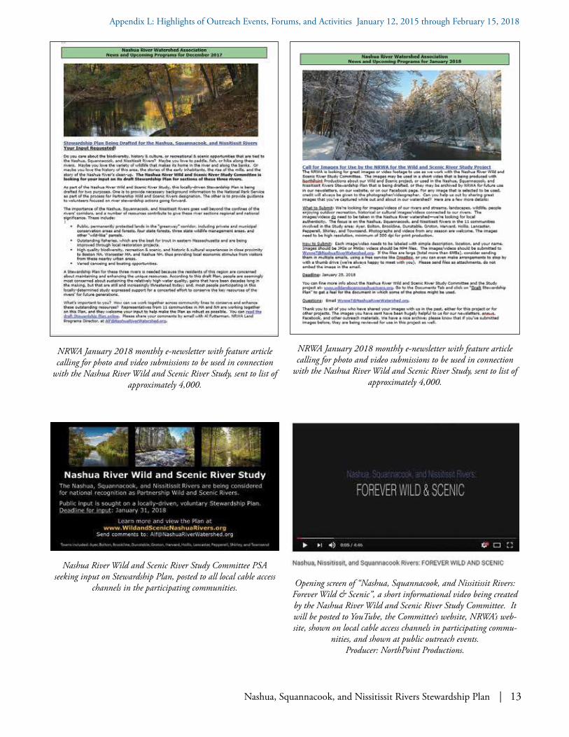
Nashua, Squannacook, and Nissitissit Rivers Stewardship Plan | 13
Appendix L: Highlights of Outreach Events, Forums, and Activities January 12, 2015 through February 15, 2018
NRWA January 2018 monthly e-newsletter with feature article calling for photo and video submissions to be used in connection
with the Nashua River Wild and Scenic River Study, sent to list of approximately 4,000.
Nashua River Wild and Scenic River Study Committee PSA seeking input on Stewardship Plan, posted to all local cable access
channels in the participating communities. Opening screen of “Nashua, Squannacook, and Nissitissit Rivers: Forever Wild & Scenic”, a short informational video being created by the Nashua River Wild and Scenic River Study Committee. It will be posted to YouTube, the Committee’s website, NRWA’s web-site, shown on local cable access channels in participating commu-
nities, and shown at public outreach events. Producer: NorthPoint Productions.
NRWA January 2018 monthly e-newsletter with feature article calling for photo and video submissions to be used in connection
with the Nashua River Wild and Scenic River Study, sent to list of approximately 4,000.

14 | Nashua, Squannacook, and Nissitissit Rivers Stewardship Plan
Appendix L: Highlights of Outreach Events, Forums, and Activities January 12, 2015 through February 15, 2018
Front and back of flyer distributed at public information meetings in Hollis and Brookline, New Hampshire beginning in February 2018.

Squannacook River. Photo: Joan Wotkowicz
Nissitissit River. Photo: Cindy Knox Photography
Nashua River. Photo: Ken Hartlage
Nashua, Squannacook, and Nissitissit Rivers
Stewardship Plan
Nashua River Wild and Scenic River Study Committeec/o Nashua River Watershed Association592 Main Street, Groton, Massachusetts 01450
978-448-0299 | www.WildandScenicNashuaRivers.org
February 15, 2018
Nashua, Squannacook, and N
issitissit Rivers Stew
ardship Plan – February 15, 2018