NASA/SLI Technology Development Status - Landsat · NASA/SLI Technology Development Status ......
19
July 11, 2017 Sachidananda Babu Technology Development Manager (SLI) Earth Science Technology Office NASA/SLI Technology Development Status 2017 Landsat Science Team Meeting
Transcript of NASA/SLI Technology Development Status - Landsat · NASA/SLI Technology Development Status ......

July 11, 2017
Sachidananda Babu
Technology Development Manager (SLI)
Earth Science Technology Office
NASA/SLI Technology Development Status 2017 Landsat Science Team Meeting
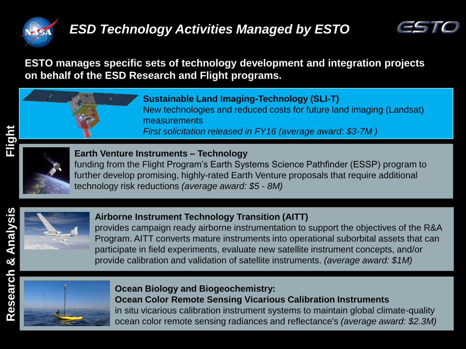
ESD Technology Activities Managed by ESTO
ESTO manages specific sets of technology development and integration projects
on behalf of the ESD Research and Flight programs.
Airborne Instrument Technology Transition (AITT)
provides campaign ready airborne instrumentation to support the objectives of the R&A
Program. AITT converts mature instruments into operational suborbital assets that can
participate in field experiments, evaluate new satellite instrument concepts, and/or
provide calibration and validation of satellite instruments. (average award: $1M)
Researc
h &
An
aly
sis
F
lig
ht
Ocean Biology and Biogeochemistry:
Ocean Color Remote Sensing Vicarious Calibration Instruments
in situ vicarious calibration instrument systems to maintain global climate-quality
ocean color remote sensing radiances and reflectance's (average award: $2.3M)
Earth Venture Instruments – Technology
funding from the Flight Program’s Earth Systems Science Pathfinder (ESSP) program to
further develop promising, highly-rated Earth Venture proposals that require additional
technology risk reductions (average award: $5 - 8M)
Sustainable Land Imaging-Technology (SLI-T)
New technologies and reduced costs for future land imaging (Landsat)
measurements
First solicitation released in FY16 (average award: $3-7M )
2
Sate
llite
M
issio
ns
A
irb
orn
e C
am
pa
ig
ns
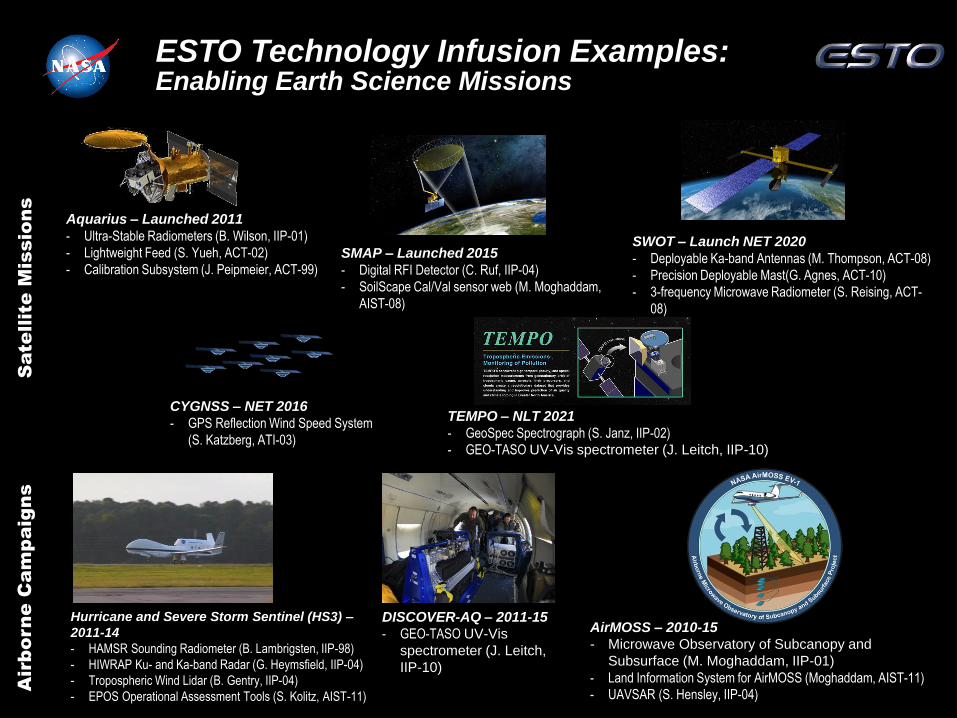
Aquarius – Launched 2011
- Ultra-Stable Radiometers (B. Wilson, IIP-01)
- Lightweight Feed (S. Yueh, ACT-02)
- Calibration Subsystem (J. Peipmeier, ACT-99) SMAP – Launched 2015
- Digital RFI Detector (C. Ruf, IIP-04)
- SoilScape Cal/Val sensor web (M. Moghaddam,
AIST-08)
SWOT – Launch NET 2020
- Deployable Ka-band Antennas (M. Thompson, ACT-08)
- Precision Deployable Mast(G. Agnes, ACT-10)
- 3-frequency Microwave Radiometer (S. Reising, ACT-
08)
Hurricane and Severe Storm Sentinel (HS3) –
2011-14
- HAMSR Sounding Radiometer (B. Lambrigsten, IIP-98)
- HIWRAP Ku- and Ka-band Radar (G. Heymsfield, IIP-04)
- Tropospheric Wind Lidar (B. Gentry, IIP-04)
- EPOS Operational Assessment Tools (S. Kolitz, AIST-11)
DISCOVER-AQ – 2011-15
- GEO-TASO UV-Vis
spectrometer (J. Leitch,
IIP-10)
CYGNSS – NET 2016
- GPS Reflection Wind Speed System
(S. Katzberg, ATI-03)
TEMPO – NLT 2021
- GeoSpec Spectrograph (S. Janz, IIP-02)
- GEO-TASO UV-Vis spectrometer (J. Leitch, IIP-10)
AirMOSS – 2010-15
- Microwave Observatory of Subcanopy and
Subsurface (M. Moghaddam, IIP-01)
- Land Information System for AirMOSS (Moghaddam, AIST-11)
- UAVSAR (S. Hensley, IIP-04)
ESTO Technology Infusion Examples: Enabling Earth Science Missions

ESTO investments in Remote Sensing
ESTO Technology Development Program
AIST Program SLI-T & InVEST Programs IIP & ACT Programs
Sustainable Land Imaging
Program
(for future Landsat)
Infusion into NASA Earth Science
Programs

Sustainable Land Imaging-Technology
(SLI-T) Program Overview & Objectives
“New technologies and reduced costs for future land imaging (Landsat) measurements”
• The goals of the SLI-T program are to research, develop, and
demonstrate new measurement technologies that improve upon
the Nation’s current land imaging capabilities while at the same
time reduce the overall program cost risk for future SLI
measurements.
The SLI-T program seeks to:
• Reduce the risk, cost, size, volume, mass, and development time for the
next generation SLI instruments, while still meeting or exceeding the
current land imaging program capabilities;
• Improve the temporal, spatial, and spectral resolution of SLI
measurements; and
• Enable new SLI measurements that can improve the future program’s
operational efficiency and reduce the overall costs of the Nation’s land
imaging capabilities.
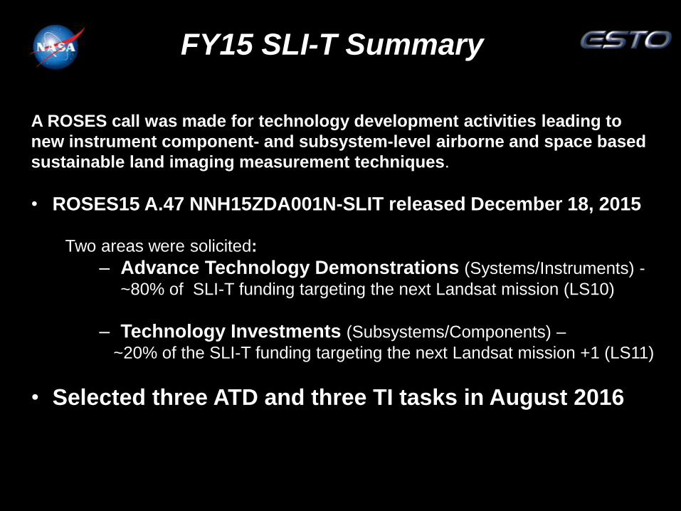
FY15 SLI-T Summary
A ROSES call was made for technology development activities leading to
new instrument component- and subsystem-level airborne and space based
sustainable land imaging measurement techniques.
• ROSES15 A.47 NNH15ZDA001N-SLIT released December 18, 2015
Two areas were solicited:
‒ Advance Technology Demonstrations (Systems/Instruments) -
~80% of SLI-T funding targeting the next Landsat mission (LS10)
‒ Technology Investments (Subsystems/Components) –
~20% of the SLI-T funding targeting the next Landsat mission +1 (LS11)
• Selected three ATD and three TI tasks in August 2016

Sustainable Land Imaging-Technology-15 Status
Completed first interim reviews for all awards
PI Name PI Org Status Project Title Start
Date
End
Date
Comments
Kampe Ball Compact Hyperspectral
Prism Spectrometer
09/01/16 08/31/19
ATD
First interim review held
04/26/17
Puschell Raytheon Advanced Technology Land
Imaging Spectroradiometer
(ATLIS)
10/16/16 10/15/18
ATD
First interim review held
04/11/17
Wamsley Ball Reduced Envelope Multi-
spectral Imager
09/01/16 08/31/19
ATD
First interim review held
04/26/17
Ting JPL Long Wavelength Infrared
Focal Plane Array for Land
Imaging
10/01/16 09/30/19
TI
First interim review held
02/16/17
Sandor -
Leahy
Northrop
Grumman
Integrated Photonic Imaging
Spectrometer
09/27/16 09/26/21
TI
First interim review held
04/13/17
Yoo University
Of
California,
Davis
Multi-Spectral, Low-Mass,
High-Resolution Integrated
Photonic Land Imaging
Technology
09/01/16 08/31/19
TI
First interim review held
04/27/17
SLI-T 15 Advanced Technology
Demonstrations
Thomas Kampe, Ball Aerospace & Tech Corp.
Mature Ball Compact Hyperspectral Prism
Spectrometer(CHPS) small form factor VSWIR imaging
spectrometer for SLI Demo mission. Advance TRL
through airborne demonstration validating instrument low
stray light performance
Jeff Puschell, Raytheon
Demonstrate compact low mass Advanced
Technology Land Imaging Spectrometer (ATLIS)
design approach with wide field of view (WFOV,
freeform fast optics, large format small detector digital
FPS and on-chip Time delay Integration (TDI) to
SLI-T VSWIR requirements
NNH15ZDA001N-SLIT
A12584 Ball Aerospace & Technologies Corp. Proprietary Information 2
Use or disclosure of the information contained in this proposal is subject to the restrictions on page i of this proposal.
Table 1. The pushbroom CHPS addresses the SLI’s data continuity mandate.
Parameter Value Benefit
Spectral Range 400 nm-2.5 µm Full coverage of Landsat VSWIR bands
Stray Light See discussion Low stray light supports radiometric accuracy needed for data continuity
Spectral Uniformity
>90% Low spatial-spectral mixing supports data continuity by ensuring spectral content assigned to correct ground pixel
Spatial Uniformity >90%
Slit Length 30 mm Supports wide swath
F/# 3 Moderate F/# eases tolerances and manufacturability
Figure 1 shows the opto-mechanical layout, the breadboard implementation, and the white light
spectrum image. This hardware demonstration was developed as a Ball Internal Research and
Development (IR&D) program. One objective was demonstrating a wide swath imaging
spectrometer for land use applications with low stray light; the stray light requirement led
directly to the prism solution. CHPS’ high performance relies on wedged spherical elements with
a resulting in loss of element symmetry. Optimax met the specifications for all of the non-
standard elements with no waivers, delays, or reworks. Procurement cost of the complete set of
optics (3-lenses and 2-mirrors) was more than a factor of 10 less than a recent Ball procurement
of a single diffraction grating for an Offner spectrometer. Optical alignment was an extension to
refractive elements of the Zeiss Coordinate Measuring Machine techniques developed for the
ESTO funded IIP MOS; CHPS was aligned in 3 days. Figure 1’s right panel shows the white
light spectrum of a long Lenox Laser fabricated slit. Aggressive Ball investments have mitigated
design, procurement, and alignment risks. The next step is to raise the TRL of the SLI class opto-
mechanical system enabled by CHPS.
Figure 1. CHPS’ critical function as a spectrometer has been demonstrated on a Ball Internal Research and Development (IR&D) program. Left: opto-mechanical layout. Middle: assembled and aligned spectrometer breadboard. Right: spectrum of a white light source illuminating the 30 mm length of the slit; the picture was taken with a commercial DSLR. FL: Field Lens. M: Mirror.
Table 2 summarizes the spectral dispersion. On a per pixel basis these values are the
instrumental contribution to the spectral response function bandwidth. Green [1998] argue that
uniform spectral sampling is required to accurately retrieve biochemical properties from
terrestrial ecosystems. ESA’s Airborne Prism Experiment (APEX) is a dual-channel solar
reflective imaging spectrometer with a non-linear dispersion like CHPS. A large number of
ecological parameters are successfully retrieved from APEX data (Schaepman et al., 2015).
Paula Wamsley,
Ball Aerospace & Technology Corporation
Develop a compact multispectral instrument for SLI and
perform an airborne demonstration. Key technologies
include: scan mechanism to perform step-stare motion,
jitter removal, and image motion correction.
NNH15ZDA001N-SLIT
A12583 Ball Aerospace & Technologies Corp. Proprietary Information 21
Use or disclosure of the information contained in this proposal is subject to the restrictions on page i of this proposal.
1.8. Quad Chart
RAYTHEON COMPETITION SENSITIVE EXPORT CONTROLLED
21
Unpublished work. Copyright 2016 Raytheon Company.

SLI-T 15 Advanced Technology
Demonstrations Thomas Kampe, Ball Aerospace & Tech Corp.
Mature Ball Compact Hyperspectral Prism Spectrometer(CHPS) small form factor VSWIR
imaging spectrometer for SLI Demo mission. Advance TRL through airborne demonstration
validating instrument low stray light performance
Space borne instrument concept development is on-going
CHPS VSWIR imaging spectrometer with separate TIR instrument feasible within
volume approaching Reduced Instrument Volume Requirement – 0.5 m cube
Radiometric Math Model adapted to spaceborne system
– SLI-T CHPS Flight Concept Meets SNR Requirements at the Binned RMA Bands
and at Nearly All Single-Pixel Wavelengths

SLI-T 15 Advanced Technology
Demonstrations Jeff Puschell, Raytheon
Demonstrate compact low mass Advanced Technology Land Imaging Spectrometer (ATLIS) design
approach with wide field of view (WFOV, freeform fast optics, large format small detector digital
FPS and on-chip Time delay Integration (TDI) to SLI-T VSWIR requirements
New and emerging optical and focal plane
technology enables much smaller land imagers than
current systems
Innovative signal processing methods to RER slope
and SNR and lead to further reductions in land
imager size, mass and power
ATLIS-P supports both a disaggregated architecture
and a full spectrum instrument and provides a
testbed that can be used in future technology
demonstrations
Key ATLIS-P technology (free form reflective
telescope, digital FPA) benefits many other NASA
Earth Science missions, especially those involving
small satellite systems

SLI-T 15 Advanced Technology
Demonstrations
Paula Wamsley, Ball Aerospace & Technology Corporation
Develop a compact multispectral instrument for SLI and perform an airborne demonstration. Key
technologies include: scan mechanism to perform step-stare motion, jitter removal, and image
motion correction.
Mechanical Packaging Concept Complete
NNH15ZDA001N-SLIT
A12583 Ball Aerospace & Technologies Corp. Proprietary Information 21
Use or disclosure of the information contained in this proposal is subject to the restrictions on page i of this proposal.
1.8. Quad Chart
SLI-T 15 Technology Investments
S J Ben Yoo, UC Davis
Design, fabrication and testing of an electro-optical
(EO) imaging sensor concept that provides a low
mass, low volume alternative to the traditional bulky
optical telescope and focal plane detector array
ROSES 2015 SLI-T TI
NRA NNH15ZDA001N-SLIT LONG WAVELENGTH INFRARED FPA FOR LAND IMAGING
1-16 Use or disclosure of information c ontained on this sheet is subject to the restriction on the Cover Page of this proposal.
1.8 Quad Chart
David Ting, NASA Jet Propulsion Laboratory
Demonstrate a high-performance long-wavelength
infrared (LWIR) focal plane array (FPA) technology
with the flexibility to meet a variety of possible future
land imaging needs.
Stephanie Sandor-Leahy, Northrop Grumman
Develop next-generation compact SLI instrument
based on NGAS photonic waveguides
Reduce instrument volume by x25, mass by x7
compared to current multispectral approach
NNH15ZDA001N
Northrop Grumman Private/Proprietary Level I 1-1 16-75987
Use or disclosure of data contained on this sheet is subject to the restriction on the title page of this proposal.
1. SCIENTIFIC/TECHNICAL/MANAGEMENT
Northrop Grumman Aerospace Systems understands SLI requirements and the need to evolve
the mission to achieve a sustained land imaging capability for the future. Our innovative
approach preserves critical data continuity while adding the power of hyperspectral imaging
in a small and affordable instrument.
1.1 DESCRIPTION OF PROPOSED TECHNOLOGY
We propose a highly integrated photonic SLI instrument manufactured using established
semiconductor fabrication processes to provide a new hyperspectral land imaging capability.
For more than 40 years the Landsat program has provided the Earth science community with
highly accurate global multispectral imagery (MSI) to monitor our planet and its ecosystems. In
that time, hyperspectral imaging (HSI) has emerged and demonstrated new analysis techniques
and data products through the measurement of image scenes at high spectral resolution (see
Section 1.2) [1]. Through our work on the Sustainable Land Imaging (SLI) Reduced Instrument
Envelope Study and the ESTO Novel Concepts for SLI Study, Northrop Grumman Aerospace
Systems (NGAS) has demonstrated a thorough understanding of SLI mission, instrument and
calibration requirements, and we have shown that a versatile HSI sensor can meet SLI instrument
goals while maintaining continuity with traditional Landsat data products [2], [3].
Under the Advanced Technology Demonstrations program, NGAS proposes to address SLI
requirements through a new photonic approach to land imaging that provides the benefits of HSI
in a small, versatile, scalable package while maintaining critical continuity with traditional
Landsat data and products. Our Hyperspectral Array Waveguide Camera (HAWC)1 combines
wavelength selection and optical detection in an integrated package yielding substantial mass and
volume reductions over standard spectrometers. Compared to the current MSI approach we
estimate a total instrument mass and volume reduction of ~7x and ~25x respectively (see Section
1.1.4). Another benefit of lithographically patterned photonic waveguides fabricated at wafer
scales is that ultimately these devices can be rapidly and inexpensively reproduced in large
quantities. Photonic lightwave circuits (PLCs) are arrayed efficiently in multiple dimensions to
generate perfectly co-registered, spectrally resolved imagery over large ground swaths
(Figure 1). We have separately addressed the crucial data continuity aspect of the SLI mission.
1 NGAS HAWC is not related to the HAWC+ instrument that is part of the SOFIA airborne astronomy observatory.
Figure 1. HAWC and Representative Telescope
Scene Image
Micro-Lens Array
Scene Photons
HAWC
23

SLI-T 15 Technology Investments
Stephanie Sandor-Leahy, Northrop Grumman
Develop next-generation compact SLI instrument based on NGAS photonic waveguides
Reduce instrument volume by x25, mass by x7 compared to current multispectral approach

SLI-T 15 Technology Investments
S J Ben Yoo, UC Davis
Design, fabrication and testing of an electro-optical (EO) imaging sensor concept that provides a
low mass, low volume alternative to the traditional bulky optical telescope and focal plane detector
array

SLI-T 15 Technology Investments
David Ting, NASA Jet Propulsion Laboratory
Demonstrate a high-performance long-wavelength infrared (LWIR) focal plane array (FPA)
technology with the flexibility to meet a variety of possible future land imaging needs.

IIP Investments in Landsat technology
Ronald Lockwood, MIT/LL
Demonstrate the CCVIS design in a breadboard to
mature the technology.
Quantify the scattered light contamination in an
imaging spectrometer for both e-beam
microlithographic and diamond machined gratings
Phil Ely, DRS Technology
Demonstrate an Eight Band Radiometric Imager utilizing low cost,
uncooled Focal Plane Array for Earth Science applications. Utilize a Piezo
Backscan stage to image stabilize and allow for multi-frame stacking. Use
of DRS patented TCOMP to provide radiometirc accuracy (<2% error).
Tomasz Tkaczyk, Rice University
Develop a low-resource highly-capable tunable
hyspectral imager for a range of Earth observations.
Technologies include innovative fiber optic light-guide,
snapshot imaging and tunability for specific line
selection for spatial/spectral pixel distribution.
9. Quadd Chart
21
NASA Instrument Incubator Program Chrisp Compact VNIR/SWIR Imaging Spectrometer (CCVIS)
Milestone Schedule: • Finalize CCVIS design – 1st quarter, yr 1
• Complete breadboard – 4th quarter, yr 1
• Manufacture ebeam lithography grating – 4th
quarter, yr 1
• Complete performance evaluation – 2nd quarter,
yr 2
• Quantify scattered light performance – 2nd
quarter, yr 2
Entry TRL: 2
Proposed Approach: • Breadboard implementation of recent advances in
optical design of a new imaging spectrometer form and to demonstrate the large reduction in SWaP and performance comparable to current designs
• Electron beam microlithographic optical elements are developed to minimize light scatter and optimize optical throughput
• Demonstrate breadboard design and quantify performance of the imaging spectrometer
Partners: none
Objectives: • Demonstrate the CCVIS design in a breadboard to
mature the technology
• Demonstrate that the CCVIS supports the NASA
Earth Science Division requirements to maintain or
improve performance, while reducing SWaP and
buying down risk
• Quantify the scattered light contamination in an
imaging spectrometer for both ebeam
microlithographic and diamond machined gratings
Chrisp Compact VNIR/SWIR Imaging Spectrometer
Catadioptric
lens
Immersion grating
Slit
FPA and
order-sorting
filter
7 cm
7.6 cm

AIST Investments
Melba Crawford, Purdue University
Improve the use of land cover data by developing an
advanced framework for robust classification using
multi-source datasets. Utilize first results to query
new samples to significantly improve classification
performance and accuracy
Dan Mandl, NASA GSFC
Dramatically improve onboard processing capability
for data rate missions (e.g. 1Gbps instrument data
rates using processors consuming <20W and
radiation tolerant)
Petya Campbell, UMBC
Develop and demonstrate innovative software systems
for producing and disseminating science-quality
spectral data from Unpiloted Aerial Vehicles (UAC) with
capability to multi-source data integration.
12/15
Objective
Accomplishments
A High Performance Onboard Multicore Intelligent Payload Module for Orbital and Suborbital Remote Sensing Missions
PI: Dan Mandl, NASA GSFC
• Dramatically improve onboard processing (OBP) capability for high data rate missions (e.g., 1 Gbps instrument data rates using processors using less than 20 watts and rad tolerant)
• Utilize onboard multicore and field programmable array processors and intelligent onboard data reduction
• Demonstrate the Intelligent Payload Module (IPM) end-to-end operations concept for low latency custom data products from airborne platforms
• Demonstrate multi-tiered onboard data processing chain • Demonstrate direct download of Level 2 (L2) data products with
atmospheric correction and geocorrection based on user selected location, parameters, and algorithms
• Demonstrate rapid delivery of data products in near real time
• Built preliminary IPM which included: (a) Tilera Tile Pro (proxy for Maestro multicore processor-- <20 watts ); (b) MicroZed (Field Programmable Gate Array(FPGA) with two ARM Processors as a proxy for CHREC Space Processor(CSP)-- <5 watts); (c ) SDN500 Inertial Measurement Unit (IMU); (d) Core Flight Executive (cFE) flight software; and (e) Web Coverage Processing Service (WCPS) for real time custom science algorithm upload capability
• Ported hyperspectral data processing chain (Level 0 Processing, Radiometric Correction, Atmospheric Correction, Geometric Correction and classification) and realistic flight software to IPM
• Benchmarked performance for various IPM configurations parallelizing multicore environment and FPGA circuits (using virtualized circuit synthesis-Xillybus, OpenCL approach) achieving up to 1.7 Gbps throughput
• Conducted 10+ airborne flights with various realistic IPM configurations as proxies for space IPM flights • IPM adapted as HyspIRI mission requirement to provide low latency data products – status every 6 months at mission workshops
Co-Is/Partners: Rob Sohlberg, Univ. of MD Geographic Services; Vuong Ly, Matt Handy, GSFC; Don Sullivan, Vince Ambrosia, ARC; Geoff Bland, GSFC WFF; Enric Pastor, Univ. of Catalunya; Pat Cappelaere, Vightel; Stuart Frye, SGT, Inc.; Steve Crago, USC-ISI
TRLin = 3 TRLout = 6
AIST-QRS-13-0002
Intelligent Payload Module Concept Graphic
Mini-helicopter
UAV
HyspIRI
Real Time Data
Imaging
Spectrometer Citation
Bussmann helicopter
04/16
Objective
Key Milestones Approach
Next Generation UAV Spectral Systems for Environmental Modeling PI: Petya Campbell, UMBC
Co-Is/Partners: V. Ambrosia, CSU, Monterey Bay; P. Cappelaere, Vightel; M. Coen, P. Townsend, F. Navarro, C. Kingdon, Univ of Wisconsin; L. Corp, Sigma Space; V. Ly, D. Mandl, GSFC; J. Nagol, R. Sohlberg, UMd,; L. Ong, SSAI
• Develop and demonstrate innovative software system for producing and disseminating science-quality spectral data from Unpiloted Aerial Vehicles (UAV) that
• Ensure well-calibrated, science quality measurements • Leverage UAV strengths such as rapid deployment, high
temporal frequencies, and high resolution • Allow ready integration with, or comparison to, in situ,
satellite and airborne data and derived products • Support capability to characterize diurnal and seasonal
cycles in vegetation function
• Integrate and test Ocean Optics USB2000+, OEPro and Headwall VNIR E series spectrometers onto UAV
• Validate measurements with well-characterized sites
• Develop rapid data assimilation and delivery system
• Develop data gathering campaign strategy to optimize data yield
• Leverage EcoSIS online spectral library
• Integrate first two spectrometers 07/15 • Complete calibration protocol and 09/15
intercalibration (initial) • Retrieve parameters, validate against field data 11/15 • Integration of Headwall imaging spectrometer 02/16 • Validate computing capacity for real-time
retrievals 12/16 • Demonstrate data production pipeline 05/17
Small UAV sensor-web filling the gap between ground and satellite measurements.
AIST-14-0090
2
We will employ a two-step methodology that first uses a series of discrete-point
spectrometer measurements (from a UAV-deployed spectrometer in Year 1) before deploying an
imaging spectrometer array providing spatially resolved measurements (in Year 2). In Year 1 we
will focus on calibration and understanding measurement constraints before dealing with
significant issues associated geometry and much larger data volumes related to imaging in Year
2. These new methods and integrated technology components will affect future mission
formulations such as HyspIRI and Landsat 9 by providing a rapidly deployable and flexible
approach to measure surface reflectance and derived ecosystem parameters for integration with
satellite data. In addition, we will identify much-needed approaches to ensure that UAV-based
measurements produce repeatable results in time and space.
2. Description of Proposed Technology
Near ground measurements are required to bridge the gap between satellite, airborne and field
measurements (Fig. 1) and enable spectral acquisitions at appropriate spatial and temporal scales
where biogeochemical processes and ecosystem functional properties are observed by carbon
flux networks (Mac Arthur et al. 2014). The proposed technology will integrate UAV platforms
in Year 1 with single-point spectrometers (Table 1 a. and b.), and in Year 2 an imaging
spectrometer (Table 1 c). We will integrate SensorWeb software and Intelligent Payload Module
techniques developed on previous AIST efforts to facilitate ease of access to, and control of, this
precision science-grade data collection system.
We propose a practical two-step methodology as a significant step forward in the use of
UAVs, for the collection of accurate science-quality data measurements for the assessment of
ecosystem function and agricultural monitoring. First, we need to understand how to make a
single calibrated data measurement from a point and retrieve important biological parameters
(i.e., a spectral measurement from a fiber-optic based spectrometer), before subsequently
making many measurements (i.e., hyperspectral imagery from an imaging spectrometer) (A.
MacArthur, pers. communication to Co-I Townsend).
Figure 1. Small UAVs augmented with SensorWeb capabilities fill the gap between
satellite measurements and fixed ground measurements.
TRLin = 3 TRLcurrent = 3
12/15
Objective
Accomplishments
Advanced Active Learning Methods for Robust Classification of Multi-Source Remotely Sensed Data
PI: Melba Crawford, Purdue University
• Improve the use of land cover data by developing an advanced framework for robust classification using multi-source datasets:
• Develop, validate and optimize a generalized multi-kernel, active learning (MKL-AL) pattern recognition framework for multi-source data fusion.
• Develop both single- and ensemble-classifier versions (MKL-AL and Ensemble-MKL-AL) of the system.
• Utilize multi-source remotely sensed and in situ data to create land-cover classification and perform accuracy assessment with available labeled data; utilize first results to query new samples that, if inducted into the training of the system, will significantly improve classification performance and accuracy.
• Work will be performed in collaboration with the NASA Earth Science Division’s Carbon Cycle and Ecosystems focus area.
• Developed both single- and ensemble-classifier versions (MKL-AL and Ensemble-MKL-AL) of the system. • Incorporated the multi-kernel Support Vector Machine (SVM) into an ensemble multi-source-classification system. • Completed the multi-view active learning component of the system and its integration with Hierarchical Segmentation (HSEG).
HSEG extended to include: – segmented boundary information to mitigate the impact of edge anomalies exhibited at the boundaries of regions. – pruning the segmentation tree, and inclusion of multiscale spatial information in the multi-source environment.
• Validated the new methods using a suite of multispectral, hyperspectral, and airborne LIDAR data collect over a well characterized field site.
• Framework implemented and demonstrated on the Purdue cloud computing platform.
Co-Is/Partners: Saurabh Prasad, University of Houston; James Tilton, NASA GSFC TRLin = 2 TRLout = 4
AIST-11-0077
Proposed Ensemble Multi-Kernel Active Learning Algorithm
ESTO Technology Developments for Future Earth Science Measurements
Landsat technology in InVest program
From ESTO InVEST 2015 Program
CIRiS Ball Aerospace Launch: March 2018
CIRAS Jet Propulsion Lab
Launch: June 2018
Infrared Atmospheric Sounder Demonstrate ability to measure spectrum of upwelling infrared radiation and validate 2D infrared detector material, a micro pulse tube cryocooler, and a grating spectrometer
Infrared Transfer Radiometer Validate an uncooled imaging infrared (7.5 um to 13 um) radiometer designed for high radiometric performance from LEO

Looking Ahead
• Develop technology relevant for missions
• Smaller, less resource-intensive instrumentation
• High-resolution optical and infrared sensors
• Formation flying
• Nano-satellites / CubeSats
• Fractionated spacecraft
• Autonomous operations
• High-resolution ensemble models
• Rapid, error-free data transfer
For more information visit: https://esto.nasa.gov