NASA MSFC GOES Receiving Station - Space … · NASA MSFC GOES-R Series Receiving Station Earth...
17
NASA MSFC GOES-R Series Receiving Station Earth Science Branch Kevin M. McGrath (Jacobs Technology) Paul J. Meyer (NASA/MSFC, Earth Science Branch) Gary J. Jedlovec (NASA/MSFC, Earth Science Branch) Emily B. Berndt (NASA/MSFC, Earth Science Branch) CSPP/IMAPP Users’ Group Meeting 2017 29 June 2017
Transcript of NASA MSFC GOES Receiving Station - Space … · NASA MSFC GOES-R Series Receiving Station Earth...

NASA MSFC GOES-R Series Receiving Station
Earth Science BranchKevin M. McGrath (Jacobs Technology)
Paul J. Meyer (NASA/MSFC, Earth Science Branch)Gary J. Jedlovec (NASA/MSFC, Earth Science Branch)Emily B. Berndt (NASA/MSFC, Earth Science Branch)
CSPP/IMAPP Users’ Group Meeting 201729 June 2017

Historical PerspectiveNASA Marshall Space Flight Center (MSFC) has been utilizing GOES data since the early 1980’s
• Launch support for manned spaceflight missions• Algorithm and product development supporting NASA science • Real-time data ingest since 1996
• Provide a consistent and reliable source of real-time data and products for the broader community of interest
• Data and product transition to the operational weather community to monitor current environmental conditions and improve short-term weather forecasts (SPoRT)
GOES-East/West GVAR

End Users• NASA
• Internal research, algorithm development• Field Campaigns
• Other U.S. Government Agencies• NOAA• FAA• USCG• USDA• DoD
• Commercial• Insurance• Private weather concerns
• Academia• Weather-attentive public

Receiving StationTELESPACE CAPELLA-GR from Enterprise Electronics Corporation (EEC)• Hardware:
• Dish: ASC Signal 6.5-m reflector• Positioning: ASC Signal motor control system• Feed: Quorum GRB• Demodulator/Receiver: Quorum GRB-200• Dehydrator• Linux workstations
• Acquisition• Data processing• Visualization
• Software:• GEOSat• CSPP (v.0.4.4)• AIT• PROTEUS (visualization)
• Located at MSFC
NASA MSFC receiving station at Activities Building (4316)
Acquisition and Data ProcessingVisualization

Data Processing• Ingest and process all data from all 6 instruments
• ABI - Level 1b• GLM - Level 2: events, groups, flashes• Space weather instruments - Level 1b data from EXIS, MAG, SEISS, and SUVI
• Temporary local data storage (~ 10 days)
• Real-time transfer of all data to NSSTC via 10 Gbps connection for additional product generation and dissemination
• McIDAS-X used to convert ABI L1b netCDF4 to Area
National Space Science and Technology Center

System Health Monitoring and StatusSeparation distance between NSSTC and receiving station make monitoring challenging• Created software suite to monitor station health
• Real-time and historical monitoring of critical system parameters• Signal strength, SNR, temperatures, humidity, pressure, etc.
• Ingest and product status systems send email alerts when data outages are detected
https://weather.msfc.nasa.gov/goeshealth/https://weather.msfc.nasa.gov/sport/ingeststatus/https://weather.msfc.nasa.gov/sport/productstatus/

Data Products• ABI: Generation of value-added NASA L2 products
• RGB suite
• GLM• Currently acquiring data via the NESDIS PDA while waiting
for GRB dissemination• Code written to aggregate data into 2-minute intervals
(events, groups, flashes)
• SUVI• Imagery from various channels and integration times
• Air Mass• Ash• Day Convection• Day Land Cloud
• Day Land Cloud Fires• Day Ocean Cloud
Convection• Day Snow Fog
• Daytime Microphysics• Dust • Fire Temperature• Nighttime Microphysics
• Simple Water Vapor• SO2

Data DisseminationNear real-time access to data and products• Web:
• Classic Viewer and API• Quick-Look Images
• Web Map Service (WMS)• LDM:
• Timely and efficient transfer of specific data and products to collaborators and partner end users
• NWS National Centers for use in N-AWIPS and AWIPS II
• SCP/SFTP: ABI feed to other NASA Centers• FTP: Public access

Classic Viewer• Developed a web-based interactive interface for viewing GOES
imagery in 1997• ~500,000 unique visitors/month• ~50M hits/month
• Select channels (0.64µm, 6.2µm, 11.2µm)• Users define area of interest to display• Animations are very quick to load• Options:
• Color palettes• Map overlays• Quality
• Resolution• Width/height• Static or animation
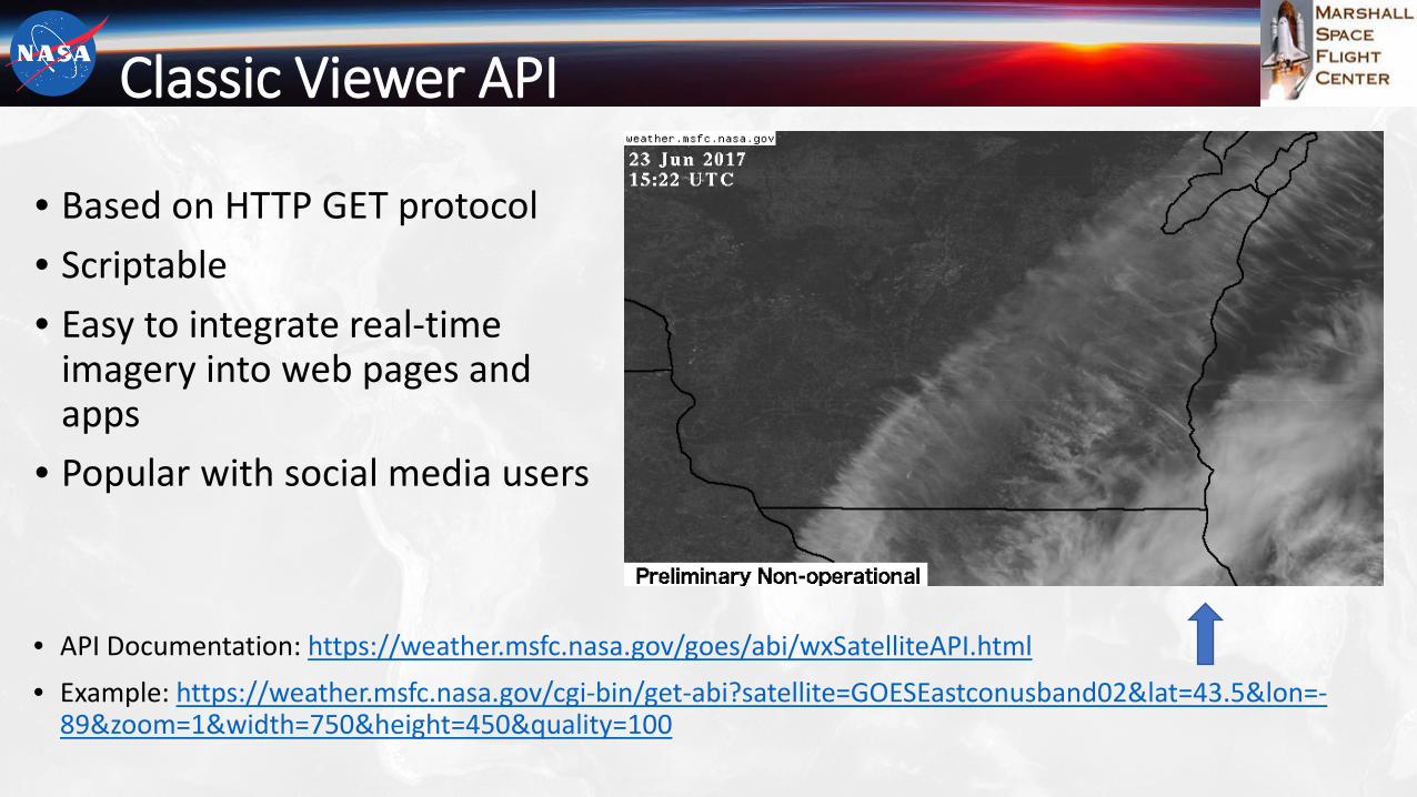
Classic Viewer API
• Based on HTTP GET protocol• Scriptable• Easy to integrate real-time
imagery into web pages and apps
• Popular with social media users
• API Documentation: https://weather.msfc.nasa.gov/goes/abi/wxSatelliteAPI.html• Example: https://weather.msfc.nasa.gov/cgi-bin/get-abi?satellite=GOESEastconusband02&lat=43.5&lon=-
89&zoom=1&width=750&height=450&quality=100

Quick-Look Images• Used to verify data integrity for all
ABI, GLM, and SUVI products• Supports long animation sequences • Fixed resolutions
https://weather.msfc.nasa.gov/cgi-bin/sportPublishData.pl?dataset=goes16abiconus

Quick-Look Images
GLM 2-Minute Group Density 28 June 2017 2341Z – 29 June 2017 0424Z
28 June 2017
South Beloit, IL

Web Map Service
• Current viewer is based upon OpenLayers
• Transitioning from open source GeoServer WMS to Esri Enterprise Server
• Ability to more easily share layers with other GIS users
Interactive GIS-based Layered Visualization and Data Access
https://weather.msfc.nasa.gov/viewer/viewer.html?config=GOES
GLM 2-Minute Groups Overlaid on ABI 0.64µm in GIS Framework (28 June 2017)

Web Map Service
GLM 2-Minute Group Density Overlaid on ABI 0.64µm 29 June 2017 1530Z – 1630Z

Future• Visualization and dissemination of real-time data
• ABI• Addition of mesoscale sectors and unique NASA products
• GLM• Implement display in classic viewer
• Space weather instruments• SUVI: Create quick-look displays• EXIS, MAG, and SEISS: Visualize temporal changes
as graphical plots• WMS
• Animation• Migration to Esri ecosystem
• Integrate NASA unique value-added products as part of the GOES L2 processing within CSPP
• Acquire a second GOES-R series receiving station for ocean-to-ocean CONUS coverage – replicate visualization and dissemination capabilities

Contact InfoKevin McGrath [email protected] Meyer [email protected] Jedlovec [email protected] Berndt [email protected]
Funding for the GRB system was provided by NASA and NOAA.