NARACOORTE AERODROME MASTER PLAN...Naracoorte Aerodrome Master Plan June 2016 Page 5 the area...
33
NARACOORTE AERODROME MASTER PLAN 2018 -2038
Transcript of NARACOORTE AERODROME MASTER PLAN...Naracoorte Aerodrome Master Plan June 2016 Page 5 the area...

NARACOORTE AERODROME
MASTER PLAN
2018 -2038

Naracoorte Aerodrome Master Plan
June 2016 Page 1
CONTENTS 1 INTRODUCTION ............................................................................................................................... 2
1.1 Overview of the Airport ........................................................................................................................ 2 1.2 Purpose and Objectives of the Master Plan .......................................................................................... 2 1.3 Methodology and Consultation ............................................................................................................ 3 1.4 Report Structure ................................................................................................................................... 3
2 MASTER PLAN CONTEXT ................................................................................................................. 4 2.1 Historical Background ........................................................................................................................... 4 2.2 Regional Context ................................................................................................................................... 4 2.3 Socio-Economic Context ....................................................................................................................... 5 2.4 Regulatory Context ............................................................................................................................... 5 2.5 Policy Context ....................................................................................................................................... 5 2.6 Previous and Current (Master) Plans .................................................................................................... 6 2.7 Key Stakeholders ................................................................................................................................... 6
3 CURRENT SITUATION ...................................................................................................................... 8 3.1 Ownership and Management ............................................................................................................... 8 3.2 Site Description ..................................................................................................................................... 8 3.3 Surrounding Land .................................................................................................................................. 8 3.4 Existing Activities ................................................................................................................................... 8 3.5 Existing Facilities ................................................................................................................................... 8 3.6 Ground Transport Access ...................................................................................................................... 9 3.7 Utility Services ....................................................................................................................................... 9 3.8 Environmental Values ........................................................................................................................... 9 3.9 Heritage Values ................................................................................................................................... 10
4 STRATEGIC VISION AND OBJECTIVES ............................................................................................ 11 4.1 Strategic Vision .................................................................................................................................... 11 4.2 Objectives ............................................................................................................................................ 11
5 CRITICAL AIRPORT PLANNING PARAMETERS ................................................................................ 12 5.1 Forecast of Future Operations ............................................................................................................ 12 5.2 Selected Design Aircraft ...................................................................................................................... 12 5.3 Runway configuration ......................................................................................................................... 13 5.4 Taxiways and Aprons ........................................................................................................................... 16 5.5 Navigation Systems ............................................................................................................................. 17 5.6 Aviation Support and Landside Facilities ............................................................................................ 17 5.7 Airspace Protection Surfaces .............................................................................................................. 18 5.8 Aircraft Noise Contours ....................................................................................................................... 18 5.9 Environmental and Heritage Sites ....................................................................................................... 19 5.10 Heritage Management Plan ................................................................................................................ 20
6 LAND USE PLAN ............................................................................................................................. 21 6.1 Land Use Precincts .............................................................................................................................. 21 6.2 Land Use Precinct Guidelines .............................................................................................................. 21
7 FACILITY DEVELOPMENT PLAN ..................................................................................................... 24 7.1 Movement Area Facilities ................................................................................................................... 24 7.2 Aviation Support Facilities ................................................................................................................... 24
8 GROUND TRANSPORT PLAN .......................................................................................................... 24 9 ENVIRONMENTAL MANAGEMENT PLAN ...................................................................................... 24 10 HERITAGE MANAGEMENT PLAN ................................................................................................... 24 11 AIRPORT SAFEGUARDING PLAN .................................................................................................... 25
11.1 National Airports Safeguarding Framework (NASF) ............................................................................ 25 11.2 Airspace Protection Surfaces .............................................................................................................. 26 11.3 Aircraft Noise Contours ....................................................................................................................... 27 11.4 Planning Policies and Controls ............................................................................................................ 27
12 IMPLEMENTATION PLAN............................................................................................................... 28 13 DRAWINGS .................................................................................................................................... 28

Naracoorte Aerodrome Master Plan
June 2016 Page 2
1 INTRODUCTION
1.1 Overview of the Airport
The Naracoorte Aerodrome is a registered aerodrome facility; owned and managed by the Naracoorte Lucindale Council. The aerodrome is at an elevation of 169 feet, located approximately 3 kilometres from the Naracoorte Town Centre. The Aerodrome is situated on Sections 1068, 1069, 1094 and part Section 639, Hundred of Naracoorte and is contained within an area of 180 hectares. Direct access to the aerodrome is provided from Doolans Road; the registered rural address being 139 Doolans Road Naracoorte.
Naracoorte Aerodrome Layout
1.2 Purpose and Objectives of the Master Plan
The purpose of this master plan is to: • establish the strategic direction for efficient and economic development at the airport over the
time frame of the plan; • provide for the development of additional uses of the airport site; • indicate to the public the intended uses of the airport site; and, • reduce potential conflicts between uses of the airport site, and to ensure that uses of the airport
site are compatible with the areas surrounding the airport.

Naracoorte Aerodrome Master Plan
June 2016 Page 3
The Naracoorte Aerodrome Strategic Management Plan 2013 forms the basis for the management of the aerodrome and provides the following objectives:
- ensure that the Aerodrome infrastructure meets community needs, in particular with regard to emergency services;
- define an agreed level of facilities and services to reduce the cost burden to Council and the community; and,
- ensure that decisions relating to the development Naracoorte Aerodrome are recognised and supported by all levels of Government – Federal, State and Local.
The Management Plan also references Council’s Strategic Plan 2012-2022 objectives comprising:
- a prosperous community; - a vibrant and progressive business centre; - liveable neighbourhoods; - a safe and integrated transport network; - progressive leadership in managing community assets and natural resources for future
generations; and, - sustainable community finances and assets.
1.3 Methodology and Consultation
Organisations and individuals with an interest in the airport include;
- Naracoorte Aero club; - fixed based operators; - flying schools; - tenants; - companies regularly operating into Naracoorte; - Naracoorte Lucindale Council; and, - local residents.
1.4 Report Structure
This master plan comprises 2 parts; • Sections 1-3 - Background information; • Section 4 onwards Master Planning

Naracoorte Aerodrome Master Plan
June 2016 Page 4
2 MASTER PLAN CONTEXT
2.1 Historical Background
The first landing ground constructed at Naracoorte was on privately owned land and was jointly funded by both town and district councils, together with Dalgety and Co. in 1935/36. An investigation into a more suitable location for the airfield ensued, but in late 1938, on receipt of advice from the Department of Defence that no requirement then existed for either a civil or military airfield, this action was suspended. In 1944, the RAAF advised that an emergency 2-runway field was considered desirable in Naracoorte. Construction commenced in 1945 at the present location on land leased from the Department of Lands, and in 1947 an “A “Class Licence was first issued. Since 1948, when passenger operations commenced from the present location, a number of operators have conducted Regional Passenger Transport (RPT) services, the last of which was O’Connor Airlines which ceased operations through Naracoorte in September 1985. Following the formation of the Naracoorte Aero club in 1957, the first hangar was constructed, and in about 1958 Ansett-ANA constructed a terminal building. From 1980, the aerodrome has expanded from 1 hangar (2 aircraft permanently based) to 5 hangars housing 8 permanently based aircraft. In 1979 runway lights were installed on the sealed strip, with PAALC facility added in 1983 and in 1985 a Development Plan was commissioned from AUSDA, jointly funded by the Department of Aviation. From 1985 to 2008, an additional nine hangars have been established on the property, none of these by Council. Three businesses are based at the Aerodrome; Southern Air Agricultural, Helifarm, and aircraft maintenance.
2.2 Regional Context
The Naracoorte Lucindale Council is located at the heart of the Limestone Coast region. The Council is approximately 300 kilometres from Adelaide and 450 kilometres from Melbourne. Naracoorte is the main service centre for the Council district, which also contains the smaller communities of Lucindale, Hynam, Kybybolite and Frances. The Naracoorte Aerodrome is located on the southern side of the Naracoorte Township. The district is characterised by reliable rainfall and contains prime agricultural land and accessible underground water. It is home to a thriving and vibrant rural economy; featuring beef and dairy cattle, sheep for both wool and meat, and cereal growing. Two large enterprises; Toys Australia abattoir and Mini Jumbuk wool manufacturing centre value add to the primary produce with large grain storage facilities supporting the cereal growing industry. The Naracoorte Regional Livestock Exchange has recently undergone a major upgrade and attracts livestock from all over the region as well as more broadly. Naracoorte Lucindale Council is central to some of Australia’s best wine producing areas with parts of both the Wrattonbully and Padthaway wine regions within the district. There is a strong tourism industry in the Council area supported by the Visitor Information Centre in Naracoorte. South Australia’s only World Heritage site, Naracoorte Caves and Bool Lagoon Game Reserve, a wetland of international importance, are the district’s two best known natural features. Several more conservation parks and reserves are home to abundant wildlife. Other attractions in

Naracoorte Aerodrome Master Plan
June 2016 Page 5
the area include the Sheep’s Back Museum, Mini Jumbuk Centre, Cockatoo Lake, Limestone Coast Cheese Factory, Naracoorte Golf Club, Lucindale Country Club and the Naracoorte Swimming Lake. The Naracoorte Aerodrome services a total area of over 4500sq km and a population of over 8000. Surrounding airport facilities include the Mt Gambier Airport (85km) Horsham Airport VIC (133km) and Hamilton Aerodrome VIC (139km).
2.3 Socio-Economic Context
The population count for the Naracoorte Lucindale Council from the 2011 Census is 8310, with a gender split of 51.3% males and 48.7% females. This was a small decline from the 2006 Census. Since the 2006 Census, there has been an increase in migrants settling in Naracoorte, reflected by the decrease in Australian born residents from 88% to 85% with 6% from non-English speaking backgrounds. Employment levels remain high at over 96% of the labour force.
2.4 Regulatory Context
Naracoorte is a registered aerodrome and therefore is required to comply with Civil Aviation Safety Authority (CASA) regulations and standards. The following form regulatory references were used in the formation of this master plan: • CASA Civil Aviation Safety Regulations CASR 139 • CASA Manual of Standards Part 139 - Aerodromes • Naracoorte Lucindale Development Plan (2012)
2.5 Policy Context
National perspective: Airports are critical pieces of national infrastructure and suitable locations are scarce. The current and future viability of aviation operations at Australian airports can be threatened by inappropriate development. Communities under flight paths and near airports can be affected by issues including noise, development restrictions and safety risks. In the interest of safety and public amenity, development needs to be carefully managed in the vicinity of airport operations. However, there is also a need for airports to be easily accessible to population centres and for developments to be undertaken in a way that is compatible with airport operations, both now and into the future. The National Airports Safeguarding Framework (NASF) was developed with the above in mind and comprises overarching Principles and Guidelines. Section 11 of this Master Plan (Airport Safeguarding Plan) provides further detailed information on the Framework. State-wide Perspective: The SA Government has developed seven strategic priorities. These include making South Australia an affordable place to live. The quality of life for South Australians is influenced by the rising costs of housing, transport and utilities. Regional airports are an important component of the transport sector.

Naracoorte Aerodrome Master Plan
June 2016 Page 6
The SA Government Strategic Plan targets include the provision of key economic and social infrastructure to accommodate population growth. Naracoorte Aerodrome is considered part of the strategic infrastructure for the area. Population levels are planned to increase in regional areas, by 20 000 to 30 000 or more by 2020. Access to regional areas is a key component for the increased population. Tourism Industry: Increase visitor expenditure in South Australia’s total tourism industry to $8 billion by 2020. Naracoorte is considered a regional centre to one of the premium wine growing regions in Australia. The Integrated Transport and Landuse Plan allows to maintain aviation assets – to continue to actively support local councils and airport owners in maintaining regional and remote aviation assets. It also seeks to work with local council to identify upgrades of strategically important local airports and aerodromes The Hudson Howells Regional Airports Project Final Report February 2012 states: “In summary the Naracoorte Airport supports 24 jobs (FTE’s) in the Naracoorte region, and generates Gross Regional Product (value added) of $2.9 million annually ($1.3 million in wages and salaries and $1.6 million in Gross Operating Surplus), while at the State level it supports 35 FTE jobs and Gross State Product (value added) of $4.5 million per annum.” The following policy references were used in the formation of this master plan:
• Naracoorte Aerodrome Strategic Management Plan (2013-23) NB. This plan has been replaced by this Master Plan.
• Naracoorte Lucindale Council Strategic Plan (2016-26) • Limestone Coast Regional Plan (2011) • Naracoorte Lucindale Council Structure Plan Twenty-35 (2014)
2.6 Previous and Current (Master) Plans
Currently this document is the second edition of an Airport Master Plan developed by the Naracoorte Lucindale Council, in accordance with guidelines provided by the Department of Transport, Planning and Infrastructure SA (DTPI).
2.7 Key Stakeholders
The airport provides a regional base for agricultural aerial spraying, bank freight and flight training while also providing access for the Royal Flying Doctor Services (RFDS) and Country Fire Service (CFS) water bombing. Business Two aerial spraying services operate out of Naracoorte Aerodrome;
1) Southern Aerial Agriculture (SAA) occupies the largest footprint at the aerodrome and is seeking to expand. It currently employs 6 staff.
Naracoorte Aerodrome Master Plan
June 2016 Page 7
2) Helifarm uses Naracoorte as a base for its business which operates over most of Australia, and utilises the servicing capacity where appropriate for its equipment. Helifarm has 5 full time staff, two part time and one seasonal staff member.
The bank plane uses the aerodrome on a regular basis. Recreation The Naracoorte Aero Club (NAC) has approximately 50 members. The Wimmera Aero Club has approximately 52 members, many of which have dual membership with Naracoorte. Aside from Naracoorte, the Wimmera Aero Club uses Horsham, Warracknabeal, Mount Gambier and Nhill aerodromes. The clubs operate a successful training school with Naracoorte well serviced with night lights. Sharp Aviation, based in Hamilton, also uses the aerodrome for training purposes. The NAC reports that Naracoorte is an important facility for refuelling and servicing of planes. Emergency Services The RFDS uses the aerodrome on an almost daily basis flying Pilatus PC12 aircraft which exclusively operate off the sealed runway. The unsealed runway 02/20 was upgraded to a rubble surface in 2017 and extended to 1350m to provide an all-weather surface that can better accommodate aircraft demands. In 2017, a joint venture between Naracoorte Lucindale Council, OneFortyOne Plantations and the Country Fire Service, constructed a permanent loading area for aircraft involved with Aerial Firefighting operations in the South East area. As Naracoorte is located approximately 22km from the Victorian border, the Airbase can service communities from the South East of South Australia and Western Victoria.
Naracoorte Aerodrome Master Plan
June 2016 Page 8
3 CURRENT SITUATION
3.1 Ownership and Management
Naracoorte Aerodrome is owned and operated by Naracoorte Lucindale Council. The council has a responsibility for the provision of the aviation infrastructure within the aerodrome boundary and ensuring compliance with aviation regulations and standards for the safe operation of the aerodrome.
3.2 Site Description
The aerodrome is on Section 1094 Hd Naracoorte (CR 5673/614) comprising approximately 168 hectares. Parcels not directly used for the purposes of aircraft activity and support services are leased for grazing. The site’s address is 136 Doolans Road Naracoorte.
3.3 Surrounding Land
The adjoining land uses around the site are predominantly agricultural, with some recreational activities including radio controlled cars and motor sports (moto cross). Residential development is restricted to the higher ground to the east mainly east of the Riddoch Highway. This zone of low development around the aerodrome reduces potential land use conflicts of noise, lighting glare, activities that attract birds and materials that affect navigational aids.
3.4 Existing Activities
The aerodrome services a number of group’s activities throughout the year; these can vary from a daily basis to monthly frequencies. The aerodrome is used as a base for Emergency Services (CFS and Royal Flying Doctors Service), and services the Naracoorte Aero Club and the Wimmera Aero Club as well as several aerial spraying businesses.
3.5 Existing Facilities
Runway 08/26 length 1048m; width 18m; sealed, pavement unrated This runway receives the most traffic and is equipped with pilot operated lights for night landings. It is used by the RFDS, commercial planes (bank, freight), agricultural and recreational use. Generally, the aircraft size is limited to maximum takeoff weight of 5,700 kg. Larger aircraft may operate subject to a Pavement Concession being approved by Council for the particular operation. Runway 02/20 length 1350m; width 23m; unsealed. The limestone rubble runway is useful during strong cross winds. The installation of compacted limestone rubble and changed vertical alignment has the runway all weather. Sealed taxiway 100m x 12m. The taxiway provides the main entry point from runway 08//26 onto the sealed apron Unsealed Taxiway 230m x 15m This taxiway provides the main entry from runway 02/20 onto the sealed apron. Main Apron (asphalt). The public use area is 120m x 70m. This area has the capacity to park 12 aircraft

Naracoorte Aerodrome Master Plan
June 2016 Page 9
Additional Aerodrome Assets: The main components of the aerodrome building area are shown below below.
E Evaporation Pond –Southern Air Ag. C Aero Club Clubhouse S Sheds – Private IWI Illuminated wind indicator H Hangars – Private
Proposed Helipads
3.6 Ground Transport Access
Access by vehicle to the Naracoorte Aerodrome is via two main access points off Doolans Road; (a) western access gives direct access to private hangars and (b) public access to the Aero Club clubrooms and public apron. Access to the airside restricted to persons having a lawful excuse to be airside (pilots, passengers, person involved with aircraft servicing and maintenance, Council maintenance staff etc).
3.7 Utility Services
Engineering services; electricity, sewer water and telecom are available at the aerodrome.
3.8 Environmental Values
In 2012, Council investigated the feasibility of purchasing Section 1094, Hd of Naracoorte, which the aerodrome is wholly contained within. As part of this investigation, the Department of Environment,
H H
H

Naracoorte Aerodrome Master Plan
June 2016 Page 10
Water and Natural Resources undertook an environmental assessment, and rated the land as low environmental value. Most of the land parcel is cleared, with a small ephemeral swamp in the north eastern corner.
3.9 Heritage Values
Council endorsed its Local Heritage List in 2011. The Aerodrome does not contain any items recognised on a formal heritage list. The Van Leuven Memorial and gates are of value to the aero community and should be maintained.

Naracoorte Aerodrome Master Plan
June 2016 Page 11
4 STRATEGIC VISION AND OBJECTIVES
4.1 Strategic Vision
The operation of the Naracoorte Aerodrome has a strategic alignment to the Naracoorte Lucindale Council Strategic Plan 2012-22; which has the following visions: • a prosperous community; • a vibrant and progressive business centre; • liveable neighbourhoods; • a safe and integrated transport network; • progressive leadership in managing community assets and natural resources for future
generations; and, • sustainable community finances and assets.
4.2 Objectives
The following objectives are contained in the Naracoorte Lucindale Council Strategic Plan 2012-22; • ensure that the Aerodrome infrastructure meets community needs, in particular with regard to
emergency services; • define an agreed level of facilities and services to reduce the cost burden to Council and the
community; and, • ensure that decisions relating to the development Naracoorte Aerodrome services that are
recognised and supported by all levels of Government – Federal, State and Local.

Naracoorte Aerodrome Master Plan
June 2016 Page 12
5 CRITICAL AIRPORT PLANNING PARAMETERS
5.1 Forecast of Future Operations
Over the next 20 years anticipated changes in aircraft activity are predicted from:
• increased activity from fixed based operators, i.e. aerial work, aircraft maintenance; • increased flying training; • increased RFDS activity due change in demographics, population; • increased use of the facility by the CFS; and, • expanded tourism and charter flights.
Naracoorte does not have access to specific aircraft landing data. The current activity involves a varying number flights for agricultural, business charter including the bank plane, RFDS, flying training and private flying, generally in aircraft below a maximum weight of 5700kg. There are no RPT services. A reasonably busy day may see upwards of 20 flights or 40 movements. Using a possibly high annual growth rate of 3% gives a predicted 72 daily movements or 26,370 annual movements by the year 2035. Planning documents such as the US Federal Aviation Administration Advisory Circular AC 150/5060-5 provides broad estimates of airport capacity. For a single runway, the annual capacity is of the order of 190,000 - 200,000 aircraft movements. The existing runway layout will meet future number of movement demand, although aspects of the layout may need to change in terms of length and pavement strength etc. to meet future aircraft requirements.
5.2 Selected Design Aircraft
Planning allowance has been made to accommodate aircraft size up to Reference Code 2B*. (see below for an explanation of the aerodrome reference code) Typical Aircraft Characteristics
Aircraft 1 Seats ARFL (m)2 MTOW (kg) 3 ACN 4 Ref code
Beech 1900D* 19 1098 7530 4 2B Metro III 19 991 6577 4 2B
Note 1: For indicative purposes only. Specific values for particular aircraft should be obtained
from the aircraft operator or the aircraft manufacturer. Note 2: ARFL = Aircraft reference field length. Note 3: MTOW = Maximum take-off weight. Note 4: ACN = Aircraft Classification Number. The ACN is based on the aircraft’s maximum
take-off weight on a flexible pavement; the values listed are for medium a sub- grade rating of “B”.
Aerodrome Reference Code System The Reference Code is described by International Civil Aviation Organisation (ICAO) as a system that relates the characteristics of airports to specifications that are suitable for the aeroplanes that are intended to operate from these airports. The code number relates to the aeroplane reference field

Naracoorte Aerodrome Master Plan
June 2016 Page 13
length, the code letter is based on the aeroplane wingspan and outer main gear wheel span. Note that determination of the aeroplane reference field length is solely for the selection of the code number and is not intended to influence the actual runway length provided. The table below indicates the aircraft characteristics that determine the Aerodrome Reference Code. Table 1 - Aerodrome Reference Code extracted from MOS Part 139 - Aerodromes
Aerodrome Reference Code
Code Element 1 Code Element 2
Code number
Aircraft reference field length (ARFL) Code letter Wing span Outer main gear wheel span
1 Less than 800m A Up to but not including 15m Up to but not including 4.5m
2 800m up to but not including 1200m B 15m up to but not including
24m 4.5m up to but not including 6m
3 1200m up to but not including 1800m C 24m up to but not including
36m 6m up to but not including 9m
4 1800m and over D 36m up to but not including 52m 9m up to but not including 14m
E 52m up to but not including 65m 9m up to but not including 14m
F 65m up to but not including 80m 14m up to but not including 16m
5.3 Runway configuration
Analysis of Wind Data CASA Regulations do not specify a wind useability level; it is left to pilots to operate within the allowable cross wind component prescribed for their particular aircraft. ICAO Annex 14 states the number and orientation of runways at an airport should ensure a usability of not less than 95% for the aeroplanes that the airport is intended to serve. The allowable crosswind component varies with the specific aircraft type. ICAO Annex 14 provides the following guidance for planning purposes: − 37 km/h (20 kt) for aircraft whose reference field length1 is 1500m or over, − 24 km/h (13 kt) for aircraft whose reference field length is 1200m or up to 1500m; and, − 19 km/h (10 kt) for aircraft whose reference field length is less than 1200m.
(ICAO Annex 14) As the majority of operations at Naracoorte are light aircraft, a 19kph allowable crosswind component is considered appropriate. An analysis was undertaken of wind data compiled from the Bureau of Meteorology (BoM). The wind data provides the percentage of time the wind, in 5km/hr increments, occurs within the 16 compass headings. The BoM data is shown as shown overleaf.

Naracoorte Aerodrome Master Plan
June 2016 Page 14
The study determined the 19 km/h cross wind useability of the combined runways 08/26 and 02/20 to be 94.7% for the 9am period which is considered consistent with the ICAO recommendation.
Wind rose with a 19km/h cross wind component plotted for the two available runways. The sum of the percentage of time within the coloured envelopes gives the usability for the 2-runway layout.
N NNE NE ENE E ESE SE SSE S SSW SW WSW W WNW NW NNW Calms Row Totals9AM >= 0 and < 5 0.43 0.20 0.07 0.17 0.15 0.12 0.15 0.16 0.41 0.08 0.10 0.10 0.15 0.13 0.26 0.12 3.38 6.10
>= 5 and < 10 1.71 1.05 0.68 0.51 0.70 0.48 0.67 1.34 1.60 0.64 0.39 0.42 0.53 0.75 1.33 1.60 0.00 14.33>= 10 and < 15 3.21 2.44 1.43 0.68 1.19 0.86 0.86 2.22 2.29 0.56 0.78 0.76 1.09 0.98 1.46 2.15 0.00 22.88>= 15 and < 20 1.90 1.71 0.99 0.52 0.28 0.74 0.77 0.99 1.55 0.87 0.92 0.81 0.81 0.46 0.98 1.66 0.00 15.86>= 20 and < 25 2.82 1.96 2.23 0.34 0.24 0.46 1.17 1.47 1.72 0.99 0.99 0.96 0.93 0.57 0.83 1.67 0.00 19.32>= 25 and < 30 1.84 1.53 1.53 0.20 0.03 0.23 0.99 1.03 1.04 0.62 0.60 0.82 0.79 0.43 0.48 0.90 0.00 13.03>= 30 and < 35 0.40 0.60 0.66 0.05 0.00 0.00 0.23 0.54 0.49 0.19 0.21 0.15 0.45 0.17 0.10 0.40 0.00 4.61>= 35 and < 40 0.16 0.36 0.20 0.02 0.02 0.02 0.14 0.28 0.23 0.12 0.15 0.28 0.36 0.23 0.19 0.23 0.00 2.92 >= 40 0.08 0.10 0.03 0.02 0.00 0.00 0.02 0.05 0.10 0.07 0.14 0.10 0.13 0.12 0.03 0.02 0.00 0.95Column Totals 12.53 9.89 7.78 2.45 2.58 2.88 4.98 8.08 9.41 4.12 4.21 4.38 5.27 3.78 5.63 8.72 3.38 100.00
21.93 14.01 11.98 6.83 7.84 6.66 10.61 16.79N NNE NE ENE E ESE SE SSE S SSW SW WSW W WNW NW NNW Calms Row Totals
3PM >= 0 and < 5 0.08 0.02 0.03 0.03 0.08 0.05 0.05 0.08 0.08 0.12 0.12 0.05 0.08 0.05 0.05 0.10 0.40 1.47 >= 5 and < 10 0.92 0.46 0.57 0.28 0.45 0.32 0.24 0.57 0.82 0.64 0.40 0.60 0.64 0.50 0.70 0.53 0.00 8.57>= 10 and < 15 1.51 0.69 0.63 0.57 0.87 0.63 1.00 1.53 2.48 1.82 0.97 1.06 1.27 0.75 1.06 1.32 0.00 18.18>= 15 and < 20 1.39 0.78 0.45 0.27 0.41 0.40 0.38 1.11 2.07 1.41 0.78 0.88 0.78 0.48 0.93 1.03 0.00 13.57>= 20 and < 25 1.92 0.75 0.68 0.34 0.23 0.23 0.81 1.65 3.12 2.24 1.39 1.90 1.67 1.21 1.32 1.74 0.00 21.19>= 25 and < 30 1.28 0.73 0.28 0.18 0.03 0.23 0.46 1.08 2.57 1.65 2.16 1.83 2.07 1.38 1.00 0.98 0.00 17.92>= 30 and < 35 0.28 0.18 0.12 0.03 0.02 0.03 0.10 0.42 1.05 0.68 0.84 0.84 1.20 0.87 0.36 0.40 0.00 7.38>= 35 and < 40 0.28 0.05 0.00 0.00 0.02 0.02 0.09 0.33 0.75 0.62 0.73 1.18 1.62 0.83 0.45 0.23 0.00 7.19 >= 40 0.13 0.03 0.02 0.00 0.00 0.00 0.02 0.12 0.37 0.31 0.27 0.70 1.23 0.93 0.30 0.15 0.00 4.53Column Totals 7.81 3.64 2.74 1.68 2.08 1.87 3.18 6.88 13.29 9.48 7.68 9.06 10.57 7.03 6.17 6.47 0.40 100.00
Naracoorte Aerodrome Master Plan
June 2016 Page 15
Layout - Number of Runways Needed While provision of a new northwest – southeast runway would provide even greater useability, such an alignment is not considered practical due to the presence of a large open water network to the northwest of the aerodrome. The substantial system of water ponds is considered natural habitat to a large bird population. Flights over the area are not considered viable from a risk viewpoint. As result it is recommended the existing runway layout be retained Runway Length The required runway length is determined by:
• aircraft type, model etc; • required payload (fuel etc to reach required destination plus mandatory holding
requirement); • ambient air temp and pressure; and, • runway surface (unsealed runways have reduced operational performance).
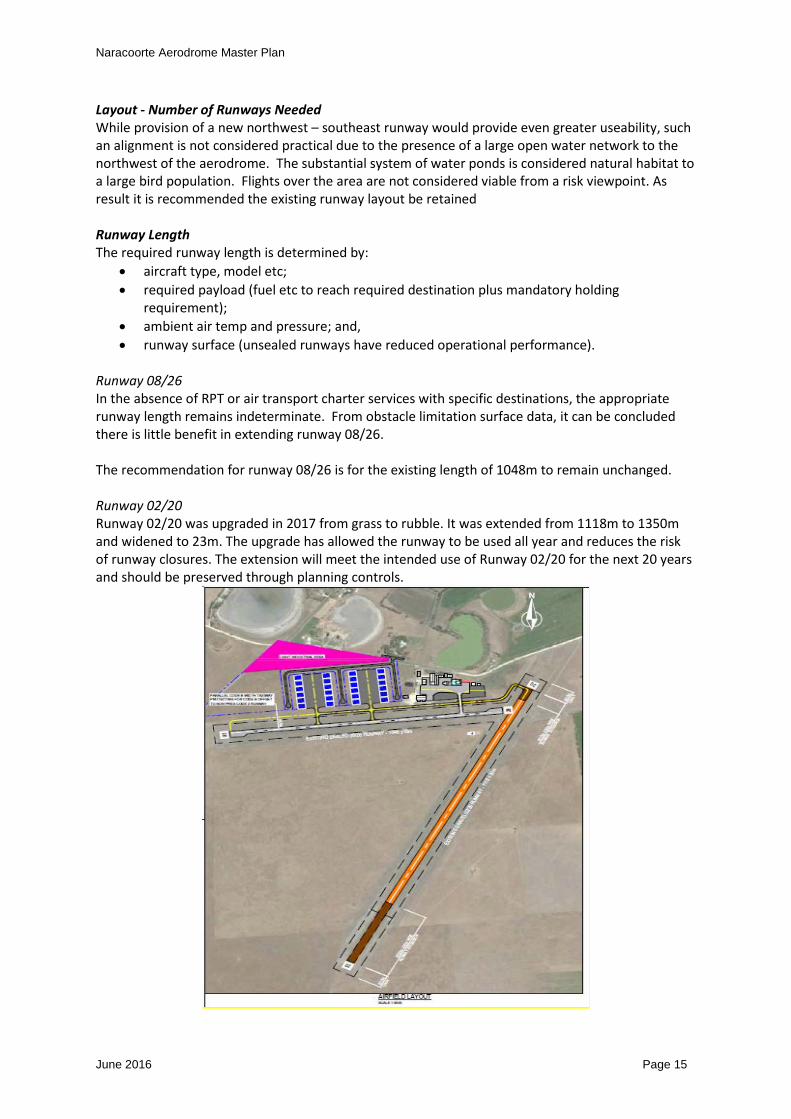
Runway 08/26 In the absence of RPT or air transport charter services with specific destinations, the appropriate runway length remains indeterminate. From obstacle limitation surface data, it can be concluded there is little benefit in extending runway 08/26. The recommendation for runway 08/26 is for the existing length of 1048m to remain unchanged. Runway 02/20 Runway 02/20 was upgraded in 2017 from grass to rubble. It was extended from 1118m to 1350m and widened to 23m. The upgrade has allowed the runway to be used all year and reduces the risk of runway closures. The extension will meet the intended use of Runway 02/20 for the next 20 years and should be preserved through planning controls.
Naracoorte Aerodrome Master Plan
June 2016 Page 16
5.4 Taxiways and Aprons
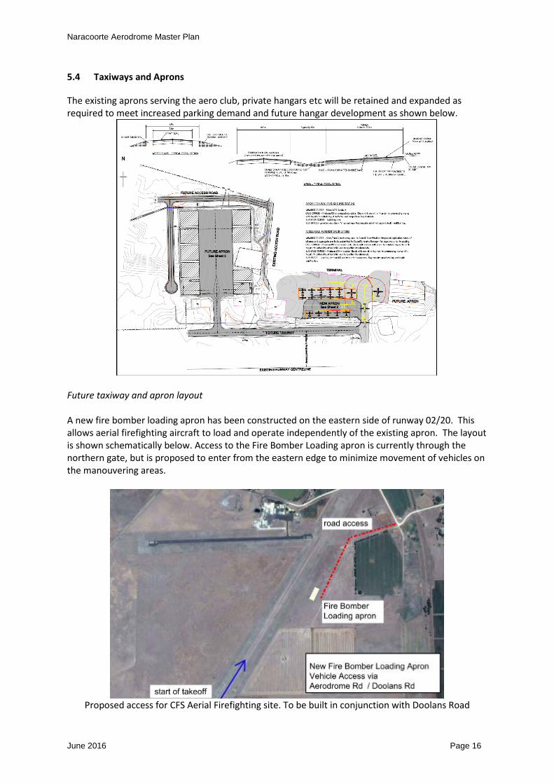
The existing aprons serving the aero club, private hangars etc will be retained and expanded as required to meet increased parking demand and future hangar development as shown below.
Future taxiway and apron layout A new fire bomber loading apron has been constructed on the eastern side of runway 02/20. This allows aerial firefighting aircraft to load and operate independently of the existing apron. The layout is shown schematically below. Access to the Fire Bomber Loading apron is currently through the northern gate, but is proposed to enter from the eastern edge to minimize movement of vehicles on the manouvering areas.
Proposed access for CFS Aerial Firefighting site. To be built in conjunction with Doolans Road

Naracoorte Aerodrome Master Plan
June 2016 Page 17
5.5 Navigation Systems
Naracoorte currently has a Global Navigation Satellite System GNSS (GPS) non-precision approach to the threshold of runway 26. In the long term it may be beneficial to provide a GNSS approach to runway 02/20, particularly in the case where future increases tree obstructions to the east of 08/26 make this runway difficult to maintain to the required instrument approach standard. The Council owned non directional beacon (NDB) was deemed as not required under the Air Services Australia Navigation Rationalisation Project and has subsequently has been decommissioned. There is currently no foreseeable requirement for a ground based navaid at Naracoorte.
5.6 Aviation Support and Landside Facilities
a) Passenger Terminal The existing aero club facilities provide an open area for training, offices and toilets etc. The current location is consistent with the required use of the facility. Sufficient space is available to the west and north of the building for future expansion / redevelopment as needed over the next 20 years. b) Security Requirements Current security regulations do not require passenger or baggage screening for closed charter aircraft operations. Where charters are open to the public and involve aircraft with a maximum weight in excess of 20 tonnes, dedicated screening areas are mandatory. Within the next 20 years, it is unlikely Naracoorte will service 20 tonne aircraft so it is unlikely there will be a need for passenger and baggage screening unless there is a significant change to the existing regulations. Increased security surveillance may be required in the form of additional lighting, and CCTV security monitoring, security standard fencing, monitored and controlled access through gates and buildings etc. Such provisions are unlikely to impact on the master planning layout for the aerodrome c) Refuelling facilities The location of the current Avgas 100 refuelling facilities east of the Aero Club is in an area that allows convenient access to light aircraft. The position is consistent with the foreseeable demand for refuelling with some additional space available if increased storage in the form of above ground tanks was required. With the increasing number of aircraft using Jet A1 fuel, including emergency aircraft, e.g. CFS, Medstar, consideration of a fuel sales licence is being sought by a private contractor to supply and sell Jet A1 fuel to operators using the Naracoorte Aerodrome. This fuel supply is on the western side of the apron. d) Aircraft hangars Based on past activity it is highly likely there will be ongoing demand for additional hangars within the master plan time frame. It is suggested (a) the existing hangars remain and (b) a new area for hangar development be provided to the west of the existing facilities. Survey and design has been completed, with construction of the taxiways to be done in 2018-19. e) Meteorological facilities The existing Bureau of Meteorology (BoM) facilities at Naracoorte currently comprises an automatic weather station AWS, but has no ceilometer or visibility meter. The BoM Review of Aerodrome Forecast Services for The Aviation Industry Final Report September 2014 recommended the Naracoorte TAF to cease as neither the annual passenger or movement numbers met required thresholds. From 2014 a TAF service would only be offered on a contractual basis. Since 2014, movement numbers have substantially increased and lobbying has commenced

Naracoorte Aerodrome Master Plan
June 2016 Page 18
for the reintroduction of the TAF Weather Service at Naracoorte. Discussions have included BOM, Naracoorte Aero Club, Local Member of Parliament. For master planning purposes the current BoM weather station site southwest of the intersection of the 2 runways can remain as the site is not required for any other use.
5.7 Airspace Protection Surfaces
Protection of airspace involves the provision of an obstacle limitation surface (OLS) plan and protections of Procedures of Air Navigation Operations PANS-OPS surfaces. Forming part of this master plan is the preparation of plans showing OLS and PANS ops protection of the lengthened 02/20 runway.
5.8 Aircraft Noise Contours
a) Australian Noise Exposure Forecasts At capital cities and major airports, information on aircraft noise has been provided using Australian Noise Exposure Forecasts (ANEF). Modelling of aircraft activity is used to produce ANEF noise contours which identify restriction of land uses according to the sensitivity of the nominated use. The Australian Standard AS 2021 Acoustics-Aircraft Noise Intrusion-Building Siting and Construction 2015 lists various land uses (e.g. houses through to heavy industrial areas) considered acceptable/unacceptable within the various ANEF contours as shown in the following extracted. Building Site Acceptability Based On ANEF Zones
ANEF zone of site
Building type Acceptable Conditionally acceptable Unacceptable
House, home unit, flat, caravan park
Less than 20 ANEF (Note 1)
20 to 25 ANEF (Note 2) Greater than 25 ANEF
NOTES:
1. The actual location of the 20 ANEF contour is difficult to define accurately, mainly because of variation in aircraft flight paths.
2. Within the 20 ANEF to 25 ANEF, some people may find that the land is not compatible with residential or educational uses. Land use authorities may consider that the incorporation of noise control features in the construction of residences or schools is appropriate. Ref AS 2021-2000
b) Single Event Contours Because the ANEF is a summation of the total noise over an average day, when applied at aerodromes with small numbers of aircraft movements the results are less than satisfactory, in that the ANEF contours barely go beyond the extent of the airport, whereas it is known aircraft noise will be heard over a far greater area and will, in some situations be considered intrusive. Even with higher traffic levels than expected it is unlikely Naracoorte would receive more than 4 flights per day by a large seat aircraft of say 50 seat capacity. This low level of activity would be insufficient to expand the area covered by the ANEF contours to effectively describe the areas subject to potential noise intrusion.
Naracoorte Aerodrome Master Plan
June 2016 Page 19
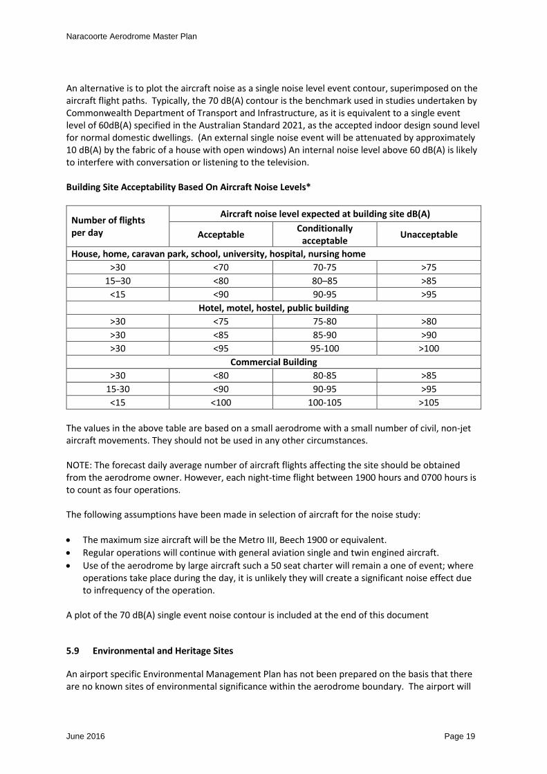
An alternative is to plot the aircraft noise as a single noise level event contour, superimposed on the aircraft flight paths. Typically, the 70 dB(A) contour is the benchmark used in studies undertaken by Commonwealth Department of Transport and Infrastructure, as it is equivalent to a single event level of 60dB(A) specified in the Australian Standard 2021, as the accepted indoor design sound level for normal domestic dwellings. (An external single noise event will be attenuated by approximately 10 dB(A) by the fabric of a house with open windows) An internal noise level above 60 dB(A) is likely to interfere with conversation or listening to the television. Building Site Acceptability Based On Aircraft Noise Levels*
Number of flights per day
Aircraft noise level expected at building site dB(A)
Acceptable Conditionally acceptable Unacceptable
House, home, caravan park, school, university, hospital, nursing home >30 <70 70-75 >75
15–30 <80 80–85 >85 <15 <90 90-95 >95
Hotel, motel, hostel, public building >30 <75 75-80 >80 >30 <85 85-90 >90 >30 <95 95-100 >100
Commercial Building >30 <80 80-85 >85
15-30 <90 90-95 >95 <15 <100 100-105 >105
The values in the above table are based on a small aerodrome with a small number of civil, non-jet aircraft movements. They should not be used in any other circumstances. NOTE: The forecast daily average number of aircraft flights affecting the site should be obtained from the aerodrome owner. However, each night-time flight between 1900 hours and 0700 hours is to count as four operations. The following assumptions have been made in selection of aircraft for the noise study: • The maximum size aircraft will be the Metro III, Beech 1900 or equivalent. • Regular operations will continue with general aviation single and twin engined aircraft. • Use of the aerodrome by large aircraft such a 50 seat charter will remain a one of event; where
operations take place during the day, it is unlikely they will create a significant noise effect due to infrequency of the operation.
A plot of the 70 dB(A) single event noise contour is included at the end of this document
5.9 Environmental and Heritage Sites
An airport specific Environmental Management Plan has not been prepared on the basis that there are no known sites of environmental significance within the aerodrome boundary. The airport will
Naracoorte Aerodrome Master Plan
June 2016 Page 20
be managed and developed in accordance with the Council Wide Provisions and objectives contained in the Development Plan 2012 in regards to the protection of the environment.
5.10 Heritage Management Plan
The Aerodrome does not contain any sites or items recognised on the formal heritage list. Accordingly, a Heritage Management Plan for the aerodrome has not been developed. The Van Leuven Memorial and gates are of value to the aero community and should be maintained.

Naracoorte Aerodrome Master Plan
June 2016 Page 21
6 LAND USE PLAN
6.1 Land Use Precincts
The land surrounding the aerodrome is zoned primary production. The adjacent land use zones are shown in the map below extracted from the NLC Development Plan 2012.
6.2 Land Use Precinct Guidelines
Building near Airfields OBJECTIVES 1 Development that ensures the long term operational, safety and commercial aviation
requirements of airfields (airports, airstrips and helicopter landing sites) continue to be met.

Naracoorte Aerodrome Master Plan
June 2016 Page 22
PRINCIPLES OF DEVELOPMENT CONTROL 1. The height and location of buildings and structures should not adversely affect the long term
operational, safety and commercial aviation requirements of airfields. 2. Buildings and structures that penetrate the obstacle limitation surfaces (OLS) should not be
developed unless a safety analysis determines that the building/structure does not pose a hazard to aircraft operations.
3. Development in the vicinity of airfields should not create a risk to public safety, in particular through any of the following: (a) lighting glare (b) smoke (c) air turbulence (d) storage of flammable liquids (e) attraction of birds (f) materials that affect aircraft navigational aids.
4. Lighting within 6 kilometres of an airport should be designed so that it does not pose a hazard to aircraft operations.
5. Development that is likely to increase the attraction of birds should not be located within 3 kilometres of an airport used by commercial aircraft. If located closer than 3 kilometres the facility should incorporate bird control measures to minimise the risk of bird strikes to aircraft.
6. Dwellings should not be located within areas affected by airport noise. 7. Development should not take place in the proximity to Naracoorte Aerodrome if the
development would be unduly affected by noise. 8. Development within areas affected by aircraft noise should be consistent with Australian
Standard AS2021 - Acoustics - Aircraft Noise Intrusion - Building Siting and Construction. Airfield Zone OBJECTIVES 1) A zone primarily accommodating aircraft operations, passenger terminals, airport and aviation-
related light industrial, service industrial, warehouse and storage purposes. 2) Development that contributes to the desired character of the zone. DESIRED CHARACTER Naracoorte Aerodrome is a valuable regional facility. Development will be compatible with the operation of the aerodrome which will also have the character of an enterprise zone to assist with freight forwarded by air and to enable industrial development compatible with the operations of the airfield. It is desirable to maintain the majority of the land in a single land parcel of land to assist with airfield management, however separate allotments under a community title scheme are encouraged to foster development of uses complementary to the aerodromes primary purpose. Development throughout the zone will be required to conform to CASA requirements to maintain the safety of the airport’s operation. It is envisaged that the airport will be developed for a range of air services including charter operations, flight training, access for the Royal Flying Doctor Service, aircraft maintenance and agricultural operations.

Naracoorte Aerodrome Master Plan
June 2016 Page 23
Development of an industrial nature which relates to the operation of the aerodrome, or may provide a commodity which requires transportation by air, is encouraged within the zone. Buildings will be sited and designed so as to not impact upon the safe operation of the aerodrome. PRINCIPLES OF DEVELOPMENT CONTROL Land Use 1) The following forms of development are envisaged in the zone:
• air passenger or air freight terminal • aircraft related facility • airport • fuel depot • light industry ancillary to and in association with aviation activities • recreation area • service industry ancillary to and in association with aviation activities • shop within the terminal building • warehouse ancillary to and in association with aviation activities.
2) Development listed as non-complying is generally inappropriate. 3) Development that would be adversely affected by noise and other hazards caused by airport
activities should not be undertaken in the zone. 4) Development should not impede the use of the zone for aviation purposes. Form and Character 5) Development should not be undertaken unless it is consistent with the desired character for the
zone. 6) Commercial and light industrial development located on the airport site should:
a) facilitate the more efficient operation of the airport b) be sited in defined clusters c) not adversely affect the amenity of surrounding land uses.
Land Division 7) Land should not be divided except for the realignment of allotment boundaries, where this
assists in the more efficient operation and use of the airport. 8) There should be no increase in the total number of allotments in the zone.
Naracoorte Aerodrome Master Plan
June 2016 Page 24
7 FACILITY DEVELOPMENT PLAN
7.1 Movement Area Facilities
1. Runway 08/26 will be retained 2. Runway 02/20 will be retained unsealed with limestone gravel. The runway has been extended
to the south, (a) to improve the approach takeoff clearances over trees to the north of the runway and (b) increase the height of aircraft when flying over built up areas.
3. A new taxiway connection has been provided to runway 02/20 4. The existing sealed apron has been expanded toward runway 08/26 5. A new apron supporting fire bomber refilling has been established on the eastern side of
Runway 02/20. 6. A new taxiway and apron system is being developed west of the current hangar facilities to
support future hangar development
7.2 Aviation Support Facilities
1. Provision for a future light industrial area to provide aviation workshops training facilities etc to be provided in the northern part of the aerodrome.
2. The present Aero Club location has been retained with allowance to expand the facility if needed for example to support expanded flying training schools
8 GROUND TRANSPORT PLAN
There is no anticipated change to the external road network. A new roadway will be needed to connect to the proposed apron hangar and light industrial area in the northwest part of the aerodrome. Existing internal roads will eventually require resealing, widening and geometric upgrades.
9 ENVIRONMENTAL MANAGEMENT PLAN
At this stage an aerodrome specific environmental management plan has not been prepared on the basis that there are no known sites of environmental significance located within the aerodrome boundary. The airport will be managed and developed in accordance with the general provisions and objectives contained in the Development Plan 2012 in regards to the protection of the environment.
10 HERITAGE MANAGEMENT PLAN
At this stage an aerodrome specific Heritage Management Plan has not been prepared on the basis that there are no known sites of archaeological or heritage significance within the aerodrome boundary.

Naracoorte Aerodrome Master Plan
June 2016 Page 25
11 AIRPORT SAFEGUARDING PLAN
11.1 National Airports Safeguarding Framework (NASF)
The National Airports Safeguarding Framework is a national land use planning framework that aims to:
• improve community amenity by minimising aircraft noise-sensitive developments near airports; and
• improve safety outcomes by ensuring aviation safety requirements are recognised in land use planning decisions through guidelines being adopted by jurisdictions on various safety-related issues.
The National Airports Safeguarding Advisory Group (NASAG), comprising of Commonwealth, State and Territory Government planning and transport officials, the Australian Government Department of Defence, the Civil Aviation Safety Authority (CASA), Airservices Australia and the Australian Local Government Association (ALGA), has developed the National Airports Safeguarding Framework (the Framework). The National Airports Safeguarding Framework was developed to provide guidance for Planners to consider potential impact of developments outside the airport on airport operations. Principles of the guideline will be considered in local planning processes when assessing a development application in the vicinity of Naracoorte Aerodrome. The purpose of the framework is to enhance the current and future safety, viability and growth of aviation operations by supporting and enabling:
• the implementation of best practice in relation to land use assessment and decision making in the vicinity of airports;
• assurance of community safety and amenity near airports; • better understanding and recognition of aviation safety requirements and aircraft noise • impacts in land use and related planning decisions; • the provision of greater certainty and clarity for developers and land owners; • improvements to regulatory certainty and efficiency; and • the publication and dissemination of information on best practice in land use and related
planning that supports the safe and efficient operation of airports. NASF PRINCIPLES Principle 1. The safety, efficiency and operational integrity of airports should be protected by all governments, recognising their economic, defence and social significance. Principle 2. Airports, governments and local communities should share responsibility to ensure that airport planning is integrated with local and regional planning. Principle 3. Governments at all levels should align land use planning and building requirements in the vicinity of airports. Principle 4. Land use planning processes should balance and protect both airport/aviation operations and community safety and amenity expectations. Principle 5. Governments will protect operational airspace around airports in the interests of both aviation and community safety.

Naracoorte Aerodrome Master Plan
June 2016 Page 26
Principle 6. Strategic and statutory planning frameworks should address aircraft noise by applying a comprehensive suite of noise measures. Principle 7. Airports should work with governments to provide comprehensive and understandable information to local communities on their operations concerning noise impacts and airspace requirements. NASF GUIDELINES Over the long term, inappropriate development around airports can result in unnecessary constraints on airport operations and negative impacts on community amenity due to the effects of aircraft noise. These impacts need to be managed in a balanced and transparent way. Guideline A provides advice on the use of a complementary suite of noise metrics, to inform planners and provide communities with comprehensive and understandable information about aircraft noise. Guideline B presents a layered risk approach to the siting and design of buildings near airport runways to assist land use planners and airport operators to reduce the risk of building - generated windshear and turbulence. It also provides options to modify existing buildings. Guideline C provides advice to help protect against wildlife hazards originating off-airport through appropriate land use planning decisions and the way in which existing land use is managed in the vicinity of airports. Guideline D provides advice on the location and safety management of wind turbines and other similar structures which can constitute a risk to low-flying aviation operations and can also affect the performance of Communications, Navigation equipment operated by Airservices Australia. Guideline E provides advice on ensuring lighting in the vicinity of airports is not configured so as to cause distraction or confusion to pilots Guideline F provides advice for planners and decision makers about working within and around protected airspace, including obstacle limitation surface (OLS) and Procedures for Air Navigation Services (PANS-OPS) intrusions, and how these can be better integrated into local planning processes.
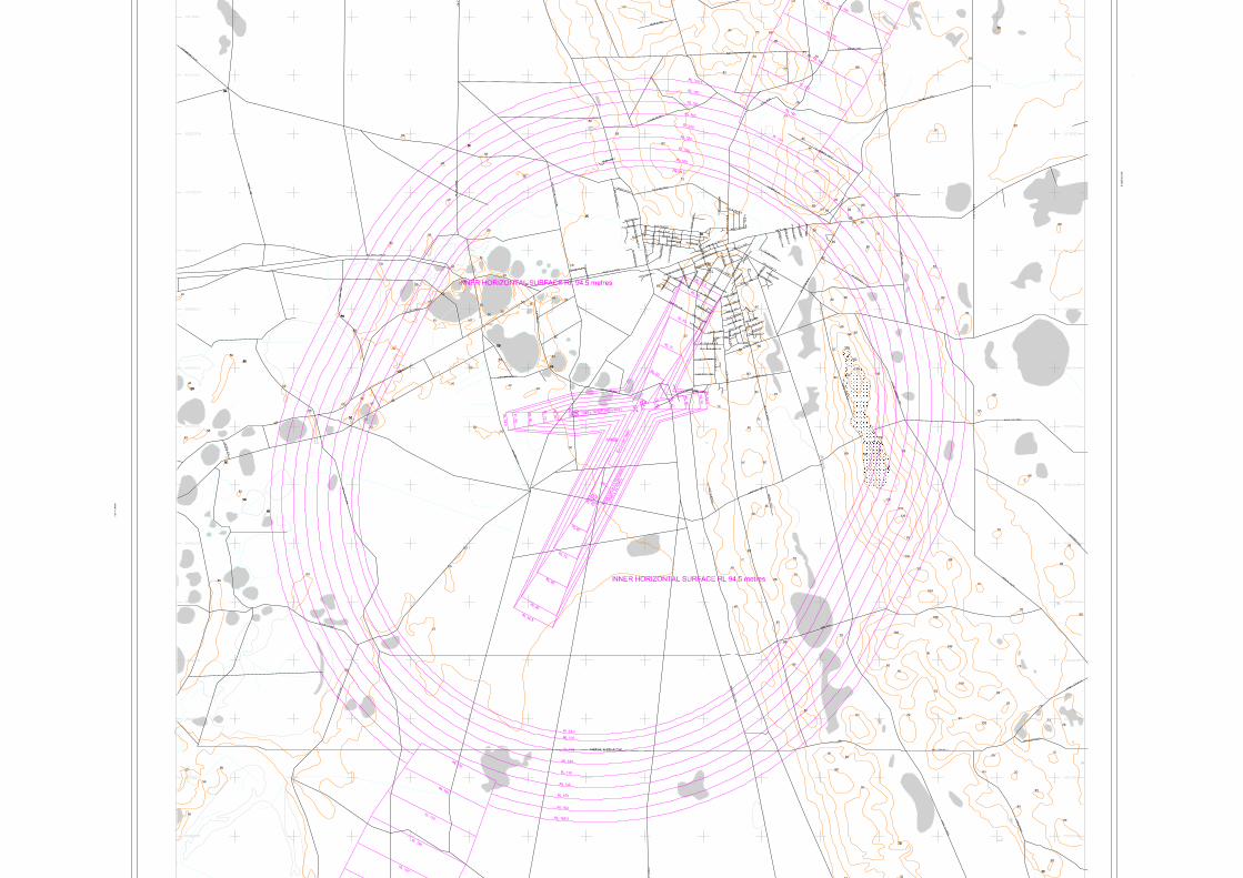
11.2 Airspace Protection Surfaces
Obstacle Limitation Surface Plan. An airport OLS has been developed for Naracoorte for the protection of the 2 runways. The OLS plans protect for the existing 08/26 runway configuration and a future extension of runway 02/20. Naracoorte allowing for non-precision approaches to all runways and an extended PANS OPS Naracoorte has straight in approach Area Navigation Global Navigation Satellite System (RNAV GNSS) procedures for runway 08. The clearance surfaces associated with these procedures are covered by the OLS parameters.
Naracoorte Aerodrome Master Plan
June 2016 Page 27
For long term planning consideration, it is possible GPS non-precision approaches could be applied to the remaining 3 runways. The future OLS has been incorporated the design requirements for a GPS approach to all runway ends.
11.3 Aircraft Noise Contours
Australian Noise Exposure Forecasts have not been prepared for Naracoorte on the basis that the frequency of aircraft movements and the type of aircraft flying are not sufficient to generate a meaningful ANEF even using the most optimistic forecasts. Instead single event noise contours have been generated using modelling data for the largest aircraft types likely to use Naracoorte in the next 20 years.
11.4 Planning Policies and Controls
Planning policies and controls relating to safeguarding of the airport are contained within the NLC Development 2012. The planning provisions of this Master Plan are in agreement with the principles and objectives contained in NLC Development Plan 2012. The Master Plan also takes into account State, Regional and Local Government strategic directions, planning policies and legislative framework.
Naracoorte Aerodrome Master Plan
June 2016 Page 28
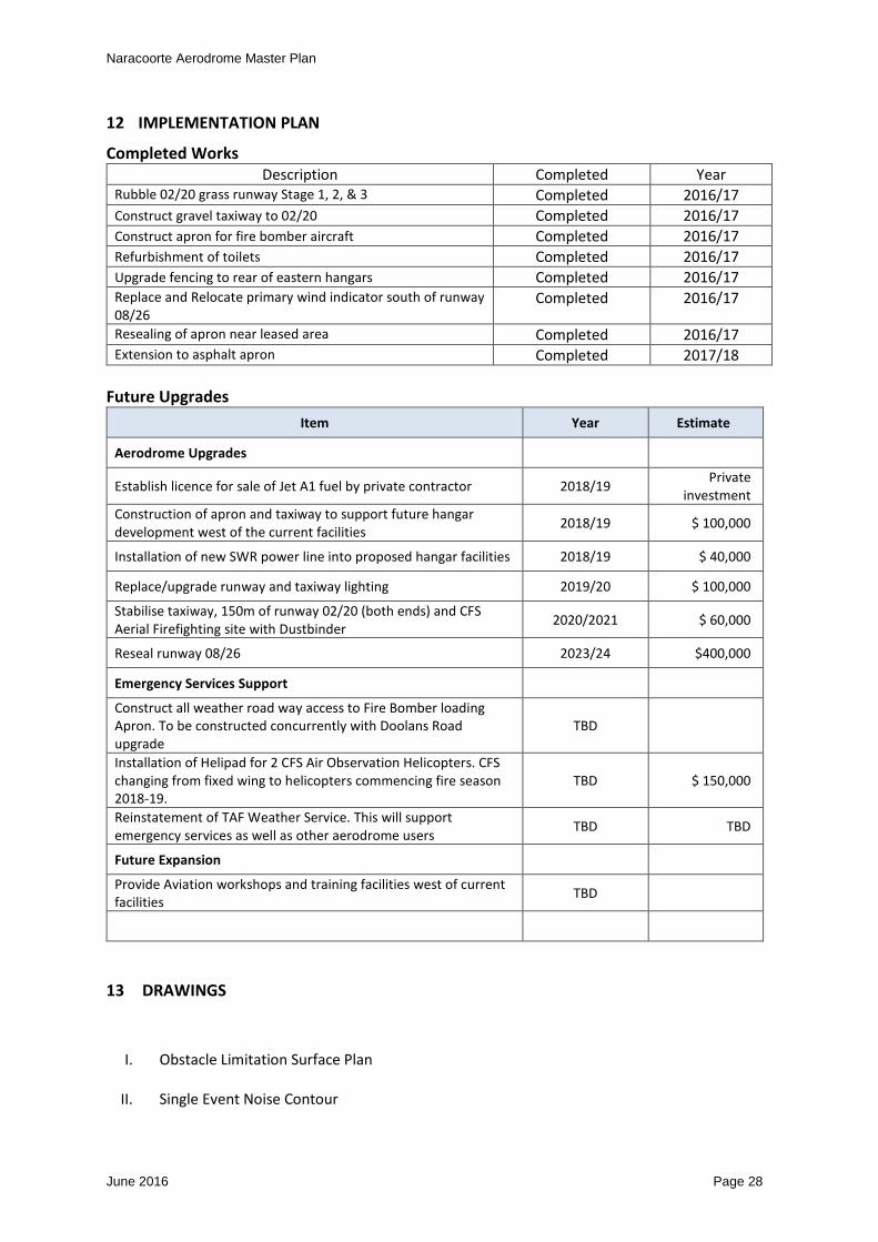
12 IMPLEMENTATION PLAN
Completed Works Description Completed Year
Rubble 02/20 grass runway Stage 1, 2, & 3 Completed 2016/17 Construct gravel taxiway to 02/20 Completed 2016/17 Construct apron for fire bomber aircraft Completed 2016/17 Refurbishment of toilets Completed 2016/17 Upgrade fencing to rear of eastern hangars Completed 2016/17 Replace and Relocate primary wind indicator south of runway 08/26
Completed 2016/17
Resealing of apron near leased area Completed 2016/17 Extension to asphalt apron Completed 2017/18
Future Upgrades
Item Year Estimate
Aerodrome Upgrades
Establish licence for sale of Jet A1 fuel by private contractor 2018/19 Private investment
Construction of apron and taxiway to support future hangar development west of the current facilities 2018/19 $ 100,000
Installation of new SWR power line into proposed hangar facilities 2018/19 $ 40,000
Replace/upgrade runway and taxiway lighting 2019/20 $ 100,000
Stabilise taxiway, 150m of runway 02/20 (both ends) and CFS Aerial Firefighting site with Dustbinder 2020/2021 $ 60,000
Reseal runway 08/26 2023/24 $400,000
Emergency Services Support
Construct all weather road way access to Fire Bomber loading Apron. To be constructed concurrently with Doolans Road upgrade
TBD
Installation of Helipad for 2 CFS Air Observation Helicopters. CFS changing from fixed wing to helicopters commencing fire season 2018-19.
TBD $ 150,000
Reinstatement of TAF Weather Service. This will support emergency services as well as other aerodrome users TBD TBD
Future Expansion
Provide Aviation workshops and training facilities west of current facilities TBD
13 DRAWINGS
I. Obstacle Limitation Surface Plan
II. Single Event Noise Contour

Naracoorte Aerodrome Master Plan
June 2016 Page 29
III. 20 year Master Plan
Asus N61
Line
Asus N61
Line
Asus N61
Text Box
NARACOORTE - SA AERODROME OLS PLAN DRAWING STATUS For Information Extracted from DC Naracoorte OLS Plan 2002 Level Datum AHD

Asus N61
Text Box
NARACOORTE AERODROME SINGLE EVENT 70dB(A) NOISE CONTOUR Regional Turbo Prop Data extracted from AS 2021
Asus N61
Rectangle
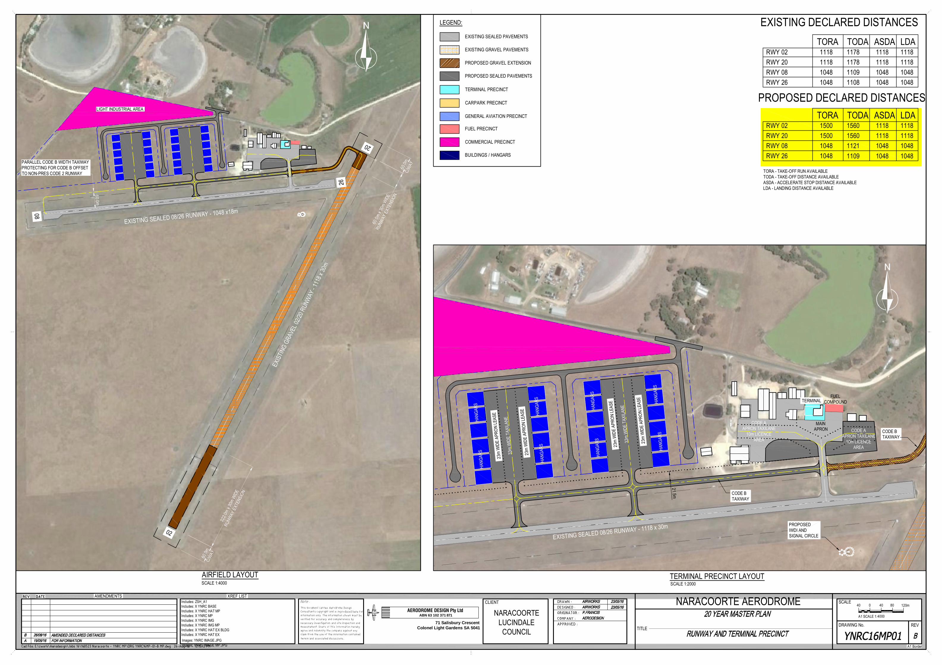
LEGEND:
EXISTING SEALED PAVEMENTS
EXISTING GRAVEL PAVEMENTS
PROPOSED SEALED PAVEMENTS
TERMINAL PRECINCT
FUEL PRECINCT
COMMERCIAL PRECINCT
CARPARK PRECINCT
GENERAL AVIATION PRECINCT
BUILDINGS / HANGARS
PROPOSED GRAVEL EXTENSION
EXISTING SEALED 08/26 RUNWAY - 1048 x18m
20
60.0m
C/WAY
322.0
m x 3
0m W
IDE
RUNW
AY E
XTEN
SION
60.0m
C/WAY
60.0m
x 30
m W
IDE
RUNW
AY E
XTEN
SION
EXIST
ING
GRAV
EL 02
/20 R
UNW
AY - 1
118 x
30m
26
02
08
LIGHT INDUSTRIAL AREA
60.0m
PARALLEL CODE B WIDTH TAXIWAYPROTECTING FOR CODE B OFFSETTO NON-PRES CODE 2 RUNWAY
23m
WID
E AP
RON
LEAS
E
33m
WID
E TA
XILA
NE
HANG
ARS
HANG
ARS
23m
WID
E AP
RON
LEAS
E
23m
WID
E AP
RON
LEAS
E
33m
WID
E TA
XILA
NE
HANG
ARS
HANG
ARS
23m
WID
E AP
RON
LEAS
E
HANG
ARS
HANG
ARS
HANG
ARS
HANG
ARS
TERMINAL
EXISTING SEALED 08/26 RUNWAY - 1118 x 30m
FUELCOMPOUND
CODE AAPRON TAXILANE
10m LICENCEAREA
CODE AAPRON TAXILANE
10m LICENCEAREA
MAINAPRON
CODE BTAXIWAY
CODE BTAXIWAY
PROPOSEDIWDI ANDSIGNAL CIRCLE
21.5m
TITLEDRAWING No. REV
SCALEXREF LISTAMENDMENTS
A1 Border
CLIENT
AERODROME DESIGN Pty LtdABN 63 102 371 871
71 Salisbury CrescentColonel Light Gardens SA 5041
Includes: ZSH_A1Includes: X YNRC BASEIncludes: X YNRC HAT MPIncludes: X YNRC MPIncludes: X YNRC IMGIncludes: X YNRC IMG MPIncludes: X YNRC HAT EX BLDGIncludes: X YNRC HAT EXImages: YNRC IMAGE.JPGImages: YNRC IMAGE MP.JPG
NARACOORTE AERODROMENARACOORTE
LUCINDALECOUNCIL
0
A1 SCALE 1:4000
120m804040
TORA TODA ASDA LDARWY 02 1118 1178 1118 1118RWY 20 1118 1178 1118 1118RWY 08 1048 1109 1048 1048RWY 26 1048 1108 1048 1048
EXISTING DECLARED DISTANCES
AIRFIELD LAYOUT TERMINAL PRECINCT LAYOUTSCALE 1:4000 SCALE 1:2000
PROPOSED DECLARED DISTANCES TORA TODA ASDA LDA
RWY 02 1500 1560 1118 1118RWY 20 1500 1560 1118 1118RWY 08 1048 1121 1048 1048RWY 26 1048 1109 1048 1048
TORA - TAKE-OFF RUN AVAILABLETODA - TAKE-OFF DISTANCE AVAILABLEASDA - ACCELERATE STOP DISTANCE AVAILABLELDA - LANDING DISTANCE AVAILABLE