Nantasket Beach Reservation Master Plan - Mass. · PDF fileNantasket Beach Reservation Master...
47
Nantasket Beach Reservation Master Plan DCR Public Meeting September 22, 2014 – 7:00-8:30 p.m. Nantasket Beach Resort, 45 Hull Shore Drive
Transcript of Nantasket Beach Reservation Master Plan - Mass. · PDF fileNantasket Beach Reservation Master...

Nantasket Beach Reservation Master Plan
DCR Public Meeting
September 22, 2014 – 7:00-8:30 p.m. Nantasket Beach Resort, 45 Hull Shore Drive
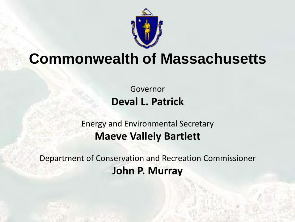
Commonwealth of Massachusetts
Governor Deval L. Patrick
Energy and Environmental Secretary
Maeve Vallely Bartlett
Department of Conservation and Recreation Commissioner John P. Murray

DCR Mission Statement
To protect, promote and enhance our common wealth of natural, cultural and
recreational resources for the well-being of all.

Purpose of Meeting • As the culmination of
the Master Planning Process, to present DCR’s proposed Master Plan for the Nantasket Beach Reservation and to obtain feedback.

Reservation Overview Cook Comfort Station
Nantasket Beach
Nantasket Beach Resort
Mary Jeanette Murray Bath House
Bernie King Pavilion
Tivoli Bath House
DCR Operations & Maintenance Facilities
Atlantic Hill Condominium
Horizons Condominiums Sunset Place Condominiums
Paragon Carousel & Clock Tower
Comfort Station Nantasket Pier
• 26 Acres • 1.3 miles of beachfront • 35,200 annual passes/daily hangtags sold in 2013 (does not include seniors & HRA lots)
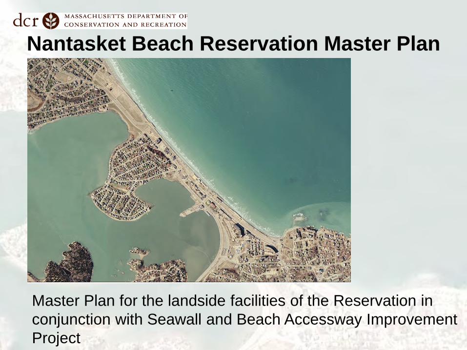
Nantasket Beach Reservation Master Plan
Master Plan for the landside facilities of the Reservation in conjunction with Seawall and Beach Accessway Improvement Project
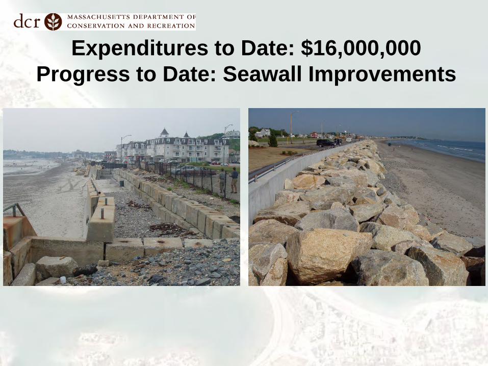
Expenditures to Date: $16,000,000 Progress to Date: Seawall Improvements

Progress to Date: Ramps and Stairs

Progress to Date: Sidewalks & Railings

Progress to Date: Reconstruction of Bernie King Pavilion

Progress to Date: Bath Houses
• Shade structures & playground at Mary Jeanette Murray Bath House
• Interior improvements at Mary Jeanette Murray Bath House, Tivoli Bath House & Cook Comfort Station

Master Plan Goals Provide an enhanced natural and recreational experience at Nantasket Beach, with: • attractive amenities to support
a wide range of activities, • safe and convenient access for
pedestrians, cyclists, transit and ferry passengers and automobile users, and
• connections to adjacent bicycle paths and parking areas, as well as commercial and entertainment opportunities.

Public Process MTG NO. DATE
TOPIC
Seawall/Shore Protection Alternatives
Master Plan Traffic/Civil Engineering (upland)
Citizen Advisory Committee (CAC) Meetings 1 12 Oct. 2006
2 29 Nov. 2006
3 31 Jan. 2007
4 13 Jun. 2007
5 15 Mar. 2008
6 17 Nov. 2008
7 1 Dec. 2008
Town of Hull – Board of Selectmen Meetings 1 14 Nov. 2006
2 24 Feb. 2009
3 21 May 2013
Town of Hull – Master Plan Coordination Meetings 1 9 Jun. 2014
2 24 Jun. 2014
Meetings with Executive Office of Energy and Environmental Affairs 1 4 Oct. 2006
2 2 Nov. 2006

2006 User Survey
• 99 out of 101 would come again
• 72% went swimming; most planned to later
• 91% came by car • 16% from Quincy, 13% from
Boston, 11% from Hull
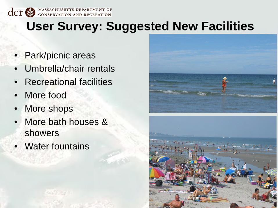
User Survey: Suggested New Facilities
• Park/picnic areas • Umbrella/chair rentals • Recreational facilities • More food • More shops • More bath houses &
showers • Water fountains

The Master Plan
• New open space: 1.53 acres including 1.05 acre Nantasket Green • Continuous boardwalk with shade shelters & vendor spaces: 2.68 acre boardwalk • Continuous bike lane: 1.3 miles • More protected locations for Cook Comfort Station & Tivoli Bath House • Expanded playgrounds • Improved plazas • New landscaping: 1.39 acres • Improved operations & maintenance area • Enhanced vehicular/pedestrian access & circulation & parking • New interpretive opportunities • Introduction of wayfinding & signage program • Phasing

South Area
POTENTIAL RECREATION AREA
• Boardwalk & bike lane • More protected location
for Tivoli Bath House • Reconfigured parking
lots • Pedestrian path from
remote lot • New shade structures &
picnic tables • New vendor pavilion

Boardwalk/Promenade
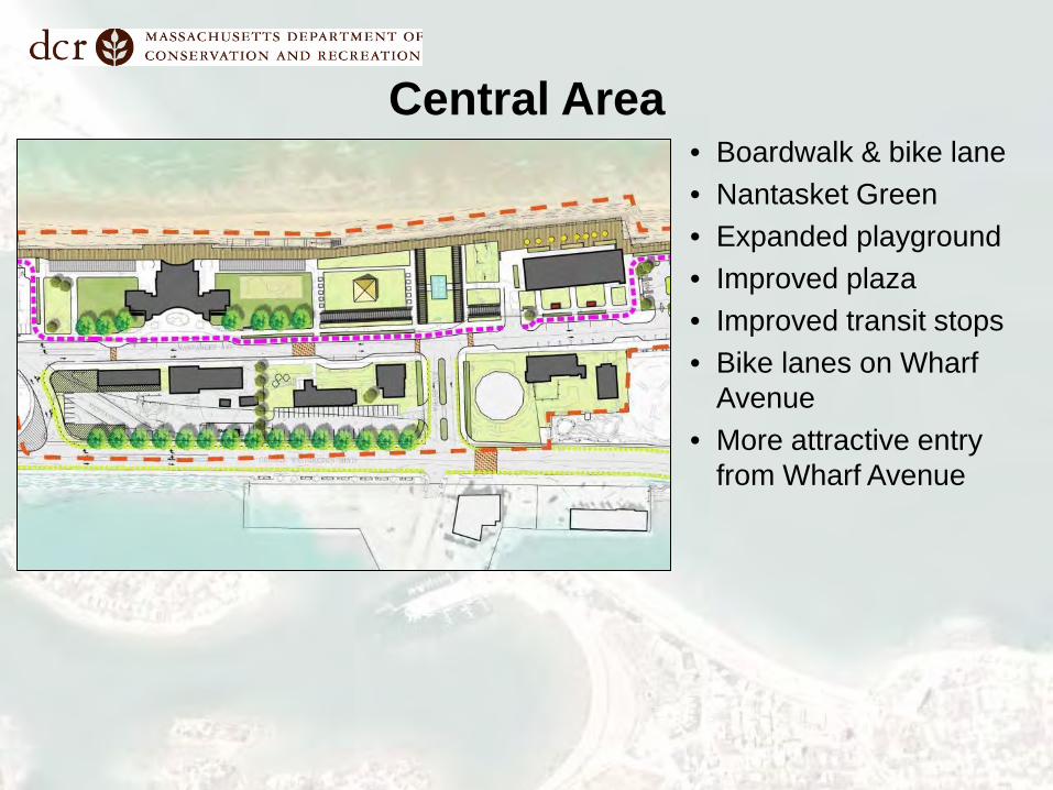
Central Area • Boardwalk & bike lane • Nantasket Green • Expanded playground • Improved plaza • Improved transit stops • Bike lanes on Wharf
Avenue • More attractive entry
from Wharf Avenue
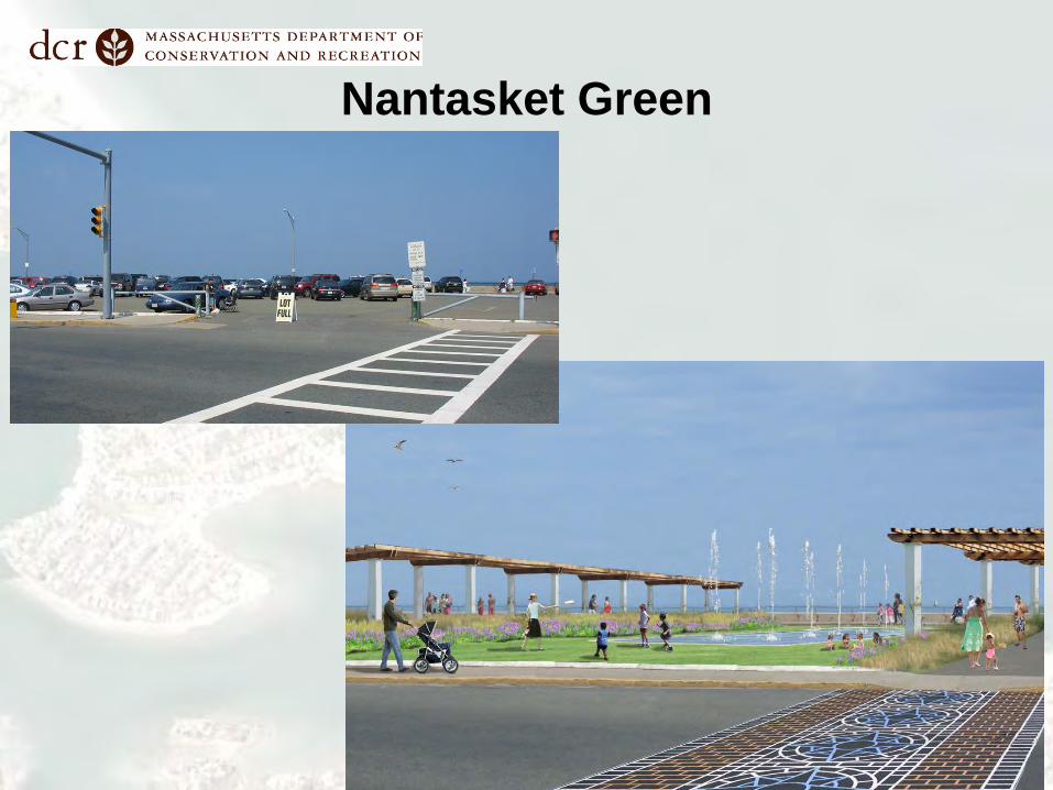
Nantasket Green

Promenade at Bernie King Pavilion

Water Street to Bay Street

Water Street to Bay Street
Existing 10’ promenade shown with red line
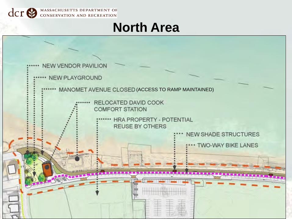
North Area
(ACCESS TO RAMP MAINTAINED)

Operations & Maintenance Area
• Expanded & more efficient Operations/Maintenance Yard • Expanded Upper Garage to better accommodate vehicles • Improved internal circulation • Allows potential reuse/lease of Dormitory and Police Station
Buildings & buffers them from operations/maintenance facilities

Reuse Options: Dormitory Building
• Could be used by DCR as a headquarters for the youth program Student Conservation Association: – first floor office space – second floor rooming
for students participating in program.
• Could also be leased to another entity

Reuse Options: Police Station
• DCR Visitor’s Center and/or office space.
• Leased to other entity
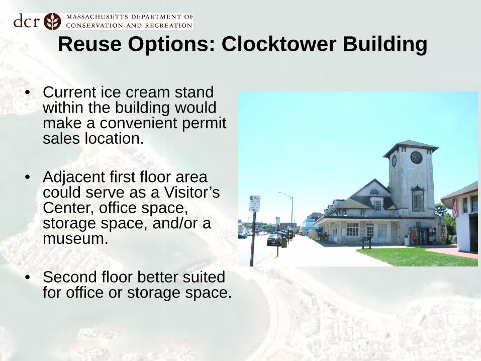
Reuse Options: Clocktower Building
• Current ice cream stand within the building would make a convenient permit sales location.
• Adjacent first floor area
could serve as a Visitor’s Center, office space, storage space, and/or a museum.
• Second floor better suited for office or storage space.

Transportation • Pedestrian – improved pedestrian environment • Bicycles – bicycle lane and racks, connection to George
Washington Boulevard • Transit – new transit stops/shelters, bus parking & better
schedule coordination

Transportation: Vehicular

Parking
• Variable message signage, more efficient layouts, landscaping, opening of pedestrian link to remote lots, potential covered/solar power lot
• Existing: 1405 spaces • Proposed: 1325 spaces with solar
powered covered parking; 1365 spaces without solar powered covered parking (includes 10 bus spaces)
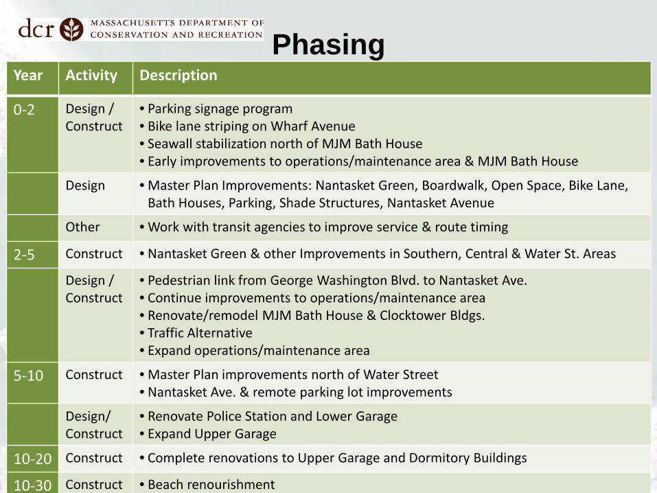
Phasing Year Activity Description
0-2 Design / Construct
• Parking signage program • Bike lane striping on Wharf Avenue • Seawall stabilization north of MJM Bath House • Early improvements to operations/maintenance area & MJM Bath House
Design • Master Plan Improvements: Nantasket Green, Boardwalk, Open Space, Bike Lane, Bath Houses, Parking, Shade Structures, Nantasket Avenue
Other • Work with transit agencies to improve service & route timing
2-5 Construct • Nantasket Green & other Improvements in Southern, Central & Water St. Areas
Design / Construct
• Pedestrian link from George Washington Blvd. to Nantasket Ave. • Continue improvements to operations/maintenance area • Renovate/remodel MJM Bath House & Clocktower Bldgs. • Traffic Alternative • Expand operations/maintenance area
5-10 Construct • Master Plan improvements north of Water Street • Nantasket Ave. & remote parking lot improvements
Design/ Construct
• Renovate Police Station and Lower Garage • Expand Upper Garage
10-20 Construct • Complete renovations to Upper Garage and Dormitory Buildings
10-30 Construct • Beach renourishment

Future Stabilization Projects
• Installation of a stone revetment to stabilize the existing seawall segment from the Mary Jeanette Murray Bath House north to Water Street. (Fall 2015)
• Beach Renourishment

Shore Protection Studies
• Army Corps of Engineers Coastal Protection Alternative Analysis – Recommended Beach Nourishment from off shore
source • Louis Berger/Woods Hole Group Coastal
Protection Alternative Analysis – Recommended toe protection for seawall stabilization
and Beach Nourishment from off shore source • Army Corps of Engineers Seawall Stabilization
Alternative Analysis – Recommended toe protection for seawall stabilization

Technical Team Recommended Alternative Sand Renourishment with Toe Protection
Need for sand source for nourishment • All reasonable alternatives include nourishment • Offshore sand source
• Permitting timeline and concern relative to other failures in MA
• Upland sand source • Expensive, long construction time, and leaves Nantasket exposed until
enough sand can provide adequate protection for the seawall.
• Any sand source leaves wall exposed over next years
• Offshore source: Will take years to permit and get approval. • Upland sources: Will take years to construct. • In the Meantime: Seawall is exposed to storms. Without some sort of
seawall fortification, the seawall will remain at risk for the next few years if sand nourishment alone is the solution.

Seawall Stability Analysis by USACE (Feb. 18, 2004)
“The stability analysis showed that the seawall’s condition is inadequate to resist the soil and water pressures behind the wall, ranging from a no-storm condition to a 100-year storm event. This instability of the seawall is caused by the lack of passive resistance resulting from the continued loss of sand in front of the seawall. The stability analysis also indicates, that to provide adequate passive resistance, sand fill to Elevation 7 feet is required for a no-storm condition and Elevation 9 feet for a 100-year storm event.”

5
6
7
8
9
10
11
2 days after Hurricane Sandy
Beach Elevation – Mid-Section of Seawall
• Continuous quarterly monitoring since 2006
• Elevation of sand is highly variable
• Lowest beach elevation along seawall mid-section has decreased by one foot (on average) since 2006
Average Elevation along Seawall
Lowest Elevation along Seawall
9 ft
7 ft

FEMA VE ZONE
Existing FEMA VE Flood Zone (left panel) and potential FEMA VE Flood Zone with the seawall collapse (right panel).

Sept. 10 Sept. 15
Galveston – Hurricane Ike Sept. 12, 2008 (Source: USGS)
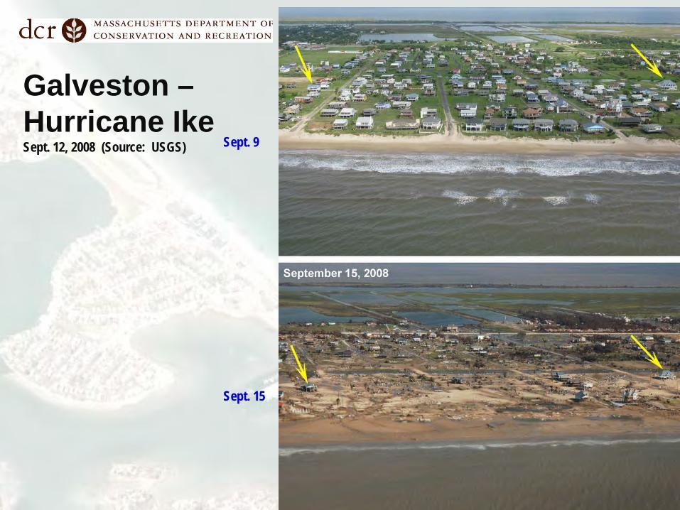
Sept. 9 Sept. 15
Galveston – Hurricane Ike Sept. 12, 2008 (Source: USGS)

Toe Protection for Mid-section of Seawall
First Step for Beach Nourishment with Sand
(Preferred Alternative for Shore Protection following Alternatives Analysis, 2006-2008)
Existing Toe Protection in Southern Section of Seawall during Nor’easter in March 2010

Toe Protection for Mid-Section of Seawall Construction Planned for Fall 2015
Previous stabilization solution was collaborative design between DCR, USACE, Town of Hull and their consultants
Schematic – Not-to scale
8’ - 6” 27’ - 0” 5’ - 6”

Beach Elevations – Southern Section of Seawall
• In December of 2003,
beach erosion severely weakened southerly section of the seawall.
• Monitoring of beach elevations in front of the existing STP have remained relatively constant (on average) and much higher than before STP was built.
• Mean elevation of the 11 individual transects is shown in red.
1
2
3
4
5
6
7
8
9
Jan-04 Jan-05 Jan-06 Jan-07 Jan-08 Jan-09 Jan-10 Jan-11 Jan-12 Jan-13
Elev
atio
n (f
eet
NG
VD
29)
Survey Date
Elevation of Seaward Edge of STP - Southern Nantasket Beach
70+30 69+30 68+30 67+30
66+30 65+30 64+30 63+30
62+30 61+30 53+30 Mean
Elevation at base of Seawall before TSF Construction
Pre- Post- TSF Construction
Next Steps
• DCR will receive comments on the Master Plan until October 22, 2014
• Final will report will be prepared and released in December 2014.

Additional Information For more information:
–Web: http://www.mass.gov/eea/agencies/dcr/public-outreach/public-meetings/
If you have comments:
Email: [email protected], noting “Nantasket Beach Master Plan” in the subject line Call: 617-626-4974 Write: Department of Conservation and Recreation, Office of Public Outreach, 251 Causeway Street, Suite 600, Boston, MA 02114 Note: Public comments submitted to DCR by email or letter may be posted on the DCR website in their entirety, and no content, including personal information, will be redacted.
If you have questions or concerns or would like to be added to an email list to receive DCR general announcements:
Email: [email protected] Call: 617-626-4973

Additional Studies
• Nantasket Beach Seawall Repair and Reservation – Master Plan Services – Existing Infrastructure, The Louis Berger Group, Inc., 2007.
• Nantasket Beach Reservation Traffic Analysis Report, The Louis Berger Group, Inc., 2014.
• Nantasket Beach Reservation Facilities Utilization Report, The Louis Berger Group, Inc., 2014.
• Nantasket Beach Seawall Repair and Reservation Master Plan Services Coastal Engineering and Shore Protection Alternatives Assessment. Final Report. Woods Hole Group, Inc. and The Louis Berger Group, Inc., 2010.

Q&A/Discussion