Author: Carol S. King Presenter: Ruth E. Detlefsen Service Sector Statistics Division

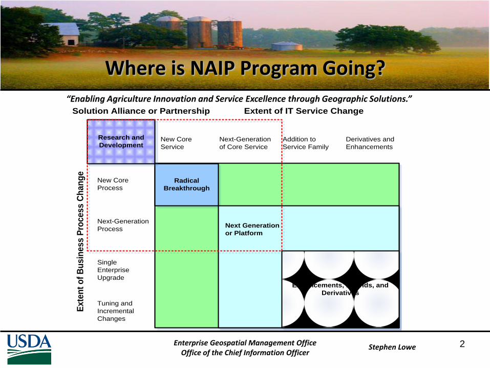
“Enabling Agriculture Innovation and Service Excellence through Geographic Solutions.”
Stephen LoweEnterprise Geospatial Management Office
Office of the Chief Information Officer
NAIP Business Model Innovations:Concepts and Implementation
Stephen Lowe
Geospatial Information Officer
US Department of Agricultural
December 2011
“Enabling Agriculture Innovation and Service Excellence through Geographic Solutions.”
Stephen Lowe 2
Where is NAIP Program Going?
Tuning and
Incremental
Changes
Single
Enterprise
Upgrade
Next-Generation
Process
New Core
Process
New Core
Service
Next-Generation
of Core Service
Addition to
Service Family
Derivatives and
Enhancements
Ex
ten
t o
f B
us
ine
ss
Pro
ce
ss
Ch
an
ge
Extent of IT Service Change
Radical
Breakthrough
Next Generation
or Platform
Enhancements, Hybrids, and
Derivatives
Research and
Development
Solution Alliance or Partnership
Enterprise Geospatial Management OfficeOffice of the Chief Information Officer

“Enabling Agriculture Innovation and Service Excellence through Geographic Solutions.”
Stephen Lowe
What are Components of Business Models?
• Identify a market segment; users and purpose of use
• Articulate the value proposition of the offering
• Define the value chain to deliver the offering
• Create a way to get paid through cost structure
• Establish the value network needed to sustain the model
• Models represent the dominate structure used to conduct enterprise operations in a marketplace and preserve competitive advantage. They perform two key functions:
– Creates value by defining a series of activities that deliver products and services to end consumers
– Captures value by maintaining unique resources, assets, or positions within a series of activities
Enterprise Geospatial Management OfficeOffice of the Chief Information Officer

“Enabling Agriculture Innovation and Service Excellence through Geographic Solutions.”
Stephen Lowe
Traditional APFO Business Models
• Broker/Intermediary Model:
– Coordinate industry supply and consumer demand activities to satisfy requirements, e.g. data set acquisition
• Transformer Model:
– Change value of product by codifying data, standardizing format, and optimizing consumer access, e.g. aerial and satellite imagery supporting CLU
• Value Chain Model:
– Process (assembly) integration of products and/or services to meet specific consumer needs, e.g. science, research, policy, disaster response, performance measurement….
Enterprise Geospatial Management OfficeOffice of the Chief Information Officer

“Enabling Agriculture Innovation and Service Excellence through Geographic Solutions.”
Stephen Lowe 5
IFTN Managing Partner NAIP Solutions
• FY 2012 Base Year
– Phase 1 IFTN Delivery
– Drive down unit costs
– Reduce time-to-market
– Build analytics capability
– Optimize existing business model & markets:
• Federal
• State
– Identify residual demand:
• Constituent
• Academic
• Local
• Tribal
• Out Years 2013-2016
– Enhance APFO Offerings
– Extend IFTN Services
– Expand IFTN Products
– Open/Create new markets:
• Commercial Industry
• NGO
• Actuarial
• Litigation
• News Media
• IT Innovation Testing
• Cross-sell other USDA Products & Services
• Government Mashups
Enterprise Geospatial Management OfficeOffice of the Chief Information Officer

“Enabling Agriculture Innovation and Service Excellence through Geographic Solutions.”
Stephen Lowe 6
Complex Strategic Challenges
• Business model maturity and fit to demand
• Tension between balancing strategic direction
• Unknown customer experience and product use
• Develop the means of sustaining program growth
• Adoption of new business model(s)
Enterprise Geospatial Management OfficeOffice of the Chief Information Officer

“Enabling Agriculture Innovation and Service Excellence through Geographic Solutions.”
Stephen Lowe 7
Chesbrough Diagnostic: Model Maturity Stages
Enterprise Geospatial Management OfficeOffice of the Chief Information Officer
Platform-Ecosystem
http://www.youtube.com/watch?v=2UDBaDtwXfI

“Enabling Agriculture Innovation and Service Excellence through Geographic Solutions.”
Stephen Lowe8Enterprise Geospatial Management Office
Office of the Chief Information Officer
Business Model Strategic Direction
Operational Excellence Customer Intimacy Product Leadership
Focus Information ProcessingReliable ProductsMinimize Costs, ObstaclesStandardize, Simplify, CentralizeReliability, high-speed transactionsLimited product variety and customer segmentation
Relationship BuildingShare KnowledgeCustomer ServiceExpert at Customer’s BusinessCentralizationDetailed SystemsExtensive HR investmentResponsiveness
Innovation, Continuous ImprovementFluid OrganizationBest PerformancePeople Capability Maturity
Culture Tight ManagementEfficiency orientedStandardization Information technologyHigh Quality
Strong client-oriented cultureTraining, Talent are hallmarksAdaptable, Flexible, Multi-talented peopleBroad Skills and SpecializationCoordinated Expertise
Positive, Comfortable EnvironmentInternally ChallengingHigh-Performance TeamsInvention and Development CultureEncourage Individual BehaviorEntrepreneurial

“Enabling Agriculture Innovation and Service Excellence through Geographic Solutions.”
Stephen Lowe 9
“Blue Ocean” Consumer Experience Stages
Acquire Delivery Use Supplements Maintenance Evolve
How long does it
take to find the
product you
need?
Is the place of
purchase
attractive and
accessible?
How secure is
the transaction
environment?
How rapidly can
you make a
purchase?
How long does
it take to get
the product
delivered?
How difficult is
it to unpack
and install the
new product?
Do consumers
have to
arrange
delivery
themselves? If
yes, how costly
and difficult is
this?
Does the product
require training or
expert assistance?
Is the product easy to
store when not in
use?
How effective are the
product’s features
and functions?
Does the product or
service deliver far
more power or
options than required
by the average user?
Is in overcharged with
bells and whistles?
Do you need other
products and
services to make
this product work?
If so, how costly are
they?
How much time do
they take?
How easy are they
to obtain?
Does the product
require external
maintenance?
How easy is it to
maintain and
upgrade the
product?
How costly is
maintenance?
Does use of the
product create
waste items?
How easy is it to
evolve of the
product?
Are there legal
or network
issues in
evolving the
product?
How costly is
evolve?
Enterprise Geospatial Management OfficeOffice of the Chief Information Officer
http://www.blueoceanstrategy.com/ http://www.youtube.com/watch?v=bYbZfBPrqyk

“Enabling Agriculture Innovation and Service Excellence through Geographic Solutions.”
Stephen Lowe10
Creating Sustainable Program Growth
Acquisition methods expand access to key capabilities and assets to open growth in new areas of opportunity
Acquisition
Organic methods provide ongoing but incremental growth based on expanding business through use of owned resources and sales
Organic
Innovation methods generate growth in self-sustaining and market creation capacity with higher returns
Innovation
Enterprise Geospatial Management OfficeOffice of the Chief Information Officer

“Enabling Agriculture Innovation and Service Excellence through Geographic Solutions.”
Stephen Lowe
Example Approaches to Innovation
Type: Attributes:
Strategy-Driven Top-down approach relying on strategic objectives to lead into new markets/segments, create deliverables
Product-Driven Middle-out new product design/develop/deliver processes supported by product lifecycle management
Idea-Driven Bottom-up triggering/harvesting/developing ideas after identifying potential solutions
Customer-Driven Beneficiaries become collaborative partners ensuring product/service decision foster value and growth
Open-Market Import/exchange new ideas with outside environment, community, culture, etc. regarding products/services
Enterprise Geospatial Management OfficeOffice of the Chief Information Officer

“Enabling Agriculture Innovation and Service Excellence through Geographic Solutions.”
Stephen Lowe
Implementing a Sustainable Innovation Culture
• Identify and eliminate Obsolete Business Rules
• Find a significant APFO Opportunity to Fail Together
• Establish and nurture a NAIP Talent Network
• Build visual Storyboard Scenarios and Scripts
• Create a space for Unfinished Products
• Facilitate design of Technology Game Boards
• Incentivize collection of Adjacencies and Complements to the NAIP Core Brand
Enterprise Geospatial Management OfficeOffice of the Chief Information Officer

“Enabling Agriculture Innovation and Service Excellence through Geographic Solutions.”
Stephen Lowe
Possible APFO Business Models (inside-out)
• Industry Expert Model:
– Deliver high-focus expertise in agriculture products and services, e.g. emerging markets, non-profits, security
• Distribution Network Model:
– Facilitate acquisition and allocation process by managing search, discovery, exchange, and delivery of value among provisioners and consumers, e.g. web services, mashups
• Infrastructure Provider Model:
– Deliver trusted horizontal/vertical services offering scalability, integration, data management, e.g. platform
Enterprise Geospatial Management OfficeOffice of the Chief Information Officer

“Enabling Agriculture Innovation and Service Excellence through Geographic Solutions.”
Stephen Lowe
Possible APFO Business Models (outside-in)
• Consumer Participation Model:
– Turn customer relationship into experiences characterized by initiative, e.g. collaboration, VGI, and co-evolution
• Aggregation Channel Model:
– Match market needs; create new markets, e.g. lifecycle selection, convenience, price discovery, and performance
• Devolution Model:
– Transfer product and service enhancement activities vertically to local government practitioners, e.g. diverse consumption, transaction costs, and behavior change
Enterprise Geospatial Management OfficeOffice of the Chief Information Officer

“Enabling Agriculture Innovation and Service Excellence through Geographic Solutions.”
Stephen Lowe15
Service Bundle Approach to Costing
Level 1: Low End Level 2: Moderate Level 3: Standard Level 4: High End
Recommended Usage Low-activity data Low-cost focused application
High-performance application
Business critical applications
Provisioning Low Low Medium High
Operations 9x5 9x5 12x5 24x7
Expert Services n/a 9x5 12x5 24x7
Online Storage Low - < 500GB Medium – 10TB Medium - >100TB High ->1PB
Storage Network Connection
T-1 OC3 OC12 OC12.5
Cost $50 unit $150 unit $210 unit $320 unit
Disaster Management/COOP
Low Low Medium-High High
Data Lifecycle Management
Weekly Daily Hourly Real-time Demand Managed
Archiving None On-Demand Automatic Automatic
List of Services
1. Requirements
2. Acquisition
3. Platform
4. Analytics
5. ……
Base Products
Some service level upgrades possible for certain products
Add-On Products
Each product carries an additional cost
Enterprise Geospatial Management OfficeOffice of the Chief Information Officer

“Enabling Agriculture Innovation and Service Excellence through Geographic Solutions.”
Stephen Lowe 16Enterprise Geospatial Management OfficeOffice of the Chief Information Officer
Institutionalized
Service Delivery
Federated
Service
Functionality
Distributed
Core Service
Delivery
Enterprise
Value
Creation
Ecosystem
Commodity
Management
Dynamic Business ScalabilityStatic Business Structures
Consolidation of
Facilities, Hardware,
and Software
Realignment of IT
Staff Functions and
Capabilities
Deployment of
Innovative
Technology Solutions
Implementation of
Significant Cost
Savings Initiatives
Creation of Innovative
Partnerships and
Collaboration
Componentize
ServicesCommoditize
Services
Productize
ServicesIndustrialize
Platform
Product
Standardization
Continuum of Virtual Solutions Transformation
USDA Geospatial Maturity Model
GIS
Tools
Service
Portals
PaaS
(EDC)
SaaS
(Dedicated)
Platform
(Network)
Standards Visibility Productivity Diffusion

“Enabling Agriculture Innovation and Service Excellence through Geographic Solutions.”
Stephen Lowe
Backup Slides

“Enabling Agriculture Innovation and Service Excellence through Geographic Solutions.”
Stephen Lowe 18
Geospatial Lifecycle Capabilities
Phase EGMO COE (APFO) AGENCIES (Stakeholders) NITC ITS
Discovery Enterprise Geospatial StrategyNational Geospatial Platform
Best Practice RepositoryEnterprise Product Alignment
Business RequirementsMission Value Proposition
Business ModelEfficiency/ Effectiveness Improvements
Service Level AlignmentSCA Requirements Normalization
Design Geospatial Policy/Guidance Metadata/Data Standards GIS/Cartographic StandardsEnterprise ArchitecturePortfolio ManagementGovernanceGeospatial Pilots
Geospatial Centers of Excellence ModelsImagery Lifecycle ManagementGeospatial TrainingCurrent Year Project Budget AlignmentInnovation Sandbox
Centers of Excellence Planning Task OrderingGeospatial AnalyticsProcess WorkflowsBusiness Activity MonitoringProgram/Customer EducationOutyear Project Investment BudgetQuality Control Frameworks
VirtualizationExtensibility Mobilization Sustainability COOPLegacy Migration Green ComputingStorage ManagementSolution Lifecycle Management
Platform/Network Optimization Telecon/Mobile Solutions Geospatial SecurityIT Service Management (ITSM)Product Support Levels
Develop Geo Methodologies Asset ManagementCapacity BuildingIndustry InnovationsConcept Prototypes
Emerging Issues ResponseConfiguration Management Change ManagementDesign Prototypes
GIS Solutions DevelopmentCartographic Product DevelopmentPilots/ Proofs of ConceptDemo Prototypes
Business ApplicationsPilots/Proofs of ConceptDemo PrototypesSystems IntegrationCapacity/Demand Management
Tier SupportMaintenance SchedulesDocumentation
Deploy Knowledge ManagementSocial Media/ Network Refresh
GeocodingGeospatial Service CatalogGIS Services RepositoryProduct ManagementEnterprise License Agreements
Geospatial AnalysisPerformance ManagementData.govReuse Patterns
Software as a ServicePlatform as a ServiceData as a ServiceInfrastructure as a Service
Help DeskService Personnel
Disposition Legacy Retirement Planning
Legacy Transition Planning
Legacy Migration Planning
Legacy Transition/ Migration Implementation
Legacy Transition/ Migration Implementation
Enterprise Geospatial Management OfficeOffice of the Chief Information Officer
Managing Partner (Programs/Services) Managing Partner (Technical Solutions)

“Enabling Agriculture Innovation and Service Excellence through Geographic Solutions.”
Stephen Lowe19
USDA Geospatial Solutions Reference Model
Software
as a
Service
(SaaS)
GeoCoding
Workflow Process
Management (BPM)
Spatial Analysis
Infrastructure as a Service (IaaS)
Platform as a Service (PaaS)
Data as a Service (DaaS)
Development as a
Service (DVaaS)
Service-Oriented
Architecture (SOA)
Web-Oriented
Architecture (WOA)
Geospatial Data Mining
System Development
Lifecycle (SDLC)
Methodology
Configuration
Management Database
(CMDB)
Other Services…
Enterprise Architecture (EA)
Framework
Se
cu
rity
as
a S
erv
ice
(SC
aa
S)
Integrated Development
Environment (IDE)
Enterprise Data Quality
Management (EDQM)
Data Integrity/ETL
Transformation Services
Data Lifecycle
Management Services
Enterprise Metadata
Modeling (EMM)
Master Data Repository
(MDR)
Asset Value Management
(AVM)
Master Data Management
(MDM)
Data Interface Services
Stephen Lowe – USDA GIO March 2010
Enterprise Geospatial Management OfficeOffice of the Chief Information Officer

“Enabling Agriculture Innovation and Service Excellence through Geographic Solutions.”
Stephen Lowe20
Products & Services Concept Model
EMGONITC
(Ft Collins)APFO
Agency C
Agency B
Agency A
NITC(KC)
Emerging Research & Development ProductionApplied Innovations
USDA
“Innovation Sandbox”
“Full-Services”
Product Mgt MDM Geocoding
Registry Catalog
Collaboration
Metadata
“Common Enterprise Services” (examples)
Analytics
Certification
Channel Mgt
Data ETL
Enterprise Geospatial Management OfficeOffice of the Chief Information Officer

“Enabling Agriculture Innovation and Service Excellence through Geographic Solutions.”
Stephen Lowe 21
Content Value Management Model
Blogs
Wikis
Sharepoint
Video
CorrespondenceAudio
Photos
Customer Relationship Management
Enterprise Content Management
Digital Asset Management
CRM
ECM
DAM
Webpage
Collection/
Publication
Collaboration/
Experience
Storage/
Archival“Managing the Lifecycle Value of
National Assets”
“Organizing Resources to Satisfy
Demand and Extend Product Value”
“Building Geospatial Community
Capacity to Solve Public Problems”
Records
Management
Versioning
Performance
Management
Digital Rights
Management
Security
Geospatial Maps
& Analytics
Enterprise Geospatial Management OfficeOffice of the Chief Information Officer

“Enabling Agriculture Innovation and Service Excellence through Geographic Solutions.”
Stephen Lowe 22Enterprise Geospatial Management OfficeOffice of the Chief Information Officer
Emerging NAIP Consumer Requirements
Greatest
ROI Value

“Enabling Agriculture Innovation and Service Excellence through Geographic Solutions.”
Stephen Lowe 23
Stakeholder Dialogue

“Enabling Agriculture Innovation and Service Excellence through Geographic Solutions.”
Stephen Lowe 24
Capturing NAIP Stakeholder’s Attention
• To receive a lot of attention, personalization is the single most important factor; second is keeping it short and concise; third is emotion, having either positive or negative emotion being evoked by the message; and the fourth one is making it come from a trustworthy source.
– Understand “Chain of Attention”
– Create attention agendas
– Focus attention on novel ideas and their implementation
– Reward for attention
– Create attention guards

“Enabling Agriculture Innovation and Service Excellence through Geographic Solutions.”
Stephen Lowe 25
Managing Partner FY2011 Core Tasks: Program
Task Area Managing Partner
Stakeholders Industry Other
Finalize IFTN CONOPS L, C, E P P International, Academic, Citizens, Non-Profit
Establish PMO L, C, E A A
Establish Governance Board
& Charter
L, C, E P A
Develop Outreach &
Communication Plan
A, P A L, C International, Academic, Citizens, Non-Profit
Establish Formal MOUs with Stakeholders (Fed, State, Local, Tribal)
L, C, E C, P, E A
Create Performance Management Plan A L, C C, P Citizens
Project Life-cycle Activities
(Scope, Risk, Schedule, Staffing, etc.)
L, C, E P, A P, A
Refine IFTN FY2013 Business Case w/ OMB Passback
L, C, E A A
Enterprise Geospatial Management OfficeOffice of the Chief Information Officer
Lead (L), Create (C), Participate (P), Advise (A), and Execute (E)

“Enabling Agriculture Innovation and Service Excellence through Geographic Solutions.”
Stephen Lowe 26
Managing Partner FY2011 Core Tasks: Technical
Task Area Managing Partner
Stakeholders Industry Other
Refine IFTN Solution Offerings within Geospatial Platform Architecture
L, C P, A P, A International, Academic, Citizens, Non-Profit
Establish a Federal-wide H/W-S/W
Configuration Management and
Performance specification
A L, E P, A, E
Develop & Mature Delivery of IFTN Data, Web Services, and Infrastructure through various Business Models
L, A, E C, P, A P, A
Identify & Optimize IFTN Licensed Products & Services w/Industry Partners
L, C, E A P, A
Certify IFTN Development & Production in CMMI 2
A L, E P, A, E
Establish Automated Stakeholder Relationship Management
L, C, E P, A P, A Academic, Citizens, Non-Profit
Publish Technical Guidance: Standards,
Data Stewardship, Service Registry, etc .
L, A C, E P, A
Enterprise Geospatial Management OfficeOffice of the Chief Information Officer
Lead (L), Create (C), Participate (P), Advise (A), and Execute (E)

“Enabling Agriculture Innovation and Service Excellence through Geographic Solutions.”
Stephen Lowe 27
Managing Partner FY2012 Core Tasks: Program
Task Area Managing Partner
Stakeholders Industry Other
Fully Implement & Deploy Organization Structure, Processes, Competencies
L, C, E P, A P, A
Convene & Accomplish IFTN Governance Agenda
L, C, A C, P, A, E A
Develop & Facilitate IFTN Communities of Practice
C, A L, P, A A, E International, Academic, Citizens, Non-Profit
Implement Quality Control Framework & Internal Controls
L, E P, A P, A
Mature Portfolio Management L, C P, A, E A
Measure & Optimize IFTN Performance C, A L, P, A, E P, A
Deploy Research & Best Practices Exchange
L, C, E P, A P, A International, Academic, Citizens, Non-Profit
Enterprise Geospatial Management OfficeOffice of the Chief Information Officer
Lead (L), Create (C), Participate (P), Advise (A), and Execute (E)

“Enabling Agriculture Innovation and Service Excellence through Geographic Solutions.”
Stephen Lowe 28
Managing Partner FY2012 Core Tasks: Technical
Task Area Managing Partner
Stakeholders Industry Other
Fully Deploy Scalable IFTN Technical Architecture
L, C, E P, A P, A
Certify IFTN Development & Production in CMMI 3
L, C, E P, A, E P, A
Establish Enterprise Data Quality Lifecycle Management Solutions
L, A C, P, A, E P, A
Build Web Services Assembly Workflows L, A C, P, A, E P, A, E International, Academic, Citizens, Non-Profit
Increase Demand & Capacity Management Capability Maturity
L, C P, A, E P, A, E International, Academic, Citizens, Non-Profit
Establish IFTN Integrated Development Environment
L, C P, A A, E
Create API & Mashups to standardize open product integration and delivery
P, A L A, C, E
Enterprise Geospatial Management OfficeOffice of the Chief Information Officer
Lead (L), Create (C), Participate (P), Advise (A), and Execute (E)