NABOS: observational program in the high Arctic Vladimir Ivanov IARC UAF, Fairbanks, Alaska, USA...
22
NABOS: observational NABOS: observational program in the high Arctic program in the high Arctic Vladimir Ivanov Vladimir Ivanov IARC UAF, Fairbanks, Alaska, USA AARI, St. Petersburg, Russia Summer school onboard R/V “Akademik Fedorov”, August – September, 2013
-
Upload
corey-manning -
Category
Documents
-
view
217 -
download
0
Transcript of NABOS: observational program in the high Arctic Vladimir Ivanov IARC UAF, Fairbanks, Alaska, USA...

NABOS: observational program in NABOS: observational program in the high Arcticthe high Arctic
Vladimir IvanovVladimir Ivanov
IARC UAF, Fairbanks, Alaska, USAAARI, St. Petersburg, Russia
Summer school onboard R/V “Akademik Fedorov”, August – September, 2013

What is NABOS?What is NABOS?
NABOSNABOS (Nansen and Amundsen Basins Observational (Nansen and Amundsen Basins Observational
System) is a large-scale long-term project launched in System) is a large-scale long-term project launched in
2002 in conjunction with 2002 in conjunction with CABOSCABOS (Canadian Basin (Canadian Basin
Observational System)Observational System)
This project was initiated by the International Arctic
Research Center (IARC) University of Alaska and
AARI (Arctic and Antarctic Research Institute,
St.Petersburg, Russia) with wide participation of the US
and overseas scientists

NNansen and ansen and AAmundsenmundsenBBasin asin OObservational bservational SSystemystem
Overall goal: Overall goal: To get continuous time series of water properties in key locations along the Atlantic Water pathways in the Arctic Ocean.
Approach:Approach: To use autonomous anchored moorings, operating for one year at a time, with replacement every year. To supplement mooring records with CTD casts along the mooring lines.
Originators: Originators: International Arctic ResearchCentre, Fairbanks, Alaska, USAUSA
Arctic and Antarctic Research Institute, St.Petersburg, RussiaRussia
VVEESSSSEELL
IcebreakerIcebreakerKapitan DranitsynKapitan Dranitsyn
International collaboration: International collaboration:
NABOS conceptual NABOS conceptual scheme 2002-2009scheme 2002-2009
Opportunity to carry out field studies in the hard-to-access regions of the World Ocean;Obtain new unique data on Arctic environment;Check new instruments and methods;Collect new data shedding light on global climate variability.

GOALGOAL
Provide a quantitative, observationally based Provide a quantitative, observationally based
assessment of circulation, water mass assessment of circulation, water mass
transformations, and their temporal transformations, and their temporal
variability along the principal pathways variability along the principal pathways
transporting water from the Nordic Seas into transporting water from the Nordic Seas into
the central Arctic Basinthe central Arctic Basin

To get continuous time series of water properties in specific To get continuous time series of water properties in specific locations along the Eurasian continental slope. To use locations along the Eurasian continental slope. To use autonomous anchored mooringsautonomous anchored moorings, operating for one year at a , operating for one year at a time, with replacement every year. To supplement mooring time, with replacement every year. To supplement mooring records with records with CTD castsCTD casts
APPROACHAPPROACH
Initial plan2001200220032004200520062007

(A) Moorings
(B) CTD Transects through the moorings (C) Additional CTD sections (proposed by partners)
Program components

Icebreaker “Kapitan Dranitsyn”
Lebus winch Capstan
Ship
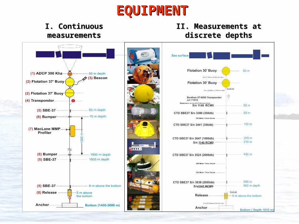
EQUIPMENTEQUIPMENTI. Continuous I. Continuous measurementsmeasurements
II. Measurements at II. Measurements at discrete depthsdiscrete depths

Cruise track: October 1-30, 2008

0
2
4
6
8
10
12
14
7-8 10-12 13-16 18-19 21-23 26-28data, October
hou
r
Dusk
Sun lighthmax=5.70
hmax=2.90
hmax=1.20hmax=2.90
79 N 80 N
80 N
78 N 80.5 N 81.5 N
Light and Meteorological conditions in October 2008 cruise
-30
-25
-20
-15
-10
-5
0
7-8 10-12 13-16 18-19 21-23 26-28
Data, October
Air
Tem
per
atu
re, 0
C
average
minimum

Abrupt warming (about 0.80 C) in the Atlantic Water layer has been captured in the Laptev Sea in February 2004 (Polyakov et al., 2005)
Research highlights
MMP temperature record

Distinct seasonal cycle Distinct seasonal cycle (~1(~100C amplitude) was C amplitude) was revealed deep in the water revealed deep in the water column under the pack ice column under the pack ice (Ivanov et al., 2009) (Ivanov et al., 2009)
Research highlights
Two-year record by SBE-37 at 217 m
1
2
3
4
5
T0C
34.88
34.92
34.96
35
35.04
35.08
S, P
SU
Jan2005
Jan2006
Jul Ju l Jan2005
Jan2006
Jul Ju l

Research highlights
Temporary ‘disappearance’ Temporary ‘disappearance’ (for about 1 month) of (for about 1 month) of Atlantic Water layer at the Atlantic Water layer at the East-Siberian Sea slopeEast-Siberian Sea slope
0 50 100 150 200
D istance, km
-1000
-800
-600
-400
-200
0D
epth
, m
-1.5
-1.0
-0.5
0.0
0.5
1.0
1.5
2.0
2.5
2004 2005 2006 2007 2008Years
-1
0
1
2
T0 C
Temperature, C

Research highlights
Continuous warming in the Atlantic Water layer (Polyakov et al., 2007)

NABOS observational network has become an important element NABOS observational network has become an important element of Arctic Observing System by providing continuous information of Arctic Observing System by providing continuous information
about changes in the Arctic Oceanabout changes in the Arctic Ocean
NABOS moorings

NABOS, IARC UAF NABOS, IARC UAF
UKUKSouthampton Southampton Oceanographic CenterOceanographic Center
International collaborationInternational collaboration
University of Alaska, FairbanksUniversity of Alaska, Fairbanks
University of MiamiUniversity of Miami
APL, University of WashingtonAPL, University of Washington

Priorities Continue mooring-based and CTD observations at selected locationsCarry out scientific tasks proposed by partners
Changes Different ship: “Akademik Fedorov”, AARIHosting Summer school aboard (about 20 students from Russia,
USA and Europe)Increased variety of modern measurement devices
Planning 2013 field seasonPlanning 2013 field season

NABOS cruise 2008 schematics

Anomalously high heat
storage in the upper ocean
slows down ice growth
making the next year ice
thinner than normal
Useful experience from 2007 NABOS cruiseUseful experience from 2007 NABOS cruise
NABOS moorings
Mean summer ice edge

SUMMARYSUMMARYDuring 8 years of NABOS/CABOS operation the program have During 8 years of NABOS/CABOS operation the program have accumulated a great deal of experience deploying and recovering accumulated a great deal of experience deploying and recovering deep-sea oceanographic moorings in the harsh Arctic conditionsdeep-sea oceanographic moorings in the harsh Arctic conditions
Obtained scientific results proved the efficiency of chosen Obtained scientific results proved the efficiency of chosen observational strategy, based on a combination of autonomous observational strategy, based on a combination of autonomous anchored moorings and adjoining CTD transectsanchored moorings and adjoining CTD transects
The project has won wide international recognition, which extends The project has won wide international recognition, which extends through participation of through participation of scientists/technicians/scholars/reporters scientists/technicians/scholars/reporters from various countries in the project activities from various countries in the project activities
Established observational network has become an important Established observational network has become an important element of the IPY-2007-2009 Arctic Observing Systemelement of the IPY-2007-2009 Arctic Observing System
NABOS is open for any form of coordination/collaboration with NABOS is open for any form of coordination/collaboration with other observational programs aimed on cost-effective and other observational programs aimed on cost-effective and scientifically justified field studies in the Arctic Oceanscientifically justified field studies in the Arctic Ocean

Mooring positionsMooring positions
Location of moorings along 126 E Location of moorings along 126 E
NABOS - 2013NABOS - 2013

M ooring125E 1850m
Pick up floats plastic traw l
R ecovery line
Sphere 37 inch steel
C hain 1/2" long link
Location transponder shackled to chain
SB E 37 clamped to AD C P frame
53m
Steel w ire lineone continuous length
D ual Edgetech release assembly
D ual release chain and linksR elease ring
2m C hain 1/2" long link to anchor
Anchor
MMP
kevlar line1081m
700m
AD C P 300khz in mooring frame
1850m
754m
1m
13m kevlar adjust
1836m
1835m
54m
1m
C hain 1/2" long link
Sphere 30 inch steel
1m
4m
49m
48m
47m
37m
B umper
B umper