N/A - California State Lands Commission Brayton Pointner 16 DGPS Side Scan Sonar 400 Khz, and 900...
47
✔ ✔ ✔ ✔ ✔ attached and shapefiles supplied ✔ No other required ✔ ✔ ✔ ✔ delivered attached attached ✔ QSB5.9 - Cummins Engines are EPA Tier2 - Attached Attached N/A
Transcript of N/A - California State Lands Commission Brayton Pointner 16 DGPS Side Scan Sonar 400 Khz, and 900...

✔
✔
✔
✔
✔
attached and shapefiles supplied
✔No other required
✔
✔
✔
✔
delivered
attached
attached
✔
QSB5.9 - Cummins Engines are EPA Tier2 - Attached
Attached
N/A

FUGRO PELAGOS INC.
March 24, 2015
✔ ✔✔ ✔
4820 McGRATH STREET SUITE 100 8391
VENTURA, CALIFORNIA 93003 2
Santa Barbara/VenturaSanta Barbara/Ventura
✔
attached and shapefiles supplied
✔
Fugro Pelagos Inc.
April 15, 2015 - April 30, 2015
Daylight Hours Only (6:30 am - 6:30 pm)
R/V Theory
12175491217549
N/A
Brayton Pointner
16
DGPS

Side Scan Sonar
400 Khz, and 900 Khz
188.0 dB rms
side scan sonar 4125 0.46 degrees along track x 50 degrees across track
pulse rate 0.1 (ms) length: 2.8 (ms)
N/A
160=25/60m 180=9/22m 190=4/9
2 to 365 meters below sea surface (varies depending on water depth)
4.0 Knots
5 to 800 meters (varies depending on water depth)
Eddie StuttsFugro Pelagos Inc.4820 McGrath St. Suite 100Ventura, CA 93003(805) 289-3891

!
!
!
!
!
!
!
!
!
!
!
NOAA Nautical Chart 18720 with Proposed Survey AreaSeafloor Mapping Geophysical Survey Notice
Offshore Santa Barbara County, California
Latitude
34° 23' 28.409" N34° 20' 04.738" N34° 12' 05.784" N34° 8' 31.731" N34° 6' 59.559" N34° 5' 19.124" N34° 7' 53.706" N34° 9' 26.607" N34° 11' 50.380" N34° 20' 14.961" N34° 22' 46.350" N
Longitude
119° 31' 16.211" W119° 33' 06.569" W119° 29' 49.747" W119° 29' 45.912" W119° 28' 01.864" W119° 22' 51.591" W119° 21' 40.179" W119° 25' 52.118" W119° 26' 37.289" W119° 30' 32.754" W119° 28' 58.481" W

Updated March 2015 Page 1 of 10
FUGRO 2015 ON-BOARD SPILL CONTAINMENT
AND CLEAN-UP PLAN
THIS PLAN IS FOR FUGRO PERSONNEL TO READ BEFORE A SPILL OCCURS --AND TO KEEP HANDY FOR REFERENCE DURING AN EMERGENCY. THE KEY TO SPILL PROTECTION IS EARLY RESPONSE AND ACTION. THIS PLAN IS FOR ALL EMPLOYEES ON A VESSEL OR BARGE. IT OUTLINES THE COMPANY PRIORITIES, THE LOCATION OF SPILL RESPONSE EQUIPMENT, INSTRUCTIONS ON HOW TO RESPOND, DIRECTIONS TO EMERGENCY MEDICAL FACILITIES, AND NOTIFICATION NAMES AND PHONE NUMBERS.
SPILL RESPONSE PRIORITIES
In the event of a spill, on-site personnel are in the best position to take prompt action to minimize and control the spill. Our company priorities are:
1. Personnel Safety 2. Prevention of Fire or Explosion 3. Elimination of Spill Source 4. Containment of the Spill 5. Collection and Storage of Contaminated Debris and Materials 6. Notification of Spillage 7. Preparation of Reports
SAFETY OF PERSONNEL IS ALWAYS OUR FIRST PRIORITY.

FUGRO, Inc. On-Board Spill Response Plan
Updated March 2015 Page 2 of 10
SPILL RESPONSE MEASURES In case of an actual spill, take the following actions IF IT IS SAFE TO DO SO: Call 911 for medical or fire emergency assistance if needed Isolate and administer to injured persons if necessary TAKE NECESSARY STEPS TO REDUCE THE RISK OF FIRE
Turn off equipment, valves, or pumps Turn off or extinguish any sources of hot surfaces or flame
STOP SPILL AT SOURCE IF SAFE AND POSSIBLE
Stop equipment leaks by crimping hoses, plugging holes, or isolating parts Upright turned over oil/grease or paint buckets Stop tank leaks by placing in additional containment or plugging hole
CONTAIN ON-DECK SPILL FROM SPREADING OVERBOARD
Berm around spreading spill with absorbent material(rags, kitty litter, sock boom, etc)
Apply granular absorbent(“kitty litter”) in sufficient quantity to soak up entire spill
Wipe small spills with cotton rags
CONTAIN WATER-BORNE SPILLS TO AS SMALL AN AREA AS POSSIBLE Apply absorbent pads to spilled material Deploy oil boom/absorbent sock boom
IF SPILL IS LARGE, CALL THE FUGEO SUPERINTENDENT OR VICE
PRESIDENT AS SOON AS POSSIBLE.
FOR IMMEDIATE DEPLOYMENT OF LARGE OIL BOOM, CALL ONE OF THE FOLLOWING COMPANIES.
Clean Seas, LLC (805) 684-3838
Marine Spill Response Corporation (MSRC) Tel: (510) 478-0702
National Response Corporation (NRC) Tel: (562) 506-2060
Patriot Environmental Services (562) 244-2204
Foss Maritime or another closer response team and request response to clean up the fuel
CLEAN UP SPILL AND USED SPILL MATERIALS
Gather soaked rags, absorbents, boom and dirt Place in leak proof containers for storage and disposal

FUGRO, Inc. On-Board Spill Response Plan
Updated March 2015 Page 3 of 10
EMPLOYEE TRAINING ON OIL SPILL CONTINGENCY PLAN
Prior to the departure of the vessel for any activities, all Captain and crew members on the vessel will have read the Oil Spill Contingency Plan, understand procedures to be implemented in the event of an oil spill, and know where the oil spill kit is located on the vessel.
EMERGENCY EQUIPMENT
LOCATION
As part of each job start-up safety meeting, the spill containment and cleanup material will be discussed and verified.
EQUIPMENT
The Spill Containment and Cleanup Materials include:
1 Box of 20 Gloves: in spill kit box located in front compartment of vessel 2 pair Goggles: in spill kit box located in front compartment of vessel 1 Box of Rags:in spill kit box located in front compartment of vessel 1 Box of 20 Garbage bags: in spill kit box located in front compartment of
vessel 30 each Absorbent pads: spill kit box located in front compartment of
vessel 1 Small Oil Boom: located on back deck 1 12lb Bag Granular absorbent (“kitty litter”): located in fron compartment
of vessel 1 Shovel: located on back deck
FIRE EXTINGUISHERS ARE MOUNTED ON ALL VESSELS, PICKUP TRUCKS AND THERE IS ONE IN THE OFFICE. THE FIRE EXTINGUISHER WILL BE CHECKED FOR EXPIRATION DATE AND THE LOCATION DISCUSSED AT EACH SAFETY MEETING.
INVENTORY & RESTOCKING
The on-board spill containment and cleanup materials are inventoried by the Foreman at the start of every job, at least monthly and after a spill response. Depleted items are to be reported to the Superintendent or any member of the office staff. Items are to be ordered immediately and restocked promptly.

FUGRO, Inc. On-Board Spill Response Plan
Updated March 2015 Page 4 of 10
NOTIFICATIONS In case of a spill, notify a Fugro 24 hour representative (see addendum 1 for names and phone numbers). GIVE THE FOLLOWING INFORMATION TO THE BEST OF YOUR ABILITY:
Your name Location Date of spill Time of spill Substance spilled Quantity spilled Potential for continued spill Possible health hazard Source of spill Actions taken Threatened resources/utilites
THE ENVIRONMENTAL COORDINATOR WILL:
Notify the applicable local, state and federal authorities Coordinate and disseminate information to the media Handle the legal obligations and responsibilities of the company
FUGRO, Inc. On-Board Spill Response Plan
Updated March 2015 Page 5 of 10
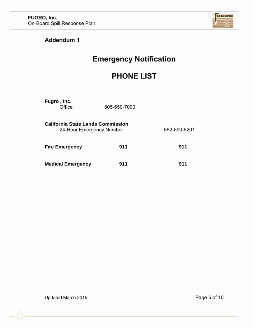
Addendum 1
Emergency Notification
PHONE LIST
Fugro , Inc. Office 805-650-7000
California State Lands Commission 24-Hour Emergency Number 562-590-5201
Fire Emergency 911 911
Medical Emergency 911 911

FUGRO, Inc. On-Board Spill Response Plan
Updated March 2015 Page 6 of 10
Addendum 2
Guide for Fugro Management
1. Call for outside assistance if appropriate for the spill.
2. Call the Company Environmental and Safety Coordinator to coordinate thelegal notifications and media inquiries:
3. If there is an actual release to the environment, the U.S. EPA EmergencyResponse Program requires notification to one of the following organizations:
NATIONAL RESPONSE CENTER 1-800-424-8802 U.S. COAST GUARD MARINE SAFETY OFFICE 1-510-437-3073
1-510-437-3074
4. Other organizations that may be involved:
U.S. EPA Hazardous Waste 1-415-744-2000 California Office of Emergency Services 1-800-852-7550 Additional number 1-916-427-4287 State of California Water Quality 1-510-286-1255 State of California Fish & Game 1-707-944-5512
After hours and weekends 1-916-445-0045 Vessel Traffic 1-415-556-2760 Ca Oiled Wildlife Care Network 1-916-445-0045
5. The information that will be requested is attached as Addendum # 6.

FUGRO, Inc. On-Board Spill Response Plan
Updated March 2015 Page 7 of 10
Addendum 3
Fugro ,Owner, and Management Information
Fugro Environmental and Safety Coordinator Jeffery Ripper 858-427-2017 Officers of the Corporation Robin Villa 805-815-5812 Eddie Stutts 805-432-2213

FUGRO, Inc. On-Board Spill Response Plan
Updated March 2015 Page 8 of 10
Addendum 4
OPERATIONAL INFORMATION
NORMAL OPERATIONS
We contract with public and private entities to conduct high resolution low energy geophysical and geotechnical engineering surveys.
To accomplish this work, we purchase equipment, tools, material, and supplies which are gathered at various mobilization sites and loaded onto vessels and barges which are berthed alongside a dock. When needed tugboats move barges to and from the jobsites. At the completion of projects, the reverse process takes place - unloading equipment, materials, tools, and supplies.
POTENTIAL SPILLS DUE TO NORMAL OPERATIONS
Oil, grease, fuel, or hydraulic fluid leak from machinery or equipment Cranes, winches, generators, light plants and boats require fluids to operate.
Fluids could leak onto the vessel or into the water
Oil, grease, or fuel spill from storage Oil and grease are stored in the vessels and/or barges in 5 gallon or
smaller plastic buckets. Buckets could be dropped or punctured in transport
Fuel is stored in steel tanks housed on the vessels. Tanks could be punctured by sharp objects
Paint spill Paint is generally purchased and utilized as needed. If extra is kept, one gallon pails and spray cans could be stored below deck.
Pails could be punctured or tipped over during use

FUGRO, Inc. On-Board Spill Response Plan
Updated March 2015 Page 9 of 10
Addendum 5
PRODUCT USAGE INFORMATION
CHEMICALS AND FUELS (DESCRIPTION & QUANTITIES)
MSDS sheets are available on the vessel, and the Fugro office.
Oil < 4 quarts
Gasoline < 100 gallons

FUGRO, Inc. On-Board Spill Response Plan
Updated March 2015 Page 10 of 10
Addendum 6
SPILLS RESULTING FROM VESSEL FUELING
All vessel fueling will be conducted on land at a gas station or at an approved docking facility. No cross vessel fueling will be performed.

M/V Theory
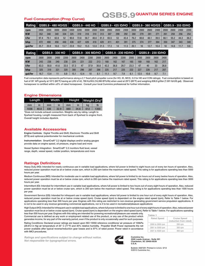
QSB5.9 for Recreational Marine - Cummins Engines
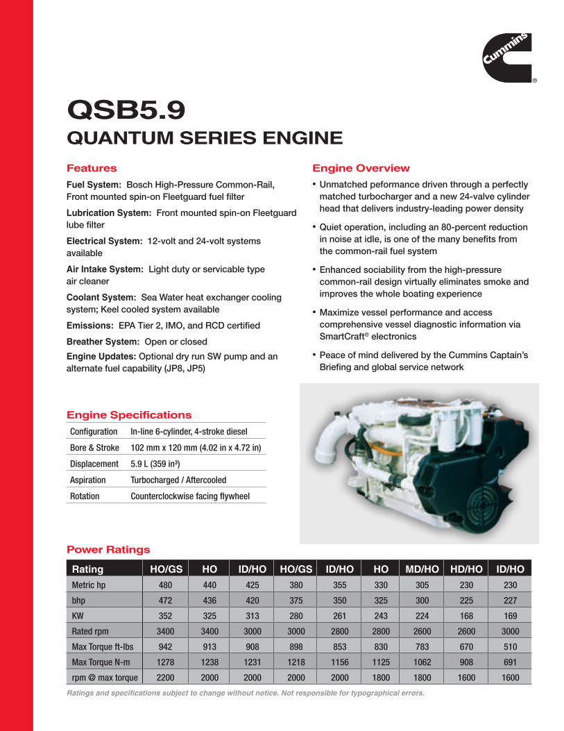
QSB5.9Quantum SerieS engine
Features
Fuel System: Bosch High-Pressure Common-Rail,Front mounted spin-on Fleetguard fuel filter
Lubrication System: Front mounted spin-on Fleetguard lube filter
electrical System: 12-volt and 24-volt systems available
air intake System: Light duty or servicable type air cleaner
Coolant System: Sea Water heat exchanger cooling system; Keel cooled system available
emissions: EPA Tier 2, IMO, and RCD certified
Breather System: Open or closed
engine updates: Optional dry run SW pump and an alternate fuel capability (JP8, JP5)
engine Overview
• Unmatched peformance driven through a perfectlymatched turbocharger and a new 24-valve cylinderhead that delivers industry-leading power density
• Quiet operation, including an 80-percent reductionin noise at idle, is one of the many benefits fromthe common-rail fuel system
• Enhanced sociability from the high-pressurecommon-rail design virtually eliminates smoke andimproves the whole boating experience
• Maximize vessel performance and accesscomprehensive vessel diagnostic information viaSmartCraft® electronics
• Peace of mind delivered by the Cummins Captain’sBriefing and global service network
Configuration In-line 6-cylinder, 4-stroke diesel
Bore & Stroke 102 mm x 120 mm (4.02 in x 4.72 in)
Displacement 5.9 L (359 in³)
Aspiration Turbocharged / Aftercooled
Rotation Counterclockwise facing flywheel
engine Specifications
Power ratings
Ratings and specifications subject to change without notice. Not responsible for typographical errors.
rating HO/gS HO iD/HO HO/gS iD/HO HO mD/HO HD/HO iD/HO
Metric hp 480 440 425 380 355 330 305 230 230
bhp 472 436 420 375 350 325 300 225 227
KW 352 325 313 280 261 243 224 168 169
Rated rpm 3400 3400 3000 3000 2800 2800 2600 2600 3000
Max Torque ft-lbs 942 913 908 898 853 830 783 670 510
Max Torque N-m 1278 1238 1231 1218 1156 1125 1062 908 691
rpm @ max torque 2200 2000 2000 2000 2000 1800 1800 1600 1600
Cummins inc.4500 Leeds avenue - Suite 301Charleston, SC 29405-8539u.S.a.
Bulletin 4087251 Printed in U.S.A. 5/12©2012 Cummins Inc.
Fuel consumption data represents performance along a 2.7 fixed pitch propeller curve (for HO, ID, MCD, 3.0 for HD and CON ratings). Fuel consumption is based on fuel of 35° API gravity at 16°C (60°F) having an LHV of 42, 780 KJ/KG (18,390 BTU/lb) when used at 29°C (85°F) and weighing 838.9 g/liter (7.001 lb/US gal). Observed horsepower is certified within ±5% of rated horsepower. Consult your local Cummins professional for further information.
Heavy Duty (HD): Intended for nearly continuous use in variable load applications, where full power is limited to eight hours out of every ten hours of operation. Also, reduced power operation must be at or below cruise rpm, which is 200 rpm below the maximum rated speed. This rating is for applications operating less than 5000 hours per year.
Medium Continuous (MD): Intended for moderate use in variable load applications, where full power is limited to six hours out of every twelve hours of operation. Also, reduced power operation must be at or below cruise rpm, which is 200 rpm below the maximum rated speed. This rating is for applications operating less than 3000 hours per year.
Intermittent (ID): Intended for intermittent use in variable load applications, where full power is limited to two hours out of every eight hours of operation. Also, reduced power operation must be at or below cruise rpm, which is 200 rpm below the maximum rated speed. This rating is for applications operating less than 1500 hours per year.
Government Service (GS): Intended for infrequent use in variable load applications, where full power is limited to one hour out of every eight hours of operation. Also, reduced power operation must be at or below cruise speed (rpm). Cruise speed (rpm) is dependent on the engine rated speed (rpm), Refer to Table 1 below. For applications operating less than 500 hours per year. Engines with this rating are restricted to non-revenue generating government service propulsion applications. It is not to be used in any revenue generating commercial applications, nor is it to be used in recreational/pleasure applications
High Output (HO): Intended for infrequent use in variable load applications, where full power is limited to one hour out of every eight hours of operation. Also, reduced power operation must be at or below cruise speed (rpm). Cruise speed (rpm) is dependent on the engine rated speed (rpm), Refer to Table 1 below. For applications operating less than 500 hours per year. Engines with this rating are intended for powering recreational/pleasure use vessels only. Commercial use is defined as any work or employment related use of the product, or any use of the product which generates income, for any part of the warranty period, even if the product is only occasionally used for such purposes.
Rating Conditions: Declared power ratings are based upon ISO 15550 reference conditions/ air pressure of 100kPa (29.612 in Hg) air temperature of 25° C (77°F) and 30% relative humidity. Propeller Shaft Power represents the net power available after typical reverse/reduction gear losses and is 97% of rated power. Power rated in accordance with IMCI procedures.
rated Speed Cruise Speed (reduction from rated)
2000 to 2800 rpm 200 rpm
2801 to 3500 rpm 300 rpm
3501 to 4500 rpm 400 rpm
table 1
available accessoriesengine Controls: Digital Throttle and Shift; Electronic Throttle and Shift (ETS) and optional potentiometer for mechanical controls
instrumentation: SmartCraft® 2.2 digital displays and/or analog gauges provide data on engine speed, oil pressure, engine load and more
Vessel System Integration: SmartCraft® 2.2 monitors fluid level, vessel range, depth, vessel speed, rudder position, temperatures and more
QSB5.9Quantum SerieS engineFuel Consumption (Prop Curve)
*Does not include exhaust connection. Weights vary by rating. Length toflywheel housing. Length measured from back of flywheel to engine front. Overall height includes dipstick.
mm in mm in mm in kg lb1036 40.8 836 32.9 880 34.6 612 1350
engine DimensionsLength Width Height Weight (Dry)*
ratings Definitions
Ratings and specifications subject to change without notice. Not responsible for typographical errors.
ratingrpm 3400 3200 3000 2800 3400 3200 3000 2800 3000 2800 2600 2400 3000 2800 2600 2400 2800 2600 2400 2200
KW 352 348 340 334 325 319 318 310 313 307 299 292 280 279 281 271 261 259 256 254
l/hr 97.4 79.1 62.8 52 90.6 72.8 58.7 48.6 81.3 65.5 53 43.4 76.2 60.6 48.1 39.5 68.1 55.2 44.3 36.2
bhp 472 466 456 448 436 427 426 416 420 411 401 391 375 374 377 364 350 347 343 340
gal/hr 25.7 20.9 16.6 13.7 23.9 19.2 15.5 12.8 21.5 17.3 14 11.5 20.1 16 12.7 10.4 18 14.6 11.7 9.6
QSB5.9 - 480 HO/gS QSB5.9 - 440 HO QSB5.9 - 425 iD/HO QSB5.9 - 380 HO/gS QSB5.9 - 355 iD/HO
ratingrpm 2800 2600 2400 2200 2600 2400 2200 2000 2600 2400 2200 2000 3000 2800 2600 2400
KW 243 238 240 238 224 221 222 213 168 162 167 165 169 168 162 217
l/hr 63.3 50.8 41.6 33.5 57.3 47 37.9 30.8 42.2 36.8 29.7 23.3 47 40 33 26.8
bhp 325 319 321 320 300 296 287 286 225 217 225 222 227 226 217 207
gal/hr 16.7 13.4 11 8.9 15.1 12.4 10 8.1 11.1 9.7 7.9 6.1 12.5 10.6 8.7 7.1
QSB5.9 - 330 HO QSB5.9 - 305 mD/HO QSB5.9 - 230 HD/HO QSB5.9 - 230 iD/HO


Notice of Survey Operations
DEPARTMENT OF HOMELAND SECURITY UNITED STATES COAST GUARD
COMMANDER, 11TH
COAST GUARD DISTRICTBuilding 50-2 Coast Guard Island
Alameda, CA 94501-5100
LNM Point of Contact
BM1 John Hinson: 510-437-2980
1. Name of Contractor: FUGRO
2. Type of Operation: Side Scan Sonar Survey
3. Location / Position Information: Offshore Ventura, California (See Attached Map)
4. Start and End Dates: Start: April 13, 2015, End: April 30, 2015
5. Vessel(s) Involved (include FCC Call Sign): R/V Theory
6. Radio Yes / No, VHF Freq’s Monitored: Yes, VHF 16
7. Any other pertinent Info: The Theory will be towing up to 3000 feet of cable
astern of the vessel. Operations will be conducted
only during daylight hours.
8. POC Name & Telephone Number(s): Eddie Stutts or Cindy Pratt (Fugro)
805-650-7000
9. Chart Number: 18720
SOUTHERN CALIFORNIA-SURVEY OPERATIONS – OFFSHORE VENTURA, CALIFORNIA
Fugro will be conducting a side scan sonar survey from the R/V Theory in the area outlined on the attached
portion of Chart 18720. Operations will last approximately 5 days and be carried out between April 13 and
30, 2015, during daylight hours only. The R/V Theory will be towing up to 3000 feet of cable during mapping
operations. The survey area is outlined by the following coordinates. Latitude Longitude
34° 23' 28.409" N 119° 31' 16.211" W
34° 20' 04.738" N 119° 33' 06.569" W
34° 12' 05.784" N 119° 29' 49.747" W
34° 8' 31.731" N 119° 29' 45.912" W
34° 6' 59.559" N 119° 28' 01.864" W
34° 5' 19.124" N 119° 22' 51.591" W
34° 7' 53.706" N 119° 21' 40.179" W
34° 9' 26.607" N 119° 25' 52.118" W
34° 11' 50.380" N 119° 26' 37.289" W
34° 20' 14.961" N 119° 30' 32.754" W
34° 22' 46.350" N 119° 28' 58.481" W
The vessel will have limited maneuverability during operations and mariners are advised to use due caution
when transiting in the area. For more details or comments contact Cindy Pratt or Eddie Stutts at 805-650-
7000.

!
!
!
!
!
!
!
!
!
!
!
NOAA Nautical Chart 18720 with Proposed Survey AreaSeafloor Mapping Geophysical Survey Notice
Offshore Santa Barbara County, California
Latitude
34° 23' 28.409" N34° 20' 04.738" N34° 12' 05.784" N34° 8' 31.731" N34° 6' 59.559" N34° 5' 19.124" N34° 7' 53.706" N34° 9' 26.607" N34° 11' 50.380" N34° 20' 14.961" N34° 22' 46.350" N
Longitude
119° 31' 16.211" W119° 33' 06.569" W119° 29' 49.747" W119° 29' 45.912" W119° 28' 01.864" W119° 22' 51.591" W119° 21' 40.179" W119° 25' 52.118" W119° 26' 37.289" W119° 30' 32.754" W119° 28' 58.481" W

339 Pacific Street, San Luis Obispo, CA 93401 ▪ Phone 805-786-2650 ▪ Fax 805-786-2651
MARINE WILDLIFE CONTINGENCY PLAN
SIDE SCAN SONAR SURVEY FROM PLATFORM GAIL TO GRACE AND PLATFORM GRACE TO SHORE
Prepared for:
FUGRO PELAGOS, INC. 4820 McGrath St. Suite 100 Ventura, California 93003
Prepared by:
Padre Associates, Inc. 369 Pacific Street
San Luis Obispo, California 93401
March 2015

Fugro Pelagos, Inc. Marine Wildlife Contingency Plan Project No. 1502-1681
- i -
TABLE OF CONTENTS
1.0 INTRODUCTION ................................................................................................................ 1
1.1 PURPOSE AND OBJECTIVES ............................................................................. 1 1.2 PROPOSED SURVEY ACTIVITIES AND AREA .................................................. 1 1.3 SURVEY EQUIPMENT ......................................................................................... 1
2.0 MARINE WILDLIFE ............................................................................................................ 3
2.1 PINNIPED HAUL-OUTS AND ROOKERIES ......................................................... 5
3.0 MARINE PROTECTED AREAS ......................................................................................... 8
4.0 ONBOARD MONITORING AND OTHER MITIGATIONS ................................................ 10
4.1 VESSEL TRANSIT .............................................................................................. 10 4.2 FISHING GEAR CLEARANCE ............................................................................ 10 4.3 SURVEY MONITORING ..................................................................................... 11 4.4 MITIGATION MEASURES .................................................................................. 11
5.0 RECORDING AND REPORTING PROCEDURES .......................................................... 13
5.1 OBSERVATION RECORDING............................................................................ 13 5.2 COLLISION RESPONSE .................................................................................... 13 5.3 MONITORING REPORT ..................................................................................... 14
6.0 REFERENCES ................................................................................................................. 15
TABLES
2.1 Abundance Estimates for Marine Mammals and Reptiles within Southern California (California/Mexico Border to Point Conception) ................................................................ 3
2.2 California Marine Wildlife Species and Periods of Occurrence within Southern California (California/Mexico Border to Point Conception) ................................................................ 5
4.1 Fishing Gear Contact Information ................................................................................... 11 5.1 Collision Contact Information ......................................................................................... 14
FIGURES
1 Proposed Survey Area ...................................................................................................... 2 2 Pinniped Haul-out and Rookeries ..................................................................................... 7 3 Marine Protected Areas .................................................................................................... 9
APPENDICES
APPENDIX A: MARINE WILDLIFE MONITOR RESUMES

Fugro Pelagos, Inc. Marine Wildlife Contingency Plan Project No. 1502-1681
- 1 -
1.0 INTRODUCTION
This Marine Wildlife Contingency Plan (MWCP) has been developed for Fugro Pelagos, Inc., (Fugro) in support of side scan sonar survey along several pipelines interconnecting Platforms Gail and Grace then continuing onto shore, all located offshore of Ventura, California (Figure 1). This MWCP has been prepared in accordance with the requirements in the existing California State Lands Commission (CSLC)-issued geophysical and geologic sampling permit No. 8391.9. This MWCP is designed to reduce or eliminate adverse impacts to marine wildlife resources within the survey area.
This MWCP is specific to the equipment and activities that are proposed for the survey. The proposed monitoring and mitigations have been successfully used in agency-approved MWCPs for similar offshore surveys in southern California marine waters, and have been shown to be effective in reducing or eliminating potential impacts to marine mammals and turtles.
1.1 PURPOSE AND OBJECTIVES
The proposed survey will utilize a side scan sonar system to acquire seafloor imaging of existing pipelines and document the seafloor conditions within the pipeline right of ways. The survey will be completed by Fugro in accordance with requirements specified by Venoco, Inc’s statement of work.
1.2 PROPOSED SURVEY ACTIVITIES AND AREA
The survey will be completed over a five day period and will utilize Theory Marine’s survey vessel (SV) Theory, a 11.2 meter (m) (37 foot [ft]) survey vessel designed specifically for hydrographic surveying. The vessel will be mobilized in Ventura Harbor and will transit to the survey area on the morning of each day. The survey will be completed during daylight hours (no nighttime operations are proposed). The vessel will return to the Ventura Harbor at the completion of each survey day.
The proposed survey area is located within federal and state waters with depths ranging from approximately 10 to 235 m (30 to 770 ft). Data will be collected within a survey corridor width of approximately 150 m (492 ft) (Figure 1).
1.3 SURVEY EQUIPMENT
Fugro proposes to use the following equipment to collect the required data:
STARFIX® II DGPS Satellite Navigation System; IXSEA Global Acoustic Positioning System (GAPS) USBL Tracking System; and Edgetech 4200 Side Scan Sonar Towfish.

CHART NO.:
DATE: DESCRIPTION: DRAWN:
PLATFORMS GAIL TO GRACEAND PLATFORM GRACE TO SHORE
SIDE SCAN SONAR PIPELINE SURVEYPROPOSED SURVEY LINES
March 2015Santa Barbara Channel, California
CHKD: APPR:
This document may only be used for the purpose for which it was commissioned and in accordance with the terms of engagement for that commission. Unauthorized use of this document in any form whatsoeveris prohibited. Not for navigational use.
SCALE :
23.00007126 - 1 1 of 1
Side Scan Sonar Pipeline Survey - Proposed Runlines CPMarch 20150
NOTES:
2,000 0 2,000 4,0001,000Feet
1 " = 2,000 '
VENOCO, INC.
#!
#!
#!
#!
#!#!
#!
#!#!#!#! #!#!#!
Õ̀
Õ̀ Õ̀
Õ̀
Õ̀
Õ̀
Õ̀
Õ̀
Õ̀Õ̀
Õ̀
Õ̀Õ̀Õ̀
Õ̀
Chart 1 Santa Barbara County
Ventura CountyABC
GinaGail
HoganHenry
Grace Gilda
Holly
Houchin
Habitat
Hillhouse
Rincon Island
Õ̀Õ̀Õ̀Õ̀Õ̀Õ̀
12" Oil Pipeline
10" Gas Pipeline
Pipe
line (
Aban
done
d)
Hogan to Shore Pipeline Bundle
Submarine Power Cable
Abandoned Power Cable Pipeline Bundle From Hope Bypass to Shore
Power Cable (Abandoned)
Punta
Gorda
Aban
done
d Pipe
lines
Houc
hin to
Hog
an Pi
pelin
e Bun
dle
Hazel
Aban
done
d Pow
er Ca
ble
110109
101
103104106105
102
108107
-100
-10 -20 -30-40 -50 -60
-70-80
-90
-130
-140
-120
-110
-150
-250
-240
-220
-210
-200
-160
-170
-180
-190
-190
-230
-170
-100
-10
-20
-30-40
-50-60
-70-80
-160-15
0-140
-130
-120
-110
-240
-220
-210-200-18
0
-190
-90
6100
000
6100000
6120000
6120
000
1920000
1920000
1940000
1940000
1960000
1960000
Minor Contours, Contour Interval = 10 FeetMajor Contours, Contour Interval = 50 Feet
Backdown Mooring LocationsÕ̀Õ̀Õ̀
Legend
Infrastructure
Contours
GEODETIC INFORMATIONPROJECTION:DATUM: ZONE: UNITS:
California Coordinate System (CCS-83)NAD 83 Zone 5 U.S. Survey Feet
4820 McGrath St., Suite 100Ventura, California 93003 Tel: (805) 650-7000Fax: (805) 650-7010www.fugro-pelagos.com
FUGRO PELAGOS, INC.
CP
JOB NUMBER - DRAWING NUMBER:
«
1. Bathymetry contours from Fugro data combined with NOAA database. Contours are in feet and referenced to Mean Lower Low Water (MLLW).
Õ̀Õ̀Õ̀
Õ̀Õ̀Õ̀Õ̀Õ̀
Õ̀Õ̀Õ̀
Õ̀
Õ̀Õ̀Õ̀
Õ̀Õ̀Õ̀Õ̀Õ̀
Õ̀Õ̀Õ̀
Õ̀
Õ̀Õ̀Õ̀
11211410" Gas Pipeline
Telecom Cable
124125
126127
117118
121122
119120
123
111113
115
13012
812
9
116
121
122
12" Oil Pipeline
8" Gas (
M-29)
8" Sour G
as (M-30
)
8" Oil Pipelin
e (M-28)
PlatformGail
PlatformGrace
-160
-180
-710
-720
-730
-350
-360
-370
-380
-390
-740
-750
-760
-620
-650
-570
-550
-540-53
0-520-510-48
0
-470
-460
-450
-440
-430
-420
-690-68
0-670-660-64
0-630-610-59
0-580
-190
-200
-310
-320
-340
-210
-220-230 -240
-250
-260
-270
-280 -290 -300
-330
-490
-770
-780
-400
-500
-600
-700
-560
-170
020502
09
020902
1602
17
0217
0216
0217
6120
000
6120000
6140000
6140
000
1880000
1880000
1900000
1900000
Map Extent
Telecom Cable3-Mile Boundary
Active Federal Lease with Lease NumberPower CablePipeline
Proposed Survey Lines
Abandoned 4H Sites
441
0166
Federal Lease Boundaries
ATAT
PLATE 1
PLATE 2
«
PLATE 2
PLATE 1
N:\Pr
ojects
\04_2
015\2
3_00
00_7
126_
Veno
co_S
SS_P
LSurv
ey\O
utputs
\2015
_03_
01_W
orkPla
n\mxd
\7126
_Run
lines
_24x
36.m
xd, 0
3/12/1
5, tar
difa

Fugro Pelagos, Inc. Marine Wildlife Contingency Plan Project No. 1502-1681
- 3 -
2.0 MARINE WILDLIFE
Multiple species of marine turtles, cetaceans (whales, dolphins, and porpoises, pinnipeds (seals and sea lions), and fissipeds (sea otter) have been recorded along the Southern California coast (Table 2.1). Most of the recorded species can occur within the survey region, although seasonal abundances of these taxa vary; pinnipeds and some dolphins are year-round residents (Table 2.2). Other species are migratory, such as the gray whale (Eschrichtius robustus), or seasonal, such as the blue and humpback whales (Balaenoptera musculus and Megaptera novaeangliae, respectively) and therefore are more abundant during specific months. Within the project region, resident, seasonal, and migrant taxa could be expected to occur.
Table 2.1. Abundance Estimates for Marine Mammals and Reptiles within Southern California (California/Mexico Border to Point Conception)
Common Name Scientific Name
Population Estimate Current Population Trend
REPTILES Cryptodira* Olive Ridley turtle Lepidochelys olivacea
1.15 to 1.62 million (Eastern Tropical Pacific)
Increasing
Green turtle Chelonia mydas
3,319 to 3,479 (Eastern Pacific Stock)
Increasing
Leatherback turtle Dermochelys coriacea
361 (California)
Decreasing
Loggerhead turtle Caretta caretta
7,138 (California)
Decreasing
MAMMALS Mysticeti
California gray whale Eschrichtius robustus
18,017 (Eastern North Pacific)
Increasing
Blue whale Balaenoptera musculus
1,551 (Eastern North Pacific)
Stable
Fin whale Balaenoptera physalus
2,598 (California/Oregon/Washington)
Increasing
Humpback whale Megaptera novaeangliae
1,876 (California/Oregon/Washington)
Increasing
Minke whale Balaenoptera acutorostrata
202 (California/Oregon/Washington)
No long-term trends suggested
Sei whale Balaenoptera borealis
83 (Eastern North Pacific)
No long-term trends suggested
Northern Pacific right whale Eubalaena japonica
25 (Eastern North Pacific)
No long-term trend is suggested
Odontoceti Short-beaked common dolphin Delphinus delphis
343,990 (California/Oregon/Washington)
Unable to determine
Long-beaked common dolphin Delphinus capensis
76,224 (California)
Unable to determine
Dall’s porpoise Phocoenoides dalli
32,106 (California/Oregon/Washington)
Unable to determine
Pacific white-sided dolphin Lagenorhynchus obliquidens
21,406 (California/Oregon/Washington
Northern and Southern) No long-term trends suggested
Risso’s dolphin 4,913 No long-term trends suggested

Fugro Pelagos, Inc. Marine Wildlife Contingency Plan Project No. 1502-1681
- 4 -
Table 2.1. Abundance Estimates for Marine Mammals and Reptiles within Southern California (California/Mexico Border to Point Conception)
Common Name Scientific Name
Population Estimate Current Population Trend
Grampus griseus (California/Oregon/Washington) Northern right whale dolphin Lissodelphis borealis
6,019 (California/Oregon/Washington)
No long-term trends suggested
Bottlenose dolphin Tursiops truncatus
684 (California/Oregon/Washington
Offshore) No long-term trends suggested
290 (California Coastal)
No long-term trends suggested
Sperm whale Physeter macrocephalus
751 (California/Oregon/Washington)
No long-term trends suggested
Short-finned pilot whale Globicephala macrorhynchus
465 (California/Oregon/Washington)
No long-term trends suggested
Killer whale Orcinus orca
85 (Eastern North Pacific Southern
Resident) Decreasing
162 (Offshore
California/Oregon/Washington) Unable to determine
243 (West Coast Transient)
Unable to determine
Pinnipedia Northern fur seal Callorhinus ursinus
6,722 (California)
Increasing
Guadalupe fur seal Arctocephalus townsendi
3,028 (Mexico; Undetermined in
California) Increasing
California sea lion Zalophus californianus
153,337 (U.S.)
Increasing
Northern elephant seal Mirounga angustirostris
74,913 (California Breeding)
Increasing
Pacific harbor seal Phoca vitulina richardsi
26,667 (California)
Increasing
Fissipedia Southern sea otter Enhydra lutris nereis
2,944** Increasing
* Estimates are based on number of current numbers of nesting females. ** Estimate provided by USGS (2014). Source: NMFS, 2014, and Allen et al., 2011

Fugro Pelagos, Inc. Marine Wildlife Contingency Plan Project No. 1502-1681
- 5 -
Table 2.2. California Marine Wildlife Species and Periods of Occurrence within Southern
California (California/Mexico Border to Point Conception)
Family Common Name
Month of Occurrence(1)
J F M A M J J A S O N D REPTILES
Cryptodira
Olive Ridley turtle (T)
Green turtle (T)
Leatherback turtle (E)
Loggerhead turtle (E)
MAMMALS
Mysticeti
California gray whale
Blue whale (E)
Fin whale (E)
Humpback whale (E)
Minke whale
Sei whale (E)
Northern right whale (E)
Odontoceti
Short-beaked common dolphin
Long-beaked common dolphin
Dall’s porpoise
Pacific white-sided dolphin
Risso’s dolphin
Short-finned pilot whale
Bottlenose dolphin
Northern right whale dolphin
Sperm Whale
Killer Whale
Pinnipedia
Northern fur seal(2)
Guadalupe fur seal
California sea lion
Northern elephant seal(3)
Pacific harbor seal
Fissipedia
Southern sea otter (T)(4)
(E) Federally listed endangered species. (T) Federally listed threatened species. (1) Where seasonal differences occur, individuals may also be found in the “off” season. Also, depending on the species, the
numbers of abundant animals present in their “off” season may be greater than the numbers of less common animals in their “on” season.
(2) Only a small percent occur over continental shelf (except near San Miguel rookery, May-November). (3) Common near land during winter breeding season and spring molting season. (4) Only nearshore (diving limit 100 feet).
Rare with uniform distribution
Not expected to occur due to seasonal distribution
More likely to occur due to seasonal distribution
Present Year Round
Sources: Bonnell and Dailey,1993; NMFS, 2014 (a,b); NCCOS, 2007; and Allen, 2011

Fugro Pelagos, Inc. Marine Wildlife Contingency Plan Project No. 1502-1681
- 6 -
2.1 PINNIPED HAUL-OUTS AND ROOKERIES
The proposed survey activities will occur within 300 m (1,000 ft) of pinniped haul-out and/or rookeries (Figure 2 depicts the locations of haul-outs and rookeries in the region). The closest haul-out/rookery is approximately 91 m (300 ft) northwest of the survey area. Mitigation measures to avoid potential impacts to pinniped haul-out and/or rookeries are described in Section 4.0 – Onboard Monitoring and Other Mitigations.

"S
"S
!(!(!(!(!(!(!(!(!(!(!(!(!(!(!(!(!(!(!(!(!(!(!(!(!(!(!(!(!(!(!(!(!(!(!(!(!(!(!(!(!(!(!(!(!(!(!(!(!(!(!(!(!(!(!(!(!(!(!(!(!(!(!(!(!(!(!(!(!(!(!(!(!(!(!(!(!(!(!(!(!(!(!(!(!(!(!(!(!(!(!(!(!(!(!(!(!(!(!(!(!(!(!(!(!(!(
!(
!(
!(
!(
!(
!(
!(!(!(
!(
!(
!(
!(!(!(!(
!(
!(!(!(
!(
!(!(!(!(!(!(!(!(!(
!(
!(!(
!(
!( !(
!(!(
!(
!(!(
!(
!(!(
!(
!(
!(
!(
!(!(!(
!(!(
!(
!( !(!(!(!(!(!(!(!(!(!(
!(
!(!(
!(
!(
!(!(!(!(
!(!(
!(
!(
!(
!(
!(!(!(
!(
!(!(
!(!(!(
!(
!(
!(
!(!(!(!(
!( !(!(!(!(!(!(!(
!( !(
!(
!(!(
!(
!(
!(
!(
!(
!(
!(
!(
!(
!(!( !(
!(!(!(!(!(!(!(!(!(!(!(!(!(!(!(!(!( !(!(!(
!(!(!(!(!( !(!(!(!(!(
!(
!(
!(!(!(!(!(!(!(!( !(
!(
!(
!(
!(!(
!(!(!(!(
!(
!(
!(
!(
!(
!(
!(!(!(!(!(!(
!(
!(
!(
!(!(
!(
!(!(!( !(
!(
!(!(
!(!(!(!(
!( !(
!(
!(
!(
!(!(
!(
!(!(
!(
!(!(!(
!(
!(
!(!(
!(
!(!(!(!(!(!(
!(
!(
!(
!(
!(
!(
!(!(!(
!(!(!( !(!(
!(
!(
!(
!(
!(
!(
!(
!(!(!(!(!(!(
!(!(!(!(
!(
!(!(
!(
!(!(!(!(!(!(!(!(!(!(!(!(!(!(!(!(!(!(!(
!(
!(
!(
!(
!(
!(
!(!(
!(
!(!(!(
!(
!(
!(
!(
!(
!(
!(
!(
!(!(!(!(!( !(!(
!(
!(
!(
!(
!(
!(
!(
!(!(
!(
!(!(
!(
!( !(
!(
!(
!(
!(
!(
!(!(
!(!(!(!(!(!(!(!(!(!(!(!(!(!(!(!(!(!(!(!(!(!(!(!(!(!(!(!(!(!(!(!(!(!(!(!(!(!(!(!(!(!(!(!(!(!(!(!(!(!(!(!(!(
")")
")")")
")")")")")")")")")")")")")")")
")")")")")")")
")
")
")")
GFGF
_̂
GRACE
GAIL
SURVEY TERMINUS
PINNIPED HAUL-OUTS AND ROOKERIES
Source: ESRI Online Topo Map, BOEM, NOAACoordinate System: NAD 1983 StatePlane California V FIPS 0405 FeetNotes: This map was created for informational and display purposes only.
Z:\Kr
istin\
GIS
Maps
\Map
Proj
ect\V
enoc
o Plat
forms
Grac
e Gail
\Figu
re 2 -
Pinn
iped H
aul-O
uts an
d Roo
kerie
s.mxd
GRT
3/10
/2015
LEGEND:_̂ Survey Terminus") Pinniped Haulout/Rookery
!( Harbor Seal"S Platform of Interest
1502-1681 March 2015
FIGURE2
FUGRO - VENOCO PLATFORMS GAILAND GRACE GEOPHYSICAL SURVEY
PROJECT NUMBER: DATE:
PROJECT NAME:
0 2.5 5
MILES
CALIFORNIA

Fugro Pelagos, Inc. Marine Wildlife Contingency Plan Project No. 1502-1681
- 8 -
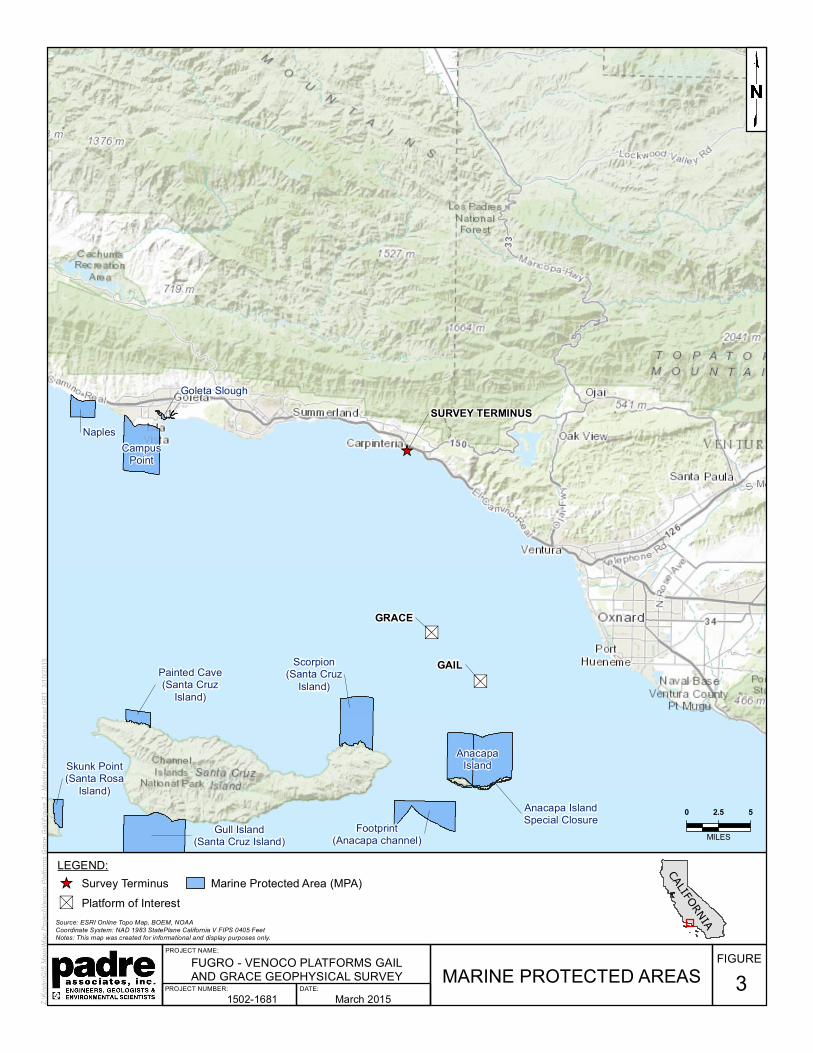
3.0 MARINE PROTECTED AREAS
The proposed survey area does not fall into a designated marine protected area (MPA). Anacapa Island State Marine Conservation Area (Figure 3) is the closest MPA, located approximately 2.3 kilometers (km) [1.4 miles (mi)] south of the survey area.
"S
"S
_̂
GRACE
GAIL
SURVEY TERMINUS
AnacapaIsland
Painted Cave(Santa Cruz
Island)
Skunk Point(Santa Rosa
Island)
Gull Island(Santa Cruz Island)
Scorpion(Santa Cruz
Island)
Footprint(Anacapa channel)
Anacapa IslandSpecial Closure
CampusPoint
Naples
Goleta Slough
MARINE PROTECTED AREAS
Source: ESRI Online Topo Map, BOEM, NOAACoordinate System: NAD 1983 StatePlane California V FIPS 0405 FeetNotes: This map was created for informational and display purposes only.
Z:\Kr
istin\
GIS
Maps
\Map
Proj
ect\V
enoc
o Plat
forms
Grac
e Gail
\Figu
re 3 -
Mari
ne Pr
otecte
d Area
s.mxd
GRT
3/10
/2015
LEGEND:_̂ Survey Terminus"S Platform of Interest
Marine Protected Area (MPA)
March 20151502-1681
FIGURE3
FUGRO - VENOCO PLATFORMS GAILAND GRACE GEOPHYSICAL SURVEY
PROJECT NUMBER: DATE:
PROJECT NAME:
0 2.5 5
MILES
CALIFORNIA

Fugro Pelagos, Inc. Marine Wildlife Contingency Plan Project No. 1502-1681
- 10 -
4.0 ONBOARD MONITORING AND OTHER MITIGATIONS
4.1 VESSEL TRANSIT
Following mobilization, the survey vessel will transit between Ventura Harbor and the survey area. During vessel transit to and from the survey area, there is a potential for encountering marine wildlife and therefore onboard monitoring will occur. Two qualified marine wildlife monitors (approved by NOAA Fisheries and/or experienced in marine wildlife observations – refer to Appendix A for monitor qualifications) will be onboard the vessel throughout the period of the vessel transit and data collection activities.
During transit periods, a marine wildlife monitor will be positioned on the vessel so that the monitor will have a clear view of the area of ocean that is in the direction of the course of travel. That monitor will observe marine mammals and turtles (marine wildlife) and will institute measures to avoid potential collisions with those animals. To minimize the chance of collision with or disturbance of marine mammals and turtles, the vessel will maintain a minimum distance of 91 m (300 ft) from marine wildlife in accordance with CSLC-issued geophysical and geologic sampling permit. If the marine wildlife monitor should observe a marine mammal or reptile within the path of the transiting vessel, the monitor will immediately report that observation to the vessel operator who will, unless those actions will jeopardize the safety of the vessel or crew, slow the vessel and/or change course in order to avoid contact.
When whales are in the survey area and/or are observed proximal to the vessel during transit periods the vessel operator will observe the following guidelines:
Maintain a minimum distance of 100 m (330 ft) from sighted whales;
Refrain from crossing directly in front of or across the path of sighted whales;
Transit parallel to whales and maintain a constant speed that is not faster than the whale’s speed;
Avoid positioning the vessel in such a manner to separate a female whale from her calf;
Do not use the vessel to herd or drive whales; and
If a whale engages in evasive or defensive action, slow the vessel and move away from the animal until the animal calms or moves out of the area.
4.2 FISHING GEAR CLEARANCE
In addition to submitting the required Notice to Mariners that will alert commercial fishers of pending on-water activities prior to the start of each survey day, the vessel will traverse the proposed survey corridor to note and record the presence of deployed fishing gear. The type and location of fishing gear (buoys) will be noted, and the California Department of Fish and Wildlife (CDFW) Santa Barbara office and/or Joint Oil/Fisheries Liaison Office will be contacted. No survey lines will be completed within 30 m (100 ft) of any observed fishing gear. The survey

Fugro Pelagos, Inc. Marine Wildlife Contingency Plan Project No. 1502-1681
- 11 -
crew will not remove or relocate any fishing gear; removal or relocation will only be accomplished by the owner or by an authorized CDFW agent (Table 4.1).
Table 4.1. Fishing Gear Contact Information
Joint Oil/Fisheries Liaison Office
California Department of Fish & Wildlife, Santa Barbara
California Department of Fish & Wildlife, Marine Division
(805) 963-8819 (805) 568-1231 (831) 649-2870
4.3 SURVEY MONITORING
Three days prior to the initiation of the survey, Padre marine scientists will contact NOAA Fisheries Long Beach office staff and local private whale-watching operations to acquire information on the recently-observed composition and relative abundance of marine mammals offshore Ventura and the surrounding area. That information will be conveyed to the vessel operator and crew prior to departure for the survey area.
The onboard monitors responsible for observations during vessel transit will also be responsible for monitoring during the data collection efforts. Monitoring will be completed by a monitor using binoculars while located at a high vantage point onboard the survey vessel. As specified in the CSLC-issued geophysical and geologic sampling permit a safety zone is not required for any equipment operating at 200 kilohertz or greater.
During survey activities, the onboard monitor will observe for marine mammals when survey equipment is operating. At the time of equipment start-up, marine mammals/reptiles within the project area will be noted. If any animals show behavioral changes during equipment start-up, either the equipment will be shut down until the animal(s) move out of the area, or after 15 minutes of the animal(s) remaining in the project area, the equipment will be “ramped up” to full power. With the incorporation of this measure and the other mitigation measures discussed below, the proposed offshore survey activities are unlikely to have a high potential to injure and/or disturb marine wildlife.
The onboard monitor will have the authority to recommend halting data collecting operations if a mammal or turtle is observed within the project area, and is reacting to the survey-generated activities. The monitor will also have the authority to recommend continuation or cessation of operations during periods of limited visibility based on the observed abundance of mammals and/or reptiles. Periodic reevaluation of weather conditions and reassessment of the continuation/cessation recommendation will be completed by the onboard monitor.
4.4 MITIGATION MEASURES
The following operation-related actions will be implemented in accordance with CSLC permit requirements:
1. For surveys within 300 m (1,000 ft) of a haul-out site:

Fugro Pelagos, Inc. Marine Wildlife Contingency Plan Project No. 1502-1681
- 12 -
a. The Survey vessel will not approach with in 91 m (300 ft) of a haul-out site;
b. Survey activities will be conducted in an expedited manor to minimize the potential for disturbance of pinnipeds on land; and
c. The Marine Wildlife Monitor will monitor pinniped activity onshore as the vessel approaches, observing and reporting on the number of pinnipeds potentially disturbed (e.g. via head lifting, flushing into the water).
2. Survey operator shall use a “soft start” technique at the beginning of survey activities each day (or following a shutdown) to allow any marine mammal that may be in the project area to leave before the sound sources reach full energy. The survey operator will initiate each piece of equipment at the lowest practical sound level, increasing the output no greater than six (6) decibels (dB) per 5-minute period;
3. During operations, if an animal’s actions are observed to be “irregular” the monitor will have the authority to recommend the cessation of data collection until the animal moves out of the project area. If the behavior is observed, the equipment will be shut-off and will be restarted and ramped-up to full power or will not be started until the animal(s) is/are outside of the project area;
4. The monitor will have the authority to recommend halting data collecting operations if a large concentration of diving birds/sea birds is observed in the immediate vicinity; and
5. Unless the safety of the vessel or crew would be in jeopardy, avoidance measures instituted during vessel transit will be implemented during geophysical data collection as well.
In addition to the measures discussed above, three days prior to the start of survey activities Padre marine scientists will contact Carpinteria Seal Watch (CSW) and notify the organization of the survey activities. Contact information for the lead onboard marine wildlife monitor will be provided and if any disturbance related to survey activities is observed from land observers, CSW will be able to notify the onboard monitor.
With the incorporation of the mitigation measures presented in this document, the proposed offshore survey activities are unlikely to cause injury and/or disturb marine wildlife.

Fugro Pelagos, Inc. Marine Wildlife Contingency Plan Project No. 1502-1681
- 13 -
5.0 RECORDING AND REPORTING PROCEDURES
5.1 OBSERVATION RECORDING
The onboard monitor will record observations on pre-printed forms and will photodocument observations whenever possible. The completed forms will be used as the primary data sources for the post-survey report (see Section 5.3 below) which will be provided to the CSLC and/or other agencies if requested.
5.2 COLLISION RESPONSE
If a collision with marine mammal or reptile occurs, the vessel operator must document the conditions under which the accident occurred, including the following:
Location (latitude and longitude) of the vessel when the collision occurred;
Date and time of collision;
Speed and heading of the vessel at the time of collision;
Observation conditions (e.g., wind speed and direction, swell height, visibility in miles or kilometers, and presence of rain or fog) at the time of collision;
Species of marine wildlife contacted (if known);
Whether an observer was observing for marine wildlife at the time of collision; and
Name of vessel, vessel owner/operator (the company), and captain or officer in charge of the vessel at time of collision.
If a collision occurs, the vessel should stop, if safe to do so. However, the vessel is not obligated to stand by and may proceed after confirming that it will not further damage the animal by doing so. The vessel will then communicate by radio or telephone all details to the vessel’s base of operations (Table 5.1).
Table 5.1. Collision Contact Information
Federal State State
Justin Viezbicke Stranding Coordinator
National Marine Fisheries Service
Long Beach, California (562) 980-3230
Enforcement Dispatch Desk California Department of Fish and
Wildlife Long Beach, California
(562) 590-5132
California State Lands Commission
Division of Environmental Planning and Management
Sacramento, California (916) 574-0748
The Marine Mammal Protection Act (MMPA) requires that collisions with or other Project-related impacts to marine wildlife will be reported promptly to the National Marine Fisheries Service (NMFS) Stranding Coordinator. From the report, the NMFS Stranding Coordinator will coordinate subsequent action, including enlisting the aid of marine mammal rescue organizations, if appropriate.

Fugro Pelagos, Inc. Marine Wildlife Contingency Plan Project No. 1502-1681
- 14 -
From the vessel’s base of operations, a telephone call will be placed to the National Marine Fisheries Service West Coast (California) Stranding Coordinator in Long Beach, to obtain instructions. Alternatively, the vessel captain may contact the NMFS Stranding Coordinator directly using the marine operator to place the call or directly from an onboard telephone, if available to:
National Marine Fisheries Service West Coast Stranding Coordinator 501 West Ocean Blvd, Suite 4200
Long Beach, CA 90802 (562) 980-3230
Contact: Justin Viezbicke
Email: [email protected]
It is unlikely that the vessel will be asked to stand by until NMFS or CDFW personnel arrive; however, this will be determined by the NMFS Stranding Coordinator. According to the MMPA, the vessel operator is not allowed to aid injured marine wildlife or recover the carcass unless requested to do so by the NMFS Stranding Coordinator.
Although NMFS has primary responsibility for marine mammals in both state and federal waters, the CDFW will also be advised that an incident has occurred in state waters affecting a protected species.
5.3 MONITORING REPORT
A technical report will be prepared documenting the project activities, observations of marine wildlife, and a summary of encounters with any marine mammals and/or turtles, and subsequent actions taken during the survey. The report will be submitted to Fugro within two weeks of completion of field data collection. Fugro will then submit the monitoring report to the appropriate agencies.

Fugro Pelagos, Inc. Marine Wildlife Contingency Plan Project No. 1502-1681
- 15 -
6.0 REFERENCES
Allen, S., Mortenson, J., and Webb, S.. 2011. Field Guide to Marine Mammals of the Pacific Coast: Baja, California, Oregon, Washington, British Columbia. University of California Press. Berkeley and Los Angeles, California.
Bonnell, M.L., and Dailey, M.D.. 1993. Ecology of the Southern California Bight: A Synthesis and Interpretation. Berkeley, CA: University of California Press.
National Marine Fisheries Service. 2011. Revised Critical Habitat Designation for the Endangered Loggerhead Sea Turtle. Final Rule. 114p.
National Marine Fisheries Service. 2012. Biological opinion on continued operation of the Hawaii-based Shallow-set Longline Swordfish Fishery – under Amendment 18 to the Fishery Management Plan for Pelagic Fisheries of the Western Region. Pacific Islands Regional Office. January 30, 2012
National Marine Fisheries Service. 2014a. Marine Mammal Stock Assessment Reports by Species. Website: http://www.nmfs.noaa.gov/pr/sars/species.htm. Updated June 11, 2013 accessed on April 2, 2014.
National Marine Fisheries Service 2014b. Status of Marine Turtles Website: http://www.nmfs.noaa.gov/pr/species/turtles/ Updated January 8, 2014 accessed on April 2, 2014.
National Marine Fisheries Service and U.S. Fish and Wildlife Service. 2007a. Loggerhead Sea Turtle (Caretta caretta). 5-Year Review: Summary and Evaluation. 81 p.
National Marine Fisheries Service and U.S. Fish and Wildlife Service. 2007b. Leatherback Sea Turtle (Dermochelys coriacea). 5-Year Review: Summary and Evaluation. 67 p.
National Marine Fisheries Service and U.S. Fish and Wildlife Service. 2007c. Olive Ridley Sea Turtle (Lepidochelys olivacea). 5-Year Review: Summary and Evaluation. 67 p.
National Marine Fisheries Service and U.S. Fish and Wildlife Service. 2007d. Green Sea Turtle (Chelonia mydas). 5-Year Review: Summary and Evaluation. 105 p.
NOAA National Centers for Coastal Ocean Science (NCCOS). 2007. A Biogeographic Assessment off North/Central California: In Support of the National Marine Sanctuaries of Cordell Bank, Gulf of the Farallones and Monterey Bay. Phase II - Environmental Setting and Update to Marine Birds and Mammals. Prepared by NCCOS’s Biogeography Branch, R.G. Ford Consulting Co. and Oikonos Ecosystem Knowledge, in cooperation with the National Marine Sanctuary Program. Silver Spring, MD. NOAA Technical Memorandum NOS NCCOS 40. 240 pp.

Fugro Pelagos, Inc. Marine Wildlife Contingency Plan Project No. 1502-1681
- 16 -
U.S Geological Surveys (USGS). 2014. Spring 2014 California Sea Otter Census Results. website: http://www.werc.usgs.gov/ProjectSubWebPage.aspx?SubWebPageID=23&ProjectID=91

APPENDIX A
MARINE WILDLIFE MONITOR RESUMES

Resume 2014
- 1 -
Jennifer Klaib Marine Biologist/Biologist
EDUCATION: B.S. Aquatic Biology (Marine Emphasis) University of California – Santa Barbara, 2006.
QUALIFICATIONS: Biological Surveying and Monitoring Biological Resource Surveys/Reports Contingency Plans Restoration and Mitigation Plans Permit Compliance Monitoring Permit Applications Agency Communications Off-Shore Marine Mammal Monitoring Wildlife Rescue and Relocation
Ms. Klaib joined Padre Associates, Inc. in 2006. As a marine biologist with Padre she has experience in environmental assessments of coastal and offshore development projects, monitoring of construction impacts on biological resources, and in the permitting of coastal projects. Ms. Klaib is responsible for biological surveys, permit compliance monitoring, contingency plans, permit applications, environmental sensitivity trainings, sensitive species surveys, water quality sampling, and wildlife rescue and relocation. Ms. Klaib has also worked for the Marine Science Institute at the University of California – Santa Barbara where she participated in subtidal and rocky intertidal field research associated with long-term monitoring of biological resources on the Channel Islands and in San Diego County. She also has 6 years of supervisonal experience in marine mammal rescue and rehabilitation with the Santa Barbara Marine Mammal Center.
MARINE PROJECT EXPERIENCE SUMMARY:
Ms. Klaib has over 2,000 hours of offshore monitoring experience and is a NOAA Fisheries-qualified marine mammal monitor. Ms. Klaib was responsible for monitoring the effects of construction on marine mammals and turtles during geophysical surveys throughout the California coast, for the PG&E deep seismic surveys offshore Point Buchon, during the installation of pile-supported piers at South Bay Boat Yard in San Diego Bay, and during the replacement of a power cable offshore of Carpinteria. Ms. Klaib has also participated in aerial surveys off the central coast of California. She has logged 40 hours of aerial observations of marine mammals and reptiles. Ms. Klaib has participated in construction monitoring activities for the Calleguas Municipal Water District Hueneme Outfall Replacement Project, AT&T AAG Fiber Optic Cable Project, the US Coast Guard Floating Dock Repair Project (San Diego Sector), Fifth Avenue Landing/Water Transportation Center Marina Enhancement Project and during the installation of pile-supported piers at South Bay Boat Yard in San Diego Bay. She was responsible for monitoring the effects of construction on

Resume 2014
- 2 -
marine mammals, turtles and marine avifauna. Ms. Klaib also participated in turbidity monitoring activities for the later projects and for the PG&E pipeline remediation project in the Sacramento and San Joaquin rivers (delta region), ensuring permit compliance. She has also participated in post-construction monitoring of the recovery of surf grass (Phyllospadix spp) at the decommissioned Cojo Marine Terminal near Point Conception. Prior to joining Padre Associates, Ms. Klaib participated in field studies that included monitoring of the effects of demolition of offshore oil and gas facilities in Santa Barbara Channel on fish, marine mammals and birds. The involvement included the collection and identification of fish species as well as recording aerial and shipboard observations of marine mammals.
ENVIRONMENTAL DOCUMENTATION:
Ms. Klaib’s NEPA experience includes preparation of technical sections for environmental assessment documents for a proposed liquefied natural gas facility off the coast of California; for a proposed marina expansion; and for a proposed hydrogen gas pipeline between the cities of Martinez and Benicia in the Carquinez Straits area of San Francisco Bay. She has also participated in the preparation of permit applications and application support packages for shipyard and marina expansion projects in San Diego Bay. Ms. Klaib’s experience in CEQA projects includes preparation of environmental documents consisting of mitigated negative declarations (MND), initial studies, environmental assessments, monitoring reports, technical reports and environmental impact reports (EIR). Ms. Klaib has experience in the development of monitoring plans, including the observation and reporting protocols that focus on the documentation of marine operations, oil spill prevention, and marine mammal and bird mitigation compliance.
BIOLOGICAL OPINIONS / PERMITS: CDFG Scientific Collecting Permit (No. SC-11935) authorizing capture and
release of marine fishes, and marine/tidal invertabrates. This permit also authorizes the salvage of marine aquatic plants.
CDFG Scientific Collecting Permit (No. SC-12730) authorizing sacrifice of marine aquatic plants, and marine/tidal invertabrates.
CERTIFICATIONS: Certified SCUBA Diver (SSI, 2002) Certified AAUS Research Diver (2003) Certified Caulerpa Survey Specialist (2008) 40-Hr. Hazardous Waste Certification (HAZWOPER) 1st Aid, CPR, and Oxygen Administration Certified (Bi-annual Refresher) Offshore Survival/Helicopter Underwater Egress Training (H.U.E.T) (2008) NOAA Basic Aviation and Aviation Health Safety Course (2012) Confined Space Attendant and Entrant San Ardo/Coalinga – EHS Site Specific Orientation. Smith System Defensive Driving Course.

Resume 2014
Resume_Hoffman December 2013 - 1 -
Michaela Hoffman Staff Biologist
EDUCATION: B.S. Biology, Concentration: Marine Science and Fisheries California Polytechnic State University, San Luis Obispo, 2009
QUALIFICATIONS: • Biological Surveying and Monitoring
• Biological Resource Surveys/Reports
• Marine Wildlife Contingency Plans
• Essential Fish Habitat Assessments
• Offshore Marine Wildlife Observer
• Wildlife Rescue and Relocation
Ms. Hoffman is a staff biologist and is responsible for mitigation monitoring of protected species offshore, preparing permit applications, wildlife contingency plans and resource assessments. Primarily, she is responsible for monitoring various geophysical surveys offshore San Luis Obispo and Santa Barbara counties. Ms. Hoffman joined Padre Associates, Inc. in 2011. Prior to joining Padre, her experience consisted of both research-based and hands-on experience with marine wildlife.
OFFSHORE EXPERIENCE:
Ms. Hoffman’s offshore experience includes over 150 hours while onboard the Navy Marine Mammal Program (NMMP) training vessels, as well as experience on a research boat for California Polytechnic State University. While with the NMMP in 2007, she was responsible for record keeping, care of working animals, and general crew duties. In 2008-2009, she participated in water quality research while studying at Cal Poly San Luis Obispo and has experience with small vessel operations within Morro Bay, California. Her responsibilities included navigating shallow water channels using GPS, monitoring for wildlife, and maintenance of instruments.
Ms. Hoffman has more than 1,000 hours of experience monitoring marine wildlife and is a National Oceanic and Atmospheric Administration (NOAA) qualified marine mammal monitor. She was responsible for monitoring marine mammals, reptiles, and avifauna during pipe replacement projects in the Dos Cuadras oil field in the Santa Barbara Channel and in the Beta Unit offshore Long Beach, California. Ms. Hoffman was also responsible for monitoring wildlife during the PG&E 3D geophysical surveys offshore San Luis Obispo county in 2011 and 2012, and the cable and seismometer deployments in 2013.

Resume 2014
Resume_Hoffman December 2013 - 2 -
ENVIRONMENTAL DOCUMENATION:
Ms. Hoffman has experience preparing marine wildlife contingency plans and incidental harassment assessments for high-energy offshore geophysical surveys, oil and gas pipe replacements, and marine terminal decommissioning projects. Ms. Hoffman has also prepared vessel oil spill contingency plans and essential fish habitat assessments for various marine projects. She has also assisted in the preparation of biological resource sections for CEQA documents such as environmental impact reports (EIRs), and mitigated negative declarations (MNDs).
MARINE WILDLIFE HANDLING:
Ms. Hoffman worked with the NMMP in San Diego, California where she had responsibilities in both animal husbandry and acoustical research with California sea lions and Atlantic bottlenose dolphins. Ms. Hoffman also has experience in marine mammal rehabilitation at the Marine Mammal Center in Morro Bay, California and Wolf Hollow Rehabilitation Center on San Juan Island, Washington. Her responsibilities included transporting sick and injured animals, and providing medical aid for federally protected species such as California sea lions, Pacific harbor seals, northern elephant seals, fur seals, and southern sea otters.
CERTIFICATIONS:
BIOLOGICAL WORKSHOPS:
Certified SCUBA Diver, PADI 2008
40-Hr. Hazardous Waste Certification (HAZWOPER), 2011
CPR/AED and First Aid Certified, 2011
STCW Certified Personal Survival Techniques, Cal Maritime Academy, 2011
Taxonomy and Ecology of Branchiopods of California and Oregon, December 2012. Presented by Christopher Rogers
Fairy Shrimp of California Identification Course, March 2013. Presented by Mary S. Belk.

1
Pratt, Cynthia FPI
From: Pratt, Cynthia FPISent: Monday, March 30, 2015 10:58 AMTo: '[email protected]'Subject: Pre-survey notificationAttachments: DiveShop_HrbrNotification.pdf
Good Morning, Mr. Riedman, Per our geophysical notification requirements by California State Lands Commission (CSLC), I am submitting to you the attached notice for posting. Please contact me if you have any questions or require further information. Kind regards, Fugro Pelagos, Inc. Cindy Pratt Survey Operations Manager – Ventura T +1 805 289 3807 I C +1 805 279 1138 [email protected] I www.fugro.com 4820 McGrath Street, Suite 100, Ventura, CA 93003‐7778, USA

1
Pratt, Cynthia FPI
From: Pratt, Cynthia FPISent: Thursday, March 26, 2015 4:14 PMTo: '[email protected]'Cc: Stutts, Eddie FPISubject: Local Notice to Mariners Attachments: LNM-Geophysical Survey Venoco 2015.pdf
Good Afternoon, Attached is a local notice to mariners for an upcoming project. Please contact me if you have any questions or further requirements. Kind regards, Fugro Pelagos, Inc. Cindy Pratt Survey Operations Manager – Ventura T +1 805 289 3807 I C +1 805 279 1138 [email protected] I www.fugro.com 4820 McGrath Street, Suite 100, Ventura, CA 93003‐7778, USA
1
Pratt, Cynthia FPI
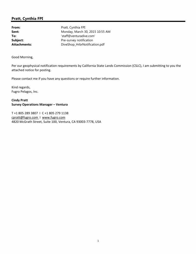
From: Pratt, Cynthia FPISent: Monday, March 30, 2015 10:55 AMTo: '[email protected]'Subject: Pre-survey notificationAttachments: DiveShop_HrbrNotification.pdf
Good Morning, Per our geophysical notification requirements by California State Lands Commission (CSLC), I am submitting to you the attached notice for posting. Please contact me if you have any questions or require further information. Kind regards, Fugro Pelagos, Inc. Cindy Pratt Survey Operations Manager – Ventura T +1 805 289 3807 I C +1 805 279 1138 [email protected] I www.fugro.com 4820 McGrath Street, Suite 100, Ventura, CA 93003‐7778, USA

1
Pratt, Cynthia FPI
From: Pratt, Cynthia FPISent: Thursday, March 26, 2015 4:18 PMTo: '[email protected]'Cc: Stutts, Eddie FPISubject: Pre-survey notificationAttachments: DiveShop_HrbrNotification.pdf
Good Afternoon, Mr. Miller, Per our geophysical notification requirements by California State Lands Commission (CSLC), I am submitting to you the attached notice for posting. Please contact me if you have any questions or require further information. Kind regards, Fugro Pelagos, Inc. Cindy Pratt Survey Operations Manager – Ventura T +1 805 289 3807 I C +1 805 279 1138 [email protected] I www.fugro.com 4820 McGrath Street, Suite 100, Ventura, CA 93003‐7778, USA