N TRANSPORTATION SAFETY C - reports.aviation-safety.netPRELIM).pdf · Badan Meteorologi dan...
26
PRELIMINARY KNKT.10.04.09.04 N N A A T T I I O O N N A A L L T T R R A A N N S S P P O O R R T T A A T T I I O O N N S S A A F F E E T T Y Y C C O O M M M M I I T T T T E E E E PT. Merpati Nusantara PK-MDE Boeing B737-300 Rendani Airport, Manokwari - Papua Barat REPUBLIC OF INDONESIA 13 April 2010 Aircraft Accident Investigation Report NATIONAL TRANSPORTATION SAFETY COMMITTEE MINISTRY OF TRANSPORTATION REPUBLIC OF INDONESIA 2010
Transcript of N TRANSPORTATION SAFETY C - reports.aviation-safety.netPRELIM).pdf · Badan Meteorologi dan...
1
PPRREELLIIMMIINNAARRYY KKNNKKTT..1100..0044..0099..0044
NNAATTIIOONNAALL TTRRAANNSSPPOORRTTAATTIIOONN SSAAFFEETTYY CCOOMMMMIITTTTEEEE
PT. Merpati Nusantara
PK-MDE
Boeing B737-300
Rendani Airport, Manokwari - Papua BaratREPUBLIC OF INDONESIA
13 April 2010
Aircraft Accident Investigation Report
NATIONAL TRANSPORTATION SAFETY COMMITTEE MINISTRY OF TRANSPORTATION REPUBLIC OF INDONESIA 2010

This Preliminary Factual Report was produced by the National Transportation Safety Committee (NTSC), Karya Building 7th Floor Ministry of Transportation, Jalan Medan Merdeka Barat No. 8 JKT 10110, Indonesia. The report is based upon the investigation carried out by the NTSC in accordance with Annex 13 to the Convention on International Civil Aviation, Aviation Act (UU No.1/2009), and Government Regulation (PP No. 3/2001). Readers are advised that the NTSC investigates for the sole purpose of enhancing aviation safety. Consequently, NTSC reports are confined to matters of safety significance and may be misleading if used for any other purpose.
As NTSC believes that safety information is of greatest value if it is passed on for the use of others, readers are encouraged to copy or reprint for further distribution, acknowledging NTSC as the source.
When the NTSC makes recommendations as a result of its investigations or research, safety is its primary consideration.
However, the NTSC fully recognizes that the implementation of recommendations arising from its investigations will in some cases incur a cost to the industry.
Readers should note that the information in NTSC reports and recommendations is provided to promote aviation safety. In no case is it intended to imply blame or liability.
2

TABLE OF CONTENTS TABLE OF CONTENTS..................................................................................................... i
TABLE OF FIGURES ....................................................................................................... iii
GLOSSARY OF ABBREVIATIONS................................................................................ v
INTRODUCTION ............................................................................................................... 1
1 FACTUAL INFORMATION...................................................................................... 3 1.1 History of the Flight ........................................................................................... 3
1.2 Injuries to Persons .............................................................................................. 4
1.3 Damage to Aircraft ............................................................................................. 5
1.4 Other Damage..................................................................................................... 7
1.5 Personnel Information ........................................................................................ 7 1.5.1 Pilot in command .................................................................................. 7 1.5.2 Co-pilot.................................................................................................. 7
1.6 Aircraft Information ........................................................................................... 8 1.6.1 General .................................................................................................. 8 1.6.2 Engines .................................................................................................. 8
1.7 Meteorological Information................................................................................ 8
1.8 Aids to Navigation.............................................................................................. 9
1.9 Communications................................................................................................. 9
1.10 Aerodrome Information...................................................................................... 9
1.11 Flight Recorders ............................................................................................... 10
1.12 Wreckage and Impact Information ................................................................... 11
1.13 Medical and Pathological Information ............................................................. 11
1.14 Fire.................................................................................................................... 11
1.15 Survival Aspects ............................................................................................... 11
1.16 Tests and Research ........................................................................................... 12
1.17 Organisational and Management Information.................................................. 12
1.18 Additional Information ..................................................................................... 12
1.19 Useful or Effective Investigation Techniques .................................................. 12
2 ANALYSIS.................................................................................................................. 13
3 CONCLUSIONS......................................................................................................... 15 3.1 Findings ............................................................................................................ 15
3.2 Causes............................................................................................................... 15
i

4 SAFETY ACTIONS AND RECOMMENDATIONS ............................................. 17 4.1 Safety Actions................................................................................................... 17
4.2 Recommendations ............................................................................................ 17 4.2.1 Recommendation to the Directorate General of Civil Aviation
(DGCA)............................................................................................... 17 4.2.2 Recommendation to the Directorate General of Civil Aviation
(DGCA)............................................................................................... 17 4.2.3 Recommendation to the Directorate General of Civil Aviation
(DGCA)............................................................................................... 17 4.2.4 Recommendation to the Directorate General of Civil Aviation
(DGCA)............................................................................................... 18 4.2.5 Recommendation to the Directorate General of Civil Aviation
(DGCA)............................................................................................... 18 4.2.6 Recommendation to PT. Merpati Nusantara ....................................... 18 4.2.7 Recommendation to PT. Merpati Nusantara ....................................... 18
ii
TABLE OF FIGURES Figure 1: The fractured aircraft fuselage ................................................................................5
Figure 2: The left wing tip sheared off from the wing ...........................................................5
Figure 3: The right wing and number-two (right) engine damage .........................................5
Figure 4: The left engine separated ........................................................................................6
Figure 5: Left wing damage ...................................................................................................6
Figure 6: Passenger cabin damage .........................................................................................6
Figure 7: Flight data recorder ...............................................................................................10
Figure 8: Cockpit voice recorder..........................................................................................10
iii

iv

GLOSSARY OF ABBREVIATIONS AD : Airworthiness Directive AFM : Airplane Flight Manual AGL : Above Ground Level ALAR : Approach-and-Landing Accident Reduction AMSL : Above Mean Sea Level AOC : Air Operator Certificate ATC : Air Traffic Control ATPL : Air Transport Pilot License ATS : Air Traffic Service ATSB : Australian Transport Safety Bureau Avsec : Aviation Security BMG : Badan Meterologi dan Geofisika BOM : Basic Operation Manual °C : Degrees Celsius CAMP : Continuous Airworthiness Maintenance Program CASO : Civil Aviation Safety Officer CASR : Civil Aviation Safety Regulation CPL : Commercial Pilot License COM : Company Operation Manual CRM : Cockpit Recourses Management CSN : Cycles Since New CVR : Cockpit Voice Recorder DFDAU : Digital Flight Data Acquisition Unit DGCA : Directorate General Civil Aviation DME : Distance Measuring Equipment EEPROM : Electrically Erasable Programmable Read Only Memory EFIS : Electronic Flight Instrument System EGT : Exhaust Gas Temperature EIS : Engine Indicating System FL : Flight Level F/O : First officer or Copilot FDR : Flight Data Recorder FOQA : Flight Operation Quality Assurance GPWS : Ground Proximity Warning System hPa : Hectopascals Hr : Hours ICAO : International Civil Aviation Organization IFR : Instrument Flight Rules IIC : Investigator in Charge ILS : Instrument Landing System
v
Kg : Kilogram(s) Km : Kilometer(s) Kt : Knots (nm/hours) Mm : Millimeter(s) MTOW : Maximum Take-off Weight NM : Nautical mile(s) NTSB : National Transportation Safety Board (USA) KNKT / NTSC : Komite Nasional Keselamatan Transportasi / National Transportation Safety Committee PIC : Pilot in Command QFE : Height above airport elevation (or runway threshold elevation) based on local station pressure QNH : Altitude above mean sea level based on local station pressure RESA : Runway End Safety Area RPM : Revolution Per Minute ROV : Remotely Operated Vehicle SCT : Scattered S/N : Serial Number SSCVR : Solid State Cockpit Voice Recorder SSFDR : Solid State Flight Data Recorder TS/RA : Thunderstorm and rain TAF : Terminal Aerodrome Forecast TPL : Towed Pinger Locator TSN : Time Since New TT/TD : Ambient Temperature/Dew Point TTIS : Total Time in Service UTC : Universal Time Coordinate VFR : Visual Flight Rules VMC : Visual Meteorological Conditions
vi

INTRODUCTION
SYNOPSIS On 13 April 2010, a Boeing B737-300 aircraft registered PK-MDE was being operated by PT. Merpati Nusantara Airline as a scheduled passenger flight MZ 836, from Hasanuddin Airport, Makassar, Sulawesi to Rendani Airport, Manokwari, Papua. It made a transit stop at Domine Eduard Osok Airport, Sorong, Papua. The pilot in command was the pilot flying, and the copilot, who also held a command rating on the aircraft, was the support/monitoring pilot for the sector to Manokwari.
Due to heavy rain over Manokwari, the departure from Sorong was delayed for about two hours. Approaching Manokawari the crew were informed that the weather was continuous slight rain, visibility 3 kilometers, cloud overcast with cumulus-stratocumulus at 1,400 feet, temperature 24 degrees Celsius, QNH 1012 hectopascals. When the crew reported that they were on final for runway 35 controller informed them that the wind was calm, runway condition was wet and clear.. The crew read back the wind condition and that the runway was clear, but did not mention the wet runway condition.
Witnesses stated that the aircraft made a normal touchdown on the runway, about 120 meters from the approach end of runway 35, but the aircraft’s engine reverser sound was not heard during landing roll. The aircraft overran the departure end of runway 35, and came to a stop 205 meters beyond the end of the runway in a narrow river; the Rendani River.
Due to the steep terrain 155 meters from the end of runway 35, the airport rescue and fire fighting service had to turn back and use the airport’s main road to reach the aircraft, taking about 10 minutes to reach the aircraft. The accident site was in an area of shallow muddy water surrounded by mangrove vegetation. The aircraft was substantially damaged. Nearby residents, police and armed forces personnel assisted the evacuation from the aircraft.
The passengers and crew members were evacuated and moved from the site by 0230. They were taken to the Manokwari General Hospital, and Manokwari Naval Hospital for further medical treatment.
The investigation is continuing and will include analysis of data from the flight data and cockpit voice recorders. Operational documentation and training with respect to aircraft performance, stabilized approach criteria, and operations into wet and contaminated runways will be examined. Runway conditions and safety systems including rescue and fire fighting services, and the system for ensuring flight crews have sufficient and appropriate information to aid their decision making will also be examined. The role of the aviation regulator in providing timely, appropriate and effective oversight of the operator and the aerodrome is being examined.
The National Transportation Safety Committee issued a number of recommendations to PT. Merpati Nusantara and the Directorate General of Civil Aviation with the Preliminary Report, covering adequacy of documentation and training, and regulatory oversight of the airline and the airport.
1

2

1 FACTUAL INFORMATION
1.1 History of the Flight On 13 April 2010, a Boeing B737-300 aircraft registered PK-MDE was being operated by PT. Merpati Nusantara Airline as a scheduled passenger flight MZ 836, from Hasanuddin Airport, Makassar, Sulawesi to Rendani Airport, Manokwari1, Papua. It made a transit stop at Domine Eduard Osok Airport, Sorong, Papua.
The aircraft departed from Makassar at 2010 UTC2 and landed at Sorong at 2214 UTC3. The scheduled departure time from Sorong was 2235, but due to heavy rain over Manokwari, the departure was delayed for about two hours. The pilot in command was the pilot flying, and the copilot, who also held a command rating on the aircraft, was the support/monitoring pilot. The aircraft subsequently departed Sorong 2 hours and 43 minutes later, at 0118. The observed weather report issued by Badan Meteorologi dan Geofisika (BMG)4 Manokwari for takeoff and landing at 0100 indicated that the weather was “continuous slight rain, horizontal visibility of 3 to 4 kilometers, cloud overcast cumulus-stratocumulus, westerly wind at 5 knots”.
The aircraft’s dispatch release from Sorong indicated that the flight was planned under the Instrument Flight Rules (IFR5). The destination, Manokwari, had no published instrument approach procedure. Terminal area operations, including approach and landing, were required to be conducted under the Visual Flight Rules (VFR6).
At 0146 the crew made the first direct contact with Rendani Radio and reported their position as 14 Nm from Manokwari, and maintaining altitude 10,500 feet. Following this radio contact, Rendani Radio informed the crew that the weather was continuous slight rain, visibility 3 kilometers, cloud overcast with cumulus-stratocumulus at 1,400 feet, temperature 24 degrees Celsius, QNH 1012 hectopascals.
The transcript of the Rendani Radio communications with the aircraft indicated that controller then instructed the crew to descend and joint right downwind for runway 35, and to report when overhead the airport. Shortly after, the crew reported overhead the airport at 5,000 feet. The controller then instructed the crew to report when they were on final approach for runway 35. The crew acknowledged this instruction.
At 0154 the crew reported that they were on final for runway 35. The controller informed them that the wind was calm, runway condition was wet and clear7.
1 Rendani Airport, Manokwari, Papua will be termed Manokwari throughout this report
2 The 24-hour clock in Coordinated Universal Time (UTC) is used in this report to describe the local time as specific events occurred. Waktu Indonesia Tengah (WITA) is UTC +8 hours. Therefore, 2010 UTC on 12 April 2010 was 0410 local Makassar time on 13 April.
3 Local time in the area of the accident, Eastern Indonesia Standard Time (Waktu Indonesia Timur (WIT)) is UTC +9 hours. Therefore, 2212 UTC on 12 April 2010 was 0812 local Manokwari time on 13 April.
4 BMG is the Indonesia national meteorology office.
5 IFR - Rules applied when flying in cloud or whenever external reference not available
6 VFR - Controlling flight trajectory by reference to identified earth surface
7 Clear – The AFIS terminology to inform the crew that the runway was fit for use.
3
The crew read back the wind condition and that the runway was clear, but did not mention the wet runway condition.
According to the Rendani Airport Administrator’s report to the investigation, the aircraft was observed to make a normal touchdown on the runway at about 0155, about 120 meters from the approach end of runway 35. The report stated that the aircraft’s engine reverser sound was not heard during landing roll. Witnesses on board the aircraft also stated that the aircraft made a smooth landing, and the engine reversers were not heard during the landing roll.
During the landing roll, the aircraft veered to the left about 140 meters from the end of runway 35, then overran the departure end of runway 35. At about 0156 it came to a stop 205 meters beyond the end of the runway in a narrow river; the Rendani River.
The Observed Weather Report issued by BMG Manokwari for takeoff and landing at 0200 (4 minutes after the accident) indicated that the weather was continuous moderate rain, with a horizontal visibility of 4 kilometers, cloud overcast cumulus-stratocumulus, south-westerly wind at 5 knots.
The airport rescue and fire fighting unit was immediately deployed to assist the post-crash evacuation. Due to the steep terrain 155 meters from the end of runway 35, the rescuers had to turn back and use the airport’s main road to reach the aircraft. The accident site was in an area of shallow muddy water surrounded by mangrove vegetation.
The aircraft was substantially damaged. Nearby residents, police and armed forces personnel assisted the evacuation from the aircraft.
The Rendani Airport Administrator reported that the passengers and crew members were evacuated and moved from the site by 0230. They were taken to the Manokwari General Hospital, and Manokwari Naval Hospital for further medical treatment.
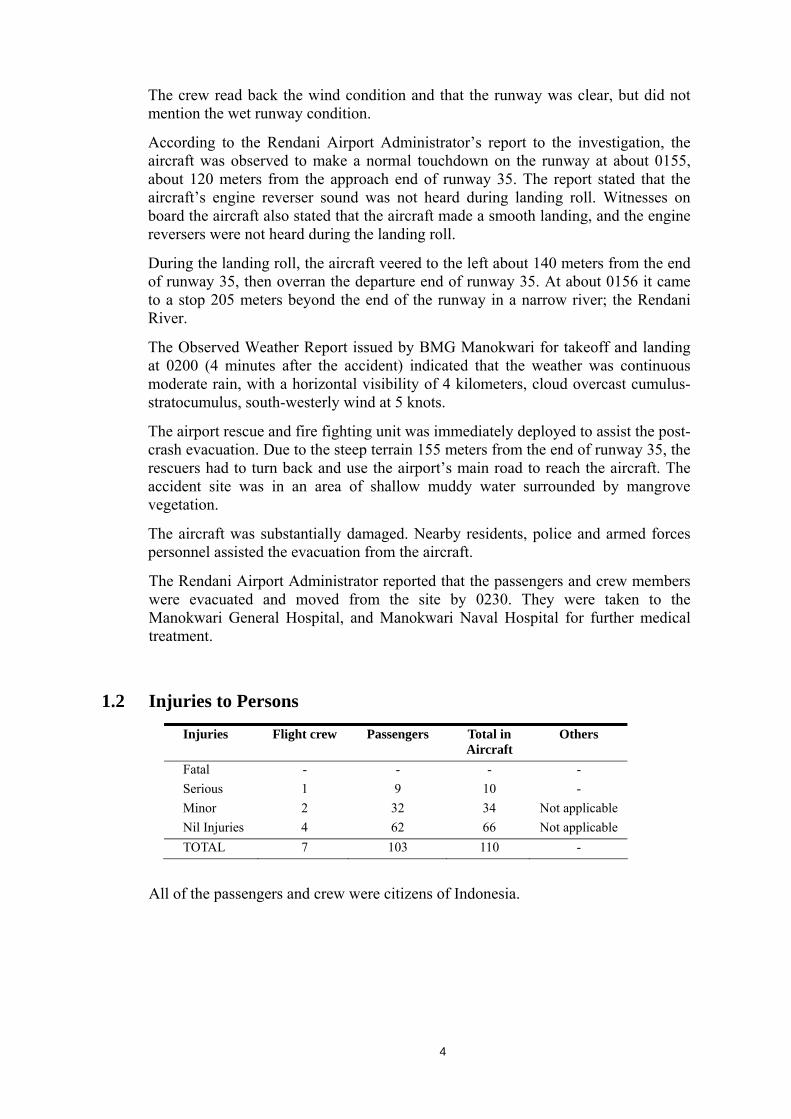
1.2 Injuries to Persons
Injuries Flight crew Passengers Total in
Aircraft Others
Fatal - - - - Serious 1 9 10 - Minor 2 32 34 Not applicable Nil Injuries 4 62 66 Not applicable TOTAL 7 103 110 -
All of the passengers and crew were citizens of Indonesia.
4

1.3 Damage to Aircraft The aircraft was substantially damaged.
Figure 1: The fractured aircraft fuselage
Figure 2: The left wing tip sheared off from the wing
Figure 3: The right wing and number-two (right) engine damage
5

Figure 4: The left engine separated
Figure 5: Left wing damage
Figure 6: Passenger cabin damage
6

1.4 Other Damage One mango tree situated about 185 meters from the end of runway 35 was clipped by the aircraft’s left wing. One langsat tree about 4 meters to the left of the mango tree was also clipped by the left wing tip. There was substantial damage to the mangrove vegetation along aircraft’s ground impact trail.
1.5 Personnel Information 1.5.1 Pilot in command
Gender : Male
Date of birth : 26 August 1954 Nationality : Indonesia License : ATPL Date of issue : 23 May 1985 Valid to : 20 June 2010 Aircraft type rating : B737-300/400/500 Medical certificate : Class 1 Date of medical : 20 December 2009 Valid to : 20 June 2010 Last proficiency check : 20 February 2010 Total hours : 16,450 hours 24 minutes Last 90 days : 148 hours 20 minutes Last 7 days : 9 hours 57 minutes Last 24 hours : 2 hours 18 minutes This flight : 42 minutes
1.5.2 Co-pilot
Gender : Male
Date of birth : 17 August 1954 Nationality : Indonesia License : ATPL Date of issue : 29 May 1985 Valid to : 28 August 2010 Aircraft type rating : B737-300/400/500 Medical certificate : Class 1 Date of medical : 23 February 2010 Valid to : 22 Juli 2010 Last proficiency check : 22 March 2010 Total hours : 22,139 hours 55 minutes Last 90 days : 183 hours 29 minutes Last 7 days : 21 hours 30 minutes Last 24 hours : 2 hours 18 minutes
7

1.6 Aircraft Information
1.6.1 General
Aircraft manufacturer : Boeing Company, Seattle USA
Aircraft model/type : B 737-300 Serial number : 24660 Year of manufacture : 28 February 1990 Aircraft registration : PK-MDE Certificate of Registration : No.2679 Valid to : 15 November 2010 Certificate of Airworthiness : No.2679 Valid to : 15 November 2010 Time Since New : 54,759 hours Cycles Since New : 38,485 cycles Maximum Take-off Weight : 116,600 lbs Actual Take-off Weight : 112,300 lbs Actual Landing Weight : 108,589 lbs
1.6.2 Engines
Engine type : Turbofan Manufacturer : SNECMA Model : CFM56-3C1 Number-one (Left) Serial Number
:
724567
Time Since New : 53,934 hours Cycles Since New : 31,353 cycles Number-two (Right) Serial Number #2
:
725718
Time Since New : 51,027 hours Cycles Since New : 34,015 cycles
The Auxiliary Power Unit (APU) had been unserviceable since 12 April 2010.
1.7 Meteorological Information Weather report for Manokwari (WASR), issued 13 April 2010, at 0100
Surface wind : Calm Visibility : 3000 meters Present weather : Continuous slight rain Cloud : Overcast cumulus stratocumulus ceiling at 1,400 feet Temperature : 24 deg C Dew Point : 24 deg C QNH : 1012.2 hPa QFE : 1011.5 hPa
8

Weather report for Manokwari (WASR), issued 13 April 2010, at 0200 Surface wind : South westerly (200 degrees true) 5 knots Visibility : 4,000 meters Present weather : Continuous moderate rain Cloud : Overcast cumulus stratocumulus ceiling 1400 feet Temperature : 26 deg C Dew Point : 24 deg C QNH : 1011.9 hPa QFE : 1011.2 hPa
Daylight conditions prevailed at the time of the accident.
1.8 Aids to Navigation There were no navigation aids for the approach and landing at Manokwari. The an approach and landing must be conducted under the VFR to runway 35 only. The precision approach path indicator (PAPI), installed for runway 35, was not operational at the time of accident.
1.9 Communications Air traffic communication services provided by the Aerodrome Flight Information Service (AFIS8), when operating into Manokwari, were advisory. All communications between Manokwari and the crew were recorded by ground based automatic voice recording equipment. Direct two-way communication between Rendani Radio and the crew was established at 0147, approximately 14 Nm from airport.
1.10 Aerodrome Information
Aerodrome Code : WASR / MWK Airport Name : Rendani Airport Airport Address : Jl.Trikora, Rendani PO BOX 164,
Manokwari Papua 98315 Airport Class : III Airport Authority : DGCA Airport Service : AFIS Type of Traffic Permitted : VFR Coordinates : 00° 53′ 37′′ S, 134° 03′ 01′′ E Elevation : 15 feet Runway Length : 2,000 meters Runway Width Stopway
::
30 meters 60 meters
8 Even though the controller gave instructions to the crew, the Aerodrome Flight Information Service at Manokwari provided
advisory information.
9

Runway End Safety Area : Nil Azimuth : 17 / 35 Category for Rescue Fire Fighting Service9
: Category 3
1.11 Flight Recorders The aircraft was equipped with a Flight Data Recorder (FDR) and a Cockpit Voice Recorder (CVR).
Flight Data Recorder (FDR)
Manufacturer : Allied Signal
Model : 980-4700-042 Serial Number : 5728
Figure 7: Flight data recorder
Cockpit Voice Recorder (CVR)
Manufacturer : Allied Signal
Model : 980-6020-001 Serial Number : 1751
Figure 8: Cockpit voice recorder
Both recorders were removed from the aircraft and taken to the NTSC laboratory in Jakarta by NTSC investigators. Good quality data from the recorders was downloaded.
9 The Indonesian Aeronautical Information Publication listed Rendani Airport as Category 1 with respect to RFFS. However,
the Rendani Airport Administrator reported that Rendani Airport was Category 5. In accordance with ICAO Annex 14 Vol 1 Table 9.1, for Boeing 737-300 aircraft operations, the airport is required to have Category 6 RFFS.
10

For the purpose of data analysis, and to resolve the unique data frame particular to the accident flight data recorder, the NTSC requested the Australian Transport Safety Bureau (ATSB) and US National Transportation Safety Board (NTSB) to assist.
1.12 Wreckage and Impact Information The aircraft’s final impact position was about 205 meters beyond the departure end of runway 35, bearing 340 degrees magnetic.
The aircraft was substantially damaged. The radome was detached from the aircraft’s nose section. The electronic equipment compartment was buried in the mud. The forward fuselage was fractured adjacent to the wing leading edge and bent downward, remaining connected to the rear fuselage via the floor beams. Both wings and adjacent structure, and the nose and main landing gears were substantially damaged. Both engines, including their pylons, were separated from their respective wings.
1.13 Medical and Pathological Information Medical examinations of the crew and passengers were conducted as a result of this accident.
1.14 Fire There was no evidence of fire in flight or after the aircraft impact.
1.15 Survival Aspects The flight crew evacuated the aircraft from the cockpit left side window. A number of passengers left the aircraft through the fracture opening in the fuselage near the wing leading edge. Most of passengers left the aircraft through the right aft service door.
Two passengers were trapped under their seats and had to be assisted by rescuers.
According to witnesses, only two escape slides were used; the front main passenger door escape slide and the right aft service door escape slide. The front main passenger door escape slide did not automatically inflated when the door was opened, but the flight attendant assigned to that door observed the very close proximity with the ground and decided not to manually inflate the escape slide. It was subsequently deployed by the flight crew from outside the aircraft, but was not used for passenger evacuation. The right aft service door escape slide was automatically deployed, but shortly after being used it deflated. The left aft escape slide was not used and the door was kept shut during the evacuation due to the flight attendant observing the strong flowing water along that side of the aircraft.
Witnesses informed the investigation that the airport fire fighting and rescue service personnel arrived about 10 minutes after the accident.
11

1.16 Tests and Research Test and research will be considered if additional factual data indicates the requirement.
1.17 Organisational and Management Information Aircraft Owner : Wilmington Trust Company Trustee
Address : Rodney Square North ATTN Corp TRS Wilmington Delaware 19890
Aircraft Operator : PT. Merpati Nusantara Airlines
Address : Jl. Angkasa Blok B-15 Kav 2-3
Kemayoran, Jakarta 10720
The Company Operations Manual found on board the aircraft was not current. The operator also did not have current copies of the Boeing 737-300/CFM56-3B1_20K Flight Crew Operations Manual (FCOM) or Quick Reference Handbook (QRH).
The investigation found a copy of the Boeing 737-400/CFM56-3_22K FCOM and QRH on board the aircraft.
The operator informed the investigation that it had ordered the Boeing 737-300/CFM56-3B1_20K FCOM and QRH from the Boeing Company, which are expected to be delivered during August 2010.
The initial examination of the Company Operations Manual, with respect to actual landing distance, found that the policy had not been implemented.10
1.18 Additional Information The investigation is continuing and will include analysis of data from the flight data and cockpit voice recorders. Operational documentation and training with respect to aircraft performance, stabilized approach criteria, and operations into wet and contaminated runways will be examined. Runway conditions and safety systems including rescue and fire fighting services, and the system for ensuring flight crews have sufficient and appropriate information to aid their decision making will also be examined. The role of the aviation regulator in providing timely, appropriate and effective oversight of the operator and the aerodrome is being examined.
1.19 Useful or Effective Investigation Techniques The investigation is being conducted in accordance with NTSC-approved policies and procedures, and in accordance with the standards and recommended practices of Annex 13 to the Chicago Convention.
.
10 Company Operations Manual, Operational Directives, Flight Deck Procedures, Paragraph 4.10.6.3, Final Approach and
Landing, Actual Landing Distance.
12

2 ANALYSIS
To be included in the Final Report.
13

14

3 CONCLUSIONS
3.1 Findings
To be included in the Final Report.
3.2 Causes
To be included in the Final Report.
15

16

4 SAFETY ACTIONS AND RECOMMENDATIONS
4.1 Safety Actions
At the time of issuing this Preliminary Accident Investigation Report, the National Transportation Safety Committee had not been informed of any safety actions resulting from this accident.
4.2 Recommendations
4.2.1 Recommendation to the Directorate General of Civil Aviation (DGCA)
The National Transportation Safety Committee recommends that the Directorate General Civil of Aviation (DGCA) should ensure that PT. Merpati Nusantara Airlines Operational Specifications and other technical and operational safety requirements are met. This should include:
a) an extensive review of mandatory operational documentation and associated crew training; and
b) an extensive review of the operational implementation of the Actual Landing Distance policy and procedures, and associated training.
4.2.2 Recommendation to the Directorate General of Civil Aviation (DGCA) The National Transportation Safety Committee recommends that the Directorate General Civil of Aviation (DGCA) urgently review the Rendani Airport, Manokwari runway complex, to ensure that the runway end safety areas (RESA) meet the dimension Standards prescribed in the International Civil Aviation Organization (ICAO) Annex 14.
Particular attention should be given to:
a) ICAO Annex 14 Paragraph 3.5.2 (Standard) that a runway end safety area (RESA) shall extend from the end of a runway strip to a distance of at least 90 meters.
b) ICAO Annex 14 Paragraph 3.5.3 (Recommendation) that for a Code number 3 airport a runway end safety area (RESA) should, as far as practicable, extend from the end of a runway strip to a distance of at least 240 meters.
If the DGCA is unable to meet the RESA Standard in accordance with ICAO Annex 14, it should file a difference with ICAO as soon as possible.
4.2.3 Recommendation to the Directorate General of Civil Aviation (DGCA)
The National Transportation Safety Committee recommends that the Directorate General Civil of Aviation (DGCA) urgently review all airports throughout Indonesia involving Civil Aviation Safety Regulation Part 121 and Part 135 aircraft operations, to ensure that the runway end safety areas (RESA) meet the dimension Standards prescribed in the International Civil Aviation Organization (ICAO) Annex 14.
17

If the DGCA is unable to meet the RESA Standard in accordance with ICAO Annex 14, it should file a difference with ICAO as soon as possible.
4.2.4 Recommendation to the Directorate General of Civil Aviation (DGCA) The National Transportation Safety Committee recommends that the Directorate General Civil of Aviation (DGCA) urgently ensure that Indonesian airports equipped with visual approach slope guidance systems, maintain the equipment to a serviceable standard, and are operational particularly during Civil Aviation Safety Regulation Part 121 and Part 135 aircraft operations.
4.2.5 Recommendation to the Directorate General of Civil Aviation (DGCA) The National Transportation Safety Committee recommends that the Directorate General of Civil Aviation (DGCA) review the procedures and equipment used by airport Rescue and Fire Fighting Services to ensure that they:
a) meet the minimum requirements, including timeliness, specified in the International Civil Aviation Organization’s Annex 14; and
b) meet the requirements to cover the area up to 5 NM (8 Km) from the airport perimeter, as stated in the Transport Ministry Decree 47 (KM47).
4.2.6 Recommendation to PT. Merpati Nusantara
The National Transportation Safety Committee recommends that PT. Merpati Nusantara should review its technical and operational safety requirements to ensure they are implemented. This should include:
a) an extensive review of mandatory operational documentation and associated crew training; and
b) an extensive review of the operational implementation of the Actual Landing Distance policy and procedures, and associated training.
4.2.7 Recommendation to PT. Merpati Nusantara
The National Transportation Safety Committee recommends that PT. Merpati Nusantara review equipment used by airport Rescue and Fire Fighting Services at airports in its network, to ensure that they meet the minimum requirements for Boeing 737 aircraft, that are specified in the International Civil Aviation Organization’s Annex 14.
18