color IUI MRK-005-0345 6C-104-A037 6C-107-A037 6C-109-A037 ...

“Mission first, people always”, as quoted by our administrator Dr. Kathryn D. Sullivan, is a statement that embodies the spirit of NOAA and is firmly represented within the N-Wave team! Looking back with great pride at the accomplishments of FY15 and the professional manner in which services have been delivered, I want to take this small front page space to individually thank the N-Wave team and partners for their dedication to NOAA’s mission. (See the associated articles in this edition for more
information on FY15 accomplishments.)
For the multiple projects surrounding the design, engineering, project planning and deployment of the NOAA Trusted Internet Connection (TIC) sites, I want to thank Alex Hsia, John Parker, Will O’Brien, Mark Mutz, Jason Iannone, Keith Holub, Lisa Love, John Kyler, Dave Hartzell, Jared Brown, Greg Boles, Steve Sanderson, and Jared Schlemmer, with special thanks to Ann Keane and Sybil Ennis who have coordinated and led large-scale logistics and sub projects across all TIC sites. For dedicated National Environmental Satellite, Data, and Information Service (NESDIS) support and the stellar efforts with the engineering and deployment of the DC Metro DWDM ring, I would like to thank Eldar Urumbaev, Keith Holub, John Kyler, Dave Hartzell, and Jared Schlemmer. Thanks to Eldar, Dave, and John Parker for their support working with NASA and NESDIS, bringing up the DSCOVR connectivity between Fairbanks and the Space Weather Prediction Center (SWPC). For N-Wave new service tracking and preliminary engineering with an emphasis on the efforts surrounding the N-Wave California aggregations site, thanks go out to Paul Love and Matt Smith, with additional appreciation to Matt for conducting multiple wireless site assessments.
N-WaveNews
From the N-Wave Network Manager
06I S S U E
N o v e m b e r2 0 1 5
NOAA N-WaveN-Wave is NOAA’s science network. Built on partnerships and relationships among NOAA and the Academic and State research network communities, N-Wave connects researchers to the data and resources needed to advance environmental science.
MissionN-Wave is committed to provide innovative networking capabilities with integrity, excellence, value, and flexibility, to enable NOAA’s science and research through reliable high-performance networking.
Our VisionA consolidated, agency-wide network resource that meets NOAA’s research connectivity requirements and where appropriate, supplements NOAA’s operational connectivity requirements.
this issueFrom the N-Wave Science Network Manager P. 1
N-Wave to Establ ish Cal i fornia Connect iv i ty P. 4
N-Wave Technology Futures P. 5
N-Wave a Final ist for Excel lence.gov Awards P. 6
Total N-Wave Traff ic Volumes and Network Performance Metr ics P. 7
N-Wave NOC Tickets Report P. 9
The Unif ied Dashboard: How i t Works, and What ’s Next P. 10
N-Wave Updates P. 14
Robert Sears

2
A special thank you for the collaborative work between the N-Wave Engineering team and the Silver Spring NOC team for dedication and expertise on the enterprise routing change project, which optimizes intra-NOAA traffic flow. In similar fashion, the cooperative TIC management and operations work between the NOAA Cyber Security Center and the N-Wave NOC, with Jeremy Oakes and Chris Robb leading efforts for N-Wave, is an exemplary display of intra-NOAA program collaboration with NOAA-wide benefit.
Adding to the conversation of security, thank you to the N-Wave security team - information system security officer John Parker and security specialist Leeanne Witherspoon. The scope and breadth of your proficiency is seen in every service N-Wave provides. And as always, our success begins with acquisitions support. Thank you to Contracting Officer Michael Blumenfeld (SSAD) and Contract Specialist team members Ronette Pratt, Keith Harding and Franklin Miles for your professional support to the N-Wave program. In addition, a special thank you to Contracting Officer Chad Hepp (WAD) and Contract Specialist Sue Bratton for your guidance and expertise on the NOAA Boulder Specialized IT Labor effort.
Again, I am proud of the accomplishments of the N-Wave program and the many instances of collaboration across NOAA and our partners. These efforts reflect well upon the agency and truly enable NOAA’s mission!
N-Wave Network Manager
On October 1, 2015, the N-Wave program transitioned from the NOAA Office of Oceanic and Atmospheric Research, Earth System Research Laboratory Office of the
Director, to the NOAA Office of the Chief Information Officer (CIO). All N-Wave services, relationships and agreements remain, with the N-Wave manager now reporting to the CIO/Deputy CIO. As N-Wave supports multiple Line Offices and programs across NOAA’s mission of science, stewardship and service, this transition will further ensure
operations and accountability for N-Wave as a NOAA enterprise service.
N-Wave Program Relocation

3
Photo:Will von Dauster

4
N-Wave to Establish California Connectivity Engineering efforts with the Corporation for Education Network Initiatives in California (CENIC).
Proposed California Sites
Early in FY15, N-Wave began examining connectivity options for both NOS and NMFS regarding new service requests for several sites in the San Francisco Bay area. Initial engineering found it beneficial to leverage the Western Regional Network’s (WRN) resources via N-Wave’s partnerships with multiple WRN members to facilitate connectivity.
The WRN is a collaboration of the Pacific Northwest Gigapop (PNWGP) in Washington, the Front Range GigaPoP (FRGP) in Colorado and Wyoming, the University of New Mexico on behalf of the State of New Mexico, the Corporation for Education Network Initiatives in California (CENIC), and the University of Hawaii. WRN is a multi-state partnership providing advanced, robust high-speed networking for research, education, and related uses. WRN provides super aggregation for its members and allows for Layer 2 connections between its participants.
Proposed California sites

5
The N-Wave team continually examines new networking technology to better meet NOAA’s mission while maintaining competence in the field as new technology becomes available. Here are some examples of recent work by N-Wave to meet these goals:
• Since it began five years ago, N-Wave has utilized Ethernet and IP/MPLS technologies, avoiding the use of legacy Time Division Multiplexing (TDM)(e.g. T-1, DS-3, OC-3). TDM has recently been identified by the OMB as a technology that should be eliminated over the next few years. N-Wave’s use of the alternative technologies has proven beneficial in improving the bandwidth-to-cost ratio due to carrier industry adoption of Ethernet on the wide area.
• In February 2015, N-Wave engineers rolled out a Ciena 100-Gbps optical network in the Washington, DC area, providing Ethernet transport over a 44-channel Dense Wave Division Multiplexing (DWDM) system. Thisnetwork currently supports a single 100-Gbps OTN-4 channel, providing 10Gbps add/drop at Suitland, Silver Spring, College Park/MAX, and McLean, VA. With 44 channels of capacity, the ring can support terabits per second of capacity, meeting NOAA’s bandwidth needs well into the future.
• In addition to supporting Layer 3 VPNs and point-to-point Ethernet transport, this spring N-Wave began deploying Virtual Private LAN Services (VPLS). VPLS provides multi-point Layer 2 Ethernet services allowing customers to connect multiple sites to N-Wave, and run their own Layer 3 IP protocols. For more on VPLS see the article on page 14.
• In the interest of achieving a high quality of service (QoS), N-Wave has always maintained an architecture goal to provide ample bandwidth to customers on the backbone. But this year NESDIS asked N-Wave to implement differentiated services (DiffServ) on edge access circuits for GOES-R, where bandwidth upgrades weren’t feasi-ble. DiffServ is usually used to provide multiple classes of service, for example differentiated voice traffic from bulk data. For NESDIS such things as file synchronization, product data, network management, and inter-site antenna traffic are given differentiating tags. This is the first deployment of QoS on N-Wave, and it has provided useful insight into various implementations.
N-Wave Technology Futures New networking technology to better meet NOAA’s mission
Through the FRGP partnership and resulting WRN membership, N-Wave and the FRGP began engineering efforts with the Corporation for Education Network Initiatives in California (CENIC). CENIC is the Regional Optical Network (RON) covering the whole state including the UC and CSU systems, the K-12 systems, and all public libraries.
To establish connectivity, N-Wave will deploy an aggregation site in California that will connect to the N-Wave core nodes in Seattle and Denver over 10-Gbps WRN Virtual Area Local Networks (VLAN). As engineering progressed, members of CENIC and the FRGP, along with N-Wave engineers, decided on the placement of an N-Wave aggregation node at the CENIC POP in Sunnyvale, CA. This aggregation node will allow for the con-nectivity of multiple NOAA sites in the region for access to the N-Wave national backbone for intra-line office communication and access to NOAA’s TICAPS.
Technically, the various sites will connect via metro Ethernet service to the N-Wave aggregation site in Sunnyvale. From there they will connect via WRN north to the NOAA Seattle TICAP & N-Wave core node, or over a differ-ent WRN path to reach the NOAA Denver TICAP & N-Wave core node.

6
• To meet expanding needs for backbone bandwidth, N-Wave engineers are currently studying 100-Gbps op-tions for an N-Wave backbone refresh. Due to the current high cost of the 100-Gbps router interfaces, in the short term this will most likely be a 100-Gbps optical network solution, allowing N-Wave to aggregate multiple 10-Gbps routers interfaces.
• Networking vendors are developing equipment that consolidates Layers 1, 2, and 3 into a single device solution - IP over light. Compressing these layers together on a single device not only creates opportunities to reduce space and power footprints, but opens the doors for true software-defined networking over the wide area, providing very easy “point-and-click” provisioning and much richer traffic engineering capabilities.
Government efficiency is about saving money and being a good steward of public trustN-Wave a Finalist for Excellence.gov Awards
N-Wave has been named a finalist for the 2015 Excellence.gov Awards, co-sponsored by the Federal CIO Council and American Council for Technology – Industry Advisory Council (ACT-IAC). The national awards have become a benchmark for superior performance in government programs, and all levels of government are eligible for nomination.
N-Wave, along with programs by the USDA, EPA, Social Security Administration and others, is a finalist in the Excellence in Enterprise Efficiency category: “Efficiency in government is about saving money and being a good steward of the public trust. The nominations in this category really show how hard government works to do the right thing.” Finalists for the awards may be included in the Federal CIO Council’s Management Best Practices Database.
Representatives of the N-Wave team will attend the Reception and Awards Presentation on November 9 in Washington, DC. More information can be found at https://actiac.org/excellencegov2015
Congratulations and good work!
7
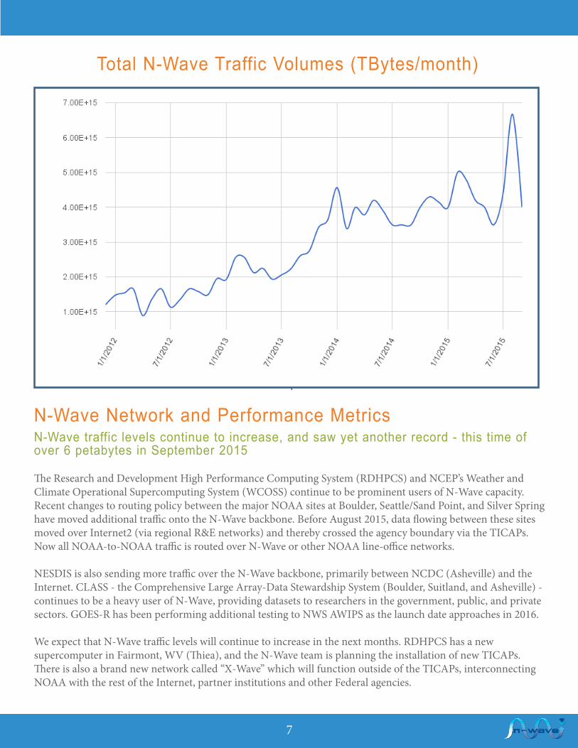
N-Wave Network and Performance Metrics
Total N-Wave Traffic Volumes (TBytes/month)
The Research and Development High Performance Computing System (RDHPCS) and NCEP’s Weather and Climate Operational Supercomputing System (WCOSS) continue to be prominent users of N-Wave capacity. Recent changes to routing policy between the major NOAA sites at Boulder, Seattle/Sand Point, and Silver Spring have moved additional traffic onto the N-Wave backbone. Before August 2015, data flowing between these sites moved over Internet2 (via regional R&E networks) and thereby crossed the agency boundary via the TICAPs. Now all NOAA-to-NOAA traffic is routed over N-Wave or other NOAA line-office networks.
NESDIS is also sending more traffic over the N-Wave backbone, primarily between NCDC (Asheville) and the Internet. CLASS - the Comprehensive Large Array-Data Stewardship System (Boulder, Suitland, and Asheville) - continues to be a heavy user of N-Wave, providing datasets to researchers in the government, public, and private sectors. GOES-R has been performing additional testing to NWS AWIPS as the launch date approaches in 2016.
We expect that N-Wave traffic levels will continue to increase in the next months. RDHPCS has a new supercomputer in Fairmont, WV (Thiea), and the N-Wave team is planning the installation of new TICAPs. There is also a brand new network called “X-Wave” which will function outside of the TICAPs, interconnecting NOAA with the rest of the Internet, partner institutions and other Federal agencies.
N-Wave traffic levels continue to increase, and saw yet another record - this time of over 6 petabytes in September 2015

8
If you would like to subscribe to the outbound traffic information, please go to: noc.nwave.noaa.gov to submit a service inquiry and fill in a request.

9
N-Wave NOC Tickets Report: March through August 2015 This report contains data from 1069 tickets
Unscheduled Outage tickets are created by the N-Wave NOC in response to a previously unannounced event, regardless of source, that impacts the network or network services. Examples of unscheduled outages include circuit or power outages, damaged fiber, and unannounced customer or vendor maintenance. The NOC uses outage tickets to record details, provide notification to the affected participants and N-Wave community, escalate to the circuit provider, and contact N-Wave Engineering. Although outage tickets are created in response to active network monitoring, the NOC can also open suspected Outage Tickets at customer requests in response to an observed event.
The N-Wave NOC strives to provide notification and resolution based on our N-Wave Response Times Agreement and automated escalation procedure. Outage escalation and notification is continued until the outage has been resolved. Resolution may be dependent on respective vendor SLA, but the NOC adheres to our Network Impact Guidelines: https://globalnoc.iu.edu/noc-doc/how-to/noc-tools/impact-guidelines.html to determine criticality. Outage tickets are displayed as events on the public N-Wave Operations Calendar: http://noc.nwave.noaa.gov/nwave/support/operations-calendar.html and are recorded in the N-Wave Operations Reports: http://noc.nwave.noaa.gov/nwave/support/weekly-reports.html.
This N-Wave tickets report tracks various ticket types* that are used to support the N-Wave Network. In this issue, we feature and discuss one of these ticket types and its associated workflows: the Unscheduled Outage ticket.
*Ticket type is a categorization of events that may not necessarily affect customers. The robust engineering, design, operations, and management of N-Wave has yielded 100% customer availability on the backbone and dual backbone connected customer sites since January 2011.

10
The Unified Dashboard: How it Works, and What’s Next A concise and common operations picture of NOAA’s overall IT infrastructure healthIn early 2015, N-Wave partnered with the GlobalNOC at Indiana University to develop a NOAA-wide IT Infrastructure Operations Portal, more commonly known as the unified dashboard. The main goal of this effort was to go beyond traditional infrastructure management system silos to create a concise and common operations picture of overall IT infrastructure health for all of NOAA. Users are able to see the operational status of each monitored network, how the network is being used, and whether/when maintenance is ongoing or planned.
The distributed system gathers information about each participating infrastructure, the services it provides, and how those services are performing. Data gathered includes network flow accounting records, documented topology, SNMP-based usage, perfSONAR active performance measurements, monitoring and alarm status, and NOC maintenance calendars. Once published to the dashboard, this data is combined with other infrastructure collections and non-infrastructure data (such as weather) to create a common picture of operations.

11
Overview capabilities:
• See where outages are occurring using an operational status map• View operations map with weather condition overlays• Assess the overall health of each infrastructure provider
Detailed capabilities:
• Monitor network utilization• Determine top uses of the network• Access results and trends from active performance tests• Observe current and planned maintenances and alarms
Figure 1: Portal Architecture
Cont’d.

12
Figure 2: Network Status Map
Figure 3: Flow-based Top Talkers Report
The Unified Dashboard: How it Works, and What’s Next (cont’d. from pg. 11)

13
The dashboard is still maturing, but today's users are already able to perform a variety of tasks:1. Verify if operators are tracking known operationally impacting events2. Determine if those impacts might be related to ongoing maintenance3. Understand how a given part of the infrastructure is used, including popular protocols and sites using resources 4. Evaluate how large data transfers are likely to perform between various facilities
In April, the dashboard was deployed with N-Wave as the initial infrastructure provider. X-Wave recently became the second provider, and work progresses to integrate the Silver Springs NOC. An initial usability review is nearly complete.
The GlobalNOC is now seeking other NOAA infrastructure providers – particularly providers of data center and supercomputing resources – who would be interested in participating.
For more information, please inquire via the N-Wave service inquiry portal: http://noc.nwave.noaa.gov/nwave/support/service-inquiry-form.html . And be sure to join us for dashboard demonstrations at SC15 in Austin.
14
N-Wave Updates
N-Wave continues to work with the NOAA Cyber Security Center (NCSC) to roll out the Trusted Internet Connection (TIC) security stacks at the five NOAA Trusted Internet Connection Access Point (TICAP) locations: Washington, D.C.; Denver, Colorado; Seattle, Washington; Dallas, Texas and Honolulu, Hawaii. The TIC v2.0 stack improves upon the current v1.0 stack with the addition of security components that are placed inline with the data flows from NOAA to the Internet. The TIC v2.0 deployment will improve the Federal Government’s security posture by providing the Department of Homeland Security with increased situational awareness, while also providing NOAA with visibility into potential security threats. To reduce the risk of Internet outages, the TIC stacks are built in a high availability configuration at each TICAP location. Additionally, at the higher bandwidth demand locations the redundant TIC stacks are being deployed at physically diverse colocation facilities, providing even more resiliency.
The TIC stacks in Honolulu and Dallas have been fully deployed and NOAA offices that will use those TICAP locations will soon be routing through a security stack. The Seattle TICAP network infrastructure deployment and configuration was completed in late September, allowing for the continued configuration and testing of the TIC security components. As of the date of this publication, the routing of NOAA programs through the Seattle TIC stack is pending. The DC metro TICAP network infrastructure deployment began in late September and will carry through into Q1 of FY16, due to the multiple phases of engineering required. One of the phases for both Seattle and DC is the upgrade of N-Wave core routers to provide the space and power needed for the network and security equipment that supports the TIC. The out-of-band TIC components in Seattle and Denver have been deployed, as they will be housed at the NOAA campuses at Sand Point and Boulder respectively.
Of the five NOAA TICAPs, the DC Metro TICAP and the Denver TICAP require much more engineering, configuration, and deployment due to the geographic redundancy being leveraged. After the N-Wave core upgrade is completed in McLean VA, deployment of TICAP aggregation and borders routers will follow, providing the infrastructure for the in-line TIC stack components. Denver-specific work for the TICAP network infrastructure will begin late in Q1 or early in Q2 of FY16. Denver work will include establishment of racks in a new colocation facility to house half of the geographically diverse TIC stack pair, aggregation router, and border router deployment, along with interconnecting optical paths to the DOC Boulder, CO campus.
NOAA’s TIC deployment will provide failover capability between TICAP locations, leveraging the N-Wave backbone to provide the NOAA-to-NOAA transport between those locations. This new networking paradigm will allow NOAA to present itself to the Internet as a single system, instead of the separate campus-based interconnects that are currently in place.
N-Wave TICAP Status UpdateNew TIC version improving security and increasing situational awareness
The TIC v2.0 deployment will improve the Federal Government’s security posture by
providing the Department of Homeland Security with increased situational awareness, while also
providing NOAA with visibility into potential security threats.

15
Network Changes and New ParticipantsN-Wave continues to grow
• NOAA enterprise routing — Through a recently completed project between N-Wave and the NOAA Silver Spring, MD NOC, traffic between several of the larger NOAA campuses and Headquarters has been migrated off of the Internet2 network and onto the N-Wave national backbone. This change was critical in providing optimal routing for NOAA enterprise services allowing NOAA-to-NOAA traffic to traverse the NOAA N-Wave network. This is also key in the TICAP functionality, where peering services like Internet2 are provisioned on the public-facing side of the TICAP and NOAA-to-NOAA traffic on the internal or private side of the TICAP.
• Fairmont circuit upgrades— Bandwidth to the NOAA Environmental Security Computing Center (NESCC) in Fairmont, WV was upgraded from 10Gbps to 20Gbps on the circuits to the N-Wave backbone sites in Chicago, IL and Mclean, VA. The recent upgrade brings NOAA a total of 50Gbps of available bandwidth to this important supercomputing location.
• Dallas X-Wave infrastructure — The X-Wave TICAP network infrastructure for NOAA’s second TICAP gateway was successfully installed and brought online in Dallas, TX.
New N-Wave Layer 2 Service: Virtual Private LAN Service
N-Wave Network Engineers recently deployed a new Layer 2 service on the N-Wave Multiprotocol Label Switching (MPLS) backbone called Virtual Private LAN Service (VPLS). This service will satisfy the requirements for network integration and future satellite data exchange efforts between the Joint Polar Satellite System (JPSS) Common Ground System (CGS) in Fairmont, WV and the Navy (Department of Defense). VPLS allows N-Wave participants to provision multi-point to multi-point Ethernet-based communications between geographically diverse sites that are part of a single Layer 2 broadcast domain - essentially creating a Local Area Network (LAN) across multiple geographically diverse sites and/or locations. Compared to the standard Layer 2 circuits or L2VPN services, which are point-to-point, VPLS allows any-to-any or multi-point connectivity across the N-Wave MPLS infrastructure. One of the benefits of VPLS is that additional sites can easily be added to the VPLS instance as a participant’s network expands or new sites join N-Wave.
While VPLS is a VPN technology like L3VPNs or Virtual Routing and Forwarding instances (VRFs), creating logical separation/segregation of traffic from the Internet or other NOAA traffic on N-Wave, it does not offer data encryption, and NOAA programs that have security requirements for encryption must run their own encryption software along with the normal Layer 3 protocols.
Creating a LAN across multiple geographically diverse sites

16
• NOS NCCOS South Carolina — The NOS National Center for Coastal Ocean Science (NCCOS) facility in Charleston, SC was migrated to N-Wave via a 100-Mb/s metro ethernet connection to their sister site, the Office for Coastal Management in North Charleston.
• NESDIS - EUMETSAT Proof of Concept Project (PoC)— In June 2015, N-Wave provisioned its first international connection across the NOAA TICAP in Silver Spring, MD and existing Internet2 and GÉANT Layer 3 infrastructure, between the NOAA Satellite Operations Facility (NSOF) in Suitland, MD and the European Organisation for the Exploitation of Meteorological Satellites (EUMETSAT) in Darmstadt, Germany. This connection was established as an official NOAA and EUMETSAT Proof of Concept project with joint collaboration between N-Wave, NESDIS Office of the CIO (ACIO-S) and Office of Satellite and Product Operations, as well as the German partners at EUMETSAT.
• Suitland to McLean Dark Fiber Build — As part of the continuing effort to deploy a 100-Gbps ring network in the DC Metro area, N-Wave has been working with the University of Maryland Mid-Atlantic Crossroads (MAX) and their fiber vendor, Zayo Group, to complete a fiber optic path between Suitland, Maryland and McLean, Virginia. This fiber path completes the DC Metro Dense Wave Division Multiplexing (DWDM) optical network ring.
• NESDIS ESPDS WAN Effort— In preparation for NOAA’s next generation NESDIS satellites such as the GOES-R through U Series, Joint Polar Satellite System (JPSS)and others, NESDIS has been developing an enterprise solution for ingest of telemetry data and subsequent satellite products generation and distribution - Environmental Satellite Processing and Distribution System (ESPDS). The ESPDS program has been working with N-Wave to leverage the N-Wave infrastructure, including the recent DC Metro DWDM ring, to build out their Wide Area Network (WAN) infrastructure to lay the groundwork for this new enterprise solution and a “one-stop shop” for satellite data dissemination and access. New generation satellites are expected to produce more than 20 terabytes of weather data per day.
As part of this effort, N-Wave provisioned several high-speed and large-capacity circuits between key NESDIS sites: 1. Redundant 10-Gbps Layer 3-Border Gateway Protocol (BGP) peering for ESPDS between NSOF in Suitland, MD and the Consolidated Backup (CBU) facility in Fairmont, WV 2. Redundant 10-Gbps Point-to-Point Layer 2 circuits for ESPDS data synchronization between NSOF and CBU 3. Redundant 1-Gbps Layer 2 Virtual Private LAN Service (VPLS) for HRIT tying in NSOF, CBU, Wallops Command and Data Acquisition Station (WCDAS ) at Wallops Island, VA and Fairbanks Command and Data Acquisition Station (FCDAS) in Fairbanks, AK. For more on VPLS see the article on page 14.
• SEFSC/AOML redundant connection— An existing VLAN was moved to make use of a diverse path from Miami to Denver via Pensacola & Baton Rouge, thereby giving the two Virginia Key labs physically diverse connections from downtown Miami.
• GOES-R LZSS— N-Wave stood up a GOES-R VPN Virtual Routing and Forwarding (VRF ) instance for remote user access to the GOES-R LZSS (Level Zero Storage Service) at WCDAS - Wallops Island, VA. The Silver Spring, MD NOC providing Enterprise VPN service at NSOF and N-Wave provides transport to Wallops.

17
Florida’s environmental resources include scenic beaches, productive fisheries, and vibrant ecosystems that support this environmentally and economically diverse region. Located on Virginia Key in Miami, Florida, NOAA’s Atlantic Oceanographic and Meteorological Laboratory (AOML) and the Southeast Fisheries Science Center (SEFSC) partner with the University of Miami Rosenstiel School of Marine and Atmospheric Science to improve hurricane forecasting, protect the health of ecosystems and marine sanctuaries, and ensure the sustainability of fisheries. NOAA relies on the Florida LambdaRail’s 100-Gbps network to connect partners within the region and around the world for collecting and sharing data, engaging researchers and stakeholders, and employing innovative technologies to advance the mission.
Founded in 2003, Florida LambdaRail (FLR) is a 1,540-mile-long independent statewide fiber-optic network owned and operated on behalf of its 12-member Florida research and education institutions and 48 affiliates. FLR is dedicated to producing knowledge and prosperity within the state of Florida through education and research activities that drive partner institutions’ and affiliates’ 21st century economy initiatives. Utilizing next generation network technologies, protocols and services, FLR facilitates collaboration and academic, scientific, educational, and clinical application development through high-speed communications. Bringing together people, resources, and information, FLR enables resource aggregation and sharing over large distances, and fosters innovation and discovery.
With its network-wide upgrade to 100-Gbps capacity, completed just this past August, FLR continues to provide direct connectivity between its members & affiliates and a wide range of domestic and international networks, including the FIU/AMPATH International Exchange Point located in Miami, and Internet2’s networking infrastructure. High performance services are optimized for innovative and competitive advantages, placing FLR’s partner institutions and affiliates on the forefront of educational and research activities that lead to a diversified and knowledge-driven 21st century economy.
AOML conducts research to understand the physical, chemical, and biological characteristics and processes of the ocean and the atmosphere, both separately and as a coupled system. The principal focus of these investigations is to advance knowledge that leads to more accurate forecasting of severe storms, better use and management of marine resources, better understanding of the factors affecting both climate and environmental quality, and improved ocean and weather services for the nation.
Seeking better observation and understanding of the ocean and atmosphere, AOML applies advanced technologies such as underwater gliders to reach and continuously measure remote areas that would otherwise be too resource intensive. Gliders - autonomous underwater vehicles that use small changes in buoyancy together with wings to propel themselves underwater - are able to measure ocean parameters during periods of weeks or months along thousands of kilometers. Gliders can measure different ocean properties that are useful to hurricane forecasting, ecosystem modeling, and oceanography sending back data in real time.
Partnering with Regional Optical Networks (RONs)Florida’s LambdaRail helps NOAA connect regional and international partners

18
The neighboring SEFSC develops the scientific information required for fishery resource and habitat conservation, fishery development and utilization, and the protection of marine mammals and endangered marine species in the southeastern United States, Puerto Rico, and the U.S. Virgin Islands. Programs at SEFSC use ships and satellites to conduct surveys of the health and abundance of fishery resources and marine mammals, and to support the conservation coastal habitats. From studying the genetics of protected species to tracking sea turtles by satellite, researchers apply innovative technologies to ensure the health and sustainability of the nation’s marine resources.
Established in 1977, the Cooperative Institute for Marine and Atmospheric Studies (CIMAS) in the University of Miami’s Rosenstiel School of Marine and Atmospheric Science (RSMAS) brings together the research resources of NOAA and the partner universities in a Center of Excellence for understanding the Earth’s oceans and atmosphere within the context of NOAA’s mission. This collaboration engages scientists from universities and strategic partnerships throughout the Gulf and Caribbean regions.
CIMAS supports research in seven theme areas complementing NOAA’s mission: (1) climate research and impacts (2) tropical weather (3) sustained ocean and coastal observations (4) ocean modeling (5) ecosystem modeling and forecasting (6) ecosystems management and (7) protection and restoration of resources.
For more information about these partners and programs:http://www.flrnet.org/http://www.aoml.noaa.gov/http://www.sefsc.noaa.gov/http://cimas.rsmas.miami.eduGlider data - http://www.aoml.noaa.gov/phod/goos/gliders/observations.phpSea turtle tracking by satellite - http://www.fisheries.noaa.gov/stories/2015/06/behind_scenes_seaturtle_research html
Baby loggerhead sea turtle with a solar-powered tag attached to its shell. (Photo: Jim Abernethy)
Sea turtles geared up with tags that allow marine biologists to track them: one example of the research that N-Wave efforts support. (Photo: NOAA)

19
Winter Haven
Crestview
AtlanticWave
FIU/AMPATH
FIU/AmLightFIU/OpenWave(100G)
Bay County
AOML/NOAA
Lake Nona
(100G) AL2SFIU/OpenWave
PSC
Datasite
UWF
FSUUNF
UFL
FIT
UCF
FAUNSU
FIU
UM
Pensacola
Tallahassee
Lake City
Jacksonville
Gainesville
Tavares
Orlando
Tampa
Ft. Lauderdale
Miami(NOTA)
Internet2 via Baton Rouge(10G)
USF
FLR ext Pop/SoX/TelX(10G Dedicated Wave)
FGCU
(100G) AL3SInternet2 via Atlanta
LEGENDFLR Optical Pop Site
KEY FACTSCOVERAGE: 1,540 MILESBackbone Capacity: 100GbpsOwnership: 12 Equity Partners - 9 Public Universities - 3 Private UniversitiesLinks to other regional, nationaland international networks
FLR Optical Amp Site
Equity Member
FLR Backbone Fiber
FLR Member Fiber
InLand Fiber
FLR OnRamp
Copyright 2015, Florida LambdaRail, LLCAll Rights Reserved
Florida LambdaRail
West Palm Beach
Melbourne
FIU/OpenWave(FUTURE) (100G)
rev 9/2015

For more information contact:NOAA N-Wave Science Network http://noc.nwave.noaa.gov/Office of the Chief Information Officerhttp://cio.noaa.govRobert Sears, Network ManagerAnnie Reiser, Design and LayoutTiffany Fourment, Editor
N-WaveNews Issue 06 November 2015
U. S. Department of Commerce, NOAA325 Broadway, R/ESRLDSRC-3B107Boulder, CO 80305-3337
• Indiana University, one of N-Wave’s partner organizations, will be hosting an SOS demonstration highlighting their locally-developed content as well as data sets from NOAA and other organizations.
• In a Big Data demonstration in the iCAIR booth, the Open Cloud Consortium (OCC) and the Open Science Data Cloud will demonstrate new tools used to model data over 100-Gbps connections to SC. Much of the data being showcased is NOAA’s environmental data, provided through our agreement with OCC.
The theme is how HPC is transforming the world – be it designing safer cars, analyzing climate change, creating personalized treatment plans for Parkinson’s disease, or improving hurricane predictions. SC15 will bring together the top researchers, programmers, developers, scientists and engineers in HPC, storage and networking. The conference includes a peer-reviewed technical program, tutorials, Birds-of-a-Feather sessions, research posters, student-centered programs, and a technical exhibit with universities from around the world, government agencies, and vendors.
NOAA-related Events at SC15
This Year SC15 Returns to Austin