N e a r t n a G a o i t h e - nngoffshorewind.com · 146 147 145 144 14 141 142 81D 78D 77D 73D 72D...
14
Reproduced from Ordnance Survey digital map data © Crown copyright 2012. All rights reserved. Licence numbers 100047514, 0100031673. 0 1 2 3 Km LUCGL Fig08-01_5166-0021-r2_StudyArea 22/10/2012 Ecological Study Area Map Scale: 1:35,000 ¯ Figure 8.1 Application Boundary Construction Compound Proposed Substation Existing Crystal Rig II Substation Ecological Study Area Neart na Gaoithe Onshore Works
-
Upload
trinhduong -
Category
Documents
-
view
212 -
download
0
Transcript of N e a r t n a G a o i t h e - nngoffshorewind.com · 146 147 145 144 14 141 142 81D 78D 77D 73D 72D...

Reproduced from Ordnance Survey digital map data © Crown copyright 2012. All rights reserved. Licence numbers 100047514, 0100031673.
0 1 2 3 Km
LUCGL Fig08-01_5166-0021-r2_StudyArea 22/10/2012
Ecological Study Area
Map Scale: 1:35,000
¯
Figure 8.1
Application BoundaryConstruction CompoundProposed SubstationExisting Crystal Rig II Substation
Ecological Study Area
N e a r t n a G a o i t h eOnshore Works

1
4
3
2
3
2
1
5
4
Reproduced from Ordnance Survey digital map data © Crown copyright 2012. All rights reserved. Licence numbers 100047514, 0100031673.
0 1 2 3 4 5 Km
LUCGL Fig08-02_5166-0020-r0_NatureConservationDesignations 22/10/2012
Nature Conservation Designations
Map Scale: 1:50,000
¯
Figure 8.2
Application BoundaryConstruction CompoundProposed SubstationExisting Crystal Rig II Substation
Scottish Wildlife Trust Reserve
Ancient Woodland
1. Woodhall Dean2. Barns Nest Coast3. Rammer Cleugh4. Lammermuir Deans5. Pease Bay Coast
1. Woodhall Dean2. Thornton Glen3. East Lammermuir Deans4. Pease DeanListed Wildlife Sites
Sites of Special Scientific Interest
Source:
Ecological Study Area
N e a r t n a G a o i t h eOnshore Works

! !
555
5 555
55
5
5
5
5 555
55
5
5
5
5
5
5
55
5555 55
5
55
55
5
5
555 5
5
5 55
5
5
55
555
5
5 5555
5
5
5
55
55
5
5
55
55
5 5
5
55
6
2
1
8 43
9D
7D1D2D3D
6D
43
38
3736
35
34
33
32
3130
29 2827
25
24
22
21
19
16
1413
12
116
115
136137
138
135
29D
30D
28D26D
25D 11D
12D
13D 19D
18D
17D
24D21D
20D
115D
114D9 7 5
4D5D
26
23
2018
17
15
1110
10D
8D
120
27D
15D
14D
16D
23D
22D
116D
H1
H10
Reproduced from Ordnance Survey digital map data © Crown copyright 2012. All rights reserved. Licence numbers 100047514, 0100031673.
0 0.5 1 Km
LUCGL Fig08-03_5166-0025-r1_Phase1 28/09/2012
Phase 1 Habitat Survey
Map Scale @ A3: 1:12,500¯
Figure 8.3a
c
a
d
b
Application Boundary
Ecological Study Area
5 Target Note with Number
Phase 1 Habitat Types
FenceHedgerow (defunct, species-poor)Hedgerow (intact, species-poor)Running waterStone wall
! ! Tree lineBroad-leaved semi-natural woodlandBroad-leaved plantation woodlandConiferous plantation woodlandMixed plantation woodlandDense continuous scrub
X X XX X XX X XScattered scrub
! ! !
! ! !
! ! !
! ! ! Scattered trees
S S SS S SI II IS SI IX X XX X XX X X
X X XSemi-improved neutral grassland with scattered scrubS S SI IS SI I Semi-improved neutral grassland
I I II I II I Improved grassland
X X XX X XX X XTall ruderal with scattered scrub
Tall ruderalDune grasslandOpen dune/dune grassland mosaicOpen duneOther exposureA AA A AArable
A AA A AA A AAmenity grassland
X X XX X XX X XEphemeral/short perennial
Building! ! !
! ! !
Bare groundHardstandingNot surveyedOutside of survey area
Source: LUC 2011
H1 - H14 Hedgerow Crossing
N e a r t n a G a o i t h eOnshore Works

!
!
! !
!!
555
5
55
55
5
55
5
5
5
5
5
5
5
5
5
5
5
5
55
55
55
5
55 5
5
55
5
5
5
5
5
5
5
55
5
55
5 55
55
5
5
55
55
555
5
5
5
55
5
55
55
55
5
55
5555
5
5
5
55
55
5
5
55
5
5
5
5
55 5
5
55
5
79
78
77
76
73
6866
6564
60
59
5857
56
54
5352
51
50
49
48
47
4544
43
40
38
3736
35
34
33
32
30
29
64D
117116
115
114113
140
139
137
135
59D
60D
63D
62D61D 55D54D
53D52D
51D
50D
49D47D
46D
45D
44D 43D
41D 40D
38D
37D
36D
33D31D
29D
30D
28D
115D
114D
113D
112D
111D
67
63
6261
55
46
42
41 39
119
118
112
134
58D
57D
56D
48D
42D
39D 35D34D32D
27D
116D
110D109DH6
H5
H4
H3
H2
H1
H11
H7
H14
H13
H12
Reproduced from Ordnance Survey digital map data © Crown copyright 2012. All rights reserved. Licence numbers 100047514, 0100031673.
0 0.5 1 Km
LUCGL Fig08-03_5166-0025-r2_Phase1 22/10/2012
Phase 1 Habitat Survey
Map Scale @ A3: 1:12,500¯
Figure 8.3b
c
a
d
b
Application BoundaryConstruction CompoundEcological Study Area
5 Target Note with Number
Phase 1 Habitat Types
FenceHedgerow (defunct, species-poor)Hedgerow (defunct, species-poor)/TreesHedgerow (intact, species-poor)Running waterStone wall
! ! Tree lineBroad-leaved semi-natural woodlandBroad-leaved plantation woodlandConiferous plantation woodland
! ! !
! ! !Mixed semi-natural woodlandMixed plantation woodlandDense continuous scrub
X X XX X XX X X
X X XScattered scrubScattered trees with dense scrub
! ! !
! ! !
! ! !
X X XX X XX X X Scattered trees with scattered scrub
S S SI IS SI IX X XX X XX X X
X X XSemi-improved neutral grassland with scattered scrub
S S SI IS SI I Semi-improved neutral grassland
I I II I II I Improved grassland
Marshy grasslandTall ruderalStanding water
A AA A AA A AArable
A AA A AAmenity grassland
X X XX X XX X X
X X XEphemeral/short perennial
X X XX X XEphemeral/tall ruderal/scrub mosaicBuilding
! ! !
! ! !
! ! ! Bare groundHardstandingNot surveyed
Source: LUC 2011
H1 - H14 Hedgerow Crossing
N e a r t n a G a o i t h eOnshore Works
!!!!
!
!!!!
!!
!!
!
!
!
!
!
!
!
!!
!!
5
55
5
5
5
55
5
5
55
55
5
5 5
5
5
55
5
5
5
5
5
55
5
5
5
5
55
5
55
5
55
55
55
5
55
5555
55
5
55
5555
5
5
5
5
5
5
5
55
5
5
5
55
5
55
55
5
5
99
98 97
94
93
9190
87
8685
82
8180
79
78
77
76
75
74
73
72
71
7069
64D
147146
145
144
143
141142
81D
78D
77D
73D
72D
59D
60D
63D
62D61D 55D54D
53D52D
51D
50D
49D47D
46D
9695
92
89
88
84
83
133
83D
82D
80D
79D
111
109
134
76D
71D70D 69D
66D
68D
67D
65D75D
74D
58D
57D
56D
48D
H8
H6
H5
H9
H7
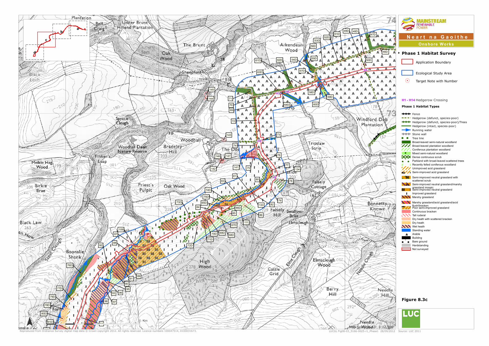
Reproduced from Ordnance Survey digital map data © Crown copyright 2012. All rights reserved. Licence numbers 100047514, 0100031673.
0 0.5 1 Km
LUCGL Fig08-03_5166-0025-r1_Phase1 28/09/2012
Phase 1 Habitat Survey
Map Scale @ A3: 1:12,500¯
Figure 8.3c
c
a
d
b
Application Boundary
Ecological Study Area
5 Target Note with Number
Phase 1 Habitat Types
FenceHedgerow (defunct, species-poor)Hedgerow (defunct, species-poor)/TreesHedgerow (intact, species-poor)Running waterStone wall
! ! Tree lineBroad-leaved semi-natural woodlandBroad-leaved plantation woodlandConiferous plantation woodland
! ! !
! ! !Mixed semi-natural woodlandDense continuous scrub
! ! !
! ! !
! ! !
! ! ! Parkland with broad-leaved scattered trees
F F FF F FF F Recently felled coniferous woodland
Unimproved acid grassland
S S SS S SS S
S SI II I
I II I Semi-improved acid grassland
S S SI IS SI IX X XX X XX X X
X X XSemi-improved neutral grassland with scattered scrub
S S SS S SI II IS SI I Semi-improved neutral grassland/marshy
grassland mosaic
S S SS S SI II IS SI I Semi-improved neutral grassland
I I II I Improved grasslandMarshy grasslandMarshy grassland/acid grassland/acid flush/bracken
S S SS S SI II IS SI I Poor semi-improved grassland
Continuous brackenTall ruderalDry heath with scattered brackenDry heathWet heathStanding water
A AA A AArableBuilding
! ! !
! ! !
! ! !
! ! ! Bare groundHardstandingNot surveyed
Source: LUC 2011
H1 - H14 Hedgerow Crossing
N e a r t n a G a o i t h eOnshore Works

!!!!
!
!!!!
!!
!!
!
!
!
5
55
5
5
5
5
5
55
5
5
5
5
5
5
5
5
5
5
5
5
5555
5
5
5
5
5
5 5
5
5
5
55
55
5
5
55
5
5
5
55
5
5 5
5
5
55
5
5
5
5
5
55
5
5
5
5
55
5 555
5
5
99
98 97
94
93
9190
87
122
12198D 97D
95D
94D
84D
81D
78D
77D
130
129128
127
124
123
72D
108
107
104
102
100
104D
103D
102D
9695
92
89
88
99D
96D
93D92D
91D90D
89D
88D
87D
86D85D
83D
82D
80D
79D
132
131
126
125
110
109
76D
71D70D 69D
105106
103
101
108D
107D
106D
105D101D
100D
Reproduced from Ordnance Survey digital map data © Crown copyright 2012. All rights reserved. Licence numbers 100047514, 0100031673.
0 0.5 1 Km
LUCGL Fig08-03_5166-0025-r2_Phase1 08/10/2012
Phase 1 Habitat Survey
Map Scale @ A3: 1:12,500¯
Figure 8.3d
c
a
d
b
Application BoundaryConstruction CompoundProposed SubstationEcological Study Area
5 Target Note with Number
Phase 1 Habitat Types
Running water! ! Tree line
Broad-leaved semi-natural woodlandConiferous plantation woodlandDense continuous scrub
! ! !
! ! !
! ! ! Parkland with broad-leaved scattered treesUnimproved acid grassland
S S SS S SS SI II II I Semi-improved acid grassland
S S SI IS SI I Semi-improved neutral grassland/marshy grassland mosaic
S S SI IS SI I Semi-improved neutral grassland
I I II I II I Improved grassland
Marshy grasslandMarshy grassland/acid grassland/acid flush/brackenMarshy grassland/acid flush/blanket bog mosaicMarshy grassland/blanket bog mosaicMarshy grassland/acid grassland/acid flush mosaic
S S SS S SI II IS SI I Poor semi-improved grassland
Continuous brackenDry heath with scattered brackenDry heathWet heath/acid grassland mosaicWet heathDry heath/acid grassland mosaicBlanket bogWet modified bog/acid flush mosaicWet modified bogBuildingHardstandingNot surveyed
Source: LUC 2011
H1 - H14 Hedgerow Crossing
N e a r t n a G a o i t h eOnshore Works

SD8
MG1a
MG1e
MG1a
MG1a
MG1a
MG1a
Reproduced from Ordnance Survey digital map data © Crown copyright 2012. All rights reserved. Licence numbers 100047514, 0100031673.
0 0.5 1 Km
LUCGL Fig08-04_5166-0026-r1_NVC 28/09/2012
NVC Survey
Map Scale @ A3: 1:12,500¯
Figure 8.4a
c
a
d
b
Application Boundary
Ecological Study AreaNVC Category
MG1aMG1eSD8Survey not applicableOutside of survey area
Source: LUC 2011
N e a r t n a G a o i t h eOnshore Works

W9a
W9a
W9a
W9a
W10e
W9a
MG1a
MG1a
MG9
MG1a
MG6b
MG1bM23a
MG1a
MG10
MG1a
MG1a
MG1a
Reproduced from Ordnance Survey digital map data © Crown copyright 2012. All rights reserved. Licence numbers 100047514, 0100031673.
0 0.5 1 Km
LUCGL Fig08-04_5166-0026-r2_NVC 22/10/2012
NVC Survey
Map Scale @ A3: 1:12,500¯
Figure 8.4b
c
a
d
b
Application BoundaryConstruction Compound
Ecological Study AreaNVC Category
M23aMG1aMG1bMG6bMG9MG10W9aW10eSurvey not applicable
Source: LUC 2011
N e a r t n a G a o i t h eOnshore Works

MG6b
M16
M23a
H12M4 - M23- U4b
W9a
M23a - M23b
M23a
M23B - MG6b
W9a
W9a
W9a
M23a
W10e
M23b
W9a
U4b
MG1a
U5
MG9
M23a
MG1a
Juncus effusus vegetation
MG6b
M23a
MG1a
MG6b
MG6b
MG1a
U2 - Juncus effusus vegetation
M23a
Reproduced from Ordnance Survey digital map data © Crown copyright 2012. All rights reserved. Licence numbers 100047514, 0100031673.
0 0.5 1 Km
LUCGL Fig08-04_5166-0026-r1_NVC 28/09/2012
NVC Survey
Map Scale @ A3: 1:12,500¯
Figure 8.4c
c
a
d
b
Application Boundary
Ecological Study AreaNVC Category
H12Juncus effusus vegetationM4 - M23- U4bM16M23b - MG6bM23aM23a - M23bM23bMG1aMG6bMG9U2 - Juncus effusus vegetationU4bU5W9aW10eSurvey not applicable
Source: LUC 2011
N e a r t n a G a o i t h eOnshore Works

U4b
MG6b
M20
M16
MG9
MG6a
MG6a
U5
M23a
H12
M20
MG6b
M4 - M23- U4b
W9a
M23a - U2 - U5
M23a
Juncus effusus vegetation
M23a - M23b
M23B - MG6b
M23a
U4b
M19 - M23
H12 - U5MG9
M23a
U2 - U5
U4b
U5
H12U4b
M15 - U4 - U5M23a
M23a
M18
M23b
M6c - M23 - U4b
M4 - M20 - M23a
M23b
Juncus effusus vegetation
M19
M4 - M20
M23a
Juncus effusus vegetation
Juncus effusus / Carex nigra
MG6b
MG6b
M23a
Reproduced from Ordnance Survey digital map data © Crown copyright 2012. All rights reserved. Licence numbers 100047514, 0100031673.
0 0.5 1 Km
LUCGL Fig08-04_5166-0026-r2_NVC 08/10/2012
NVC Survey
Map Scale @ A3: 1:12,500¯
Figure 8.4d
c
a
d
b
Application BoundaryConstruction CompoundProposed SubstationExisting Crystal Rig II Substation
Ecological Study AreaNVC Category
H12H12 - U5Juncus effusus / Carex nigraJuncus effusus vegetationM4 - M20M4 - M20 - M23aM4 - M23- U4bM6c - M23 - U4bM15 - U4 - U5M16M18M19M19 - M23M20M23b - MG6bM23aM23a - M23bM23a - U2 - U5M23bMG6aMG6bMG9U2 - U5U4bU5W9aSurvey not applicable
Source: LUC 2011
N e a r t n a G a o i t h eOnshore Works

1817
18 23
Reproduced from Ordnance Survey digital map data © Crown copyright 2012. All rights reserved. Licence numbers 100047514, 0100031673.
0 1 2 3 Km
LUCGL Fig08-05_5166-0028-r1_BatRoostSurvey 22/10/2012
Bat Roost Potential Survey
Map Scale: 1:30,000
¯
Figure 8.5
Bat Roost PotentialHighMediumLow
Source: T & SS (2011)
Application BoundaryConstruction CompoundProposed SubstationExisting Crystal Rig II Substation
Note: the size of the polygons represents the size of the feature surveyed
N e a r t n a G a o i t h eOnshore Works

Waterbody 3
Waterbody 4
Waterbody 7
Waterbody 2
Waterbody 11
Waterbody 10
Waterbody 1
Waterbody 8
Waterbody 5
Waterbody 6
Waterbody 9
Reproduced from Ordnance Survey digital map data © Crown copyright 2012. All rights reserved. Licence numbers 100047514, 0100031673.
0 1 2 3 Km
LUCGL Fig08-06_5166-0029-r1_NewtSurvey 22/10/2012
Great Crested Newt Habitat Suitability Index Assessment
Map Scale: 1:35,000
¯
Figure 8.6
Waterbody
Source: LUC 2011
Application BoundaryConstruction CompoundProposed SubstationExisting Crystal Rig II Substation
N e a r t n a G a o i t h eOnshore Works

GE
GE
GE!( GEGE
!
GE
GE
GE
GE
!(
GE
!(
GE!(
GE
!(!(
Reproduced from Ordnance Survey digital map data © Crown copyright 2012. All rights reserved. Licence numbers 100047514, 0100031673.
0 1 2 3 Km
LUCGL Fig08-07_5166-0030-r1_OtterSurvey 22/10/2012
Otter Survey
Map Scale: 1:35,000
¯
Figure 8.7
Ecological Study AreaOtter Field Sign! Holt
!( Potential holt!( Shelter/lie-up
GE Spraint
Source: LUC 2011
Application BoundaryConstruction CompoundProposed SubstationExisting Crystal Rig II Substation
N e a r t n a G a o i t h eOnshore Works

Reproduced from Ordnance Survey digital map data © Crown copyright 2012. All rights reserved. Licence numbers 100047514, 0100031673.
0 1 2 3 Km
LUCGL Fig08-08_5166-0031-r1_ReptileHabitat 22/10/2012
Reptile Habitat Assessment
Map Scale: 1:35,000
¯
Figure 8.8
Ecological Study AreaReptile Habitat Assessment
Suitable Reptile HabitatOptimal Reptile Habitat
Source:
Application BoundaryConstruction CompoundProposed SubstationExisting Crystal Rig II Substation
N e a r t n a G a o i t h eOnshore Works

![109 w] ^ 0 [ ï}Ú}²Vóÿ ÿ ÿ ÿ ÿ ÿ ÿ ÿ - Nagasaki...n n n n n n n n n n n n n n n n n n n n n n n n n n n n n n n n n n n n n n n n n n n n n n n n n n n n n n n n n n n n](https://static.fdocuments.in/doc/165x107/5f36fb8f1f26d128d06b20dc/109-w-0-v-nagasaki-n-n-n-n-n-n-n-n-n.jpg)


![The Essential Guide to Forage Crops€¦ · Average fresh yield 80-90 tonnes/ha Dry matter 12-19% Crude protein 12-13% [mainly leaves] Digestibility value 78D Metabolisable energy](https://static.fdocuments.in/doc/165x107/601d704c5f121870d00fec80/the-essential-guide-to-forage-crops-average-fresh-yield-80-90-tonnesha-dry-matter.jpg)