N BS I R 86-3042 INDUSTRIAL TIME SERVICE STUDY
192
N BS I R 86-3042 INDUSTRIAL TIME SERVICE STUDY D. Wayne Hanson David A. Howe Time and Frequency Division Center for Basic Standards National Measurement Laboratory National Bureau of Standards Boulder, Colorado 80303 February 1986 U.S. DEPARTMENT OF COMMERCE, Malcolm Baldrige, Secretary NATIONAL BUREAU OF STANDARDS, Ernest Ambler, Director
Transcript of N BS I R 86-3042 INDUSTRIAL TIME SERVICE STUDY

N BS I R 86-3042
INDUSTRIAL TIME SERVICE STUDY
D. Wayne Hanson David A. Howe
Time and Frequency Division Center for Basic Standards National Measurement Laboratory National Bureau of Standards Boulder, Colorado 80303
February 1986
U.S. DEPARTMENT OF COMMERCE, Malcolm Baldrige, Secretary
NATIONAL BUREAU OF STANDARDS, Ernest Ambler, Director

CONTENTS
INTRODUCTION
PHASE I : REQUIREMENTS FOR A HIGH ACCURACY TIME AND FREQUENCY SYSTEM
PHASE 11: A REVIEW OF POSSIBLE TIME SERVICES
PHASE 111, PART 1 : THE FIXED SATELLITE SERVICE, A PRELIMINARY DES I GN
PART 2 : THE GLOBAL POSITIONING SYSTEM OPTION
PART 3: THE GEOSTAR OPTION
SUMMARY
REFERENCES
APPENDIXES
Page
1
3
8
61
125
143
1 7 6
180
181
iii

I N D U S T R I A L TIME S E R V I C E STUDY
D. Wayne Hanson and David A . Howe Time and Frequency D i v i s i o n
N a t i o n a l Bureau o f S t a n d a r d s Boulder , Colorado 80303
T h i s s t u d y examines o p t i o n s f o r d e l i v e r y of a c c u r a t e time and f requency i n f o r m a t i o n t o i n d u s t r i a l u s e r s . The s t u d y is sponsored by t he B o n n e v i l l e Power A d m i n i s t r a t i o n ( B P A ) who f i n d s a need f o r a c c u r a t e t i m i n g t o the one microsecond l e v e l . P r o s p e c t i v e e x i s t i n g and f u t u r e d i s s e m i n a t i o n methods (Loran-C, GOES, USRDSS, GPS, e t c . ) are d i s c u s s e d i n d e t a i l . The s t u d y produces a system a r c h i t e c t u r e and p r e l i m i n a r y d e s i g n f o r a new time s e r v i c e u s i n g t h e w i d e l y a v a i l a b l e U . S . f i x e d s a t e l l i t e s e r v i c e (FSS) i n which cus tomers s h a l l assume f u l l c o s t s of i ts o p e r a t i o n th rough subscr iber fees.
The s t u d y e l a b o r a t e s on three v i a b l e o p t i o n s : ( 1 ) FSS, ( 2 ) GPS, and ( 3 ) USRDSS. Based on t h i s s t u d y , c o n c l u s i o n s c a n be drawn r e g a r d i n g a t i m i n g sys tem which w i l l most s a t i s f a c t o r i l y meet t h e long range g o a l s o f most i n d u s t r i a l u s e r s .
Key words: a c c u r a c y ; f r e q u e n c y ; s a t e l l i t e ; time; time b r o a d c a s t s e r v i c e s ; time d i s s e m i n a t i o n
Commercial companies are i d e n t i f i e d i n t h i s r e p o r t i n o r d e r t o a d e q u a t e l y d i s c u s s issues. Such i d e n t i f i c a t i o n does n o t imply recommendation o r endorsement by t he N a t i o n a l Bureau of S t a n d a r d s , n o r does i t imply t h a t any i d e n t i f i e d e n t i t y is t h e on ly o r t h e best a v a i l a b l e f o r t he purpose .
V

I N D U S T R I A L TIME S E R V I C E S T U D Y
INTRODUCTION
T h i s r e p o r t is a comprehensive s t u d y of a c c u r a t e time d i s s e m i n a t i o n
o p t i o n s which can s a t i s f y p r e s e n t and f u t u r e requ i rements f o r t h e
B o n n e v i l l e Power A d m i n i s t r a t i o n ( B P A ) . Over t he y e a r s , t h e BPA has
exp lo red t h e u s e of p r e c i s e time s y n c h r o n i z a t i o n as a means of b e t t e r
f a u l t l o c a t i o n and improved system s t a b i l i t y . I n a d d i t i o n t o i ts own
c o n t i n u i n g a n a l y s e s , BPA c o n t r a c t e d w i t h t he N a t i o n a l Bureau of S t a n d a r d s ,
T i m e and Frequency D i v i s i o n , t o s t u d y s u i t a b l e time d i s t r i b u t i o n sys tems
and asked NBS t o make recommendations based on t h e s t u d y .
Many of t h e e x i s t i n g time s e r v i c e s are u n s a t i s f a c t o r y s o l u t i o n s t o
t h e BPA f o r r e a s o n s d i s c u s s e d i n t h i s s tudy . Fur the rmore , t h e f u t u r e
communication and n a v i g a t i o n s e r v i c e s , which d i r e c t l y a f f e c t p r o s p e c t i v e
o p t i o n s f o r s o l v i n g the time t r a n s f e r problem f o r t h e BPA, a re i n a s t a t e
o f c o n t i n u i n g t e c h n i c a l and p o l i c y changes a t t h i s time. N e v e r t h e l e s s ,
t h e s t u d y has done a u s e f u l e v a l u a t i o n of what can be done for t he BPA.
The r e p o r t c o n s i s t s o f f o u r p h a s e s of s t u d y . I t s ta r t s (Phase I )
w i t h a b r i e f rev iew o f r e q u i r e m e n t s f o r t h e BPA and NBS. Tha t is fol lowed
by g e n e r a l d i s c u s s i o n s of any and a l l v i a b l e or c l o s e l y v i a b l e t i m i n g
sys tems (Phase 11). S i n c e no s y s t e m w i l l b e a p e r f e c t s o l u t i o n , t h i s
phase narrows t h e o p t i o n s t o t h o s e which have t h e l eas t r i s k and
1

fewest problems. Cons ide rab ly more d e t a i l is p r e s e n t e d concern ing three
p o s s i b l e o p t i o n s i n t he f o l l o w i n g p h a s e (Phase 111). The r e p o r t t h e n
conc ludes w i t h a summary.
T h i s s t u d y has gone i n t o g r e a t d e t a i l i n some areas, p a r t i c u l a r l y
Phase 111, which i t se l f has three p a r t s . T h i s was done because Phase I11
p r e s e n t s three s e p a r a t e and v i a b l e o p t i o n s i n enough d e t a i l t h a t t h e
sponsor ( B P A ) could a r r i v e a t i ts own c o n c l u s i o n s . I n a d d i t i o n , a
p r e l i m i n a r y d e s i g n f o r a t i m i n g sys tem u s i n g t h e Fixed S a t e l l i t e S e r v i c e
(FSS) is e x t e n s i v e l y d i s c u s s e d . A combinat ion of m a r k e t demands,
t e c h n i c a l advances , FCC p o l i c y changes , and s a t e l l i t e r e c e i v e r c o s t
r e d u c t i o n s l ed t o f u r t h e r i n v e s t i g a t i o n of a FSS-based system.
2

A. PHASE I I N T R O D U C T I O N AND OBJECTIVES
The f o l l o w i n g is a s t a t e m e n t o f r e q u i r e m e n t s f o r t h e "high accuracy time
and f requency sys tem" a s p rov ided f o r i n t he Agreement between t h e
N a t i o n a l Bureau of S t a n d a r d s (NBS) and t h e B o n n e v i l l e Power A d m i n i s t r a t i o n
( B P A ) - Agreement No. DE-AI79-84BP19476. The s t a t e m e n t s o f r e q u i r e m e n t s
are d i v i d e d i n t o two p a r t s -- a p o l i c y s e c t i o n and a f u n c t i o n a l s e c t i o n .
The p o l i c y s e c t i o n o u t l i n e s t h o s e r e q u i r e m e n t s imposed upon s e r v i c e s
p rov ided by government by a d m i n i s t r a t i o n p o l i c y and by NBS management t o
c o n t r o l unexpected f i n a n c i a l l i a b i l i t y . The f u n c t i o n a l r e q u i r e m e n t s are a
composi te d e r i v e d from those r e q u i r e m e n t s by BPA f o r such a s e r v i c e a s
p rov ided i n t h e agreement , by NBS t e c h n i c a l c o n s i d e r a t i o n s g i v e n i ts
e x p e r i e n c e w i t h similar sys tems , and th rough long term and e x t e n s i v e
c o n t a c t s beatween time and f requency u s e r s and NBS.
Throughout t h i s document t h e sys tem o f i n t e r e s t w i l l be referred t o as t h e
I n d u s t r i a l T i m e S e r v i c e o r t h e ITS.
B. POLICY REQUIREMENTS
C e r t a i n a d m i n i s t r a t i o n r e q u i r e m e n t s must be met i n o r d e r f o r the NBS t o
e n t e r i n t o a time and f requency s e r v i c e such as the ITS.
1 . The ITS must g e n e r a t e th rough u s e r c h a r g e s s u f f i c i e n t f u n d s t o
comple te ly r e c o v e r a l l costs a s s o c i a t e d w i t h the e s t a b l i s h m e n t ,
o p e r a t i o n and maintenance o f t h e s e r v i c e .
4

2. The ITS must be des igned , implemented and o p e r a t e d i n such a
manner t h a t no s i g n i f i c a n t p o t e n t i a l e x i s t s f o r l a r g e , unexpected
c o s t t o be i n c u r r e d through f a i l u r e s o r o t h e r u n c o n t r o l l a b l e
e v e n t s .
3. The ITS must b e c o n f i g u r e d so t h a t , a t t h e d i s c r e t i o n of NBS,
d i r ec t NBS involvement may be s u b s t i t u t e d by c o n t r a c t t o o r
t r a n s f e r t o t he p r i v a t e s e c t o r .
These are p o l i c y matters which p r o t e c t NBS from any f i n a n c i a l r i s k and
i n a b i l i t y t o c o n t r o l t h e s e r v i c e . S h o r t term fund ing i s needed t o s t a r t
t h e s e r v i c e , b u t i t is t h e long term p r o j e c t i o n s o f o p e r a t i n g funds which
must be i n l i n e w i t h NBS expenses .
P o l i c y r e q u i r e m e n t s as t h e y are do n o t r e s t r i c t the development o f t h e ITS
i n any way g i v e n adequa te demand, and hence fund ing , f o r such a s e r v i c e .
P o l i c y is i n p l a c e t o r educe f i n a n c i a l r i s k and a s s u r e tha t t h e b e n e f i t -
t i n g s e c t o r of t h e economy bears the c o s t of s e r v i c e r e c e i v e d . NBS
e x p e r t i s e and h i s t o r y are p r e c i s e l y i n t h e area o f time and f requency
g e n e r a t i o n and d i s s e m i n a t i o n , and a l l e f f o r t s w i l l go toward p r o p e r
implementa t ion of t h e I T S .
With r e g a r d t o item 3, i d e a l l y the removal o f NBS involvement would n o t
s e r i o u s l y a f f ec t t he c o n t i n u i n g o p e r a t i o n of t he ITS and s e r v i c e t o i t s
u s e r s . I t must be p o i n t e d o u t t h a t f i n a n c i a l c o n s i d e r a t i o n s a l o n e do n o t
a f f ec t t h e d e c i s i o n concern ing ongoing involvement by NBS. NBS must
5

m a i n t a i n f u l l c o n t r o l of i ts ' own r e s o u r c e s , and i ts ongoing d i r e c t
involvement canno t be g u a r a n t e e d . Again, t h i s does n o t take a n y t h i n g away
from development o f t he s e r v i c e .
C. FUNCTIONAL AND OTHER TECHNICAL REQUIREMENTS
The f o l l o w i n g are f u n c t i o n a l and t e c h n i c a l r e q u i r e m e n t s f o r t he ITS.
S p e c i f i c r e c e i v e r r e q u i r e m e n t s as p rov ided by BPA i n t h e Agreement can be
g u a r a n t e e d by these r e q u i r e m e n t s and c o n v e n t i o n a l and economical r e c e i v e r
des ign .
1 . P R O V I S I O N S OF THE ITS
a. T ime o f Year i n f o r m a t i o n i n t h e form o f a time code r e p e a t e d
a t a ra te o f a t least once p e r minute .
b. The ITS s h a l l p r o v i d e s y n c h r o n i z a t i o n t o UTC(NBS) th roughout
CONUS t o a p r e c i s i o n o f 0 . 1 us o r be t t e r .
c. The ITS s h a l l o p e r a t e c o n t i n u o u s l y wi th a v a i l a b i l i t y o f
99.7% averaged over one y e a r .
d . The I T S s h a l l p r o v i d e i n f o r m a t i o n r e l a t i n g t o t h e d i f f e r e n c e s
between UTC(NBS) and UT1 and s h a l l p r o v i d e n o t i f i c a t i o n o f a
l e a p second d u r i n g t h e month o f occurence .
6

e. The ITS s h a l l r e q u i r e t h e use of an antenna no g r e a t e r t h a n
1 meter i n any dimension t o a c h i e v e a l l s t a t e d requ i rements .
f . T h e ITS s h a l l r e q u i r e of t h e u a e r no o p e r a t o r or o t h e r
a s s i s t a n c e once a p r o p e r l y s e t up r e c e i v i n g system is i n
p l a c e ( o u t s i d e of user equipment f a i l u r e ) .
7

PHASE 11: A REVIEW OF
D.
E .
F.
G.
H.
I.
J.
K.
L.
POSSIBLE TIME SERVICES
CONTENTS
PHASE I1 INTRODUCTION AND OBJECTIVES
1. 2 . 3. 4. 5. 6 . 7 . 0 . 9 .
10. 11.
Accuracy Unambiguous UTC T i m e Code Coverage S t a tu s Operational T i m e Receiver System Costs Operator Antenna Package NBS Operation and Maintenance Costs fo r ITS Subscriber Fees Long Term Prospects
FIXED SATELLITE SERVICE
BROADCAST SATELLITE SERVICE (BSS)
NAVSTAR GPS
RADIODETERMINATION SATELLITE SERVICE
LORAN-C SYSTEM
TRANSIT
GOES
CONCLUSIONS OF PHASE I1
8
Page
9
16
23
28
31
37
41
50
59

PHASE I1 I N T R O D U C T I O N AND OBJECTIVES D.
The purpose of t h i s phase of t h e s t u d y is t o examine systems t h a t have t h e
p o t e n t i a l o f meeting some or a l l o f t he requ i rements f o r t he I n d u s t r i a l
T i m e S e r v i c e ( I T S ) . The sys t em or systems t h a t appear t o meet a l l
r equ i rements f o r the ITS w i l l b e i d e n t i f i e d and w i l l b e t h e s u b j e c t o f
more s tudy and development i n the nex t phase of t h i s s t u d y . The systems
under examinat ion i n c l u d e t h o s e e x i s t i n g , under p h y s i c a l development, o r
i n the planning s t a g e s . These systems e i t h e r a l r e a d y p rov ide s i g n a l s
in tended f o r time d i s s e m i n a t i o n , s i g n a l s tha t i n h e r e n t l y c o n t a i n
s y n c h r o n i z a t i o n in fo rmat ion t h a t can be r e l a t e d t o t h e NBS time scale , o r
systems t o which time d i s s e m i n a t i o n s e r v i c e can e a s i l y be added. These
systems i n c l u d e n a v i g a t i o n or p o s i t i o n l o c a t i o n sys tems, data t r a n s m i s s i o n
systems and b roadcas t systems. The r e s u l t s of t h i s phase of t h e s tudy are
summarized a t t he conc lus ion s e c t i o n of t h i s r e p o r t as well as i n Table 1.
Many of the o p t i o n s d i s c u s s e d i n t h i s phase f o r t h e i n d u s t r i a l time
s e r v i c e are developed t o a degree t ha t a l lows a f a i r e v a l u a t i o n o f t he i r
c a p a b i l i t i e s . Such sys tems are Loran-C, OMEGA, T r a n s i t and GPS. However,
important o p t i o n s for the ITS invo lve the u s e o f g e o s t a t i o n a r y s a t e l l i t e s ,
and i n t h i s area there is c o n s i d e r a b l e change and growth i n markets. A s a
r e s u l t o f f u t u r e needs a new segment i n communications is emerging a t a
9

r a p i d ra te . T h i s is t h e Radiodeterminat ion S a t e l l i t e S e r v i c e (RDSS). RDSS
based systems are d i s c u s s e d i n t h i s phase b u t i n a p r e l i m i n a r y manner.
RDSS systems appear t o be i n only a p lann ing s t a g e , and no such systems
may evo lve . I n a d d i t i o n , i f such s e r v i c e s e v o l v e , t h e y may n o t be able t o
c a r r y a p p r o p r i a t e time and f requency in fo rmat ion f o r any one of s e v e r a l
r e a s o n s . There fore t h e d i s c u s s i o n o f RDSS-based ITS is exemplary on ly .
The RDSS f o r t he Uni ted S t a t e s is described i n p r e l i m i n a r y form i n
Appendix 11, C C I R Study Draft o f 518-3, A p r i l , 1985.
Except f o r RDSS systems, well developed ITS o p t i o n s are d i s c u s s e d i n t h i s
phase o f work. Each w i l l be descr ibed and compared a g a i n s t t he t e c h n i c a l
and o p e r a t i o n a l r equ i rements determined i n Phase I o f t h i s s tudy .
By i t s e l f , t h e m a r k e t for precise time and f requency d i s t r i b u t i o n is
l i m i t e d . However, a l a r g e m a r k e t e x i s t s f o r systems which a l l o w p r e c i s e
n a v i g a t i o n and a v a r i e t y of n a v i g a t i o n systems are i n s e r v i c e o r are
proposed. F u t u r e h igh accuracy n a v i g a t i o n sys tems are di rected toward
t echn iques invo lv ing p r e c i s e time d i s t r i b u t i o n from s e v e r a l l o c a t i o n s i n
o r d e r t o do p o s i t i o n l o c a t i o n . The bet ter s e r v i c e s f o r time and f requency
d i s t r i b u t i o n are u s u a l l y l i n k e d t o some so r t o f n a v i g a t i o n system. S i n c e
the two d i s c i p l i n e s work t o g e t h e r , t h e f a c t that proposed time and
f requency d i s t r i b u t i o n systems are a c t u a l l y d e r i v e d from r a d i o n a v i g a t i o n
sys tems adds u n c e r t a i n t y t o the l o n g term v i a b i l i t y o f a time and
f requency d i s t r i b u t i o n s e r v i c e . T h i s is s o because t h e o b j e c t i v e of t h e
r a d i o sys tems is n a v i g a t i o n first w i t h only secondary regard for t h e
10

t imekeeping c a p a b i l i t y t o the end u s e r of such systems. I n f ac t , t h e need
t o p e r i o d i c a l l y c o o r d i n a t e w i t h some form of t i m e r e f e r e n c e is cons ide red
an added maintenance f u n c t i o n f o r n a v i g a t i o n systems. Unfor tuna te ly r a d i o
n a v i g a t i o n systems f i n d i t coun te rp roduc t ive t o s e r v i c e t h e time and
f requency u s e r s because of t h e l i m i t e d market and added maintenance of
time c o o r d i n a t i o n w i t h a r e f e r e n c e such a s NBS o r USNO. One concludes
then t h a t t h e most s u i t a b l e kind of i n d u s t r i a l time s e r v i c e is one
s p e c i f i c a l l y des igned f o r time and f requency d i s t r i b u t i o n which is
t e c h n i c a l l y workable and a t t he lowes t p o s s i b l e c o s t o v e r a l l .
The systems examined i n t h i s s tudy are e v a l u a t e d a g a i n s t some of the
requ i rements and o t h e r pa ramete r s r e l e v a n t t o choosing between v a r i o u s
s y s t e m o p t i o n s f o r the ITS. The requ i rements o f major importance are
shown i n t h e first column o f Table I . They i n c l u d e :
D1. ACCURACY
Accuracy is the measure of how c l o s e l y the s y s t e m w i l l d e l i v e r
U T C ( N B S ) time t o t h e u s e r . T h i s s p e c i f i c a t i o n has been s e t a t one
microsecond as minimum a c c e p t a b l e performance. T h i s l e v e l a p p l i e s
under a l l o p e r a t i n g c o n d i t i o n s o r r equ i rements t h a t f o l l o w ; i . e . on a
con t inuous bas is , over t h e CONUS, u s i n g a r e c e i v i n g sys tem c o s t i n g
$3,000 o r l e s s , e t c . I n cases where a manufacturer or system
o p e r a t o r quotes an accuracy f i g u r e , t h a t f i g u r e is used f o r t h i s
a s p e c t of t h e s tudy .
11

D2. UNAMBIGUOUS UTC TIME CODE
T h i s p r o v i s i o n r e q u i r e s that t h e system t r a n s m i t s a t ime code g iv ing
the date i nc lud ing days , hou r s , minutes and seconds t h a t is
unambiguous t o a t least one yea r . I t must be a uniform time code i n
t h a t d i s c o n t i n u i t i e s such a s t h e l e a p second do n o t occur wi thout
p r i o r n o t i f i c a t i o n i n the code dur ing the month of i ts occur rence .
D3. COVERAGE
The coverage of t h e s i g n a l must be the c o n t i n e n t a l United S t a t e s
( C O N U S ) a s a minimum w i t h g r e a t e r than 99% a v a i l a b i l i t y .
D4. STATUS
The "s ta tus" is n o t a requirement b u t is s imply a comment g i v i n g
in format ion about a sys tem's c a p a b i l i t y t o p rovide i ts in tended
purpose and when.
D5. OPERATIONAL TIME
The o p e r a t i o n a l time is t h e time t h a t t h e system can perform and
d e l i v e r a l l of i ts a p p l i c a b l e c h a r a c t e r i s t i c s and s p e c i f i c a t i o n s .
The ITS requi rement c a l l s f o r f u l l time o p e r a t i o n wi th a small
a l lowance f o r s i g n a l l o s s f o r any r ea son (<1$ on t h e average
and always less than a few hours a t t he worst a t any one time).
12

D 6 . RECEIVER SYSTEM COSTS
Receiver system c o s t s inc lude t h e c o s t s f o r antenna, p reampl i f i e r ,
cables, r e c e i v e r and e x t e r n a l o s c i l l a t o r if r e q u i r e d . I t r e p r e s e n t s
an estimate of the complete c o s t of t h e r e c e i v e r hardware r e f l e c t i n g
c u r r e n t p r i c e s .
D7. OPERATOR
The o p e r a t o r is the o r g a n i z a t i o n r e s p o n s i b l e f o r t h e o p e r a t i o n o f the
source o r d e l i v e r y p o r t i o n o f a system. The o b j e c t i v e o f a system
may o r may n o t inc lude time and f requency d i s semina t ion . A second
o p e r a t o r may be r e q u i r e d t o o p e r a t e any time and f requency c a p a b i l i t y
o r subsystem. For example, t h i s is t h e s i t u a t i o n f o r GOES, where NBS
is r e s p o n s i b l e f o r t h e o p e r a t i o n o f t h e time code and NOAA, Department
of Commerce, is r e s p o n s i b l e f o r t he o v e r a l l o p e r a t i o n of t he
s a t e l l i t e s and i t s u p l i n k i n g f a c i l i t i e s . A similar s i t u a t i o n would
e x i s t f o r the FSS and BSS e n t r i e s .
D8. ANTENNA PACKAGE
T h i s d e s c r i p t i o n i n c l u d e s t he weight and p h y s i c a l s i z e o f t h e antenna
system. Many of t he an tennas used i n t h e sys tems d i s c u s s e d must be
mounted on masts o r s imi lar s t r u c t u r e s . The dimensions of a l l
suppor t ing s t r u c t u r e s are n o t included here.
1 3

D9. NBS OPERATION A N D MAINTENANCE COSTS FOR ITS
The annua l c o s t s f o r o p e r a t i n g the time and f requency p o r t i o n o f t h e
sys tem are estimated here. For most sys tems, t h e time and f requency
in fo rmat ion is a by-product o f a n a v i g a t i o n system and is a v a i l a b l e
a t e s s e n t i a l l y no c o s t t o t he u s e r . I n many cases, t h e c o s t is
n o t s e p a r a b l e from t h e c o s t s o f o p e r a t i n g the n a v i g a t i o n p o r t i o n of
t h e system. T h i s a s p e c t is important t o t h i s s t u d y only when NBS o r
a n o t h e r such agency p r o v i d e s t h e time and f requency f u n c t i o n .
D10. SUBSCRIBER FEES
I f the p r i v a t e s e c t o r p r o v i d e s time-and- frequency in fo rmat ion , it
must r ecover costs p l u s p r o f i t through s u b s c r i b e r fees. I t is p o l i c y
now that government a lso rea l ize f u l l c o s t r ecovery through u s e r
fees. T h i s w i l l app ly t o new and proposed time and f requency
s e r v i c e s . A t p r e s e n t no time and f requency b r o a d c a s t s have u s e r fees
a s s o c i a t e d wi th them mainly because o f t h e d i f f i c u l t y i n denying
access t o t h o s e who do n o t pay any fees. New sys tems, however, can
be des igned t o make charges p o s s i b l e t o spec i f ic u s e r s w i t h no access
a v a i l a b l e t o non- users.
D11 . LONG TERM PROSPECTS
Presen ted here are brief comments on t h e v i a b i l i t y of each system and
on where and what t h e system may be i n t h e f o r e s e e a b l e f u t u r e . The
ITS s t u d y r e q u i r e s a r e a s o n a b l e e x p e c t a t i o n tha t the system have a
14

l i f e t i m e of 20 y e a r s . I n some s i t u a t i o n s t h i s l i f e t i m e r e f e r s t o the
p r i n c i p a l s e r v i c e of t h e sys tem assuming t h a t t he a d d i t i o n of a t ime
and frequency c a p a b i l i t y is always p o s s i b l e throughout t h a t l i f e t i m e .
For i n s t a n c e , t h i s is t r u e w i t h r egard t o t h e l e a s e of a channel on a
domestic communications s a t e l l i t e ( t h e FSS o p t i o n ) .
15

a, E
w 0
15-a

E. FIXED SATELLITE SERVICE
The Fixed S a t e l l i t e S e r v i c e is a radio communication s e r v i c e between earth
s t a t i o n s a t spec i f i ed f i x e d p o i n t s where one or more sa te l l i t e s are used.
I n some cases t h i s s e r v i c e i n c l u d e s s a t e l l i t e - t o - s a t e l l i t e l i n k s which may
be conf igured i n t h e i n t e r s a t e l l i t e s e r v i c e . The f i x e d s a t e l l i t e s e r v i c e
may a l s o i n c l u d e feeder l i n k s f o r o t h e r space r a d i o communication
s e r v i c e s .
T h i s s e r v i c e is mainly f o r t e l ephone , t e l e g r a p h , telegram and t e l e x t r u n k
s e r v i c e s as well as t e l e v i s i o n d i s t r i b u t i o n . More r e c e n t l y , new s e r v i c e s
have included h igh speed t r a n s m i s s i o n of documents, da ta t r a n s m i s s i o n
between computers, a u d i o , and v ideo t e l e c o n f e r e n c i n g .
I n t e r n a t i o n a l examples o f t he u s e o f t he FSS are INTELSAT and INTER-
SPUTNIK. Neither o f these i n t e r n a t i o n a l systems p r o v i d e CONUS coverage
from one s a t e l l i t e . Furthermore, CONUS coverage is n o t p o s s i b l e w i t h
e i t he r system u s i n g any number o f t h e i r o p e r a t i o n a l s a t e l l i t e s .
A number o f domest ic s a t e l l i t e communication s y s t e m s have been p u t i n t o
o p e r a t i o n s i n c e its i n c e p t i o n i n t h e U.S. i n 1975. Many more are planned
f o r t h e f u t u r e . Table 2 shows the p r e s e n t l y a u t h o r i z e d FSS systems
s e r v i n g t h e U . S . and Table 3 shows t h o s e tha t a p p l i e d w i t h t he FCC b e f o r e
t h e November 1983 c u t o f f . More sys tems are expected t o be added once the
backlog o f a p p l i c a n t s from the 1983 a c t i o n has been acted upon.
16

TABLE 2 .
A U T H O R I Z E D SYSTEMS (FIXED)
Advanced Business Communications Inc.
American S a t e l l i t e Company
American Telephone and Telegraph
GTE Sa t e l l i t e /Spacene t
Hughes Communications
Mobile S a t e l l i t e Corporation
Rainbow S a t e l l i t e Inc.
RCA Americom
S a t e l l i t e Business Systems
United S t a t e s S a t e l l i t e Systems
Western Union
17

TABLE 3.
PROPOSED SYSTEMS AND SATELLITES
(November 1983 Applicants)
Genera 1
Alascomn, Inc.
American S a t e l l i t e
American Telephone & Telegraph
Cablesat General Corp.
Columbia Communications Corp . Comsat General Corp.
D ig i t a l Telesat
Equator ia l Communications Systems
Federal Express
Ford Aerospace S a t e l l i t e Services Corp.
GTE S a t e l l i t e Corp.
GTE Spacenet Corp.
Hughes Communications Galaxy, Inc.
Martin Mariet ta Communications Systems, Inc.
Mobile S a t e l l i t e Corp.
National Exchange, Inc.
Rainbow S a t e l l i t e , Inc.
RCA Americom
S a t e l l i t e Business Systems
Systemat i c s General Corp.
18
The FSS is a s e r v i c e in tended t o suppor t t he po in t- to- poin t t r a n s m i s s i o n
of communications on a bulk basis . It is n o t in tended f o r b r o a d c a s t
s e r v i c e s , a l though r e c e n t a p p l i c a t i o n s are us ing i t f o r b r o a d c a s t s e r v i c e .
No time s e r v i c e s e x i s t today u s i n g t h e FSS a l though some a u d i o s e r v i c e s do
c a r r y time in format ion on a p a r w i t h t he t y p i c a l t ime- and- temperature
messages a v a i l a b l e on t h e t e l ephone i n urban areas accompanied by e i ther
commercial messages o r opera ted on a pay b a s i s , t y p i c a l l y 25 c e n t s p e r c a l l .
S a t e l l i t e s o p e r a t i n g i n the o t h e r s e r v i c e s have been used b o t h
exper imenta l ly and o p e r a t i o n a l l y f o r time and f requency d i s s e m i n a t i o n
w i t h ve ry a c c e p t a b l e l e v e l s o f performance. I n t h e e a r l y 1970 's an
exper imenta l N A S A s a t e l l i t e , ATS-3, was used t o t r a n s m i t a s l i g h t l y
modif ied WWV format t o l a r g e geograph ica l areas of t h e Western Hemisphere
w i t h r e s u l t s f o r the f i rst time demonstra t ing s u p e r i o r time performance
related t o accuracy , r e l i a b i l i t y o f s i g n a l t r a n s m i s s i o n , s i m p l i c i t y , low
c o s t of u s e r equipment, and s i g n a l recovery. These e a r l y exper iments l ed
t o t h e GOES s e r v i c e ( d i s c u s s e d elsewhere i n t h i s r e p o r t ) which has been
p r o v i d i n g a f u l l time code t o t he Western Hemisphere s i n c e 1975. Both of
these examples i l l u s t r a t e t h e u s e of dedicated f a c i l i t i e s f o r which the re
is very l i m i t e d or no backup ( redundancy) .
The u s e of t he FSS is much l i k e t h e s imple lease o f a t e lephone l i n e .
The FSS has many o p e r a t o r s competing f o r u s e r s ' b u s i n e s s i n c l u d i n g long
term p r o t e c t e d leases. T h i s means a time s e r v i c e can be implemented
through a long term lease of a channel on someone's e x i s t i n g s a t e l l i t e .
The lease can be t h e r e s u l t o f a c o m p e t i t i v e procurement g u a r a n t e e i n g t h e
19

lowes t p r i c e f o r a s p e c i f i e d l e v e l o f service. No s p e c i a l equipment
needs t o be designed o r p laced i n t o o r b i t over what is already there i n
abundance.
Through (1) a c a r e f u l examinat ion of t h e t e c h n i c a l c h a r a c t e r i s t i c s o f t h e
FSS t r ansponde r s , ( 2 ) a review of work done on s a t e l l i t e t r a c k i n g
t echn iques a p p l i c a b l e t o a time s e r v i c e concept , ( 3 ) n o t i n g t h e e x i s t i n g
te lecommunicat ions and b roadcas t i ng a p p l i c a t i o n s now implemented i n the
FSS, ( 4 ) a review of equipment c o s t s and t r e n d s , and (5) p a s t expe r i ences
w i t h implementing s a t e l l i t e s e r v i c e s , we a t NBS f ee l , with r ea sonab le
c e r t a i n t y , t h a t the performances summarized i n Table 1 f o r a time s e r v i c e
u s ing t h e FSS can be ach ieved . These e x p e c t a t i o n s do , however, r e q u i r e
de ta i l ed s tudy and exper imenta t ion t o v e r i f y , some of which w i l l b e done
i n t h e next phase of t h i s s tudy assuming enough merit i n t h e FSS o p t i o n
r e l a t i v e t o t he o t h e r o p t i o n s is found t o cont inue .
The FSS p rov ides f a c i l i t i e s f o r te lecommunicat ions a c t i v i t i e s . These
f a c i l i t i e s a r e h igh ly re l iab le and can be provided on a con t inuous basis
even du r ing p e r i o d s when t h e sun would be e c l i p s e d by the ea r th , thereby
c u t t i n g o f f the sou rce of energy from the s a t e l l i t e ' s s o l a r c o l l e c t o r s .
A l l s a t e l l i t e s i n t h e FSS s e r v i n g the U.S . p rov ide a t t h e minimum CONUS
coverage w i t h many g i v i n g a d d i t i o n a l coverage of Hawaii, Pue r to Rico and
A l a s k a . S ince the antenna p a t t e r n cannot p rov ide sharp c u t o f f s i n i ts
p a t t e r n , parts of Canada and Mexico can a l s o exper ience similar s i g n a l
l e v e l s near o u r bo rde r s with dec rea s ing l e v e l s as one moves away from
these boundaries . Con t inu i ty of s e r v i c e is guaran teed by use of backup
s a t e l l i t e c i r c u i t r y and, i f neces sa ry , a backup s a t e l l i t e .
20

The p r i n c i p a l accuracy of t h i s time s i g n a l is a matter of f i n a l s i g -
na l- to- noise r a t i o i n t h e u s e r ' s r e c e i v e r and a c c u r a t e in fo rmat ion on the
p o s i t i o n of t h e FSS s a t e l l i t e . (Equipment s y s t e m a t i c s can be cal ibra ted
and a re comparat ively smal l . ) P re l iminary c a l c u l a t i o n s have shown t h a t
s u f f i c i e n t SIN r a t i o s can be achieved f o r c e r t a i n s i g n a l s t r u c t u r e s t o
y i e l d b e t t e r than one t e n t h microsecond p r e c i s i o n u s i n g an tennas of l e s s
t h a n one meter i n diameter. These c a l c u l a t i o n s hold t r u e f o r bo th t h e C
band and t h e K U band o f t he FSS. Recent NBS a n a l y s i s o f t r a c k i n g
exper iments done by General E lec t r i c , under c o n t r a c t t o N A S A , on some of
NASA's Applied Technology S a t e l l i t e s (ATS) i n t h e 1970 ' s i n d i c a t e t h a t
adequate t r a c k i n g can be accomplished by a t r a c k i n g sys tem s u i t a b l e for
t h e ITS concept and mode o f o p e r a t i o n . T h i s a n a l y s i s coupled w i t h more
r e c e n t f i l t e r i n g t echn iques l eads t h e a u t h o r s t o b e l i e v e a low c o s t ,
s imple , and r e l i ab l e t r a c k i n g s y s t e m can be developed f o r t h e I T S t o
guaran tee n e a r l y 0 . 1 microsecond d e l i v e r y accuracy. P re l iminary
examinat ion o f t h e u s e of t he Data Encrypt ion Standard (DES) i n t he I T S t o
deny d e l i v e r y o f time t o nonpaying u s e r s has been favorab le . The DES h a s
been implemented on a s i n g l e c h i p c o s t i n g twenty t o f i f t y d o l l a r s
(depending upon speed) t o which a "key" (decode a u t h o r i z a t i o n ) can be s o l d
p e r i o d i c a l l y t o each u s e r , t h u s making c o s t recovery feas ib le . The number
o f cus tomers one can reasonab ly expec t remains unanswered and is c e r t a i n l y
a f u n c t i o n o f o v e r a l l annua l c o s t s . We t h i n k t h a t f o r a r e c e i v e r c o s t i n g
$2500, a 10% annua l charge of $250 pe r y e a r would be acceptable t o most
u s e r s . The GOES b r o a d c a s t has n e a r l y 2000 r e c e i v e r s i n t h e f i e l d wi thou t
21

any NBS promotion fo r i ts use . A similar number of ITS customers should
be p o s s i b l e w i t h a c t i v e NBS promotion of i t s u s e e spec ia l ly c o n s i d e r i n g
t h a t t h e s e r v i c e w i l l b e meeting many more u s e r s ' needs .
22

F. BROADCAST SATELLITE SERVICE (BSS)
The Broadcast S a t e l l i t e S e r v i c e is a system of d i r e c t b roadcas t o f s i g n a l s
t o t h e g e n e r a l p u b l i c . S i g n a l s are r e l a y e d by s a t e l l i t e s g e n e r a l l y a t
g e o s t a t i o n a r y o r b i t a l a l t i t u d e and in tended f o r d i r e c t
r e c i p i e n t . I n t h e BSS, s i g n a l s may e i t h e r be r e c e i v e d
i n d i v i d u a l s o r may be r e c e i v e d by a community r e c e i v e r
r e c e p t i o n t o t h e
d i r e c t l y by
f o r d i s t r i b u t i o n t o
o t h e r r e c i p i e n t s . I n the l i t e r a t u r e t h i s system is a l s o r e f e r r e d t o a s
the Direct Broadcast ing S a t e l l i t e S e r v i c e o r DBS Serv ice . These sys tems
are g e n e r a l l y des igned t o handle NTSC v ideo s i g n a l s s i n c e t he pr imary
o b j e c t i v e is t o p rov ide in fo rmat ion and e n t e r t a i n m e n t program s e r v i c e s .
Given t h e wide a v a i l a b l e bandwidth o t h e r s i g n a l s may be added ( m u l t i-
p lexed) w i t h t h e normal v i d e o and aud io t r a n s m i s s i o n s on a n o n i n t e r f e r i n g
bas is g iven a p p r o p r i a t e a p p r o v a l s . Thus a n o p p o r t u n i t y e x i s t s f o r
a d d i t i o n a l t r a n s m i s s i o n o f a time code.
For home r e c e p t i o n the r e c e i v e r antenna w i l l be small f o r a e s t h e t i c ,
s t r u c t u r a l , and c o s t r easons . A home an tenna o f less than 1 meter i n
diameter is t h e system g o a l . With a small r e c e i v e r antenna a burden
is p laced on t h e r e l a y s a t e l l i t e t o produce enough t r a n s m i t t e d power so
t h a t the energy i n c i d e n t upon r e c e i v i n g antenna is s u f f i c i e n t f o r f u l l
r e c e p t i o n . Larger r e c e i v i n g an tennas may be used i n o t h e r s i t u a t i o n s .
For example a community r e c e i v e r may be used t o d i s t r i b u t e a s i g n a l t o
more than one i n d i v i d u a l . I n t h i s way the c o s t s are sp read over t h e
number of r e c i p i e n t s and there is more f l e x i b i l i t y i n choosing a n optimum
an tenna l o c a t i o n . Community r e c e i v e r s may be used i n cable sys tems,
e d u c a t i o n a l f a c i l i t i e s , and h o t e l s o r apar tment houses .
23

Although c o n s i d e r a b l e groundwork has been l a i d i n t h e development of a
s p e c i f i c BSS planned f o r the C O N U S , there is no r o u t i n e s e r v i c e i n p l a c e
now. Small sys tems have been used i n t h e Uni ted S t a t e s t o v a l i d a t e
concep t s . Opera t iona l systems do e x i s t i n Japan and p a r t s o f Europe,
however. A s p e c i f i c BSS planned f o r t h e Uni ted S t a t e s would have t h e
fo l lowing major a s p e c t s based on t h e pr imary o b j e c t i v e s of t h e system.
(Other planned systems may have somewhat d i f f e r e n t charac te r i s t ics . ) In-
dependent ly programmable s a t e l l i t e s would be used f o r each of t he f o u r
time zones of the con t iguous U.S. The f o u r o p e r a t i n g sa te l l i t e s would
p rov ide downlink t r a n s m i s s i o n s i n t h e 12 GHz BSS band w i t h a t y p i c a l EIRP
of 57 dBW. Uplinks are i n t h e 17 CHz BSS band. S a t e l l i t e o r b i t a l
l o c a t i o n s would be selected t o maximize r e l a y c a p a c i t y and spectrum u s e
whi le r e t a i n i n g a c c e p t a b l e e c l i p s e times and e l e v a t i o n a n g l e s . Operation-
a l l y , a d d i t i o n a l s a t e l l i t e s would be i n o r b i t a s s p a r e s i n a f u l l
nat ionwide implementation of t h e BSS. The s p a r e s would a l l o w r e s t o r a t i o n
of s e r v i c e w i t h i n a few minutes t o h i g h l y popula ted areas i f any pr imary
s a t e l l i t e f a i l u r e should occur . The s p a r e s would be mainta ined i n such a
way t h a t t h e y cou ld be r e l o c a t e d and r e o r i e n t e d t o p rov ide f u l l backup t o
any f a i l e d s a t e l l i t e .
A c e n t r a l u p l i n k l o c a t i o n would be used f o r t he m a j o r i t y o f t r a n s m i t t e d
programs. Although i t is p o s s i b l e t o have m u l t i p l e access i t is n o t
e n t i r e l y d e s i r a b l e d u r i n g h i g h viewing p e r i o d s . Mul t ip le access may be
used d u r i n g low viewing p e r i o d s . The most f a v o r a b l e p l a n c a l l s f o r a l l
24

access t o t he BSS t o be done through a c e n t r a l d i s p a t c h . Real time
programming o u t s i d e t h e c e n t r a l l o c a t i o n could be l i n k e d v i a o t h e r
s a t e l l i t e s ( i . e . , FSS) o r t e r r e s t r i a l microwave l i n k s .
Although the BSS c a l l s for t e l e m e t r y t r a c k i n g and command c o n t r o l of i t s
r e l a y s a t e l l i t e s , on ly very c o a r s e p o s i t i o n i n g informat ion w i l l b e
provided. The BSS is n o t deemed as any s o r t o f n a v i g a t i o n f a c i l i t y . I ts
emphasis i n command and c o n t r o l is f o r system t e s t i n g , a c t i v a t i n g home
equipment o f s u b s c r i b e r s , changing l e v e l s o f programming t o e x i s t i n g
customers , and c o o r d i n a t i n g customer s u b s c r i b e r b i l l i n g f u n c t i o n s .
Because of t h e s u b s c r i p t i o n n a t u r e of t h e v i d e o program material ,
b r o a d c a s t t r a n s m i s s i o n s from s a t e l l i t e s are scrambled f o r s e c u r i t y
purposes . The purpose of t h e s e c u r i t y scrambl ing is t o d i s c o u r a g e p i r a c y
and t o f i l t e r o u t nonpaying customers. Normal decoding in fo rmat ion w i l l
be done i n r e a l time over t he a i r by p e r i o d i c t r a n s m i s s i o n of t h e unique
data key f o r r e c i p i e n t s . I n a d d i t i o n s p e c i a l scrambl ing t echn iques
s u i t a b l e f o r s p e c i a l programs o r s p e c i a l i n t e r e s t material w i l l be on
l i n e .
Standard b roadcas t t r a n s m i s s i o n s o f v ideo s i g n a l s u s e a s i n g l e s ideband
ampl i tude modulated scheme f o r t h e v ideo informat ion and f requency
modulation (FM) f o r the aud io p o r t i o n . To minimize c o s t s t he BSS w i l l u s e
only FM i n t he t r a n s m i s s i o n of v ideo and a u d i o in fo rmat ion . Not on ly
c o s t , b u t system complexity are a l s o reduced. The o v e r a l l s i g n a l
t r a n s m i s s i o n pa ramete r s f o r t h e BSS are o u t l i n e d i n Tab le 4.
4
25

TABLE 4.
Video Baseband: Audio/Control Subcarrier:
Inputs:
Audio Encoding: Composite Bit Rate: Modulation: Frequency: Amplitude:
Emphasis: Video Deviation: IF Bandwidth: Uplink Frequency: Downlink Frequency:
CCIR Standard M with NTSC color
1 ea. Basic Program; Audio Bandwidth = 13 kHz
1 ea. Stereo or Second Language; Audio Bandwidth = 13 kHz
1 ea. Access Control Channel; Bit Rate = 62kbps
PCM, Bit Rate = 315 kbpslchannel 692 kbps QPSK 5.5MHz 0.12 volts r.m.s. before emphasis at
1 volt p-p video reference point
525 line per CCIR Rec. 405-1
16 MHz In the band 17.3 - 18.1 GHz In the band 12.2 - 12.7 GHz
10 MHz p-p

Because of t h e h igher o u t p u t power needed by the BSS s a t e l l i t e s , t h e
onboard b a t t e r y power s y s t e m is i n s u f f i c i e n t f o r f u l l time o p e r a t i o n .
P e r i o d s when t h e s a t e l l i t e s o l a r p a n e l s a r e no t r e c e i v i n g s o l a r power
( e c l i p s e p e r i o d s ) e x i s t f o r t h e s a t e l l i t e s and cause p e r i o d s i n which
o p e r a t i o n is not p o s s i b l e . T h i s is a s e r i o u s l i m i t a t i o n in view of t h e
ITS requirement f o r f u l l time unat tended r e c e p t i o n of an a c c u r a t e t ime
s i g n a l . In a d d i t i o n t o t h i s l i m i t a t i o n t h e BSS is no t fundamental ly a
n a v i g a t i o n system and s a t e l l i t e p o s i t i o n informat ion w i l l not be
c a l c u l a t e d t o a p r e c i s e enough l e v e l . I t is p o s s i b l e f o r t h e ITS t o bea r
t h e f u l l burden of p r e c i s e s a t e l l i t e p o s i t i o n in fo rmat ion . However, t h e
p r i n c i p l e miss ion of t h e BSS a l l o w s f o r scrambled video s i g n a l s and t h e r e
is no d i r e c t p r o v i s i o n f o r a " c l e a r " channel a v a i l a b l e f o r t ime and
p o s i t i o n informat ion which needs t o be r e l a y e d . S i n c e non-BSS s i g n a l s are
no t a p r o v i s i o n of t h e BSS s e r v i c e t h e a d d i t i o n of time and f requency
d i s semina t ion a t t h e 1 us level is more compl ica ted .
On t h e s u r f a c e there appear t o be some b e n e f i t s a v a i l a b l e from t h e use of
t h e BSS f o r t ime-and- frequency d i s t r i b u t i o n . However, t h e BSS must be
r u l e d o u t on two key issues. The first is t h a t t r ansmiss ion is no t
a v a i l a b l e on a f u l l time bas i s ( f u l l time is n o t needed t o meet t he g o a l s
of t h e BSS). Secondly, t h e spectrum a l l o c a t i o n i n t h e 12 GHz frequency
range is s t r i c t l y a s s igned f o r meeting t h e o b j e c t i v e s of the BSS, and no
p r o v i s i o n s e x i s t f o r o t h e r s i g n a l s . T h i s would make t h e p l a n t o
d i s t r i b u t e a time and f requency s i g n a l complicated by unknown f a c t o r s a t
t h i s p o i n t s i n c e none of t h e approved BSS a p p l i c a t i o n s are i n s e r v i c e .
27

G. NAVSTAR GPS
The NAVSTAR Global P o s i t i o n i n g System (GPS) is a worldwide n a v i g a t i o n
system us ing s a t e l l i t e s and has been under development s i n c e 1973. GPS is
a Department of Defense (DoD) program intended t o s a t i s f y DoD r e q u i r e-
ments. During t h e p a s t few y e a r s the u s e of GPS by non-DoD a p p l i c a t i o n s
has been encouraged by the DoD. The system is expected t o be f u l l y
o p e r a t i o n a l by 1988 o r 1989 and w i l l p rov ide worldwide con t inuous
n a v i g a t i o n c a p a b i l i t i e s t o a l l u s e r s . Only s i x s a t e l l i t e s are i n o r b i t
(May 1985) now and p rov ide less than cont inuous worldwide coverage.
P o s i t i o n f i x i n g w i t h GPS is accomplished as fo l lows . The s a t e l l i t e s
b r o a d c a s t a p r e c i s e l y timed s i g n a l modulated w i t h a ranging code and a
n a v i g a t i o n message c o n s i s t i n g of s t a t e m e n t s on where t h e s a t e l l i t e was a t
t h e t ime o f b r o a d c a s t . A r e c e i v e r performs a t r i l a t e r a t i o n t o three
separated s a t e l l i t e s , computing s a t e l l i t e range from the ranging code and
decoding s a t e l l i t e l o c a t i o n from the n a v i g a t i o n message. The range t o one
s a t e l l i t e e s t a b l i s h e s a sphere around t h e s a t e l l i t e upon which t h e u s e r is
l o c a t e d . Range t o two s a t e l l i t e s d e f i n e s a c i r c l e of i n t e r s e c t i o n of two
spheres on which the user is l o c a t e d . A t h i r d sa te l l i t e range reduces
t h e u s e r ' s l o c a t i o n t o two p o i n t s one of which can be r e j e c t e d a s
imposs ible . The f i n a l key element t o t h i s p o s i t i o n l o c a t i o n procedure is
t h a t t o perform a c c u r a t e r ang ing , the user must determine t h e time of
r e c e p t i o n which he d i f f e r e n c e s wi th t h e b roadcas t time of t r a n s m i s s i o n
( g i v e n i n the s a t e l l i t e message). The user's r e c e i v e r c lock is n o t
28

synchronized w i t h t he s a t e l l i t e c lock (each s a t e l l i t e c a r r i e s atomic
c locks , a l l m u t u a l l y synchron ized) . T h i s lack of synchron iza t ion adds a
c lock bias ( r a n g e b ias ) t o each s a t e l l i t e s i g n a l as i t a r r i v e s . The b i a s
is reso lved by ranging t o a f o u r t h s a t e l l i t e and i n e f f e c t produces four
e q u a t i o n s invo lv ing f o u r unknowns ( t h e user's t h r e e dimensions of p o s i t i o n
and t h e u s e r ' s c lock b ias ) .
When f u l l y o p e r a t i o n a l t h e s a t e l l i t e c o n s t e l l a t i o n w i l l c o n s i s t of 18
s a t e l l i t e s i n low e c c e n t r i c i t y (20 ,169 k i l o m e t e r ) o r b i t s i n c l i n e d a t 55
degrees wi th 6 s a t e l l i t e s e q u a l l y spaced w i t h i n three o r b i t p l a n e s each
e q u a l l y spaced a t 120 degrees around t h e e q u a t o r i a l p l a n e . The s a t e l l i t e s
are a t half- synchronous a l t i t u d e making two r e v o l u t i o n s of the e a r t h each
sidereal day ( 2 3 hour , 56 minutes and 4.09 seconds ) .
The GPS s a t e l l i t e s b roadcas t cont inuous n a v i g a t i o n messages a t
approximate ly 1575 and 1228 MHz c a l l e d the L1 and L2 f r e q u e n c i e s
r e s p e c t i v e l y . The L1 frequency is modulated by two codes c a l l e d the P
code o r p r e c i s e code and t h e C / A code or c o a r s e a c q u i s i t i o n code. The L2
frequency has only t h e P code. The P code runs a t a rate of 10.23 Mbit/s
and the C / A code a t 1.023 Mbit /s . The P code is very long , r e p e a t i n g
every 267 days. The P code sequence is changed e v e r y seven days f o r t h e
purpose of t r ansmiss ion s e c u r i t y . The P code is in tended f o r t h e h i g h e s t
p r e c i s i o n work and w i l l b e a v a i l a b l e only t o t he DoD and o t h e r u s e r s
approved f o r u s e on t h e bas i s of " n a t i o n a l s e c u r i t y i n t e r e s t s . " The C / A
code is s h o r t e r , w i t h a one mi l l i second per iod , and has been s t a t e d by DoD
t o be a v a i l a b l e t o t he g e n e r a l p u b l i c . Each s a t e l l i t e h a s a unique C / A
and P code.
29

There are p l a n s by t h e DoD t o degrade the accuracy of t h e C I A code and
l i m i t t he nav iga t i on accuracy t o 100 meters. P re sen t performance wi thout
deg rada t ion is much bet ter .
A s mentioned be fo re , each GPS s a t e l l i t e c a r r i e s an atomic c lock synchro-
n ized t o a time s c a l e c a l l e d GPS time. The message from t h e s a t e l l i t e
p rov ides t he r e l a t i o n s h i p between GPS time and UTC time and t h e r e f o r e
p rov ides t h e means of UTC time d i s semina t ion . The time transfer p r o c e s s
is as fo l lows . The p o s i t i o n of t h e s a t e l l i t e is g iven i n the t r a n s m i t t e d
message as a f u n c t i o n of time. The p o s i t i o n of the u s e r ' s r e c e i v e r is
known e i t h e r as a resu l t of the user e n t e r i n g a p o s i t i o n o r as a result of
the r e c e i v e r o p e r a t i n g i n the nav iga t i on mode w i t h t h e GPS sys tem. These
two p i e c e s of in format ion provide t h e d i s t a n c e between t h e s a t e l l i t e and
t h e u s e r ' s r e c e i v e r a s a f u n c t i o n of time ( i t is assumed t h a t the u s e r ' s
r e c e i v e r is s t a t i o n a r y ) . The propaga t ion de l ay is determined us ing the
v e l o c i t y of l i g h t . The u s e r ' s c lock can t h e n be synchronized t o UTC
through simple c a l c u l a t i o n s handled by t h e r e c e i v e r i t s e l f .
A commercial , r e l a t i v e l y low c o s t GPS t iming r e c e i v e r has been used t o
e v a l u a t e t h e GPS system f o r s a t i s f y i n g the requi rements of t h e ITS. The
system was found capab le of synchroniz ing e x t e r n a l c l o c k s t o w i t h i n
0 . 1 microsecond. The r e c e i v e r c o s t s $25,000, b u t s i g n i f i c a n t c o s t
r e d u c t i o n s a r e expected over t h e nex t 10 y e a r s a f t e r GPS becomes
o p e r a t i o n a l . The antenna is small and l i g h t w e i g h t , and r e q u i r e s no
p o i n t i n g . Although subsc r ibe r fees have been mentioned, t h e most r e c e n t
s t a t e m e n t s by t h e DoD on GPS p o l i c y have i nd i ca t ed t h a t DoD w i l l a l l ow
f r e e a c c e s s t o t h e C I A code.
30

H . RADIODETERMINATION SATELLITE SERVICE
The Radiodeterminat ion S a t e l l i t e S e r v i c e is a radiocommunication s e r v i c e
f o r t h e purpose of r a d i o d e t e r m i n a t i o n involving t h e use of one of more
space s t a t i o n s . The r a d i o d e t e r m i n a t i o n s a t e l l i t e s e r v i c e f o r the United
S ta tes , USRDSS, is being developed t o provide p o s i t i o n and n a v i g a t i o n
informat ion and a l i m i t e d d i g i t a l message c a p a b i l i t y t o users w i t h small,
low c o s t t r a n s c e i v e r s . The system is in tended t o be used f o r maritime,
a e r o n a u t i c a l , and land based mobile a p p l i c a t i o n s . Four companies have now
revea led p l a n s t o launch s a t e l l i t e s t o handle s e r v i c e s ranging from
l o c a t i n g and n a v i g a t i n g t r u c k s , b o a t s , and p lanes t o hand l ing nat ionwide
c e l l u l a r r a d i o , paging and d i g i t a l messages.
S e v e r a l companies have a p p l i e d t o t h e FCC t o launch a r a d i o d e t e r m i n a t i o n
system. Geostar Corpora t ion was t h e f irst t o f i l e w i t h t he FCC (March
1983) and has made some p r o p o s a l s o f p a r t i c u l a r i n t e r e s t t o t h i s s tudy .
Geostar is i n f a c t t h e only sys tem a t t h i s time f o r which we know d e t a i l s
on i ts f u t u r e p l a n s . It w i l l t h e r e f o r e be used t o f’urther d i s c u s s what
the RDSS is and how it might be u s e f u l t o the ITS. The system proposes t o
p rov ide t h e fo l lowing f u n c t i o n s : p o s i t i o n i n g , d i r e c t i o n a l guidance ,
c o l l i s i o n and t e r r a i n voidance f o r a i r c r a f t and b o a t s , p o s i t i o n r e p o r t i n g
t o f l e e t d i s p a t c h c e n t e r s , sending messages, r e c e i v i n g messages, and
i n t e r c o n n e c t i o n t o t h e te lephone sys tem f o r a l l s e r v i c e s tha t can be
provided through a modem. Geostar w i l l p rov ide t h e s e s e r v i c e s through t h e
use of a ground s t a t i o n w i t h a computer, two o r more g e o s t a t i o n a r y
31

s a t e l l i t e s , and t r a n s c e i v e r s c a r r i e d by a i r c r a f t , s u r f a c e v e h i c l e s , and
p o s s i b l y i n d i v i d u a l s .
I n September 1984 t h e FCC i s sued a Notice of Proposed Rulemaking proposing
the a l l o c a t i o n of f requency bands i n the microwave r e g i o n i n the United
States f o r the RDSS. The FCC's f i n a l a c t i o n i n t h e RDSS w i l l de te rmine
t e c h n i c a l de t a i l s and s t a n d a r d s f o r t h e RDSS and which e n t i t i e s may beg in
b u s i n e s s i n the U.S. If t h e FCC a c t s i n a t imely manner, Geostar expects
t o beg in s e r v i c e t o CONUS i n 1987.
Add i t i ona l Geostar p l a n s t h a t have been advanced r e c e n t l y i nc lude time and
frequency d i s semina t ion . Drawing d i r e c t l y from a r e p o r t p repared f o r
Geostar by t h e Sys t ema t i c s General Corpora t ion we found G e o s t a r ' s p l a n s t o
be desc r ibed as fo l lows:
The USRDSS is a proposed sys tem envis ioned i n the r ad iode t e rmina t ion
s a t e l l i t e s e r v i c e which w i l l c o n s i s t o f a number of o p e r a t i o n a l s a t e l l i t e s
i n g e o s t a t i o n a r y o r b i t s , one o r more f i x e d l o c a t i o n c o n t r o l c e n t e r s , and a
large popu la t i on of mobile u s e r s ( s u b s c r i b e r s ) l oca t ed w i t h i n t h e system
coverage zone. I n t he envis ioned system, a p e r i o d i c time r e f e r e n c e PN
code, o r i g i n a t i n g a t a c o n t r o l c e n t e r , is relayed through one s a t e l l i t e t o
a l l u s e r s t a t i o n s w i th in a coverage zone. The u s e r s t a t i o n s are expected
t o be r e l a t i v e l y inexpens ive , preprogrammed t r a n c e i v e r s designed t o
respond w i t h uniquely i d e n t i f i e d s i g n a l b u r s t s back t o t he c o n t r o l c e n t e r
v i a two of t h e s a t e l l i t e s i n the sys tem. Responses may inc lude messages
f o r o t h e r u s e r s o r r e q u e s t s f o r o t h e r s e r v i c e s . The c o n t r o l c e n t e r w i l l
determine t h e two a s s o c i a t e d r o u n d t r i p p ropaga t ion pa th de l ays and, u s i n g
32

a s t o r e d t e r r a i n map o r a l t i t u d e informat ion from t h e u s e r s t a t i o n ,
compute t he precise l o c a t i o n of t h e u s e r s t a t i o n us ing redundant h igh
speed computers. Computed p o s i t i o n s a long w i t h pending messages are
addressed and t r a n s m i t t e d back t o t h e a p p r o p r i a t e u s e r v i a t h e o r i g i n a l
s i g n a l c o n t a i n i n g t h e embedded per i o d i c r e f e r e n c e PN code. During
o p e r a t i o n , t h e system w i l l be con t inuous ly c a l i b r a t e d u s i n g known,
f i x e d l o c a t i o n I1benchmarkf1 t r a n s c e i v e r s . Outbound l i n k s from a s a t e l l i t e
t o t h e u s e r s t a t i o n s are planned f o r t h e frequency range 2483.5-2500.0 MHz
whi le inbound l i n k s from t h e u s e r s t o t he s a t e l l i t e s a r e planned f o r t h e
frequency 1610.0-1626.5 MHz.
As a complementary by-product of i ts pr imary s e r v i c e of p r e c i s i o n
r a d i o d e t e r m i n a t i o n , t h e USRDSS System is expected t o p rov ide bo th g e n e r a l
time d i s semina t ion t o a large number of users and h igh accuracy time
t r a n s f e r . The c a p a b i l i t y f o r wide a r e a coverage and t h e des ign emphasis
on low c o s t , automated user t r a n s c e i v e r s enable a l a r g e user base fo r
these f u n c t i o n s . For g e n e r a l t ime d i s semina t ion t h e o p e r a t i o n a l mode of
t h e envis ioned USRDSS i n c l u d e s c o r r e c t i o n s f o r t h e u s e r p o s i t i o n performed
by a microprocessor w i t h i n t h e u s e r t r a n s c e i v e r . Computed p o s i t i o n
parameters from the c o n t r o l c e n t e r w i l l be used and the estimated accuracy
f o r u s e r s i n t h i s mode is 150 microseconds.
The o p e r a t i o n a l mode f o r a h igh accuracy time t r a n s f e r s e r v i c e w i t h t h e
env i s ioned USRDSS invo lves a method analogous t o the s imul taneous exchange
of t iming s i g n a l s through a communications s a t e l l i t e l i n k . Two u s e r s
d e s i r i n g t o c o r r e l a t e t h e i r l o c a l c l o c k s w i l l respond t o a s p e c i f i e d
33

epoch on the outbound USRDSS s i g n a l . The time of receipt of t h e epoch a t
t h e user s t a t i o n is labeled w i t h t h e l o c a l c lock v a l u e . The c o n t r o l
c e n t e r can estimate the d i f f e r e n c e i n t h e outbound s i g n a l ' s time of
a r r i v a l a t t h e two s t a t i o n s by measuring t h e time d i f f e r e n c e i n t h e
a r r i v a l of t h e i r r e sponses and i n c o r p o r a t i n g c a l i b r a t i o n f a c t o r s de r ived
from t h e ffbenchmarks." By comparing t h e c lock v a l u e labels and t h e
calculated times of a r r i v a l of t h e outbound s i g n a l s , t h e o f f s e t between
t h e two u s e r c l o c k s can be determined. The estimated accuracy for t h i s
s e r v i c e is 10 nanoseconds.
A s p e c i a l c a s e of t h e h igh accuracy time t r a n s f e r s e r v i c e makes use of a n
a c c u r a t e c lock a t t h e c e n t r a l c o n t r o l c e n t e r . The c lock is p e r i o d i c a l l y
r e c a l i b r a t e d by t r a n s f e r r i n g time from a r e f e r e n c e s t andard c lock such as
that a v a i l a b l e a t t h e United S ta tes Na t iona l Bureau of S tandards . The
c o n t r o l c e n t e r can then t r a n s f e r p r e c i s e time, upon r e q u e s t , t o any u s e r
l o c a t e d w i t h i n t h e system coverage zone. The estimated accuracy f o r t h i s
s p e c i a l c a s e is a l s o 10 nanoseconds.
The fo l lowing Tables 5 and 6 tha t fo l low summarize t h e character is t ics ,
c o s t s and advantages t o C e o s t a r ' s p l a n s f o r time d i s semina t ion .
34

v)
w
u) u > - U (0 c L 0 Y
U
u
c
Y - c - U Y m v)
L 0 L
c 0 I
L
(L 0
aJ >
L - o m
U c c O a J - E m L L O U P
O W
Y -
n x
L 0
a J 3 " X c
Q) m m
> 0 u
b
c m i 0 - m Y E m - L Y
0 x 0 rc\ c
U e m
a u a~ E V ) =sat- -0 V ) O L . - -
c rg c 0
u m m c .-
u) aJ >
n o r - E 0
0 0) ul E
8 c
2 Y m Y v)
35

VI e, > -
rc 0
- 0
'0 C m
U c m
ul 0, m CD U C (0 > '0 m VI
0
(0
0 C
.- c
n - - h
VI e, CT m LJ C m > '0 4
c (0
0 C L
n - - n
0, > 0 , - u u .- -: - L U P ) u u m - m u
L u
C 0
C 0 U m C
-
. a0 CD QI
\ h co QI
c
c
c .- U C J
e,
m
m > m U 0 C
c
n c -
6 U v) z cn
ul e , V E 0 - e , . - c u m

I. LORAN-C SYSTEM
Loran-C is a low frequency r a d i o n a v i g a t i o n s e r v i c e which o p e r a t e s a t a
frequency of 100 kHz. The bandwidth of a l l Loran-C t r a n s m i s s i o n s wi th
modulation is 20 kHz. Low frequency r a d i o s i g n a l s ( l o n g wavelength
s i g n a l s ) have t r a n s m i s s i o n c h a r a c t e r i s t i c s which a r e s t a b l e f o r d i s t r i b u -
t i o n of frequency and time as wel l as i ts in tended purpose of n a v i g a t i o n
f o r t h e m i l i t a r y . Because t h e r a d i o s i g n a l fo l lows t h e c u r v a t u r e of t he
earth, t h e usua l HF s k i p c o n d i t i o n s are reduced o r e l imina ted . Low
frequency r a d i o t r a n s m i s s i o n s propagate a lmost e x c l u s i v e l y by ground wave
c h a r a c t e r i s t i c s .
For s a t i s f y i n g n a v i g a t i o n needs Loran-C is made up of many synchronized
t r a n s m i t t e r s forming a network o r c h a i n of s t a t i o n s . One s t a t i o n i n each
c h a i n is a master s t a t i o n and it s e r v e s a s t h e o r i g i n a t o r of frequency and
t iming in fo rmat ion . The o t h e r t r a n s m i t t e r s i n t h e network r e t r a n s m i t
s i g n a l s r ece ived from a master s t a t i o n . Retransmiss ion from a s l a v e
s t a t i o n i n t h e network o c c u r s a t a p r e c i s e l y de layed i n t e r v a l of time. A
Loran-C n a v i g a t i o n r e c e i v e r r e q u i r e s r e c e p t i o n from t h r e e t r a n s m i t t e r s ( a
master and two s l a v e s , f o r example) t o es tabl ish a p o s i t i o n f i x . For
frequency and time r e c e p t i o n only a s i n g l e Loran-C t r a n s m i t t e r needs t o be
used.
Loran-C is a well developed n a v i g a t i o n sys tem t h a t has demonstrated t ime
accuracy t o t h e 1 microsecond l e v e l f o r measurements i n long term ( s e v e r a l
d a y s ) . Performance is no t expected t o exceed these numbers. For
f requency d i s semina t ion the s t a b i l i t y is of t h e o r d e r of 1 x lo-’’ at
37

one day averaging. One must r e a l i z e tha t these performance c h a r a c t e r i s -
t i c s a r e t h e best publ i shed and LORAN-C has been g iven very e x t e n s i v e
development by l a r g e agenc i e s such as t h e m i l i t a r y . Indeed, g iven t h e
s igna l- to- no i se r a t i o s t y p i c a l l y a v a i l a b l e from Loran-C and t h e l i m i t e d 20
kHz bandwidth, the performance s p e c i f i c a t i o n s publ i shed r e p r e s e n t
remarkable r e s u l t s .
Table 7 shows the Loran-C network and o t h e r parameters o f i n t e r e s t wi th
r e s p e c t t o t h i s s tudy . Although Loran-C s a t i s f i e s most o f t h e p re-
r e q u i s i t e s of t h e ITS a few i s s u e s are no t sa t i s f ied . The most s e r i o u s
problem w i t h t h e use of Loran-C is t h a t its format does n o t t r a n s m i t a
time code. T i m e in te rva l measurements are p o s s i b l e u s ing Loran-C b u t no
a b s o l u t e time is a c t u a l l y t r a n s m i t t e d . One cou ld , of c o u r s e , main ta in
c o a r s e time a t the r e c e i v e r t o r e s o l v e time ambigui ty . But g iven a
complete r e c e i v e r f a i l u r e , t h e r e c e i v e r would n o t be able t o a u t o m a t i c a l l y
resynchronize . Some o t h e r method of r ece ived time would be necessary and
would need t o be downloaded t o t h e c o a r s e c lock .
A second area of concern is t h e high c o s t (approximate ly $10,000) of a
s u i t a b l e au tomat ic time r e c e i v e r . Automatic i n t h i s s e n s e means t h a t the
r e c e i v e r can be ope ra t ed completely unat tended. Although Loran-C
n a v i g a t i o n r e c e i v e r s can be purchased f o r under $2,000, t h e need f o r t h e
a d d i t i o n a l automation t o make i t a t iming r e c e i v e r ( i . e . , t h e a b i l i t y t o
i d e n t i f y t h e proper c y c l e and decode p u l s e groups) adds cons ide rab ly t o
t h e c o s t of t h e b a s i c 100 kHz r e c e i v e r .
38

Tab le 7. LORAN-C NETWORK
C X
Central Pacific
Canadian East coast
Sea of Ja p a n (Commando L on).
Canadian Wes Coast
North Atlantic
Gulf ot Alaska
Norwegian S e a
Southeast U . S .
Great Lakes
West Coast U.S.
Northeast U . S .
Northwest Pacific
North Pacific
CHAIN GRI TRANSMITTER
COORDINATES T E D
PWR (kw) SOURCE . ..
CRJ. TRANSHITTER COORDINiTES
49900 H Johnston IS., I11 16 44 44.0 N 169 30 31.2 W X UpOlu, PT., HI 20 14 49.2 N 1 5 5 53 09.7 W Y Kure Is., HI 28 23 41.8 N 178 1’1 30.2 W
59300 fl Caribou, HE 46 48 21.2 N 67 55 37.7 W X Nantudkrt, HA 41 15 11.9 N € 5 56 39.1 W Y Cape Race, NFLD 46 46 32.2 N 53 10 28.2 W
59700 M Poliang, Korea 36 11 02.1 N 129 20 25.8 E W Ilokkdido, Japan 42 4 4 37.1 N 143 4 3 09.2 E X Krang J u , KOred 35 02 27.5 N 126 3 2 31.4 E Y Gesashl. Okrnawa 26 36 25.0 N 128 C 8 56.4 E
59900 H williams Lake, BC 51 57 58.8 N 122 22 02.2 w X Shoal Cove, AK 55 26 20.9 N 131 1 5 19.7 W Y George, Wh 47 03 48.0 N 119 4 4 39.5 W 2 Port ilardy. UC 50 36 29.7 N 127 2 1 29.0 w
79300 fl AngiSSOq 59 59 17.3 N 45 10 27.5 W
W Sandur, Iceland 64 54 26.6 N 23 55 21.8 w X Ejde, Faeroe Is., 62 17 59.6 N 07 04 26.1 W
2 Cape Race, NFLD 46 46 32.2 N 53 10-28.2 W
79600 M T o k , AK 63 19 42.8 N 142 4 e 31.9 w
Y Shoal Cove, AK 55 26 20.9 N 131 15 19.7 W
Greenland
Denmark
X NdCrOW Cape, AK 57 26 20.2 N 152 22 11.3 W
79700 fl Elda, Faerod Is., Denmark
W Sylt, Germany X BO, Norway Y Sandur, Iceland 2 Jan flayen. Norway
W Grangeville, L A X Raymondville, TX Y Jupiter, FL 2 Carolina Be., NC
79800 n Malone, FL
62 17 59.6 N 07 04 26.1 W
54 48 29.9 N 08 17 36.3 E 68 38 06.2 N 14 27 47.0 E 64 54 26.6 N 23 55 21.8 W 70 54 52.6 N 08 43 58.7 W 30 59 38.7 N 85 10 09.3 W 30 43 33.0 N 90 49 43.6 W 26 31 55.0 N 97 50 00.1 W 27 01 58.5 N 80 06 53.5 W 34 03 46.0 N 77 54 46.8 W
79900 f l Sellia Marina, It 38 52 20.6 N 16 43 06.2 E x Laspcdusa, It 35 31 20.8 N 12 31 30.3 E
2 EstJrtit, Spain 42 03 36.5 N 03 12 15.5 E Y KhrgAbArUn, Turk. 40 58 21.0 N 27 52 01.5 E
89700 M Dana, I N 39 51 07.5 N 87 29 12.1 W W flalone, F L 30 59 38.7 N 85 10 09.3 H X Sencca, NY 42 42 50.6 N 76 49 33.9 H Y Baudette, HN 48 36 49.8 N 94 33 18.5 w
99400 !4 Fallon, NV 39 33 06.6 N 118 49 56.4 H W George, WA 47 a3 48.0 N 119 4 4 39.5 w X Middletown, C A 38 46 57.0 N 122 29 44.5 W Y Searchlight, N V 35 19 18.2 N 114 48 17.4 W
99600 H Sencca, NY 42 42 50.6 N 76 49 33.9 W W Carlbou, ME 46 48 27.2 N 67 55 37.7 W X Nantucket, HA 41 15 11.9 N 69 58 39.1 W Y Carolina Be., N C 34 03 46.0 N 77 54 46.8 W 2 Dana, IN 39 51 07.5 N 87 29 12.1 W
99700 M Iwo Jima, Japan 24 48 03.6 N 141 19 30.3 E * * H Marcus Is., J a p a n 24 17 07.9 N 153 58 53.2 E
X Hokkaido, Japan 42 44 37.1 N 143 43 09.3 E Y Gesashi, Japan 26 36 25.0 N 128 08 56.5 E 2 Yap Island, USA 09 32 45.8 N 138 09 55.0 E
99900 M St. Paul, AK 57 09 12.3 N 170 15 06.8 W X Attu, AK 52 49 44.0 N 173 10 49.0 E Y pt. Clarence, AK 65 14 40.3 N 166 5 3 12.6 W 7. Narrow Cape, AK 57 26 20.2 N 152 22 11.3 W
TED ( u.c )
15972.23 34253.17
13131.88 28755.02
15783.68 31947.02 45565.56
13343.60 28927.36 42266.63
15068.03 27803.77
48212.20
13804.45 29651.14
30065.64 15048.10 48944.53 63216.30
12809.54 27443.38 45201.88 61542.72
12755.98 32273.30 50999.71
14355.11 31162.06 47753.74
13796.90 28094. SO 41967.30
13797.20 26969.93 42221.65 57162.06
15283.94 36685.12 59463.18 80746.79
14875.25 32068.95 46590.45
PUR 0 7 275 275 275
350 275
1500
30 1000
30 1000
400 540
1600 400
760
1500 325
1500
540 400 540
325
275 165
1500 165 800 800 400 275 550
165 325 165 165
400 800 800 500
400 1600 400 540
800 350 275 550 400
1800 1800 1000 1000 1000
275 275
1000 400
The Loran-C transmitters and the basic chain configuration. The Loran-C Group Repetition Interval (transmission rate) i n microseconds. M = Master Transmitter of the Loran-C Chain. W- 2 - Secondary Transmitter identification letter within a given chain. Location of transmitter antenna. Total emission delay. T h i s is the sum of the coding delay and baseline length in microseconds. Transmitter radiated power in k1lowa:cs. United States Coast Guard Specification of the Transmitted Loran-C Sianal July 1981, COflDTINST f116562.4 (with :..le exceptlon of Commando Llonl. Expected t o be operational in 1981. Chain reconfigures when M antenna is down for maintenance. ThlS occurs approximately every 3-4 years for a 30-60 day peziod. MarCUS Island becomes M and the GRI is temporarily changed to 79300. Last temporary rrconf iguration was FEB 1981.
39
Although t h e p r o s p e c t s for con t inued v i a b i l i t y o f Loran-C a s a n a v i g a t i o n
system are good, o t h e r n a v i g a t i o n systems of h i g h e r p r e c i s i o n and
g e n e r a l l y be t te r performance are now becoming a v a i l a b l e . T h i s t r e n d w i l l
g e n e r a l l y t a k e away from f u t u r e t e c h n o l o g i c a l upgrades of Loran-C. Loran-C
r e p r e s e n t s t he best t h a t systems us ing r a d i o p ropaga t ion on the ear th 's
s u r f a c e can rea l ize f o r p r e c i s e t iming . T h i s o t h e r w i s e good system
s u f f e r s from on ly two major o b j e c t i o n s ; t h e i n a b i l i t y t o r e c e i v e
unambiguous time and t h e h igh c o s t o f a f u l l y au tomat ic r e c e i v e r . The c o s t
o f t he r e c e i v e r may f a l l i n time, b u t t h i s is n o t a p r e d i c t a b l e t r e n d , and
t h e m a r k e t s i z e may n o t be s u f f i c i e n t t o d r i v e p roduc t ion up and cost down
s u b s t a n t i a l l y .
40

J . TRANSIT
The U.S. Navy Navigat ion S a t e l l i t e System ca l l ed T r a n s i t became
o p e r a t i o n a l i n 1964. It answered the need of t h e P o l a r i s b a l l i s t i c
missile submarines f o r an a c c u r a t e g l o b a l n a v i g a t i o n system. T r a n s i t
p r o v i d e s i n t e r m i t t e n t p o s i t i o n f i x e s i n t h a t t h e s a t e l l i t e is on ly i n view
o f a f i x e d p o s i t i o n on t h e ear th f o r approximately 20 minutes.
There are u s u a l l y f i v e o p e r a t i o n a l T r a n s i t s a t e l l i t e s i n o r b i t w i t h many
more on the ground, a l l ready f o r launch t o r e p l a c e f a i l u r e s i n o r b i t .
Each s a t e l l i t e transmits car r ie r f r e q u e n c i e s , c o h e r e n t l y d e r i v e d from a n
onboard o s c i l l a t o r , a t approximately 150 and 400 MHz. The t r a n s m i t t e d
s i g n a l s p r o v i d e , d u r i n g a p a s s , a s o u r c e o f c o n s t a n t t r a n s m i t t e d
f requency , a n a v i g a t i o n message, and t iming in fo rmat ion .
The n a v i g a t i o n message is c o n t r o l l e d t o beg in and end a t t h e i n s t a n t o f
every even minute. An updated n a v i g a t i o n message and time c o r r e c t i o n is
ob ta ined p e r i o d i c a l l y by uploading from t h e ground. The time c o r r e c t i o n
data are s t o r e d i n the s a t e l l i t e ' s memory and a p p l i e d i n s t eps as small as
9.7 microseconds.
The f i v e s a t e l l i t e s are i n n e a r l y c i r c u l a r p o l a r o r b i t a t an a l t i t u d e o f
approximately 1075 k i l o m e t e r s . A t t h i s a l t i t u d e the s a t e l l i t e s and t h e i r
o r b i t s would look something l i k e F igure 1. The ear th rotates underneath
t he c o n s t e l l a t i o n o f s a t e l l i t e s . With a s a t e l l i t e above t h e h o r i z o n , one
can make a p o s i t i o n f i x . The i n t e r v a l between f i x e s ( p a s s e s of t h e
41
SOUTH POLE
Fig. J1. Five Transit Satellites in Polar Orbit
42

s a t e l l i t e ) can vary from a h a l f hour t o nea r ly two hours depending upon
your p o s i t i o n r e l a t i v e t o t h e o r b i t p l anes .
The nav iga t i on message, t r a n s m i t t e d every two minutes , begins on t h e even
minute . The end of t h e message c o n t a i n s a synch ron iza t i on word t h a t
i d e n t i f i e s t h e time mark and beginning of t h e next two minute message.
The s a t e l l i t e ' s o r b i t a l parameters i n t h e first p a r t of the message
d e f i n e an o r b i t from which t h e s a t e l l i t e ' s p o s i t i o n can be c a l c u l a t e d .
To determine o n e ' s p o s i t i o n on the ear th , one has t o re la te h i s p o s i t i o n
t o t he known s a t e l l i t e o r b i t through the p roces s of measuring t he Doppler
s h i f t which is a unique func t ion of t h e o b s e r v e r ' s p o s i t i o n and motion
r e l a t i v e t o t he s a t e l l i t e ' s motion through a known o r b i t .
The f r equenc i e s r ece ived from the s a t e l l i t e c o n s i s t of t h e f r e q u e n c i e s
t r a n s m i t t e d p l u s a Doppler f requency s h i f t of up t o p l u s o r minus 8 kHz.
The Doppler- shif ted f r equenc i e s are due t o t h e r e l a t i v e motion between t h e
s a t e l l i t e ' s t r a n s m i t t e r and t h e user 's ground-based r e c e i v e r . A p o s i t i o n
f i x is obta ined from t h e fo l lowing p roces s : ( 1 ) a n informed estimate is
made of the u s e r ' s p o s i t i o n ; ( 2 ) t h e s l a n t ranges from t h i s p o s i t i o n t o
t h e known s a t e l l i t e p o s i t i o n s a r e computed; ( 3 ) t h e computed ranges are
compared wi th the a c t u a l measured r anges ; and ( 4 ) the assumed p o s i t i o n is
s y s t e m a t i c a l l y v a r i e d and the p roces s r epea t ed u n t i l t h e sum of t h e
squa re s of t h e r e s i d u a l s is minimized.
4 3

As is with any n a v i g a t i o n sys t em, there is a c e r t a i n time o r d e r involved.
I n t h e case of T r a n s i t , a c lock is involved , be ing carried i n t h e
s a t e l l i t e which can be used t o synchronize c l o c k s on the ground, a
by-product of the n a v i g a t i o n func t ion .
A T r a n s i t t iming r e c e i v e r needs t o only r e c e i v e the T r a n s i t s i g n a l ,
demodulate i t , and p r o c e s s the d a t a and t iming mark called t h e Fud ica l
Timing Mark o r s imply the FTM a s shown in F igure 2 . The FTM is t h e t iming
mark a t t h e end of t h e two minute T r a n s i t message tha t beg ins on the even
minute. It is the t r a n s i t i o n from the synch ron iza t i on word c o n s i s t i n g of
23 c o n s e c u t i v e 1 ' s fol lowed by a s i n g l e 0 t o t h e modulation b u r s t o f 400
Hz as shown on F igure 3. The t iming mark and ephemeris da t a are handed t o
the micro computer which c a l c u l a t e s the de lay between t h e s a t e l l i t e and
t h e r e c e i v e r , c o r r e c t s t h e a r r i v a l o f the FTM, and sets an i n t e r n a l c lock
t o a g r e e approximately wi th UTC, i nc lud ing hou r s , minutes and seconds.
Commercial v e r s i o n s of t h i s r e c e i v e r u s u a l l y have the a b i l i t y t o average
t h e r e s u l t s over many p a s s e s of s e l e c t e d T r a n s i t s a t e l l i t e s and t o f i l t e r
the data fo r poor q u a l i t y due t o s i g n a l l e v e l , low e l e v a t i o n a n g l e s , poor
performance as s ta ted through DoD b u l l e t i n s o r o t h e r c r i t e r i a .
During most of 1979, NBS used two commercial T r a n s i t t iming r e c e i v e r s t o
a c q u i r e t h e 400 MHz T r a n s i t s i g n a l s . These r e c e i v e r s computed the p a t h
d e l a y s and c o r r e c t e d a 1 p p s ou tpu t t o be i n synch ron iza t i on w i t h the
s a t e l l i t e c lock . Reference t o DoD b u l l e t i n s were t h e n used t o r e f e r e n c e
t h e r ece ived time t o UTC. The block diagram of F igu re 4 i n d i c a t e s how the
commercial TRANSIT r e c e i v e r s were used f o r these e v a l u a t i o n s . Although
44

F i g . 52 . A P o s i t i o n F i x Using a T r a n s i t S a t e l l i t e
45

0 R B ITA L - I N FOR MATI o N - * FTM b
MICRO- PROCESSOR RECEIVER
PoSITloNl TIME OF DAY = 15 MINUTES
d l PPS
-HHMMSS
400 Hz ~
BEEP WORD
USER'S FREQUENCY
F i M
Fig. 5 3 . Block Diagram of Transit Receiver and Transit Signal
46

'Y , 1 ? S UWER
T R A N S n RECEIVER
I
I r 4
DATA DATA FILES
MULTt - CHANNEL ANALYSlS I- CORRECTION DATA DATA ACOUlSlTlON
YN If LKCINBS) -TRANSIT .. I v
TIME OF C O R R E C T I ~ N i d
LOWER TRANSIT RECEIVER
USNO CORRECTIONS
SATELLITE * RECElVER f;
C3RRECTlON
STD DEVIATION '
VTC(NBS1
+ TRAFlSK ELEY.
ANGLE ?RED tCTl ON 5
+ WNO SERIES
17
FIGURE 54. Block Diagram of T r a n s i t Monitoring System
47

these p a r t i c u l a r r e c e i v e r s i n c l u d e c a p a b i l i t i e s f o r averag ing o v e r any
number o f s a t e l l i t e passes from 1 to 100 and f o r s e l e c t i v e l y d e l e t i n g one
or more o f t h e 5 o p e r a t i n g sa te l l i t e s from the ensemble used t o c o r r e c t
t h e o u t p u t 1 pps , NBS chose t o u s e a mul t i channe l data logger t o
accumulate data s e p a r a t e l y from each s u c c e s s f u l s a t e l l i t e pass . The data
from each pass were recorded p r o v i d i n g a measurement of the T r a n s i t
r e c e i v e r 1 p p s r e l a t i v e t o UTC(NBS) , i d e n t i f i c a t i o n numbers f o r t he
p a r t i c u l a r s a t e l l i t e and r e c e i v e r invo lved , the amount of c o r r e c t i o n
computed and a p p l i e d by the r e c e i v e r , t h e data and time of c o r r e c t i o n , and
the s t a n d a r d d e v i a t i o n of t h e i n d i v i d u a l 2 minute p o i n t s a s s u p p l i e d by
the r e c e i v e r . After t he f a c t t h e data f i l e was completed by add ing a
" T r a n s i t clock-UTC(USN0) c o r r e c t i o n as pub l i shed by USNO and t h e
e l e v a t i o n ang le f o r each pass . These data were then analyzed i n v a r i o u s
ways t o show the dependence on the p a r t i c u l a r s a t e l l i t e ensemble used , t he
number of passes averaged, t he p a r t i c u l a r r e c e i v e r s used, t h e a p p l i c a t i o n
of t h e USNO c o r r e c t i o n s , and s a t e l l i t e e l e v a t i o n a n g l e .
These tes ts r e v e a l e d t h a t T r a n s i t provided s y n c h r o n i z a t i o n t o UTC(NBS) t o
w i t h i n 25 ps the m a j o r i t y of t h e time g iven t h a t p roper s u p p o r t was
p r e s e n t . T h i s suppor t inc luded e l i m i n a t i n g data from c o n s i d e r a t i o n when
a d v i s e d by USNO b u l l e t i n s tha t there were problems wi th any p a r t i c u l a r
s a t e l l i t e s . There is a l s o the requirement t o main ta in a c l o c k as a
l f f lywheel l l t o keep time w i t h i n t o l e r a n c e s when no s u i t a b l e s a t e l l i t e s
were a v a i l a b l e f o r data c o l l e c t i o n .
48

The r e c e i v i n g equipment cos ts run between $12,000 and $21,000 depending
upon f e a t u r e s . The antenna is small and l i gh twe igh t and r e q u i r e s no
po in t ing . General consensus for the f u t u r e of T r a n s i t is t h a t i t may be
d i scon t inued once GPS is fully o p e r a t i o n a l making T r a n s i t ' s e x i s t e n c e
u n l i k e l y a f t e r 1990. There is some p o s s i b i l i t y t h a t p r i v a t e i ndus t ry may
cont inue t h e service.
49

K . GOES -
The Geos ta t ionary Ope ra t i ona l Environmental S a t e l l i t e s ( G O E S ) are
opera ted by t h e Nat ' ional Environmental Sa te l l i t e Data Informat ion S e r v i c e
(NESDIS) of the Nat iona l Oceanic and Atmospheric Adminis t ra t ion ( N O A A ) .
The GOES s a t e l l i t e s a r e p r i m a r i l y f o r me teo ro log i ca l purposes i nc lud ing
t h e produc t ion of images of c loud systems f o r improving the accuracy of
s h o r t term weather f o r e c a s t s . GOES is n o t a nav iga t i on system and has no
need f o r h igh accuracy p o s i t i o n in format ion . A d d i t i o n a l l y , a data
c o l l e c t i o n sys t em on t h e s p a c e c r a f t , i l l u s t r a t e d i n F igure K1, r e c e i v e s
and r e l a y s environmental data sensed by widely d i spe r sed s u r f a c e data
c o l l e c t i o n p l a t f o r m s ( D C P ' s ) such as r a i n and r i v e r gauges, se ismometers ,
t i d e gauges, buoys, s h i p s , and au tomat ic weather s t a t i o n s . The DCP's
t r a n s m i t data t o t h e s a t e l l i t e a t r e g u l a r i n t e r v a l s , upon i n t e r r o g a t i o n by
the s a t e l l i t e , o r i n an emergency alarm mode.
A time code is s e n t cont inuous ly through t h e s a t e l l i t e so t h e DCP ' s may
l abe l t h e environmental data w i t h t h e date and time as it is c o l l e c t e d ,
the reby enhancing i t s u s e f u l n e s s . The time code and its a s s o c i a t e d
g e n e r a t i o n and monitor ing systems are provided by t h e Na t iona l Bureau of
S t anda rds . The time code is r e f e r enced t o the NBS time s c a l e UTC(NBS).
The i n t e r r o g a t i o n and time code messages comprise a cont inuous data stream
s e n t through two GOES s a t e l l i t e s . These messages o r i g i n a t e a t Wallops
I s l a n d , V i r g i n i a , where two 18.31 (60 f o o t ) diameter p a r a b o l i c an t ennas
main ta in the cont inuous d a t a l i n k wi th the s a t e l l i t e s . The s i g n a l s are
50

FIGURE K 1 . Collection of environmental data from data collection platforms.
FIGURE ~ 2 . Coverage of GOES Satellites
51

s e n t t o t h e s a t e l l i t e s on a car r ier of approximately 1.68 GHz. The
1.68 GHz c a r r i e r is changed i n f requency a t t h e s a t e l l i t e t o nominally 469
MHz and is r e t r a n s m i t t e d t o t h e earth through an t ennas w i t h g l o b a l
coverage beamwidths. See Figure K 2 f o r approximate coverages f o r the GOES
s a t e 11 i t e s .
The time code is conta ined w i th in t h e i n t e r r o g a t i o n channel of the GOES
s a t e l l i t e s . The i n t e r r o g a t i o n channel is used t o command remote DCP ' s t o
send t h e i r c o l l e c t e d data t o the GOES s a t e l l i t e s . The sa te l l i t e s r e l a y
these data t o the Command and Data Acqu i s i t i on ( C D A ) f a c i l i t y a t Wallops
I s l a n d , V i r g i n i a , f o r p roces s ing and d i s semina t ion t o u s e r s .
I n t e r r o g a t i o n messages are con t inuous ly being s e n t through the GOES
sa te l l i t e s . The format of the i n t e r r o g a t i o n messages is shown i n
F igure K 3 .
The i n t e r r o g a t i o n message is 0.5 s i n l e n g t h , o r 50 b i t s . The data
r a t e , c o n t r o l l e d by atomic frequency s t a n d a r d s , is 100 b i t / s ( b i t s p e r
second) . An i n t e r r o g a t i o n message c o n s i s t s of 4 b i t s r e p r e s e n t i n g a
b ina ry coded decimal (BCD) word of t ime code beg inn ing on t h e half second
of UTC, fol lowed by a maximum l e n g t h sequence (MLS) 15 b i t s i n l e n g t h f o r
message synch ron iza t i on , and ending w i t h 31 b i t s as an address f o r a
p a r t i c u l a r remote DCP. S i x t y i n t e r r o g a t i o n messages are r e q u i r e d t o send
the 60 BCD time code words c o n s t i t u t i n g a time code frame. The time code
frame begins on the hal f minute of UTC and r e p e a t s every 30 s ( s e e
F igu re K 4 ) . The time code frame c o n t a i n s a synch ron iza t i on word, a time
message (UTC) , the UT1 c o r r e c t i o n , i n d i c a t o r s f o r c u r r e n t sys tem accuracy
and d a y l i g h t s a v i n g s time, and t h e s a t e l l i t e ' s p o s i t i o n i n terms
52

T[ M L S O T H E R T C M L S O T H E R T C M L S Y o l o S Y N C D A T A M O R 0 S Y N C D A T A W O R D S Y N C
O T H E R T C M L S O T H E R D A T A WORD S Y N C D A T A
F I G U R E K3 Interrogation channel format.
T[ M L S O T H E R T C M L S O T H E R T C M L S Y o l o S Y N C D A T A M O R 0 S Y N C D A T A W O R D S Y N C
O T H E R T C M L S O T H E R D A T A WORD S Y N C D A T A
Figure K4. Time code format
- + ’//.L/H
53
- + ’//.L/H
‘ImE OF LONG L A T R A D SYNC mono Y E A R E X P E R I M E N T A L U S E
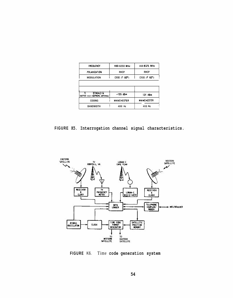
FRtOUENCY 4 6 8 8250 MHz
P0:ARIZATIOY RHCP
I MODULATION 1 CPSK I* 6D'I I CPSK I: 60'1 !
4 6 8 8375 MHz
RHCP
COOING 1 MANCHESTfR
BANDWIDTH I ' 400 HZ
I I
-139 dBm SIGNAL STRtNGTH 1"l ROY 6 m c Ull"*.,I -135 d h
MANCHfSTfR 1 4 0 0 Hz I
F I G U R E K5. Interrogation channel signal characteristics.
WESTERN ECJTERN
^ATELL I TE TV LORAN C
F I G U R E
TO TO ESTER)( EASTERN
SATELLITE SATELLITE
K6. Time code generation system
54

of i ts longi tude , l a t i t u d e , and he ight above the su r f ace of the earth
minus a b i a s of 119,300 ps. The p o s i t i o n information is updated
f r equen t ly , p r e s e n t l y every 1 min.
The GOES time s i g n a l s from both s a t e l l i t e s a r e summarized i n F i g u r e K5.
The s i g n a l s are r i g h t hand c i r c u l a r l y po l a r i zed ( R H C P ) , coherent phase
s h i f t keyed (CPSK) , and separa ted i n frequency by 12.5 kHz. The data
r a t e , being 100 b / s , occupies on ly 400 Hz o f bandwidth. The da t a are
Manchester coded and phase modulate t he c a r r i e r k60°, t h u s providing a
carrier f o r convent iona l phase-locked loop demodulation.
N O A A ' s CDA ground s t a t i o n s are loca t ed a t Wallops I s l and , V i rg in i a , where
a l l i n t e r r o g a t i o n s i g n a l s s e n t t o t h e s a t e l l i t e are o r i g i n a t e d . NBS
maintains an ensemble of atomic c locks a t tha t s i t e . These c locks
provide t h e time and frequency r e f e r ence f o r t h e time code. The time
code genera t ion system, p a r t l y shown i n Figure K 6 , is completely redundant
and f u l l y supported by an u n i n t e r r u p t a b l e power supply. There is a
communication i n t e r f a c e between t h e equipment and NBS, Boulder, us ing a
te lephone l i n e . Over t he te lephone l i n e , s a t e l l i t e p o s i t i o n information
is s e n t t o t he CDA and s t o r e d i n memory f o r eventua l i nco rpo ra t i on i n t o
the time code and i n t e r r o g a t i o n message.
Data are a l s o retrieved from t h e CDA v i a t h e te lephone l i n e t o Boulder.
These data include t h e frequency of t h e atomic o s c i l l a t o r s and t h e time of
t h e c locks r e l a t i v e t o UTC compared v i a GPS s a t e l l i t e s i g n a l s and Loran-C
55

20a
100
UTC-GOE 1
UTC-GOES/EAST (FIR) : CORRECTED ;/WEST (HR) : CORRECTED /15/1982-11/15/1982
L I I I I B 10 20 30 -200
DAYS
FIGURE K7. Typ i ca l c o r r e c t e d t i m i n g da ta f rom GOES.
56

t ransmissions from Cape Fear, North Carol ina. Besides t h e time-and-
frequency monitoring func t ions the NBS equipment a t Wallops I s l and
provides t h e information necessary f o r NBS staff a t Boulder t o remotely
determine i f and where malfunctions ex i s t and t o c o r r e c t them through t h e
switching of redundant system components.
The s a t e l l i t e p o s i t i o n information is generated a t Boulder by us ing a
l a r g e s c i e n t i f i c computer and o r b i t a l elements furn ished by NESDIS.
NESDIS genera tes these o r b i t a l elements weekly using d a t a obtained from
the i r t r ack ing f a c i l i t i e s a t t h e CDA.
Commercial rece iv ing equipment is a v a i l a b l e from t h r e e manufacturers w i t h
c o s t s i n t he range of $3,000 t o $7,500 depending upon f e a t u r e s . The
antennas are t y p i c a l l y of t he h e l i x type w i t h o v e r a l l l eng ths of about one
meter, diameters of approximately 1 1 4 meter, and weight of 10 kilograms.
The performance f o r GOES has been t y p i c a l of t h a t shown i n Figure K7.
Except f o r r a r e occasions when the s a t e l l i t e ephemeris is of poor
q u a l i t y , t h e GOES s i g n a l s provide time t o wi th in 100 p s of UTC(NBS)
throughout t h e e n t i r e coverage areas of both east and west s a t e l l i t e s .
Since May 1974 t h e NBS has operated time code broadcas ts from N O A A ' s GOES
s a t e l l i t e s . There are t h r e e o r more s a t e l l i t e s i n o r b i t ; two a r e
o p e r a t i o n a l , t h e o the r se rv ing a s t he ' i n- o r b i t ' ' h o t ' spa re ready t o
r ep l ace e i ther s a t e l l i t e i n case of f a i l u r e . Other sa te l l i t e s a re u s u a l l y
57

ready f o r launch when needed. The p re sen t complement of s a t e l l i t e s is
expected t o i n su re two s a t e l l i t e s i n cont inuous opera t ion . P lans e x i s t t o
cont inue the program beyond the year 2000.
Considering t h e long l i f e of t h e GOES system, the important mission of the
GOES program, and the wide geographica l coverage of the sa te l l i t e s the
GOES time s i g n a l s are f i n d i n g many a p p l i c a t i o n s where r e l i a b i l i t y ,
automatic s i g n a l recovery , and accuracy a r e desirable. Being geos ta-
t i o n a r y , GOES is a source of cont inuous synchroniza t ion , o f f e r i n g a
s i g n i f i c a n t advantage over a non- geostat ionary s a t e l l i t e which can only
provide exposure t o t h e u s e r dur ing b r i e f p e r i o d s of time. Also, t h e GOES
time s i g n a l s are not s u b j e c t t o t he fad ing and unpredic tab le pa th de lays
tha t l i m i t t e r res t r ia l systems ope ra t i ng i n t h e low t o h igh frequency
ranges.
The time code information is a convenient a d d i t i o n t o GOES but n o t a
requirement . The p r e s e n t l e v e l of accuracy is 100 1.1s w i t h no p rov i s ion
f o r improvement g iven t h e low r e s o l u t i o n and p r e c i s i o n of p o s i t i o n
information.
58

L. CONCLUSIONS OF PHASE I1
Seven systems have been examined a g a i n s t c r i t e r i a designed t o s e l e c t t h e
bes t sys tem o r sys tems t h a t have reasonable p o t e n t i a l f o r s a t i s f y i n g the
requirements of t h e ITS. The BSS has been r e j e c t e d f o r f u r t h e r s t u d y or
development because i t d i d n o t o f f e r cont inuous ope ra t i on time and
p r e s e n t s t rack ing problems tha t are no t suppor t ive of t h e one microsecond
requirement wi th reasonable c o s t s . LORAN-C was not accep tab l e because o f
r e c e i v e r c o s t s , l a c k of a time code, and unce r t a in f u t u r e .
The T r a n s i t system was rejected f o r b a s i c a l l y t h e same reasons as f o r
LORAN-C w i t h t he a d d i t i o n a l problem of inadequate accuracy. GOES was no t
accep tab l e f o r accuracy reasons.
The FSS, GPS and RDSS w i l l b e examined f u r t h e r i n t h e next phase of t h i s
s tudy . FSS w i l l be s t u d i e d because of i t s e x c e l l e n t p o t e n t i a l t o meet a l l
requirements and have time and frequency d issemina t ion as its s o l e
mission. An ITS system w i l l be p a r t i a l l y developed us ing the FSS s o
i s s u e s of c o s t , accuracy and f e a s i b i l i t y can be examined i n a more
r e a l i s t i c environment. GPS is a system t h a t is already working and
sa t i s f ies o r w i l l s a t i s f y a l l requirements except c o s t . Long term DoD
po l i cy adds some u n c e r t a i n t y which w i l l be explored i n the next phase a long
w i t h some t echno log ica l f o r e c a s t i n g of equipment c o s t s f o r the near
f u t u r e . The RDSS is a v e r y new system and was a s u r p r i s e op t ion f o r t h i s
s tudy. If t h e d i r e c t i o n f o r Geostar cont inues as planned i t may se rve as
an e x c e l l e n t ITS. We w i l l a t t e m p t t o e s t a b l i s h a d i a l o g w i t h t h e Geostar
o rgan iza t ion t o provide a clearer p i c t u r e of their p lans . We w i l l a ss is t
59

i n developing those p l ans through a l i m i t e d coopera t ive e f f o r t i f such an
e f f o r t is found d e s i r a b l e by bo th p a r t i e s .
The f i n a l phase of t h e ITS s tudy converges on examining a p r i v a t e s e c t o r
o f f e r i n g , a DoD nav iga t ion system w i t h a mission d i f f e r e n t from time and
frequency d issemina t ion , and t h e exc lus ive u se of a p o r t i o n of a
telecommunication s e r v i c e ( t h e FSS o p t i o n ) . Each op t ion has t echn ica l and
p o l i t i c a l advantages and disadvantages. T h i s next phase w i l l a t t empt t o
f u r t h e r i d e n t i f y and ana lyze a l l p e r t i n e n t i s s u e s needed t o make informed
d e c i s i o n s f o r f u t u r e use of h igh p r e c i s i o n synchroniza t ion s e r v i c e s .
60
P H A S E 111, P A R T 1 :
THE FIXED SATELLITE SERVICE
A P R E L I M I N A R Y D E S I G N
C O N T E N T S
M. P H A S E 111, P A R T 1 I N T R O D U C T I O N
N . E L E M E N T S OF T H E ITS
1 . T H E S P A C E S E G M E N T
2. T H E GROUND S E G M E N T
a ) . The master earth s t a t i o n
b). The t r ack ing sys tem
c ) . The user's equipment
3. S I G N A L S T R U C T U R E
4 . O R B I T D E T E R M I N A T I O N AND E P H E M E R I S
P R E D I C T I O N
5 . D E N I A L OF S I G N A L S T O U N A U T H O R I Z E D U S E R S
6 . L I N K C A L C U L A T I O N S
0 . SUMMARY OF P R E L I M I N A R Y D E S I G N
Page
62
65
65
76
77
80
86
90
99
1 1 1
121
122
61

M. PHASE 111, Par t 1 I N T R O D U C T I O N
The FSS (F ixed S a t e l l i t e Se rv i ce ) op t ion r e p r e s e n t s the des ign of
the ITS as a s a t e l l i t e b roadcas t system us ing p a r t of a t ransponder
c a r r i e d by a U . S . domestic communications s a t e l l i t e ope ra t i ng i n the Fixed
S a t e l l i t e Se rv i ce . The FSS is gene ra l l y intended f o r po in t- to- poin t
telecommunications. However, r e c e n t foo tno te s added t o t h e I T U r egu la-
t i o n s now a l lows FSS bands t o ope ra t e on a secondary basis i n a broadcas t
mode. There a r e s e v e r a l very s u c c e s s f u l examples of t h i s i n u se today,
most no tab ly t h a t of the Equa to r i a l Communications Corporat ion who
d i s t r i b u t e s data t o small ear th s t a t i o n s i n a po in t- to- mul t ipo in t o r
b roadcas t mode.
The ITS, u s ing a FSS s a t e l l i t e , could be implemented i n c l o s e
approximation t o tha t descr ibed i n t h i s s e c t i o n . A moderately s i z e d ear th
s t a t i o n l oca t ed a t the source of time and frequency s t anda rds would upl ink
o r t r ansmi t the time and frequency s i g n a l s t o a communications s a t e l l i t e .
Th i s moderately s i z e d earth s t a t i o n , the diameter of which would be on the
order of 6 meters, would guaran tee t h a t the t o t a l communications l i n k would
be downlink l i m i t e d . I n o t h e r words the upl ink would c o n s t i t u t e no
l i a b i l i t y i n the t o t a l system no i se budget.
The s a t e l l i t e , upon r ece iv ing t h e upl ink s i g n a l s , would change the
c a r r i e r f requency, ampl i fy , and reradiate them back t o the ear th 's
su r f ace . These s i g n a l s would be rece ived by u s e r s equipped w i t h small
microwave an tennas ( l i k e l y t o be a d i s h w i t h a diameter of one meter or
less) and a r e c e i v e r which would amplify, down conver t and decode t h e
62

t iming s i g n a l s . The timing s i g n a l s would provide t h e information requi red
t o s e t and con t ro l a clock t o wi th in be t te r than one microsecond of t h e
NBS time scale denoted as U T C ( N B S ) . That information would include t h e
day number, hour , minute, second, and the s a t e l l i t e ' s c u r r e n t p o s i t i o n i n
longi tude , l a t i t u d e , and earth c e n t e r d i s t ance . The r ece ive r could a l s o
genera te one o r more f requencies such a s 1 MHz and 5 MHz d i s c i p l i n e d t o
t he NBS frequency s tandard v i a t h i s ITS s e r v i c e l i n k .
The t r ack ing of t he s a t e l l i t e ' s p o s i t i o n r e l a t i v e t o t he earth and
t h e genera t ion of i ts ephemeris would be accomplished using the t iming
s i g n a l s . The ephemeris of t he s a t e l l i t e is information requi red by the
user 's r ece ive r i n t h e computation and co r rec t ion of s i g n a l d e l a y from t h e
NBS ear th s t a t i o n through t h e s a t e l l i t e t o t h e u s e r ' s r e c e i v e r . The
p o s i t i o n of t h e s a t e l l i t e would be determined by rece iv ing the timing
s i g n a l s relayed by t h e s a t e l l i t e a t t h r e e c a r e f u l l y s e l e c t e d p o i n t s on the
e a r t h wi th in the s a t e l l i t e ' s antenna coverage. One po in t w i l l be NBS,
Boulder. The o ther two sites w i l l be s e l e c t e d t o provide t h e best
geometries f o r determining the s a t e l l i t e ' s p o s i t i o n as wel l as f o r
p o l i t i c a l , economic and o ther t echn ica l reasons. These two s i t e s w i l l
communicate t he i r data in rea l time t o NBS, Boulder e i ther through t h e same
s a t e l l i t e o r v i a t e r r e s t r i a l communications f a c i l i t i e s . An o r b i t w i l l be
f i t t o t he data. T h i s o r b i t w i l l then be used t o genera te the s a t e l l i t e ' s
ephemeris a lgor i thm f o r de r iv ing ephemeris data.
The timing s i g n a l w i l l b e encrypted t o deny i ts use by unauthorized
o r nonsubscribing u s e r s . The key f o r encrypt ion w i l l be provided t o t h e
user according t o a s u b s c r i p t i o n l ist. Subsc r ip t ion f ees w i l l pay f o r t h e
63

ope ra t i on and maintenance of the ITS. Each u s e r ' s r e c e i v e r w i l l have a
unique master enc ryp t ion key b u i l t i n t o t h e r e c e i v e r . Each key s h a l l be
genera ted , au tho r i zed and registered by NBS p r i o r t o being i n s t a l l e d i n
t he r e c e i v e r by the manufacturer. A working key could be d i s t r i b u t e d by
NBS or its c o n t r a c t o r s on a pe r iod i c bas i s and according t o s u b s c r i p t i o n
fees p a i d . The key may be de l ive red e i t h e r i n t h e form of an e l e c t r o n i c
appa ra tu s ( such as PROMS) which is i n s e r t e d i n t o the r e c e i v e r or, more
p r e f e r a b l y , s e n t v i a the s a t e l l i t e t o each paid-up u s e r ' s r e c e i v e r .
Delinquent user's r e c e i v e r s could be made inope ra t i ve , as w e l l , by sending
an i n v a l i d working k e y . The i n t e n t of t h e encrypt ion procedure is t o
render chea t ing a poor use of time and e f f o r t when compared t o paying a
r e l a t i v e l y small annual s u b s c r i p t i o n fee f o r t h e s e r v i c e d e l i v e r y of time
and frequency information.
The c o s t of u s e r ' s equipment must be reasonable enough t o guaran tee a
s u f f i c i e n t popula t ion of u s e r s t o cover the s e r v i c e ' s c o s t of ope ra t i on
and maintenance. I n t h e l a s t few years the c o s t s of small microwave
an tennas , low no i se a m p l i f i e r s and down conve r t e r s designed f o r s a t e l l i t e
receive- only a p p l i c a t i o n have decreased s i g n i f i c a n t l y . Th i s c o s t
r educ t ion has been p a r t i c u l a r l y t r u e due t o the emerging Direc t Broadcast
S a t e l l i t e (DBS) indus t ry i n the U . S . , Europe, and Japan. The ITS, being
broadcas t i n n a t u r e , can enjoy the economies of scale t o be r e a l i z e d from
t h e DBS indus t ry . S ince t e n s of m i l l i o n s of u n i t s are t o be produced,
t h i s should p a r t i c u l a r l y b e n e f i t the I T S u s e r . The u s e r ' s antenna
must be phys i ca l l y small b u t n o t n e c e s s a r i l y c l a s s i f i e d as mobile.
Typica l ly , DBS antennas are being designed and manufactured wi th diameters
as small as 0.6 meters. Complete DBS r e c e i v i n g systems not inc lud ing the
TV se t a r e expected t o be i n $400-500 range.
64

The u s e of t he FSS can be ex t remely r e l i a b l e . One need only n o t i c e
t h a t t h e major TV networks are now rou t ing programming t o l o c a l d i s t r i b u-
t o r s v i a s a t e l l i t e and t h a t many major spo r t ing events from around t h e
wor ld are watched l i v e w i t h l i t t l e i n t e r r u p t i o n . Due t o t h e numerous
sources f o r s a t e l l i t e bandwidth and time, e spec i a l ly i n the U . S . , one can
be assured of a very competi t ive environment and t h u s r e a l i z e the lowest
c o s t s poss ib le f o r s a t e l l i t e bandwidth and time.
The d i scuss ion above was a b r i e f s ta tement of one model f o r the ITS
us ing the F ixed S a t e l l i t e Serv ice and is intended as an in t roduct ion t o
the d i scuss ions of t h e main issues r e l evan t t o t he ITS. They are more
f u l l y developed and descr ibed below.
N . ELEMENTS OF THE ITS
N 1 . THE SPACE SEGMENT
The space segment is tha t p a r t of the ITS t h a t w i l l be loca ted in
space. In t h i s ca se , i t is t h a t part of a s a t e l l i t e t h a t is d i r e c t l y
involved w i t h t h e ITS.
The FSS a s operated in t h e United States is a nonmonopoly s a t e l l i t e
s e r v i c e and is pr iced on an open market bas is . It is d r iven by c o s t s and
p r o f i t incent ive . The c o s t s p e r channel have been s t e a d i l y dropping
r e l a t i v e t o i n f l a t i o n s i n c e i ts incept ion . Th i s has r e s u l t e d i n a s t e a d y
growth. Growth has s t imula ted t h e design of l a r g e r and more c o s t
e f f e c t i v e s a t e l l i t e s , f u r t h e r reducing c o s t s through economies of s c a l e .
65

T h i s s i t u a t i o n is expected t o cont inue fo r some y e a r s t o come, a t least
u n t i l t h e growth of f iber o p t i c s communications begins t o assume a major
r o l e i n the point- to- point telecommunications m a r k e t s .
The FSS wi th in t h e United S ta tes can be p a r t i a l l y understood by
looking a t t h e numbers of t ransponders i n space today and t h e numbers
expected i n t h e near term. A t ransponder is simply a s a t e l l i t e r e p e a t e r .
The t ransponders have mainly been 36 MHz i n bandwidth bu t o t h e r
bandwidths are becoming common, e s p e c i a l l y i n the K U band. It has become
s tandard t o d i s c u s s s a t e l l i t e capac i ty i n terms of numbers of 36 MHz
t ransponders . Recent s t u d i e s have placed the number of t ransponders i n
space a t 732 fo r 1985, 1212 f o r 1986, and 1336 f o r 1987. The capac i ty f o r
1985 i n terms o f bandwidth is t h e r e f o r e 732 x 36 MHz, o r 26,352 MHz,
a v a i l a b l e t o suppor t va r ious telecommunication customers. A t y p i c a l
K U band t ransponder and frequency p lan are shown i n F igures N 1 and N2.
Sa te l l i t e s e r v i c e s may be acqui red a t a number o f l e v e l s . S a t e l l i t e
owners w i l l lease or s e l l t ransponders (36 MHz u n i t s ) . F u l l time h o l d e r s
(owners or l e a s o r s ) of t ransponders may lease o u t the t ransponder on a
p a r t time basis. Th i s may be scheduled, for example, on a "same-
time-every-dayII o r llonly-on-Mondaysfl basis or on an occas iona l ba s i s f o r a
s p e c i a l even t . F r a c t i o n a l t ransponder u s e r s , l i k e t h e I T S , could o b t a i n
t he i r necessary bandwidths from transponder owners o r lease holders . An
example of a f r a c t i o n a l t ransponder use is a bus ines s needing only a
narrowband data s e r v i c e or one t h a t does no t need a f u l l t ransponder .
66

RECEIVE 14.0-14.5 GHz
- 7 - --O TOTAL + - BEAM FORMING
POWER COMBINED
NETWORK
IRS: 6 to 7 Input Redundancy Switch. 7 tn 6 nlltnllt RnAnonAsnm, C!t.,;tnh -. .-. . .- - -".la". I I "u" I Iuc I I I "y U V V I L C I I I .
DA: Driver Amplifier PA: Power Amplifier
Q
Fig . N 1 . Typica l KU-BAND Transponder Conf igura t ion
67

DOWN LINK
0 0 N z
0 (D c) z
0 9 9 P
Fig. N2. Typ ica l KU Band Frequency P l a n
68

The FSS f o r US domestic use ope ra t e s i n t he 5.925 t o 6.425 GHz upl ink
and 3.7 t o 4.2 GHz downlink band and is commonly r e f e r r e d t o a s the
C-band. The o the r FSS domestic assignment is a t KU-band w i t h t h e 1 4 . 0 t o
14.5 GHz band f o r t he upl ink and 11.7 t o 12.2 GHz band f o r the downlink.
Addit ional frequency bands were a l l o c a t e d a t t he 1979 World Administrat ive
Radio Conference (WARC-1979). These a d d i t i o n a l bands w i l l not become a
f a c t o r f o r t h e ITS f o r s eve ra l years because of t echn ica l and economic
rea sons .
The U.S. domestic s a t e l l i t e s ope ra t ing i n t he FSS a r e assigned
p o s i t i o n s by t he FCC in the geos ta t ionary a r c between 62 degrees West
longi tude and 146 degrees west longi tude (except f o r t he arc between 105
and 120 degrees which is assigned t o Canadian s a t e l l i t e s ) . These
s a t e l l i t e s have antenna p a t t e r n s t h a t cover t h e CONUS w i t h some s a t e l l i t e s
a l s o providing spot beams t o Hawaii, Alaska, and Puer to Rico and Virgin
I s l ands . The r ecen t assignments of t h e geos ta t ionary a r c a r e shown in
Table 8 . These s a t e l l i t e s , due t o antenna s i z e , provide reduced, b u t
u s a b l e , s i g n a l l e v e l s f a r i n t o ad jacent a r e a s of Canada, Mexico, t h e
P a c i f i c and A t l a n t i c Oceans. A t y p i c a l f o o t p r i n t is shown in Figure N3
where contours of e q u a l E R I P a r e shown.
Recent e f f o r t s t o increase t h e capac i ty of t he geos t a t iona ry o r b i t
have l e d the FCC t o r e q u i r e tha t s a t e l l i t e s be spaced a t two and t h r e e
degrees apart rather than t h e o ld s tandard of four degrees. T h i s new
spacing means t h a t ground antennas w i l l experience more i n t e r f e r e n c e from
ad jacen t s a t e l l i t e s through t h e i r s i d e lobes . These ground antennas, when
t r a n s m i t t i n g , w i l l i n t e r f e r e w i t h t h e recept ion by ad j acen t s a t e l l i t e s
69

T A B L E 8. S A T E L L I T E O R B I T A L P O S I T I O N A S S I G N M E N T S
P O S I T I O N S
146 144 142 140 138 136 136 134 134 132 132 130 130 128 126 126 124 124 122 122 120
S A T E L L I TE KU BAND
AURORA 2 WESTAR 7 AURORA 1 GALAXY 4 S A T C O M 1 R S P A C E N E T 4 G S T A R 3 U N A S S I G N E D COMSAT G E N B GALAXY 1 WESTAR B S A T C O M 3-R GALAXY B ASC- 1 T E L S T A R M A R T I N M A R I E T T A WESTAR 5 F E D E R A L E X P R E S S U N A S S I G N E D SBS 5 S P A C E N E T 1
X X
X
X
X X
B X
B X
X X
C BAND
X X X X X X X
X
X
X X
X
X
P O S I T I O N B E T W E E N 120 AND 105 D E G R E E S A R E A S S I G N E D T O C A N A D I A N S A T E L L I T E S
105 G S T A R X 103 G S T A R X 101 F O R D 1 X
99 WESTAR 4 X 99 SBS 1 X 97 T E L E S T A R X 97 SBS 2 X 95 SBS 3 X 95 GALAXY 3 X 93 F O R D 2 X X 91 W E S T A R 3 X 91 SBS 4 X 89 U N A S S I G N E D X 89 U N A S S I G N E D X 87 S P A C E N E T 3 X 85 T E L E S T A R X 85 RCA A X 83 A S C 2 X X 81 S A T C O M 4 X 81 RCA B X 79 M A R T I N M A R I E T T A A X 79 WESTAR 2 X
70

77 76 75 74 73 72 71 69 67 67 64 62 62
F E D E R A L E X P R E S S A X COMSTAR D4 COMSAT G E N E R A L A X GALAXY 2 WESTAR A X SATCOM 2-R GALAXY A X S P A C E N E T 2 X SATCOM 6 RCA C X ASC 4 X SATCOM 7 SBS 6 X
X
X
X
X X
X X
71

U.S. FSS
Fig. N3. Typical EIRF' Contours f o r U.S. FSS Sate l l i tes
72
a s well. The i n t e r f e r e n c e geometry f o r ad jacent s a t e l l i t e systems is
i l l u s t r a t e d in Figure N 4 . New s ide lobe s t anda rds have been imposed by t he
FCC f o r t h e ear th s t a t i o n . The e f f e c t has been the use of l a r g e r and more
expensive antennas on t h e ground. These s ide lobe s tandards a r e mandatory
f o r a l l t r ansmi t antennas and f o r a l l r ece ive r antennas wanting the
p r o t e c t i o n afforded by a FCC l i c e n s e but must accept whatever
i n t e r f e r e n c e ad jacen t s a t e l l i t e s and t e r r e s t r i a l microwave may i n f l i c t .
The in t e r f e rence w i l l be p a r t i c u l a r l y severe f o r the very small ear th
s t a t i o n whose s i d e lobes a r e high wi th in two o r four degrees from i t s main
lobe a x i s . Techniques such as t h e use of spread spectrum a r e a v a i l a b l e t o
reduce the e f f e c t t h i s i n t e r f e r e n c e and are discussed elsewhere.
The c o s t s of t ransponders o r t h e i r long term l e a s e s can only be
est imated. The reasons are the near ly complete deregula t ion of s a t e l l i t e
t a r i f f s . The cu r ren t procompeti t ive p o l i c i e s of t he Federal Communica-
t i o n s Commission ( F C C ) have r e s u l t e d i n a number of a c t i o n s t h a t d i r e c t l y
a f f e c t domestic s a t e l l i t e f i r m ' s charges f o r t h e i r transponder s e r v i c e s .
In the FCC' s Competitive Carrier dec i s ion ( C C Docket 7 9 - 2 5 2 ) two
regula tory t iers f o r nondominant common c a r r i e r s were established and
include s a t e l l i t e firms providing domestic i n t e r s t a t e s e r v i c e s ,
spec i a l i zed common c a r r i e r s , and r e s e l l e r s . Nondominant c a r r i e r s are
those not possessing s u f f i c i e n t market power o r unable t o raise p r i c e s
s i g n i f i c a n t l y above c o s t s f o r an apprec i ab le per iod of time o r t o
d i sc r imina te a g a i n s t any c l a s s of customers.
73

ADJACENT SATELLITE
0
\ ADJACENT SATELLITE
INTERFERING SIGNAL
J
EARTH STATION
F i g . N 4 . I n t e r f e r e n c e Geometry f o r Adjacen t S a t e l l i t e s
74

Under t h e s t reamlined r egu la t ion order (adopted October 1983) t a r i f f
requirements were s u b s t a n t i a l l y reduced f o r these non-dominant c a r r i e r s .
Ta r i f f s could be f i l e d on 1 4 d a y s n o t i c e rather than 90. Carriers were
permit ted t o expand s e r v i c e s sub jec t t o nominal r epo r t ing requirements and
t o d iscont inue s e r v i c e s s u b j e c t t o a r e l a t i v e l y s h o r t approval per iod and
customer n o t i c e o b l i g a t i o n . T h i s order has made f o r a more dynamic
environment where s e r v i c e s can more e a s i l y meet m a r k e t demands.
Under t h e ? 'forbearance" doc t r ine adopted in August 1984, t h e s e
c a r r i e r s were now able t o change p r i c e s or rate s t r u c t u r e s , o r t o expand
o r d i scon t inue a s e r v i c e without any wait ing per iod requirement o r
r epo r t ing t o t he FCC. I n an a c t i o n taken in November 1984 the FCC
d i r e c t e d common c a r r i e r s sub jec t t o t h e r egu la to ry forbearance t o cance l
t h e i r t a r i f f s on f i l e and not t o f i l e o the r t a r i f f s in t h e fu tu re . A l l
t a r i f f s are now cance l l ed . All c a r r i e r s have an o b l i g a t i o n , however, t o
keep ma te r i a l on f i l e a t t he i r o f f i c e s t h a t can be produced r e a d i l y upon
inqui ry from the FCC, i n order t o s u b s t a n t i a t e reasonableness of r a t e s ,
terms and condi t ions .
T h i s competi t ive environment h a s been c r e d i t e d w i t h an increased
array of s e r v i c e s and choices . In a d d i t i o n t o communication s e r v i c e s ,
s a t e l l i t e common c a r r i e r s , t ransponder r e s e l l e r s and brokers o f f e r a
v a r i e t y of ope ra t iona l and ownership a l t e r n a t i v e s . The customer can
s e l e c t from end-to-end services provided by one e n t i t y , o r customers may
c o n t r a c t w i t h a s a t e l l i t e or transponder owner f o r space segment only and
bui ld and own the ground segment.
75

I n t h i s deregula ted environment i t is d i f f i c u l t t o p r e d i c t the
space segment c o s t s a c c u r a t e l y without a formal bidding process o r d i r e c t
n e g o t i a t i o n w i th t h e c a r r i e r s . A r e c e n t example can be informative
however. The ITS, i n t h i s s tudy , r e q u i r e s a small p a r t of one
t ransponder , approximately 200 kHz o f the t r ansponde r ' s 36 MHz o r roughly
one pe rcen t . For a f i xed term, p ro t ec t ed* s e r v i c e (two years o r more),
t h e c o s t s have r e c e n t l y been i n the $130,000 t o $170,000 per month range.
Assuming a p a r t i a l t ransponder use of one pe rcen t and a mark up of 100% by
a broker due t o reduced t ransponder e f f i c i e n c y and brokerage f e e s , these
c o s t s f o r the ITS would be $2600 t o $3400 per month. These c o s t s are f o r
s a t e l l i t e t ransmiss ion time only.
N2. THE GROUND SEGMENT
The ground segment w i l l c o n s i s t of t h r e e major components inc lud ing
( 1 ) t h e master ear th s t a t i o n w i t h t h e time and frequency r e f e r e n c e , system
t r a c k i n g c o n t r o l , and t h e information gene ra t i on sys tem, ( 2 ) t h e remote
t r a c k i n g ear th s t a t i o n s c o n s i s t i n g of two o r more smaller an tennas , and ( 3 )
the use r r e c e i v i n g sys tem each c o n s i s t i n g of a small antenna and r e c e i v e r .
~~
*Two forms o f p ro t ec t ed t ransponder s e r v i c e s are common. There is the
f fPro tec ted-dedica ted , i n which a company w i l l r e se rve a s p e c i f i c
replacement t ransponder , c o n s i s t i n g of an unassigned t ransponder o r a
t ransponder s u b j e c t t o i n t e r r u p t i o n i n a separate s a t e l l i t e o r i n the same
s a t e l l i t e , f o r use i n t h e event of t ransponder f a i l u r e . With "Protected-
des igna ted , t y p i c a l l y , no s p e c i f i c replacement t ransponder is i d e n t i f i e d .
76

N2a. THE MASTER EARTH STATION
The master earth s t a t i o n w i l l t r ansmi t t h e s i g n a l s t o t h e s a t e l l i t e
for r e l ay t o t h e u s e r s . The e a r t h s t a t i o n w i l l be co- located with t h e
time and frequency s t anda rds which genera te UTC(NBS) a t t h e NBS
f a c i l i t y i n Boulder, Colorado. A master ear th s t a t i o n a l ready ex is t s a t
Boulder and can serve as t h e ITS master earth s t a t i o n . I t is a 6.1 meter
K U band antenna roof mounted us ing a kingpost mount. A photo of t he
antenna is shown in Figure N5. The antenna is within 300 f e e t of t h e time
and frequency s t anda rds , i . e . , the NBS time s c a l e and the U.S. frequency
s tandard.
The r e q u i r e d ITS e a r t h s t a t i o n is represented by a block diagram i n
Figure N 6 . The NBS time and frequency s tandards provide t h e r e fe rence f o r
t h e time code gene ra to r , t o t h e time i n t e r v a l coun te r s ( T I C ) which output
t h e range measurements data between t h e s a t e l l i t e and the NBS master and
two o the r smaller earth s t a t i o n s . The computer r ece ives these range
measurements from the T I C ' S and computes an o r b i t f o r t h e s a t e l l i t e .
Using t h i s computed o r b i t , t h e computer ou tputs the s a t e l l i t e ' s c u r r e n t
p red ic t ed p o s i t i o n f o r i nc lus ion i n t o t h e next message frame t o be s e n t t o
the s a t e l l i t e . The computer a l s o looks a t t he data relayed by t he
s a t e l l i t e f o r t he purposes of checking opera t ions .
The time code and s a t e l l i t e p o s i t i o n are encrypted. The encrypted
output is jo ined w i t h t h e i n i t i a t i o n vec tor used i n the encrypt ion and
decrypt ion process , and both are encoded f o r forward e r r o r c o r r e c t i o n
77

5 k (d w

6 METER
I t
FEC UPCONVERTER
L SATELLITE POSITION
1 CONVERTER
N BS TIME AND
FREQUENCY STANDARDS
SATELLITE RANGE DEMODLLATOR coMpuTg M EASU R EM ENTS L
DES PR EAD E R DES PR EAD ER DES PR EA D ER VI 1 J I t 1 1 + 1
I) t TIC
DECRYPTION 1
F i g . N6 . NBS Master Earth S t a t i o n
7 9
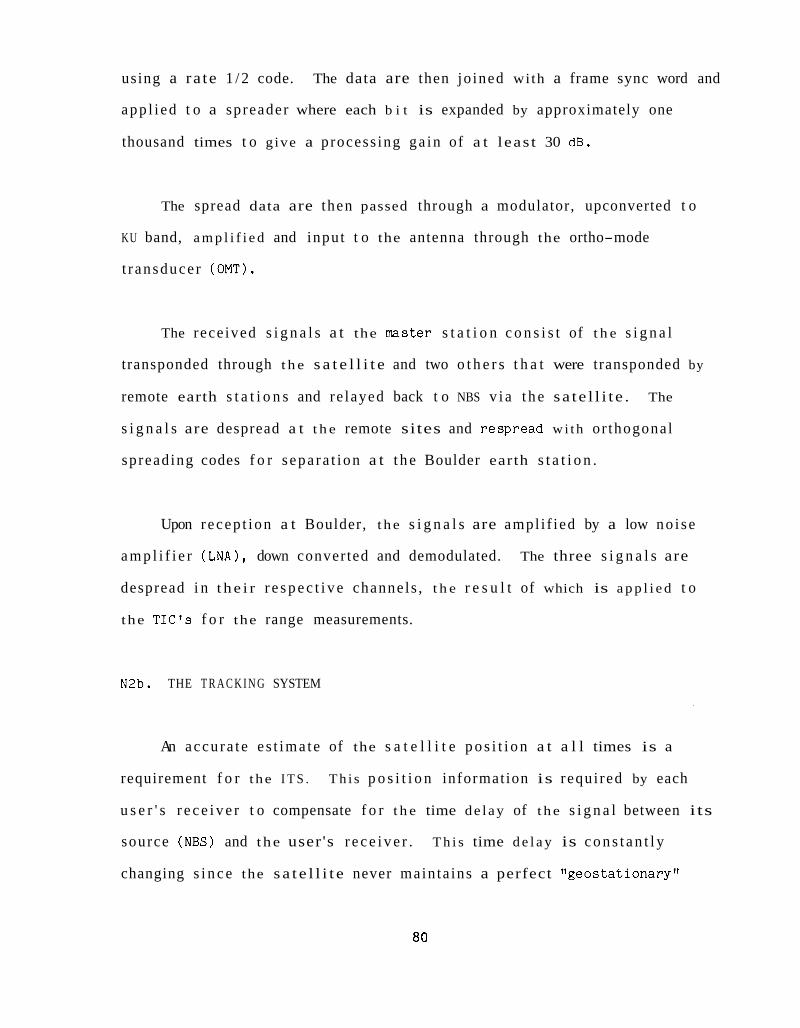
using a ra te 1 / 2 code.
app l i ed t o a spreader where each b i t is expanded by approximately one
thousand times t o g ive a process ing ga in of a t l eas t 30 dB.
The data are then jo ined with a frame sync word and
The spread data are then passed through a modulator, upconverted t o
KU band, a m p l i f i e d and input t o the antenna through the ortho-mode
t r ansduce r (OMT).
The rece ived s i g n a l s a t the master s t a t i o n c o n s i s t of t h e s i g n a l
transponded through t h e s a t e l l i t e and two o t h e r s t h a t were transponded by
remote earth s t a t i o n s and re layed back t o NBS v i a t h e sa te l l i t e . The
s i g n a l s are despread a t t h e remote sites and respread w i t h or thogonal
spreading codes f o r s epa ra t i on a t t h e Boulder earth s t a t i o n .
Upon r ecep t ion a t Boulder, t h e s i g n a l s are ampl i f ied by a low no i se
a m p l i f i e r ( L N A ) , down converted and demodulated. The three s i g n a l s are
despread i n t h e i r r e s p e c t i v e channels , t h e r e s u l t of which is a p p l i e d t o
the T I C ' S f o r the range measurements.
N2b. THE T R A C K I N G SYSTEM
An accu ra t e e s t ima te of the s a t e l l i t e p o s i t i o n a t a l l times is a
requirement f o r t he I T S . T h i s p o s i t i o n information is requi red by each
u s e r ' s r e c e i v e r t o compensate f o r t h e time de l ay of t h e s i g n a l between its
source (NBS) and t h e user 's r e c e i v e r . T h i s time d e l a y is c o n s t a n t l y
changing s i n c e the s a t e l l i t e never main ta ins a perfect "geos ta t ionary"
80
o r b i t . A l l g eos t a t iona ry s a t e l l i t e s have an o r b i t with a small
e c c e n t r i c i t y and a s m a l l degree of i n c l i n a t i o n . F igure N7 i l l u s t r a t e s the
o r b i t geometry w i t h r e s p e c t t o t he ea r th .
Communication sa te l l i t e s a r e maneuvered every week or two t o keep
t h e i r p o s i t i o n s , r e l a t i v e t o t he e a r t h ' s su r f ace , reasonably cons tan t .
Typical requirements f o r communications s a t e l l i t e s a r e t o keep them wi th in
a box i n space of f 0.05 degrees nor th and south of t he e q u a t o r i a l plane
and 2 0.05 degrees east and west of an assigned p o s i t i o n in longi tude .
Assignments i n longi tude f o r U.S. s a t e l l i t e s are now made a t every two
degrees by t he FCC. Keeping the s a t e l l i t e s a t these pos i t i ons r equ i r e s
t r ack ing procedures by t h e s a t e l l i t e ' s ope ra to r s t h a t are not s u f f i c i e n t
t o meet the ITS requirements. The ope ra to r s need only t rack t h e
s a t e l l i t e s a t in f requent i n t e r v a l s rather than on a continuous bas i s a s
requi red by the ITS t o produce o r b i t a l elements accura te enough t o produce
long term, accu ra t e p r e d i c t i o n s of s a t e l l i t e p o s i t i o n .
The use of communication s a t e l l i t e s f o r t he I T S , t h e r e f o r e ,
n e c e s s i t a t e s t he ITS system t o include i ts own t r ack ing sys tem. A
t r ack ing system f o r t h e ITS can be genera l ly s p e c i f i e d w i t h reasonable
confidence.
The ITS t racking sys tem would idea l ly include three earth s t a t i o n s ,
each performing ranging measurements t o t h e s a t e l l i t e on a cont inuous
basis. The e a r t h s t a t i o n s would include the same master e a r t h s t a t i o n as
NBS used t o uplink the time and frequency s i g n a l s t o t h e s a t e l l i t e . Two
81

2
r
Fig. N7 Satellite Orbit Geometry
82

o the r smaller ear th s t a t i o n s would be loca ted on the e a r t h ' s s u r f a c e a t
l o c a t i o n s t o produce t h e b e s t t racking r e s u l t s . General ly , t h e
coord ina tes of t h e t h r e e earth s t a t i o n s should de f ine a t r i a n g l e of t he
greates t areas p o s s i b l e wi th in the beam of t h e s a t e l l i t e . If t h e beam
covers CONUS then the t r i a n g l e would be cons t ra ined t o l i e wi th in CONUS
w i t h one ve r t ex loca ted a t NBS, Boulder. These t h r e e e a r t h s t a t i o n s
providing range measurements t o the s a t e l l i t e c o n s t i t u t e a process c a l l e d
t r i l a t e r a t i o n of t h e s a t e l l i t e .
Ranging s i g n a l s w i l l o r i g i n a t e a t NBS, Boulder, and be s e n t t o the
s a t e l l i t e . The s a t e l l i t e w i l l r e ce ive these s i g n a l s , change t he i r
frequency, and send them back t o e a r t h . Reception of t h e s i g n a l s a t
Boulder w i l l a l low a measurement of t h e range from Boulder t o t h e
sa te l l i t e . Range measurements made through the o the r two e a r t h s t a t i o n s
w i l l produce the combined ranges between Boulder and these s i t e s v i a t h e
s a t e l l i t e .
The t h ree range measurements from known p o s i t i o n s on t h e ear th ' s
su r f ace de f ine t h e s a t e l l i t e ' s p o s i t i o n . These data taken over a
s u f f i c i e n t per iod of time w i l l b e used t o f i t an o r b i t i n a l eas t squares
manner. The computed o r b i t is then used t o p r e d i c t f u t u r e p o s i t i o n s of
t h e s a t e l l i t e using Kepler's laws alone. The data ga ther ing , processing,
and o r b i t p r e d i c t i o n w i l l be a t t h e NBS, Boulder, s i t e . The c u r r e n t
s a t e l l i t e ' s p o s i t i o n w i l l b e p a r t of the data s e n t t o the u s e r ' s r e c e i v e r .
T h i s process w i l l be handled us ing a smal l computer a t t h e Boulder s i t e
and c o n s t i t u t e s p a r t of the t r ack ing system.
i l l u s t r a t e d in Figures N8 and N9.
The t racking sys tem is
a3

NBS MASTER EARTH STATION
I
STATION I SATELLITE
Fig . N8. ITS Tracking System
84
REMOTE TURN AROUND
STATION

REMOTE
STATION TURN AROUND)
PN (1) SEQUENCE DESPR EAD
t
Fig . N 9 . Remote Turnaround S t a t i o n
85

N2c. THE USER'S EQUIPMENT
The equipment w i l l c o n s i s t of ( 1 ) an antenna system, ( 2 ) t h e r e c e i v e r
performing t h e downconversion, demodulation, t iming , and decoding
func t ions , and ( 3 ) t h e processing system f o r computation of p a t h d e l a y s ,
Doppler s h i f t , c o n t r o l o f o u t p u t s , and the genera t ion of s tandard time
codes and co r r ec t ed ou tputs including d i s p l a y s and 1 pps .
The antenna w i l l c o n s i s t of t h e phys i ca l antenna and suppor t ing
s t r u c t u r e s and a s u i t a b l e low no i se ampl i f ie r ( L N A ) o r low no i se block
downconverter (LNBC) . Making use of economies of scale, a s i g n i f i c a n t
c o s t b e n e f i t is expected through t h e use of t h e same antenna being
manufactured f o r t h e d i r e c t b roadcas t s a t e l l i t e (DBS) indus t ry . These
an tennas a r e designed t o work a t t h e same frequency band, KU band, as is
assigned t o the FSS and have many new f e a t u r e s b u i l t i n . Included are
o f f s e t f eeds f o r lower antenna noise temperatures and near v e r t i c a l
mounting ( f o r l o c a t i o n s wi th in CONUS) which reduces i ts snow and ice
loading p o t e n t i a l . DBS antennas are now being produced w i t h 2 t o 4 f o o t
d iame ter s.
Located a t t he antenna feed is a low no i se ampl i f ie r o r a low no i se
block downconverter. The LNA a m p l i f i e s t h e 11.7 t o 12.2 GHz band by
approximately 50 dB w i t h a no i se f i g u r e of approximately 2.5 dB o r about
260 K no i se temperature. The low no i se block downconverter has similar
ga in and no i se f i g u r e s but has an ou tput t y p i c a l l y a t 950 t o 1450 MHz. A
commercial LNBC f o r t h e DBS is i l l u s t r a t e d i n Figure N10. The c o s t s f o r
86

c, rn cd U a (d 0 Ll m
!-l a, U Ll a, ? c 0 u 3 V 0 d !a a, rn
87

t h e antenna and LNBC ( o r L N A ) are expected t o be l e s s than $500 s i n c e t ens
of m i l l i o n s w i l l be manufactured f o r a worldwide market. Di rec t
a p p l i c a t i o n of t hese antenna s y s t e m s t o t he ITS should make a $2500 I T S
r ece ive r system poss ib l e .
The rece iv ing system block diagram is shown in Figure N 1 1 . The
antenna, L N A , and downconverter including i t s l o c a l o s c i l l a t o r s w i l l be
t h e same as used in t h e Di rec t Broadcast S a t e l l i t e ( D B S ) indus t ry f o r home
roof top use . The c o s t f o r t h i s sys tem is expected t o be less than $500.
The output of the downconverter w i l l be the input t o a phase lock loop
demodulator. Phase lock de t ec t ion w i l l be poss ib l e s i n c e the spectrum
w i l l be cons t ruc ted t o leave a r e s i d u a l c a r r i e r f o r t h i s purpose. The
s i g n a l w i l l be phase s h i f t keyed approximately 70 degrees t o guarantee
the r e s i d u a l c a r r i e r thus e l imina t ing t h e need f o r a Costas o r squaring
loop demodulator. The output of t he PLL is f ed t o a d e l a y lock loop ( D L L )
t o remove the spreading code from t h e data. A l o c a l l y generated PN
sequence is used in t he DLL t o c o r r e l a t e a g a i n s t the received sequence.
The DLL s h i f t s its phase u n t i l i t phase matches t h a t of t h e rece ived
sequence and then locks t o i t . The phase of t h e l o c a l l y generated PNB
sequence then is used as a p r e c i s i o n timing marker.
The co l lapsed spectrum is now the da ta which are run through the FEC
c i r c u i t r y t o c o r r e c t f o r e r r o r s and then through t h e DES machine f o r
decrypt ion. The decrypted data conta in ing the time code, s a t e l l i t e
p o s i t i o n , and r e l a t e d data a r e input t o a microprocessor f o r computation
of p a t h delays and c o r r e c t i o n of an output one pps t o be i n synchronism
w i t h U T C ( N B S ) .
88

lj, I I
DOWN CONVERTER ' I 4-4-
I I PNl DECODER I
I
I I I I OSC I LLATO R I
I ---A _---- --A
I
SWITCH
A 1
DECRYPT KEY PN2
F i g . N 1 1 . I T S User R e c e i v i n g System
7 D BS
FRONT END
89
1
PN CLOCK
- CONTROLLER
+ DISPLAYS
USER'S ANTENNA

F i g u r e N 1 1 shows t h e t e c h n i q u e which g e n e r a t e s the PN sequence and
p r o v i d e s t h e key f o r d e c r y p t i o n . T h i s may be a v i r t u a l c h i p i n t h a t t h e
PN sequence and d e c r y p t i o n key w i l l b e s e n t t o t h e r e c e i v e r v i a t h e
s a t e l l i t e rather t h a n c h i p s mailed t o t h e u s e r f o r i n s e r t i o n i n t o t h e
r e c e i v e r .
N3. SIGNAL STRUCTURE
The ITS s i g n a l s t r u c t u r e d i s c u s s e d here is based on c a r e f u l
c o n s i d e r a t i o n o f a l l t he ITS s y s t e m r e q u i r e m e n t s as d i s c u s s e d i n phase one
o f t h i s s tudy . S e l e c t i o n of a good s i g n a l s t r u c t u r e is impor tan t s i n c e it
has been decided t h a t i t must s e r v e f o r b o t h t iming and t r a c k i n g p u r p o s e s
a s well a s hav ing a major impact f o r r e c e i v e r d e s i g n and reduced c o s t s .
T h i s s e c t i o n descr ibes a f a v o r a b l e s i g n a l s t r u c t u r e and p r o v i d e s a br ief
d i s c u s s i o n of i ts merits r e l a t i v e t o v a r i o u s I T S r e q u i r e m e n t s .
OBJECTIVES FOR THE SIGNAL STRUCTURE
The pr imary o b j e c t i v e s are l i s t e d below.
- p r o v i d e a time code and ephemeris message and o t h e r related
data t o t he u s e r on a re l iab le basis.
- p r o v i d e a n a c c u r a t e t r a c k i n g c a p a b i l i t y .
- p r o v i d e a h igh p r e c i s i o n t iming c a p a b i l i t y .
- t o l e r a t e s u b s t a n t i a l i n t e r f e r e n c e from a d j a c e n t s a t e l l i t e and
other ter res t r ia l s o u r c e s .
90

- a l l o w u s e r equipment t o o p e r a t e i n a comple te ly p a s s i v e
(one way) mode.
- s u p p o r t the c a p a b i l i t y t o deny access t o data by unau thor ized
u s e r s .
Spread spect rum t e c h n i q u e s have been chosen as the basic s i g n a l
concep t f o r the ITS. T h i s is because a sp read spect rum s i g n a l w i l l
p rov ide good t iming r e s o l u t i o n w i t h a r b i t r a r y ambigui ty and a t t he same
time s e r v e as a n e x c e l l e n t t r a c k i n g s i g n a l . Spread spect rum a l s o w i l l
p r o v i d e t he n e c e s s a r y a d j a c e n t s a t e l l i t e i n t e r f e r e n c e r e j e c t i o n t h a t w i l l
be exper ienced w i t h t h e u s e of small u s e r a n t e n n a s and can p r o v i d e a n
a d d i t i o n a l p r o t e c t i o n a g a i n s t unau thor ized ( u n p a i d ) u s e r s . These f e a t u r e s
a re ffboughtlf i n exchange f o r u s i n g more bandwidth t h a n is g e n e r a l l y
n e c e s s a r y t o accompl ish t h e same tasks . Spread spect rum a l s o has
a d v a n t a g e s o f r e q u i r i n g r e l a t i v e l y low s i g n a l- t o- n o i s e r a t i o s a t t h e
r e c e i v e r . A d d i t i o n a l l y , s i n c e t he s i g n a l h a s a n o i s e - l i k e spect rum it is
less l i k e l y t o i n t e r f e r e w i t h o t h e r t e r r e s t r i a l and s a t e l l i t e based
sys tems .
Some o f t h e advan tages o f s p r e a d spect rum t r a n s m i s s i o n may be s e e n
from Shannon 's theorem, which re la tes the c a p a c i t y of a channe l (C) t o the
bandwidth i t o c c u p i e s , B , and t h e s i g n a l - t o- n o i s e r a t i o . The theorem is
a s f o l l o w s :
S C = Bln(1 + . For S/N r a t i o small t h e e x p r e s s i o n c a n be approximated as
91

which shows t h a t if t h e capac i ty is maintained cons t an t , t he bandwidth can
be increased while decreas ing the S/N.
Spread spectrum e s s e n t i a l l y s t r e t c h e s i n time each b i t of
information. Th i s is done by t ransforming each b i t i n t o a ser ies of many
elements or c h i p s cal led a pseudo-noise ( P N ) sequence. These elements
make up two d i s t i n c t p a t t e r n s that are def ined as a one o r a zero . While
the r e c e i v i n g system may make mistakes i n r ece iv ing a l l the elements , due
t o i n t e r f e r e n c e o r n o i s e , it w i l l see enough of t h e p a t t e r n t o understand
whether the element represen ted a one o r a zero. An example of a good
series of e lements , a llonelf may be r ep re sen t ed as 100010011010111 and a
l lzeroff a s i ts inverse o r 011101100101000. I n t h i s ca se the ch ip r a t e is
f i f t e e n times t h a t of the b i t ra te , thereby r equ i r ing a corresponding
inc rease i n bandwidth t o t r ansmi t .
The genera t ion of the s i g n a l is as fo l lows . A s shown i n Figure N12,
a data s t ream is input t o a modulo-two adder where each b i t of data is
expanded i n t o a PN sequence tha t is N b i t s long occupying a d u r a t i o n T ,
which is the du ra t i on of one of the data b i t s . The modulo-two adder
i n v e r t s t h e sequence unchanged when a ze ro is p re sen t . The data in t h e
case f o r the ITS w i l l be made up o f a synch word, an i n j e c t i o n vec to r and
encrypted data v i a the DES. T h i s data s t r u c t u r e is explained i n more
d e t a i l i n Sec t ion 5. The ou tpu t of t h e modulo-two adder is passed t o a
phase modulator where t he phase of the c a r r i e r is s h i f t e d according t o the
inpu t . The amount o f phase s h i f t is ad jus t ed t o leave a r e s i d u a l c a r r i e r
92

7 t t \ T / I I DATA I
f c (carrier)
I /
PN CODE N BITS LONG / I
I ’ N f c - T
I f c
1 f
N fc+,
Fig. N12. ITS Signal Generation
93

f o r simple phase lock loop recovery i n the r ece ive r . The spectrum is
expanded by N as shown due t o t h e m u l t i p l i c a t i o n i n the modulo-two adder
and s h i f t e d up i n frequency i n t h e mixing process .
Detect ion of t h i s s i g n a l is by c o r r e l a t i o n where the rece ived s i g n a l
is modulo-two added, b i t by b i t , w i t h an i d e n t i c a l r ep l ica of t h i s s i g n a l
and i n t e g r a t e d over the e n t i r e s i g n a l element d u r a t i o n as is i l l u s t r a t e d
i n Figure N13. Not shown are the demodulation and downconversion
processes . Here the rece ived s i g n a l , when modulo-two added t o t h e
in-phase r e f e r ence s i g n a l , is reduced i n spectrum w i d t h and t h e spreading
code is removed from t h e data. The r e f e r ence s i g n a l must be i n phase wi th
t h e rece ived s i g n a l i n o rde r t o c o l l a p s e t h e spectrum and is accomplished
w i t h t h e a id of a d e l a y lock loop which seeks o u t t h i s c o r r e c t phase
r e l a t i o n s h i p and locks t o it. Figure N 1 4 shows the same process bu t a l s o
i l l u s t r a t e s the c o r r e l a t o r ' s p rocess ing of a CW and wide band i n t e r f e r e n c e
s i g n a l which is spread by the r e f e r ence code and then narrow band f i l t e r ed .
The b e n e f i t of t h i s process is c a l l e d process ing g a i n and can be expressed
a s fo l lows: Processing Gain (dB) = 10 log [number of c h i p s p e r b i t ]
= 10 log [ch ip rate/data rate]
= 10 log [Bs/Bn]
where Bs is the spread spectrum bandwidth and Bn is t h e bandwidth of t h e
narrowband f i l t e r fol lowing the c o r r e l a t o r .
The i n t e r f e r e n c e is reduced by t h e amount of t h e process ing gain.
The a b i l i t y t o reduce i n t e r f e r e n c e is u s e f u l s i n c e the user of small
diameter an tennas w i l l r e ce ive more ad j acen t s a t e l l i t e i n t e r f e r e n c e than
convent iona l s i g n a l w i l l a l low. New FCC r u l e s p l ace s a t e l l i t e s a t two
94
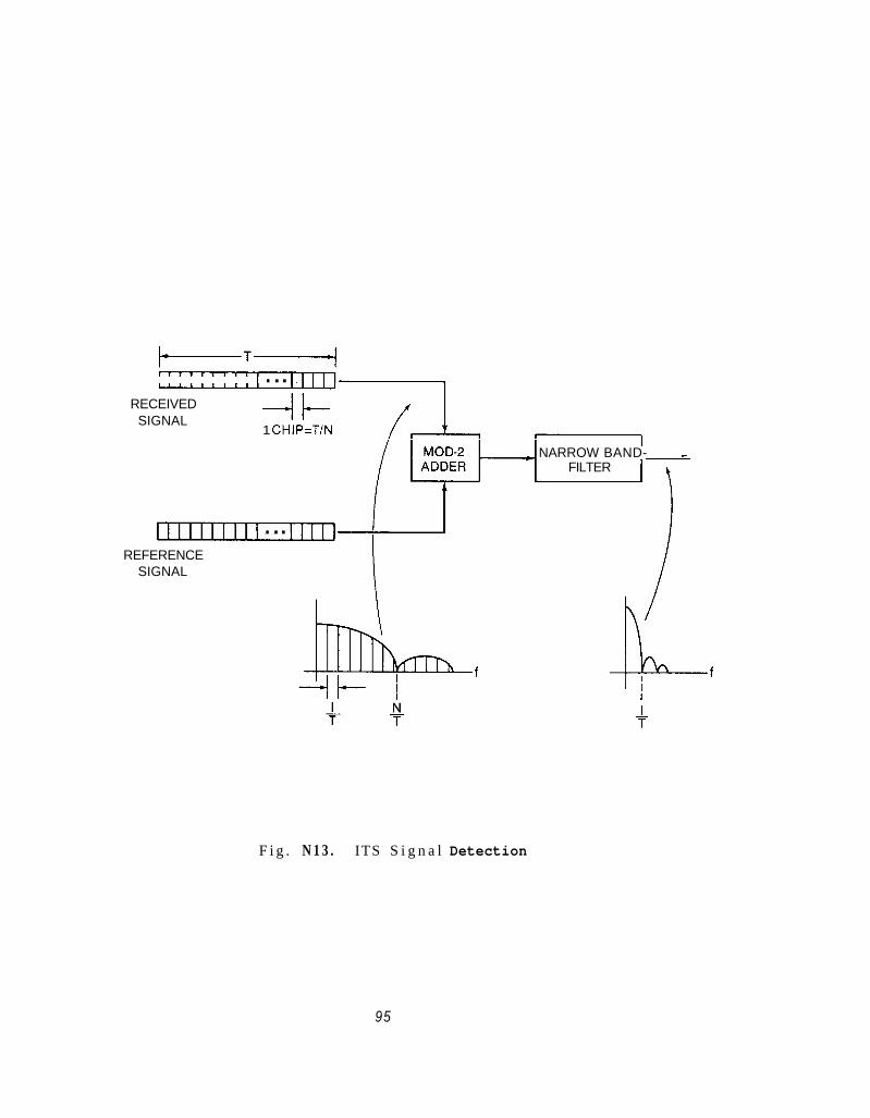
-T+ . ..
1 CHIP=T/N
- NARROW BAND- - r FILTER
RECEIVED SIGNAL
. .. REFERENCE
SIGNAL
F i g . N 1 3 . ITS S i g n a l Detection
95

RECEIVED SIGNAL
INTENDED SIGNAL
I INTERFERING CW SIGNAL
MOD-2 ADDER OUTPUT
I WIDE BAND
NARROW BAND FILTER OUTPUT
t
Fig. N14. Interfering Signal Rejection
96

degree s p a c i n g s . A t KU band a 0.6 m an tenna has i ts first s i d e l o b e
a t f i v e degrees and t h e h a l f power beamwidth is 2.8 degrees. F i g u r e N 1 5
shows 0 .6 m d i s h a n t e n n a s o p e r a t i n g a t C band and e l i m i n a t i n g a d j a c e n t
s a t e l l i t e i n t e r f e r e n c e through t h e use of spread spect rum t e c h n i q u e s .
The u s e o f t h e PN code a l s o l e n d s i t se l f well t o t he r a n g i n g p r o c e s s .
The t r a n s m i s s i o n o f a b i n a r y sequence of d i g i t s ( r a n g i n g code) as a s i g n a l
whose p e r i o d can be d e s i g n a t e d t o be a r b i t r a r i l y long can reduce t h e r a n g e
ambigu i ty problem t o any l e v e l d e s i r e d . Range r e s o l u t i o n is a problem o f
how p r e c i s e t he r e t u r n e d code can be matched t o a d e l a y e d r e f e r e n c e code.
I n p r a c t i c e t h i s amounts t o a few p e r c e n t o f one code c h i p . The
measurement o f r ange is, i n r e a l i t y , t h e same problem as t h e measurement
of time d e l a y o r the time s y n c h r o n i z a t i o n of c l o c k s . The same PN sequence
s e r v e s both measurements.
The c h i p ra te must accommodate t h e d a t a t o be s e n t a t t h e r e p e t i t i o n
ra te found n e c e s s a r y and y i e l d a r e a s o n a b l e p r o c e s s i n g g a i n . I t must a l s o
s u p p o r t the t r a c k i n g and s y n c h r o n i z a t i o n p r e c i s i o n requ i rements . The
basic data i n c l u d e t he time code, t h e s a t e l l i t e p o s i t i o n , s y n c h r o n i z a t i o n
words and o t h e r related in fo rmat ion . The e n t i r e code should r e p e a t a t
least e v e r y minute .
The PN sequence has been selected t o run a t a 102.3 kHz r a t e , t h e
c h i p ra te , w i t h a p e r i o d o f 1023 b i t s o r eve ry 10 m i l l i s e c o n d s . The
p r o c e s s i n g g a i n w i l l b e approx imate ly 33 dB f o r t h i s case. The modula t ion
w i l l be phase s h i f t keying a t i: 70 degrees t o a l l o w f o r a r e s i d u a l
car r ie r . T h i s w i l l a l l o w d i r e c t carrier r e c o v e r y of t h e s i g n a l and a
97

c 0
.A +I (d u Ln
m . . I u

coherent delay- lock loop f o r t he PN code t racking . Di rec t c a r r i e r
recovery and coherent code t racking w i l l be s imple r and more c o s t
e f f e c t i v e t o implement i n t h e u s e r ' s r e c e i v e r b u t probably in t roduce more
o f f s e t errors than non-coherent t racking . W e t h ink , however, t h a t these
e r r o r s w i l l no t produce a not iceable impact on the ITS requirements .
N 4 . ORBIT DETERMINATION A N D EPHEMERIS P R E D I C T I O N
The requirement t o provide t h e user of t he ITS w i t h an accu ra t e value
of p o s i t i o n of t h e s a t e l l i t e has been mentioned a number of t imes in t h i s
r e p o r t . T h i s s e c t i o n d i scusses N B S ' s experiences in a t tempt ing t o obta in
t h i s kind of information, t h e q u a l i t y of t h e information obta ined , and why
the ITS system must provide the information i t se l f r a t h e r than r e ly ing on
o u t s i d e sources. Arguments a r e a l s o made t h a t a simple t r i l a t e r a t i o n
network can support b e t t e r than a one microsecond de l ive ry by the ITS.
These arguments are based upon r e s u l t s w i t h the ATS-5 s a t e l l i t e , appl ied
t o a hypo the t i ca l t r ack ing network f o r the ITS E l ] .
In the process of genera t ing a s e t of o r b i t a l e lements , some o r a l l
of the measured q u a n t i t i e s , including range, range r a t e , and angle
information, a r e gathered from one, two, t h r e e , and sometimes more widely
d ispersed s i t e s on t h e e a r t h ' s sur face . After some minimum amount of data
is taken , an o r b i t is ca l cu la t ed from these d a t a . T h i s o r b i t is descr ibed
by s i x parameters o r s t a t e vec to r s . Two of t he parameters desc r ibe t h e
o r b i t ' s s i z e and shape (semimajor ax i s and e c c e n t r i c i t y ) s i n c e t h e o r b i t
is t h e o r e t i c a l l y an e l l i p se f o r two body po in t sources. Three of t he four
99

remaining parameters d e s c r i b e the o r b i t ' s o r i e n t a t i o n with r e s p e c t t o t he
ear th . They are t h e i n c l i n a t i o n , t h e argument o f perigee, and the r i g h t
ascens ion of the ascending node. The f i n a l parameter d e s c r i b e s the
s a t e l l i t e ' s p o s i t i o n i n the o r b i t a t t h e epoch of t h e elements ( t h e mean
anomoly 1.
These elements are then used as input t o a p r e d i c t i o n program t o
determine the s a t e l l i t e ' s p o s i t i o n a t any time be fo re o r a f t e r t h e
elements epoch. The s o p h i s t i c a t i o n of the p r e d i c t i o n program needed
depends upon how accurately p r e d i c t i o n is r equ i r ed . Also, the g r e a t e r the
time d i f f e r e n c e between epoch and p r e d i c t i o n time t h e greater the
s o p h i s t i c a t i o n of the p r e d i c t i o n program t h a t w i l l be r equ i r ed .
NBS f irst experienced and deal t wi th the p o s i t i o n de te rmina t ion
problem i n 1969 us ing DoD experimental s a te l l i t e s . DoD-supplied s a t e l l i t e
p o s i t i o n p r e d i c t i o n s were s u f f i c i e n t l y i naccu ra t e f o r NBS purposes t h a t
NBS chose t o determine s a t e l l i t e s p o s i t i o n u s ing an NBS-operated
t r i l a t e r a t i o n network. Resu l t s of 1-1 0 microseconds, without p r e d i c t i o n ,
throughout North and South America were obta ined .
During the per iod of 1970 t o 1973 whi le working w i t h N A S A ' s ATS
s e r i e s of s a t e l l i t e s , NBS depended upon NASA-generated p r e d i c t i o n s u s ing
N A S A ' s Goddard T ra j ec to ry Determination System (GTDS) program and NASA-run
computers. GTDS is a l a r g e and s o p h i s t i c a t e d program t h a t accounts f o r
t h e e a r t h ' s g e o p o t e n t i a l expressed i n a 15x15 m a t r i x , t h e g r a v i t a t i o n a l
a t t r a c t i o n of the p l a n e t s , s o l a r r a d i a t i o n p re s su re on t h e s a t e l l i t e , and
t h e e f f e c t s of t he moon. T h i s procedure gene ra l l y provided 1 t o 10
100

microsecond p r e d i c t i o n s over a one week period. These r e s u l t s were
obtained from a t r ack ing network far too complex f o r cons ide ra t ion w i t h the
ITS concept.
Using GOES s a t e l l i t e s between 1975 and 1983, NBS has generated its
own ephemeris using NOAA o r b i t a l elements der ived from NOAA's
t r i l a t e r a t i o n network and NBS's ve r s ion of NASA's GTDS. The NBS vers ion
of the program r e q u i r e s 40,000 For t ran s ta tements , 250 sub rou t ines , and 19
over lays on a l a r g e mainframe computer. I t has proved e f f e c t i v e bu t is
expensive t o run and maintain. R e s u l t s of 1-10 microseconds f o r
p r e d i c t i o n over a one week period were u s u a l .
Recent cos t- cu t t i ng e f f o r t s have forced NOAA t o drop the t r i l a t -
e r a t i o n network a s soc i a t ed w i t h t he GOES s a t e l l i t e and t o make p o s i t i o n
e s t ima te s based upon the ea r th ' s image which is t ransmi t ted by the
s a t e l l i t e every twenty minutes. The r e s u l t i n g o r b i t a l elements have
gene ra l ly been of a poorer q u a l i t y ; t h i s r e s u l t e d , a t times, i n 100 micro-
second p red ic t ion e r r o r s of t he GOES time code se rv i ce .
Discussions with communication s a t e l l i t e ope ra to r s i n the FSS have
revea led t h a t they a l s o do not produce o r b i t a l elements of a q u a l i t y o r
frequency t h a t can s a t i s f y the needs of t he ITS. The conclus ions drawn
from these experiences a r e t h a t t h e ITS s e r v i c e must determine the
s a t e l l i t e ' s p o s i t i o n us ing information gathered from i ts own ranging
system.
101

The t r ack ing and p r e d i c t i o n process f o r t h e ITS must be c o s t
e f f e c t i v e and simple as well as accu ra t e enough t o suppor t t h e d e l i v e r y of
b e t t e r than one microsecond t o the use r . Because of t h e unique func t ions
inheren t w i t h t he ITS, such a s cont inuous t r ack ing by us ing t h e t iming
s i g n a l s , t h e s e g o a l s w i l l be argued t o be p o s s i b l e w i t h s u r p r i s i n g
s i m p l i c i t y a s compared t o t h e e f f o r t s and f a c i l i t i e s normally expended i n
t h e o r b i t de te rmina t ion and p r e d i c t i o n process .
The work done i n Ref. 1 us ing a t r i l a t e r a t i o n t r a c k i n g network
provided t h e experimental r e s u l t s on which we base our expec t a t i ons f o r a
t r i l a t e r a t i o n t r ack ing network f o r the ITS. The geographica l p o s i t i o n i n g
of the ITS t r i l a t e r a t i o n network w i l l b e l i m i t e d by t h e s a t e l l i t e
f o o t p r i n t t o the nor thern hemisphere and probably t o C O N U S , Hawaii, and
Puer to Rico. Other l o c a t i o n s a r e e i ther of l i t t l e b e n e f i t or would be on
f o r e i g n s o i l (Canada, Mexico, o r i s l a n d s of t h e Caribbean) and may
r e p r e s e n t l o g i s t i c a l and p o l i t i c a l problems r e q u i r i n g formal agreements
t h a t probably would no t j u s t i f y any t e c h n i c a l b e n e f i t s der ived . The NBS
does, however, enjoy the advantages of having f a c i l i t i e s a t Gai thersburg,
Maryland and Kaui i , Hawaii t h a t may h o s t t r ack ing e a r t h s t a t i o n s of t h e
ITS.
Whatever t he t r i l a t e r a t i o n con f igu ra t i on becomes, i t w i l l b e
cons iderab ly smaller than t h a t used by Ref. 1 i . e . Schenectady, N Y ,
Hawaii, and Buenos Aires. The r e s u l t s ob ta ined and v e r i f i e d by
NASA's s o p h i s t i c a t e d t r a c k i n g network has been a va luab le t o o l t o suppor t
102

the a n a l y s i s of a ITS t r a c k i n g system. The i s s u e is whether t he reduced
geometry of t h e ITS t r i l a t e r a t i o n system w i l l a f f ec t t h e p r e c i s i o n of t h e
I T S t r i l a t e r a t i o n system. The NASA r e s u l t s p r o v i d e some i n d i c a t i o n and an
extended a n a l y s i s was performed t o answer the q u e s t i o n posed above.
TRILATERATION STUDY:
The t r i l a t e r a t i o n work of Ref. 1 was suppor ted by NASA and accom-
p l i s h e d i n 1974-75. The purposes of the NASA-supported work were s ta ted
among o t h e r s t o b e . . . " t o p r o v i d e a t r i l a t e r a t i o n network c a p a b l e of
l o c a t i o n o f t h e ATS-5 s a t e l l i t e i n c l u d i n g t h e f o l l o w i n g tasks :
1 . To i n v e s t i g a t e and r e p o r t on:
a ) A sys tem of p r e d i c t i n g s a t e l l i t e p o s i t i o n u s i n g measurements
made a t s h o r t i n t e r v a l s spaced a n hour a p a r t and p r e d i c t i o n
f o r t h e n e x t hour .
b ) A method of v e r i f y i n g p r e d i c t i o n c a p a b i l i t y ( b o t h p r e c i s i o n
and a c c u r a c y ) .
f > The d e s i g n of computer s o f t w a r e r e q u i r e d t o de te rmine n e a r
rea l time s a t e l l i t e p o s i t i o n i n l a t i t u d e , l o n g i t u d e , and
ear th c e n t e r d i s t a n c e and t o p r e d i c t s a t e l l i t e p o s i t i o n .
2...3...4...
5. Develop computer s o f t w a r e t o de te rmine t he n e a r l y rea l time
s a t e l l i t e p o s i t i o n i n l a t i t u d e , l o n g i t u d e , and ear th c e n t e r
d i s t a n c e . The s o f t w a r e w i l l a l s o compute t h e o r b i t a l e l e m e n t s o f
t h e s a t e l l i t e , r ange measurement s t a n d a r d d e v i a t i o n , and s h o r t
term p r e d i c t i o n s o f s a t e l l i t e p o s i t i o n .
103

6 . Conduct coopera t ive experiments w i t h NASA us ing ATS-5. These
t e s t s w i l l accomplish the fol lowing:
a ) An exercise of rea l- t ime s a t e l l i t e t r i l a t e r a t i o n ranging,
p o s i t i o n and p red i c t ed p o s i t i o n computation, and data
t ransmiss ion t o NASA and MARAD (Maritime Adminis t ra t ion) .
b ) E s t a b l i s h basis f o r p r e d i c t i n g s a t e l l i t e p o s i t i o n s up t o
s e v e r a l hours. The p r e d i c t i o n w i l l b e an e x t r a p o l a t i o n based
on Kepler ' s laws from a sequence of t r i l a t e r a t i o n p o s i t i o n s .
c ) Verify t h e accuracy of t r i l a t e r a t i o n p o s i t i o n measurements
and p red i c t ed p o s i t ion. . .
Only the o b j e c t i v e s of importance t o t h e ITS were quoted here. These
o b j e c t i v e s were met and c a r e f u l l y documented i n a number of r e p o r t s and
papers inc lud ing (1 -2) . The fol lowing is a d e s c r i p t i o n and summary of t h e
work t h a t had d i rec t impact on t h e I T S . It is indeed f o r t u n a t e t h a t t h i s
body of work was succes s fu l ly accomplished, v e r i f i e d , and documented i n
t h e d e t a i l t h a t d i r e c t l y b e n e f i t s the ITS. Without i t , much of t h a t work
would have t o be repea ted before d e f i n i t i v e s t a t emen t s on the f e a s i b i l i t y
of an I T S t r i l a t e r a t i o n system could be made t o the degree a f forded a t
t h i s time. I t w i l l b e argued by d i r e c t analogy t o t h i s t r i l a t e r a t i o n work
and by f u r t h e r suppor t ing a n a l y s i s by NBS t h a t a t r i l a t e r a t i o n network can
be e s t a b l i s h e d tha t w i l l support 0.1-microsecond-precision time dissemina-
t i o n simply and inexpensively us ing domestic communication s a t e l l i t e s
whi le , a t a minimum, s e rv ing CONUS and probably most of North America.
104

PROGRAM DESCRIPTION:
Using s i g n a l s c o n s i s t i n g of s h o r t sequences a t audio frequency, 9.8 kHz,
followed by a d i g i t a l address i n which t h e audio cyc l e s are i n h i b i t e d f o r
zeros and t r ansmi t t ed f o r ones, range measurements were made between t h e
ATS-5 s a t e l l i t e and three l o c a t i o n s on the earth 's su r f ace . These ranging
s i g n a l s were s e n t ( o r i g i n a t e d ) a t Schenectady, NY and t r ansmi t t ed t o t he
ATS-5 s a t e l l i t e a t L band (1651 MHz) . The audio s i g n a l was frequency
modulated onto the c a r r i e r and occupied a t o t a l RF bandwidth of 60 kHz.
The t r i l a t e r a t i o n network cons i s t ed of t h e master ground s t a t i o n near
Schenectady, NY and remote, unmanned t ransponders i n Buenos Aires ,
Argentina and a loca t ion near Wahiawa, Hawaii. In t h e ope ra t ion , NY
master s equen t i a l l y s e n t ranging s i g n a l s t o t he s a t e l l i t e which
t r a n s l a t e d them i n frequency and r e t r ansmi t t ed them back t o ear th . Each of
t h e th ree ground s t a t i o n s had a unique address and responded only t o tha t
address. The two remote, unmanned t ransponders responded by r e t r a n s m i t t i n g
t h e ranging s i g n a l t o t he s a t e l l i t e , a f t e r a f ixed d e l a y , f o r eventua l
r ecep t ion by the master.
measured.
r l , r2 , and r3 were obtained.
I n t h i s way the s l a n t ranges r l , r2 , and r3 were
In a c t u a l i t y 2 r l , 2 ( r 1 + r 2 ) and 2 ( r 1 + r 3 ) were measured from which
The accuracy of t h e t r i l a t e r a t i o n network was determined by
comparison w i t h N A S A ' s C-band range and range r a t e measurements t o ATS-5
from t h e NASA Rosman, NC and Mojave, CA t r ack ing s t a t i o n s . A 24 hour t e s t
was run where both NASA's C band range and range r a t e t r ack ing network and
L band t r i l a t e r a t i o n t r ack ing network were operated s imultaneously.
The p o s i t i o n f o r ATS-5 computed agreed v e r y w e l l w i t h the NASA
105

der ived p o s i t i o n s . The accuracy of t h e t r i l a t e r a t i o n p o s i t i o n s were
checked f u r t h e r by computing s l a n t ranges from t h e ATS-5 s a t e l l i t e t o
N A S A ' s Rosman and Mojave s i t es and comparing these w i t h t h e NASA measured
s l a n t ranges.
Addi t iona l ly , t h e s tudy determined t h e p o s i t i o n s of ATS-5 on 1 7
s e p a r a t e days . A comparison of these p o s i t i o n s w i t h NASA p r e d i c t i o n s
genera ted from b i w e e k l y range and range rate measurements showed
e x c e l l e n t agreement w i th in t h e bounds of the gradua l degrada t ion of the
NASA p r e d i c t i o n s as a func t ion of time from t h e epoch date of the o r b i t a l
e lements .
The experiment a l s o used three 10 minute ranging p e r i o d s separated by
an hour t o d e f i n e t h e o r b i t of the ATS-5 s a t e l l i t e . The p o s i t i o n of the
s a t e l l i t e was then p red i c t ed f o r t h e next two hours. The p r e d i c t i o n s were
ver i f i ed by the N A S A network as well a s a g a i n s t t r i l a t e r a t i o n measure-
ments.
The conc lus ion and f i n d i n g s of t h e t r i l a t e r a t i o n program, p a r t i c u-
l a r l y dur ing t h e 24 hour tes ts d i r e c t l y r e l e v a n t t o t he I T S are:
1 . L band t r i l a t e r a t i o n p o s i t i o n s of ATS-5 agreed with N A S A ' s
computed p o s i t i o n s based upon t h e i r C band range and range rate
measurements t o wi th in 0.00050 degrees i n l ong i tude , 0.00025
degrees i n l a t i t u d e , and 50 meters i n ear th c e n t e r d i s t a n c e .
2. P rec i s ion of s i n g l e o b s e r v a t o r y- s a t e l l i t e s l a n t range
measurements were on t h e o rde r of 12 meters; f o r s i n g l e remote
t r a n s p o n d e r- s a t e l l i t e s l a n t range measurements, 2 3 meters.
106

3. Computed s l a n t ranges based on t r i l a t e r a t i o n and NASA measured
s l a n t ranges t o the N A S A Mojave t r ack ing s t a t i o n agree t o w i t h i n
1.6 k 9.6 meters and t o the NASA Rosman t r ack ing s t a t i o n t o
w i t h i n 15.7 f 8.7 meters.
4. ..5.. . 6 . S a t e l l i t e p o s i t i o n p r e d i c t i o n s degraded by less than 0.00075
degrees i n longi tude and l a t i t u d e and 200 meters i n ear th c e n t e r
d i s t a n c e in one hour from t h e l a s t range measurement.
The f i n d i n g s can be condensed i n t o t h e fol lowing f a c t s p e r t i n e n t t o
t h e I T S t r ack ing problem. Pos i t i on data of an accuracy and p r e c i s i o n
s ta ted above when used t o e s t a b l i s h a s i n g l e Kepler ian o r b i t can be used
f o r s h o r t pe r iods of time (up t o one hour) t o p r e d i c t t h e s a t e l l i t e ' s
p o s i t i o n t o b e t t e r t han 0.00075 degrees i n longi tude and l a t i t u d e and
bet ter than 200 meters i n ear th c e n t e r d i s t ance . The i s sue f o r t h e I T S
is: What w i l l t h e performance be f o r a t r i l a t e r a t i o n sys tem t h a t must be
conta ined , by v i r t u e of i ts f o o t p r i n t , t o CONUS and poss ib ly Hawaii and
Puer to Rico? The t r i l a t e r a t i o n network included Schenectady, N Y , Hawaii,
and Buenos Aires, Argentina. T o a t tempt t o answer t h a t ques t i on an
a n a l y s i s was made of the geomet r ica l e f f e c t on p o s i t i o n de te rmina t ion f o r
a gene ra l t r i l a t e r a t i o n network.
Using the a n a l y s i s t o o l developed i n Appendix 111, t h e geometric
d i l u t i o n o f p o s i t i o n (GDOP) f o r va r ious s a t e l l i t e and t r a c k i n g s i t es were
ca l cu l a t ed . The G D O P ' s show t h a t t h e e f f e c t s of moving a t r ack ing s i t e
from t h e southern hemisphere t o the nor thern hemisphere g r e a t l y magnif ies
t h e G D O P ' s i n the Z d i r e c t i o n . L i k e w i s e , a l lowing the s a t e l l i t e ' s
107
l ong i tude t o be o u t s i d e of the t r ack ing s i te 's meridian ra ther than
between them w i l l r e s u l t i n g r e a t l y increased GDOP's i n t h e X and Y
d i r e c t i o n s . By c a r e f u l des ign of t h e network i t is shown that t h e ITS can
be t racked wi th s u f f i c i e n t p r e c i s i o n t h a t s a t e l l i t e p o s i t i o n f i x i n g
r e s u l t s of a domestic s a t e l l i t e s similar t o t he t r i l a t e r a t i o n study can be
expected. For i n s t a n c e , r e f e r r i n g t o Tab le 9 , a CO-HA-FL t r a c k i n g
con f igu ra t i on produces a GDOP of 32.6 o r j u s t a l i t t l e more than three
times t h e GDOP computed f o r the t r ack ing con f igu ra t i on of HA-NY-Argentina.
The p o s i t i o n e r r o r va r i ances f o r t h e two t r ack ing con f igu ra t i ons can be
made equa l by improving the range e r r o r va r i ances by t h i s same f a c t o r .
The s tudy had quoted t he i r range e r r o r va r i ances as between 80 and 120
nanoseconds. Th i s means t h e CO-HA-FL t r ack ing con f igu ra t i on should work
equa l ly as well f o r p r e d i c t i o n purposes i f t h e range e r r o r va r i ances are
reduced t o approximately 30 nanoseconds. In Sec t ion B6, the range
r e s o l u t i o n is c a l c u l a t e d t o be less than 27 nanoseconds wi th less than one
second averaging times.
expected t o be a v a i l a b l e t o t he ITS and t h e r e f o r e h igher r e s o l u t i o n f o r
the s l a n t range measurements. Add i t i ona l ly , b e n e f i t s should be r e a l i z e d
by :
T h i s w i l l b e p o s s i b l e because of g r e a t e r C / N o ' s
1 Simultaneous s l a n t range measurements. ( t h e study used
s e q u e n t i a l measurements).
2 ) More averaging of data.
3 ) Reduced u n c e r t a i n t i e s i n t r ack ing s i t es l o c a t i o n s .
4 ) Considerat ion of the effects of the moon and sun i n de te rmina t ion
of a se t of o r b i t a l e lements and i n t h e p r e d i c t i o n process .
(Th i s was n o t used by the s t u d y ) .
108

Table 9 . C a l c u l a t e d GDOP's
TRACK1 NG SITE
LOCAT I 0 N S
HA- N Y-Arg en t i n a
N Y- H A- F L
N Y-CA-Arg e n t i n a
N Y-CA-F L
CO-MD-PR
CO-HA-FL
CO-MD-FL
SAT E LLl TE AND
LO CAT I 0 N
ATS-5
105OW
89OW
119OW
0 /g 6.3
8.6
13.2
10.0
23.8
7.39
27.8
2.0
2.3
4.4
5.7
3.56
3.61
18.8
7.3
37.7
8.2
46.4
38.5
31.5
48.5
(GDOP)
9.8
38.7
16.2
47.8
45.5
32.6
56.8
109

5)
6 ) Reduced p r e d i c t i o n times from one hour t o 10 or 20 minutes.
Continuous t r ack ing of the sa te l l i t e .
7 ) Use of Kalman f i l t e r techniques t o make bet ter use of our
understanding of t h e mechanics involved.
Based upon t h e work w i t h t h e t r i l a t e r a t i o n of t h e ATS-5 s p a c e c r a f t ,
i t has been concluded t h a t t h e ITS t r ack ing of domestic s a t e l l i t e s a t
e i ther C o r KU band can be accomplished as w e l l a s o r be t te r than i n the
GE case. This is e s p e c i a l l y t r u e s i n c e by providing cont inuous t iming
s i g n a l s there is a cont inuous source f o r t r i l a t e r a t i o n . A s w i t h GE, t h e
three measurements of s a t e l l i t e range once each hour is sa t i s f i ed . The
r e s u l t s of p r e d i c t i o n can be monitored and a new o r b i t f i t t o the data as
needed. I n e f fec t , a s l i d i n g s e t of d a t a can be envis ioned , i . e . , t h r e e
se ts of p o s i t i o n s one hour ( o r any o the r i n t e r v a l ) apar t a t any time may
be used t o gene ra t e o r b i t a l e lements from which p r e d i c t i o n s are made based
upon a Kepler ian o r b i t . A s t ha t p r e d i c t i o n degrades and f a l l s below some
th re shho ld , a new s e t ( three p o s i t i o n v a l u e s ) of data is p icked and
processed. Other a lgor i thms w i t h o t h e r sets of i npu t data may provide
bet ter r e s u l t s and should be i nves t i ga t ed . However, we can be con f iden t
t h a t , provided t h e ranging r e s o l u t i o n and accuracy are a v a i l a b l e , a
better- than-one-microsecond p r e d i c t i o n system can be maintained. The
problem of o r b i t maneuvers is sti l l p r e s e n t bu t its effect can be g r e a t l y
reduced i n magnitude and du ra t i on due t o t he cont inuous rea l time t r ack ing
of the s a t e l l i t e . Simple techniques such as t h e "adjustment" o f t h e
ou tpu t ephemeris t o keep each t r ack ing s t a t i o n "on time" could be used
u n t i l a v a l i d new o r b i t could be c a l c u l a t e d . ftAdjustmentll could be the use
110

of s a t e l l i t e p o s i t i o n j u s t determined. T y p i c a l l y t h e s a t e l l i t e might be
moving by 20 n s / s . Measurement o f the range rate cou ld be used t o a i d the
p r e d i c t i o n p r o c e s s .
N5. DENIAL OF SIGNALS TO UNAUTHORIZED USERS
The NBS has f o r many years o f f e r e d time and f requency i n f o r m a t i o n
f ree by way of t h e i r r a d i o b r o a d c a s t s from WWV, WWVB, WWVH, and t h e GOES
s a t e l l i t e s . Government p o l i c y e s s e n t i a l l y mandates o r s t r o n g l y encourages
tha t new s e r v i c e s such as the ITS o p e r a t e on a " f u l l c o s t r ecovery th rough
u s e r cha rges" bas i s . Responding t o t h i s p o l i c y means t h a t t h e u s e f u l n e s s
o f t h e ITS s i g n a l s must be den ied t o u n a u t h o r i z e d u s e r s o r a t least made
u n r e l i a b l e o r d i f f i c u l t t o u s e by them. Unauthor ized u s e r s are t h o s e
u s e r s who have n o t pa id f o r the u s e of the s i g n a l s . A u s e r becomes
a u t h o r i z e d th rough s u b s c r i p t i o n a f t e r which h i s r e c e i v e r becomes u s e f u l
th rough some p e r i o d i c upgrading.
For t h i s p a r t of t h e s t u d y , we c o n s i d e r t he u s e of t h e Data
Encryp t ion S tandard ( D E S ) i n denying s i g n a l s t o u n a u t h o r i z e d u s e r s . The
DES is a complex c i p h e r i n g a l g o r i t h m based upon b o t h s u b s t i t u t i o n and
t r a n s p o s i t i o n t e c h n i q u e s . The DES was first p u b l i s h e d by NBS i n 1975 and
it became a Federal I n f o r m a t i o n P r o c e s s i n g S tandard i n 1977 f o r t he
p r o t e c t i o n o f non- na t iona l s e c u r i t y i n f o r m a t i o n .
The DES d e f i n e s a se t of o p e r a t i o n s t o be performed on a 64 b i t b lock
o f i n f o r m a t i o n , t h e p l a i n t e x t , t o e n c r y p t i t i n t o a 64 b i t b lock o f
111

scrambled information o r encrypted t ex t , T h i s is done under the c o n t r o l
of a 56 b i t key block chosen by the sender and known by the r e c e i v e r .
Data p ro t ec t ed by the DES, t h e e x p e r t s s a y , may be recovered by
unauthorized i n d i v i d u a l s o r o rgan iza t ions through t h e u se of t h e l a r g e
computers expected t o be a v a i l a b l e i n about t e n years. Even then t h e c o s t
of us ing these new supercomputers would make such tasks q u i t e expensive
and imprac t i ca l when as i n t h e case f o r t h e ITS, t h e key may be purchased
f o r perhaps only a few hundred d o l l a r s . The DES is p r e s e n t l y a v e r y
s ecu re encrypt ion device,and its use i n the ITS may seem t o be a large
o v e r k i l l . The l o g i c i n us ing the DES, however, l i e s with its low c o s t .
Today the DES may be purchased i n t h e form of a s i n g l e ch ip i n s i n g l e
q u a n t i t i e s f o r as l i t t l e as $20 each.
t h e DES make t echn ica l sense f o r i ts use i n the ITS.
Also c e r t a i n modes of ope ra t i on of
The use of t h e DES i n the I T S would be a s fo l lows: The u s e r ' s
r e c e i v e r would have an acces s ch ip which is provided on a s u b s c r i p t i o n
basis by t he ITS ope ra to r . The c h i p is a complex L S I dev ice and c o n t a i n s
the c ryptographic key and PN sequence code. Unless it is i n s t a l l e d i n t h e
r e c e i v e r , the r e c e i v e r w i l l not decode t h e s a t e l l i t e data c o r r e c t l y nor
lock t o t he incoming PN sequence. Each acces s ch ip could be unique o r
customized t o a p a r t i c u l a r receiver w i t h its own unique s e r i a l number o r
encrypt ion key. I n o t h e r words, each r e c e i v e r would have a unique master
k e y r e q u i r i n g a unique working key . The unique access code, which changes
every year, must be i n s t a l l e d i n t h e u s e r ' s r e c e i v e r . T h i s access code
could be mailed as a ch ip and i n s t a l l e d by t h e user. A l t e r n a t i v e l y , t h e
112

access code could be sen t as par t of the data from the s a t e l l i t e and
loaded automat ica l ly i n to t h e receiver .
The annual renewal process would be v e r y much l i k e t ha t f o r a
magazine subscript ion. A month or two before the subscript ion expires , a
renewel not ice is sent . The user must send h i s annua l fee t o the operator
who i n t u r n sends the access code a s a chip by mail or by s a t e l l i t e
transmission.
An LSI device is an excel lent media f o r the access code. Its
production cos t s can be very low b u t its cost t o copy would be far too
d i f f i c u l t and cost ly t o be any s i gn i f i c an t threat t o the ITS support base.
Development of the access chip and b i l l i n g procedure can be subcontracted
t o a manufacturer. Transmission by s a t e l l i t e is possible b u t would
require a modified data format over t ha t presented i n t h i s s t u d y .
The subscript ion fees must cover the cos t s of operation and
maintenance of the ITS. About 2000 timing receivers f o r the GOES system
have been sold, each costing between $3000 and $5000. We estimate that
the ITS w i l l have as many a s 3000 customers.
there would be $600,000 p e r year income, eas i ly covering operational and
maintenance costs .
If each paid $200 per year,
The DES has a number of modes of operation. An analys is , not covered
here, has determined tha t the Output Feedback Mode (OFB) w i l l work bes t
113

w i t h t h e ITS. Generally there are three func t ions t h e r e c e i v e r must
perform t o ope ra t e proper ly and t o synchronize t o encrypted data. These
f u n c t i o n s a r e :
1 . The r e c e i v e r must use the same key f o r decrypt ion as was used f o r
encrypt ion.
2. The receiver must use the same i n i t i a l i z a t i o n vec to r ( I V ) a s was
used i n t r a n s m i t t i n g .
3. The r e c e i v e r must f i n d the start of t h e c iphe r t ex t i n t h e
rece ived data.
I n the case of the ITS there w i l l b e a cont inuous t ransmiss ion of
data . The data must, t h e r e f o r e , be cons t ruc ted t o have a beginning and an
end. T h i s p rocess must be repea ted cont inuously. The de te rmina t ion of
which b i t i n the rece ived data starts t h e f i rst cipher t e x t is mandatory.
Once the r e c e i v e r c o r r e c t l y f i n d s t h e first b i t of the c iphe r t e x t ,
decrypt ion synchroniza t ion is reduced t o count ing rece ived data b i t s .
The most common s o l u t i o n t o t he problem is t o precede the c iphe r t e x t w i t h
a synchronizing data p a t t e r n . T h i s is a p a t t e r n which has an
a u t o c o r r e l a t i o n func t ion which peaks a t the in-phase p o s i t i o n and is low
elsewhere. Once the p a t t e r n is de t ec t ed , it is used t o p o i n t t o t h e s ta r t
of t he c iphe r t ex t . The beginning of an encrypted t ransmiss ion i n the OFB
mode is a l s o preceded by a f i x e d length i n i t i a l i z a t i o n v e c t o r ( I V ) . The
p o s i t i o n of t h e I V is a l s o determined from t h e sync p a t t e r n .
114

I n t he OFB mode, the DES is used t o g e n e r a t e a pseudorandom b i n a r y
stream which is modulo-two added t o p l a i n t e x t t o produce c iphe r t e x t .
T h i s DES o u t p u t is fed back t o form a l l o r p a r t of t he nex t i n p u t t o t h e
DES. The number o f b i t s fed back may be a s few as one and a s many as 64.
Encryp t ion b e g i n s by l o a d i n g a n I V a s a n i n p u t b lock t o the DES. The I V
is processed th rough the DES d e v i c e o p e r a t i n g i n t he e n c r y p t mode and the
p r o c e s s y i e l d s a b lock of pseudorandom data. T h i s b lock o f pseudorandom
data is added on a b i t - f o r - b i t basis t o t h e p l a i n t e x t t o produce c i p h e r
t e x t . T h i s b lock of pseudorandom data from t h e DES is f e d back t o form a
new i n p u t t o t h e DES and the b lock is a g a i n e n c r y p t e d , y i e l d i n g a n o t h e r
b lock of pseudorandom data. T h i s new pseudorandom b lock is added t o t h e
n e x t b lock of p l a i n t e x t t o form c i p h e r t e x t . Th is p r o c e s s is i l l u s t r a t e d
i n F i g u r e N16. T h i s p r o c e s s is r e p e a t e d f o r each block of p l a i n t e x t t o
be e n c r y p t e d .
The d e c r y p t i o n p r o c e s s is i d e n t i c a l t o t h e p r o c e s s of e n c r y p t i o n .
The pseudorandom stream is g e n e r a t e d i n e x a c t l y t h e same manner a s t h a t
used f o r e n c r y p t i o n . The keyst ream is modulo-two added t o the r e c e i v e d
c i p h e r t e x t t o create the p l a i n t e x t . I n o r d e r t o d e c r y p t c o r r e c t l y , t h e
d e c r y p t i o n keyst ream g e n e r a t i o n p r o c e s s must be synchron ized wi th t h e
e n c r y p t i o n p r o c e s s . That is, t h e same b i t of t h e keyst ream used t o
e n c r y p t a p a r t i c u l a r b i t of p l a i n t e x t must be used t o d e c r y p t the
cor respond ing c i p h e r t e x t b i t .
The OFB mode had one major advantage o v e r the o t h e r modes. S i n c e t he
two keys t reams are g e n e r a t e d independen t ly and do n o t depend upon t h e
115
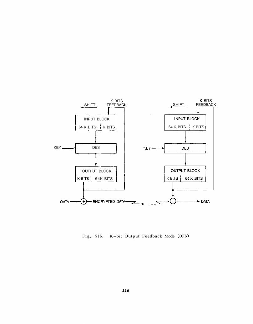
K BITS SHIFT FEEDBAC f--- J
INPUT BLOCK
64 K BITS I K BITS
1 i
KEY .- DES
OUTPUT BLOCK
KBITS ! 64K BITS
(1
T
K BITS SHIFT FEED BACK I c-----.
64 K BITS K BITS
KBITS 1 64 K BITS
Fig . N 1 6 . K-bit Output Feedback Mode (OFB)
116

i n t e g r i t y of the r e c e i v e d data , OFB mode does n o t c a u s e error e x t e n s i o n .
A s i n g l e b i t e r r o r i n t he r e c e i v e d c iphe r t e x t r e s u l t s i n a s i n g l e b i t
e r r o r i n the p l a i n t e x t . T h i s p r o p e r t y is a p p r o p r i a t e f o r t h e I T S
a p p l i c a t i o n .
The DES o p e r a t e d i n OFB modes c a n be t h o u g h t of a s a pseudorandom
sequence g e n e r a t o r . The I V i n OFB mode d e t e r m i n e s a s t a r t i n g p o i n t i n t he
p a r t i c u l a r o u t p u t sequence. Each time t h e t r a n s m i s s i o n is s ta r ted , t h e
e n c r y p t i o n p r o c e s s shou ld b e g i n w i t h a new randomly d e r i v e d I V . T h i s w i l l
minimize the p o s s i b i l i t y of m u l t i p l e u s e of t h e same p o r t i o n of t h e
pseudorandom o u t p u t sequence. If the r e c e i v e r s t a r ted each time w i t h the
same I V , t h e i d e n t i c a l sequence would be g e n e r a t e d and used t o e n c r y p t
p l a i n t e x t . S y n c h r o n i z a t i o n between the t r a n s m i t t e r and r e c e i v e r r e q u i r e s
t h a t b o t h start a t t he same p o i n t i n t h e pseudo random sequence. I n
a d d i t i o n b o t h must g e n e r a t e t he sequence i n s t e p w i t h 'one a n o t h e r . I n
o t h e r words, t h e same b i t o f keys t ream used t o e n c r y p t a b i t o f p l a i n t e x t
a t t h e t r a n s m i t t e r must be used t o d e c r y p t the cor respond ing c iphe r t e x t
b i t a t t he r e c e i v e r . The r e c e i v e r must g e n e r a t e t h e same sequence as t h e
t r a n s m i t t e r b u t de layed by any p r o p a g a t i o n d e l a y s between them.
r e c e i v e r does n o t g e n e r a t e keyst ream i n synchronism w i t h t h e t r a n s m i t t e r ,
approx imate ly 50% o f t h e dec ryp ted p l a i n t e x t b i t s w i l l be i n error.
If the
S t a r t i n g a t the same p o i n t i n t h e sequence r e q u i r e s tha t b o t h
t r a n s m i t t e r and r e c e i v e r b e g i n w i t h t h e same I V . I n OFB mode, t h i s
r e q u i r e m e n t is much more impor tan t t h a n i n o t h e r modes. Other modes w i l l
e v e n t u a l l y synchron ize even i f b o t h the t r a n s m i t t e r and r e c e i v e r s t a r t
117

ONE FRAME-4
+-----TOD------+SATELLITE -+OTHER
ONE FRAME 1 POSITION 7 SYNC WORD
m m ENCRYPTED FEC APPLIED
Fig. N17. ITS Data Format
118

w i t h d i f f e r e n t I V ' s , g i v e n tha t t he b lock b o u n d a r i e s are c o r r e c t l y
es tabl ished. However, i f t he t r a n s m i t t e r and r e c e i v e r i n OFB mode a re
started w i t h d i f f e r e n t I V ' s and are c locked a t t h e same rate , t h e y w i l l
never synchron ize .
The data stream for the ITS is shown i n F i g u r e 1 7 . One s e c t i o n of
the e n c r y p t e d message c o n t a i n s the sync word, and I V and t h e e n c r y p t e d
data. T h i s s t r u c t u r e w i l l a l l o w any r e c e i v e r tha t has e i ther j u s t been
t u r n e d on or has los t sync t o p r o p e r l y sync o r r e s y n c t o the data stream,
l o a d t h e I V , and d e c r y p t t h e data. The sync word is a f i x e d word tha t is
r e p e a t e d f r e q u e n t l y , p o s s i b l y e v e r y second . The f requency o f the
occurences o f the sync word is a f i x e d word t h a t is r e p e a t e d f r e q u e n t l y ,
p o s s i b l y e v e r y second. The f requency o f the o c c u r r e n c e s o f t h e sync word
would be a f u n c t i o n of t h e e r r o r r a t e s t h a t can be t o l e r a t e d f o r t h e I V
and data. The I V and e n c r y p t e d data may be p r o t e c t e d from e r r o r s by
add ing Forward E r r o r C o r r e c t i o n (FEC) i f needed such as a rate 1 / 2 code.
Having the sync word i n t h e c lear and r e p e a t e d a t a f i x e d r a t e p r o v i d e s
its own e r r o r c o r r e c t i o n or e r r o r f o r g i v e n e s s . I f t h e r e c e i v e r is i n sync
i t shou ld see the same sync word repeated a t a g i v e n rate . If t h e sync
p a t t e r n shows up i n t h e I V data f i e l d it is h i g h l y u n l i k e l y i t would appear
a g a i n a t t h e p r o p e r i n t e r v a l . Sync t o t h e message frame is a s s u r e d t h e n
when three or f o u r sync words are detected a t t h e f i x e d i n t e r v a l s of t h e
data stream. If t h i s t e s t f a i l s , sync is assumed t o have been l o s t and
t he r e c e i v e r r e v e r t s t o t he mode o f r e s y n c i n g t o it .
119

TO D I I
DES
OUTPUT BLOCK
t IV
Fig. N18. Generation of Initialization Vector (IV)
120

A t t h e t r a n s m i t t e r , t h e I V ' s might be generated i n t h e fol lowing
manner. The t ime of day is t h e input o r seed t o the DES machine operated
a s shown in Figure N18. The TOD is a l s o the key t o t h e DES i n i t i a l l y .
After one cyc l e of t h e DES machine, a switch is thrown s o t h e ou tpu t of
t h e DES becomes t h e input and the key. Each cycle of the DES produces a
random 64 b i t ou tpu t which may be used f o r an I V i n t he ITS t ransmission.
N6. L I N K CALCULATIONS
The o b j e c t i v e f o r t h e ITS is t o d e l i v e r t o t h e u s e r a s i g n a l which is
synchronized t o t h e NBS(UTC) time scale a t a l e v e l of one microsecond or
b e t t e r accuracy. The two main f a c t o r s are accu ra t e s a t e l l i t e p o s i t i o n and
a s i g n a l s t r e n g t h t o y i e l d s u f f i c i e n t p r e c i s i o n . The i s sue on s a t e l l i t e
p r e d i c t i o n s has been d iscussed i n Sec t ion N 4 .
i n v e s t i g a t i o n s were favorab le and it has been concluded i n t h i s r e p o r t
t h a t a simple t r i l a t e r a t i o n network w i l l support the one microsecond
accuracy f o r the ITS. In t h i s s e c t i o n l i n k c a l c u l a t i o n s are made t o
determine the synchroniza t ion p rec i s ion tha t w i l l b e a v a i l a b l e u s ing a
t ransponder i n a t y p i c a l communications s a t e l l i t e ope ra t i ng i n the FSS a t
KU band.
The r e s u l t s of those
The upl ink from t h e master earth s t a t i o n t o t h e s a t e l l i t e r e q u i r e s 89
dBW E I R P a t t h e ear th ' s su r f ace t o f u l l y s a t u r a t e t h i s t y p i c a l KU band
t ransponder on a geos t a t i ona ry s a t e l l i t e ope ra t i ng i n t h e Fixed S a t e l l i t e
Se rv i ce . The t ransponder is assumed t o be support ing 100 separate u s e r s
i n a s i n g l e channel p e r carr ier (SCPC) basis . The r equ i r ed input backoff
121

i n t h e t ransponder necessary f o r SCPC o p e r a t i o n and f o r r educ t ion of
in te rmodula t ion products , is assumed t o b e 10 dB. The maximum E I R P pe r
channel is then 53.4 dBW.
Using a 1 . 6 dB/K s p a c e c r a f t q u a l i t y f a c t o r f o r G/T and including
reasonable allowances f o r the pa th l o s s , t r ack ing l o s s e tc . , a C/No f o r
the upl ink is c a l c u l a t e d t o b e 74.9 dB-Hz. The downlink, s a t e l l i t e t o t he
u s e r , is c a l c u l a t e d t o have an EIRP o f 13.4 dBW. The u s e r ' s r ece iv ing
system no i se temperature is taken t o b e 250K o r 50K f o r the antenna and
200K f o r the LNA.
is t h e r e f o r e downlink l i m i t e d as expected when upl ink ing wi th a l a r g e
antenna and p lac ing the burden on a small r ece iv ing antenna on t h e o t h e r
end. A t r a c k i n g bandwidth of 3 Hz was
used t o compute t he t iming- er ror va r i ance i n t h e delay- lock loop. The
r e s u l t was 27 nanoseconds, nea r ly a f a c t o r of 40 be t te r than the r equ i r ed
accuracy of one microsecond. The complete l i n k c a l c u l a t i o n is shown i n
Table 10 .
The C/No f o r the downlink is then 53.3 dB-Hz. The l i n k
The combined C/No is 53.3 dB-Hz.
0. SUMMARY OF PRELIMINARY DESIGN
A p re l iminary des ign f o r t h e ITS us ing a small p o r t i o n of a t y p i c a l
FSS t ransponder has been presen ted . A l l t e c h n i c a l and c o s t requirements
f o r t h e ITS appear t o be ach ievable through t h i s design. The t r ack ing of
t h e s a t e l l i t e by means of a s imple t r i l a t e r a t i o n network should produce
o r b i t f i t s of s u f f i c i e n t accuracy t o p r e d i c t s a t e l l i t e p o s i t i o n a t t h e
accuracy l e v e l s necessary t o suppor t t he ITS g o a l s o f one microsecond o r
122

Table 10.
PARAMETER
U P L I N K , 14 .25 GHz
Uplink E I R P f o r Transponder Sa tu ra t ion .................... 89.0 dBW
To ta l Number of Carriers .................................. 25.6 dB
Required Input Backoff . . . . . . . . . . . . . . . . . . . . . . . . . . . . . . . . . . .- 10 .0 dB
Required E I R P per Channel ................................. 53.4 dBW
To ta l Path Loss .......................................... 207.5 dB
Tracking Loss . . . . . . . . . . . . . . . . . . . . . . . . . . . . . . . . . . . . . . . . . . . . - 1 . 2 dB
Spacecraf t G / T . . . . . . . . . . . . . . . . . . . . . . . . . . . . . . . . . . . . . . . . . . . + 1 .6 dB/K
Boltzmann's Constant. . . .................................. 228.6 dBW/K-Hz
( C / N o ) up ................................................. 74.9 dB-Hz
DOWNLINK, 11.95 GHz
Spacecraf t E I R P . . ......................................... 44.0 dBW
To ta l Number of Carriers. ................................. 25.6 dB
Required Output backoff . . . . . . . . . . . . . . . . . . . . . . . . . . . . . . . . . . - 5 dB
EIRP pe r Channel .......................................... 13.4 dBW
To ta l Path Loss. . . . . . . . . . . . .............................. 205.9 dB
Receive Antenna Gain ...................................... 42.0 dB
Tracking Loss . . . . . . . . . . . . . . . . . . . . . . . . . . . . . . . . . . . . . . . . . . . . - 0.8 dB
Receive Carrier Power. ................................... 151.3 dBW
Boltzmann's Constant . . . . . . . . ............................. 228.6 dBW/K-Hz
System Noise Temperature .................................. 24.0 dB-K
S p e c t r a l Noise Density ................................... 204.6 dBW/Hz ( C / N ) down... ............................................ 53.3 dB-Hz
0
Combined ( C / N o ) ........................................... 53.3 dB-Hz
Timing Error Variance..(T, = 10 us, BL = 20 Hz/3 Hz) ...... 70ns/27ns
123

bet te r synchroniza t ion t o UTC(NBS1.
system were a r r i v e d a t through d i r e c t comparisons w i t h ex t ens ive
experimental work done i n Ref. 1 and NASA du r ing the mid 1970's.
These conc lus ions on t h e t r ack ing
The par t ia l t ransponder t y p i c a l of t h e FSS was shown t o be capable
of suppor t ing the one microsecond o b j e c t i v e whi le working i n t o small u s e r
an tennas . Through u s e of an tennas , ampl i f iers , and downconverters being
manufactured f o r the D i r e c t Broadcast S a t e l l i t e i ndus t ry on a very large
s c a l e , a ccep tab l e c o s t u s e r equipment appears t o be feasible . The use of
the Data Encryption Standard (DES) f o r denying the s i g n a l s t o unauthorized
users w i l l guaran tee t h a t only f u l l y subscr ibed users w i l l b e n e f i t from
t h e ITS s i g n a l s . The DES w i l l be a c o s t e f f e c t i v e s o l u t i o n t o i n su r ing
the " f u l l c o s t recovery through u s e r ' s fees" po l i cy .
A spread spectrum s i g n a l w i l l p rov ide t h e t r ack ing and t iming
p r e c i s i o n necessary f o r the proper func t ion ing of t h e ITS w h i l e p r o t e c t i n g
t h e data from i n t e r f e r e n c e from ad jacen t s a t e l l i t e s and t e r r e s t r i a l
sources . The spread spectrum s i g n a l w i l l make a small user antenna
poss ib l e whi le adding an a d d i t i o n a l i n h i b i t o r t o i ts use by unsubscribed
receivers.
The pre l iminary des ign r e q u i r e s a d d i t i o n a l s tudy e f f o r t s i n o rde r t o
opt imize a l l parameters and t o i n su re proper i n t e r a c t i o n of a l l system
components. F i n a l v e r i f i c a t i o n of t h e ITS ope ra t i on can be accomplished
through l i m i t e d experimental use o f a pa r t i a l s a t e l l i t e t ransponder and
f u l l t r a c k i n g system deployment accompanied by t h e t e s t i n g of a pro to type
user r e c e i v e r . 124

PHASE 111, P a r t 2 :
THE GLOBAL P O S I T I O N I N G SYSTEM OPTION
CONTENTS
P. PHASE 111, P a r t 2 INTRODUCTION
Q. GPS SYSTEM OVERVIEW
1 . THE SPACE SEGMENT
2. USER EQUIPMENT SEGMENT
R . TIME FROM GPS
S. RECEIVER SYSTEM COST
T. CONCLUSION REGARDING GPS
Page
126
128
130
133
137
138
141
125

P. PHASE 111, Part 2 INTRODUCTION
The NAVSTAR Global Pos i t i on ing System (GPS) is a worldwide naviga t ion
sys tem developed by t h e U.S. Department of Defense f o r use by t h e Armed
Forces and our Allies. Completion of t h e sys tem is t a r g e t t e d f o r between
1988 and 1990. T i m e information is t r ansmi t t ed i n the sys tem i n two
forms, one f o r DoD use only ( t h e P-code) and one f o r DoD and c i v i l i a n use
( t h e C I A code) . The P-code is a h igh p r e c i s i o n mode and is no t a v a i l a b l e
t o c i v i l i a n users. However, t h e C/A code used f o r r e c e i v e r coa r se
a c q u i s i t i o n w i l l have time t r a n s f e r accuracy t o 250 ns o r be t te r . The C/A
code would meet t h e 1 us c r i t e r i o n needed by BPA.
Seven GPS s a t e l l i t e s a r e c u r r e n t l y i n o r b i t and are being used f o r
eva lua t ion purposes. Eighteen s a t e l l i t e s make up f u l l implementation of
t h e next phase c a l l e d BLOCK I1 ( f u l l coverage u s ing nons t a t i ona ry ,
low o r b i t s a t e l l i t e s ) . Atomic s t anda rds ( rubidium o r cesium) are c a r r i e d
on each.
The c u r r e n t DoD po l i cy regard ing c i v i l i a n acces s t o t he C I A code
is a v a i l a b l e from the U.S. Naval Observatory automated data s e r v i c e . The
l a t e s t s ta tement is shown below (12/20/85):
Revised Comprehensive GPS User Pol icy ( E f f e c t i v e 22 May 85) :
"The GPS is a cont inuous worldwide satell i te-based r a d i o
nav iga t ion system c u r r e n t l y i n f u l l - s c a l e development by DoD.
The sys tem w i l l p rov ide proper ly equipped u s e r s t he c a p a b i l i t y t o
o b t a i n nav iga t ion and geode t i c p o s i t i o n s i n three dimensions,
v e l o c i t y i n three dimensions, p l u s h igh ly accu ra t e time. The
126

sys tem w i l l s i m u l t a n e o u s l y transmit n a v i g a t i o n i n f o r m a t i o n t h a t
p e r m i t s p o s i t i o n i n g accuracy a t t w o l e v e l s . The h igher l e v e l of
accuracy can be o b t a i n e d from t h e s t a n d a r d p o s i t i o n i n g s e r v i c e
(SPS).
T h i s p o l i c y p r o v i d e s t h a t DoD i n t e n d s t h a t t h e SPS s i g n a l w i l l
be b r o a d c a s t i n the c lear and w i l l be a v a i l a b l e f o r u s e by any
p r o p e r l y equipped u s e r . There w i l l b e no a n n u a l or o t h e r d i r ec t
fee a s s o c i a t e d w i t h t he u s e o f t h i s s i g n a l . The SPS w i l l be made
a v a i l a b l e t o c i v i l , commercial , and o t h e r u s e r s on an i n t e r n a-
t i o n a l bas i s a t t h e h i g h e s t l e v e l of accuracy c o n s i s t e n t w i t h
U.S. n a t i o n a l s e c u r i t y i n t e r e s t s . I t should be no ted tha t a t the
d i r e c t i o n of t he d e f e n s e subcommittee of t he s e n a t e a p p r o p r i a-
t i o n s committee, t h e GPS has been des igned and eng ineered i n a
manner t o p r o t e c t the u s e r- f e e o p t i o n shou ld i t be a p p r o p r i a t e i n
t he f u t u r e . If Congress does decide t o r e q u i r e a u s e r- f e e
implementa t ion i n t h e f u t u r e , a n a p p r o p r i a t e time would be
a l lowed f o r t h e t r a n s i t i o n of u s e r equipment i n t o a u s e r- f e e
c o n f i g u r a t i o n . "
Some key i s s u e s r e g a r d i n g the C I A code s e r v i c e are i n t h e
p r o c e s s o f b e i n g e v a l u a t e d as p o i n t e d o u t i n t he las t CCIR conc lud ing
r e p o r t :
1 . The f i r s t p r i o r i t y of GPS is f o r m i l i t a r y t ac t ica l m i s s i o n s , and
as such c i v i l i a n u s e r s have no c o n t r o l , o f t h e
C I A s e r v i c e .
127

2. Poss ib l e degraded s e r v i c e of the C / A code is 250 ns (two sigma
estimate), b u t the l e v e l of degrada t ion could change depending on
p r e v a i l i n g m i l i t a r y po l icy .
3. GPS con ta in s an implementation of the s e r v i c e u s ing a u s e r fee,
bu t p r e s e n t po l i cy is t o a l low free access.
Th i s s e c t i o n of t h e BPA s tudy w i l l e l a b o r a t e on the NAVSTAR GPS. I n
s p i t e o f key i s s u e s , i t is u s e f u l t o review GPS a s a v i a b l e s o l u t i o n f o r
BPA ' s requirements because some of t h e s e r v i c e is a v a i l a b l e now.
Furthermore, t h e f u l l m i l i t a r y implementation is v i r t u a l l y assured i n t h e
coming years.
Q. GPS SYSTEM OVERVIEW
The NAVSTAR GPS concept evolved from a DoD J o i n t Program Of f i ce which
was es tabl ished i n 1973. I t ' s purpose was t o conso l ida t e separate
naviga t ion systems which were i n s e r v i c e ( o r proposed) t o form a s i n g l e
mil i tary- based, h igh ly su rv ivab le system t o se rve a l l armed s e r v i c e s . The
GPS is j o i n t l y supported by t he Army, Navy, Marine Corps, A i r Force, and
Defense Mapping Agency. The A i r Force is designated a s lead agency t o
develop, t e s t , a c q u i r e , and deploy the GPS. Bradford Parkinson and
Stephen G i l b e r t were among the leaders of t h e GPS planning and develop-
ment, and much of the m a t e r i a l i n t h e s e c t i o n comes from t h e i r
l i t e r a t u r e C21.
128
The CPS is a sa te l l i te- based r a d i o n a v i g a t i o n sys tem in tended t o
p r o v i d e h i g h l y a c c u r a t e three d imens iona l p o s i t i o n and precise time on a
c o n t i n u o u s g l o b a l bas is . When t h e sys tem becomes f u l l y o p e r a t i o n a l , i t
w i l l c o n s i s t of 18 s a t e l l i t e s i n s i x o r b i t a l p l a n e s i n c l i n e d a t 55". Each
p l a n e w i l l c o n t a i n three s a t e l l i t e s spaced 120" apar t i n 1 2 hour o r b i t s .
The r e l a t i v e p h a s i n g of the s a t e l l i t e s from one o r b i t a l p l a n e t o t he n e x t
is 40". Each s a t e l l i t e w i l l c o n t i n u a l l y t r a n s m i t n a v i g a t i o n s i g n a l s a t L1
= 1575.42 MHz and L 2 = 1227.6 MHz c o n s i s t i n g of t h e P-code r a n g i n g s i g n a l
(10.23 MBPS), t h e CIA code r a n g i n g s i g n a l (1 .023 MBPS), and 50 BPS data
p r o v i d i n g s a t e l l i t e ephemeris and clock b ias i n f o r m a t i o n .
Nav iga t ion u s i n g GPS is accomplished by p a s s i v e t r i a n g u l a t i o n . The
GPS u s e r equipment measures the pseudorange t o f o u r s a t e l l i t e s , computes
t h e p o s i t i o n of t he f o u r sa te l l i t e s u s i n g t he r e c e i v e d ephemeris da ta ; and
p r o c e s s e s the pseudorange measurements and s a t e l l i t e p o s i t i o n s t o
estimate three d imens iona l u s e r p o s i t i o n and precise time a s d e p i c t e d i n
F i g u r e Q1 .
There are s i t u a t i o n s where the u s e r on ly has three s a t e l l i t e s
a v a i l a b l e and s t i l l wishes t o u t i l i z e GPS. T h i s c a n be accomplished by
equ ipp ing the u s e r w i t h a p r e c i s e c lock synchron ized t o GPS time.
129

Q1. THE SPACE SEGMENT
A s c u r r e n t l y planned, the o p e r a t i o n a l NAVSTAR GPS w i l l c o n s i s t of 18
pr imary s a t e l l i t e s deployed i n s i x o r b i t a l p l anes . These w i l l be
augmented by three on- orbi t spa re s t o i n su re a h igh degree of system
a v a i l a b i l i t y . To accomplish t h i s , the A i r Force awarded a 1.17 b i l l i o n
d o l l a r mult i- year procurement c o n t r a c t , one of t h e first of i ts k ind , f o r
p roduct ion of 28 NAVSTAR GPS sa te l l i t e s . The first fou r of these
s a t e l l i t e s are t o be d e l i v e r e d i n 1986; e i g h t more in 1987; n ine i n 1988;
and t h e remaining seven i n 1989. The planned launches aboard the S h u t t l e
c l o s e l y fo l low the s a t e l l i t e d e l i v e r y schedule .
T a b l e 11 g i v e s the r e f e r ence o r b i t va lues f o r t h i s b a s e l i n e
deployment, inc lud ing the three on- orbi t spa re s which are l o c a t e d i n every
o t h e r o r b i t p lane t o provide quick r e a c t i o n and recovery i n the event of a
primary s a t e l l i t e f a i l u r e . The sa te l l i t e s are a l l i n c i r c u l a r o r b i t s a t
a l t i t u d e s of approximately 201 83 km ( 1 0898 nmi) .
T h i s s e l e c t i o n of parameters results i n a r epea t ing d a i l y ground
t r a c e o r , i n o t h e r words, an o r b i t a l pe r iod t h a t causes each s a t e l l i t e t o
pas s over t h e same p o i n t on the earth every 23 hour s 55 minutes and 56.6
seconds, i .e . , a sidereal day. T h i s could have been accomplished by
p l ac ing the s a t e l l i t e s a t synchronous a l t i tude-- the concept embodied i n
the FSS and GEOSTAR approaches. However, t o avoid t h e need f o r a g l o b a l
t r a c k i n g and c o n t r o l s t a t i o n network t h a t could cont inuously t tseel t each
s a t e l l i t e i n t he system, t he o r b i t a l a l t i t u d e was s e l e c t e d t o provide a
130

TABLE 1 1 .
REFERENCE ORBIT PARAMETERS:
BASELINE SATELLITE DEPLOYMENT
S a t e l l i t e O r b i t
Number Plane
Longi tude Righ t Ascension
of Ascending of t h e Ascending
Node (deg) Node (deg)*
~ ~~~
1
2
3
4
5
6
7
8
9
10
11
12
13 1 4
15
16
17
18
S p a r e s
19 20
21
1
1
1
2
2
2
3
3 3 4
4
4
5
5
5 6
6 6
0.180
240.60
300.120
260.80
320.1 40
20.200
340.160
40.220
100.280
60.240
120.300
180.00
140.320
200.20
80.260
220.40
280.100
160.340
95.15
215.35
25.105
30
30
30 90
90
90
150
150
150
21 0
21 0
21 0
270
270
270
330
220
330
30
270
150
*Referenced t o Astronomical C o o r d i n a t e s of 1950.0 a s o f J u l y 1, 1985 0 h 0 min GMT
and r e g r e s s i n g a t -0.04009°/day.
131

per iod exac t ly one h a l f synchronous-- 1 1 hours 57 minutes and 58.3
seconds. Another way of looking a t t h i s is t o imagine t h a t each s a t e l l i t e
completes exactly two o r b i t s whi le t h e earth t u r n s one complete r e v o l u t i o n
on its a x i s the reby causing t h e s a t e l l i t e t o pass d i r e c t l y over t h e same
spo t once a day. The d i f f e r e n c e between t h i s and t h e s o l a r day of exac t ly
24 hours causes t h e sa te l l i t e s t o pass over the same spot about 4 minutes
e a r l i e r each day. The r e a l importance of t h i s f e a t u r e of t h e system
concept is t o a l low each s a t e l l i t e t o be viewed by a s i n g l e c o n t r o l
s t a t i o n a t least once each day, thereby e l imina t ing or a t l eas t minimizing
dependence on s t a t i o n s o u t s i d e of t h e d i r e c t c o n t r o l of t he United States.
The minimum number of s a t e l l i t e s r equ i r ed t o provide cont inuous
g l o b a l coverage w i t h a t l e a s t f ou r s a t e l l i t e s i n view a t a given l o c a t i o n
is 18. Thus a s a t e l l i t e f a i l u r e i n any of the s i x o r b i t a l p l anes could
d i s r u p t s e r v i c e ( f o r p o s i t i o n de te rmina t ion) over one or more c r i t i c a l
areas of t h e globe. The time r equ i r ed t o launch, check o u t , and place i n t o
ope ra t i on a spa re s a t e l l i t e is l i k e l y t o be unacceptab le from an
o p e r a t i o n a l s t andpo in t , and t h i s w i l l become even more c r i t i c a l a s c i v i l
and i n t e r n a t i o n a l u s e r s of the sys tem become more p l e n t i f u l and dependent
upon the system. The a b i l i t y t o qu ick ly r e p o s i t i o n one of the on- orbi t
spares, which has already been checked o u t and placed i n t o f u l l ope ra t i on
w i l l b e a major asset t o the sys tem r e l i a b i l i t y and a v a i l a b i l i t y . I n
a d d i t i o n , wh i l e t h e b a s e l i n e c o n s t e l l a t i o n of 18 s a t e l l i t e s is f u l l y
o p e r a t i o n a l , c a r e f u l s e l e c t i o n of t h e "s torage l o c a t i o n" f o r each of the
t h r e e on- orb i t spa re s w i l l r e s u l t i n s i g n i f i c a n t l y enhanced coverage and
accuracy over any s p e c i f i c area--e.g., the c o n t i n e n t a l United S t a t e s .
132

The widely d ispersed monitor s t a t i o n s employ ex t remely s t a b l e GPS
r e c e i v e r s t o ga ther t ransmi t ted naviga t ion data from each of t he GPS
s a t e l l i t e s as they pass overhead. The l o c a t i o n of each monitor s t a t i o n is
p r e c i s e l y surveyed and the naviga t ion measurements are combined w i th
a d d i t i o n a l data on atmospheric cond i t i ons , etc. T h i s information is
t ransmi t ted back t o the Master Control S t a t i o n where p r e c i s e p r e d i c t i o n s
of s a t e l l i t e ephemerides and clock o f f s e t s are made.
The Master Control S t a t i o n , t o b e colocated in Colorado Spr ings , C O ,
w i t h t h e Consolidated Space Operations Center ( C S O C ) , w i l l p rocess t he
data received from a l l of t h e monitor s t a t i o n s t o determine t h e p red ic t ed
s a t e l l i t e ephemerides and clock b i a s parameters f o r each s a t e l l i t e in t h e
system. These data are then used t o genera te upload messages f o r each
s a t e l l i t e t o c o r r e c t t h e s a t e l l i t e s ' naviga t ion messages desc r ib ing those
parameters t o t h e u s e r s . The upload messages are then relayed t o t h e
app ropr i a t e upload s t a t i o n f o r subsequent t ransmission t o the s a t e l l i t e s .
Q2. USER EQUIPMENT SEGMENT
The NAVSTAR GPS User Equipment Segment is a sepa ra t e ly operated
department which provides development and t e s t i n g of m i l i t a r y r ece ive r
hardware. I t a l s o provides information regarding nonsecure
s p e c i f i c a t i o n s f o r c i v i l i a n u s e r s . The information here is derived
d i r e c t l y from t h e GPS l i t e r a t u r e .
133

I I
I
\
/
F i g . Q19. GPS Four S a t e l l i t e P o s i t i o n ' a n d T i m e Recovery
134
Each s a t e l l i t e c o n t i n u o u s l y t r a n s m i t s a unique n a v i g a t i o n message
t h a t c o n t a i n s t he i n f o r m a t i o n t h a t t h e u s e r equipment r e q u i r e s t o pe r fo rm
the measurements and computat ion t o e f fec t the n a v i g a t i o n s o l u t i o n . A l l
s a t e l l i t e s t r a n s m i t on t h e same two f r e q u e n c i e s , L1 a t 1575.42 MHz and L2
a t 1227.6 MHz, c o h e r e n t l y d e r i v e d from t h e 10.23 MHz atomic f requency
s t a n d a r d s on-board each s a t e l l i t e . The L1 s i g n a l is modulated w i t h two
pseudo-random n o i s e codes i n phase q u a d r a t u r e , h i s t o r i c a l l y c a l l e d t h e
Precise ( P I and t h e C o a r s e / A c q u i s i t i o n ( C / A ) c o d e s . The L 2 s i g n a l is
modulated on ly by the P-code d u r i n g normal sys tem o p e r a t i o n , b u t f o r
s p e c i a l a p p l i c a t i o n s and t e s t i n g t h e P-code modula t ion on L 2 c a n be
switched t o the C I A code. Both t he L1 and L2 s i g n a l s are a l s o
c o n t i n u o u s l y modulated w i t h a n a v i g a t i o n data b i t stream a t 50 b i t / s .
The P-code o p e r a t e s a t 10.23 Mbit /s and completes a code g e n e r a t i o n
c y c l e i n 267 days . It is t h e modulo-2 sum of t h e o u t p u t of two pseudo-
random code g e n e r a t o r s , each of which employs a n i n p u t from t h e sum o f t h e
o u t p u t of two s u b s i d i a r y g e n e r a t o r s . Each s a t e l l i t e u s e s t he same b a s i c
code g e n e r a t o r , and each is a s s i g n e d a unique and mutual ly e x c l u s i v e 7 day
segment of t h e 267 day c y c l e . The i n i t i a l s t a t e of t h e code i n each
s a t e l l i t e is made t o occur e v e r y 7 days by r e s e t t i n g t h e two code
g e n e r a t o r s t o t h e i r i n i t i a l s t a t e a t t he end of each week. I n t h i s
manner, u s i n g a c o d e- d i v i s i o n , m u l t i p l e- a c c e s s scheme up t o 36 s a t e l l i t e s
cou ld t r a n s m i t synchronized n a v i g a t i o n s i g n a l s s i m u l t a n e o u s l y on t h e same
two f r e q u e n c i e s and each s a t e l l i t e can be un ique ly i d e n t i f i e d by t h e 7 day
phase segment of the long code i t is t r a n s m i t t i n g .
135

The P-code provides t h e fundamental accuracy of GPS. However, u n l e s s
the u s e r equipment has been provided wi th both a p r e c i s i o n time r e f e r e n c e
synchronized t o GPS time and an estimate of c u r r e n t p o s i t i o n ( w i t h i n 3-6
k m ) , d i r e c t a c q u i s i t i o n and t r a c k i n g of t h e code segment f o r any s p e c i f i c
s a t e l l i t e w i l l b e ex t remely d i f f i c u l t . I t is necessary i n most i n s t ances
t o r e s o r t t o i n i t i a l a c q u i s i t i o n on t h e s h o r t e r C / A code. They ope ra t e a t
1.023 Mbit/s, as compared t o the 10.23 Mbit/s rate of t h e P-code and
they r e p e a t each mi l l i second a s opposed t o t h e 267 day cyc l e of t h e
P-code. Thus t h e C / A codes are much e a s i e r t o acqu i r e without p r i o r
knowledge of sys tem time and u s e r p o s i t i o n . A s p a r t of the data stream
contained i n the modulated C / A code, a Handover Word (HOW) is t r ansmi t t ed
every 6 s, i n d i c a t i n g t h e c o r r e c t phase p o i n t i n the incoming P-code
a s s o c i a t e d wi th the t r a n s m i t t i n g s a t e l l i t e . Based on t h i s information,
the u s e r equipment P-code gene ra to r is s h i f t e d i n phase t o synchronize
wi th the incoming P-code a t t h e next change of t h e HOW.
The nav iga t ion message t r ansmi t t ed by each s a t e l l i t e inc ludes t h e
fo l lowing information :
1 ) S t a t u s of the s a t e l l i t e so the u s e r can e i ther accep t o r re jec t
the data f o r u se i n the nav iga t ion s o l u t i o n .
2 ) The HOW used t o determine time synchroniza t ion f o r t r a n s f e r from
t h e C / A t o t h e P-code.
3 ) S a t e l l i t e clock c o r r e c t i o n and ephemeris parameters .
136

4 ) Parameters f o r c o r r e c t i n g propagat ion de l ays through the
ionosphere.
5 ) Almanac information including ephemerides and s t a t u s of a l l o t h e r
sa te l l i tes i n t h e system.
R . TIME FROM GPS mi
Obtaining time from GPS is a three s tep process . One must first
determine t h e time k e p t by the s a t e l l i t e being t racked. Next, one a p p l i e s
c o r r e c t i o n s t o t he s a t e l l i t e time t o d e r i v e UTC(GP.5). The r e f e r ence f o r
GPS time is an ensemble of t h r e e cesium c locks a t t h e Master Cont ro l
S t a t i o n a t Vandenberg AFB. Then, one a p p l i e s c o r r e c t i o n s t o UTC(GPS) t o
ob t a in UTC(USN0) which i n t u r n a l lows c a l i b r a t i o n t o UTC(NBS) through
publ ished b u l l e t i n s . A complete nav iga t ion message c o n s i s t s o f 1500 b i t s
of information. A subframe of 300 b i t s is t r ansmi t t ed every 6 s. From
Subframe 1 of t h e nav iga t ion message one computes t h e r e l a t i o n s h i p
t = ts, - a f O - a f l ( t - tot) - a f 2 ( t - + ( A t , )
where
t GPS system time
space veh ic l e PRN code phase time tsv
a fO ,af , , a f2 polynomial c o e f f i c i e n t s of Kalman f i l t e r determined by
MCS
clock data r e f e r ence time
r e l a t i v i s t i c term which use r must now c a l c u l a t e
= Fe(A)’/2sinEk
cons t an t = -4.443 x IO-’’ s / ( m ) l ’ * F
137

One cor rec t s t fo r several f a c to r s , e .g. , ionospheric correct ion,
tropospheric correct ion, d i t he r ( i f p resen t ) , e t c .
te = t + correct ions .
One then ge t s UTC from
UTC = te(mod 86400) - AtLS - A0 - A l ( t e - t o T ) ,
where
A t L S
A O , A 1 coef f i c ien t s of polynomial (Subframe 4
t 0 T reference time fo r A O , A 1 .
leap second correct ion (Subframe 41,
provided by USNO,
Presently, A t L S is 3 s, i . e . , UTC(USN0) = (GPS time) - 3 s.
increase by 1 s every time a leap second is introduced.
I t w i l l
The received-time marks (one every 6s) adjusted by these correct ions
a r e now w i t h i n 100 n s of UTC(USN0) . Present s t ee r ing is such t h a t the rms
e r ro r of t h i s adjusted time reference is 25 ns .
S . RECEIVER SYSTEM COST
GPS receivers intended fo r time t rans fe r u s i n g the C / A code a r e
current ly priced from approximately $15,000 t o $25,000 from commercial
manufacturers. Examples of manufacturers a t the time of t h i s repor t a r e
l i s t e d below :
138

Allen Osborne Associates
756 Lakefield Road, Bldg. J
Westlake V i l l age , CA 91361
T e l : 805-495-8420
TWX : 91 0-494-1 71 0
Austron Inc .
P . 0. Box 14766
Aust in , TX 78761
Tel: 51 2-251 -2341
Bal l lEfratom Divis ion
1885 1 Bordeen Avenue
I r v i n e , CA 92715
Frequency and T i m e Systems, Inc.
343 Tozer Road
Beverly, MA 01914
Tel: 61 7-927-8220
TWX: 94-0518 FTS BVLY
S tanford Telecommunications Inc.
1195 Bordeaux Dr.
Sunnyvale, CA 94086
T e l : 408-734-5300
139

Kineme tr ics /True T i m e
3243 Santa Rosa Avenue
Santa Rosa, CA 95407
T e l : 707-528-1,230
Telex : 176-687
I n t e r s t a t e E l e c t r o n i c s Corp.
1001 E . Bal l Road
P . 0. Box 3117
Anaheim, CA 92803
T e l : 714-758-0500
TWX 910 591 1197
There are more manufacturers who supply r e c e i v e r s f o r nav iga t ion use only.
P r i c e s are coming down a s more r e c e i v e r s are b u i l t and so ld as a r e s u l t of
lower manufacturing c o s t s . Competition is a l s o caus ing some p r i c e
r educ t ions . Although a reducing p r i c e t r end should cont inue f o r a number
of years, t h e market f o r t iming r e c e i v e r s is very l i m i t e d . The naviga t ion
market on t h e o the r hand is cons iderab ly l a r g e r (by pos s ib ly 1000 times o r
more) so the p r e d i c t i o n s by manufacturers f o r p r i c e s t o u l t i m a t e l y f a l l t o
approximately $1000 are probably v a l i d .
c a p a b i l i t y is c l o s e l y t i e d t o the naviga t ion c a p a b i l i t y wi th in GPS, the
suppor t , added c i r c u i t r y , r e l i a b i l i t y a s p e c t s , and s p e c i a l t iming
requirements a l l suggest tha t t he c o s t of t iming r e c e i v e r s w i l l n o t be near ly
a s low.
Even though the time t r a n s f e r
140

T . CONCLUSION REGARDING USE OF GPS
The Global P o s i t i o n i n g System i n i ts p r e s e n t phase of s t u d y has
demons t ra ted i ts normal time t r a n s f e r c a p a b i l i t y t o be t te r t h a n 100 ns .
The m i l i t a r y has stated t h a t t h e c i v i l i a n time t r a n s f e r c a p a b i l i t y may be
degraded t o 250 ns ( 2 sigma estimate) i n t h e f i n a l (Block 11)
implementa t ion which w i l l be o p e r a t i o n a l by 1988-1989. Th i s l e v e l o f
performance w i l l meet B P A ' s 1 p s accuracy g o a l .
There are no t e c h n i c a l s tumbl ing b l o c k s t o u s i n g GPS t o s a t i s f y B P A ' s
t i m i n g requ i rements . Rece ive r c o s t s are h i g h a t t h i s time
($15,000-$25,000) with a p o s s i b i l i t y of f u t u r e r e d u c t i o n s , a l t h o u g h we do
n o t b e l i e v e the c o s t s w i l l d r o p t o the same d e g r e e the n a v i g a t i o n r e c e i v e r
c o s t s are p r o j e c t e d t o drop.
An i m p o r t a n t i s s u e s t i l l is t h a t there is a n u n s a t i s f a c t o r y s t a t e m e n t
o f p o l i c y r e g a r d i n g a c i v i l i a n ( n o n m i l i t a r y ) time s e r v i c e v i a GPS.
R e a l i z i n g BPA w i l l i n v e s t a g r e a t deal o f time and money toward a n
i n t e r n a l t i m i n g sys tem, t h e u s e o f GPS car r ies a r i s k i f it is t o be i t s
s o u r c e of t iming. Although t h e s e r v i c e is now f r e e l y a v a i l a b l e , there is
also no m i l i t a r y s t a t e m e n t r e g a r d i n g f u t u r e s u b s c r i p t i o n fees i n t h e
a c t u a l Block I1 implementa t ion.
141

The GPS policy as stated by DoD is a strong indicator of an intent t o
accommodate civilian users to the fullest extent possible given a
peacetime situation. However, any level of military need which is greater
than that of the prevailing peacetime situation can change DoD's policy.
There is no policy now regarding civilian use of GPS in a national alert
situation. Certainly a full scale national emergency situation would put
military use as a top priority.
142
P H A S E 111, Part 3:
T H E G E O S T A R O P T I O N
C O N T E N T S
U. P H A S E 111, Par t 3 I N T R O D U C T I O N
V . G E O S T A R S Y S T E M O V E R V I E W
1 . G E O S T A R MARKET
2. G E O S T A R F C C A U T H O R I Z A T I O N
3. S Y S T E M C O N F I G U R A T I O N
4. E X P E R I M E N T A L TESTS
5. G E O S T A R T E C H N I C A L S P E C I F I C A T I O N S
W. E S T I M A T E D TIME T R A N S F E R ACCURACY O F G E O S T A R
X. P R O S P E C T S F O R H I G H ACCURACY T I M I N G
Y. C O N C L U S I O N R E G A R D I N G U S E O F G E O S T A R
144
145
148
150
151
' 5 5
157
162
171
175
143
U. PHASE 111, Part 3 , INTRODUCTION
During the c o u r s e o f t h i s c o n t r a c t , NBS has g o t t e n i n f o r m a t i o n r e g a r d i n g a
new n a v i g a t i o n sys tem based on g e o s t a t i o n a r y s a t e l l i t e s . T h i s sys tem is
cal led GEOSTAR, and because of t h e a d d i t i o n a l p o t e n t i a l f o r p r e c i s e time
d i s s e m i n a t i o n GEOSTAR h a s t h e p o t e n t i a l f o r s a t i s f y i n g BPA sys tem
r e q u i r e m e n t s . I t is impor tan t t o k e e p i n mind a number o f f a c t o r s :
The GEOSTAR sys tem is n o t a n o p e r a t i o n a l s e r v i c e . I t is a sys tem
which is p r o j e c t e d t o have t h e q u a l i t i e s which w i l l be described
i n t h i s s e c t i o n .
The sys tem has as its p r i n c i p a l f e a t u r e n a v i g a t i o n and message
h a n d l i n g c a p a b i l i t y . An enhanced mode a l l o w s GEOSTAR t o d e l i v e r
time t o a h igh p r e c i s i o n t o a s p e c i a l GEOSTAR r e c e i v e r .
Much of t h e i n f o r m a t i o n r e g a r d i n g GEOSTAR is p r o p r i e t a r y . NBS,
g i v e n access t o much of t h i s i n f o r m a t i o n , has a t t e m p t e d t o draw
clear t e c h n i c a l c o n c l u s i o n s . I n f o r m a t i o n p r e s e n t e d here w i l l n o t
be de ta i l ed on those p r o p r i e t a r y matters.
The GEOSTAR sys tem is i n t e n d e d s t r i c t l y for c i v i l i a n a p p l i c a t i o n s .
There are no m i l i t a r y s o u r c e s of f u n d s n o r any s u p p o r t f u n d s t h a t
we are aware of o t h e r than those u l t i m a t e l y d e r i v e d from end
u s e r s . I n t h i s s e n s e , t h e GEOSTAR sys tem is a r i s k v e n t u r e f o r
t h o s e p e o p l e i n v e s t i n g i n t h e system a t t h i s e a r l y stage.
144

We have t r i e d t o e v a l u a t e the GEOSTAR p r o s p e c t i n enough d e t a i l t o g e t a
clear u n d e r s t a n d i n g of t he advan tages and d i s a d v a n t a g e s o f t h i s f u t u r e
system. Although there are a number of q u e s t i o n s s t i l l remain ing , w e
s t i l l b e l i e v e t h a t GEOSTAR needs t o be exp lo red f o r s a t i s f y i n g t h e BPA
requ i rements . We have s e e n enough documentat ion and ev idence t o w a r r a n t
t he time f o r t h i s phase of t h e s t u d y .
V . GEOSTAR SYSTEM OVERVIEW C41
GEOSTAR Corpora t ion was founded i n February 1983 by D r . Gerard K . O ' N e i l l .
The company was formed t o look a t t h e f e a s i b i l i t y of a s a t e l l i t e based
system t o p r o v i d e p o s i t i o n d e t e r m i n a t i o n , n a v i g a t i o n , two way d i g i t a l
message s e r v i c e and emergency l o c a t i o n s e r v i c e s t o t r a n s c e i v e r s used by
the r e c i p i e n t s of t he s e r v i c e . The o r i g i n a l f e a s i b i l i t y s t u d y stemmed
from t h e a i r l i n e i n d u s t r y ' s d e s i r e t o move i n a d i r e c t i o n o f automated
a i r c ra f t n a v i g a t i o n . Some work was done p r i o r t o 1983 b u t O ' N e i l l a t t h a t
time g a t h e r e d enough s u p p o r t t ha t t h e GEOSTAR sys tem was created f o r
g e n e r a l c i v i l i a n u s e . The work done by GEOSTAR has passed much of the
p r e l i m i n a r y f e a s i b i l i t y s t a g e . A key exper iment has been completed i n t h e
v i c i n i t y of the Sierra Mountains (Nevada, U.S.A.). T h i s exper iment used a
ground s t a t i o n , a u s e r t r a n s c e i v e r and s a t e l l i t e e m u l a t o r s located on
mountain peaks . From t h i s t e c h n i c a l f e a s i b i l i t y s t u d y , there emerged a
number of o t h e r s t u d i e s and d i r e c t i o n s which f u r t h e r proved t h e v i a b i l i t y
of such a system. More r e c e n t l y t h e FCC has approved t h e u s e of the
145

USRDSS system which w i l l c o n s i s t of a u t h o r i z a t i o n f o r a number of opera-
t i o n a l s a t e l l i t e s i n geos t a t i ona ry o r b i t t o provide information t o a l a r g e
popula t ion of mobile subsc r ibe r s .
The GEOSTAR system w i l l provide t h e fol lowing s e r v i c e s :
1. Navigat ional p o s i t i o n i n g
2. Radio l o c a t i o n
3. Emergency l o c a t i o n
4 . Te r r a in warnings t o p i l o t s
5. Warnings of p o t e n t i a l c o l l i s i o n s between GEOSTAR equipped
a i r c r a f t
6. P r e c i s e T ime Dissemination
7 . Two way d i g i t a l message s e r v i c e
8. In t e r connec t ion t o ground data bases
A s the system evolved, i t found a d d i t i o n a l markets. The market appears t o
be v e r y large f o r items 1, 7 and 8. The sys tem as i t has been planned
provides f o r p a r t i c u l a r needs which are not met by any o t h e r e x i s t i n g
system, t h e s t r o n g e s t of which is t h e two way d i g i t a l message s e r v i c e i n
which l a r g e volumes o f information can be d i s t r i b u t e d t o u s e r s and small
amounts of information can be s e n t from a u s e r t o a GEOSTAR c e n t r a l
d i s p a t c h o r another user. T h i s system of h igh l e v e l mult i- point
d i s t r i b u t i o n coupled wi th information " t r i ck l e back" is a des i rable
feature of the USRDSS s e r v i c e . A powerful a s p e c t of t h e GEOSTAR system is
tha t s u b s c r i b e r s are given both a r e c e i v e r and a t r a n s m i t t e r ( t r a n s -
c e i v e r ) . Th i s a b i l i t y t o t r ansmi t data t o a s a t e l l i t e on a t r i c k l e back
146

b a s i s opens up o p p o r t u n i t i e s n o t a v a i l a b l e i n most o t h e r m u l t i- p o i n t
d i s t r i b u t i o n s e r v i c e s . I t is i n f a c t t h i s t r a n s c e i v e r a s p e c t which a l l o w s
f o r precise n a v i g a t i o n , hence precise time d i s t r i b u t i o n .
The t r a n s c e i v e r s are des igned t o be low i n c o s t . Each u s e s t h e same
bandwidth f o r t r a n s m i t t i n g as well as r e c e i v i n g . A l l t r a n s c e i v e r s are on
t h e same f requency . The s i n g l e channe l can accommodate a l a r g e number o f
s u b s c r i b e r s f o r three r e a s o n s .
1. Each t r a n s c e i v e r is s i l e n t most of t h e time, t r a n s m i t t i n g on ly
i n shor t , o c c a s i o n a l b u r s t s .
2. T r a n s c e i v e r s u s e s p r e a d spect rum t r a n s m i s s i o n s , which p e r m i t many
messages t o occupy the same channe l s i m u l t a n e o u s l y w i t h o u t
i n t e r f e r e n c e . 3. D i f f e r e n t s a t e l l i t e s o f t h e GEOSTAR sys tem w i l l c o v e r d i f f e r e n t
g e o g r a p h i c a l areas u s i n g c o n t r o l l e d s p o t beam t e c h n i q u e s . I t is
proposed that s e v e r a l s a t e l l i t e s be used u l t i m a t e l y . T h i s w i l l
p r o v i d e wide area coverage and on ly three ground s t a t i o n s are
s e e n now a s b e i n g n e c e s s a r y t o p r o v i d e a l l s e r v i c e s worldwide,
e x c l u d i n g on ly t h e extreme p o l a r l a t i t u d e s . Having a m u l t i -
s a t e l l i t e sys tem not on ly a l l o w s f o r s p a c e d i v e r s i t y b u t a l s o
p r o v i d e s more redundancy t o back up system c a p a b i l i t i e s i f any
s i n g l e s a t e l l i t e should f a i l . A s t r o n g p o i n t is tha t
GEOSTAR- like sys tems cou ld c o e x i s t u s i n g t h e same f requency bands
because of t h e n o n i n t e r f e r e n c e among v a r i o u s spread spect rum
modem schemes.
14 7

V1. GEOSTAR MARKET
The m a r k e t f o r t h e GEOSTAR s y s t e m has changed s i n c e t h e o r i g i n a l
f e a s i b i l i t y s t u d i e s were done. Indeed, t h e market has changed because of
o t h e r a v a i l a b l e services such as t h e Global Pos i t i on ing System. The GPS
f o r example has sur faced many u s e r s by drawing a t t e n t i o n t o new nav iga t ion
and t iming performance l e v e l s never be fo re seen. I n a way, t h e GEOSTAR
system has become cons iderab ly more c r e d i b l e because of t h e GPS sys tem.
There was o r i g i n a l skept ic i sm s i n c e GEOSTAR i n its o r i g i n a l concept
o f f e r e d even more c a p a b i l i t y (two way message communication). The market
s t u d i e s t o date done by GEOSTAR i n d i c a t e a very large, worldwide m a r k e t .
I n fact t h e o r i g i n a l market ( c i v i l a v i a t i o n ) is d imin ish ingly small and
nea r ly 0% compared t o over a h a l f dozen o t h e r v i a b l e markets. The GEOSTAR
marketing r e p o r t s t o date i n d i c a t e favorab le response t o the system given
its low c o s t per u s e r (around $45 pe r month). Coupled w i t h t h e a b i l i t y t o
add enhancements, t h e end u s e r acceptance has p a r t i c u l a r l y grown s t r o n g on
two f r o n t s : (1) gene ra l nav iga t ion , and ( 2 ) mul t i- poin t data d i s t r i b u t i o n
and information t r i c k l e back.
The p o s s i b l e a p p l i c a t i o n s of t h e GEOSTAR system extend t o a v a r i e t y of
areas i n today ' s s o c i e t y . A few of t h e more no t ab l e a p p l i c a t i o n s are
l i s t e d below:
P o s i t i o n i n g and Navigation. Any GEOSTAR-equipped a i r c r a f t could be
l oca t ed , i n three dimensions, t o w i th in a t most 7 meters. For more
accuracy, as i n t e rmina l nav iga t ion , the presence of a s t a t i o n a r y
ground-mounted "benchmark" t r a n s c e i v e r a t o r near an a i r p o r t could
148
improve accuracy t o 1 me te r- - fa r be t te r t h a n c u r r e n t Cat 3 ILS
s t a n d a r d s . Guidance c a n be p rov ided d i r ec t from one p o i n t t o a n o t h e r
o r a l o n g any p a t h s t o r e d i n t h e a lmos t l imit less memory of t h e
c e n t r a l computer , i n c l u d i n g curved approaches and /o r stepped-down
g l i d e p a t h s . Other d i v e r s e u s e s f o r the p o s i t i o n i n g / n a v i g a t i o n
c a p a b i l i t y i n c l u d e t a x i c a b s , f i r e and p o l i c e s e r v i c e s , t r u c k i n g and
f r e i g h t l i n e s , and emergency, s e r v i c e- o r i e n t e d p r o f e s s i o n a l
i n d i v i d u a l s such as doctors and medical d i s p a t c h p e r s o n n e l .
Aircraft c o l l i s i o n avo idance . S i n c e t he c e n t r a l computer knows the
l o c a t i o n of e v e r y u s e r and can send messages t o any of them e i the r
i n d i v i d u a l l y o r s i m u l t a n e o u s l y , it can moni tor p o t e n t i a l c o l l i s i o n
h a z a r d s and a d v i s e t h e a i r c r a f t n o t j u s t o f the h a z a r d , b u t o f i ts
e x a c t l o c a t i o n and the r e q u i r e d e v a s i v e a c t i o n . By t h e same token
t r a f f i c c o n f l i c t s cou ld be avoided by i s s u a n c e o f e n r o u t e h o l d i n g
a d v i s o r i e s when necessa ry .
T e r r a i n avo idance . Among t h e i n f o r m a t i o n i n t h e c e n t r a l compute r ' s
d a t a b a s e w i l l be a complete t e r r a i n map of t h e Uni ted S t a t e s , which
w i l l c o n t i n u a l l y be c rosschecked a g a i n s t a i r c ra f t p o s i t i o n and
a l t i t u d e . Messages such a s " p u l l up-- radio tower 3 miles ahead" c a n
be g e n e r a t e d and t r a n s m i t t e d a u t o m a t i c a l l y t o a i rcraf t a s r e q u i r e d ,
w i t h o u t d i s t u r b i n g other u s e r t r a n s c e i v e r s .
149

Communications. S ince each t r a n s c e i v e r has a unique address code,
messages can be addressed t o i t without being registered by o t h e r
u n i t s . Moreover, t h e user t r a n s c e i v e r can o r i g i n a t e messages.
Weather s e r v i c e s . The s y s t e m ' s communication c a p a b i l i t y can be used
t o t r ansmi t r o u t i n e o r s p e c i a l weather information.
Emergency h e l p . The p r e s s of a s i n g l e key p l a c e s a user t r a n s c e i v e r
i n emergency mode. If t h i s s i g n a l is t r ansmi t t ed by any u n i t , t he
c e n t r a l computer can a l e r t l o c a l a u t h o r i t i e s and respond w i t h
immediate nearby he lp .
V2. GEOSTAR FCC A U T H O R I Z A T I O N
On March 31, 1983 the GEOSTAR Corporat ion p e t i t i o n e d the Federal
Communications Commission t o begin a proceeding t o a l low spectrum use f o r
developmental purposes f o r t h i s new type of s a t e l l i t e sys t em. Developmen-
t a l l i c e n s i n g was reques ted f o r GEOSTAR's o r i g i n a l r a d i o de te rmina t ion and
a s s o c i a t e d messages t r a n s f e r s e r v i c e s t o s u b s c r i b e r s throughout the
c o n t i n e n t a l United S t a t e s . A t t h i s time no a l lowable frequency a l l o c a-
t i o n s e x i s t e d f o r any such s e r v i c e s . During the proceedings a sub-
s t a n t i a l amount of suppor t came i n the form of comments t o t h e FCC f o r
the GEOSTAR proposa l . S u f f i c i e n t i n t e r e s t was demonstrated by a very
broad c r o s s s e c t i o n o f p o t e n t i a l u s e r s t o sugges t t h a t a nationwide r a d i o
de te rmina t ion s a t e l l i t e s e r v i c e would be b e n e f i c i a l and a spectrum should
150

be assigned f o r t h i s purpose. Only two companies, O N 1 (Offshore
Navigation Inc . ) and MOBILSAT, objected t o the o v e r a l l p roposa ls i n t h e
proceedings.
Af te r one and one h a l f y e a r s of d e l i b e r a t i o n the FCC began a gene ra l r u l e
making procedure t o a l low spectrum f o r t h e USRDSS proposa l . The procedure
which took p l a c e a t t h e middle of 1984 was abnormal f o r t h e FCC bu t no t
without p recedent . The FCC t y p i c a l l y r e f u s e s a p p l i c a t i o n s f o r spectrum
which is not a l l o c a t e d wi th in t h e FCC r u l e s . An except ion was made here
because of the i n t e r e s t i n adopt ing t h e USRDSS concept. General r u l e
making was then c a r r i e d ou t which created the spectrum f o r t h e USRDSS
sys tem and t h a t r u l e making was complete i n t h e summer of 1985.
t o s a y t h e GEOSTAR co rpo ra t i on was i n a f i r s t hand p o s i t i o n t o ga in
l i c e n s i n g and f u l l a u t h o r i z a t i o n f o r t h e c o n s t r u c t i o n of t h e i r system.
The gene ra l r u l e making proceeding, consol ida ted w i t h t h e a p p l i c a t i o n
p roces s , was unacceptable t o Commissioner Dawson of t he FCC. However, the
o t h e r commissioners were gene ra l l y i nc l i ned t o move expedi t ious ly on
beha l f of a new USRDSS s e r v i c e because of t h e large number o f p o s i t i v e
comments i n the i n i t i a l phases of t he proceedings.
Needless
V 3 . SYSTEM C O N F I G U R A T I O N
The GEOSTAR system is based on s e v e r a l concepts t h a t were unava i lab le a t
t h e time the T r a n s i t and GPS sys tems were designed. Cen t r a l t o G E O S T A R ' s
sys t em is t h e idea of keeping t h e s o p h i s t i c a t e d hardware on t h e ground
while T r a n s i t and e s p e c i a l l y CPS r e q u i r e advanced computat ional c a p a b i l i t y
i n both the s a t e l l i t e s and user equipment. GEOSTAR fundamentally uses
151

t ransponders and keeps system c o n t r o l l oca t ed on t h e ground. Three
s a t e l l i t e s p l u s a f o u r t h i n a c t i v e on- orbi t spare are proposed f o r t h e
GEOSTAR system. The s a t e l l i t e s a r e in geosynchronous e q u a t o r i a l o r b i t
a l i gned w i t h t h e Eas te rn , Cen t r a l , and Western United S t a t e s . A l l three
are above the hor izon anywhere i n North America and appear t o be
s t a t i o n a r y . User equipment is a d i g i t a l t r ansce ive r wi th a func t ion of
exchanging messages w i t h t h e s a t e l l i t e s . They i n t u r n are relay s t a t i o n s
t h a t exchange da t a w i t h the u s e r ' s t r a n s c e i v e r s and r e t r ansmi t i t t o the
c e n t r a l computer on t h e ground.
The c e n t r a l computer t r a n s m i t s an i n t e r r o g a t i o n s i g n a l analogous t o t h a t
used by today ' s t ransponders ; one hundred times pe r second. Relayed by
t i g h t microwave beams t o the t h r e e s a t e l l i t e s the s i g n a l from the c e n t r a l
computer is rebroadcas t by them on a s i n g l e frequency of 2492 MHz i n a
p a t t e r n which covers CONUS.
The use r t r a n s c e i v e r s each have a unique d i g i t a l s i g n a t u r e code which
i d e n t i f i e s i t . These codes a r e b u i l t i n a t t h e f ac to ry . When a
t r a n s c e i v e r r ece ives t h e i n t e r r o g a t i o n s i g n a l from the s a t e l l i t e , it
answers w i t h i t s i d e n t i f i e r on a frequency of 1618 MHz. A small antenna
sys tem on the u s e r equipment is a l l t h a t is r equ i r ed f o r the r e l a t i v e l y
low power needs of its t r a n s m i t t e r . The s a t e l l i t e antenna sys tem and
modulation technique c a r r i e s t he necessary s o p h i s t i c a t i o n t o proper ly
r e c e i v e any and a l l i d e n t i f i e r s i g n a l s .
152
7-,

The t r a n s c e i v e r ' s answer back i d e n t i f i e r is r e c e i v e d by a l l of t h e
s a t e l l i t e s and r e l a y e d by microwave t o t h e ground s t a t i o n . There t h e
computer compares its time of a r r i v a l a t each of t h e s a t e l l i t e s and
computes u s i n g a t r i a n g u l a t i o n t e c h n i q u e t h e l o c a t i o n of t h e u s e r
t r a n s c e i v e r . T h i s i n f o r m a t i o n is encoded and addressed t o t he
t r a n s c e i v e r and r e l a y e d back t o t h e s a t e l l i t e s . The t o t a l time for the
e n t i r e t r a n s a c t i o n is a b o u t 1 / 2 second.
An impor tan t a s p e c t o f GEOSTAR's p r o b a b l e s u c c e s s l i e s i n t he tremendous
computa t iona l c a p a b i l i t y which w i l l b e a v a i l a b l e on t h e ground. Tests o f
s o f t w a r e on a CRAY-1 supercomputer similar t o t h o s e planned f o r t h e sys tem
i n d i c a t e t h a t a s i n g l e such computer could hand le t he e n t i r e p r o j e c t e d
maximum system l o a d o f 100,000,000 u s e r s w i t h r e l a t i v e ease. By
a d d r e s s i n g each u s e r i n d i v i d u a l l y , t h e sys tem c a n hand le a l l of them u s i n g
the two f r e q u e n c i e s , one f requency used f o r i n t e r r o g a t i o n s and data
t r a n s m i t t e d from t h e s a t e l l i t e and one f o r i d e n t i f i c a t i o n s and data
t r a n s m i t t e d by the u s e r t r a n s c e i v e r s . The l i m i t on t h e number of u s e r s is
s t a t i s t i c a l l y d e r i v e d , based on a 90% chance of d e c i p h e r i n g s i g n a l
c o l l i s i o n s from t h e u s e r t r a n s c e i v e r s . Because o f t h e n a t u r e of t h e
s i g n a l s , many t r a n s c e i v e r messages can occur s i m u l t a n e o u s l y and t h e sys tem
w i l l p r o p e r l y d e c i p h e r them. The system h a s a r e a s o n a b l e upper l i m i t of
350,000 u s e r s p e r s a t e l l i t e . T h i s number of u s e r s a l l o w s f o r channe l
c o n t e n t i o n and st i l l meets t h e 90% s u c c e s s w i t h i n a one second i n t e r r o g a-
t i o n time. Keep i n mind tha t messages are p o l l e d d u r i n g t h e u p l i n k and
conf i rmed d u r i n g t h e downlink so that a l l messages conce ivab ly w i l l b e
d e c i p h e r e d , b u t n o t a l l may be d e c i p h e r e d w i t h i n one second. Because t he
153

sys tem software i d e n t i f i e s which u s e r s are associated w i t h a i r c ra f t and
which, f o r example, are a s s o c i a t e d w i t h l i g h t u s e r s such as p e d e s t r i a n s ,
i t can budget its time and upda te a i r c ra f t p o s i t i o n twice per second whi le
p e d e s t r i a n s may o n l y r e q u i r e u p d a t i n g once e v e r y few minu tes . As the need
changes t h e sys tem c a n a d j u s t its response ra te f o r a i r c ra f t t o meet en
r o u t e or t e r m i n a l r e q u i r e m e n t s .
GEOSTAR has t h e p o t e n t i a l t o p r o v i d e i ts s ta ted a c c u r a c i e s w i t h inexpen-
s i v e equipment because i t is a two way, i n t e r a c t i v e system. Most of the
e r r o r s i n o t h e r s a t e l l i t e l o c a t i o n s sys tems c a n c e l o u t i n GEOSTAR because
p o s i t i o n s are measured r e l a t i v e t o f i x e d - s i t e "benchmark" t r a n s c e i v e r s .
GEOSTAR is a s t r i c t l y d i f f e r e n t i a l , c l o s e d- l o o p s y s t e m rather t h a n
open- loop sys tem. The basic t r a n s c e i v e r has a p r o j e c t e d c o s t o f $450 and
the s i ze is p r o j e c t e d t o be smaller t h a n checkbook s i z e , h a v i n g a s p a c e
for keypad and LCD d i s p l a y and abou t a n i n c h of t h i c k n e s s i n c l u d i n g a
b u i l t - i n an tenna . The sys tem w i l l consume low power much l i k e a p r e s e n t
day c a l c u l a t o r , and on ly two wrist watch ba t te r ies are r e q u i r e d t o power
the u n i t f o r a b o u t a year. The p r o j e c t e d monthly lease of t h e basic
t r a n s c e i v e r u n i t is expec ted t o be abou t $45 p e r month f o r t h e basic
s e r v i c e s . I n a l l p r o b a b i l i t y , t he bulk of t h e sys tem would s e r v e u s e r s
such as f i r e and p o l i c e s e r v i c e s , t a x i c a b s , f r e i g h t l i n e s , and i n d i v i d u a l
p e d e s t r i a n s . V i r t u a l l y a l l of these u s e r s would s u b s c r i b e t o t he
bas ic s e r v i c e c o n s i s t i n g o f t h e n a v i g a t i o n and message- handling capa-
b i l i t y .
154

V4. EXPERIMENTAL TESTS
The f i rst t e s t s a t e l l i t e equipment is scheduled t o be o r b i t e d a t t h e end
of 1985. The GEOSTAR equipment is a n add-on package u s i n g a p r o p r i e t a r y
c e n t r a l encoding and decoding t e c h n i q u e o f b u r s t s p r e a d spectrum. T h i s
add-on package p r o p e r l y implements t he m u l t i- p o i n t d i s t r i b u t i o n and
t r i c k l e back t r a n s c e i v e r c a p a b i l i t y aboard the s a t e l l i t e . The add-on
package is c a l l e d t he L I N K 1 sys tem. T e s t i n g of the L I N K 1 system w i l l be
carried o u t th rough most of 1986. GEOSTAR has been performing a series of
tests n e a r Lake Tahoe on t h e Cal i fornia- Nevada b o r d e r . T h i s s i t e was
chosen because it combines good l o g i s t i c s u p p o r t i n c l u d i n g a n a l l wea the r
a i r p o r t w i t h s u r r o u n d i n g mounta ins on t h e summi t s o f which s a t e l l i t e
e m u l a t o r s can be p laced .
e q u i v a l e n t s ) . Each EME is s o l a r powered and s i m u l a t e s t h e a c t u a l
o p e r a t i o n of t h e s a t e l l i t e s and t he i r r e p r e s e n t a t i v e l y low s i g n a l l e v e l s .
I n 1983 a complete t e s t f o r t h e GEOSTAR system was p u t i n p l a c e c o n s i s t i n g
of a computer c o n t r o l ground s t a t i o n , some u s e r t r a n s c e i v e r s , and the
EME's. S i n c e the EME's were l o c a t e d on t h e p e a k s i n t h e Sierra Mountains
t h e c o n d i t i o n s s i m u l a t e d o p e r a t i o n i n ext reme n o r t h e r n l a t i t u d e s n e a r t he
limits o f t h e proposed s a t e l l i t e coverage . The system d e m o n s t r a t i o n s
inc luded g u i d i n g a p e d e s t r i a n t o a h idden m a r k e r i n a f i e l d , g u i d i n g a
v e h i c l e t o a p r e c i s e s t ree t address, and g u i d i n g a n a i r c ra f t t o a
p r e c i s i o n l and ing . I n good c o n d i t i o n s , p o s i t i o n s were r e p e a t a b l e t o
approx imate ly one meter. T h i s test was the first f u l l scale t e s t , and
some t e c h n i c a l a d j u s t m e n t s were made t o t h e sys tem t o enhance o v e r a l l
c a p a b i l i t y .
These u n i t s are cal led EMEk ( e l e c t r o m a g n e t i c
155

In 1984 t h e t ransmiss ions were done w i t h h igh e l e v a t i o n ang le s similar t o
those of a real s a t e l l i t e sys tem. With t he EME's loca ted on two l i g h t
a i r c r a f t t o a l t i t u d e s of about 3,000 meters t h e s y s t e m more c l o s e l y
approximated p ro j ec t ed k inds of s a t e l l i t e ang le s . The ground s t a t i o n had
a d d i t i o n a l computing power and calculated t h e changing p o s i t i o n s of the
emulators as they were no t i n f i xed p o s i t i o n s . T h i s c o n f i g u r a t i o n allowed
more r e a l i s t i c t e s t i n g , a l though w i t h p r e c i s i o n degraded from t h a t of t h e
a c t u a l s a t e l l i t e sys tem because of t h e motion of t h e emulators i n
t u r b u l e n t a i r . I n s p i t e of these e f f e c t s , the 1984 tes ts confirmed the
p o s i t i v e r e s u l t of having a h igher e l e v a t i o n ang le f o r the EMEs. The
improvement i n p o s i t i o n was of t h e o rde r of 1 meter under a larger v a r i e t y
of cond i t i ons . This is because t h e p r e v a i l i n g l i m i t of t h e 1983 t es t s
was mul t ipa th due t o t e r r a i n c l u t t e r around t h e low ly ing EMEs.
Throughout t h e tes ts t h e hand-held d i sp l ay was able t o t r ansmi t i t s
messages back and f o r t h t o the c e n t r a l computer system. The hand-held
d i s p l a y was t r a n s f e r r e d t o t he t op of an instrument pane l on board a l i g h t
a i r c r a f t . I n t he approach mode it ind i ca t ed d i s t a n c e and bear ing t o a
waypoint, ground track, ground speed , and time to waypoint. During t h e
f i n a l approach of the a i r c ra f t , the d i s p l a y changed t o inc lude l e f t and
r i g h t d e v i a t i o n and g l i d e s lope . Accuracy and s t a b i l i t y of t h e p o s i t i o n
and s t e e r i n g i n d i c a t i o n s were above the capab i l i t i e s of any o t h e r system
f o r an a i rcraf t approach. "Distance t o go" zeroed o u t p roper ly over t h e
threshhold and l e f t and r i g h t guidance were accu ra t e t o a couple of feet .
Holding v e r t i c a l speed c a l l e d f o r by t h e d i s p l a y u n i t s r e s u l t e d i n
a l t i t u d e which corresponded exac t ly w i t h t h e normal on board v e r t i c a l
p o s i t i o n i n g sys tem t o wi th in one h a l f meter.
156

One can der ive normal l e v e l s of expected timing accuracy given t h e t e s t s
of t h e d i f f e r e n t i a l naviga t ion c a p a b i l i t y of GEOSTAR. Figure V1 shows r a w
t iming data from t h e GEOSTAR a i rbo rne t e s t system. Standard dev ia t ion of
t h e 1984 t e s t s was 15.9 ns . The p ro j ec t ed improvement i n t iming for the
f u l l system is expected t o be t o about 5.9 ns s tandard devia t ion . T h i s
corresponds t o a pos i t i on ing e r r o r of about 1 . 6 meters f o r a t y p i c a l
l o c a t i o n in v i ew of t h e th ree sa t e l l i t e s .
V5. GEOSTAR TECHNICAL SPECIFICATIONS
The information here o u t l i n e s the m j o r ope ra t iona l s p e c i f i c a t i o n s f o r
Geostar based on i ts FCC a p p l i c a t i o n f o r l i c e n s i n g i n t h e USRDSS S a t e l l i t e
Service. A developmental l i c e n s e has been au thor ized; t h e information
here, however, r e f e r s t o t he f u l l system conf igu ra t ion which is t a r g e t t e d
f o r 1987.
1. The Geostar s y s t e m ' s space segment is t o c o n s i s t of t h r e e
geos t a t iona ry s a t e l l i t e s loca ted a t 70° west, l o o o west and 130" west
longi tude t o provide coverage t o t h e contiguous 48 s ta tes . Each of t h e
sa te l l i tes is t o be i d e n t i c a l i n design. The proposed s a t e l l i t e system
would use random access time d i v i s i o n mult iplex w i t h s l o t t e d ALOHA
pro tocol and d i f f e r e n t i a l phase s h i f t keying (DPSK). The s a t e l l i t e s are
t o r e l a y information between t h e system's users and a c o n t r o l c e n t e r . The
c o n t r o l c e n t e r w i l l con ta in f a c i l i t i e s t o communicate w i t h each s a t e l l i t e
15 7

I 7 I i
i i i i i I I
I I
- 0
a I a 3 -40 Z
L
I t I I I - 20 0 20 40 E O I
Time (nanoseconds) - r?
Fig . V1. Raw Timing Data of Geostar Ai rborne Test System
158

and computers r equ i r ed t o perform p o s i t i o n de te rmina t ion and o the r system
func t ions . Geostar has proposed t o locate i ts control c e n t e r a t
Pr ince ton , N e w Jersey.
2. Four c o m u u i c a t i o n l i n k s are requi red f o r t he radio- determinat ion
system proposed by Geostar: two space- to- earth l i n k s and two ear th- to-
space l i n k s . The u s e r s ' rad iode te rmina t ion upl ink would ope ra t e wi th in
t h e 1610-1626.5 MHz band. The u s e r s ' rad iode te rmina t ion downlink would
ope ra t e within t h e 2483.5-2500 MHz band. The c o n t r o l c e n t e r would be
l inked t o each s a t e l l i t e us ing a s i n g l e data upl ink bandwidth of 16.5 MHz
loca t ed wi th in the 6425-7075 MHz band. For the data downlink, t h e band
5117-5183 MHz would be used t o l i n k each of t h e sa te l l i t e s t o the c o n t r o l
c e n t e r .
3. Opera t iona l ly , t h e c o n t r o l c e n t e r con t inua l ly t r a n s m i t s v i a each of
t h e three s a t e l l i t e s what Geostar terms an I n t e r r o g a t i o n Pulse Group ( I P G )
a v a i l a b l e t o a l l u s e r s throughout the c o n t i n e n t a l U . S . The I P G ' s are
t r ansmi t t ed a t a 100 Hz r a t e and c o n s i s t of a p r e s e t p a t t e r n of 64 b i t s
of 80 nanoseconds d u r a t i o n each. The u se r may respond from what Geostar
c a l l s an Automatic Beacon Transfer (ABT) by t r a n s m i t t i n g a message which
w i l l be i n one of s e v e r a l p o s s i b l e formats , depending upon the needs of
the user. The message always con ta in s t iming and i d e n t i f i c a t i o n
information and may con ta in a u s e r message. Based on elapsed time from
the emission of an I P G from the c o n t r o l c e n t e r t o t h e r e c e i p t of an ABT's
response v i a each of t h e 3 d i f f e r e n t s a t e l l i t e s , the u s e r ' s p o s i t i o n is
c a l c u l a t e d us ing d i rec t range measurements. The c o n t r o l c e n t e r t hen
159
t r a n s m i t s an addressed message, which may inc lude t h e u s e r ' s p o s i t i o n ,
through one of the s a t e l l i t e s f o r r e l a y t o the u s e r intended t o r e c e i v e
t h e message.
4 . A u s e r may acces s the system through t h r e e basic types of responses
t o the IPG: a p o s i t i o n r e q u e s t , an emergency s i g n a l o r a message s i g n a l ,
Based on the u s e r ' s s e l e c t i o n f o r t h e type of response, a varying l eng th
d i g i t a l message t ransmiss ion w i l l be relayed t o t h e c o n t r o l c e n t e r through
t h e s a t e l l i t e system. After responding, the u s e r awaits a s y s t e m r e p l y .
The r ep ly w i l l be e i ther t h e user p o s i t i o n l o c a t i o n information o r
conf i rmat ion that t he u s e r message has been rece ived by t h e c o n t r o l
c e n t e r and s e n t o u t as i n s t r u c t e d . If t h e u s e r does no t r e c e i v e a r e p l y
wi th in 0.6 seconds, e i t he r due t o coincidence of the user 's response w i t h
t ha t of another user 's a t t h e s a t e l l i t e an tenna , o r b i t e r r o r s on t h e
user- to- cont ro l- center communication l i n k , t h e ABT w i l l au tomat ica l ly
r e p e a t t h e response message. Randomization is introduced i n t o t h e time of
r e p e a t t o avoid consecut ive co inc idences on t h e up l ink .
5. Geostar claims i ts rad iode te rmina t ion sys tem w i l l provide p o s i t i o n
information w i t h accu rac i e s i n the range from 1 t o 7 meters. To
accomplish such accuracy, Geostar w i l l employ f i x e d "benchmarkvv
t r a n s c e i v e r s a t known l o c a t i o n s . Accordingly, systematic e r r o r s f o r each
mobile u s e r ' s measured range can be c o r r e c t e d by s u b t r a c t i n g range e r r o r s
t o f i xed benchmark t r a n s c e i v e r s i n t h e same geographica l area. Such
e r r o r s inc lude ionospher ic de lay v a r i a t i o n s , d r i f t s i n the e l e c t r o n i c
de l ays through t h e s a t e l l i t e s , v a r i a t i o n s i n t h e p o s i t i o n s of the
s a t e l l i t e an tennas , and lack o f knowledge of d e t a i l s of t h e ear th ' s
160

shape. The only equipment e r r o r which cannot be s u b t r a c t e d , according t o
Geostar, is d r i f t i n g of t h e e l e c t r o n i c d e l a y wi th in an i n d i v i d u a l user
t r a n s c e i v e r .
6. A t t he p re sen t time, t h e 1610-1727.5 MHz band, reques ted f o r use t o
provide the u s e r rad iode te rmina t ion up l ink , is a l l o c a t e d i n t e r n a t i o n a l l y
and domes t ica l ly t o a e r o n a u t i c a l rad ionaviga t ion . I n t e r n a t i o n a l Footnote
732 provides f o r satell i te-based f a c i l i t i e s a s s o c i a t e d w i t h a i d s t o a i r
naviga t ion . Within t h e U.S., no telecommunication use is p re sen t ly being
made of t h i s band. However, t h e 1610.6-1613.8 MHz band is used by t h e
r a d i o astronomy s e r v i c e f o r observing t h e hydroxyl s p e c t r a l l i n e .
7 .
t h e rad iode te rmina t ion downlink t o u se r s . The band 2483.5-2500 MHz is
p a r t of the 2400-2500 MHz i n d u s t r i a l , s c i e n t i f i c , and medical (ISM) band.
Geostar has provided a t e c h n i c a l a n a l y s i s regard ing the p o t e n t i a l
i n t e r f e r e n c e t h a t would r e s u l t from ISM equipment ope ra t i ng i n t h i s band
t o Geostar u se r equipments. I n p a r t i c u l a r , i t c a r r i e d ou t a s t a t i s t i c a l
a n a l y s i s and performed on s i te f i e l d measurements f o r i n t e r f e r e n c e
r e s u l t i n g from ope ra t i on of microwave ovens. From its s tudy , Geostar has
concluded t h a t t h i s i n t e r f e r e n c e source should no t pose a s e r i o u s
ope ra t i ona l problem t o its proposed system. The s o l e e f f e c t of p o s s i b l e
microwave oven i n t e r f e r e n c e t o Geostar u s e r equipments would be t o cause a
modest i nc rease i n t h e 9-etransmit1' ra te .
The 2483.5-2500 MHz band has been proposed by Geostar t o provide f o r
161
8. The next proposed band used by Geostar is 5117-5183 MHz. T h i s band,
l i k e t h e 1610-1626.5 MHz band, is a l l o c a t e d p r i m a r i l y f o r a e r o n a u t i c a l
rad ionaviga t ion . T h i s band would be used by t h e Geostar system t o provide
a downlink t o the ear th s t a t i o n loca ted a t Pr ince ton , N.J. and would
con ta in seven channels , condensed i n t o t he wid th of f o u r channels by use
of dua l p o l a r i z a t i o n s ; t h i s accounts f o r a t o t a l bandwidth o f 66 MHz
( 4 x 16.5 MHz).
9 . Last , a 16 MHz bandwidth wi th in the 6425-7075 MHz band is proposed t o
provide f o r an upl ink t o t r ansmi t commands and message t r a f f i c from i ts
proposed computer c e n t e r and ear th s t a t i o n a t Pr ince ton , N.J. t o each of
t h e three geosynchronous s a t e l l i t e s . This band ' s a l l o c a t i o n s t a t u s is
c u r r e n t l y being used by l i c e n s e e s i n t h e Domestic Publ ic Fixed, P r i v a t e
Opera t iona l Fixed, and Auxi l ia ry Broadcast s e r v i c e s .
W. ESTIMATED TIME TRANSFER ACCURACY OF GEOSTAR
Although t h e primary purpose of the USRDSS s e r v i c e is nav iga t iona l
p o s i t i o n de te rmina t ion f o r a u s e r , a by-product could be the p r e c i s e
t r a n s f e r of time t o end users. There are two modes of time t r a n s f e r
claimed f o r Geostar u s e r s : (1) gene ra l time t r a n s f e r t o 150 ps accuracy
and ( 2 ) h igh accuracy time t r a n s f e r t o a s h igh as 10 n s accuracy.
For gene ra l time d issemina t ion , an o p e r a t i o n a l mode of Geostar inc ludes
c o r r e c t i o n s t o a time code which c o r r e c t f o r the u s e r p o s i t i o n . T h i s is
performed by a microprocessor wi th in t h e u s e r ' s t r a n s c e i v e r . Computed
p o s i t i o n parameters from t h e c o n t r o l c e n t e r w i l l be used, and t h e
162

estimated accuracy f o r u s e r s i n t h i s mode is 150 us. T h i s is in tended t o
be a minimum cos t service and , f o r t h i s r e a s o n , i g n o r e s errors due t o
i o n o s p h e r i c d e l a y , t r o p o s p h e r i c d e l a y , and s a t e l l i t e l a t i t u d e and
l o n g i t u d e wander. I n c o n t r a s t t o t he h i g h accuracy mode, t h i s is a
b r o a d c a s t mode and the computa t iona l l o a d on the c o n t r o l s t a t i o n is
independent o f t he number of u s e r s a c c e s s i n g t h e time i n f o r m a t i o n .
The high- accuracy c a p a b i l i t y u s e s a comparison between two u s e r s who each
r e c e i v e a s p e c i f i c code t r a n s m i t t e d from a common s a t e l l i t e . The
comparison is done back th rough the s a t e l l i t e s , and t h e c o n t r o l c e n t e r
estimates t h e d i f f e r e n c e of t h e outbound s i g n a l ' s time of a r r i v a l a t the
two u s e r s i t e s . A comparison of t h e a c t u a l time code a r r i v a l s and t h e
c a l c u l a t e d times o f a r r i v a l of t he outbound s i g n a l s allows t h e o f f s e t
between the two u s e r s t o be determined. B r i a n T u n s t a l l s t u d i e d t h e e r r o r s
of t h e h i g h accuracy mode f o r Geostar i n a r e p o r t o f J u l y , 1985 C51. The
f o l l o w i n g i n f o r m a t i o n is d e r i v e d from t h a t r e p o r t .
The h igh accuracy mode is in tended t o p r o v i d e time t r a n s f e r s e r v i c e s w i t h
a c c u r a c i e s i n t he nanosecond range. The sugges ted t e c h n i q u e compensates
f o r i o n o s p h e r i c d e l a y s and is independent of u s e r and Geostar s a t e l l i t e
p o s i t i o n s and of t r o p o s p h e r i c d e l a y s . The mode r e q u i r e s some Geostar
c o n t r o l s t a t i o n p r o c e s s i n g f o r each time t r a n s f e r execu ted . The sugges ted
h i g h accuracy mode is a round t r i p t e c h n i q u e i n which time can be
t r a n s f e r r e d from t h e Geostar c o n t r o l s t a t i o n t o User A o r between User A
and User B v i a Geos ta r . Consider first t h e more g e n e r a l case i n which
User A wishes t o compare h i s c l o c k w i t h t h e c l o c k of User B.
163

Assume tha t t h e Geostar c o n t r o l s t a t i o n broadcas t s t h e outbound s i g n a l
through the Geostar c e n t r a l sa te l l i t e . By prearrangement Users A and B
read the i r c locks upon r e c e i p t of a p a r t i c u l a r numbered frame and t r ansmi t
a response back t o t h e c o n t r o l s t a t i o n v i a t h e c e n t r a l sa te l l i t e . The
response is synchronized t o the outbound frame j u s t as i n t h e usua l
nav iga t iona l mode. The c o n t r o l s t a t i o n t hen knows the round t r i p time
d e l a y t o User A and t o User B. To a first approximation, t h e time a t
which each u s e r reads h i s c lock is j u s t the midpoint of h i s round t r i p
time delay. The time d i f f e r e n c e between the midpoints of the round t r i p
de l ays , as observed a t the c o n t r o l s t a t i o n , should equal t h e d i f f e r e n c e i n
t h e clock r ead ings observed by the use r s . If no t , t h e discrepancy equa ls
the r e l a t i v e clock o f f s e t s .
Seve ra l obse rva t ions may be made a t t h i s po in t . No p o s i t i o n information
is r equ i r ed concerning the s a t e l l i t e o r e i ther u s e r . Fu r the r , t h e Geostar
c o n t r o l s t a t i o n need no t maintain an abso lu t e t i m e r e f e r e n c e ; it need only
measure time d i f f e r e n c e s of less than a second.
To r e f i n e t h e technique d e s c r i p t i o n somewhat and t o develop an accuracy
estimate cons ider the time d e l a y diagram shown i n Figure W1. I n F igure
Wl(a) ( n o t drawn t o scale) t h e s i g n a l d e l a y s encountered i n a round t r i p
between t h e Geostar c o n t r o l s t a t i o n and User A are po r t r ayed , assuming
z e r o ionospheric de lay . The de l ays encountered are labeled as f O l l O W 9 :
164

UA
L 1
1' MP
(a> No ionospheric delay
UA
MP
(b) W i t h ionospheric delay
Fig. W1. T i m e Delay Diagram
165

T1
L,
T2 = t r oposphe r i c d e l a y on s a t e l l i t e t o User A l i n k
UA = Point a t which t h e s i g n a l is rece ived by User A
T3 = t ropospher ic de l ay on User A t o s a t e l l i t e l i n k
L2 = geometric p a t h de l ay from User A t o s a t e l l i t e c o n t r o l s t a t i o n
= t ropospher ic d e l a y on c o n t r o l s t a t i o n t o s a t e l l i t e l i n k
= geometric p a t h de l ay from c o n t r o l s t a t i o n t o s a t e l l i t e t o User A
= L1 (assuming quas i- s t a t i ona ry s a t e l l i t e p o s i t i o n )
T 4 = t r oposphe r i c de l ay on s a t e l l i t e t o c o n t r o l s t a t i o n l i n k
Tropospheric de lay is dependent on temperature, pressure, water vapor ,
e l e v a t i o n angle , and u s e r a l t i t u d e bu t n o t on RF frequency.
= T4 and T2 = T3.
User A , p o i n t UA, is co inc iden t w i t h the round t r i p midpoint , p o i n t MP.
Also Figure W 1 does no t i l l u s t r a t e de l ay lock loop j i t t e r . T h i s is
Therefore T,
A s a r e s u l t of t h i s symmetry, t h e s i g n a l r e c e p t i o n a t
treated i n subsequent paragraphs.
F i g u r e Wl(b) adds the e f fec t of ionospher ic de,ay t o t h e de lays shown i n
F igure Wl(a). Because of the l / f frequency dependence of ionospher ic
de lay t h e de l ays on each of t h e f o u r l i n k s involved w i l l , i n g e n e r a l ,
d i f f e r . The symmetry of F igure Wl(a) is no longer p re sen t and t h e p o i n t UA
w i l l be s h i f t e d t o the l e f t of t h e midpoint , p o i n t MP. The suggested
technique a t t empt s t o minimize and t o compensate for t h i s offset .
2
166

Ionospheric de l ay fo l lows a 24 hour d a i l y cyc le reaching a minimum s h o r t l y
before dawn. In order t o maximize accuracy t h e predawn hour w i l l be
u t i l i z e d f o r time t r a n s f e r s . Within CONUS, f o r a z e n i t h t r a j e c t o r y ( 9 0 °
e l e v a t i o n ) and a frequency of 1 .6 GHz, t h e maximum pre-dawn delay has been
measured and shown t o be l e s s than 10 ns. Nonzenith t r a j e c t o r i e s show
increased de lays wi th a maximum of 35 ns a t O o e l eva t ion .
Assuming t h e worst case e l e v a t i o n and the l / f 2 frequency dependence, the
ionospheric d e l a y s i n Figure W1 (b) have t h e fol lowing va lues :
I, = ionospheric de l ay on the control-station-to-satellite l i n k
= 2.1 ns a t 6533 MHz
I2 = ionospheric de lay on t h e sa t e l l i t e - to -Use r A l i n k
= 14.8 n s a t 2492 MHz
I3 = ionospheric de l ay on t h e User A t o s a t e l l i t e l i n k
= 35 n s a t 1618 MHz
I4 = ionospheric de lay on the s a t e l l i t e- t o- c o n t r o l s t a t i o n l i n k
= 3.5 ns a t 5150 MHz
The r e s u l t i n g o f f s e t between p o i n t s MP and UA is ca l cu la t ed as fol lows:
16 7

= 10.8 ns.
F igures Wl(a) and Wl(b) r e p r e s e n t the two extremes of measurement e r r o r due
t o ionospher ic de lay . In order t o minimize the average e r r o r , t h e p o i n t
UA w i l l a lways be assumed t o be 10.8/2 = 5.4 ns p r i o r t o p o i n t MP. T h i s
r e s u l t s i n an ionospheric d e l a y e r r o r , E I , o f
EI = k5.4 ns
on the l i n k between the c o n t r o l s t a t i o n and User A .
Assuming t h a t t h e customer f o r high accuracy time t r a n s f e r w i l l u s e t h e
h igher performance t r a n s c e i v e r f o r geophysical survey a p p l i c a t i o n s , t h e
round t r i p t iming e r r o r due t o d e l a y lock loop j i t t e r w i l l be k2.8 ns.
T h i s impl ies t h e e r r o r , E j , i n l o c a t i n g the midpoint w i l l be
E j = *2.8/2
= k1.4 ns .
Root sum squar ing of the two e r r o r components, t h e o v e r a l l e r r o r , EA,
i n measuring User A ' s time of r ecep t ion is
168

= k5.6 ns.
The a n a l y s i s of t h e l i n k between t h e c o n t r o l s t a t i o n and User B is
i d e n t i c a l t o t h a t given above f o r User A , i .e .
The o v e r a l l error i n t r a n s f e r i n g time from User A t o User B, i . e . ,
t he e r r o r , EAB, i n measuring the o f f s e t between t h e midpoints of t h e
s i g n a l pa ths t o User A and B , is t h e r e f o r e given by
= k7.9 ns.
Two extens ions of the h igh accuracy mode descr ibed above are ( a )
release of the predawn opera t ing r e s t r i c t i o n and (b) maintaining accu ra t e
abso lu t e time a t the c o n t r o l s t a t i o n which can be t r ans fe red t o u s e r s on
an ind iv idua l bas is .
169

For ex tens ion ( a ) , no r e s t r i c t i o n on time of day of ope ra t i on , the
dominant e r r o r component, EI, i n c r e a s e s by a f a c t o r of 5 r e s u l t i n g i n
an o v e r a l l accuracy of
EAB = k38.2 ns.
For case ( b ) , (main ta in ing abso lu t e time a t the c o n t r o l s t a t i o n ) i t
is assumed that the c o n t r o l s t a t i o n clock is updated by means of a Geostar
l i n k t o t h e Nat iona l Bureau of S tandards . Then t h e c o n t r o l s t a t i o n clock
is accu ra t e t o the l e v e l of E A ,
EA = k5.6 ns.
When t h i s time is t r a n s f e r e d t o an i n d i v i d u a l u s e r , t h e o v e r a l l
accuracy of the u s e r ' s u p d a t e is aga in EAB = k7.9 ns.
170

X. PROSPECTS FOR HIGH-ACCURACY T I M I N G
For h igh accuracy time t r a n s f e r , no c o s t e s t ima te s have been put forward
i n any of the Geostar documents t o t h i s date. Medium accuracy broadcas t s
of time t r a n s f e r t o t h e 150 us l e v e l is suggested as being a v a i l a b l e a t a
small o r no a d d i t i o n a l charge. A s p e c i a l u se r ABT is r equ i r ed f o r t ime
t r a n s f e r i n t h e high accuracy mode t o t he l e v e l of 50 ns o r b e t t e r .
Geostar a t t h i s p o i n t is p u t t i n g a l l of i ts emphasis on o t h e r concepts and
s e r v i c e s of t h e s y s t e m and the s i z e , scope, and c o s t s of j u s t t h e
pre l iminary 1986 t e s t (Link One t e s t ) has l e f t no resource f o r any high
accuracy time t r a n s f e r c o s t a n a l y s i s o r commitment. To add j u s t i f i c a t i o n
f o r l i c e n s i n g , Geostar ha s done a pre l iminary a n a l y s i s of t h e high-
accuracy p o t e n t i a l c a p a b i l i t i e s ( T u n s t a l l , 1985) and has no t committed t o
s e r v i c i n g users a t any l e v e l of time t r a n s f e r .
I t is assumed t h a t f u l l c o s t s of the Geostar high accuracy mode w i l l be
borne by t h e users of such a s e r v i c e j u s t as i n t h e naviga t ion and
telecommunication s e r v i c e s . I n our opinion, it is un l ike ly Geostar would
themselves i n v e s t i n deployment of a high accuracy time t r a n s f e r s e r v i c e .
Th i s is because (1) i t is not implied o r s t a t e d i n Geos t a r ' s p rospec tus
t h a t t h e ground computer sof tware is e a s i l y o r d i r e c t l y extendable t o
h igh accuracy time t r a n s f e r , ( 2 ) a " spec i a l" ABT of unknown s i z e and c o s t
is necessary by t h e u s e r , and ( 3 ) t h e market f o r high accuracy time
t r a n s f e r is only a few pe rcen t of Geos ta r ' s nav iga t ion and telecommunicat-
ions market. Given the c u r r e n t Geostar p rospec tus and t ime tab l e ,
171
i f funding were a v a i l a b l e o u t s i d e of Geostar Corporat ion and i f h igh
accuracy t iming c a p a b i l i t y were targetted f o r 1988 o r l a t e r , such a
c a p a b i l i t y could be i n p lace .
Geostar could provide its adve r t i s ed h i g h accuracy c a p a b i l i t y w i t h
app rop r i a t e a c t i o n s . F i r s t , w e sugges t t h a t Geostar go ahead wi th
i n s t a l l a t i o n and maintenance of a s u i t a b l e cesium c lock a t i ts c e n t r a l
ground s t a t i o n i n P r ince ton , N J . Although t h i s e l i m i n a t e s t h e requirement
t o do time t r a n s f e r s a t "predawn" times t o reduce ionospheric de l ay
u n c e r t a i n t i e s , these u n c e r t a i n t i e s are no t a s i g n i f i c a n t problem f o r B P A ' s
one microsecond accuracy. The i n t e n t hoped f o r here is t o s imp l i fy t h e
o v e r a l l ope ra t i on by having a master clock a t Geos ta r ' s Cent ra l d i spa t ch .
Second, NBS would monitor t h e accuracy of time t r a n s f e r u s ing a s a t e l l i t e
receiver- decoder a t Boulder, Colorado by comparison a g a i n s t UTC. Next,
c o r r e c t i o n s would be a p p l i e d t o t h e Geostar c lock as needed t o steer i ts
time t o w i th in p r e s e t limits r e l a t i v e t o UTC. A p r a c t i c a l l i m i t would be
+lo0 ns (one sigma e s t i m a t e ) . T h i s is t e n times be t te r than BPA ' s
s p e c i f i c a t i o n , y e t co inc ides w i t h rugged, commercial c lock i n s t a b i l i t i e s
and reasonable c o r r e c t i o n updates of s ay , once per day or less. Along
w i th t h i s , equipment would need t o be made which au toma t i ca l l y d i d the UTC
comparison and Geostar c lock updates . Correc t ion data would need t o be
s e n t from Boulder t o Pr ince ton v i a a te lephone l i n k o r Geos ta r ' s own
communications system.
1 7 2

To make the system operate in the high accuracy mode, additional
computations need to be executed at Geostar's central computer at
Princeton, NJ. The cost of the additional software development cannot be
estimated now. As mentioned earlier, Geostar Corporation has made no
commitment to do this development.
173

A rough e s t ima te of c o s t s is shown below.
I n i t i a l Cost Estimate
Cesium Clock $ 45k
Automatic Correc t ion Equipment $200k
T o t a l $245k
Unknown I n i t i a l Costs
High accuracy ABT ( a t Boulder, C O )
High accuracy Software a t Geostar Cen t r a l
Onnoinn Cost Estimate
NBS Ceostar-UTC Comparison
Maintenance, t r a v e l , misc. (113 man yea r )
T o t a l
Unknown Onaoinn Cost Estimate
Geostar monthly s u b s c r i p t i o n fee (h igh accuracy t iming)
The items l i s t e d above are given as a basis on ly . They do not c o n s t i t u t e
a proposal . L i t t l e can be concluded about a c t u a l o v e r a l l c o s t s u n t i l t he
h igh accuracy equipment and sof tware is p r i ced and Geos ta r ' s ongoing fee
for high accuracy time t r a n s f e r is determined.
174

Y. CONCLUSION R E G A R D I N G USE OF GEOSTAR
We b e l i e v e GEOSTAR w i l l t e c h n i c a l l y and f i n a n c i a l l y real ize i ts
o b j e c t i v e s i n t h e r a d i o d e t e r m i n a t i o n s a t e l l i t e s e r v i c e ( R D S S ) of
n a v i g a t i o n and message h a n d l i n g c a p a b i l i t y . However, it is d i f f i c u l t t o
s a y whether GEOSTAR w i l l meet i ts own t i m e t a b l e o f b e i n g f u l l y o p e r a t i o n a l
by 1988.
More impor tan t is t h e fac t tha t GEOSTAR does n o t appear t o have p u t i n
p l a c e a d e q u a t e measures t o p r o v i d e a h i g h accuracy time t r a n s f e r
c a p a b i l i t y a t t h i s time. However, t h e p o t e n t i a l ex is t s and has been
e v a l u a t e d t o p r o v i d e as good a s 10 n s accuracy . Development o f
h i g h accuracy t i m i n g c a p a b i l i t y may occur l a t e r , b u t there is no c lear
d i r e c t i o n o r p o l i c y r e g a r d i n g t h i s .
Our a n a l y s i s o f t h e USRDSS concept has focussed on the GEOSTAR p r o p o s a l
s i n c e it is now t h e o n l y one i n which de ta i l ed i n f o r m a t i o n p e r t i n e n t t o
t h i s s t u d y is r e a d i l y a v a i l a b l e . Other companies may a r i se i n t h e f u t u r e
and shou ld be c o n s i d e r e d i f t h e USRDSS o p t i o n is deemed a p p r o p r i a t e f o r
a c c u r a t e time d i s s e m i n a t i o n .
175

SUMMARY
T h i s r e p o r t has s t u d i e d ways i n which time t r a n s f e r could be achieved
t o meet a l l requirements of t h e Bonnevi l le Power Adminis t ra t ion and NBS.
T h i s work has concent ra ted on systems which d issemina te time i n a
broadcas t mode and are independent of t h e e x i s t i n g i n t e r n a l communications
l i n k s of t h e BPA. The desired l e v e l o f accuracy throughout t h e power
t ransmiss ion sys tem was e s t a b l i s h e d as one microsecond.
The first phase of s tudy gave po l i cy gu ide l ines f o r t h i s work. The
NBS provides s e v e r a l time-and-frequency broadcas t s e r v i c e s . Although i t
was n o t t r u e in t h e p a s t , c u r r e n t U.S. a d m i n i s t r a t i o n po l i cy is tha t any
new work o r s e r v i c e s should con ta in a method of f u l l c o s t recovery f o r
NBS. The second phase concentrated on e x i s t i n g and p o t e n t i a l s e r v i c e s .
P e r t i n e n t i s s u e s such as accuracy, c o s t t o u s e r s , r e l i a b i l i t y , coverage,
and o the r i tems were d iscussed . I n a l l , seven time d i s t r i b u t i o n sys tems
were considered and d e t a i l s on them were given. S ix of t h e systems were
s a t e l l i t e based, and one (Loran-C) was not . Phase I11 then presented
ex t ens ive review of three systems which were l i k e l y t o s e r v e the needs of
BPA based on the phase I1 s t u d y . The three sys tems determined as v i a b l e
were :
1 . The Fixed S a t e l l i t e Se rv i ce (FSS) used as a time broadcas t l i n k
d i r e c t l y from NBS,
176

2. t h e m i l i t a r y ' s Global P o s i t i o n i n g System ( G P S ) , and
3. GEOSTAR, a p r i v a t e s e c t o r Radio De te rmina t ion S a t e l l i t e S e r v i c e
( R D S S ) under development
There are advan tages and d i s a d v a n t a g e s a s s o c i a t e d w i t h each of these
sys tems . T a b l e 12 shows a breakdown of t h e main f e a t u r e s of each of these
three sys tems w i t h r e g a r d t o sys tem i s s u e s o u t l i n e d a t the beg inn ing o f
Phase 11.
The Phase I11 p o r t i o n of t h e s t u d y e l a b o r a t e d on t h e FSS, GPS, and
GEOSTAR o p t i o n s and the c o n c l u s i o n s are summarized as f o l l o w s :
1 . FSS o p t i o n : A l l t e c h n i c a l and c o s t r e q u i r e m e n t s appear t o be
a c h i e v a b l e u s i n g the FSS p r e l i m i n a r y d e s i g n p r e s e n t e d i n Phase 111.
P o s s i b l y the most impor tan t f a c t o r t o s u c c e s s f u l FSS o p e r a t i o n is
a c c u r a t e t r a c k i n g of t h e s a t e l l i t e which NBS p r o p o s e s as i n t e g r a t e d
i n t o t he time d i s t r i b u t i o n system. Based on e x p e r i m e n t a l s a t e l l i t e
t r a c k i n g done by NASA d u r i n g t h e mid-19701s, time s y n c h r o n i z a t i o n
t o l e s s t h a n one microsecond should be a c h i e v a b l e . No t e c h n i c a l o r
p o l i c y o b s t a c l e s p r e v e n t NBS from deve lop ing t h e FSS as a n
" I n d u s t r i a l T i m e S e r v i c e f 1 which cou ld meet B P A ' s o b j e c t i v e s and
cou ld s e r v e a v a r i e t y of u s e r s on a f u l l c o s t r e c o v e r y bas i s .
2. GPS o p t i o n : T e c h n i c a l r e q u i r e m e n t s can be met u s i n g GPS. Rece ive r
c o s t s are h i g h now w i t h a n a v e r a g e c o s t of $20,000 and a range of
$15,000-25,000 w i t h a p o s s i b i l i t y of f u t u r e r e d u c t i o n s , b u t we
177

~~
rJ o o m r l c a 0 > d w c , o m L x m
r l a - rl O a J m a d h m L - i m ¶ x
arl
& L O
I I .
O L W O Pc, o m r l L w w > a w o c , .
O
h C O r l w m w a 0% > e o '4 m r l c w > w e w O c o x d c w 3 x VI c l r
m am
2 22
4 z
w
€-
a 4
3
E c 4 a W e 0
M o c 0 4
L O ¶ w e e, 0 % W d P O x c w m 0 .
O d m m b L 0.L" o c a
MZ, I ..-I I m o
rl o w l O C V I 0 - - 4 c, o v x N W O ) * O c
0 0 VI N y+
I
0 0 0 m * V
E + v) * VI
VI
w v ) > O H V W 0 w a
a c
178
L O o w oe, 0 0 w w m a w w 0 m m > w L L 0.0
S = r m
- 4 . 4
-
0
C m
i e 0 c) C
e, L m a W
I
n
-
m L e, m W a 0
c, C
O m a 'c1 .rl
VI N I -
2
-
rK 0 + 4 a W e 0
L 42 W e d O
C
L c,
.rl
I rl
v
.c
Q .r(
w u 4 Y V 4
4 2 Z w w c N Z H e a
n.
U w w O E m d d O
0
$ F a.2 m d
m m - m c m O Q c n 0 " Z
I;; Z1.S m c , € 4 0 VI 3c,
c, L E o w ao 3 % a m m m n c 8.2
e, I m M
W " c > o m z c
L W
1. M 3 m oc, L m
o O m w c , L a o x > L 0 0 v c w m
I W I
x w c ,
5 -
n m m
22:
m M
m L:
L x \ 0 0 y+
1
m
M C
W L O ¶ - h W
.rl
o m
2;s I c w I W M
o L
o o m c u r l 0" - + o s
W M U I l m m clo c
! ? L $
2 2.2

3 .
do n o t b e l i e v e t h e c o s t s w i l l d rop t o t he same degree the GPS
n a v i g a t i o n r e c e i v e r c o s t s are p r o j e c t e d t o d rop . Of s p e c i a l
importance is t h a t the m i l i t a r y p o l i c y r e g a r d i n g a c i v i l i a n time
s e r v i c e car r ies some r i s k which l e a v e s open t h e p o s s i b i l i t y f o r
a l te red , degraded , o r d i s c o n t i n u e d s e r v i c e a t t he f u t u r e d i s p o s i -
t i o n of t h e m i l i t a r y a d m i n i s t r a t i o n . Fur the rmore , t h e s e r v i c e is
now c o n s i d e r e d t o be f r e e l y a v a i l a b l e , b u t the o p t i o n for f u t u r e
c i v i l i a n u s e r fees e x i s t s i n t h e f i n a l B l o c k I1 implementa t ion.
GEOSTAR o p t i o n : Although t e c h n i c a l l y and f i n a n c i a l l y s t r o n g ,
GEOSTAR Corpora t ion does n o t appear t o have p u t i n p l a c e a d e q u a t e
measures f o r p r o v i d i n g a h i g h accuracy time t r a n s f e r c a p a b i l i t y .
However, t h e p o t e n t i a l e x i s t s f o r a c c u r a t e time t r a n s f e r and has
been e v a l u a t e d t o p r o v i d e accuracy as good a s 10 n s . Development
of h i g h accuracy t iming c a p a b i l i t y may o c c u r l a t e r , b u t t he re is no
c lear d i r e c t i o n o r p o l i c y r e g a r d i n g t h i s . I n f a c t , t h e GEOSTAR
system is o p e r a t e d e n t i r e l y by t h e p r i v a t e s e c t o r , and f u t u r e
o p e r a t i o n a l a s p e c t s are d i f f i c u l t , i f n o t i m p o s s i b l e , f o r NBS t o
p r e d i c t a t t h i s time.
179

REFERENCES
1. ATS-5 Trilateration Support Final Report, 12 November 1973-31 December
1975.
Company, Schenedtady, NY 12301. Report No. 76-004.
Prepared under NASA Contract NAS5-2003'4 by General Electric
2. I'NAVSTAR: Global Positioning System - Ten Years Later," B. W.
Parkinson and S. W. Gilbert, Proc. IEEE, Vol. 71, no. 10, pp.
1177-1186, Oct. 1983.
3. "Modern Navigation Systems and Their Relation to Timekeeping," W.
Klepczynski, Proc. I E E E , Vol. 71, no. 70, pp. 1193-1198, Oct. 1983.
4. Geostar Radiodetermination Satellite System, Federal Communications
Commission File nos. 2191-DSS-P/LA-83 through 2194-DSS-P/LA-83,
April 5, 1985.
5. "Time Dissemination Accuracies Using Geostar," B. Turnstall,
Systematic General Corporation memorandum to Geostar, July 3, 1985
(Copy submitted to ITU-CCIR Library, October, 1985).
180

APPENDIX I
PHASE 2: TECHNICAL APPROACH--
OPTIONS FOR SERVICE DELIVERY
Below are some o f the o p t i o n s t o be s t u d i e d and c o n s i d e r e d as t h e d e l i v e r y
v e h i c l e of a TOD and f requency sys tem. The l ist i n c l u d e s most of t h e
p r e s e n t t h i n k i n g a t NBS b u t may be expanded depending upon new i n f o r m a t i o n
r e c e i v e d p r i o r t o o r d u r i n g the a c t u a l s t u d y .
System C o n f i g u r a t i o n s :
a . The u s e of a pa r t i a l t r a n s p o n d e r aboard a communications s a t e l l i t e
o p e r a t i n g i n t h e Fixed S a t e l l i t e S e r v i c e wi th downl inks o f 3.7 t o
4.2 GHz o r 11.7 t o 12 .2 GHz. T h i s o p t i o n has t h e advan tages of
h i g h r e l i a b i l i t y and low c o s t s due t o t h e ex t remely c o m p e t i t i v e
environment e x i s t i n g i n t h i s i n d u s t r y . Special t e c h n i q u e s w i l l
have t o be u s e d , however, t o compensate fo r t h e rather low power
f l u x d e n s i t i e s a v a i l a b l e and the p o t e n t i a l i n t e r f e r e n c e from
a d j a c e n t s a t e l l i t e s and o t h e r t e r res t r i a l s e r v i c e s .
b. The u s e o f t h e Direct Broadcas t S a t e l l i t e s ( D B S ) o p e r a t i n g i n t h e
bands al located t o the Broadcast Sa t e l l i t e s S e r v i c e (BSS) w i t h
downl inks at 12.2 t o 12 .7 GHZ. T h i s o p t i o n has a d v a n t a g e s of h i g h
f l u x d e n s i t i e s and inexpens ive equipment due t o h igh p r o d u c t i o n
q u a n t i t i e s . S e v e r a l t e n s of m i l l i o n s of small ear th s t a t i o n s w i l l
be b u i l t by t h e DBS i n d u s t r y i n t h e n e x t f i v e y e a r s .
181

c. The u s e o f t he time and f requency s e r v i c e s p a c e- t o- e a r t h b r o a d c a s t
channe l a l l o c a t i o n a t 400.1 MHz. T h i s a l l o c a t i o n is e x c l u s i v e i n
t h a t i t is a p r imary a l l o c a t i o n and w i l l n o t be s h a r i n g the channe l
wi th o t h e r s e r v i c e s t h u s a s s u r i n g i n t e r f e r e n c e free o p e r a t i o n . I t
also has t h e advan tage of n o t be ing l i m i t e d i n power f l u x d e n s i t y ,
i t may b r o a d c a s t t o the ear th ' s s u r f a c e .
d . The s e r v i c e may be i n t e g r a t e d i n t o a n a l r e a d y e x i s t i n g sys tem.
Although dedicated t o o t h e r purposes or o t h e r u s e r s , sys tems such
as LORAN-C, OMEGA, TRANSIT, GPS, and the terrestr ial d i s t r i b u t i o n s
of t e l ecommunica t ions s e r v i c e s d o p r o v i d e c e r t a i n u s e f u l l e v e l s of
time and f requency i n f o r m a t i o n . These sys tems s u f f e r the
d i s a d v a n t a g e o f b e i n g s u b j e c t t o m o d i f i c a t i o n , wi th n o t i c e , i n such
ways t h a t n u l l i f y or r e d u c e its u t i l i t y as a s o u r c e o f time and
f requency i n f o r m a t i o n .
These above o p t i o n s s h a l l be examined from t h e s t a n d p o i n t of how w e l l t h e y
might meet t e c h n i c a l and o p e r a t i o n a l r e q u i r e m e n t s de te rmined i n phase 1 of
t h i s s t u d y .
182

APPENDIX I1 Documents C C l R Study Groups Per iod 1982-1 986
DOC. USSG 7/19-1 April 15, 1985 Page 1
UNITED STATES OF AMERICA
DRAFT REVISION OF REPORT 518-3
Time/Frequency Disseminations and Coordination Via Satellites
(Quest ion 2/71
1. Add new section 4.3.4 as follows:
4.3.4 USRDSS
The USRDSS is a proposed system envisioned in the radiodetermination- satellite service which will consist of a number of operational satellites in geostationary orbits, one or more fixed location control centers, and a large population of mobile users (subscribers) located within the system coverage zone. In the envisioned system, a periodic time reference PN code, originating at a control center, is relayed through one satellite to all user stations within a coverage zone. The user stations are expected to be relatively inexpensive, pre-programed transceivers designed to respond with uniquely identified signal bursts back to the control center via two o f the satellites in the system. Responses may Include messages for other users or requests for other services. The control center will determine the two associated roundtrip propagation path delays and, using a stored terrain map or altitude information from the user station, compute the precise location of the user station using redundant high speed caputers. Computed posit ions along with pending messages are addressed and transmitted back to the appropriate user via the original signal containing the embedded per iodic reference PN code. the system will be continuously calibrated using known, fixed-location "benchmark" transceivers. Outbound 1 inks from a sate1 1 ite to the user stat ions are planned fo r the frequency range 2483.5-2500.0 MHr while inbound links from the users to the satellites are planned for the frequency 1610.0-1626.5 MHr.
During operation,
As a complementary byproduct of its primary service of precision radiodetermination, the USRDSS System is expected to provide both general time dissemination to a large number of users and hlgh-accuracy time transfer. The capability f o r wide area coverage and the design emphasis on low cost, automated user transceivers enables a large user base for these functions. For general time dissemination the operational mode of the envisioned USRDSS includes corrections for the user position performed by a microprocessor within the user transceiver. will be used and the estimated accuracy for users in this mode is 150 microseconds [Tunstall, 19853.
Computed position parameters from the control center
The operational mode for high accuracy time transfer service with the envisioned USRDSS involves a method analogous to the simultaneous exchange of
183

-2-
t im ing s ignals through a comnunications s a t e l l i t e l i nk . Two users des i r ing t o c o r r e l a t e t h e i r l oca l c locks w i l l respond t o a spec i f ied epoch on the outbound USRDSS signal . The t ime o f rece ip t of the epoch a t the user s ta t i on I s labeled w i t h the loca l c lock value. The con t ro l center can estimate the d i f ference i n the outbound s i gna l ' s t ime o f a r r i v a l a t t h e two s ta t ions by measuring the t ime d i f fe rence i n the a r r i v a l o f t h e i r responses and incorporat ing c a l i b r a t i o n factors der ived f r a n t he llbenchmarksll. By canparing the c lock value labels and the ca lcu la ted t imes o f a r r i v a l o f the outbound signals, the o f f s e t between the two user c locks can be determined. 10 nanoseconds [Tuns ta l l * 1985 1.
The estimated accuracy f o r t h i s service I s
A special case o f the h igh accuracy t ime t r ans fe r serv ice makes use o f an accurate c lock a t t he cen t ra l con t ro l center. The c lock i s per iod lca ly reca l i b ra ted by t r ans fe r i ng t ime from a reference standard c lock such as ava i lab le a t t h e Uni ted States National Bureau o f Standards. The contro center can then t r ans fe r prec ise time, upon request, t o any user located t he system coverage zone. 10 nanoseconds [Tuns ta l l e 1985 1.
The estimated accuracy f o r t h i s special case
tha t
w i t h i n s also
2. Make the addi t ions t o Table 1 as attached.
3. Make the add i t ions t o Table 2 as attached.
4. Add t o t h e l i s t o f references the fo l lowingr
Tunsta l l B. [October, 1985 J Time Dissemination Accuracies Using Geostar. Prepared f o r Geostar Corp. by Systematics General Corporation, March, 1985. (Copy submitted t o ITU - C C l R L ibrary , October, 1985).
184

APPENDIX 111: GEOMETRICAL D I L U T I O N OF P R E C I S I O N FOR TRILATERATION
An equat ion r e l a t i n g the range e r r o r var iances w i t h . p o s i t i o n e r r o r
var iances is derived f o r the s i m p l e t r i l a t e r a t i o n model i l l u s t r a t e d i n
Figure Al. Three t r ack ing s t a t i o n s on t h e ear th 's su r f ace are shown with
coord ina tes ( X i , Y i , Z i ) f o r i = 1 , 2 , and 3.
( X , Y , Z ) .
The s a t e l l i t e is loca t ed a t
The ranges t o t h e s a t e l l i t e a r e R 1 , R2, and R3.
The range e r r o r var iances a r e shown t o be d i r e c t l y p ropor t iona l t o
t h e p o s i t i o n e r r o r var iances by a cons tan t gene ra l ly known a s the
geometr ical d i l u t i o n of p rec i s ion o r s i m p l y t h e GDOP.
The equat ions f o r t h e ranges, l i , t o the s a t e l l i t e are:
( 1 1 + (ys-yl l2 + ' ( Z S - - Z 1 2
l2 = j ( x s - x 2 ) 2 + (ys-y2)2 + (zs-z2) 2
l3 = J(xs-x3) z + (Ys-Y3) + (zs-z3) L'
It is assumed t h a t t h e s a t e l l i t e coord ina tes and ranges may be
expressed as :
( 4 )
( 5 )
( 6
( 7
xS - - xsn + A X
YS - - Ysn + A Y
zS - - zsn + A Z
R1 = R l n + A t l
a3 = R3n + AQ3
R2 = Q +At2 ( 8 )
( 9 )
where xsn, ysn, zsn R l n R 2 n and R3n a r e s t o c h a s t i c v a r i a b l e s ; Ax, Ay, Az,
A R 1 , A R 2 and A R 3 are e r r o r s and xs = E{xsn}, y, E{ysn} e t c .
185

z
Fig. APP1. Trilateration Geometry
186

Theref o r e
a l l a12 a13
aZ1 a22 a23
a31 a32 a33
2 2 2 (xsn-xl ) + (Ysn-Y1) + (Zsn-Z1)
R 2 n =J(xsn-x2)2 + (ysn-y2) 2 + (zs,-z2) 2
R3n = f i s n - x 3 ) 2 + (ys,-y3P + (zsn-z3) 2
x -x s n 1 R l n and s o f o r t h , where a l l =
S u b s t i t u t i n g Equa t ions 4-9 i n t o 1 y i e l d s - 2 2 2 xsn+Ax-xl ) + ( Y ~ ~ + A Y - Y ~ ) + ( z ~ ~ + A z - z ~ )
S q u a r i n g b o t h s i d e s and ignor ing 2nd o r d e r terms y i e l d s
z -2 s n 1 Ysn-y~ s n '1 n 'I n '1 n
AY +
x -x Ax + A R 1 =
L i k e w i se
z -2 s n 2 AY +
x -x Ysn-'2 A t 2 = 3n Ax + 2n '2n '2n
and
Def in ing
187

X i [Ax by AzIT
L 2 [Ag1 A t 2 A i 3 ] T
We have
L = A X
x = A - ~ L
S ince t h e above equa t ion is l i n e a r , the r e l a t i o n s h i p ho lds f o r e r r o r s
i n p o s i t i o n s and ranges a l s o .
To o b t a i n the p o s i t i o n and range e r r o r va r i ances , t h e covar iance
matrix is formed as
However cov(L) = oL21 assuming t h e range r e s i d u a l e r r o r s are
unco r r e l a t ed and equal f o r each log o r range.
2 -1 -T
2 T
Thus cov (x> = oL[A A I o r
C O V ( X > = oL[A A]-’
The geomet r ica l d i l u t i o n of p r e c i s i o n , GDOP, is def ined as
188

Thus I
2
GDOP = J.’+ X a 2 Y + a Z
all
GDOP is then the ampl i f i ca t ion f a c t o r of range e r r o r var iances t o t he
p o s i t ion e r r o r var iances.
189