MONITORING OF BENTHIC EFFECTS OF THE WDC OUTFALL OUTFALL ...

MWH
STATES OF GUERNSEY -BELLE GREVE OUTFALLDISCHARGE OF PRELIMINARY
TREATED WASTEWATER TO THE LITTLERUSSEL
Report Reference. P1467_RN2780_Rev0
Issued 07 September 2011
Metoc LimitedExchange House
LiphookHants GU30 7DW
United Kingdom
Tel: +44 (0) 1428 727800Fax: +44 (0) 1428 727122
E-mail:[email protected]
Web Site: www.metoc.co.uk

DOCUMENT RELEASE FORM
Title:STATES OF GUERNSEY - BELLE GREVE OUTFALL
DISCHARGE OF PRELIMINARY TREATED WASTEWATER TO THE LITTLERUSSEL
Client: MWH
Report Reference: P1467_RN2780_REV0
Date of Issue: 07 September 2011
Hard Copy Digital
Distribution: MWH No: n/a PDF
Metoc Limited No: n/a PDF
Prepared By: Ann Saunders, Richard Dannatt, Emma White
Project Manager: Authoriser:
Richard Dannatt Chris Mooij
Rev No Date Reason Author Checker Authoriser
Rev 0 07/11/11 Original AS RPD CM
COPY NUMBER: (applies to hard copies only)
Intertek-Metoc is the trading name of Metoc Ltd, a member of the Intertek group of companies
MWHSTATES OF GUERNSEY - BELLE GREVE OUTFALL
REPORT REFERENCE: P1467_RN2780_REV0 07/11/2011
SUMMARYHistorically, wastewater has been discharged to the Little Russel through theBelle Greve long sea outfall (LSO), after receiving preliminary treatment.Environmental monitoring over a number of years has not appeared to identifyany significant impacts of this approach (for example bathing waters qualitysampling, shellfish flesh sampling).
The States of Guernsey are keen to understand the potential implications thecurrent discharge regime might have with regard to the impact on theenvironment, the impact on bathing waters and shellfish harvesting areas. Asthe States of Guernsey are not members of the Union, the Union Directivesconcerned with the above issues are not legally binding. They are, however,recognised as providing a good benchmark for the assessment ofenvironmental impact, and it is the aim of the States to be broadly compliantwith the aims of these Directives as part of their management strategy forwastewater treatment and disposal.
This report describes the method for the assessment of the current wastewaterdisposal strategy against key Directive standards. It uses a combination ofpredictive modelling approaches and field data collection to establish the likelyimpacts of the Belle Greve discharge, in the context of these Directives.
The assessment is being undertaken to determine the environmental impact ofdischarges from the Belle Greve outfall:
To quantify impacts over a wide range of conditions, for a number of receivers,and several different standards
Set the Belle Greve discharge in the context of European environmentallegislation, and UK policy and standards
Determine what, if any, impacts there are, and to identify any necessaryremediation, including enhanced treatment
The study is divided into four categories:
Initial Dilution standards, and the predicted concentrations of standarddeterminands arising from initial dilution
Standards for nutrients (phosphate and nitrate) that were used for UrbanWaste Water Treatment Directive (UWWTD) studies to identify potentialeutrophication
Standards for ecological change used for UWWTD studies to identifyimpacts to benthic communities arising from deposition of suspendedsolids
Bathing Waters water quality standards and Shellfish Waters qualitystandards
MWHSTATES OF GUERNSEY - BELLE GREVE OUTFALL
REPORT REFERENCE: P1467_RN2780_REV0 07/11/2011
The study considers the various legislative and policy standards used in theUK, and identifies the standards that are to be used for the assessment of theBelle Greve discharge. These standards include:
AMP2 Guidelines policy standards (initial dilution)
UWWTD standards in the UK (nutrient impacts, suspended solids)
Bathing Waters Directive (bathing waters quality)
Shellfish waters Directive and the Food Hygiene Directive (shellfishquality)
A field data collection programme was undertaken, to collect hydrodynamic andwater quality data. The report describes the field studies undertaken to supportthe modelling study, and how the data has been used to calibrate and validatethe coastal model.
The report describes the models and approaches used for the assessment ofthe potential impacts of the Belle Greve discharge. This includes thedevelopment of the Guernsey Coastal Modelling System (GCMS), a dynamic2D model of the coast of Guernsey and surrounding seas. The model was builtusing well known and globally accepted software, and built to the standards setout by the environmental regulators in the UK.
The GCMS provides a tool for the assessment of impacts from the Belle Grevedischarge, and in the longer term for many potential purposes, including:
Future water quality studies
Coastal processes
Tidal renewable power
Coastal engineering
Wave modelling
Almost all of the UWWTD studies, bathing waters and shellfish watersassessments in the UK have been carried out using similar models and similarapproaches and standards.
The report describes the results of the study. The report provides a verydetailed consideration of the approaches and study methods, as well asdetailed reporting concerning the results.
In summary, the results and conclusions are as below:
Initial Dilution
The existing outfall does not meet UK minimum requirements for initial dilution.This is primarily due to the lack of a sufficient diffuser section.
The implementation of the environmental design for a diffuser will delivercompliance with the initial dilution standard.
Near Field modelling
Near field (‘Zone A’) modelling suggests that almost all requirements are met bythe existing outfall. The provision of a sufficient diffuser section to meet initialdilution requirements would allow all conditions to be met.

MWHSTATES OF GUERNSEY - BELLE GREVE OUTFALL
REPORT REFERENCE: P1467_RN2780_REV0 07/11/2011
Nutrients
There is no indication that the discharge presents any adverse impacts withregard to nutrients. Nutrient levels arising from the Belle Greve dischargerepresent a small fraction of the concentrations considered acceptable underthe standards used in previous studies in the UK.
Suspended Solids
There is no indication that the deposition of suspended solids has any adverseimpact on the benthic habitat. Deposition is very slight, primarily due to thestrong current regime entraining suspended solids, leading to effective transportand dispersion.
Bacterial modelling
The results of the bacterial modelling indicated that for:
Belle Greve long sea outfall
E. coli concentrations at all of the designated bathing waters arepredicted to be less than 100 ec/100ml.
Intestinal enterococci concentrations at all of the designated bathingwaters are predicted to be less than 25 ie/100ml.
Red Lion short sea outfall
E. coli concentrations at all of the designated bathing waters arepredicted to be less than 15 ec/100ml.
Intestinal enterococci concentrations at all of the designated bathingwaters are predicted to be less than 2 ie/100ml.
The Red Lion discharge does not discharge regularly, and its impacts aretherefore considered negligible. Current improvements to the seweragenetwork and the handling of wet weather flows will decrease the operation ofthe Red Lion outfall still further.
The Belle Greve discharge does not impact significantly on any of the identifiedbathing waters. Consideration of the highest quality threshold concentrationshows that it is never exceeded at any bathing water.
The two shellfish harvesting areas in the vicinity of the discharge are notsignificantly impacted. The Herm harvesting area is not affected by thedischarge plume at all, and the Houmet Paradis harvesting area is predicted tomeet the local standard, and also the standard currently required in England &Wales. These predictions are supported by the monitoring data available forboth harvesting areas.
It is therefore considered that the Belle Greve discharge does not significantlyimpact the designated sensitive receivers (Bathing Waters and ShellfishWaters)
Conclusions
In conclusion, the study has demonstrated:
The initial dilution of the discharge is insufficient to satisfy UK standards.This can be resolved by installing a diffuser section for the outfall.

MWHSTATES OF GUERNSEY - BELLE GREVE OUTFALL
REPORT REFERENCE: P1467_RN2780_REV0 07/11/2011
The environmental design for the diffuser section would suggest arequirement for seven ports (diameter 0.2m) with a minimum spacing of11m. The hydraulic design of the diffuser and outfall would need to beconfirmed by design engineers.
The concentration of solids, BOD, ammonia and COD after initial dilutionfall within UK standards (some after the imposition of a new diffusersection).
The nitrogen and phosphorus concentrations predicted by the simulationare below the limits which would indicate (or increase the risk of) thepotential for eutrophication (e.g. Algal blooms)
The Benthic assessment has indicated a very small deposition aroundthe outfall and therefore the present discharge has no significant impacton the benthos.
Bathing Waters and Shellfish Harvesting Areas are not predicted to besignificantly impacted by the Belle Greve outfall – i.e. compliance ismaintained
Whereas the UWWTD suggests a minimum of primary treatment forwastewater discharges for a population the size of Guernsey, all of the studiesconducted would suggest that there is no adverse affect from the Belle Grevedischarge.
The results of the study would therefore suggest that the current level oftreatment, whilst not strictly conforming with the UWWTD:
Protects the surrounding waters from the risks of eutrophication
Protects the surrounding waters from deleterious local impacts of wastewater discharges
Protects Bathing and Shellfish Waters
Does not pose a risk to the local benthic community due to deposition ofsuspended solids

MWHSTATES OF GUERNSEY - BELLE GREVE OUTFALL
REPORT REFERENCE: P1467_RN2780_REV0 07/11/2011
CONTENTS1 INTRODUCTION.................................................................................................1
1.1 OVERVIEW ............................................................................................................11.2 GEOGRAPHICAL OVERVIEW ....................................................................................11.3 OCEANOGRAPHIC OVERVIEW..................................................................................21.4 BELLE GREVE WASTEWATER TREATMENT ...............................................................21.5 THE STUDIES ........................................................................................................21.6 OVERVIEW OF THE REPORT ....................................................................................2
2 WATER QUALITY STANDARDS AND PARAMETERS ....................................5
2.1 ASSET MANAGEMENT PLAN 2 (AMP2) GUIDELINES FOR INITIAL DILUTION ..................52.2 URBAN WASTEWATER TREATMENT DIRECTIVE .........................................................52.3 THE BATHING WATER DIRECTIVE ............................................................................92.4 SHELLFISH WATERS STANDARDS ..........................................................................10
3 FIELD SURVEYS..............................................................................................12
3.1 HYDROGRAPHIC AND OCEANOGRAPHIC SURVEY ....................................................123.2 WATER QUALITY..................................................................................................123.3 BENTHIC SAMPLING .............................................................................................16
4 INITIAL DILUTION MODELLING .....................................................................18
5 ZONE A MODELLING ......................................................................................21
6 COASTAL MODELLING METHODOLOGY .....................................................23
6.1 MODEL CALIBRATION AND VALIDATION ..................................................................236.2 MODEL ASSESSMENT ....................................................................................23
7 NUTRIENT MODELLING .................................................................................25
7.1 ZONE B MODELLING ............................................................................................257.2 ZONE C ASSESSMENT..........................................................................................27
8 BACTERIAL MODELLING (BATHING WATERS AND SHELLFISH WATERS)29
8.1 IMPACT OF BELLE GREVE OUTFALL .......................................................................298.2 IMPACT OF DISCHARGES FROM THE RED LION CSO ...............................................30
9 BENTHIC AND SEDIMENT MODELLING .......................................................31

MWHSTATES OF GUERNSEY - BELLE GREVE OUTFALL
REPORT REFERENCE: P1467_RN2780_REV0 07/11/2011
10 CONCLUSIONS AND RECOMMENDATIONS.................................................32
10.1 CONCLUSIONS.....................................................................................................3210.2 RECOMMENDATIONS ............................................................................................33
11 REFERENCES..................................................................................................35
APPENDIX A SCOPE OF SURVEY WORK ......................................................... A-1
A.1 INTRODUCTION............................................................................................. A-3A.2 HEALTH AND SAFETY ................................................................................... A-5A.3 HYDROGRAPHIC SURVEY ........................................................................... A-6A.4 BENTHIC AND NUTRIENT SURVEYS ........................................................... A-9A.5 BATHYMETRY SURVEY .............................................................................. A-11
APPENDIX B WATER QUALITY SURVEY RESULTS ........................................ B-1
APPENDIX C ZONE A MODEL RESULTS ........................................................ C-10
APPENDIX D BRIEF OVERVIEW OF THE MODEL CALIBRATION ANDVALIDATION .................................................................................................. D-1
APPENDIX E NUTRIENT MODELLING RESULTS ............................................. E-1
APPENDIX F MODELLED BACTERIAL CONCENTRATIONS RESULTING FROMBELLE GREVE OUTFALL ............................................................................. F-1
APPENDIX G MODELLED BACTERIAL CONCENTRATIONS RESULTING FROMRED LION CSO ..............................................................................................G-1

MWHSTATES OF GUERNSEY - BELLE GREVE OUTFALL
REPORT REFERENCE: P1467_RN2780_REV0 07/11/2011
TABLESTABLE 2-1: COMPLIANCE STANDARDS FOR THE RBWD ............................................................ 9TABLE 2-2: SHELLFISH FLESH QUALITY STANDARDS................................................................ 10TABLE 3-1: STATISTICAL ANALYSIS OF DISSOLVED OXYGEN CONCENTRATIONS ...................... 12TABLE 3-2: NUTRIENT AND CHLOROPHYLL-A CONCENTRATIONS............................................. 14TABLE 3-3: BENTHIC SURVEY RESULTS................................................................................. 16TABLE 4-1: PARAMETERS USED IN THE INITIAL DILUTION CALCULATIONS ................................. 18TABLE 4-2: INITIAL DILUTION PRELIMINARY RESULTS .............................................................. 19TABLE 4-3: PARAMETERS USED IN THE DIFFUSER INITIAL DILUTION CALCULATIONS ................. 19TABLE 4-4: DIFFUSER INITIAL DILUTION RESULTS................................................................... 20TABLE 5-1: PER CAPITA LOADS AND DERIVED CONCENTRATIONS........................................... 21TABLE 5-2: MODELLED CONCENTRATIONS IN THE NEAR FIELD RECEIVING WATERS ................ 22TABLE 7-1: MODELLED MAXIMUM CONCENTRATIONS IN THE WATER COLUMN......................... 26TABLE 7-2: POPULATIONS OF COMMUNITIES DISCHARGING TO ZONE C ................................... 28
FIGURESFIGURE 1-1: GEOGRAPHICAL OVERVIEW OF THE AREA AROUND GUERNSEY 4FIGURE 3-1: MONTHLY AVERAGE SEA TEMPERATURES AT ST MARTIN’S BAY 13FIGURE 3-2: BENTHIC SAMPLING SITES 16FIGURE 9-1: MAXIMUM MODELLED DEPTH OF SEDIMENT 31

MWHSTATES OF GUERNSEY - BELLE GREVE OUTFALL
REPORT REFERENCE: P1467_RN2780_REV0 07/11/2011
GLOSSARYADCP – Acoustic Doppler Current Profiler. A type of current meter used for collecting
field data
AMP – Asset Management Plan. The five year investment cycle controlling investment in
the water industry in England and Wales
Bathing Water – a beach designated under the Bathing Waters Directive as an area where
significant recreational contact with the water takes place, and as such certain standards are
required in order to mange risks to human health. Regular sampling takes place in order for
standard to be assessed and reported.
Biological Oxygen Demand (BOD) – The organic material within wastewater uses up
oxygen as it decomposes or reacts with material in the environment. This can be formally
analysed and quantified to identify the BOD – expressed as mg/l. Controlling the BOD of
wastewater is a fundamental element of wastewater treatment (along with the control of
suspended solids) as it has the capacity to de-oxygenate the local environment, with
significant impact to the local ecology.
CEFAS – Centre for Environment, Fisheries and Aquaculture Science. An Agency of
DEFRA, concerned with a number of marine scientific issues including shellfish quality in
England and Wales
CSTT Report – The Comprehensive Studies Task Team Report was the UK report which set
out the standards to be met to determine a body of water as Less Sensitive under the
UWWTD.
DAIN – Dissolved Available Inorganic Nitrogen. A measure of available nitrogen, an
excessive concentration of which may lead to eutrophication
DAIP – Dissolved Available Inorganic Phosphate. A measure of available phosphate, an
excessive concentration of which may lead to eutrophication
DEFRA – Department for Agriculture, Food and Rural Affairs. The Government Department
responsible for environmental issues and environmental legislation. The Environment
Agency and CEFAS are agents of DEFRA.
Dynamic 2D model – a mathematical model which actively represents tides, currents and
changing water depths. 2D indicates that both horizontal axes of movement are
MWHSTATES OF GUERNSEY - BELLE GREVE OUTFALL
REPORT REFERENCE: P1467_RN2780_REV0 07/11/2011
represented, but the vertical axis (depth) is assumed to be perfectly mixed. A model suitable
for well mixed waters not subject to issues such as stratification by temperature or salinity.
Environment Agency – Government Agency responsible for environmental and flooding
protection in England & Wales. This includes the setting of discharge consents, abstraction
consents, and the setting of policies designed to meet legislative targets.
Escherichia coli (E. coli) – one of the faecal indicator organisms used as a standard in the
rBWD. It is considered equivalent with the term faecal coliform
Eutrophication – the mechanism of nutrient enrichment which leads to significant change to
the ecological status of a water body. The term now indicates anthropogenic influence, and
is typically characterised by unexpected or increased algal blooms in coastal waters
Faecal coliform - the faecal indicator organisms used as a standard in the Shellfish Waters
and harvesting areas standards. It is considered equivalent with E. coli.
Faecal Indicator Organism (FIO) – these are organisms that are regarded as indicators of
the presence of wastewater in a sample, and therefore as indicators of the potential
presence of pathogenic organisms. These FIOs are used instead of testing for pathogens,
as FIOs are consistently present in wastewater, whereas pathogenic organisms may or may
not be present in a particular sample. FIOs also do not replicate in the environment, a feature
essential for any indicator species. H Food Hygiene Directive – European legislation
controlling the member state legislation for the protection of all manner of food related
issues, including hygiene standards for harvested shellfish. Replace the Shellfish Hygiene
Directive.
Guernsey Coastal Modelling System (GCMS) – a dynamic 2D model of the coastline of
Guernsey and the surrounding area, sufficiently resolved to undertake water quality and
hydrodynamic modelling assessments
Initial Dilution – the dilution (dispersion) of a discharge immediately after leaving the
discharge pipe. In a marine environment, it describes the dilution achieved as the buoyant
plume rises from the discharge point to the surface. Initial dilution minimum standards are
often set in order to stop the formation of unsightly surface slicks.
Intestinal enterococci - one of the faecal indicator organisms used as a standard in the rBWD
Preliminary Treatment – process in a WwTW, usually involving screening of solids, and grit
removal.

MWHSTATES OF GUERNSEY - BELLE GREVE OUTFALL
REPORT REFERENCE: P1467_RN2780_REV0 07/11/2011
Primary Treatment – process in a WwTW, occurring after preliminary treatment, usually
involving the settlement of solids which are retained, with the liquid waste moving on to
secondary treatment, or discharge.
Revised Bathing Waters Directive (rBWD) – the 2006 revision of the original 1976
Directive. The Directive sets out thresholds of bacterial concentration which are required in
order to effectively manage the risk of exposure to potentially harmful organisms arising from
waste water discharges at designated Bathing Waters.
Scottish Environment Protection Agency - Government Agency responsible for
environmental and flooding protection in Scotland. This includes the setting of discharge
consents, abstraction consents, and the setting of policies designed to meet legislative
targets.
Secondary Treatment – a process in a WwTW, occurring after primary treatment, which
provides biological treatment to improve the quality of the wastewater. This will then be
discharged, or passed for further treatment
Shellfish Hygiene Directive – Directive for the protection of human health regarding the
consumption of shellfish flesh. Sets bacterial standards to be met to meet compliance
standards allowing shellfish to be harvested for consumption, and also sets certain pre-
consumption treatments that may be required.
Shellfish Waters Directive – European Union legislation which sets water quality standards
for the protection of designated Shellfish Waters, within which harvesting areas will be
identified, where shellfish are collected for human consumption.
Tertiary treatment - a process in a WwTW, occurring after secondary treatment, to provide
additional treatment to deliver effluent of a very high quality. Examples include ultra-violet
disinfection or membrane filtration treatment. This effluent will then be discharged back to
the environment.
UWWTD – Urban Waste Water Treatment Directive. The European Union Directive which
set out standards for sewerage systems and wastewater treatment in the Union.
Waste Water Treatment Works (WwTW) – facility for the treatment of wastewater (sewage)
prior to discharge back to the environment, usually by a process which might include
screening of solids, settlement of solids, biological treatment and ultra-violet disinfection.
The particular processes involved will depend on individual works, but each will be designed
to meet the consent standards set by the environmental regulator
MWHSTATES OF GUERNSEY - BELLE GREVE OUTFALL
REPORT REFERENCE: P1467_RN2780_REV0 1 07/11/2011
1 INTRODUCTION
1.1 OVERVIEW
Historically, wastewater has been discharged to the Little Russel through theBelle Greve long sea outfall (LSO), after receiving preliminary treatment.Environmental monitoring over a number of years has not appeared to identifyany significant impacts of this approach (for example bathing waters qualitysampling, shellfish flesh sampling).
In additional, storm water discharges are made intermittently from the Red Lionshort sea outfall.
The States of Guernsey are keen to understand the potential implications thecurrent discharge regime might have with regard to the impact on theenvironment, the impact on bathing waters and shellfish harvesting areas. Asthe States of Guernsey are not members of the Union, the Union Directivesconcerned with the above issues are not legally binding. They are, however,recognised as providing a good benchmark for the assessment ofenvironmental impact, and it is the aim of the States to be broadly compliantwith the aims of these Directives as part of their management strategy forwastewater treatment and disposal.
This study provides a method for the assessment of the current wastewaterdisposal strategy against key Directive standards. It uses a combination ofpredictive modelling approaches and field data collection to establish the likelyimpacts of the Belle Greve discharge, in the context of these Directives.
The assessment is being undertaken to determine the environmental impact ofdischarges from the Belle Greve outfall:
To quantify impacts over a wide range of conditions, for a number of receivers,and several different standards
Set the Belle Greve discharge in the context of European environmentallegislation, and UK policy and standards
Determine what, if any, impacts there are, and to identify any necessaryremediation, including enhanced treatment
1.2 GEOGRAPHICAL OVERVIEW
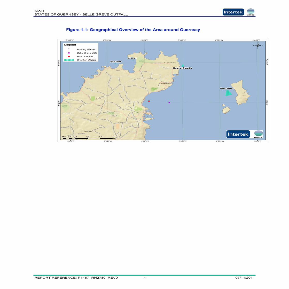
The position of the Belle Greve LSO is shown in Figure 1.1. The LSOcatchment comprises the catchments of St Peter Port and surrounding areas.The location of the only intermittent discharge in the area is also showntogether with the approximate locations of the bathing waters and shellfishharvesting areas designated by the States of Guernsey.
MWHSTATES OF GUERNSEY - BELLE GREVE OUTFALL
REPORT REFERENCE: P1467_RN2780_REV0 2 07/11/2011
1.3 OCEANOGRAPHIC OVERVIEW
The tidal streams in the area of the Channel Islandsi rotate in an anticlockwisedirection. Residual current can be considerable and around the time of springtides anticlockwise residual currents can reach 0.6 m/s around Guernsey.There is a well known front between Guernsey and Jersey.
The area around Guernsey is known to be very high energy in nature, whichwould indicate that it can be expected to disperse wastewater very quickly.Researchers from the Peninsula School of Marine Renewable Energy and fromthe School of Environment and Australian Rivers found that there was anextreme tidal stream area around Guernseyii.
1.4 BELLE GREVE WASTEWATER TREATMENT
The Belle Greve facility treats 99% of the island’s wastewater, around 16,000tonnes per day. The treatment works provides preliminary treatment to theislands wastewater. This level of treatment provides a significant improvementon the aesthetic quality of the discharge, but does not significantly alter theconcentrations of the major pollutants.
1.5 THE STUDIES
The study is divided into four categories:
Initial Dilution standards, and the predicted concentrations of standarddeterminands arising from initial dilution
Standards for nutrients (phosphate and nitrate) that were used for UrbanWaste Water Treatment Directive (UWWTD) studies to identify potentialeutrophication
Standards for ecological change used for UWWTD studies to identifyimpacts to benthic communities arising from deposition of suspendedsolids
Bathing Waters water quality standards and Shellfish Waters qualitystandards
1.6 OVERVIEW OF THE REPORT
The report is divided into a number of sections which are briefly describedbelow:
Chapter 1 Introduction, this chapter.
Chapter 2 Water Quality Standards and Parameters, which describesthe legislative background and the water parameters considered.
Chapter 3 Field Surveys, which describes the field surveys which werespecificall3 carried out for this study.
Chapter 4 Initial Dilution Modelling, which describes the modellingwhich was carried out in order to ensure that initial dilution criteria have beenmet.

MWHSTATES OF GUERNSEY - BELLE GREVE OUTFALL
REPORT REFERENCE: P1467_RN2780_REV0 3 07/11/2011
Chapter 5 Zone A Modelling, which described the modelling which hasbeen carried out in the very near field (i.e. Zone A), close to the outfall position.
Chapter 6 Coastal Modelling Methodology, which gives a brief overviewof the calibration and validation and a more complete description of the modelset ups for the model simulations used in this study.
Chapter 7 Nutrient Modelling, which describes the nutrient modellingand its results, taking into account concentrations measured during the fieldsurvey.
Chapter 8 Bacterial Modelling, which describes the bacterial modellingand its results for discharges from both the Belle Greve outfall and theintermittent discharges from the Red Lion Combined Sewer Overflow.
Chapter 9 Conclusions and Recommendations
MWHSTATES OF GUERNSEY - BELLE GREVE OUTFALL
REPORT REFERENCE: P1467_RN2780_REV0 4 07/11/2011
Figure 1-1: Geographical Overview of the Area around Guernsey
MWHSTATES OF GUERNSEY - BELLE GREVE OUTFALL
REPORT REFERENCE: P1467_RN2780_REV0 5 07/11/2011
2 WATER QUALITY STANDARDS ANDPARAMETERS
2.1 ASSET MANAGEMENT PLAN 2 (AMP2) GUIDELINES FOR INITIAL
DILUTION
The AMP2 guidelines arose from the investment cycle which operates inEngland and Wales post 1989 privatisation. The water industry works on a fiveyear investment cycle, with each cycle having an Asset Management Plan(AMP) which identifies the investment objectives and costs for that period. Weare currently in AMP5 (i.e. the 5th investment period since privatisation). The‘AMP2 Guidelines’ were, therefore, a set of guidelines identified for thepurposes of the AMP2 investment period. They represent a number of policiesand standards which helped in the early stages of wastewater improvements,and indeed a number of them are still relevant for design proposes today.
The purpose of the guidance is to describe general standards for continuousdischarges of wastewater effluent to tidal waters, including initial dilutionstandards for use in circumstances where there is a high degree of public wateruse for recreational or amenity purposes. The purpose of the guidance is toprevent any more than occasional offence arising from visual evidence ofdischarge. The standards set in the guidance note relate to the location ofwastewater ports and the initial dilution necessary to ensure aestheticacceptability.
Effluent discharged to tidal waters is typically buoyant; that is, a surface layer ofeffluent may form in the absence of adequate initial dilution. This may result indiscolouration at the sea surface, possibly giving rise to a slick due to thepresence of fats, oils and greases (FOGs) in the effluent.
The guidance note sets standards for initial dilution within, or in close proximityto, those waters which are regularly used by the public for recreationalactivities.
The basic need to eliminate density differences between effluent and receivingwater to allow uniform dispersion requires:
50 dilutions, to be achieved on a 95 %ile basis for secondary effluents.
100 dilutions, to be achieved on a 95 %ile basis for primary effluents.
Initial dilution can also help to dilute levels of contaminants such as heavymetals to compliant concentrations. In the absence of any industrial dischargesfrom the Belle Greve outfall, or any evidence that these type of contaminantsare significantly present in the discharge, the consideration of these types ofcontaminants is not taken any further in this study.
2.2 URBAN WASTEWATER TREATMENT DIRECTIVE
The Urban Waste Water Treatment Directiveiii concerns the collection,treatment and discharge of urban waste water and the treatment of waste waterfrom certain industrial sectors. Article 4 states that urban waste waterdischarges into coastal waters from agglomerations of more than 10,000population equivalent (p.e.) must be subject to secondary treatment or an

MWHSTATES OF GUERNSEY - BELLE GREVE OUTFALL
REPORT REFERENCE: P1467_RN2780_REV0 6 07/11/2011
equivalent treatment. However, under Article 6, the UWWTD provides scopefor ‘Less Sensitive Areas’, termed High Natural Dispersion Areas (HNDAs) inthe UK, to be identified. Within these areas, urban waste water dischargesfrom agglomerations of between 10,000 and 150,000 p.e. may be subjected totreatment less stringent than secondary or equivalent treatment if they receiveat least primary treatment and if comprehensive studies carried out indicate thatsuch discharges would not adversely affect the environment.
The UWWTDiii does not detail the content of a comprehensive study. TheComprehensive Studies Task Team (CSTT), established by the MarinePollution Monitoring Management Group, was commissioned by the UKDepartment of the Environment to develop guidelines for carrying outcomprehensive studies. The CSTT Report produced in 1994iv (revised 1997v)offers guidance to dischargers and regulators on the objectives, standards andmethodology to be applied in undertaking comprehensive studies for thepurposes of Article 6 of the UWWTD.
The UWWTD is concerned with the provision of ‘adequate’ sewerage. Underthe terms of the Directive, which defines the purpose of the sewerage system to‘prevent pollution’, we have considered for the purposes of this study that thesewerage system should be defined as adequate if it prevents pollution.
2.2.1 Nutrients
In accordance with the CSTT guidelinesiv,v, studies of the waste water effluentreleased into the marine environment around the Belle Greve LSO were carriedout within nested zones of potential effect. The two areas focused on within thisstudy are the receiving waters known as Zone B, also termed the nutrient boxand the surrounding waters known as Zone C. These waters have beendescribed in the guidelines as follows:-
2.2.1.1 Zone B
2.2.1.1.1 Zone Designation
Zone B is designated as
‘a zone in which discharged dissolved nutrients have residence times of 1 x 10⁵sor a few days, the timescale of phytoplankton growth in favourablecircumstances. Nutrients are dispersed through this zone mainly (in ChannelIsland waters) by tidal movements.’
2.2.1.1.2 Impact Assessment
The potential for eutrophication arising from a waste water discharge has beenhighlighted as an area of study by the CSTT Reportiv,v. The Report identifiesphosphorus and nitrogen as the nutrient parameters which should be examinedto determine the potential for eutrophication in receiving waters. Thresholdlimits, which describe ‘adverse effects’ in relation to the nutrient parameterswithin Zone B, are defined in the guidelinesiv,v in the following manner:

MWHSTATES OF GUERNSEY - BELLE GREVE OUTFALL
REPORT REFERENCE: P1467_RN2780_REV0 7 07/11/2011
An adverse effect is considered to occur within Zone B if it is hypernutrified andthere is evidence of the likelihood of eutrophication3. Where the contribution tothe eutrophic state by the discharge in question is insignificant, then thedischarge is considered to cause no adverse effects to the area. There isconsidered to be no adverse effect if:
a) Outwith any area of local effect, there are no observations showing winterDAIN > 12 mmol m-3 (in the presence of 0.2 mmol-DAIP m-3), and that predictionsfor the steady state nutrient concentrations show no evidence or likelihood ofhypernutrification.
b) Where hypernutrification has been demonstrated or predicted: there are nosummer observations showing chlorophyll > 10 mg m-3 and that predictionsillustrate that conditions would not allow phytoplankton growth to exceed losses:that is, there is no evidence, or likelihood of eutrophication.
c) Where eutrophication has been demonstrated or predicted which can betermed anthropogenic3,4: the application of secondary treatment will reduce thepredicted maximum chlorophyll concentration by less than 1 mg chl m-3.
2.2.1.2 Zone C
2.2.1.2.1 Zone Designation
Zone C is designated as
‘a larger region in which the residence time of water is 106 to 107s (10 to 100days), sufficiently long for its dissolved nutrient concentration to be increased bymineralisation of particulates. Dispersion on this larger scale results fromresidual circulation as well as tidal movements’
2.2.1.2.2 Impact Assessment
The CSTT Reportiv,v states that
The contribution of nutrients from waste water discharges into Zone C must beconsidered in relation to eutrophication. The Zone is defined in terms ofhydrographically realistic management units. Within these units, all dischargedwaste waters are ranked according to their nitrogen and phosphorus contribution.If the discharge under consideration, contributes more than 5% of the totalanthropogenic nutrient input, detailed hydrodynamic models should be used topredict the potential for eutrophication if the discharge were secondary ratherthan primary treated.

MWHSTATES OF GUERNSEY - BELLE GREVE OUTFALL
REPORT REFERENCE: P1467_RN2780_REV0 8 07/11/2011
2.2.2 Dissolved Oxygen and Biochemical Oxygen Demand
2.2.2.1 Zone Designation
Zone A is defined as:
Zone A is the local scale, within which sinking particles mostly reach the seabedand in which the residence time of discharged water (or neutrally buoyant tracer)is a few hours, too short for nutrients to be converted into phytoplankton
The average current speed under neap tidal conditions has been found to beapproximately 0.27 m/s. If a residence time of 3 hours is assumed then it canbe assumed that Zone A will cover an area with a radius of approximately 1500metres.
2.2.2.2 Impact Assessment
Both particulate and dissolved BOD contribute to an oxygen demand within thewater column. Particulate organic matter settling to the bottom will alsocontribute to sediment oxygen demand.
It has been estimated that where BOD levels deviate by less than 1.5 mg/l, theresulting impact on DO levels will be less than 0.5 mg/l. Where the median DOlevel is maintained above 7 mg/l, a change of 0.5 mg/l in concentrations can beassumed to cause no adverse affect
2.2.3 Suspended Solids and Organic Carbon
The principal effect of suspended solids and organic carbon is on the benthos.
The guidelinesiv,v specify that:
It is proposed that an adverse effect exists when primary treatment induces asignificant change in community structure at a distance greater than 100 metresfrom the outlet which would not have occurred had secondary treatment beeninstalled. Having regard for the inherent variability of marine communities, anumber of variables should be examined. Levels of acceptable change within thesphere of waste influence compared to a reference site are as follows:
Total abundance +200% of reference station value
Total taxa +50% of reference station value
Total biomass +50% of reference station value

MWHSTATES OF GUERNSEY - BELLE GREVE OUTFALL
REPORT REFERENCE: P1467_RN2780_REV0 9 07/11/2011
2.3 THE BATHING WATER DIRECTIVE
The efforts of the European Unionvi (EU) to ensure clean and healthy bathingwaters commenced in the 1970s. The 2006 Bathing water Directivevii (the "new"Directive, repealing by 2014 the "old" 1976 Bathing Water Directiveviii) has thepurpose to preserve, protect and improve the quality of the environment and toprotect human health. The provisions of the Directive include a number ofobligations for Member States, as well as rules generally applicable all acrossthe EU.
The new Directive is often referred to as the revised Bathing Waters Directive(rBWD) in the UK.
The rBWD has four levels of compliance: Excellent; Good; Sufficient; and Poor.The standards are assessed statistically using data collected during the currentbathing season and the three preceding bathing seasons, making a four-yearrolling assessment period providing approximately 80 samples (4 x 20 samplesper year).
It is assumed that the BW concentrations fit a log-normal distribution andpercentiles are calculated on that basis. These derived percentiles are thencompared to the standards set out in Table 1 3 to establish the compliance ofthe Bathing Water.
Table 2-1: Compliance standards for the rBWD
For coastal waters and transitional waters
Parameter Excellentquality
Goodquality
Sufficientquality
Reference methods ofanalysis
1 Intestinal enterococci (ie/dl) 100 (*) 200 (*) 185 (**) ISO 7899-1 orISO 7899-2
2 Escherichia coli (ec/dl) 250 (*) 500 (*) 500 (**) ISO 9308-3 orISO 9308-1
(*) Based upon a 95-percentile evaluation.(**) Based upon a 90-percentile evaluation.
The key aspect of these standards is that they are assessed statistically over afour-season period, and the magnitude of failure is an important component ofcompliance or failure (unlike the standards for the 1976 Directive).
The calculations for rBWD standards have been carried out under the followingassumptions:
Faecal coliforms (used in the 1976 Directive and current samplingregimes) are equivalent to E. coli (ec - used in the rBWD)
Faecal streptococci (used in the 1976 Directive and current samplingregimes) are equivalent to intestinal enterococci (ie - used in the rBWD)
This assumption, instigated by the environmental regulators in the UK, isimportant, as it means that existing sampling data can be used to analyseperformance under the rBWD.
Three Bathing Waters are considered likely to perhaps fall under the influenceof Belle Greve (all others are considered sufficiently distant that impacts areunlikely):
MWHSTATES OF GUERNSEY - BELLE GREVE OUTFALL
REPORT REFERENCE: P1467_RN2780_REV0 10 07/11/2011
Pembroke
Bordeaux
Havelet
All three are shown in Figure 1.1.
The nature of the modelling study means that if any others are impacted, thenthese will be shown on the output (i.e. no bathing waters are assumed to be notaffected and discounted; all are present in the model domain).
2.4 SHELLFISH WATERS STANDARDS
Shellfish legislation is again health legislation (like the Bathing WatersDirective). Its role is to protect human health, and is not an environmentalprotection measure per se.
Principally, legislation is designed to ensure that the quality of shellfish flesh tobe consumed does not present an unacceptable risk to human health.
Principal legislation is the Food Hygiene Directive (replacing the ShellfishHygiene Directive) and the Shellfish Waters Directive.
The Shellfish Waters Directive provides standards for a wide ranging set ofparameters, and is based on water quality. There is no statutory standard forfaecal indicator organisms, but there is a Guideline standard of 300 faecalcoliforms/100mg flesh.
The Food Hygiene Directive sets out classes of quality, based again on levelsof bacteria/100g of flesh.
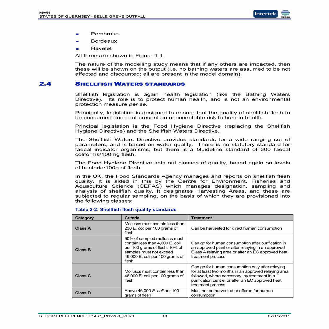
In the UK, the Food Standards Agency manages and reports on shellfish fleshquality. It is aided in this by the Centre for Environment, Fisheries andAquaculture Science (CEFAS) which manages designation, sampling andanalysis of shellfish quality. It designates Harvesting Areas, and these aresubjected to regular sampling, on the basis of which they are provisioned intothe following classes:
Table 2-2: Shellfish flesh quality standards
Category Criteria Treatment
Class AMolluscs must contain less than230 E. coli per 100 grams offlesh
Can be harvested for direct human consumption
Class B
90% of sampled molluscs mustcontain less than 4,600 E. coliper 100 grams of flesh; 10% ofsamples must not exceed46,000 E. coli per 100 grams offlesh
Can go for human consumption after purification inan approved plant or after relaying in an approvedClass A relaying area or after an EC approved heattreatment process
Class CMolluscs must contain less than46,000 E. coli per 100 grams offlesh
Can go for human consumption only after relayingfor at least two months in an approved relaying areafollowed, where necessary, by treatment in apurification centre, or after an EC approved heattreatment process
Class D Above 46,000 E. coli per 100grams of flesh
Must not be harvested or offered for humanconsumption

MWHSTATES OF GUERNSEY - BELLE GREVE OUTFALL
REPORT REFERENCE: P1467_RN2780_REV0 11 07/11/2011
The current aim in England and Wales is the achievement of Class B shellfishWaters as a minimum. The Environment Agency has set out a policy whichlinks water quality to the shellfish flesh class that can be achieved.
Under the terms of this policy, demonstrating that a Harvesting Area has less than1500 faecal coliforms/100ml water for 97% of the time, will deliver Class B fleshquality (i.e. the standard being aimed for in England and Wales).
Using the 1500 fc/100ml as an absolute threshold (i.e. assuming compliance100% of the time), it can be seen that the lower concentration thresholds of therBWD serve as a proxy for the shellfish standards – that is, compliance withbathing waters standards (as absolute thresholds for 100% compliance)automatically provides compliance with this Shellfish Waters standard.
There are two Harvesting Areas in the locality:
Herm (sampling data show Class A performance presently)
Houmet Paradis (sampling data show Class B performance presently).
Both are shown on Figure 1.1.
The nature of the modelling study means that if any others are impacted, thenthese will be shown on the output (i.e. no harvesting areas are assumed to benot affected and discounted; all are present in the model domain).

MWHSTATES OF GUERNSEY - BELLE GREVE OUTFALL
REPORT REFERENCE: P1467_RN2780_REV0 12 07/11/2011
3 FIELD SURVEYS
The scope of work for the field survey was designed to serve two purposes:
Hydrographic and oceanographic data for the calibration and validation ofthe hydrodynamic and water quality model.
Water column and benthic sampling to fulfil the requirements of themethodology set out in CSTT guidelinesiv,v.
The scope of work to which the field survey programme was designed, is setout in Appendix A.
The results of the field survey are discussed below.
3.1 HYDROGRAPHIC AND OCEANOGRAPHIC SURVEY
The results of the hydrographic and oceanographic survey are reported in detailin the sub-contractors report.
3.2 WATER QUALITY
3.2.1 Results
The results of the water quality sampling are presented in Appendix B. Fulldetails are included in the sub-contractor’s report, but the key elements of thewater quality data are discussed below.
3.2.2 Analysis
The sampling results have been compared to the standards set out in the CSTTdocumentiv,v.
Dissolved Oxygen
Back ground dissolved oxygen concentrations were measured at Site H2 over aneap tidal cycle on 23rd August 2011. A statistical analysis of these data isprovided in Table 3-1.
Table 3-1: Statistical Analysis of Dissolved Oxygen Concentrations
Statistic Temperature (oC) DO (% sat) DO (mg/l)Maximum 18.35 106.01 8.23Mean 17.18 95.89 7.46Median 16.85 95.56 7.49Minimum 16.74 93.90 7.14Standard Deviation 0.60 1.97 0.20Count 48 48 48
These results show that dissolved oxygen concentrations were found to beabove 7 mg/l in all cases. Sea temperatures in late August are likely torepresent close to maximum sea temperature in the area. The measurementson this day represent worse case conditions. Indeed a plot of sea temperaturesat St Martin’s Bay (Figure 3-1) shows that these recorded sea temperature are

MWHSTATES OF GUERNSEY - BELLE GREVE OUTFALL
REPORT REFERENCE: P1467_RN2780_REV0 13 07/11/2011
likely to be from the upper range of sea temperatures which might beexperienced in the area.
Figure 3-1: Monthly Average Sea Temperatures at St Martin’s Bay
The solubility of oxygen in water is inversely proportional to temperature.Therefore at lower temperatures than those recorded on this day, even higherdissolved concentrations are likely to be found.
Nutrients and Chlorophyll-a
The results of the nutrient sampling is provided in Table 3-1, expressed asDAIN, DAIP and Chlorophyll-a. The results show that concentrations in excessof the CSTT limit of 12 mmol/m3 of DAIN was only measured once at Site 6during a mid ebb tide. This is somewhat surprising in that Site 6 is some 1kmfrom the outfall discharge point. The results show that concentrations in excessof the CSTT limit of 0.2 mmol/m3 of DAIP was only measured once at Site 6during the same mid ebb tide. High nutrient concentrations were not observedat this or any other site under other tidal conditions. No samples analysed forchlorophyll showed concentrations in excess of 10 mg Chla/m3, demonstratethat eutrophication was not evident during the field survey.

MWHSTATES OF GUERNSEY - BELLE GREVE OUTFALL
REPORT REFERENCE: P1467_RN2780_REV0 14 07/11/2011
Table 3-2: Nutrient and Chlorophyll-a Concentrations
Site and Tidal StateDAIN(mmol/m3)
DAIP(mmol/m3)
Chlorophyll-a(ug/l)
Site 1 Surface ME 1.00 0.07 1.07Site 1 Surface LW 1.03 0.07 0.90Site 1 Surface MF 1.10 0.09 0.97Site 1 Surface HW 1.05 0.08 1.13Site 1 Mid depth ME 1.13 0.07Site 1 Mid depth LW 1.11 0.06Site 1 Mid depth MF 1.01 0.07Site 1 Mid depth HW 1.06 0.07Site 2 Surface ME 9.83 0.07 0.89Site 2 Surface LW 1.01 0.07 1.18SIte 2 Surface MF 1.00 0.07 0.90Site 2 Surface HW 1.00 0.07 1.71Site 2 Mid depth ME 1.01 0.07Site 2 Mid depth LW 1.01 0.08Site 2 Mid depth MF 2.25 0.11Site 2 Mid depth HW 1.00 0.07Site 3 Surface ME 1.00 0.06 1.06Site 3 Surface LW 2.85 0.15 1.15Site 3 Surface MF 1.00 0.08 0.90Site 3 Surface HW 1.04 0.07 1.04Site 3 Mid depth ME 1.01 0.07Site 3 Mid depth LW 1.99 0.11Site 3 Mid depth MF 1.02 0.08Site 3 Mid depth HW 1.05 0.08Site 4 Surface ME 1.49 0.10 0.75Site 4 Surface LW 1.07 0.07 0.90Site 4 Surface MF 1.00 0.09 0.89Site 4 Surface HW 1.00 0.08 1.04Site 4 Mid depth ME 1.37 0.08Site 4 Mid depth LW 1.45 0.10Site 4 Mid depth MF 1.19 0.08Site 4 Mid depth HW 1.67 0.06Site 5 Surface ME 1.15 0.07 0.80Site 5 Surface LW 1.14 0.08 0.66Site 5 Surface MF 1.00 0.07 0.79Site 5 Surface HW 1.53 0.09 0.66Site 5 Mid depth ME 1.27 0.10Site 5 Mid depth LW 1.35 0.08Site 5 Mid depth MF 1.00 0.07Site 5 Mid depth HW 1.31 0.10Site 6 Surface ME 13.24 0.64 0.97

MWHSTATES OF GUERNSEY - BELLE GREVE OUTFALL
REPORT REFERENCE: P1467_RN2780_REV0 15 07/11/2011
Site 6 Surface LW 1.01 0.08 0.77Site 6 Surface MF 1.00 0.07 0.92Site 6 Surface HW 1.00 0.08 0.89Site 6 Mid depth ME 1.45 0.11Site 6 Mid depth LW 1.04 0.07Site 6 Mid depth MF 1.09 0.11Site 6 Mid depth HW 1.04 0.08Site 7 Surface ME 1.44 0.07 0.88Site 7 Surface LW 1.34 0.08 0.77Site 7 Surface MF 1.02 0.09 0.95Site 7 Surface HW 1.01 0.09 0.87Site 7 Mid depth ME 1.31 0.06Site 7 Mid depth LW 1.05 0.07Site 7 Mid depth MF 1.00 0.07Site 7 Mid depth HW 1.01 0.08Site 8 Surface ME 2.32 0.06 0.85Site 8 Surface LW 1.00 0.07 0.83Site 8 Surface MF 1.00 0.08 1.03Site 8 Surface HW 1.20 0.09 0.66Site 8 Mid depth ME 1.70 0.08Site 8 Mid depth LW 1.08 0.08Site 8 Mid depth MF 1.00 0.09Site 8 Mid depth HW 1.05 0.07
MWHSTATES OF GUERNSEY - BELLE GREVE OUTFALL
REPORT REFERENCE: P1467_RN2780_REV0 16 07/11/2011
3.3 BENTHIC SAMPLING
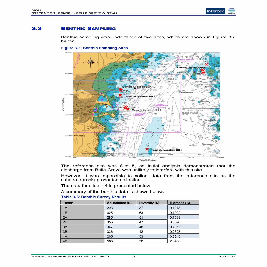
Benthic sampling was undertaken at five sites, which are shown in Figure 3.2below.
Figure 3-2: Benthic Sampling Sites
The reference site was Site 5, as initial analysis demonstrated that thedischarge from Belle Greve was unlikely to interfere with this site.
However, it was impossible to collect data from the reference site as thesubstrate (rock) prevented collection.
The data for sites 1-4 is presented below
A summary of the benthic data is shown below:Table 3-3: Benthic Survey ResultsTaxon Abundance (N) Diversity (S) Biomass (B)1A 293 37 0.12781B 625 63 0.19222A 285 51 0.15982B 355 47 0.33983A 347 48 0.49523B 336 42 0.23234A 265 53 0.33454B 560 78 2.6486

MWHSTATES OF GUERNSEY - BELLE GREVE OUTFALL
REPORT REFERENCE: P1467_RN2780_REV0 17 07/11/2011
Each site had two sample stations (1A & 1B, 2A & 2B, etc). Each site isbroadly comparable in terms of abundance, diversity and biomass, with site 4Bskewing the data somewhat in terms of biomass.
Without a functioning reference site, comparison with CSTT standards isdifficult. However, a consideration of the data in context with data regardingsediment deposition allows us to draw some conclusions from the data. Wehave no evidence to suggest that there is any significant deposition ofsuspended solids from the outfall and no evidence that nutrient levels aresignificantly elevated. Both of these issues may cause impacts to the benthiccommunity, either by changing substrate/habitat conditions (settling of solids) orchanging community structure (nutrient changes affecting algal populations forexample).
The data for the sample sites, which range from close to the outfall site to a sitesome distance away, show comparability. This would indicate that there are nolocal effects (i.e. at the outfall discharge point), which might be an issueconsidering that there is not an effective diffuser operating at this moment intime. A lack of local impact would support the conclusion that there is noimpact to the benthic community in general. In association with the dataregarding solids deposition and nutrient levels, the data would thereforeindicate that there is no significant impact on the benthos due to the discharge.

MWHSTATES OF GUERNSEY - BELLE GREVE OUTFALL
REPORT REFERENCE: P1467_RN2780_REV0 18 07/11/2011
4 INITIAL DILUTION MODELLING
The WRc equations were applied to the results of the hydrodynamic modellingextracted at the location of the current discharge point over the period27/12/2009 to 06/01/2010. The following parameters relating to the dischargewere applied.
Table 4-1: Parameters used in the Initial Dilution Calculations
Parameter Value UnitAverage Daily Flow (ADF) 0.23 m3/sNo of Ports 1Port diameter 0.5 mSoffit depth 0.5 mDepth to Mean Sea Level 12.82 mDistance between ports 1 mFlow per port 0.23 m3/sJet velocity 1.18 m/sFroude number 3.30Buoyant flux 0.06 (m4/s3)
The average daily flow was calculated based on a population of 75,000, anassumed infiltration rate of 40% and the assumption that ADF = 1.25 . DWF.
The results of the initial dilution calculations are presented in Table 4.2.

MWHSTATES OF GUERNSEY - BELLE GREVE OUTFALL
REPORT REFERENCE: P1467_RN2780_REV0 19 07/11/2011
Table 4-2: Initial dilution Preliminary Results
The results of the initial dilution calculations indicate that the existing outfall,which is without a diffuser section, is failing to meet the standards set out in theAMP2 Guidelines for primary treated discharges. These results indicate that adiffuser section would be required to meet the standard.
Initial analysis indicates that a 7 port diffuser section, each with a diameter of0.2m, would be required to meet the initial dilution requirement. Each portshould have a minimum spacing of 11m. A full engineering appraisal of theinstallation of the diffuser, including consideration of the hydraulic implicationsof the environmental solution identified in this report, should be undertaken.The parameters used in this analysis are provided in Table 4.3 and the resultsof the initial dilution calculations are provided in Table 4.4.
Table 4-3: Parameters used in the Diffuser Initial Dilution Calculations
Parameter Value UnitAverage Daily Flow (ADF) 0.23 m3/sNo of Ports 7Port diameter 0.2 Msoffit depth 0.5 MDepth to Mean Sea Level 12.82 MDistance between ports 5 to 10 MFlow per port 0.03 m3/sJet velocity 1.05 m/sFroude number 4.7
Percentile Initial Dilution5% 17510% 15715% 13820% 11925% 10330% 8935% 7140% 4845% 4650% 4455% 4360% 4065% 3770% 3375% 3180% 3085% 2890% 2695% 25

MWHSTATES OF GUERNSEY - BELLE GREVE OUTFALL
REPORT REFERENCE: P1467_RN2780_REV0 20 07/11/2011
Parameter Value UnitBuoyant flux 0.009 (m4/s3)
Table 4-4: Diffuser Initial Dilution Results
Percentile Initial Dilution5% 122810% 109815% 96420% 83225% 72430% 62235% 49840% 37245% 32950% 31755% 30860% 29665% 28270% 27075% 25380% 21785% 12390% 11095% 103
The proposed environmental design for a diffuser section is confirmed asproviding the necessary dilutions.

MWHSTATES OF GUERNSEY - BELLE GREVE OUTFALL
REPORT REFERENCE: P1467_RN2780_REV0 21 07/11/2011
5 ZONE A MODELLING
The initial dilution calculations have been used in order to calculate theconcentration of a number of parameters directly after their release into theenvironment. This is a very conservative approach as this provides for mixingin the immediate wastewater plume not necessarily across the whole of Zone A.Zone A has been estimated to have a radius of 1.5 kilometres while the radiusof the initial dilution zone varies from 3 to 9 metres This approach, therefore,provides much additional scope for further dilution to reach the standards set inthe guidelines.
Typical and well established values for the per capita production of SuspendedSolids, BOD and ammonia were applied to the flow established for a populationof 75,000 and the resulting concentrations were used in subsequentcalculations. The per capita load and the calculated concentrations areprovided in Table 5.1.
Table 5-1: Per Capita Loads and Derived Concentrations
Time series plots of concentration for each of the parameters are provided inAppendix C (Figure C-1 Suspended solids, Figure C-2 BOD, Figure C-3ammonia)
In addition, the dilution calculations were carried out for the proposed newdiffuser arrangement. Similarly, time series plots of concentration for each ofthe parameters are provided in Appendix C (Figure C-4 Suspended solids,Figure C-5 BOD, Figure C-6 ammonia).
Statistics relating to the water quality concentrations are presented in Table 5-1.
The results show that currently, the additional BOD concentration around theoutfall resulting from wastewater discharges, is predicted to exceed 10 mg/l forless than 5% of the time. If the outfall is improved to provide 100 dilutions atthe 95 %’ile then, then the additional BOD concentration in the receiving watersis predicted to be less than 2.2 mg/l for more than 95 percent of the time andless than 1.5 mg/l for more than 84% of the time.
Further analysis of the model results show that in the period when additionalconcentrations are predicted to exceed 1.5 mg/l, the average plume width ispredicted to be less than 7 metres. In order for the predicted concentration ofBOD in the wastewater plume to be reduced to 1.5 mg/l, the average plumewidth in these cases would need to be increased to around 11 metres. Thisplume width is a factor of 30 smaller than the predicted width of Zone A.
ParameterPer CapitaLoad Unit Concentration Unit
Solids 80 g/h/d 300 mg/lBOD 60 g/h/d 225 mg/lAmmonia 7 g/h/d 26 mg/l

MWHSTATES OF GUERNSEY - BELLE GREVE OUTFALL
REPORT REFERENCE: P1467_RN2780_REV0 22 07/11/2011
Table 5-2: Modelled Concentrations in the Near Field Receiving Waters
Percentile Suspended Solids (mg/l) BOD (mg/l) Ammonia (mg/l)Current Future Current Future Current Future
95% 12.18 2.92 9.13 2.19 1.07 0.2690% 11.42 2.74 8.56 2.05 1.00 0.2485% 10.75 2.45 8.06 1.83 0.94 0.2180% 10.13 1.38 7.60 1.04 0.89 0.1275% 9.56 1.18 7.17 0.89 0.84 0.1070% 9.05 1.11 6.79 0.83 0.79 0.1065% 8.02 1.06 6.02 0.80 0.70 0.0960% 7.46 1.01 5.60 0.76 0.65 0.0955% 7.05 0.97 5.29 0.73 0.62 0.0950% 6.76 0.94 5.07 0.71 0.59 0.0845% 6.54 0.91 4.90 0.68 0.57 0.0840% 6.22 0.81 4.66 0.61 0.54 0.0735% 4.21 0.60 3.16 0.45 0.37 0.0530% 3.37 0.48 2.53 0.36 0.30 0.0425% 2.90 0.41 2.17 0.31 0.25 0.0420% 2.52 0.36 1.89 0.27 0.22 0.0315% 2.18 0.31 1.63 0.23 0.19 0.0310% 1.91 0.27 1.43 0.20 0.17 0.025% 1.71 0.24 1.28 0.18 0.15 0.02
This Zone A modelling (which can effectively be considered to be theconsideration of the dilution of these determinands due to initial dilution),demonstrates that with the proposed diffuser in place, then all of thedeterminands meet required standards very close to the outfall. There are nopredicted significant impacts to the surrounding environment.

MWHSTATES OF GUERNSEY - BELLE GREVE OUTFALL
REPORT REFERENCE: P1467_RN2780_REV0 23 07/11/2011
6 COASTAL MODELLING METHODOLOGY
Intertek METOC’s existing calibrated and verified 1350 metre model of theEnglish Channel and the North Sea was used as the basis of the nutrientmodelling approach and the newly constructed Guernsey Coastal ModellingSystem (GCMS) was used for the bacterial modelling.
Both of these models were constructed using the MIKE21 software platform, aproven modelling system that is deployed worldwide for all manner of coastalassessment, including water quality, bacterial modelling, coastal processmodelling, wave modelling. Tidal renewable energy modelling and floodmodelling. It is the most common modelling system used in the UK for thesetypes of water quality studies.
Water quality parameter can be modelled using two basic approaches withinMIKE series of models and most other complex modelling systems:
Particle tracking;
Advection and dispersion.
The water quality module of MIKE series of models which employs theadvection and dispersion technique has been applied in this instance. Theintrinsic advantages in the advection and dispersion approach make it the mostappropriate model to apply in this case.
The advection and dispersion modelling technique simulates the movement anddispersion of water quality parameters dissolved or suspended in the body ofwater. This means that the movement of water quality parameters is alwayscorrectly represented. In the past, the high computing overhead inherent inapplying this technique meant that it could only be used with models ofrelatively coarse resolution. However, as a result of the increase in computerspeed and power, it has been possible to apply the advection and dispersionmodel to detailed studies such as this one for Guernsey.
6.1 MODEL CALIBRATION AND VALIDATION
A summary of the results of the calibration and validation of the GCMS isprovided in Appendix D.
6.2 MODEL ASSESSMENT
6.2.1 Time Period
The model assessment will be carried out for both spring and neap conditionsand over a time frame appropriate to the type of assessment.
Nutrients - a period of a number of months in order to give the non-decaying nutrients time to build up in the water column, which issometimes referred to as reaching dynamic equilibrium..
Bacteria - a period of some days as bacteria decay relativelyquickly and so will reach dynamic equilibrium relatively quickly.
MWHSTATES OF GUERNSEY - BELLE GREVE OUTFALL
REPORT REFERENCE: P1467_RN2780_REV0 24 07/11/2011
6.2.2 Water Quality Parameters
The parameters which have been considered are:
Nitrogen Cycle (DAIN, ammonia, nitrite, nitrate, organic nitrogen)
Phosphates (inorganic and organic)
Chlorophyll
Faecal Coliforms
Faecal Streptococci
Suspended solids
6.2.3 Model Output
Contour plots will be provided of the predicted concentrations of:
DAIN
DAIP
Potential for the growth of Chlorophyll
Faecal Coliforms
Faecal Streptococci
Results were obtained for a range of spring and neap tidal conditions. Inaddition, time series plots of the predicted concentrations at locations agreedwith the regulator have been provided.
In addition, a plot of the modelled depth of deposited suspended solids hasbeen provided.

MWHSTATES OF GUERNSEY - BELLE GREVE OUTFALL
REPORT REFERENCE: P1467_RN2780_REV0 25 07/11/2011
7 NUTRIENT MODELLING
7.1 ZONE B MODELLING
7.1.1 Background and Assumptions
The modelling method and assumptions are, in all cases, conservative.
The calibrated and validated 1350 metre model of the English Channeland North Sea was used for the model assessment..
Nutrient components. DAIN and DAIP have both been modelled. It hasbeen assumed that the whole of the organic components of DAIN andDAIP have been mineralised to the available chemical species. This is aconservative assumption.
Model period in excess of 7 months. This very long simulation periodallows the concentration of nutrients in the water column to reach adynamic equilibrium at a considerable distance from the Channel Islands.This is a relatively long time period when compared to the time periodover which DAIN and DAIP are likely to build up in the coastalenvironment. Typically, nutrients build up in the autumn and wintermonths until a point in the spring when, if nutrient concentrations aresufficient, algal populations increase and nutrient levels decreasedramatically.
Background concentrations have been assumed to be zero in themodelling. In effect, the excess nutrients resulting from the dischargehave been modelled.
Decay rate. No decay of or other changes to nutrients has beenassumed.
Denitrification. Nitrates are reduced to atmospheric nitrogen (aprocess known as denitrification) and so the overall amount ofDAIN in the water column is reduced. This process has notbeen included. This is a conservative assumption.
Atmospheric nitrogen fixation. Lightning causes atmosphericnitrogen to react with oxygen to form nitrates. This processhas not been included in the assessment as this componentforms part of the background concentration.
Biological nitrogen fixation. Blue green algae reduceatmospheric nitrogen to ammoniated compounds. Thisprocess has not been included in the assessment as thiscomponent forms part of the background concentration.
There is a dynamic equilibrium between the components ofDAIN (ammonia, nitrite and nitrate)
NH3 ↔ NO2 ↔ NO3
However, the overall amount of the nutrient in the system does not change.
Organic phosphorus is mineralised to form ortho-phosphate. Ortho-phosphate is buffered in the marine environment. This means that as

MWHSTATES OF GUERNSEY - BELLE GREVE OUTFALL
REPORT REFERENCE: P1467_RN2780_REV0 26 07/11/2011
more phosphate is added to the water column then more phosphate isprecipitated to the seabed. Similarly, as phosphate in the water column isconsumed by algal then phosphate stored in the seabed comes back intosolution. This process means that phosphate is relatively constant in thesea (in contrast to the situation found in rivers). Phosphate for thisreason is not normally the critical parameter in seawater.
7.1.2 Model Results
The model results are presented in Appendix E. The results are presented intwo formats:
Contour plots of the maximum concentration of DAIN and DAIP
Time series plots of the concentration of DAIN and DAIP at a number oflocations around the Channel Islands.
The maximum nitrogen and phosphorus concentrations predicted duringthe course of the modelling are presented in the Table 7-1 below togetherwith the limits which would allow algal growth and a comparison betweenthe maxima and those limits.
Table 7-1: Modelled Maximum Concentrations in the Water Column
7.1.3 Analysis of Model and Survey Results
The model results show that in Zone B and beyond, the maximum modelledexcess DAIN and DAIP concentrations are a very small percentage of theallowable limit.
Analysis of the survey results show that
63 of the 64 averaged measured DAIN concentrations are below theCSTT limit
45 of the 64 averaged measured DAIP concentrations are below theCSTT limit. The average DAIP concentration is 0.196 mmol/m3, which isvery close to the guideline value. DAIP is, in general, not a criticalparameter for algal growth in coastal waters. In normal circumstances,there will be just about enough DAIP in the water column to promote algalgrowth, which is reflected in these results.
Three (3) sub-samples (3 sub samples make up one averaged sample)from Site 6 on the mid-ebb tide were found to have concentrations aboveor just below 12 mmol/m3. However, this site is some 1 km from theoutfall and so is unlikely to be grossly affected by nutrients from thedischarge point when sites much closer to the outfall are not affected inthe same way. The DAIP concentration at this site and for this tidal statewas found to be 0.16 mmol/m3, which indicates that there is nosubstantial human derived nutrient load at this point. The mid-depth sub-samples at this location at the same tidal state did not show elevated
DAIN (mmol/m3) DAIP (mmol/m3)Max Modelled Conc 0.202 0.014Allowable Limits 12.000 0.200% of allowable limit 2 7

MWHSTATES OF GUERNSEY - BELLE GREVE OUTFALL
REPORT REFERENCE: P1467_RN2780_REV0 27 07/11/2011
concentrations. These results have been discounted from furtheranalyses.
One sub-sample from Site 2 on the mid-ebb tide was found to have aconcentration of 27.4 mmol/m3, substantially above the 12 mmol/m3 limit.The accompanying DAIP concentration (0.8 mmol/m3) for this sub-sample was also in excess of the guideline value indicating that there is apotential that the sample may have been contaminated by nutrientderived from a human origin. However, the other two sub-samples showvery low values from both DAIN and DAIP, indicating that it likely that thissub-sample is spurious.
7.2 ZONE C ASSESSMENT
Zone C is designated as an area in which the residence time of water is 10 to100 days, sufficiently long for its dissolved nutrient concentration to beincreased by mineralisation of particulates. Dispersion on this larger scaleresults from residual circulation as well as tidal movements. The Zone Cassessment has been carried out by considering the large bay in whichstretches from the headland at Auderville to the headland at Roscoff.
Nutrient discharges to this zone can be from both human sources and fromagricultural sources. Agricultural source, in general, discharge to rivers andsubsequently to the sea. The major water course discharging to this area is LaRance. However, it has proved very difficult to obtain water quality informationrelating to rivers in France.
The initial analysis has focussed on a comparison of the human populationscontributing to the zone. The estimated populations of the French Departmentsand the Channel Islands are provided in Table 7-2 below. Secondary treatmentis estimated to remove 20% of the nutrient load. It has been assumed that alldischarges from the French Departments are treated to secondary standard,although it is by no means certain that all rural discharges are treated to such ahigh standard. This is a conservative assumption.

MWHSTATES OF GUERNSEY - BELLE GREVE OUTFALL
REPORT REFERENCE: P1467_RN2780_REV0 28 07/11/2011
Table 7-2: populations of Communities Discharging to Zone C
Name PopulationEstimatedPopulationDischargingto Zone C
NotionalPopulationassumingsecondarytreatment
Percentageof Overallpopulation(%)
Comment
Manche 492,563 350,000 280,000 18.2 Assumed 70% effluent discharges to this Zone
Ile et Vilaine 954,851 954,851 764,000 49.8 Assumed 100% effluent discharges to thisZone
Cote d’Armor 570,861 400,000 320.000 20.9 Assumed 70% effluent discharges to this Zone
Jersey 92,500 92,500 92,500 6.0 Assumed 100% effluent discharges to thisZone
Guernsey* 75,000 75,0000 75,0000 4.9 Assumed 100% effluent discharges to thisZone
Alderney 2,400 2,400 2,400 0.2 Assumed 100% effluent discharges to thisZone
Sark 600 600 600 0.0 Assumed 100% effluent discharges to thisZone
Herm 60 60 60 0.0 Assumed 100% effluent discharges to thisZone
* Design population for modelling purposes
Based on this analysis, discharges from Belle Greve would represent justbelow 5% of the human nutrient budge in this area. However, rivers are knownto be major contributors to coastal nutrient loads and so the nutrient load fromGuernsey is likely to represent a much smaller percentage contribution to theoverall nutrient load to this zone.
Therefore, there is no need to carry out further detailed analysis to predict thepotential for eutrophication if the discharge were secondary treated.

MWHSTATES OF GUERNSEY - BELLE GREVE OUTFALL
REPORT REFERENCE: P1467_RN2780_REV0 29 07/11/2011
8 BACTERIAL MODELLING (BATHING WATERSAND SHELLFISH WATERS)
Bacterial discharges from Belle Greve outfall and the Red Lion CSO have beenmodelled using the GCMS. In each case, the results have been presented ascontour plots and as time series plots at the designated bathing waters.
8.1 IMPACT OF BELLE GREVE OUTFALL
The model parameters are outlined below.
Decay rate Faecal coliforms 15 hours and faecal streptococci 30 hours
Flow 0.23 m3/s (equivalent to a population of 75,000)
Wind conditions
Calm
Speed 5 m/s Direction 0oN.
Speed 5 m/s Direction 60oN.
Speed 5 m/s Direction 120oN.
Speed 5 m/s Direction 180oN
Speed 5 m/s Direction 240oN.
Speed 5 m/s Direction 300oN.
These wind conditions were applied across the whole simulation in each case.
Standards were assumed to be thresholds, and the percentile compliancelevels were ignored. That is, it was assumed that the standard had to be met100% of the time, and therefore any breach of the threshold would indicate thepotential for Belle Greve to impact the Bathing Water. This is a conservativeassumption.
The highest threshold (100 bacteria/100ml water) was the basis for the initialassessment.
If this was met, then all other standards (including the Shellfish standard) wouldbe met.
This study did not consider the potential for other sources to impact on thereceivers.
8.1.1 Faecal Coliforms
The results of the model assessment for discharges of faecal coliforms fromBelle Greve outfall are presented in Appendix F. The results are presented asmaximum concentration plots and time series plots.

MWHSTATES OF GUERNSEY - BELLE GREVE OUTFALL
REPORT REFERENCE: P1467_RN2780_REV0 30 07/11/2011
8.1.2 Faecal Streptococci
The results of the model assessment for discharges of faecal streptococci fromBelle Greve outfall are presented in Appendix F. The results are presented asmaximum concentration plots and time series plots.
8.2 IMPACT OF DISCHARGES FROM THE RED LION CSO
The model parameters are outlined below.
Decay rate Faecal coliforms 15 hours and faecal streptococci 30hours
Flow 2,000 m3 discharged across a 3 hour period
Wind conditions Calm
Tides Spring and neap
Tidal phase High water, mid ebb, low water and mid flood
8.2.1 Faecal Coliforms
A selection of time series results for discharges from the Red Lion CSO havebeen supplied in Appendix G. Many of the plots show little or no impact, soonly those plots which show impacts higher than 10 ec/100ml have beenincluded.
8.2.2 Faecal Streptococci
A selection of time series results for discharges from the Red Lion CSO havebeen supplied in Appendix G. Many of the plots show little or no impact, soonly those plots which show impacts higher than 1 ie/100ml have beenincluded.

MWHSTATES OF GUERNSEY - BELLE GREVE OUTFALL
REPORT REFERENCE: P1467_RN2780_REV0 31 07/11/2011
9 BENTHIC AND SEDIMENT MODELLING
Sediment discharges from Belle Greve outfall have been modelled using theGCMS.
The model parameters are outlined below.
Flow 0.23 m3/s (equivalent to a population of 75,000)
Wind conditions Calm
Particle size distribution The particle size distribution for a typicalpreliminary discharge was applied.
Sediment concentration The concentration was based on that calculatedduring the Zone A assessment.
The maximum depth distribution in millimetres has been presented inFigure 9-1.
Figure 9-1: Maximum Modelled Depth of Sediment
The results show that there is little or no deposition close to the outfall, while avery small amount of deposition is shown to occur around the harbour.
On this basis it was considered that there was no case for further benthicmodelling, as the low levels of deposition would not result in any significantimpacts being reported.

MWHSTATES OF GUERNSEY - BELLE GREVE OUTFALL
REPORT REFERENCE: P1467_RN2780_REV0 32 07/11/2011
10 CONCLUSIONS AND RECOMMENDATIONS
10.1 CONCLUSIONS
10.1.1 Initial Dilution
The initial dilution requirements set out in the AMP2 guidelines are not currentlymet.
The implementation of the environmental design for a diffuser will delivercompliance with the initial dilution standard.
10.1.2 Zone A
The concentration of BOD in the Zone A is predicted to be met in the initialsurface boil for the majority of tidal conditions. Improvements to the outfallwould ensure that the condition would be met under even more tidal conditions.A very few additional dilutions would be required to meet the standard, whichwould easily be met within Zone A.
The provision of the recommended diffuser would deliver the necessaryimprovements.
10.1.3 Nutrient Assessment
The nutrient assessment took into account both the nutrient modelling and theresults of the nutrient field survey. The assessment show that discharges fromBelle Greve outfall are predicted to provide additional nutrient loads which areonly a small percentage of the guideline standard. The data indicates thatnutrient from the Belle Greve outfall will not lead to nutrient in excess of thestandard within Zone B.
The assessment of discharges to Zone C indicated that discharges from BelleGreve outfall represent less than 5% of the total nutrient discharges to thezone. Therefore, these discharges need not be considered further.
10.1.4 Bacterial Assessment
The results of the bacterial modelling indicated that for:
Belle Greve long sea outfall
Faecal coliform concentrations at all of the designated bathing waters arepredicted to be less than 100 ec/100ml.
Faecal streptococci concentrations at all of the designated bathing watersare predicted to be less than 25 ie/100ml.
Red Lion short sea outfall
Faecal coliform concentrations at all of the designated bathing waters arepredicted to be less than 15 ec/100ml.
Faecal streptococci concentrations at all of the designated bathing watersare predicted to be less than 2 ie/100ml.
MWHSTATES OF GUERNSEY - BELLE GREVE OUTFALL
REPORT REFERENCE: P1467_RN2780_REV0 33 07/11/2011
The Red Lion discharge does not discharge regularly, and its impacts aretherefore considered negligible. Current improvements to the seweragenetwork and the handling of wet weather flows will decrease the operation ofthe Red Lion outfall still further.
It is therefore considered that the Belle Greve discharge does not significantlyimpact the designated sensitive receivers (Bathing Waters and ShellfishWaters)
10.1.5 Sediment Assessment
The sediment assessment showed that suspended solids are not predicted tosettle close to the Belle Greve outfall. There is no indication that any significantdeposition occurs. The highly dynamic and energetic nature of the site wouldmean that deposition of solids to any meaningful level is highly unlikely.
The data from the benthic survey would support the conclusion that thedischarge is not adversely affecting the benthic community.
10.2 RECOMMENDATIONS
The study has demonstrated:
The initial dilution of the discharge is insufficient to satisfy UK standards.This can be resolved by installing a diffuser section for the outfall.
The environmental design for the diffuser section would suggest arequirement for seven ports (diameter 0.2m) with a minimum spacing of11m. The hydraulic design of the diffuser and outfall would need to beconfirmed by design engineers.
The concentrations of solids, BOD, ammonia and COD after initial dilutionfall within UK standards (some after the imposition of a diffuser section).
The nitrogen and phosphorus concentrations predicted by the simulationare below the limits which would indicate (or increase the risk of) thepotential for eutrophication (e.g. Algal blooms)
The Benthic assessment has indicated a very small deposition aroundthe outfall and therefore the present discharge has no significant impacton the benthos.
Bathing waters and Shellfish Harvesting Areas are not predicted to besignificantly impacted by the Belle Greve outfall – i.e. compliance ismaintained
Whereas the UWWTD suggests a minimum of primary treatment forwastewater discharges for a population the size of Guernsey, all of the studiesconducted would suggest that there is no adverse affect from the Belle Grevedischarge.
The results of the study would therefore suggest that the current level oftreatment, whilst not strictly conforming with the UWWTD:
Protects the surrounding waters from the risks of eutrophication
Protects the surrounding waters from deleterious local impacts of wastewater discharges
Protects Bathing and Shellfish Waters

MWHSTATES OF GUERNSEY - BELLE GREVE OUTFALL
REPORT REFERENCE: P1467_RN2780_REV0 34 07/11/2011
Does not pose a risk to the local benthic community due to deposition ofsuspended solids
MWHSTATES OF GUERNSEY - BELLE GREVE OUTFALL
REPORT REFERENCE: P1467_RN2780_REV0 35 07/11/2011
11 REFERENCES1 R. D. Pingree and G. T. Mardella. Tidal flows around the Channel Islands.Journal of the Marine Biological Association of the United Kingdom (1987), 67 :pp 691-7071 Emma V. Sheehan, Timothy F. Stevens, Martin J. Attrill. A Quantitative, Non-Destructive Methodology for Habitat Characterisation and Benthic Monitoring atOffshore Renewable Energy Developments.1 UWWTD; 91/271/EEC1 CSTT. Comprehensive Studies for the Purposes of Articles 6 and 8.5 of DIR91/271EEC. The Urban Waste Water Treatment Directive. 19941 CSTT. Comprehensive Studies for the Purposes of Articles 6 and 8.5 of DIR91/271EEC. The Urban Waste Water Treatment Directive. 19971 http://ec.europa.eu/environment/water/water-bathing/index_en.html1 EU. DIRECTIVE 2006/7/EC OF THE EUROPEAN PARLIAMENT AND OFTHE COUNCIL. OJL.64/37/20061 EEC. Council Directive 76/160/EEC of 8 December 1975 concerning thequality of bathing water. OJ L 31, 5.2.1976, p. 1–7

MWHSTATES OF GUERNSEY - BELLE GREVE OUTFALL
REPORT REFERENCE: P1467_RN2780_REV0 A-1 07/11/2011
Appendix A Scope of Survey Work

MWHSTATES OF GUERNSEY - BELLE GREVE OUTFALL
REPORT REFERENCE: P1467_RN2780_REV0 A-2 07/11/2011
FIGURES
FIGURE A- 1: HYDROGRAPHIC SURVEY LOCATIONS ..............................................................A-6FIGURE A- 2: NUTRIENT SURVEY – SAMPLING LOCATIONS DIAGRAM ...................................A-10FIGURE A- 3: BATHYMETRY SURVEY AREA .........................................................................A-12
TABLESTABLE A- 1: HYDROGRAPHIC APPROXIMATE SURVEY LOCATIONS..........................................A-7TABLE A- 2: WATER QUALITY SAMPLING..............................................................................A-10

MWHSTATES OF GUERNSEY - BELLE GREVE OUTFALL
REPORT REFERENCE: P1467_RN2780_REV0 A-3 07/11/2011
A.1 INTRODUCTION
It is required that hydrographic and benthic survey be carried out around thelocation of the Belle Greve outfall close to St Peter Port Guernsey.
The survey area will require a suite of survey work to be completed comprising:
Hydrographic and oceanographic survey
Current meters
Depth profiles
Dye release with accompanying drogue release.
Benthic survey
Samples at impacted and reference sites
Water quality survey
Samples at impacted and reference sites
Bathymetry survey
survey local to discharge point, suitable for engineeringassessment, and
a more general topographical survey of St Peter Port bay
A.1.1 PROJECT OVERVIEW
The survey will comprise of four components.
Currents and levels monitoring - At sites specified in Section A.2, currentspeeds and directions through the water column should be measuredover at least a 31-day period. In addition, water levels (elevations relativeto a vertical datum) should also be measured, over the same 31-dayperiod,
Depth profiles - At each current monitoring site, independentmeasurements of current speed and direction, temperature and salinityare to be taken hourly through the water column over a 13-hour tidal cycleon both a spring and neap tide.
Dye tracing – At sites specified in Section A.2, dye patch tracingundertaken for high and low water releases under both a spring and neaptide.
Benthic sampling at sites specified in Section A.3.
Water quality sampling at sites specified in Section A.3.
Bathymetry survey in the area specified in Section A.4.
Depth Profiles, and Dye Tracing, must be collected during the same period asCurrents and Levels Monitoring.
The most appropriate equipment must be selected for each component andlocation. It is anticipated that bottom-mounted Acoustic Doppler Current

MWHSTATES OF GUERNSEY - BELLE GREVE OUTFALL
REPORT REFERENCE: P1467_RN2780_REV0 A-4 07/11/2011
Profilers (ADCP) with a pressure sensor will be used for component Currentsand Levels Monitoring, but the surveyor should ensure that this is the mostsuitable instrument for each location. An alternative option may be to use anarray of Direct Reading Current Meters (DRCM) through the water column anda tide gauge, which would also be acceptable, and possibly even preferable toan ADCP at some sites, depending on the water depth and prevailingconditions. The equipment and methodology to be used for these surveysshould be stated.
A.1.2 DEFINITION OF SPRING AND NEAP TIDE
Spring conditions are defined as pertaining during the period when the tidalrange exceeds MSTR-0.25(MSTR-MNTR), and neaps as the period duringwhich the tidal range is lower than MNTR+0.25(MSTR-MNTR).
Where:
MSTR: Mean Spring Tidal Range
MNTR: Mean Neap Tidal Range
A.1.3 NOTE ON TECHNICAL SPECIFICATIONS
Technical Specifications drafted by Metoc describe acceptable equipment andmethodologies by which the work is undertaken; these are presented in thesections below.
In addition to this document, the SEPA Site and Hydrographic SurveyRequirements (for Applications for Consent to Discharge from Marine CageSalmon Farms), hereafter referred as ‘SEPA guidelines’, provides a guide totechnical requirements for equipment and survey techniques which have beenused for a variety of similar studies, and these are deemed suitable as thereference for this survey.
A.1.4 HORIZONTAL AND VERTICAL REFERENCE
The coordinate system to be used during all reporting and charting shall be theGuernsey Grid. The vertical datum along all route components shall beOrdnance Datum Guernsey, OD(G).
Positional accuracy should be ±3m.
A.1.5 SURVEY LOCATIONS
Figure A.1 gives an overview of the survey area.
The locations of sites provided in this document are indicative, and may well beslightly amended. Final positions will be confirmed following award of contractand appointment of the client representative.
Details of proposed locations are provided in the relevant sub-sections below.
A.1.6 SURVEY PERSONNEL
For each survey vessel undertaking the data acquisition the survey team shallbe sufficient to operate on a 16-hour/day basis.
MWHSTATES OF GUERNSEY - BELLE GREVE OUTFALL
REPORT REFERENCE: P1467_RN2780_REV0 A-5 07/11/2011
All survey personnel shall be trained in the use of the equipment utilised duringthe study and where appropriate hold appropriate certificates for workingonboard survey vessels. Training records for all personnel shall be provided forinspection.
The data shall be monitored and interpreted on board the survey vessel and atthe site office by a qualified surveyor with at least five (5) years experience.
A.1.7 CALIBRATION OF INSTRUMENTS
Pre-deployment Checks
Checks shall be performed on each instrument before mobilisation/deploymentto ensure that all the sensors and processing equipment specified in the Scopeof Work are functioning correctly and that they are performing within themanufacturer's specifications.
If the performance of any sensor is found to be unsatisfactory, and outside themanufacturer's specification, then the Tenderer shall either discount it entirelyor shall undertake a full re-calibration of the sensor, or instrument, in order toobtain calibration curves and/or equations which shall be applied to thegathered data.
Instrument calibration checks shall be undertaken in the presence of the clientrepresentative.
Post-deployment Checks
Calibration checks shall also be performed, where practicable, on eachinstrument on deployment.
Documentation on the final checks shall be provided to the client representativefor approval prior to the final processing of the data.
If significant differences are evident between pre and post calibration checks, orif the instrument malfunctions during the measurement period, discussions shallbe held with the client representative, in order to establish any requirements foradditional calibrations and any corrections which shall be applied to thegathered data. The Client Representative may require re-calibration of aninstrument at any time.
A.2 HEALTH AND SAFETY
Health and Safety considerations are of paramount importance. It is vital thatthe contractor undertakes the works in a safe and responsible manner and candemonstrate that acceptable health and safety procedures, risk assessmentsand method statements are complied with at all times.
The contractor shall provide all method statements, risk assessments andcertifications (for instance, to demonstrate vessel suitability) prior to any worksbeing undertaken.
The contractor shall ensure that the personnel take all reasonable safetymeasures in relation to the work undertaken under the Contract, andconducts itself and themselves in a safe and proper manner carrying outall applicable obligations and duties under all relevant legislation.

MWHSTATES OF GUERNSEY - BELLE GREVE OUTFALL
REPORT REFERENCE: P1467_RN2780_REV0 A-6 07/11/2011
The contractor shall in addition observe and follow all guides, codes andrecommendations issued or made relating to health and safety at work.
The contractor shall supply, prior to commencement of the contract, acopy of its Health and Safety policy and procedures and safety record forall aspects of the contractor's services, which are necessary to completethe work. This inspection will not imply any seal of approval.
A.3 HYDROGRAPHIC SURVEY
A.3.1 SCOPE OF WORK
All permissions, notifications such as Notices to Mariners, and licences requiredto undertake the survey works shall be the responsibility of the Surveyor.
Each phase of marine work shall require vessel positioning by differentialGlobal Positioning System. Heading determination will be provided by agyro/survey compass. This navigation spread deemed to be part of theessential equipment of the survey vessel used under the contract.
A.3.2 SURVEY LOCATIONS
The hydrographic survey locations are shown in Figure A.1 and tabulated inTable A.1.
Figure A- 1: Hydrographic Survey Locations
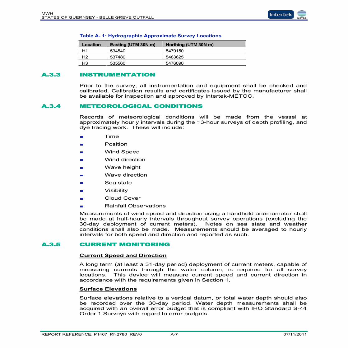
MWHSTATES OF GUERNSEY - BELLE GREVE OUTFALL
REPORT REFERENCE: P1467_RN2780_REV0 A-7 07/11/2011
Table A- 1: Hydrographic Approximate Survey Locations
Location Easting (UTM 30N m) Northing (UTM 30N m)H1 534540 5479150H2 537480 5483625H3 535560 5476090
A.3.3 INSTRUMENTATION
Prior to the survey, all instrumentation and equipment shall be checked andcalibrated. Calibration results and certificates issued by the manufacturer shallbe available for inspection and approved by Intertek-METOC.
A.3.4 METEOROLOGICAL CONDITIONS
Records of meteorological conditions will be made from the vessel atapproximately hourly intervals during the 13-hour surveys of depth profiling, anddye tracing work. These will include:
Time
Position
Wind Speed
Wind direction
Wave height
Wave direction
Sea state
Visibility
Cloud Cover
Rainfall Observations
Measurements of wind speed and direction using a handheld anemometer shallbe made at half-hourly intervals throughout survey operations (excluding the30-day deployment of current meters). Notes on sea state and weatherconditions shall also be made. Measurements should be averaged to hourlyintervals for both speed and direction and reported as such.
A.3.5 CURRENT MONITORING
Current Speed and Direction
A long term (at least a 31-day period) deployment of current meters, capable ofmeasuring currents through the water column, is required for all surveylocations. This device will measure current speed and current direction inaccordance with the requirements given in Section 1.
Surface Elevations
Surface elevations relative to a vertical datum, or total water depth should alsobe recorded over the 30-day period. Water depth measurements shall beacquired with an overall error budget that is compliant with IHO Standard S-44Order 1 Surveys with regard to error budgets.

MWHSTATES OF GUERNSEY - BELLE GREVE OUTFALL
REPORT REFERENCE: P1467_RN2780_REV0 A-8 07/11/2011
The Surveyor shall specify the method by which vertical control shall beundertaken to ensure error limits fall within those set out in S-44 Order 1surveys.
Timing of Operations
The fixed measurements should be taken over at least a 31-day period startingeither on a neap tide or a spring tide.
A.3.6 DEPTH PROFILES
Depth profiles of temperature, salinity, and current speeds and directions arerequired. These must be collected at Locations H1 to H3 during the 31-daycurrent meter deployment. They will help determine the three-dimensional (3D)structure of the water column, and will also provide an independent check of thecurrent meter data collected.
The depth profiles are required over two 13-hour periods, incorporating highand low water over both a neap and spring tide. However, it is acknowledgedthat this may not be possible, given the hours of daylight available during thesurvey. The minimum duration required is likely to be at least 8 hours.
Current Speed and Direction
At each current meter location, independent measurements of current speedand direction are required. Measurements are to be collected over two 13-hourperiods (to be agreed – see note above) to incorporate high and low waterduring both a neap and a spring tide. The current profiles must be collectedindependently of the current monitoring data collected (component (a)).
Temperature and Salinity
At each current meter location, independent measurements of temperature andsalinity are required. Measurements are to be collected through the watercolumn over two 13-hour periods (to be agreed – see note above) toincorporate high and low water during both a neap and a spring tide,simultaneously with the current speed and direction profiles. An appropriatemulti-parameter Conductivity, Temperature, Depth (CTD) probe will be used.
A.3.7 DISPERSION DATA
Rhodamine WT dye releases shall be made from Location H1, given in Table2.1, at high and low water on both a spring and neap tides.
NB. It is possible that the client representative may suggest amending therelease location at the time of the survey based on the prevailing conditions.
The dye patches shall be tracked and quantitative measurements shall bemade at half hourly intervals at a depth within the range of 0.25-1.5m (actualdepth to be decided on site). The dye patch shall be monitored using afluorimeter taking data from an agreed depth. Sufficient dye will be released toenable the dye patch to be tracked for one tidal excursion (at least 6 hours – oruntil significant dilution to immeasurable concentrations has occurred).
Transects shall be taken through each dye patch to assess the position ofmaximum concentration and spread of dye.
MWHSTATES OF GUERNSEY - BELLE GREVE OUTFALL
REPORT REFERENCE: P1467_RN2780_REV0 A-9 07/11/2011
Speeds and directions of winds will be measured during the dye tracing.
A.4 BENTHIC AND NUTRIENT SURVEYS
The client wishes to undertake a benthic survey to determine communitystructure at the discharge point.
The contractor should determine the appropriate method of sampling,accounting for local conditions.
One site at the discharge point should be surveyed, and also a suitablereference site should be identified and sampled. Costs for these two sitesshould be submitted, although there is the possibility that existing data the clientholds may prove suitable for the reference site.
A.4.1 SAMPLE LOCATIONS
A sparse water quality grid consisting of 8 stations has been designed tomaximize the spatial extent of the survey while allowing the samples to becollected at several different tidal states. The grid consists of eight stations, 5lying in the principal direction of current flow and 3 lying perpendicular to thedirection of current flow.
Station W1/B1 above the diffuser
Station W2/B2 100m from Station 1 in the direction of the flood tideaxis;
Station W3/B3 250m from Station 1 in the direction of the flood tideaxis;
Station W4 1000m from Station 1 in the direction of the flood tideaxis;
Station W5/B4 2000m from Station 1 in the direction of the flood tideaxis;
Station W6 1000m from Station 1 perpendicular to the direction ofthe flood tide axis;
Station W7 2000m from Station 1 perpendicular to the direction ofthe flood tide axis;
Station W8/B5 3000m from Station 1 perpendicular to the direction ofthe flood tide axis.
A diagram showing the location of sampling points in relation to the outfall andthe direction of the flood tide is supplied in Figure A-2.

MWHSTATES OF GUERNSEY - BELLE GREVE OUTFALL
REPORT REFERENCE: P1467_RN2780_REV0 A-10 07/11/2011
Figure A- 2: Nutrient Survey – Sampling Locations Diagram
The samples should be analysed for particle size as well as the identification oforganisms to species level. A sieve size of 0.5mm should be used as standard,although a 1mm mesh would acceptable where the substrate is gravelly.
A.4.2 WATER QUALITY SURVEYS
The water quality survey should be carried out for neap tidal conditions, as farpossible alongside the profiling survey (Section 2.6). The schedule of samplingis provided in Table A.2.
Table A- 2: Water quality sampling
Determinand LW Slack Mid Flood HW Slack Mid EbbDO SurfaceDO Mid-depthTemperature SurfaceTemperature Mid-depthSalinity SurfaceSalinity Mid-depthBOD5 SurfaceBOD5 Mid-depth
Station 1
Station 2
Station 3
Station 4
Station 5
Station 6 Station 7 Station 8
3000 m2000 m1000 m
250 m
100 m

MWHSTATES OF GUERNSEY - BELLE GREVE OUTFALL
REPORT REFERENCE: P1467_RN2780_REV0 A-11 07/11/2011
Determinand LW Slack Mid Flood HW Slack Mid EbbNutrients SurfaceNutrients Mid-depthChlorophyll-A SurfacePAR/Secchi Depth
In addition, 3 ‘nutrient blanks’ should be analysed for the first and last run usinglow nutrient seawater: Totalling 6 nutrient blanks for QC purposes.
Samples should be submitted in triplicate for QC purposes.
All water quality samples should labelled and be kept at an appropriatetemperature (between 2 and 4oC) and should be transferred to a designatedlaboratory as quickly as possible.
Water samples should be collected in containers which have previously beenrinsed in distilled water.
The replicate samples should be filled by sub-sampling from the same bulksample.
Samples for nutrient analysis should be filtered through in-line filter unitsdirectly into the bottles. Freezing of the samples should be considered ifanalysis cannot be carried out rapidly.
Chlorophyll samples should be filtered on site and filter papers submitted foranalysis. Freezing of the samples should be considered if analysis cannot becarried out rapidly.
Although the client has lab facilities, allowance should be made for analysis atanother location. We understand that transit to the Environment Agency’s Labat Starcross, Exeter, has been used by the client in the past.
A.5 BATHYMETRY SURVEY
It is proposed that a bathymetry survey suitable for engineering assessment becarried out for the area from the headworks of the outfall to a point 500 metresbeyond the outfall endpoint with a width of some 200m (i.e. 100m either side ofthe existing outfall). The bathymetric survey shall be performed along theoutfall centre with crosslines, at regular intervals for the full length.
In addition, a topographical survey for the purposes of model bathymetry datashall be undertaken for the area of St Peter’s Port bay. This is shown in thefigure below.
Data acquisition shall be compliant with IHO Standard S-44 (Special Order)Surveys with regard to error budgets.

MWHSTATES OF GUERNSEY - BELLE GREVE OUTFALL
REPORT REFERENCE: P1467_RN2780_REV0 A-12 07/11/2011
Figure A- 3: Bathymetry Survey Area
MWHSTATES OF GUERNSEY - BELLE GREVE OUTFALL
REPORT REFERENCE: P1467_RN2780_REV0 B-1 07/11/2011
Appendix B Water Quality Survey Results

MWHSTATES OF GUERNSEY - BELLE GREVE OUTFALL
REPORT REFERENCE: P1467_RN2780_REV0 B-2 07/11/2011
TABLESTABLE B- 1: WATER QUALITY FIELD SURVEY RESULTS – LOW WATER ..................................B-3TABLE B- 2: WATER QUALITY FIELD SURVEY RESULTS – MID FLOOD ....................................B-7TABLE B- 3: WATER QUALITY FIELD SURVEY RESULTS – HIGH WATER..................................B-8TABLE B- 4: WATER QUALITY FIELD SURVEY RESULTS – MID EBB ........................................B-9
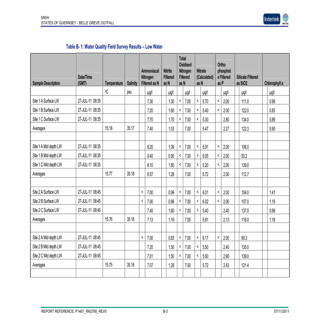
MWHSTATES OF GUERNSEY - BELLE GREVE OUTFALL
REPORT REFERENCE: P1467_RN2780_REV0 B-3 07/11/2011
Table B- 1: Water Quality Field Survey Results – Low Water
Sample DescriptionDate/Time(GMT) Temperature Salinity
AmmoniacalNitrogenFiltered as N
NitriteFilteredas N
TotalOxidisedNitrogenFilteredas N
Nitrate(Calculated)as N
Orthophosphate Filteredas P
Silicate Filteredas SiO2 Chlorophyll a
oC psu µg/l µg/l µg/l µg/l µg/l µg/l µg/lSite 1 A Surface LW 27-JUL-11 08:35 7.30 1.30 < 7.00 < 5.70 < 2.00 111.0 0.99Site 1 B Surface LW 27-JUL-11 08:35 7.20 1.60 < 7.00 < 5.40 < 2.00 122.0 0.83Site 1 C Surface LW 27-JUL-11 08:35 7.70 1.70 < 7.00 < 5.30 2.80 134.0 0.89Averages 15.18 35.17 7.40 1.53 7.00 5.47 2.27 122.3 0.90
Site 1 A Mid depth LW 27-JUL-11 08:35 8.20 1.09 < 7.00 < 5.91 < 2.00 106.0Site 1 B Mid depth LW 27-JUL-11 08:35 9.40 0.95 < 7.00 < 6.05 < 2.00 93.2Site 1 C Mid depth LW 27-JUL-11 08:35 8.10 1.80 < 7.00 < 5.20 < 2.00 139.0Averages 15.77 35.18 8.57 1.28 7.00 5.72 2.00 112.7
Site 2 A Surface LW 27-JUL-11 08:45 < 7.00 0.99 < 7.00 < 6.01 < 2.00 104.0 1.41Site 2 B Surface LW 27-JUL-11 08:45 < 7.00 0.98 < 7.00 < 6.02 < 2.00 107.0 1.15Site 2 C Surface LW 27-JUL-11 08:45 7.40 1.60 < 7.00 < 5.40 2.40 137.0 0.99Averages 15.76 35.18 7.13 1.19 7.00 5.81 2.13 116.0 1.18
Site 2 A Mid depth LW 27-JUL-11 08:45 < 7.00 0.83 < 7.00 < 6.17 < 2.00 90.3Site 2 B Mid depth LW 27-JUL-11 08:45 7.20 1.50 < 7.00 < 5.50 2.40 135.0Site 2 C Mid depth LW 27-JUL-11 08:45 7.01 1.50 < 7.00 < 5.50 2.90 139.0Averages 15.75 35.18 7.07 1.28 7.00 5.72 2.43 121.4

MWHSTATES OF GUERNSEY - BELLE GREVE OUTFALL
REPORT REFERENCE: P1467_RN2780_REV0 B-4 07/11/2011
Site 3 A Surface LW 27-JUL-11 08:55 29.40 1.40 < 7.00 < 5.60 4.00 125.0 1.36Site 3 B Surface LW 27-JUL-11 08:55 34.60 1.80 < 7.00 < 5.20 5.40 138.0 1.04Site 3 C Surface LW 27-JUL-11 08:55 34.80 1.90 < 7.00 < 5.10 4.70 145.0 1.04Averages 15.72 35.16 32.93 1.70 7.00 5.30 4.70 136.0 1.15
Site 3 A Mid depth LW 27-JUL-11 08:55 20.20 1.96 9.10 7.14 3.70 144.0Site 3 B Mid depth LW 27-JUL-11 08:55 21.50 1.60 8.00 6.40 2.80 122.0Site 3 C Mid depth LW 27-JUL-11 08:55 17.00 1.70 7.70 6.00 3.40 124.0Averages 15.60 35.17 19.57 1.75 8.27 6.51 3.30 130.0
Site 4 A Surface LW 27-JUL-11 09:06 < 7.00 1.30 < 7.00 < 5.70 < 2.00 101.0 0.99Site 4 B Surface LW 27-JUL-11 09:06 < 7.00 1.01 < 7.00 < 5.99 < 2.00 93.2 0.83Site 4 C Surface LW 27-JUL-11 09:06 8.20 1.90 8.90 7.00 2.70 131.0 0.89Averages 15.57 35.18 7.40 1.40 7.63 6.23 2.23 108.4 0.90
Site 4 A Mid depth LW 27-JUL-11 09:06 10.30 2.07 9.60 7.53 2.80 131.0Site 4 B Mid depth LW 27-JUL-11 09:06 10.50 1.80 9.20 7.40 3.50 125.0Site 4 C Mid depth LW 27-JUL-11 09:06 11.50 2.08 10.00 7.92 3.06 135.0Averages 15.51 35.18 10.77 1.98 9.60 7.62 3.12 130.3
Site 5 A Surface LW 27-JUL-11 09:20 7.50 1.20 < 7.00 < 5.80 2.20 91.1 0.73Site 5 B Surface LW 27-JUL-11 09:20 9.70 2.10 9.70 7.60 2.90 131.0 0.57Site 5 C Surface LW 27-JUL-11 09:20 < 7.00 0.92 < 7.00 < 6.08 < 2.00 76.3 0.68Averages 15.47 35.18 8.07 1.41 7.90 6.49 2.37 99.5 0.66
Site 5 A Mid depth LW 27-JUL-11 09:20 10.10 1.70 8.90 7.20 3.00 117.0
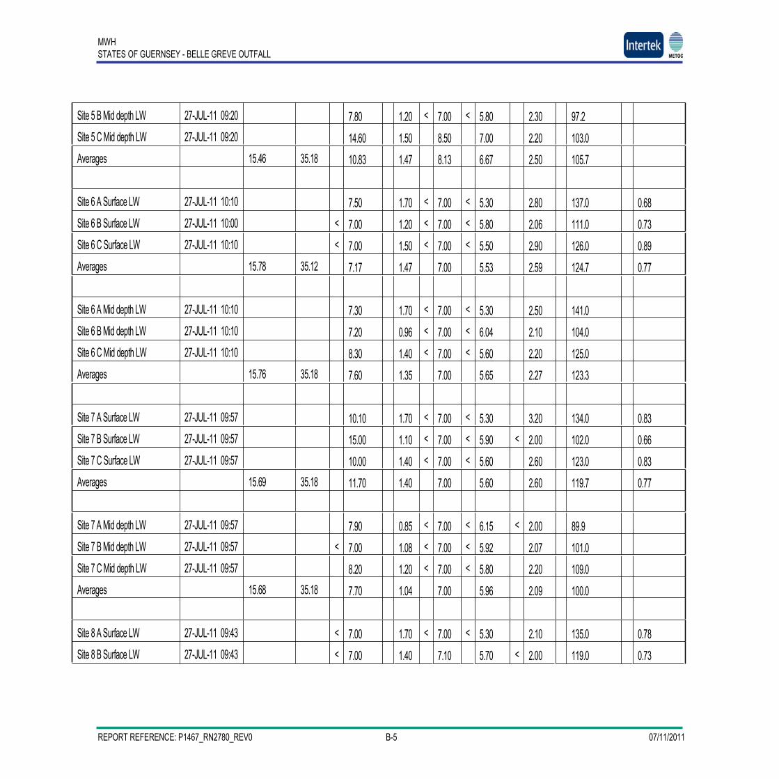
MWHSTATES OF GUERNSEY - BELLE GREVE OUTFALL
REPORT REFERENCE: P1467_RN2780_REV0 B-5 07/11/2011
Site 5 B Mid depth LW 27-JUL-11 09:20 7.80 1.20 < 7.00 < 5.80 2.30 97.2Site 5 C Mid depth LW 27-JUL-11 09:20 14.60 1.50 8.50 7.00 2.20 103.0Averages 15.46 35.18 10.83 1.47 8.13 6.67 2.50 105.7
Site 6 A Surface LW 27-JUL-11 10:10 7.50 1.70 < 7.00 < 5.30 2.80 137.0 0.68Site 6 B Surface LW 27-JUL-11 10:00 < 7.00 1.20 < 7.00 < 5.80 2.06 111.0 0.73Site 6 C Surface LW 27-JUL-11 10:10 < 7.00 1.50 < 7.00 < 5.50 2.90 126.0 0.89Averages 15.78 35.12 7.17 1.47 7.00 5.53 2.59 124.7 0.77
Site 6 A Mid depth LW 27-JUL-11 10:10 7.30 1.70 < 7.00 < 5.30 2.50 141.0Site 6 B Mid depth LW 27-JUL-11 10:10 7.20 0.96 < 7.00 < 6.04 2.10 104.0Site 6 C Mid depth LW 27-JUL-11 10:10 8.30 1.40 < 7.00 < 5.60 2.20 125.0Averages 15.76 35.18 7.60 1.35 7.00 5.65 2.27 123.3
Site 7 A Surface LW 27-JUL-11 09:57 10.10 1.70 < 7.00 < 5.30 3.20 134.0 0.83Site 7 B Surface LW 27-JUL-11 09:57 15.00 1.10 < 7.00 < 5.90 < 2.00 102.0 0.66Site 7 C Surface LW 27-JUL-11 09:57 10.00 1.40 < 7.00 < 5.60 2.60 123.0 0.83Averages 15.69 35.18 11.70 1.40 7.00 5.60 2.60 119.7 0.77
Site 7 A Mid depth LW 27-JUL-11 09:57 7.90 0.85 < 7.00 < 6.15 < 2.00 89.9Site 7 B Mid depth LW 27-JUL-11 09:57 < 7.00 1.08 < 7.00 < 5.92 2.07 101.0Site 7 C Mid depth LW 27-JUL-11 09:57 8.20 1.20 < 7.00 < 5.80 2.20 109.0Averages 15.68 35.18 7.70 1.04 7.00 5.96 2.09 100.0
Site 8 A Surface LW 27-JUL-11 09:43 < 7.00 1.70 < 7.00 < 5.30 2.10 135.0 0.78Site 8 B Surface LW 27-JUL-11 09:43 < 7.00 1.40 7.10 5.70 < 2.00 119.0 0.73
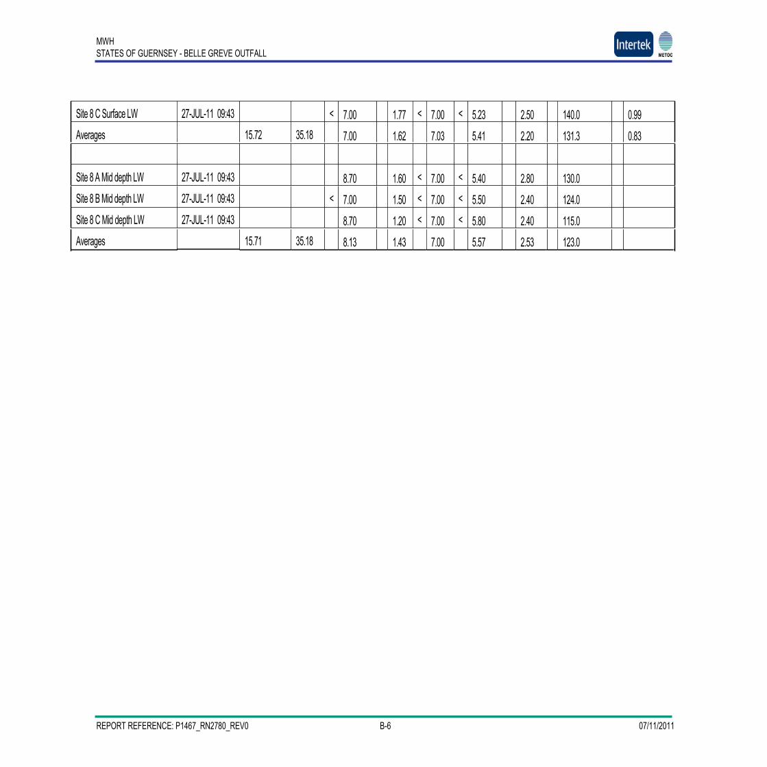
MWHSTATES OF GUERNSEY - BELLE GREVE OUTFALL
REPORT REFERENCE: P1467_RN2780_REV0 B-6 07/11/2011
Site 8 C Surface LW 27-JUL-11 09:43 < 7.00 1.77 < 7.00 < 5.23 2.50 140.0 0.99Averages 15.72 35.18 7.00 1.62 7.03 5.41 2.20 131.3 0.83
Site 8 A Mid depth LW 27-JUL-11 09:43 8.70 1.60 < 7.00 < 5.40 2.80 130.0Site 8 B Mid depth LW 27-JUL-11 09:43 < 7.00 1.50 < 7.00 < 5.50 2.40 124.0Site 8 C Mid depth LW 27-JUL-11 09:43 8.70 1.20 < 7.00 < 5.80 2.40 115.0Averages 15.71 35.18 8.13 1.43 7.00 5.57 2.53 123.0

MWHSTATES OF GUERNSEY - BELLE GREVE OUTFALL
REPORT REFERENCE: P1467_RN2780_REV0 B-7 07/11/2011
Table B- 2: Water Quality Field Survey Results – Mid Flood
Eastings Northings Sample_Description Date_Time_(GMT) Temperature Salinity Ammon Nitrite TON Nitrate Orthophos Silicate Chlor534539.9 5479150 Site_1_Av_Surface_MF 27-JUL-11__11:40 15.968 35.181 8.343333 1.456667 7 5.543333 2.933333 137 0.973333534539.9 5479150 Site_1_Av_Mid_depth_MF 27-JUL-11__11:40 15.83 35.18 7.17 1.19 7.00 5.81 2.10 118.7534607.5 5478955 Site_2_Av_Surface_MF 27-JUL-11__11:50 16.01 35.18 7.00 1.18 7.00 5.82 2.20 118.3 0.90534607.5 5478955 Site_2_Av_Mid_depth_MF 27-JUL-11__11:50 15.85 35.17 20.70 1.46 10.87 9.41 3.27 117.9534839.3 5478285 Site_3_Av_Surface_MF 27-JUL-11__12:00 15.95 35.20 7.00 1.53 7.00 5.47 2.63 136.0 0.90534839.3 5478285 Site_3_Av_Mid_depth_MF 27-JUL-11__12:00 15.83 35.18 7.29 1.37 7.00 5.63 2.63 131.0535179.2 5477302 Site_4_Av_Surface_MF 27-JUL-11__12:21 15.87 35.18 7.00 1.80 7.00 5.20 2.73 144.3 0.89535179.2 5477302 Site_4_Av_Mid_depth_MF 27-JUL-11__12:21 15.78 35.17 9.60 1.25 7.00 5.75 2.55 118.0535510.5 5476345 Site__5_Av_Surface_MF 27-JUL-11__12:30 15.81 35.19 7.00 1.34 7.00 5.66 2.16 117.0 0.79535510.5 5476345 Site_5_Av_Mid_depth_MF 27-JUL-11__12:30 15.75 35.18 7.00 3.17 7.00 3.83 2.09 101.5535405.3 5479449 Site_6_Av_Surface_MF 27-JUL-11__13:18 15.93 35.18 7.00 1.03 7.00 5.97 2.17 111.7 0.92535405.3 5479449 Site_6_Av_Mid_Depth_MF 27-JUL-11__13:18 15.89 35.18 8.20 1.39 7.00 5.61 3.30 122.4536385.2 5479788 Site_7_Av_Surface_MF 27-JUL-11__13:07 15.82 35.18 7.34 1.27 7.00 5.73 2.67 105.5 0.95536385.2 5479788 Site_7_Av_Mid_Depth_MF 27-JUL-11__13:07 15.80 35.18 7.00 1.15 7.00 5.85 2.07 97.3537343.1 5480120 Site_8_Av_Surface_MF 27-JUL-11__12:52 15.86 35.18 7.00 1.14 7.00 5.86 2.43 104.3 1.03537343.1 5480120 Site_8_Av_Mid_Depth_MF 27-JUL-11__12:52 15.82 35.18 7.03 1.67 7.00 5.33 2.93 135.3

MWHSTATES OF GUERNSEY - BELLE GREVE OUTFALL
REPORT REFERENCE: P1467_RN2780_REV0 B-8 07/11/2011
Table B- 3: Water Quality Field Survey Results – High Water
Eastings Northings Sample_Description Date_Time_(GMT) Temperature Salinity Ammon Nitrite TON Nitrate Orthophos Silicate Chlor534539.9 5479150 Site_1_Av_Surface_HW 27-JUL-11__14:45 15.994 35.19332 7.633333 1.3 7 5.7 2.4 115.9333 1.13534539.9 5479150 Site_1_Av_Mid_depth_HW 27-JUL-11__14:45 15.866 35.17267 7.833333 1.226667 7 5.773333 2.233333 109.3333534607.5 5478955 Site_2_Av_Surface_HW 27-JUL-11__14:55 16.02 35.17146 7.733333 1.263333 7 5.736667 2.316667 112.6333 1.13534607.5 5478955 Site_2_Av_Mid_depth_HW 27-JUL-11__14:55 15.851 35.17345 20.7 1.456667 10.86667 9.41 3.266667 117.9333534839.3 5478285 Site_3_Av_Surface_HW 27-JUL-11__15:07 15.9463133 35.17836 14.21667 1.36 8.933333 7.573333 2.791667 115.2833 1.13534839.3 5478285 Site_3_Av_Mid_depth_HW 27-JUL-11__15:07 15.8425743 35.17476 7.666667 1.416667 7 5.583333 2.4 114.5535179.2 5477302 Site_4_Av_Surface_HW 27-JUL-11__15:20 16.0373486 35.18012 10.94167 1.388333 7.966667 6.578333 2.595833 114.8917 1.13535179.2 5477302 Site_4_Av_Mid_depth_HW 27-JUL-11__15:20 15.7701737 35.17702 9.304167 1.4025 7.483333 6.080833 2.497917 114.6958535510.5 5476345 Site_5_Av_Surface_HW 27-JUL-11__15:33 15.5231985 35.18519 11.83333 1.766667 9.566667 7.8 2.733333 122.6667 0.66535510.5 5476345 Site_5_Av_Mid_depth_HW 27-JUL-11__15:33 15.5129276 35.17958 10.56875 1.584583 8.525 6.940417 2.615625 118.6813535405.3 5479449 Site_6_Av_Surface_HW 27-JUL-11__16:18 15.8115507 35.1783 11.20104 1.675625 9.045833 7.370208 2.674479 120.674 0.66535405.3 5479449 Site_6_Av_Mid_Depth_HW 27-JUL-11__16:18 15.7827413 35.17798 10.8849 1.630104 8.785417 7.155313 2.645052 119.6776536385.2 5479788 Site_7_Av_Surface_HW 27-JUL-11__16:03 16.0641561 35.1784 11.04297 1.652865 8.915625 7.26276 2.659766 120.1758 0.66536385.2 5479788 Site_7_Av_Mid_Depth_HW 27-JUL-11__16:03 15.7505367 35.179 10.96393 1.641484 8.850521 7.209036 2.652409 119.9267537343.1 5480120 Site_8_Av_Surface_HW 27-JUL-11__12:52 15.5062315 35.18784 11.00345 1.647174 8.883073 7.235898 2.656087 120.0512 0.66537343.1 5480120 Site_8_Av_Mid_Depth_HW 27-JUL-11__12:52 15.5007507 35.1806 10.98369 1.644329 8.866797 7.222467 2.654248 119.989

MWHSTATES OF GUERNSEY - BELLE GREVE OUTFALL
REPORT REFERENCE: P1467_RN2780_REV0 B-9 07/11/2011
Table B- 4: Water Quality Field Survey Results – Mid Ebb
Eastings Northings Sample_Description Date_Time_(GMT) Temperature Salinity Ammon Nitrite TON Nitrate Orthophos Silicate Chlor534539.9 5479150 Site_1_Av_Surface_ME 27-JUL-11__05:23 15.07 35.17 7.00 1.43 7.00 5.57 2.27 132.33 1.07534539.9 5479150 Site_1__Av_Mid_depth_ME 27-JUL-11__05:23 15.77 35.17 8.67 1.41 7.20 5.79 2.03 132.00534607.5 5478955 Site_2_Av_Surface_ME 27-JUL-11__05:45 15.81 35.18 123.57 2.13 14.03 11.90 2.10 142.33 0.89534607.5 5478955 Site_2_Av_Mid_depth_ME 27-JUL-11__05:45 15.78 35.18 7.20 1.43 7.00 5.57 2.10 131.67534839.3 5478285 Site_3_Av_Surface_ME 27-JUL-11__05:57 15.78 35.17 7.00 1.40 7.00 5.60 2.00 130.3 1.06534839.3 5478285 Site_3_Av_Mid_depth_ME 27-JUL-11__05:57 15.50 35.18 7.10 1.45 7.00 5.55 2.23 121.2535179.2 5477302 Site_4_Av_Surface_ME 27-JUL-11__06:12 15.48 35.18 10.13 2.09 10.73 8.64 3.03 132.00 0.75535179.2 5477302 Site_4_Av_Mid_depth_ME 27-JUL-11__06:12 15.48 35.18 9.43 1.67 9.73 8.07 2.37 113.00535510.5 5476345 Site_5_Av_Surface_ME 27-JUL-11__06:24 15.45 35.18 8.03 1.53 8.00 6.47 2.20 100.93 0.80535510.5 5476345 Site_5_Av_Mid_depth_ME 27-JUL-11__06:24 15.45 35.18 9.20 1.72 8.64 6.92 3.04 111.70535405.3 5479449 Site_6_Av_Surface_ME 27-JUL-11__07:06 15.68 35.01 177.33 3.10 7.97 4.87 19.83 187.7 0.97535405.3 5479449 Site_6_Av_Mid_depth_ME 27-JUL-11__07:06 15.57 35.17 12.20 1.84 8.17 6.32 3.30 125.7536385.2 5479788 Site_7_Av_Surface_ME 27-JUL-11__06:54 15.52 35.18 11.23 1.79 8.97 7.18 2.25 113.00 0.88536385.2 5479788 Site_7_Av_Mid_depth_ME 27-JUL-11__06:54 15.46 35.18 10.60 1.27 7.73 6.47 2.01 90.40537343.1 5480120 Site_8_Av_Surface_ME 27-JUL-11__06:42 15.46 35.18 22.97 1.63 9.50 7.87 2.00 109.07 0.85537343.1 5480120 Site_8_Av_Mid_depth_ME 27-JUL-11__06:42 15.46 35.18 14.13 1.83 9.60 7.77 2.43 116.53

MWHSTATES OF GUERNSEY - BELLE GREVE OUTFALL
REPORT REFERENCE: P1467_RN2780_REV0 C-10 07/11/2011
Appendix C Zone A Model Results
MWHSTATES OF GUERNSEY - BELLE GREVE OUTFALL
REPORT REFERENCE: P1467_RN2780_REV0 C-11 07/11/2011
FIGURESFIGURE C- 1: TIME SERIES PLOT OF CALCULATED SUSPENDED SOLIDS CONCENTRATIONS CLOSE
TO BELLE GREVE OUTFALL ......................................................................................... C-12FIGURE C- 2: TIME SERIES PLOT OF CALCULATED BOD CONCENTRATIONS CLOSE TO BELLE
GREVE OUTFALL......................................................................................................... C-12FIGURE C- 3: TIME SERIES PLOT OF CALCULATED AMMONIA CONCENTRATIONS CLOSE TO BELLE
GREVE OUTFALL........................................................................................................... C-1FIGURE C- 4: TIME SERIES PLOT OF CALCULATED SUSPENDED SOLIDS CONCENTRATIONS CLOSE
TO BELLE GREVE OUTFALL ........................................................................................... C-1FIGURE C- 5: TIME SERIES PLOT OF CALCULATED BOD CONCENTRATIONS CLOSE TO BELLE
GREVE OUTFALL........................................................................................................... C-2FIGURE C- 6: TIME SERIES PLOT OF CALCULATED AMMONIA CONCENTRATIONS CLOSE TO BELLE
GREVE OUTFALL........................................................................................................... C-2

MWHSTATES OF GUERNSEY - BELLE GREVE OUTFALL
REPORT REFERENCE: P1467_RN2780_REV0 C-12 07/11/2011
0
2
4
6
8
10
12
14
16
27/12/2009 00:00 29/12/2009 00:00 31/12/2009 00:00 02/01/2010 00:00 04/01/2010 00:00 06/01/2010 00:00 08/01/2010 00:00
Conc
entra
tion
(mg/l
)Modelled Suspended Solids Concentrations Zone A
0
2
4
6
8
10
12
27/12/2009 00:00 29/12/2009 00:00 31/12/2009 00:00 02/01/2010 00:00 04/01/2010 00:00 06/01/2010 00:00 08/01/2010 00:00
Conc
entra
tion
(mg/l
)
Modelled BOD Concentrations Zone A
Figure C- 1: Time series plot of calculated Suspended Solids concentrations closeto Belle Greve outfall
Figure C- 2: Time series plot of calculated BOD concentrations close to Belle Greveoutfall
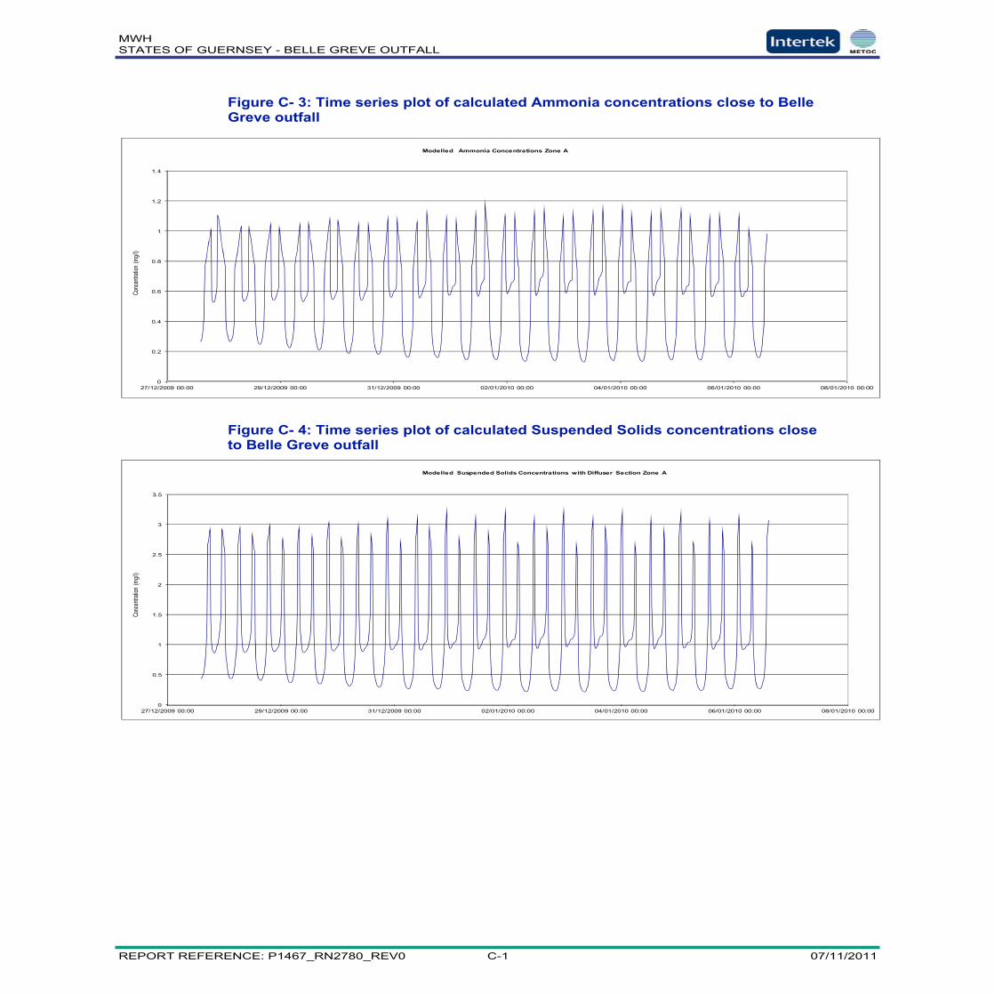
MWHSTATES OF GUERNSEY - BELLE GREVE OUTFALL
REPORT REFERENCE: P1467_RN2780_REV0 C-1 07/11/2011
0
0.2
0.4
0.6
0.8
1
1.2
1.4
27/12/2009 00:00 29/12/2009 00:00 31/12/2009 00:00 02/01/2010 00:00 04/01/2010 00:00 06/01/2010 00:00 08/01/2010 00:00
Conc
entra
tion
(mg/l
)
Modelled Ammonia Concentrations Zone A
0
0.5
1
1.5
2
2.5
3
3.5
27/12/2009 00:00 29/12/2009 00:00 31/12/2009 00:00 02/01/2010 00:00 04/01/2010 00:00 06/01/2010 00:00 08/01/2010 00:00
Conc
entra
tion
(mg/l
)
Modelled Suspended Solids Concentrations with Diffuser Section Zone A
Figure C- 3: Time series plot of calculated Ammonia concentrations close to BelleGreve outfall
Figure C- 4: Time series plot of calculated Suspended Solids concentrations closeto Belle Greve outfall
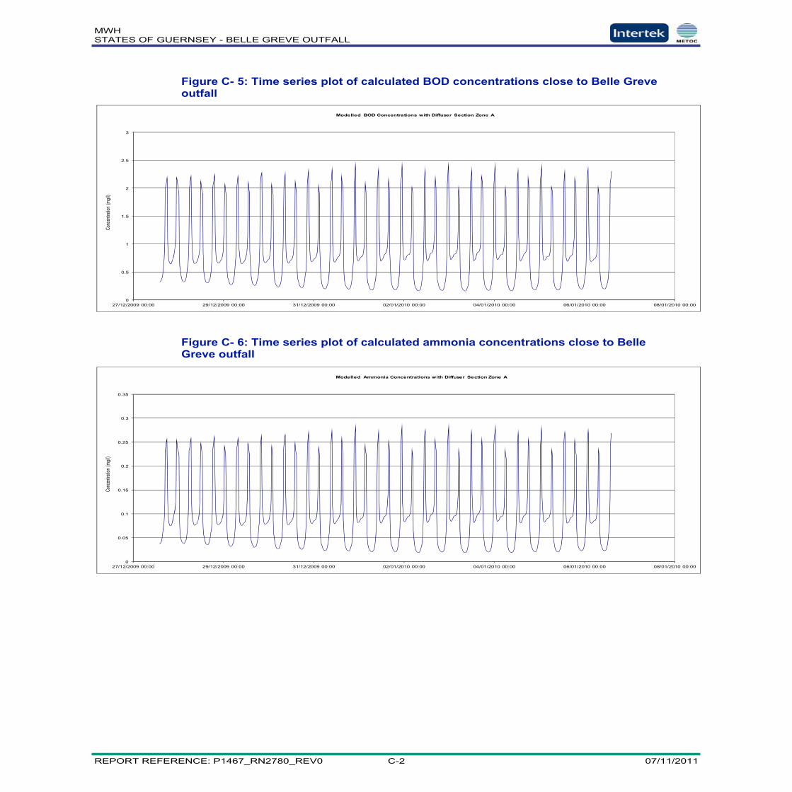
MWHSTATES OF GUERNSEY - BELLE GREVE OUTFALL
REPORT REFERENCE: P1467_RN2780_REV0 C-2 07/11/2011
0
0.5
1
1.5
2
2.5
3
27/12/2009 00:00 29/12/2009 00:00 31/12/2009 00:00 02/01/2010 00:00 04/01/2010 00:00 06/01/2010 00:00 08/01/2010 00:00
Conc
entra
tion
(mg/l
)Modelled BOD Concentrations with Diffuser Section Zone A
0
0.05
0.1
0.15
0.2
0.25
0.3
0.35
27/12/2009 00:00 29/12/2009 00:00 31/12/2009 00:00 02/01/2010 00:00 04/01/2010 00:00 06/01/2010 00:00 08/01/2010 00:00
Conc
entra
tion
(mg/l
)
Modelled Ammonia Concentrations with Diffuser Section Zone A
Figure C- 5: Time series plot of calculated BOD concentrations close to Belle Greveoutfall
Figure C- 6: Time series plot of calculated ammonia concentrations close to BelleGreve outfall

MWHSTATES OF GUERNSEY - BELLE GREVE OUTFALL
REPORT REFERENCE: P1467_RN2780_REV0 D-1 07/11/2011
Appendix D Brief Overview of the Model Calibrationand Validation
MWHSTATES OF GUERNSEY - BELLE GREVE OUTFALL
REPORT REFERENCE: P1467_RN2780_REV0 D-2 07/11/2011
FIGURESFIGURE D- 1: MEASURED AND MODELLED TIDAL ELEVATIONS SITE H1. ................................ D-3FIGURE D- 2: MEASURED AND MODELLED TIDAL ELEVATIONS SITE H2. ................................ D-3FIGURE D- 3: MEASURED AND MODELLED TIDAL ELEVATIONS SITE H3. ................................ D-3FIGURE D- 4: MEASURED AND MODELLED CURRENT SPEEDS SITE H1 ................................. D-4FIGURE D- 5: MEASURED AND MODELLED CURRENT SPEEDS SITE H2. ................................ D-4FIGURE D- 6: MEASURED AND MODELLED CURRENT SPEEDS SITE H3. ................................ D-4FIGURE D- 7: MEASURED AND MODELLED CURRENT DIRECTIONS SITE H1. .......................... D-5FIGURE D- 8: MEASURED AND MODELLED CURRENT DIRECTIONS SITE H2 ........................... D-5FIGURE D- 9: MEASURED AND MODELLED CURRENT DIRECTIONS SITE H3 ........................... D-5

MWHSTATES OF GUERNSEY - BELLE GREVE OUTFALL
REPORT REFERENCE: P1467_RN2780_REV0 D-3 07/11/2011
-5-4-3-2-1012345
28/12/2009 00:00 30/12/2009 00:00 01/01/2010 00:00 03/01/2010 00:00 05/01/2010 00:00
Modelled Re-Predicted
-4
-3
-2
-1
0
1
2
3
4
28/12/2009 00:00 30/12/2009 00:00 01/01/2010 00:00 03/01/2010 00:00 05/01/2010 00:00
Modelled Re-Predicted
-5-4-3-2-1012345
28/12/2009 00:00 30/12/2009 00:00 01/01/2010 00:00 03/01/2010 00:00 05/01/2010 00:00
Modelled Re-Predicted
Figure D- 1: Measured and Modelled Tidal Elevations Site H1.
Figure D- 2: Measured and Modelled Tidal Elevations Site H2.
Figure D- 3: Measured and Modelled Tidal Elevations Site H3.

MWHSTATES OF GUERNSEY - BELLE GREVE OUTFALL
REPORT REFERENCE: P1467_RN2780_REV0 D-4 07/11/2011
0
0.1
0.2
0.3
0.4
0.5
0.6
0.7
0.8
0.9
1
28/12/2009 00:00 30/12/2009 00:00 01/01/2010 00:00 03/01/2010 00:00 05/01/2010 00:00
Modelled Re-predicted
00.1
0.20.30.40.50.60.70.80.9
1
28/12/2009 00:00 30/12/2009 00:00 01/01/2010 00:00 03/01/2010 00:00 05/01/2010 00:00
Modelled Re-predicted
0
0.2
0.4
0.6
0.8
1
1.2
28/12/2009 00:00 30/12/2009 00:00 01/01/2010 00:00 03/01/2010 00:00 05/01/2010 00:00
Modelled Re-predicted
Figure D- 4: Measured and Modelled Current Speeds Site H1
Figure D- 5: Measured and Modelled Current Speeds Site H2.
Figure D- 6: Measured and Modelled Current Speeds Site H3.

MWHSTATES OF GUERNSEY - BELLE GREVE OUTFALL
REPORT REFERENCE: P1467_RN2780_REV0 D-5 07/11/2011
0
60
120
180
240
300
360
28/12/2009 00:00 30/12/2009 00:00 01/01/2010 00:00 03/01/2010 00:00 05/01/2010 00:00
Modelled Re-predicted
0
60
120
180
240
300
360
28/12/2009 00:00 30/12/2009 00:00 01/01/2010 00:00 03/01/2010 00:00 05/01/2010 00:00
Modelled Re-predicted
0
60
120
180
240
300
360
28/12/2009 00:00 30/12/2009 00:00 01/01/2010 00:00 03/01/2010 00:00 05/01/2010 00:00
Modelled Re-predicted
Figure D- 7: Measured and Modelled Current Directions Site H1.
Figure D- 8: Measured and Modelled Current Directions Site H2
Figure D- 9: Measured and Modelled Current Directions Site H3

MWHSTATES OF GUERNSEY - BELLE GREVE OUTFALL
REPORT REFERENCE: P1467_RN2780_REV0 E-1 07/11/2011
Appendix E Nutrient Modelling Results

MWHSTATES OF GUERNSEY - BELLE GREVE OUTFALL
REPORT REFERENCE: P1467_RN2780_REV0 E-1 07/11/2011
FIGURESFIGURE E- 1: MAXIMUM MODELLED DAIN CONCENTRATIONS ...............................................E-2FIGURE E- 3: MAXIMUM MODELLED DAIP CONCENTRATIONS................................................E-2

MWHSTATES OF GUERNSEY - BELLE GREVE OUTFALL
REPORT REFERENCE: P1467_RN2780_REV0 E-2 07/11/2011
Figure E- 1: Maximum Modelled DAIN Concentrations
Figure E- 2: Maximum Modelled DAIP Concentrations

MWHSTATES OF GUERNSEY - BELLE GREVE OUTFALL
REPORT REFERENCE: P1467_RN2780_REV0 F-1 07/11/2011
Appendix F Modelled Bacterial ConcentrationsResulting from Belle Greve Outfall

MWHSTATES OF GUERNSEY - BELLE GREVE OUTFALL
REPORT REFERENCE: P1467_RN2780_REV0 F-2 07/11/2011
FIGURESFIGURE F- 1: TIME SERIES PLOT FAECAL COLIFORMS RESULTING FROM BELLE GREVE OUTFALL
– CALM CONDITIONS ..................................................................................................... F-3FIGURE F- 3: TIME SERIES PLOT FAECAL COLIFORMS RESULTING FROM BELLE GREVE OUTFALL
– WIND CONDITIONS 5M/S FROM NORTH........................................................................ F-3FIGURE F- 4: TIME SERIES PLOT FAECAL COLIFORMS RESULTING FROM BELLE GREVE OUTFALL
– WIND CONDITIONS 5M/S FROM NORTH EAST ............................................................... F-4FIGURE F- 5: TIME SERIES PLOT FAECAL COLIFORMS RESULTING FROM BELLE GREVE OUTFALL
– WIND CONDITIONS 5M/S FROM SOUTH EAST ............................................................... F-4FIGURE F- 6: TIME SERIES PLOT FAECAL COLIFORMS RESULTING FROM BELLE GREVE OUTFALL
– WIND CONDITIONS 5M/S FROM SOUTH ........................................................................ F-5FIGURE F- 7: TIME SERIES PLOT FAECAL COLIFORMS RESULTING FROM BELLE GREVE OUTFALL
– WIND CONDITIONS 5M/S FROM SOUTH WEST .............................................................. F-5FIGURE F- 8: TIME SERIES PLOT FAECAL COLIFORMS RESULTING FROM BELLE GREVE OUTFALL
– WIND CONDITIONS 5M/S FROM NORTH WEST.............................................................. F-6FIGURE F- 9: MAXIMUM CONCENTRATION PLOT FAECAL COLIFORMS RESULTING FROM BELLE
GREVE OUTFALL – CALM CONDITIONS ........................................................................... F-6FIGURE F- 10: TIME SERIES PLOT FAECAL STREPTOCOCCI RESULTING FROM BELLE GREVE
OUTFALL – CALM CONDITIONS....................................................................................... F-7FIGURE F- 11: TIME SERIES PLOT FAECAL STREPTOCOCCI RESULTING FROM BELLE GREVE
OUTFALL – WIND CONDITIONS 5M/S FROM NORTH ......................................................... F-7FIGURE F- 12: TIME SERIES PLOT FAECAL STREPTOCOCCI RESULTING FROM BELLE GREVE
OUTFALL – WIND CONDITIONS 5M/S FROM NORTH EAST ................................................ F-8FIGURE F- 13: TIME SERIES PLOT FAECAL STREPTOCOCCI RESULTING FROM BELLE GREVE
OUTFALL – WIND CONDITIONS 5M/S FROM SOUTH EAST................................................. F-8FIGURE F- 14: TIME SERIES PLOT FAECAL STREPTOCOCCI RESULTING FROM BELLE GREVE
OUTFALL – WIND CONDITIONS 5M/S FROM SOUTH.......................................................... F-9FIGURE F- 15: TIME SERIES PLOT FAECAL STREPTOCOCCI RESULTING FROM BELLE GREVE
OUTFALL – WIND CONDITIONS 5M/S FROM SOUTH WEST................................................ F-9FIGURE F- 16: TIME SERIES PLOT FAECAL STREPTOCOCCI RESULTING FROM BELLE GREVE
OUTFALL – WIND CONDITIONS 5M/S FROM NORTH WEST ............................................. F-10FIGURE F- 17: MAXIMUM CONCENTRATION PLOT FAECAL STREPTOCOCCI RESULTING FROM
BELLE GREVE OUTFALL – CALM CONDITIONS............................................................... F-10

MWHSTATES OF GUERNSEY - BELLE GREVE OUTFALL
REPORT REFERENCE: P1467_RN2780_REV0 F-3 07/11/2011
0
10
20
30
40
50
60
70
80
90
100
29/12/2009 30/12/2009 31/12/2009 01/01/2010 02/01/2010 03/01/2010 04/01/2010 05/01/2010 06/01/2010 07/01/2010
Conc
(f c/d
l)Predicted Faecal Coliform Concentration Guernsey
Vazon
Cobo
LadiesBay
Pembroke
Bourdeaux
Havelet
Fermain
Saints
Petit Bot
Portlet
L'Eree
Grande Rocques
Port Soif
‐10
0
10
20
30
40
50
60
70
80
90
100
25/1
2/200
9
27/1
2/200
9
29/1
2/200
9
31/1
2/200
9
02/0
1/201
0
04/0
1/201
0
06/0
1/201
0
08/0
1/201
0
Conc
(fc/d
l)
Predicted Faecal Coliform Concentration Guernsey
Vazon
Cobo
Ladies Bay comp
Pembroken
Bourdeaux
Haveletne
Fermainne
Saintsnen
Petit Bot
Portletne
L'Ereenen
Grande Rocques
Port Soif
Figure F- 1: Time Series Plot Faecal Coliforms Resulting from Belle Greve Outfall –Calm Conditions
Figure F- 2: Time Series Plot Faecal Coliforms Resulting from Belle Greve Outfall –Wind Conditions 5m/s from North

MWHSTATES OF GUERNSEY - BELLE GREVE OUTFALL
REPORT REFERENCE: P1467_RN2780_REV0 F-4 07/11/2011
-100
102030405060708090
100
25/12
/2009
27/12
/2009
29/12
/2009
31/12
/2009
02/01
/2010
04/01
/2010
06/01
/2010
08/01
/2010
Conc
(fs/dl
)Predicted Faecal Coliform Concentration Guernsey
VazonCoboLadies BayPembrokenBourdeauxHaveletneFermainneSaintsnenPetit BotPortletneL'EreenenGrande RocquesPort Soif
-100
102030405060708090
100
25/12
/2009
27/12
/2009
29/12
/2009
31/12
/2009
02/01
/2010
04/01
/2010
06/01
/2010
08/01
/2010
Conc
(fc/dl
)
Predicted Faecal Coliform Concentration in Guernsey
VazonCoboLadies BayPembrokeonBourdeauxoHaveletoneFermainoneSaintsonenPetit BotoPortletoneL'EreeonenGrande RocquesPort Soifo
Figure F- 3: Time Series Plot Faecal Coliforms Resulting from Belle Greve Outfall –Wind Conditions 5m/s from North East
Figure F- 4: Time Series Plot Faecal Coliforms Resulting from Belle Greve Outfall –Wind Conditions 5m/s from South East

MWHSTATES OF GUERNSEY - BELLE GREVE OUTFALL
REPORT REFERENCE: P1467_RN2780_REV0 F-5 07/11/2011
0
10
20
30
40
50
60
70
80
90
100
25/12
/2009
27/12
/2009
29/12
/2009
31/12
/2009
02/01
/2010
04/01
/2010
06/01
/2010
08/01
/2010
Conc
(fc/dl
)Predicted Faecal Coliform Concentration in Guernsey
VazonCoboLadies BayPembrokeBourdeauxHaveleteFermaineSaintsPetit BotPortleteL'EreeGrande RocquesPort Soif
0102030405060708090
100
25/12
/2009
27/12
/2009
29/12
/2009
31/12
/2009
02/01
/2010
04/01
/2010
06/01
/2010
08/01
/2010
Conc
(fc/dl
)
Predicted Faecal Coliform Concentration in Guernsey
VazonCoboLadies BayPembrokeBourdeauxHaveletFermainSaintsnPetit BotPortletL'EreenGrande RocquesPort Soif
Figure F- 5: Time Series Plot Faecal Coliforms Resulting from Belle Greve Outfall –Wind Conditions 5m/s from South
Figure F- 6: Time Series Plot Faecal Coliforms Resulting from Belle Greve Outfall –Wind Conditions 5m/s from South West
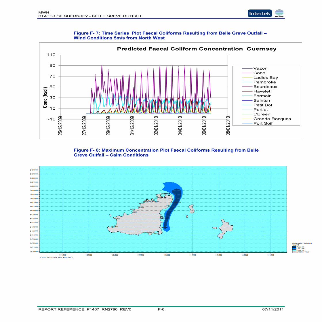
MWHSTATES OF GUERNSEY - BELLE GREVE OUTFALL
REPORT REFERENCE: P1467_RN2780_REV0 F-6 07/11/2011
-10
10
30
50
70
90
11025
/12/20
09
27/12
/2009
29/12
/2009
31/12
/2009
02/01
/2010
04/01
/2010
06/01
/2010
08/01
/2010
Conc
(fc/dl
)Predicted Faecal Coliform Concentration Guernsey
VazonCoboLadies BayPembrokeBourdeauxHaveletFermainSaintsnPetit BotPortletL'EreenGrande RocquesPort Soif
Figure F- 7: Time Series Plot Faecal Coliforms Resulting from Belle Greve Outfall –Wind Conditions 5m/s from North West
Figure F- 8: Maximum Concentration Plot Faecal Coliforms Resulting from BelleGreve Outfall – Calm Conditions

MWHSTATES OF GUERNSEY - BELLE GREVE OUTFALL
REPORT REFERENCE: P1467_RN2780_REV0 F-7 07/11/2011
0
5
10
15
20
25
29/12
/2009
30/12
/2009
31/12
/2009
01/01
/2010
02/01
/2010
03/01
/2010
04/01
/2010
05/01
/2010
06/01
/2010
07/01
/2010
Conc
(fs/dl
)Predicted Faecal Streptococci Concentration Guernsey
Vazon
Cobo
LadiesBay
Pembroke
Bourdeaux
Havelet
Fermain
0
5
10
15
20
25
29/12
/2009
30/12
/2009
31/12
/2009
01/01
/2010
02/01
/2010
03/01
/2010
04/01
/2010
05/01
/2010
06/01
/2010
07/01
/2010
Conc
(fs/dl
)
Predicted Faecal Streptococci Concentration Guernsey
Vazon
Cobo
LadiesBay
Pembroke
Bourdeaux
Havelet
Fermain
Figure F- 9: Time Series Plot Faecal Streptococci Resulting from Belle GreveOutfall – Calm Conditions
Figure F- 10: Time Series Plot Faecal Streptococci Resulting from Belle GreveOutfall – Wind Conditions 5m/s from North
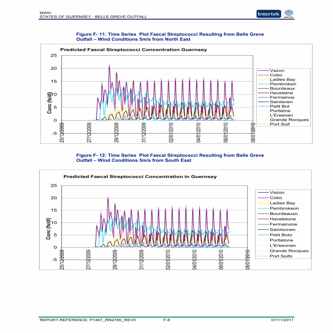
MWHSTATES OF GUERNSEY - BELLE GREVE OUTFALL
REPORT REFERENCE: P1467_RN2780_REV0 F-8 07/11/2011
-5
0
5
10
15
20
25
25/12
/2009
27/12
/2009
29/12
/2009
31/12
/2009
02/01
/2010
04/01
/2010
06/01
/2010
08/01
/2010
Conc
(fs/dl
)Predicted Faecal Streptococci Concentration Guernsey
VazonCoboLadies BayPembrokenBourdeauxHaveletneFermainneSaintsnenPetit BotPortletneL'EreenenGrande RocquesPort Soif
-5
0
5
10
15
20
25
25/12
/2009
27/12
/2009
29/12
/2009
31/12
/2009
02/01
/2010
04/01
/2010
06/01
/2010
08/01
/2010
Conc
(fs/dl
)
Predicted Faecal Streptococci Concentration in Guernsey
VazonCoboLadies BayPembrokeonBourdeauxoHaveletoneFermainoneSaintsonenPetit BotoPortletoneL'EreeonenGrande RocquesPort Soifo
Figure F- 11: Time Series Plot Faecal Streptococci Resulting from Belle GreveOutfall – Wind Conditions 5m/s from North East
Figure F- 12: Time Series Plot Faecal Streptococci Resulting from Belle GreveOutfall – Wind Conditions 5m/s from South East

MWHSTATES OF GUERNSEY - BELLE GREVE OUTFALL
REPORT REFERENCE: P1467_RN2780_REV0 F-9 07/11/2011
0
5
10
15
20
25
25/12
/2009
27/12
/2009
29/12
/2009
31/12
/2009
02/01
/2010
04/01
/2010
06/01
/2010
08/01
/2010
Conc
(fs/dl
)Predicted Faecal Streptococci Concentration in Guernsey
VazonCoboLadies BayPembrokeBourdeauxHaveleteFermaineSaintsPetit BotPortleteL'EreeGrande RocquesPort Soif
0
5
10
15
20
25
25/12
/2009
27/12
/2009
29/12
/2009
31/12
/2009
02/01
/2010
04/01
/2010
06/01
/2010
08/01
/2010
Conc
( fs/d
l)
Predicted Faecal Streptococci Concentration in Guernsey
VazonCoboLadies BayPembrokeBourdeauxHaveletFermainSaintsnPetit BotPortletL'EreenGrande RocquesPort Soif
Figure F- 13: Time Series Plot Faecal Streptococci Resulting from Belle GreveOutfall – Wind Conditions 5m/s from South
Figure F- 14: Time Series Plot Faecal Streptococci Resulting from Belle GreveOutfall – Wind Conditions 5m/s from South West

MWHSTATES OF GUERNSEY - BELLE GREVE OUTFALL
REPORT REFERENCE: P1467_RN2780_REV0 F-10 07/11/2011
-5
0
5
10
15
20
25
25/12
/2009
27/12
/2009
29/12
/2009
31/12
/2009
02/01
/2010
04/01
/2010
06/01
/2010
08/01
/2010
Conc
(fs/dl
)Predicted Faecal Streptococci Concentration Guernsey
VazonCoboLadies BayPembrokeBourdeauxHaveletFermainSaintsnPetit BotPortletL'EreenGrande RocquesPort Soif
Figure F- 15: Time Series Plot Faecal Streptococci Resulting from Belle GreveOutfall – Wind Conditions 5m/s from North West
Figure F- 16: Maximum Concentration Plot Faecal Streptococci Resulting from BelleGreve Outfall – Calm Conditions

MWHSTATES OF GUERNSEY - BELLE GREVE OUTFALL
REPORT REFERENCE: P1467_RN2780_REV0 G-1 07/11/2011
Appendix G Modelled Bacterial ConcentrationsResulting from Red Lion CSO

MWHSTATES OF GUERNSEY - BELLE GREVE OUTFALL
REPORT REFERENCE: P1467_RN2780_REV0 G-2 07/11/2011
0
2
4
6
8
10
12
27/12/2009 29/12/2009 31/12/2009 02/01/2010 04/01/2010 06/01/2010
Conc(fc/dl)
Predicted Faecal Coliform Concentration Guernsey Mid Flood Spring Red Lion Release
Vazon
Cobo
LadiesBay
Pembroke
Bourdeaux
Havelet
Fermain
Saints
PetitBot
Portlet
L'Eree
GrandeRocques
PortSoif
0
2
4
6
8
10
12
27/12/2009 29/12/2009 31/12/2009 02/01/2010 04/01/2010 06/01/2010
Conc(fc/dl)
Predicted Faecal Coliform Concentration Guernsey Mid Ebb Spring Red Lion Release
Vazon
Cobo
LadiesBay
Pembroke
Bourdeaux
Havelet
Fermain
Saints
Petit Bot
Portlet
L'Eree
GrandeRocques
PortSoif
Figure G- 1: Predicted Faecal Coliform Concentration Spring Mid Flood Red Lion
Figure G- 2: Predicted Faecal Coliform Concentration Spring Mid Ebb Red Lion

MWHSTATES OF GUERNSEY - BELLE GREVE OUTFALL
REPORT REFERENCE: P1467_RN2780_REV0 G-3 07/11/2011
0
2
4
6
8
10
12
27/12/2009 29/12/2009 31/12/2009 02/01/2010 04/01/2010 06/01/2010
Conc(fc/dl)
Predicted Faecal Coliform Concentration Guernsey High Water Spring Red Lion Release
Vazon
Cobo
LadiesBay
Pembroke
Bourdeaux
Havelet
Fermain
Saints
PetitBot
Portlet
L'Eree
GrandeRocques
Port Soif
0
0.2
0.4
0.6
0.8
1
1.2
1.4
1.6
27/12/2009 29/12/2009 31/12/2009 02/01/2010 04/01/2010 06/01/2010
Conc(fs/dl)
Predicted Faecal Streptococci Concentration Guernsey Mid Flood Spring Red Lion Release
Vazon
Cobo
LadiesBay
Pembroke
Bourdeaux
Havelet
Fermain
Saints
PetitBot
Portlet
L'Eree
GrandeRocques
PortSoif
Figure G- 3: Predicted Faecal Coliform Concentration Spring High Water Red Lion
Figure G- 4: Predicted Faecal Streptococci Concentration Spring Mid Flood RedLion
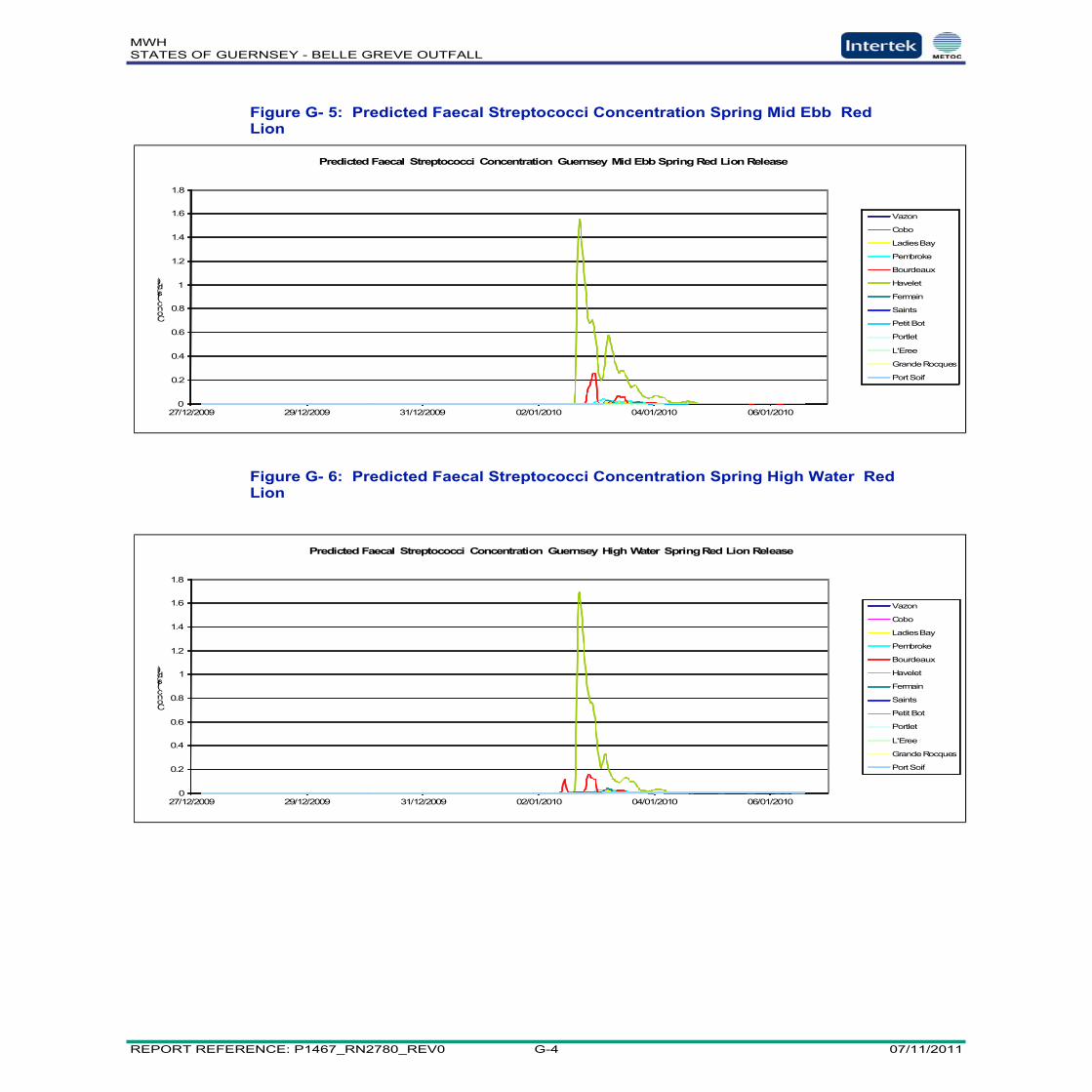
MWHSTATES OF GUERNSEY - BELLE GREVE OUTFALL
REPORT REFERENCE: P1467_RN2780_REV0 G-4 07/11/2011
0
0.2
0.4
0.6
0.8
1
1.2
1.4
1.6
1.8
27/12/2009 29/12/2009 31/12/2009 02/01/2010 04/01/2010 06/01/2010
Conc(fs/dl)
Predicted Faecal Streptococci Concentration Guernsey Mid Ebb Spring Red Lion Release
Vazon
Cobo
LadiesBay
Pembroke
Bourdeaux
Havelet
Fermain
Saints
PetitBot
Portlet
L'Eree
GrandeRocques
PortSoif
0
0.2
0.4
0.6
0.8
1
1.2
1.4
1.6
1.8
27/12/2009 29/12/2009 31/12/2009 02/01/2010 04/01/2010 06/01/2010
Conc(fs/dl)
Predicted Faecal Streptococci Concentration Guernsey High Water Spring Red Lion Release
Vazon
Cobo
LadiesBay
Pembroke
Bourdeaux
Havelet
Fermain
Saints
Petit Bot
Portlet
L'Eree
GrandeRocques
PortSoif
Figure G- 5: Predicted Faecal Streptococci Concentration Spring Mid Ebb RedLion
Figure G- 6: Predicted Faecal Streptococci Concentration Spring High Water RedLion