MUNICIPAL DISTRICT OF FOOTHILLS NO. 31 … HEARING PLANNING AND DEVELOPMENT DEPT. REPORT LAND USE...
69
MUNICIPAL DISTRICT OF FOOTHILLS NO. 31 January 31, 2018 Location: M.D. of Foothills Administration Office 309 Macleod Trail South – High River COUNCIL AGENDA A. GENERAL MATTERS 1. Call Meeting to Order 2. Approval of the Agenda as Distributed 3. Consideration of Additions to the Agenda 4. Minutes – January 24, 2018 5. Accounts – January 31, 2018 B. PUBLIC WORKS/ENGINEERING C. PUBLIC HEARINGS & MEETINGS Theresa Chipchase Pg. 3 10:00 a.m. *1. Jadick – NE 20-20-03 W5M – A to CR (1 lot) Pg. 15 10:30 a.m. *2. Smith & Reykdal – SE 29-21-28 W4M – Amend CR (1 lot) Drew Granson Pg. 33 11:00 a.m. *3. Williams – NW 15-21-29 W4M – CR to DC#27 (Major Home Occupation) 1:30 p.m. RCMP Meeting D. MISCELLANEOUS PLANNING ITEMS Pg. 42 *1. Chinook Valley Inc. / Xplornet Communications – NW 13-21-02 W5M (Telecommunications Tower) E. SUBDIVISION APPROVING AUTHORITY ITEMS Pg. 48 *1. Levoir – NW 32-21-28 W4M – Request for Time Extension Pg. 55 *2. Torrence / Baskin – W 19-17-28 W4M – Request for Boundary Adjustment Pg. 61 *3 Dahrouge / Purwins – SE 31-22-04 W5M – Request for Boundary Adjustment F. MISCELLANEOUS MUNICIPAL ITEMS
Transcript of MUNICIPAL DISTRICT OF FOOTHILLS NO. 31 … HEARING PLANNING AND DEVELOPMENT DEPT. REPORT LAND USE...

MUNICIPAL DISTRICT OF FOOTHILLS NO. 31 January 31, 2018
Location: M.D. of Foothills Administration Office 309 Macleod Trail South – High River
COUNCIL AGENDA
A. GENERAL MATTERS
1. Call Meeting to Order 2. Approval of the Agenda as Distributed 3. Consideration of Additions to the Agenda 4. Minutes – January 24, 2018 5. Accounts – January 31, 2018
B. PUBLIC WORKS/ENGINEERING C. PUBLIC HEARINGS & MEETINGS
Theresa Chipchase
Pg. 3 10:00 a.m. *1. Jadick – NE 20-20-03 W5M – A to CR (1 lot) Pg. 15 10:30 a.m. *2. Smith & Reykdal – SE 29-21-28 W4M – Amend CR (1 lot)
Drew Granson Pg. 33 11:00 a.m. *3. Williams – NW 15-21-29 W4M – CR to DC#27 (Major Home Occupation)
1:30 p.m. RCMP Meeting
D. MISCELLANEOUS PLANNING ITEMS Pg. 42 *1. Chinook Valley Inc. / Xplornet Communications – NW 13-21-02 W5M
(Telecommunications Tower)
E. SUBDIVISION APPROVING AUTHORITY ITEMS Pg. 48 *1. Levoir – NW 32-21-28 W4M – Request for Time Extension Pg. 55 *2. Torrence / Baskin – W 19-17-28 W4M – Request for Boundary Adjustment Pg. 61 *3 Dahrouge / Purwins – SE 31-22-04 W5M – Request for Boundary Adjustment
F. MISCELLANEOUS MUNICIPAL ITEMS

G. TABLED ITEMS
H. NEW BUSINESS 1. Committee Reports I. OTHER MATTERS 1. Adjourn 2. Next Meeting – February 7, 2017 at 9:00 am 3. January Accounts Review – Councillors: J. Parker, A. Alger and D. Miller

PUBLIC HEARING
PLANNING AND DEVELOPMENT DEPT. REPORT
LAND USE REDESIGNATION
January 31st, 2018 at 10:00 am
LANDOWNER: Carmen Jadick
AGENT: Planning Protocol 3 Inc./ Rodney Potrie
LEGAL DESCRIPTION: NE 20-20-03-W5M
DIVISION: #3 – Jason Parker
EXISTING PARCEL: 160.0 acres
EXISTING LAND USE: Agricultural District
NUMBER OF PROPOSED NEW PARCELS:
1 x 5.0+/- ac Country Residential lot
FILE MANAGER: Theresa Chipchase
PROPOSAL: Redesignation of a portion of the NE 20-20-03-W5M from the Agricultural Land Use District to the Country Residential Land Use District in order to permit the future subdivision of one 5.0+/- acre Country Residential parcel with a 155 +/- acre Agricultural balance.
LOCATION: The subject property is located approximately: Five and one half miles north west of Turner Valley Five miles south west of Millarville Three miles south of Highway 549 Two miles west of Highway 22 POLICY AREA: The proposal has been reviewed within the terms of the MDP2010, Growth Management Strategy and the Land Use Bylaw. QUARTER SECTION BACKGROUND INFORMATION: Physiography: The parcel contains diverse topography sloping from a plateau along the west boundary, toward the edge of a steep hillside which gives way to a steep embankment north west to south east through the middle of the quarter, with flat terrain in the north east corner. There is approximately 68 acres of grassland and 89 acres of dense tree cover consisting of poplar and fir trees. There are two small ponds along the east boundary both appear to be either spring fed or fed from the overland drainage off the embankment to the west. The larger pond including the outfall and some riparian lands would be approximately 3.1 acres and the smaller including the inlet and some riparian lands would be approximately 0.6 acres.
Page 3
sbarrett
C1

The proposed parcel would contain steep terrain, sloping from its highest point along the south boundary, north to its lowest. Thick groves of aspens line the west boundary of the proposed parcel with sporadic aspen and fir trees throughout the proposed lot. Those areas not covered in trees contain native grass species. 264th Street West: 264th Street West is a unique road surface. Currently completely encompassed within the applicant’s parcel, this is a private road not owned by the Municipality, which gives access to 6 properties within the adjacent quarter section to the west. This road is not surveyed out of the applicant’s property and although not owned by the Municipality, it is maintained by the Municipality. The Deputy Director and Director of Public Works and Engineering have provided that they are currently in negotiations with Mrs. Jadick (the applicant) to extend the same proposal to her as was extended to the previous landowner with regards to acquisition of the lands which contain the road, payment for those lands and survey of those lands as well as registration of a road plan. The landowner has proposed to provide a 30 meter wide road dedication over the area of land which encompasses the road surface. Access: Currently the parcel contains a field access along the east boundary, north of the small pond, this field access as well as the future access to the proposed parcel are adjacent to 256th Street West, which is a 20 meter wide rural collector road with a gravelled surface. There is a second approach to a small uninhabited cabin in the north west corner of the quarter at the intersection of 370th Avenue West and 264th Street West. This approach would not meet the municipal setback requirement to the intersection and if it is to remain would need to be reconstructed in an appropriate location to the satisfaction of the Public Works and Engineering department. 370th Avenue along the north boundary is partially developed at the eastern end for a length of 400 meters, in this location it is 20 meters wide and is a gravelled local low volume road, which is maintained by the Municipality. The remainder of 370th Avenue is undeveloped road allowance. No road widening has yet been acquired adjacent to either 370th Avenue or 256th Street, it would be suggested that widening be acquired as a condition of subdivision approval. Site Improvements: There is a small 661 square foot cabin on the property built in 1972. The municipality’s assessment department has provided that the cabin has depreciated past the point of value and would be considered uninhabitable. There are also a couple of cattle containment pens on the parcel. No other improvements where noted on the site. POLICY / PLANNING CONSIDERATIONS: MDP2010:
Page 4

Policy 2, 4 and 5 in the Agricultural section of the MDP2010 reads: 2. The MD supports maintaining the integrity of the agricultural land base and discourages the
fragmentation of agricultural land, including the subdivision of land into smaller agricultural parcels.
4. When considering the conversion of agricultural lands to other uses the Municipality shall
consider the following:
4.1 Guidance and Policy contained within the Municipal Development Plan and other approved plans in the Planning Hierarchy found in Appendix A of the MDP.
4.2 Present or proposed use of the land in the vicinity, including that of confined feeding operations.
4.3 Impact the proposed use will have on the existing or potential agricultural use of the property and properties that may be affected.
4.4 Information contained within the farmland assessment records maintained by the Municipality.
4.5 Response to referrals sent to Provincial government departments. 5. The subdivision of one parcel from a previously un-subdivided quarter section may be
supported if the following criteria are met to the satisfaction of the Municipal District: 5.1 The panel is a small as possible while encompassing the structures, shelterbelts, well
and septic fields necessary to the use, but not less than 2 acres in size and where possible, not larger than 20.00 acres.
5.2 Where possible, given the other criteria in this subsection the subdivision will be designed in a manner that respects natural capital, including but not limited to soils, vegetation, water bodies and their associated riparian areas, and views.
5.3 The parcel has year round physical and legal access to a developed MD road. 5.4 Subdivision of the parcel does not negatively impact adjacent agricultural uses. 5.5 All provisions of the Land Use Bylaw have been met. 5.6 The parcel has been zoned to allow for the subdivision. Policies 3 and 9 in the Residential section of the MDP2010 reads: 3. Proposals for residential parcels should be developed to be compatible with the
surrounding area and existing land use. Consideration will be given to the density, design, traffic and the visual impact of the proposal on the adjacent lands. Proposals shall be considered on the basis of the following criteria:
3.1 Impact on agricultural industry, the efficient use of land and the conservation of water; 3.2 Guidance found within this MDP, and other documents as listed in appendix A,
Planning Hierarchy; 3.3 Impact on the natural capital of the MD; 3.4 Suitability of the land for residential uses; 3.5 Environmental significance of the land and adjoining properties; 3.6 Environmental Impact; 3.7 Cumulative effect of the development; 3.8 Condition of the Provincial and/or Municipal road servicing the proposed development.
9. All residential parcels shall have a developable area of land which:
Page 5

9.1 Is not subject to the development restrictions such as those created by sour gas or other natural resource extraction, flooding, hazardous lands, landfills, transfer stations, sewage lagoons or other restrictions as indicated by the MGA and the Provincial Planning Regulation.
9.2 Contains a water table and soils suitable for the construction of a residence and the wastewater disposal system to be utilized.
9.3 Does not exceed 15% in slope unless a report has been submitted to the satisfaction of the MD, prepared by a qualified Professional which indicates that the developable area is suitable for residential construction.
9.4 Meets the setback requirements of the Land Use Bylaw.
GROWTH MANAGEMENT STRATEGY: The Subject Property is located within the NORTH WEST DISTRICT as noted within the M.D. of Foothills Growth Management Strategy. The approximate location of the subject property is identified by the green star on the GMS District Map shown below. Growth Management Vision for the North West District
“Continued development pressure is expected in the North West District. This area could likely accommodate minimal to moderate growth in the form of both country residential and cluster residential development. Support may be anticipated for the idea of a more intense form of development such as Hamlet Residential in close proximity to the existing hamlets if appropriate utility infrastructure is available. This growth must be undertaken with careful consideration of the potential impacts on wildlife habitat and watershed areas.” MUNICIPAL DISTRICT OF FOOTHILLS LAND USE BYLAW (Adopted by Bylaw 60/2014, December 17th, 2014) SECTION 12 AGRICULTURAL DISTRICTS
Approximate location of applicant
within District
Page 6

SECTION 12.1 AGRICULTURAL DISTRICT 12.1.1 PURPOSE AND INTENT To promote a wide range of agricultural land uses that encourage growth,
diversification and development of the agricultural industry while having regard for the agricultural value and rural character of the area consistent with the policies outlined in the Municipal Development Plan.
SECTION 13 RESIDENTIAL DISTRICTS SECTION 13.1 COUNTRY RESIDENTIAL DISTRICT 13.1.1 PURPOSE AND INTENT To provide for acreage development consistent with the policies outlined in the
Municipal Development Plan. CIRCULATION:
Landowners (1/2 mile)
No letters received prior to the submission of this Staff Report
Western Wheel Advertised January 17th and January 24th, 2018
AER (Alberta Energy Regulator)
The AER no longer illustrates abandoned well sites within their referral responses through “Directive 79 - Surface Development in Proximity to Abandoned Wells” Additionally the AER no longer provides responses to the municipality, if the application does not result in additional overnight accommodations. The landowner however has ensured through their due diligence in response to AER’s Directive that no abandoned wells exist within the confines of their parcel.
Public Works Public Works has reviewed the application and provides the following requirements: Conditions of Subdivision: Slope stability testing Approach construction and upgrades to municipal standards Conditions of Development Permit: Septic Disposal Evaluation Building Envelopes Lot Grading Plan
OPTIONS FOR CONSIDERATION: Following are possible options for Council’s consideration: OPTION #1: APPROVAL
Page 7

Council may choose to grant first reading to the application for redesignation of a portion of the NE 20-20-03-W5M from the Agricultural Land Use District to the Country Residential Land Use District in order to allow for the future subdivision of one 5.0+/- acre country residential lot for the following reasons: Council is of the opinion that the proposal is in alignment with the intent and policy outlined in the Residential section of the MDP2010 and that the application falls within the density provisions and lot size restrictions for Country Residential development.
Staff suggests Country Residential – A district on the proposed parcel to ensure that the recommendations and restrictions as outlined in the building envelope, septic disposal evaluation and lot grading plans (provided as conditions of the development permit) and slope stability testing and report (provided as a condition of the subdivision) are constructed to the satisfaction of the Public Works department, to be complied with as part of the development permit process. A completion certificate by a Professional Engineer verifying that all aspects of the noted reports have been met may be required. Council may also wish to require a $5000 deposit as a pre-release condition to ensure compliance of all conditions of the development permit.
Should Council choose to grant first reading to the Bylaw they may wish to impose the following conditions: RECOMMENDED CONDITIONS FOR OPTION #1:
Applicant to fully execute and comply with all requirements as outlined within a Development Agreement for the purposes of construction of any grading plans,payment of community sustainability fee, and any other necessary municipal and on-site improvements as required by Council and the Public Works and Engineering department;
Site plan to be provided which identifies building envelopes on the proposed lot which meet the requirements as outlined in Policy 9 under the Residential section of the MDP2010, to the satisfaction of the Public Works and Engineering department, as a condition of development permit approval;
Lot Grading Plans to be provided for the subject lands to the satisfaction of the Public Works and Engineering department, as a condition of the development permit approval;
Submission of Septic Disposal Evaluations for the proposed new lot to the satisfaction of the Public Works department, as a condition of the development permit approval;
Submission of a Geotechnical Report completed in accordance with MD standards to be provided for slope stability testing within the proposed new lot to the satisfaction of the Public Works department, as a condition of the subdivision approval;
Proof of adequate water supply provided, for the new lot, in accordance with the Municipal Water Policy;
Final redesignation lot fees to be submitted;
Submission of an executed subdivision application and the necessary fees.
OPTION #2: REFUSAL Council may choose to refuse the application for the redesignation of a portion of the NE 20-20-03-W5M from the Agricultural Land Use District to the Country Residential Land Use
Page 8

District, in order to allow for the future subdivision of one 5.0+/- acre parcel for the following reasons: In consideration of the criteria noted in Policies 2 and 4 of the Agricultural Section of the MDP2010, Council did not find sufficient merit in the proposal to consider removing the subject lands from the Agricultural Land Use District. ENCLOSURES:
Location Map
Land Use Map
Subject and Adjacent Lot Sizes
Site Plan
Lot Ortho
Page 9

LOCATION MAP
Hwy 549
Millarville Hwy 549
Hwy 7
Turner Valley
Hwy 22
Subject Parcel
Black Diamond
Hwy 546
Kananaskis
Improvement
District
Page 10
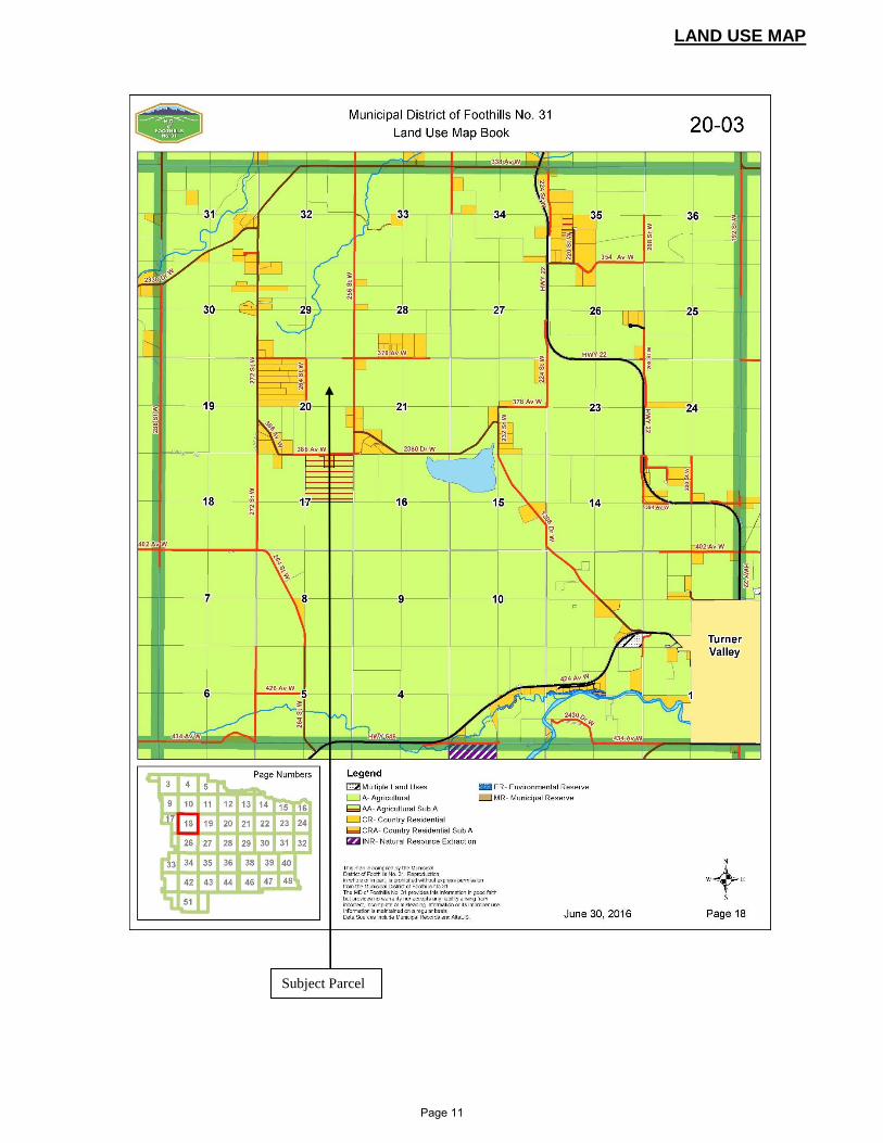
LAND USE MAP
Subject Parcel
Page 11

SUBJECT AND ADJACENT LOT SIZES
Hwy #549 Hwy #7
Subject Parcel
Page 12

SITE PLAN
Page 13

LOT ORTHO
Page 14

PUBLIC HEARING
PLANNING AND DEVELOPMENT DEPT. REPORT
LAND USE AMENDMENT January 31st, 2018 at 10:30 am
LANDOWNER: Timothy Smith and Elaine Reykdal
AGENT: CivicWorks Planning and Design/ Kristi Beunder
LEGAL DESCRIPTION: SE 29-21-28-W4M, Plan 9812387, Lot 1
DIVISION: #7– R.D. McHugh
EXISTING PARCEL: 10.48 Acres
EXISTING LAND USE: CR – Country Residential
NUMBER OF PROPOSED NEW PARCELS: 1 x 4.66 +/- acre Country Residential parcel
FILE MANAGER: Theresa Chipchase
PROPOSAL: Amendment to the Country Residential Land Use District in order to allow the future subdivision of one 4.66 +/- acre Country Residential parcel with a 5.82 acre Country Residential balance from the SE 29-21-28-W4M, Plan 9812387, Lot 1.
LOCATION: The subject property is located Seven miles east of the Hamlet of Heritage Pointe Six miles east of Highway 2 Two miles south of the Bow River One and one half miles south of Dunbow Road One half mile north of Highway 552
POLICY AREA: The proposal has been reviewed within the terms of the MDP2010, Growth Management Strategy and Land Use Bylaw.
QUARTER SECTION BACKGROUND INFORMATION: 1970 - Quarter separated into four, 40 acre parcels 2003 – 28.59 acre parcel adjacent to Highway 552 subdivided into three, 4.0 acre parcels with
constructed service road and 10 acre balance parcel. 2004 – 4 acre parcel from 14.67 acre parcel adjacent to intersection of 112th St. E and
Highway 552. 2005 - 6.57 acre parcel adjacent to intersection of 112th St. E and Highway 552 subdivided
with requirement for 30 meter service road caveat along full south boundary of parcel. 2006 – 4.0 acre parcel subdivided 2008 – six, 3.1 to 4.75 acre parcels subdivided from 40 acre parcel in middle of quarter,
Council allowed 20 meter right of way rather than standard 30 meter right of way 2017 – Plan 0811239, Block 10, Lot 7 – applied to Alberta Environment and Parks to reduce
the size of the dugout on their parcel
Page 15
sbarrett
C2
2017 – Development Appeal Board overturned the Development Officer’s decision to refuse application on the applicant’s lands for the sale of used cars from the site. The approval was later withdrawn from the parcel by the applicant’s.
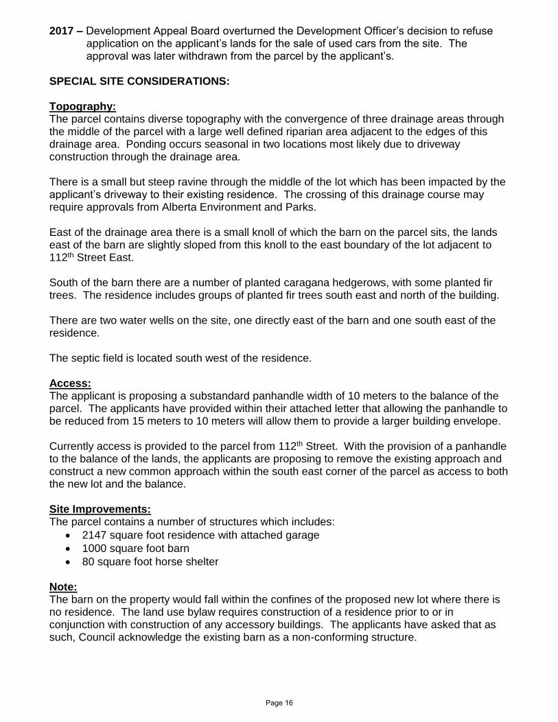
SPECIAL SITE CONSIDERATIONS: Topography: The parcel contains diverse topography with the convergence of three drainage areas through the middle of the parcel with a large well defined riparian area adjacent to the edges of this drainage area. Ponding occurs seasonal in two locations most likely due to driveway construction through the drainage area. There is a small but steep ravine through the middle of the lot which has been impacted by the applicant’s driveway to their existing residence. The crossing of this drainage course may require approvals from Alberta Environment and Parks. East of the drainage area there is a small knoll of which the barn on the parcel sits, the lands east of the barn are slightly sloped from this knoll to the east boundary of the lot adjacent to 112th Street East. South of the barn there are a number of planted caragana hedgerows, with some planted fir trees. The residence includes groups of planted fir trees south east and north of the building. There are two water wells on the site, one directly east of the barn and one south east of the residence. The septic field is located south west of the residence. Access: The applicant is proposing a substandard panhandle width of 10 meters to the balance of the parcel. The applicants have provided within their attached letter that allowing the panhandle to be reduced from 15 meters to 10 meters will allow them to provide a larger building envelope. Currently access is provided to the parcel from 112th Street. With the provision of a panhandle to the balance of the lands, the applicants are proposing to remove the existing approach and construct a new common approach within the south east corner of the parcel as access to both the new lot and the balance. Site Improvements: The parcel contains a number of structures which includes:
2147 square foot residence with attached garage
1000 square foot barn
80 square foot horse shelter Note: The barn on the property would fall within the confines of the proposed new lot where there is no residence. The land use bylaw requires construction of a residence prior to or in conjunction with construction of any accessory buildings. The applicants have asked that as such, Council acknowledge the existing barn as a non-conforming structure.
Page 16

Please also note that the building envelope provided for the proposed lot does not include the accessory building (barn). The building envelope should include this structure and would modify the acres within the available building envelope. MDP2010 Policy 3, 8, and 9 in the Residential section of the MDP2010 reads: 3. Proposals for residential parcels should be developed to be compatible with the
surrounding area and existing land use. Consideration will be given to the density, design, traffic and the visual impact of the proposal on the adjacent lands. Proposals shall be considered on the basis of the following criteria:
3.1 Impact on agricultural industry, the efficient use of land and the conservation of water; 3.2 Guidance found within this MDP, and other documents as listed in appendix A,
Planning Hierarchy; 3.3 Impact on the natural capital of the MD; 3.4 Suitability of the land for residential uses; 3.5 Environmental significance of the land and adjoining properties; 3.6 Environmental Impact; 3.7 Cumulative effect of the development; 3.8 Condition of the Provincial and/or Municipal road servicing the proposed development.
8. All residential developments shall meet the approved MD standards including, but not
limited to soil, slope stability and water table analysis, biophysical assessment, proof of water, water and wastewater systems requirements, storm water management, road design, setbacks, site coverage, building heights, landscaping and dedication of reserves.
9. All residential parcels shall have a developable area of land which:
9.1 Is not subject to the development restrictions such as those created by sour gas or other natural resource extraction, flooding, hazardous lands, landfills, transfer stations, sewage lagoons or other restrictions as indicated by the MGA and the Provincial Planning Regulation.
9.2 Contains a water table and soils suitable for the construction of a residence and the wastewater disposal system to be utilized.
9.3 Does not exceed 15% in slope unless a report has been submitted to the satisfaction of the MD, prepared by a qualified Professional which indicates that the developable area is suitable for residential construction.
9.4 Meets the setback requirements of the appropriate district in the Land Use Bylaw. 9.5 Is considered developable by the Subdivision Authority.
Page 17

GROWTH MANAGEMENT STRATEGY (GMS) The Subject parcel is located within the Central District (highlighted below in red) as noted within the M.D. of Foothills Growth Management Strategy. The approximate location of the subject parcel within the District is identified by the red star on the District map as shown below. GROWTH MANAGEMENT VISION FOR THE CENTRAL DISTRICT “The Central District of the MD has been the growth engine for the MD and this trend is expected to continue into the future. While significant development and intensification of development is expected in this area, it will need to be undertaken bearing in mind the aspirations of our municipal neighbors and with due consideration to riparian and wetland areas. Opportunities for joint initiatives will play a key role in providing effective, efficient and affordable services for this area.” MUNICIPAL DISTRICT OF FOOTHILLS LAND USE BYLAW: SECTION 13 RESIDENTIAL DISTRICTS SECTION 13.1 COUNTRY RESIDENTIAL DISTRICT 13.1.1 PURPOSE AND INTENT
To provide for acreage development consistent with the policies outlined in the Municipal Development Plan.
13.1.6 LAND USE REQUIREMENTS 13.1.6.2 In order to facilitate the purpose and intent of this district and ensure the
comprehensive development of country residential uses within the District, the following applies to applications for subdivision:
a. Parcel Density i. Maximum one lot per 2.02 ha (5 acres) of existing land contained under the
same title to a maximum of 32 lots per quarter section.
Approximate location
of applicant within
District
Page 18
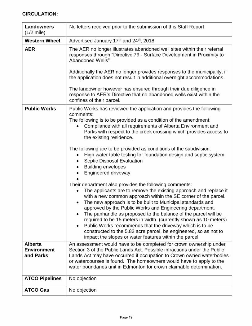
CIRCULATION:
Landowners (1/2 mile)
No letters received prior to the submission of this Staff Report
Western Wheel Advertised January 17th and 24th, 2018
AER The AER no longer illustrates abandoned well sites within their referral responses through “Directive 79 - Surface Development in Proximity to Abandoned Wells” Additionally the AER no longer provides responses to the municipality, if the application does not result in additional overnight accommodations. The landowner however has ensured through their due diligence in response to AER’s Directive that no abandoned wells exist within the confines of their parcel.
Public Works Public Works has reviewed the application and provides the following comments: The following is to be provided as a condition of the amendment:
Compliance with all requirements of Alberta Environment and Parks with respect to the creek crossing which provides access to the existing residence.
The following are to be provided as conditions of the subdivision:
High water table testing for foundation design and septic system
Septic Disposal Evaluation
Building envelopes
Engineered driveway
Their department also provides the following comments:
The applicants are to remove the existing approach and replace it with a new common approach within the SE corner of the parcel.
The new approach is to be built to Municipal standards and approved by the Public Works and Engineering department.
The panhandle as proposed to the balance of the parcel will be required to be 15 meters in width. (currently shown as 10 meters)
Public Works recommends that the driveway which is to be constructed to the 5.82 acre parcel, be engineered, so as not to impact the slopes or water features within the parcel.
Alberta Environment and Parks
An assessment would have to be completed for crown ownership under Section 3 of the Public Lands Act. Possible infractions under the Public Lands Act may have occurred if occupation to Crown owned waterbodies or watercourses is found. The homeowners would have to apply to the water boundaries unit in Edmonton for crown claimable determination.
ATCO Pipelines No objection
ATCO Gas No objection
Page 19

OPTIONS FOR COUNCIL’S CONSIDERATION: OPTION #1: APPROVAL Council may choose to grant 1st reading to the application for an amendment to the Country Residential Land Use District in order to allow the future subdivision of one 4.66 +/- acre Country Residential parcels with a 5.80 +/- acre Country Residential balance, all within the SE 29-20-28-W4M, Plan 9812387, Lot 1, for the following reasons: Council in their consideration provides that the proposal is in alignment with the intent and policy outlined in the Residential section of the MDP2010 and that the application falls within the density provisions and lot size restrictions for Country Residential development. Staff suggests Country Residential – A district on the proposed parcel to ensure that the recommendations and restrictions as outlined in the Building Envelopes, High Water Table Testing, and Septic Disposal Evaluation (all provided as conditions of the subdivision) and the engineered driveway (as a condition of the Development permit) are constructed to the satisfaction of the Public Works department; to be complied with as part of the development permit process. A completion certificate by a Professional Engineer verifying that all aspects of the noted reports have been met may be required. Council may also wish to require a $5000 deposit as a pre-release condition to ensure compliance of all conditions of the development permit. Council may choose to impose the following suggested conditions: RECOMMENDED CONDITIONS FOR OPTION #1:
Applicant to fully execute and comply with all requirements as outlined within a Development Agreement for the purposes of payment of the community sustainability fee and any other necessary municipal and on-site improvements as required by Council and the Public Works and Engineering department;
Site plan to be provided which identifies a building envelope on the proposed lot which meets the requirements as outlined in Policy 9 under the Residential section of the MDP2010, provides for a 15 meter wide panhandle as access to the balance of the lands and identifies the barn on the proposed parcel to be within the building envelope for the proposed parcel, all to the satisfaction of the Public Works and Engineering department;
The applicant is to comply with all requirements of Alberta Environment and Parks with written confirmation of compliance provided to the satisfaction of the Municipality.
Geotechnical Report completed in accordance with MD standards to be provided for high water table testing for foundation designs and septic systems for the proposed lot to the satisfaction of the Public Works and Engineering department, as a condition of the subdivision approval;
Septic Disposal Evaluations for the proposed lot to the satisfaction of the Public Works and Engineering department, as a condition of the subdivision approval;
Page 20

Engineering to be submitted to the satisfaction of the Municipal Fire Chief, the Municipal Safety Codes department and Public Works and Engineering department, with respect to driveway construction proposed to be provided to the 5.82+/- acre balance parcel;
Proof of adequate water supply provided for both the new lot and the balance in accordance with the Provincial Water Act, to the satisfaction of the Municipality;
Final redesignation lot fees to be submitted;
Submission of an executed subdivision application and the necessary fees.
OPTION #2: REFUSE APPLICATION Council may choose to refuse the application for amendment to the Country Residential Land Use District in order to allow the future subdivision of one 4.66 +/- acre Country Residential parcel with a 5.82 +/- acre Country Residential balance all within the SE 29-21-28-W4M, Plan 9812387, Lot 1 for the following reasons: In their consideration of the criteria noted in Residential Policies 3.4, 3.5, 3.6 and 3.7 of the MDP2010, Council is of the opinion that the application does not adequately address the intent of the Residential policy with respect to the provision of adequate access, the cumulative effects, the environmental impact and the suitability of the lands for further development. ENCLOSURES:
Location Map
Land Use Map
Subject and Adjacent Lot Sizes
Site Plan(s)
Lot Ortho(s)
Water Well Reconnaissance
Applicant’s letter
Page 21

LOCATION MAP
Okotoks
Hwy 552
Hwy 547
City of Calgary
Dunbow Rd.
Hwy 2A
Hwy 2
Subject Parcel
Rockyview County
Page 22

LAND USE MAP
Hwy #549
Hwy #7
Subject Parcel
Page 23

SUBJECT AND HALF MILE LOT SIZES
Subject Parcel
Page 24

PROPOSED SITE PLAN
Page 25

PROPOSED SITE PLAN (with air photo)
Page 26

AERIAL PHOTO 2012
7.0+/- ac
Page 27

AERIAL PHOTO 2015
Page 28
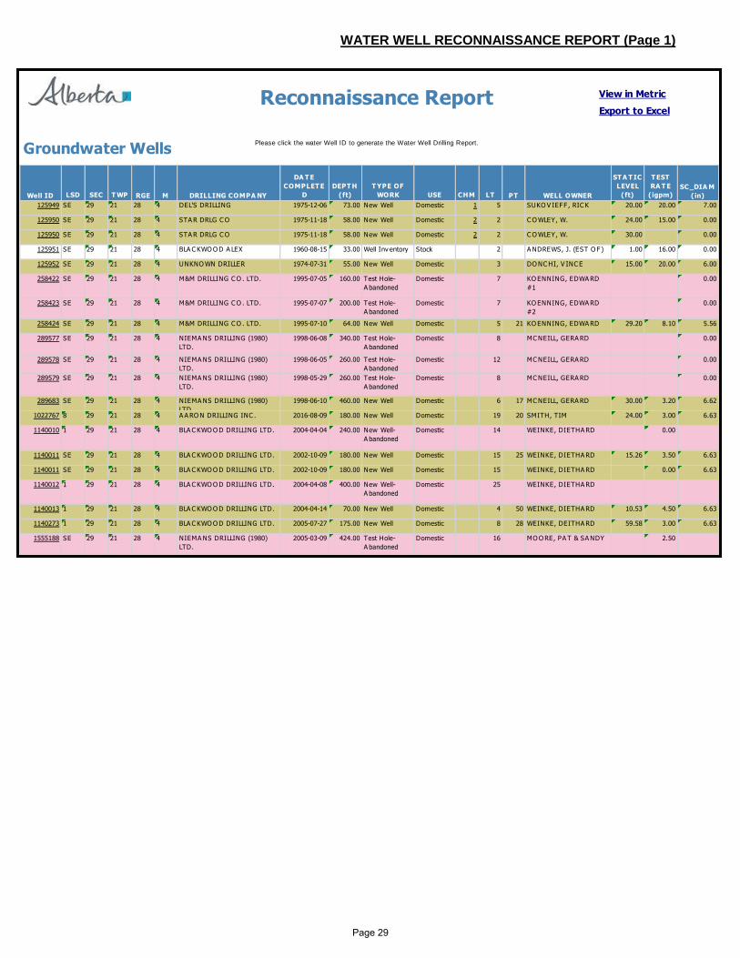
WATER WELL RECONNAISSANCE REPORT (Page 1)
LSD SEC T WP
DA T E
COMPLET E
D
DEPT H
(ft)
T YPE OF
WORK USE CHM LT
ST A T IC
LEVEL
(ft)
T EST
RA T E
(igpm)
SE 29 21 1975-12-06 73.00 New Well Domestic 1 5 20.00 20.00
SE 29 21 1975-11-18 58.00 New Well Domestic 2 2 24.00 15.00
SE 29 21 1975-11-18 58.00 New Well Domestic 2 2 30.00
SE 29 21 1960-08-15 33.00 Well Inv entory Stock 2 1.00 16.00
SE 29 21 1974-07-31 55.00 New Well Domestic 3 15.00 20.00
SE 29 21 1995-07-05 160.00 Test Hole-
A bandoned
Domestic 7
SE 29 21 1995-07-07 200.00 Test Hole-
A bandoned
Domestic 7
SE 29 21 1995-07-10 64.00 New Well Domestic 5 29.20 8.10
SE 29 21 1998-06-08 340.00 Test Hole-
A bandoned
Domestic 8
SE 29 21 1998-06-05 260.00 Test Hole-
A bandoned
Domestic 12
SE 29 21 1998-05-29 260.00 Test Hole-
A bandoned
Domestic 8
SE 29 21 1998-06-10 460.00 New Well Domestic 6 30.00 3.20
8 29 21 2016-08-09 180.00 New Well Domestic 19 24.00 3.00
1 29 21 2004-04-04 240.00 New Well-
A bandoned
Domestic 14 0.00
SE 29 21 2002-10-09 180.00 New Well Domestic 15 15.26 3.50
SE 29 21 2002-10-09 180.00 New Well Domestic 15 0.00
1 29 21 2004-04-08 400.00 New Well-
A bandoned
Domestic 25
1 29 21 2004-04-14 70.00 New Well Domestic 4 10.53 4.50
1 29 21 2005-07-27 175.00 New Well Domestic 8 59.58 3.00
SE 29 21 2005-03-09 424.00 Test Hole-
A bandoned
Domestic 16 2.501555188 28 4 NIEMA NS DRILLING (1980)
LTD.
MO O RE, PA T & SA NDY
6.63
1140273 28 4 BLA C KWO O D DRILLING LTD. 28 WEINKE, DEITHA RD 6.63
1140013 28 4 BLA C KWO O D DRILLING LTD. 50 WEINKE, DIETHA RD
6.63
1140012 28 4 BLA C KWO O D DRILLING LTD. WEINKE, DIETHA RD
1140011 28 4 BLA C KWO O D DRILLING LTD. WEINKE, DIETHA RD
1140011 28 4 BLA C KWO O D DRILLING LTD. 25 WEINKE, DIETHA RD 6.63
1140010 28 4 BLA C KWO O D DRILLING LTD. WEINKE, DIETHA RD
6.62
1022767 28 4 A A RO N DRILLING INC . 20 SMITH, TIM 6.63
289683 28 4 NIEMA NS DRILLING (1980)
LTD.
17 MC NEILL, GERA RD
0.00
289579 28 4 NIEMA NS DRILLING (1980)
LTD.
MC NEILL, GERA RD 0.00
289578 28 4 NIEMA NS DRILLING (1980)
LTD.
MC NEILL, GERA RD
5.56
289577 28 4 NIEMA NS DRILLING (1980)
LTD.
MC NEILL, GERA RD 0.00
258424 28 4 M&M DRILLING C O . LTD. 21 KO ENNING, EDWA RD
0.00
258423 28 4 M&M DRILLING C O . LTD. KO ENNING, EDWA RD
#2
0.00
258422 28 4 M&M DRILLING C O . LTD. KO ENNING, EDWA RD
#1
0.00
125952 28 4 UNKNO WN DRILLER DO NC HI, V INC E 6.00
125951 28 4 BLA C KWO O D A LEX A NDREWS, J. (EST O F )
0.00
125950 28 4 STA R DRLG C O C O WLEY, W. 0.00
125950 28 4 STA R DRLG C O C O WLEY, W.
SC_DIA M
(in)
125949 28 4 DEL'S DRILLING SUKO V IEFF , RIC K 7.00
Well ID RGE M DRILLING COMPA NY PT WELL OWNER
Reconnaissance Report View in Metric
Export to Excel
Groundwater WellsPlease click the water Well ID to generate the Water Well Drilling Report.
Page 29

WATER WELL RECONNAISSANCE REPORT (Page 2)
LSD SEC T WP DRILLING COMPA NY
DA T E
COMPLET E
D
DEPT H
(ft)
T YPE OF
WORK USE CHM LT PT
ST A T IC
LEVEL
(ft)
T EST
RA T E
(igpm)
SE 29 21 NIEMA NS DRILLING (1980)
LTD.
2005-03-09 424.00 Test Hole-
A bandoned
Domestic 16 21 0.00
SE 29 21 NIEMA NS DRILLING (1980)
LTD.
2005-03-09 424.00 Test Hole-
A bandoned
Domestic 16 0.00
SE 29 21 NIEMA NS DRILLING (1980)
LTD.
2005-03-09 424.00 Test Hole-
A bandoned
Domestic 16 1
SE 29 21 NIEMA NS DRILLING (1980)
LTD.
2005-03-09 424.00 Test Hole-
A bandoned
Domestic 16 0.00
SE 29 21 NIEMA NS DRILLING (1980)
LTD.
2005-03-10 100.00 New Well Domestic 10 2 20.14 2.50
SE 29 21 NIEMA NS DRILLING (1980)
LTD.
2007-02-19 480.00 Test Hole-
A bandoned
Domestic 12
SE 29 21 NIEMA NS DRILLING (1980)
LTD.
2007-06-15 440.00 Test Hole-
A bandoned
Domestic 11
SE 29 21 NIEMA NS DRILLING (1980)
LTD.
2007-02-25 460.00 Test Hole-
A bandoned
Domestic 15
SE 29 21 NIEMA NS DRILLING (1980)
LTD.
2007-02-22 400.00 New Well Domestic 15 43 47.67 1.00
SE 29 21 NIEMA NS DRILLING (1980)
LTD.
2007-06-18 135.00 New Well Domestic 4 34 15.49 3.50
SE 29 21 NIEMA NS DRILLING (1980)
LTD.
2007-02-24 460.00 New Well Domestic 12 36 65.35 1.40
SE 29 21 NIEMA NS DRILLING (1980)
LTD.
2007-02-21 280.00 New Well Domestic 14 39 37.60 7.50
SE 29 21 NIEMA NS DRILLING (1980)
LTD.
2007-06-18 160.00 New Well Domestic 14 38 5.22 3.00
SE 29 21 NIEMA NS DRILLING (1980)
LTD.
2007-06-14 360.00 New Well Domestic 15 0.00
SE 29 21 NIEMA NS DRILLING (1980)
LTD.
2007-06-14 360.00 New Well Domestic 15 43 144.82 2.501555636 28 4 JO HNSO N, NEIL &
RO BINSO N, DA NA
6.63
1555635 28 4 JO HNSO N, NEIL &
RO BINSO N, DA NA
6.63
1555636 28 4 JO HNSO N, NEIL &
RO BINSO N, DA NA
6.63
1555633 28 4 RO BINSO N, DA NA &
JO HNSO N, NEIL
6.63
1555634 28 4 RO BINSO N, DA NA &
JO HNSO N, NEIL
6.63
1555631 28 4 JO HNSO N, NEIL &
RO BINSO N, DA NA
6.63
1555632 28 4 JO HNSO N, NEIL &
RO BINSO N, DA NA
6.63
1555625 28 4 JO HNSO N, NEIL &
RO BINSO N, DA NA
1555627 28 4 RO BINSO N, DA NA &
JO HNSO N, NEIL
1555310 28 4 MO O RE, PA T & SA NDY 6.63
1555622 28 4 RO BINSO N, DA NA &
JO HNSO N, NEIL
1555188 28 4 MO O RE, PA T & SA NDY
1555188 28 4 MO O RE, PA T & SA NDY
1555188 28 4 MO O RE, PA T & SA NDY
1555188 28 4 MO O RE, PA T & SA NDY
Reconnaissance Report View in Metric
Export to Excel
Well ID RGE M WELL OWNER
SC_DIA M
(in)
Page 30

Page 31

Page 32

PUBLIC HEARINGS AND MEETINGS
PLANNING AND DEVELOPMENT REPORT
LAND USE BYLAW AMENDMENT January 31st, 2018 at 11:00am
LANDOWNERS: Jason & Calley Williams DIVISION: #7 – R.D. McHugh
LEGAL DESCRIPTION: NW 15-21-29 W4M; Plan 0613958, Block 5, Lot 8
PARCEL SIZE: 3.31 +/- acres FILE MANAGER: Drew Granson
EXISTING LAND USE: CR – Country Residential Land Use District
PROPOSED LAND USE: DC #27 – Major Home Based Business District
PROPOSAL: Redesignation of the subject property from Country Residential Land Use District to Direct Control District #27 to allow for a Major Home Occupation for a Property Maintenance – Snow Removal / Parkade Maintenance Business on the subject property. Note: this application is the result of enforcement.
LOCATION:
The subject property is a 3.31+/- acre Country Residential parcel located on the north side of 292nd Avenue East and approximately 675 meters east of 32nd Street East. This is approximately 800 meters northeast of Highway 2 and 1.6 kilometers south of Highway 552E.
POLICY AREA:
The proposal does not fall within an Area Structure Plan, Outline Plan, or Area Redevelopment Plan and has therefore been reviewed within the terms of the MDP2010, the Growth Management Strategy, and the Land Use Bylaw.
PROPOSAL:
The landowner has submitted application to allow for a property maintenance business to operate from the subject property as a major home based business. The applicant has stated that the business operates primarily off site with on-site operations consisting of administrative office work within the dwelling, and storage and maintenance of equipment. No customers attend the property and one non-resident employee attends the property occasionally, no more than once per week to pick up or drop off equipment. 2-5 additional non-resident employees work entirely off site and do not attend the property.
An existing 3,225 sq.ft. accessory building is located on the subject property. Business related vehicles currently being stored on site include two flatbed one-ton pickup trucks, a street sweeper, a medium-duty dump truck, a cargo trailer, a flatbed trailer, and several skid-steer attachments. The landowner has also stated that personal vehicles and equipment not related to the business use is being stored outside on site. Applicants have stated that due to the seasonal nature of the business most of the equipment leaves the property for extended periods and requires storage during the alternate season.
The applicants have applied for Major Home Occupation to allow for the outdoor parking of these vehicles and equipment which exceeds the 3 vehicle units that can be permitted under a minor home occupation, on a property of this size. Outdoor parking is proposed to the east of the
Page 33
sbarrett
C3

existing accessory building on a gravelled area. Outdoor parking areas should be generally screened from adjacent lands and roadways.
No additional lot grading, and no additional structures are proposed with this application.
A dumpster bin is located directly east of the attached garage, near the south side of the accessory building which the landowners have stated is used for primarily personal use as well as business related waste.
BACKGROUND:
- On November 21st, 2012 a stop order was issued on the subject property requiring the immediate discontinuation of the home based business and removal of all business related vehicles, equipment, and materials from the property or to apply for appropriate application for development permit.
- On December 3rd, 2012, the applicants appealed the stop order in order to request additional time to bring the property into compliance.
- On December 17th, 2012, the Development Appeal Board made the following order:
The landowner is hereby ordered to:
1. Remove all related vehicles, equipment and materials to bring the current operation into compliance with the Municipal Government Act and the MD of Foothills Land Use Bylaw #01/99. Compliance is to be attained no later than April 1st, 2013;
2. Obtain all required approvals from the MD of Foothills as necessary to bring the Minor Home Occupation into Compliance with the Municipal Government Act and the MD of Foothills Land Use Bylaw #01/99. Approvals must be attained no later than July 1st, 2013.
Note: No development permit was issued at this time, and landowners identified that the business related vehicles and equipment would be removed from the property.
- On October 19th, 2017, Municipal Protective Services issued a letter of notice to the landowners stating that the property is in contravention due to the operation of a major home based occupation without proper approvals.
- On November 2nd, 2017, Landowners submitted application for land use redesignation to DC#27 to allow for a Major Home Occupation.
SPECIAL SITE CONSIDERATIONS:
Access:
There is one existing residential approach onto the subject property off of the north side of the cul-de-sac on 292nd Avenue East.
Physiography:
The subject property located near the eastern ridge of a rolling hill with lands sloping down towards the north, east, and south, and highest point along the west boundary and through the center of the property.
Vegetation on the property is primarily grassland and young (20+ foot) poplars and spruce trees have been planted along most of the perimeter of the property with the exception of the northern portions of the east boundary.
Applicants have noted that they are willing to provide additional screening to the outdoor storage area in the form of vegetation and/or fencing.
Note: Lot grading activities on the subject property had previously encroached within the adjacent MR parcel. Ortho images and site inspection indicate that activities within the MR parcel have ceased; however, the location of the east property line was difficult to identify at the time of the site inspection.
Page 34

Site Improvements:
A dwelling with attached garage and a 3,225 sq.ft. Accessory Building are currently located on the property. No additional structures are proposed with this application. The internal driveway is paved up to the dwelling then continues as a graveled surface to the accessory building and outdoor parking area.
Half Mile History
Land use within a half mile of the subject property is predominantly agricultural and country residential land use districts.
Two other business uses have been approved within a half mile of the subject quarter section, in 2002 and in 2004, both of which were to allow for Intensive Vegetation Operations and Minor Home Based Businesses for Tree Farms and Landscaping Businesses, and are both located directly west of Highway 2, approximately ½ mile west of the subject property.
POLICY / PLANNING CONSIDERATIONS:
MDP 2010:
ECONOMY - POLICY
3. Proposals for home-based businesses shall be considered on the basis of the following criteria:
3.1 Impact on area residents
3.2 Impact on adjoining lands
3.3 Impact on the environment
3.4 Traffic generation
3.5 Water consumption
3.6 Sewage disposal
3.7 Dust, odor, noise, exterior lighting, visual impacts; and
3.8 Proximity to Heritage Pointe.
LAND USE BYLAW:
“Home Based Business (Major)” means a business or occupation conducted within a dwelling and/or accessory building(s) or on a parcel on which a dwelling is located and where one or more residents of the parcel is/are involved in the occupation or business and the following requirements apply:
A maximum of eight (8) Business Visits per day;
No more than five (5) non-resident employees working on site;
On parcels 10 acres and larger, exterior storage may be allowed if, in the opinion of the Approving Authority, the exterior storage is adequately screened;
A maximum of 5 vehicles or equipment may be stored outdoors;
No offensive noise, vibration, smoke, dust, odor, heat, glare, electrical or radio disturbance detectable beyond the boundary of the lot;
all in accordance with Section 10.12 of this bylaw. Home based business, major does not include a medical marihuana production facility.
18.27 Direct Control District #27 (DC27)
18.27.1 Purpose and Intent
To allow for the development of major home based businesses to operate on lots with a single family residence and to allow for the Direct Control by Council over development on the following lots:
Page 35

18.27.4 Land Use Requirements
18.27.4.1 Standards of the development shall be at the discretion of Council.
SCREENING STANDARDS
The required level and materials for screening of outdoor parking storage/parking area(s) should be acknowledged by Council as condition of the Development Permit.
GROWTH MANAGEMENT STRATEGY (GMS)
The Subject Parcel is located within the Central District (highlighted below in blue) as noted within the M.D. of Foothills Growth Management Strategy. The approximate location of the subject parcel is identified by the green star on the GMS District Map shown below.
SECTION 4.5 Managing Growth in the Central District of the GMS reads:
Growth Management Vision for the Central District:
The Central District of the MD has been the growth engine for the MD and this trend is expected to continue into the future. While significant development and intensification of development is expected in this area, it will need to be undertaken bearing in mind the aspirations of our municipal neighbours and with due consideration to riparian and wetland areas. Opportunities for joint initiatives will play a key role in providing effective, efficient and affordable services for this area.
Page 36

CIRCULATION:
Landowners (1/2 mile)
No letters have been received prior to the submission of this Staff Report.
Western Wheel Advertised January 17th and 24th, 2018.
Public Works Landowner’s are advised that if the gravelled parking areas are paved in the future, stormwater management should be implemented to address cumulative effect of impermeable surfaces. No concern for gravel surface at this time.
Landowner’s responsibility to ensure all business related activities occur wholly within the subject property and do not encroach into MR parcel.
Approach adheres to municipal standards and is sufficient for proposed use.
Agricultural Service Board
Request that Council require applicant to provide fencing along entire east boundary in order protect MR parcel and ensure activities remain within subject property. Applicant would be responsible contracting professional surveyor to confirm location of east property line prior to installing fence. No gates would be permitted into MR parcel.
ATCO Pipelines No objections
ATCO Gas No objections
Telus No objections
Alberta Transportation
Proposed development is beyond AT’s development control zone adjacent to provincial highway; therefore, no roadside development approval is required.
Alberta Health Services
No objection; following comments apply: Applicant must ensure the property is designed and maintained in accordance with the Alberta Health Act (RSA 2000), Nuisance and General Sanitation Regulation 243/2003 which states: “No person shall create, commit or maintain a nuisance. A nuisance means a condition that is or might become injurious or dangerous to the public health, or that might hinder in any manner the prevention or suppression of disease.”
Fire Chief Applicant to contact Foothills Fire Services for Fire Inspection of existing Accessory Building prior to occupancy for business related use. Applicant to ensure proper 911 addressing on property, access to the property for emergency services, and two points of access to structures.
Page 37
OPTIONS FOR CONSIDERATION:
The following are possible options for Council’s consideration:
OPTION #1: APPROVAL FOR REDESIGNATION TO DIRECT CONTROL DISTRICT #27
Council may choose to grant 1st reading to the Land Use Bylaw Amendment to Redesignate the subject property from Country Residential Land Use District to Direct Control District #27 to allow for the Major Home Occupation of a Property Maintenance Business, for the following reasons:
Council is of the opinion that the proposed development will not unduly interfere with neighbouring land uses or materially interfere with or affect the use, enjoyment, or value of neighbouring properties.
Under option #1, Council may wish to impose the following condition:
Submission of an executed Development Permit application and necessary fees;
Final redesignation lot fees to be submitted.
OPTION #2: REFUSE APPLICATION
Council may choose to refuse the application as submitted for the following reasons:
Council is of the opinion that the proposed development is beyond the scope of development suitable on the subject property and feels that the development opposes the intent of the Municipal Development Plan which states that Commercial or Industrial developments should be developed and located to be compatible with the surrounding area and existing land uses, and are of the opinion that the proposed development will unduly interfere with the neighbouring land uses or materially interfere with or affect the use, enjoyment, or value of neighbouring properties.
ENCLOSURES:
Location & Land Use Map
Lot Ortho Image
Submitted Site Plan
Page 38

Subject Parcel
Page 39

Page 40

SUBMITTED SITE PLAN
Page 41

MISCELLANOUS ITEM
PLANNING AND DEVELOPMENT REPORT
January 31, 2018
LANDOWNER: Chinook Valley Inc.
SERVICE PROVIDER: Xplornet Communication Inc.
LEGAL DESCRIPTION: NW 13-21-02 W5M
DIVISION: #5 – Alan Alger
EXISTING PARCEL: 79 acres
EXISTING LAND USE: Agricultural District
NUMBER OF PROPOSED NEW PARCELS: N/A
MUNICIPAL CONTACT: Brenda Bartnik
PROPOSAL: To replace an existing 10m telecommunications facility with a 29.9 m (98 ft) self-support telecommunication tower and a 21.5 sq. ft. equipment cabinet on an area of approximately 10 m2 (107.64 sq. ft.) on the property. This property is located a little more than 2.5 miles north of Highway #549 on the east side of 112th Street west.
BACKGROUND: Formal proposal has been submitted by Scott Telecom Services, on behalf of Xplornet. The request notes that a tower with greater height is required in the area in order to bring improved coverage to the surrounding area. Communication Towers are federally regulated and fall under the jurisdiction of Innovation, Science and Economic Development Canada (previously Industry Canada). As a result of the federal jurisdiction over such operations, traditional municipal land use controls such as zoning by-laws, site plan controls, development approvals and building code requirements would not be the authority of the local municipality. It is nonetheless, a requirement of federal licensing that a proponent consult with the local land-use authority and/or local public where required, in order to address reasonable and relevant concerns and obtain land-use authority concurrence in writing.
PROCESS: Proponents must follow the land-use consultation process for the siting of antenna systems established by the land-use authority, where one exists. As per Appendix B of the Land Use Bylaw, local requirements include the following and have been addressed with respect to this proposal, as follows:
VISION STATEMENT:
The Municipal District of Foothills, by way of the policies listed, will take proactive steps to limit the number of towers within the Municipality by encouraging carriers towards co-utilization. It is important to the Council of the Municipality to have telecommunication towers placed in an area that will have the least amount of opposition to and visual impact upon nearby residents.
POLICIES:
Location
New telecommunication towers should be encouraged to locate in the areas zoned as Agriculture District and Industrial District.
Page 42
sbarrett
D1

All equipment shelters and tower locations must meet the Municipality’s setback distances to roads and property lines.
It is proposed that the facility be located on a parcel zoned as Agriculture District.
Setbacks for this District include 15m from side and rear yard property lines. The proposal identifies that excepting the 15m requirement from the north property line, all other setbacks have been met. It is noted that the tower is proposed to be located 11.8m from the north property line as the landowner mandated that the tower be placed within the existing compound area. Due to existing equipment it is not possible to move the tower further south within this area.
The installation would be subject to any required building and safety code permits with respect to the Xplornet equipment.
PROPOSED INSTALLATION AREA IN GREEN. ONE EXISTING 9.144m POLE TO BE REMOVED.
The balance of the equipment and the 5.2m pole are identified to be the property of the landowner.
PROPOSED
EXISTING
Page 43

Co-Location
All Carriers requesting a new telecommunication tower (freestanding antenna structure) will be required to identify any other such structure within a 5-mile radius of the proposed site location. Each request should also provide documentary evidence that co-location of the existing structures within that 5-mile radius is not a viable alternative to a second structure.
Page 44
The co-location of additional carriers is preferred and supported by this Municipality. Each new tower request should allow for co-utilization. Required are letters from registered telecommunication carriers indicating that they can or cannot co-locate on this tower. Reasons for not co-locating will be required.
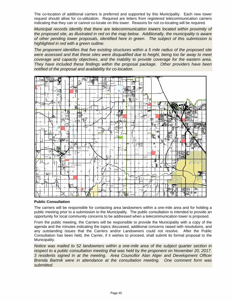
Municipal records identify that there are telecommunication towers located within proximity of the proposed site, as illustrated in red on the map below. Additionally, the municipality is aware of other pending tower proposals, identified here in green. The subject of this submission is highlighted in red with a green outline.
The proponent identifies that five existing structures within a 5 mile radius of the proposed site were assessed and that these sites were disqualified due to height, being too far away to meet coverage and capacity objectives, and the inability to provide coverage for the eastern area. They have included these findings within the proposal package. Other providers have been notified of the proposal and availability for co-location.
Public Consultation
The carriers will be responsible for contacting area landowners within a one-mile area and for holding a public meeting prior to a submission to the Municipality. The public consultation is intended to provide an opportunity for local community concerns to be addressed when a telecommunication tower is proposed.
From the public meeting, the Carriers will be responsible to provide the Municipality with a copy of the agenda and the minutes indicating the topics discussed, additional concerns raised with resolutions, and any outstanding issues that the Carriers and/or Landowners could not resolve. After the Public Consultation has been held, the Carrier, if it wishes to proceed, shall submit its formal proposal to the Municipality.
Notice was mailed to 52 landowners within a one-mile area of the subject quarter section in respect to a public consultation meeting that was held by the proponent on November 20, 2017. 3 residents signed in at the meeting. Area Councillor Alan Alger and Development Officer Brenda Bartnik were in attendance at the consultation meeting. One comment form was submitted.
Page 45
Concerns that have been expressed with the proposal include:
- proliferation of telecommunication towers and concern over additional future expansion of the telecommunication facility on this site,
- concerns about lighting. It was suggested that municipal policy should dictate that prior to public consultation, lighting requirements need to be identified by the authority having jurisdiction,
- effects on property values,
- assurances that Health Canada safety guidelines will be tested/met,
- possible environmental impact,
- if any appropriate historical resources impact assessments have been performed,
- the current design does not integrate the antenna into the local surroundings.
Design Standards
Where Transport Canada requires that a telecommunication tower be lighted, the following steps are encouraged to minimize visual impacts:
1. the lighting of equipment structures and any other facilities on site should be shielded from adjacent properties where possible without interfering with the requirements of Transport Canada;
2. all lighting should be a minimum number of low intensity white lights; and
3. the strobe interval should be the maximum allowable by Transport Canada, and the strobe lights should only be used if absolutely necessary.
The proposal identifies that an assessment form was submitted to Transport Canada however response from that agency has not yet been received, however the proponent has noted that it is not expected that lighting will be required for this installation.
Response from the proponent with respect to integrating the tower into the landscape identifies that when assessing the property for potential location, it was determined that trees located to the north and east of the proposed location would minimize the visual impact of the facility. The design of the tower is a self support lattice which is less obstructive to views that solid structures such as the monopole design that is currently installed at this location. Questions were posed as to other design availability ie: a tree. It was noted that that was not an option at this site.
Municipality Consultation & Decision
The Carriers will submit their formal proposal to the Development Officer of the Municipality. The Development Officer will present the proposal to Council and will provide his/her position of support or non-support towards the formal proposal.
The Municipality will provide its position to the Carriers within a 30-day period of receiving the proposal. This decision will also be forwarded to Industry Canada by the Development Officer.
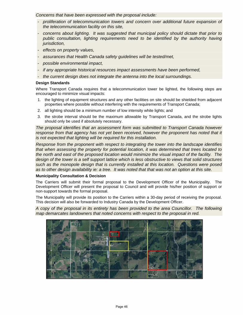
A copy of the proposal in its entirety has been provided to the area Councillor. The following map demarcates landowners that noted concerns with respect to the proposal in red.
Page 46

COUNCIL ACTION REQUIRED: This proposal is submitted on behalf of Xplornet under the local municipality's policies and procedures and is not a request for public hearing and/or meeting. Local and federal requirements include the necessity of Council providing their position (support / non-support of the installation) in writing to the requesting service provider and Innovation, Science and Economic Development Canada within 30 days of receiving the formal proposal. Any determination of non-support toward the proposal will be required to include rationale as to the decision.
RECOMMENDED: SUPPORT OF THE PROPOSAL
Council may move to support the installation of one 29.9m self-support tower on the lands legally
described as NW 13-21-02 W5M. This support is based upon design and location as have been
identified within the formal proposal - file AB1751 and is contingent upon lighting requirements. Council implores the determining authority to ensure that lighting on the tower is avoided if at all possible, in an effort to ensure the least amount of disturbance to area residents and area wildlife.
The local municipality bears no responsibility with respect to providing and/or maintaining access to the proposed facility.
Page 47

SUBDIVISION APPROVING AUTHORITY ITEM
PLANNING AND DEVELOPMENT REPORT 1st Time Extension Request
January 31st, 2018
SUBDIVISION APPROVING AUTHORITY ACTION REQUESTED: Decision Re: Request for 1st Time Extension
LANDOWNER: Keith Levoir AGENT: CivicWorks Planning + Design
LEGAL DESCRIPTION: NW 32-21-28 W4; Plan 1410482 Blk 3 Lot 1
DIVISION: #7 – R.D. McHugh
EXISTING PARCEL: 9.97 Acres
EXISTING LAND USE: CR ‘A’: Country Residential Sub-district ‘A’
NUMBER OF PROPOSED NEW PARCELS: 1
FILE MANAGER: Samantha Payne
PROPOSAL: Subdivision of 1 x 4.82+/- acre Country Residential ‘A’ District lot.
BACKGROUND
PLEASE NOTE:
Members of the Subdivision Approving Authority present on November 23rd, 2016 included: Reeve L. Spilak, Deputy Reeve D. Miller and Councillors J. Parker and S. Oel; and .
The subject parcel was identified within the Division 6 boundaries at the time of Subdivision Approval, however as a result of changes to the divisional boundaries, the subject parcel is now identified within the boundaries of Division 7.
November 23rd, 2016: The Subdivision Approving Authority granted conditional subdivision approval for one additional 4.82+/- acre Country Residential ‘A’ District lot from Plan 1410482, Block 3, Lot 1, Ptn. NW 32-21-28 W4M. The excerpt from the November 23rd, 2016 Council meeting minutes outlining this approval are attached and titled, ‘Meeting Minutes’. The 4.82+/- acre lot was designated Country Residential ‘A’ District to ensure that the recommendations and restrictions as outlined in the septic disposal evaluation, high water table testing and building envelope identification (all provided as conditions of Subdivision) are complied with to the satisfaction of the Public Works Department as conditions of the development permit. November 23rd, 2017: The subdivision application expired. The applicant’s agent has recently submitted a letter requesting the 1st one year time extension. The letter of request is attached and titled, ‘Agent’s Letter of Request’. NOTE: The subdivision conditions that have been completed to date are shown highlighted in yellow throughout the attachment titled, ‘Meeting Minutes’.
Page 48
sbarrett
E1

SUBDIVISION APPROVING AUTHORITY ACTION REQUESTED
The Subdivision Approving Authority is respectfully requested to:
a) Approve the 1st Time Extension Request OR b) Deny the 1st Time Extension Request
ENCLOSURES
Location Map
Ortho Map
Site Plan
Meeting Minutes
Agent’s Letter of Request
Page 49

LOCATION MAP
\
The Town of Okotoks
Page 50

ORTHO MAP
Page 51

SITE PLAN
AGENT’S LETTER OF REQUEST
ER
3.71+/- ac
Page 52

MEETING MINUTES
LEVOIR – SUBDIVISION – NW 32-21-28-W4M …moved that the subdivision of one additional 4.82 +/- acre Country Residential ‘A’ District lot from Plan 1410482, Block 3, Lot 1, Ptn. NW 32-21-28 W4M has been evaluated in terms of Section 654 of the Municipal Government Act and Section 7 of the Subdivision and Development Regulation and therefore it is recommended that the application be approved as per the tentative plan for the following reasons:
The application is consistent with Section 7 of the Subdivision and Development Regulations;
The subject land has the appropriate land use designation.
Further, in accordance with Sections 654 and 655 of the Municipal Government Act, the application be approved subject to the following conditions:
Subdivision to be effected by Plan of Survey, pursuant to Section 657 of the Municipal Government Act, or such other means satisfactory to the Registrar of the South Alberta Land Titles District;
It is the applicant’s responsibility to provide a Real Property Report or an ‘as built’ drawing signed and sealed by an Alberta Land Surveyor, certifying the location of the adjacent municipal road(s), water well(s) within the boundaries of the appropriate properties and that the site plan is surveyed according to municipal setback requirements;
Completion of all pre-release conditions as noted in the executed Municipal Development Agreement to the satisfaction of the Municipality. These conditions include:
o Payment of the Community Sustainability Fee;
All accesses to be located and culverts and approaches to be installed to current Municipal subdivision road standards to the satisfaction of the Public Works Department;
Building envelope to be identified for the proposed lot that meets the requirements outlined in Policy 9 under the Residential Section of the MDP2010 to the satisfaction of the Public Works Department;
Submission of a Geotechnical Report completed in accordance with MD standards to be provided for high water table testing for foundation design and septic system for the proposed lot to the satisfaction of the Public Works Department;
Submission of a Septic Disposal Evaluation for the proposed lot to the satisfaction of the Public Works Department;
Landowners are to provide all utility easements and agreements to the satisfaction of the Municipality and the utility companies;
Landowners are to pay all arrears of taxes on the existing parcel prior to finalization of the subdivision;
Public Reserve: to be provided by way of cash in lieu of land based on $42,889.00 per acre on account of 10% of the entire 9.97 acre parcel;
Submission of all required engineering review fees to the satisfaction of the Public Works Department;
Submission of final subdivision fees.
CARRIED
Page 53

AGENT’S LETTER OF REQUEST
Page 54
SUBDIVISION APPROVING AUTHORITY ITEM
PLANNING AND DEVELOPMENT REPORT SUBDIVISION FOR THE PURPOSES OF A BOUNDARY ADJUSTMENT
January 31st, 2018
SUBDIVISION APPROVING AUTHORITY ACTION REQUESTED: Subdivision Approval or Refusal for the purposes of a Boundary Adjustment
LANDOWNERS: Parcel 1: Joshua Torrence Parcel 2: Joseph Baskin
AGENT: N/A
LEGAL DESCRIPTIONS: Parcel 1: Plan 2326P Blk 4 Lot 20,21; W 19-17-28 W4 Parcel 2: Plan 2326P Blk 4 Lot 22; W 19-17-28 W4
DIVISION: #1 – Rob Siewert
EXISTING PARCELS: Parcel 1: 0.28 acres Parcel 2: 0.14 acres
EXISTING LAND USES: Parcel 1: HR – Hamlet Residential District Parcel 2: HR – Hamlet Residential District
NUMBER OF PROPOSED NEW PARCELS: 0
FILE MANAGER: Samantha Payne
PROPOSAL: Subdivision for the purposes of a Boundary Adjustment, whereby 0.13+/- acres from Plan 2326P Blk 4 Lot 20,21 (Parcel 1) would be consolidated into Plan 2326P Blk 4 Lot 22 (Parcel 2), resulting in one 0.15+/- acre Hamlet Residential lot (Parcel 1) and one 0.27+/- acre Hamlet Residential lot (Parcel 2).
LOCATION
The subject properties are located within the Hamlet of Cayley and are accessed from Jamieson Street.
SPECIAL SITE CONSIDERATIONS
Improvements A residence and 3 accessory buildings are currently located within the boundaries for Parcel 1 and a residence and 1 accessory building are currently located within the boundaries for Parcel 2.
Note: The landowner of Parcel 1 has indicated that 2 of the 3 accessory buildings are located within the 0.13+/- acre area of Parcel 1 that is proposed to be boundary adjusted and has noted that these 2 structures, both sheds, will be removed. The approximate locations of the sheds are shown outlined in orange on the attachment titled, ‘Ortho Photo’. Access Access to both parcels is currently obtained from Jamieson Street.
Page 55
sbarrett
E2

SUBDIVISION APPROVING AUTHORITY ACTION REQUESTED
Requesting a decision regarding the proposed subdivision for the purposes of a Boundary Adjustment, whereby 0.13+/- acres from Plan 2326P Blk 4 Lot 20,21 (Parcel 1) would be consolidated into Plan 2326P Blk 4 Lot 22 (Parcel 2), resulting in one 0.15+/- acre Hamlet Residential lot (Parcel 1) and one 0.27+/- acre Hamlet Residential lot (Parcel 2).
RECOMMENDED CONDITIONS SHOULD THE SUBDIVISION FOR THE PURPOSES OF A BOUNDARY ADJUSTMENT BE APPROVED:
Boundary Adjustment and Consolidation to be effected by Plan of Survey, pursuant to Section 657 of the Municipal Government Act, or such other means satisfactory to the Registrar of the South Alberta Land Titles District;
All accesses to be located and culverts and approaches to be installed to current Municipal subdivision road standards to the satisfaction of the Public Works Department;
Landowners are to provide all utility easements and agreements to the satisfaction of the Municipality and the utility companies;
Landowners are to pay all arrears of taxes on the existing parcels prior to finalization of the subdivision;
It is the applicant’s responsibility to provide a Real Property Report or an ‘as built’ drawing signed and sealed by an Alberta Land Surveyor, certifying the location of the adjacent municipal road(s), and that the site plan is surveyed according to municipal setback requirements;
Submission of subdivision endorsement fees; ENCLOSURES
Location & Land Use Map
Ortho Photo
Site Plan
Current Parcel Layouts & Proposed Parcel Layouts
Page 56

LOCATION AND LAND USE MAP
MLR – Municipal Land/Reserve District
Page 57

ORTHO PHOTO
Parcel 1 Parcel 2
Sheds to be
Removed
Page 58

SITE PLAN
(0.27+/- acres)
Page 59

CURRENT PARCEL LAYOUTS PROPOSED PARCEL LAYOUTS
Page 60
SUBDIVISION APPROVING AUTHORITY ITEMS SUBDIVISION APPROVAL
(BOUNDARY ADJUSTMENT) January 31st, 2018
LANDOWNERS: 1. Alec and John Dahrouge 2. Martin and Monica Purwins
AGENT: Dwayne Zaba
LEGAL DESCRIPTIONS: 1. SE 31-22-04-W5M 2. SE 31-22-04-W5M, Plan 0712740, Block 1, Lot 2
DIVISION: #4 – Suzanne Oel
EXISTING PARCELS: 1. 73.49 acres 2. 4.20 acres
EXISTING LAND USES: 1. A – Agricultural 2. CR – Country Residential
NUMBER OF PROPOSED NEW PARCELS: none
FILE MANAGER: Theresa Chipchase
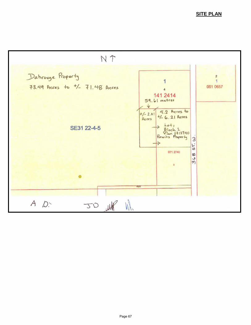
PROPOSAL: This is a boundary adjustment application which proposes the following:
• 2.01 +/- acres subtracted from SE 31-22-04-W5M and added to SE 31-22-04-W5M, Plan 0712740, Block 1, Lot 2
The above mentioned boundary adjustment will result in the following changes to the existing lot sizes:
• SE 31-22-04-W5M – 73.49 acres to 71.48 ac.
• SE 31-22-04-W5M, Plan 0712740, Block 1, Lot 2 – 4.20 ac. to 6.21 ac. NOTE: No land use will change as a result of the boundary adjustments proposed.
LOCATION: The subject properties are located: One mile east of Highway 762 One mile south of Highway 22 Directly west of 368th Street West BACKGROUND December 6th, 2017 – application for boundary adjustment between Dahrouge and Purwins to adjust 2.04 acres from the SE 31-22-04-W5M into Plan 0712740 refused by Council under the following motion: “Council moved that the Boundary Adjustment whereby 2.04 +/- acres from SE 31-22-04 W5M is consolidated into Plan 0712740, Block 1, Lot 2, Ptn. SE 31-22-04
Page 61
sbarrett
E3

W5M, resulting in a 71.45 +/- acre parcel (SE 31-22-04 W5M) and a 6.24 +/- acre parcel (Plan 0712740, Block 1, Lot 2, Ptn. SE 31-22-04 W5M) be refused. In consideration of the Policy 2 of the Agricultural Section of the MDP2010 and the criteria noted in Policies 3, 11 and 13 of the Residential Section of the MDP2010, Council could not find sufficient merit in the proposal to consider adjusting the boundaries of the 73.49 acre Agricultural Land Use District parcel and the 4.20 acre Residential Land Use District parcel.” SITE PLAN SUBMITTED WITH APPLICATION:
CIRCULATION:
AER The AER no longer illustrates abandoned well sites within their referral responses through “Directive 79 - Surface Development in Proximity to Abandoned Wells”. Additionally the AER no longer provides responses to the municipality, if the application does not result in additional overnight accommodations. The landowner however has ensured through their due diligence in response to AER’s Directive that no abandoned wells exist within the confines of their parcel.
ATCOGas No objections
ATCO Pipelines No objections
Public Works Public Works has requested that 5 meters of road widening be provided adjacent to 368th Street West along the east boundary of SE 31-22-04-W5M and the east boundary of SE 31-22-04-W5M, Plan 0712740,
Page 62

Block 1, Lot 2. Public works also provides that the approaches to both parcels would need to meet current municipal approach construction standards.
TELUS Telus has no objections to the application
FortisAlberta No requirements
Alberta Environment and Parks
No issues noted.
RECOMMENDED CONDITIONS OF BOUNDARY ADJUSTMENT:
• Boundary adjustment and consolidation to be effected by Plan of Survey, pursuant to Section 657 of the Municipal Government Act, or such other means satisfactory to the Registrar of the South Alberta Land Titles District;
• It is the applicant’s responsibility to provide a Real Property Report or an ‘as built’ drawing signed and sealed by an Alberta Land Surveyor, certifying the location of the water wells and the adjacent municipal road(s) within the boundaries of the adjusted parcels and that the site plan is surveyed according to municipal setback requirements;
• Execution of an agreement for acquisition of 5.16 acres of land, more or less, perpendicular to the east boundary of the SE 31-22-04-W5M and the SE 31-22-04-W5M, Plan 0712740, Block 1, Lot 2. Agreement to be registered by way of caveat concurrently with the Plan of Survey to the satisfaction of Council and the Public Works and Engineering Department;
• Public Reserve: Cash in lieu of land to be provided based on $10,052.00 per acre on account of 10% of the 2.01 acres subtracted from SE 31-22-04-W5M and added to Plan 0712740, Block 1, Lot 2. Reserves to be deferred on the balance of the SE 31-22-04-W5M after adjustment.
• All accesses to be located and culverts and approaches to be installed to the satisfaction of the municipality’s public works department;
• Landowners are to provide all utility easements and agreements to the satisfaction of the MD and the utility companies;
• Landowners are to pay all arrears of taxes on the existing parcels prior to finalization of the subdivision;
• Landowners are to pay final subdivision lot fees;
ENCLOSURES:
• Location Map
• Land Use Map
• Half Mile Map
• Site Plan
• Ortho Photo
• Public Reserve Calculation
Page 63

LOCATION MAP
Priddis
Coal Mine Rd.
Hwy 22
Subject Parcels
Tsuu Tina Nation
Hwy 762
Hwy 66
Kananaskis Improvement
District
Page 64

LAND USE MAP
Subject Parcels
Page 65

HALF MILE MAP & LOT SIZES
Subject Parcels
Page 66
SITE PLAN
Page 67

LOT ORTHO
Plan 1014574, Block 4,
Lot 2
Plan 1014574, Block 4,
Lot 3
SE 31-22-04-W5M reduced from 73.49 ac. to 71.48 ac.
Plan 0712740, Block 1, Lot 2, increased from 4.20 ac. to 6.21 ac.
Page 68

PUBLIC RESERVE CALCULATION
INTEROFFICE MEMORANDUM3.00 Boundary adjustment
DATE:
File No:
Legal:
TO: Subject:
Parcel Size: 73.49 acres
FROM: Mkt Zone: 12
Trees: 16
Views: -1
11529 River/Creek: Subj River/Creek Code -1
10220 Y
1.00
Final Indicated
Time Adj River/ Adjusted Price Per
Sale Sale Time Sale Loc Size Trees View Creek Sale Acre For
Sale Mz Qr Sec Twp Rge M Date Acres Price Adj Price Adj Adj Adj Adj Adj Price 73.49 Acs
1 22 NW 10 22 02 5 Aug-14 80.00 $900,000 0.98 $882,000 0.81 0.95 60000 $738,699 $10,052
2 4 SE 11 21 29 4 Oct-16 83.57 $750,000 1.00 $750,000 0.88 0.93 60000 $673,800 $9,169
3 23 SE 22 20 02 5 May-17 74.06 $540,000 1.00 $540,000 1.22 1.00 60000 $718,800 $9,781
4 2 NE 16 21 03 5 Jul-17 71.98 $682,000 1.00 $682,000 1.11 1.01 55000 $819,590 $11,152
5 16 NE 02 21 04 5 Nov-14 77.72 $800,000 0.97 $776,000 1.15 0.97 20000 -81175 $804,453 $10,946
Lots mature trees
F2204-31SE
January 5, 2018
Julie Peters
Planning Department
SE 31-22-4 W5
Alex & John Dahrouge
Subj View Code
CAMAlot Value Per Acre
Subj Tree Code
in this area is : per acre.
Avg Sale Price Per Acre
$10,052
Based on the following sales, the fair market value for a 73.49 acre parcel
Subdivision Location AdjusmentCONCLUSION
Use Market Land Influences?
Page 69