MUNICIPAL DEVELOPMENT PLAN - unhabitat- · PDF fileNada Brkljac, Director, Department of...
143
1 2014-2029+ MUNICIPAL DEVELOPMENT PLAN
Transcript of MUNICIPAL DEVELOPMENT PLAN - unhabitat- · PDF fileNada Brkljac, Director, Department of...
1
2014-2029+
MUNICIPAL DEVELOPMENT PLAN

2
„Municipality of Gracanica, opulent with antique and medieval treasures and natural beauty- modern
environment with developed economy and infrastructure where everyone enjoys the same rights and
freedoms“
(“Gracanica Visioning Workshop”, Ohrid, 2010)

3
This document is prepared by Municipality of Gracanica, which bearer is the Directorate of Urbanism,
Cadastre and Environment, with support of Municipal Spatial Planning Support Programme (MuSPP),
implemented by UN-Habitat, and Ministry of Environment and Spatial Planning, respectively Spatial
Planning Institute.
This draft version of the Gracanica Municipal Development Plan is the result of a close cooperation and
support from UN-Habitat but does not necessarily express the views and opinions of UN-Habitat.
Gracanica, July 2014

4
MDP DRAFTING WORKING GROUPS- MUNICIPALITY OF GRACANICA
Steering Committee
(Present Administration)
Branimir Stojanovic, Mayor;
Srdjan Petkovic, Deputy Mayor;
Miljaz Gashi, Deputy Mayor for Albanian community issues;
Sebastian Serifovic, Deputy Mayor for Roma Ashkali and Egyptian community issues;
Nebojsa Peric, Advisor to the Mayor for political issues.
Vladeta Kostic, Chairman of the Assembly.
Dejan Jovanovic, Director, Department of Planning;
Aleksandar Mihajlovic, Director, Department of Public Services;
Dragan Dimitrijevic, Director, Department of Education;
Jovica Vasic, Director, Department of Healthcare and Social Welfare.
Slavisa Nicic, Director, Department of Finance;
Zvonko Stevic, Director, Department of Administration;
Milos Dimitrijevic, Director, Department of Inspection;
Vojkan Marinkovic, Chief of Cadastre.
(Past Administration)
Bojan Stojanovic, Mayor;
Igor Aritonovic, Deputy Mayor;
Viktor Djokic, Advisor to the Mayor for political issues and Projects Coordination.
Goran Lazic, Chairman of the Assembly.
Nada Brkljac, Director, Department of Planning;
Jelena Stojanovic, Director, Department of Public Services;
Verica Ristic and Elia Mladenovic, Directors, Department of Education;
Bojan Todorovic, Director, Department of Healthcare and Social Welfare.
Slavisha Nicic, Director, Department of Finance;
Nebojsa Milovanovic, Director, Department of Administration;
Agron Batalli, Director, Department of Inspection;
Vojkan Marinkovic, Chief of Cadastre.
Core Team
Dejan Jovanovic, Director, Department of Planning (MDP Project Manager- Present);
Nada Brkljac, Director, Department of Planning (MDP Project Manager- Present);
Natasa Dimitrijevic, Planning Official (MDP Coordinator);
Mirjana Stanojevic, Planning Official.
Municipal Planning Team
Natasha Dimitrijevic, Planning Officer (Head of Thematic Group), Department of Planning;
Mirjana Stanojevic, Planning Officer (Head of Thematic Group), Department of Planning;
Nevenka Rika, Building Permit Officer, Department of Planning;
Igor Rasic, Environmental Protection Officer, Department of Planning;
Alexander Kukurekovic, Land Surveyor, Department of Planning;
Zoran Mandic, Land Surveyor, Department of Planning;
Ljubisa Janicijevic, External Collaborator (Head of Thematic Group), Department of Planning;
Milos Nicic, Public Services Officer, Department of Public Services;
Boban Marinković, Education Officer, Department of Education;
Sonja Jovanovic, Social Issues Officer, Department of Healthcare and Social Welfare;
Sonja Artinovic, Economic Development Officer (Head of Thematic Group), Dept. of Economy and Finance;
Sasha Zdravkovic, Rural Development Officer, Department of Economy and Finance;
Mirjana Stankovic, Internal Auditing Officer, Department of Economy and Finance;
Sinisa Subaric, European Integration Officer, Department of Administration;
Aleksandar Jocic, Information Technology Officer, Department of Administration;
Sladjana Maksimovic, Information Officer, Department of Administration;
Miljan Blagic, Information Officer, Department of Administration;
Boban Todorovic, Cultural Heritage Coordinator;
Miloš Maksimovic, Director, Regional Hospital;
Manushaqe Susari, Translation Officer, Department of Administration;

5
UN-Habitat/ Municipal Spatial Planning Support Programme in Kosovo
In-house Support:
Sadije Kelmendi, Spatial/ Urban Planning Officer.
Specialized Support:
Visar Salihu, Spatial/ Urban Planning Officer.
Support Team:
Jillian Bywater, Spatial/ Urban Planning Officer;
Ishaku Maitumbi, Spatial/ Urban Planning Officer;
Pren Domgjoni, Spatial/ Urban Planning Officer;
Lumnije Gashi Shabani, Spatial/ Urban Planning Officer;
Rudina Qerimi, Spatial and Urban Planning Officer.
Klodeta Krasniqi, Junior Spatial/ Urban Planning Officer;
Arijeta Himaduna, Gender and Civil Society Officer;
Gloriosa Hisari, Legal Officer;
Peter Engstrom, Planning Unit Coordination Advisor;
Hasse Eriksson, Planning Unit Coordination Advisor.

6
TABLE OF CONTENTS
1 INTRODUCTION ..................................................................................................................................... 10
1.1 SPATIAL PLANNING AND ITS IMPORTANCE ........................................................................................... 10 1.2 GOAL OF MDP (MUNICIPAL DEVELOPMENT PLAN) ............................................................................. 10 1.3 LEGAL BASIS FOR DRAFTING MDP ...................................................................................................... 11 1.4 DOCUMENTS CONSULTED WITH SPATIAL PLANNING RELEVANCE ......................................................... 11 1.5 ESTABLISHMENT OF GRACANICA MUNICIPALITY ................................................................................ 12 1.6 STRUCTURE OF MUNICIPAL BODIES ..................................................................................................... 13 1.7 GRACANICA WITHIN THE NATIONAL AND REGIONAL CONTEXT............................................................ 14
1.7.1 Historic Basis.................................................................................................................................. 14 1.7.2 Gracanica in Kosovo Context ......................................................................................................... 15
1.7.3 General data on Municipality of Gracanica ................................................................................... 16
1.7.4 Gracanica in Blue Area of Kosovo Spatial Plan ............................................................................ 16
1.7.4.1 Blue Area Characteristics ........................................................................................................................... 16 1.7.4.2 Blue Area Vision ......................................................................................................................................... 17 1.7.4.3 Blue Area General Goals ............................................................................................................................ 17 1.7.4.4 Development of Settlements Network .......................................................................................................... 17 1.7.4.5 Areas of Special Interest within the Blue Area............................................................................................ 17 1.7.4.6 Conflicts and Synergies of Blue Area Development Scenarios ................................................................... 18 1.7.4.7 Conflicts ...................................................................................................................................................... 18 1.7.4.8 Synergies ..................................................................................................................................................... 18
2 MUNICIPAL PROFILE ........................................................................................................................... 19
2.1 GEO-CLIMATE OVERWIEV AND LAND USE ........................................................................................... 19 2.1.1 Climate ............................................................................................................................................ 21
2.1.2 Land use .......................................................................................................................................... 21
2.2 SOCIAL INFRASTRUCTURE, HOUSING AND DEMOGRAPHY ................................................................... 24 2.2.1 Population....................................................................................................................................... 24
2.2.2 Population density .......................................................................................................................... 25
2.2.3 Population Growth ......................................................................................................................... 25
2.2.4 Mortality Rate ................................................................................................................................. 26
2.2.5 Composition of Population by Ethnicity ......................................................................................... 26
2.2.6 Composition of Population by Age ................................................................................................. 26
2.2.7 Migrations....................................................................................................................................... 26
2.2.8 Housing ........................................................................................................................................... 27
2.2.8.1 Housing Facilities ....................................................................................................................................... 27 2.2.9 Settlements ...................................................................................................................................... 28
2.2.9.1 Informal Settlements ................................................................................................................................... 28 2.2.10 Collective centres ............................................................................................................................ 30
2.2.11 Illegal Buildings .............................................................................................................................. 30
2.2.12 Health ............................................................................................................................................. 30
2.2.13 Social Services ................................................................................................................................ 32
2.2.14 Education ........................................................................................................................................ 34
2.2.15 Cultural institutions ........................................................................................................................ 37
2.2.16 Public Spaces (Squares and Memorials) ........................................................................................ 37
2.2.17 Recreation and Sports ..................................................................................................................... 39
2.3 ECONOMIC DEVELOPMENT .................................................................................................................. 40 2.3.1 Local Economic Situation ............................................................................................................... 40
2.3.2 Industry ........................................................................................................................................... 42
2.3.3 Employment (Private Sector) .......................................................................................................... 43
2.3.4 Nongovermental Organizations (NGO) .......................................................................................... 44
2.3.5 Agriculture ...................................................................................................................................... 44
2.3.6 Irrigation ........................................................................................................................................ 45
2.3.7 Livestock Breeding .......................................................................................................................... 45

7
2.3.8 Tourist Potentials ............................................................................................................................ 46
2.4 INFRASTRUCTURE AND PUBLIC SERVICES ............................................................................................ 47 2.4.1 Traffic and Roads ........................................................................................................................... 47
2.4.2 Railway Traffic ............................................................................................................................... 49
2.4.3 Air Traffic ....................................................................................................................................... 49
2.4.4 Public Transport ............................................................................................................................. 49
2.4.5 Water Supply ................................................................................................................................... 50
2.4.6 Sewerage System ............................................................................................................................. 51
2.4.7 Waste Management ......................................................................................................................... 51
2.4.8 Electricity Networks ........................................................................................................................ 51
2.4.9 Communications (Telecommunications and Internet) .................................................................... 52
2.5 ENVIRONMENT, NATURAL RESOURCES AND CULTURAL HERITAGE .................................................... 53 2.5.1 Natural Resources .......................................................................................................................... 53
2.5.2 Rivers within Municipal Territory .................................................................................................. 54
2.5.3 Forestry .......................................................................................................................................... 56
2.5.4 Environmental situation .................................................................................................................. 57
2.5.5 Pollution ......................................................................................................................................... 57
2.5.5.1 Water Pollution ........................................................................................................................................... 57 2.5.5.2 Air and Soil Pollution ................................................................................................................................. 59 2.5.6 Illegal Landfills ............................................................................................................................... 59
2.5.6.1 Open Industrial Landfill of the Waste from Ore Exploitation Facility ........................................................ 61 2.5.7 Disaster Risk Assessment Management (DRAM) ........................................................................... 62
2.5.8 Traffic Frequency and Noise .......................................................................................................... 63
2.5.9 Cultural and Natural Heritage ....................................................................................................... 64
2.5.10 Gracanica Monastery ..................................................................................................................... 65
2.5.11 Ulpiana ........................................................................................................................................... 66
2.5.12 Wetlands of Radevo- Special Protected Zone of Birds ................................................................... 68
2.5.13 Churches and Settlements within Municipality of Gracanica ......................................................... 68
2.6 CURRENT SITUATION ANALYSIS .......................................................................................................... 71 2.6.1 Social Infrastructure, Housing and Demography ........................................................................... 71
2.6.2 Infrastructure, Public Services and Traffic ..................................................................................... 71
2.6.3 Economic Development .................................................................................................................. 72
2.6.4 Environment, Natural Resources and Cultural Heritage................................................................ 72
2.7 DEVELOPMENT CHALLENGES .............................................................................................................. 73 2.7.1 Social Infrastructure, Housing and Demography ........................................................................... 73
2.7.2 Infrastructure, Traffic and Public Services ..................................................................................... 73
2.7.3 Economic Development .................................................................................................................. 73
2.7.4 Environment, Natural Resources and Cultural Heritage................................................................ 74
2.8 ASSESSMENT OF MUNICIPAL INVESTMENT CAPACITIES ....................................................................... 75
3 VISION, PRINCIPLES AND GOALS ..................................................................................................... 78
3.1 VISION FOR THE FUTURE OF THE MUNICIPALITY................................................................................... 78 3.2 GENERAL DEVELOPMENT PRINCIPLES ................................................................................................. 80 3.3 LONG-TERM DEVELOPMENT GOALS .................................................................................................... 81
3.3.1 Social infrastructure, Housing and Demography (A) ..................................................................... 82
3.3.2 Economic Development (B) ............................................................................................................ 82
3.3.3 Public Services, Infrastructure and Transport (C) ......................................................................... 82
3.3.4 Environment, Natural Resources and Cultural Heritage (C) ......................................................... 82
3.4 STRATEGIC PRIORITIES ........................................................................................................................ 83
4 MUNICIPAL SPATIAL DEVELOPMENT FRAMEWORK ............................................................... 85
4.1 FEATURES OF DEVELOPMENT SCENARIOS ............................................................................................ 85 4.1.1 Trend scenario ................................................................................................................................ 85
4.1.2 Concentrated Development Scenario ............................................................................................. 87
4.1.3 Decentralized Development Scenario ............................................................................................. 89

8
4.2 EVALUATION OF THE DEVELOPMENT SCENARIOS ................................................................................. 91 4.3 INTEGRATED SCENARIO CONCEPT ........................................................................................................ 95 4.4 STRUCTURE OF DEVELOPMENT FRAMEWORK ...................................................................................... 97
4.4.1 Social Infrastructure, Housing and Demography ........................................................................... 97 4.4.1.1 Housing and Settlements ............................................................................................................................. 97 4.4.1.2 Healthcare .................................................................................................................................................. 99 4.4.1.3 Social services ............................................................................................................................................ 99 4.4.1.4 Education .................................................................................................................................................. 100 4.4.1.5 Culture, youth, sport and recreation ......................................................................................................... 100 4.4.2 Economic Development ................................................................................................................ 101
4.4.3 Infrastructure and Transport ........................................................................................................ 103
4.4.3.1 Public transport ........................................................................................................................................ 103 4.4.3.2 Road network ............................................................................................................................................ 103 4.4.3.3 Water Supply ............................................................................................................................................. 103 4.4.3.4 Sewerage ................................................................................................................................................... 104 4.4.4 Environment .................................................................................................................................. 105
4.4.4.1 Air and noise pollution ............................................................................................................................. 105 4.4.4.2 Water pollution ......................................................................................................................................... 105 4.4.4.3 Soil pollution ............................................................................................................................................. 105 4.4.4.4 Solid waste ................................................................................................................................................ 106 4.4.4.5 Natural resources ..................................................................................................................................... 106 4.4.4.6 Disaster Risk Reduction ............................................................................................................................ 107 4.4.4.7 Cultural heritage ...................................................................................................................................... 107
4.5 SOCIO-ECONOMIC AND ENVIRONMENTAL ASSESSMENT ON PROPOSED FRAMEWORK ....................... 108
5 STRATEGIES AND ACTION PLAN .................................................................................................... 110
5.1 SOCIAL INFRASTRUCTURE, HOUSING AND DEMOGRAPHY ................................................................. 110 5.2 ECONOMIC DEVELOPMENT ................................................................................................................. 112 5.3 PUBLIC SERVICES, INFRASTRUCTURE AND TRANSPORT ..................................................................... 114 5.4 ENVIRONMENT, NATURAL RESOURCES AND CULTURAL HERITAGE ..................................................... 116 5.5 ACTION PLAN .................................................................................................................................... 119
6 IMPLEMENTATION PROVISIONS .................................................................................................... 126
6.1 GUIDANCE ON MDP INTERPRETATION DURING THE DRAFTING OF URP'S/ DRP'S AND OTHER PLANS 126 6.2 CONDITIONS SET BY THE LOCAL GOVERNMENT REGULATION SET REGARDING DEVELOPMENT AND LAND
USE IN THE MUNICIPALITY. .............................................................................................................................. 126 6.3 SPATIAL REGULATION CONDITIONS .................................................................................................. 127 6.4 BUILDINGS/ ZONES OF NATIONAL IMPORTANCE ................................................................................ 127 6.5 SETTLEMENT AREAS .......................................................................................................................... 127 6.6 GUIDING PRINCIPLES FOR SETTING ECONOMIC ACTIVITIES ............................................................... 128 6.7 MUNICIPAL ECONOMIC ZONES- INDUSTRIAL, BUSINESS AND COMMERCIAL ZONES .......................... 129 6.8 GUIDING PRINCIPLES FOR SETTING THE PUBLIC FUNCTIONS ............................................................. 129 6.9 GUIDING PRINCIPLES FOR SETTING TRACKS AND CORRIDORS AND OTHER INFRASTRUCTURE SYSTEMS. ...
.......................................................................................................................................................... 130 6.10 PROTECTION MEASURES FOR LANDSCAPES, NATURAL VALUES AND CULTURAL HERITAGE ............. 132 6.11 PREVENTION MEASURES FOR NEGATIVE ENVIRONMENTAL IMPACT ................................................. 132 6.12 PREVENTION MEASURES ON NEGATIVE SOCIAL IMPACT ................................................................... 133 6.13 MEASURES ON PLAN IMPLEMENTATION ............................................................................................ 134 6.14 PROVISIONS ON COOPERATION .......................................................................................................... 135 6.15 PROVISIONS ON CHRONOLOGIC ORDER FOR IMPLEMENTATION PHASES ............................................ 135 6.16 ELEMENTS AND INSTRUCTIONS FOR FURTHER RESEARCH ................................................................. 135 6.17 FINAL PROVISIONS ............................................................................................................................. 136
7 ANNEX- MDP MAPS.............................................................................................................................. 137

9
List of Abbreviations
CEZ- Centre Economic Zone
CGO- Clinic for Gynaecology and Obstetrics
CSW- Centre for Social Welfare
EIA- Environmental Impact Assessment
EULUP- EU funded project "Further Support to Land Use"
KDP- Kosovo Spatial Plan
KED- Kosovo Economic Development
KEDT- Kosovo Economic Development Triangle
KEK- Kosovo Energy Corporation
KEPA- Kosovo Environmental Protection Agency
LED- Local Economic Development
MAFRD- Ministry of Agriculture Forestry and Rural Development
MCR- Ministry for Communities and Returns
MCYS- Ministry of Culture Youth and Sports
MDP- Municipal Development Plan
MED- Ministry of Economic Development
MESP- Ministry of Environment and Spatial Planning
MF- Ministry of Finance
MI- Ministry of Infrastructure
MLGA- Ministry of Local Government Administration
MLSW- Ministry of Labor and Social Welfare
MPA- Ministry of Public Administration
MPT- Municipal Planning Team
NGO- Non-governmental Organization
OCA- Prime Minister’s Office for Community Affairs
OSCE- Organization for Security and Cooperation in Europe
PF- Preschool Facility
PS- Primary School
RTV- Radio and Television
SEA- Strategic Environmental Assessment
SIA- Social Impact Assessment
SOC- Serbian Orthodox Church
SS- Secondary School
UNESCO- United Nations Educational, Scientific and Cultural Organization
UNHCR- United Nations High Commissioner for Refugees

10
1 INTRODUCTION
1.1 Spatial Planning and its Importance
The structure of Kosovo spatial plans are determined by Law on Spatial Planning no.2003/14 and its
respective administrative instructions. A Spatial plan is defined as a plan for regulation and use of
municipal territories within Kosovo.
Ministry of Environment and Spatial Planning issued Kosovo Spatial Plan based on which all
municipalities are required to develop their respective Municipal Development Plans.
New approaches to spatial and strategic planning include more than simple rules on land use,
consequence of which is more integrated strategy for land development as well as a clear vision in
accordance with all integrated groups acting toward accomplishment of goals identified during the
visioning process. Active community participation, capacity building and increased awareness are
also important elements of the planning process.
The basic idea of development processes is to regulate existing situation and to harmonize it with the
planned activities.
1.2 Goal of MDP (Municipal Development Plan)
The Municipal Development Plan covers the whole municipal territory, including urban and rural
areas. This plan defines long-term goals in relation with spatial, social and economic development.
The purpose of the Municipal Development Plan is to offer clear vision and goals for future municipal
spatial development and to define programs, development policies and activities for accomplishment
of identified goals and promote sustainable development. How to direct housing; how to preserve in
proper way but also develop natural wealth and cultural heritage values in favor of economic
development and social welfare; how to facilitate movements of inhabitants and to provide easier
access for visitors – are only some of issues where MDP should provide answers.
Gracanica Municipal Development Plan offers strategy for municipal urban and rural development
and further advices on basic planning issues. Once it is adopted by the Municipal Assembly and
consent provided by the Ministry of Environment and Spatial Planning (MESP), Municipal
Development Plan will have the key role in attraction and orientation of private and commercial
investments. Moreover, it will serve as a basis for future planning activities.
All changes within urban development are part of a wider context. Municipality was permanently
under influence of different economic, social and political processes occurring in the society.
Important goal of the planning process is development of sustainable and balanced communities
where all parts of society, regardless their wealth, profession or origin, consider themselves included.
Therefore, it is vital that planners and decision makers have a clear picture of the context when
planning future municipal development.

11
1.3 Legal Basis for drafting MDP
According to the Law on Spatial Planning no.2003/14 and the Law no.03/L-106 on Amending Law on
Spatial Planning no.2003/14, the Municipal Assembly of Gracanica in the meeting held
on 23.06.2010, issued the decision for drafting of Municipal Development Plan of Gracanica.
When the MDP profile was drafted, the following laws have been taken into consideration:
• Law on Spatial Planning No. 2003/14;
• Law No.03/L-106 on Amending Law on Spatial Planning
Planning No. 2003/14;
• Law on Cultural Heritage No.02/L-88;
• Law on Construction No.04/L-110;
• Law on Roads No.2003/11
Law No.03/L-120 for Amending and
Supplementing the Law No.2003/11 on Roads;
• Law on Road Transport No.04/L-179;
• Law on Agricultural Land No.02/L-26
• Law on Strategic Environmental Assessment
No.03/L-230;
• Law on Environmental protection No.03/L-025;
• Law on Nature protection No. 03/L-233;
• Law No. 04/L-027 for Protection Against
Natural and Other Disasters;
• Law on Economic Zones No.04/L-159;
1.4 Documents consulted with spatial planning relevance
Until late 2009, Municipality of Gracanica and its settlements were under Municipalities of
Pristina/Prishtine, Lipljan/Lipjan and Kosovo Polje/Fushe Kosove. Therefore, the municipal
administration was not in process of drafting its own Municipal Development Plan. In addition to this,
Municipality of Pristina failed to draft Municipal Development Plan that would serve as a basis for
guiding future developments.
The following documents have been used as a basis when the Gracanica MDP has been drafted:
• Kosovo Spatial Plan (2010-2020);
• Marti Ahtisari’s Plan;
• Municipality of Gracanica Action Plan on infrastructure development;
• Green Agenda of Gracanica Municipality;
• Lipjan/Lipljan Municipal Development Plan;
• Visioning Integrated Document (2011)
Furthermore, the Municipal Planning Team while drafting the MDP was engaged in consulting the
Draft Municipal Development Plan of Prishtina and Draft Municipal Development Plan of Lipjan
during their public review process.
• Law on Waste No.04/L-060;
• Law on Waters of Kosovo No.04/L-147;
• Law on Agriculture and Rural Development
No.03/L-098
Law No.04/L-090 on Amending and Supplementing
the Law no.03/L-098 on Agriculture and Rural
Development;
• Law on Municipal Administrative Boundaries
No.03/L-041;
• Law on Special Protective Zones No. 03/L-039;
• Law on Local Elections in Republic of Kosovo
No.03/L-072;
• Law on Local Self Government No.03/L-040;
• Decision on Protection of Archaeological Site
Ulpiana;
• Relevant decisions and regulations of the
Municipality of Gracanica.

12
1.5 Establishment of Gracanica Municipality
Municipality was established in accordance with Ahtisaari plan through incorporation of parts of
municipalities of Pristina/ Prishtine Lipljan/ Lipjan and Kosovo Polje/ Fushe Kosove.
Municipality of Gracanica includes the following settlements and cadastral units:
- from Municipality Kosovo Polje/ Fushe Kosove: Batuse and Ugljare;
- from Municipality of Lipljan/ Lipljan: Gornja Gusterica, Dobrotin, Donja Gusterica, Lepina,
Livadje, Radevo, Skulanevo and Suvi Do,
- from Municipality of Pristina/ Prishtine: Gracanica, Novi Badovac, part of Stari Badovac,
Laplje Selo, Preoce, Susica, Kisnica and part of Caglavica.
Municipality of Gracanica was established in accordance with the Law on Municipal Administrative
Boundaries adopted on 20 February 2008. Following elections from 15 November 2009, Municipality
of Gracanica is officially established on 29 December 2009.

13
1.6 Structure of Municipal Bodies

14
1.7 Gracanica within the National and regional context
1.7.1 Historic Basis
During an ancient historical period, Kosovo was populated with Ilirs, of which the most influential
was the tribe Dardans, which formed Kingdom of Dardania 1000 BC. Dardans frequent clashes
against the Macedonians and Romans took place in the third and second century BC. Dardanians
sovereignty ruled until the first century AD when they were conquered by the Romans.
The most valuable archaeological site of the ancient period is the Roman city of Ulpiana near today’s
Gracanica. Assumptions are that the city Ulpiana is formed between first and second century AD
during the Roman emperor Trajan (Marcus Nerva Ulpius Traianus). Ulpiana was a town under
superior Roman authority, but with its own self-government, constitution and laws. Its citizens were
granted Roman civil rights, including the right to vote. There is no doubt that Ulpiana, as a self-
standing town within the Roman Empire, developed into economic and cultural centre of the time,
owing to extraordinary favorable geographic location, close to major deposits of lead, zinc and
precious metals. Ulpiana reached its climax during the third Century AD because of its beauty and the
glory was rightly called URBS SPLENDISSIMA- GORGEOUS TOWN. Ulpiana was ravaged by
Goths in 471st AD, the complete destruction Ulpiana experienced in518 due to a strong earthquake.
The town was later rebuilt in mid-sixth century by Byzantine Emperor Justinian, after whom the city
was renamed Justiniana sekunda.
For the first time Gracanica was mentioned as Grazanica in 1303, in one letter of Pope Benedict IX
sent to the Archbishop Marino, in relation with the Catholic parish in Janjevo/Janjeva and the mining
colony Kisnica/Kishnice in the outskirts of Gracanica. In this letter it was mentioned as a Catholic
parish of Grazaniza. It is evident that the name of this parish stemmed from the name of the village of
Gracanica in the vicinity of which existed Saxons’ colonies and miners in Janjevo. Until IX Century,
Kosovo was Byzantine border area. During this period, Gracanica was part of medieval Serbia,
erected in the immediate vicinity of Ulpiana.
Under its actual name, for the first time Gracanica was mentioned by King Milutin in 1321 in
Gracanica Charter, issued on the occasion of the construction of the Monastery. The monastery was
the center of spirituality that time until the fall of Serbia under Turkey. Due to the Austrian - Turkish
war of resistance and awakening the people of Turkey, in the fight against Turks, Serbs and Albanian
joined the army. Due to their defeat and in fear of revenge from the Turkish, in 1690 a great migration
of Serbs happens. This influenced that the settlement of Gracanica was completely abandoned.
Gracanica has been liberated from Turks during Serbian- Turkish wars in 1878, when Serbian army
reached outskirts of Pristina, but because of the decision of the Berlin Congress, Gracanica remained
outside the Serbian state, what caused that numerous inhabitants, not just war participants, had to flee
to Serbia. After wars in the Balkans and liberation from Turkey, in 1918 it becomes part of Serbia,
more precisely Kingdom of Serbs, Croats and Slovenians, respectively Kingdom of Yugoslavia and
then in 1945 a part of Social Federal Republic of Yugoslavia.

15
1.7.2 Gracanica in Kosovo Context
Municipality of Gracanica is located at the central part of Kosovo respectively in south of capital city
Prishtina. The municipality is divided into 16 cadastral zones. The municipality has a rural character
with high quality agricultural land. Figure 1 shows location of the municipality within Kosovo.
Kosovo is located at the central part of South-eastern Europe with the area of 10.907 km². Kosovo has
borders with Albania, Macedonia, Serbia and Monte Negro. Its territory includes broad valleys right
up to the high mountains. Kosovo is surrounded by mountain ranges: Sar Mountain, Pastrik,
Prokletije, Mokra Gora and Kopaonik, with the highest altitude of 2.656 meters.
Photo 1- Position Municipality of Gracanica within Kosovo and region
Rivers have formed deep valleys, overcoming natural obstacles, thus forming natural connections
with surrounding areas. In the middle of Kosovo there are two main areas, Kosovo valley and
Dukagjin plain, which are separated from one another by Drenica plateaus.
Kosovo capital Pristina/ Prishtine is situated in Kosovo valley. It is administrative and economic
centre of Kosovo. High density of heavy industry, due to coal deposits within the Prishtina region,
caused heavy pollution of the environment in this region. Highways connect Prishtina with Albania,
Macedonia and Serbia. Railway network is currently in poor condition.

16
1.7.3 General data on Municipality of Gracanica
Municipal territory covers area of 122,25 km². Due to the fragile political situation in the
municipality, the was no will among the municipal population to participate in 2011 population
registration. Data presented below, were collected through municipal household survey.
Municipality of Gracanica has 25.000 inhabitants with the multiethnic structure, out of which 85.7%
Serbs, 3.7% Albanians and 10.6% Roma, Ashkali, Egyptians and others.
With its convenient location, with proximity of capital Pristina/ Prishtine, offers great opportunities
for development of Gracanica into prosperous, multicultural, vibrant trade, commercial and residential
location.(Source: Gracanica Action Plan 2010).
By establishment of new municipality, inhabitants residing in this area have been provided with great
opportunities for better services and improvement of standard of living.
1.7.4 Gracanica in Blue Area of Kosovo Spatial Plan
According to the adopted Kosovo Spatial Plan, Municipality of Gracanica is situated in blue area
designated for economic development.
Photo 2- Strategy of Spatial Development- Blue Area
1.7.4.1 Blue Area Characteristics
This area represents the Northeast part of Kosovo that includes: Pristina/ Prishtine, Obilic/ Obiliq,
Podujevo/Podujeve, Kosovo Polje/ Fushe Kosove, Lipljan/ Lipjan, Glogovac/ Gllogovce and Stimlje/
Shtime, with Pristina/ Prishtine in the middle. This area, presented in blue color, has the population
density that is characteristic for urban centers and for developing rural areas, with high quality
agricultural land, underground resources (lignite, nickel, lead, zinc, gold), important archaeological
and cultural sites, empty green areas, while economic activities are characterized with the industry,
trade and services. When it is about administrative issues, there are international and local authorities,
academic, educational and scientific facilities.
GRAČANICA

17
1.7.4.2 Blue Area Vision
Prosperous and vibrant zone, where cities seek continuous modern urban development, in planned and
competitive way, while at the same time they are united and cooperative for competition with
neighboring cities in wider region, attractive for life and work. Blue area with Pristina/ Prishtine in the
middle, as a metropolis, national capital, place of the Government and foreign diplomatic offices,
good access from other Kosovo cities and cities across borders, with developed infrastructural
networks (roads, railways, air traffic, energy facilities), as well as administrative and institutional
facilities. Networking of these facilities will create preconditions and proper environment for
economic, industrial, commercial and service activities. In the middle of the blue area the Triangle of
Kosovo Economic Development (TKED) is foreseen, so-called the backbone of economic
development of national interest, the source of income for Kosovo economy, as well as possible place
for investors from multinational companies. Reasons for such determination of TKED future spatial
development are: 1) proximity of Pristina/ Prishtine as the biggest administrative, educational-
scientific and service centre in Kosovo, as possible attractive place for local and foreign investors, but
also for congress tourism; 2) main corridors of road, railway, air, telecommunication and energy
infrastructure; 3) Pristina International Airport as a future strategic point for connection with the
world in domain of people and goods movement, already proven as the important hub for economic
development; 4) proximity of regional corridors.
1.7.4.3 Blue Area General Goals
• Development of cities network with easy access, attractive for life and work;
• Support to LED for KED- use of competitive advantages;
• Development of efficient urban connections, interurban with 5 other areas and wider, regional
through development of network infrastructure (road, railway, air, IT);
• Promotion of TKED locations for grouping of activities from the spatial aspect, foreign
investments of multinational companies;
• Support to P&R activities for economy of knowledge, with the support of organizational
capacities;
• Promotion of Pristina/ Prishtine as a skill centre of the wider region of South-eastern Europe;
• Development of administrative, educational and trade activities, energy facilities, food-
processing industry and tourism.
1.7.4.4 Development of Settlements Network
Smaller centers, including Municipality of Gracanica, represent group of centers that in future spatial
developments should play active role in:
• Improvement of provision of services and making them more efficient;
• Strengthening connections with surrounding villages; and
• Efforts to create a zone functioning as a whole based on specific development programs.
1.7.4.5 Areas of Special Interest within the Blue Area
Special Protective Zones are special spatial category that is thoroughly described in the Law on
Special Protected Zones No.03/L- 039. This Law is an integral part of the Ahtisaari package adopted
by the Kosovo Assembly in July 2008. According to this Law, Kosovo territory includes 45 such
zones which mostly belong to the inheritance of the Orthodox culture.

18
Boundaries of such zones on the map include:
1. Gracanica Monastery, Gracanica;
Polluted environmental zones that should be rehabilitated and used for other purposes are:
• Industrial waste landfills in Kishnica
• Locations of closed municipal landfills.
Zones of Special Interest for Kosovo
There are zones within this category where determined development regime should be provided:
• Central level capital investments;
• Zone of coordinated action (Triangle of Kosovo Economic Development – TKED);
• Pristina Airport;
• Other zones designated by the central Government
1.7.4.6 Conflicts and Synergies of Blue Area Development Scenarios
1.7.4.7 Conflicts
TKED development is in conflict with protection of agricultural land, environment and housing.
Possible development of TKED will be in conflict with strategies for agricultural land, environment
and housing.
1.7.4.8 Synergies
TKED development is conducive to Kosovo economic development, increasing the attractiveness of
Pristina, foreign investments/ attraction of international companies, development and direct
application of researches and development, orientation of capital investments for physical
infrastructure.

19
2 MUNICIPAL PROFILE
2.1 Geo-Climate Overview and land use
Municipality of Gracanica is situated in the central part of Kosovo, with its borders in the North and
East with Pristina/Prishtina Municipality, in the South with Lipljan/Lipjan Municipality and in the
South with Municipality of Kosovo Polje/Fushe Kosove.
Administrative centre of the municipality is Gracanica settlement, situated eight kilometers south-east
from Pristina, on the eastern edge of Kosovo basin, where begins slight rise of Veletin slops with
altitude of 874 m and slightly steeper slopes of Strazevac with altitude of 796 m, as well as Glasnovik.
The settlement is situated in the vicinity of Gracanka River, tributary to Sitnica River, within the large
valley below Gracanica Lake and industrial landfill of Kisnica- Novo Brdo lead and zinc mining
facility. The village has an altitude of 570 m and is situated in the part of tectonic basin stretching
along the cleavage since mid-Tertiary. Veletin and Ostri vrh are extinguished volcanic peaks rich in
mineral stones.

20
Photo 3- Geographic position in relation with neighboring municipalities
The regional road passing through the settlement connects Gracanica with South-East Serbia and
roads leading toward West Pomoravlje connect Gracanica with Adriatic Sea and Albania.
Gracanka River belongs to Sitnica River system. Nearby the village there is an artificial Gracanica
Lake. The dam on the river was built in the period 1963-1966. This lake provides drinking water for
number of settlements in central Kosovo, including Pristina, Gracanica and surrounding settlements.

21
2.1.1 Climate
The climate of Kosovo is prevailing continental climate, characterized by warm summers and cold
winters, with influences of Mediterranean and Alpine climate (average temperatures range from plus
30ºC during the summer up to minus 10ºC during the winter). Also, depending on differences in
altitudes, there are some variations in temperatures and precipitations.
December and January are the coldest months and July and August are the warmest ones. The
maximum amount of rainfall is in October and December. In the period between November and
March, snowfalls could be expected all over Kosovo, even in lowland areas. The greatest snowfalls
can be expected in mountainous areas. Snow in the valley generally reaches 10 to 30 cm. Snowfalls
are also possible in the period until late April.
Based on climate characteristics, Kosovo could be divided into three climatic areas: Kosovo valley,
Dukagjin valley and high mountains and forests. Climatic area of Kosovo valley, including Ibar River
valley, is under influence of continental air masses. For this reason, this area is characterized by
colder winters with average temperature lower than minus 10ºC, sometimes reaching minus 26ºC.
Summers are very warm with average temperature of 23ºC and maximum sometimes reaches 40ºC. It
is characteristic that in addition to high daily temperatures during the summer, nights are very chilly.
This area is characterized by a dry climate with total annual rainfall around 600 mm per m².
2.1.2 Land use
No. Unit Ha Km2 %
1 Agricultural Land 9519,64 95,196 76.93
2 Meadows 178,11 1,7811 15.1
3 Forests 389,79 3,8979 29.69
4 Lake 41,44 0,4144 0.31
5 Industrial Landfill 48,35 0,4835 0.36
6 Fishpond 69,82 0,6982 0.53
7 Orchards 34,25 0,3425 0.26
8 Urban part with infrastructure 1828,6 18,286 17.1
9 Total 12107 121,0996 Table 1- The total land area

22
CZ Gracanica Municip.
m² % m² %
CZ Sušica 94097 0.95% 1252442 12.61%
CZ L.Selo 427061 3.82% 2733765 24.45%
CZ Batuse 164145 3.60% 100629 2.21%
CZ Livađe 112579 1.09% 5490 0.05%
CZ Lepina 42144 0.85% 303188 6.13%
CZ Suvi Do 266171 2.18% 1369376 11.24%
CZ Preoce 195473 2.50% 913581 11.67%
CZ Radevo 82083 2.37% 858319 24.80%
CZ Skulanevo 142911 2.39% 534489 8.93%
CZ Ugljare 140396 2.14% 220034 3.35%
CZ Dobrotin 54738 0.69% 881487 11.04%
CZ G.Gušterica 811879 12.78% 110918 1.75%
CZ D.Gušterica 1361287 12.01% 577684 5.10%
CZ Gračanica 3275542 24.82% 749083 5.68%
7170506 5.87% 10610485 8.68%Total
SocialMunicipal
Table 2- Areas of Municipal and Socially-Owned Land
Out of 7170506 m² of the municipality land, 1595591 m² is already in use. Unused area is 5574915
m².

23
Photo 4- Agricultural land suitability classification (Source: EULUP)
From the map one can see that majority of the agriculture land are of I-IV category which is by the
Law on Agricultural Land protected.

24
2.2 Social Infrastructure, Housing and Demography
2.2.1 Population
Based on the data provided by MF1 and OSCE, in 2008 there were 18,642 inhabitants, and based on
estimations of the Municipality of Gracanica from 2011, this number was 25000. Results of Kosovo
population and households census from 2011 cannot be taken as authentic since census was carried
out only partially. (It is estimated that around 50% of population was included in census- Source: Municipal Census Commission).
Within the territory of Municipality of Gracanica there are around 4.500 households (Source: representatives of villages).
Table 3- Population, Households in Settlements and Territorial Organization of Gracanica until 2008 (Source:
Kosovo Agency of Statistics)
Due to historical circumstances and the permanent neglecting in the economic development of the
region has led to constant migrations of these villages population to nearby centers in the region. The
lack of institutions, secondary schools, the poor quality of social services as a whole affected the non-
increase or decrease the number of population in villages like Lepina, Radevo Skulanevo, Suvi Do
and Livadje. Development of coal mine near the village Kišnica led to greater opportunities for
employment and thereby settling in the village of Gracanica. Due to the dissolution of Yugoslavia
sanctions in the nineties of mine worked like a charm but on a smaller scale.
1 Ministry of Finance
Year 1948 1953 1961 1971 1981 1991 1948 1953 1961 1971 1981 1991 2008
No. Settlements 1 Gracanica 1,087 1,240 1,891 3,478 4,537 4,739 160 208 329 672 905 930 915
2 Badovac 351 419 977 280 302 413 56 79 315 54 56 78 3
3 Kisnica / / / / / / / / / / / / 119
4 Laplje Selo 852 932 1043 1072 1209 1383 135 144 172 208 240 271 343
4 Preoce 428 471 520 585 661 755 56 65 81 107 124 140 168
5 Caglavica 669 741 789 866 1,104 1,205 83 95 122 156 208 222 571
6 Susica 575 643 757 718 746 863 74 89 98 116 130 145 160
7 Ugljare 595 682 748 763 949 1,107 80 91 118 147 191 218 353
8 Batuse 373 409 419 458 489 542 50 57 61 85 88 99 41
9 Dobrotin 858 931 958 902 1,004 1,111 133 146 152 170 194 212 257
10 G.Gusterica 391 451 479 495 537 604 59 64 80 86 101 109 133
11 D.Gusterica 974 1,097 1,187 1,158 1,210 1,269 154 162 190 214 245 245 280
12 Lepina 343 413 453 425 455 498 52 68 75 73 76 84 83
13 Livadje 777 863 914 704 626 618 121 127 142 126 129 118 159
14 Radevo 254 282 322 260 272 272 40 46 54 49 57 174 52
15 Skulanevo 462 525 515 440 425 361 64 75 80 79 74 64 73
16 Suvi Do 725 679 626 589 638 641 124 116 130 129 144 143 176
TOTAL 9,714 10,778 12,598 13,193 15,164 16,381 1441 1632 2199 2471 2962 3252 3886
Population Households

25
2.2.2 Population density
2.2.3 Population Growth
According to data provided by Health Department, i.e. CGO2, 372 babies were born in Municipality
of Gracanica in 2010, while this number was 472 in 2011. On the basis of data obtained from the
Registry of Birth, 437 newborns were registered in 2011, while this number was 394 in 2012. Number
of deceased persons in 2009 was 176, in 2011 it was 177, and in 2012 this number was 177.
These data show that number of inhabitants increased for 195 persons in 2010, while in 2011 this
number was 295, and in 2012 it was increased for 217. On average, annual population growth was
236 inhabitants, what in proportion with the estimated number of 25,000 inhabitants gives annual
natural growth of 0.94%. In a 15-year period, natural population growth up to 28783inhabitants is
expected.
P=28783
2 Clinic for Gynecology and Obstetrics, Gracanica

26
2.2.4 Mortality Rate
No. % No. % No. %
34 0.14% 37 0.15% 27 0.11%
73 0.29% 74 0.30% 88 0.35%
26 0.10% 25 0.10% 20 0.08%
177 0.71% 176 0.70% 177 0.71%
2012
42 0.17%
Batuse, Ugljare
Total
2011 2009
Sttlement
Gračanica, Badovac, Sušica
Čagllavica, Preoce, L. Selo
D. I G. Gušterica, Livađe,
Lepina, Suvi Do, Radevo, 44 0.18% 40 0.16%
2.2.5 Composition of Population by Ethnicity
Municipality of Gracanica has multiethnic structure of population composed of 85.7 % Serbs, 3.7 %
Albanians and 10.6% Roma, Ashkali and Egyptians and others.
2.2.6 Composition of Population by Age
According to the Kosovo Census of 2011, in which approximately 50% of municipal population took
part, the young population aged 20-29 presents a high ratio of 17.2% of the total registered population
in the municipality of Gracanica. (Source: Kosovo Agency of Statistics).
2.2.7 Migrations
Mobility of population is characteristic of human society since its beginning up to the present. So-
called forced migrations, which are result of a big social – political turmoil, before all war conflicts,
existed also in this area. UNHCR3 Office in Pristina has no official information on number of
displaced persons from the territory of Municipality of Gracanica. According to UNHCR estimates
from 2001, until July 2011, 392 families with 1.381 family members returned to Municipality of
Gracanica, with the following composition:
• Serbs: 331 families with 1.095 family members;
• Roma: 51 families with 231 family members;
• Ashkali: 9 families with 50 family members;
• Montenegrins: 1 family with 5 family members.
Simultaneously, there are emigration and immigration processes in this area. Namely, there are people
who do not want to leave this area, but rather looking for a better life in Gracanica as a main
administrative, educational, health and cultural centre of, not only Serbian, but also other ethnicities,
move from their home places to Gracanica.
There is no precise information on number of those who left abroad. Many emigrants looking for
better life left toward Scandinavian countries, as well as toward Western Europe.
Total number of repatriated families registered in Municipal office for communities and returns since
establishment of Municipality of Gracanica is 104, composed of:
• 28 men,
• 23 women,
• 53 children.
Municipal office for communities and returns (MOCR) since its establishment, from May to
November 2012, registered 70 repatriated persons. Out of this number, 48 persons belong to RAE
(Roma, Ashkali and Egyptian) communities and 22 to Serbian community.
Before commencement of its work, MOCR Gracanica registered 34 repatriated persons, all from RAE
communities. This registry includes person deported to Pristina Airport. (Source: UNHCR)
3 Abbreviation

27
2.2.8 Housing
2.2.8.1 Housing Facilities
Predominant type of housing facilities within the municipal territory is individual housing. According
to preliminary Census results provided by Statistical Office, there is 3250 individual dwellings. In
Gracanica, currently there are 5 collective housing facilities, 5 in Laplje Selo and 2 in Dobrotin, with
the total of 210 housing units. (Source: Municipality of Gracanica).
Figure 5- Collective Housing Facilities, Gracanica Figure 6- Collective Housing Facilities, Laplje Selo
Figure 7- Collective Housing Facilities, Dobrotin

28
2.2.9 Settlements
2.2.9.1 Informal Settlements
Term “Informal settlement” was initially used in Kosovo Standard Implementation Plan in 2004 under
the following definition: “Informal settlements are human settlements offering to their inhabitants no
possibilities to enjoy their rights to adequate standard of living, especially rights to adequate housing”.
Signing of Vienna Declaration in 2005 enabled consent of all member countries about measures for
regulation of informal settlements in sustainable way, in order to prevent their creation in the future.
This Declaration was followed by Action Plan for European Partnership 2006 imposing obligation to
implement regularization of informal settlements.
Based on Law No. 03/L-106 amending Law on Spatial Planning No. 2003/14, informal settlement
was characterized as settlement with the following characteristics:
• Informal ownership of the property,
• Inadequate or privation in elementary services,
• Inadequate participation or non-participation in governance, and
• High level of discrimination of inhabitants.
Since its establishment, Municipality of Gracanica faced many problems, one of which was that the
whole municipality is rural and should be regulated. Based on criteria about informal settlements,
detailed analysis of all settlements was conducted in 2010 and it was ascertained that there was 15
(fifteen) informal settlements. Analysis shows development level of social and physical infrastructure
of these settlements.
Three years since Municipality was established, there was significant improvement in development of
these settlements in respect of social and physical infrastructure.
Based on conducted analysis and taking into account implemented projects, it was concluded that
some settlements being informal in 2010, now have the form of formal settlements. Out of previously
registered 15 informal settlements, only three remained as such:
- Part of settlement Padaliste in Gracanica;
- Roma Neighborhood in Gracanica, and
- Roma Neighborhood in Preoce.

29
Table 4- Situation analysis of the existing informal settlements in Gracanica in 2013
Informal
settlements Are
a
(ha)
T
y
p
ol
o
g
y
No
.
of
ho
us
es
No.
of
pop
ulati
on
Physical
Infrastructure
Social
Infrastructure Property
Situation in
relation with
informal
settlements
Priority
If any
other
subject
in
regulati
on of
informal
settleme
nts was
included
Gračanica
1 Padaliste
Gracanica
4.35 U
r
b
a
n
22 100 -Water supply/YES
-Sewerage/YES
-Streets and
pathways/street
lighting –NO/YES
-Empty areas/YES
-Regulated green
areas/NO
-School / There is
no need for new
facilities
-Ambulance /
There is no need
for new facilities
-Childcare/ There
is no need for new
facilities
-Nursing home/
YES
-House of
Culture- / There
is no need for new
facilities
Municipal
property
Settlement is
unregulated;
within the
settlement
there is
container
settlement for
internally
displaced
persons.
Priority is
to provide
donations.
No
informat
ion
2 Roma
Neighbor
hood
Gracanica
17.5
8
U
r
b
a
n
12
0
580 Water
Supply/Partially
Sewerage/Partially
Streets and
pathways/Street
lighting –
Partially/Partially
Empty areas/YES
Regulated green
areas/NO
-School / There is
no need for new
facilities
-Ambulance /
There is no need
for new facilities
-Childcare/ There
is no need for new
facilities
-Youth Centre
/YES
Private
property;
small part
is
municipal
property
Settlement is
unregulated
with the low
level of
living
standard
Depends
on
provision
of
donations
No
informat
ion
3 Roma
neighborh
ood
Preoce
1.56 R
u
ra
l
40 320 Water
Supply/Partially
Sewerage/Partially
Streets and
pathways/Street
lighting –NO/NO
Regulated green
areas/NO
-School / There is
no need for new
facilities
-Ambulance /
There is no need
for new facilities
-Childcare/ There
is no need for new
facilities
Private
property
Settlement is
unregulated
with the low
level of
living
standard
Depends
on
provision
of
donations
No
informat
ion

30
2.2.10 Collective centers
According to UNHCR estimates, there are 68 households within four collective refugee centers (until
July 2011).
Table 5- Number of Households and Number of Family Members in Collective Centers
Collective Centre No. of Households No. of Family
Members
Ethnicity
Container Settlement
„Vocar“
25 63 Serbs
„Padaliste“ 19 31 Serbs
„Bergen“ 17 21 Serbs and Ashkali
Ugljare 7 11 Serbs and Montenegrins
2.2.11 Illegal Buildings
Although there is no recording of identified illegal buildings, municipality considers that there are
existing illegal buildings within the territory of municipality. This issue shall be regulated once the
Draft Law on Treatment of Constructions without Permit (DLTCwP) is finally adopted4.
2.2.12 Health
Health care system providing primary and secondary health care for all inhabitants in Kosovo district
is a system recognizable for its high level services and includes hospital, health houses and number of
ambulances.
Situation in health care system is satisfactory taking into account specific conditions of work, lack of
medical equipment and lack of specialist ambulances, premises for reception of patients etc. Very
often they give their maximum if we look at the number of specialist check-ups, number of ultrasound
examinations, number of surgeries and number of newborns.
Despite limitations due to the lack of premises, inadequate capacities and premises, lack of necessary
equipment, medical staff managed to provide full secondary health care for all citizens asking for
medical treatment in our hospitals.
Table 6- Health Care Facilities within Municipal Territory
Source: Hospital, Laplje Selo, Gracanica
Since its establishment, Gracanica Health House medical staff offered emergency interventions and
Emergency services are separate organizational unit. This service has two emergency teams working
around the clock, composed of 1 medical doctor, 2 paramedics and a driver. First team is a field team,
and another one is permanently on duty in Emergency Room, as well as laboratory staff.
4 DLTCwP has passed the first reading in the Assembly of Kosovo on March 19
th, 2013
Surgery and GAK-Gracanica HH in Gracanica Caglavica
Internal hospital L.Selo HH in D. Gusterica Preoce
HH in Ugljare Lepina
HH Pristina in Gracanica Suvi Do
Livadje
Gornja Gusterica
Batuse
Susica
Dobrotin
Laplje Selo
HOSPITAL HEALTH HOUSE AMBULANCE

31
Table 7- Number of Medical Doctors and Number of Beds
Source: Hospital, Laplje Selo, Gracanica
• Gracanica Surgery Clinic has 18 beds for overnight stay of patients. It employs 25 surgeons
and anesthesiologists, 3 resident doctors and 1 general practitioner, in total 29 medical staff
are employed at this clinic.
• Clinic for Gynecology and Obstetrics has 22 overnight beds for patients. It employs 8
gynecologists and obstetricians, 1 resident doctor, 3 neonatologists, what gives the total of 12
medical staff.
• Internal- Pediatric Clinic has 30 overnight beds for patients. It employs 10 internists, 8
pediatricians, 8 neurophysiologists, 2 resident internists, 1 biochemist and 2 general
practitioners, what gives the total of 31 medical staff.
Table 7. Number of Specialist Medical Doctors in Clinical and Hospital Centre
Specialist Medical
Doctors Surgeons
Gynecologists-
Obstetricians
Internists-
Pediatricians
Surgery and
Anesthesiology 25
Gynecology and
Obstetrics 8
Neonatologists 3
Internists 10
Pediatricians 8
Neurophysiologists 8
General Practitioners 1 2
Resident Doctors 3 1 3
TOTAL 29 12 31
Source: Hospital, Laplje Selo, Gracanica
In order to enhance the level of health services, it is necessary to provide new premises and new
medical equipment that would enable much better organization of work in delivering of health
services.
In late 2001 Municipality of Gracanica has established the Diagnostic- Laboratory Centre in
Gracanica. This laboratory provides a wide range of services including all biochemical,
hematological, immunological and hormonal analysis.
CLINIC NUMBER OF DOCTORS No. of Beds
Surgery 29 18
GAK 12 22
Internal-Paediatric 31 30
TOTAL 72 70

32
2.2.13 Social Services
One of the primary duties of municipal centers for social work is provision of social assistance in
accordance with the Law on Social Assistance Scheme no. 2003/15. Social assistance scheme
includes two categories of users. The first category provides financial assistance to families which
have members with disabilities, in which no member is employed. This category includes single
parents. The second category is intended to provide monthly financial assistance to unemployed
parents with at least one child under 5 years, as well as foster families. Centre for Social Work shall
exercise the rights in the field of social protection, the provision of social security to citizens and
family.
This centre provides services for the following categories of people:
• Vulnerable children and youth due to poor family situation, children and youth with
behavioral disorders, children and youth with special needs, persons with mental disorders or
with psychophysical disabilities,
• Adults with behavioral disorders, physically and mentally disabled adult persons, persons
without income and persons without care.
• Persons with family problems, persons with family violence, persons who are foster parents.
• Elderly people without family care, elderly people without income, elderly chronically ill and
disabled people, elderly people with family problems, other elderly people with temporary
custodian.
When providing social welfare services, the following activities are carried out:
• Realization of right to material support;
• Realization of right to housing in the social welfare facility;
• Child adoption;
Social Welfare Centre provides its services everyday free of charge to all municipal inhabitants.
Taking into account types of social and family services, there is a need for the following premises
within the Municipality:
• Safe Home to provide shelter for victims of family violence and other kinds of violence;
• Elderly Home (facility is under construction);
• Counseling facilities for socially important issues
• Shelter for children without parental care;
• Shelter for children with disabilities (such facility exists in Padaliste, so-called “Children
House” which is currently under competence of Municipality of Stimlje/ Shtime).
Social Welfare Beneficiaries
One of priority tasks of municipal Social Welfare Centers is to provide social assistance in accordance
with Law No. 2003/15 on Social Assistance Scheme. Social assistance scheme includes two
categories of beneficiaries. First category includes families with family members with disabilities
where all family members are unemployed. This category includes also single parents. Second
category includes unemployed parents with at least one child younger than 5 years, as well as foster
families.
According to Gracanica SWC, in June 2011 there were 176 registered families receiving social
welfare. Out of this number, 25 families are from the category of single parents, 69 families have
persons with disabilities and 82 families are from the second category of beneficiaries.
Financial aid is provided by Ministry of Labor and Social Welfare. Municipality provides support for
the most vulnerable population through many other projects.

33
Table 9- Number of Social Welfare Beneficiary Families in June 2011
Settlements
Gra
canic
a
Lap
lje
Sel
o
Pre
oce
Cag
lavic
a
Bad
ov
ac
Su
sica
Kis
nic
a
Liv
adje
Do
bro
tin
Do
nja
Gu
ster
ica
Go
rnja
Gu
ster
ica
Lep
ina
Rad
evo
Sk
ula
nev
o
Su
vi
Do
Ug
ljar
e
Bat
use
To
tal
Number of
Families
4
1
1
2
2
2
3 5 2 2
2
3 10 8 3 4 7 2 5 1
5
1
2 17
6
The highest percentage of beneficiaries is from Gracanica 23.3%, what corresponds with the number
of inhabitants, then from Preoce and Kisnica with 12.5%. Poverty is obvious in collective centers in
Gracanica and Ugljare as well as in Roma settlements in Gracanica and Preoce.
By ethnicity, structure of social welfare beneficiary families is the following:
• 93 Serbian families- 52,84% ;
• 44 Roma families- 25%;
• 31 Albanian families- 17.61%;
• 6 Ashkali families- 3.41 %;
• Turkish families- 1.14%.
Figure 8- Structure of beneficiary families by ethnicity
Persons with Disabilities in Municipality of Gracanica
There are four associations of persons with disabilities in Municipality of Gracanica: Association of
Persons with Muscular Dystrophy, Association of Disabled Persons, Association of Blind and
Visually Impaired Persons and Association of Civil War Disabled Persons. Associations are facing
many problems, before all lack of premises for activities related to disabled persons.
Special school
Within the primary school “Miladin Mitic” in Laplje Selo exists a special school class for children
with disabilities. There is a need to open special school for primary and secondary education of
children with special needs.
Muscular dystrophy
According to data provided by Organization of persons with disabilities from November 2012, there
are 620 persons with disabilities registered in four associations. In addition to premises, there is also
need for daily center.
34
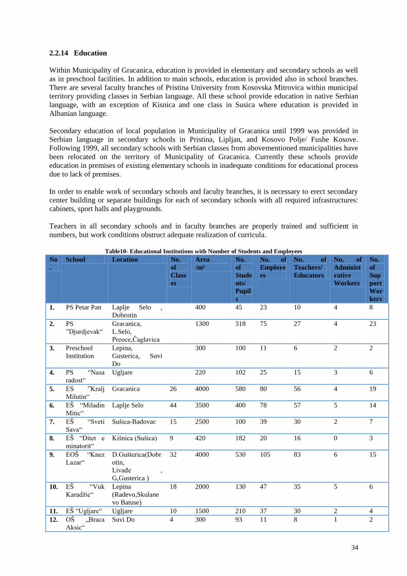
2.2.14 Education
Within Municipality of Gracanica, education is provided in elementary and secondary schools as well
as in preschool facilities. In addition to main schools, education is provided also in school branches.
There are several faculty branches of Pristina University from Kosovska Mitrovica within municipal
territory providing classes in Serbian language. All these school provide education in native Serbian
language, with an exception of Kisnica and one class in Susica where education is provided in
Albanian language.
Secondary education of local population in Municipality of Gracanica until 1999 was provided in
Serbian language in secondary schools in Pristina, Lipljan, and Kosovo Polje/ Fushe Kosove.
Following 1999, all secondary schools with Serbian classes from abovementioned municipalities have
been relocated on the territory of Municipality of Gracanica. Currently these schools provide
education in premises of existing elementary schools in inadequate conditions for educational process
due to lack of premises.
In order to enable work of secondary schools and faculty branches, it is necessary to erect secondary
center building or separate buildings for each of secondary schools with all required infrastructures:
cabinets, sport halls and playgrounds.
Teachers in all secondary schools and in faculty branches are properly trained and sufficient in
numbers, but work conditions obstruct adequate realization of curricula.
Table10- Educational Institutions with Number of Students and Employees
No
.
School Location No.
of
Class
es
Area
/m²
No.
of
Stude
nts/
Pupil
s
No. of
Employe
es
No. of
Teachers/
Educators
No. of
Administ
rative
Workers
No.
of
Sup
port
Wor
kers
1. PS Petar Pan Laplje Selo ,
Dobrotin
400 45 23 10 4 8
2. PS
”Djurdjevak“
Gracanica,
L.Selo,
Preoce,Čaglavica
1300 318 75 27 4 23
3. Preschool
Institution
Lepina,
Gusterica, Suvi
Do
300 100 11 6 2 2
4. PS “Nasa
radost“
Ugljare 220 102 25 15 3 6
5. ES ”Kralj
Milutin“
Gracanica 26 4000 580 80 56 4 19
6. EŠ “Miladin
Mitic“
Laplje Selo 44 3500 400 78 57 5 14
7. EŠ “Sveti
Sava“
Sušica-Badovac 15 2500 100 39 30 2 7
8. EŠ “Ditet e
minatorit“
Kišnica (Sušica) 9 420 182 20 16 0 3
9. EOŠ “Knez
Lazar“
D.Gušterica(Dobr
otin,
Livađe ,
G,Gusterica )
32 4000 530 105 83 6 15
10. EŠ “Vuk
Karadžic“
Lepina
(Radevo,Skulane
vo Batuse)
18 2000 130 47 35 5 6
11. EŠ “Ugljare“ Ugljare 10 1500 210 37 30 2 4
12. OŠ „Braca
Aksic“
Suvi Do 4 300 93 11 8 1 2

35
13. Medical
School
Gracanica 8 In premises
of ES
K.Milutin ,
K.Lazar
,ES
V.Karadzic
350 43 87 10 22
14. Civil
Engineering/
Traffic
School
Gracanica 12 In premises
of ES
K.Milutin ,
250 69 47 5 11
15. Musical
School
Gracanica
(D.Gusterica)
20 In premises
of ES
K.Milutin ,
ES K.Lazar
,ES
M.Mitic
180 41 24 6 9
16. Economic/
Trade School
Laplje Selo 14 In premises
of ES
M.Mitic
200 33 27 3 3
17. Gymnasium Laplje Selo 8 In premises
of ES
M.Mitic
115 37 27 3 2
18. Mechanical
School
Preoce 9 In premises
of ES
M.Mitic
90 58 42 4 13
19. Electrical
Engineering
School
Susica-Badovac 11 In premises
of ES
S.Sava
150 37 56 10 10
20. Agricultural
School
Lipljan
(D.Gusterica)
18 In premises
of
ES.V.Kara
dzic
250 96 74 6 15
21. Special
Education
Laplje Selo 250 27 7 4 1 2
TOTAL 262 33,370 4,357 949 751 82 188
Municipality of Gracanica includes twenty (20) educational institutions within its territory, out of
which four (4) kindergartens- preschool facilities, eight (8) elementary and eight (8) secondary
schools. All elementary schools provide education in their own premises, while secondary schools use
premises of elementary schools during morning shift for educational process.
Majority of schools work in three shifts: secondary schools from 06.30-11.00h, elementary schools
from 11.00-14.00h (1st to 4
th grade) and 14.00-18.30h (5
th to 8
th grade).
All elementary school facilities are old ones, i.e. there is a lack of newly constructed buildings, with
an exception of several annexes (school gyms) which are continuously upgraded since 1999.
In late 2010, two preschool facilities have been constructed, the main facility in Laplje Selo and its
branch in Dobrotin.
Number of primary school buildings, their arrangement and the distance is within the set of standard
benchmarks.
Construction and equipping secondary schools would create conditions for the full and proper
operation of the faculties as well.

36
Photo 9- Preschool facility, Laplje Selo Photo 10- Preschool facility, Dobrotin
Photo 11- ES “Kralj Milutin“, Gracanica Photo 12- ES "Miladin Mitic", Laplje Selo
Photo 13- ES “Ditet e Minatorit“, Susica Photo 14- ES “Knez Lazar”, Dobratin
Photo 15- “Ditët e Minatorit “, Kisnica

37
2.2.15 Cultural institutions
Fostering cultural and national tradition and preservation of cultural and religious facilities-
monasteries and churches throughout the centuries, is a part of cultural heritage of Kosovo population.
The most important feature of Gracanica settlement is Monastery of Gracanica, where through the
centuries local population used to gather and which was the centre of education and cultural events.
Considering that until the establishment of the municipality Gračanica was rural, from all cultural
facilities it had only the Culture House, which for decades, from 1948 presents a centre of cultural
events, as in most of the villages in the municipality. These are multipurpose spaces in which there is
a hall for cultural and entertainment events, library with reading room, areas of local communities,
galleries and public spaces.
Figure 16- Cultural House Gracanica
Currently, cultural houses are operational in the following villages: Gracanica, Laplje Selo, Donja
Gusterica, Dobrotin and Batuse. Within the Cultural House in Gracanica operates a Gallery, which is
used for exhibitions, promotions and literary events throughout a year.
The Cultural House is a home of professional and amateur ensemble “Venac”, which is operational
for more than 30 years.
Following establishment of Municipality of Gracanica, cultural centers in Badovac and Batuse as well
as Youth Centre in Preoce, have been constructed. In the past all these villages lacked cultural
facilities.
2.2.16 Public Spaces (Squares and Memorials)
Prior to establishment of new municipality, majority of green areas have been unregulated and
neglected. There was neither squares nor children playgrounds, and memorials were neglected.
Following establishment of Municipality of Gracanica, number of projects was implemented,
including construction and regulation of public parks, regulation of children playgrounds, regulation
of memorial parks, construction and regulation of squares.
There are still green areas to be regulated, planted and made operational. The future developments and
improvements in implementation will create possibilities for increased number of projects for
renovation and regulation of new parks.

38
Parks:
Photo 17- City park, Laplje Selo Photo 18- Memorial park and children playground,
Livadje
Photo 19- Memorial park, Gracanica
Public squares:
Photo 20- Simonida square, Gracanica Photo 21- Square, Dobrotin

39
2.2.17 Recreation and Sports
In the area of sport activities, immediately following the establishment of the Municipality,
rehabilitation and reconstruction of sport fields was carried out in all settlements, as well as
construction of new ones, with installation of lighting equipment.
In Gracanica has begun the construction of the sport centre composed of already built tennis courts
and fields for basketball and volleyball. Construction of football field has commenced which includes
running track, seats for spectators, auxiliary field and facilities for athletes.
The cooperation with sport associations with organizational and financial support has been already
established, which resulted in organization of first “Sport Olympics”. Also, tennis school, basketball
school, football school and karate school have been opened. Currently in all villages within the
municipality, with an exception of the village of Radevo, exist sport fields as independent complexes
or within school facilities.
Photo 22- Tennis Court, Gracanica Photo 23- Sport Compound Admin. Facility
In order to achieve higher level of education, culture and healthy life, the real challenges for the future
are construction of facilities and investment in human resources.
Existing educational staff and cultural and sport workers should be supplemented with young,
educated and perspective staff. Also, continuous improvement through seminars, trainings and
meetings should be enabled for everyone, including through establishment of Educational Centre as a
backbone of such activities.
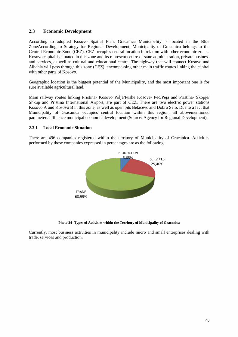
40
2.3 Economic Development
According to adopted Kosovo Spatial Plan, Gracanica Municipality is located in the Blue
ZoneAccording to Strategy for Regional Development, Municipality of Gracanica belongs to the
Central Economic Zone (CEZ). CEZ occupies central location in relation with other economic zones.
Kosovo capital is situated in this zone and its represent centre of state administration, private business
and services, as well as cultural and educational centre. The highway that will connect Kosovo and
Albania will pass through this zone (CEZ), encompassing other main traffic routes linking the capital
with other parts of Kosovo.
Geographic location is the biggest potential of the Municipality, and the most important one is for
sure available agricultural land.
Main railway routes linking Pristina- Kosovo Polje/Fushe Kosove- Pec/Peja and Pristina- Skopje/
Shkup and Pristina International Airport, are part of CEZ. There are two electric power stations
Kosovo A and Kosovo B in this zone, as well as open pits Belacevc and Dobro Selo. Due to a fact that
Municipality of Gracanica occupies central location within this region, all abovementioned
parameters influence municipal economic development (Source: Agency for Regional Development).
2.3.1 Local Economic Situation
There are 496 companies registered within the territory of Municipality of Gracanica. Activities
performed by these companies expressed in percentages are as the following:
Photo 24- Types of Activities within the Territory of Municipality of Gracanica
Currently, most business activities in municipality include micro and small enterprises dealing with
trade, services and production.
PRODUCTION 5,65% SERVICES
25,40%
TRADE 68,95%

41
Table 11- Business Activities in Municipality of Gracanica
No. Locations Production Services Trade Total
1 Gracanica 2 52 120 174
2 Laplje Selo 6 30 63 99
3 Caglavica 2 7 39 48
4 Preoce 4 8 23 35
5 Livadje 2 6 10 18
6 Donja Gusterica 5 8 25 38
7 Gornja Gusterica 3 3 6
8 Dobrotin 4 7 27 38
9 Susica 1 4 5
10 Badovac 1 5 6
11 Kisnica 2 2
12 Lepina 2 5 7
13 Radevo 1 3 4
14 Skulanevo 2 2
15 Suvi Do 1 2 8 11
16 Batuse 3 3
Total 28 126 332 496
Source: Economic Development Unit, Municipality of Gracanica
Table 12- Service Business Activities in Private Sector
No. Location Banks Hospitals Hotels5
1 Gracanica 6 2
2 Laplje Selo 3 1 4
3 Gornja Gusterica 1
4 Dobrotin 2
5 Livadje 1
6 Caglavica 1 1
7 Preoce 2 3
8 Total 9 4 14
Source: Economic Development Unit, Municipality of Gracanica
Photo 18- Service Business Activities
5 Motels, restaurants are also included

42
2.3.2 Industry
The biggest lead and zinc mine is Kisnica mine which is not operational since 1999. However, in last
few years this mine processes lead and zinc ore from Marevac and Novo Brdo mines. Kisnica mine
represents industrial asset but it should be thoroughly checked.
Table 13- Production
No. Company Activity Location
1 "MILLENIUM GROUP" Flour production Laplje Selo
2 "ELNOR" SH.P.K Production of tables and chairs Laplje Selo
3 "MIQESIA" Concrete production Laplje Selo
4 "KEMA COMPANY" Concrete and cement products Laplje Selo
5 "EUROBETON
COMPANY"
Production of concrete elements for sewage
systems
Preoce
6 "SOLID" Gutter production Preoce
7 "YLLITERM" Production of boilers Dobrotin
8 "CONCEZUS" Production of concrete elements Dobrotin
9 "KRYEZIU 2" Production of concrete elements Dobrotin
10 "LAS PALMAS" Production of vegetables and flowers Dobrotin
11 "XELLA" Production of silicate bricks Dobrotin
12 "MENTORI COM" Recycling of metal waste Dobrotin
13 "INTER QADRA" Production of tarpaulins and tents Livadje
14 "SCAMPA" Production of plastic bags Livadje
15 "FRATELO TRADE" Production of cakes Badovac
16 "FITORJA" Concrete production Čaglavica
17 "RELUX" Production of paints and varnishes Laplje Selo
Figure 25- Location of the existing Business Zone

43
2.3.3 Employment (Private Sector)
According to registered and certified businesses, number of employees in private sector is from 992 to
1488. Below table presents 10 companies with 196 fully employed workers and 25 seasonal workers,
although the real number should be even higher. Officially registered number of employees is not
realistic and objective.
Table 14- Major Employers in Municipality
No. Company Activity Location No. of
Employees
1. "ANTON" SH.P.K Wholesale of glass and
paints
Laplje Selo 20+seasonal
workers
2. "RELUX" SH.P.K Production of paints and
varnishes
Laplje Selo 10
3. "KOSOVA KOLOR" SH.PK Wholesale of paints and
varnishes
Laplje Selo 5
4. "ELNOR" SH.P.K Production of tables and
chairs
Laplje Selo 39+9 seasonal
workers
5. "HIB" SH.P.K Gas station, restaurant,
shop
Laplje Selo 26
6. "INTER QADRA" SH.P.K Production of tarpaulin and
tents
Livadje 7+7 seasonal
workers
7. "KEMA" SH.P.K Concrete and cement
products
Laplje Selo 21
8. "ORBICO" SH.P.K Wholesale of foods and
cosmetics
Laplje Selo 17
9. "EBC COMPANY" SH.P.K Wholesale of cosmetics Laplje Selo 19
10. "PORSHE" SH.P.K Car shop Laplje Selo 32
Photo 15- Graphical Presentation of Major Employers

44
2.3.4 Nongovernmental Organizations (NGO)
There are twenty two (22) active nongovernmental organizations within the territory of Municipality
of Gracanica.
Table 16- Nongovernmental Organizations in Municipality of Gracanica
No. NGO Activity Location
1 NGO “CSD” Communication for society development Gračanica
2 “CRT/KPA” Centre for peace and tolerance Gračanica
3 NGO “Mother Teresa” Cooperation for building multiethnic kindergarten Kišnica
4 “AVENIJA” Economic empowerment of women Laplje
Selo
5 “SUZ” Alliance of women associations Laplje
Selo
6 “FUTURE” Human rights and empowerment Gračanica
7 “PUTEVIMA SUNCA” Children and youth organization Gračanica
8 NGO”Ruka ruci” Empowerment of women from minority communities in
Kosovo
Ugljare
9 NGO Centre for dialog and reconciliation Laplje
Selo
10 NGO It will be better Gračanica
11 “OČI BUDUĆNOSTI” Roma organization Gračanica
12 “POKRETAČ" Sport association Sušica
13 NGO”GETO” In cooperation with CSD Gračanica
14 “SAVEZ SLEPIH” Association of blind persons Gračanica
15 NGO Organization of persons with disabilities Gračanica
16 NGO”Moja inicijativa” Youth devoted project (sport) Kišnica
17 “MINATORI I RI” Cultural- Artistic Association Kišnica
18 “REAL KLUB” Boxing Club Gračanica
19 “UGLJARE” Football Club Ugljare
20 “ZELENA AGENDA” Green Agenda Gračanica
21 NGO”Kometa” Human rights, economic development, youth etc. Gračanica
22 “OMLADINSKI
CENTAR”
Near achievement Gračanica
2.3.5 Agriculture
The agriculture is ranked as high quality. Based on the information obtained from the Directorate of
Agriculture 76.93 % of land is arable land mainly crops (wheat and corn). There are also small
orchards and small vegetable gardens mainly only for personal use. About 15.1 % is meadows and
pastures however there is very limited number of farms (19 farmers registered in all municipalities).
Gracanica is primarily rural municipality and its economy is heavily dependent on agricultural
production. Major part of its territory is composed of land of I and II categories.
Two basic agricultural branches prevailing in Gracanica Municipality are farming and cattle breeding.
Gracanica Municipality encompasses around 8700 hectares of agricultural land, what represents
around 71% of the total area. This land includes meadows and pastures.
Municipality of Gracanica in cooperation with Ministry for Agriculture and Forestry encourages
development of agriculture through subsidies for spring and autumn season, supporting in this way
economic strengthening of farms in order to intensify their production capacities.
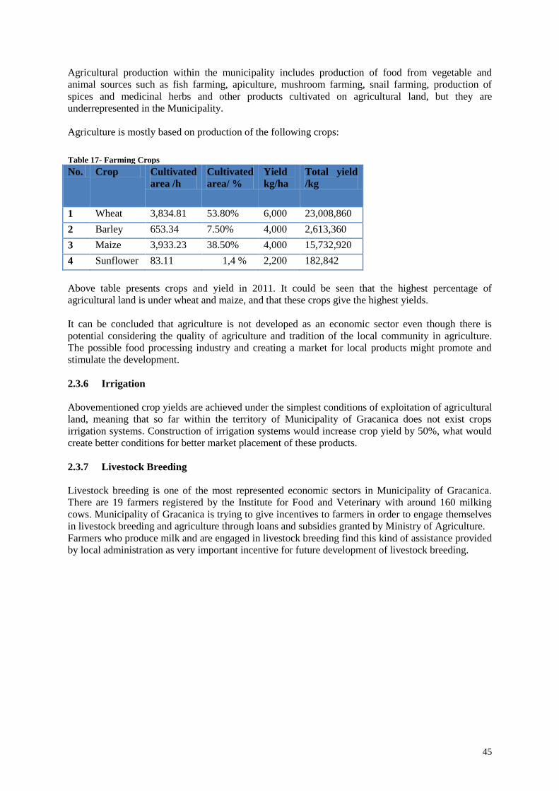
45
Agricultural production within the municipality includes production of food from vegetable and
animal sources such as fish farming, apiculture, mushroom farming, snail farming, production of
spices and medicinal herbs and other products cultivated on agricultural land, but they are
underrepresented in the Municipality.
Agriculture is mostly based on production of the following crops:
Table 17- Farming Crops
No. Crop Cultivated
area /h
Cultivated
area/ %
Yield
kg/ha
Total yield
/kg
1 Wheat 3,834.81 53.80% 6,000 23,008,860
2 Barley 653.34 7.50% 4,000 2,613,360
3 Maize 3,933.23 38.50% 4,000 15,732,920
4 Sunflower 83.11 1,4 % 2,200 182,842
Above table presents crops and yield in 2011. It could be seen that the highest percentage of
agricultural land is under wheat and maize, and that these crops give the highest yields.
It can be concluded that agriculture is not developed as an economic sector even though there is
potential considering the quality of agriculture and tradition of the local community in agriculture.
The possible food processing industry and creating a market for local products might promote and
stimulate the development.
2.3.6 Irrigation
Abovementioned crop yields are achieved under the simplest conditions of exploitation of agricultural
land, meaning that so far within the territory of Municipality of Gracanica does not exist crops
irrigation systems. Construction of irrigation systems would increase crop yield by 50%, what would
create better conditions for better market placement of these products.
2.3.7 Livestock Breeding
Livestock breeding is one of the most represented economic sectors in Municipality of Gracanica.
There are 19 farmers registered by the Institute for Food and Veterinary with around 160 milking
cows. Municipality of Gracanica is trying to give incentives to farmers in order to engage themselves
in livestock breeding and agriculture through loans and subsidies granted by Ministry of Agriculture.
Farmers who produce milk and are engaged in livestock breeding find this kind of assistance provided
by local administration as very important incentive for future development of livestock breeding.

46
2.3.8 Tourist Potentials
Kosovo is a rich treasure of ethnic cultural and spiritual heritage from different historical periods.
Cultural heritage is characterized by its diversity, values and historical significance.
Tourist attractions in Municipality of Gracanica are:
• Gracanica Monastery, magnificent building from XIV century, was built by King Milutin in
1321. It is dedicated to the Assumption of the Blessed Virgin Mary.
• Archaeological site Ulpiana with remnants of Roman and Early Byzantine town, founded in
the middle of II century A.D.
• Plenty of different style churches in almost every village;
• Gracanica Lake;
• Radevo fishpond;
• Natural source- Cesma.
Photo 26- Tourist Potentials of Municipality of
Gracanica
Municipality of Gracanica has significant potentials for development of cultural, religious,
recreational, sport, village and hunting tourism. Tourism is poorly developed. However, Municipal
Tourist Organization of Gracanica is under development.

47
2.4 Infrastructure and Public Services
2.4.1 Traffic and Roads
Three national roads pass through Municipality of Gracanica:
• National Road Pristina- Gnjilane/ Gjilan (5.5 km through municipal territory);
• National Road Pristina- Skopje/ Shkup (12.3 km through municipal territory);
• National Road Pristina- Prizren (3.45 km through municipal territory).
Photo 27- Municipal Road Network
Additionally, the highway that will connect Kosova, Albania and Serbia (European Corridor 10) is
being constructed and it passes through Municipality of Gracanica.
Municipality of Gracanica includes 16 (sixteen) villages which are more or less connected with local
rural roads. Most roads within settlements are inadequate ones. Since establishment of Municipality of
Gracanica, local roads connecting settlements are mostly reconstructed and paved. Other roads within
settlements are partially paved. The whole area of all roads within the territory of Municipality of
Gracanica is 2,696.301.00 m².
According to data from Gracanica police station in 2012 in the municipality there were recorded 197
accidents, there were no accidents resulting in death.
Black spots in the municipality recorded in the previous period are:
• Local road Gracanica- N.Badovac (curve in front of the pool, 5 incidents);
• Local road Gracanica- Laplje Selo (double curvature near the fountain, 13 incidents);
• Local road in Laplje Selo (between the restaurant “Hrana” and restaurant “Vožd”, 33
incidents).
(Source: Municipality of Gracanica Cadastral Office)
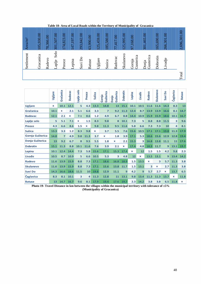
48
Table 18- Area of Local Roads within the Territory of Municipality of Gracanica A
rea/
m²
10
5,9
30
.00
78
,36
6.0
0
30
1,5
07
.00
17
4,8
23
.00
14
7,1
97
.00
29
3,8
42
.00
63
,99
0.0
0
12
5,4
59
.00
18
5,5
80
.00
77
,41
7.0
0
12
5,9
95
.00
97
,16
8.0
0
30
1,4
65
.00
16
5,6
90
.00
26
6,3
01
.00
2,6
96
,30
1.0
0
Set
tlem
ent
Gra
canic
a
Rad
evo
Lap
lje
Sel
o
Pre
oce
Lep
ina
Su
vi
Do
Bat
use
Ug
ljar
e
Su
sica
Bad
ov
ac
Sk
ula
nev
o
Go
rnja
Gu
ster
ica
Do
nja
Gu
ster
ica
Do
bro
tin
Liv
adje
To
tal
Ugl
jare
Gra
čani
ca
Bad
ovac
Lapl
je s
elo
Preo
ce
Suši
ca
Gor
nja
Guš
teri
ca
Don
ja
Guš
teri
ca
Dob
roti
n
Lepi
na
Liva
đe
Rad
evo
Skul
anev
o
Suvi
Do
Čagl
avic
a
Bat
use
Ugljare x 10.1 12.1 5 4.3 13.3 14.8 13 15.1 10.1 10.5 11.6 11.6 14.3 8.3 13
Gračanica 10.1 x 2.1 5.1 6.6 3.3 7 9.2 11.3 12.4 8.7 13.9 13.9 16.6 8.1 14.7
Badovac 12.1 2.1 x 7.1 8.6 1.2 4.9 6.7 8.8 14.4 10.9 15.9 15.9 18.6 10.1 16.7
Laplje selo 5 5.1 7.1 x 1.5 8.3 9.8 8 10.1 7.3 5 8.8 8.8 11.5 3 9.6
Preoce 4.3 6.6 8.6 1.5 x 9.8 11.3 9.5 11.6 5.8 6.6 7.3 7.3 10 4 8.1
Sušica 13.3 3.3 1.2 8.3 9.8 x 3.7 5.5 7.6 15.6 10.5 17.1 17.1 19.8 11.3 17.9
Gornja Gušterica 14.8 7 4.9 9.8 11.3 3.7 x 1.8 3.9 17.1 5.3 18.6 15.6 12.9 12.8 19.4
Donja Gušterica 13 9.2 6.7 8 9.5 5.5 1.8 x 2.1 15.3 3 16.8 13.8 11.1 11 17.6
Dobrotin 15.1 11.3 8.8 10.1 11.6 7.6 3.9 2.1 x 17.4 4.8 18.9 11.7 9 13.1 19.7
Lepina 10.1 12.4 14.4 7.3 5.8 15.6 17.1 15.3 17.4 x 12 1.5 1.5 4.2 9.8 2.3
Livađe 10.5 8.7 10.9 5 6.6 10.5 5.3 3 4.8 12 x 13.5 13.1 9 13.4 14.2
Radevo 11.6 13.9 15.9 8.8 7.3 17.1 18.6 16.8 18.9 1.5 13.5 x 3 5.7 11.3 3.8
Skulanevo 11.6 13.9 15.9 8.8 7.3 17.1 15.6 13.8 11.7 1.5 13.1 3 x 2.7 11.3 3.8
Suvi Do 14.3 16.6 18.6 11.5 10 19.8 12.9 11.1 9 4.2 9 5.7 2.7 x 13.7 6.5
Čaglavica 8.3 8.1 10.1 3 4 11.3 12.8 11 13.1 9.8 13.4 11.3 11.3 13.7 x 11.8
Batuse 13 14.7 16.7 9.6 8.1 17.9 19.4 17.6 19.7 2.3 14.2 3.8 3.8 6.5 11.8 x Photo 19- Travel Distance in km between the villages within the municipal territory with tolerance of ±5%
(Municipality of Gracanica)

49
2.4.2 Railway Traffic
There are two railway routes passing through the territory of Municipality of Gracanica:
• International railway Pristina- Skopje- Athens;
• Local railway that connects settlements Kisnica, Gracanica, Laplje Selo and Lepina with the
main railway hub in Kosovo Polje/Fushe Kosove.
This railway line was used for ore transportation from Kisnica mine. The line was operational until
2003. It was also used for passenger traffic.
2.4.3 Air Traffic
Pristina Airport is international airport with a distance of 22 km from Gracanica settlement. This
airport is the biggest within Kosovo territory and has strategic location. It is situated in the central part
of Balkan region enabling good connections with other regional centers. Pristina Airport enables
passenger air traffic and cargo air traffic. In the past, in addition to civilian purposes it was also used
for military purposes.
2.4.4 Public Transport
Public transport is not operational in Gracanica. There are two types of private transport in
Municipality of Gracanica, urban and interurban transport. Urban transport within Municipality of
Gracanica is mostly provided by small travelling agencies with minibuses. These companies generally
have one or two minibuses.
This transport operates from 6:30 to 15:00, after this time only taxis may be used. This problem of
residents’ communication between the villages is an added obstacle in the development of these areas,
and residents of this municipality are forced every day to hitchhike to get to work, school, and health
centre.
Department for Public Services in cooperation with Ministry of Infrastructure organized humanitarian
transport for all inhabitants of Municipality of Gracanica. Urban transport is organized 3 times a week
within the whole municipal territory and is provided by company “Arsa prevoz”. Interurban transport
is organized 3 times a week and is provided by company “Selo Turs”.

50
In addition to abovementioned, there are the following bus- lines passing through Gracanica
settlement: Pristina-Gnjilane/Gjilane, Pristina-Janjevo and Pristina-Susica. Bus Pristina-
Gnjilane/Gjilane passes daily every 20 min in the period from 7:45 a.m. until 6:30 p.m. Bus Pristina-
Janjevo passes through municipality three times every day. However, such transport does not meet
needs of inhabitants. There are no bus lines operating in evening hours between settlements and also
there is no direct bus line to Pristina. Lack of bus station where passengers could wait for buses makes
this situation even worse.
Only one taxi company operates within municipality.
Public utilities services are provided by the regional public utilities department in Prishtina. Similarly
to other rural areas in Kosovo, utility services are very bad.
2.4.5 Water Supply
Municipality of Gracanica is supplied with drinking water by the “Regional Water Supply Company”
from Pristina. Pristina Region as well as one part of settlements within Municipality of Gracanica
including Gracanica, Kisnica, Badovac, Susica, Laplje Selo, Preoce and Caglavica are supplied with
potable water from artificial reservoir, so-called Gracanica Lake. Artificial lake was built in 1966 and
became operational in September 1966. Capacity of the Gracanica lake is around 26,000.000.00 liters.
In the vicinity of the lake there is a water supply station for production of drinking water. There is a
protection zone around Gracanica/Badovc lake.
Photo 28- Water Supply Station in Gracanica- Regional Water Supply Pristina
Number of customers/households from abovementioned settlements within Municipality of Gracanica
who are provided with water supply is 2723. Also, regional water supply company with its branch in
Lipljan/Lipjan provides potable water for the following villages within Municipality of Gracanica:
Dobrotin, Donja Gusterica, Gornja Gusterica and Livadje. These settlements are supplied with water
from the water processing station in Lipljan, but also from nearby wells.
Table 20- Pipeline length, number of customers and network capacity
No Network Section Pipeline Length/m Number of
Customers
Capacity l/s
1 Lipljan- Gornja Gusterica L = 7,300 257 12 l/s
2 Lipljan-Donja Gusterica L=4,200 112 2 l/s
3 Lipljan-Livadje L=8,100 165 2-3 l/s
4 Lipljan-Dobrotin L=7,300 145 2-2,5 l/s
Total L=26,900 679
In total, there are 3402 households provided with water supply which shows that from total number of
households there are 1098 households without water supply.
Settlements Lepina, Batuse, Skulanevo, Radevo and partially Suvi Do have no water supply systems
and water is supplied from private wells. Unfortunately none of the relevant institutions do not check
the water quality from private wells.

51
2.4.6 Sewerage System
Municipality of Gracanica is composed of rural settlements, because of which, before the
establishment of Municipality of Gracanica, coverage with sewerage systems was weak. Following
the establishment of Municipality of Gracanica, sewerage systems are constructed in settlements
throughout the Municipality..Poor coverage of sewerage network is still in places like Lepina, Batuse,
Radevo. All the water from the sewer system together with rainwater end in rivers, without prior
filtering (there are no systems for wastewater treatment).
By measuring the composition of the waste water, the quality of surface and underground waters was
determined. In order to protect public health, basic preventive and protective measures are
implemented to reduce water contamination. Municipal Assembly has managed the implementation of
capital investment projects (construction of sewerage collectors) to eliminate temporarily
contaminators of underground and surface waters.
Indicate percentage of households connected in sewerage system. (check during public review).
The total coverage of the Municipality of Gracanica with public sewerage collector is 30,173 m.
Rainwater drainage system in Gracanica settlement in 2011 and 2012 is around 2,500 m. Regional
Water Supply Company PRISTINA is responsible for the functionality of the sewerage and rainwater
drainage networks. Although these networks are in an old condition and doesn’t have more capacity
for enlargement.
2.4.7 Waste Management
Gracanica doesn’t have waste management plan yet. However, following establishment of Gracanica
municipality, municipality together with regional waste company Pastrimi took charge for waste
collection and disposal. But, the capacity of company Pastrimi is considered insufficient and there is
no sufficient number of containers within municipal territory. The waste is collected twice a week in
entire municipal territory (twice in Gracanica settlement and once a week in other settlements). The
waste in business zone is managed by business owners themselves. The amount of waste collected in
entire municipality is about 140m3 per week. The waste is not selected (all organic and other waste is
mixed together). Significant problem is disposal of medical waste which is disposed together with
other types of waste. One of major landfills is Kisnica mine tailing dam. This landfill is the main
environmental challenge municipality is faced with.
2.4.8 Electricity Networks
Territory of Municipality of Gracanica is almost completely covered with electricity network.
Company KEK is provider of electricity. Electricity is produced in thermo power plant Obilic.
Frequent electricity cuts during the winter season create difficulties for normal functioning of
households and business companies. Despite the fact that majority of customers pay their electricity
bills regularly to the KEK distribution, power cuts during the winter season are part of life of
inhabitants of Gracanica Municipality.
Due to non-provision of data from relevant institutions, there is no information about number of
customers and network capacities on energy supply.

52
2.4.9 Communications (Telecommunications and Internet)
There is number of companies within the territory of Gracanica Municipality dealing with this
business activity. According to available information, there is more than 15 companies providing
Internet, cable TV, landline and mobile telephony services. We have to mention that according to our
estimation, Telecom Serbia covers with landline telephony around 95% of the territory of Gracanica
Municipality, as well as with the mobile telephony. This company also offers ADSL and IPTV
services, but in Gracanica and Susica only. These data have been obtained using field estimates in
absence of official information.
In addition to the abovementioned, mobile and landline telephony services are also provided by IPKO
and PTK. When it is about landline telephony, IPKO has two customers and PTK one customer.
There are no official information about customers of mobile telephony.
It should be mentioned that all settlements within the municipality have cable TV, but there is no
official information. IPKO has its cable TV with around 70 channels in Albanian, Serbian, English
and Turkish languages.

53
2.5 Environment, Natural Resources and Cultural Heritage
2.5.1 Natural Resources
For Municipality of Gracanica it could be said that it is opulent with natural resources.
Badovc Lake is an artificial reservoir on the Gracanka River two kilometers from Gracanica
settlement, constructed to supply Pristina and surrounding settlements with drinking water. One part
of lake Badovc belongs to the municipality. Construction of Gracanica Lake began in 1963, and water
from the lake started to flow toward Pristina in summer 1966. The dam height is 52 meters and the
length is 246 m. It was constructed in Badovac strait in the foothill of Androvac mountain, nearby
“Kisnica” mining facility. Lake is 3.5 km long and 500 m wide, with maximal depth of 30 m and total
water volume of 26 million m3. One can find different kinds of fishes, mainly carps and chubs.
During its construction, Serbian settlements Novo Selo, which was in the area of lake water and Stari
Badovac, which was located below the dam, have been relocated.
Photo 29- Badovc Lake
One of the most important natural resources is also the agricultural land, which is a beautiful
landscape in the Municipality of Gracanica.

54
Photo 30- Agriculture landscape
2.5.2 Rivers within Municipal Territory
Municipality of Gracanica is opulent with water resources. There are four rivers and one creek
flowing through Gracanica Municipality: Gracanka, Sitnica, Pristevka, Janjevka and Zegovo Creek.
Gracanka River is Kosovo river flowing nearby Gracanica Monastery, through settlements
Gracanica, Laplje Selo, Preoce, Gornje Dobrevo and joins Sitnica River in the village of Donje
Dobrevo. Source of the river is under the dam of Gracanica Lake and it flows along Kisnica mine
industrial waste landfill. While there was no lake, Gracanka was richer in water and was made of
small rivers and streams nearby the village of Labljane and Mramor. Length of the river is 18.50 km.
One part of Gracanka riverbed is regulated.
Photo 31- Gracanka River Photo 32- Sitnica River
Sitnica River is one of major Kosovo rivers. Its source is in the southeast part of Kosovo on Zegavac
mountain. Its length is 90 km with the average flow of 9,5 m²/sec at the mouth of the river. Although
the average altitude of its basin is 1.000 m, flowing along Kosovo valley, it has all characteristics of
lowland rivers: small drop (0.76‰) and shallow meandering riverbed from which water regularly
spills over when at higher water levels, what causes modification of the riverbed.

55
Photo 33- Prishtevka River, Uglarë
Pristevka River thirty years ago was clean river. Today, throughout its length of 15.43 km, this river
serves as a sewerage collector for Pristina City. In the lower part this river flows through settlement of
Ugljare and joins Sitnica River. Pristevka riverbanks are unregulated, overgrown in bushes, shrubs
and willows. Riverbed is full of mud and sewage sludge. Pristevka River was bridged in the village of
Ugljare and this bridge prevents unimpeded water flow and causes frequent floods of nearby housing
facilities.
Janjevka River flows through Gornjand Donja Gusterica. Janjevka River dries up during summer
periods, especially at high temperatures, so water flows only during winter periods.
Watercourses: Water quality in Municipality of Gracanica is disastrous and requires urgent action as well as
significant infrastructural investments. Inheritance of dirty industry which was not based on the
sustainable development, but rather on misuse of resources and their direct and brutal pollution caused
significant deterioration of watercourses within the territory of Municipality of Gracanica. Also,
majority of households discharge their waste waters into rivers and some of them into underground
waters. When Municipality of Gracanica Polluter Cadastral is drafted, it is necessary to make
categorization of polluters dividing them into collective and individual polluters. (Source:“Green Agenda”, Document of Municipality of Gracanica)

56
Photo 34- Underground sensitivity on pollution (source: EULUP)
2.5.3 Forestry
Forests in Kosovo account 41.8% or around 455000 ha. Forests in Municipality of Gracanica occupy
area of 1300 ha, or around 9.9% of the total territory of Municipality of Gracanica. The most common
types of forest tree species are black and white pine and oak.
Photo 35- Forest Zone

57
2.5.4 Environmental situation
Environment situation in Gracanica Municipality it is determined by natural conditions, rural
structure, economic activities, transport and ongoing social- economic processes.
Mean annual concentration of polluting gasses in the air in 2011 was provided by Hydro-
meteorological Institute of Kosovo. Station for air quality measuring is located in Pristina and it
covers area of 10 km2 (data PM10 -57,83 ng/m
3 ; 3- 49,41ng/m
3; SO2 – 19,6 ng/m
3 ; CO 3784,55 ng/m
3;
NO2- not available).They provide measuring data for air and soil pollution within the municipal
territory, but from experience it could be stated that air in Gracanica is polluted by Kisnica mine
tailing dam. Also, the main air pollutant in the whole municipal territory and the source of noise is
traffic.
2.5.5 Pollution
Collective Polluters- as defined, include all polluters or settlements with more than fifty (50)
households with access to sewerage system or sewer drain.
Most of the settlements are supplied with the drinking water from Gracanica Lake. However, villages
of Batuse, Radevo, Suvi Do, Skulanevo, Lepina, also located within the territory of Municipality of
Gracanica use drinking water from wells or nearby natural springs. Rural wells are connected to
pneumatic pumps through which inhabitants use the water for different purposes. Those pneumatic
pumps use electricity as a power source, and due to frequent electricity cuts inhabitants are often left
without water. This water contains limestone, in some settlements inhabitants use bacteriological
irregular water what threatens their health. Many villages still use sewer drains what pose a threat for
water used by inhabitants for everyday purpose.
2.5.5.1 Water Pollution
Waste water from Gracanica settlement flows to six water recipients. Most waste water flow to
Gracanka River, Zegovka River, Janjevka River, Susica Creek, PristevkaRiver and then to Sitnica
Rivers.
Settlement Waste Water
Recipient River
Purifying Collectors
Gracanica, Laplje Selo,
Preoce, Kisnica
Gracanka River NO
Dobrotin Zegovka River NO
G. Gusterica, D.
Gusterica
Janjevka River NO
Livadje Susica Creek NO
Ugljare Pristevka River NO
Lepina, Radevo,
Skulanevo, Suvi Do
Sitnica NO
Caglavica Irrigation channels,
sewer drains
NO
Table 21- Tabular Presentation of Waste Water Polluters Flowing to Riverbeds
The biggest individual polluter of Gracanka River is Kisnica mining facility. Until the late nineties,
the quality of water in Gracanka River was seriously compromised due to continuous discharge of
waste waters from flotation. Currently, operations of these major individual polluters are suspended.

58
Another serious pollution source is flotation of industrial waste located along the riverbed. Due to
erosion significant part of mud reaches the riverbed.
Kisnica Mine is a black spot of pollution of Black Sea basin waterways, where through Sitnica River,
Ibar River and Morava River, significant amounts of heavy metals reach Danube River and Black Sea.
This was the subject of one study drafted in 1996 under the title “Rehabilitation and Recultivation of
Gracanka River”.
Table 22- Water Quality Parameters in rivers flowing through Municipality of Gracanica
(Source: Kosovo Hydro meteorological Institute)
This study, drafted upon the request of the Ministry of Environment of the Republic of Serbia, states
among others, that Ibar River is continually polluted with waste materials from Kosovo.
As it was the case with Pristevka River, also Janjevka River, Zegovka River (14.28 km long) and
Susica Creek are used as sewerage systems and waste landfills in settlements of Gornja and Donja
Gusterica and Livadje. The consequence of this is the smell of waste water in spring, summer and
autumn days. The following table presents water quality parameters in rivers flowing through
Gracanica Municipality in 2008 and 2009.
The measurements conducted by the Hydro Meteorological Institute of Kosovo, in 50 measuring
points in all rivers, were used to get the following physical and chemical parameters: according to the
results, all rivers in Kosovo exceed EU standards as regards water color, especially in the areas
around the middle and the end as a result of industrial water and sewage discharge (app. 1500 l/s are
discharged in the eastern part of Kosovo alone). Based on the measurements and chemical parameters
cyanide, nitrates, zing and phenols, are present in greater quantities from time to time, when
compared to EU determined standards. Based on these analyses conducted in the rivers of Kosovo,
only the river Sitnica turned out to have values at a dangerous level.
Water pollution is increased by the sewage, which is discharged in the water, as well as garbage, use
of sand and gravel and land being washed. Plants used to process urban sewage do not exist in any
settlements. (Source: SEA for MDP of Gracanica)
Parameter
s
River SITNICA PRISTEVKA GRACANKA
Sampling
Locationetr
i
Reka SITNICA PRIŠTEVKA GRAČANKA
Mes
to
Uzo
rkov
an
a
Bab
ljak
Lip
jan
Vra
goli
ja
Ple
met
ina
Mit
rovic
a
Bre
sje
Vra
goli
ja
SHBO5 2.695 1.43 4.34 3.8 4.49 18.43 6.92
Nitrati .091 2.289 3.545 4.93 11.0 10.84 2.9
Nitriti 0.057 0.445 0.296 0.37 0.681 0.279 0.167
Amonijak 0.58 3.834 1.474 4.46 2.124 22.473 2.416
Ptotal(poli+orto) 0.133 0.621 0.397 0.51 0.435 0.670 0.400
Sa
mp
lin
g
Lo
cati
on
Ba
blj
ak
Lip
lja
n
Vra
go
lija
Ple
met
ina
Mit
rovic
a
Bre
sje
Vra
go
lija
SHBO5 2.695 1.43 4.34 3.8 4.49 18.43 6.92
Nitrates 1.091 2.289 3.545 4.93 11.0 10.84 2.9
Nitrite 0.057 0.445 0.296 0.37 0.681 0.279 0.167
Ammonia 0.58 3.834 1.474 4.46 2.124 22.473 2.416
Ptotal(poli+orto) 0.133 0.621 0.397 0.51 0.435 0.670 0.400
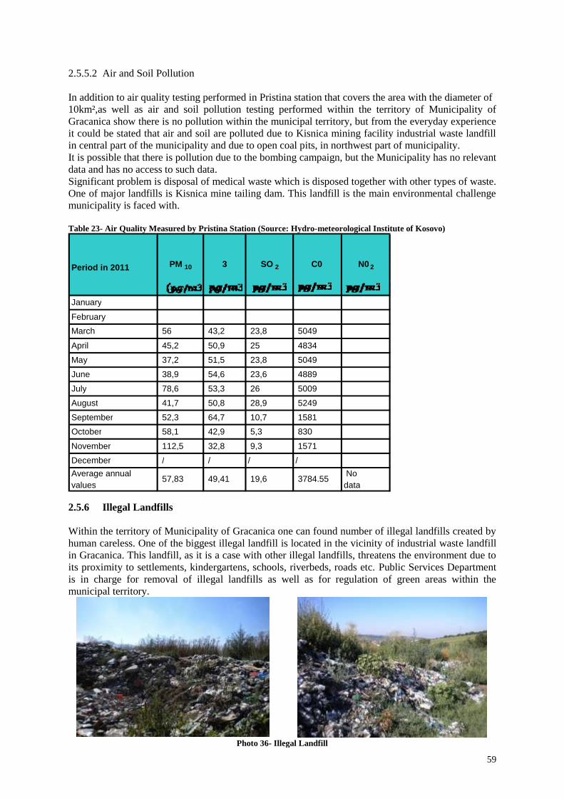
59
2.5.5.2 Air and Soil Pollution
In addition to air quality testing performed in Pristina station that covers the area with the diameter of
10km²,as well as air and soil pollution testing performed within the territory of Municipality of
Gracanica show there is no pollution within the municipal territory, but from the everyday experience
it could be stated that air and soil are polluted due to Kisnica mining facility industrial waste landfill
in central part of the municipality and due to open coal pits, in northwest part of municipality.
It is possible that there is pollution due to the bombing campaign, but the Municipality has no relevant
data and has no access to such data.
Significant problem is disposal of medical waste which is disposed together with other types of waste.
One of major landfills is Kisnica mine tailing dam. This landfill is the main environmental challenge
municipality is faced with.
Table 23- Air Quality Measured by Pristina Station (Source: Hydro-meteorological Institute of Kosovo)
2.5.6 Illegal Landfills
Within the territory of Municipality of Gracanica one can found number of illegal landfills created by
human careless. One of the biggest illegal landfill is located in the vicinity of industrial waste landfill
in Gracanica. This landfill, as it is a case with other illegal landfills, threatens the environment due to
its proximity to settlements, kindergartens, schools, riverbeds, roads etc. Public Services Department
is in charge for removal of illegal landfills as well as for regulation of green areas within the
municipal territory.
Photo 36- Illegal Landfill
January
February
March 56 43,2 23,8 5049
April 45,2 50,9 25 4834
May 37,2 51,5 23,8 5049
June 38,9 54,6 23,6 4889
July 78,6 53,3 26 5009
August 41,7 50,8 28,9 5249
September 52,3 64,7 10,7 1581
October 58,1 42,9 5,3 830
November 112,5 32,8 9,3 1571
December / / / /
Average annual values
57,83 49,41 19,6 3784.55 No data
Period in 2011 PM 10 3 SO 2 N0 2 C0

60
Department for Urbanism, Planning, Cadastre and Environment of Municipality of Gracanica in
April, May and August 2011 carried out registration of illegal landfills. It was concluded that within
the municipal territory exist twenty five (25) illegal landfills with negative influence to the
environment and health of municipal population. In order to resolve the problem of illegal landfills,
experts have prepared detailed Action plan for removal of illegal landfills. The following table
presents illegal landfills:
Table 22- Illegal Landfills Locations
Number and Name of Landfill Location
(1)
Estimated Area in
m² (2)
Estimated waste in m³
(3)
1.Graanica
a. Padaliste
Around
600m²
180m3
2.Laplje Selo
a. Hospital Road – along the railway
b. Near ES ”Miladin Mitic”
24m3
3. Livadje
a. Near Elementary School
b. At the outskirt of Livadje toward D. Gusterica
21,00 m³
4.Donja Gusterica
a. Along the river in the vicinity of the
graveyard
b. In the vicinity of the village, on the road
toward Slovinje
100m3
5.Dobrotin
a. Outside the village at location called “rupe”
35 m3
6.Gornja Gusterica
a. Along the road toward Oklape
b. In the outskirt of G. Gusterica toward D.
Gusterica
56m3
7.Caglavica
a. Along the road toward Ajvalija
28m3
8. Preoce
a. In the vicinity of Youth Centre
28m3
9. Ugljare
a. Near new cemetery
b. Near antenna pole
40 m3
10.Batuse
a. Near cemetery
21,00 m3
11.Lepina
a. Along the railway between Lepina and
Preoce
b. Near ES “Vuk Karadzic”
10,00x4,00x0,20m
20,00x10,00x,030
m
28,00 m3
12.Skulanevo
a. Near football playground along the river
b. On the left side along the road Skulanevo-
Suvi Do
40,00x20mx0,40
m
35,00m3
13. Suvi Do
a. Near cemetery
b.Novo Naselje (along the railway)
20,00x4,00x0,50m
40x3,00x0,40
56,00m3
14.Kisnica
Three (3) landfills
100m3
15. Radevo 14,00m3
16. Landfill in the location of the industrial waste
landfill in Gracanica
100mx150m x
2.5m
37.500 m3

61
2.5.6.1 Open Industrial Landfill of the Waste from Ore Exploitation Facility
Photo 37- Mining tailings sites in the municipality
Kisnica industrial waste landfill poses environmental disaster for the municipality and permanent
threat for degradation of the environment. Threat for the environment is reflected in pollution of
waterways, air and surrounded soil.
Since 1965, pollution poses a threat to waterways through erosion of waste material and to air through
winds that spread floating dust waste, as well as surrounding agricultural land where the dust is
settled. Erosion is frequent phenomenon in landfills.
Amongst accidents presented in the report of International Commission on Big Dams as well as in the
United Nations Environment Program, only two accidents were registered in the area of former
Yugoslavia, the industrial landfill dam failure in Brskovo lead and zinc mining facility in Mojkovac
(Monte Negro) and failure on the slop of Kisnica mining facility landfill bank. Accident occurred in
September 1988 when over 10.000m3
of polluted water spilled over the dam. Polluted water flooded
agricultural land and around ten houses. Overspill was caused by negligence during landfill operation
and this accident was largely politicized (RI, 1988).

62
2.5.7 Disaster Risk Assessment Management (DRAM)
For ensuring the sustainable development it is very important to recognize the level of risk based on
hazards and vulnerability of the area.
Floods:
Based on the studies Gracanica is partially prone to floods, earthquakes, wild fire, erosion, hail and
transportation of dangerous goods. The flood prone areas are alongside the Sitnica River. The river
embankments are built in both sides of the river, however during long heavy rains and when the snow
melting during the winter the water penetrates the embankments. The other rivers and streams are
narrow and solid waste disposal cause floods. The atmospheric water also causes flash floods during
the heavy rains in some flat areas.
Earthquakes:
Kosovo is in high seismic area which is heat by earthquakes in the past, which area cased by
autochthon earthquakes generated 15-20 km depth in the ground. The tectonic structure and
earthquake epicenters with magnitude M >4.0 which affected Kosovo until 2009 are shown in the
map below 2009.
Photo 38- Seismic-tectonic map of Kosovo
Based on existing seismologic and tectonic and
geological maps, Kosovo is divided into 6
seismological zones. Pristina is one of these zones
with magnitude (Mmax=3.8). In this zone belongs
Gracanica municipality. These seismic zones have
generated in the past and can generate strong
earthquakes. Despite the fact that Kosovo is in
seismic zone the construction is not properly
controlled if the seismic code is respected.
Graicanica is close to Ulpiana archeological site
and based in the information Ulpiana was
destroyed in 515 AD. This is another fact that
shows earthquake vulnerability (Source Ulpiana
(ancient settlement) Pristina-Kosovo/UNMIK
2006).
Transport of dangerous goods:
Gracanica territory is situated in the area where main corridors pass through the territory. The
transportation of dangerous goods is potential for disaster. The proper control with respective
standards shall be considered for ensuring safety of citizens.
Wild fire:
The forest area is prone to fires during summer seasons. Also the fields after the wheat is harvesting in
many cases is burned by the farmers. This activity in summer season in many cases causes fire in the
forest nearby the field areas.
Erosion:
Based on the observation from the field survey and maps obtained from EULUP the forest area is
prone to erosion. The causes of the erosion are deforestation and also the mining in the area of
Jalovine.

63
Hail storm:
During the summer season the hail storms has caused damages to agriculture crops, vegetables and
orchards often. Considering the vulnerability of agriculture crops and orchards in Gracanica the hail is
considered as a hazard that might cause a lot of economic lost to local farmers.
Heavy snows:
The weather in Kosovo often during the winters is very hard. The heavy snows and cold winters cause
problems to movement of citizens. The houses without proper construction of roofs and old houses
are vulnerable to this hazard.
2.5.8 Traffic Frequency and Noise
Regional road Pristina- Gnjilane/Gjilan with its length of 48 km influences above all the settlement
and Monastery Gracanica along the road with constant emission of vibrations, smog and dust, exhaust
gasses and noise. Measurements conducted in the period 26 August – 5 September 2011 indicated the
average noise level of 78 dB during the day, 13 dB more than permitted level of noise pollution.
Table 25- Level of Acoustic Load Produced by Regional Road Pristina- Gnjilane/Gjilan in the vicinity of Monastery
Gracanica
Measurement
Location
Average noise
level / day
Excess of
Allowed
Noise Level /
day
Measured
peak of the
noise
Average noise
level / night
Excess of
Allowed
Noise Level /
night
Simonida
Square
Vicinity of
Monastery
Gracanica
78dB
13dB
98dB
67dB
12dB
Allowed noise level/ day- 65 dB
Allowed noise level/ night- 55 dB, for residential area 45 dB
Note: Average value is obtained on the basis of 90 samples where all daily values have been in the
range from 55 to 98 dB, and the most frequent interval was from 65 to 84 dB, what indicates a high
level of daily excess of the noise.
Table 26- Traffic Frequency in Relevant Measurement Locations
Measurement
Location
Cars Buses Tractors Trucks Motorcycles
Simonida
Square
209
5
2
18
3
Vicinity of
Monastery
Gracanica
63 1 0 3 0
Types of vehicles- Frequency of vehicles within 15-minute intervals (average measured values for
day/night)

64
2.5.9 Cultural and Natural Heritage
Kosovo is opulent with cultural- historical heritage. It is a legacy inherited from our ancestors we
should preserve and leave for future generations. There is a number of Serbian Orthodox churches and
monasteries within the municipal territory, and some of them are built by medieval Serbian rulers
(Gracanica Monastery). Within the municipal territory one can also find many cultural – historical
monuments, including archaeological site Ulpiana.
Despite the large number of churches and monasteries, cultural – historical monuments and
archaeological site within the territory of Municipality of Gracanica, currently only Gracanica
Monastery is within the special protective zone.
When it is about protection of cultural heritage, Municipality of Gracanica is engaged to ensure that
areas surrounding churches, historical monuments and archaeological site area under protection.
Gracanica Special Protective Zone
According to Law on Special Protective Zones No. 03/L – 039 from 2008, in addition to regulation of the
role of Serbian Orthodox Church, this Law states that surrounding area of Gracanica Monastery is one of
special protective zones. Also, this Law clearly defines protected zones and types of activities permitted
within such zones.
Source: Law on Special Protective Zones No. 03/L – 039 from 2008.
Article 2. Special Protective Zones
“Special Protective Zone” shall be an area defined by a map, or by a defined area surrounding a
monument, building, group of buildings, ensemble, village, or historic town centre that is safeguarded
from any development or activity which could damage its historical, cultural, architectural or
archaeological context, natural environment or aesthetic visual setting.
Article 3. Objectives
The objectives of the Special Protective Zones are:
a) to provide for the peaceful existence and functioning of the sites to be protected, and to preserve
monastic way of life of the clergy;
b) to preserve the character and appearance of the sites to be protected, in particular, the historical, cultural,
architectural or archaeological context, natural environment or aesthetic visual setting; and
c) to prevent adverse development around the sites to be protected, while ensuring the best possible
conditions for harmonious and sustainable development of the communities inhabiting the areas
surrounding such sites by regulating development and other activities.
Number of monasteries, churches and other religious sites of Serbian Orthodox Church, as well other
historical and cultural facilities of special importance for community of Kosovo Serbs, will enjoy special
protection by application of the Law on Special Protective Zones.
Enjoyment of property rights within protective zones may be limited due to prohibition of every new
activities within these areas:
a) industrial construction or development, such as the exploration and exploitation of mineral resources and
the building of power plants or power lines, kilns and factories;
b) Construction or development of other structures such as structures taller than the monastery/ church/
cultural monument to be protected; use of dangerous materials during construction works (including
housing facilities); road/street construction; construction of warehouses, workshops, shops, restaurants,
bars, cafes, hotels/motels, food stalls and kiosks, petrol and automobile repair stations, supermarkets, night
clubs, etc.
c) Public construction or development leading to deforestation in rural areas.
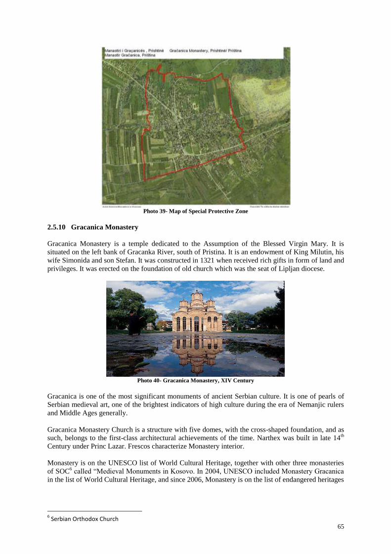
65
Photo 39- Map of Special Protective Zone
2.5.10 Gracanica Monastery
Gracanica Monastery is a temple dedicated to the Assumption of the Blessed Virgin Mary. It is
situated on the left bank of Gracanka River, south of Pristina. It is an endowment of King Milutin, his
wife Simonida and son Stefan. It was constructed in 1321 when received rich gifts in form of land and
privileges. It was erected on the foundation of old church which was the seat of Lipljan diocese.
Photo 40- Gracanica Monastery, XIV Century
Gracanica is one of the most significant monuments of ancient Serbian culture. It is one of pearls of
Serbian medieval art, one of the brightest indicators of high culture during the era of Nemanjic rulers
and Middle Ages generally.
Gracanica Monastery Church is a structure with five domes, with the cross-shaped foundation, and as
such, belongs to the first-class architectural achievements of the time. Narthex was built in late 14th
Century under Princ Lazar. Frescos characterize Monastery interior.
Monastery is on the UNESCO list of World Cultural Heritage, together with other three monasteries
of SOC6 called “Medieval Monuments in Kosovo. In 2004, UNESCO included Monastery Gracanica
in the list of World Cultural Heritage, and since 2006, Monastery is on the list of endangered heritages
6 Serbian Orthodox Church

66
Photo 41- Fresco of Queen Simonida, XIV Century Photo 42- Fresco of King Milutin, XIV Century
2.5.11 Ulpiana
Ulpiana (lat.Ulpiana) or Iustiana Secunda was Roman and Early Byzantine town in the province of
Upper Moesia. Its remnants are spread on the area of ca. 300 hectares, including a buffer zone of 100
m along the protection zone, in the territory between Pristina, Gracanica and Lipljan, only 1 km away
from Gracanica Monastery. Archaeological researches commenced in 1954 and are still ongoing, and
the most significant artifacts are marble female head, jeweler from so-called Gothic tomb and gold-
plated cross fibulas.
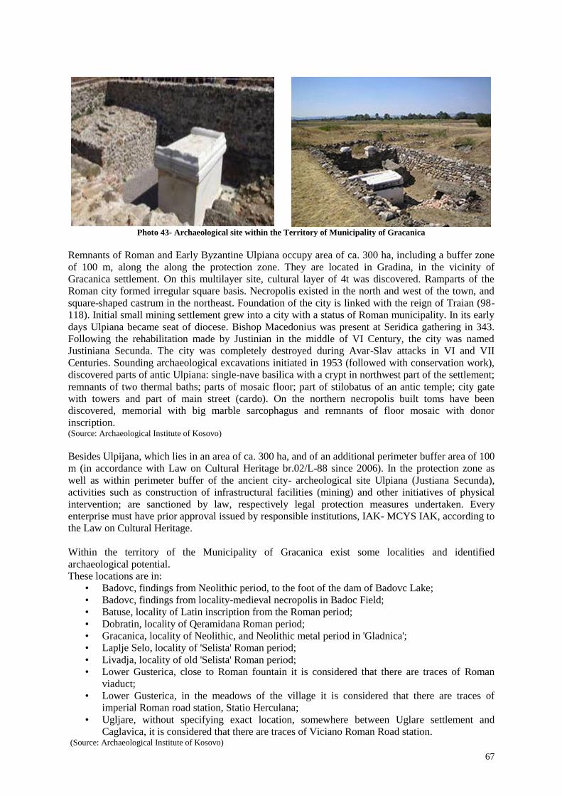
67
Photo 43- Archaeological site within the Territory of Municipality of Gracanica
Remnants of Roman and Early Byzantine Ulpiana occupy area of ca. 300 ha, including a buffer zone
of 100 m, along the along the protection zone. They are located in Gradina, in the vicinity of
Gracanica settlement. On this multilayer site, cultural layer of 4t was discovered. Ramparts of the
Roman city formed irregular square basis. Necropolis existed in the north and west of the town, and
square-shaped castrum in the northeast. Foundation of the city is linked with the reign of Traian (98-
118). Initial small mining settlement grew into a city with a status of Roman municipality. In its early
days Ulpiana became seat of diocese. Bishop Macedonius was present at Seridica gathering in 343.
Following the rehabilitation made by Justinian in the middle of VI Century, the city was named
Justiniana Secunda. The city was completely destroyed during Avar-Slav attacks in VI and VII
Centuries. Sounding archaeological excavations initiated in 1953 (followed with conservation work),
discovered parts of antic Ulpiana: single-nave basilica with a crypt in northwest part of the settlement;
remnants of two thermal baths; parts of mosaic floor; part of stilobatus of an antic temple; city gate
with towers and part of main street (cardo). On the northern necropolis built toms have been
discovered, memorial with big marble sarcophagus and remnants of floor mosaic with donor
inscription. (Source: Archaeological Institute of Kosovo)
Besides Ulpijana, which lies in an area of ca. 300 ha, and of an additional perimeter buffer area of 100
m (in accordance with Law on Cultural Heritage br.02/L-88 since 2006). In the protection zone as
well as within perimeter buffer of the ancient city- archeological site Ulpiana (Justiana Secunda),
activities such as construction of infrastructural facilities (mining) and other initiatives of physical
intervention; are sanctioned by law, respectively legal protection measures undertaken. Every
enterprise must have prior approval issued by responsible institutions, IAK- MCYS IAK, according to
the Law on Cultural Heritage.
Within the territory of the Municipality of Gracanica exist some localities and identified
archaeological potential.
These locations are in:
• Badovc, findings from Neolithic period, to the foot of the dam of Badovc Lake;
• Badovc, findings from locality-medieval necropolis in Badoc Field;
• Batuse, locality of Latin inscription from the Roman period;
• Dobratin, locality of Qeramidana Roman period;
• Gracanica, locality of Neolithic, and Neolithic metal period in 'Gladnica';
• Laplje Selo, locality of 'Selista' Roman period;
• Livadja, locality of old 'Selista' Roman period;
• Lower Gusterica, close to Roman fountain it is considered that there are traces of Roman
viaduct;
• Lower Gusterica, in the meadows of the village it is considered that there are traces of
imperial Roman road station, Statio Herculana;
• Ugljare, without specifying exact location, somewhere between Uglare settlement and
Caglavica, it is considered that there are traces of Viciano Roman Road station. (Source: Archaeological Institute of Kosovo)

68
2.5.12 Wetlands of Radevo- Special Protected Zone of Birds
Special Protected Zone of Birds- Wetlands of Radevo, is taken under protection as a whole space due
to special values and natural characteristics, such as: ornithological, ichthyologic, geological,
botanical and landscape.
The zone includes a surface of 109 ha 52 are 35 m² and is located in the territory of the municipalities:
Gracanica, Lipljan and Kosovo Polje. (Source: Ministry of Environment and Spatial Planning)
2.5.13 Churches and Settlements within Municipality of Gracanica
Church of Holy Friday, Laplje Selo: Serbian village, 14 km south of Pristina, along regional road
Pristina- Skopje. It was mentioned in Gracanica Charter 1314-1316 as L’apov. In the village existed
remains of the old church. On its foundations, prior to Second World War, new big church of Holy
Friday was erected, dedicated to Christian ascetics Holy Friday or Paraskeva.
Church of St. Lazar, Lower Gusterica: Serbian village, 5 km northeast of Lipljan, created by
separation of Gornja Gusterica through decree of Sultan Mahmud I (1729-1730).
In place of old dilapidated St. Jovan church, in period 1901 – 1910 new church dedicated to Vidovdan
and Princ Lazar was erected. In the churchyard, the first Serbian school in this region was established,
as one of the most beautiful Serbian school buildings.
Church of St. Dimitrije, Dobrotin: There is a temple of St. Dimitrije in the village of Dobrotin. It was
erected during the Turkish reign, buried around one and a half meter in the soil, surrounded with a
fence, more resembling a house, than a church.
Church of St. Grigorije Bogoslov, Livadje: On the ruins of old church, in 1935 inhabitants erected
new church dedicated to St. Grigorije Bogoslov.
Church of St. Dimitrije, Susica: The church is situated on the outskirts of the village. St. Dimitrije
Church, known as “Marko’s Monastery”, was erected by King Vukasin (1366 – 1371), father of
Marko Kraljevic, with his sons, dedicated to St. Dimitrije. There are no many written records about
the church. On the old foundations in period 1992 – 1993 new church was erected.
Church of St. Trinity, Skulanevo: Gracanica Charter (1314-1316) mentions “Skulanovo vodenisce”.
There is old shrine and old Serbian cemetery in the village.
Church of Holy Sunday, Batuse: There was old church in the village. On its foundations in 1932 new
church was erected.
Church of Holy Sunday, Upper Gušterica: In the village, next to the river, there is a sacred site of the
church dedicated to Elijah and the ruins of the church of Sv. Immaculate with the surrounding old
cemetery. On the foundations of one of them, a new church Holy Sunday was built.
Church of Holy Pantelej, Lepina: In the Devic katastichos in 1761, 1763, 1776 and 1772were
registered Serbian donors from the 'Lepene or Lepina "to" Nuria of priest Janko". In the village there
is an old church yard and the old Serbian cemetery.
(Source: “Legacy of Kosovo, monuments and symbols of Serbian population”, Atanasije Jevti)

69
Photo 44- Church of St. Lazar, Lower Gusterica Photo 45- Church of St. Dimitrije, Susica
Photo 46- Church of St. Panteleu, Lepina Photo 47- Church of St. Trinity, Skulanevo
Photo 48- Church of Holy Sunday, Batusa Photo 49- Church of Holy Sunday, Upper Gushterica
Photo 50- Church of Holy Friday, Laplje Selo Photo 51- Church of St. Gligor Theologist, Livadja

70
Photo 52- Church of St. Dmitri, Dobratin

71
2.6 Current Situation Analysis
Assessment of the municipality was made during a one day working meeting with municipal planning
team and civil society. Evaluation is done by thematic areas set in profile. SWOT technique is used.
Below we present assessment by thematic areas, followed by analysis.
2.6.1 Social Infrastructure, Housing and Demography
STRENGTHS
1. Young Population;
2. Expert Staff;
3. Multiethnic and multicultural population;
4. Good coverage with health, educational
facilities;
5. Proximity to the capital city;
6. Business Zone;
7. Open Sport Playgrounds;
8. Planned Residential Areas;
9. Rich Cultural Heritage;
10. Geographic location of Municipality.
WEAKNESSES
1. Lack of housing Capacities;
2. Lack of some premises for Health
Services;
3. Lack of school Premises-secondary
school Centre;
4. Lack of shelter for Children without
Parental Care;
5. Lack of Safe House;
6. Lack of hotel capacities;
7. Lack of Cultural Facilities (Library,
Theatre, Cinema, Youth Centers);
8. Informal Settlements.
OPPORTUNITIES
1. Business Development;
2. Funds and Donations;
3. University;
4. NGO Sector.
THREATS
1. Migration.
2.6.2 Infrastructure, Public Services and Traffic
STREGTHS
1. New Road Infrastructure;
2. Regulation of Riverbeds;
3. Sewerage and Water Supply System in
the Most of Municipal Territory;
4. Electric and Telephone Network in Most
Parts of the Territory;
5. Proximity of main road axes (magisterial
and regional roads), railway and airport;
6. Good inter-municipal connections.
WEAKNESSES
1. Traffic Through Gracanica Centre;
2. Unpaved Roads in few settlements;
3. Not all settlements covered with water
supply system;
4. Planning and building without standards;
5. Lack of Public Enterprises;
6. Lack of Bus Station and not operational
public transport within municipality;
7. Poor electricity supply in winter time;
8. Lack of Parking Space;
9. Lack of Underground Cadastre Registry.
OPPORTUNITIES
1. Lowland (good morphologic conditions);
2. Access to the Airport;
3. Proximity of the Capital;
4. Railway;
5. Production of Electricity from
Renewable Energy Sources.
THREATS
1. Threat to the Dam due to proximity of the
quarry;
2. River floods during the winter time;
3. Unadjusted Vehicle load on the road.

72
2.6.3 Economic Development
STRENGTHS
1. Industrial Zone;
2. Spirit of Entrepreneurship (associations
of farmers, livestock breeding, or fruit-
growing);
3. Spirit of young entrepreneurs is on
higher level;
4. Mineral exploitation (long-term);
5. Assets for tourism development-
archeological, religious, cultural,
recreational);
6. Quality of agricultural land.
WEAKNESSES
1. Unemployment
2. Lack of support to production activities?
3. Market for product placement lacking
4. Lack of qualified staff working in
education and health sector
5. Lack of business park
6. Insufficient foreign investments
OPORTUNITIES
1. Tourism development;
2. Production and placement of agricultural
products (assortment);
3. Increase rate of employment in tourism,
agriculture etc.;
4. Workshops (souvenirs, goldsmiths,
shoemakers, hand-made crafts...).
THREATS
1. Migration.
2.6.4 Environment, Natural Resources and Cultural Heritage
STRENGTHS
1. Geographic Location;
2. Monastery Gracanica and surrounding
churches;
3. Ulpiana;
4. Natural springs;
5. Lake;
6. Cultural Monuments;
7. Rivers;
8. Fishpond;
9. Agricultural Land;
10. Water mill;
11. Traditional Cuisine;
12. Hunting and Fishing;
13. Tina’s Well;
14. Kisnica Mine;
15. Veletin and Stezevac Hill;
16. Proximity of the capital.
WEAKNESES
1. Insufficient protection of cultural and
natural heritage;
2. Illegal landfills;
3. Water degradation from waste waters;
4. Water and land degradation from
industrial waste;
5. Unregulated watercourses.
OPORTUNITIES
1. Development of cultural, rural and
recreational tourism;
2. Cultural and natural heritage;
3. Cleaning of landfills;
4. Agricultural development;
5. Recycling of waste materials;
6. Waste water purification system;
7. Construction of road infrastructure;
8. Production of natural and domestic food.
THREATS
1. Illegal construction;
2. Lack of understanding on importance of
preservation of cultural and natural
heritage;
3. Dam- crack of the dam spillway;
4. Industrial landfill;
5. Illegal landfills;
6. Floods;
7. Loss of agriculture land.

73
2.7 Development Challenges
Challenges of the highest priority are specified according to thematic groups during the workshop
with Municipal Planning Team, civil society representatives and UN-Habitat. This chapter considered
the input from the workshop and profile analysis.
2.7.1 Social Infrastructure, Housing and Demography
Newly established municipality without inherited infrastructure with a large number of young people
and expert staff in all areas have to cope with the following development challenges (in relation with
social infrastructure:
Challenge 1: Provision and improvement of social infrastructure is needed How can plan contribute to provision of premises in sectors: health, education, social welfare, culture
and sport and along with that building (human and technical capacities) to improve services in these
areas?
Challenge 2: Demand on housing supply is high
How to ensure provision of housing capacities in order to improve the living standards of inhabitants
whilst taking care about the environment and culture heritage?
2.7.2 Infrastructure, Traffic and Public Services
Challenge 3: The conditions for mobility are not at satisfactory level. There is no public
transport and traffic flow through Gracanica creates noise and disturbance for inhabitants
How can the plan improve mobility?
Challenges 4: Advance development of physical infrastructure and public services
How can the plan improve existing infrastructure network and service and provide new ones where
needed?
2.7.3 Economic Development
Challenge 5: Low Level of Production Activities
• Insufficiently developed economy and agriculture
• Inadequate agricultural production
• Insufficient market for product placement
• Insufficient use of natural resources
• Insufficiently developed infrastructure (roads, water supply system, sewerage system,
electricity, Internet)
• Lack of public transport
How to enhance production level within our Municipality in a more sustainable way?
Municipality of Gracanica is rural municipality with high-quality agricultural land, what creates
favorable conditions for modern and better use of fertile agricultural land.

74
Challenge 6: Tourism Development
How we can develop tourism in our Municipality?
Photo 53- Diagram of Sustainable Development
2.7.4 Environment, Natural Resources and Cultural Heritage
Challenge 7: Insufficient Protection of Cultural Heritage and Natural Resources How this plan can protect cultural and natural heritage, whilst at the same time using them as assets
for future economic growth?
Challenge 8: Industrial Landfill and Illegal Landfills- degraded areas- high level of water, soil
and air pollution
How the plan can resolve these environmental issues?

75
2.8 Assessment of Municipal Investment Capacities
Municipality of Gracanica total budget for 2011 was 4,538,780.00€, out of which 4,138,780.00€ was
financed from governmental grants and 400,000.00 € was planned own income.
THE TOTAL BUDGET IS ALLOCATED TO THE FOLLOWING CATEGORIES:
• GENERAL GRANT FOR ADMINISTRATION IN THE AMOUNT OF 1,746,282.00€
• SPECIFIC GRANT FOR HEALTH IN THE AMOUNT OF 1,587,667.00€
• SPECIFIC GRANT FOR EDUCATION IN THE AMOUNT OF 1,204,830.00€
Figure 54- Municipality of Gracanica Budget for 2011
Report on Budget Execution for 2011
With proper and adequate planning and management with funds, municipality managed to spend all
available funds, from planned budget and from donations. Through proper budgetary management, all
planned infrastructural projects and all budgetary obligations have been implemented, what provided
better living conditions for municipal population.
The following table shows that Municipality of Gracanica was granted with the budget in the amount
of 4,538,780.00€, and that final budget amounted 5,671,059.27 €.
Table 27- Report on the Budget Execution for 2011
GV SP OD Total
Description € '000 € '000 € '000 € '000
Payments
Buildings 248,250.86 99,439.41 263,245.26 610,935.53
Road Construction 105,948.43 145,694.80 251,643.23
Sewerage System - - -
Water Supply - - -
Electricity, Production, Transmission and Supply - - -
Equipment more expensive than 1000 Euro 172,299.00 26,350.00 198,649.00
Transport Vehicle 34,930.00 14,995.00 49,925.00
Machinery - Vehicles - - -
Other Capital 612,720.14 438,639.92 26,364.45 1,077,724.51
Land - - -
Intangible Assets - - -
Capital Transfers for Public Entities - - -
Capital Transfers for Nonpublic Entities - - -
Court Decisions 1,830.90 - 1,830.90
Total Payments 1,175,979.33 725,119.13 289,609.71 2,190,708.17
2011
38%
35%
27%
GRACANICA BUDGET FOR 2011
ADMINISTRATION HEALTH EDUCATION

76
Table shows that Municipality of Gracanica spent for capital investments (construction of roads,
sewerage systems, equipment, transport vehicles and other capital) 1,175,979.33€ from governmental
grants and 725,119.13€ from own income.
Municipality of Gracanica received amount of 289,6o9.71€ as a donation from the Government of
Albania and this amount was spent as a capital investment for implementation of number of projects.
It is clear that Municipality of Gracanica spent for capital investments in 2011 the total amount of
2,190,708.17€.
Municipality of Gracanica also received donations for category of goods and services as the
following:
• World Bank donation in the amount of 10,000.00€ for purchase of school equipment
• UNOPS donation in the amount of 2,340.00€ for population census.
Donations
Municipality of Gracanica signed several memoranda of understanding with Ministry of Labor and
Social Welfare, Ministry for Communities and Returns and Ministry for Local Administration.
Municipality of Gracanica signed in 2010 Memorandum of Understanding with the government of
Albania and received donation in the amount of 400,000,00 Euro. These funds have been invested in
implementation of capital projects.
Municipality of Gracanica, in addition to regular budgetary funds, received number of subsequent
grants and donations from MLSW and MCR7, OCA
8, MLA in the total amount of 4.774.458,00 Euro,
which was spent for funding of more than 50 infrastructural projects, implementation of which
contributed to the development of a positive image of the Municipality.
Table 28- Budgetary allocations 2011-2013
Budget 2011
Programs – Grants Governmental
Grants
Salaries Total
General Administration* 1,346,282.00 400,000.00 1,746,282.00
Education 1,204,830.00 0 1,204,830.00
Health 1,587,667.00 0 1,587,667.00
Total 4,138,779.00 0 4,538,779.00
Budget 2012
General Administration* 1,468,867.00 537,000.00 2,005,867.00
Education 1,562,103.00 0 1,562,103.00
Health 1,410,500.00 0 1,410,500.00
Total 4,441,470.00 537,000.00 4,978,470.00
Budget 2013
General Administration* 1,468,867.00 537,000.00 2,005,867.00
Education 1,562,103.00 0 1,562,103.00
Health 1,410,500.00 0 1,410,500.00
Total 4,441,470.00 537,000.00 4,978,470.00
7 Ministry for Community and Returns
8 Office for Community Affairs within the Prime Minister Office

77
Based on the data presented in Table 14 it is possible to estimate municipal budget only, while private
or public sector as well as donations can be estimated on the basis of their average percentage
participation in Kosovo (25%, 75%, 5%).
Municipality of Gracanica has approved budget for 2012 in the amount of 4,978,470,00 €.
Governmental grants participate with 4,441,470,00 €, while planned own revenues with the amount of
537,000.00€.
Figure 55- Governmental Grants
Municipality of Gracanica has 529 employees, for all programs.
Municipality collects personal revenues from traffic tickets, administrative taxes, municipal taxes,
taxes for issuance of various permits and property taxes. Collection of funds from these categories so
far was satisfactory. There was only limited growth of funds collected from personal revenues in
comparison with other types of revenues, so that Municipality is very dependent on central grants.
Significant work was done for implementation of property tax system within the municipality, and
this ensured possibility for growth of municipal personal revenues. Municipality actively looked for
ways to enlarge the basis of personal revenues and to improve their collection. Main source of
municipal personal revenues is property tax.
Table 29- Revenues of Municipality of Gracanica
Municipality of Gracanica exceeded planned revenue realization in 2011 for 400,000.00€ . In 2011, it
collected revenues in the amount of 1,121,553.64€, out of which amount of 11,985.00€ is amount
received from traffic tickets.

78
3 Vision, Principles and Goals
3.1 Vision for the future of the municipality
Common logo about vision:
Integrated declaration about vision:
„Municipality of Gracanica, opulent with antic and medieval treasures and natural beauties–
modern environment with developed economy and infrastructure where everyone enjoys the
same rights and freedoms“
In order to integrate aspirations and opinions of civil society and municipal staff in planning process,
this declaration about vision came out from the visioning workshop held in Ohrid, Macedonia from 25
to 29 November 2010, where jointly and with the participatory approach vision of future municipal
development was developed.
During the visioning workshop each thematic group came out with its own vision followed by a
motto, including visioning maps and declaration about their vision. The following mottos are:
• Green-greener, old-modern, healthy and attractive Municipality of Gracanica
• Municipality of Gracanica, accessible, attractive and traditional
• Modern municipality with developed infrastructure and economy
• Every family in its own house within socio-urban environment

79
All above mentioned mottos resulted in a common motto and integrated declaration about the vision
as mentioned above. The common motto is:
Motto:
“Gracanica Monastery- the World Treasure and our Pearl”
The results from the visioning workshop were used as guidance in MDP drafting and implementation
process in order to transform this vision into reality.
The final and integrated vision represents modern, urban, economically strong municipality with
vibrant environment, developed economy and preserved cultural heritage.

80
3.2 General Development Principles
General development principles provide broad framework of guidelines stemming from relevant local,
national, European and international development planning documents:
• Law on Spatial Planning;
• Principles of sustainable spatial development from European spatial development perspective
EU-ESDP;
• Principles of sustainable development - Agenda 21;
• Principles of good urban governance - Program UN HABITAT;
• Principles of local self-government and decentralization- Ahtisaari Plan.
Proposed principles and values should be respected in the future. Principles determined as the most
important ones in Gracanica Municipal Development Plan that should be taken into account during
and even following adoption of the Plan are the following:
• MDP supports principle of integrated approach, including elements of infrastructure and
transport, economic development, social and ecological elements as well as other strategic
municipal policies;
• MDP promotes common interests of Gracanica inhabitants with the aim to raise the quality of
life and social welfare;
• Plan is based on principle of provision of access for all inhabitants to education, healthcare
and other social services;
• Promotion and support to sustainable development with rational use of natural, historical and
cultural values for development in order to promote and preserved them for future
generations;
• Promotion of stable economy that will create possibilities for creation of new jobs for
Gracanica inhabitants with equal rights for all;
• Good urban governance promoting public participation and involvement in development of
Municipal Development Plan, including different interested groups without excluding needs
of special groups in this process; promoting transparency in planning and equality in terms of
gender equality and needs of person with special needs, young people, women, children,
elderly etc.;
• Subsidiary principle, according to which plan should be focused on local problems, but
should not be in conflict with higher level issues; Municipality will take responsibility for
implementation of central level decisions but also to made decisions that could be efficiently
implemented at the local level;
• Gracanica MDP emphasizes principle of compact development, especially in urban areas, in
order to use space in more rational way, insisting on equal distribution of basic development
functions in rural areas in order to diminish differences between urban and rural zones;
• Developments proposed in MDP should contribute to the process of European integration.

81
3.3 Long-term Development Goals
Definition of development goals and tasks is continuation of the vision. Based on SWOT analysis and
taking into account possibilities and potential for development as well as developmental challenges,
MDP defined goals and objectives for the period covered by the Plan according to thematic areas.
MDP took into account recommendations defined by Kosovo Spatial Plan for Blue Zone. In the center
of the Blue Zone, Kosovo Economic Development Triangle (KEDT) was planned, so called the Pillar
of economic development of national interest, the source of income for Kosovo economy as well as
possible location for investors from multinational companies. Reasons for such determination of
KEDT future spatial development are: 1) proximity of Pristina as the biggest administrative,
education-scientific and service center in Kosovo, as possible attractive place for local and foreign
investors, and also for congress tourism; 2) main road, railway and air corridors, telecommunication
and energy infrastructure; 3) Pristina International Airport as future strategic point for connection with
the world in the area of passenger and freight transport, that is already important node for economic
development; 4) Proximity of regional corridors.
Visionary document for Gracanica Municipality developed in 2010 gives significance to agricultural
and economic development, development of modern municipality with adequate infrastructure,
provision of high-quality services within socio-urban environment, better management with
environment and natural resources as well as human resources development, including education,
training etc.
Motto of the document “Visioning declaration for Gracanica” according to thematic groups is:
• Green-greener, old-modern, healthy and attractive Municipality of Gracanica;
• Municipality of Gracanica, accessible, attractive and traditional;
• Modern municipality with developed infrastructure and economy;
• Every family in its own house within socio-urban environment.
Goals and tasks determined by MDP through comprehensive consultative process represent group of
goals determined in above-mentioned documents and listed according to above-mentioned thematic
areas: social infrastructure, housing and demography; Economic development; Public services,
infrastructure and transport; and Environment, natural resources and cultural heritage.
Based on goals determined in the visioning process and based on development challenges obtained
by situation analysis, goals and objectives for Gracanica Municipality development according to
thematic groups have been set:

82
3.3.1 Social infrastructure, Housing and Demography (A)
AC1- Expansion of housing facilities and improvement of services in the area of health,
education, social services, culture, sport and recreation:
AO1.1- Strengthening the capacities of staff and improvement of the conditions of the facilities;
AO1.2- Providing adequate and quality services.
AC2- Improvement of the living standard of citizens through proper planning of settlements
and housing facilities:
AO2.1- Development of human settlements and enforcement of relevant legislation;
AO2.2- Expansion of housing capacities through construction of collective and individual residential
facilities.
3.3.2 Economic Development (B)
BC1- Improvement of an economic development through the development of agriculture
production and tourism:
BO1.1- Stimulation of sustainable agricultural production;
BO1.2- Development of market for local products;
BO1.3- Awareness raising on sustainable agriculture;
BO1.4- Encouraging and stimulating local family businesses;
BO1.5- Prevention of illegal use and exploitation of publicly-owned agricultural land;
BO1.6- Development and promotion of local tourism (cultural, religious, rural, sport and
entertainment);
BO1.7- Business stimulation and development.
3.3.3 Public Services, Infrastructure and Transport (C)
CC1- Improvement of Public Services:
CO1.1- Coverage of the whole territory of the Municipality with water supply and sewage networks;
CO1.2- Improvement of the electricity network and electricity supply;
CO1.3- Coverage of the whole territory of the Municipality with telecommunication networks;
CO1.4- Improvement of solid waste management.
CC2- Improvement of Transport in Gracanica Municipality:
CO2.1- Reduction of traffic congestion in the centre of Gracanica;
CO2.2- Improvement of public transport, public spaces, as well as pedestrian and cycling mobility;
CO2.3- Creation of green corridors along the roads whenever possible;
CO2.4- Improvement of the local road network.
3.3.4 Environment, Natural Resources and Cultural Heritage (C)
DC1- Protection of Environment and Natural Resources:
DO1.1- Protection of agricultural land against chemical influences (agro-technical products);
DO1.2- Protection of agricultural land against illegal construction;
DO1.3- Prevention of illegal logging and forestation of barren areas;
DO1.4- Awareness raising on environment protection;
DO1.5- Use of renewable energy sources;
DO1.6- Improvement of quality of water, air and soil through resolution of problem of tailing dam
and illegal landfills.
DC2- Protection and Promotion of Cultural Heritage
DO2.1- Protection of cultural heritage (architectural, archaeological, cultural landscapes, spiritual);
DO2.2- Promotion of cultural heritage values (tangible and intangible).
DC3- Decrease of risks &improve management of negative impact to environment caused by
natural disaster or human driven activities
DO3.1- Awareness raising and capacity building on cultural heritage;
DO3.2- Reducing negative environmental impacts in areas prone to natural disasters.

83
3.4 Strategic Priorities
Municipal planning team (MPT) in cooperation with UN-Habitat Program MuSPP, in order to provide
transparency of work and to include citizens in development of MDP, conducted survey “Objectives
for Gracanica Municipality Development” with above-mentioned objectives. Survey was published on
municipal web pages as well as on municipal Facebook group from May to July 2012. In addition to
inhabitants themselves, possibility to rank priorities also used employees of Gracanica Municipality,
representatives of civil society, representatives of business society from Business zone and others.
Ranking was made according to thematic areas, from higher toward lower priorities. Results of above-
mentioned survey are presented in following charts.
A- Social infrastructure, Housing and Demography
B- Economic Development

84
C- Public Services, Infrastructure and Transport
D- Environment, Natural Resources and Cultural Heritage

85
4 MUNICIPAL SPATIAL DEVELOPMENT FRAMEWORK
The MDP has undergone an interactive process during which experts and municipal staff developed
three alternative development scenarios. In these sessions the participants worked on maps by
presenting the current situation and future development.
4.1 Features of development scenarios
4.1.1 Trend scenario
• Very large areas with risk of urban sprawl;
• Large development areas on land not suitable for building or on good agricultural land;
• Land-use, promotion of mixed use within a “realistic approach” of containing the current
trend;
• Encourages maximum use of existing main and transit roads;
• As far as the land use concern the developments will be also more intensified , making
possible that the investments on public transport and housing to be more feasible;
• Attention is given to increase the productivity and consumption;
• Considerable attention is given to environment protection;
• Services are oriented mainly alongside the corridor (road axes).
Description of Trend Scenario
It is proposed:
• Based on current development trends the group thought that in the future the neighboring
settlements will merge;
• Check the possibility of Ulpiana location size reduction in the future;
• Mainly the single family housing is proposed and only in Gracanica is proposed the multi-
family housing;
• Plan a bypass in order to avoid the traffic congestion and noise in the centre of Gracanica
within a particular period of time;
• Considering that the villages in western part as a main activity have farming and agriculture,
it is proposed that they should continue with these activities and develop further;
• Develop a public transport that connects all settlements;
• Provision of water and sewage network for the western part of the municipality- since the
citizens are supplied from private wells. The water supply system would be partly supplied by
Badovc lake;
• Groundwater capacity study to supply 5 villages (Suvi Do, Radevo, Skulanevo, Lepina i
Batuse)
• Pedestrian and cycling paths where is possible;
• Landfill site for construction waste and solid waste in the location near the mining waste
disposal-opposite mine Kisnica;
• Planning for a railway stop (in Lepina, Laplje Selo, in Kisnica) and to reopen the railway line
for passengers and for cultural attraction;
• Bus stop at the roundabout in Preoce;
• Building a recycling station for waste selection;
• Cattle cemetery in Lower Gusterica;
• Systems for waste water at the end of the river streams- the sewage collectors;
• Mosque in Kisnica;
• Special protected zones around churches in Dobrotin, Laplje Selo, L. Gusterica;
• Facility for disposal of medical waste in the vicinity of the hospital.

86
Remarks:
• Scenario of trend is a scenario when we do not do anything in planning aspect; however this
scenario includes also some planning elements, which enables protection of agricultural land;
• The determination of Marigona settlement construction zone, which in the future will tent to
expand and the shorter road to airport since the developments are already happening;
• Further expansion of Marigona settlement should be prevented in the future;
• Also the trend of buying land of western villages by the airport of Prishtina can be as risk in
the future.
• The issue of land consolidation/re-parceling was raised;
• After the discussion with SEA expert emerged the idea to reactivate the mining railway and to
construct the bus stops and railway stations and in each stop to provide the visitors with
bicycles for cycling and to enjoy landscape of the municipality;
• Planning of walking and cycling paths impacts the reduction of CO2;
• There is a new a system for managing solid waste;
• Respecting the river basins in the village and planned systems for wastewater treatment;
• Land and infrastructure - the concentration of new zones, reducing the use of the land;
• Culture and economy - raising awareness about the importance of economic development and
culture.
Strengths: Conflicts:
• Mixed land use, bus stops, bike paths
(the part that relates to public transport
very positive)
• Land Use and Housing
(As a possible solution to the
concentration of new housing areas,
multiple-story buildings)
• Culture and Economics

87
4.1.2 Concentrated Development Scenario
• Encourages rehabilitation and / or reuse of existing structures;
• Focuses on maintenance of existing infrastructure (roads, water supply, sewage, etc);
• Promotes new developments in zones where already exist road infrastructure and public
services;
• Preserves agricultural land and agricultural enterprises especially in rural areas;
• Increases the possibilities for public transport and mobility (walking, driving, riding, train,
bus services, etc.) but an individual transport;
• Encourages developments around the existing buildings of value for municipality;
• Encourages rehabilitation of empty/unused spaces and abandoned industrial zones;
• Encourages use of energy efficiency in buildings;
• Maintain and extends the parks, natural zones, and recreational services;
• Encourages qualitative and realistic housing;
• Cities/centers are supported with their functions as an engines for economic and cultural
development;
• Infrastructure is concentrated and optimally used;
• There are contrasts of landscape developments between urban and rural zones.
Description of Scenario for Concentrated Development
It is proposed:
• Protection of agricultural land;
• Maintaining the rural context;
• Retention of rural landscapes (tourism);
• The introduction of railways (the creation of green corridors);
• New transport route for airport;
• Areas for the expansion of settlements;
• Defined zone of settlements;
• Tourism (Ethno-hotel - synergies with cultural heritage);
• Promotion of organic food production;
• Bypass in Gracanica (to take into account the potential risk to the urban area);
• Tourist hotel-near the well, close to archaeological site Ulpiana;
• Emphasis on extensive agriculture, conservation and protection of agricultural land;
• Provision of green belt and bike paths along the new road and putting the railway into
function;
• Landfill in Preoce;
• Council to examine the financial viability, i.e. unavailability of the new road.

88
Remarks:
• The new road next to railway presents a potential risk that construction of commercial
buildings will start along the road;
• Regarding landfill in Preoce, this municipal owned land is planned for businesses incubator,
because of the flat terrain and good soil so that it would be a pity that waste disposal is on this
land and that settlement would be endangered.;
• Nothing should be planned on the very borders of the municipality;
• In exercise of inter-sectorial relationships, members of other groups consider that the
relationship between land use and housing - population is not as negative as this group has
labeled it, but should be a medium; the relationship of environment and natural resources
versus infrastructure, transport and mobility should be negative.
Strengths: Conflicts:
• Mixed land use, bus stops, bike paths
(the part that relates to public transport
very positive)
• Protecting a good agriculture land
• The introduction and revival of the
railway line
• Public transport routes
• Expansion of settlements
• Hotel-ethno areas
• Promotion of organic farming
• Bypass (to take into account the risk to
the urban area)
• The road which is planned to connect
Gracanica with Airport needs to be
developed just as a local road with
vegetation along it, because in contrary
it may be spread and in such manner
agricultural land on which the
emphasis has been placed in this
scenario would not be preserved.
•
89
4.1.3 Decentralized Development Scenario
• Decentralized development is weakening the existing city-centre
• Development focused on many points uses land and other resources effectively
• The city and most parts of the villages are supplied with services,
• Large parts of plains can be used for agriculture,
• Short distances within the municipality
• Inter-city traffic is kept outside the town of Gracanica
• Remote parts of villages have no development
Description of Scenario for Decentralized Development
It is proposed:
• Center remains settlement of Gracanica;
• Sub-centers:
• Lower Gusterica (mini center Dobrotin, Livadje, Upper Gusterica);
• Lepina-Skulanevo (for villages of Suvi Do, Radevo, Batuse).
• Expansion of the village of Gracanica to Susica and up to the north (provision of collective
housing);
• Build a bypass around Gracanica. From the direction of Pristina, get off in Ajvalija and get
out in village of Mramor;
• New road: The route from the magisterial road (which leads to Lipjan) to road-Lepina Preoce;
• Faster connection to the airport, the existing road for agriculture;
• Putting into operation the existing railway Lepina-Preoce, which could be used for tourism
purposes (Ulpiana, picnic site "Fountain");
• Provision of market for product placement in the village and Laplje Selo and Lepina;
• Provision of business zone Incubator in the area towards Ugljare;
• Provision of settling basin in Preoce and Gracanica;
• Provision of landfill-on the stretch of Upper Gusterica to Janjevo;
• Bus-station on the way Laplje Selo-Livadje (at the entrance to Laplje Selo);
• Train station in Suvi Do (previously there existed a rail stop);
• Narrowing the protected zone around the archaeological site of Ulpiana, but the possibility for
examination to remain;
• To narrow the Special Protected Zone of Gracanica as well;
• Greening mining remaining, to make it a recreational zone;
• Sports-recreational area on the outskirts of Laplje Selo towards Livadje;
• Craft centers in Gracanica (around "the city drinking fountain") and in Lower Gusterica;
• The Green River corridor along roads where there is a possibility;
• Planning the business zone in the area from magisterial road to the road Laplje Selo-Livadje,
near the so-called "Potok", which is already under sprawl;
• Business-zone along magisterial road Pristina-Skopje and Pristina-Lipljan;
• Possibility of having light industry in Suvi Do;
• Tourist places: picnic site "Fountain" and archaeological site "Ulpiana";
• Fishing-Radevo.

90
Remarks:
• In planning and construction of new roads it is required to do the strategic environmental
assessment;
• Landfills: better solution (since it is a small volume of waste) to be a covered recycling yard
and that each settlement is covered by the service. The recycling yard to be combined with
sedimentation tanks. Sediment material can be used as an energy source;
• To leave business incubators to the private property owners, whereas municipal land (given
that it is not much) to use for public services. In addition they will be paying taxes to the
municipality;
• Belt along the stream (Livadje) that was affected from businesses to preserve (not to allow
expansion) in order to preserve good quality agricultural land;
• To limit the spread of Gracanica to Susica on all sides;
• If business incubator is located in outskirts of Preoce to Ugljare, there is a big risk that
agricultural land will be lost (proximity of developed Caglavica);
• For this decentralized scenario there should be controls on the development, be limited to one
place;
• Can the railway be used only for tourism purposes?
• Check possibility for land consolidation!
• Take into account the population growth-how much land is needed to plan for new
settlements;
• In the vicinity of planned spreading of Gracanica settlement to the north there is a quarry and
the land is intersected by mining canals. In order to prevent landslide, it is needed to do a
feasibility study before spreading the settlement;
• New roads shorten distance and save time, but they are all subject to Environmental Impact
Assessment (EIA);
• Municipality has to impose a certain percentage of green space for each business parcel;
• It's a good idea to use municipal land and recreation.
Strengths: Conflicts:
• Eco-network is the most developed;
• Two green cores, one near the lake in
the north and another south-eastern
part.
• New roads- subject to EIA;
• Business Park-good for development
but it can change the environment
character from rural to urban.

91
4.2 Evaluation of the development scenarios
After the development of scenarios in an interactive way, the MPT together with the SEA consultant
has conducted a mini-workshop. In this workshop, each scenario was evaluated with a matrix method,
in which was assessed the relationship between the planning determinants and the SEA objectives.
Each scenario set up a development framework on different land use patterns and economic
development options. In the following lines these scenarios are described and tested against their
adherence to the sustainability principles and thus the environmental objectives.

92
Comments to Trend scenario from the SEA point of view are presented as follows:
1. The merger of settlements is a reality and although it may result in sprawl, loss of quality
agricultural land and possibly in loss of biodiversity, it cannot be prevented. Mitigation is possible by
defining clear boundaries for extension of settlements and by keeping the population density within
the existing levels and establishing limits for height of houses / buildings and defining a minimum
percent of greenery within an urban block.
2. The transport infrastructure naturally attracts businesses as they require supply and dispatch
of commodities. streets, water supply, wastewater & storm water collection and disposal systems,
electricity The SEA would suggest a full coverage of the business zones with necessary technical
infrastructure (a network of internal and other energy distribution systems etc.) environmental
infrastructure (fat traps, sedimentation ponds, green belts along the public roads etc.) in the
aforementioned zones to mitigate the related health and environmental impacts.
3. The restriction for settling residential areas on agricultural land goes in the same direction
with the SEA objectives. The settling of residential areas will be restricted, which will protect the
further degradation of agricultural land.
4. The bypass leading outside Gracanica is potentially attracting business and residential activity
which in turn results in sprawl. The planners should take it into account when setting the boundaries
for the future development of the municipal centre; in addition, any uncontrolled land development,
either for residential or business activity, should be strictly prohibited.
5. The proposed public transport could take a form of an inter-modal scheme. It comprises of
combining available public transport modes (railway, bus) including also definition of transport nodes
(shifting from one to another public transport mode). To this end the railway stops that are planned in
Lepina, Laplje Selo and Kisnica can be combined with bus stops. Alternatively, the planned railway
stops can remain in Lepina and Kisnica, while instead of the one in Laplje Selo a node for shifting
from railway to road transport can be planned at the crossroad in Preoce. As the cycling corridors are
also planned with this scenario, rental points for bicycles can be planned at the transport nodes.
6. By this SEA it is proposed to introduce Best Agricultural Practices (BAT) at the consolidated
parcels. In addition, to protect the agricultural landscape utilization of traditional land operation
techniques is envisaged.
7. The proposed water supply concept is fully in line with the SEA objectives;
8. The proposed landfill for inert waste should be in line with the Directive 1999/31/EC and
therefore should not accept wastes that are leaching in the ground as a result of any material
decomposition;
9. Key to sound operation of healthcare waste, apart from setting up suitable technical
infrastructure, is improving the capacities of operators (at the level of waste segregation, packing and
handling within and outside hospitals` premises - collection, temporary storage, transportation and
final treatment) and regular maintenance of facilities;
10. Next to any biomass plants, Photovoltaic (PV) panels can be installed to support the energy
generation of public (municipality, schools etc.) and private buildings (for high-rise and single houses
as well as industrial establishments) and for public lighting. Wind farms can also be implemented at
consolidated agricultural parcels. Integration of aforementioned renewable energy sources (RES) into
the existing electricity grid goes in line with the EU Green House Gases (GHG) reduction targets;
still, there might be legal, institutional and technical barriers that require detailed observations.
11. The regular Waste Water Treatment Plan can be a costly solution for Gracanica municipality.
Therefore it is proposed to analyze the possibility to use engineered lagoons to treat the municipal
wastewaters. For the industrial establishments Integrated Prevention and Pollution Control (IPPC)
procedures should be implemented in order to prevent any discharge of polluted water into the
recipients.
12. The protection of cultural heritage is fully in line with the SEA objectives.

93
Comments to Concentrated scenario from the SEA point of view are presented as follows:
1. The concentration of public services in the central part of the municipality is not favoring a
balanced development. Dispersion of primary education, healthcare, sport, telecommunications and
communal services (waste and water) would prevent the depopulation of presently underdeveloped
villages. A completely new outlook of settlements must be worked out to secure equal quality of life
in every part of the municipality.
2. The commentaries related to the public transport expressed for the ‘trend” scenario are valid;
3. The same applies to the bypass;
4. The planned restoration of the ecological networks is strengthening the biodiversity and
landscape, therefore it can apply to any development scenario as a mitigation measure accompanying
the transport infrastructure and/or regulation of rivers;
5. Regarding the new national transport framework under which highways intersect the territory
of the municipality of Gracanica, EIA processes must be implemented in order to prevent or mitigate
the related environmental impacts ad risks which will certainly arise and will have bigger magnitude
than any local economic activity;
6. The organic agriculture can be implemented only where mineral fertilizers and pesticides
were used with a limited extent. Certification and other incentives will have to be introduced to
compensate the agricultural producers who decide to apply best agricultural practices. The eco-
tourism is a rather new economic activity and the interested entrepreneurs should be trained in order
to design their products and marketing;
7. The planned multipurpose tourist area (including an Ethno-hotel) in the vicinity of Ulpiana
can have good economic effects. Still, this project should be carefully designed and accompanied by
an EIA;
8. A landfill for municipal waste is not needed for the municipality of Gracanica. Only a landfill
for inert waste can be planned. The collected municipal waste on this territory should be segregated
and commodities (paper, plastics, metal, glass) prepared for recycling. In such a way a reduction of
waste quantities for transport to the regional (sanitary) landfills can be achieved.
9. The improved water supply and sanitation is fully in line with the SEA objectives;
The following general comments derive from the environmental assessment of the alternative
planning scenarios:
1. All subsequent plans and particular investment projects must be prioritized and tested against
the environmental objectives throughout SEA and/or EIA processes;
2. Strategic Environmental Assessment may be needed when developing urban plans of lower
level; this possibility must be always examined by the municipal staff in consultation with MESP
prior to initiating any urban planning document; This is particularly true for planning of any extension
of settlements and organizing new business zones in order to prevent converting high quality
agricultural land, intensifying erosion, jeopardizing environmental media`s quality and land stability,
as well as potentially causing unwanted environmental, social and public health risks of any kind;
3. Environmental Impact Assessment must be undertaken for the new transport corridors and
industries, in line with the EIA Directive and its annexes;
4. The dedicated zones for business development should be organized nearby the settlements to
make use of existing infrastructure and protect the agricultural land; stretching business zones along
the transport corridors renders the infrastructure development inefficient and therefore expensive; The
scarce publicly owned land should not be used for commercial use- it should be converted into public
amenities and other services for the benefit of the entire community;
5. A strong ecological network shall enhance the biodiversity, maintain the water quality and
positively contribute to both- climate change mitigation and adaptation.

94
Main strengths and weaknesses for each scenario
Areas for future study common to all scenarios were identified:
• Waste management
• Water capacity
After this evaluation, the Trend scenario was selected to be developed in combination of some
elements from each scenario.
The integrated (proposed) scenario took into consideration strengths of three scenarios, analyzed
conflicts between sectors, and tried to strengthen the medium relations whereas the conflicts to
mitigate.

95
4.3 Integrated scenario concept
Based on developed scenarios (trend, concentrated and decentralized), it was concluded to keep trend
scenario with parts from concentrated and decentralized scenarios. The integrated (proposed) scenario
will be a base for future spatial development in municipality.
Concentrated scenario is composed of:
Main Center:
Gracanica- all settlements gravitate towards;
Sub-centers:
• Laplje Selo (for settlements Preoce and Caglavica);
• Donja Gusterica (for settlements Livadje, Gornja Gusterica and Dobrotin);
• Lepina (for settlements Skulanevo, Suvi Do, Radevo, Batuse).
Based on existing development trends it is considered that in the future settlements will expand in
centric way (as it was the case in the past) and that some settlements will merge with each other.
Expansion of Gracanica settlement goes toward settlements of Badovac and Susica (individual
housing) and toward north where complex of collective buildings was already developed. Merger of
these settlements is planned, although it could be said that these settlements are already merged.
Photos 56- Integrated scenario map
Expansion of Laplje Selo is planned to be centric, and mostly individual housing was planned. Also,
in Laplje Selo already exists constructed complex of collective buildings where it is feasible to foresee
collective buildings, depending on available space. This settlement is connected with settlement
Caglavica in the north and with settlement Preoce in the west.
Expansion of settlement Caglavica is planned to be centric and only for individual housing.
Settlements Donja Gusterica and Gornja Gusterica expand in centric way, but also in line along the
road Lipljan- D. Gusterica- Janjevo. One can say that these two settlements are already merged.
Individual housing is planned.

96
Expansion of settlements Lepina and Skulanevo is planned to develop in centric way. Individual
housing is planned and these settlements gravitate toward merger in the future.
Settlements whose centric way of expansion was foreseen and which are not merged with other
settlements are Batuse, Radevo, Livadje, Dobrotin and Ugljare. Individual housing is planned.
• New bypass was planned in order to:
o Reduce traffic congestion in the settlement of Gracanica;
o Create pedestrian zone that will be periodically closed for traffic in order to improve
the quality of social life and encourage development of tourism;
o Create linear square;
o Protect medieval Gracanica Monastery.
• Development of public transport connecting all settlements;
• Improvement of roads with adequate profile, pedestrian pathways, and where it is possible
construction of cycling lanes;
• Creation of green corridors along riverbeds and roads, where it is possible;
• Construction of water supply and sewerage systems for western part of Municipality in order
to prevent water supply from private wells;
• It is necessary to elaborate Study of underground waters for 5 settlements- western part (Suvi
Do, Radevo, Skulanevo, Lepina and Batuse);
• Construction of waste water treatment system- sewerage collectors;
• Construction of precipitators in Preoce and Gracanica;
• Bus station is planned in Gracanica, and bus stops are planned in all settlements;
• Construction of railway stop in Suvi Do (which existed before the war);
• Municipal business zone is created along highways Pristina- Skoplje and Pristina- Lipljan.
Expansion of business zone is planned only along the road, as it was the case. In the western
part of municipality with settlements Lepina, Radevo, Skulanevo, Batuse, Suvi Do and Novo
Naselje, where predominantly exist livestock breeding and agriculture, it is suggested to
continue with these activities and to provide assistance for further development;
• There is possibility to build new business zone in Suvi Do- light industry of agricultural and
food products;
• Construction of business incubator is planned in the outskirt of Preoce in direction of Ugljare;
• Market for product placement should be planned;
• It is necessary to develop Research study for archeological site Ulpiana in cooperation with
the Ministry of Culture and Archeological Institute and to examine if there is possibility to
shrink protective zone surrounding the archeological site Ulpiana;
• Construction of tourist Ethno hotel in the vicinity of the fountain near archeological site
Ulpiana;
• Construction of new graveyard in Gracanica;
• Construction of the mosque in Susica;
• Construction of green market in Gracanica;
• Plan/ provide location for deposition of the construction waste;
• Construction of the cattle cemetery in Donja Gusterica;
• Revitalize and protect fish pond in Radevo;
• Depot for temporary deposition of medical waste is planned in Badovac, where construction
of hospital commenced;
• Primary school in Gracanica- upgrade or construction of new secondary school;
• Upgrade the school in Laplje Selo or construction of new secondary school;
• Construction of fire station in Laplje Selo or Lepina;
• Construction of police station in Lepina;
• Reconstruction of house of culture, relocation of health house and construction of new health
house in Laplje Selo;
• Construction of sport facilities between Laplje Selo and Livadje;
• Development of hunting and fishing;
• Construction of biomass factory in Suvi Do (use of renewable energy sources);
• Development of orchards;
• Development of beekeeping;
• Development of rural tourism;
• Rehabilitation of tailing dam through planting and forestation.

97
4.4 Structure of Development Framework
4.4.1 Social Infrastructure, Housing and Demography
4.4.1.1 Housing and Settlements
Analysis of current condition in respect of expanding shows that settlements mainly expand in centric
way. Different movements of population caused different ways of development of settlements.
For the main urban municipal center and sub-centers, development of urban-regulatory plans is
proposed. Before URPs are developed, zoning map with the regulation table should be used.
Expansion limits of settlements and land purpose (zoning)
When determined future limits, MPT key group was guided by 1987 Regulation Plan and settlement
development trends in recent years. Also, important factors were migration as well as natural growth
of municipal population.
Gracanica settlement:
Since establishment of Municipality and its designation as municipal center, faced the problem of
possible ways of settlement sprawl.
Major part of settlement is located within the special protection zone under UNESCO protection of
Gracanica Monastery, what conditioned the height and the way of construction of future buildings.
On the west, the sprawl is limited because of existence of archeological site Ulpiana. Under such
conditions, the sprawl of the settlement spontaneously took direction toward Badovac and Susica
(individual housing) and toward Padaliste (collective housing).
On the basis of existing trends of expansion, future expansion toward Badovac and Susica was
planned, as well as their merger.
Laplje Selo settlement:
Has very good location for development, both in social and economic ways. There is highway
Pristina- Skopje in the vicinity of the settlement where construction of business premises and business
development is allowed.
This settlement sprawls in centric way toward Caglavica in the north, toward Preoce in the west and
toward Livadje in the southeast.
Sprawl toward Gracanica in the east is limited due to existence of archeological site Ulpiana.
In the part of the settlement toward Caglavica, business zone is under development and future merger
of these settlements is planned.
Taking into account existence of highway Pristina- Skopje toward village of Preoce, individual
housing is planned until determined perimeter, and business facilities along the road. Settlements are
already merged.
In the southeast, toward village of Livadje, sport hall is under construction, what conditioned sprawl
of the settlement in this direction (individual housing and business facilities). Within the settlement
there are several collective buildings where, depending on the available space, new collective
buildings could be planned.
Due to its location and possibilities for development, it is planned that Laplje Selo becomes sub-
center for settlements Preoce, Caglavica and Ugljare.
Caglavica settlement:
Territorially partially belongs to Gracanica Municipality, namely part of the village on the east side of
highway Pristina- Skopje. This part of the settlement sprawls in centric way, in the north toward
Pristina, in the east toward Ajvalija, and in the south is merged with Laplje Selo.
Northern part of the settlement expanding toward Pristina with individual housing is determined to be
a housing area. In the part of the settlement toward Laplje Selo there is a business zone under
development, and merger of these settlements is planned. Part of the settlement along highway
Pristina- Skopje offers possibilities for economic development.

98
Preoce settlement: Also has good location for economic development. There is a nearby highway Pristina- Skopje along
which construction of business premises and development of business is allowed.
This settlement sprawls in centric way as it was planned, where individual housing is allowed. In the
north sprawl is taking place toward Ugljare, but limited one, in order to preserve high-quality
agricultural land. In the west settlement is merged with Laplje Selo through business zone.
In the southwest part of settlement there is a settlement Marigona, where individual housing prevails.
Ugljare settlement:
Location of settlement Ugljare conditioned construction tendency in direction toward Kosovo
Polje/Fushe Kosove. In the eastern part of the settlement there is a settlement Emshir with individual
housing.
Within the center of the settlement there is temporary shelter that should be closed and its inhabitants
provided with adequate housing through construction of social housing facilities.
Radevo, Skulanevo and Batuse settlements:
Have no sprawl tendencies. They use services from Lepina settlement which functionally connects
these settlements. If there is a need, there is a possibility of expansion of individual housing.
Lepina settlement:
Is, thanks to its location, planned for sub-center for settlements Radevo, Skulanevo, Batuse and Suvi
Do. Currently there are no sprawling tendencies. If there is a need in the future, centric way o
sprawling is planned and possibility for individual housing is offered.
When Municipality Gracanica was established, it included settlements Suvi Do, part of Novo Naselje
and settlement Ashani which are all considered as one settlement with mostly individual housing.
Currently there is no sprawling tendency in terms of individual housing. Due to its location, proximity
of highway and railway, structure of the settlement and available municipal land, future construction
of industrial park between Suvi Do and Novo Naselje is planned, as well as industry of agricultural
and food products.
Livadje settlement:
Has no sprawling tendencies. If such a need arises in the future, individual housing along the road to
Laplje Selo and along the village road connected with the highway Pristina- Skopje is planned. Sub-
center Donja Gusterica provides services to this settlement.
Dobrotin settlement:
Has tendency of linear sprawling toward west along the road Janjevo- Lipljan which is connected with
the highway Pristina- Skopje. There is a tendency for development of individual housing and business
facilities along the road.
Gornja Gusterica settlement:
Has tendency of linear sprawling through individual housing toward Gornja Gusterica what would
lead to their functional merger.
Donja Gusterica settlement:
Due to its location and size, as well as possibility for expansion, planned as sub-center for settlements
Livadje, Dobrotin and Gornja Gusterica. Linear expansion of individual housing is planned toward
Gornja Gusterica and Livadje.

99
4.4.1.2 Healthcare
Certain primary and secondary health care services are provided in Gracanica Municipality.
Current health capacities are not sufficient. There is a lack of adequate facilities where citizens could
receive adequate health services since existing facilities operate in prefabricated buildings. Capacities
of existing facilities cannot meet needs of patients, who are not only municipal inhabitants, but also
inhabitants of municipalities Novo Brdo, Strpce, Kamenica, Partes etc.
When new hospital with sufficient capacity, which is under construction, becomes operational, it will
provide complete services for all who need them.
Priority of health sector is provision of adequate health services to patients regardless the race and
religion, as well as habitual residence, 24 hours daily, including emergency services and hospital
treatment. In order to achieve this, it is necessary to ensure adequate working conditions, in this case
new ambulances in settlements where they do not exist as well as emergency room for primary
healthcare.
In addition to hospital, depot for temporary disposal of medical waste is also planned.
Medical waste is very hazardous for environment and cannot be disposed at the landfill before
adequate treatment. Smoke and vapors which are result of medical waste destruction are very
cancerous and poisonous for the soil. Waste management includes enforcement of legal measures for
waste management, including collection, segregation, transport, treatment, recycling and final
disposal, with the permanent supervision of the above-mentioned activities. Waste management is
done in the way which will ensure the smallest risk for health and lives of people and the
environment, through permanent control and measures for reduction of water, air and soil pollution
and risk of fire or explosion.
4.4.1.3 Social services
Immediately following the establishment of Gracanica municipality, inhabitants got Social Welfare
Center (SWC) responsible for social protection of socially vulnerable inhabitants. Social Welfare
Center is located in the same building together with other public services (Pension Office,
Employment Office). MDP planned the following:
• Extension of the existing facility;
• Furnishing of children room (SWC provides contact between children and divorced parents);
• Possibility of expert advices in relation with important issues in the area of social welfare.
There are four associations of disabled people in Gracanica municipality: Muscular Dystrophy
Association, Association of Disabled Persons, Association of blind and visually impaired persons and
Association of war civilian invalids. Associations are lacking adequate premises for their activities.
Elderly people also have no adequate place for their activities. Construction of Multipurpose Center
will enable:
• Daily stay for persons with disabilities;
• Daily stay for elderly persons which will provide possibilities for socializing, learning and
information of elderly fellow citizens in accordance with offered activities;
• Expert training of personnel engaged to work with these categories of people.
There is no institutional facility for family violence victims and for children without parental care in
Gracanica Municipality. The following measures are planned:
• Construction of adequate facilities;
• Assistance to family violence victims;
• Re-socialization of family violence victims;
• Adequate care for children without parental care;
• Training of personnel dealing with above mentioned vulnerable categories.

100
4.4.1.4 Education
Existing capacities of educational facilities are inadequate and insufficient to cover educational needs.
Educational system exists in Gracanica Municipality covering areas from pre-school up to university
education. There are no adequate educational facilities for secondary and university education, with
an exception of primary education and pre-school facilities. It is necessary to increase capacities of
pre-school facilities, reconstruct existing primary schools and construct secondary schools and
university premises.
In addition to existing pre-school facility in Gracanica with insufficient capacity to cover needs of
large number of children, it is necessary to build another facility bigger than the existing one. Also
there is a need for pre-school facilities in sub-centers ( Laplje Selo, Lepina i Donja Gusterica) .
Following construction of secondary schools in Gracanica settlement and in above mentioned sub-
centers, it is necessary to renovate and reconstruct existing primary school buildings where due to
large number of students educational process is conducted in three shifts and it is impossible to
provide maintenance and equipment according to required educational standards.
Primary school facility in Suvi Do is more than 100 years old and is in very bad condition. It is
necessary to build new facility.
Having in mind the fact that some faculties within Pristina University from Mitrovica have their
branches in Gracanica and in order to facilitate studying of large number of students from Gracanica
Municipality, it is necessary to build one facility for university education.
4.4.1.5 Culture, youth, sport and recreation
Before establishment of Gracanica Municipality, there was small number of cultural institutions and
facilities. Existing cultural facilities were houses of culture in almost every village, where all cultural
and social activities have been performed.
Having in mind that number of inhabitants in all villages, and especially in Gracanica, is significantly
increased due to creation of all institutions within new Gracanica Municipality, existing capacities are
insufficient. Municipality allocated significant amount of money in order to create as better as
possible living conditions for population, especially for youth.
In order to improve the situation, the house of culture in Gracanica was extended and upgraded with
all necessary facilities: multipurpose hall (theater and cinema), main hall, gallery, library with a
reading room, outer stage as well as office premises. House of culture is surrounded with regulated
park.
Existing houses of culture in villages are also renovated and partially furnished. New cultural centers
are built and furnished in Badovac and Batuse as well as youth center in Preoce and building of Radio
Gracanica.
Municipal needs are still much greater in comparison with the existing situation. When it is about the
culture, it is necessary to build and furnish cultural facilities where they do not exist, because villages
are distant one from another and transport issue within the Municipality is still completely unresolved.
Social facilities are necessary for conducting of social activities.
Due to the fact that Gracanica Municipality is rural municipality, there was a lack of regulated park
areas. In some villages within the municipal territory parks with adequate facilities have been
constructed, providing fun for children and adults.
Municipality also lacked sport facilities with an exception of few village football playgrounds.
Municipality reconstructed existing playgrounds and constructed new multipurpose sport compound
and tennis hall in Laplje Selo.
Current implementation of multipurpose sport facility project near road Laplje Selo – Livadje includes
large hall, open sport playgrounds, secondary facilities and their complete furnishing.
In addition to multipurpose sport facility it is necessary to construct smaller sport facilities or
playgrounds for everyday activities and recreation in all villages, as well as to reconstruct school
playgrounds and halls for sport activities.

101
4.4.2 Economic Development
Gracanica Municipality belongs to Center Economic Zone (CEZ) and has central location in regard to
other economic zones. According to adopted Kosovo Spatial Plan, Gracanica Municipality is located
in the Blue Zone, which is priority and vibrant zone.
In the center of the Blue Zone, KEDT- Kosovo Economic Development Triangle is planned, so-called
pillar of the economic development of national interest, the source of income for Kosovo economy
and possible place for investments from multinational companies.
This is the region where central Government plans to build new power station “New Kosovo” with
new lignite open pit mine capacity of which will be 830 million tones- Sibovac field.
The biggest lead and zinc mine is Kisnica mine which is not operational since 1999. However, in last
few years this mine processes lead and zinc ore from Marevac and Novo Brdo mines. Kisnica mine
represents industrial asset but it should be thoroughly checked.
Gracanica Municipality is rural municipality with the high-quality agricultural land. Two the most
represented agricultural branches are agronomy and livestock breeding.
Territory of Gracanica Municipality hosts the biggest business zone. Trade is the main activity in this
zone with 69%, followed by services with 26% and production with 5% of all activities.
Having all above-mentioned in mind, economic development of Gracanica Municipality has to be
improved. Economic development should be improved through the development of agriculture,
economy and tourism.
Activities identified by MPT as necessary to improve agriculture are the following:
• Encourage sustainable agricultural production;
• Increase livestock production;
• Production of specific agricultural products (medical herbs, aromatic herbs and spices) thanks
to existence of favorable natural conditions;
• Increased agricultural production through irrigation;
• Provision of market for product placement;
• Development of SMEs in the area of agricultural product processing (winter food, dried
products);
• Education about adequate use of agro-technical means and measures;
• Improvement of degraded land;
• Prevention of illegal use and exploitation of socially-owned agricultural land;
• Use of modern machinery;
• Education about production of organic food;
• Creation of clusters;
• Laboratory for product quality control;
• Stimulation of sustainable agricultural production;
• Certification and other incentives in order to convince farmers to use the best agricultural
products;
• Promotion of investments in ecologically compatible use of local resources, their organization
in value chains and improvement of competitive capacities with preservation of long-term
sustainable environment, social and gender equality;
• Development of feasibility study for sustainable agricultural production.

102
Only competitive and attractive economy with developed sector of micro, small and middle size
enterprises and entrepreneurship initiative can be generators of new employments in Gracanica
Municipality.
Activities identified by MPT as necessary to improve economy are the following:
• Support to new and existing businesses;
• Encouraging and establishment of family businesses;
• Strengthening necessary business infrastructure;
• Business incubator center- Ugljare;
• Industrial zone and business park- Suvi Do;
• Business service center- Suvi Do;
• Establishment of Office for local economic development (OLED);
• Enhance employment through stimulation and investments in permanent education and
development of alternative education and improvement of knowledge which will harmonize
available labor with demands of private sector;
• Creation of new educational institutions;
• Development of curricula for retraining;
• Service for business orientation;
• Employment fairs;
• Advanced business zone- ABZ;
• Promote Private Public Partnership;
• Attractive economic and social environment for foreign and local investors;
• Creation and maintenance of database SMPs;
• Analysis of existing resources.
Tourism represents perspective development opportunity, complementary with other economic
branches. Problems in tourism developments are insufficient skilled personnel, lack of projects and
tourist capacities.
Activities identified by MPT as necessary to improve tourism:
• Development and promotion of local tourism: Religious, Cultural, Historical, Rural, Sport-
recreational;
• Development of tourist SMEs;
• Development of tourism development strategy;
• Enhancement of tourist offers and better promotion of existing resources;
• Enhancement of population awareness on religious, cultural and natural heritage;
• Multipurpose tourist area- Ethno hotel in Ulpiana archeological site;
• Sport- recreational center- Laplje Selo;
• Promotion of fishing sites- Radevo and Gracanica Lake;
• Promotion of hunting sites- Location Cesma toward Laplje Selo, Livadje, Gornja Gusterica
(quail, partridge, rabbit, pheasant, fox and wolf). Area of Radevo fishpond and Sitnica river is
hunting place for mallards and wild geese;
• Tourist information signs;
• Organization of different manifestations (festivals, fairs, carnivals etc);
• Promotion and development of Eco Network (stimulation of ecologically sound habits);
• Establishment point of interests (POI) within the territory of Gracanica Municipality;
• Establishment of Tourist info center;
• Establishment of private- public partnership;
• Education of tourist guides and managers.

103
4.4.3 Infrastructure and Transport
4.4.3.1 Public transport
Creation of public transport would resolve these problems; all parts of municipality will be connected
what would enable balanced development of the whole municipality and prevent migration of
inhabitants from distant settlements.
One of preconditions for creation of public transport is construction of bus station and garage space
for maintenance of public transport vehicles. This station will serve vehicles operating in inter-urban
and international bus lines.
• Bus station is planned in the outskirt of Gracanica settlement in direction toward Kisnica due
to proximity of the highway Pristina- Gnjilane and lack of suitable locations in Gracanica for
such purpose. Bus stops are planned in all settlements. Central garage for public transport
vehicles is planned in Laplje Selo.
International railway Pristina- Skopje intersects territory of Gracanica Municipality, as well as local
railway for Kisnica mine, Kisnica- Lepina. After 1999 conflict, railway stop in Suvi Do was closed
and there is no any single functional railway stop or station within the municipal territory.
• Reconstruction and putting into operation existing railway stop in Suvi Do. Railway traffic is
one of the cheapest transportation modes and strategically is convenient for transport of large
quantities of goods and products, directly influencing the development. Railway stop in Suvi
Do is convenient due to proximity of highway Pristina- Skopje, what creates preconditions for
establishment of the future Industrial zone for food and agricultural products.
4.4.3.2 Road network
Poor road infrastructure is result of long-lasting negligence and the lack of investments. One can say
that when it is about the road infrastructure, the present situation is even worse than before 1999.
Political situation caused that for ten years there was a lack of investments in this area and one of
consequences is poor road infrastructure. Mostly, roads have no adequate profile. Road infrastructure
is in the poorest condition in the western part of municipality, where inhabitants of this part of
municipality call themselves “The forgotten”.
In order to resolve these problems, it is necessary to:
• Reconstruct existing roads and construct new roads in settlements and connecting roads;
• Regulate roads with an appropriate profile, construct pedestrian pathways and where it is
possible, construct cycle lanes;
• Reconstruct and construct street lighting in settlements along main roads;
• Construct green corridors along roads, where it is possible.
4.4.3.3 Water Supply
Inhabitants of Gracanica Municipality, especially inhabitants of villages of Radevo, Skulanevo,
Lepina, Batuse, Suvi Do and Ugljare are lacking basic preconditions for normal life. These villages
have no water supply system. They use private wells with mostly poor quality of water preventing
them to use it as potable water. Also, this problem exists along the highway Pristina – Skopje, where
exist illegally constructed facilities, so called “Business zone”.
Due to unplanned and illegal construction this zone lacks water supply and sewerage systems. This is
one of major existing problems which has to be resolved as soon as possible. This problem can be
resolved through:
• Construction of water supply and sewerage systems for western part of municipality, since
inhabitants use private wells for water supply;
• Elaboration of research study about quality and quantity of underground water for water
supply of five settlements in western part of municipality (Suvi Do, Radevo, Skulanevo,
Lepina i Batuse).

104
Major problem in the water supply represent increased number of inhabitants in surrounding
settlements who use water from Gracanica Lake, because the quantity of water in the lake is
insufficient.
• One possible solution of this problem is reconstruction of water supply system which
connects Gracanica Lake with Gazivode Lake;
• Regulation of infrastructure in business zone.
4.4.3.4 Sewerage
Due to rural character of settlements within Gracanica Municipality, sewerage system does not exist
or did not exist in near past. Since creation of Gracanica Municipality in 2009, significant part of
municipality is covered with sewerage network. There is justified need for construction of waste water
treatment facility.
• Construction of waste water treatment facilities before releasing the waste waters in riverbeds
(these facilities should be constructed in accordance with the Environmental Impact
Assessment Study).

105
4.4.4 Environment
Environment situation in Gracanica Municipality it is determined by natural conditions, rural
structure, economic activities, transport and ongoing social-economic processes.
4.4.4.1 Air and noise pollution
Mean annual concentration of polluting gasses in the air in 2011 was provided by Hydro-
meteorological Institute of Kosovo. Station for air quality measuring is located in Pristina and it
covers area of 10 km2 (data PM10 -57,83 ng/m
3 ; 3- 49,41ng/m
3; SO2 – 19,6 ng/m
3 ; CO 3784,55 ng/m
3;
NO2- not available). They provide measuring data for air and soil pollution within the municipal
territory, but from experience it could be stated that air in Gracanica is polluted by Kisnica mine
tailing dam. Also, the main air pollutant in the whole municipal territory and the source of noise is
traffic. It poses a threat to inhabitants in central zones as well as in areas of highways. In order to
resolve these problems the following should be done:
• Reduce air pollution and the level of noise in central zones
• Rehabilitate the mine tailing dam through planting and forestation
4.4.4.2 Water pollution
Quality of water in rivers and canals is beyond norms due to massive presence of waste waters. The
source of Gracanka River is Gracanica Lake and from its very beginning it is polluted due to the
presence of pollutants from Kisnica mine tailing dam. This pollution is continuous and is result of
drainage and leaching. This pollution has chemical character what means that water is saturated with
heavy metals what prevents existence of living organisms with an exception of some species of algae.
Contaminated river also influences underground waters what causes intensive pollution of soil in
upper part of Gracanka River. Gracanka, Janjevka, Zegovka, Sitnica and Pristevka rivers are
unregulated and with the presence of waste waters. In some settlements where riverbeds are
unregulated, heavy rains lead to flooding, causing significant damages to inhabitants. It should be
stated that once existing green corridors along riverbeds have been illegally cut without taking care of
their importance. The following measures are proposed:
• Construction of waste water treatment facility- sewerage collectors;
• Construction of precipitators in Preoce and Gracanica;
• Creation of green corridors along riverbeds and roads;
• Regulation of riverbeds using natural materials in order to prevent floods.
4.4.4.3 Soil pollution
Soil pollution and degradation is significantly influenced by illegally constructed buildings due to the
fact that they have been erected on fertile agricultural land and green areas and without adequate
infrastructure. There is a number of unplanned settlements built near rivers within municipal territory.
Some of these settlements lack regulated infrastructure and waste waters are released into rivers. All
these rivers are tributaries to Sitnica river carrying also polluted waters. Another example is illegally
constructed business zone without adequate infrastructure where waste waters are released into
agricultural land. The following measures are required:
• Rational and controlled use of construction land;
• Protection of agricultural land against illegal construction;
• Provision of adequate infrastructure for business zone.

106
4.4.4.4 Solid waste
There is a number of illegal landfills emerged due to a human negligence. Before establishment of
municipality, Gracanica preparation team placed containers for solid municipal waste. Government of
the Republic of Serbia established public waste company operating in this area. Waste disposal was
unplanned, meaning that waste was disposed near mine tailing dam, causing creation of another
illegal landfill. Following establishment of Gracanica Municipality, Municipality together with
company Pastrimi took charge for waste collection and disposal. However, it is considered that
capacity of company Pastrimi is insufficient and that there is no sufficient number of containers
within municipal territory. Significant problem is disposal of medical waste which is disposed
together with other types of waste. One of major landfills is Kisnica mine tailing dam. This landfill is
the main environmental challenge municipality is faced with.
For waste management it is foreseen to develop a plan for solid waste management, which will
include clear strategies for reducing, recycling and selection of waste. Concerning the management of
medical waste, until a permanent solution is found, it is planned to foresee a temporary container near
the new hospital for periodical waste disposal.
Basic goals of environmental protection are:
• Construction of waste selection station;
• Construction of recycling station;
• Construction of the storage place for temporary disposal of medical waste within the future
hospital premises;
• Improvement of the waste disposal services;
• Increase of number of containers and placement of waste selection containers;
• Resolution of the tailing dam problem on regional level.
4.4.4.5 Natural resources
One part of Gracanica Lake belongs to the Municipality. This lake is located two kilometers from
Gracanica and is artificially constructed in order to supply Pristina and surrounding settlements with
drinking water. There is also a fishpond in Radevo village that was operational before the war and
now is abandoned. Currently, Radevo fishpond is under supervision of the Privatization Agency, but
Municipality is not in favor of privatization.
There is natural wellspring in the vicinity of archeological site Ulpiana. This place is called Picnic
Fountain and is used by inhabitants as a picnic place during the summer.
The following actions are planned:
• Development of hunting and fishing in Gracanica Lake and Sitnica River;
• Revitalization of Radevo fishpond;
• Rehabilitation of the Picnic place- Fountain;
• Construction of tourist ethno hotel in the vicinity of the Fountain.

107
4.4.4.6 Disaster Risk Reduction
Based on the information obtained the potential hazards in Gracanica are: floods, earthquake, wild fire
and accidents cause from transportation of dangerous goods. Therefore the Disaster risk reduction
measures shall be considered to ensure secure and sustainable development communities.
Flooding:
Based on flooding map part of Municipality of Gracanica is prone to flooding. The flood hazardous
area is alongside Sitnica River. The plan proposes measures through land use. Therefore the green
corridors are proposed alongside all rivers to minimize the potential risk caused by floods. The
surface drainage system shall not be interrupted in new construction zones.
Earthquake:
Gracanica new construction should consider proper building code in force and assessment for old
public buildings should be conducted and retrofitting buildings can be applied if necessary especially
for public and heritage buildings.
Transport of dangerous goods:
Main transport corridors pass through Municipality of Gracanica. Therefore risk reduction and
mitigation measures shall me taken into consideration in cooperation with Ministry of Internal Affairs
(Agency for Emergency Management) and Ministry of Infrastructure.
Wild fire:
Most of the settlements in Gracanica municipality are flat area without forest. However there is a part
of forest area which should be protected from forest fire. The buffer zone to divide the forest in parts
will help to control the possible fire and reduce the risk. The awareness rising for community
awareness also shall be conducted by local authorities.
Erosion:
Due to the forest degradation the forest the erosion is present. The plan proposes the protection of
further degradation of the forest and reforestation activities as a protective measure for erosion rate
reduction and improvement of forest.
Hail:
The measures for protection from hail storm and early warning system shall be built in order to
protect agriculture activities in Gracanica. Also insurance for agriculture should be considered in
order to protect farmers and their products from potential atmospheric hazards.
Heavy snows:
The heavy snow in Kosovo often causes problems and paralyses the movement. The old houses and
not proper roof construction are vulnerable. The proper construction of roofs as well as protective
measures for snows slide from the roofs should be considered when the houses are constructed.
4.4.4.7 Cultural heritage
It could be said that municipality is opulent with cultural-historical heritage. In addition to Gracanica
Monastery that is located within t he special protection zone and which is under UNESCO
protection, Orthodox churches and many cultural-historical monuments are constructed in almost
every village within the municipal territory. Archeological site Ulpiana is also located within the
municipal territory.
• Respect all relevant legal provisions related to protection of cultural heritage;
• Maintenance and preservation of all Orthodox churches and all other religious facilities;
• Development of research study for archeological site Ulpiana in cooperation with the
Ministry of Culture and Archeological Institute and check if there is possibility to shrink
protective zone surrounding Ulpiana archeological site.
108
4.5 Socio-Economic and Environmental Assessment on Proposed Framework
The municipal development plan of Gracanica as the first document for entire territory of the
municipality aims to improve living conditions and create opportunities for development. However,
the new development besides being positive at the first glance can usually have also negative effects
on socio-economic and environmental aspect. Therefore, the MPT has conducted an assessment of the
above-mentioned aspects on the proposed framework.
The main elements of the developed concept are taken from the trend scenario with some elements
taken from other two scenarios.
From the environmental point of view, trend scenario was initially assessed as not a sustainable one.
However, the Municipal Planning Team and other stakeholders brought forward a slightly deviating
land use pattern which, besides following the development trends, incorporated some planning
elements of land use instruments with the aim to protect the environment and prevent sprawl.
Further decentralized concept from the second scenario is integrated in this framework. The concept
proposes a decentralized development with urban sub-centers and the main administrative centre
Gracanica.
Through polycentric development proposed in this framework, it is intended to create compact
settlements by merging settlements which are close to each-other which positively impacts the
environment by protecting the agricultural land, enables settlement with social cohesion and provides
services with a lower cost of physical infrastructure and public transport. Secondary settlements (sub-
centers) will provide services to surrounding settlements. This will reduce the numbers of commuting
by car to Gracanica and consequently will have positive impact to the CO2 emission reduction.
Moreover, the planned public transport and mobility system in general would have a very positive
impact on inhabitants’ lives as it will enable movement and integration of all parts of the municipality.
More precisely, it will ease the commuting to work and school and will have positive impact to
economic development.
As for the foreseen development in Gracanica towards Badovac/Badovc and Sušica/Sushicë, it can be
stated that in principle it is not sustainable to develop settlements linearly. However, the development
is already happening on that direction and also, considering the trend, the lack of available land due to
Special Protective Zone and Ulpiana restrictions and tailing from mining remaining, the proposed
extension is the only possibility for development. As a mitigation measure, it is proposed to have an
in-fill development in this zone where the soil quality is poorer compared to the other part. This
proposal is assessed as economically reasonable, since the primary physical infrastructure in this zone
exists, hence there will be no need for large investments.
We can conclude that with this proposed in-fill development, the best agricultural land will be
protected and the compact development will be promoted, which will result to positive socio-
economic and environmental impact.
The business zone alongside the National Road Prishtina-Skopje and Prishtina-Prizren is proposed to
be restricted aiming to protect surrounding agricultural land. The development of this zone is
proposed to be 150m from road border on both sides of the road, except in the junctions. As a
mitigation measure, it is proposed to introduce greenbelt along the magisterial road and in between
the buildings, aiming to balance the provision of open green space and business area. This is
presented in detail in the zoning map.
The zone of light industry and business incubator near the settlements of Suvi Do and Novo Naselje
will be environmentally friendly industry for food processing which will stimulate agricultural
production and create jobs in rural area which is for the moment not developed at all. The location is
close to main rail and road transport nodes and the raw material (agricultural product) is within the
area, therefore there is no need for transportation costs.
109
The proposed scenario intends to protect agricultural land and promotes farming activities.
Considering the local agricultural tradition and the good agricultural soil, this the highest potential for
sustainable development in Gracanica. As a measure for Green House Gases (GHG) reduction it is
proposed to build biomass plants which will produce heating energy for settlements. This energy is
environmentally friendly and will substitute electrical energy which is nowadays consumed for
heating, cooking, etc.
In addition to biomass plants, Photovoltaic (PV) panels are proposed to be installed to support the
energy generation of public (municipality, schools etc.) and private buildings (for high-rise and single
houses as well as industrial establishments). This scenario is assessed as the most favorable one for
socio-economic development and environment protection.
However, the institutional and legal issues as for instance some clauses in Law on Agricultural Land
present a barrier in efficient agricultural land protection.

110
5 STRATEGIES AND ACTION PLAN
This chapter will provide strategies and actions to achieve the vision of the municipality within the
period of the plan (2014-2029+). All the actions that are presented in this chapter present the proposed
projects which have derived from the consultation meetings with relevant stakeholders held during the
drafting of this plan.
5.1 Social Infrastructure, Housing and Demography
As a newly established municipality, the main challenge to cope with in facing the ongoing
development challenges of the municipality is the lack of inherited social infrastructure, and the large
number of young and inexperienced staff. In this thematic field there are two strategies set to address
the ongoing issues:
Strategy 1: Expansion of housing capacities and provision of services in the areas of health,
education, social services, culture and sports, along with that capacity building in these areas. There are two main objectives which are set by the strategy to address the issues on the expansion of
the housing capacities and provision of social services.
O1: Increase of capacities in the fields of health, education, social services, culture, youth, sports
and recreation;
O2: Provision of adequate and qualitative services.
The strategy proposes the improvement of the physical conditions of the existing facilities, as a
precondition for improvement of social infrastructure.. The following actions present concrete
projects that have derived from the above-mentioned strategy and its objectives in the fields of Health,
Education, Social Services, Culture, Youth, Sports, and Recreation. For better explanation the projects
are divided in their respected field.
Health
The municipality has two general projects for better management of the health system: improvement
of primary care centers as well as the completion of the building of the clinical hospital.
• Completion of the centre of clinical hospital;
• Improvement of facilities in the existing health centers in the sub centers.
Education
The education system is planned to be addressed from the preschool institutions up to the
rehabilitation and equipment of the existing school facilities in the entire territory of Gracanica. The
education system is addressed from pre-school facilities up to secondary school and higher education,
with the below mentioned actions:
• Construction and equipment of school centers in the centre and sub-centers;
• Rehabilitation and equipment of existing school facilities;
• Construction of kindergartens
Social Services
Taking into account that the plan aims at improving the quality of life of the citizens of Gracanica, the
strategy proposes projects that would also improve the existing situation of the less favored groups in
the society such as elderly, people with special needs, orphans. The projects are mainly focused on the
provision of the facilities/spaces for accommodation and socialization of the above-mentioned groups.
• Expansion of the existing Center for Social Work;
• Construction of a community centre (for socializing of people with special needs, socializing
of elderly, and children with special needs and other activities of social importance);
• Construction of the home for children without parental care/orphanage;
• Shelter for Victims of Violence.
The above mentioned actions are set to significantly improve the existing situation of the social
infrastructure facilities.

111
Public Services Taking into account the newly established municipality, many public service buildings are still
missing. They are mainly accommodated into private buildings improvised as public ones. The
construction/improvement of these buildings would help to improve public access and services to the
citizens of Gracanica in general. Moreover, the Municipality is committed to ensure space for these
buildings in the frame of the MDP.
• Construction of the post office;
• Construction of the Court building;
• Construction of the premises for bus station;
• Construction of the fire station.
Culture, Youth, Sports and Recreation
In order to increase opportunities for Gracanica youth to participate in sport, recreation and cultural
activities, so as to enhance personal development, community cohesion and pride through the
encouragement and empowerment of local individuals, community organizations and institutions, the
municipality has planned several activities within the frame of the MDP. They are as follows:
• Rehabilitation and equipping existing facilities culture centers (neighboring Serb village,
Donja Gusterica, Dobratin);
• Construction of youth centers in the sub-centers;
• Construction of sports and children’s playgrounds in the neighborhoods;
• Rehabilitation of existing sports facilities;
• Construction of the building for the museum;
• The construction of religious facilities in Caglavica and Kisnica.
O2: Provision of adequate and qualitative services.
Apart from the improvement of physical infrastructure the municipality is also committed on the
enhancement of the professional capacities of the professional staff, through provision of trainings in
the respective field.
• Training of professional personnel in all areas (professional training ...)
Strategy 2: Improvement of living standards through planning and regulated settlements.
O1: Regularization of the existing settlements in accordance with relevant laws.
The finalization of the Municipal Development Plan (MDP), will guide future developments of the
settlements in the entire municipality of Gracanica. The MDP has also foreseen the creation of the
sub-centers, which would create better conditions for the citizens living in those areas through
bringing them closer to the services, and this would balance the development in the entire
municipality of Gracanica. It is very important to set the priorities when it comes to drafting the URPs
for the settlements including informal settlements.
In order to regulate the spatial use, constructions zones and give construction conditions, for the new
settlements, informal settlements and municipal sub centers Laplje Selo, Donja Gusterica and Lepina,
which will be regulated based on the Law no. 04/L-174 on Spatial Planning.
O2: Expansion of housing capacities through the construction of collective and individual units
Housing affordability is an important issue for the local government of Gracanica. The municipality is
committed to work on this regard and give the chance of home ownership to the citizens of Gracanica
considering that it provides financial security and a form of savings and lowers dependence on public
assistance later in life. To address housing issues in general the municipality will initially draft a
three year programme for housing.
• Providing housing at affordable prices
• Making a three-year program for sustainable housing in the municipality
• Building and Land use restrictions
• Advance the work of inspection in order to control the illegal construction;
• Respect applicable laws and regulations in the development of design and technical
documentation;
• Develop municipal geographic information system.

112
5.2 Economic development
Strategy 1: Improvement of economic development through the development of economy,
agriculture, and tourism
The municipality of Gracanica falls into the economic zone centre (EZC) according to the Spatial Plan
of Kosovo, and it has a central position in relation to other economic zones. One of the largest
business areas in the country is located within the municipality of Gracanica. Trade is the most
common activity in Gracanica consisting of 69%, services 26%, and 5% of production. The strategy
puts an emphasis on the stimulation of production and services.
O1: Encourage sustainable agricultural production
Gracanica is a rural municipality with high-quality agricultural land. In order to create favorable
conditions for modern and better use of fertile agricultural land, the strategy has set an objective to
encourage sustainable agricultural production and placement of those products in the market. The
municipality will facilitate farmers to develop new, innovative strategies to produce and distribute the
products sustainably. The municipality’s strategy is to embrace three broad goals, or the 3 pillars of
sustainability: Profit over the long term; Stewardship of the land/soil, air and water; and quality of life
for farmers of the municipality of Gracanica. The essential components of agriculture such as
production, processing, marketing, distribution, research and development, regulation, support
services, and natural resource management are addressed through the projects/actions as follows:
• Education of farmers and herders, through visits on fairs and study visits;
• Development of projects for donor funding;
• Drafting of the study on sustainable agriculture;
• Application of modern agricultural practices and encouraging organic production;
• Construction of irrigation systems (rehabilitation of the existing system and building new
ones, establishment of water enterprise within the municipality).
O2: Provide access to the market and product placement
In relation to the strategy the objective is also set for the product placement. The projects are set to
follow the entire chain for selling the products from the establishment of the business association up
to the building the market for selling the products. An emphasis is also put on the training of traders
on product placement, as well as building facilities for food storage and drying.
• Training on product placement;
• Promote cooperation between producers and processors (establishment of the Commission,
signing of a memorandum of cooperation, annual program);
• Construction of cold storage and drying facilities;
• Building markets for product placement;
• Establishment of business associations.
O3: Raising awareness about sustainable agriculture
Even though not very much promoted in Kosovo in general, the sustainable use of pesticides and the
development of good agriculture is becoming quite an important issue worldwide. The strategy is
focused on sustainable agriculture as it addresses many environmental and social concerns, and it
offers innovative and economically viable opportunities for growers, consumers, policymakers and
others in the entire food system, therefore an objective is set to raise awareness in this regard:
• Education on good agricultural practices.
O4: Employment stimulation
The objectives that are set from the strategy, apart from their specificities, all relate to the stimulation
of employment. Special emphasis is put on capacity building, new technologies and market needs; the
establishment of business incubators which would be a substantive support for the business start-ups.
The municipality will support businesses which stimulate employment, through incentive measures.
• Creating a program for upgrading and retraining as well implementation of trainings in the
needed fields;
• Establishment of a business centre and a business incubator;
• Implementation of incentive measures (incentives for tax, and alike.).

113
O5: Encouraging the opening of family businesses and micro, small and medium enterprises
The municipality of Gracanica will take the initiative of creation of good climate/environment for
boosting the local economy, encouraging family businesses and creation of small and medium
enterprises. This is planned to be achieved through enabling closer and faster access on administrative
services and simplifying the procedures for the new businesses. The municipality will also be as a
linking bridge between the donors and different organizations which would help also on the
establishment of a fund for supporting MSME.
• Education/trainings on running family businesses, visiting and organizing fairs;
• Provide budget and subsidies to run family business.
O6: Development and promotion of local tourism (cultural, religious, rural, sports and
recreational tourism)
The development and promotion of local tourism is planned to be done through the protection and
promotion of cultural heritage and natural sites, and providing the needed infrastructure for improving
and creating better access in these location. Apart from the physical interventions the municipality
will also take soft measures in this regard, such as promotion and marketing of Gracanica’s sites and
products. In order to achieve this, the municipality is ready to cooperate with different organizations
and institutions from the local and central level.
• Education, visit trade fairs, preparation of brochures, training of tour guides;
• Promotion of traditional food and local handicrafts and souvenirs;
• Organization of events (flower days, bee-keeping/honey days, pottery days, etc.);
• Promotion of fishing in Radevo and Sitnica;
• Improvement of the fish-pond in Radevo;
• Building of ethno-hotel;
• Development of space for recreation and jogging trail around the lake.
O7: Stimulation of Business Development
The MDP sets the spatial location for business development. Even though the attraction of external
investments, as well as tax administration belongs to the central level, the municipality is committed
to create a good climate for businesses by offering them the needed infrastructure, being that
municipal services or physical infrastructure which would help them for the development of
businesses within the municipality.
• Establishing an office for local economic development and education of its staff;
• Encourage cooperation between the entrepreneur and businesses of the Municipality and the
formation of clusters;
• The construction of an industrial park;
• Providing subsidies and grants for the development and promotion of business expansion;
• Reconstruction and build the necessary infrastructure network in business zones.

114
5.3 Public Services, Infrastructure and Transport
Strategy 1: Improvement of utilities within the municipality of Gracanica
For the improvement of the quality of the public services/utilities the Municipality has set four
objectives which aim at addressing primary services within the municipality. Each objective has set
number of projects and programmes which will help achieving the set objectives.
O1: Coverage of water supply and sewerage system in the whole territory of the municipality
Within the municipality there are villages/settlements where there is no water supply system and
water is supplied from private wells, therefore the objective has set a project to expand the water
network in those settlements. Taking into account that the main economic development asset in
Gracanica is fertile agricultural land, construction of an alternative irrigation system would help save
the drinking water and would improve the services. In order to permanently protect public health,
reduce water and land contamination, this objective has foreseen the construction of the micro
wastewater treatment plants in three settlements in Gracanica, Preoce and Lapjeselo.
• Construction of new water and sewage system in Radevo, Skulanevo, Suvi Do, Batuse,
Lepina, business areas and places where it does not exist;
• Reconstruction of the existing water supply network;
• Construction of alternative water supply system for irrigation purposes;
• The construction of three micro plants for wastewater treatment in Gracanica, Lapjeselo and
Preoce.
O2: Improvement of electrical network and supply with electrical energy
The electrical energy supply is the competence of the central level respectively of the Kosovo Energy
Corporation (KEK), but the municipality can facilitate through the construction of the underground
infrastructure for the electrical energy and can explore new/alternative ways of energy production in
order to achieve the set objectives which would improve the supply in the municipality. In this regard
the municipality is planning to orient the alternative energy production from the biomass, therefore
there are two projects set for this; one is for the factory for production of the biomass and the other
one is for the biomass-energy production plant. The projects to achieve this objective are set as
follows:
• Electricity production from renewable energy sources;
• Construction of a factory for the production of biomass;
• Construction of the biomass-energy production plant;
• Construction of underground infrastructure in Gracanica and LapjeSelo and places where is
needed.
O3: Coverage of telecommunications networks
The municipality is mainly covered with different telecommunications networks, but it needs to be
further expanded and its quality to be enhanced. The placement of the entire infrastructure
underground and installation of an optic cable network are projects foreseen by this objective. This
objective requires cooperation with telecommunication companies and the municipality will work on
this direction.
• Construction of underground telecommunications network in Gracanica;
• Installation of optic fiber cable network infrastructure in all areas;
• Extension of the existing telecommunication networks in Gracanica.
O4: Improvement of Solid Waste Management
Even though there are many illegal dump sites within the municipality, a landfill for municipal waste
is not planned to be built because it will be transported to the regional landfills. Apart from this, the
strategy proposes that the landfill for construction waste and a temporary landfill for medical waste
should be within municipal territory. The establishment of a local publicly owned enterprise is
planned, in order to closer manage the utilities within the municipality.
• Establishment of a local publicly owned enterprise;
• Construction of cattle cemetery;
• Landfill for temporary storage of medical waste near the hospital clinical centre;
• Landfill for construction waste.
115
Strategy 2: Improvement of mobility through the municipality of Gracanica
This strategy addresses the traffic issues in the municipality of Gracanica. It has set five objectives
and each of them is prioritized in a number of projects/programmes, with the overall aim at improving
the traffic within the municipality. Apart from this, the strategy also promotes a healthier lifestyles
through offering the infrastructure for non-motorized transport, and the use of public transport.
O1: Reduction of the traffic congestion in the centre of Gracanica
In order to reduce the traffic congestion in the centre of Gracanica, the strategy has set an objective
integrating three actions to ensure its achievement. The construction of the bypass around the historic
centre would protect the monastery’s site from the noise and dust pollution which is created by the
heavy traffic, and it would increase the safety of the citizens in the centre. The municipality is
committed to limit the heavy traffic in the centre and manage the mobility in order to enhance the life
close to the monastery. The expansion of parking capacities would contribute to the safety of the
citizens and would improve the quality of the public spaces such as pavements, squares and parks.
Comment/Risk: The activity related to the construction of the bypass might divert economic activity
from the city centre and might encourage sprawl.
• Construction of the bypass in Gracanica;
• Expansion of the capacity of parking space in Gracanica and Lapljeselo;
• Construction of a parking garage.
O2: Improvement of pedestrian and bicycle traffic and public spaces
The improvement of public realm is particularly important for the citizens of Gracanica. The rural
character of this municipality does not offer qualitative public spaces and public life; therefore the
strategy has set an objective to address this issue through building the needed infrastructure for the
promotion of a healthier transport which will improve the public realm and life quality:
• Construction of sidewalks in all areas;
• Building bike trails where possible;
• Construction of accesses and paths for people with special needs.
O3: Creation of green corridors in the municipality
In order to make the built environment and the natural environment to co-exist in harmony and in
balanced proportions, the strategy has set an objective to create green corridors along the rivers and
roads. Measures should be taken to promote traffic safety by avoiding to plant on the critical points
and curves along the road, in order to improve visibility.
• Building a green corridor along the river Gracanka in settlements and construction of
pedestrian and bicycle paths from Gracanica to Laplje Villages;
• Building a green buffer zone along roads.
O4: Improvement of the road network
An objective is also set for the improvement of the road network, which consists of three
projects/actions. There are sections within the municipality which need rehabilitation, signage design
for elderly and people with visual impairments to reduce the incidence of vehicular accidents. This
would also help farmers and small businesses in rural areas to bring their products to the market more
easily and at a lower costs.
• Reconstruction and construction of local roads throughout the municipality;
• Building lighting along major roads;
• Marking all roads horizontal and vertical signalization.
O5: Improvement of public transport in the municipality of Gracanica
Public transport in the municipality of Gracanica, needs a special attention having in mind its rural
character and local communities, where many residents rely on it. In order to succeed in the context of
Gracanica where there are spread settlements in the territory of municipality, public transportation
must operate in flexible schedules and routes, and has to be a combination of various services. Indeed,
coordination of overlapping services- employer shuttles and the like- can be one of the major
challenges; therefore a feasibility study on the needs of public transport should be conducted.
• Construction of the central terminal;
• Feasibility study on the needs of public transport;
• Construction of the garage for public transport vehicles.

116
5.4 Environment, natural resources and cultural heritage
The issue of environment, natural resources and cultural heritage is quite high in the agenda of the
municipality, having in mind its high quality agricultural land and the possession of the archaeological
site Ulpiana and the medieval monastery Gracanica. The municipality has proposed three strategies to
address these issues and manage its assets in the best way possible.
Strategy 1: Protection of Environment and Natural Resources
O1: Protection of agricultural land against chemicals (agro-technical means)
In order to reduce the impact of Agriculture on the environment the objective has set three projects to
address this issue. The municipality will support projects/programmes and will stimulate the
campaigns which will raise awareness of the farmers concerning the use of chemicals for agricultural
production. To choose means and ways of plant protection it is possible to use not only chemical
spraying of plants but also agro technical, mechanical and biological control methods or seed
treatments, therefore the municipality is committed to work in this direction. Agro technical pest
control means strictly observing a crop rotation to avoid accumulation of pests, disease agents and
weeds or soil exhaustion. It is not recommended to sow related plants on neighboring fields or on the
same field several years in a row. It is also necessary to be timely in all agro technical measures. The
regulation of sowing terms can also be an agro technical pest control measures. Thus the numbers of
pesticide treatments can be reduced by using agricultural measures.
Considering that the rivers in the municipality are highly polluted, mainly from the sewage system,
and posing risks to soil contamination the municipality will take measures on river decontamination..
• Raising awareness in the community about the use of chemical means;
• Assessment of the contamination of agricultural land;
• Construction of sewage treatment plant (Gracanica, Prishtevka Zegovka, Janjevka, Sitnica -
inter municipal cooperation).
• Performing an environmental “clean-up”.
O2: Protection of land from illegal constructions
The construction borders are set with the document of the MDP. Having in mind the high quality of
the agricultural land, the municipality has to be specifically careful in this regard. Therefore it has set
actions concentrated on strengthening the inspectorate, and also an aggressive campaign on raising
awareness amongst citizens on the consequences of the construction on agricultural land.
• One-year campaign on informing the citizens and raising awareness on the importance of
permitted and prohibited construction areas on agricultural land;
• Strengthen the inspectorate (strengthen controls and on-site inspections for illegal
construction).
O3: Prevention of illegal deforestation and forestation of bare land
In the municipality of Gracanica there are close to 10% forest land in the entire territory, and this area
is endangered from illegal deforestation. In this regard, the municipality has set an activity to conduct
a campaign which would raise awareness on the consequences of illegal deforestation as well as on
the ecological benefits of the forests. Apart from this, the municipality is planning to take measures on
the forestation of the erosive land near Kisnica landfill, which would also serve as a green belt to
protect the neighboring settlements from the landfill pollution.
• Green belt along Kisnica landfill;
• Prevention from erosion by putting construction waste on the erosive site of Kisnica;
• Raising awareness about ecology and illegal deforestation;
• Forestation of erosive land near Kisnica landfill;
• Rehabilitation of the existing parks through the use of natural local materials and creation of
access for all.

117
O4: Use of renewable energy resources
The integration of different renewable energy resources into the existing electrical grid in the
municipality of Gracanica would contribute a lot in the quality of the energy supply, as well as it
would go in line with EU green House Gases (GHG) reduction targets. Based on this, the municipality
has set three projects which would serve as a starting point towards the use of green energy, amongst
which a campaign that would inform inhabitants of Gracanica on the importance and benefits of
biomass and solar based energy.
• Building a solar public lighting;
• Building a renewable energy plant on biomass;
• Conduct a campaign to raise community awareness on the importance of the use of biomass
& solar energy.
O5: Improvement of the quality of air, water and land by addressing waste and illegal landfills
As cited many times in the document, the municipality of Gracanica possesses good agricultural land,
good hydrological network, good landscape and all this is endangered from the pollution from
wastewaters and from the inherited and devastated mine landfill. On the other hand, there are many
settlements which require good services and above all a healthy living environment. In order to
address the aforementioned issues, the municipality will take the following actions:
• Raising awareness on environmental issues;
• Application of municipal penalties for illegal dumping;
• Reclamation of surface where there were illegal dump sites / remediate depredated land;
• Drafting the Waste Management Plan;
• Creation of the Green Corridor along all roads in the settlements;
• Creation of Protective green belt around the Kisnica landfill;
• Landfill removal;
• Quality assessment for the water from wells;
• Construction of water supply network in the villages Radevo, Skulanevo, Lepina, Batuse,
Suhadoll;
• Regulation of the river-bed and creation of the green corridor (Biodiversity Conservation).
Strategy 2: Protection and promotion of cultural heritage
The municipality of Gracanica is quite opulent with cultural heritage sites, with religious objects as
well as with archaeological sites. There are two objectives set for the strategy on the protection and
promotion of the cultural heritage.
O1: Protection of Cultural Heritage (architectural, archaeological, landscapes, spiritual)
The cultural heritage requires a lot of financial and professional capacities to protect and maintain it,
in order to resist weather and development conditions throughout the time. Depending on its scale and
legal status, its management and administration has to be done in cooperation with the central level
institutions, therefore the municipality is committed to cooperate with competent institutions for the
better management of these sites.
• Study on the archaeological site/area in cooperation with the Ministry of Culture, Youth and
Sports and the Institute of Archaeology;
• Redefining activities in the archaeological site Ulpijana;
• Assessment on the archaeological remains within the protected site of Ulpiana.
O2: Promotion of the cultural heritage (tangible and intangible)
There is a very strong link between cultural heritage promotion and tourism development. The
municipality is committed towards tourism industry, and through this local residents will experience
pride for Gracanica and its history. The municipality will support local tourism programs which will
lead to the improvement of the local economy and to the enhancement of the quality of life for local
residents. In Kosovo there is an annual event happening every year in September supported by the
Ministry of Culture, Youth and Sports and the European Union funds, and the municipality of
Gracanica is committed to cooperate and take part in the activities organized during these days, which
will give substantial input on boosting the local tourism.
• Promotion of heritage through tourism (Gracanica Monastery, archaeological site Ulpiana);
• Marking Heritage Days/ European Heritage Days every September.

118
Strategy 3 - Reduce risk and improve negative impacts on the environment
In order to reduce risks and improve impacts on the environment, caused by natural and mankind
disasters, it is very important to be aware of and understand the nature of those risks. The plan has set
an objective consisting of several activities to address these issues in the best way possible.
O1: Reducing negative impacts on the environment in the areas prone to natural disasters
through drafting and implementing DRAM
Considering the hydrological network of Gracanica, there are many areas vulnerable to flooding and
in order to prevent it, there are certain measures that need to be taken such as study/assessment of the
flood prone areas and then regulation of the riverbed in the most vulnerable areas. Apart from this the
municipality will work on the development of the emergency response plan. All this is addressed with
the activities listed below:
• Conduct a study to prevent flooding;
• Regulation of river-bed to prevent flooding of the rivers;
• Perform land-use restrictions in areas prone to flooding;
• Development of the fire protection, evacuation plan / establishment fire-fighting units;
• Reforestation of erosive zone;
• Investigate soil bearing capacity before construction and respecting the building code;
• Assessment and retrofitting of the existing public buildings for seismic features.

119
5.5 Action Plan

120
HEALTH
1.1. Completion of the centre of clinical hospital; Municipality; Ministry of Health; H LT H Government of Kosovo,
Municipality, Donors;
Functional health facility of Center of
Clinical Hospital;
1.2. Improvement of facilit ies in the existing health centres in the sub centres; Municipality; Ministry of Health; M MT M Government of Kosovo, Municipality,
Donors;
Health care facilit ies built for the primary
care in subcenters;
EDUCATION
1.1. Construction and equipment of school centres in the centre and sub-centres; Municipality; Ministry of Education, Science and
Technology;
H MT H Ministry of Education, Science and
Technology, Municipality, Donors;
Secondary school centres built in the centre
and subcenters;
1.2. Rehabilitation and equipment of existing school facilit ies; Municipality; Ministry of Education, Science and
Technology;
H C M Ministry of Education, Science and
Technology, Municipality, Donors;
Existing school building renovated and
supplied;
1.3. Construction of kindergartens; Municipality, Private Sector; Ministry of Education, Science and
Technology;
H MT M Ministry of Education, Science and
Technology, Municipality, Donors,
Private Sector;
Preschool centres built;
SOCIAL SERVICES
1.1. Expansion of the existing Center for Social Work; Ministry of Labour and Social Welfare; Municipality; M MT M Ministry of Labour and Social Welfare; The centre for social care expanded;
1.2. Construction of a community centre (for socializing of people with special needs,
socializing of elderly, socializing of children with special needs and other activities of
social importance);
Municipality; NGOs, Civil Society; H MT M Municipality, Donors; Community Center Built;
1.3. Construction of the home for children without parental care/orphanage; Ministry of Labour and Social Welfare; Municipality; M MT M Ministry of Labour and Social Welfare,
Municipality, NGOs;
Orphanage built;
1.4. Shelter for Victims of Violence; Ministry of Labour and Social Welfare; Municipality, NGOs; M MT M Ministry of Labour and Social Welfare,
Municipality, NGOs;
Shelter for violence victims built;
PUBLIC SERVICES
1.1. Construction of the post office; Ministry of Infrastructure; Municipality; M MT M Government of Kosovo,
Ministry of Infrastructure;
Post office built;
1.2. Construction of the court building; Ministry of Justice; Municipality; M MT M Government of Kosovo,
Ministry of Justice;
Court building built;
1.3. Construction of the premises for bus station; Municipality; Ministry of Infrastructure; M MT M Municipality, Donors; Bus Station built;
1.4. Construction of the fire station; Ministry of Internal Affairs; Municipality, Department for Emergencies; M MT M Ministrty of Internal Affairs, Municipality; Fire station built;
CULTURE YOUTH SPORTS AND RECREATION
1.1. Rehabilitation and equipping existing facilit ies culture centres (neighbouring Serb village,
Donja Gusterica, Dobratin)
Municipality; Ministry of Education, Science and
Technology;
M MT M Municipality, Donors; Existing culture houses renovated and
supplied;
1.2. Construction of youth centres in the sub-centres; Municipality; Ministry of Education, Science and
Technology;
M MT H Municipality, Donors; -
1.3. Construction of sports and children’s playgrounds in the neighbourhoods; Municipality; NGOs, Civil Society; L ST M Municipality, Donors; Number of hectares designed as open space
(% change to previous);
1.4. Rehabilitation of existing sports facilit ies; Municipality; NGOs, Civil Society; L ST L Municipality, Donors; % of existing sports fields renovated;
1.5. Construction of the building for the museum and library; Ministry of Culture, Youth and Sports; Municipality; M MT H MCYS, Municipality, Donors; Conventionally located/accessible
community library and museum;
1.6. Construction of religious facilit ies in Cagllavica and Kisnica; Ministry of Culture, Youth and Sports Municipality; M ST H MCYS, Donors, Religious Communities; -
2.1. Training of professional personnel in all areas (professional training ...); Responsible Ministry; Municipality; M C M Municipality, NGOs, Donors; Number of staff trained per year;
1.1. Drafting URP for informal settlements based on priority; Municipality; Ministry of Env. and Spatial Planning; H ST M Municipality; % of settlements covered with URPs;
1.2. Drafting URP for municipal sub-centres (which sub-centres); Municipality; Ministry of Env. and Spatial Planning; H MT M Municipality; % of subcenters covered with URPs;
1.3. Drafting URP for neighbourhoods of Gracanica; Municipality; Ministry of Env. and Spatial Planning; H MT M Municipality; % of urban area covered with URPs;
2.1. Providing collective housing at affordable prices; Municipality; Private Sector; L MT H Municipality, Private Sector; % of increase of housing unit with affordable
housing;
2.2. Making a three-year program for sustainable housing in the municipality; Municipality; Municipality,
Ministry of Env. and Spatial Planning;
L MT H Municipality; Housing programme document provided.
Measures:
1.
2.
3.
4.
5.
PRIORITY
High- H
Medium- M
Low- L
TIME-FRAME*
Short-term- ST
Mid-term- MT
Long-term- LG
Continuous- C
FINANCIAL
IMPLICATIONS**
Minimal- M
Low- L
Medium- M
High- H
BUDGET LINE INDICATORS
SO
CIA
L I
NF
RA
ST
RU
CT
UR
E, H
OU
SIN
G A
ND
DE
MO
GR
AP
HY
Str
ateg
y 1
:
Ex
pan
sio
n o
f h
ou
sin
g c
apac
itie
s an
d p
rov
isio
n o
f se
rvic
es i
n t
he
area
s o
f h
ealt
h,
edu
cati
on
, so
cial
ser
vic
es,
cult
ure
an
d s
po
rts
and
alo
ng
wit
h t
hat
cap
acit
y b
uil
din
g i
n t
hes
e ar
eas.
O1. Increase of capacities in the fields of health, education, social services, culture, youth, sports and recreation:
O2. Provision of adequate and qualitative services:
TH
EM
AT
IC A
RE
A
ST
RA
TE
GY
CO
DE
ACTIVITY/ PROJECT/ PROGRAM RESPONSIBLE INSTITUTIONS OTHER ACTORS INVOLVED
Determine the location for the provision of plots for all new facilit ies (identify the location);
Harmonize existing municipal regulations with provisions of the municipal development plan;
Respect applicable laws and regulations in the development of design and technical documentation;
Develop municipal geographic information system.
Str
ateg
y 2
:
Imp
rov
emen
t o
f li
vin
g
stan
dar
ds
thro
ug
h p
lan
nin
g
and
reg
ula
ted
set
tlem
ents
O1. Regularization of the new and existing settlements in accordance with relevant laws:
O2. Expansion of housing capacities through the construction of collective and individual housing:
*Short-Term (1-3 years); Mid-Term (up to 6 years); Long-Term (more than 6 years); Continuous (activity that develops continuously);
**Minimal (< 1 000 €); Small (<10 000 - ≥ 1 000€); Medium (<500 000 - ≥10 000 €); High (≥500 000€)
Control of illegal construction: no construction of new buildings without permit;

121
1.1. Education of farmers and herders, through visits on fairs and study visits; Municipality; Ministry of Agriculture, Forestry and Rural
Development; Agriculture Enterprises;
Farmers Association; Donors;
H C M Subsidies; Goods and Services; Number or seminars/ trainings held on
agriculture and number of seminars visited;
1.2. Development of projects for donor funding; Municipality; Ministry of Agriculture, Forestry and Rural
Development; Agriculture Enterprises;
Farmers Association; Donors;
H C M Capital Investments; Number of projects submitted for grants in
the Ministry of Agriculture, Forestry and
Rural Development and other donors;
1.3. Drafting of the study on sustainable agriculture; Municipality; Faculty of Agriculture; Ministry of
Agriculture, Forestry and Rural
Development; Agriculture Enterprises;
Farmers Association; Donors;
H ST M Donors; Capital Investments; Plan/ study on the sustainable agriculture;
1.4. Application of modern agricultural practices and encouraging organic production; Municipality; Ministry of Agriculture,
Forestry and Rural Development;
Individual Agriculture Producers; H C M Subsidies and Grants; -
1.5. Construction of irrigation systems (rehabilitation of the existing system and building new
ones, establishment of water enterprise within the municipality);
Municipality; Ministry of Agriculture,
Forestry and Rural Development;
Individual Agriculture Producers
(maintenance, payment, usage);
H MT H Grants; Percentage (%) of the coverage with
irrigation system of the agriculture land ;
2.1. Training on product placement; Municipality; Ministry of Trade and
Industry;
Donors; H C M Subsidies; Goods and Services; Number of seminars/trainings on the product
market;
2.2. Promote cooperation between producers and processors (establishment of the
Commission, signing of a memorandum of cooperation, annual program);
Municipality; Producers; H C MIN Subsidies; Goods and Services; Commission established, signed
memorandum between producers and traders;
2.3. Construction of cold storage and drying facilit ies; Municipality; Public Private Partnership; M MT L Capital Investments; Refrigerator and dryer built;
2.4. Building markets for product placement; Municipality; Public Private Partnership; H ST M Donors; Market built;
2.5. Establishment of business associations. Municipality; Producers; M ST L Donors; Association of businessmen established;
3.1. Education on good agricultural practices; Municipality; Faculty of Agriculture; Ministry of
Agriculture, Forestry and Rural
Development; Agriculture Enterprises;
Farmers Association; Donors;
M C L Subsidies, Goods and Services; Number/ percentage of farmers trained on
good farming practices;
4.1. Creating a program for upgrading and retraining as well implementation of trainings in the
needed fields;
Municipality; Ministry of Economic
Development, Professional Schools;
Ministry of Economic Development;
Ministry of Trade and Industry; Donors;
M MT M Subsidies, Goods and Services; Training centre established and number of
people trained;
4.2. Establishment of a business centre and a business incubator; Municipality- Office for Local Economic
Development;
Technological Faculty; Ministry of Trade
and Industry; Entrepreneurs Association,
Donors;
M MT M Donors; Capital Investments; Business centre and business incubator
established and number of business active in
the business centre;
4.3. Implementation of incentive measures (incentives for tax, and alike.); Municipality; - M C M Donors; Subsidies, Goods and Services; Favourable municipal taxes in place;
5.1. Education/trainings on running family businesses, visiting and organizing fairs; Municipality; Ministry of Trade and Industry; Donors;
Business Association; Agriculture Enterprise;
Farmer's Association;
H C M Subsidies; Goods and Gervices; Number of people trained on business start-
up;
5.2. Provide budget and subsidies to run family business; Municipality; Donors, Ministry of Agriculture, Forestry
and Rural Development; Ministry of Local
Government Administration; Ministry of
Labour and Social Welfare;
H C M Subsidies; Goods and Services; Capital
Investments;
Allocated municipal budget for the business
start-up scheme;
6.1. Education, visit trade fairs, preparation of brochures, training of tour guides; Municipality; Ministry of Trade and Industry; NGOs,
Touristic Organizations;
H C M Donors; Subsidies; Goods and Services; Number of training/seminars held for
tourism development and promotional
materials developed ;
6.2. Promotion of traditional food and local handicrafts and souvenirs; Municipality; Ministry of Trade and Industry; NGOs,
Touristic Organizations;
H C M Donors; Subsidies; Goods and Services; Number of fairs held for the promotion of
the national food and arts and crafts
6.3. Organization of events (flower days, bee-keeping/honey days, pottery days, etc.); Municipality; NGOs; Business Association; H C M Donors; Subsidies; Goods and Services; Promotion days marked and celebrated
every year;
6.4. Improvement of the fish-pond in Radevo; Municipality; Privatization Agency of
Kosovo;
NGOs; Business Association; M MT H Donors; Capital Investments; Regulated fish pond in Radevo;
6.5. Building of ethno-hotel; Municipality; Public Private Partnership; M MT L Capital Investments; Ethno hotel built;
6.6. Development of space for recreation and jogging trail around the lake; Municipality; Ministry of Infrastructure; Ministry of
Environment and Spatial Planning;
M MT M Capital Investments; Recreation spaces and built and around the
lake ;
6.7. Development of space for recreation and jogging trail around the lake; Municipality; NGOs; Municipality of Lipljan; Ministry of
Environment and Spatial Planning;
- - - - -
7.1. Establishing an office for local economic development and education of its staff; Municipality- Office for Local Economic
Development;
Donors, Ministry of Economic
Development;
H ST L Municipal Budget; Office for local economic development
established and trained staff;
7.2. Encourage cooperation between the entrepreneur and businesses of the municipality and
the formation of clusters;
Municipality- Office for Local Economic
Development;
Donors, Ministry of Economic
Development; Ministry of Trade and
Industry;
H C L Municipal Budget; Business clusters established;
7.3. Providing subsidies and grants for the development and promotion of business
development;
Municipality- Office for Local Economic
Development;
Ministry of Trade and Industry; Donors; H C M Donors; Subsidies; Goods and services; Number of projects/ businesses funded from
donors;
7.4. Drafting of the Feasibility Study (FS) on the system of planned (2014- 2029+) Municipal
Economic Zones (MEZ)- industrial, business and trade; as well as the Action Plan (AP) for
the implementation of the outcome deriving from the Feasibility Study (FS).
Municipality; Ministry of Trade and Industry; Donors; H ST H Donors; Capital Investments; -
7.5. Land use change, in accordance with the outcome deriving from the Feasibility Study (FS)
on the system of planned (2014- 2029+) Municipal Economic Zones (MEZ)- industrial,
business and trade; based on the Activity Plan (AP) for the implementation of the
outcome deriving from the Feasibility Study (FS).
Municipality; Ministry of Agriculture, Forestry and Rural
Development;
H LT H Donors; Capital Investments; -
7.6. Drafting of Detailed Regulation Plans (DRPs) for each Municipal Economic Zone (MEZ)-
industrial, business and trade; in accordance with the outcome deriving from the
Feasibility Study (FS)- 7.4;
Municipality; Public Private Partnership; H ST H Donors; Capital Investments; -
7.7. Construction of the networks of technical and road infrastructure for each Municipal
Economic Zone (MEZ)- industrial, business and trade; in accordance with the outcome
deriving from the Feasibility Study (FS)- 7.4; as well as in accordance with Detailed
Regulation Plans (DRP's)- 7.5.
Municipality; Public Private Partnership; H LT H Donors; Capital Investments; -
*Short-Term (1-3 years); Mid-Term (up to 6 years); Long-Term (more than 6 years); Continuous (activity that develops continuously);
**Minimal (< 1 000 €); Small (<10 000 - ≥ 1 000€); Medium (<500 000 - ≥10 000 €); High (≥500 000€).
O4. Employment stimulation
O5. Encouraging the opening of family businesses and micro, small and medium enterprises (MSME)
O6. Development and promotion of local tourism (cultural, religious, rural, sports and recreational tourism)
O7. Stimulation of Business Development
PRIORITY
High- H
Medium- M
Low- L
TIME-FRAME*
Short-term- ST
Mid-term- MT
Long-term- LG
Continuous- C
FINANCIAL
IMPLICATIONS**
Minimal- MIN
Low- L
Medium- M
High- H
BUDGET LINE INDICATORSOTHER ACTORS INVOLVED
EC
ON
OM
IC D
EV
EL
OP
ME
NT
Str
ateg
y 1
:
Imp
rov
emen
t o
f ec
on
om
ic d
evel
op
men
t th
rou
gh
th
e d
evel
op
men
t
of
eco
no
my
, ag
ricu
ltu
re,
and
to
uri
sm
O1. Encourage sustainable agricultural production
O2. Provide access to the market and product placement
O3. Raising awareness about sustainable agriculture
TH
EM
AT
IC F
IEL
D
ST
RA
TE
GY
CO
DE
ACTIVITY/ PROJECT/ PROGRAM RESPONSIBLE INSTITUTIONS

122
1.1. Education of farmers and herders, through visits on fairs and study visits; Municipality; Ministry of Agriculture, Forestry and Rural
Development; Agriculture Enterprises;
Farmers Association; Donors;
H C M Subsidies; Goods and Services; Number or seminars/ trainings held on
agriculture and number of seminars visited;
1.2. Development of projects for donor funding; Municipality; Ministry of Agriculture, Forestry and Rural
Development; Agriculture Enterprises;
Farmers Association; Donors;
H C M Capital Investments; Number of projects submitted for grants in
the Ministry of Agriculture, Forestry and
Rural Development and other donors;
1.3. Drafting of the study on sustainable agriculture; Municipality; Faculty of Agriculture; Ministry of
Agriculture, Forestry and Rural
Development; Agriculture Enterprises;
Farmers Association; Donors;
H ST M Donors; Capital Investments; Plan/ study on the sustainable agriculture;
1.4. Application of modern agricultural practices and encouraging organic production; Municipality; Ministry of Agriculture,
Forestry and Rural Development;
Individual Agriculture Producers; H C M Subsidies and Grants; -
1.5. Construction of irrigation systems (rehabilitation of the existing system and building new
ones, establishment of water enterprise within the municipality);
Municipality; Ministry of Agriculture,
Forestry and Rural Development;
Individual Agriculture Producers
(maintenance, payment, usage);
H MT H Grants; Percentage (%) of the coverage with
irrigation system of the agriculture land ;
2.1. Training on product placement; Municipality; Ministry of Trade and
Industry;
Donors; H C M Subsidies; Goods and Services; Number of seminars/trainings on the product
market;
2.2. Promote cooperation between producers and processors (establishment of the
Commission, signing of a memorandum of cooperation, annual program);
Municipality; Producers; H C MIN Subsidies; Goods and Services; Commission established, signed
memorandum between producers and traders;
2.3. Construction of cold storage and drying facilit ies; Municipality; Public Private Partnership; M MT L Capital Investments; Refrigerator and dryer built;
2.4. Building markets for product placement; Municipality; Public Private Partnership; H ST M Donors; Market built;
2.5. Establishment of business associations. Municipality; Producers; M ST L Donors; Association of businessmen established;
3.1. Education on good agricultural practices; Municipality; Faculty of Agriculture; Ministry of
Agriculture, Forestry and Rural
Development; Agriculture Enterprises;
Farmers Association; Donors;
M C L Subsidies, Goods and Services; Number/ percentage of farmers trained on
good farming practices;
4.1. Creating a program for upgrading and retraining as well implementation of trainings in the
needed fields;
Municipality; Ministry of Economic
Development, Professional Schools;
Ministry of Economic Development;
Ministry of Trade and Industry; Donors;
M MT M Subsidies, Goods and Services; Training centre established and number of
people trained;
4.2. Establishment of a business centre and a business incubator; Municipality- Office for Local Economic
Development;
Technological Faculty; Ministry of Trade
and Industry; Entrepreneurs Association,
Donors;
M MT M Donors; Capital Investments; Business centre and business incubator
established and number of business active in
the business centre;
4.3. Implementation of incentive measures (incentives for tax, and alike.); Municipality; - M C M Donors; Subsidies, Goods and Services; Favourable municipal taxes in place;
5.1. Education/trainings on running family businesses, visiting and organizing fairs; Municipality; Ministry of Trade and Industry; Donors;
Business Association; Agriculture Enterprise;
Farmer's Association;
H C M Subsidies; Goods and Gervices; Number of people trained on business start-
up;
5.2. Provide budget and subsidies to run family business; Municipality; Donors, Ministry of Agriculture, Forestry
and Rural Development; Ministry of Local
Government Administration; Ministry of
Labour and Social Welfare;
H C M Subsidies; Goods and Services; Capital
Investments;
Allocated municipal budget for the business
start-up scheme;
6.1. Education, visit trade fairs, preparation of brochures, training of tour guides; Municipality; Ministry of Trade and Industry; NGOs,
Touristic Organizations;
H C M Donors; Subsidies; Goods and Services; Number of training/seminars held for
tourism development and promotional
materials developed ;
6.2. Promotion of traditional food and local handicrafts and souvenirs; Municipality; Ministry of Trade and Industry; NGOs,
Touristic Organizations;
H C M Donors; Subsidies; Goods and Services; Number of fairs held for the promotion of
the national food and arts and crafts
6.3. Organization of events (flower days, bee-keeping/honey days, pottery days, etc.); Municipality; NGOs; Business Association; H C M Donors; Subsidies; Goods and Services; Promotion days marked and celebrated
every year;
6.4. Improvement of the fish-pond in Radevo; Municipality; Privatization Agency of
Kosovo;
NGOs; Business Association; M MT H Donors; Capital Investments; Regulated fish pond in Radevo;
6.5. Building of ethno-hotel; Municipality; Public Private Partnership; M MT L Capital Investments; Ethno hotel built;
6.6. Development of space for recreation and jogging trail around the lake; Municipality; Ministry of Infrastructure; Ministry of
Environment and Spatial Planning;
M MT M Capital Investments; Recreation spaces and built and around the
lake ;
6.7. Development of space for recreation and jogging trail around the lake; Municipality; NGOs; Municipality of Lipljan; Ministry of
Environment and Spatial Planning;
- - - - -
7.1. Establishing an office for local economic development and education of its staff; Municipality- Office for Local Economic
Development;
Donors, Ministry of Economic
Development;
H ST L Municipal Budget; Office for local economic development
established and trained staff;
7.2. Encourage cooperation between the entrepreneur and businesses of the municipality and
the formation of clusters;
Municipality- Office for Local Economic
Development;
Donors, Ministry of Economic
Development; Ministry of Trade and
Industry;
H C L Municipal Budget; Business clusters established;
7.3. Providing subsidies and grants for the development and promotion of business
development;
Municipality- Office for Local Economic
Development;
Ministry of Trade and Industry; Donors; H C M Donors; Subsidies; Goods and services; Number of projects/ businesses funded from
donors;
7.4. Drafting of the Feasibility Study (FS) on the system of planned (2014- 2029+) Municipal
Economic Zones (MEZ)- industrial, business and trade; as well as the Action Plan (AP) for
the implementation of the outcome deriving from the Feasibility Study (FS).
Municipality; Ministry of Trade and Industry; Donors; H ST H Donors; Capital Investments; -
7.5. Land use change, in accordance with the outcome deriving from the Feasibility Study (FS)
on the system of planned (2014- 2029+) Municipal Economic Zones (MEZ)- industrial,
business and trade; based on the Activity Plan (AP) for the implementation of the
outcome deriving from the Feasibility Study (FS).
Municipality; Ministry of Agriculture, Forestry and Rural
Development;
H LT H Donors; Capital Investments; -
7.6. Drafting of Detailed Regulation Plans (DRPs) for each Municipal Economic Zone (MEZ)-
industrial, business and trade; in accordance with the outcome deriving from the
Feasibility Study (FS)- 7.4;
Municipality; Public Private Partnership; H ST H Donors; Capital Investments; -
7.7. Construction of the networks of technical and road infrastructure for each Municipal
Economic Zone (MEZ)- industrial, business and trade; in accordance with the outcome
deriving from the Feasibility Study (FS)- 7.4; as well as in accordance with Detailed
Regulation Plans (DRP's)- 7.5.
Municipality; Public Private Partnership; H LT H Donors; Capital Investments; -
*Short-Term (1-3 years); Mid-Term (up to 6 years); Long-Term (more than 6 years); Continuous (activity that develops continuously);
**Minimal (< 1 000 €); Small (<10 000 - ≥ 1 000€); Medium (<500 000 - ≥10 000 €); High (≥500 000€).
O4. Employment stimulation
O5. Encouraging the opening of family businesses and micro, small and medium enterprises (MSME)
O6. Development and promotion of local tourism (cultural, religious, rural, sports and recreational tourism)
O7. Stimulation of Business Development
PRIORITY
High- H
Medium- M
Low- L
TIME-FRAME*
Short-term- ST
Mid-term- MT
Long-term- LG
Continuous- C
FINANCIAL
IMPLICATIONS**
Minimal- MIN
Low- L
Medium- M
High- H
BUDGET LINE INDICATORSOTHER ACTORS INVOLVED
EC
ON
OM
IC D
EV
EL
OP
ME
NT
Str
ateg
y 1
:
Imp
rov
emen
t o
f ec
on
om
ic d
evel
op
men
t th
rou
gh
th
e d
evel
op
men
t
of
eco
no
my
, ag
ricu
ltu
re,
and
to
uri
sm
O1. Encourage sustainable agricultural production
O2. Provide access to the market and product placement
O3. Raising awareness about sustainable agriculture
TH
EM
AT
IC F
IEL
D
ST
RA
TE
GY
CO
DE
ACTIVITY/ PROJECT/ PROGRAM RESPONSIBLE INSTITUTIONS

123
1.1. Construction of new water and sewage system in Radevo, Skulanevo, Suvi Do, Batuse,
Lepina, business areas and places where it does not exist;
Regional Water and Sewage Company;
Municipality;
Inhabitants; H MT H Municipality; Regional Water and Sewage
Company;
The % of the settlement covered with water
and sewage system;
1.2. Reconstruction of the existing water supply network; Regional Water and Sewage Company;
Municipality;
Inhabitants; H MT M Municipality; Regional Water and Sewage
Company;
% of the recovered sewage system;
1.3. Construction of alternative water supply system for irrigation purposes; Municipality; Ministry of Agriculture and
Rural Development;
Inhabitants; Farmers; Association of
Farmers;
M LT H Municipality; Ministry of Agriculture,
Forestry and Rural Development;
% of agricultural land covered with
alternative irrigation system;
1.4. The construction of three micro plants for wastewater treatment in Gracanica, Lapjeselo
and Preoce.
Municipality; Ministry of Environment and
Spatial Planning;
Municipality; H MT H Municipality; Donors; Ministry of
Environment and Spatial Planning;
Waste water treatment plant built;
2.1. Electricity production from renewable energy sources; Municipality; Kosovo Energy Corporation;
Ministry of Economic Development;
Donors;
Public Private Partnership; Kosovo Energy
Corporation;
M LT H Municipality; Donors; Ministry of
Economic Development;
Number of KW produced from alternative
energy resources;
2.2. Construction of a factory for the production of biomass; Municipality, Kosovo Energy Corporation;
Ministry of Economic Development;
Donors;
Public Private Partnership; Kosovo Energy
Corporation;
M LT M Municipality; Donors; Ministry of
Economic Development;
Number of KW produced from Biomass;
2.3. Construction of the biomass-energy production plant; Municipality, Kosovo Energy Corporation;
Ministry of Economic Development;
Donors;
Public Private Partnership; Association of
Farmers;
M LT M Municipality; Donors; Ministry of
Economic Development;
Factory built and number of tons of biomass
produced;
2.4. Construction of underground infrastructure in Gracanica and LapjeSelo and places where is
needed.
Municipality, Kosovo Energy Corporation;
Ministry of Economic Development;
Donors; H MT H Municipality; Kosovo Energy Corporation;
Donors; Ministry of Economic
Development;
% of the villages/settlements covered with
underground infrastructure;
2.5. Revitalization of the existing power grid; Municipality, Kosovo Energy Corporation; Municipality; M C H Municipality; Kosovo Energy Corporation;
Donors;
-
3.1. Construction of underground telecommunications network in Gracanica; Municipality; Telecommunication
Companies; Ministry of Infrastructure;
Users; H LT M Telecommunication Companies; Ministry of
Infrastructure;
% of the villages/settlements covered with
IT network;
3.2. Installation of optic fibre cable network infrastructure in all areas; Municipality; Telecommunication
Companies; Ministry of Infrastructure;
Users; H LT M Telecommunication Companies; Ministry of
Infrastructure;
% of the settlement covered with the
infrastructure of optical network;
3.3. Extension of the existing telecommunication networks in Gracanica. Municipality; Telecommunication
Companies; Ministry of Infrastructure;
Users; M ST M Telecommunication Companies; Ministry of
Infrastructure;
% of expansion of the existing network;
4.1. Establishment of a local publicly owned enterprise; Municipality; Ministry of Public
Administration; Ministry of Local
Government Administration;
Inhabitants; Donors; H MT M Municipality; Ministry of Local
Government Administration; Donors;
Public Enterprise Established;
4.2. Construction of cattle cemetery; Municipality; Association of Farmers; Donors; M MT M Municipality; Donors; Animal graveyard/dumpsite established;
4.3. Landfill for temporary storage of medical waste near the hospital clinical centre; Municipality; Ministry of Health; Inhabitants; Healthcare Institutions; Donors; H LT M Municipality; Ministry of Health; Donors; Temporary dumpsite built;
4.4. Landfill for construction waste. Municipality; Inhabitants; Donors; M LT M Municipality; Donors; Construction dumpsite built;
1.1. Construction of the bypass in Gracanica; Municipality; Ministry of Infrastructure; Ministry of Infrastructure; Ministry of
Environment and Spatial Planning, Donors;
Inhabitants;
H MT H Municipality; Ministry of Infrastructure;
Donors;
Ring road around Gracanica built;
1.2. Expansion of the capacity of parking space in Gracanica and Lapjeselo; Municipality; Inhabitants; Donors; Private Sector; M MT M Municipality; Donors; Number of new parking spaces in Gracanica
and Laplje selo;
1.3. Construction of a parking garage. Municipality; Inhabitants; Donors; Private Sector; M MT M Municipality; Donors; Private Sector; Public garage built and number of new
parking places obtained;
2.1. Construction of footpaths in all areas; Municipality; Donors; Inhabitants; M MT M Municipality; Donors; Walking/pedestrian trails number of km;
2.2. Building bike trails where possible; Municipality; Donors; Inhabitants; M MT H Municipality; Donors; Cycling trails, number of km;
2.3. Construction of accesses and paths for people with special. Municipality; Donors; Inhabitants; M MT M Municipality; Donors; % of public buildings, with handicap access;
3.1. Building a green corridor along the river Gracanka in settlements and construction of
pedestrian and bicycle paths from Gracanica to Laplje Villages;
Municipality; Donors; Inhabitants; M LT M Municipality; Donors; Number of hectares designed as green
corridor and number of km of cycling trails;
3.2. Building a green buffer zone along roads. Municipality; Donors; Inhabitants; M LT M Municipality; Donors; Number of ha designed of green tampon
zones;
4.1. Reconstruction and construction of local roads throughout the municipality; Municipality; Donors; Inhabitants H LT H Municipality; Donors; Number of km of new roads built and
reconstructed;
4.2. Building lighting along major roads; Municipality; Donors; Inhabitants; H LT H Municipality; Donors; Number of km of roads lightened;
4.3. Marking all roads horizontal and vertical signalization. Municipality; Donors; Inhabitants, Ministry of Infrastructure; H LT M Municipality; Donors; % of the roads supplied with signalization;
5.1. Construction of the central bus terminal; Municipality; Ministry of Infrastructure,
Donors;
Inhabitants, Private Sector; H MT H Municipality; Ministry of Infrastructure;
Donors;
Central bus station built;
5.2. Feasibility study on the needs of public transport; Municipality; Ministry of Infrastructure,
Donors;
Inhabitants; H MT L Municipality; Donors; Feasibility study document completed;
5.3. Construction of the garage for public transport vehicles; Municipality; Ministry of Infrastructure,
Donors;
Inhabitants, Private Sector; H MT M Municipality; Ministry of Infrastructure;
Donors;
Public transport garage built and number of
vehicle parking places.
PU
BL
IC S
ER
VIC
ES
, IN
FR
AS
TR
UC
TU
RE
AN
D T
RA
NS
PO
RT
O4. Improvement of Solid Waste Management:
*Short-Term (1-3 years); Mid-Term (up to 6 years); Long-Term (more than 6 years); Continuous (activity that develops continuously);
**Minimal (< 1 000 €); Small (<10 000 - ≥ 1 000€); Medium (<500 000 - ≥10 000 €); High (≥500 000€) .
Str
ateg
y 2
:
Imp
rov
emen
t o
f m
ob
ilit
y t
hro
ug
h t
he
Mu
nic
ipal
ity
of
Gra
can
ica
O1. Reduction of the traffic congestion in the centre of Gracanica:
O2. Improvement of pedestrian and bicycle traffic and public spaces:
O3. Creation of green corridors in the municipality:
O4 Improvement of the road network:
O5. Improvement of public transport in the Municipality of Gracanica:
PRIORITY
High- H
Medium- M
Low- L
TIME-FRAME*
Short-term- ST
Mid-term- MT
Long-term- LG
Continuous- C
FINANCIAL
IMPLICATIONS**
Minimal- MIN
Low- L
Medium- M
High- H
BUDGET LINE INDICATORSS
trat
egy
1:
Imp
rov
emen
t o
f m
un
icip
al s
erv
ices
O1. Coverage of water supply and sewerage system in the whole territory of the municipality:
O2. Improvement of electrical network and supply with electrical energy:
O3. Coverage of telecommunications networks:
TH
EM
AT
IC F
IEL
D
ST
RA
TE
GY
CO
DE
ACTIVITY/ PROJECT/ PROGRAM RESPONSIBLE INSTITUTIONS OTHER ACTORS INVOLVED

124
1.1. Raising awareness in the community about the use of chemical means; Municipality; NGO's; Agricultural Enterprises; Ministry of
Agriculture, Forestry and Rural
Development- Agency for Rural
Development;
M ST L Municipality; Trainings and awareness campaigns on use of
the pesticides (5 training or campaigns
yearly);
1.2. Assessment of the contamination of agricultural land; Municipality; Ministry of Agriculture, Forestry and Rural
Development- Forestry Agency;
M ST L Municipality; Ministry of Agriculture,
Forestry and Rural Development;
Land pollution report submitted to the
municipality;
1.3. Construction of sewage treatment plant (Gracanica, Prishtevka Zegovka, Janjevka, Sitnica
- inter municipal cooperation);
Municipality; Ministry of Environment and Spatial
Planning; Municipality of Lipjan;
Municipality of Prishtina;
H MT H Municipality; Ministry of Agriculture,
Forestry and Rural Development; Donors;
Types & numbers of Sewage Treatment/
pumping Stations and % of the Treatment;
1.4. Clean-up program; Municipality; NGO's; Ministry of Agriculture, Forestry and
Rural Development; Citizens;
M C L Municipality; Donors; -
2.1. One-year campaign on informing the citizens and raising awareness on the importance of
permitted and prohibited construction areas on agricultural land;
Municipality- Department of Inspection and
Public Services;
NGOs; Ministry of Agriculture, Forestry and
Rural Development- Agency for Rural
Development;
H ST MIN Municipality; Campaign delivered/media monitoring and
surveys on the impacts of the campaigns;
2.2. Strengthen the inspectorate (strengthen controls and on-site inspections for illegal
construction);
Municipality; Ministry of Local Government
Administration;
H ST L Municipality; Ministry of Local
Government Administration;
Number of reported cases from the field;
3.1. Green belt along Kisnica landfill; Ministry of Environment and Spatial
Planning;
Ministry of Agriculture, Forestry and Rural
Development- Forestry Agency;
H ST MIN Municipality; Ministry of Agriculture,
Forestry and Rural Development- Forestry
Agency;
Campaign delivered/media monitoring and
surveys on the impacts of the campaigns;
3.2. Prevention from erosion by putting construction waste on the erosive site of Kisnica; Municipality; Ministry of Agriculture,
Forestry and Rural Development- Forestry
Agency;
NGO's; M C L Donors; Hectares designated for forestation;
3.3. Raising awareness about ecology and illegal deforestation; Municipality; Ministry of Agriculture,
Forestry and Rural Development- Forestry
Agency;
NGO's; M C L Municipality; Donors; Campaign delivered/media monitoring and
surveys on the impacts of the campaigns;
3.4. Forestation of erosive land near Kisnica landfill; Municipality; Ministry of Agriculture, Forestry and Rural
Development- Forestry Agency;
H MT M Municipality; Ministry of Agriculture,
Forestry and Rural Development; Donors;
Number of hectares forestated;
3.5. Rehabilitation of the existing parks through the use of natural local materials and creation
of access for all;
Municipality; Donors; M MT M Municipality; Donors; Number of hectares designed and
implemented as parks within the
municipality;
4.1. Building a solar public lighting; Municipality; Ministry of Environment and Spatial
Planning; Ministry of Infrastructure;
H C H Ministry of Environment and Spatial
Planning; Ministry of Infratsructure; Donors;
% of public lighting supplied with solar
energy;
4.2. Building a renewable energy plant on biomass; Municipality; Ministry of Environment and Spatial
Planning; Ministry of Agriculture, Forestry
and Rural Development;
M LT H Donors; Municipality; Private Sector; KW produced from biomass production;
4.3. Conduct a campaign to raise community awareness on the importance of the use of
biomass & solar energy;
Municipality; NGOs; M ST MIN Municipality; -
5.1. Raising awareness on environmental issues; Municipality; Ministry of Environment and Spatial
Planning; NGO's;
H MT M Municipality; Donors; Ministry of
Environment and Spatial Planning;
Number of campaign on the environment
protection;
5.2. Application of municipal penalties for illegal dumping; Municipality; Municipality- Department of Inspectorate; H ST L Municipality; Donors; Number of penalties executed for illegal
dump sites;
5.3. Reclamation of surface where there were illegal dump sites / remediate depredated land; Municipality; Ministry of Environment and Spatial
Planning;
M ST L Municipality; Donors; Ministry of
Environment and Spatial Planning;
% of illegal dumpsites remediated;
5.4. Drafting the Waste Management Plan; Municipality; Ministry of Environment and Spatial
Planning;
H LT M Ministry of Environment and Spatial
Planning; Donors;
Waste management plan produced;
5.5. Creation of the Green Corridor along all roads in the settlements; Municipality; Ministry of Environment and Spatial
Planning;
H C M Municipality; Ministry of Environment and
Spatial Planning; Donors;
km of green corridors along the main roads;
5.6. Creation of Protective green belt around the Kisnica landfill; Municipality; Ministry of Environment and Spatial
Planning;
H C M Municipality; Ministry of Environment and
Spatial Planning; Donors;
Number of afforested area in ha (Yearly);
5.7. Landfill removal; Municipality; Ministry of Environment and Spatial
Planning; Ministry of Economic
Development;
H LT H - -
5.8. Quality assessment for the water from wells; Municipality; Ministry of Health- Institute for Public
Health;
H C L Municipality; Ministry of Health; Donors; Well water quality and safety analyses
checked periodically;
5.9. Construction of water supply network in the villages Radevo, Skulanevo, Lepina, Batuse,
Suhadoll;
Municipality; Ministry of Infrastructure; Ministry of
Environment and Spatial Planning;
H MT/LT H Ministry of Infrastructure; Ministry of
Environment and Spatial Planning; Donors;
% of extension of the public network of
water supply;
5.10. Regulation of the river-bed and creation of the green corridor (Biodiversity Conservation); Municipality; Ministry of Environment and Spatial
Planning;
H C L Municipality; % of the area under public green spaces
(change to the existing situation);
1.1. Study on the archaeological site/area in cooperation with the Ministry of Culture, Youth
and Sports and the Institute of Archaeology;
Ministry of Culture, Youth and Sports;
Municipality;
Ministry of Culture, Youth and Sports-
Archaeological Institute, Museum;
H MT H Ministry of Culture, Youth and Sports;
Donors;
Number of m2 uncovered in the
archaeological sites;
1.2. Redefining activities in the archaeological site Ulpijana; Municipality; Ministry of Culture, Youth and Sports; H C L Ministry of Culture, Youth and Sports;
Donors;
Conservation plan of Ulpiana delivered;
2.1. Promotion of cultural heritage through tourism visit into the cultural sites (Gracanica
Monastery, archaeological site Ulpiana);
Municipality; Municipality- Touris Enterprise; Ministry of
Culture, Youth and Sports;
M C MIN Municipality; Ministry of Culture, Youth
and Sports; Donors;
% of tourism increase yearly (number of
tourists visiting Monastery, Ulpiana);
2.2. Marking Heritage Days / European Heritage Days every September; Municipality Municipality- Touris Enterprise; Ministry of
Culture, Youth and Sports; NGO's;
M C MIN Municipality; Ministry of Culture, Youth
and Sports; Donors;
Number of events and manifestation during
the European Heritage Days;
1.1. Conduct a study to prevent flooding; Municipality; Ministry of Environment and Spatial
Planning- Department on Waters;
Municipality;
H ST M Municipality; Donors; Ministry of
Environment and Spatial Planning;
Flood prone area study delivered in the
municipality;
1.2. Regulation of river-bed to prevent flooding of the rivers; Municipality; Ministry of Environment and Spatial
Planning; Faculty of Biology;
M MT H Donors; Ministry of Environment and
Spatial Planning;
% of flood prone areas reduced (riverbed
improved);
1.3. Development of the fire protection, evacuation plan/ establishment fire-fighting units; Municipality; Government of Kosovo; Ministry of
Internal Affairs- Agency for Protection and
Emergencies;
M MT M Donors; Ministry of Internal Affairs; DRAM plan delivered in the municipality;
1.4. Introduction of land-use limitations in flood prone ares; Municipality; Ministry of Environment and Spatial
Planning; Faculty of Biology;
M MT MIN Municipality; DRAM plan delivered in the municipality;
1.5. Reforestation of erosion areas; Municipality; Ministry of Environment and Spatial
Planning; Ministry of Agriculture, Forestry
and Rural Development;
V MT M Municipality; Donors; Reforested areas (ha);
1.6. Soil examination prior to construction- compliance with construction code; Municipality; Ministry of Environment and Spatial
Planning; Faculty of Civili Engineering;
V C MIN Public Private Partnership; DRAM plan delivered in the municipality;
1.7. Assessment and rehabilitation of the existing public buildings on seismics; Municipality; Government of Kosovo; Ministry of
Internal Affairs;
V LT H Municipality; Donors; Ministry of Internal
Affairs;
DRAM plan delivered in the municipality.
INDICATORS
TH
EM
AT
IC F
IEL
D
ST
RA
TE
GY
CO
DE
ACTIVITY/ PROJECT/ PROGRAM RESPONSIBLE INSTITUTIONS OTHER ACTORS INVOLVED
PRIORITY
High- H
Medium- M
Low- L
TIME-FRAME*
Short-term- ST
Mid-term- MT
Long-term- LG
Continuous- C
FINANCIAL
IMPLICATIONS
Minimal- MIN
Low- L
Medium- M
High- H
BUDGET LINES
trat
egy
3:
Red
uce
ris
k a
nd
im
pro
ve
neg
ativ
e im
pac
ts o
n t
he
env
iro
nm
ent
O1. Reducing negative impacts on the environment in the areas prone to natural disasters:
*Short-Term (1-3 years); Mid-Term (up to 6 years); Long-Term (more than 6 years); Continuous (activity that develops continuously);
**Minimal (< 1 000 €); Small (<10 000 - ≥ 1 000€); Medium (<500 000 - ≥10 000 €); High (≥500 000€).
EN
VIR
ON
ME
NT
, N
AT
UR
AL
RE
SO
UR
CE
S A
ND
CU
LT
UR
AL
HE
RIT
AG
E
Str
ateg
y 1
:
Pro
tect
ion
of
En
vir
on
men
t an
d N
atu
ral
Res
ou
rces
O1. Protection of agricultural land against chemicals (agro-technical means):
O2. Protection of land from illegal constructions:
O3. Prevention of illegal deforestation and forestation of bare land:
O4. Use of renewable energy resources:
O5. Improvement of the quality of air, water and land by addressing waste and illegal landfills:
Str
ateg
y 2
:
Pro
tect
ion
an
d p
rom
oti
on
of
cult
ura
l h
erit
age
O1. Protection of Cultural Heritage (architectural, archaeological, cultural landscapes, spiritual heritage):
O2. Promotion of the cultural heritage (tangible and intangible):

125
1.1. Raising awareness in the community about the use of chemical means; Municipality; NGO's; Agricultural Enterprises; Ministry of
Agriculture, Forestry and Rural
Development- Agency for Rural
Development;
M ST L Municipality; Trainings and awareness campaigns on use of
the pesticides (5 training or campaigns
yearly);
1.2. Assessment of the contamination of agricultural land; Municipality; Ministry of Agriculture, Forestry and Rural
Development- Forestry Agency;
M ST L Municipality; Ministry of Agriculture,
Forestry and Rural Development;
Land pollution report submitted to the
municipality;
1.3. Construction of sewage treatment plant (Gracanica, Prishtevka Zegovka, Janjevka, Sitnica
- inter municipal cooperation);
Municipality; Ministry of Environment and Spatial
Planning; Municipality of Lipjan;
Municipality of Prishtina;
H MT H Municipality; Ministry of Agriculture,
Forestry and Rural Development; Donors;
Types & numbers of Sewage Treatment/
pumping Stations and % of the Treatment;
1.4. Clean-up program; Municipality; NGO's; Ministry of Agriculture, Forestry and
Rural Development; Citizens;
M C L Municipality; Donors; -
2.1. One-year campaign on informing the citizens and raising awareness on the importance of
permitted and prohibited construction areas on agricultural land;
Municipality- Department of Inspection and
Public Services;
NGOs; Ministry of Agriculture, Forestry and
Rural Development- Agency for Rural
Development;
H ST MIN Municipality; Campaign delivered/media monitoring and
surveys on the impacts of the campaigns;
2.2. Strengthen the inspectorate (strengthen controls and on-site inspections for illegal
construction);
Municipality; Ministry of Local Government
Administration;
H ST L Municipality; Ministry of Local
Government Administration;
Number of reported cases from the field;
3.1. Green belt along Kisnica landfill; Ministry of Environment and Spatial
Planning;
Ministry of Agriculture, Forestry and Rural
Development- Forestry Agency;
H ST MIN Municipality; Ministry of Agriculture,
Forestry and Rural Development- Forestry
Agency;
Campaign delivered/media monitoring and
surveys on the impacts of the campaigns;
3.2. Prevention from erosion by putting construction waste on the erosive site of Kisnica; Municipality; Ministry of Agriculture,
Forestry and Rural Development- Forestry
Agency;
NGO's; M C L Donors; Hectares designated for forestation;
3.3. Raising awareness about ecology and illegal deforestation; Municipality; Ministry of Agriculture,
Forestry and Rural Development- Forestry
Agency;
NGO's; M C L Municipality; Donors; Campaign delivered/media monitoring and
surveys on the impacts of the campaigns;
3.4. Forestation of erosive land near Kisnica landfill; Municipality; Ministry of Agriculture, Forestry and Rural
Development- Forestry Agency;
H MT M Municipality; Ministry of Agriculture,
Forestry and Rural Development; Donors;
Number of hectares forestated;
3.5. Rehabilitation of the existing parks through the use of natural local materials and creation
of access for all;
Municipality; Donors; M MT M Municipality; Donors; Number of hectares designed and
implemented as parks within the
municipality;
4.1. Building a solar public lighting; Municipality; Ministry of Environment and Spatial
Planning; Ministry of Infrastructure;
H C H Ministry of Environment and Spatial
Planning; Ministry of Infratsructure; Donors;
% of public lighting supplied with solar
energy;
4.2. Building a renewable energy plant on biomass; Municipality; Ministry of Environment and Spatial
Planning; Ministry of Agriculture, Forestry
and Rural Development;
M LT H Donors; Municipality; Private Sector; KW produced from biomass production;
4.3. Conduct a campaign to raise community awareness on the importance of the use of
biomass & solar energy;
Municipality; NGOs; M ST MIN Municipality; -
5.1. Raising awareness on environmental issues; Municipality; Ministry of Environment and Spatial
Planning; NGO's;
H MT M Municipality; Donors; Ministry of
Environment and Spatial Planning;
Number of campaign on the environment
protection;
5.2. Application of municipal penalties for illegal dumping; Municipality; Municipality- Department of Inspectorate; H ST L Municipality; Donors; Number of penalties executed for illegal
dump sites;
5.3. Reclamation of surface where there were illegal dump sites / remediate depredated land; Municipality; Ministry of Environment and Spatial
Planning;
M ST L Municipality; Donors; Ministry of
Environment and Spatial Planning;
% of illegal dumpsites remediated;
5.4. Drafting the Waste Management Plan; Municipality; Ministry of Environment and Spatial
Planning;
H LT M Ministry of Environment and Spatial
Planning; Donors;
Waste management plan produced;
5.5. Creation of the Green Corridor along all roads in the settlements; Municipality; Ministry of Environment and Spatial
Planning;
H C M Municipality; Ministry of Environment and
Spatial Planning; Donors;
km of green corridors along the main roads;
5.6. Creation of Protective green belt around the Kisnica landfill; Municipality; Ministry of Environment and Spatial
Planning;
H C M Municipality; Ministry of Environment and
Spatial Planning; Donors;
Number of afforested area in ha (Yearly);
5.7. Landfill removal; Municipality; Ministry of Environment and Spatial
Planning; Ministry of Economic
Development;
H LT H - -
5.8. Quality assessment for the water from wells; Municipality; Ministry of Health- Institute for Public
Health;
H C L Municipality; Ministry of Health; Donors; Well water quality and safety analyses
checked periodically;
5.9. Construction of water supply network in the villages Radevo, Skulanevo, Lepina, Batuse,
Suhadoll;
Municipality; Ministry of Infrastructure; Ministry of
Environment and Spatial Planning;
H MT/LT H Ministry of Infrastructure; Ministry of
Environment and Spatial Planning; Donors;
% of extension of the public network of
water supply;
5.10. Regulation of the river-bed and creation of the green corridor (Biodiversity Conservation); Municipality; Ministry of Environment and Spatial
Planning;
H C L Municipality; % of the area under public green spaces
(change to the existing situation);
1.1. Study on the archaeological site/area in cooperation with the Ministry of Culture, Youth
and Sports and the Institute of Archaeology;
Ministry of Culture, Youth and Sports;
Municipality;
Ministry of Culture, Youth and Sports-
Archaeological Institute, Museum;
H MT H Ministry of Culture, Youth and Sports;
Donors;
Number of m2 uncovered in the
archaeological sites;
1.2. Redefining activities in the archaeological site Ulpijana; Municipality; Ministry of Culture, Youth and Sports; H C L Ministry of Culture, Youth and Sports;
Donors;
Conservation plan of Ulpiana delivered;
2.1. Promotion of cultural heritage through tourism visit into the cultural sites (Gracanica
Monastery, archaeological site Ulpiana);
Municipality; Municipality- Touris Enterprise; Ministry of
Culture, Youth and Sports;
M C MIN Municipality; Ministry of Culture, Youth
and Sports; Donors;
% of tourism increase yearly (number of
tourists visiting Monastery, Ulpiana);
2.2. Marking Heritage Days / European Heritage Days every September; Municipality Municipality- Touris Enterprise; Ministry of
Culture, Youth and Sports; NGO's;
M C MIN Municipality; Ministry of Culture, Youth
and Sports; Donors;
Number of events and manifestation during
the European Heritage Days;
1.1. Conduct a study to prevent flooding; Municipality; Ministry of Environment and Spatial
Planning- Department on Waters;
Municipality;
H ST M Municipality; Donors; Ministry of
Environment and Spatial Planning;
Flood prone area study delivered in the
municipality;
1.2. Regulation of river-bed to prevent flooding of the rivers; Municipality; Ministry of Environment and Spatial
Planning; Faculty of Biology;
M MT H Donors; Ministry of Environment and
Spatial Planning;
% of flood prone areas reduced (riverbed
improved);
1.3. Development of the fire protection, evacuation plan/ establishment fire-fighting units; Municipality; Government of Kosovo; Ministry of
Internal Affairs- Agency for Protection and
Emergencies;
M MT M Donors; Ministry of Internal Affairs; DRAM plan delivered in the municipality;
1.4. Introduction of land-use limitations in flood prone ares; Municipality; Ministry of Environment and Spatial
Planning; Faculty of Biology;
M MT MIN Municipality; DRAM plan delivered in the municipality;
1.5. Reforestation of erosion areas; Municipality; Ministry of Environment and Spatial
Planning; Ministry of Agriculture, Forestry
and Rural Development;
V MT M Municipality; Donors; Reforested areas (ha);
1.6. Soil examination prior to construction- compliance with construction code; Municipality; Ministry of Environment and Spatial
Planning; Faculty of Civili Engineering;
V C MIN Public Private Partnership; DRAM plan delivered in the municipality;
1.7. Assessment and rehabilitation of the existing public buildings on seismics; Municipality; Government of Kosovo; Ministry of
Internal Affairs;
V LT H Municipality; Donors; Ministry of Internal
Affairs;
DRAM plan delivered in the municipality.
INDICATORS
TH
EM
AT
IC F
IEL
D
ST
RA
TE
GY
CO
DE
ACTIVITY/ PROJECT/ PROGRAM RESPONSIBLE INSTITUTIONS OTHER ACTORS INVOLVED
PRIORITY
High- H
Medium- M
Low- L
TIME-FRAME*
Short-term- ST
Mid-term- MT
Long-term- LG
Continuous- C
FINANCIAL
IMPLICATIONS
Minimal- MIN
Low- L
Medium- M
High- H
BUDGET LINE
Str
ateg
y 3
:
Red
uce
ris
k a
nd
im
pro
ve
neg
ativ
e im
pac
ts o
n t
he
env
iro
nm
ent
O1. Reducing negative impacts on the environment in the areas prone to natural disasters:
*Short-Term (1-3 years); Mid-Term (up to 6 years); Long-Term (more than 6 years); Continuous (activity that develops continuously);
**Minimal (< 1 000 €); Small (<10 000 - ≥ 1 000€); Medium (<500 000 - ≥10 000 €); High (≥500 000€).
EN
VIR
ON
ME
NT
, N
AT
UR
AL
RE
SO
UR
CE
S A
ND
CU
LT
UR
AL
HE
RIT
AG
E
Str
ateg
y 1
:
Pro
tect
ion
of
En
vir
on
men
t an
d N
atu
ral
Res
ou
rces
O1. Protection of agricultural land against chemicals (agro-technical means):
O2. Protection of land from illegal constructions:
O3. Prevention of illegal deforestation and forestation of bare land:
O4. Use of renewable energy resources:
O5. Improvement of the quality of air, water and land by addressing waste and illegal landfills:
Str
ateg
y 2
:
Pro
tect
ion
an
d p
rom
oti
on
of
cult
ura
l h
erit
age
O1. Protection of Cultural Heritage (architectural, archaeological, cultural landscapes, spiritual heritage):
O2. Promotion of the cultural heritage (tangible and intangible):

126
6 IMPLEMENTATION PROVISIONS
This chapter provides mandatory provisions following from the legal framework which guide the
implementation of the plan.
6.1 Guidance on MDP Interpretation during the drafting of URP's/ DRP's and other plans
The MDP provides guidelines for the developments within and out of the settlement areas.
The MDP guides all the relevant municipal sectors on developing future programs or projects
through the thematic guidelines set in the Development Framework and Action Plan.
The MDP guides the development of the following plans or programs such as URP’s,
Housing Program, Economic Development Strategy, Land Regulation Project as well as other
projects that might become a requirement by legislation.
1. The MDP through the regulation set in the following pages guides the development of the
URP’s, which have to fulfill the development concept for the focus area set forward by the
development framework.
2. The MDP provides a situation analysis on the demographics, socio-economic state, housing
trends and typology as well as population projections, proposed housing typology according
to the settlements and development limits which will guide the in-depth analysis as required
by the Law on Housing Financing Specific Programs no.03/L-164 and the relevant
administrative instructions for the development of Housing Program.
3. The MDP proposes the potential area for agricultural land regulation through the land use
plan, as set by the Law on Land Regulation no. 04/L-040.
6.2 Conditions set by the local government regulation set regarding development and land
use in the municipality.
Guiding principles for Land-Use planning
The land-use plan of the municipality is the spatial interpretation of the vision and strategic
goals set by the plan, built upon the main potentialities for social and economic development
with a special regard towards environmental issues. Through the land-use plan the MDP
defines the:
1. Settlement Areas including Housing, Social infrastructure, Public spaces, Commercial areas
and Public administration.
2. Cultural Heritage - Protected Sites,
3. Economic Zones,
4. Agricultural land including orchards,
5. Forest.
The land-use plan set by the MDP is in line with the guidelines and restrictions set by the Law
on Agricultural Land no. 02/L-26 concerning the use on agricultural land in respect to its
category, the Law on Land for Construction no.14/80 & 42/86 in defining the character of the
zones within the settlement areas, the Law on Special Protected Zones no.03/L-039
concerning the buffer zone of Gracanica Monastery, as well as the Law on Mines and
Minerals no.03/L-163 concerning restrictions in respect to Kisnica Tailing Zone.
127
6.3 Spatial Regulation Conditions
The MDP regulates the constructions within the settlements accordingly to the hierarchical
level set in the Development Framework.
Construction can take place only within the development limits set by the MDP.
The expansion of the settlements shall be guided by a financially sound approach. The
constructions within the set boundaries shall not take place if the distance from the existing
technical infrastructure (street, electricity, water supply and sewage network) is larger than
150 m.
6.4 Buildings/ Zones of National Importance
The MDP lists two main locations which are areas of national importance:
1. Gracanica Monastery, defined by the Law on Special Protected Zones no.03/L-039 amongst
the Protected Zones within the territory of Kosovo and defines the buffer zone to which apply
a number of restrictions for the future developments.
2. The archeological site of Ulpiana. All the procedures concerning developments within the
buffer zone of 100 m from the perimeter of the protected archeological site including the
Archeological Excavation is regulated by the Law on Cultural Heritage no.02/L-88 article
no.7. In all cases it is required that the applications are submitted to the relevant Institutions at
the central level for a review.
3. Kisnica Tailing Zone, an asset of Trepca, which according to the SEA is considered the
greatest threat of the environment and public health. Since the informal expansion of the
settlement of Gracanica has breached the buffer zone set by the Law on Mines and Minerals
no.03/L-163, the municipality has foreseen a number of activities to mitigate the impact on
the settlement. Nevertheless the Municipality reserves the right to put a number of measures
which the permit holder is obliged to respect in order to minimize the impact on public health.
6.5 Settlement Areas
Through the development limits the MDP has allocated sufficient land to accommodate the
projected population growth and the supporting physical infrastructure.
The Municipality is obliged to provide the social and technical infrastructure only within the
set limits of the settlements in the location as planned by the MDP.
The Re-Parceling procedures which shall be done in accordance with the below set term are
regulated by the Law on Cadastre no.04/L-013 and Administrative Instruction 02/2013 on
implementing the Law on Cadastre.

128
6.6 Guiding Principles for Setting Economic Activities
The mixed-use areas within the settlements
The activities that fall under this category are trade and services.
The activities that fall under this category can be located within commercial and residential
zone defined by the land use plan.
The economic activities which fall under this category and are obliged to obtain an
environmental permit as regulated by the Administrative Instruction no.10/2012 for the
release of Municipal Environmental Permit.
The Municipality is obliged to define the minimum standards/norms for the above mentioned
activities within a period of 6 months.
The restricted economic activities within the buffer zone of Gracanica Monastery by the Law
on Special Protected Zones no.03/L-039are defined through: Article no.5, which prohibits the
following functions:
a) Industrial activities such as exploration and exploitation of mineral resources, construction of
dams, power plants or power lines, kilns and factories, and transit roads in rural areas; and
Construction or development leading to deforestation or pollution of the environment
b) Article no.6, which restricts the following functions if The Orthodox Church does not
approve. In such case the parties shall refer the matter to the IMC for review in line with the
article no.4.:
a) a) Commercial constructions or development such as structures or edifices taller than the
monastery/ church/cultural monument to be protected; road/street construction; construction
of warehouses, workshops, shops, restaurants, bars, cafes, hotels/motels, food stalls and
kiosks, petrol and automobile repair stations, supermarkets, night clubs, any other large scale
construction in rural areas;
b) Public gatherings, recreation and entertainment; and
c) Urbanization of agricultural land.
For all the restrictions and generally applicable procedures concerning the buffer zone of the
archeological site of Ulpiana refer to the Law on Cultural Heritage no.02/L-88 article no.7.
For all the restrictions and generally applicable procedures concerning the buffer zone of
Kisnica Tailing Zone refer to the Law on Mines and Minerals no.03/L-163, article 8 and 13.
The Design Norms for mixed-used facilities as defined within this section, are obliged to
fulfill the minimum standards set by Law on Noise Protection, no.02/L-10 , Article no.5.
Administrative Instruction no.03/2009 on technical regulation on Energy Efficiency and
Thermal Protection; Administrative Instruction no.33/2007 on technical regulation for Access
to Buildings for People with Disabilities;
The Construction Terms set by the applicants for Building Permits, as regulated by the
Administrative Instruction no. 10/2013 on Setting Procedures for Submission and Review of
Applications for Terms of Construction and Construction Permits, are obliged to be in line
with the following term set by the MDP.

129
6.7 Municipal Economic Zones- Industrial, Business and Commercial Zones
The MDP though land-use plan allocates land for the system of municipal economic zones;
The activities within the Economic zone are exclusively economic activities.
The Law on Economic Zones no.03/L-129 restricts the economic activities to those that do
not affect the environment, flora, fauna and national wealth of the Republic of Kosovo and
which is not in contradiction with the laws in force.
The MDP requires that Economic Zones have a green buffers to mitigate pollution impacts.
The MDP discourages accessibility to the economic zones through the settlement areas.
The Design Norms for Administrative, Trade and Service Buildings are obliged to fulfill the
minimum standards set by the Administrative Instructions, such as:
Administrative Instruction no.03/2009 on technical regulation on Energy Efficiency and
Thermal Protection; Administrative Instruction no.33/2007 on technical regulation for Access
to Buildings for People with Disabilities.
6.8 Guiding Principles for Setting the Public Functions
The MDP has planned the infrastructure of public functions in accordance to the norms and
standards set by the relevant Ministries.
In case of Uglare, where there is a lack of communal land for service provision in the proper
location, according to the Law on Expropriation of Immovable Property no.03/L – 139 article
4. the Municipality is entitled to purchase private property in the location fit for the purpose
of relevant service provision.
The Design Norms for Educational facilities, Sports and Recreation, Healthcare facilities as
well as those for other social services such as Nurseries, Shelters or Social Centers are
obliged to fulfill the minimum standards set by the Administrative Instructions, such as:
Administrative Instruction no.03/2009 on technical regulation on Energy Efficiency and
Thermal Protection; Administrative Instruction no.33/2007 on technical regulation for Access
to Buildings for People with Disabilities;
Healthcare
The Law on Healthcare no.2004/4 article no.74 regulates the health care institutions in three
levels:
1. Primary healthcare institutions;
2. Secondary healthcare institutions;
3. Tertiary healthcare institutions.
The MDP foresees the provision of:
Primary Healthcare Institutions
b) Family Health Centers;
c) Health Ambulances;
d) Pharmacies;
Secondary Healthcare Institutions
a) Hospital;
b) Diagnostic and Therapeutic Centers;
c) Center for Oral Health and Dental Care;
The Rehabilitation of the existing facilities for Primary Healthcare shall be in line with the
Administrative Instruction no. 15/2000 on The establishment of Family Health Center.

130
Education
The Law on Pre-University studies no. 04/L-032 regulates the pre-school and the pre-
university studies in four levels: 0|Pre-primary education; 1|Primary education (5 years);
2|Lower Secondary (4 years); 3| Upper Secondary (3 years).
The construction and reconstruction of the relevant educational facilities as set by the MDP
shall be in line with the Guidelines for standards and norms for educational facilities
published by the Ministry of Education, Science and Technology, Volume I and II as well as
the guidelines set by the MDP such as :
Pre-primary Education
Maximal distance dwelling/educational facility: 400- 600 m;
Parcel Area/ per child: 20- 40 m2/child;
Maximal number of children/facility: 120 children;
Primary and Lower Secondary Education
Maximal distance dwelling/educational facility: 500- 800 m;
Parcel Area/ per child: 7-16 m2/pupil;
Maximal number of children/facility: 500- 800 pupils;
Upper secondary Education
Maximal distance dwelling/educational facility: 1000- 1500 m;
Parcel Area/ per child: 6.4- 11.5 m2/pupil;
Maximal number of children/facility: 500- 600 pupils;
Higher Education
Norms and standards for construction of the University are determined by the Municipality
Rulebook.
Culture, Youth, Sports and Recreation
The relevant department of the Municipality is obliged to develop a Task Design accordingly
to the relevant standards.
The MDP recommends that all such facilities or complexes have either direct accessibility to
the public spaces or consist of 20 % open (block) green space within the plot area.
6.9 Guiding principles for setting tracks and corridors and other infrastructure systems.
Green Corridors and Cycling Lanes
The slow mobility network along the water lines (Sitnica, Gracanka), archeological site
(Ulpiana) and areas of natural value (Badovac, Radevo) shall be constructed out of permeable
paving.
Railway Network
The Law on Railways no.04/L-040 defines buffer zone of:
25 m from the axes of the end gages for construction of housing, business, auxiliary and
similar buildings, digging wells, reservoirs, septic tanks etc., construction of long distance
power lines and 50 m from the axes of the end gages for the opening of mines, quarries,
construction of lime or bricks production facilities, construction of industrial buildings, plants
and other similar structures in the protection area.

131
Road Network
The Law on Roads 2003/11 (Law 03/L-120) regulates the roads into 7 categories:
Competence of Central administration: a) Motorway;
b) National Roads;
c) Regional Roads;
Competence of Local Administration: d) Local Roads;
e) Settlement Roads;
f) Uncategorized Roads.
In case of road constructions or reconstruction which require widening the tracks of the
movement into the private land, the Municipality is entitled to purchase private property in
line with procedures set by Law on Expropriation of Immovable Property no.03/L- 139.
The Law on Roads 2003/11 (Law 03/L-120) article no.26 sets a buffer zone for the different
road categories based on the surrounding functions which affect the definition of tracks for
the new roads as well as the construction limitation within the settlements that they pass.
The minimum distance from the public roads in case of activities/functions such as opening a
mine, artificial lake, factories or similar installations that might damage the public roads are: a) 100 m from motorway;
b) 60 m from main road;
c) 40 m from regional road;
d) 30 m from local roads.
The minimum distance from the public roads in case of constructions of housing,
administrative buildings, septic tanks, wells, electric transmitters or similar installations that
might damage the public roads are: e) 40 m from motorway;
f) 20 m from main road;
g) 10 m from regional and local road.
The construction and the reconstruction of the roads have to be in line with the standards set
by the Law on Road traffic safety no.02/L-70 on maintenance and signage. Important norms
to be drawn from the law, article no.8,9 & 10 in terms of design are as follow:
- Public roads must have 2 traffic tracks and 2 terminal tracks without interruption on its length
with the same width which is different depending on the road type. The local roads might
only consist of one traffic track in cases when on a distance of max 500 m exists the
possibility to have a corresponding enlargement for opposite passage of the vehicles.
- On the entire width of the road, public roads must have free space in height or at least 4,5m.
- The Public roads, except the local roads must be in a condition to face an axle burden of
15000 kg, while the local roads the capacity should be up to 6000 kg.
- Bus stops for entrance and emersion of passengers, on the public road outside and inside the
inhabited zone in the motorway and regional road must be out of the traffic track.
Water Supply
The municipality is obliged to provide access to water supply network in the areas defined
with the MDP as settlement areas, business and economic zones.
Sewage System
The municipality is obliged to provide access to sewage network in the areas defined with the
MDP as settlement areas and economic zone.
The developments outside the set areas of the settlements, are obliged to present the solution
for wastewater. In cases when the connection to the existing sewage system is not possible or
is not considered feasible by the municipally, the developer is obliged to present such solution
with the supporting infrastructure though a septic tank or constructed wetlands.
The MDP recommends that the waste water treatment alternatives be followed by a
management plan and considered under the conditions as they follow:
1. Proximity of the housing units in terms of noise and air pollution
2. Land availability and land 5th category.

132
6.10 Protection Measures for Landscapes, Natural Values and Cultural Heritage
The MDP defines the locations of special cultural value. The municipality in cooperation with
the relevant institutions from the central government shall legitimate the proposed list, state
the current situation of the listed facilities and develop an Management and Action Plan for
the Restoration of such facilities.
The MDP endorses and empowers the measures that are set by the legal framework regarding
the Gracanica Monastery and Ulpiana Archeological Site.
The architectural character of the developments that the plan foresees as supporting facilities
of the archeological site of Ulpiana shall respect the character of the location. All the relevant
procedures shall be in line with the Law on Cultural Heritage no.02/L-88 article no.7.
The MDP defines the zone of Badovc Lake, Fishpond in Radevo, are around the Sitnica River
and forests as locations of Natural Protected Values, which shall be a subject of the
procedures as set by the Law on Nature Protection no.03/L-233.
6.11 Prevention Measures for Negative Environmental Impact
The Law on Environmental Protection no.03/L-025 article no.24 obliges the municipality to
develop the Local Environmental action plan and Environmental Programs which have to be
in line with the Kosovo’s Environmental Action Plan.
The developments which are required to obtain an environmental permit from the relevant
departments of the central level which are subject to an environmental impact assessment are
regulated by the Law on Environmental Impact Assessment no.03/L-214and the
Administrative Instruction no.25/2012 on environmental permit.
The treatment plant which are required to obtain an integrated environmental permit from the
relevant departments of the central level which are not subject to an environmental impact
assessment, are regulated by the Law on Integrated prevention pollution control no. 03/L-043.
The planned activities by the MDP which fall under this category are as follow :
Mini-waste-water treatment plants
The developments which are required to obtain a municipal environmental permit, which are
not subject to an environmental impact assessment are regulated by the Administrative
Instruction no.10/2012 for the release of Municipal Environmental Permit.
The SEA report lists a number of measures to mitigate the impact on the environment:
- Creation of an ecological (continuous) network;
- Use of Biomass CHP plants and other sources of renewable energy ,
- Closure of landfills with a capacity bellow 100 m3,
- Remediation measures for Kisnica tailing dam such as: creation of a green belt around the
dam, forming a landfill of inert waste close to the tailing dam, planting relevant vegetation as
means to rehabilitate the location;
- Reduction of water consumption to 120 l/capita/day;
- Improve the public transport as means to reduce the CO2 emission;
- Implementation of constructed wetlands where possible.
The Municipality is entitled to issue the water permits according to the procedures as set by
the Law on Waters of Kosovo no.04/L-147 as means to prevent extensive use of the
resources.
For activities that do and do not require water permits please refer to article no.72.

133
6.12 Prevention Measures on Negative Social Impact
The municipality will provide the necessary social infrastructure and drafts programs and
activities that will generate and create conditions for social welfare, as means to fight the
negative social behavior.
The municipality drafts the employment program and takes care to undertake activities that
generate new jobs while taking into account the interests of different society groups
depending on age, gender, skills, education, etc.
During the development of various projects, the municipality shall favor the local potential of
Gracanica in performing works, normally under the condition that they are equal to other
participants who apply for the project.
The municipality, in cooperation with NGOs, businesses, donors, etc., develops projects that
enhance in terms of quality and quantity the cultural-sports activities as means for youth
engagement in a healthier social life.
Through the planned activities the municipality should provide the conditions for providing
public safety. E.g.
- For securing the traffic and movement during the night it is important that the road
construction projects are always accompanied by the provisions of public lighting;
- The municipality will not issue any building permits for facilities that do not take into account
the application of design standards for the provision of necessary infrastructure for the
movement of persons with special needs. These measures will prevent the social segregation.
- In drafting the planned URP’s and other design oriented project the municipality must ensure
the participation of the key stakeholders, a transparent and inclusive process. In this regard
the municipality must give particular attention to the information and how the information is
made for eliminating every possible chance to have any dissatisfaction presented by the
parties, which have an interest in the project.

134
6.13 Measures on Plan Implementation
Liabilities on plan drafting
The Municipal Assembly is obliged to provide financial and other conditions for preparing
and supervising the implementation of plans.
The proposed plans in MDP should be in accordance with provisions of the Law no. 04/L-174
on Spatial Planning.
According to the draft Kosovo Spatial Plan 2010- 2020+, approved in 2010, for every space
that exceeds a surface of more than 2 ha outside the urban area, Urban Regulation
Plans(URP)/ Detailed Regulatory Plans (DRP) should be drafted;
The Municipality shell draft DRP's for the zones outside the urban area:
The urban and building permits for developments outside the urban area are issued in
accordance with the decisions of the MPD and under the provisions defined by the MDP. The
municipality takes into account the legal provisions for urban planning and construction
permits for facilities as described by the Law on Spatial Planning, 2003/14,Law on
Construction 04/L-110 and the respective Administrative Instructions.
Application of Development and Other Measures
Upon approval of the plan, the municipality undertakes measures for linking the plan with the
cadastral register including activities for creating a new cadastre plan, if the plan converts the
land use in a different destination.
The implementation of re-parceling and expropriation is necessary for achievement of space
objectives, which have to be done following the procedures as set by the Law on
Expropriation of Immovable Property no.03/L – 139, Law no.04/L-115 and Law no.03/L-205
on Amending and Supplementing Law no.03/L-139 on Expropriation of Immovable Property,
Law on Cadastre no.04/L-013 and the respective administrative Instructions.
The municipality establishes and maintains the data system of municipal spatial plan (in
reference to the Law on Spatial Planning) which should be in harmony with data system of
the country.
Reconstruction of buildings which designation is in contradiction to the planned designation
The specific issues related to informal settlements will be solved in accordance with actions
outlined in the MDP and according to the instructions of MESP/DSP.
The municipality undertakes measures to prevent construction in areas where buildings are
not allowed.

135
6.14 Provisions on Cooperation
The municipality informs, cooperates and/ or reaches cooperation and co-financing
agreements with ministries and relevant agencies for projects proposed in the MDP that
require the participation of these institutions.
The municipality informs, cooperates and/ or reaches co-financing agreements with
neighboring municipalities for projects of common interest.
The municipality informs, cooperates and reaches partnership agreement with public
companies for public services in the competencies of these companies (issues of water supply,
sewerage, electricity, waste management, etc.).
Municipality cooperates and establishes partnership agreements (PPP) with the private sector
for projects, in which both sides have a common interest.
Municipality establishes cross-border cooperation relations with municipalities of the
neighboring states for projects of common interest.
Municipality cooperates with various donors for projects envisaged by the plan, whose
implementation can be assisted by various donor programs.
The municipality supports and cooperates with NGOs in a number of projects envisaged by
the plan, especially in those dealing with awareness campaigns and promotion of the
municipal values.
During the development of other plans derived from the MDP, the municipality should ensure
the participation and involvement of the public (civil society and the respective stakeholders)
from the early stages throughout the process and undertake information campaigns as
foreseen by the provisions of the Law on Spatial Planning.
6.15 Provisions on Chronologic Order for Implementation Phases
Within a period of six months from the date of the MDP approval, the municipal departments
should review sectoral policies in order to fulfill the provisions of the MDP.
Within a period of six months from the date of the MDP approval, the municipal assembly
should approve a budget plan for at least three years, which will include explanations and
directions on financing the plan implementation.
The actions/ projects proposed in the MDP are grouped in three development phases:
- phase I: the period 2014- 2017, during which mainly short term projects/actions are included
that are also associated with the mid-term municipal budgetary planning;
- phase II: the period 2014- 2020 and includes mid-term action/projects;
- phase III: the period 2014-2029+ and includes long term actions/projects.
All investments in the municipality that have a spatial character must be in harmony with the
proposals and priorities outlined by the Municipal Development Plan
Upon approval of the plan and its entry into force, the municipality must analyze the current
budget plan (budget framework) and incorporate the resulting projects from the MDP
according to their priority level.
6.16 Elements and Instructions for Further Research
The MDP provides a framework for the development of studies and research in specific areas
such as:
- Feasibility study for using alternative energy in general but also the possibility of its use for
central heating;
- Feasibility study for the system of planned municipal economic zones;
- Feasibility study for the expansion of settlements in areas prone to slide;
- Feasibility study for the purposes of public traffic;
- Study design for sustainable agriculture;
- Study design for flood prevention.

136
6.17 Final Provisions
Entry into force:
- This plan enters into force after adoption by the Municipal Assembly and eight days after its
publication in the Official Gazette of Kosovo. The plan shall be published at the official
website of the municipality.
Validity:
- This plan shall be valid until 2029.
Monitoring, evaluation and amendment of plan:
- Monitoring, implementation assessment, amendmenting and changing of the MDP shall be
done based on the provisions set by Law no. 04/L-174 on Spatial Planning.

137
7 ANNEX- MDP Maps

138
KORIŠĆENJE ZEMLJIŠTA
SHFRYTEZIMI I TOKËS
LAND USE

139
SOCIJALNA INFRASTRUKTURA
INFRASTRUKTURA SOCIALE
SOCIAL INFRASTRUCTURE

140
EKONOMSKI RAZVOJ
ZHVILLIMI EKONOMIK
ECONOMIC DEVELOPMENT

141
PUTNA INFRASTRUKTURA I JAVNI PREVOZ
INFRASTRUKTURA RRUGORE DHE TRANSPORTI PUBLIK
ROAD INFRASTRUCTURE AND PUBLIC TRANSPORT

142
TEHNICKA INFRASTRUKTURA
INFRASTRUKTURA TEKNIKE
TECHNICAL INFRASTRUCTURE
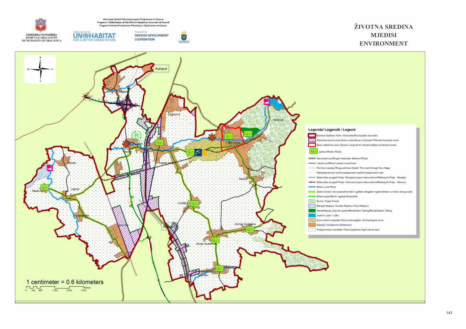
143
ŽIVOTNA SREDINA
MJEDISI
ENVIRONMENT