Municipal Class EA Study for McLaughlin Road from Bristol ... Workshop 3... · by unaddressed...
150
May 9, 2015 Community Workshop Summary Report Municipal Class EA Study for McLaughlin Road from Bristol Road West to Britannia Road West Prepared for City of Mississauga by IBI Group August 2015
Transcript of Municipal Class EA Study for McLaughlin Road from Bristol ... Workshop 3... · by unaddressed...

May 9, 2015 Community Workshop Summary Report
Municipal Class EA Study for McLaughlin Road from Bristol Road West to Britannia Road West
Prepared for City of Mississauga
by IBI Group
August 2015

IBI GROUP MAY 9, 2015 COMMUNITY WORKSHOP SUMMARY REPORT
MUNICIPAL CLASS EA STUDY FOR MCLAUGHLIN ROAD FROM BRISTOL ROAD WEST TO BRITANNIA ROAD WEST
Prepared for City of Mississauga
Document Control Page
August 2015
CLIENT: City of Mississauga
PROJECT NAME: McLaughlin Road Class EA
REPORT TITLE: Municipal Class EA Study for McLaughlin Road from Bristol Road West to Britannia Road West
IBI REFERENCE: 24RX12.0246.00
VERSION: 3
DIGITAL MASTER: Y:\24RX12.0246_Miss-Class EA\10.0 Reports\PIC\Workshop Summary Report
ORIGINATOR: Marianne Radue
REVIEWER: Don Drackley
AUTHORIZATION: Allan Ortlieb
CIRCULATION LIST:
HISTORY:

IBI GROUP MAY 9, 2015 COMMUNITY WORKSHOP SUMMARY REPORT
MUNICIPAL CLASS EA STUDY FOR MCLAUGHLIN ROAD FROM BRISTOL ROAD WEST TO BRITANNIA ROAD WEST
Prepared for City of Mississauga
Table of Contents
August 2015 i
1 Introduction .............................................................................................................. 1
2 Notice of Community Workshop Registration ...................................................... 1
3 Workshop Discussion ............................................................................................. 3
3.1.1 Agenda ............................................................................................. 3
3.1.2 Presentation ..................................................................................... 3
3.1.3 Question Identification Exercise ....................................................... 4
3.1.4 Information Stations ......................................................................... 6
3.1.5 Q & A Discussion/Closing Remarks ................................................. 6
4 Comment Summary ................................................................................................. 7
4.1 Comments Received by the Project Team ................................................... 9
5 Workshop Comments and Responses ................................................................ 10
Exhibits
Exhibit 1. Study Area ......................................................................................................... 1
Exhibit 2. Workshop Agenda ............................................................................................ 3
Exhibit 3. Summary of Question Identification Exercise ............................................... 4
Exhibit 4. Comment Summary .......................................................................................... 7
Appendices Appendix A. Notice of Community Workshop Registration (Workshop Notice #1) Appendix B. Notice of Community Workshop Invitation (Workshop Notice #2) Appendix C. Attendance Register Appendix D. Workshop Presentation Appendix E. Question Identification Exercise Index Cards Appendix F. Display Panels Appendix G. Comment Sheets Appendix H. Comment and Response Summary Table

IBI GROUP MAY 9, 2015 COMMUNITY WORKSHOP SUMMARY REPORT
MUNICIPAL CLASS EA STUDY FOR MCLAUGHLIN ROAD FROM BRISTOL ROAD WEST TO BRITANNIA ROAD WEST
Prepared for City of Mississauga
August 2015 1
1 Introduction
The City of Mississauga retained IBI Group to undertake a ‘Schedule ‘C’ Class Environmental
Assessment (Class EA) and Preliminary Design for the section of McLaughlin Road from Bristol Road
West to Britannia Road West (Exhibit 1). The study is being undertaken to investigate the need for
additional north-south capacity and traffic management improvements along this section of
McLaughlin Road, while taking into consideration the Scenic Road designation, adjacent land uses
and plans for a cycling route. The study is being conducted in accordance with the planning and
design process for ‘Schedule C’ projects as outlined in the Municipal Engineers Association
"Municipal Class Environmental Assessment," (October 2000, as amended in 2011).
Exhibit 1. Study Area
The May 9, 2015 community workshop was held to receive public and stakeholder input,
comments, and concerns on the preferred design selected by the Project Team. The public was
encouraged to attend to learn more about the study and engage in discussions with project
representatives.
2 Notice of Community Workshop Registration
The Notice of Community Workshop Registration (Workshop Notice #1) (Appendix A) was first
placed in the Mississauga News on April 9, 2015. Road signs were placed at strategic locations
along the study corridor to notify the public of the upcoming workshop and provide information
regarding registration. The notice was also posted on the City of Mississauga website
(http://www.mississauga.ca/portal/residents/mclaughlinroadenvironmentalassessmentstudy)
which was accessible to all external stakeholders and members of the public.

IBI GROUP MAY 9, 2015 COMMUNITY WORKSHOP SUMMARY REPORT
MUNICIPAL CLASS EA STUDY FOR MCLAUGHLIN ROAD FROM BRISTOL ROAD WEST TO BRITANNIA ROAD WEST
Prepared for City of Mississauga
August 2015 2
Additionally, the Workshop Registration Notice (Workshop Notice #1) was mailed to residences
by unaddressed admail for Forward Sortation Area L5R which is bound by Highway 401,
Hurontario Street, Highway 403 and Mavis Road. In total approximately 11,460 notices were
distributed in this manner. Additional direct mailing was made to the original 300 m resident
mailing list area used for PIC #1, and interested persons who signed up from previous PIC #1 and
# 2 and throughout the study (2,095 notices in total). The notice invited members of the public to
register for the workshop. Those that were registered were then email/mailed the Community
Workshop Invitation (Workshop Notice #2) (Appendix B) detailing the workshop discussion topics
and location.
The session was held as follows:
Date: Saturday, May 9, 2015
Time: Registration 8:30 a.m.
Workshop: 9:00 a.m. to 11:30 a.m.
Location: St. Gertrude Separate School, Gymnasium
815 Ceremonial Dr., Mississauga
Approximately 60 individuals attended the workshop (44 were preregistered and 16 signed in).
The attendance register is available in Appendix C. Mississauga Councillor Carolyn Parrish
(Ward 5) and her Executive Assistant (Danny Singh) were in attendance. In addition, Mississauga
Councillor George Carlson (Ward 11) attended the workshop part-time. There was no media
present. The Project Team present at the workshop included the following individuals:
Dana Glofcheskie, Project Manager, City of Mississauga
Leslie Green, Manager, Transportation Projects, City of Mississauga
Steve Barrett, Manager, Transportation Infrastructure Management, City of Mississauga
Sue Ann Laking, Landscape Architect, City of Mississauga
Jessica McEachren, Forestry Manager (Acting), City of Mississauga
Jacquelyn Hunter, Active Transportation Technologist, City of Mississauga
Giancarlo Tedesco, Traffic Planning Technologist, City of Mississauga
Allan Ortlieb, Consultant Project Manager, IBI Group
Don Drackley, Transportation Planner, IBI Group
Todd Smith, Landscape Architect, IBI Group
Marianne Radue, Environmental Planner, IBI Group
Glenn Pothier, Facilitator, GLPi
The materials presented at the workshop, including comment forms, were made available online on
the City of Mississauga website. The last day to receive public comment on the information presented
was on May 25, 2015.

IBI GROUP MAY 9, 2015 COMMUNITY WORKSHOP SUMMARY REPORT
MUNICIPAL CLASS EA STUDY FOR MCLAUGHLIN ROAD FROM BRISTOL ROAD WEST TO BRITANNIA ROAD WEST
Prepared for City of Mississauga
August 2015 3
3 Workshop Discussion
3.1.1 Agenda
Registration for the workshop began at 8:30 a.m. The workshop agenda is outlined in Exhibit 2.
A summary of the discussions are provided in the following sections.
Exhibit 2. Workshop Agenda
TIME TASK
8:30 – 9:00 am Registration/Sign In
9:00 – 9:10 am Introductions and description of session purpose
Councillor Parrish opening remarks
9:10 – 9:30 am Presentation
9:30 – 9:45 am Question Identification Exercise
9:45 – 10:45 am Information Stations
10:45 – 11:15 am Q & A Discussion
11:15 – 11:30 am Next Steps and Closing Remarks
3.1.2 Presentation
Opening remarks were provided by Councillor Parrish. This was followed by a presentation by the
Project Team. The presentation can be found in Appendix D.
There were a number of initial questions from the audience summarized below along with Project
Team answers:
1. How long will it take the trees to grow to the same size and structure? The soils are different than they were when the trees were first established. For the canopy trees it will take 20 years. The Project is proposing a multi-layer technique to define the edge of the woodlot which will help establish a strong root system.
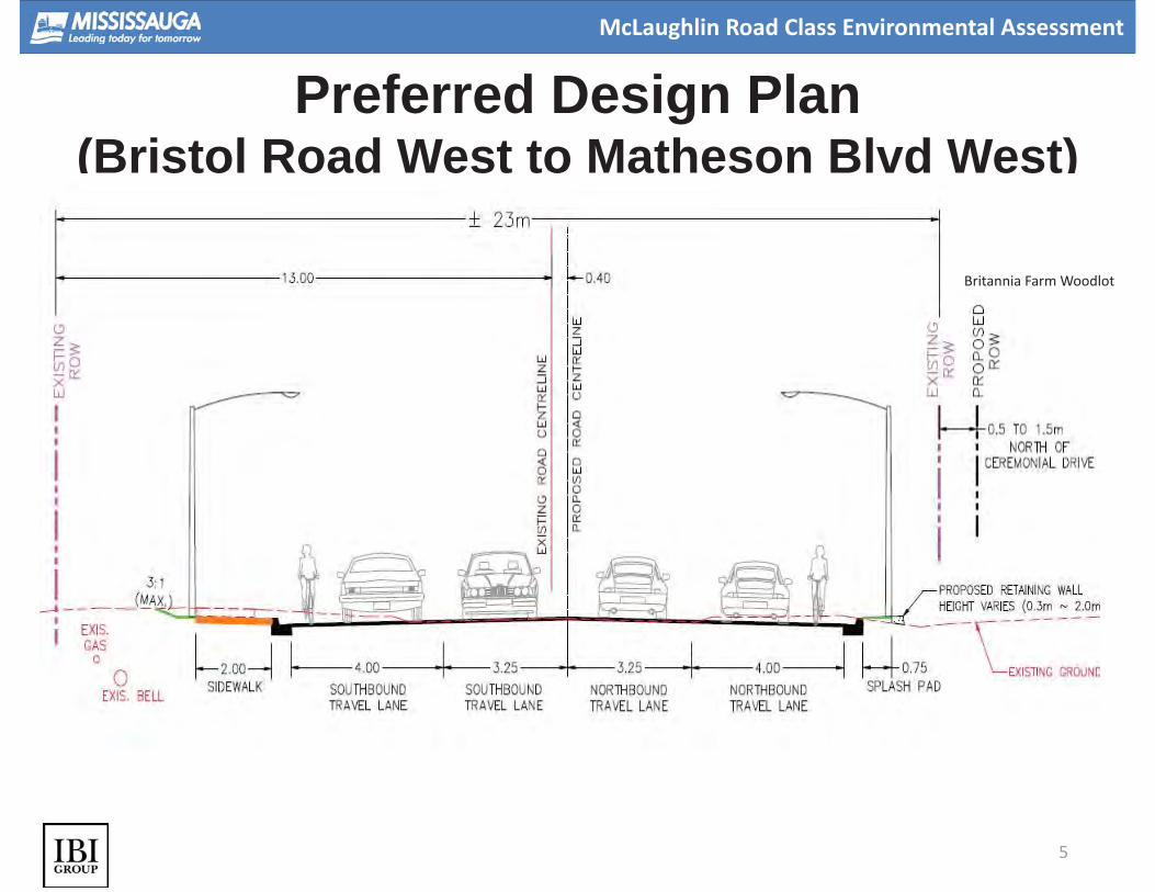
2. What is the width of the ROW for the new design? There is a 23 m ROW for the new design. An additional 0.5 – 1.5 m is required from the Britannia Farm woodlot.
3. From Avonwick Avenue to Matheson Boulevard West, residents concerned their backyards will decrease in size. There will be no acquisition of property in this location. Backyards will remain the same size.
4. Will there be more noise walls?
A noise study was conducted and it indicated that additional noise walls are not warranted within the study area. However, the existing noise walls will be replaced as part of this study.
5. Could there be traffic signals at Faith Drive and McLaughlin Road?

IBI GROUP MAY 9, 2015 COMMUNITY WORKSHOP SUMMARY REPORT
MUNICIPAL CLASS EA STUDY FOR MCLAUGHLIN ROAD FROM BRISTOL ROAD WEST TO BRITANNIA ROAD WEST
Prepared for City of Mississauga
August 2015 4
Based on the traffic signal warranting process outlined by MTO, a traffic signal is not warranted at this intersection. To improve pedestrian visibility, intersection treatments, such as textured, coloured or raised intersections, are being considered. The feasibility of these design features will be reviewed with Mississauga Transit, Fire and Emergency Services and Traffic Operations.
6. What is the design process for removing trees on the west side? Burying the hydro lines will allow the tree canopy to grow to its full potential.
7. Will the speed limit change? The speed limit will remain at 50 km/h. The narrower lanes will help to promote vehicles to travel at the speed limit
8. [Question from Councillor Parrish] How will you mitigate salt impacts? What type of trees will be put in? The trees that have been chosen are salt resistant. A species list is available.
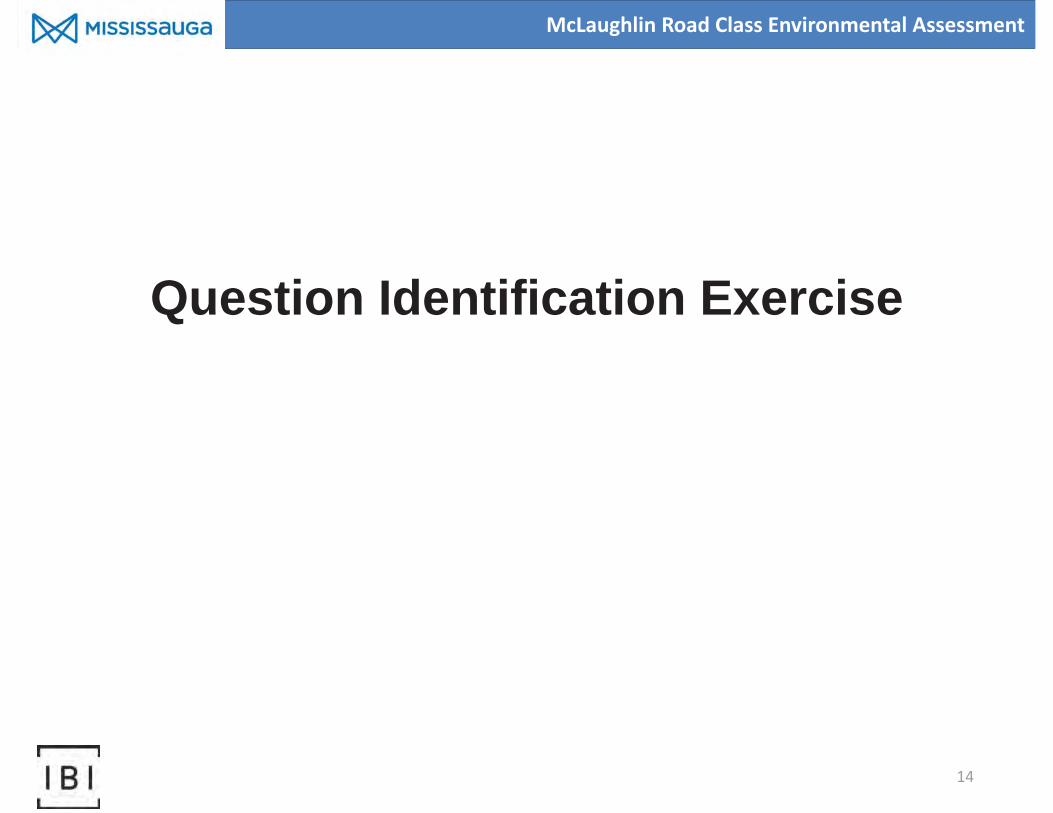
3.1.3 Question Identification Exercise
After the presentation, the attendees broke into groups with a team member at each table. The
goal was to identify any questions or concerns about the Preferred 4-lane Alternative and
Mitigation Plan. These were then written onto an index card. At the end of the exercise the cards
were gathered and grouped into themes. See Exhibit 3 for a summary of these themes and
questions/comments (not verbatim comments). The index cards are located in Appendix E. See
Section 3.1.5 for responses.
Exhibit 3. Summary of Question Identification Exercise
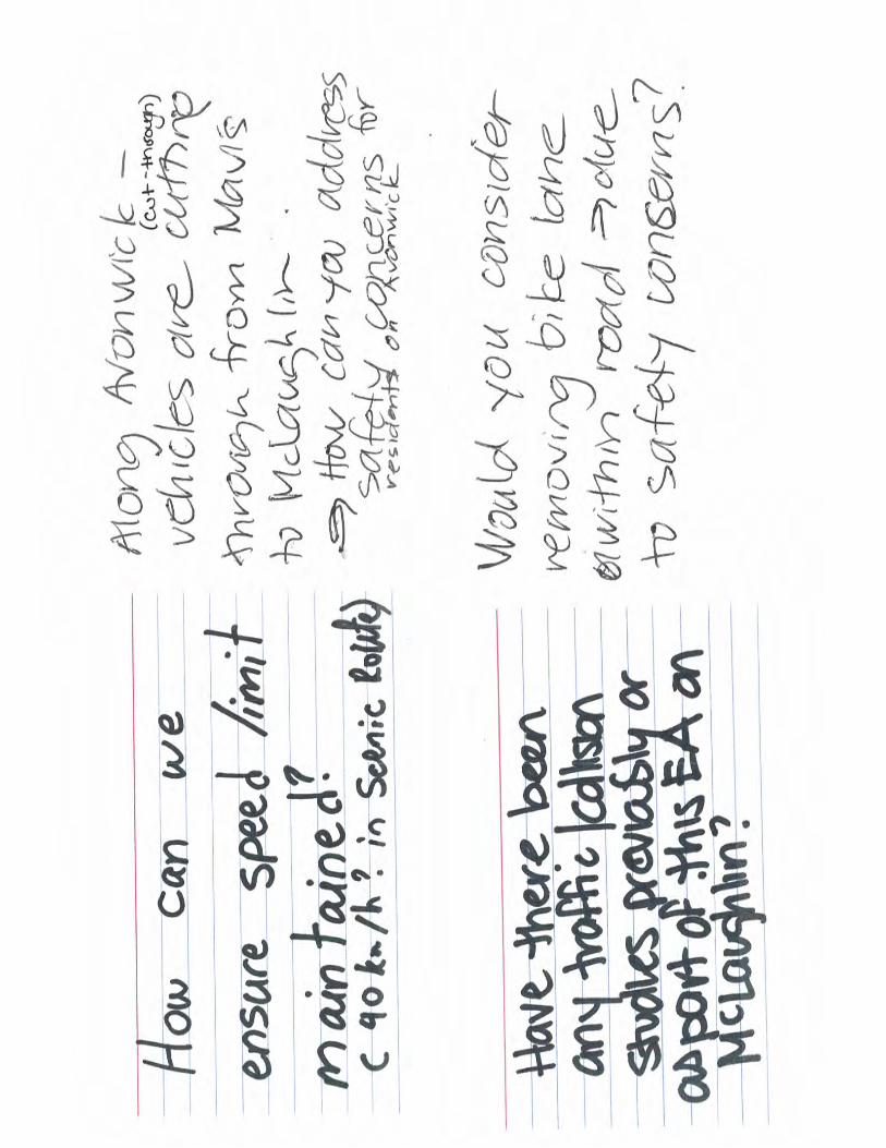
THEME QUESTION/COMMENT
Safety What considerations can be made to assist with crossing safely
(pedestrian and vehicular)? Already difficult.
Would the 50 km/hr be maintained (two comments)?
Speeding is an issue on McLaughlin Road.
How do we mitigate safety issues as a result of widening?
Have there been any traffic/collision studies previously undertaken
or as a part of this EA on McLaughlin Road?
Along Avonwick Avenue vehicles are cutting through from Mavis to
McLaughlin Road. How can you address safety concerns for the
residents of Avonwick Avenue?
Would you consider removing the shared bike space within the
road due to safety reasons?
At Faith Drive and Parkwood Place (or other non-signalized
intersections) how can you improve safety without affecting
aesthetics?

IBI GROUP MAY 9, 2015 COMMUNITY WORKSHOP SUMMARY REPORT
MUNICIPAL CLASS EA STUDY FOR MCLAUGHLIN ROAD FROM BRISTOL ROAD WEST TO BRITANNIA ROAD WEST
Prepared for City of Mississauga
August 2015 5
THEME QUESTION/COMMENT
Design and
Function
On the west side of McLaughlin Road will it remain raised or will it
be flush with the roadway?
What does the width of the ROW include?
From Ceremonial Drive north will the left/centre turn lane be lost?
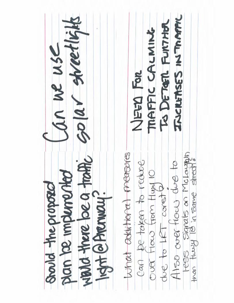
Should the proposed plan be implemented, would there be a traffic
light at Avonwick Avenue?
What additional measures can be taken to reduce overflow from
Highway 10 due to the LRT construction? Also overflow due to less
signals on McLaughlin Road than Highway 10 in the same stretch?
Can we use solar streetlights?
Ensure truck designation of “No trucks” does not change.
Need for traffic calming to deter further increases in traffic.
What studies will be done to look at turning traffic at non-signalized
locations?
McLaughlin Road is more attractive to drivers as there are fewer
lights.
What improvements can be made to assist with left turn
movements from adjoining streets due to the deletion of the centre
lane on McLaughlin Road?
How much increased traffic is planned on the road with four lanes?
What are the numbers (growth rates and attracted traffic from
Mavis Road/Highway 10)?
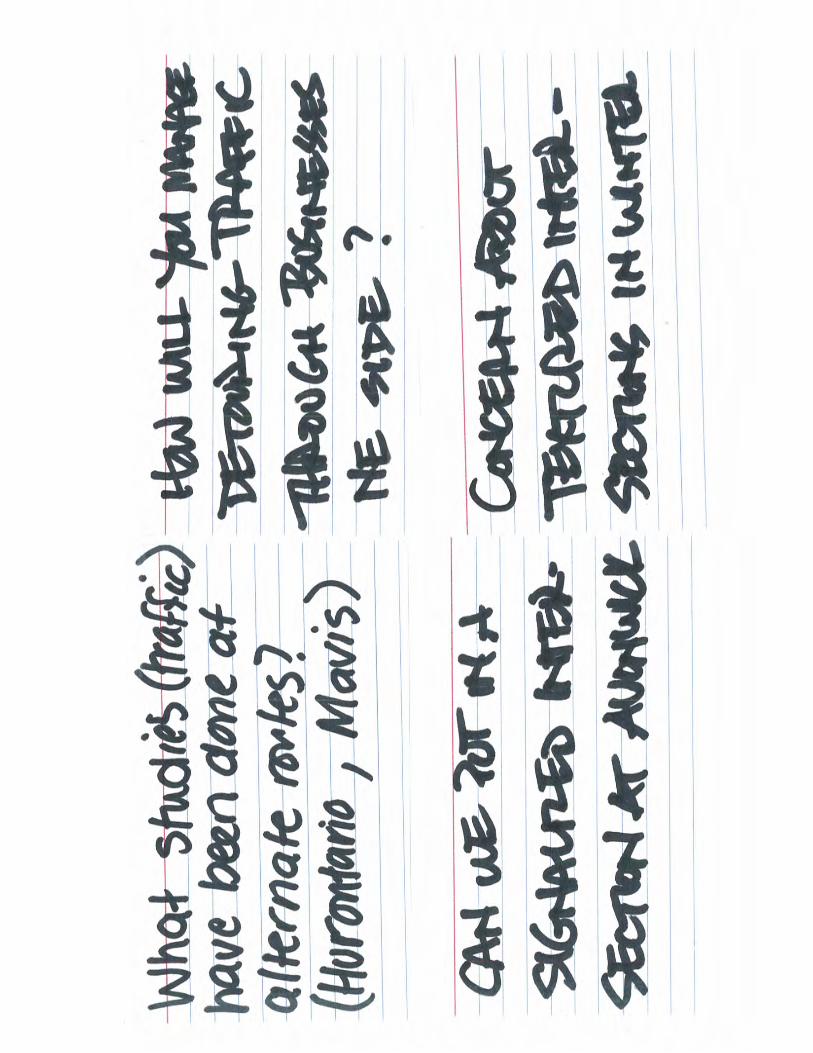
What studies (traffic) have been done at alternative routes
(Hurontario Street and Mavis Road)?
How will you manage detouring traffic through businesses on the
north-east side?
Concern about textured intersections in the winter.
Money and
Timing
What is the construction timing?
How long would this take to construct?
Will my taxes rise?
Will my property value decrease/be impacted (3 comments)?
Trees Are the trees to be planted native to the area?
Who will maintain the sugar bush or will the sugar bush be
maintained?
Noise What technical studies are being prepared related to noise being
considered for this project?
Can more noise barriers be provided?
Advance replacement of the noise barriers?

IBI GROUP MAY 9, 2015 COMMUNITY WORKSHOP SUMMARY REPORT
MUNICIPAL CLASS EA STUDY FOR MCLAUGHLIN ROAD FROM BRISTOL ROAD WEST TO BRITANNIA ROAD WEST
Prepared for City of Mississauga
August 2015 6
THEME QUESTION/COMMENT
Active
Transportation
What alternate cycling facilities were reviewed?
Bike trail of the west side instead of on road.
No one uses the sidewalks.
Why is there no safety advocate for pedestrians on the planning
team? The sidewalk as planned is extremely dangerous for
pedestrians. Shift the sidewalk away from the road.
Doubling traffic will not make cycling or walking that enjoyable.
Sharrow will not be effective, Have a dedicated bike lane.
How can cyclists feel safe with narrower car lanes?
Other What are the heavy vehicle restrictions?
How can we monitor increased density in the area (i.e., new
development)?
It is a designated route. Don’t change its designation.
How is the scenic designation being respected?
Who wants the widening?
Provide landscaping of the cul-de-sac beyond McLaughlin Road
ROW in advance of construction.
3.1.4 Information Stations
Display panels (Appendix F) were arranged by topic and organized in a manner which effectively
presented information on the project. The stations were as follows:
1. Transportation Safety
2. Active Transportation
3. Streetscape/Woodlot Restoration Plan
4. Design and Implementation
Participants were invited to visit each station and discuss the Preferred Plan with a Project Team
member. Display material including a roll plan highlighting the applicable attributes of the preferred
plan was provided at each station.
3.1.5 Q & A Discussion/Closing Remarks
The group reconvened for the question and answer period as well as closing remarks. Facilitated
by GLPi, the question and answer period was based on the Question Identification Exercise
(summarized in Exhibit 3) that was conducted earlier in the workshop. Key questions discussed
are summarized below:
1. What is included in the ROW?
Included in the ROW are travel lanes including shared cycling space, curb and gutters,
sidewalks and a boulevard (includes utilities and landscaping).
2. How will you calm traffic on McLaughlin Road?

IBI GROUP MAY 9, 2015 COMMUNITY WORKSHOP SUMMARY REPORT
MUNICIPAL CLASS EA STUDY FOR MCLAUGHLIN ROAD FROM BRISTOL ROAD WEST TO BRITANNIA ROAD WEST
Prepared for City of Mississauga
August 2015 7
The narrower lanes will help to promote vehicles to travel at the speed limit. To address speeding, communication will be undertaken with law enforcement officials. In addition, to improve pedestrian visibility, intersection treatments, such as textured, coloured or raised intersections, are being considered. The feasibility of these design features will be reviewed with Mississauga Transit, Fire and Emergency Services and Traffic Operations.
3. Will you consider using solar lights along McLaughlin Road
The Project Team is considering different methods of illumination. That will be taken into
consideration.
4. Are the trees being planted native to Ontario?
Yes.
5. What is the cost of the project?
The cost for the project is approximately $10 million, with approximately $2 million of this
cost associated with burying the hydro lines.
6. What is the timeline for construction?
Following completion of the Environmental Assessment, the detailed design and tender
documents must be prepared based on funding approval by City Council. Construction
will then commence based on funding approval from Council. Construction staging and
timing would be determined as part of the detailed design.
Councillor Parrish made closing remarks and asked for members of the audience who were
against the road widening to stand. The Project Team was not able to estimate the number of
individuals who stood up.
4 Comment Summary
The following (Exhibit 4) is a summary of comments that were submitted by comment sheet. A
number of attendees submitted their comments on index cards noting that they were not in support
of the widening. Some included contact information and others did not. All comments received are
located in Appendix G.
Exhibit 4. Comment Summary
THEME COMMENT
Traffic/Transportation
Excited about improvements to the intersection at McLaughlin Road
and Ceremonial Drive.
Will there be left turn signals in every direction at the intersection of
McLaughlin Road and Bristol Road West.
Difficult to get out of . Need a left turn lane (2
comments).
Reassess widening in 10 years after the LRT is built and operational.
Widening will promote automobile use.
Need bus bays.
Redirect traffic onto other arterial roads.
Consider traffic improvements that improve flow.
Put a roundabout at Bristol Road West and McLaughlin Road (2
comments).
Continue to pursue traffic lights at Avonwick Avenue.
Widening will increase speeding (5 comments).

IBI GROUP MAY 9, 2015 COMMUNITY WORKSHOP SUMMARY REPORT
MUNICIPAL CLASS EA STUDY FOR MCLAUGHLIN ROAD FROM BRISTOL ROAD WEST TO BRITANNIA ROAD WEST
Prepared for City of Mississauga
August 2015 8
THEME COMMENT
Widening will lead to an increase in traffic congestion.
Increase in traffic volume.
No heavy truck traffic on McLaughlin Road.
Difficult to get out of property complex, need left turn lanes.
Reduce the speed on McLaughlin Road (2 comments).
Speed is an issue on McLaughlin Road.
It takes a considerable length of time to make a safe turn from Parkwood Place on to McLaughlin Road. What will it be like when a 4-lane configuration is implemented?
Natural Heritage
Protect the woodlot.
Concerned about the impacts/loss of trees (9 comments).
Replace trees with large evergreen trees.
Increase in pollution (3 comments).
In the 90s the OMB under a Schedule “I” ruling stated that the canopy of trees buffering the low rise condo across McLaughlin from the Parkwood residents must be maintained for aesthetic purposes. How will that be honoured in the current future.
Noise/Vibration
Would like a concrete noise wall (2 comments).
Replace noise barriers (2 comments).
Replace chain link fence with noise walls.
Extend/add noise walls (2 comments).
Widening will increase noise (4 comments).
Widening will increase vibration.
Keep chain link fence.
Active Transportation
Have designated bike lanes.
Do not need bike lanes.
Sidewalks are placed too close to the road (2 comments).
Install pedestrian crossing at Avonwick Avenue and McLaughlin Road.
Install pedestrian crossing at Parkwood Place and McLaughlin Road (2
comments).
Install pedestrian crossing at Faith Drive and McLaughlin Road.
Instead of the east side pedestrian sidewalk, make it a designated bike
lane.
Policy
Maintain road designation as a Scenic Route.
Negative impacts of visual character and Scenic Road designation.
Does not conform to the Mississauga Living Green Plan, the OP or
Growth Plan.
Move the west side sidewalk inward creating a buffered grassy area
between pedestrians and traffic.
Do not use salt in the winter.
Streetscape Bury the hydro lines (4 comments)
Enhance the street lighting.
Other
Depreciation of property values (3 comments).
Concerned about the loss of property.
Construction should occur during the day time.
With narrow lanes sewers will be affected by heavy buses and vehicles
will run over these. How to redesign?
Why did residents take the time to fill out their concerns and then
nothing be collated with numerical results?
Is the Peel Board OK with the proposed widening since this would
involve crown land?

IBI GROUP MAY 9, 2015 COMMUNITY WORKSHOP SUMMARY REPORT
MUNICIPAL CLASS EA STUDY FOR MCLAUGHLIN ROAD FROM BRISTOL ROAD WEST TO BRITANNIA ROAD WEST
Prepared for City of Mississauga
August 2015 9
THEME COMMENT
Asphalt is deteriorating on McLaughlin Road which backs onto
properties.
Need to view the long-term impacts of the area if the expansion
occurred.
City and consultant have done a great job of balancing the needs of
increased capacity while maintaining the elements of a Scenic Route.
4.1 Comments Received by the Project Team
During the workshop a number of comments were received verbally by the Project Team. A
summary of comments is provided below:
Consider pedestrian signals at Avonwick Avenue.
If signals are not warranted at McLaughlin Road/Parkwood Place, can pedestrian-activated signals be used to allow for safer pedestrian crossing of a widened busy street?
Concerned with pedestrians crossing at unsignalized intersections.
Consider the opportunity to shift the sidewalk along the west side away from the road.
Relocate southern pedestrian walkway connection between Champlain Trail and McLaughlin Road further to the north, away from residential property at 5357 Champlain Trail (since bus stop is proposed to be removed).
Consider multi-use trail instead of sharrow and sidewalk.
Discussion of rationale for sharrow lanes vs. multi-use or bike lanes.
Concern about sharrow lanes on such a busy street, and that few cyclists will use the
facility.
Ensure adequate left turn lane width onto Ceremonial Drive intersection, since the existing is very narrow.
Some people felt that widening McLaughlin Road will attract additional traffic, but retaining the two lanes will force traffic to use alternative routes.
Improve signage along McLaughlin Road to increase awareness of intersecting streets/driveways.
How come so many collisions between Avonwick Avenue and Ceremonial Drive (approx. 2-3/month)? Will this be improved?
Concern about cars parking on Ceremonial Drive to access the plaza and resulting traffic congestion.
Put in a bus bay, so don’t have to widen to four lanes.
IBI GROUP MAY 9, 2015 COMMUNITY WORKSHOP SUMMARY REPORT
MUNICIPAL CLASS EA STUDY FOR MCLAUGHLIN ROAD FROM BRISTOL ROAD WEST TO BRITANNIA ROAD WEST
Prepared for City of Mississauga
August 2015 10
Include new plantings on the court streets at the end of cul-de-sacs to create a visual
barrier to McLaughlin Road.
Would like to see the entire section of fencing in their back yard replaced (to ensure a consistent appearance ( )
Replace chain link fences at the court streets with wood fences or noise walls. Plant trees beyond the ROW (specifically at the end of Tipton Court and Langport Court) to provide vegetation screening. Undertake this work in advance the road construction to allow the trees to mature ahead of tree removals within the ROW.
Extend the limits of noise fencing to the end of property and/or provide fencing of similar appearance beyond the required limits.
Extend noise fencing further north along property line (5357 Champlain Trail) and remove duplicate fencing (garbage collects between the two fences).
Advance replacement of the noise barriers (separate from the road reconstruction).
Concern about air quality due to impacts of increased traffic and loss of trees.
Concern about the impacts of dead trees along the woodlot edge that remain after the trimming, thinning and new planting.
There was some agreement that the woodlot edge is deteriorating and needs to be improved and managed. Some felt this is the School Board’s responsibility and admitted that the board likely does not have the funds.
Concern that any additional tree planting will take a very long time to mature into the full canopy setting that currently exists.
5 Workshop Comments and Responses
Responses to the comments received (comment sheets and emails), can be found in Appendix
H.

Workshop Summary Report
Municipal Class EA Study for McLaughlin Road from Bristol Road West to Britannia Road West
APPENDICES
Prepared for City of Mississauga by IBI Group July 2015

IBI GROUP WORKSHOP SUMMARY REPORT MUNICIPAL CLASS EA STUDY FOR MCLAUGHLIN ROAD FROM BRISTOL ROAD WEST TO BRITANNIA ROAD WEST Prepared for City of Mississauga
July 2015
APPENDIX A. NOTICE OF COMMUNITY WORKSHOP REGISTRATION (WORKSHOP NOTICE #1)

CITY OF MISSISSAUGA
COMMUNITY WORKSHOP REGISTRATION McLaughlin Road Environmental Assessment Study
THE STUDY: The City of Mississauga is completing a Class Environmental Assessment (Class EA) Study and Preliminary Design for McLaughlin Road from Bristol Road West to Britannia Road West.
Following a context sensitive approach, McLaughlin Road is proposed to be four travel lanes including a shared cycling facility, improved sidewalk connectivity, buried hydro lines, tree planting and landscaping and new noise barriers. The preferred design also includes edge restoration along the Britannia Farm woodlot, and roadway design features intended to slow traffic speed. The preferred design plans are available for viewing on the project website at:
http://www.mississauga.ca/portal/residents/mclaughlinroad environmentalassessmentstudy.
PUBLIC CONSULTATION OPPORTUNITY: Public consultation is a vital component to this study. Two Public Information Centres were previously held. The next consultation opportunity is to register for an upcoming Community Workshop being planned for the morning of Saturday May 9, 2015.
The purpose of this Workshop is to update members of the public and stakeholders on the study progress, and to present and discuss elements of the Preferred 4-lane Alternative and Mitigation Plan. Project Team members will also be able to provide responses to specific aspects of the project.
The time and location of this upcoming Community Workshop are currently being finalized. Those who register for the Workshop will be notified of the final arrangements. In order to best prepare for the upcoming workshop, those interested in attending should notify the Project Team via the following contact information by Friday April 17, 2015:
Dana Glofcheskie, P.Eng. Project Manager City of Mississauga 201 City Centre Drive, Suite 800 Mississauga, Ontario, L5B 2T4 Tel: 905-615-3200, Ext. 8243 Fax: 905-615-3173 E-mail: [email protected]
Don Drackley, MCIP, RPP Consultation Manager IBI Group 100-175 Galaxy Blvd. Toronto, Ontario, M9W 0C9 Tel: toll free 1-877-822-3798, Ext.1302 Fax: 416-675-4620 E-mail: [email protected]
If you would like to stay up-to-date with what’s going on in Ward 5, I invite you to sign up for my monthly e-newsletter. You can do that on my website, www.carolynparrish.ca or email [email protected] and let me know that you’d like to be added.
- Carolyn Parrish, Ward 5 Councillor
Personal information is collected under the authority of the Environmental Assessment Act and will be used in the assessment process. With exception of personal information, all comments shall become part of the public records. Questions about this collection should be directed to the Project Manager listed in the notice.
Study Area

IBI GROUP WORKSHOP SUMMARY REPORT MUNICIPAL CLASS EA STUDY FOR MCLAUGHLIN ROAD FROM BRISTOL ROAD WEST TO BRITANNIA ROAD WEST Prepared for City of Mississauga
July 2015
APPENDIX B. NOTICE OF COMMUNITY WORKSHOP INVITATION (WORKSHOP NOTICE #2)

CITY OF MISSISSAUGA
COMMUNITY WORKSHOP INVITATION McLaughlin Road Environmental Assessment Study
THE WORKSHOP: Thank you for registering for the upcoming Community Workshop. The purpose of the workshop will be to provide a study progress update, and to discuss elements of the Preferred Design and Mitigation Plan. The preferred typical cross-section of McLaughlin Road is shown below.
WORKSHOP DATE: SATURDAY, MAY 9, 2015 TIME: 8:30 AM – 11:30 AM. Presentation begins at 9:00 AM LOCATION: St. Gertrude Separate School, Gymnasium
815 Ceremonial Dr., Mississauga
DISCUSSION TOPICS: The Workshop will focus on key comments and questions identified thus far, and how the Project Team can address these issues as it moves into the next phase of the study process. The following four discussion topics will be set up at the Workshop for your participation based on your area(s) of interest:
Traffic Safety intersection control, turn lanes, pedestrian crossings
Cycling / Walking bike route, sidewalks
Woodlot / Streetscape Britannia Farm forest edge restoration, streetscaping, tree replacement
Design & Implementation noise walls, property impacts, construction impacts, etc.
If you have any questions about this Workshop, please contact us:
Dana Glofcheskie, P. Eng. Project Manager City of Mississauga Tel: 905-615-3200, ext. 8243 Email: [email protected]
Don Drackley, MCIP, RPP Consultation Manager IBI Group Tel: toll free 1-877-822-3798, ext. 1302 Email: [email protected]
The Project Team looks forward to your participation and input at this important study event.
Personal information is collected under the authority of the Environmental Assessment Act and will be used in the assessment process. With exception of personal information, all comments shall become part of the public records. Questions about this collection should be directed to the Project Manager listed above in this notice.
Preferred Typical McLaughlin Road Cross-Section At Britannia Farm

IBI GROUP WORKSHOP SUMMARY REPORT MUNICIPAL CLASS EA STUDY FOR MCLAUGHLIN ROAD FROM BRISTOL ROAD WEST TO BRITANNIA ROAD WEST Prepared for City of Mississauga
July 2015
APPENDIX C. ATTENDANCE REGISTER


IBI GROUP WORKSHOP SUMMARY REPORT MUNICIPAL CLASS EA STUDY FOR MCLAUGHLIN ROAD FROM BRISTOL ROAD WEST TO BRITANNIA ROAD WEST Prepared for City of Mississauga
July 2015
APPENDIX D. WORKSHOP PRESENTATION

McLaughlin Road Class Environmental Assessment
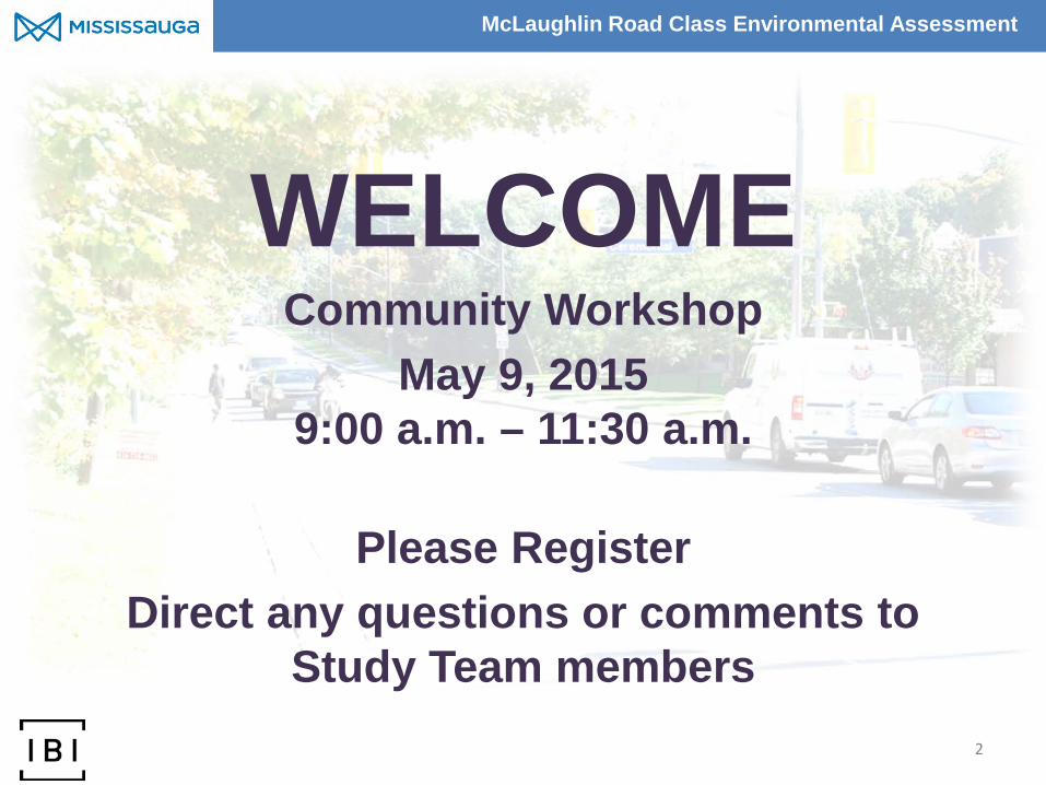
Community Workshop May 9, 2015
9:00 a.m. – 11:30 a.m.
Please sign in Direct any questions or comments to
Study Team members
1

McLaughlin Road Class Environmental Assessment
• Update on Study Progress • Discuss the Preferred Plan • Discuss the Mitigation Plan • Discuss Key Issues / Comments
Workshop Agenda
1. Study Overview 2. Present Preferred Plan 3. Present Key Elements of Mitigation Plan 4. Quick Questions of Fact or Clarification 5. Information Stations 6. Q&A Discussions 7. Next Steps / Closing Remarks
2
Study Area Workshop Purpose
Britannia Farm
Heartland Town Centre

McLaughlin Road Class Environmental Assessment
3
Class EA Process
3
Notice of Project Initiation
• Problem identification • Newspaper notice • Letter to agencies • Mail out to surrounding
area residents and businesses
Public Information Centre #1
• Inventory natural, cultural and economic environment
• Identification of alternative solutions
• Opportunities and constraints within the study area
• Identification of evaluation criteria
• Public input on problem and opportunity and preliminary preferred alternative solutions
• Select preferred alternative solutions
Public Information Centre #2
• Evaluation of alternative design concepts
• Inventory natural, cultural and economic environment
• Public input on preliminary preferred design concept
• Select preferred design concept
Documentation and Project Completion
• Community Workshop #3 • Prepare Environmental
Assessment Document • Notice of Project
Completion • Begin the 30-day review
period • Select preferred design
September 2012 January 2013 March 2014 Spring 2015
PHASE 2 PHASE 3 PHASE 1 PHASE 4
WE ARE HERE
Implementation (subject to funding and
council approvals)
• Detailed Design • Begin Construction
PHASE 5
TBD

McLaughlin Road Class Environmental Assessment
Study Context
Investigate the need for capacity, safety and operational improvements to McLaughlin Road from Bristol Road West to Britannia Road West, taking into consideration: • The Scenic Route designation; • Adjacent land uses; • City plans for a cycling route; • Streetscape improvement opportunities; and • Local public interests.
Classified as a Major Collector Road. Designated as a “Scenic Route” between Bristol Road West and Matheson Boulevard West.
4
McLaughlin Road Class Environmental Assessment
Preferred Design Plan (Bristol Road West to Matheson Blvd West)
5
Britannia Farm Woodlot

McLaughlin Road Class Environmental Assessment
Streetscape Vision West Side:
• Bury hydro (Bristol Road to Matheson Blvd) to accommodate a new line of canopy trees on the west side;
• Utilize pavers or cobblestone banding that suggest another era along parts of the sidewalk, and could remind walkers of previous farm foundations or dwellings;
East Side:
• Hardwood fencing done in a traditional but contemporary language down the east side which tells people ‘this area is protected’ and this area is woodland;
• Small orchards of flowering shrubs and small trees can be interspersed along this new path/sidewalk, so that this side of road feels more open and friendly;
• Benches for resting at strategic points; interpretive signage;
• Restoration of woodlot edge using best principles of urban forestry management to create new woodlot edge.
6
Large dimension hardwood fences
Natural stone retaining walls
Paver banding along sidewalk

McLaughlin Road Class Environmental Assessment
Woodlot Edge Restoration The Britannia Sugar Bush woodlot edge will be restored with the following researched and practiced principles in mind: 1. Species diversity, woodlot condition, age/size class
distribution are equally important in aggregate as is canopy cover.
2. Mimicking the layers of a forest (canopy, understorey, shrub, herbaceous, rhizomatous) in edge restoration better provides for long-term success.
3. Consideration of entire woodlot condition as natural area managed through thinning, planting, silviculture will enhance diversity and strength of edge condition.
Kenney et al, 2011.
7

McLaughlin Road Class Environmental Assessment
.
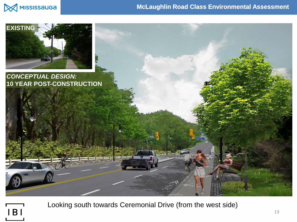
8 Looking south towards Ceremonial Drive (from the west side)
EXISTING
CONCEPTUAL DESIGN: 10 YEAR POST-CONSTRUCTION

McLaughlin Road Class Environmental Assessment
.
9 Looking south along McLaughlin at the intersection of Ceremonial Drive
EXISTING
CONCEPTUAL DESIGN: 10 YEAR POST-CONSTRUCTION

McLaughlin Road Class Environmental Assessment
.
10 Looking north towards Ceremonial Drive (adjacent to Champlain Trail)
EXISTING
CONCEPTUAL DESIGN: 10 YEAR POST-CONSTRUCTION

McLaughlin Road Class Environmental Assessment
Summary of Tree Impacts
11
To accommodate the Preferred Plan between Bristol Rd. & Matheson Blvd:
• 472 trees will remain unaffected (174 east side, 298 west side) • 186 additional trees impacted (83 east side, 103 west side) • 413 trees will need to be removed (256 east side, 157 west side)
96% of trees impacted expected to survive post construction (i.e.178 of 186 trees)
So 421 existing trees will either need to be removed or are not expected to survive post construction. These include:
– 26 trees greater than 50cm DBH – 58 trees on private lands
It is estimated that 260 trees can be reinstated within the McLaughlin Road right-of-way. As a minimum, an additional 213 trees are to be added elsewhere (i.e. Britannia Farm). Based on a 2:1 replacement ratio, 369 more trees would be added (842 total).

McLaughlin Road Class Environmental Assessment
12
What We Have Heard CONCERNS: • Widening the street will increase
traffic volume, noise and travel speed;
• Widening the street will result in traffic safety issues – traffic calming is needed;
• Existing pedestrian safety issues;
• Impacts on Britannia Farm and other existing street trees;
• Widening the street will depreciate property values.
OPPORTUNITIES: • Accommodating pedestrian and
cyclist facilities along the corridor;
• Widening the street supports City growth;
• Widening supports transit use along the corridor;
• Attractive landscaping, enhancements to the woodlot and buried utility lines are improvements.

McLaughlin Road Class Environmental Assessment
Questions of Fact / Clarification?
13
McLaughlin Road Class Environmental Assessment
Question Identification Exercise
14

McLaughlin Road Class Environmental Assessment
Workshop Information Stations
15
Station 1: Transportation Safety – intersection control, turn lanes, pedestrian crossing Station 2: Active Transportation – cycling and walking Station 3: Streetscape / Woodlot Restoration Station 4: Design & Implementation – noise, construction impacts, property taking, etc.

McLaughlin Road Class Environmental Assessment
Next Steps for the Study
16
• Finalize the Preliminary Design taking into account Workshop comments received.
• Complete and file the Environmental Study Report for public review.

IBI GROUP WORKSHOP SUMMARY REPORT MUNICIPAL CLASS EA STUDY FOR MCLAUGHLIN ROAD FROM BRISTOL ROAD WEST TO BRITANNIA ROAD WEST Prepared for City of Mississauga
July 2015
APPENDIX E. QUESTION IDENTIFICATION EXERCISE INDEX CARDS


IBI GROUP WORKSHOP SUMMARY REPORT MUNICIPAL CLASS EA STUDY FOR MCLAUGHLIN ROAD FROM BRISTOL ROAD WEST TO BRITANNIA ROAD WEST Prepared for City of Mississauga
July 2015
APPENDIX F. DISPLAY PANELS

McLaughlin Road Class Environmental Assessment
Welcome Area
McLaughlin Road Class Environmental Assessment
WELCOME Community Workshop
May 9, 2015 9:00 a.m. – 11:30 a.m.
Please Register
Direct any questions or comments to Study Team members
2
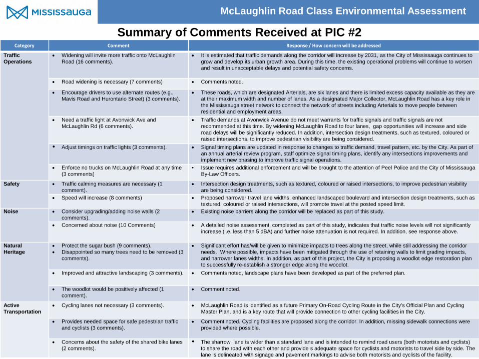
McLaughlin Road Class Environmental Assessment
Category Comment Response / How concern will be addressed
Traffic Operations
• Widening will invite more traffic onto McLaughlin Road (16 comments).
• It is estimated that traffic demands along the corridor will increase by 2031, as the City of Mississauga continues to grow and develop its urban growth area. During this time, the existing operational problems will continue to worsen and result in unacceptable delays and potential safety concerns.
• Road widening is necessary (7 comments) • Comments noted.
• Encourage drivers to use alternate routes (e.g., Mavis Road and Hurontario Street) (3 comments).
• These roads, which are designated Arterials, are six lanes and there is limited excess capacity available as they are at their maximum width and number of lanes. As a designated Major Collector, McLaughlin Road has a key role in the Mississauga street network to connect the network of streets including Arterials to move people between residential and employment areas.
• Need a traffic light at Avonwick Ave and McLaughlin Rd (6 comments).
• Traffic demands at Avonwick Avenue do not meet warrants for traffic signals and traffic signals are not recommended at this time. By widening McLaughlin Road to four lanes, gap opportunities will increase and side road delays will be significantly reduced. In addition, intersection design treatments, such as textured, coloured or raised intersections, to improve pedestrian visibility are being considered.
• Adjust timings on traffic lights (3 comments). • Signal timing plans are updated in response to changes to traffic demand, travel pattern, etc. by the City. As part of an annual arterial review program, staff optimize signal timing plans, identify any intersections improvements and implement new phasing to improve traffic signal operations.
• Enforce no trucks on McLaughlin Road at any time (3 comments)
• Issue requires additional enforcement and will be brought to the attention of Peel Police and the City of Mississauga By-Law Officers.
Safety • Traffic calming measures are necessary (1 comment).
• Intersection design treatments, such as textured, coloured or raised intersections, to improve pedestrian visibility are being considered.
• Speed will increase (8 comments) • Proposed narrower travel lane widths, enhanced landscaped boulevard and intersection design treatments, such as textured, coloured or raised intersections, will promote travel at the posted speed limit.
Noise • Consider upgrading/adding noise walls (2 comments).
• Existing noise barriers along the corridor will be replaced as part of this study.
• Concerned about noise (10 Comments)
• A detailed noise assessment, completed as part of this study, indicates that traffic noise levels will not significantly increase (i.e. less than 5 dBA) and further noise attenuation is not required. In addition, see response above.
Natural Heritage
• Protect the sugar bush (9 comments). • Disappointed so many trees need to be removed (3
comments).
• Significant effort has/will be given to minimize impacts to trees along the street, while still addressing the corridor needs. Where possible, impacts have been mitigated through the use of retaining walls to limit grading impacts, and narrower lanes widths. In addition, as part of this project, the City is proposing a woodlot edge restoration plan to successfully re-establish a stronger edge along the woodlot.
• Improved and attractive landscaping (3 comments). • Comments noted, landscape plans have been developed as part of the preferred plan.
• The woodlot would be positively affected (1 comment).
• Comment noted.
Active Transportation
• Cycling lanes not necessary (3 comments).
• McLaughlin Road is identified as a future Primary On-Road Cycling Route in the City’s Official Plan and Cycling Master Plan, and is a key route that will provide connection to other cycling facilities in the City.
• Provides needed space for safe pedestrian traffic and cyclists (3 comments).
• Comment noted. Cycling facilities are proposed along the corridor. In addition, missing sidewalk connections were provided where possible.
• Concerns about the safety of the shared bike lanes (2 comments).
• The sharrow lane is wider than a standard lane and is intended to remind road users (both motorists and cyclists) to share the road with each other and provide s adequate space for cyclists and motorists to travel side by side. The lane is delineated with signage and pavement markings to advise both motorists and cyclists of the facility.
Summary of Comments Received at PIC #2

McLaughlin Road Class Environmental Assessment
4
Class EA Process
Notice of Project Initiation
• Problem identification • Newspaper notice • Letter to agencies • Mail out to surrounding area
residents and businesses
Public Information Centre #1
• Inventory natural, cultural and economic environment
• Identification of alternative solutions
• Opportunities and constraints within the study area
• Identification of evaluation criteria
• Public input on problem and opportunity and preliminary preferred alternative solutions
• Select preferred alternative solutions
Public Information Centre #2
• Evaluation of alternative design concepts
• Inventory natural, cultural and economic environment
• Public input on preliminary preferred design concept
• Select preferred design concept
Documentation and Project Completion
• Community Workshop • Prepare Environmental
Assessment Document • Notice of Project
Completion • Begin the 30-day review
period • Select preferred design
September 2012 January 2013 March 2014 Spring 2015
PHASE 2 PHASE 3 PHASE 1 PHASE 4
WE ARE HERE
Implementation (subject to funding and
council approvals)
• Detailed Design • Begin Construction
PHASE 5
TBD

McLaughlin Road Class Environmental Assessment
Station 1: Transportation
Safety

McLaughlin Road Class Environmental Assessment
Station 2: Active
Transportation

McLaughlin Road Class Environmental Assessment McLaughlin Road Class Environmental Assessment
.
7 Looking south along McLaughlin at the intersection of Ceremonial Drive
EXISTING
CONCEPTUAL DESIGN: 10 YEAR POST-CONSTRUCTION

McLaughlin Road Class Environmental Assessment
Proposed Cycling Facilities
From Matheson Blvd W to Britannia Rd W
As part of the recommended plan, cycling facilities are proposed.
From Bristol Rd W to Matheson Blvd W Sharrow Facilities Bike Lanes
McLaughlin Road Class Environmental Assessment
Station 3: Woodlot /
Streetscape

McLaughlin Road Class Environmental Assessment McLaughlin Road Class Environmental Assessment
Streetscape Vision
10
Large dimension hardwood fences
Natural stone retaining walls
West Side: • Bury hydro (Bristol Road to Matheson Blvd) to
accommodate a new line of canopy trees on the west side; • Utilize pavers or cobblestone banding that suggest
another era along parts of the sidewalk, and could remind walkers of previous farm foundations or dwellings;
East Side: • Hardwood fencing done in a traditional but contemporary
language down the east side which tells people ‘this area is protected’ and this area is woodland;
• Small orchards of flowering shrubs and small trees can be interspersed along this new path/sidewalk, so that this side of road feels more open and friendly;
• Benches for resting at strategic points; interpretive signage;
• Restoration of woodlot edge using best principles of urban forestry management to create new woodlot edge.

McLaughlin Road Class Environmental Assessment McLaughlin Road Class Environmental Assessment
Woodlot Edge Restoration The Britannia Sugar Bush woodlot edge will be restored with the following researched and practiced principles in mind: 1. Species diversity, woodlot condition, age/size class
distribution are equally important in aggregate as is canopy cover.
2. Mimicking the layers of a forest (canopy, understorey, shrub, herbaceous, rhizomatous) in edge restoration better provides for long-term success.
3. Consideration of entire woodlot condition as natural area managed through thinning, planting, silviculture will enhance diversity and strength of edge condition.
Kenney et al, 2011.
11

McLaughlin Road Class Environmental Assessment McLaughlin Road Class Environmental Assessment
.
12 Looking north towards Ceremonial Drive (adjacent to Champlain Trail)
EXISTING CONCEPTUAL DESIGN: 10 YEAR POST CONSTRUCTION
McLaughlin Road Class Environmental Assessment McLaughlin Road Class Environmental Assessment
.
13 Looking south towards Ceremonial Drive (from the west side)
EXISTING
CONCEPTUAL DESIGN: 10 YEAR POST-CONSTRUCTION

McLaughlin Road Class Environmental Assessment McLaughlin Road Class Environmental Assessment
.
14 Looking south along McLaughlin at the intersection of Ceremonial Drive
CONCEPTUAL DESIGN: 10 YEAR POST-CONSTRUCTION
EXISTING

McLaughlin Road Class Environmental Assessment McLaughlin Road Class Environmental Assessment
.
15
Looking north along McLaughlin Road (west side) north of Ceremonial Drive.
EXISTING
CONCEPTUAL DESIGN: 10 YEAR POST-CONSTRUCTION
McLaughlin Road Class Environmental Assessment McLaughlin Road Class Environmental Assessment
.
16
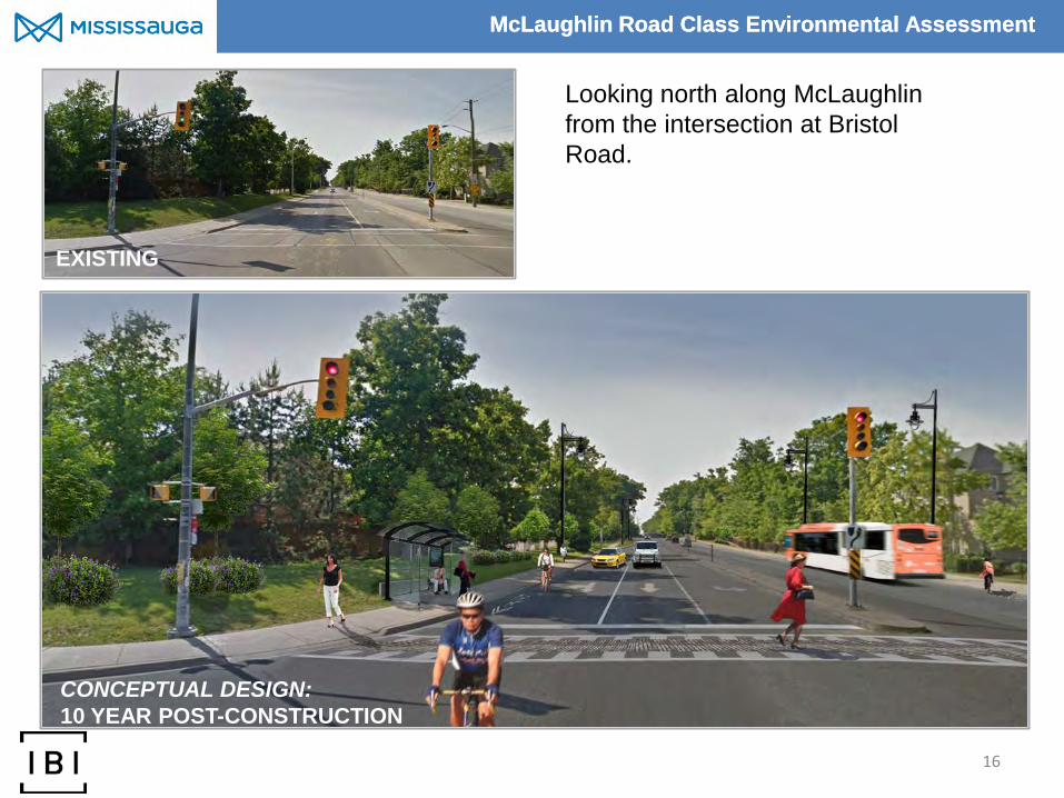
Looking north along McLaughlin from the intersection at Bristol Road.
CONCEPTUAL DESIGN: 10 YEAR POST-CONSTRUCTION
EXISTING

McLaughlin Road Class Environmental Assessment McLaughlin Road Class Environmental Assessment
.
17
Looking south along McLaughlin Road through the Matheson Blvd intersection.
EXISTING
CONCEPTUAL DESIGN: 10 YEAR POST-CONSTRUCTION

McLaughlin Road Class Environmental Assessment
Station 4: Design &
Implementation

McLaughlin Road Class Environmental Assessment
Noise As part of the recommended plan, all existing noise walls will be replaced (as per the City’s Noise Wall Replacement Program). Below are the proposed noise wall materials.
Wood Option
• 2 – 3 metres in height • Red cedar or other approved pressure treated wood • Colour stains are available • Life expectancy of 20 years
Concrete Option
• 2 – 3 metres in height • Precast concrete • Life expectancy of 40 years
The type of noise wall will be confirmed in the subsequent design phase.

McLaughlin Road Class Environmental Assessment McLaughlin Road Class Environmental Assessment
.
20
Looking north along McLaughlin Road (west side) north of Ceremonial Drive.
EXISTING
CONCEPTUAL DESIGN: 10 YEAR POST-CONSTRUCTION

IBI GROUP WORKSHOP SUMMARY REPORT MUNICIPAL CLASS EA STUDY FOR MCLAUGHLIN ROAD FROM BRISTOL ROAD WEST TO BRITANNIA ROAD WEST Prepared for City of Mississauga
July 2015
APPENDIX G. COMMENT SHEETS AND INDEX CARD SUMMARY


betty.white
Text Box

betty.white
Text Box


betty.white
Text Box
IBI GROUP WORKSHOP SUMMARY REPORT MUNICIPAL CLASS EA STUDY FOR MCLAUGHLIN ROAD FROM BRISTOL ROAD WEST TO BRITANNIA ROAD WEST Prepared for City of Mississauga
July 2015
APPENDIX H. COMMENT AND RESPONSE SUMMARY TABLE

Page 1 of 21
MCLAUGHLIN ROAD CLASS EA
COMMUNITY WORKSHOP COMMENT/RESPONSE TABLE – AUGUST 21, 2015
Comment Response We have great concern about how will we be able to get out of our complex to turn left, especially if there are no left turn lanes? As it stands right now, we have great difficulty making turn safely. Also how much of our property will be taken for this project?
Widening McLaughlin Road to 4-lanes will improve the ability of side street and intersecting driveway traffic to access McLaughlin Road by providing more travel lanes and associated traffic gaps. In the preferred design shown at the May 9, 2015 workshop, no expected property acquisition would be required for the proposed improvements. Property acquisition will be confirmed during detail design.
1. I have been told before that Ceremonial / McLaughlin intersection being impacted by traffic to/from the Asian plaza is not part if this study. There will be serious accidents if something is not done about parking on Ceremonial in that area. This blocks the intersection and someday will cause a serious accident. Please put no parking signs in that area. Sometimes drivers turning left (NB McLaughlin) have remained in intersection after light changes. 2. I support reducing speed to 40 km/h with flashing lights (similar to school zone) 3. Sewers – with narrow lanes, sewers will be affected by heavy buses. All vehicles will run over these. How to redesign?
Consideration will be given to prohibiting parking in the vicinity of the intersection to reduce congestion. The City will conduct a separate assessment of the plaza access and egress following the completion of the Class Environmental Assessment study for McLaughlin Road. We acknowledge your request for a reduction in the speed limit; however, it is proposed that the speed limit remain at 50 km/hr as McLaughlin Road is a Major Collector Road. In an effort to discourage speeding, the Project Team is considering a number of speed management measures for inclusion in the design. As an example, intersection treatments such as textured, coloured or raised intersections are being considered at the Parkwood Place/Faith Drive and Avonwick Avenue intersections. The feasibility of these design features are being reviewed with Mississauga Transit, Fire and Emergency Services and Traffic Operations. Sewers are buried under narrowed travel lanes to the same depth as wide lanes. Therefore no impacts to sewers under McLaughlin Road are expected with the narrower lanes. Determining the location and design of manholes along travel lanes will be completed during detail design.
The sidewalk is being placed too close to the traffic. There are many schools in the area. Many young children walk on these sidewalks. Traffic is an issue; it moves quickly. The kids are walking at their peril. There is no buffer between the children and the wheels. Forget about the east side pedestrian sidewalk. Make it a designated Bike Lane for Bikes only.
Further to your inquiry regarding the sidewalk location, the design shown at the May 9, 2015 workshop was a balance between providing sidewalk connectivity and minimizing impacts on existing street trees and vegetation along McLaughlin Road. Providing additional buffer space between the west side sidewalk and road will impact additional trees along the corridor; however, the opportunity to increase this buffer space will be considered during the final review of the preliminary design plan. Cycling facilities along the east side of the street were investigated as part of this study. Based on the review, these cycling facilities would have a significant impact on the trees located within the Britannia Farm woodlot.

Page 2 of 21
Move the west sidewalk inward creating a buffering grassy area between pedestrians and traffic. Pedestrian and cyclists will be safer.
The City of Mississauga Official Plan, Section 8.2.4.6 states “Sidewalks or multi-use trails in the vicinity of all transit stops will be provided.” There are existing transit stops on both sides of McLaughlin Road and therefore, in order to support these facilities, sidewalks are proposed on both sides of the street to connect with the City’s transit facilities.
Minimize movement of retaining wall at Langport Court to preserve existing trees between McLaughlin and Langport Court. Expedite the replacement of existing noise barriers at Langport Court/Tipton Court. Existing wood barriers are at end of life with wooden pillars rotting at ground level. Minimize required grading at Langport Court to retain existing trees. Road widening comment – in general – I do not agree with overall widening but there are turning lane issues that do require some widening.
Some trees will be removed to accommodate the retaining wall and grading in the Langport Court area. The proposed retaining wall would be ±1.6m west of existing wall location. However, the trees will be replaced at a 2:1 ratio. Replacement of the existing noise walls will be phased as part of the construction works associated with the proposed improvements for McLaughlin Road. For inquiries regarding the current state of existing noise walls, please contact City of Mississauga customer contact centre at 311 or 905-615-4311. It is estimated that traffic demands along McLaughlin Road will increase by 2031 as the City of Mississauga continues to grow. During this time, the existing operational problems will continue to worsen and result in significant delays and potential safety concerns. City growth and traffic forecasts indicate that four lanes of road capacity on McLaughlin Road between Bristol Road and Britannia Road West, along with the associated intersection improvements and sidewalks/cycling facilities included in the preferred plan, will be needed within the next 10 years in order to ensure the street provides the level of service needed for all users. The preferred plan for McLaughlin Road is to improve transportation conditions along the street for all users and enhance the scenic route qualities of the street.
Very well organized session; facilitators well prepared. Generated good discussion. Excellent displays. The day the McLaughlin bridge opened over the 403, McLaughlin Road as a scenic route and 2-lane road ended. Do we want 4-lanes? No. but we can’t be trapped in our neighbourhood because we can’t get out or back in. If we can’t get our cars off McLaughlin Road (preferred) then move them more efficiently along McLaughlin Road.
Thank-you for your comments and attending the May 9, 2015 Community Workshop regarding the McLaughlin Road Class Environmental Assessment.
Page 3 of 21
I moved into our new house on Parkwood Place in 1989. The park behind us is called Staghorn Park, named after the Staghorn Sumacs that grew in the margin of the wood, then the City fenced the park backing into the school’s area and removed the understory small trees and shrubs including the sumacs. As per today there is not one Staghorn Sumac remaining. Very ironic considering the parks name. So I do not trust the city’s management. Taking away large trees that will not regrow in 50 years is pure folly if you will still call this a scenic route. Why not put a roundabout at Bristol Road West and McLaughlin Road? Separate the bicycle lane on the west side of McLaughlin Road from the automobile roadway and leave the east side alone. The management of the Britannia Farm should be a separate issue from widening of McLaughlin Road. It is a shame if this is not done regardless. Where is the school board with all this?
This project implementation would involve a phased commitment to both the woodlot edge restoration of Britannia Farm and the west side street trees along McLaughlin Road. The street trees would go into remediated soils and be around 10’ at installation. As part of this project, it is proposed that the existing overhead hydro lines on the west side of the street be buried underground, which will allow for the trees crowns to grow tall and wide without the need for pruning the trees around the hydro lines. We can expect a reasonable (20’) street canopy within 10 years along the west side of the street. The woodlot restoration calls for smaller trees and more of them, as well as shrubs and grasses, in order to recreate the edge forest condition. As they are smaller going in (trees at 6-7’) the roots grow faster and thicker. This is the principle of restoration planting. We can expect a reasonable (20’) canopy and lush edge condition along Britannia Farm between 4-8 years. The City will consider replanting Staghorn Sumacs as part of the woodlot restoration plan. A roundabout at the McLaughlin Road and Bristol Road intersection was reviewed. As part of the analysis, it was determined that the turning movement volumes were too high and single lane roundabout would not operate effectively. Additionally, a roundabout would have a significant impact on the existing trees and require more property compared to the Preferred Plan. McLaughlin Road is identified as a future Primary On-Road Cycling Route in the City’s Official Plan and Cycling Master Plan. The Project Team considered the inclusion of both marked exclusive bike lanes and segregated bike lanes within the McLaughlin Road right-of-way. These types of cycling facilities would increase the road width, which would impact the Britannia Farm and/or on the west side landscaping. To minimize these impacts, sharrow facilities are proposed for cyclists from Bristol Road to Matheson Boulevard. Sharrow facilities include a wider outside travel lanes to be shared by motorists and cyclists. Delineation for the sharrow cycling facility is provided. From Matheson Boulevard to Britannia Road West, marked exclusive bike lanes are proposed. The Project Team agrees that management of Britannia Farm is a separate but related issue to the McLaughlin Road planning. The Peel District School Board has been involved and consulted with since this project inception, The school board is willing to work cooperatively with the City regarding this project.
You have gone out of your way to make McLaughlin Road a danger for pedestrians. With all the room to move the sidewalk away from the road along the west side and have sections of the
Further to your inquiry regarding the sidewalk location, the design shown at the May 9, 2015 workshop was a balance between providing sidewalk connectivity and minimizing impacts on existing street trees and vegetation along McLaughlin Road. Providing additional buffer space between the west side sidewalk and road will

Page 4 of 21
sidewalk already away from the road, why not build on the current design theory into the new design concept? The speed limit of 50 km/h is often exceeded. Widening to 4-lanes will only make it worse. You show a number of photo images showing grassy areas between the paved road and sidewalk. Your plans do not allow for this. Your sidewalks actually touch the curb along the entire length of the roadway.
impact additional trees along the corridor; however, the opportunity to increase this buffer space will be considered during the final review of the preliminary design plan. With regards to traffic exceeding the 50 km/h posted speed limit, the preferred plan for the street includes narrower travel lane widths, enhanced landscaped boulevard and speed management measures, which will promote travel at the posted speed limit. Example speed management measures include intersection treatments such as textured, coloured or raised intersections potentially at the Parkwood Place/Faith Drive and Avonwick Avenue intersections. The feasibility of these design features are being reviewed with Mississauga Transit, Fire and Emergency Services and Traffic Operations. The five (5) photo renderings shown at the May 9, 2015 workshop did not show grassy areas between the paved road and sidewalk. Each showed the sidewalk abutting the roadway curb. These were the same renderings presented at PIC #2 and can be viewed on the City’s website at: http://www.mississauga.ca/portal/ residents/mclaughlinroadenvironmentalassessmentstudy.
My suggestion is to make the green improvements without widening. Re-assess in 10 years when LRT is built and operational. Seriously look at a round-about at McLaughlin and Bristol. Look at bus pull-in area just for stops Add the raised intersection and cobblestone crossings Add active transportation facilities (improve) Main concerns
1. Congested roadways in Peel are the widest 2. Widening a straight road always leads to
increased congestion, more collisions, increased pedestrian accidents
3. We know better when it comes to green space is our reassurance about nature management, but we also know better when it comes to congestion. Don’t widen.
Mississauga’s visions and strategic plan specifically makes the note of the following goals and “Pillars of change.”
A roundabout at the McLaughlin Road and Bristol Road intersection was reviewed. As part of the analysis, it was determined that the turning movement volumes were too high and single lane roundabout would not operate effectively. Additionally, the size of a roundabout would have a significant impact on the existing trees and require more property compared to the Preferred Plan. The implementation of bus bays were discussed with Mississauga Transit and it was determined that it was not appropriate for the corridor as it can be difficult for a bus to re-enter traffic, which impacts transit reliability. Currently, the one lane/direction section of McLaughlin Road, requires traffic to wait behind a stopped bus. Where two lanes are provided, the traffic has the option of passing a stopped bus on the left. Implementing bus bays would require more property and reduce the ability to provide landscaping opportunities.
Given that McLaughlin Road is a transit route and emergency response route, no significant calming measures such as speed humps could be selected. However, to improve pedestrian visibility and speed management, intersection treatments, such as textured, coloured or raised intersections, are being considered at the Parkwood Place/Faith Drive and Avonwick Avenue intersections. The feasibility of these design features will be reviewed with Mississauga Transit, Fire and Emergency Services and Traffic Operations. One of the visions of the City of Mississauga Official Plan

Page 5 of 21
1. A city where people can get around without an automobile
2. Beautiful sustainable city with safe neighbourhoods where people can walk to meet a friends…etc…. nurtures a unique quality of life
3. ….Forest and valleys will be protected … future generation enjoy a clean, healthy lifestyle.
Nowhere in our plan is the idea of encouraging increased car use mentioned. Widening Encourages more car use.
(OP) is to create a “multi-modal transportation network for the movement of people and goods that supports more sustainable communities” (Mississauga Official Plan, 2013). This multi-modal transportation system will provide transportation choices that encourage more sustainable transportation modes such as transit and Active Transportation. Based on the vision of the OP, the improvements proposed for McLaughlin Road will create a more reliable transit service and provide a facility for cyclists and pedestrians.
Burying hydro cable are good. No heavy traffic movement should be allowed. Beautifying area is good. Trees planted as replacements are usually saplings and which takes forever to grow. Mavis Road has no mature trees, city needs to improve this too.
This project implementation would involve a phased commitment to both the woodlot edge restoration of Britannia Farm and the west side street trees along McLaughlin Road. The street trees would go into remediated soils and be around 10’ at installation. As part of this project, it is proposed that the existing overhead hydro lines on the west side of the street be buried underground, which will allow for the trees crowns to grow tall and wide without the need for pruning the trees around the hydro lines. We can expect a reasonable (20’) street canopy within 10 years along the west side of the street. The woodlot restoration calls for smaller trees and more of them, as well as shrubs and grasses, in order to recreate the edge forest condition. As they are smaller going in (trees at 6-7’) the roots grow faster and thicker. This is the principle of restoration planting. We can expect a reasonable (20’) canopy and lush edge condition along Britannia Farm between 4-8 years.
McLaughlin Road will remain as a restricted truck route. Current violation of this restriction requires additional enforcement and will be brought to the attention of Peel Police and the City of Mississauga By-Law Officers.
Leave the chain link fence. Worried about the depreciation of the value of my house. It will be noisy with 4-lanes I am against widening.
Extending the existing noise walls along the road right-of-way where it is currently discontinuous (e.g., chain link fence) will not be considered as it is not warranted. However, opportunities such as a solid wood fence will be considered on a case by case basis during the next phase of the project. A noise and vibration impact study was conducted as part of this project and it concludes that growing traffic volumes on McLaughlin Road between Britannia Road West and Bristol Road West will result in a very small, imperceptible increase in traffic noise. This increase does not require additional noise attenuation along this section of the road. The preferred plan for McLaughlin Road in the study area will include the replacement of all existing noise walls.

Page 6 of 21
It is estimated that traffic demands along McLaughlin Road will increase by 2031 as the City of Mississauga continues to grow. During this time, the existing operational problems will continue to worsen and result in significant delays and potential safety concerns. City growth and traffic forecasts indicate that four lanes of road capacity on McLaughlin Road between Bristol Road and Britannia Road West, along with the associated intersection improvements and sidewalks/cycling facilities included in the preferred plan, will be needed within the next 10 years in order to ensure the street provides the level of service needed for all users. The preferred plan for McLaughlin Road is to improve transportation conditions along the street for all users and enhance the scenic route qualities of the street.
Cross walk signal at Faith Drive and McLaughlin Road I do not want McLaughlin Road expanded to 4-lanes.
In order to improve pedestrian visibility and speed management, intersection treatments, such as textured, coloured or raised intersections, are being considered at the Parkwood Place/Faith Drive and Avonwick Avenue intersections. The feasibility of these design features will be reviewed with Mississauga Transit, Fire and Emergency Services and Traffic Operations. Currently, the City does not use pedestrian-activated crosswalk signals. However, the feasibility of this will be reviewed.
Strongly opposed to widening. Significant impacts on noise, safety, visual impact, scenic road character, community character. Stop Tree destruction. Plant additional trees at the end of courts. Ensure noise walls replace any chain link fences. Noise fences put up first. Construction only during day times Replace with large evergreen trees This is not an arterial road.
It is estimated that traffic demands along McLaughlin Road will increase by 2031 as the City of Mississauga continues to grow. During this time, the existing operational problems will continue to worsen and result in significant delays and potential safety concerns. City growth and traffic forecasts indicate that four lanes of road capacity on McLaughlin Road between Bristol Road and Britannia Road West, along with the associated intersection improvements and sidewalks/cycling facilities included in the preferred plan, will be needed within the next 10 years in order to ensure the street provides the level of service needed for all users. The preferred plan for McLaughlin Road is to improve transportation conditions along the street for all users and enhance the scenic route qualities of the street.
A tree protection and planting plan has been prepared for McLaughlin Road between Britannia Road West and Bristol Road with focus on the woodlot edge restoration of the Britannia Farm. Landscaping along the east side is designed to emphasize the woodlot. The landscape plan proposes to re-create the rural character with stone and rail fencing, heritage and interpretive signage and rest points (seating). The major tree and shrub replanting will include some 840 new trees planned at a replacement ratio of 2:1.

Page 7 of 21
The preferred plan for McLaughlin Road in the study area will include the replacement of all existing noise walls. Replacement will be phased as part of the construction works associated with the proposed improvements for McLaughlin Road. Extending the existing noise walls along the road right-of-way where it is currently discontinuous (e.g., chain link fence) will not be considered as it is not warranted. However, opportunities such as a solid wood fence will be considered on a case by case basis during the next phase of the project. Your comments about daytime construction will be considered during the detailed design stage of the project. You are correct McLaughlin Road is not an arterial road, it is designated a Major Collector in the City’s Official Plan. McLaughlin Road has an important role within the City’s network of streets to provide mobility for all users to move people from the surrounding communities to their destinations via the surrounding local and arterial streets. Each street is currently playing its assigned role in the City’s street network.
My house’s side yard shares wooden / bar fences with McLaughlin Road. My bedroom windows are about 20-30’ away from the street. Current noise wall design only cover half my house. I need it to be extended and built as high as it’s allowed please. North bound left turn into Ceremonial is heavily impacted by street parking / standing from the shopping plaza. No standing sign needs to be placed all around the intersections. I expect more street car racing from this widening, more enforcement will be required, especially late night. (I can hear street racing every night during spring / summer in the middle of the night from our bedroom.)
Extending the existing noise walls along the road right-of-way where it is currently discontinuous (e.g., chain link fence) will not be considered as it is not warranted. However, opportunities such as a solid wood fence will be considered on a case by case basis during the next phase of the project. The preferred plan for McLaughlin Road in the study area will include the replacement of all existing noise walls. Consideration will be given to prohibiting parking in the vicinity of the Ceremonial intersection to reduce congestion. The City will conduct a specific assessment of the plaza access and egress following the Class Environmental study for McLaughlin Road. With regards to traffic exceeding the 50 km/h posted speed limit, the preferred plan for the street includes narrower travel lane widths, enhanced landscaped boulevard and speed management measures, which will promote travel at the posted speed limit. Example speed management measures include intersection treatments such as textured, coloured or raised intersections potentially at the Parkwood Place/Faith Drive and Avonwick Avenue intersections. The feasibility of these design features are being reviewed with Mississauga Transit, Fire and Emergency Services and Traffic Operations.
I have existing noise problem that only get worse with this project with no alternative solution.
A noise and vibration impact study was conducted as part of this project and it concludes that growing traffic volumes on McLaughlin Road between Britannia Road

Page 8 of 21
I will be forced to move because of this and no one will want to buy this house because of this as well. I do not want the road widened.
West and Bristol Road West will result in a very small, imperceptible increase in traffic noise. This increase does not require additional noise attenuation along this section of the road. The preferred plan for McLaughlin Road in the study area will include the replacement of all existing noise walls. Extending the existing noise walls along the road right-of-way where it is currently discontinuous (e.g., chain link fence) will not be considered as it is not warranted. However, opportunities such as a solid wood fence will be considered on a case by case basis during the next phase of the project. It is estimated that traffic demands along McLaughlin Road will increase by 2031 as the City of Mississauga continues to grow. During this time, the existing operational problems will continue to worsen and result in significant delays and potential safety concerns. City growth and traffic forecasts indicate that four lanes of road capacity on McLaughlin Road between Bristol Road and Britannia Road West, along with the associated intersection improvements and sidewalks/cycling facilities included in the preferred plan, will be needed within the next 10 years in order to ensure the street provides the level of service needed for all users. The preferred plan for McLaughlin Road is to improve transportation conditions along the street for all users and enhance the scenic route qualities of the street.
1. I agree and prefer the chain link fence in front of our property
2. I am against enlargement
Extending the existing noise walls along the road right-of-way where it is currently discontinuous (e.g., chain link fence) will not be considered as it is not warranted. However, opportunities such as a solid wood fence will be considered on a case by case basis during the next phase of the project. .The preferred plan for McLaughlin Road in the study area will include the replacement of all existing noise walls. It is estimated that traffic demands along McLaughlin Road will increase by 2031 as the City of Mississauga continues to grow. During this time, the existing operational problems will continue to worsen and result in significant delays and potential safety concerns. City growth and traffic forecasts indicate that four lanes of road capacity on McLaughlin Road between Bristol Road and Britannia Road West, along with the associated intersection improvements and sidewalks/cycling facilities included in the preferred plan, will be needed within the next 10 years in order to ensure the street provides the level of service needed for all users. The preferred plan for McLaughlin Road is to improve transportation conditions along the street for all users and enhance the scenic route qualities of the street.
Traffic speeding will increase due to widening. Property values will be impacted negatively both on assessment and property values Trees will be negatively impacted and will decrease the natural beauty
With regards to traffic exceeding the 50 km/h posted speed limit, the preferred plan for the street includes narrower travel lane widths, enhanced landscaped boulevard and speed management measures, which will promote travel at the posted speed limit.

Page 9 of 21
Noise will increase and affect residents Not in favour of this project. Do not widen.
Example speed management measures include intersection treatments such as textured, coloured or raised intersections potentially at the Parkwood Place/Faith Drive and Avonwick Avenue intersections. The feasibility of these design features are being reviewed with Mississauga Transit, Fire and Emergency Services and Traffic Operations. It is estimated that traffic demands along McLaughlin Road will increase by 2031 as the City of Mississauga continues to grow. During this time, the existing operational problems will continue to worsen and result in significant delays and potential safety concerns. City growth and traffic forecasts indicate that four lanes of road capacity on McLaughlin Road between Bristol Road and Britannia Road West, along with the associated intersection improvements and sidewalks/cycling facilities included in the preferred plan, will be needed within the next 10 years in order to ensure the street provides the level of service needed for all users. The preferred plan for McLaughlin Road is to improve transportation conditions along the street for all users and enhance the scenic route qualities of the street.
A tree protection and planting plan has been prepared for McLaughlin Road between Britannia Road West and Bristol Road with focus on the woodlot edge restoration of the Britannia Farm. Landscaping along the east side is designed to emphasize the woodlot. The landscape plan proposes to re-create the rural character with stone and rail fencing, heritage and interpretive signage and rest points (seating). The major tree and shrub replanting will include some 840 new trees planned at a replacement ratio of 2:1.
A noise and vibration impact study was conducted as part of this project and it concludes that growing traffic volumes on McLaughlin Road between Britannia Road and Bristol Road will result in a very small, imperceptible increase in traffic noise. This increase does not require additional noise attenuation along this section of the road. The preferred plan for McLaughlin Road in the study area will include the replacement of all existing noise walls.
I do not support the proposed expansion with the following in mind.
1. Designated bikes lanes 2. Sidewalk on the west side 3. High priority to protect woodlot and maintain
for future 4. Maintain designated scenic route. 5. Provide alternative treatment of pavement in
winter (no salt) 6. Guarantee residents will remain a green area.
McLaughlin Road is identified as a future Primary On-Road Cycling Route in the City’s Official Plan and Cycling Master Plan. The Project Team considered the inclusion of both marked exclusive bike lanes and segregated bike lanes within the McLaughlin Road right-of-way. These types of cycling facilities would increase the road width, which would impact the Britannia Farm and/or on the west side landscaping. To minimize these impacts, sharrow facilities are proposed for cyclists from Bristol Road to Matheson Boulevard. Sharrow facilities include a wider outside travel lanes to be shared by motorists and cyclists. Delineation for the sharrow cycling facility is provided. From Matheson Boulevard to Britannia Road West, marked exclusive bike lanes are proposed.

Page 10 of 21
Councillor Parrish has her view on the project however we need to view the long term impact to the area if the expansion does not proceed. Traffic will not be reduced instead it will increase I do not want the road widened.
The City of Mississauga Official Plan, Section 8.2.4.6 states “Sidewalks or multi-use trails in the vicinity of all transit stops will be provided.” There are existing transit stops on both sides of McLaughlin Road and therefore, in order to support these facilities, sidewalks are proposed on both sides of the street to connect with the City’s transit facilities.
A tree protection and planting plan has been prepared for McLaughlin Road between Britannia Road West and Bristol Road with focus on the woodlot edge restoration of the Britannia Farm. Landscaping along the east side is designed to emphasize the woodlot. The landscape plan proposes to re-create the rural character with stone and rail fencing, heritage and interpretive signage and rest points (seating). The major tree and shrub replanting will include some 840 new trees planned at a replacement ratio of 2:1. This project implementation would involve a phased commitment to both the woodlot edge restoration of Britannia Farm and the west side street trees along McLaughlin Road, which will support the scenic qualities of the corridor.
The existing Scenic Route designation for McLaughlin Road will be maintained.
Many organizations in Canada have extensively studied the use of salt and alternatives as a snow and ice control material. The City is involved with the Ontario Good Roads Association and the Ontario Road Salt Management Group to review and assess winter operations techniques and materials. These snow and ice control materials are required to either prevent or break the ice/pavement bond that forms on driving and walking surfaces. Studies have shown that the use of abrasives alone as an alternative treatment have significant negative impacts and disadvantages. Abrasives are not able to lower the freeze point of water, are not water soluble and are unable to melt snow/ice. These materials do not prevent the build-up of snow pack and require significant clean up in the spring. Further studies have shown that these types of materials also get into the creeks and rivers and leave sediments which have large negative impacts to habitat and fish spawning activities. The City utilizes the most up to date technology to monitor and track salt usage as well as reduce environmental impacts as much as possible. The City has also started using pretreated salt whereby magnesium chloride is added to regular salt on our secondary routes which allows more effective treatment at lower temperatures and an overall reduction if the quantities required to treat the road.
I do not want the road widened. Only bury hydro wires.
Thank-you for your attendance at the May 9, 2015 Community Workshop regarding the McLaughlin Road Class Environmental Assessment and the comments you provided.

Page 11 of 21
It is estimated that traffic demands along McLaughlin Road will increase by 2031 as the City of Mississauga continues to grow. During this time, the existing operational problems will continue to worsen and result in significant delays and potential safety concerns. City growth and traffic forecasts indicate that four lanes of road capacity on McLaughlin Road between Bristol Road and Britannia Road West, along with the associated intersection improvements and sidewalks/cycling facilities included in the preferred plan, will be needed within the next 10 years in order to ensure the street provides the level of service needed for all users. The preferred plan for McLaughlin Road is to improve transportation conditions along the street for all users and enhance the scenic route qualities of the street. As part of this project, it is proposed that the existing overhead hydro lines on the west side of the street be buried underground. Burying of the hydro lines will be phased as part of the construction works associated with the proposed improvements for McLaughlin Road.
I have noticed that in Mavis Road and Hurontario Street speed limits are not respected and especially at night, speeding and racing increases. This situation is not controlled effectively since it is pretty noticeable, perception is that police are not controlling this. How do you expect to control the speed limit and collateral related issues having a 4 lane road? Would it be possible to move the pedestrian and travel lanes so it does not encourage the cutting of existing trees? I am against widening the lanes. No 4-lanes and no cutting the huge amount of trees Action can be taken to improve McLaughlin with this significant impact.
With regards to traffic exceeding the 50 km/h posted speed limit, the preferred plan for the street includes narrower travel lane widths, enhanced landscaped boulevard and speed management measures, which will promote travel at the posted speed limit. Example speed management measures include intersection treatments such as textured, coloured or raised intersections potentially at the Parkwood Place/Faith Drive and Avonwick Avenue intersections. The feasibility of these design features are being reviewed with Mississauga Transit, Fire and Emergency Services and Traffic Operations. This project implementation would involve a phased commitment to both the woodlot edge restoration of Britannia Farm and the west side street trees along McLaughlin Road. A tree protection and planting plan has been prepared for McLaughlin Road between Britannia Road West and Bristol Road with focus on the woodlot edge restoration of the Britannia Farm. Landscaping along the east side is designed to emphasize the woodlot. The landscape plan proposes to re-create the rural character with stone and rail fencing, heritage and interpretive signage and rest points (seating). In addition, as part of this project, it is proposed that the existing overhead hydro lines on the west side of the street be buried underground, which will allow for the trees crowns to grow tall and wide without the need for pruning the trees around the hydro lines. The major tree and shrub replanting will include some 840 new trees planned at a replacement ratio of 2:1.
Traffic design at the city, whole department, none are qualified. Who hired them? Reason:
It is estimated that traffic demands along McLaughlin Road will increase by 2031 as the City of Mississauga continues to grow. During this time, the existing operational problems will continue to worsen and result in significant delays and potential safety

Page 12 of 21
- Matheson Road West is 4 lanes, no residential openings
- McLaughlin from Bristol Road West to Eglinton Avenue is 4-lanes only one opening from residential area and with traffic lights
- Kennedy Road is 4-lanes, any opening from residence is evident that you cannot turn left from residential area to a 4 lane street with no traffic lights.
- The 4-lane designed by the transportation department is naïve, and not just that you will not allow residents to do left turns, you will make it very dangerous, accident prone.
- Bike lane on road is a waste, it is dangerous and no one will use it. Bristol new bike lane, residents still need to bike on pedestrian to feel safe to avoid “murder” by cars, as evident in Mississauga news.
- Resident bikers are not professional ‘dare devil speed racers
- Install pedestrian crossing at Avonwick Avenue - Leave the rest of the design for further
refinement.
concerns. City growth and traffic forecasts indicate that four lanes of road capacity on McLaughlin Road between Bristol Road and Britannia Road West, along with the associated intersection improvements and sidewalks/cycling facilities included in the preferred plan, will be needed within the next 10 years in order to ensure the street provides the level of service needed for all users. The preferred plan for McLaughlin Road is to improve transportation conditions along the street for all users and enhance the scenic route qualities of the street. McLaughlin Road is identified as a future Primary On-Road Cycling Route in the City’s Official Plan and Cycling Master Plan. The Project Team considered the inclusion of both marked exclusive bike lanes and segregated bike lanes within the McLaughlin Road right-of-way. These types of cycling facilities would increase the road width, which would impact the Britannia Farm and/or on the west side landscaping. To minimize these impacts, sharrow facilities are proposed for cyclists from Bristol Road to Matheson Boulevard. Sharrow facilities include a wider outside travel lanes to be shared by motorists and cyclists. Delineation for the sharrow cycling facility is provided. From Matheson Boulevard to Britannia Road West, marked exclusive bike lanes are proposed. Given that McLaughlin Road is a transit route and emergency response route, no significant calming measures such as speed humps could be selected. However, to improve pedestrian visibility and speed management, intersection treatments, such as textured, coloured or raised intersections, are being considered at the Parkwood Place/Faith Drive and Avonwick Avenue intersections. The feasibility of these design features will be reviewed with Mississauga Transit, Fire and Emergency Services and Traffic Operations.
Having 4-lanes is not a solution for the traffic issue. It will just invite more traffic. Measures and motivation should be geared towards deterrent of traffic. Increase safety and encourage alternative transportation use. The expansion of roadways is not in agreement to the Mississauga Green living plan or Official Plan (not complying with the scenic route design guidelines which is meant to preserve the character and nature system at the road, nor is it in the same direction of the growth plan and Urban Forestry Objective It sacrifices the pedestrian sidewalk and bike safety. Shared bike use in the context of a narrow adjacent car lane and overall 4 lane way without designated space
It is estimated that traffic demands along McLaughlin Road will increase by 2031 as the City of Mississauga continues to grow. During this time, the existing operational problems will continue to worsen and result in significant delays and potential safety concerns. City growth and traffic forecasts indicate that four lanes of road capacity on McLaughlin Road between Bristol Road and Britannia Road West, along with the associated intersection improvements and sidewalks/cycling facilities included in the preferred plan, will be needed within the next 10 years in order to ensure the street provides the level of service needed for all users. The preferred plan for McLaughlin Road is to improve transportation conditions along the street for all users and enhance the scenic route qualities of the street. This project implementation would involve a phased commitment to both the woodlot edge restoration of Britannia Farm and the west side street trees along McLaughlin Road. A tree protection and planting plan has been prepared for McLaughlin Road

Page 13 of 21
is very alarming for bike users, especially with the through traffic speed. There is wild life using the woodlot area, though decreased much. The ratio of tree height and ROW width in the design takes away what makes the scenic route scenic and different from the regular roads.
between Britannia Road West and Bristol Road West with focus on the woodlot edge restoration of the Britannia Farm. Landscaping along the east side is designed to emphasize the woodlot. The landscape plan proposes to re-create the rural character with stone and rail fencing, heritage and interpretive signage and rest points (seating). In addition, as part of this project, it is proposed that the existing overhead hydro lines on the west side of the street be buried underground, which will allow for the trees crowns to grow tall and wide without the need for pruning the trees around the hydro lines. The major tree and shrub replanting will include some 840 new trees planned at a replacement ratio of 2:1. With respect to how these proposed improvements on McLaughlin Road relate to the City of Mississauga’s Living Green Master Plan or Official Plan, the City’s Planning and Building department, who are part of the project team, have advised that an Official Plan Amendment is not required. One of the visions of the City of Mississauga Official Plan (OP) is to create a “multi-
modal transportation network for the movement of people and goods that supports
more sustainable communities” (Mississauga Official Plan, 2013). This multi-modal transportation system will provide transportation choices that encourage more sustainable transportation modes such as transit and Active Transportation. Based on the vision of the OP, the improvements proposed for McLaughlin Road will create a more reliable transit service and provide facilities for cyclists and pedestrians.
This is a designated scenic route DO not change this – it is beautiful as is. A 4-lane McLaughlin Road will be exactly like living on Hurontario Street – not acceptable
The existing Scenic Route designation for McLaughlin Road will be maintained. One of the visions of the City of Mississauga Official Plan (OP) is to create a “multi-modal
transportation network for the movement of people and goods that supports more
sustainable communities” (Mississauga Official Plan, 2013). This multi-modal transportation system will provide transportation choices that encourage more sustainable transportation modes such as transit and Active Transportation. Based on the vision of the OP, the improvements proposed for McLaughlin Road, it will create a more reliable transit service and provide facilities for cyclists and pedestrians.
This project implementation would involve a phased commitment to both the woodlot edge restoration of Britannia Farm and the west side street trees along McLaughlin Road. A tree protection and planting plan has been prepared for McLaughlin Road between Britannia Road West and Bristol Road with focus on the woodlot edge restoration of the Britannia Farm. Landscaping along the east side is designed to emphasize the woodlot. The landscape plan proposes to re-create the rural character with stone and rail fencing, heritage and interpretive signage and rest points (seating). In addition, as part of this project, it is proposed that the existing overhead hydro lines on the west side of the street be buried underground, which will

Page 14 of 21
allow for the trees crowns to grow tall and wide without the need for pruning the trees around the hydro lines. The major tree and shrub replanting will include some 840 new trees planned at a replacement ratio of 2:1. This project implementation would involve a phased commitment to both the woodlot edge restoration of Britannia Farm and the west side street trees along McLaughlin Road, which will support the scenic qualities of the corridor.
At McLaughlin just north of Ceremonial, how will the safety of the residents on the corner of Ceremonial and McLaughlin be ensured as they drive in and out if the left turn lane is eliminated? How will this plan make this area safer when it is already a danger spot with the present conditions? Noise buffer for the section between Ceremonial and Avonwick.
Further to your inquiry on the Ceremonial Drive intersection configuration, please note that left turn lanes are included at all four legs of the intersection as shown on the preferred plan presented at the workshop on May 9, 2015. The material presented at the workshop is located on the City’s website at the City’s website at http://www.mississauga.ca/portal/ residents/mclaughlinroadenvironmentalassessmentstudy. Given that McLaughlin Road is a transit route and emergency response route, no significant calming measures such as speed humps could be selected. However, to improve pedestrian visibility and speed management, intersection treatments, such as textured, coloured or raised intersections, are being considered at the Parkwood/Faith and Avonwick intersections. The feasibility of these design features will be reviewed with Mississauga Transit, Fire and Emergency Services and Traffic Operations. A noise and vibration impact study was conducted as part of this project and it concludes that growing traffic volumes on McLaughlin Road between Britannia Road and Bristol Road will result in a very small, imperceptible increase in traffic noise. This increase does not require additional noise attenuation along this section of the road. The preferred plan for McLaughlin Road in the study area will include the replacement of all existing noise walls.
Nothing about redirecting traffic onto other arterials as a substitute to widening McLaughlin Road. Widening McLaughlin Road invites more traffic volumes to the surrounding area. Increased volume creates more through traffic on the local roads such as Ceremonial Drive and Avonwick Avenue. Lots of vehicles park on Ceremonial Drive in front of the commercial plaza due to insufficient parking. Increased volumes can create more issues.
Mavis Road and Hurontario Street, which are designated Arterials, are six lanes and there is limited excess capacity available as they are at their maximum width and number of lanes. McLaughlin Road, which is designated a Major Collector, has an important role within the City’s network of streets to provide mobility for all users to move people from the surrounding communities to their destinations via the surrounding local and arterial streets. Each street is currently playing its assigned role in the City’s street network. It is estimated that traffic demands along McLaughlin Road will increase by 2031 as the City of Mississauga continues to grow. During this time, the existing operational problems will continue to worsen and result in significant delays and potential safety concerns. City growth and traffic forecasts indicate that four lanes of road capacity

Page 15 of 21
on McLaughlin Road between Bristol Road and Britannia Road West, along with the associated intersection improvements and sidewalks/cycling facilities included in the preferred plan, will be needed within the next 10 years in order to ensure the street provides the level of service needed for all users. Increasing the traffic carrying capacity on McLaughlin Road is expected to make the route more attractive for some traffic. As noted, McLaughlin Road provides important role within the City’s network, the City recognizes that growing traffic volumes will continue to use this route. The preferred plan for McLaughlin Road is to improve transportation conditions along the street for all users and enhance the scenic route qualities of the street. Consideration will be given to prohibiting parking in the vicinity of the Ceremonial intersection to reduce congestion. The City will conduct a specific assessment of the plaza access and egress following the completion of the McLaughlin Road Class Environmental Assessment.
If the project will now go forward, are there any project regarding safety (pedestrian safety) in current situation? Pedestrian crossing at Parkwood and McLaughlin
In order to improve pedestrian visibility and speed management, intersection treatments, such as textured, coloured or raised intersections, are being considered at the Parkwood Place/Faith Drive and Avonwick Avenue intersections. The feasibility of these design features will be reviewed with Mississauga Transit, Fire and Emergency Services and Traffic Operations.
We do not support the widening of McLaughlin in any format. The design as proposed assures McLaughlin should absorb additional traffic it does not consider alternatives to increased capacity on Mavis Road or Hurontario Street and efforts to actually reduce traffic on McLaughlin The negative impacts of widening on safety outweighs the benefits.
Mavis Road and Hurontario Street, which are designated Arterials, are six lanes and there is limited excess capacity available as they are at their maximum width and number of lanes. McLaughlin Road, which is designated a Major Collector, has an important role within the City’s network of streets to provide mobility for all users to move people from the surrounding communities to their destinations via the surrounding local and arterial streets. Each street is currently playing its assigned role in the City’s street network. The preferred plan for McLaughlin Road is to improve transportation conditions along the street for all users and enhance the scenic route qualities of the street. Given that McLaughlin Road is a transit route and emergency response route, no significant calming measures such as speed humps could be selected. However, to improve pedestrian visibility and speed management, intersection treatments, such as textured, coloured or raised intersections, are being considered at the Parkwood Place/Faith Drive and Avonwick Avenue intersections. The feasibility of these design features will be reviewed with Mississauga Transit, Fire and Emergency Services and Traffic Operations.
I do not want McLaughlin Road widened. It is estimated that traffic demands along McLaughlin Road will increase by 2031 as the City of Mississauga continues to grow. During this time, the existing operational

Page 16 of 21
It will lose its appearance as a scenic route, increase the pollution. This effect will be widened by cutting almost 500 trees which contributes to 1/3 of existing bush, which, the way it is, is not that big. These plans should be addressed 25-30 years ago before the whole neighbourhood was built. I moved to Mississauga in 1987 and McLaughlin Road was surrounded on both sides by forest /grassland. That was the time to think about the roads to accommodate the future growth of the city. DO not touch the Britannia farm in any way as this is my only Oasis of peace and mind in this city.
problems will continue to worsen and result in significant delays and potential safety concerns. City growth and traffic forecasts indicate that four lanes of road capacity on McLaughlin Road between Bristol Road and Britannia Road West, along with the associated intersection improvements and sidewalks/cycling facilities included in the preferred plan, will be needed within the next 10 years in order to ensure the street provides the level of service needed for all users. The preferred plan for McLaughlin Road is to improve transportation conditions along the street for all users and enhance the scenic route qualities of the street. This project implementation would involve a phased commitment to both the woodlot edge restoration of Britannia Farm and the west side street trees along McLaughlin Road. A tree protection and planting plan has been prepared for McLaughlin Road between Britannia Road West and Bristol Road with focus on the woodlot edge restoration of the Britannia Farm. Landscaping along the east side is designed to emphasize the woodlot. The landscape plan proposes to re-create the rural character with stone and rail fencing, heritage and interpretive signage and rest points (seating). In addition, as part of this project, it is proposed that the existing overhead hydro lines on the west side of the street be buried underground, which will allow for the trees crowns to grow tall and wide without the need for pruning the trees around the hydro lines. The major tree and shrub replanting will include some 840 new trees planned at a replacement ratio of 2:1. This project implementation would involve a phased commitment to both the woodlot edge restoration of Britannia Farm and the west side street trees along McLaughlin Road, which will support the scenic qualities of the corridor.
No 4 lanes. Incorporate further increased traffic on McLaughlin due to LRT. Light pedestrian activated crossing lights. Bury hydro lines Maintain woodlots and trees along McLaughlin Road.
It is estimated that traffic demands along McLaughlin Road will increase by 2031 as the City of Mississauga continues to grow. During this time, the existing operational problems will continue to worsen and result in significant delays and potential safety concerns. City growth and traffic forecasts indicate that four lanes of road capacity on McLaughlin Road between Bristol Road and Britannia Road West, along with the associated intersection improvements and sidewalks/cycling facilities included in the preferred plan, will be needed within the next 10 years in order to ensure the street provides the level of service needed for all users. The preferred plan for McLaughlin Road is to improve transportation conditions along the street for all users and enhance the scenic route qualities of the street. Given that McLaughlin Road is a transit route and emergency response route, no significant calming measures such as speed humps could be selected. However, to improve pedestrian visibility and speed management, intersection treatments, such as textured, coloured or raised intersections, are being considered at the

Page 17 of 21
Parkwood/Faith and Avonwick intersections. The feasibility of these design features will be reviewed with Mississauga Transit, Fire and Emergency Services and Traffic Operations. Currently, the City does not use pedestrian-activated crosswalk signals. However, the feasibility of this will be reviewed. This project implementation would involve a phased commitment to both the woodlot edge restoration of Britannia Farm and the west side street trees along McLaughlin Road. A tree protection and planting plan has been prepared for McLaughlin Road between Britannia Road West and Bristol Road with focus on the woodlot edge restoration of the Britannia Farm. Landscaping along the east side is designed to emphasize the woodlot. The landscape plan proposes to re-create the rural character with stone and rail fencing, heritage and interpretive signage and rest points (seating). In addition, as part of this project, it is proposed that the existing overhead hydro lines on the west side of the street be buried underground, which will allow for the trees crowns to grow tall and wide without the need for pruning the trees around the hydro lines. The major tree and shrub replanting will include some 840 new trees planned at a replacement ratio of 2:1. This project implementation would involve a phased commitment to both the woodlot edge restoration of Britannia Farm and the west side street trees along McLaughlin Road, which will support the scenic qualities of the corridor. Burying of the hydro lines will be phased as part of the construction works associated with the proposed improvements for McLaughlin Road.
Noise and vibration increases (levels were already high on previous study) Was there a recent noise/vibration study? Increase in traffic volume with the LRT on # 10 and 7 lights on #10 compared to 3 on McLaughlin Road, it is more attractive for speeding and volume. Very difficult to turn left currently from Parkwood Place to McLaughlin Road How will the residents of Parkwood ever going to turn left to McLaughlin. Pedestrian safety at streets with no light crosswalk. We suggest a pedestrian activated crosswalk at Parkwood Place so one can get off Mississauga transit and cross safely
A noise and vibration impact study was conducted as part of this project and it concludes that growing traffic volumes on McLaughlin Road between Britannia Road and Bristol Road will result in a very small, imperceptible increase in traffic noise. This increase does not require additional noise attenuation along this section of the road. The preferred plan for McLaughlin Road in the study area will include the replacement of all existing noise walls. Given that McLaughlin Road is a transit route and emergency response route, no significant calming measures such as speed humps could be selected. However, to improve pedestrian visibility and speed management, intersection treatments, such as textured, coloured or raised intersections, are being considered at the Parkwood Place/Faith Drive and Avonwick Avenue intersections. The feasibility of these design features will be reviewed with Mississauga Transit, Fire and Emergency Services and Traffic Operations. Currently, the City does not use pedestrian-activated crosswalk signals. However, the feasibility of this will be reviewed.

Page 18 of 21
Concerned with removal of trees and replacing with sapling, suggest a more thorough environmental assessment for this project.
Widening McLaughlin Road to 4-lanes, will improve the ability of side street and intersecting driveway traffic to access McLaughlin Road by providing more travel lanes and associated traffic gaps. This project implementation would involve a phased commitment to both the woodlot edge restoration of Britannia Farm and the west side street trees along McLaughlin Road. The street trees would go into remediated soils and be around 10’ at installation. As part of this project, it is proposed that the existing overhead hydro lines on the west side of the street be buried underground, which will allow for the trees crowns to grow tall and wide without the need for pruning the trees around the hydro lines. We can expect a reasonable (20’) street canopy within 10 years along the west side of the street. The woodlot restoration calls for smaller trees and more of them, as well as shrubs and grasses, in order to recreate the edge forest condition. As they are smaller going in (trees at 6-7’) the roots grow faster and thicker. This is the principle of restoration planting. We can expect a reasonable (20’) canopy and lush edge condition along Britannia Farm between 4-8 years.
I have lived on Roselaire Trail since 1988 I am in favour of the widening of the road way to 4 lanes I think the city and the consultant have done a great job of balancing the needs of increased capacity while maintaining the elements of the scenic route. I am most excited about the improvements at the intersection of McLaughlin and Ceremonial. I am most excited about the improvements at the intersection of McLaughlin and Ceremonial I am in favour of widening McLaughlin to 4 lanes
Thank you for your attendance at the May 9, 2015 Community Workshop regarding the McLaughlin Road Class Environmental Assessment and your support for the project.
Will there be left turn signals in every direction at the intersection of McLaughlin and Bristol West? (To reduce the number of accidents given the increased traffic flow with the new plan / design).
It is recommended that in the long-term a left turn signal in the northbound lane would be implemented. The analysis and recommendation was based on future traffic operations. This will be reviewed by the City’s Traffic Operations Department during Detail Design.
Do not widen the scenic route of McLaughlin. Leave well alone
Thank-you for your attendance at the May 9, 2015 Community Workshop regarding the McLaughlin Road Class Environmental Assessment and the comments you provided. It is estimated that traffic demands along McLaughlin Road will increase by 2031 as the City of Mississauga continues to grow. During this time, the existing operational problems will continue to worsen and result in significant delays and potential safety

Page 19 of 21
concerns. City growth and traffic forecasts indicate that four lanes of road capacity on McLaughlin Road between Bristol Road and Britannia Road West, along with the associated intersection improvements and sidewalks/cycling facilities included in the preferred plan, will be needed within the next 10 years in order to ensure the street provides the level of service needed for all users. The preferred plan for McLaughlin Road is to improve transportation conditions along the street for all users and enhance the scenic route qualities of the street.
Why can’t you bury the hydro lines and replace the noise barriers without widening the road and losing the forest. That is what we want
Burying hydro lines on the west side of McLaughlin Road, and replacing existing noise barriers are part of the preferred plan presented at the May 9, 2015 workshop. According to the Municipal Class Environmental Assessment (October 2000, as amended in 2011) projects cannot be “piecemealed”, meaning component parts or phases cannot be addressed separately.
My backyard faces McLaughlin Road. We have a slope going down. Will the slope be flattened and / or flush? Will it be affected in any differing way? I am concerned that my backyard property line will be cut and the beautiful trees will be cut down as well. I prefer a concrete noise wall I would like the road to be widened.
Based on the preferred design shown at the May 9, 2015 workshop, the roadway changes would not extend into or impact your rear property at 563 Ashprior Avenue. This includes no expected property acquisition, and property acquisition will be confirmed during detailed design. Your preference for the noise wall to be concrete is noted. The material (i.e. concrete or wood) of the noise wall will be determined during the next phase of the project.
My backyard faces McLaughlin Road I prefer a concrete noise wall I would like to see the road widened.
Thank you for your attendance at the May 9, 2015 Community Workshop regarding the McLaughlin Road Class Environmental Assessment and your support for the project. Your preference for the noise wall to be concrete is noted. The material (i.e. concrete or wood) of the noise wall will be determined during the next phase of the project.
A. Seemingly the “Preferred 4-lane alternative” as presented recently leans towards and feels like a “when” not an “if” option. Regardless, this proposal is rooted (according to Mayor Crombie and her assistant Rob) in community collected data. However there are no hard statistics to back this claim. Why did residents take the time to fill out their concerns and then nothing be collated with numerical results? At this point I had a falling out with the staff in general.
B. In the 90s the OMB under a Schedule “I” ruling stated that the canopy of trees buffering the low rise condo across McLaughlin from the Parkwood residents must be maintained for aesthetic
The preferred plan to widen McLaughlin Road to four lanes, which was shown at the workshop held on May 9, 2015, has been identified based on public consultation with the community, landowners and regulatory agencies as well as a comprehensive technical review of items such as the transportation conditions and natural, social, economic and cultural environments. Please note that public consultation is a key component of this study and the EA process. As part of this process, the City has reviewed and taken into consideration all comments received and has responded, and will continue to consider and respond to future comments received.
Previous commitments to preserve the tree canopy along McLaughlin Road are honoured in the tree protection, planting and edge restoration plan that has been prepared for McLaughlin Road between Britannia Road West and Bristol Road. The

Page 20 of 21
purposes. How will that be honoured in the current future?
C. In 2009/2010 the City measured two factors regarding McLaughlin Road (i) sound coming from the road into our backyards; and (ii) vibrations coming from the road through the ground into our homes. Both results were negatively significant and that was for 2 lanes. What will 4 lanes produce? Some people involved were Andy Bates, Dave Morris and Steve Barrett.
D. Is the Peel Board OK with the proposed widening since this would involve crown land? Our understanding is that Crown Land cannot be used just because the City needs it. It was ceded for the best interests of the students of Peel. For that matter why do we need to lose over 500 trees when other roadways could be widened with less devastation? We should be looking at the big picture and a much longer timeline – our environment is priceless and almost impossible to correct once toyed with.
E. It takes a considerable length of time to make a safe turn from Parkwood Place on to McLaughlin Road. What will it be like when a 4-lane configuration is implemented?
F. Needless to say people/students crossing the street after exiting buses is a time for prayer.
G. It is uncomfortable taking a simple walk on McLaughlin with traffic zooming by – the speed limit is continuously broken and I have spoken many times with the Police Traffic Division. When speed has been monitored by them on McLaughlin one officer stated that ‘catching’ speeders was “like shooting fish in a barrel” (a list of PCs that I have spoken to is large and available). Needless to say the police are busy doing many important jobs in our City and cannot monitor our area as often as it is needed but once again consider how the increased volume of traffic will only add to the
plan includes focus on the woodlot edge restoration of the Britannia Farm. Landscaping along the east side is designed to emphasize the woodlot. The landscape plan proposes to re-create the rural character with stone and rail fencing, heritage and interpretive signage and rest points (seating). In addition, as part of this project, it is proposed that the existing overhead hydro lines on the west side of the street be buried underground, which will allow for the trees crowns to grow tall and wide without the need for pruning the trees around the hydro lines. The major tree and shrub replanting will include some 840 new trees planned at a replacement ratio of 2:1. This project implementation would involve a phased commitment to both the woodlot edge restoration of Britannia Farm and the west side street trees along McLaughlin Road, which will support the scenic qualities of the corridor. A noise and vibration impact study was conducted as part of this project and it concludes that growing traffic volumes on McLaughlin Road between Britannia Road and Bristol Road will result in a very small, imperceptible increase in traffic noise. This increase does not require additional noise attenuation along this section of the road. The preferred plan for McLaughlin Road in the study area will include the replacement of all existing noise walls. The Britannia Farm is not “Crown Land”. The Land Grant was made in 1833, and then ownership was given through a Provincial Act in 1966 to the Peel District School Board (source: Peel District School Board, Britannia Farm Public Meeting, March 2, 2005). As the agency responsible for the Britannia Farm, the Peel District School Board retains sole ownership of the Farm property, and is responsible for its planning, redevelopment and ongoing operations (source as noted above). School Board staff have been involved and consulted with since this project inception. The school board is willing to work cooperatively with the City regarding this project. Widening McLaughlin Road to four lanes, will improve the ability of side street and intersecting driveway traffic to access McLaughlin Road by providing more travel lanes and associated traffic gaps. Where possible pedestrians are encouraged to cross at signalized intersections. In order to improve pedestrian visibility, intersection treatments, such as textured, coloured or raised intersections, are being considered at the Parkwood Place/Faith Drive and Avonwick Avenue intersections. The feasibility of these design features will be reviewed with Mississauga Transit, Fire and Emergency Services and Traffic Operations. Given that McLaughlin Road is a transit route and emergency response route, no significant calming measures such as speed humps could be selected. However, in

Page 21 of 21
number of speeders (in conjunction with increased vibration and noise).
H. Asphalt is deteriorating on McLaughlin Road which backs onto properties. Have been told need to wait until the Environmental Assessment is completed. This could take years, unacceptable.
an effort to discourage speeding, the preferred plan for the street includes narrower travel lane widths, enhanced landscaped boulevard and speed management measures. Example speed management measures, which have been noted previously, include intersection treatments such as textured, coloured or raised intersections. The City will continue to monitor McLaughlin Road and determine the timing of any asphalt rehabilitation based on current road conditions, applicable maintenance standards and potential reconstruction timing resulting from approval of the current EA study.