Multnomah County - Oregon the comprehensive plan and zoning from EFU-38 (Exclusive Farm Use) to...
147
Following are pages that show all plan amendments adopted by the county and the cities in the county and submitted to DLCD since January of 1987. The list shows the county amendments first and then the cities alphabetically. Within a jurisdiction the amendments are sorted by adoption date with the older ones first. Page numbering returns to page 1 with each city. For each amendment the first line includes the name of the jurisdiction, local file number, DLCD file number, local adoption date and any LUBA case number for those amendments that were appealed to LUBA. We have not provided information on LUBA decisions, but provide the case number to indicate that the amendment was appealed. Below the amendment identification information are descriptions labeled "Proposed Desc." and "Adopted Desc." The Proposed Description is a more complete description of the amendment as it was proposed amendment and submitted to DLCD . This is the description that accompanied DLCD's Proposed Notice of Amendments. The adopted amendment description is a more limited description or is missing. Both descriptions are provided because not all amendments went through the department's proposed amendment process and to note changes to a proposed amendment prior to adoption. Fonts are not consistent in the document. These are an artifact of the input process and do not affect the data content. No doubt you will discover some errors in this database. The data has been converted from one database program to another and includes more than 12,000 records in both the proposed and adopted plan amendment databases. The department provides this general information to assist local governments and others in determining when local land use changes were made. It is our best effort at identifying adopted amendments but should always be verified with the appropriate local government before proceeding. Please let your regional representative know if we can be of any additional assistance with respect to this data. Multnomah County Page Number : 1
-
Upload
dinhkhuong -
Category
Documents
-
view
229 -
download
3
Transcript of Multnomah County - Oregon the comprehensive plan and zoning from EFU-38 (Exclusive Farm Use) to...

Following are pages that show all plan amendments adopted by the county and the cities in the county and submitted to DLCD since January of 1987. The list shows the county amendments first and then the cities alphabetically. Within a jurisdiction the amendments are sorted by adoption date with the older ones first. Page numbering returns to page 1 with each city.
For each amendment the first line includes the name of the jurisdiction, local file number, DLCD file number, local adoption date and any LUBA case number for those amendments that were appealed to LUBA. We have not provided information on LUBA decisions, but provide the case number to indicate that the amendment was appealed.
Below the amendment identification information are descriptions labeled "Proposed Desc." and "Adopted Desc." The Proposed Description is a more complete description of the amendment as it was proposed amendment and submitted to DLCD . This is the description that accompanied DLCD's Proposed Notice of Amendments. The adopted amendment description is a more limited description or is missing. Both descriptions are provided because not all amendments went through the department's proposed amendment process and to note changes to a proposed amendment prior to adoption.
Fonts are not consistent in the document. These are an artifact of the input process and do not affect the data content. No doubt you will discover some errors in this database. The data has been converted from one database program to another and includes more than 12,000 records in both theproposed and adopted plan amendment databases.
The department provides this general information to assist local governments and others in determining when local land use changes were made. Itis our best effort at identifying adopted amendments but should always be verified with the appropriate local government before proceeding.
Please let your regional representative know if we can be of any additional assistance with respect to this data.
Multnomah County
Page Number : 1

LUBA #Adoption DateLocal File # DLCD File #Multnomah CountyPR 3-89/ZC 002-89Multnomah County
Adopted Desc.
Amend the comprehensive plan and zoning from EFU-38 (Exclusive Farm Use) to MUF-19 (Multiple Use Forest) for 3.06 acres located at 12200 NW Rock Creek Road.
Proposed Desc.
PR 1-87 001-87BMultnomah County 1/5/1988
ADD URBAN WETLAND WILDLIFE HABITAT AREA OF 19.5 ACRES TO THE GOAL 5 INVENTORY AND RELATED SECTIONS OF THE COMPREHENSIVE PLAN.
Adopted Desc.
Amend the comprehensive plan to: 1) add an urban wetland wildlife habitat area known as "Beggar's Tick Marsh" to the Goal 5 inventory; and 2) downzone the Light Manufacturing, Flood Fringe to Low Density Residential-40, Flood Fringe, Significant Environmental Concern for approximately 20 acres located between S.E. 109th and S.E. 111th Avenue and between S.E. Reedway Street and the Railroad Right-of-Way.
Proposed Desc.
PR-1-88 001-88Multnomah County 4/5/1988
AMENDMENT TO THE CENTENNIAL COMMUNITY PLAN AND ZONING FROM MR-3 (MEDIUM DENSITY RESIDENTIAL) TO HR-1 (HIGH DENSITY RESIDENTIAL)
Adopted Desc.
Amend the zoning from MR-3, Medium Density Residential District to HR-1, High Density Residential District for approximately 0.4 acre located at 14849 S.E. Division Street
Proposed Desc.
PR-2-88 002-88Multnomah County 9/6/1988
ALLOW OFFICE USE IN THE MR-4 (MEDIUM DENSITY RESIDENTIAL) ZONE.Adopted Desc.
Amend the comprehensive plan and zoning from LR-7, Low Density Residential to MR-4, Medium Density Residential for approximately 0.4 acre located at 15054 SE Division.
Proposed Desc.
PR 3-88/ZC 003-88Multnomah County 9/6/1988
Adopted Desc.
Amend the comprehensive plan and zoning from (BPO) Business and Professional Offices to (EC) Extensive Commercial for 2 acres located 9860 S.E. Division Street.
Proposed Desc.
Page Number : 1

LUBA #Adoption DateLocal File # DLCD File #Multnomah CountyPR 01-89 004-88Multnomah County 1/31/1989
Adopted Desc.
Amend the comprehensive plan from Office to Neighborhood Commercial and zoning from BPO (Business and Professional Offices) to NC (Neighborhood Commercial) for 0.74 acre located at 2835 and 2901 SE 122nd Avenue, Portland.
Proposed Desc.
PR 2-89/ZC 003-89Multnomah County 5/2/1989
OTHER ZONE CHANGE IS (NC) NEIGHBORHOOD COMMERCIAL.Adopted Desc.
Amend the comprehensive plan and zoning from MR-3 (Urban Medium Density Residential) to NC (Neithborhood Commercial) for 0.63 acre located at 2468 SE 148th Avenue, Portland.
Proposed Desc.
PR 4-89 005-89Multnomah County 8/8/1989
URBAN STRIP CONVERSION TO NEIGHBORHOOD COMMERCIAL.Adopted Desc.
Amend the comprehensive plan and zoning from SC (Strip Conversion) to NC (Neighborhood Commercial) for 0.08 acre located at 12630 SE Division Street.
Proposed Desc.
PR 5-89 004-89Multnomah County 8/15/1989
EXCEPTION TO GOALS 3 AND 14 (DEVELOPMENT OF A GOLF COURSE). EFU TO EFU/CS (COMMUNTIY SERVICE).
Adopted Desc.
NOTE: The proposal did not include text.Proposed Desc.
PR 001-89Multnomah County 2/20/1990
PERIODIC REVIEW UPDATE.Adopted Desc.
Amend the comprehensive plan and zoning ordinance to make changes related to the periodic review plan update.Proposed Desc.
Page Number : 2

LUBA #Adoption DateLocal File # DLCD File #Multnomah CountyPR 3-90/ZC 4 001-90Multnomah County 7/13/1990
Other = Multiple Use Forest-19.Adopted Desc.
Amend the comprehensive plan from EFU (Exclusive Farm Use) to MUF-19 (Multiple Use Forest-19) for 39.47 acres located on Keizer Road in the Schoppe Acres.
Proposed Desc.
PR 4-90 003-90Multnomah County 12/4/1990
Adopted Desc.
Amend the comprehensive plan to adopt the Bicycle Master Plan which would add and delete selected bike way designations in the CFP (Comprehensive Faramework Plan) Bikeways Map.
Proposed Desc.
PR 2-91 ZC 2 001-91Multnomah County 1/29/1991
Adopted Desc.
Amend the comprehensive plan and zoning from Multiple Use Agriculture to Rural Center for the east 35 feet north 100 feet and from Rural Center to Multiple Use Agriculture for the west 107 feet. The total property acreage is 2.96 acres located 36131 SE Dodge Park Boulevard.
Proposed Desc.
C 3-91 003-91Multnomah County 5/14/1991
Adopted Desc.
Amend the zoning ordinance to comply with state legislation regarding manufactured housing (HB 2863), residential care facilities, and planned development subdistricts.
Proposed Desc.
PR 3-91 004-91Multnomah County 5/28/1991
Adopted Desc.
Amend the comprehensive plan and zoning from BPO (Business and Professional Office) to EC (Extensive Commercial) for 0.2 acre located at 2628 SE 98th Avenue. This adoption was received without text.
Proposed Desc.
Page Number : 3

LUBA #Adoption DateLocal File # DLCD File #Multnomah CountyC 3-91 1B 006-91Multnomah County 5/28/1991
Adopted Desc.
Amend the zoning ordinance to comply with state legislation regarding manufactured housing (HB 2863).Proposed Desc.
C 2-91 002-91Multnomah County 5/28/1991
Adopted Desc.
Amend the zoning ordinance to address stormwater run-off; add provisions protecting streams, ponds and wetlands with undisturbed "buffer" areas for all activities within the Tualatin River Drainage Basin. NOTE: The proposal was submitted without text.
Proposed Desc.
C 5-91 007-91Multnomah County 7/9/1991
Adopted Desc.
Amend the zoning ordinance to add a violation section.Proposed Desc.
C 7-91 010-91Multnomah County 7/9/1991
Adopted Desc.
Amend the zoning ordinance to add provisions regulating all land disturbing activities within the Balch Creek Watershed.Proposed Desc.
C 6-91 008-91Multnomah County 7/9/1991
Adopted Desc.
Amend the zoning ordinance to add a hearings officer for enforcement of zoning violations.Proposed Desc.
Page Number : 4
LUBA #Adoption DateLocal File # DLCD File #Multnomah CountyC 4-91 009-91Multnomah County 8/9/1991
Adopted Desc.
Amend the zoning ordinance to update the fee schedule for land use actions.Proposed Desc.
PR 4-91 005-91Multnomah County 8/27/1991
Adopted Desc.
Amend the comprehensive plan and zoning ordinance from EFU (Exclusive Farm Use) to MUF-19 (Multiple Farm Use) for 36.04 acres located at 14715 NW Old Germantown Road.
Proposed Desc.
C 8-91 013-91Multnomah County 8/25/1992
Adopted Desc.
Amend the comprehensive plan to adopt an East Multnomah County Bikeways Plan Map.Proposed Desc.
PR 001-89Multnomah County 11/16/1992
Allow aggregate surface mining as a conditional use.Adopted Desc.
Amend the comprehensive plan and zoning ordinance to make changes related to the periodic review plan update.Proposed Desc.
C 4-92 002-92Multnomah County 12/8/1992
Rezone from MUF to Commercial Forest zone.Adopted Desc.
Amend the comprehensive plan and zoning ordinance to bring into compliance with the current OAR on forest lands: 1) amend Policies 11 and 12 of the Comprehensive Framework Plan; 2) amend the plan and zoning maps to change nearly all Multiple Use Forest lands to the Commercial Forest Use designation; and 3) amend the CFU zoning regulations. Approximately 35,000 acres are affected by this proposal.
Proposed Desc.
Page Number : 5

LUBA #Adoption DateLocal File # DLCD File #Multnomah CountyC9-92 001-92Multnomah County 12/29/1992
Include the Bridal Veil in the significant historic resource inventory.Adopted Desc.
Amend the comprehensive plan to add the Bridal Veil district to the inventory of significant Historic Resources.Proposed Desc.
C 9-92A 005-93Multnomah County 12/29/1992
Adoption of supplementary document to the comprehensive plan, which contains the ESEE analysis, conclusions, and program for protection of Bridal Veile, a significant historic resource.
Adopted Desc.
Amend the comprehensive plan to adopt the supplementary document which contains the ESEE analysis, conclusions, and program for protection of the Bridal Veil, a significant historic resource. This adoption was received without text.
Proposed Desc.
C 6-92 004-92Multnomah County 1/7/1993
Bring comprehensive plan into compliance with the requirements of the Management Plan for the Columbia River Gorge National Scenic Area
Adopted Desc.
Amend the comprehensive plan to bring it into compliance with the requirements of the Management Plan for the National Scenic Area.
Proposed Desc.
C 1-93 001-93Multnomah County 3/23/1993
Adopted Desc.
Amend the comprehensive plan to update the functional classificaton map to include rural roads in the east and northwest of the county, (outside the urban growth boundary areas). Add text describing rural road classifications and clarify the "Scenic Route" classification.
Proposed Desc.
C 7-93 006-93Multnomah County 12/28/1993
Adopted Desc.
Amend the zoning ordinance to: (1) conform with changes in state subdivision law; (2) reflect changes in county organization and (3) improve the way the ordinance achieves its purpose of of providing classifications and standards for dividing land in the county's unincorporated area.
Proposed Desc.
Page Number : 6
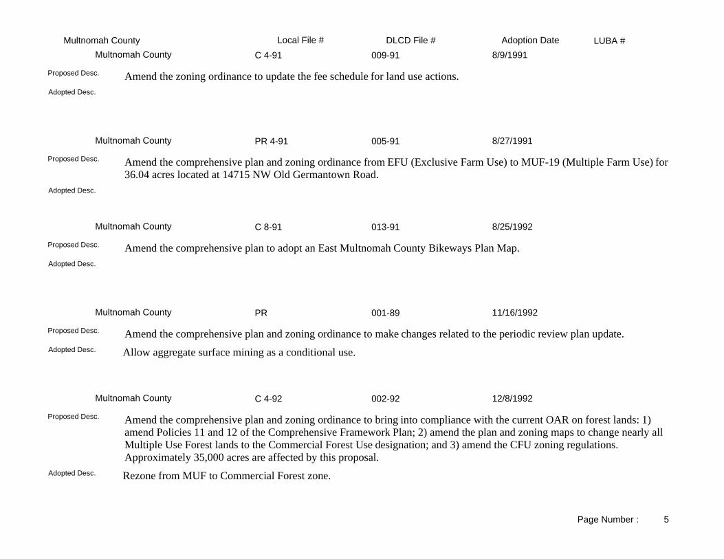
LUBA #Adoption DateLocal File # DLCD File #Multnomah CountyC 11-93 007-93Multnomah County 1/11/1994
Adopted Desc.
Amend the Health Hardship Mobile Home Provisions in the zoning ordinance to allow care provider to a property owner with a health hardship to be a non-realative. Also increase the time period for continuning a review of the permits from one year to two years.
Proposed Desc.
C 13-93 008-93Multnomah County 1/11/1994
Adopted Desc.
Amend the zoning ordinance to require a 100-foot area of undisturbed natural vegetation between grading and land disturbing activities and a stream, water body, or wetland.
Proposed Desc.
C 12-93 010-93Multnomah County 2/8/1994
Adopted Desc.
Amend the zoning ordinance to clarify the definition of a "lot" in the Low Density Residential zones.Proposed Desc.
C 1-94 009-93Multnomah County 2/8/1994
Adopted Desc.
Amend the zoning ordinance to eliminate the requirement of preparation of a written transcript for items under appeal to the Board. This proposal was submitted without text.
Proposed Desc.
C 21-94 002-94Multnomah County 11/22/1994
Adopted Desc.
Amend the county zoning code to repeal code sections that are no longer in use due to annexation of urban areas to the City of Portland.
Proposed Desc.
Page Number : 7

LUBA #Adoption DateLocal File # DLCD File #Multnomah CountyC 1-95 001-95Multnomah County 3/9/1995
Adopted Desc.
Amend the comprehensive plan (and zoning) maps to correct 1992 Goal 4 revision/update errors from Commercial Forest Use (and CFU) to Multiple Use Agriculture (and MUA-20) on approximately 65 acres located on the west bank of Multnomah Channel in the vicinity of the Sauvie Island Bridge.
Proposed Desc.
C 2-95 003-95Multnomah County 8/10/1995
Same.Adopted Desc.
Amend the comprehensive plan to reflect changes to Plan Policy 34 (Trafficways): (1) update regional Trans. Plan and Metro's 2040 Growth Mangement Plan; (2) clarify the "Scenic Route" overlay classification; and (3) add "expressway" as trafficway classification.
Proposed Desc.
C 8-95 005-95Multnomah County 12/21/1995
Adopted Desc.
Amend the land use regulations to: (1) Reference Survey Record Fees moved from the Land Division Code to the General Fee section; and, (2) Delete technical instructions for preparation of partition and subdivision plats and substitute only reference to ORS standards.
Proposed Desc.
C 10-95 001-96Multnomah County 3/21/1996
Same.Adopted Desc.
Amend the zoning code to remove the Grading and Erosion Control Provisions and relocate in Title 9 of the Building and Specialty Code section.
Proposed Desc.
C 1-96 002-96Multnomah County 3/28/1996
Adopted Desc.
Amend the land use regulations to revise the Lot of Record definition in R-30 and R-20 zones to allow undersized contiguous lots under the same ownership to be separately transferable if the lots contain single family dwellings.
Proposed Desc.
Page Number : 8

LUBA #Adoption DateLocal File # DLCD File #Multnomah CountyC 2-96 003-96Multnomah County 7/9/1996
Adopted Desc.
Amend the land use regulation to bring the Commercial Forest Use (CFU) zoning district and Plan Policy II, Commercial Forest Lands, into conformance with OAR 660, Division 6, Forest Lands.
Proposed Desc.
C-2-93 002-95Multnomah County 10/17/1996
Same.Adopted Desc.
Amend the comprehensive plan to adopt a West Hills Rural Area Plan.Proposed Desc.
C 2-93 005-96Multnomah County 10/17/1996
Same.Adopted Desc.
Amend the comprehensive plan to adopt the West Hills Rural Area Plan. The subject area incluces approximately 19,000 acres. The proposal requires an exception to approximately 50 acres and will be addressed in a separate action.
Proposed Desc.
C 5-96 006-96Multnomah County 3/6/1997
Adopted Desc.
Amend the zoning code to revise EFU and related district sections.Proposed Desc.
C-4-97 002-97Multnomah County 5/29/1997
Adopted Desc.
Amend the land use regulation regarding the notice of hearing officer decision, requiring the notice of decision to be mailed to parties that request it, or to everyone entitled to a mailed notice.
Proposed Desc.
Page Number : 9

LUBA #Adoption DateLocal File # DLCD File #Multnomah CountyC 3-95 003-97Multnomah County 7/10/1997
Adopted Desc.
Amend the comprehensive plan to adopt the Sandy River Rural Area Plan. The area plan involves 50,000 acres east of the Sandy River outside of the Columbia Gorge NSA. Addressed in the plan is protection of farm and forest uses, rural nature, rural development and streams.
Proposed Desc.
C 6-95 004-97Multnomah County 10/30/1997
Adopted Desc.
Amend the comprehensive plan to revise the Sauvie Island/Multnomah Channel Rural Area Plan to Preserve Sauvie Island as a rural, agricultural area and to overhaul planning policies and strategies for Multnomah Channel land and water use for approximately 14,000 acres located in NW Multnomah County.
Proposed Desc.
C 3-96 004-96Multnomah County 1/29/1998
Adopted Desc.
Amend the zoning ordinance exempting Single-Family Dwellings from the Design Review process. This is a reproposal with new revised language and was received with only 41 days notice.
Proposed Desc.
C 2-97 006-97Multnomah County 2/12/1998
Adopted Desc.
Amend the comprehensive plan text to make provision for two types of home occupation based on specific criteria. Proposed Desc.
C 6-97 005-97Multnomah County 4/2/1998
Adopted Desc.
Amend the comprehensive plan and zoning text establishing a two year expiration of administrative approvals for dwellings in the EFU district issued between 8/14/80 and 8/6/93.
Proposed Desc.
Page Number : 10

LUBA #Adoption DateLocal File # DLCD File #Multnomah County004-98Multnomah County 7/2/1998
Adopted Desc.
Amend the comprehensive plan text to adopt the Transportation System Plan for West Rural Multnomah County.Proposed Desc.
C-7-98 001-98Multnomah County 7/2/1998
Adopted Desc.
Amend the zoning ordinance to: 1) repeal the 120 day requirement of code and rely on statutory requirements; 2) amend thepublic hearing notice requirement from 20 days to 10 days prior to a hearing; and 3) amend the date a staff report is made available prior to a hearing from 5 days to 7 days as required by statute.
Proposed Desc.
C 1-98 003-98Multnomah County 7/9/1998
Adopted Desc.
Amend the zoning ordinance to implement the policies of the West Hills & East of Sandy River Rural Area Plans and provide equivalency standards to fire safety setbacks. Also, amend the zone map from Commercial Forest Use (CFU) to CFU-1, CFU-2, CFU-3, and CFU-4.
Proposed Desc.
C 7-98 008-98Multnomah County 12/10/1998
Same.Adopted Desc.
Amend the zoning ordinance text to revise regulations on large fill operations.Proposed Desc.
C 2-98 010-98Multnomah County 1/21/1999
Same.Adopted Desc.
Amend the county code to revise the West Hills Rural Area Plan to create a new designation of Commercial Forest Use - 5. Amend the zoning map from Commercial Forest Use - 2 to Commercial Forest Use - 5 on 80 acres located on US Highway 30 immediately south of Watson Road.
Proposed Desc.
Page Number : 11

LUBA #Adoption DateLocal File # DLCD File #Multnomah CountyC11-98 011-98Multnomah County 3/11/1999
Adopted Desc.
Amend the Action Proceedings section of the zoning code to amend the date at which a board decision becomes final from ten days after signing the decision to becoming final on the date of signing, and to delete rehearing provisions.
Proposed Desc.
C 10-98 002-99Multnomah County 4/13/1999
The Description of teh Official Zoning Map was changed from being a "GIS" Electronic Layer to a paper generated from that "GIS" Layer.
Adopted Desc.
Amend the zoning ordinance to make minor housekeeping code amendments.Proposed Desc.
C4-99 004-99Multnomah County 7/15/1999
Same.Adopted Desc.
Amend the comprehensive plan to delete and add new language to Plan Policies 13, 22, 37, 38, and 40.Proposed Desc.
C9-98 005-99Multnomah County 2/3/2000
Same.Adopted Desc.
Amend the comprehensive plan and zoning code to comply with Oregon Revised Statutes 215.130(6) "Application of ordinances; alteration of nonconforming use."
Proposed Desc.
C 2-99 003-99Multnomah County 4/15/2000
Same.Adopted Desc.
Amend the zoning ordinance to delete the Flood Hazard regulation to be in compliance with the standards of the National Flood Insurance Program. This notice received with 20 days notice.
Proposed Desc.
Page Number : 12

LUBA #Adoption DateLocal File # DLCD File #Multnomah CountyC 11-99 011-99Multnomah County 6/15/2000
Same.Adopted Desc.
Amend the zoning ordinance to add definitions for emergency/disaster and emergency/disaster response; and steps to respond to an emergency/disaster event located Countywide except the Scenic area of the Columbia Gorge.
Proposed Desc.
C 8-99 008-99Multnomah County 11/30/2000
Same. The two projects are combined (local File# C8-99 and C5-99) (DLCD FILE # 005-99 and 008-99Adopted Desc.
Amend the zoning ordinance to reorganize the land use regulations by setting up 5 new County Code Chapters, corresponding to the 5 rural area plans: Chapter 33-West Hills, Chapter 34-Sauvie Island, Chapter 35-East Sandy River, Chapter 36-West Sandy River, Chapter 38-Columbia River Gorge National Scenic Area.
Proposed Desc.
C 5-99 007-99Multnomah County 11/30/2000
Same. The two projects are combined (Local File # C8-99 and C5-99) (DLCD File# 005-99 and 008-99)Adopted Desc.
Amend the zoning ordinance sections .010 through .290 to comply with State re: noticing, hearings,etc., and to streamline the process and make the code clearer.
Proposed Desc.
CO-5 004-00Multnomah County 2/15/2001
Ordinance was changed to include incentive provisions rather than requirements for co-location and stealth technology.Adopted Desc.
Amend the county code Chapter 11.15 in 46 sections to provide standards for the appropriate location, development, and regulation of wireless communications facilities. This proposal was received with only 6 days notice before the first evidentiary hearing.
Proposed Desc.
PC 01-005 002-01Multnomah County 2/7/2002
Adds language to areas within the National Scenic Area (Columbia Gorge) that requires review of the "Plan" when there is proposed stream, riparian or land disturbing activity as per the Columbia River Gorge National Scenic Area Management Plan.
Adopted Desc.
Amend the county code Chapters 11.15, 33, 34, and 35 to revise the permit use to allow Wildlife Habitat Conservation and Management Plans as an allowed use on lands zoned EFU, Exclusive Farm Use.
Proposed Desc.
Page Number : 13

LUBA #Adoption DateLocal File # DLCD File #Multnomah CountyPC 01-002 004-01Multnomah County 5/16/2002
Added Minimum 2.00 acre lot size for " Lot Sizes for Conditional Uses" in compliance with OAR "Rural Residential' Rules. See 33.2875,33.3175, 34.3175, 35.2875, and 35.3175.
Adopted Desc.
Amend the zoning code in one hundred fifteen sections to add, delete text, revise, and update the Rural Lot of Record sections to comply with the Statewide Goal 14 rule updates.
Proposed Desc.
PC 01-01 001-01Multnomah County 9/26/2002
Same, except that proposed code amendments from 2 different files were combined into one proposal at the time of the Board of County Commissioners Hearings.
Adopted Desc.
Amend the county code Chapter 37: Land Use Planning Administration and Procedures add and delete text in the following sections: Type II, Type III Decisions and add the term expiration to the section; Reapplication Limited; Initiation of Action; Permit Types; Approval Process Table, and declare an emergency pursant to ORS 197.610(2). This proposal was received with 25 days notice before the first evidentiary hearing.
Proposed Desc.
PC 02-01 006-02Multnomah County 9/26/2002
Same, except that proposed code amendments from 2 different files were combined into one proposal at the time of the Board of County Commissioners Hearings.
Adopted Desc.
Amend the county code to make technical corrections to the code by adding, deleting text and sections in the following Chapters: 33-Land Use Code West Hills Plan Area in twenty-nine sections; 34-Land Use Code Sauvie Island/Multnomah Rural Plan Area in twenty-six sections; 35-Land Use Code East Sandy River Rural Plan Area; 37-Land Use Code Administration and Procedures in one section; 38-Land Use Code Columbia River Gorge National Scenic Area. This proposal was received with 10 days notice before the first evidentiary hearing.
Proposed Desc.
PC-01-07 001-02Multnomah County 12/12/2002
There are some changes that one summarized in the attached transmitteal memorandum. Most of the changes were clarification, not substantive. See File.
Adopted Desc.
Amend the comprehensive plan and county code in eleven areas to implement the West River Rural Plan Area. This proposal is related to DLCD File Number 003-01 (11775), the West of Sandy River Transportation and Land Use Plan.
Proposed Desc.
PC 02-01 006-02AMultnomah County 2/11/2003
Same.Adopted Desc.
Amend the county code to make technical corrections to the code by adding, deleting text and sections in the following Chapters: 33-Land Use Code West Hills Plan Area in twenty-nine sections; 34-Land Use Code Sauvie Island/Multnomah Rural Plan Area in twenty-six sections; 35-Land Use Code East Sandy River Rural Plan Area; 37-Land Use Code Administration and Procedures in one section; 38-Land Use Code Columbia River Gorge National Scenic Area. This proposal was received with 10 days notice before the first evidentiary hearing.
Proposed Desc.
Page Number : 14

LUBA #Adoption DateLocal File # DLCD File #Multnomah CountyPC-03-001 001-03Multnomah County 4/3/2003
Rather than the Clarifying language chances originally projected, the adopted amendment removes the criteria from the code.Adopted Desc.
Amend the zoning code Chapter 33 - West Hills Rural Plan Area to clarify and reduce the approval criteria applicable to development in areas designated as significant environmental concerns in wildlife habitat, scenic views and streams. This proposal was received after the first evidentiary hearing of February 2, 2003.
Proposed Desc.
T4-03-001 004-03Multnomah County 9/25/2003
Same.Adopted Desc.
Amend the comprehensive plan and zoning maps from EFU, Exclusive Forest Use to CFU-2, Commerical Farm Use for 9.29 aces, located at 11410 NW Skyline Boulevard.
Proposed Desc.
PC 03-004 005-03Multnomah County 1/22/2004
Same.Adopted Desc.
Amend the Multnomah County Resolution No. 02-104 Fees to increase fees, and new charges for actions that were previously free. This proposal was received with 10 days notice before the first evidentiary hearing, and with 34 days notice before the final hearing. Revised Notice: The revised proposal changes the first evidentiary hearing date from August 4, 2003 to December 1, 2003, and the final hearing from August 28, 2003 to January 7, 2004.
Proposed Desc.
PC 03-005 007-03Multnomah County 5/6/2004
Substantially similiar - both the proposed amendment and the adopted amendment provide similiar procedures for code enforcement process.
Adopted Desc.
Amend the following Multnomah County Code chapters dealing with enforcement: "33 - West Hills"; "34 - Sauvie Island"; "35 - East of Sandy River"; "36 - West of Sandy River"; "38 - Columbia River Gorge"; "11.15 - Inside UGB". This proposal was received with 42 days notice before the first evidentiary hearing.
Proposed Desc.
PC 03-003 006-03Multnomah County 5/13/2004
Same.Adopted Desc.
Amend the zoning code Chapter 34 - Sauvie Island and Multnomah Channel Rural Plan Area by adding text needed to allow construction of a new Sauvie Island Bridge. This proposal was received with 42 days notice before the first evidentiary hearing.
Proposed Desc.
Page Number : 15

LUBA #Adoption DateLocal File # DLCD File #Multnomah CountyPC 03-002 003-03Multnomah County 5/13/2004
Same.Adopted Desc.
Amend the zoning code Chapter 33 - West Hills Rural Plan Area Commercial and Chapter 37 - Administration and Process, Forest Use-2 ( CFU-2 ) zone and Exclusive Farm Use ( EFU ) zone adding and deleting text, sections to address changes to Oregon Administrative Rules for Agricultural Lands and Forest Lands. This proposal was received with 31 days notice before the first evidentiary hearing. Revised Notice: This revised proposal changes the final hearing from June 19, 2003 to July 31, 2003.
Proposed Desc.
T4-02-001 007-02Multnomah County 10/7/2004
The proposed amendment by staff to the Planning Commission was to apply a protected aggregate and mineral resource overlay and continue to "Specifically Limit Conflicting Use." The Planning Commission recommendation and the Board of County Commissioner's ultimately adopted amendment differed from the original proposed amendment in that it allows conflicting use.
Adopted Desc.
Amend the Comprehensive Plan Text to revise the Howard Canyon Reconciliation Report (a site-specific Goal 5 analysis for a significant aggregate resource). Amend the Comprehensive Plan Map to adjust the boundary of the significant aggregate resource site.Amend the Zoning to apply the Protected and Mineral Resources (PAM) Overlay Zone to the aggregate resource area and the designated ESEE impact area. Revised Notice: The revised notice was received on July 21, 2004 and contains updated information revised on June 24, 2004 for the Howard Canyon Reconciliation Report. The next hearing will be on August 19, 2004 with a possible adopt of the report at that time. 2nd Revised Notice: The revised proposal was received on August 3, 2004 and changes the final hearing from August 19, 2004 to September 9, 2004.
Proposed Desc.
Page Number : 16

LUBA #Adoption DateLocal File # DLCD File #FairviewNA 991-94Fairview
Others is Fairview Village Special Plan.Adopted Desc.
Amend the comprehensive plan (and zoning) from General Industrial (and M-2) to Fairview Village Special Plan District (and VCM, VC, VO, VTH, VA) for 88 acres located south of NE Halsey Street and North of NE Glisan Street, west of 223rd Avenue. Place special land use objectives, zoning stardards and design requirements, transit oriented, pedestrian friendly, and mixed use development for the subject area. (PARTIALLY ADOPTED 8/17/94)
Proposed Desc.
PR 002-89Fairview 9/6/1989
Adopted Desc.
Amend the comprehensive plan and zoning from M-2 (General Industrial) to M-3 (Light Industrial) for 5.48 acres located north of Depot Street and south of the railroad lines. This proposal relates to periodic review.
Proposed Desc.
NA 006-89Fairview 9/6/1989
Adopted Desc.
Amend the zoning from F-2 (Agriculture) to A-1-B (Apartment Residential-Business Office District) for 65.27 acres located north of Sandy Boulevard and west of 223rd Street.
Proposed Desc.
PR 005-89Fairview 9/6/1989
Adopted Desc.
Amend the comprehensive plan and zoning from R-7.5 (Low Density Residential) to C-3 (Commercial) for 2 acres located at 223rd Avenue and Blue Lake Road. This proposal relates to periodic review.
Proposed Desc.
PR 004-89Fairview 9/6/1989
Adopted Desc.
Amend the comprehensive plan and zoning from R-7.5 (Low Density Residential) to M-3 (Light Industrial) for 23.5 acres located on the south side of Sandy Boulevard near 209th. This proposal relates to periodic review.
Proposed Desc.
Page Number : 1

LUBA #Adoption DateLocal File # DLCD File #FairviewNA 003-89Fairview 9/6/1989
Adopted Desc.
Amend the zoning from M-3 (Light Industrial) to M-2 (Light Industrial) for 78.80 acres located east of 223rd Aveue to the south of Marine Drive.
Proposed Desc.
NA 007-89Fairview 10/4/1989
Adopted Desc.
Amend the comprehensive plan from R-7.5 (Low Density Residential) to A-2 (Medium Density Residential) for 7.5 acres located between 205th and 207th at NE Sandy Blvd.
Proposed Desc.
NA 001-90Fairview 11/11/1990
Adopted Desc.
Amend the zoning ordinance from Multonomah County's LR-7, LR-10, and MR-4 zone to the City's R-7.5 (Low Density Residential) to city R-7.5 (Low Density Residential) for several parcels totalling 27.38 acres located east of 201st Avenue, between Thompson Road and Broadway Court.
Proposed Desc.
NA 008-89Fairview 12/20/1990
Adopted Desc.
Amend the comprehensive plan to correct a map error from Low-Density Residential to Pulbic for 60.32 acres located at the corner of 201st and Halsey Street.
Proposed Desc.
PR 001-89Fairview 3/25/1991
Adopted Desc.
Amend the comprehensive plan and zoning ordinance to make changes related to the periodic review update.Proposed Desc.
Page Number : 2

LUBA #Adoption DateLocal File # DLCD File #FairviewNA 002-91Fairview 4/17/1991
Adopted Desc.
Amend the comprehensive plan and zoning from MR-4 (Low Density Residential) to A-2 (Medium Density Residential) for 6.77 acres located on the NE corner of NE Halsey and NE 201st.
Proposed Desc.
ZC2-91 003-91Fairview 8/21/1991
Adopted Desc.
Amend the comprehensive plan from R-7.5 (Low Density Residential-7.5) to R-10 (Low Density Residential-10) for 71.76 acres located between I-84, NE Halsey Street, an existing prower line easement and 205th Avenue.
Proposed Desc.
NA 001-92Fairview 7/1/1992
Adopted Desc.
NOTE: The proposal was submitted without text.Proposed Desc.
PR 001-89Fairview 4/7/1993
Address DLCD concerns.Adopted Desc.
Amend the comprehensive plan and zoning from M-2 (General Industrial) to M-3 (Light Industrial) for 5.48 acres located north of Depot Street and south of the railroad lines. This proposal relates to periodic review.
Proposed Desc.
NA 001-93Fairview 5/5/1993
Adopted Desc.
Amend the comprehensive plan and zoning from Multnomah County (Medium Density Residential) to city A-2 (Apartment Residential) for 9.27 acres located on the northeast corner of NE 201st Avenue and Halsey Street. The proposal was submitted without text.
Proposed Desc.
Page Number : 3

LUBA #Adoption DateLocal File # DLCD File #FairviewFairview Lake Way 002-98Fairview 6/17/1998
Adopted Desc.
Amend the comprehensive plan text to revise Low Density Residential criteria; amend the zoning ordinance to add a Design Overlay Zone; and amend the zoning map to apply the overlay zone to 42.87 acres located north of the Union Pacific Railroad and south of Fairview Lake.
Proposed Desc.
ORD 18-1998 004-98Fairview 12/17/1998
Adopted Desc.
Amend the zoning ordinance to eliminate the requirement of airport "noise disclosure statements" for new residential construction or reconstruction.
Proposed Desc.
A001-99 001-99Fairview 5/5/1999
Adopted Desc.
Amend the zoning ordinance to eliminate manufactured housing and RV Parks as permitted use in A-2, Apartment Residential; R-4, Residential Duplex; and A-1-B, Business Office zones.
Proposed Desc.
99-functional 002-99Fairview 6/2/1999
Adopted Desc.
Amend the comprehensive plan to (1) replace all references to Columbia Regional Association of Governments with the name of METRO, (2) replace Policy 13 with pertinent sections of the Regional 2040 Urban Growth Concept, and (3) add a policy to the Urbanization Element that provides METRO an annual report on all new non-residential parking approved by city. Amend the zoning ordinance to bring the city's planning program into compliance with the METRO regional requirements.
Proposed Desc.
A001-99 001-99AFairview 7/7/1999
Adopted Desc.
Amend the zoning ordinance to eliminate manufactured housing and RV Parks as permitted use in A-2, Apartment Residential; R-4, Residential Duplex; and A-1-B, Business Office zones.
Proposed Desc.
Page Number : 4

LUBA #Adoption DateLocal File # DLCD File #Fairview99-038-ZC 005-99Fairview 1/19/2000
Adopted version: Phasing as proposed. Changes proposed for single family residentce not accepted since they were different than the newly adopted ADU standards adopted to meet the Metro Standards.
Adopted Desc.
Amend the zoning ordinance to extend the development phase deadline from 5 to 7 years, for 80 acres, located at Fairview Village. This proposal was received without text, and 43 days notice, before the first evidentiary hearing.
Proposed Desc.
99-033-ZC 004-99Fairview 2/16/2000
Same.Adopted Desc.
Amend the zoning ordinance from F-2, Agricultural to M-2, Manufacturing for 116 acres, located in the City north of 223rd and Sandy Boulevard . This proposal was received without text.
Proposed Desc.
00-02ZC 002-00Fairview 4/19/2000
Includes "Assisted Care and/or Retirement Facilities" as Allowed use. Also added was a requirement that parking occupy no more than 50% of Street frontage, and the inclusion of a maximum setback of 15 feet for street facing facades.
Adopted Desc.
Amend the zoning map from R7.5, High Density Residential to C1, Town Center Commercial; A2, General Apartment to C1, Town Center Commercial; C4, Neighborhood Commercial to C1, Town Center Commercial; C2, General Commercial to C1, Town Center Commercial; M2, General Manufacturing to C1, Town Center Commercial for 55 acres, located between NE 205th Avenue and 230th Avenue on NE Halsey Street; and from R7.5, Single-Family Residential to CSP, Community Service Parks for 0.23 acres, located on NE Halsey Street, just west of 7th Street. Amend the zoning ordinance to the following sections: add uses to Section 19.60.020 "Permitted Uses; delete uses in Section 19.60.30 "Conditional Uses"; add new sections to Section 19.72.010 "Permitted Uses", 19.72.020 "Conditional Uses", 19.72.030 "Development Standards". Amend the comprehensive plan map from LDR, Low Density Residential to C, Commercial.
Proposed Desc.
00-03 CP/ZC 003-00Fairview 7/5/2000
Same.Adopted Desc.
Amend the comprehensive plan map (and the zoning map) from IG, General Industrial to MDR, Medium Density Residential; and IG, General Industrial to P-OS, Parks and Open Space (and from M-1 CR, Heavy Manufacturing Columbia River to A-1-B, Apartment Residential Business Office District; and CSP, Community Service Parks) for 78 acres, located on the south bank of the Columbia River and north of NE Marine Drive, just north of Blue Lake Park. Amend the comprehensive plan to add text to the economic development section about the acreage. Amend the municipal code Chapter 19.50, (A-1-B) Apartment Residential Business Office to allow integrated mixed use residential and commercial developments, including offices and community-serving commercial activities. Amend the municipal code Chapter 19.90, (M-1-CR) Heavy Manufacturing Columbia River to clarify the applicability of the M-1-CR zoning district to properties suitable for Water-Dependent Heavy Manufacturing. The proposal was received with 43 days notice before the first evidentiary hearing and an emergency has been declared on these actions.
Proposed Desc.
Page Number : 5

LUBA #Adoption DateLocal File # DLCD File #Fairview00-33-ZC 004-00Fairview 1/17/2001
Same.Adopted Desc.
Amend the zoning map R-7.5, Single Family Residential-7,500 square feet to CS/P, Community Service/Parks to accommodate the siting of a City water reservoir on 0.75 acres, located at 21523 NE Halsey Street. This proposal was received without text, and 42 days notice before the first evidentiary hearing.
Proposed Desc.
Ord 10 & 11-2002 003-02Fairview 11/6/2002
Area rezoned reduced to less than eight acres, rather than earlier 17.00 acres.Adopted Desc.
Amend the Comprehensive Plan Map (and the Zoning Map) from Medium Density (and R/MF) to Low Density (and R) on approximately 5.0 acres at various locations in the city. Stated purpose is to preserve existing neighborhoods by rezoning multi-family undeveloped land to single family detached.
Proposed Desc.
02-97-CPA/ZC 004-02Fairview 2/19/2003
Same.Adopted Desc.
Amend the comprehensive plan map (and the zoning map) from General Industrial to Commercial (and from General Industrial to Corridor Commercial) for 13.90 acres, located at N.E. Sandy Boulevard and 223rd Avenue. This proposal was received without text.
Proposed Desc.
Ord. No. 3-2003 001-03Fairview 5/7/2003
Includes a larger area on the edges of the town plat.Adopted Desc.
Amend the development code to change the minimum lot size in Old Town from 6,000 square feet to 7,500 square feet. Amend the zoning map from Residential to Residential Old Town Overlay Zone (R-7.5) for 90.00 acres, located in the Old Town Neighborhoods.
Proposed Desc.
Ord. 7-2003 002-03Fairview 6/16/2004
The new ordinance (4-2004) no longer deals with on-street parking. The new ordinance establishes permitted uses and a decision process for parking as a means to assure adequate parking.
Adopted Desc.
Amend the development code regarding Town Center Parking Standards to replace the word "shall" with the words "may be deemed appropriate by the Planning Commission" as pertaining to on-street parking providing parking spaces to meet parking requirements. Revised Notice: The revised notice adds text changes to the following sections of the zoning ordinance: 19.135 - Village Commercial (VC) and Mixed-Use District (VMU) and 19.140 - Village General Standards; and changes the final hearing date from September 3, 2003 to April 13, 2004.
Proposed Desc.
Page Number : 6

LUBA #Adoption DateLocal File # DLCD File #Fairview003-03Fairview 6/16/2004
Updated background information to reflect most recent development.Adopted Desc.
Amend the comprehensive plan by adding and deleting text, sections to include recent amendments to the Transportation System Plan, Goal 5 Resource Inventory, Parks and Open Space Master Plan, Economic Development, Housing Data; and revise the plan map to make it consistent with the zoning map.
Proposed Desc.
Page Number : 7

LUBA #Adoption DateLocal File # DLCD File #Gresham94-131-CPA 004-94Gresham
Adopted Desc.
Amend the comprehensive plan and zoning ordinance to comply with state law regarding the new Transportation Planning Rule. This is a reproposal with the original submittal date of October 10, 1994 and original hearing date of 11/15/94.
Proposed Desc.
87-14-PMA 006-87AGresham 6/2/1987
PLAN FROM MODERATE DENSITY RESIDENTIAL TO TRANSIT DEVELOPMENT DISTRICT.Adopted Desc.
Amend the comprehensive plan from Moderate Density Residential to Transit Development District for approximately 0.8 acre located south of Metropolitan Area Transit (MAX) on N.E. Cleveland Avenue.
Proposed Desc.
87-35-CPA 001-87AGresham 6/2/1987
DELETES LANGUAGE REGARDING WALL HEIGHT LIMITATION.Adopted Desc.
Amend the zoning ordinance's regulations concerning wall sign height limitations.Proposed Desc.
87-18-PMAMJP 005-87AGresham 6/2/1987
PLAN FROM LOW DENSITY RESIDENTIAL TO MODERATE DENSITY RESIDENTIAL.Adopted Desc.
Amend the comprehensive plan from Low Density Residential to Moderate Density Residential for approximately 1.5 acres located on N.E. Rene at 27th. The proposal would allow development of a senior housing project adjacent to Mt. Hood Medical Center.
Proposed Desc.
87-27-PMA 002-87AGresham 7/7/1987
AMEND THE COMPREHENSIVE PLAN AND ZONING FROM MODERATE DENSITY RESIDENTIAL TO GENERAL COMMERCIAL FOR 0.7 ACRE.
Adopted Desc.
Amend the comprehensive plan from Moderate Density Residential to General Commercial for approximately 0.7 acre located south of S.E. 14th, on Mt. Hood Highway.
Proposed Desc.
Page Number : 1

LUBA #Adoption DateLocal File # DLCD File #Gresham87-66-CPA 007-87BGresham 9/15/1987
COMP PLAN TO CHANGE MAXIMUM AREA, HEIGHT AND NUMBER OF FREE-STANDING SIGNS FOR SINGLE BUSINESS PREMISES.
Adopted Desc.
Amend the comprehensive plan to change maximum area, height and number of free-standing signs for single business premises.
Proposed Desc.
87-81-CPA 009-87BGresham 11/17/1987
AMENDS THE PLAN AND DEVELOPMENT CODE TO INCLUDE NEW STANDARDS TO BE USED IN THE TRANSIT IMPACT DISTRICT
Adopted Desc.
Amend the Transit Impact overlay and Transit District Development zones to allow more flexible uses of properties immediately adjacent to transit stations.
Proposed Desc.
87-73-PMA 010-87BGresham 11/17/1987
Adopted Desc.
Amend the comprehensive plan and zoning from Low Density Residential (LDR) to Extensive Commercial (EC) for approx. 0.1 acre located at the soutwest corner of East Powell and Southeast Juniper Avenue.
Proposed Desc.
87-85-CPA 01187BGresham 11/17/1987
AMENDMENT TO COMP. PLAN TO BE INCORPORATED INTO A CITY- COUNTY INTERGOVERNMENTAL AGREEMENT TO MAKE THE PLANNING SERVICES BOUNDARY CONSISTENT WITH THE GRESHAM URBAN SERVICES BOUNDARY.
Adopted Desc.
Amend the Urban Service Boundary to relocate the Gresham and Portland service areas in Mid-Multnomah County. The boundary will be relocated from the middle of the streets to the rear of property lines. The streets involved are N.E. 162nd Avenue, S.E. Stark and S.E. 174th Avenue.
Proposed Desc.
88-14-PMA 007-88Gresham 5/17/1988
Adopted Desc.
Amend the comprehensive plan and zoning from High Density Residential to General Commercial for 0.4 acre located at E. Burnside Street and NE Kelly.
Proposed Desc.
Page Number : 2

LUBA #Adoption DateLocal File # DLCD File #Gresham88-17-PMA 006-88Gresham 5/17/1988
Adopted Desc.
Amend the comprehensive plan and zoning from Industrial to Extensive Commercial for 3.4 acres located at SE 195th Avenue and Division Street.
Proposed Desc.
88-16-PMA 005-88Gresham 6/7/1988
Adopted Desc.
Amend the comprehensive plan and zoning from Moderate Density Residential (MDR) and General Commercial (GC) to Extensive Commercial (EC) for 7.87 acres located on the north side of SE 1st Street and east of Burnside Street.
Proposed Desc.
Solar Access 003-88Gresham 7/19/1988
DEFINITIONS FOR ADMINISTRATION OF CODES; SET STANDARDS FOR SOLAR ACCESS IN NEW DEVELOPMENTS AND TO RESIDENTIAL BUILDING APPLICATIONS; PROTECT SOLAR FEATURES FROM SHADING BY VEGETATION.
Adopted Desc.
Amend the zoning ordinance to: 1) provide definitions for administration of codes; 2) set standards for solar access in new developments; 3) set standards for solar access to residential building appplications on existing lots; and 4) protect solar features from shading by vegetation.
Proposed Desc.
88-18-PMA 008-88Gresham 7/19/1988
Adopted Desc.
Amend the comprehensive plan and zoning from Transit High Density Residential (THR) to Extensive Commercial (EC) for approximately 0.3 acre located at the northeast corner of SE Stark Street and 192nd Avenue.
Proposed Desc.
88-138-CPA 037-88Gresham 11/21/1988
ESTABLISH NEW LANGUAGE REGARDING CUL-DE-SAC STREET LENGTH STANDARDS.Adopted Desc.
Amend the comprehensive plan and zoning to establish new language reguarding cul-de-sac street length standards.Proposed Desc.
Page Number : 3

LUBA #Adoption DateLocal File # DLCD File #Gresham88-67-CPA 030-88Gresham 12/20/1988
FINDINGS AND INVENTORY OF SIGNIFICANT NATURAL RESOURCES AND OPEN SPACES, POLICIES &STRATEGIES TO PROTECT SIGNIFICANT NATURAL RESOURCE & OPEN SPACE SITES, & STANDARDS TO ESTABLISH NR & OS OVERLAY DISTRICTS.
Adopted Desc.
Amend the comprehensive plan and zoning to adopt findings and inventories of significant natural resources and open spaces. Adopt new policies for the protection of significant fish and wildlife, wetlands, water ares, and open space sites. The amendment relates to periodic review.
Proposed Desc.
88-108-CPA 018-88Gresham 12/20/1988
DEVELOP PROCEDURES FOR PROCESSING DEVELOPMENT PERMIT APPLICATIONS. RELATES TO PERIODIC REVIEW.
Adopted Desc.
Amend the Community Development Code to update development permit applications. This amendment relates to periodicreview.
Proposed Desc.
88-95-CPA 023-88Gresham 12/20/1988
ESTABLISH UPDATED FINDINGS AND AMEND POLICIES CONCERNING OPEN SPACE AND RECREATIONAL FACILITIES SECTIONS. RELATES TO PERIODIC REVIEW.
Adopted Desc.
Amend the Community Development Plan to establish findings and amend policies concerning open space and recreational facilities. This amendment relates to periodic review.
Proposed Desc.
88-100-CPA 016-88Gresham 12/20/1988
ESTABLISH PROVISIONS FOR RESIDENTIAL CARE FACILITIES. RELATES TO PERIODIC REVIEW.Adopted Desc.
Amend the comprehensive plan and zoning to establish provisions for Residential Care Facilities. This amendment relates to periodic review.
Proposed Desc.
88-102-CPA 021-88Gresham 12/20/1988
FINDINGS TO DOCUMENT THE 40-MILE LOOP TRAIL AS GOAL 5 RESOURCE AND PART OF THE CITY-WIDE TRAIL NETWORK.
Adopted Desc.
Amend the comprehensive plan and zoning to establish findings, policies and strategies concerning the 40-Mile Loop Trail and enact code provisions to require granting of trail easements in connection with new development. This amendment relates to periodic review.
Proposed Desc.
Page Number : 4

LUBA #Adoption DateLocal File # DLCD File #Gresham88-104-CPA 012-88Gresham 12/20/1988
FLOODPLAIN REGULATIONS. RELATES TO PERIODIC REVIEW.Adopted Desc.
Amend the zoning ordinance's floodplain regulations to conform with revised Federal Emergency Management Agency Regulations. This amendment relates to periodic review.
Proposed Desc.
88-48-CPA 029-88Gresham 12/20/1988
DEFINE MANUFACTURED HOME AND TO MAKE MANUFACTURED HOME PARKS SUBJECT TO SITE DESIGNREVIEW REQUIREMENTS. RELATES TO PERIODIC REVIEW.
Adopted Desc.
Amend the comprehensive plan and zoning to adopt new inventory data and projections relating to mobile home housing and mobile home parks, define manufactured home and make mobile home parks subject to site design review requirements. This amendment relates to periodic review.
Proposed Desc.
88-49-PMA 028-88Gresham 12/20/1988
INCLUDES OVER 100 SIGNIFICANT CHANGES TO PLAN DESIGNATIONS AND MINOR CHANGES TO THEENTIRE PLAN MAP. RELATES TO PERIODIC REVIEW.
Adopted Desc.
Amend the comprehensive plan and zoning to redesignate parcels according to updated and new land use districts. This amendment relates to periodic review.
Proposed Desc.
88-42-CPA 033-88Gresham 12/20/1988
CREATE TWO CATEGORIES OF HOME OCCUPATIONS AND ESTABLISHES PERMITTING PROCEDURES ANDSTANDARDS. ADDS ALLOWING HOME OCCUPATIONS AS AN IMPLEMENTATION STRATEGY UNDER THE ECONOMIC DEVELOPMENT POLICY. RELATES TO PERIODIC REVIEW.
Adopted Desc.
CLOSED SAME AS 010-88Proposed Desc.
88-82-CPA 019-88Gresham 12/20/1988
OUTLINE VARIOUS PLAN ELEMENTS AND DOCUMENTING THAT THE PLAN INCLUDES NO EXCEPTIONS FROM STATEWIDE PLANNING GOALS. RELATES TO PERIODIC REVIEW.
Adopted Desc.
Amend the Community Development Plan to describe the organization of the comprehensive plan. This amendment relates to periodic review.
Proposed Desc.
Page Number : 5
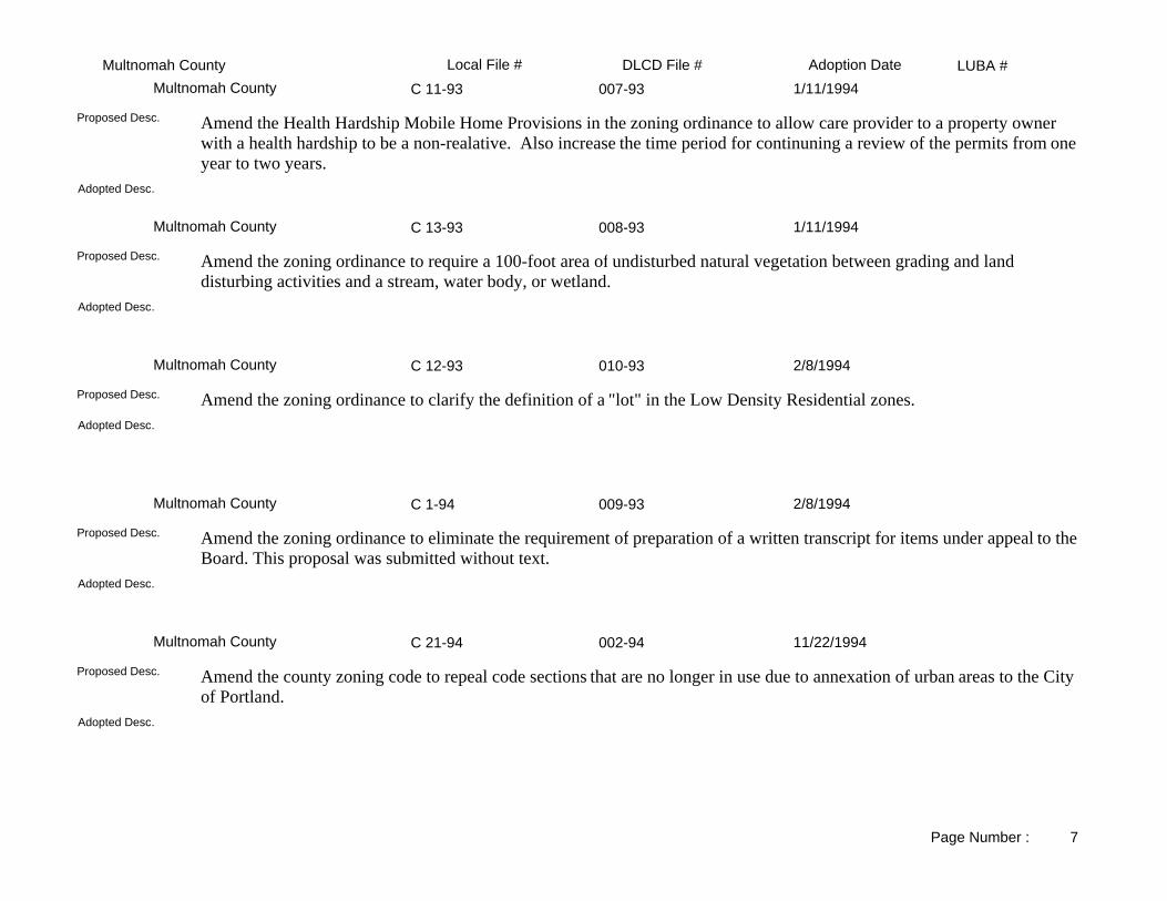
LUBA #Adoption DateLocal File # DLCD File #Gresham88-46-CPA 034-88Gresham 12/20/1988
NEW RESIDENTIAL LAND USE POLICIES AND IMPLEMENTATION STRATEGIES. RELATES TO PERIODIC REVIEW.
Adopted Desc.
Amend the comprehensive plan's residential land use policies and implementation strategies. This amendment relates tod periodic review.
Proposed Desc.
88-45-CPA 032-88Gresham 12/20/1988
CREATION OF ZERO LOT LINE HOUSING STANDARDS.Adopted Desc.
Amend the comprehensive plan to create zero lot line housing standards. This amendment relates to periodic review.Proposed Desc.
88-79-CPA 011-88Gresham 12/20/1988
ESTABLISH NEW FINDINGS AND AMEND POLICIES AND STANDARDS CONCERNING PUBLIC FACILITIES. RELATES TO PERIODIC REVIEW.
Adopted Desc.
Amend the Community Development Plan to establish new findings and amend policies concerning public facilities, transportation, water supply, sewer, and drainage systems. This amendment relates to periodic review.
Proposed Desc.
88-68-CPA 031-88Gresham 12/20/1988
FINDINGS AND INVENTORY OF HISTORIC & CULTURAL LANDMARKS; POLICIES TO PROTECT THESE RESOURCES; STANDARDS TO PROTECT INVENTORY LANDMARKS & REQUIRING DISCOVERY OF ARCHEOLOGICAL OBJECTS & SITES TO BE DISCOVERED. RELATED TO PERIODIC REV.
Adopted Desc.
Amend the comprehensive plan and zoning to inventory significant historic and cultural resources. Adopt policies and strategies to conserve these sites, and enact standards for development affecting historic and cultural resource sites. The amendment relates to periodic review.
Proposed Desc.
Page Number : 6
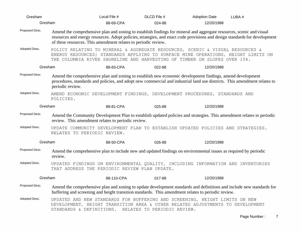
LUBA #Adoption DateLocal File # DLCD File #Gresham88-69-CPA 024-88Gresham 12/20/1988
POLICY RELATING TO MINERAL & AGGREGATE RESOURCES, SCENIC & VISUAL RESOURCES & ENERGY RESOURCES; STANDARDS APPLYING TO SURFACE MINE OPERATIONS, HEIGHT LIMITS ON THE COLUMBIA RIVER SHORELINE AND HARVESTING OF TIMBER ON SLOPES OVER 15%.
Adopted Desc.
Amend the comprehensive plan and zoning to establish findings for mineral and aggregate resources, scenic and visual resources and energy resources. Adopt policies, strategies, and enact code provisions and design standards for development of these resources. This amendment relates to periodic review.
Proposed Desc.
88-83-CPA 022-88Gresham 12/20/1988
AMEND ECONOMIC DEVELOPMENT FINDINGS, DEVELOPMENT PROCEDURES, STANDARDS AND POLICIES.
Adopted Desc.
Amend the comprehensive plan and zoning to establish new economic development findings, amend development procedures, standards and policies, and adopt new commercial and industrial land use districts. This amendment relates to periodic review.
Proposed Desc.
88-81-CPA 025-88Gresham 12/20/1988
UPDATE COMMUNITY DEVELOPMENT PLAN TO ESTABLISH UPDATED POLICIES AND STRATEGIES. RELATES TO PERIODIC REVIEW.
Adopted Desc.
Amend the Community Development Plan to establish updated policies and strategies. This amendment relates to periodic review. This amendment relates to periodic review.
Proposed Desc.
88-50-CPA 026-88Gresham 12/20/1988
UPDATED FINDINGS ON ENVIRONMENTAL QUALITY, INCLUDING INFORMATION AND INVENTORIES THAT ADDRESS THE PERIODIC REVIEW PLAN UPDATE.
Adopted Desc.
Amend the comprehensive plan to include new and updated findings on environmental issues as required by periodic review.
Proposed Desc.
88-110-CPA 017-88Gresham 12/20/1988
UPDATED AND NEW STANDARDS FOR BUFFERING AND SCREENING, HEIGHT LIMITS ON NEW DEVELOPMENT, HEIGHT TRANSITION AREA & OTHER RELATED ADJUSTMENTS TO DEVELOPMENT STANDARDS & DEFINITIONS. RELATES TO PERIODIC REVIEW.
Adopted Desc.
Amend the comprehensive plan and zoning to update development standards and definitions and include new standards for buffering and screening and height transition standards. This amendment relates to periodic review.
Proposed Desc.
Page Number : 7

LUBA #Adoption DateLocal File # DLCD File #Gresham87-95-CPA 015-88Gresham 12/20/1988
APPLICATION FEES, CONSOLIDATE PROCEDURES AND PERMIT AND ZONE CHANGE APPLICATIONS. RELATED TO PERIODIC REVIEW.
Adopted Desc.
Amend the Community Development Code regarding application fees, consolidated procedures and permit and zone changeapplications. This amendment relates to periodic review.
Proposed Desc.
88-115-CPA 020-88Gresham 12/20/1988
AMENDMENT TO CITIZEN INVOLVEMENT, FIRE AND POLICE PROTECTION SECTIONS OF COMPREHENSIVE PLAN. RELATES TO PERIODIC REVIEW.
Adopted Desc.
Amend the comprehensive plan findings related to citizen involvement and fire police protection. This amendment relates to periodic review.
Proposed Desc.
85-135-CPA 036-88Gresham 12/20/1988
APPLY STANDARDS TO THE DESIGN AND DEVELOPMENT OF REGIONAL SHOPPING CENTERS.Adopted Desc.
Amend the comprehensive plan and zoning to provide standards for a regional shopping center use.Proposed Desc.
88-42-CPA 010-88Gresham 12/20/1988
CHANGE IN THE ECONOMIC DEVELOPMENT POLICY, AND IMPLEMENTING MEASURES REGARDING HOMEOCCUPATION (MINOR AND MAJOR HOME OCCUPATION).
Adopted Desc.
Amend the comprehensive plan and zoning to establish procedures and standards for home occupations.Proposed Desc.
89-17 CPA 001-89Gresham 3/7/1989
AMEND THE PUBLIC WATER SERVICE REQUIREMENTS ALLOWING SINGLE FAMILY DWELLING THE USEOF A WELL WHEN NOT IN CLOSE PROXIMITY TO A PUBLIC WATER MAIN.
Adopted Desc.
Amend the public water service requirements of the zoning ordinance to allow a singe-family dwelling the use of a well when not in close proximity to a public water main.
Proposed Desc.
Page Number : 8
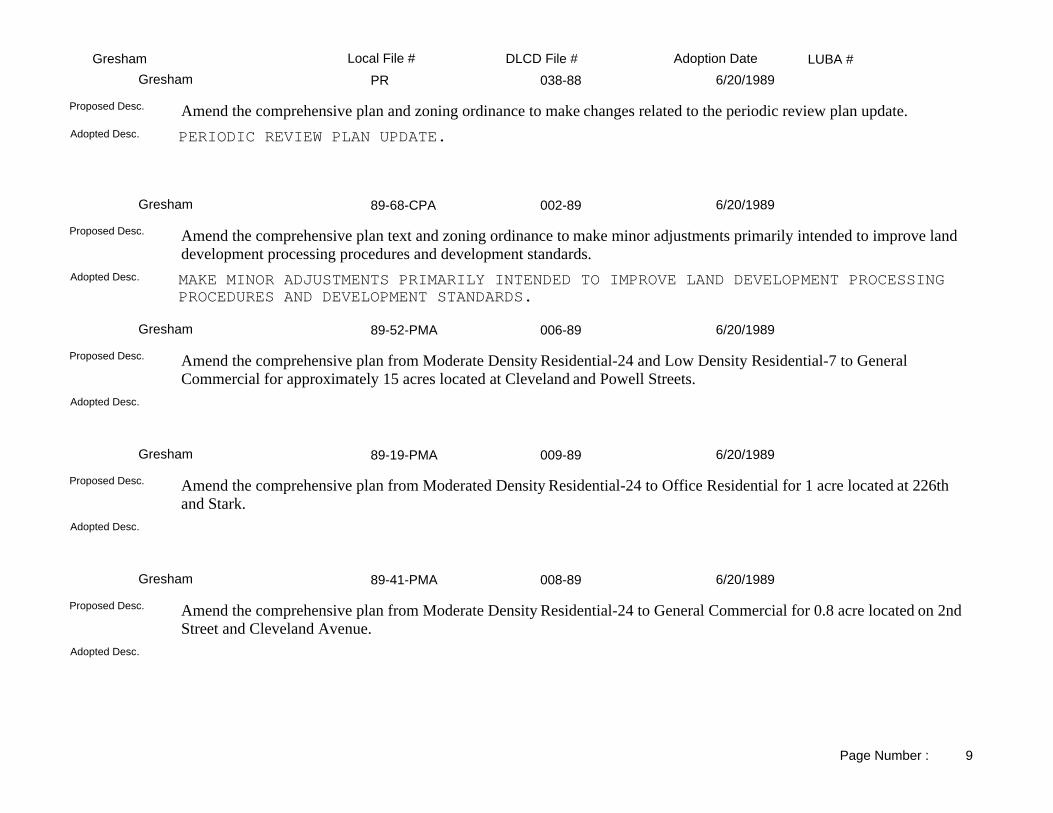
LUBA #Adoption DateLocal File # DLCD File #GreshamPR 038-88Gresham 6/20/1989
PERIODIC REVIEW PLAN UPDATE.Adopted Desc.
Amend the comprehensive plan and zoning ordinance to make changes related to the periodic review plan update.Proposed Desc.
89-68-CPA 002-89Gresham 6/20/1989
MAKE MINOR ADJUSTMENTS PRIMARILY INTENDED TO IMPROVE LAND DEVELOPMENT PROCESSING PROCEDURES AND DEVELOPMENT STANDARDS.
Adopted Desc.
Amend the comprehensive plan text and zoning ordinance to make minor adjustments primarily intended to improve land development processing procedures and development standards.
Proposed Desc.
89-52-PMA 006-89Gresham 6/20/1989
Adopted Desc.
Amend the comprehensive plan from Moderate Density Residential-24 and Low Density Residential-7 to General Commercial for approximately 15 acres located at Cleveland and Powell Streets.
Proposed Desc.
89-19-PMA 009-89Gresham 6/20/1989
Adopted Desc.
Amend the comprehensive plan from Moderated Density Residential-24 to Office Residential for 1 acre located at 226th and Stark.
Proposed Desc.
89-41-PMA 008-89Gresham 6/20/1989
Adopted Desc.
Amend the comprehensive plan from Moderate Density Residential-24 to General Commercial for 0.8 acre located on 2nd Street and Cleveland Avenue.
Proposed Desc.
Page Number : 9

LUBA #Adoption DateLocal File # DLCD File #Gresham88-58-CPA 014-88Gresham 6/27/1989
UPDATES ORDINANCES REGULATING SIGNS. RELATES TO PERIODIC REVIEW.Adopted Desc.
Update sign provisions. This amendment relates to periodic review.Proposed Desc.
89-51 PMA 007-89Gresham 7/18/1989
Adopted Desc.
Amend the comprehensive plan from Light Industrial to Moderate Density Residential-24 for approximately 10 acres located at 205th and Stark Street.
Proposed Desc.
89-44-PMA 005-89Gresham 7/18/1989
Adopted Desc.
Amend the comprehensive plan from General Commercial to Extensive Commercial for approximately 2 acres located at Powell and Vista West.
Proposed Desc.
89-50-PMA 003-89Gresham 7/18/1989
Adopted Desc.
Amend the comprehensive plan from General Commercial to Central Urban Core for approximately 12 acres located at Powell and Miller. This proposal expands the Central Urban Core.
Proposed Desc.
89-59-PMA 010-89Gresham 8/15/1989
Adopted Desc.
Amend the comprehensive plan from Low Density Residential-7 to Moderate Density Residential-12 for 5 acres located at Regner and Butler Streets.
Proposed Desc.
Page Number : 10

LUBA #Adoption DateLocal File # DLCD File #Gresham89-42-PMA 012-89Gresham 8/22/1989
Adopted Desc.
Amend the comprehensive plan from General Commercial to Moderate Density Residential-24 for 1 acre located at 180th and Division.
Proposed Desc.
89-108 CPA 019-89Gresham 9/5/1989
PERMIT LIMITED ENCROACHMENT OF BUILDINGS AND PARKING AREA INTO THE STREET-SIDE YARDAREA FOR DEVELOPMENT SITES IN COMMERCIAL DISTRICTS.
Adopted Desc.
Amend the zoning ordinance to permit limited encroachment of building and parking areas into the street side yard setback areas for corner lots in the NC (Neighborhood Commercial), EC (Extensive Commercial) and EEC (Exclusive Extensive Commercial) zones.
Proposed Desc.
89-109-CPA 018-89Gresham 10/3/1989
ALLOW A PROPERTY OWNER TO FILE A PLAN MAP AMENDMENT APP. MORE THAN TWICE A YEAR.Adopted Desc.
Amend the Community Development Plan to allow a property owner to file a plan map amendment application more frequently than twice a year.
Proposed Desc.
88-54-CPA 013-88Gresham 12/20/1989
UPDATE HOUSING AND POPULATION FINDINGS. RELATES TO PERIODIC REVIEW.Adopted Desc.
Amend the comprehensive plan to update housing and population findings. This amendment relates to periodic review.Proposed Desc.
88-47-CPA 027-88Gresham 12/20/1989
NEW AND AMENDED LAND USE DISTRICTS WHICH REPLACE THE CURRENT LAND USE DISTRICTS. RELATES TO PERIODIC REVIEW.
Adopted Desc.
Amend the comprehensive plan and zoning to establish six residential land use districts which will replace existing land use districts. This amendment relates to periodic review.
Proposed Desc.
Page Number : 11

LUBA #Adoption DateLocal File # DLCD File #Gresham89-127-PMA 020-89Gresham 1/2/1990
Adopted Desc.
Amend the comprehensive plan from GC (General Commercial) and BP (Business Park) to MDR-24 (Moderate Density Residential-24) for 6.02 acres located at SW Eleventh and Highland Drive.
Proposed Desc.
89-116-CPA 024-89Gresham 1/16/1990
AMENDMENTS ENSURE THAT ALL DISCRETIONARY DECISIONS ARE NOT MADE ADMINISTRATIVELY. TYPE II DEVELOPMENT PERMIT DECISION WILL NOW BE APPEALABLE TO THE CITY COUNCIL.
Adopted Desc.
Amend the comprehensive plan and zoning ordinance to ensure that discretionary decisions are not made administratively. Allow Type II Development Permit decisions to be appealed to the city council.
Proposed Desc.
89-150-CPA 026-89Gresham 1/16/1990
AMENDMENTS TO THE VARIANCE REGULATIONS.Adopted Desc.
Amend the Land Use Variance Procedures and Criteria.Proposed Desc.
89-134 PMA 004-90Gresham 2/20/1990
Adopted Desc.
Amend the comprehensive plan from MDR-24 (Medium Density Residential-24) to GC (General Commercial) for 0.37 acrelocated south of Stark on Hogan Road.
Proposed Desc.
89-133 PMA 001-90Gresham 2/20/1990
Adopted Desc.
Amend the comprehensive plan from MDR-24 (Moderate Density Residential-24) to OFR (Office/Residential) for 3.26 acres located at 226th and Stark Street.
Proposed Desc.
Page Number : 12

LUBA #Adoption DateLocal File # DLCD File #Gresham90-30-CPA 005-90Gresham 4/17/1990
ALLOW TEMPORARY USES TO BE APPROVED WITH THIRTY OR NINETY DAYS TIME LIMIT BETWEEN PERMITS.
Adopted Desc.
Amend the zoning ordinance to have a time limit of 30 or 90 days between temporary use permits.Proposed Desc.
89-157 CPA 027-89Gresham 5/15/1990
DESIGN REVIEW STANDARDS TO MINIMIZE TRAFFIC-RELATED IMPACTS ON LOW DENSITY RESIDENTIAL NEIGHBORHOODS.
Adopted Desc.
Amend the zoning ordinance to reduce vehicular access impacts from attached residential developments to local residential streets.
Proposed Desc.
89-170 CPA 002-90Gresham 5/15/1990
GENERAL PROVISIONS TO THE PUBLIC FACILITIES STANDARDS.Adopted Desc.
Amend the comprehensive plan to: 1) update the text of the Puplic Facilities Standards; and 2) eliminate duplication and comform with the city's updated proposed Public Works Design Standards.
Proposed Desc.
90-36-CPA 006-90Gresham 5/16/1990
AMEND THE ZONING ORDINANCE RELATING TO SUBDIVISIONS, PARTITIONS AND LOT LINE ADJUSTMENTS.
Adopted Desc.
Amend the zoning ordinance to comply with Senate Bill 358 relating to partitioning and subdivisions.Proposed Desc.
90-26-PMA 008-90Gresham 6/19/1990
Adopted Desc.
Amend the comprehensive plan from HDR-60/OFR (High Density Residential/Office Residential) to LDR-7/HDR-60 (LowDensity Residential/High Density Residential) for one acre located at 181st and Everett.
Proposed Desc.
Page Number : 13

LUBA #Adoption DateLocal File # DLCD File #Gresham90-38-CPA 007-90Gresham 6/19/1990
REGULATE RESIDENTIAL ACCESSORY STRUCTURES.Adopted Desc.
Amend the zoning ordinance to regulate placement of accessory buildings in residential rear yards.Proposed Desc.
90-27 PMA 009-90Gresham 6/19/1990
Adopted Desc.
Amend the comprehensive plan from HDR-60/GC (High Density Residential/General Commercial) to MDR-24 (Moderate Residential) for 4.5 acres located at 10th and Cleveland, south of Division.
Proposed Desc.
90-93 CPA 011-90Gresham 8/21/1990
Adopted Desc.
Amend the comprehensive plan and zoning ordinance to make editing changes and revisions regarding legislative actions, procedures and public notices.
Proposed Desc.
90-110-CPA 012-90Gresham 10/2/1990
Adopted Desc.
Amend the comprehensive plan by revising the Inventory of Historic and Cultural Landmarks to elevate six Class 2 landmarks to Class 1 status, and delete one recently destroyed by fire.
Proposed Desc.
90-112 PMA 013-90Gresham 11/6/1990
Adopted Desc.
Amend the comprehensive plan from Medium Density Residential-24 to Office/Residential for 0.22 acre located near 181st and Pacific Court.
Proposed Desc.
Page Number : 14

LUBA #Adoption DateLocal File # DLCD File #Gresham90-115-PMA 014-90Gresham 11/6/1990
Adopted Desc.
Amend the comprehensive plan from High Density Residential-60 to Low Density Residential-5 for approximately 1.11 acres located near Ankeny and 167th Avenue.
Proposed Desc.
90-137-PMA 016-90Gresham 12/4/1990
Adopted Desc.
Amend the comprehensive plan from MDR-24 (Moderate Density Residential-24) to MDR-12 (Moderate Density Residential-12) for 9.57 acres located on SE Division near Kane Road.
Proposed Desc.
90-143 CPA 017-90Gresham 12/4/1990
Adopted Desc.
Amend the comprehensive plan and zoning ordinance to comply with state legislation regarding manufactured homes and adopt design standards for such housing.
Proposed Desc.
89-161-CPA 003-90Gresham 1/8/1991
Adopted Desc.
Revised 11/07/90Proposed Desc.
90-180-CPA 021-90Gresham 1/15/1991
Adopted Desc.
Amend the zoning ordinance to eliminate the January 1, 1991 sunset clause in the "on-demand" Plan Map application procedure.
Proposed Desc.
Page Number : 15

LUBA #Adoption DateLocal File # DLCD File #Gresham90-168 PMA 018-90Gresham 2/5/1991
Adopted Desc.
Amend the zoning from LDR-7 (Low Density Residential-7) zone to LDR-5 (Low Density Residential-5) zone for 8.3 acres located near Hogan Road on SE Roberts Street.
Proposed Desc.
90-131 PMA 019-90Gresham 2/5/1991
Adopted Desc.
Amend the zoning from LDR-7 (Low Density Residential-7) to TD (Transit Development) for 0.34 acre located at NW Victoria and 14th.
Proposed Desc.
90-172 PMA 020-90Gresham 2/5/1991
Adopted Desc.
Amend the zoning from OFR/HI (Office/Residential/Heavy Industrial) to MDR-24/OFR (Medium Density Residential-24/ Office Residential) for 1.33 acres located at 175th and Stark Street.
Proposed Desc.
90-203 PMA 003-91Gresham 4/16/1991
Adopted Desc.
Amend the comprehensive plan and zoning from OFR (Office Residential) to GC (General Commercial) for 0.75 acre located at 505 W. Burnside.
Proposed Desc.
90-202 PMA 002-91Gresham 5/21/1991
Adopted Desc.
Amend the comprehensive plan from LDR-7 (Low Density Residential) to OFR (Office/Residential) for 0.23 acre located at 54 and 106 SE Hood.
Proposed Desc.
Page Number : 16

LUBA #Adoption DateLocal File # DLCD File #Gresham91-63 PMA 010-91Gresham 9/3/1991
Adopted Desc.
Amend the comprehensive plan from LDR-7 (Low Density Residential) to NC (Neighborhood Commercial) for 0.15 acre located on 220th Avenue near Stark Street.
Proposed Desc.
91064 PMA 008-91Gresham 9/3/1991
Adopted Desc.
Amend the comprehensive plan from LDR-7 (Low Density Residential-7) to NC (Neighborhood Commercial) for 0.14 acre located at 220th and Stark.
Proposed Desc.
91-65 PMA 007-91Gresham 10/1/1991
Adopted Desc.
Amend the comprehensive plan from BP (Business Park) to GC (General Commercial) for 2 acres located on the southeast corner of NE 181st and San Rafael.
Proposed Desc.
91-104-PMA 011-91Gresham 10/15/1991
Adopted Desc.
Amend the comprehensive plan from OFR (Office/Residential) to LDR-7 (Low Density Residential) for 3.7 acres located at 1850 NE 162nd.
Proposed Desc.
91-104 PMA 009-91Gresham 10/15/1991
Adopted Desc.
Amend the comprehensive plan from OFR (Office/Residential) to LDR-7 (Low Density Residential) for 3.7 acres located on NE 169th north of Halsey Avenue.
Proposed Desc.
Page Number : 17

LUBA #Adoption DateLocal File # DLCD File #Gresham91-172 CPA 014-91Gresham 1/21/1992
Adopted Desc.
Amend the zoning ordinance to add definitions for "clear cutting" and setting standards to restrict clear cutting in the city.Proposed Desc.
91-44 PMA 004-94Gresham 2/3/1992
Adopted Desc.
Amend the comprehensive plan and zoning from General Commercial, Office Residential, and Moderate Density Residential to Office/Residential, Neighborhood Commercial, and Low Density Residential for 28 parcels involving 6.22 acres.
Proposed Desc.
91-164 PMA 001-92Gresham 3/3/1992
Adopted Desc.
Amend the comprehensive plan from EEC (Exclusive Extensive Commercial) to BP (Business Park) for 39.8 acres located at Airport Way, along the north side of Sandy Boulevard.
Proposed Desc.
91-175 PMA 002-92Gresham 3/3/1992
Adopted Desc.
Amend the comprehensive plan from LDR-7 (Low Density Residential-7) to GC (General Commercial) and LDR-7 for 15.75 acres located at 182nd and Yamhill.
Proposed Desc.
91-143 CPA 013-91Gresham 3/3/1992
Adopted Desc.
Amend the comprehensive plan and zoning ordinance to: (1) establish RV parking standards; (2) expand opportunities for establishing interim office uses in the Moderate Density Residential-24 and High Density Residential-60 zones; (3) revise regulations to conform to state laws regarding the development of "Residential Facilities" and "Residential Homes."
Proposed Desc.
Page Number : 18

LUBA #Adoption DateLocal File # DLCD File #Gresham92-18-CPA 006-92Gresham 4/7/1992
Adopted Desc.
Amend the comprehensive plan to review and approve the Capital Improvement Projects for 1993-97, including Transportation, Parks, Water, Sewer, Storm Water, and Public Facilities.
Proposed Desc.
91-44 PMA 005-92Gresham 4/21/1992
Total acres are 11.47.Adopted Desc.
Amend the comprehensive plan and zoning from General Commercial, Office Residential, and Moderate Density Residential to Office/Residential, Neighborhood Commercial, and Low Density Residential for 28 parcels involving 6.22 acres.
Proposed Desc.
91-180 PMA 009-92Gresham 5/19/1992
Adopted Desc.
Amend the comprehensive plan from MDR-24/OFR (Moderate Density Residential/Office Residential) to GC (General Commercial) for approximately 3.6 acres located north of the intersection of east Burnside, NW Fairview Drive, and N. Main.
Proposed Desc.
92-31-CPA 007-92Gresham 6/16/1992
Adopted Desc.
Amend the zoning ordinance to make minor changes to correct errors and inconsistencies.Proposed Desc.
92-14-CPA 003-92Gresham 6/16/1992
Adopted Desc.
Amend the comprehensive plan and zoning ordinance to make minor changes relating to definitions and correct errors and inconsistencies.
Proposed Desc.
Page Number : 19

LUBA #Adoption DateLocal File # DLCD File #Gresham92-84-CPA 012-92Gresham 6/23/1992
Definition, standards for bed and breakfast.Adopted Desc.
Amend the comprehensive plan to establish definition and standards for bed and breakfast establishments.Proposed Desc.
92-32-CPA 008-92Gresham 7/14/1992
Tree cutting permits.Adopted Desc.
Amend the zoning ordinance to require that a permit for tree cutting on undeveloped or underdeveloped lots be accompanied by a development permit for the site.
Proposed Desc.
92-73 PMA 013-92Gresham 7/21/1992
Adopted Desc.
Amend the comprehensive plan map from LDR-7 (Low Density Residential-7) to LDR-5 (Low Density Residential-5) for 5.08 acres north of Red Sunset Park, directly east and joins 2689 NE Maple Street.
Proposed Desc.
91-19-CPA 004-92Gresham 7/28/1992
Non-conforming uses.Adopted Desc.
Amend the zoning ordinance to change the language to state that nonconforming uses are not to be encouraged, and may be altered only within strict limits; would be terminated if discontinued for one year; damaged non-conforming use could be re-established within specific guidelines; and specifications for expansion of a nonconforming use.
Proposed Desc.
92-19 CPA 010-92Gresham 7/28/1992
Adopted Desc.
Amend the zoning ordinance to clarify existing provisions and add new language to define nonconforming uses and developments. These uses will be permitted to expand one time up to 20%.
Proposed Desc.
Page Number : 20

LUBA #Adoption DateLocal File # DLCD File #Gresham92-132-CPA 016-92Gresham 10/20/1992
Use of hearing officers.Adopted Desc.
Amend the Community Development Plan to establish the position of a Land Use Hearings Officer, set guidelines for hearing types and procedures to be review by the Hearings Officer, and revise the process for hearings review before the Gresham Planning Commission and City Council.
Proposed Desc.
92-116 CPA 014-92Gresham 10/20/1992
Revisions to the Parks Systems.Adopted Desc.
Amend the zoning ordinance to remove requirements relating to parks system development charges from the community development plan standards document and add them to the city code. New additions includes existing language, some minor revisions, plus new provisions to bring the city into compliance with state law.
Proposed Desc.
92-121-PMA 017-92Gresham 12/15/1992
Exclusive Extensive Commercial to Extensive Commercial.Adopted Desc.
Amend the comprehensive plan from EEC (Exclusive Extensive Commercial) to EC (Extensive Commercial) for approximately 8.82 acres located at 2925 NW Division Street.
Proposed Desc.
92-181-CPA 019-92Gresham 2/16/1993
Permitted use, allowing pot bellied pigs in certain zones.Adopted Desc.
Amend the comprehensive plan and zoning ordinance to allow "pot-bellied" pigs (sus scrofa vittatus) as household pets in the LDR-5, LDR-7, MDR-12 and MDR-24 (Residential) zones. The proposed regulations limit the size of the pot-bellied pig, and the number of pigs allowed at any one address.
Proposed Desc.
91-144-PMA 018-92Gresham 3/16/1993
Adopted Desc.
Amend the comprehensive plan from MDR-24 (Medium Density Residential-24) to various zones. The total acreage is 7.42 and is located on NE Hogan Road.
Proposed Desc.
Page Number : 21

LUBA #Adoption DateLocal File # DLCD File #Gresham93-18-PMA 003-93Gresham 6/15/1993
Adopted Desc.
Amend the comprehensive plan from GC (General Commercial) and HDR-60 (High Density Residential) to EC (Extensive Commercial) for 4.34 acres located on the east and west sides of 187th, south of Stark Street.
Proposed Desc.
93-32-CPA 004-93Gresham 6/15/1993
Adopted Desc.
Amend the inventory of Historic and Cultural Resources to add 18 sites to the Class 1 landmarks.Proposed Desc.
93-92 PMA 005-93Gresham 9/7/1993
Adopted Desc.
Amend the comprehensive plan from LI (Light Industrial) to GC (General Commercial) for approximately 1.5 acre located at 2011 NE 181st Avenue.
Proposed Desc.
93-115 CPA 006-93Gresham 9/21/1993
Adopted Desc.
Amend the zoning ordinance to allow mini-storage facilities in the Moderate Density Residential-24 zone. Also add the definition and standards for development regarding mini-storage facilities.
Proposed Desc.
93-06-CPA 002-93Gresham 11/16/1993
Adopted Desc.
Amend the comprehensive plan to review the Gresham Improvements Program plan for the 1993-1998 fiscal years, including streets, parks, water, sewer, storm water and public facilities projects.
Proposed Desc.
Page Number : 22

LUBA #Adoption DateLocal File # DLCD File #Gresham93-133 PMA 009-93Gresham 1/4/1994
Adopted Desc.
Amend the comprehensive plan from NC (Neighborhood Commercial) and MDR-12 (Moderate Density Residential) to GC (General Commercial) for 5.15 acres located at the corners of NE Halsey and NE 162nd.
Proposed Desc.
93-192-CPA 011-93Gresham 2/1/1994
Adopted Desc.
Amend the zoning ordinance to establish provisions for limited land use decisions in conformance with state law.Proposed Desc.
93-209 CPA 012-93Gresham 2/15/1994
Adopted Desc.
Amend the zoning ordinance to reduce minimum lot sizes and demensions in the Central Urban Core District.Proposed Desc.
93-198 CPA 010-93Gresham 3/1/1994
Adopted Desc.
Amend the zoning ordinance to establish standards which require new public transit Park and Ride facilities located in the city to be located within a multi-story structure. The existing facilities may be maintained, redeveloped, or re-stripped for increase efficiency.
Proposed Desc.
93-222 CPA 001-94Gresham 4/5/1994
Adopted Desc.
Amend the zoning ordinance to comply with the state law (HB 2835) relating to the placement of manufactured housing.Proposed Desc.
Page Number : 23

LUBA #Adoption DateLocal File # DLCD File #Gresham93-186 PMA 002-94Gresham 4/5/1994
Adopted Desc.
Amend the comprehensive plan from OFR/LDR-7 (Office Residential) and (Low Density Residential) to GC (General Commercial) for two separate parcels totalling 0.22 acre at 54 SE Hood Avenue.
Proposed Desc.
NA 001-94Gresham 4/6/1994
Adopted Desc.
Amend the zoning ordinance to comply with the state law (HB 2835) relating to the placement of manufactured housing.Proposed Desc.
93-218-PMA 003-94Gresham 4/19/1994
Adopted Desc.
Amend the comprehensive plan from GC (General Commercial) to MDR-24 (Moderate Density Residential) for 2.15 acres located at 1999 NE Division.
Proposed Desc.
93-215 PMA 004-94Gresham 4/19/1994
Adopted Desc.
Amend the comprehensive plan from NC (Neighborhood Commercial) to EC (Extensive Commercial) for 4.17 acres located on the northeast corner of SE Stark and SW 223rd.
Proposed Desc.
94-26 PMA 005-94Gresham 4/19/1994
Adopted Desc.
Amend the comprehensive plan from Multnomah County UF-20 (Urban Futures) to LDR-7 (Low Density Residential-7) forseven parcels totalling 3.83 acres. This proposal will allow annexation for the property located at 18305 through 19609 NE Marine Drive.
Proposed Desc.
Page Number : 24

LUBA #Adoption DateLocal File # DLCD File #Gresham94-55-CPA 007-94Gresham 6/21/1994
Adopted Desc.
Amend the community development plan adding standards for development of amateur radio and citizen band antennas and support structures in residential district.
Proposed Desc.
94-51-PMA 009-94Gresham 6/21/1994
Adopted Desc.
Amend the comprehensive plan from GC (General Commercial) to EC (Extensive Commercial) for approximately 0.44 acrelocated on the south side of E. Powell Boulevard near SE Cleveland.
Proposed Desc.
94-48-CPA 008-94Gresham 6/21/1994
Adopted Desc.
Amend the zoning ordinance to address the 1994-95 review of the approved 1994-98 Capital Improvements Program.Proposed Desc.
93-121 PMA 007-93Gresham 7/19/1994
Adopted Desc.
Amend the zoning ordinance to establish procedures for public street improvements.Proposed Desc.
94-64-PMA 011-94Gresham 8/2/1994
Adopted Desc.
Amend the comprehensive plan from Low Density Residential to General Commercial for 1.06 acres located at 520 NW Division.
Proposed Desc.
Page Number : 25

LUBA #Adoption DateLocal File # DLCD File #Gresham93-223 CPA 013-94Gresham 10/18/1994
Adopted Desc.
Amend the zoning ordinance to modify site design standards for multi-family development by adding crime prevention through environmental design standards; increases lanscaping and shared open space requirements; increases setbacks on large sites when abutting single-family; adds on-site pedestrian circulation standards; adds architectural design standards; and modify data requirements to reflect new codes.
Proposed Desc.
94-170-CPA 015-94Gresham 12/12/1994
Adopted Desc.
Amend land use regulations to allow design reviews in the Transit Development (TD) district to be processed under the Type II procedure. Also delete provisions which allow the design review of development 50,000 square foot or less to be processed under the Type I procedure.
Proposed Desc.
94-162-CPA 017-94Gresham 12/20/1994
Adopted Desc.
Amend the land use regulations by establishing procedures and standards for helicopter landing facilities.Proposed Desc.
94-117-CPA 014-94Gresham 1/17/1995
Adopted Desc.
Establish a PUD process for residential subdivisions. Those provisions include open space requirements and a density bonus. Modifies existing hillside regulations and allows limited development on greater than 35% slope.
Proposed Desc.
94-209-CPA 018-94Gresham 2/15/1995
Adopted Desc.
Amend the Community Development Plan to define elderly housing and establish standards and criteria for permitting elderly housing as a Type III Community Service Use in all land use districts.
Proposed Desc.
Page Number : 26

LUBA #Adoption DateLocal File # DLCD File #Gresham94-224-CPA 019-94Gresham 2/16/1995
Adopted Desc.
Authorize establishment of Plan Districts and designate Plan Districts as a land use category in Volumes 2 and 3 of the Community Development Plan.
Proposed Desc.
94-206-CPA 001-95Gresham 4/4/1995
Adopted Desc.
Amend the comprehensive plan (and zoning) (Volumes 1, 2, 3, and 4) of the Gresham Community Development Plan (and Community Development Plan Map) to adopt the Gresham Downtown Plan and establish the Downtown Plan District on 333 acres located in Central Gresham.
Proposed Desc.
94-223-CPA 002-95Gresham 6/20/1995
Adopted Desc.
Amend the land use regulations by adopting the 1996-2000 Capital Improvements Program which includes water, sewer, stormwater, transportation, parks and public facilities.
Proposed Desc.
95-46-CPA 004-95Gresham 7/11/1995
Adopted Desc.
Amend the comprehensive plan (and zoning) from Transit Development (and TD) and General Commercial (and GC) to establish the Civic Neighborhood Plan District on 130 acres located in Central Grehsam, bounded by Burnside, Eastman, Division, and Wallula.
Proposed Desc.
95-45-PMA 003-95Gresham 8/1/1995
Adopted Desc.
Amend the comprehensive plan map from Neighborhood Commercial (NC) to Medium Density Residential (MDR-12) on approximately .29 acre on Southeast Stark Street between Southeast 217th Avenue and Southeast 223rd Avenue.
Proposed Desc.
Page Number : 27

LUBA #Adoption DateLocal File # DLCD File #Gresham94-131-CPA 016-94Gresham 9/19/1995
Adopted Desc.
Amend the comprehensive plan and zoning ordinance to comply with state law regarding the new Transportation Planning Rule. This is a reproposal with the original submittal date of October 10, 1994 and original hearing date of 11/15/94.
Proposed Desc.
92-248
95-32-CPA 005-95Gresham 9/19/1995
Adopted Desc.
Amend Volumes 3 and 4 of the city's Community Development Plan to make minor changes to the land use processing procedures and development standards.
Proposed Desc.
95-85-PMA 006-95Gresham 10/3/1995
Adopted Desc.
Amend the comprehensive from General Commercial (and GC) to Moderate Density Residential (and MDR-24) on 1.67 acres located on the southwest corner of Powell Boulevard and Highway 26.
Proposed Desc.
95-103-PMA 007-95Gresham 10/3/1995
Adopted Desc.
Amend the comprehensive plan from Moderate Density Residential (MDR-12) to Light Industrial (LI) on 4.05 acres located on the southeast corner of Stark and 202nd.
Proposed Desc.
95-50-CPA 009-95Gresham 11/21/1995
Adopted Desc.
Amend the Community Development Plan to allow A-Board signs on public sidewalks in the downtown and civic neighborhood plan districts, and on private internal sidewalks in multi-business complexes.
Proposed Desc.
Page Number : 28

LUBA #Adoption DateLocal File # DLCD File #GreshamPMA 95-7404 010-95Gresham 1/2/1996
Adopted Desc.
Amend the comprehensive plan (and zoning) from Moderate Density Residential-24 (and MDR-24) to High Density Residential-60 (and HDR-60) on .37 acre located at 16 Southeast 172nd Avenue, and 17224 and 17240 Southeast Burnside Street (southeast corner of 172nd and Burnside).
Proposed Desc.
95-49-CPA 008-95Gresham 2/6/1996
Adopted Desc.
Amend the Community Development Plan to establish procedures and standards for accessory dwellings as a housing option in conjunction with single-family dwellings, and for the convenient care of persons with health hardship and the elderly.
Proposed Desc.
PMA 95-7724 001-96Gresham 3/5/1996
Adopted Desc.
Amend the comprehensive plan map from Low Density Residential-5 (LDR-5) to Moderate Density Residential-24 (MDR-24) on 1.25 acres located on 172nd Street, north of Stark Street and approximately 400 feet south of Burnside.
Proposed Desc.
CPA 96-681 003-96Gresham 6/20/1996
Adopted Desc.
Amend the land use regulations to adopt the 1997-2001 Capital Improvements Program as Volume 5 of the Community Development Plan.
Proposed Desc.
CPA-95-6419 011-95Gresham 8/20/1996
Adopted Desc.
Amend the Community Development Plan regarding standards and criteria relating to vehicle parking.Proposed Desc.
Page Number : 29

LUBA #Adoption DateLocal File # DLCD File #GreshamPMA 96-1349 004-96Gresham 9/3/1996
Adopted Desc.
Amend the comprehensive plan map from Low Density Residential (and LDR-7) to Business Park (and BP) on approximately 4.3 acres located on the south side of Stark between 215th and 217th.
Proposed Desc.
CPA 96-4363 005-96Gresham 9/17/1996
Adopted Desc.
Amend the land use regulations to revise the 1996-1997 Parks Capital Improvements Program.Proposed Desc.
CPA 96-4332 006-96Gresham 11/19/1996
Adopted Desc.
Amend the comprehensive plan and zoning to create a new Low Density Residential District (LDR) to replace existing minimum lot size of 5,000 square feet (LDR-5) and minimum lot size of 7,000 square feet (LDR-7) designations; allow several kinds of single-family dwellings; establish design and density standards; and reduce right-of-way width requirement for streets from 50 to 46 feet. (RUGGO)
Proposed Desc.
PMA96-6039 007-96Gresham 1/7/1997
Adopted Desc.
Amend the comprehensive plan map from Business Park (BP) to General Commercial (GC) on 2.86 acres located north of Sacramento Street at its intersection with NE 178th Avenue, south of Banfield I-84. This proposal was received with only 43 days notice.
Proposed Desc.
CPAFS 969665 002-97Gresham 4/15/1997
Adopted Desc.
Amend the community development plan (volumes 1, Findings; and 4, Standards) to delete street extensions regarding SW/SE 19th Drive, SW Blaine, SE 15th/SE 19th, and SE Meadow Court/SE 19th. This proposal was received with only 42 days notice.
Proposed Desc.
Page Number : 30

LUBA #Adoption DateLocal File # DLCD File #GreshamCPA-96-9277 001-97Gresham 4/15/1997
Adopted Desc.
Amend the community development plan (code and the standards volumes) to revise the standards and review procedures, and add definitions regarding public trails, parks, and other open spaces to be consistant with the master plans. This proposal was received with only 42 days notice.
Proposed Desc.
91-44-PMA 004-91Gresham 4/21/1997
Adopted Desc.
Amend the comprehensive plan from OFR (Office/Residential) to NC (Neighborhood Commercial) for 0.23 acre located at 175th and SE Stark Street.
Proposed Desc.
CPA 96-8683 006-97Gresham 5/6/1997
Adopted Desc.
Amend the community development code to revise and permit single family attached dwellings (i.e. row houses on individual lots) in the Medium Density Residential (MDR-24) district. This proposal was received with 43 days notice.
Proposed Desc.
CPA 97-556 003-97Gresham 5/6/1997
Adopted Desc.
Amend the community development plan to adopt the 1998-2022 Capital Improvements Program. This proposal was received with 43 days notice.
Proposed Desc.
PMA 97-716 005-97Gresham 5/20/1997
Adopted Desc.
Amend the comprehensive plan map from Light Industrial (LI) to Low Density Residential (LDR) on 18.59 acres located east of NW 1st and SW 2nd. This proposal was received with 43 days notice.
Proposed Desc.
Page Number : 31

LUBA #Adoption DateLocal File # DLCD File #GreshamPMA 97-668 004-97Gresham 7/1/1997
Adopted Desc.
Amend the comprehensive plan map from Neighborhood Commercial (NC) to General Commercial (GC) on approximately 5.49 acres located at 22444 SE Stark Street. This proposal was received with 43 days notice.
Proposed Desc.
PMA 97-1665 008-97Gresham 9/2/1997
Adopted Desc.
Amend the comprehensive plan map from Moderate Density Residential-12 (MDR-12) to Office/Residential (OFR) on 3.39 acres located on the southeast corner of 217th and Stark. This proposal was received with only 43 days notice.
Proposed Desc.
CPA 97-5868 009-97Gresham 10/7/1997
Adopted Desc.
Amend the land use regulation to adopt a revised 1998-2002 Capital Improvement Program for the Water, Parks and Recreation and Stormwater Divisions. This proposal was received with only 43 days notice.
Proposed Desc.
PMA-97-2513 007-97Gresham 10/7/1997
Adopted Desc.
Amend the comprehensive plan map from General Commercial (GC ) to High Density Residential (HDR) on 1.16 acres located near northwest corner of SE Stark Street and 165th Avenue. This proposal was received with only 43 days notice.
Proposed Desc.
CPA 97-9007 010-97Gresham 2/17/1998
Adopted Desc.
Amend the comprehensive plan and zoning ordinance to prohibit attached dwelling rental units in the LDR, MDR-12, MDR-24, MDR-60, OFR and TDD zones. The zoning districts are located in the Central Rockwood Plan area and adjacent neighborhoods. This proposal will amend Volume 4 of the Gresham Community Development Plan. This proposal was received with only 43 days notice.
Proposed Desc.
Page Number : 32
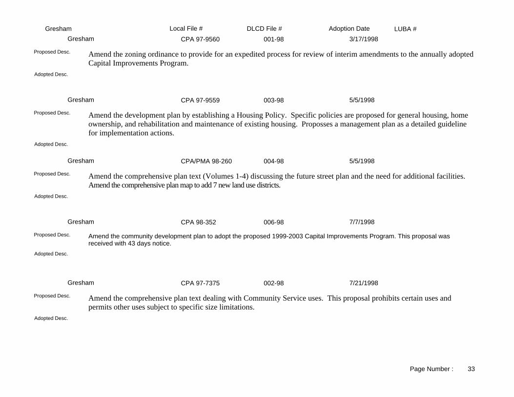
LUBA #Adoption DateLocal File # DLCD File #GreshamCPA 97-9560 001-98Gresham 3/17/1998
Adopted Desc.
Amend the zoning ordinance to provide for an expedited process for review of interim amendments to the annually adopted Capital Improvements Program.
Proposed Desc.
CPA 97-9559 003-98Gresham 5/5/1998
Adopted Desc.
Amend the development plan by establishing a Housing Policy. Specific policies are proposed for general housing, home ownership, and rehabilitation and maintenance of existing housing. Proposses a management plan as a detailed guideline for implementation actions.
Proposed Desc.
CPA/PMA 98-260 004-98Gresham 5/5/1998
Adopted Desc.
Amend the comprehensive plan text (Volumes 1-4) discussing the future street plan and the need for additional facilities. Amend the comprehensive plan map to add 7 new land use districts.
Proposed Desc.
CPA 98-352 006-98Gresham 7/7/1998
Adopted Desc.
Amend the community development plan to adopt the proposed 1999-2003 Capital Improvements Program. This proposal was received with 43 days notice.
Proposed Desc.
CPA 97-7375 002-98Gresham 7/21/1998
Adopted Desc.
Amend the comprehensive plan text dealing with Community Service uses. This proposal prohibits certain uses and permits other uses subject to specific size limitations.
Proposed Desc.
Page Number : 33

LUBA #Adoption DateLocal File # DLCD File #GreshamCPA 98-831 005-98Gresham 8/4/1998
Adopted Desc.
Amend the comprehensive plan text to allow a wider range of average lot sizes in the LDR District. This proposal was received with only 43 days notice. PER CALL TO MEG FERNEKEES (5/1998): Ordinance NOT written yet, revised hearing date will be July 21; jurisdiction will be submitting revised materials in June. (6/8/1998) Text rec'd.
Proposed Desc.
CPA 98-4887 007-98Gresham 9/1/1998
Adopted Desc.
Amend the community development plan text to revise Industrial Districts to allow the exemption of industrial uses from the transit design criteria and standards. This proposal was received with 43 days notice.
Proposed Desc.
CPA98-351/96-8682 009-98Gresham 12/1/1998
Adopted Desc.
Amend the community development plan to make various revisions generally of a "housekeeping" nature.Proposed Desc.
CPA 98-5301 010-98Gresham 12/1/1998
Adopted Desc.
Amend the community development plan to amend and adopt findings, policies, and standards regarding stormwater quantity and quality design, wetlands, floodplains and maintenance.
Proposed Desc.
CPA/FS 98-7380 011-98Gresham 12/1/1998
Adopted Desc.
Amend the community development plan to provide standards for a large ot overlay plan district for Gresham Butte. Amend the Future Street Plan to make revisions in response to a remand from LUBA (file 97-087).
Proposed Desc.
Page Number : 34

LUBA #Adoption DateLocal File # DLCD File #GreshamCPA 98-3490 008-98Gresham 12/1/1998
Adopted Desc.
Amend the community development plan to revise and adopt the Transportation Policies and Strategies. This proposal was received with 42 days notice.
Proposed Desc.
CPA/PMA 98-4536 012-98Gresham 12/29/1998
Adopted Desc.
Amend the findings, policies, and standards of the Gresham Community Development Plan text and map by adopting the Transit Corridor Plan, which will apply the city's corridor districts to residential and commercial properties along selected parcels generally within or partially within 360 feet of a city designated transit street. The transit streets are also corridors on the Region 2040 Growth Concept Map and most corridor districts allow mixed commercial and residential development. All districts set minimum and maximum residential and commercial densities consistent with the 2040 Growth Concept Corridor design type.
Proposed Desc.
CPA/SPD 98-8667 013-98Gresham 1/5/1999
Adopted Desc.
Amend the Special Purpose District map of the comprehensive plan to update Open Space designations to be consistent with the Parks and Recreation Open Space Master Plan and Trails Master Plan.
Proposed Desc.
CPA 98-10351 002-99Gresham 4/20/1999
Adopted Desc.
Amend the comprehensive plan and zoning ordinance to: 1) clarify the definition of Mixed-Use Building and Mixed-Use Development within the Gresham Civic Neighborhood Plan District; 2) permit theaters, hotels and restaurants in the Civic Neighborhood Plan District as separate uses and not subject to size limitations; 3) clarifty that minimum setbacks are to "primary" building facades along streets; and 4) allow movement of a one-block segment of street near the City Hall to provide connectivity in one of the two alignments.
Proposed Desc.
PMA 98-10566 003-99Gresham 6/1/1999
Adopted Desc.
Amend the comprehensive plan map from LDR, Low Density Residential to GC, General Commercial for .42 acres, located at Orient Drive, north of 14th Street.
Proposed Desc.
Page Number : 35

LUBA #Adoption DateLocal File # DLCD File #GreshamCPA 99-28 005-99Gresham 6/15/1999
Adopted version has minor adjustments to unding sources and funding as described in the Action Plan Summary.Adopted Desc.
Amend the Gresham Community Development Plan to add the years 2000 to 2004 Capital Improvements Program as Volume 5. This proposal was received with 43 days notice.
Proposed Desc.
CPA 99-271 007-99Gresham 11/2/1999
SameAdopted Desc.
Amend the zoning ordinance to delete, add text and add commentary for information purposes only.Proposed Desc.
CPA 99-6438 008-99Gresham 11/2/1999
Same.Adopted Desc.
Amend the community development code to change the minimum lot size from 4,000 to 5,000 square feet in the Low Density Residential District.
Proposed Desc.
AX/PMA 99-4047 006-99Gresham 11/2/1999
Same.Adopted Desc.
Amend the comprehensive plan map from County/EFU-38, County/Exclusive Farm Use-38 acres to City/LDR, City/Low Density Residential for 19.6 acres, located east of Persimmon, west of SE Hogan Road and directly north of the Clackamas County line. The property is to be annexed and the urban growth boundary changed to include the property in the city.
Proposed Desc.
CPA 99-1075 010-99Gresham 3/7/2000
The original proposed allowed for transfer of maintenance responsibility for standard accessways from public to private adjacent property owners. The adopted property owners. The adopted standards eliminated the transfer of maintenance standard.
Adopted Desc.
Amend the community develpment code to simplify construction of pedestrian and bicycle accessway standards; and allow them in right-of-ways or easements; and transfer maintenance of new and standard accessways to adjacent private property owners.
Proposed Desc.
Page Number : 36

LUBA #Adoption DateLocal File # DLCD File #GreshamCPA 99-7009 009-99Gresham 6/6/2000
Deleted requirement for 50% of units to be oriented to street. Requires instead that at least 50% of street frontage be occupied by buildings. Authorizes City to require street dedications. Amends off-street parking standards to be consistent with UGMFP Title 2 and to require visitor praking.
Adopted Desc.
Amend the community development plan, volume 3, section 7.0200 to add and delete text relating to Site Design Review Standards. This proposal was received with 42 days notice before the first evidentiary hearing.
Proposed Desc.
CPA 00-326 001-00Gresham 6/20/2000
Same.Adopted Desc.
Amend the comprehensive plan to add a Volume 5 - Capital Improvements Program to include Neighborhood Maps, Funded and Unfunded Wastewater Collection and Treatment Plant, Funded and Unfunded Water, Funded and Unfunded Transportation, Funded and Unfunded Footpaths and Bikeways, Funded and Unfunded Parks, Trails and Open Space, Funded and Unfunded Stormwater, and Local Improvement Districts.
Proposed Desc.
PMA 99-10906 002-00Gresham 7/11/2000
Same.Adopted Desc.
Amend the community development plan map from HI, Heavy Industrial to BP, Business Park; GC, General Commercial to BP, Business Park; and MC, Moderate Commercial to BP, Business Park for approximately 36.99 acres, and is bordered by NE Sandy Boulevard to the north, NE 181 st Avenue to the west, I-84/NE 181st off-ramp and pedestrian/bike path to the south, and The Boeing Company on the east.
Proposed Desc.
CPA 00-2377 004-00Gresham 8/1/2000
Adds a requirement that the home occupation must cease its operation if the permanent residents do not reside in the dwelling for more than 30 consecutive days; and adds a section regarding unsubstantiated complaints.
Adopted Desc.
Amend the comprehensive plan and the development code to change the definition, criteria and standards of home occupations; to prohibit certain business uses as home occupations: vehicle repair, vehicle sales, employee crew staging; to prohibit industrial uses including but not limited to manufacturing, fabrication, warehousing, industrial services and welding.
Proposed Desc.
PMA 00-4574 005-00Gresham 10/3/2000
Same.Adopted Desc.
Amend the comprehensive plan map from SC, Station Center to RTC, Rockwood Town Center for approximately 1.0 acre, located on the south side of SE Stark near the 194th Avenue intersection.
Proposed Desc.
Page Number : 37

LUBA #Adoption DateLocal File # DLCD File #GreshamAX/PMA 00-9242 001-01Gresham 5/1/2001
Same.Adopted Desc.
Amend the comprehensive plan map (and the zoning map) from County MUA-20, County Multiple Use Agriculture-20 acre to City LDRw/HPCD, City Low Density Residential with a Hillside Physical Constraint District Overlay (and from County EFU, County Exclusive Farm Use to City LDR, City Low Density Residential) for 5.80 acres, located at 6605 SE Hogan Road. The subject property will be annexed into the City.
Proposed Desc.
CPA 01-213 002-01Gresham 6/19/2001
Same.Adopted Desc.
Amend the comprehensive plan to adopt the proposed 2002 through 2006 Capital Improvements Program (CIP) as Volume 5 of the plan, made up of the following sections: Overview; Neighborhood Districts Map; Wastewater Collection and Treatment Plant; Unfunded Wastewater Collection and Treatment Plant; Water; Unfunded Water; Transportation; Unfunded Transportation; Footpaths and Bikeways; Unfunded Footpaths and Bikeways; Parks, Trails and Open Space; Unfunded Parks, Trails, Open Space; Stormwater; Unfunded Stormwater; and General Development. This proposal was received with 41 days notice before the first evidentiary hearing.
Proposed Desc.
CPA 01-3930 004-01Gresham 9/18/2001
Same.Adopted Desc.
Amend the comprehensive plan by adding/deleting text to update the stormwater management standards, practices, and to address groundwater infiltration and recharge.
Proposed Desc.
CPA 00-8716 007-00Gresham 10/16/2001
Addition of a new functional street classification for a "shared street". Also includes a "pedestrian accesway" that is wider than the City'smulti-use path standard and used in lieu of local street connections.
Adopted Desc.
Amend the development code Section 4.1200-Civic Neighborhood Plan District to define the Civic Neighorhood Plan District by adding a new Section 4.1247-Street Design Requirements to define lighting standards, sidewalk requirements, street trees, intersections, bikeways, on-street parking, and street classifications.
Proposed Desc.
CPA 01-1522 003-01Gresham 10/16/2001
Minor Amendments to adjust street grid.Adopted Desc.
Amend the comprehensive plan to make changes to the Civic Neighborhood Planning District located between Eastman, Division, Burnside, and Wallula Streets in the following ways: realign, refine, modify some of the streets to reflect the current use, and better support unanticipated uses on the north side of the Light Rail Corridor; boundary adjustments to the north side and south side of the Light Rail Corridor along the north-south streets primarily in the civic neighborhood, in order to continue the strong "Main Street" design element northward to Burnside Street; encourage more mixed-use office and retail users along Civic Drive.
Proposed Desc.
Page Number : 38

LUBA #Adoption DateLocal File # DLCD File #GreshamCPA 01-7527 007-01Gresham 2/19/2002
Limits "illumination" hours (not to be illuminated between 10 PM and 7 AM instead of 12AM and 7AM); limits height of a "readerboard" sign at schools to 6 foot (instead of 8 foot) above grade.
Adopted Desc.
Amend the development code Section A6.110 to add a new subsection "Readerboard sign -Schools" to allow readerboards as a type of sign, beside the free-standing signs and wall signs in school areas. This proposal was received with 24 days notice before the first evidentiary hearing.
Proposed Desc.
PMA 01-2276 006-01Gresham 4/16/2002
Same.Adopted Desc.
Amend the comprehensive plan map from TLDR, Transit-Low Density Residential to CMU, Corridor Mixed-Use, and LDR, Low Density Residential to CMU, Corridor Mixed-Use for five parcels on approximately 2.04 acres, located along the south side of Division Street across from the Gresham Station Shopping Center, and less than one quarter mile from the Gresham Station and City Hall light rail stations. This proposal was received with 42 days notice before the first evidentiary hearing.
Proposed Desc.
CPA 02-425 002-02Gresham 5/7/2002
Same.Adopted Desc.
Amend the development code in the following areas: A.5006-Subdivisions add text dealing with site grading and building permits, renumber all subsections; A5.007-Commercial, Mixed Use, Industrial, Moderate and Density Residential and Community Service Building Permits Development add subsection D to provide a means to require completion of all punch list items and payment of fees and charges, renumber sections; add section A5.008-Stop Work to give clear authority to inspectors to stop work on public facilities that are not being installed properly; add section A5.413-Utility License Required to insure that developers don't allow a non-licensed utility in a right-of-way or exclude a licensed contractor for the using the right-of-way.
Proposed Desc.
CPA 02-208 001-02Gresham 6/18/2002
Same.Adopted Desc.
Adopt the proposed 2002/03-2006/07 5-year Capital Improvement Program as Volume 5 of the comprehensive plan. The Capital Improvement program consists of fifteen sections dealing with neighborhood districts, wastewater collection and treatment, water, stormwater, transportation, footpaths, bike ways, parks, trails, open space, and general development.
Proposed Desc.
CPA 02-3098 004-02Gresham 9/3/2002
Same.Adopted Desc.
Amend community development plan Volume 2-Policies to add the appended goals, policies and action measures pertaining to economic development and industrial lands to update the City's economic status and industrial lands.
Proposed Desc.
Page Number : 39

LUBA #Adoption DateLocal File # DLCD File #GreshamCPA 02-4605 006-02Gresham 9/3/2002
Same.Adopted Desc.
Amend the Community Development Code to allow for extensions of subdivision final plat deadlines when properties are under option for acquisition for a public purpose.
Proposed Desc.
CPA 00-6319 006-00Gresham 11/19/2002
Same.Adopted Desc.
Amend the development code Volume 3 Section 4.0030 "Industrial Land Use Districts" to comply with Title 4 of the Metro Functional Plan requirements by limiting retail uses, and retail square feet in the Heavy Industrial, Light Industrial and Business Park Districts. Limiting uses and square feet will include the following: sale, lease or rent of new or used products or provide a product of repair or services to the general public; and up to a maximum of 60,000 square feet of space, for each retail business.
Proposed Desc.
CPA 01-8581 005-02Gresham 12/17/2002
Original proposal was to rescind the "rental ban" and establish the mixed use requirements in the Rockwood Town Center. The final proposal included requirements for mixed uses in certain areas of the Station Centers districts as well, and changed the land use designation in several areas of Rockwood/West Gresham.
Adopted Desc.
Amend the Community Development Code to rescind the West Gresham Rental Housing Ban; adopt standards specific to the "triangle" portion of the Rockwood Town Center; and properties in other districts which front on those major streets regarding provisions for mixed-use housing. Revised Proposal: This revision is an evaluation of possibly rezoning certain acreage in West Gresham by amending the comprehensive plan map (and the zoning map) from CC, Community Commercial to MFR, Multi-Family Residential or TDLR, Transit Low Density Residential; LI, Light Industrial to MFR, Multi-Family Residential or TDLR, Transit Low Density Residential (and from SC, Station Community to CR, Community Residential or TDLR, Transit Low Density Residential) for approximately 100.00 to150.00 acres, located in specific areas of West Gresham. This revision was received with 43 days notice before the final hearing, and the original proposal was received with 45 days notice.
Proposed Desc.
CPA 99-8396 003-03Gresham 5/20/2003
Removed development limitation on slopes over 35% (reverts to existing); added code provisions regarding Senate Bill 12 - Rapidly Moving Landslide Risk Areas; modified Hillside Special Report to more closely match DOGAMI recommendations for Geological Report submittals; Changed name reference of Planned Unit Developments (PD); adds provisions for "large lot" PDs where open space dedication is not required.
Adopted Desc.
Amend the Planned (Unit) Development and Hillside Physical Constraint District Codes to make it easier to use, provide consistency, provide better protection and maintenance requirements for steep slopes and open spaces; allows for large lot Planned Development. This proposal was originally part of Periodic Review Task No. 20 and was pulled and became a separate project.
Proposed Desc.
Page Number : 40

LUBA #Adoption DateLocal File # DLCD File #GreshamCPA/FSP 02-7635 007-02Gresham 6/3/2003
Proposed Future Street/Pedestrian paths eliminated from plan: Eigth Street from Norman to Eastman; Along Trufflehunter property north from Powell to Third Street.
Adopted Desc.
Amend the development code Volume 3 to allow "shared streets" in the Downtown Plan District. Amend the Downtown Area Future Street Plan Volume with a new proposed Future Street Plan Map.
Proposed Desc.
CPA 03-268 002-03Gresham 6/17/2003
Same.Adopted Desc.
Amend the community development code volume 5 to adopt the 2003/04 to 2007/08 annual Capital Improvements Program, for the next 5 years.
Proposed Desc.
CPA 01-384 005-01Gresham 7/29/2003
Grammatical and placement of text changes only; no substantive changes.Adopted Desc.
Amend the development code to add and delete text dealing with streets and other issues in the following areas: Volume I Findings Section 3.277 Trafficway System Wide Needs; Volume II Policy Section 10.320.1 Street System; Volume III Standards Sections 3.0010 Definitions, 6.0202 Partitions and Subdivisions-Tentative Plan Submittal, 6-0402 Final Plat-Complete Submittal, 6.0403 Partitions and Subdivisions-Final Platt, 7.0101 Dwelling Structures........., 7.0102 Community Service......., 7.0103 Manufacturing Dwelling Parks, 7.0201 Dwelling Structures........., 7.0202 Community Service, Commercial, Industrial, and Mixed Use Development, 7.0210 Transit Design Criteria and Standards, 7.0223 Maintenance Responsibility, 8.0211 Legal Nonconforming Situations, 9.0703 Submittal Requrements, 11.0401 Legislative Actions, A5.000 Public Facilities, A5.409 Street Names, and add a new Appendix 11 Street Naming and Property Numbering
Proposed Desc.
CPA/PMA 03-485 001-03Gresham 7/29/2003
Added a fifth Functional Street Classification: Civic neighborhood Community Street. Also eliminated the possible option for deletion of N.W. 16th Street - still allows for possible elimination of N.W. 18th as long as certain development requirements are met.
Adopted Desc.
Amend the comprehensive plan map from MDR-C to HDR-C for approximately 1.40 acres, located on the southwest corner of the proposed Shattuck Way and Florence Street in the Gresham Civic Neighborhood. Amend the Gresham Civic Neighborhood Plan District modifying land/use zoning requirements in the following areas: block A-6 has a lower minimum density requirement; eastern portion of block A-3 has a higher maximum density and height requirement; eliminate either 16th and 18th as long as certain development requirements are met; portion of NW Florence can be constructed as a parking lot until a full extension of the street is possible; allow for adjustments when severe topgraphical conditions make meeting the requirements impossible or prohibitive.
Proposed Desc.
Page Number : 41

LUBA #Adoption DateLocal File # DLCD File #GreshamCPA 03-3281 004-03Gresham 10/7/2003
Retain the Council as a local appeal hearing body on Type III land use applications after hearing by either the Planning Commission or Hearings officer.
Adopted Desc.
Amend the land development ordinance to revise the land use appeal process by adding and deleting text, eliminating a second local appeal on Type I and Type II Administrative decisions.
Proposed Desc.
CPA 03-3447 005-03Gresham 10/7/2003
Additional definitions (revegetation, imminent hazard tree, ornamental tree, ridgeline tree). Calendar year was changed to "a 12-month period" for detemining removal exemptions. Clarification of standards for removal of regulated trees including street trees and parking lot trees (regardless if size). Allows an exemption for cutting 3 ornamental trees per 12 months in the Hillside District.
Adopted Desc.
Amend the development code Volume 3 text to simplify the process for designation of "Significant Trees" and eliminated the need for a hearing before removal of significant trees in an emergency.
Proposed Desc.
CPA 03-5697 006-03Gresham 12/2/2003
Update street designation names for street tree location; added allowance for warranty guarantee requirement for grading/drainage; clarifies exemption for undergrounding of utilities; adds request for verification by professional biologist or person with similar qualifications for development on sites with 85% natural resource area; grammatical and text placement changes for clarity and consistency.
Adopted Desc.
Amend the development code to revise sections dealing with easements, plan checks and inspections, guarantee of completion, undergrounding, street trees, stormwater, and other miscellaneous changes for consistency and permits.
Proposed Desc.
CPA 04-761 001-04Gresham 6/15/2004
See file for numerous changes.Adopted Desc.
Amend the Capital Improvement Plan to update the plan for the next five years (funding years 2004/5 - 2008/09) in the following areas: Transportation projects including bikeways and pedways; Public Facilities such as Water, Stormwater, and Wastewater; Parks, Trails, and Open Spaces. This proposal was received with 41 days notice before the first evidentiary hearing.
Proposed Desc.
CPA 03-742 002-04Gresham 9/7/2004
Same.Adopted Desc.
Update the comprehensive plan to adopt a new background information, goals, and action measures relating to Statewide Planning Goals 1-Citizen Involvement, 2-Land Use Planning, and 5-Historic Resources.
Proposed Desc.
Page Number : 42

LUBA #Adoption DateLocal File # DLCD File #PortlandNA 008-90Portland
Adopted Desc.
Amend the zoning ordinance to rewrite Title 33, Planning and Zoning Code. Convert existing commercial and industrial zones. Amend the comprehensive plan relative to other city titles, design guidelines and community plans. Amend the comprhensive plan and zoning ordinance to revise the sections pertaining to neighborhood plan and subdivision and partitions. NOTE: This is a revised proposal.
Proposed Desc.
Ord.#159287 005-87APortland 12/24/1986
Adopted Desc.
Amend the zoning ordinance to clarify bicycle rack design regulations.Proposed Desc.
7701-PA 002-87APortland 2/17/1987
Adopted Desc.
Amend the comprehensive plan and zoning from Medium- Density Multifamily Residential (R-1) to General Commercial (C2) for approximately 1.9 acre located at 2006 S.E. Ankeny. The proposed amendment would permit expansion of an adjacent engineering office.
Proposed Desc.
7700-PA 001-87APortland 2/19/1987
Adopted Desc.
Amend the comprehensive plan and zoning from Medium- Density Multifamily Residential (R-5) to General Commercial with a Buffer overlay zone (C2B) for approx. 3500 square feet located at 3622 S.E. 38th. The proposed amendment would allow combination of the parcel with adjacent parcels for the purpose of developing a 39,500 square foot retail center site.
Proposed Desc.
7704-PA 004-87APortland 2/20/1987
Adopted Desc.
Amend the comprehensive plan from Attached Single-Family Residential to Commercial and zoning from R5 to C2/C2B for approximately 5,000 square feet located on the east side of S.E. 47th Avenue between S.E. Woodstock and S.E. Martin. The purpose of the proposed amendment is to permit expansion of parking facilities for an adjacent bank.
Proposed Desc.
Page Number : 1

LUBA #Adoption DateLocal File # DLCD File #Portland7702-PA 003-87APortland 3/25/1987
Adopted Desc.
Amend the comprehensive plan and zoning from Business and Professional Offices (BPO) to General Commercial (C2) for approximately 0.5 acre located at 9745 and 9795 S.E. Division Street. The purpose of the proposal is to allow the construction of a convenience store and gas station.
Proposed Desc.
N/A 008-87APortland 4/8/1987
CREATES A NEW COLUMBIA SOUTHSHORE INDUSTRIAL ZONE AND APPLIES IT TO 2800 ACRES FORMERLY ZONED WITH MULTNOMAH CO. ZONES. ALSO ESTABLISHES A FLOOR AREA RATIO IN THE GE-2 ZONE DEFINES TOP OF BANK, AND APPLIES INTERIM ENVIRO. PROTECTIONS
Adopted Desc.
See <PA>PA.TRACKSHEETS.3 for more informationProposed Desc.
7715PA/7716R 011-87APortland 4/8/1987
Adopted Desc.
Amend the comprehensive plan and zoning from Multnomah County's Neighborhood Commercial (NC) to the City of Portland's General Commercial (C2) for approximately 3.5 acres located on S.E. Stark between 119th and 122nd Avenues. The applicant is also requesting issuance of a revocable permit to allow the sale of used automobiles on the site.
Proposed Desc.
7717-PA 012-87APortland 4/23/1987
Adopted Desc.
Amend the comprehensive plan and zoning from High- Density Single-Family Residential (RS) to Light Manufacturing (M3) for approximately 29,000 square feet located at North Columbia Blvd., between Portsmouth and Exeter.
Proposed Desc.
7726-PA 014-87APortland 6/4/1987
Adopted Desc.
Amend the comprehensive plan and zoning from R1 (Medium- Density Multifamily Residential) to C2 (General Commercial) for approximately 0.4 acre located at 3333 North Lombard. The applicants propose expansion of an adjacent existing bank and the addition of a new parking area on the site proposed for redesignation.
Proposed Desc.
Page Number : 2

LUBA #Adoption DateLocal File # DLCD File #PortlandN/A 015-87APortland 6/18/1987
AMEND THE ZONING ORDINANCE TO ALLOW APPLICATION OF THE LIMITED COMMERCIAL (C5) ZONETO AREAS PREVIOUSLY ZONED BUSINESS AND PROFESSIONAL OFFICE BY MULTNOMAH COUNTY.
Adopted Desc.
Amend the zoning ordinance to allow application of C5 (Limited Commercial) zone on lands previously zones BPO (Business and Professional Office) by Multnomah County.
Proposed Desc.
7711-PA 013-87APortland 6/24/1987
Adopted Desc.
Amend the comprehensive plan and zoning from R5 to M3B for approximately 2.3 acres located at 1220 S.E. 82nd Avenue.The proposed site development is a self-storage center.
Proposed Desc.
Kerns Plan 018-87APortland 6/24/1987
ADOPTION OF SULLIVAN GULCH NEIGHBORHOOD PLANAdopted Desc.
Adopt the Kearns Neighborhood Action Plan as provided in the Coprehensive Plan. The proposal includes goals, policies and objectives intended to promote positive land use patterns, urban design standards, circulation and service provision.
Proposed Desc.
N/A 020-87APortland 7/16/1987
Adopted Desc.
Adopt the Sullivan Gulch Neighborhood Plan as provided in the Comprehensive Plan. The proposal includes goals, policies and objectives intended to promote positive land use patterns, urban design standards, circulation and service provision.
Proposed Desc.
N/A 020-87APortland 7/16/1987
ADOPTION OF KERNS NEIGHBORHOOD PLANAdopted Desc.
Adopt the Sullivan Gulch Neighborhood Plan as provided in the Comprehensive Plan. The proposal includes goals, policies and objectives intended to promote positive land use patterns, urban design standards, circulation and service provision.
Proposed Desc.
Page Number : 3

LUBA #Adoption DateLocal File # DLCD File #Portland7737-PA 022-87APortland 7/22/1987
Adopted Desc.
Amend the comprehensive plan from Multifamily Residential to General Commercial and zoning from R1D to C2D for approx. 0.1 acre located at 2800 S.W. Sam Jackson Park Road.
Proposed Desc.
7739-PA 023-87BPortland 7/22/1987
Adopted Desc.
Amend the comprehensive plan from Single-Family Residential to Neighborhood Commercial and zoning from R5 to C4 for approximately 0.1 acre located at 410 N.E. 28th Avenue.
Proposed Desc.
Solar Amend. 024-87BPortland 8/20/1987
MODIFY APPLICATION OF SOLAR ACCESS REGULATIONS IN CERTAIN SITUATION OF STEEP SLOPE OR NEXT TO UNDEVELOPABLE AREAS
Adopted Desc.
Amend the comprehensive plan and zoning ordinance to modify solar access regulations.Proposed Desc.
7719 AL 021-87APortland 8/26/1987
CULLY STUDY AREA (1,670.0 ACRES) TO RECEIVE COMPARABLE OR EQUIVALENT CITY OF PORTLAND BASE ZONES AND DESIGNATIONS.
Adopted Desc.
Amend the comprehensive plan and zoning in the Cully Study Area (1,670.0 acres) to receive comparable or equivalent Cityof Portland base zones and designations.
Proposed Desc.
7754-PA 027-87BPortland 9/9/1987
Adopted Desc.
Amend the plan and zone designations from Open Space (OS) and Farm and Forest (FF) to Low Density Single Family (R10) for 0.7 acre located at NW Maybrook near Germantown Road.
Proposed Desc.
Page Number : 4

LUBA #Adoption DateLocal File # DLCD File #PortlandTransit Zone 026-87BPortland 9/17/1987
ADOPT T, TRANSIT OVERLAY ZONE TO REPLACE MULTNOMAH COUNTY'S EIGHT TRANSIT ZONESAdopted Desc.
Adopt the T, Transit Overlay Zone to replace Multnomah County's eight transit zones.Proposed Desc.
7760-PA 030-87Portland 9/23/1987
Adopted Desc.
Amend the comprehensive plan and zoning from Multifamily Residential, Landing Aircraft Overlay (R1L) to General Commercial, Landing Aircraft Overlay (C2L) for 0.3 acre located at 7421 NE Beech Street.
Proposed Desc.
7728-PA 016-87APortland 10/14/1987
Adopted Desc.
Amend the comprehensive plan and zoning from High-Density, Single-Family Residential (R-5) to Local Commercial (C-3)for approximately 0.4 acre located at 6714 S.E. Division. The applicant proposes new construction and remodeling of an existing convenience store and gas station on the site.
Proposed Desc.
7689AL 031-87BPortland 10/22/1987
Adopted Desc.
Adopt the Portland Wilkes Community and Rockwood Corridor Plan; apply Portland zones and comprehensive plan map designations to annexed properties within the Glendoveer/ Wilkes/Rockwood Study area; and extend the Glendoveer Plan District boundary to include annexed properties within the study for approximately 920 acres located in mid-Multnomah County.
Proposed Desc.
7764-PA 033-87BPortland 11/5/1987
Adopted Desc.
Amend the comprehensive plan and zoning from Medium-Density Single-Family Residential (R7) to General Industrial (GI-1) and from General Manufacturing (M2) to General Industrial (GI-1) for approximately 1.6 acres located at 4401 S.E. Johnson Creek Blvd.
Proposed Desc.
Page Number : 5

LUBA #Adoption DateLocal File # DLCD File #PortlandW. Greenway 025-87BPortland 11/5/1987
AMEND WILLAMETTE RIVER GREENWAY REGULATIONS, MAPS AND DESIGN GUIDELINES.Adopted Desc.
Amend the Willamette River Greenway Plan and Land Use Regulations for all areas within the city of Portland. The proposal includes new inventories, boundary revisions, new design guidelines, revised policies and new administrative provisions.
Proposed Desc.
N/A 032-87BPortland 12/10/1987
APPLIES PUD REVIEWS TO INDUSTRIAL DEVELOPMENT.Adopted Desc.
Amend the zoning ordinance to create greater procedural flexibility for the development of industrial parks.Proposed Desc.
7779-PA 036-87BPortland 1/13/1988
Adopted Desc.
Amend the comprehensive plan and zoning from Medium Density Multifamily (R1) to General Commercial (C2) for approxi. 0.1 acre located at 3001-3007 and 3011-3017 S.E. Belmont.
Proposed Desc.
NA 041-88Portland 1/28/1988
Adopted Desc.
Amend the comprehensive plan and zoning ordinance by removing Multnomah County zones and adopting city plan map designations and zones for approximately 200 acres of annexed properties in West Powellhurst, Leach Botanical Garden, Barbara Welch Lane, SE 174th and Powell areas, and ten sites in the Hazelwood Community area.
Proposed Desc.
N/A 040-87BPortland 2/10/1988
ADOPTION OF HOSFORD-ABERNETHY NEIGHBORHOOD ACTION PLANAdopted Desc.
Adoption of the Hosford-Abernethy Neighborhood Action Plan.Proposed Desc.
Page Number : 6

LUBA #Adoption DateLocal File # DLCD File #Portland7770-PA 035-87BPortland 2/10/1988
ALLOW AN EXISTING BUILDING WITH MECHANICAL EQUIPMENT ON THE ROOF TO EXCEED 15 FEET IN HEIGHT IN THE C3, LOCAL COMMERCIAL ZONE.
Adopted Desc.
Amend the comprehensive plan and zoning to allow an existing building with mechanical equipment on the roof to exceed 15 feet in height in the C3, Local Commercial zone.
Proposed Desc.
7790-PA 039-87BPortland 2/10/1988
Adopted Desc.
Amend the comprehensive plan and zoning from MI (Heavy Industrial) to HI (Heavy Industrial) for approximately 6.8 acres located at 5407 N. Marine Drive.
Proposed Desc.
33.815 038-87BPortland 2/18/1988
REGULATION OF HELICOPTER LANDING FACILITIES.Adopted Desc.
Amend the zoning code to establish regulations for helicopter landing facilities.Proposed Desc.
N/A 001-88APortland 2/25/1988
Adopted Desc.
Revise requirements for review and approval of convenience stores.Proposed Desc.
N/A 001-88Portland 2/25/1988
AMEND THE CONVENIENCE STORE REVIEW PROCESS IN THE FORM OF REFINEMENTS TO THE EXISTING PROCESS AND WERE INITIATED BY THE CONVENIENCE STORE ADVISORY COMMITTEE ANDTHE SOUTHEAST UPLIFT CONVENIENCE STORE TASK FORCE.
Adopted Desc.
Revise requirements for review and approval of convenience stores.Proposed Desc.
Page Number : 7

LUBA #Adoption DateLocal File # DLCD File #Portland7771-PA/CU 034-87BPortland 3/1/1988
CHANGE THE PLAN AND ZONE MAP AND TAKE AN EXCEPTION TO THE GREENWAY GOAL TO ALLOW A NON-RIVER RELATED USE WITHIN THE 25 FOOT SETBACK.
Adopted Desc.
Amend the comprehensive plan and zoning: 1) from WSR (Willamette Scenic Recreational) to WSD (Willamette Scenic Development); 2) remove OS (Open Space) designation between SE Salmon Street and Burnside Bridge; and 3) allow conditional use permits for fills greater than 1,000 cubic yards between Hawthorne and Morrison Bridges, north of the Morrison Bridge, and south of the Burnside Bridge.
Proposed Desc.
7796-PA 003-88APortland 3/2/1988
Adopted Desc.
Amend the comprehensive plan and zoning from R1, Medium Density Multifamily Residential to C5, Limited Commercial for approximately 0.8 acre located at 1650 N.E. Lombard.
Proposed Desc.
7797-PA 005-88Portland 3/2/1988
Adopted Desc.
Amend the comprehensive plan from Open Space to Single Family Residential (Medium Density) for approximately 2.27 acres located on the east side of S.W. Boones Ferry Road, south of the intersection with Taylors Ferry Road.
Proposed Desc.
7658AL 004-88APortland 3/3/1988
HAZELWOOD COMMUNITY PLAN - 2400 ACRESAdopted Desc.
Amend the comprehensive plan to establish zoning conversion policies for a 2400 acre portion of Hazelwood Community located south of N.E. Halsey, east of I-205, down to Division, east to 122nd. The zoning conversion study establishes zoning to be applied when the area is annexed to Portland.
Proposed Desc.
33.205 037-87BPortland 3/19/1988
ESTABLISHES A PROCESS FOR REVOCATION OF CONDITIONAL USE AND REVOCABLE PERMITS.Adopted Desc.
Amend the land development code to establish a process to revoke conditional use permits and authorize the planning director to initiate revocations.
Proposed Desc.
Page Number : 8

LUBA #Adoption DateLocal File # DLCD File #PortlandCentral City 042-87BPortland 3/24/1988
ADOPTION OF THE CENTRAL CITY PLANAdopted Desc.
Amend the comprehensive plan and zoning ordinance to adopt the Central City Plan.Proposed Desc.
7802-PA 007-88Portland 4/5/1988
SUBAREA MASTER PLAN SUBMITTAL FOR THE AREA SOUTH OF EASTPORT PLAZA AND A SIGN ADJUSTMENT.
Adopted Desc.
Modify condition of approval for previous plan amendment and zoning change.Proposed Desc.
PC7773 010-88Portland 4/6/1988
ADOPT PORTLAND ZONE AND PLAN MAP DESIGNATIONS FOR SIX CLUSTERS OF ANNEXED PROPERTIES IN WEST PORTLAND, APPROX. 216 ACRES.
Adopted Desc.
Reaffirmation of Plan requirements which apply to annexed areas in the Northwest Hills areas of the city. Application of Portland Plan and zone designations to recently annexed parcels in the Northwest Hills area.
Proposed Desc.
Metro Solar 011-88Portland 4/7/1988
AMEND SOLAR REGULATIONS.Adopted Desc.
Amend the zoning ordinance for solar regulations to: 1) adjust the shade standard uses from 24-foot to 30-foot height allowance; 2) simplify tables so solar slope does not have to calculated separately; 3) incorporate exemptions modification and adjustment to allow flexibility on unusual lots; and 4) provide specific protection for existing active and passive solar features.
Proposed Desc.
N/A 002-88APortland 4/20/1988
AMEND BUILDING ORIENTATION REQUIREMENTS TO REMOVE THEM FROM STATE HIGHWAYS AND TRUCK ROUTES.
Adopted Desc.
Amend the building orientation provisions. The revised requirements do not apply to truck routes and state highways. The proposal adds limitations on blank walls, access issues, sidewalk links and landscaping.
Proposed Desc.
Page Number : 9
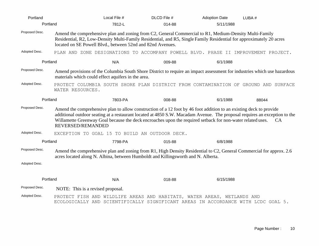
LUBA #Adoption DateLocal File # DLCD File #Portland7812-L 014-88Portland 5/11/1988
PLAN AND ZONE DESIGNATIONS TO ACCOMPANY POWELL BLVD. PHASE II IMPROVEMENT PROJECT.Adopted Desc.
Amend the comprehensive plan and zoning from C2, General Commercial to R1, Medium-Density Multi-Family Residential, R2, Low-Density Multi-Family Residential, and R5, Single Family Residential for approximately 20 acres located on SE Powell Blvd., between 52nd and 82nd Avenues.
Proposed Desc.
N/A 009-88Portland 6/1/1988
PROTECT COLUMBIA SOUTH SHORE PLAN DISTRICT FROM CONTAMINATION OF GROUND AND SURFACEWATER RESOURCES.
Adopted Desc.
Amend provisions of the Columbia South Shore District to require an impact assessment for industries which use hazardous materials which could effect aquifers in the area.
Proposed Desc.
7803-PA 008-88Portland 6/1/1988
EXCEPTION TO GOAL 15 TO BUILD AN OUTDOOR DECK.Adopted Desc.
Amend the comprehensive plan to allow construction of a 12 foot by 46 foot addition to an existing deck to provide additional outdoor seating at a restaurant located at 4850 S.W. Macadam Avenue. The proposal requires an exception to the Willamette Greenway Goal because the deck encroaches upon the required setback for non-water related uses. CA REVERSED/REMANDED
Proposed Desc.
88044
7798-PA 015-88Portland 6/8/1988
Adopted Desc.
Amend the comprehensive plan and zoning from R1, High Density Residential to C2, General Commercial for approx. 2.6 acres located along N. Albina, between Humboldt and Killingsworth and N. Alberta.
Proposed Desc.
N/A 018-88Portland 6/15/1988
PROTECT FISH AND WILDLIFE AREAS AND HABITATS, WATER AREAS, WETLANDS AND ECOLOGICALLY AND SCIENTIFICALLY SIGNIFICANT AREAS IN ACCORDANCE WITH LCDC GOAL 5.
Adopted Desc.
NOTE: This is a revised proposal.Proposed Desc.
Page Number : 10

LUBA #Adoption DateLocal File # DLCD File #PortlandPC7774 021-88Portland 6/22/1988
ADD ANNEXED PROPERTIES AND CHANGE LIGHT RAIL STATION BOUNDARIES.Adopted Desc.
Amend the comprehensive plan and zoning from County to City designations for 12 annexed properties of approximately 200 acres located between NE 92nd and NE 154th, between NE Sacramento to SE Division.
Proposed Desc.
N/A 023-88Portland 6/22/1988
ADOPTION OF PORTLAND/MULTNOMAH COUNTY COMP. PLAN MAP DESIGNATION & ZONE CONVERSION CHART.
Adopted Desc.
Adopt a Portland/Multnomah County Zone Conversion Chart for 34 annexed properties with the Portland Urban Service Boundary.
Proposed Desc.
N/A 012-88Portland 6/29/1988
UPDATE TO THE 1980 ECONOMIC DEVELOPMENT POLICY INCORPORATED INTO THE COMPREHENSIVE PLAN ECONOMIC DEVELOPMENT ELEMENT GOAL AND POLICIES.
Adopted Desc.
NOTE: This is a revised proposal.Proposed Desc.
S Auditorium 027-88Portland 7/5/1988
ADOPTION OF SOUTH AUDITORIUM PLAN DISTRICT.Adopted Desc.
Adopt the South Auditorium Plan District to apply zoning standards to base zone regulations in the area of setbacks, landscaping, sign regulations and rooftop treatment.
Proposed Desc.
7842-PA 025-88Portland 7/13/1988
Adopted Desc.
Amend the comprehensive plan from R5 (High Density Single Family Residential) to M2 (General Manufacturing) and zoning from R10 (Medium Density Single Family) to M2 (General Manufacturing) for 2 acres located at SE 83rd and Lambert.
Proposed Desc.
Page Number : 11

LUBA #Adoption DateLocal File # DLCD File #Portland7836-PA 020-88Portland 7/13/1988
Adopted Desc.
Amend the comprehensive plan and zoning from High Density Single-Family Residential (R5) to Neighborhood Commercial (C4) for approximately 0.1 acre located at 3054 N.E. Glisan Street.
Proposed Desc.
7843-PA 022-88Portland 7/13/1988
Adopted Desc.
Amend the comprehensive plan and zoning from R1, Multifamily Residential to M3, Light Manufacturing for approximately 1 acre located on the south side of N Argyle, east of N Fenwick.
Proposed Desc.
7849-PA 028-88Portland 7/27/1988
Adopted Desc.
SEE PA.TRACKSHEET FOR MORE INFORMATIONProposed Desc.
PC 7852-L 029-88Portland 8/3/1988
Adopted Desc.
Amend the comprehensive plan from Single Family to Limited Commercial and zoning from R7SR to C5SR for 1.27 acres located 11905, 11919, 11765, 11781, 11807, and 11821 North East Glisan Street.
Proposed Desc.
7861-PA 033-88Portland 10/19/1988
Adopted Desc.
Amend the comprehensive plan and zoning from R-5 (High- Density Single-Family) to C-2 (General Commercial) for 1.6 acres located between SE 84th and 87th, north and south SE of Cora.
Proposed Desc.
Page Number : 12

LUBA #Adoption DateLocal File # DLCD File #PortlandNA 034-88Portland 10/22/1988
REVISE RESIDENTIAL ZONES TO REDUCE VARIANCE REQUESTS; REVISE PROCEDURES TO REDUCE WORK LOAD; CONSOL. LAND USE REVIEW; AMEND SCHEDULE FEES.
Adopted Desc.
Amend the comprehensive plan to repeal the requirement for an annual report. Amend the zoning ordinance to: revise residential zones to reduce variance requests; revise procedures to reduce work load; consolidate land use reviews; revise responsibility for perparing findings; and amend the fee schedule.
Proposed Desc.
7866-PA 036-88Portland 10/26/1988
Adopted Desc.
Amend the comprehensive plan and zoning from MR-4 (Urban Medium-Density Residential) to C-2 (General Commercial) for 1.05 acres located at 9026 SE Division.
Proposed Desc.
NA 038-88Portland 11/23/1988
AMEND SUBDIVISION AND PARTITIONING TITLE TO ADOPT METRO SOLAR MODEL ORDINANCE. PROVIDES FOR SOLAR ORIENTATION IN NEW RESIDENTIAL SUBDIVISIONS.
Adopted Desc.
Amend the zoning orinance to replace existing solar provisions with the Metro Solar Project Model ordinance.Proposed Desc.
7856-PA 032-88Portland 11/23/1988
Adopted Desc.
Amend the comprehensive plan and zoning from R1 (High-Density Residential) to C2 (General Commercial) for .01 acre located 3032 SE Belmont.
Proposed Desc.
7856-PA 032-88Portland 11/30/1988
Adopted Desc.
Amend the comprehensive plan and zoning from R1 (High-Density Residential) to C2 (General Commercial) for .01 acre located 3032 SE Belmont.
Proposed Desc.
Page Number : 13

LUBA #Adoption DateLocal File # DLCD File #PortlandNA 041-88Portland 12/21/1988
REMOVE MULTNOMAH COUNTY ZONES AND ADOPT CITY PLAN MAP DESIGNATIONS AND ZONES FOR APPROXIMATELY 200 ACRES.
Adopted Desc.
Amend the comprehensive plan and zoning ordinance by removing Multnomah County zones and adopting city plan map designations and zones for approximately 200 acres of annexed properties in West Powellhurst, Leach Botanical Garden, Barbara Welch Lane, SE 174th and Powell areas, and ten sites in the Hazelwood Community area.
Proposed Desc.
7862-PA 035-88Portland 1/4/1989
Adopted Desc.
Amend the comprehensive plan and zoning from RH (High- Density Residential) to M3 (Light Manufacturing) for approximately 1.5 acres located at N. Russell on the North; N. Vancouver on the East; N. Page on the South; N. Flint on the West.
Proposed Desc.
NA 002-89Portland 2/22/1989
Adopted Desc.
Amend the zoning ordinance to: 1) change solid waste transfer stations to a conditional use in Industrial and Employment zones; 2) prohibit "For Fee Parking" and require additional screening for exterior storage in the Columbia South Shore Plan District; and 3) amend landscaping requirements for parking lots.
Proposed Desc.
NA 001-89Portland 3/9/1989
ESTABLISH ALTERNATIVE (EXCEPTION PROCESS) FOR STEP DOWN OF BUILDING HEIGHT ADJACENTOT HISTORIC DISTRICTS.
Adopted Desc.
Amend the zoning ordinance to establish alternative (exception process) for step down of building heights adjacent to historic districts.
Proposed Desc.
7770-PA 035-87BPortland 3/13/1989
ALLOW MECHANICAL EQUIPMENT ON THE ROOF TO EXCEED 15 FEET IN HEIGHT IN THE LOCAL COMMERCIAL ZONE.
Adopted Desc.
Amend the comprehensive plan and zoning to allow an existing building with mechanical equipment on the roof to exceed 15 feet in height in the C3, Local Commercial zone.
Proposed Desc.
Page Number : 14

LUBA #Adoption DateLocal File # DLCD File #PortlandNA 002-89Portland 4/6/1989
CHANGE STATUS OF SOLID WASTE TRANSFER STATIONS FROM PERMITTED TO CONDITIONAL USES IN INDUSTRIAL & EMPLOYMENT ZONES; AMEND COLUMBIA SOUTH SHORE PLAN DISTRICT TO PROHBIT FOR FEE PARKING & ADDITIONAL SCREENING FOR EXTERIOR STORAGE.
Adopted Desc.
Amend the zoning ordinance to: 1) change solid waste transfer stations to a conditional use in Industrial and Employment zones; 2) prohibit "For Fee Parking" and require additional screening for exterior storage in the Columbia South Shore Plan District; and 3) amend landscaping requirements for parking lots.
Proposed Desc.
CU 15-7913PA 009-89Portland 4/13/1989
(OS)FF (FARM AND FOREST) TO SINGLE FAMILY RES. AND SINGLE FAM. RES. TO (OS)FF (FARM AND FOREST).
Adopted Desc.
Amend the comprehensive plan and zoning from R7 and R10 (One Family Residential) to (OS)FF (Farm and Forest) for 6.74 acres; and from (OS)FF (Farm and Forest) to R10 (One Family Residential) for 9.04 acres located at SE 162nd and Powell Blvd (Powell Butte).
Proposed Desc.
NA 013-89Portland 4/27/1989
C-2TSR (GENERAL COMMERCIAL) W/TRANSIT OVERLAY TO C2SR (GENERAL COMMERCIAL W/SITE REVIEW. FROM R5 (SINGLE FAMILY RESIDENTIAL) AND OS (OPEN SPACE) TO R5 (SINGLE FAMILY RES).
Adopted Desc.
NOTE: Please see PA. LONG TRACKING SHEET.Proposed Desc.
NA 003-89Portland 5/4/1989
APPLY INDUSTRIAL ZONES AND THE ENVIRONMENTAL CONCERN (EC) OVERLAY ZONE TO APPROXIMATELY 14,300 ACRES LOCATED WITHIN THE COLUMBIA RIVER CORRIDOR IN PORTLAND.
Adopted Desc.
Amend the comprehensive plan to apply industrial zones and the environmental concern (EC) overlay zone to approximately 14,300 acres located within the Columbia River Coridor in Portland.
Proposed Desc.
7885-PA 043-88Portland 5/17/1989
Adopted Desc.
Amend the comprehensive plan and zoning from R2 (Multi- Family Residential) and R2.5 (Single Family Residential) to C5 (Limited Commercial) and C2 (General Commercial) for .92 acre located on the northeast corner of SE 76th and Division.
Proposed Desc.
Page Number : 15

LUBA #Adoption DateLocal File # DLCD File #PortlandNA 011-89Portland 5/20/1989
CLARIFY FLOOR AREAS RATIOS IN THE RH (HIGH DEN. MULTI-FAM. RES.) ZONE FOR ANNEXED AREAS AND SIMPLIFY MAP OF ALLOWED FARS FOR THE ENTIRE CITY.
Adopted Desc.
Amend the zoning ordinance to clarify floor area ratios (FARS) in the RH (High Density Multi-Family Residential) zone for annexed areas and simplify maps of allowed FARS for the entire city.
Proposed Desc.
7922, 7921 017-89Portland 6/21/1989
CX (CENTRAL COMMERCIAL) TO RX (CENTRAL MULTIFAMILY RES.)Adopted Desc.
Amend the comprehesive plan from Central Commercial to Central Residential and zoning from CX (Central Commercial) to RX (Central Multifamily Residential) for 0.83 acre located at 1239 NE Union.
Proposed Desc.
7921-PA 018-89Portland 6/23/1989
RHS (HIGH DENSITY MULTIFAMILY RESIDENTIAL W/SIGNBOARD CONTROL OVERLAY) TO CXDS (CENTRAL COMMERCIAL W/DESIGN REVIEW OVERLAY)
Adopted Desc.
Amend the comprehensive plan from High-Density Multi-Family Residential to Central Commercial and zoning from RHS (High-Density Multifamily Residential with a Signboard Control Overlay) to CXDS (Central Commercial with a Design Review Overlay) for 3.8 acres located at NE 16th and Multnomah Blvd.
Proposed Desc.
7901-PA 006-89Portland 6/28/1989
Adopted Desc.
Amend the comprehensive plan and zoning from MR-4 (Urban Medium Density Residential) to C-2 (General Commercial) for 0.23 acre located at 8844 SE Division Street.
Proposed Desc.
7910-PA 008-89Portland 7/19/1989
ALLOW CHIROPRACTIC AND MEDICAL OFFICES IN THE C2 (GENERAL COMMERCIAL) ZONE.Adopted Desc.
Amend the comprehensive plan and zoning ordiance to allow chiropractic and medical offices in the C2 (General Commercial) zone.
Proposed Desc.
Page Number : 16

LUBA #Adoption DateLocal File # DLCD File #PortlandGP 18-88 037-88Portland 7/26/1989
DEVELOPMENT OF HISTORIC BUILDING. ALLOW NON-WATER DEPENDENT USE. EXCEPTION TO GOAL 15.
Adopted Desc.
Amend the comprehensive plan to allow development of the Albers Mill site (an existing historic building) located 3.18 acres at 1118 Front. The proposal includes an exception to Goal 15 to allow non-water dependent uses in the renovated structure.
Proposed Desc.
7925-PA 020-89Portland 8/10/1989
HIGH DENSITY SINGLE FAM. RES. TO GENERAL INDUSTRIAL.Adopted Desc.
Amend the comprehensive plan from OS (Open Space) to GI2 (General Industrial) and zoning from R5 (High Density Single Family Residential) to GI2 (General Industrial) for 0.16 acre located at 6936 North Fathom.
Proposed Desc.
7936-PA 023-89Portland 9/5/1989
R-7 (MEDIUM DENSITY SINGLE FAMILY RESIDENTIAL) TO C-2 (GENERAL COMMERCIAL W/BUFFER OVERLAY).
Adopted Desc.
Amend the comprehensive plan from Medium Density Single Family Residential to General Commercial and zoning from R-7 (Medium Density Single Family Residential) to C-2 (General Commercial with a Buffer Overlay zone) for 1/3 acre located on the north side of SE Barbur Boulevard at the 7500 block.
Proposed Desc.
7944-PA 025-89Portland 11/15/1989
Adopted Desc.
Amend the comprehensive plan and zoning ordinance from R-1 (Medium Density-Multifamily Residential) to C-2 (GeneralCommercial) for 0.15 acres located at 2338 North Lombard.
Proposed Desc.
7904-PA 005-89Portland 11/21/1989
Adopted Desc.
Amend the comprehensive plan and zoning from R5 (High- Density Single-Family Residential) to R1 (Medium-Density Multi-Family Residential) for 0.30 acre located, at, SW Gaines Street, northest of 14th Avenue.
Proposed Desc.
Page Number : 17

LUBA #Adoption DateLocal File # DLCD File #Portland7940-PA 022-89Portland 12/5/1989
MED. DENSITY MULTI-FAM. RES. TO M-3 (LIGHT MANUFACTURING).Adopted Desc.
Amend the comprehensive plan and zoning from R-1 (Medium Density Multi-Family Residential) to M-3 (Light Manufacturing) for 0.12 acre located at 7238 Foster Road.
Proposed Desc.
Title 34 024-89Portland 12/13/1989
MINOR PARTITIONS AND MINOR SUBDIVISIONS.Adopted Desc.
Amend the zoning ordinance to establish clear and objective standards for approval of minor partitions and minor subdivisions.
Proposed Desc.
7049-PA 027-89Portland 1/10/1990
Adopted Desc.
Amend the comprehensive plan and zoning from R5 (High Density Single Family Residential) to R-2 (Low Density Multi Family Residential) for 0.5 acre located on Southwest 19th Avenue at Spring Garden Street. This proposal includes an exception.
Proposed Desc.
7956 PA 029-89Portland 1/24/1990
Adopted Desc.
Amend the comprehensive plan and zoning from R2S (Low Density Multifamily) and RHS (High Density Multifamily Residential) to C2 (General Commercial) for approximately 1.4 acres located on SW Hood between SW Gains and SW Curry.
Proposed Desc.
7955-PA 030-89Portland 1/24/1990
Adopted Desc.
Amend the comprehensive plan from OS (Open Space) to RH (High Density Multifamily Residential) for 4 acres located at 1600 SW Salmon Street.
Proposed Desc.
Page Number : 18

LUBA #Adoption DateLocal File # DLCD File #Portland7938-PA 021-89Portland 2/15/1990
Adopted Desc.
Amend the comprehensive plan and zoning from R-1 (Medium Density Multi-Family Residential) to C-2 (General Commercial) for 1.95 acres located on North Montana between North Kaiser and North Cook.
Proposed Desc.
NA 001-90Portland 3/8/1990
Adopted Desc.
Amend the comprehensive and zoning ordinance to create the Balch Creek Watershed Protection Plan in accordance with Goal 5.
Proposed Desc.
7971-PA 006-90Portland 4/11/1990
Adopted Desc.
Amend the comprehensive plan and zoning from R-7 (Medium Density Single Family Residential) to R-3 (Medium DensityResidential) for approximately 1 acre located at SW Vermont, west of 45th.
Proposed Desc.
NA 004-90Portland 4/18/1990
AMEND THE PLAN TO REPLACE THE ENERGY CONSERVATION POLICY WITH A NEW ENERGY POLICY.Adopted Desc.
Amend the comprehensive plan to replace the Energy Conservation Policy with a new Energy Policy.Proposed Desc.
NA 005-90Portland 4/18/1990
ADOPT THE EAST COLUMBIA NEIGHBORHOOD NATURAL RESOURCES MANAGEMENT PLAN TO IDENTIFY AND PROTECT WETLANDS AND OTHER NATURAL RESOURCES.
Adopted Desc.
Amend the zoning ordinance to adopt the East Columbia Neighborhood Natural Resources Management Plan to identify and protect wetlands and other natural resources.
Proposed Desc.
Page Number : 19

LUBA #Adoption DateLocal File # DLCD File #Portland7966-PA 007-90Portland 4/18/1990
Adopted Desc.
Amend the comprehensive plan and zoning from GI-1 (General Industrial) to M3 (Light Manufacturing) for 1/4 acre located at 2235 NW Savier.
Proposed Desc.
7889 L 042-88Portland 4/27/1990
OPEN SPACE TO HIGH DENSITY SINGLE FAMILY RESIDENTIAL.Adopted Desc.
Amend the comprehensive plan from Open Space to High Density Single Family for 1.12 acres located on northeast 12th Avenue between northeast Brazee and northeast Thompson.
Proposed Desc.
7982-PA 010-90Portland 5/15/1990
Adopted Desc.
Amend the comprehensive plan and zoning from RH (Light Density Residential) to M3 (Light Manufacturing) for 0.59 acre located at 2736 NW Vaughn and 1935 NW 27th.
Proposed Desc.
NA 011-90Portland 6/6/1990
AUTHORIZE TRANSPORTATION, INDUSTRIAL, COMMERCIAL USES AND PARKS AND RECREATION.Adopted Desc.
Amend the Central Eastside Urban Renewal Plan to authorize the five parcels to be used for public streets, transportation, industrial, commercial uses and parks and recreation.
Proposed Desc.
HLDZ 142-89 026-89Portland 6/6/1990
Adopted Desc.
Amend the comprehensive plan to adopt an East Portland Historic District for approximately 45 to 50 acres located approximately between SE Third Avenue on the west, SE Seventh Avenue on the east, SE Madision Street on the south, andEast Burnside Street/Ankeny Street on the north.
Proposed Desc.
Page Number : 20

LUBA #Adoption DateLocal File # DLCD File #Portland7920-PA 019-89Portland 6/13/1990
R-7 (SINGLE FAM. RES. AND SITE REVIEW OVERLAY) TO C5 (LIMITED COMMERCIAL AND SITE REVIEW OVERLAY).
Adopted Desc.
Amend the comprehensive plan and zoning from R-7 (Single Family Residential and Site Review Overlay) to C5 (Limited Commercial and Site Review Overlay) for 4.5 acres located at 1011 SE Division by SE 101st and Caruthers.
Proposed Desc.
NA 013-90Portland 10/1/1990
Adopted Desc.
Ament the comprehensive plan to add the new housing policy, Vacant and Abondoned Housing and Community Revitalization.
Proposed Desc.
NA 002-90Portland 11/7/1990
Adopted Desc.
Amend the zoning ordinance to adopt a Natural Resources Management Plan for the Columbia South Shore. The area is approximately 2,500 acres located approximately NE 82nd to 185th Avenues, NE Marine Drive to Sandy Boulevard.
Proposed Desc.
7951-PA 028-89Portland 11/7/1990
Adopted Desc.
Amend the comprehensive plan and zoning from FFsr (Farm Forest Site Review) to R-20sr (Low Density Single Family Residential Site Review) for 2.4 acres to be subdivided into four parcels located at 12717 SW Terwilliger Boulevard.
Proposed Desc.
NA 012-90Portland 11/7/1990
Adopted Desc.
Amendments to the Columbia Shore Urban Renewal District to: SEE PA LONG TRACK SHEET.Proposed Desc.
Page Number : 21

LUBA #Adoption DateLocal File # DLCD File #PortlandNA 015-90Portland 11/8/1990
Approximately 2,000 acres.Adopted Desc.
Amend the comprehensive plan and zoning ordinance to create a Natural Resources Management Plan for Smith and Bybee Lakes.
Proposed Desc.
#1 018-90Portland 12/13/1990
Adopted Desc.
Amend zoning ordinance to implement several changes including: (1) SRO housing, nonconforming uses, resouce protection, demolitions, group living uses, development permits; (2) Special provisions for SRO housing and shelter beds in specified areas; and (3) mapping converting from "Old" Commercial zones to "New" Commercial zones and correct minor mapping errors for 7 locations totaling 12 acres located in the mid-county area.
Proposed Desc.
NA 017-90Portland 1/9/1991
Adopted Desc.
Amend the comprehensive and zoning ordinance to create the Balch Creek Watershed Protection Plan in accordance with Goal 5.
Proposed Desc.
NA 022-90Portland 2/20/1991
Adopted Desc.
Amend the comprehensive plan to allow the addition of up to 1,370 spaces of new parking, with air quality offsets as approved by the Department of Environmental Quality.
Proposed Desc.
LUR91-0006 012-91Portland 2/22/1991
Adopted Desc.
Amend the comprehensive plan and zoning from R7 (Medium Density/Single Family Residential) to R5 (Single Family Residential) and R3 (Multi-Family Residential) for 15.26 acres located on NE Sandy, Fremont Street, and 149th.
Proposed Desc.
Page Number : 22

LUBA #Adoption DateLocal File # DLCD File #PortlandNA 014-90Portland 3/13/1991
Adopted Desc.
Adopt Scenic Resources Inventory, ESEE Analysis, and implementation measures as part of periodic review of Goal 5 Resources. Amend the comprehensive plan to incorporate new policy language relating to protection of designated scenic resources and adopt scenic resource zone and implement policy in the Rocky Butte Plan District.
Proposed Desc.
NA 009-90Portland 3/13/1991
Adopted Desc.
Amend the Portland Historic Preservation regulations. Includes demolition delay provision for all properties on historic inventory; creates higher tier of landmarks to which demolition denial would apply; calls for permit moratorium on pending landmarks; provides for determination of landmarks and for waiving landmark review for minor changes to historic landscapes.
Proposed Desc.
NA 001-91Portland 3/20/1991
Adopted Desc.
Amend the comprehensive plan and zoning from: (1) CG (General Commercial) to R2.5 (Residential-2.5) for 0.46 acres located in the Smiths Subdivision; (2) CS (Storefront Commercial) to R2.5 for 0.68 acre located in the Feurers Addition; and CN2 (Neighborhood Commercial 2) to R1 for 0.32 acre located in the Reynolds Addition. This proposal is for adoption of goal, policies and objectives of the Brooklyn Neighborhood Plan.
Proposed Desc.
NA 003-91Portland 3/27/1991
Adopted Desc.
Amend the zoning ordinance to reduce landscaping requirements for existing surface parking lots, that is subject to the Downtown Parking area and the Circulation Policy.
Proposed Desc.
NA 004-91Portland 3/27/1991
City wide.Adopted Desc.
Amend the zoning from: C2 (Commercial) to CN2 (Neighborhood Commercial) south of SE Stark on 128th; C5 (Commercial) to CO1 (Commercial) south side of NE Halsey at 125th; C2 to CG between NE Halsey Multnomah and 122nd and 124th; OS (Open Space) to R-5 (Residential) on N. Going Court and Campbell Avenue; and R5 to OS located on N. Going Court.
Proposed Desc.
Page Number : 23

LUBA #Adoption DateLocal File # DLCD File #Portland8042-PA 020-91Portland 3/27/1991
Adopted Desc.
Amend the comprehensive plan and zoning from R2 (Multi- Family Residential) to CG (General Commercial) for 0.32 acre located at 10931 SW 53rd Avenue.
Proposed Desc.
LUR 91-90 017-91Portland 4/2/1991
Adopted Desc.
Amend the comprehensive plan and zoning from OS (Open Space) to R-10 (Residential) for 0.23 acre located at NW Germantown Road and Harbor Boulevard.
Proposed Desc.
LUR 91-94 016-91Portland 4/5/1991
Adopted Desc.
Amend the comprehensive plan and zoning from OS (Open Space) to R-5 (Residential) for 0.38 acre located at 2916 N. Willamette.
Proposed Desc.
LUR 91-0018 005-91Portland 4/17/1991
Adopted Desc.
Amend the comprehensive plan and zoning R1 and R2.5 (Residential) to CM (Commercial) for 0.16 acre located at 7836 NE Sandy Boulevard.
Proposed Desc.
NA 019-91Portland 4/24/1991
Adopted Desc.
Amend the Urban Renewal Plan to replace and revise language regarding acquisition to comply with the LUBA opinion of November 3, 1989, and allow the Portland Development Commission the authority to acquire four blocks hotel.
Proposed Desc.
Page Number : 24

LUBA #Adoption DateLocal File # DLCD File #PortlandLUR 91-00056 015-91Portland 5/1/1991
Adopted Desc.
Amend the comprehensive plan and zoning from R-7 (Medium Density Single-Family Residential) to R-2 (Low Density Multi-Family Residential) for 0.98 acre located on SW Bertha Bloulevard near Nevada Court.
Proposed Desc.
91-00106 ZC 018-91Portland 5/2/1991
Adopted Desc.
Amend the zoning from IH (Heavy Industrial) to IG1b (General Industrial with partial buffer overlay) for approximately 5 acres located at 2425 NW St. Helens Road.
Proposed Desc.
NA 023-91Portland 5/15/1991
Adopted Desc.
Amend the zoning ordinance to limit fees assessed for concurrent appeals, and allow fees to be waived for individual property designations and fees assessed for multiple property designations.
Proposed Desc.
NA 025-91Portland 5/22/1991
Adopted Desc.
Amend the comprehensive plan to remove obsolete dates, amend the zoning ordinance to reflect new noise data, and amend the zoning maps for updated contours and associated noise overlay zone. This proposal will remove approximately 1,460 acres from the overlay zone and add approximatley 76 acres.
Proposed Desc.
8034-PA 008-91Portland 5/22/1991
SameAdopted Desc.
Amend the comprehensive plan and zoning from: R2 (Low Density Residential) to CG (General Commercial) for 0.21 acre located at 7637 SE 33rd Street; R-5 to R-2 for 0.10 acre located 7632 SW 33rd Street; and R-5 to CG for 0.10 acre located at 7689 SW Capitol Highway.
Proposed Desc.
Page Number : 25

LUBA #Adoption DateLocal File # DLCD File #PortlandNA 002-91Portland 5/22/1991
Adopted Desc.
Incorporate several amendments to the South Park Blocks Urban Renewal Plan regarding: (1) geographic expansion of 26.74 acres; (2) housing goal; (3) public improvements; and (4) redevelopment activities.
Proposed Desc.
8045-PA 006-91Portland 5/29/1991
Adopted Desc.
Amend the comprehensive plan and zoning from R-1 (Medium Density Residential) to RH (High Density Residential Multidwelling) for 0.13 acre located at 2322 N. Williams.
Proposed Desc.
NA 035-91Portland 5/29/1991
Adopted Desc.
Amend the zoning ordinance to extend the automatic expiration date of Chapter 299 temporarily prohibiting the disturbance of forests from June 30, 1991 to November 18, 1991.
Proposed Desc.
LUR 91-00175 034-91Portland 5/29/1991
Adopted Desc.
Amend the comprehensive plan and zoning ordinance to modify a condition granted in 1989 regarding number of automobiles allowed on lot. Also reduces landscaping for the total site and parking lot. The property is located at 7238 SE Foster Road. .
Proposed Desc.
Pkg. #3 022-91Portland 6/5/1991
Adopted Desc.
Amend the zoning ordinance to clarify regulations and correct errors and exempt temporary staging areas for public utility installation from normal zoning regualtions.
Proposed Desc.
Page Number : 26

LUBA #Adoption DateLocal File # DLCD File #PortlandNA 033-91Portland 7/17/1991
Adopted Desc.
Amend the comprehensive plan to add an environmental zone to land within the Johnson Creek basin.Proposed Desc.
NA 030-91Portland 7/24/1991
Adopted Desc.
Amend the comprehensive plan to adopt the Buckman Neighborhood Plan regarding policies and objectives. Other zone changes include rezoning of several areas from one residential density to another, office to residential, Storefront Commercial to Mixed Residential/Commercial, and an application of a Buffer overlay. The area involved in this proposal is30.43 acres.
Proposed Desc.
NA 032-91Portland 7/31/1991
Residential Farm/Forest (RF) with a Futures Urban overlay zone.Adopted Desc.
Amend the comprehensive plan and zoning ordinance to make map corrections, add language, create Skyline Plan District, take exception to Goal 4, and protect natural resources.
Proposed Desc.
7996-PA 0231-91Portland 7/31/1991
Adopted Desc.
Amend the comprehensive plan and zoning from R-1 (Medium Density Residential) and C-4 (Neighborhood Commercial) to C2 (General Commercial) for approximately 3.2 acres located in the Walnut Park Addition.
Proposed Desc.
NA 031-91Portland 7/31/1991
Adopted Desc.
Amend the zoning ordinance to clarify allowed uses in the "Resource Area," "Resource Protection Area," and "Transition Zone."
Proposed Desc.
Page Number : 27

LUBA #Adoption DateLocal File # DLCD File #PortlandLUR 91-00349 041-91Portland 8/16/1991
Adopted Desc.
Amend the comprehensive plan and zoning from R2 (Low Density Multi-Family Residential) to CG (General Commercial) for 0.93 acre at SW Barbur Boulevard; R1 to CG for 0.1 acre at SW Hume Court; R-2 to R1 for 1.3 acres at SW 23rd and 24th Avenues. The proposal includes an exception.
Proposed Desc.
8010-PA 013-91Portland 8/19/1991
Adopted Desc.
Amend the comprehensive plan and zoning from R1 (Multi- Family Residential) to CG (General Commercial) for 0.21 acre located at 4411 SE Belmont.
Proposed Desc.
LUR 91-00300 040-91Portland 8/23/1991
Adopted Desc.
Amend the comprehensive plan and zoning from R2.5 (Residential-2.5) to R3 (Residential-3) for 11.09 acres located at SE 157th and Powell Boulevard.
Proposed Desc.
LUR 91-0035 037-91Portland 8/28/1991
Adopted Desc.
Amend the comprehensive plan and zoning from R-2.5 (Single Family Residential) to CG (General Commercial) for 1.57 acres located between NE Sandy Boulevard, NE Fremont Street and NE 68th and 69th Avenues.
Proposed Desc.
NA 043-91Portland 11/6/1991
Adopted Desc.
Amend the Downtown Waterfront Urban Renewal Plan to incorporate the Central City Plan as the policy direction for the central city and authorize expenditure of six million dollars for the design and development of the Westside Light Rail.
Proposed Desc.
Page Number : 28

LUBA #Adoption DateLocal File # DLCD File #PortlandNA 042-91Portland 11/20/1991
Adopted Desc.
Creates the Portland Plants List identifying native, nuisance and prohibited plants and regulates which plants may be removed from protected natural resources areas without environmental review.
Proposed Desc.
PACKAGE #4 045-91Portland 12/11/1991
Adopted Desc.
Amend the zoning ordinance regulations for parking in front yards of houses and duplexes in multi-dwelling zones and clarify the regulations for parking on corner lots of houses and duplexes in all zones. Add two definitions: (1) building line and (2) side street lot line.
Proposed Desc.
NA 046-91Portland 12/18/1991
Industrial to Mixed Use; R2 to CGAdopted Desc.
SEE PA LONG TRACKING SHEET.Proposed Desc.
NA 044-91Portland 1/23/1992
Adopted Desc.
Amend the comprehensive plan and zoning ordinance to create the Southwest Hills Resource Plan to apply environmental zoning, prepare recommendation for a land bank, protect natural resources, and meet Federal Clean Water Act requirements.
Proposed Desc.
NA 055-91Portland 2/12/1992
Numerous plan/zone map changes.Adopted Desc.
Amend the policies and objection of the Brentwood- Darlington Neighborhood Plan. Make various amendments to the city zoning and plan map designations. Add environmental zoning to the Johnson Creek Corridor and the previously unprotected wetlands in the southwest corner of the neighborhood. General boundaries of the 695.21 acres involved are SE Duke Street, SE 45th Street (W), SE 92nd E, and SE Clatsop (S).
Proposed Desc.
Page Number : 29

LUBA #Adoption DateLocal File # DLCD File #PortlandNA 048-91Portland 2/19/1992
Adopted Desc.
Amend the subdivision zoning code to: (1) insert "Limited Land Use Review" procedures; (2) insert approval criteria to meet LUBA decisions; and (3) make minor housekeeping changes.
Proposed Desc.
NA 053-91Portland 3/11/1992
Add overlay for 113.27 acres.Adopted Desc.
Amend the "M" (Master Plan overlay) zone on 113.37 acres in northeast Portland between NE 64th and 79th as required by the Cully Neighborhood Plan.
Proposed Desc.
LUR 92-00010 002-92Portland 4/22/1992
Adopted Desc.
Amend the comprehensive plan and zoning from R-2 (Low Density Multi-family Residential) to CO1 (Office Commercial) for approximately 0.17 acre located at 6406 SW Beaverton- Hillsdale Highway.
Proposed Desc.
Pkg. #5 003-92Portland 4/22/1992
Adopted Desc.
Amend the zoning ordinance to make 23 minor amendments to Title 33. The amendments "fine-tune" and clarify existing regulation; change the boundary of a Plan District; clarifies definition of "foundation" as it applies to manufactured housing; and addresses whether signs can be placed in the required setbacks in a residential zones.
Proposed Desc.
Blazer Arena 004-92Portland 4/29/1992
Adopted Desc.
Amend the comprehensive plan and zoning ordinance to increase the 100' height limit in a protion of the Memorial Coliseum area to 150' to allow for construction of the Blazer Arena. NOTE: The proposal was submitted without text.
Proposed Desc.
Page Number : 30

LUBA #Adoption DateLocal File # DLCD File #PortlandNA 006-92Portland 7/8/1992
Water Level Sevice Areas.Adopted Desc.
Amend the subdivision code to bring it into compliance with a DEQ order. The property involved is approximately 3,000 acres in the Tualatin Watershed, requiring onsite treatment and errosion control.
Proposed Desc.
NA 008-92Portland 8/5/1992
Removes environmental overlay zones from map to allow sewer construction.Adopted Desc.
Amend the comprehensive plan to temporarily and partially remove an environmental protection overlay zone to allow construction of a new sewer to replace existing private line The property is located on SW Lower Drive near State Highway 26 (Canyon Road).
Proposed Desc.
005-92Portland 9/23/1992
Adopted Desc.
Amend the Arterial Streets Classification Policy (ASCP) to include the ASCP in the comprehensive plan as the Transportation Element.
Proposed Desc.
NA 009-92Portland 12/9/1992
Parking for older and historic buildings, update the (DPMP) plan.Adopted Desc.
Amend the zoning ordinance to add the definition of "Older and Historic Buildings" to the DPCP (Downtown Parking and Circulation Policy). Note: This proposal has been approved by the Department of Environmental Quailty.
Proposed Desc.
92-00853 005-93Portland 1/22/1993
Adopted Desc.
Amend the comprehensive plan and zoning from R2 (Residential) to CG (General Commercial) for 0.13 acre located at SW 24th Avenue.
Proposed Desc.
Page Number : 31

LUBA #Adoption DateLocal File # DLCD File #PortlandNA 007-92Portland 3/10/1993
Adopted Desc.
Amend the development code to: (1) bring the code into compliance with Federal Fair Housing Act; (2) increase density near light rail line; (3) limit drive-in business near light rail; and (4) allow replacement parking near light rail.
Proposed Desc.
na 002-93Portland 3/12/1993
Adopted Desc.
Amend the zoning ordinance to: (1) clarify regulations for non-conforming situations; (2) limit drive-through business near light rail lines; and (3) regulate vehicle repair in Residential zones.
Proposed Desc.
NA 006-93Portland 4/7/1993
Adopted Desc.
Amend the comprehensive plan and zoning ordinance to apply the environmental zones to the Fanno Creek watershed and to make these regulations more clear and objective.
Proposed Desc.
NA 011-92Portland 5/26/1993
Adopted Desc.
Amend the comprehensive plan and zoning to implement State Goal 5 (Natural and Open Space Resources) for 13,00 acres that include ten resource sites in East Portland, including Mt. Tabor, Kelly Butte, and Rocky Butte.
Proposed Desc.
NA 008-93Portland 6/30/1993
Adopted Desc.
Amend the zoning ordinance to clarify language, correct errors, apply the design overlay zone to a site in the Goose Hollow area. Also make changes in the Central City Plan District.
Proposed Desc.
Page Number : 32

LUBA #Adoption DateLocal File # DLCD File #PortlandAlbina Plan 007-93Portland 7/28/1993
Adopted Desc.
Amend the comprehensive plan and zoning to adopt the Albina Community Plan addressing transportation issues, public service, social and educational policies, objectives and strategies and make numerous map changes. The Albina Community Plan includes eleven neighborhood plans located north and northeast of Portland.
Proposed Desc.
NA 004-93Portland 8/4/1993
Adopted Desc.
Amend the zoning ordinance to delete the authority of PDC (Portland Planning Commission) to acquire property in the Holman redevelopment area. This proposal relates to the Airport Way Urban Renewal Plan which was previously named the Columbia South Shore Urban Renewal Plan.
Proposed Desc.
NA 012-92Portland 8/4/1993
Adopted Desc.
Amend the Columbia South Shore Plan District and Conditional Use Chapter to: (1) promote high quality development andcomplete scenic resource protection within the area; (2) amend the zoning maps to delete a descretianary scenic review in favor of objective standards tailored to local scenic resources; and (3) adopt two landscape manuals pertaining to the NE Airport Way area.
Proposed Desc.
NA 003-93Portland 8/4/1993
Adopted Desc.
Amend the comprehensive plan to make a legislative action to replace the Washington County Urban Planning Area Boundary with the Urban Service Boundary.
Proposed Desc.
010-93Portland 8/25/1993
Adopted Desc.
Amend the zoning ordinance to update and clarify regulations for the siting and operation of radio and television broadcast facilities; also address emissions standards, development standards; and create a long range plan for the Healy Height tower farm.
Proposed Desc.
Page Number : 33

LUBA #Adoption DateLocal File # DLCD File #PortlandAlbina Plan 007-93Portland 9/30/1993
Adoption for area, exception for Exhibit X it is under LUBA appeal. The area is east of the Marine Drive/I-% betweem Marine Drive ande Bridgeton Road.
Adopted Desc.
Amend the comprehensive plan and zoning to adopt the Albina Community Plan addressing transportation issues, public service, social and educational policies, objectives and strategies and make numerous map changes. The Albina Community Plan includes eleven neighborhood plans located north and northeast of Portland.
Proposed Desc.
93-00547 015-93Portland 10/15/1993
Adopted Desc.
Amend the comprehensive plan and zoning to correct alleged mapping errors, changing the Open Space and Heavy Industrial zones and removal of the Environmental Zone overlay from a protion of the IH-zoned area. The property locationis 7027 NW St. Helens Road.
Proposed Desc.
NA 011-93Portland 11/17/1993
Evironmental overlay for 520 acres.Adopted Desc.
Amend the zoning ordinance with more specific standards or approval criteria for the Columbia South Shore Plan District. Also replaces new environmental overlay zone designations on approximately 520 acres bounded by NE 82nd Avenue, Marine Drive, 185th Avenue and Sandy Boulevard.
Proposed Desc.
NA 013-93Portland 12/8/1993
Adopted Desc.
Amend the zoning ordinance to add provisions for siting of public safety facilities, flood control facilities and police or fire stations.
Proposed Desc.
#1 019-90Portland 12/13/1993
Adopted Desc.
Amend the comprehensive plan and zoning from C2 and C3 (Commercial) zones to CG, CN2, CO2, and CS (Commercial); from C4, C5, (Commercial) to CN2, CN1, CS, CO2, and C01 Commercial); and from M3 (Light Manufacturing) to EX, EG2, EG1 and CG (Commercial) for approximately 10-20 acres for various sites throughout the city.
Proposed Desc.
Page Number : 34

LUBA #Adoption DateLocal File # DLCD File #PortlandNA 014-93Portland 12/15/1993
Compliance with the Fair Housing Act.Adopted Desc.
Amend the zoning ordinance to ensure compliance with the Fair Housing Act and address the development and siting of special needs housing.
Proposed Desc.
NA 006-93Portland 1/19/1994
Adopted Desc.
Amend the comprehensive plan and zoning ordinance to apply the environmental zones to the Fanno Creek watershed and to make these regulations more clear and objective.
Proposed Desc.
93-00762 001-94Portland 2/16/1994
Adopted Desc.
Amend the comprehensive plan and zoning from R2.5 (Residential) to CM (Urban Commercial) for 0.07 acre located at 1423 SE 37th Avenue.
Proposed Desc.
NA 054-91Portland 3/11/1994
Adopted Desc.
This proposal offers two options: (1) adopt a Master Plan overlay zone and Cully ordinance; or (2) apply the Master Plan criteria into a "North Cully Plan District." The area affected is 113.37 acres between NE 64th and 79th. NOTE: This is a revised proposal.
Proposed Desc.
NA 016-93Portland 3/16/1994
Regarding the Central City-Goose Hollow area andAdopted Desc.
Amend the zoning map to add "t" overlay zones to some areas and add new use and development standards for approximately 350 acres located in the Central City-Goose Hollow area.
Proposed Desc.
Page Number : 35

LUBA #Adoption DateLocal File # DLCD File #Portland93-00708 002-94Portland 3/30/1994
Adopted Desc.
Amend the comprehensive plan and zoning from R2 (Low Density Residential) to R-1 (Medium Density Residential) for 0.958 acre located at 635 and 711 SE 60th Avenue.
Proposed Desc.
94-00034 005-94Portland 5/11/1994
Adopted Desc.
Amend the comprehnsive plan from High Density Residential to Urban Commercial and zoning from RH (High Density Residential) to CM (Mixed Use Commercial/Residential) for 0.22 acres located at 1901-1917 NW 26th Avenue.
Proposed Desc.
NA 006-94Portland 5/11/1994
Adopted Desc.
Amend the comprehensive plan and the zoning ordinance to adopt the Community and Neighborhood Planning Program.Proposed Desc.
LUR 94-149 007-94Portland 6/9/1994
Adopted Desc.
Amend the comprehensive plan and zoning from R5 (High Density Residential) to R2 (Low Density Multi-Dwelling Residential) for approximately one acre located at SE 16th and SE Center Streets, in the area known as the Brooklyn Neighborhood.
Proposed Desc.
LUR 93-00869 004-94Portland 6/9/1994
Adopted Desc.
Amend the comprehensive plan and zoning from IG2 (General Industrial) to R-3 (Multi-Dwelling Residential) for 1.33 acres located on Hayden Island, south side of North Tomahawk Island Drive and North Jantzen Avenue, between I-5 and Lotus Isle Subdivision.
Proposed Desc.
Page Number : 36

LUBA #Adoption DateLocal File # DLCD File #PortlandParking 014-94Portland 8/10/1994
Adopted Desc.
Amend the comprehesive plan and zoning ordinance, Downtown Parking and Circulation Policy, regarding the city's short- term parking strategy. This change is in response to a recent decision by the Land Use Board of Appeals.
Proposed Desc.
LUR 94-00287 012-94Portland 9/9/1994
Adopted Desc.
Amend the comprehensive plan and zoning to allow development of a Safeway/Target store and a 90-120 unit senior housing in the High Density Multifamily (and RH) and Office Commercial (and CO) zone and from Low Density Multidwelling (and R2) to High Density Multidwelling (and RH) for 7 acres located at NE 122 and Glisan.
Proposed Desc.
LUR 94-00330 011-94Portland 9/14/1994
Adopted Desc.
Amend the comprehensive plan (and zoning) from Central Commercial (and RH/High Density Residential and CX) to Central Residential (CX and RX) for 3.88 acres located at NE 15th and NE 16th Avenues and Wiedler and Multnomah Streets. This proposal includes an exception.
Proposed Desc.
NA 013-94Portland 9/15/1994
Adopted Desc.
Amend the zoning ordinance to change "fees" allowing the Bureau of Planning to charge for all land use reviews.Proposed Desc.
010-94Portland 9/21/1994
Adopted Desc.
Amend the comprehensive plan and zoning ordinance to add environmental overlay zones in the plan area, new plants to the prohibited plant list, and legislative changes to comply with Statewide Planning Goal 5.
Proposed Desc.
Page Number : 37

LUBA #Adoption DateLocal File # DLCD File #Portlandna 015-94Portland 9/21/1994
Adopted Desc.
Amend the comprehensive plan to update the Goal 5, Economic Development and consider the adoption of Prosperous Portland as the city's economic development policy.
Proposed Desc.
Richmond 008-94Portland 11/9/1994
Adopted Desc.
Amend the comprehensive plan to adopt the Richmond Neighborhood Plan. The subject area is located between SE Hawthorne and SE Powell between SE 29th and SE 52nd Avenues. The area includes approximately 660 acres.
Proposed Desc.
9400514CP,zc 016-94Portland 11/12/1994
Adopted Desc.
Amend the comprehensive plan (and zoning) from Medium Density Multi-Dwelling Residential (and R2) to Commercial Store Front (and CS) in order to legalize an existing commercial building (and use) that was built legally with a building permit but lost its nonconforming status due to a change of use. The parcel is approximately .17 acre (7,500 square feet) located at 8245 North Interstate.
Proposed Desc.
93-00763 018-94Portland 1/11/1995
Adopted Desc.
Amend the comprehensive plan (and zoning) from Medium Density Single-Dwelling (and R-7) to High Density Single Dwelling (and R-5) for 0.23 acre located 11126 SE Boise Street.
Proposed Desc.
N/A 001-95Portland 2/8/1995
Adopted Desc.
Amend the land use regulation to create the Forest Park Natural Resources Management Plan which develops long term vision and goals and provides land use approval for certain park projects: Forest Park involving approximately 5,000 acres.
Proposed Desc.
Page Number : 38
LUBA #Adoption DateLocal File # DLCD File #PortlandLUR 94-00766 020-94Portland 2/8/1995
Adopted Desc.
Amend the comprehensive plan (and zoning) from Medium Density Single Dwelling Residential (and R7) to Neighborhood Commercial (and CN1) for 1.46 acres located at 7410 SW Oleson Road.
Proposed Desc.
N/A 006-95Portland 4/12/1995
Adopted Desc.
Amend zoning and districts in: Environmental Zones; Johnson Creek Plan District; Skyline Plan; Single-Dwelling Zones; Multi-Dwelling Zones; Definitions; Measurements; and Subdivisions and Partitions. Amend the comprehensive plan to add a new objective. These amendments will streamline regulations and reduce the regulatory burden on applicants and staff.
Proposed Desc.
N/A 003-95Portland 4/12/1995
Adopted Desc.
Amend Environmental Zone and environmental protection plans for Balch Creek, Johnson Creek, and Northwest Hills.Proposed Desc.
N/A 005-95Portland 4/12/1995
Adopted Desc.
Amend the comprehensive plan (and zoning) by adding two new districts: University District and the River District. These areas are located at I-405, Market Street, and 4th Street (University District and the Willamette River, Burnside Street, and I-405 (River District). The zoning code and map amendments are intended to be adopted by ordinance.
Proposed Desc.
N/A 007-95Portland 5/24/1995
Adopted Desc.
Amend the comprehensive plan from Single Family Residential (R5) to Storefront Commercial (CS) for 4.25 acres located at 5736 NE 33rd Avenue to accommodate transit-oriented commercial development in the historic structure.
Proposed Desc.
Page Number : 39

LUBA #Adoption DateLocal File # DLCD File #PortlandLUR 95-00126 007-95Portland 6/28/1995
Adopted Desc.
Amend the comprehensive plan (and zoning) from R-10, Medium Density Residential, to R-7, Medium Density Residential on 2.08 acres located at 9917 SE Mt.Scott Blvd.
Proposed Desc.
N/A 008-95Portland 7/19/1995
Adopted Desc.
Amend the comprehensive plan (and zoning) to: 1) revise Title 33 of the zoning code to allow existing commercial uses in the Mixed Use Commercial/Residential zone (CM); and, 2) rezone 45 sites in the Belmont/Morrison Corridor with the majority of sites from Residential (and R-1) to Mixed Commercial/Residential (and CM).
Proposed Desc.
N/A 009-95Portland 9/20/1995
Adopted Desc.
Amend the zoning ordinance to correct errors, clarify language, meet state laws, and streamline procedures.Proposed Desc.
Fanno 011-95Portland 10/4/1995
Adopted Desc.
Amend the land use regulations by removing and modifying the Environmental Zone chapter to refine the Fanno Creek MapRefinement Project involving approximately 700 acres. These changes were approved and adopted as part of the Environmental Zone Streamline Project on April 17, 1995.
Proposed Desc.
LUR 95-00368 019-95Portland 11/2/1995
Adopted Desc.
Amend the comprehensive plan (and zoning) maps from Multi-dwelling and Attached Residential (and R2 and R2.5) to Urban Commercial (and CM) on .34 acres located at 2604 Southeast Division Street.
Proposed Desc.
Page Number : 40

LUBA #Adoption DateLocal File # DLCD File #PortlandN/A 015-95Portland 11/29/1995
Adopted Desc.
Amend the land use regulations for: (1) Exemptions allowed for cellular telephone facility siting to apply to personal communication services; and, (2) Eliminate arbitrary 1 gigahertz "cap" for exemption of certain low power facilities.
Proposed Desc.
N/A 017-95Portland 12/5/1995
Adopted Desc.
Amend the comprehensive plan (and zoning) to repeal the downtown parking and circulation policy and replace it with Central City Transportation Management Plan (CCTMP).
Proposed Desc.
WOODSTOCK 016-95Portland 12/15/1995
Adopted Desc.
Amend the comprehensive plan to establish the Woodstock Neighborhood Plan.Proposed Desc.
N/A 010-95Portland 1/10/1996
Numerous plan and zoning changes.Adopted Desc.
Amend the comprehensive plan (and zoning) to create the Goose Hollow Station Community Planning Project on five acres located between U.S. 26 and Northwest Flanders Street, and at Southwest Canyon Road and east to Southwest Tenth Avenue. Reproposed on October 17, 1995. Project requires housing in commercial zones, amends heights of buildings forscenic protection plan, and has 200 acres in study area.
Proposed Desc.
N/A 018-95Portland 1/31/1996
Adopted Desc.
Amend the comprehensive plan (and zoning) to establish the Outer Southeast Community Plan which include ten neighborhood plans (Centennial, Foster-Powell, Hazelwood, Lents, Mt.Scott-Arleta, Mill Park, Montavilla, Pleasant Valley, Powellhurst-Gilbert, and South Tabor) and one business plan located on a 28 square mile area involving approximately 14,300 acres. This proposal was received without text or maps (coming under separate cover).
Proposed Desc.
Page Number : 41

LUBA #Adoption DateLocal File # DLCD File #PortlandCCTMP 004-96Portland 2/15/1996
Adopted Desc.
Amend the comprehensive plan (and land use regulations ) to repeal the downtown parking and circulation policy and replace it with Central City Transportation Management Plan (CCTMP). This amendment was proposed in February 1995, adopted, and appealed. This proposal does not include disputed provisions pending in LUBA 95-258.
Proposed Desc.
CCTMP-PARK 003-96Portland 2/15/1996
Adopted Desc.
Amend the transportation element of the comprehensive plan and land use regulations to clarify the managing of transportation and how the limited number of parking spaces will be allocated to permit applications. This amendment was proposed in February 1995, adopted, and appealed. This proposal does not include disputed provisions pending in LUBA 95-258.
Proposed Desc.
COL SO SHORE 009-96Portland 3/27/1996
Adopted Desc.
Amend the zoning code to the Employment Zone (EG-Z) in the Columbia South Shore Plan District limiting the amount and type of commercial retail uses to 25,000 sq. ft. per site, excluding hotels/motels. This proposal affects approximately 200 acres and, also, implements Metro 2040 Concept Plan and Phase I Framework Plan.
Proposed Desc.
SOUTH SHORE 020-95Portland 3/27/1996
Adopted Desc.
Amend the land use regulations to place further restrictions on retail uses in the EG2 and IG2 zones in the Columbia South Shore Plan District.
Proposed Desc.
PERMIT APP 008-96Portland 3/27/1996
Same.Adopted Desc.
Amend the zoning code to clarify when a building or development permit application is complete and how revisions to applications are treated to determine when permits are "vested." This proposal applies citywide.
Proposed Desc.
Page Number : 42

LUBA #Adoption DateLocal File # DLCD File #Portland8039-PA 009-91Portland 4/8/1996
Adopted Desc.
Amend the comprehensive plan and zoning from R-1 (Medium- Density Multi-Family Residential) to CN2 (General Commercial) for 0.34 acres located at 6007 NE Glisan.
Proposed Desc.
TSP-PHASE 1 007-96Portland 5/22/1996
Adopted Desc.
Amend the comprehensive plan (and map) to adopt policy language to carry out the interim TPR requirements and to incorporate the pedestrian and bicycle master plans affecting the entire city.
Proposed Desc.
Cultural 012-96Portland 6/5/1996
Adopted Desc.
Amend Zoning Map 515-7 to reflect completion of required confirmation (archaeological) testing for two properties in the Columbia South Shore plan district on approximately 100 acres. NOTE: This proposal was received on May 6, 1996. The city has reproposed with a new hearing date.
Proposed Desc.
Signs 006-96Portland 6/13/1996
Adopted Desc.
Amend the land use regulations to revise sign standards for commercial, employment, and industrial zones.Proposed Desc.
8044-PA 011-91Portland 6/26/1996
Adopted Desc.
Amend the comprehensive plan and zoning from R-2 (Multi- Family Residential) to C01/C5 (Office Commercial) for 0.31 acre located at 6426 SW Beaverton-Hillsdale Highway. The proposal includes an exception.
Proposed Desc.
Page Number : 43

LUBA #Adoption DateLocal File # DLCD File #PortlandNeighborhood 011-96Portland 7/3/1996
Adopted Desc.
Amend the comprehensive plan to adopt the Downtown Community Associations (DCA) Residential Plan.Proposed Desc.
94-00022 003-94Portland 9/15/1996
Adopted Desc.
Amend the comprehensive plan and zoning from R-5 (High Density Single Dwelling) to CG (General Commercial) for approximatley 0.07 acre located at 8314 SW 20th Avenue.
Proposed Desc.
PO-96-13 013-96Portland 9/25/1996
Adopted Desc.
Amend the Urban Planning Area Agreement (and UPAA) to provide smooth transition of land use responsibility (from County to City) on 750 acres located on West Hayden Island.
Proposed Desc.
TPR 005-96Portland 11/6/1996
Adopted Desc.
Amend the land use regulations to add the Transportation Planning Rule for bicycle, pedestrian, and transit-friendly developments.
Proposed Desc.
NA 047-91Portland 12/13/1996
Adopted Desc.
Amend the zoning ordinance to provide for contingency protection of forest while Statewide Planning Goal 5 compliance projects are being completed.
Proposed Desc.
Page Number : 44

LUBA #Adoption DateLocal File # DLCD File #Portland001-97Portland 2/19/1997
Adopted Desc.
Amend the zoning to revise the 'a' Alternative Design Density Overlay Zone regarding infill provision standards for vacant lots to mean that the lot was created at least five years prior and not had a dwelling unit for at least five years prior. This proposal was received with 41 days notice.
Proposed Desc.
PLANT LIST 003-97Portland 3/19/1997
Adopted Desc.
Amend the Environmental Zone Regulations to revise the Portland Plant List. Proposed Desc.
MULTI-DWELL 004-97Portland 4/16/1997
Adopted Desc.
Amend the land use regulations to revise zones by allowing multi-dwelling ownerships to be divided where certain lots would not meet lot size standards, and allow maximum densities to be exceeded. This proposal was received with 44 days notice.
Proposed Desc.
LUR 96-01137 008-97Portland 5/28/1997
Adopted Desc.
Amend the comprehensive plan (and zoning) from Open Space (and OS) to Single Family Residential (and R-10) for 30.17 acres located on the west side of Skyline Boulevard and north of Thompson Road.
Proposed Desc.
CodeLangImpr 005-97Portland 5/30/1997
Adopted Desc.
Amend the zoning code to revise with 26 amendments predominately including conditional use, R5 lots size, design review, greenway zones, conditions of approval, solar access, subdivisions, flag lots, map corrections, building coverage, elderly and disabled housing, detached garages, nonconforming development, and temporary signs.
Proposed Desc.
Page Number : 45

LUBA #Adoption DateLocal File # DLCD File #PortlandBRIDGETON 009-97Portland 6/4/1997
Adopted Desc.
Amend the comprehensive plan to adopt the Bridgeton Neighborhood Plan.Proposed Desc.
PEN 1 NRMP 010-96Portland 6/12/1997
Adopted Desc.
Amend the land use regulations to adopt the Natural Resources Management Plan for the Pennisula Drainage District Number 1.
Proposed Desc.
LUR 96-937ZC 018-96Portland 7/11/1997
Same.Adopted Desc.
Amend a prior zoning map amendment (1991) to eliminate the conditions of approval (most of which duplicate city standards) and replace with other improvement criteria. Parking, signage, hours of operation, street vacation, and buffer zone addressed. Involves approximately one block located between SE Taggart and SE Woodward Streets, and between SE 15th and SE 16th Avenues. Received with 38 days notice.
Proposed Desc.
N/A 010-97Portland 8/20/1997
Adopted Desc.
Amend the land use regulations to implement the North Macadam District Street Plan by revising the Central City Plan District of the zoning code, the Willamette Greenway Plan, and Special Design Guidelines for the North Macadam District of Central City Plan. New final hearing date is 8/13/97. Original hearing date was 7/2/97.
Proposed Desc.
Lur 97-00158 007-97Portland 9/4/1997
Same.Adopted Desc.
Amend the comprehensive plan (and zoning) from Industrial Sanctuary (and IG1) to Central Employment (and EXd) for 4 acres and is bounded by NW 15th and 17th Avenues and is near Burlington Northern Railroad.
Proposed Desc.
Page Number : 46

LUBA #Adoption DateLocal File # DLCD File #PortlandDesign Stand 011-97Portland 9/10/1997
Adopted Desc.
Amend the design standards to be used in design zones throughout the city, reorganize and clarify design and historic designregulations, and allow pedestrian access through the buffer zone.
Proposed Desc.
018-97Portland 10/22/1997
Adopted Desc.
Amend the comprehensive plan to adopt the Hillsdale Town Center Plan. Making several changes to the comprehensive plan and zoning maps. The subject area is approximately 150 acres located on Southwest Capitol Highway, Beaverton-Hillsdale Highway, and Bertha Boulevard in the southwest of the city. This proposal was received with only 19 days notice.
Proposed Desc.
014-97Portland 10/22/1997
Same.Adopted Desc.
Amend the comprehensive plan text and map, and zoning text and map to revise Hillsdale Plan District and various other policies. This proposal was received without the full text which is to be sent later.
Proposed Desc.
RadioTVFacil 006-97Portland 10/31/1997
Adopted Desc.
Amend the zoning code to revise radio and television broadcast facility regulations.Proposed Desc.
LUR 97-00685 012-97Portland 12/3/1997
Same.Adopted Desc.
Amend the comprehensive plan map (and zoning map) from Institutional Residential (and IR) to Office Commercial (and High Density Single-Dwelling Residential) for Bess Kaiser Medical Center on 13.58 acres located at 5055 North Greeley Avenue.
Proposed Desc.
Page Number : 47

LUBA #Adoption DateLocal File # DLCD File #Portland016-97Portland 12/10/1997
Adopted Desc.
Amend the comprehensive plan and zoning ordinance to adopt the Sellwood and Moreland Neighborhood Plan. The proposal addresses: Vision Statement; Goals; Policies and Objectives; Plan Designations; and, Overlay Zones. Total acres involved is 912. Related DLCD File # is Portland 004-98.
Proposed Desc.
Access/Duplex 013-97Portland 12/17/1997
Adopted Desc.
Amend the zoning code to extensively revise the Accessory Unit / Duplex chapter.Proposed Desc.
LUR 97-00747 CP ZC 015-97Portland 12/17/1997
Adopted Desc.
Amend the conditions regarding a comprehensive plan map and zoning map change from R-1 (Medium Density Multi-Family Residential) to M-3 (Light Manufacturing) to allow additional parking on .12 acre located at 7238 Foster Road. This proposal is related to file # 022-89 and 034-91.
Proposed Desc.
024-97Portland 1/14/1998
Adopted Desc.
Amend the zoning map to designate twelve conservation landmarks. This proposal was received with only 42 days notice and without text or map.
Proposed Desc.
LUR 97-00866 022-97Portland 1/21/1998
Adopted Desc.
Amend the comprehensive plan (and zoning) from Medium Density Multi-Dwelling (and R1) to Urban Commercial (and CS) for 0.14 acre located at 3286 and 3292 SE Hathorne Blvd.
Proposed Desc.
Page Number : 48

LUBA #Adoption DateLocal File # DLCD File #PortlandGateway Plan 025-97Portland 2/18/1998
Adopted Desc.
Amend the comprehensive plan and zoning ordinance to correct error and make revision to the area know as Gateway Plan District. This proposal was received with only 44 days notice.
Proposed Desc.
027-97Portland 3/4/1998
Adopted Desc.
Amend the zoning code to regulate existing surface parking lots on superblocks (blocks containing a vacated street). In some cases, parking will be considered Growth Parking and may be replaced in the same parking sector.
Proposed Desc.
Floodplain 017-97Portland 4/29/1998
Adopted Desc.
Amend the Johnson Creek Floodway regulations in the Johnson Creek Plan District to prohibit redevelopment. This proposal was received with only 44 days notice.
Proposed Desc.
003-98Portland 5/13/1998
Adopted Desc.
Amend the zoning ordinance to implement a Shared Parking Pilot Project and allow limited commercial parking in Legacy Good Samaritan Hospital and Medical Center's parking structures on a temporary basis. This proposal was received with only 44 days notice.
Proposed Desc.
LUR 98-00060 002-98Portland 6/3/1998
Adopted Desc.
Amend the comprehensive plan map (and zone map) from R1 Medium Density Multi-Family Residential (and R1) to RH High Density Multi-Family Residential (and RH) for 4.88 acres located at NE 60th and NE Glisan.
Proposed Desc.
Page Number : 49

LUBA #Adoption DateLocal File # DLCD File #PortlandE-zone map refine 005-98Portland 6/24/1998
Adopted Desc.
Amend the land use code to refine the Environmental Overlay Zone Map.Proposed Desc.
Envir.OverlayCorrect 008-98Portland 8/26/1998
Adopted Desc.
Amend the environmental overlay zone map to make various corrections.Proposed Desc.
Lents Town Center 010-98Portland 9/30/1998
Adopted Desc.
Amend the comprehensive plan map and zoning map to adopt the Lents Town Center Urban Renewal Plan and Boundary located in southeast Portland, south of Reedway and mostly north of Foster, the largest area being between 88th Avenue and 91st. This proposal was received with 41 days notice.
Proposed Desc.
Title 34 Amd 009-98Portland 10/7/1998
Adopted Desc.
Amend the subdivision and partitioning code to allow residential lots less than 50 feet wide in Title 34 text in order to not conflict with an earlier text change in Title 33.
Proposed Desc.
98-196
signs 012-98Portland 11/18/1998
Adopted Desc.
Amend the zoning code to revise sign regulations, especially relating to painted walls, electronic information signs, and nonconforming signs. This proposal was received with 44 days notice.
Proposed Desc.
Page Number : 50

LUBA #Adoption DateLocal File # DLCD File #Portland019-97Portland 11/18/1998
Adopted Amendment does not address electronic information sign features (proposed originally included amendments limiting the size of these features).
Adopted Desc.
Amend the land use regulation to remove the distinction between painted wall signs and painted wall decorations, and treat them the same. This proposal was received with only 43 days notice.
Proposed Desc.
Goal 4, housing amnd 014-98Portland 12/18/1998
Adopted Desc.
Amend the housing element (Goal 4) comprehensive plan policy to reflect the new policy directions set by city neighborhood and community plans, metropolitan planning efforts, new State administrative rules and Federal housing requirements.
Proposed Desc.
PIR plan district 011-98Portland 12/24/1998
Adopted Desc.
Amend the comprehensive plan to create a Portland International Raceway (PIR) Plan District. Amend the zoning ordinance to create special zoning regulations (through the new plan district) to allow an auto race track and ampitheater in the Open Space zone at the Portland International Raceway Complex.
Proposed Desc.
PIC Plan District 016-98Portland 1/24/1999
Adopted Desc.
Amend the zoning ordinance to create at the Portland International Center (PIC) a special district for urban, transit-oriented mixed use. Amend the comprehensive plan map and the zoning map to adjust the boundary between EG and IG zoning at the center for approximately 186 acres located between NE Airport Way, I-205, 82nd Avenue, and the Columbia Slough.
Proposed Desc.
LUR98-812,CUMS/CP/ZC 015-98Portland 2/12/1999
Adopted Desc.
Amend the comprehensive plan map (and zoning map) from Industrial Sanctuary and High Density Single Dwelling Residential (and IHn and R5c) to Low Density Multifamily Residential (and R2/R2n/R2c) for 5.75 acres located southwest of the main campus of the University of Portland, along the river bluff, including 5000 N. Willamette Boulevard. This proposal was received without map or text.
Proposed Desc.
Page Number : 51

LUBA #Adoption DateLocal File # DLCD File #PortlandLUR 99-00078 CP,ZC 004-99Portland 3/5/1999
Adopted Desc.
Amend the Comprehensive Plan Map from Open Space (OS) to Residential (R5) for 15,000 s.f. located near the intersection of N. Central Avenue and Chicago Street.
Proposed Desc.
Ord.No. 173259 013-98Portland 4/15/1999
Adopted Desc.
Amend the zoning ordinance to restrict large scale retail and office development in the Industrial and Employment zones.Proposed Desc.
Changing Image Signs 005-99Portland 6/30/1999
Adopted version has minor technical changes compared to the proposal.Adopted Desc.
Amend the zoning code to prohibit all "changing image signs" citywide.Proposed Desc.
1999-114
N/A 003-99Portland 7/1/1999
Adopted Desc.
Amend the zoning ordinance to: (1) require 2 caliper inches of tree per 1000 square feet of site area for new development in single-dwelling zones, and in multi-dwelling and commercial zones for development of new houses, attached houses, duplexes and manufactured homes; and (2) require minimum tree size in commercial and industrial zones.
Proposed Desc.
N/A 006-99Portland 7/21/1999
Adopted version added main entrance must be within eight feet, not six feet of the longest street-facing wall. And Subdivisions and PUDs That required preliminary plan approval between 09/09/1990 and 09/09/1995 are exempt from these standards.
Adopted Desc.
Amend the Title 33, Planning and Zoning Ordinance to add development standards regarding new houses, manufactured homes, duplexes and rowhouses by addressing five design elements: entrances, porches and balconies, street-facing windows, garages, and driveway spacing.
Proposed Desc.
Page Number : 52

LUBA #Adoption DateLocal File # DLCD File #PortlandN/A 008-99Portland 9/16/1999
Adopted Desc.
Amend the comprehensive plan to adopt Policy 3.6: maintain and enforce the neighborhood plans that are consistent with the plan and that have been adopted by the City Council. This proposal was received without text.
Proposed Desc.
CNPF 013-99Portland 11/17/1999
Adopted version: added privately held property was not fowarded to the city council on public hearing either by the Planning Commission or applicant/owner.
Adopted Desc.
Amend the comprehensive plan map and the zoning map to: (1) correct errors on 7 private or non-profit owned sites, in the northeast and southeast portions, of the City; and (2) apply the open space designation and zoning to 192 sites owned by the city or jointly owned by the City and Metro for approximately 252 acres, located throughout the City. This proposal was received with 44 days notice, before the final hearing.
Proposed Desc.
LUR99-00486/CP/ZC/EN 014-99Portland 1/19/2000
Same.Adopted Desc.
Amend the comrehensive plan and zoning maps from R2CX, Low Density Multi-Dwelling/Environmental Conservative Overlay/Portland International Airport Noise Impact Overlay to IGZCX, General Industrial/Environmental Conservative Overlay/Portland International Airport Noise Impact Overlay for approximately 4.6 acres, located on a portion of Oregon State submerged lands - Canoe Bay, near 2755 N. Hayden Island Drive; and an environmental review to evaluate a proposed development of docks and boathouses for boat building operation. This proposal was received without text, and 7 days notice before the first evidentiary hearing. The final hearing date will be announced.
Proposed Desc.
NONE 021-99Portland 2/9/2000
Adopted version limits the allowed uses to 4 sites within the Central City.Adopted Desc.
Amend the zoning ordinance to modify the "Allowed uses," "Limited uses," and "Conditional uses," in open space zones in Chapters 33.100, 33.510, 33.815, and 33.920. This proposal was received with 43 days notice.
Proposed Desc.
LUR 99-00824 CP ZC 017-99Portland 2/25/2000
Same.Adopted Desc.
Amend the comprehensive plan map (and the zoning map) from NC, Neighborhood Commercial to UC, Urban Commercial; and HDM-D, High Density Multi-Dwelling to UC, Urban Commercial (and from CN2, Neighborhood Commercial-2 to MC/R, Mixed Commercial/Residential; and R1000, Residential 1000 to MC/R, Mixed Commercial/Residential) for 2 acres, located on the southside of SE Division Street and on the eastside of SE 115th Avenue. This proposal was received without text.
Proposed Desc.
Page Number : 53
LUBA #Adoption DateLocal File # DLCD File #Portland026-97Portland 3/12/2000
This is the last are considered by Portland City Council in adoptions of Sellwood-Moreland Plan. Different Pattern of designation and/or zoning than recommended by Planning Commission.
Adopted Desc.
Amend the comprehensive plan map and zoning map from ( R2) Low Density Multi-Dwelling to (R2.5) Attached Residential for an area located at Sellwood, south of Tenino. Neighborhood proposed zoning is for (R5) High Density Single Dwelling.
Proposed Desc.
AUR 99-00803 022-99Portland 3/16/2000
Same.Adopted Desc.
Amend the comprehensive plan and zoning maps from R-20(R-10) to R-7 for 0.504 acres, to allow a future minor partition of the site into 3 lots, located at 11120 SW 35th Avenue.
Proposed Desc.
018-99Portland 3/20/2000
Adopted versionhas minor additions, subtractions and wording changes were made during both the planning commission and city council public hearings on the project. In addition, two amendments were pulled out of the final proposal and will be adopted under separte ordinances. These amendments will address Sections 33.920.340, 33.920.400 and 33.930.50 of the zoning code.
Adopted Desc.
Amend the zoning code to make changes in approximately 100 sections of the code, to clarify, delete, and add language.Proposed Desc.
011-99Portland 4/7/2000
1) 52nd / Sandy node and bonus height deleted. 2) Property at 33rd and Peerless to CNI, Commercial Neighborhood not residential-5,00 square feet. 3) new height transition between CS and COI zones in Hollywood District. 4) Revised purpose statement for parking maximums in Hollywood District. 5) A few changes to action time frames for Sandy Transportation improvements.
Adopted Desc.
Amend the comprehensive plan to incorporate the Hollywood, Sandy and Broadway Plans. Amend the comprehensive plan map from: (1) CG, General Commercial to CS, Storefront Commercial at identified nodes (major crossroads); and (2) extend EX, Central Employment to CG, General Commercial on the northside of Sandy (27th to 31st Avenues) and the southside of Broadway (33rd to 37th Avenues); and (3) rezone CS, Commercial Storefront areas generally south of Broadway to CX, Central Commercial; and (4) rezone RH, High Density Residential areas between Broadway and Halsey to Central Residential. Amend the zoning map in the Hollywood Town Center area from: (1) CS, Commercial Storefront in areas generally south of Broadway to CX, Central Residential; and(2) rezone RH, High density Residential areas between Broadway and Halsey to RX, Central Residential; and (3) rezone some properties at identified nodes (major crossroads) from CG, General Commercial to CS, Storefront Commercial; and (4) extend EX, Central Employment to areas currently zoned CG, Commercial General on the northside of Sandy (27th to 31st Avenues) and the southside of Broadway (33rd to 37th Avenues); and (5) add four Main Street Node Overlay Zones at particular intersections or nodes; and (6) add a Main Street Corridor Overlay zone along areas between the nodes on Sandy Boulevard. This proposal was received with43 days notice, before the first evidentiary hearing.
Proposed Desc.
Page Number : 54

LUBA #Adoption DateLocal File # DLCD File #PortlandLUR 97-01151 CP ZC 001-98Portland 4/22/2000
Same.Adopted Desc.
Amend the comprehensive plan map and zoning map from Residential R-10 to Residential R-2, Open Space OS, and CNZ for 49.11 acres located in Forest Heights. This proposal was received with only 43 days notice.
Proposed Desc.
LUR 99-00875CP ZC 020-99Portland 5/10/2000
A buffer overlay was added on the R-7 zoned pardel and also on existing CG parcels that abuts residential zoned.Adopted Desc.
Amend the comprehensive plan and zoning maps from CO1, Commercial Office 1 to CG, General Commercial; and R7, Single Family Residential to CG, General Commercial for 0.65 acres, located at 12301 NE Glisan Street.
Proposed Desc.
Southwest Community 012-99Portland 7/13/2000
A section on Public Facilities was added. A separate land use plan would be developed relating to the Barbaur Boulevard and the West Portland Town Center
Adopted Desc.
Amend the comprehensive plan to add the Southwest Community Plan which addresses Land Use and Urban Reform, Citizen Involvement, Economic Development, Housing, Parks, Public Safety, Transportation, Watershed. This proposal was received with 42 days notice, before the first evidentiary hearing.
Proposed Desc.
NONE 002-00Portland 8/24/2000
Same.Adopted Desc.
Amend the zoning code to allow shared parking in an existing surface lot at Flanders Professional Building, located in northwest area of the city. This proposal was received with 35 days notice before the first evidentiary hearing.
Proposed Desc.
010-99Portland 10/11/2000
The proposal was amended in minor ways to make new language consistent with existing language and to adjust the maximum retios in several areas, but still consistent with Title 2.
Adopted Desc.
Amend the zoning to adopt the Citywide Parking Ratio Ratios Project which proposes to revise and add parking regulations for most land uses in the City, and comply with Title 2 of Metro Council's Urban Growth Management Functional Plan.
Proposed Desc.
Page Number : 55

LUBA #Adoption DateLocal File # DLCD File #PortlandNone 006-00Portland 10/26/2000
Only Minor technical differences.Adopted Desc.
Amend the zoning code Cascade Station/PIC Plan District to change public infrastructure drawings for "East Circle Area" with new park block and east station area design, adding "main street" concept figures in the plan district. Amend the design standards of the plan district regulations to make minor text changes related to street layout.
Proposed Desc.
013-00Portland 12/14/2000
The adopted copy has a addition of a new sentence on PC Composition.Adopted Desc.
Amend the zoning code to modify the term limits for city Planning Commission members; and modify the coordination between the Planning Commission, the Design Commission, and the Historic Commission to ensure coordination continues in a meaningful manner.
Proposed Desc.
LUR00-00301CP,ZC,MS 011-00Portland 12/14/2000
Same.Adopted Desc.
Amend the comprehensive plan map (and the zoning map) from CE, Central Employment to CR, Central Residential (and from EXd, Central Employment with a Design Overlay Zone to RXd, Central Residential with a Design Overlay Zone) for 3 parcels on 0.23 acres, located at 630 NW 10 Avenue, 911 and 936 NW Hoyt Street. Amend the Central City Plan District to require approval of site change per Title 33 for Central City Master Plan Code Section 33.855.050 A and B, and to be consistent with the comprehensive plan, Central City Plan, the River District Plan, Metro Functional Plan, and Statewide Planning Goals.
Proposed Desc.
N/A 014-00Portland 12/18/2000
Same.Adopted Desc.
Amend the Central City plan district maps an element of the comprehensive plan to increase the the maximum floor area ratios (FAR) at locations shown on Maps 510-2 and 510-3 from 4:1 to 5:1 west of NW 14th Avenue, and 2:1 to 4:1 north of NW Kearney between NW 9th and 12th avenues; to increase the bonus building height (65 feet, 75 feet, 100 feet, or 350 feet) at locations shown on Map 19 from west of NW 14th Avenue, north of NW Kearney between NW 9th and 14th avenues, and in the southeast corner of the rail yards at "Union Station". Amend the Central City Plan River District to consider establishing an east-west view corridor on NW Johnson Street that enhances public views of the Union Station Clock Tower. This proposal covers approximately 11.0 acres, located in the blocks around the Union Station Clock Tower. This proposal was received with 8 days notice before the first evidentiary hearing.
Proposed Desc.
Page Number : 56

LUBA #Adoption DateLocal File # DLCD File #PortlandNone 008-00Portland 12/27/2000
The adopted amendment differs slightly from the proposal in that it allows more flexibility for the use of the temporary signs, and provides additional restrictions in the use of changing signs.
Adopted Desc.
Amend the sign regulations to delete sign references in 61 Chapters and Sections of Title 33, "Planning and Zoning", and move those references to 21 Chapters and 21 sections of a proposed expanded Title 32, named "Signs and Related Regulations". Note: Title 32 currently contains structural and permitting regulations for signs. This proposal was received with 42 days notice before the first evidentiary hearing date.
Proposed Desc.
Kenton Downtown Plan 009-00Portland 12/28/2000
The City Council made two amendments to the Action Charts- they can be found on the replacement pages 19-21 in the Kenton Downtown Plan Report (Exhibit A).
Adopted Desc.
Amend the Kenton Neighborhood Plan an element of the comprehensive plan to adopt the Kenton Downtown Plan by updating the policies; implement zoning to help revitalize the Denver Avenue Business District; support the proposed light rail station at N. Denver Avenue and N. Interstate Avenue; and make the planned district pedestrian friendly and compatible with the surrounding historic character of the area. Amend the comprehensive plan map from IG2(RHd), General Industrial (High Density Residential with Design Overlay Zone) to RX, Central Residential; R1a(RHd), Residential 1,000 square feet per dwelling with Alternative Design Density OverlayZone (High Density Residential with Design Overlay) to RX, Central Residential. Amend the zoning map from IG2(RHd), General Industrial (High Density Residential with Design Overlay Zone) to R-1, Residential 1,000 square feet; CSd, Storefront Commercial with Design Overlay Zone to R-1, Residential 1,000 square feet; EG2(RHd), Economic Growth (High Density Residential with Design Overlay Zone) to R-1, Residential 1,000 square feet; R2a, Residential 2,000 square feet with Alternative Design Density Overlay Zone to CS, Storefront Commercial; R1d, Residential 1,000 square feet with Design Overlay Zone to CS, Storefront Commercial. The Kenton Downtown Plan is located in a general area south of N. Columbia Boulevard, west of N. Interstate Avenue, north of N. Watts Street, and east of N. Brandon on approximately 27.0 acres. The following is a list of possible planning district regulations for the area: Vehicle Repair, Manufacturing/Production, Wholesale Sales, Required Retail on Ground Floor in Denver Avenue Business District, Limited Retail Outside of the Denver Avenue Business District, Vehicle Sales or Leasing, Drive-Through Facilities, Maximum Heights, Floor Area Ratio, Active Building Use Areas, Required Building Lines, Required Residential Development, Parking Access Restricted Streets, and Require Design Review.
Proposed Desc.
001-01Portland 2/5/2001
Same.Adopted Desc.
Amend the Central City Planning Distirct of the zoning code to include the new eco-roof floor area ratio bonus provisions, the affected area cover approximately 1500 acres. This proposal was received with 5 days notice before the first evidentiary hearing and the final hearing.
Proposed Desc.
None 001-00Portland 2/28/2001
Main points are the same. Several technical changes made to proposal to improve clarity, address some issues raised.Adopted Desc.
Amend the zoning code to remove conflicts between the Stormwater Management Manual and the zoning code; to revise the parking lot concepts; to revise rooftop concepts; to add and delete text to the following: Chapter 33.515 - Columbia South Shore Plan District, Chapter 33.535 - Johnson Creek Basin Plan District, Chapter 33.575 - Skyline Plan District, and Chapter 17.38 - Drainage and Water Quality. This proposal was received with 43 days notice before the first evidentiary hearing.
Proposed Desc.
Page Number : 57

LUBA #Adoption DateLocal File # DLCD File #PortlandLUR 00-00423 002-01Portland 4/25/2001
Same.Adopted Desc.
Amend the comprehensive plan to allow a fiber optic cable to be installed in a river-dependent/related zone, located on approximately 22.00 acres along the Willamette River between University of Portland and Cathedral Park in an existing railroad corridor. Amend the zoning code to allow a subsurface utility corridor to be a secondary use that will not impede the recreational use of Cathedral Park. This proposal includes an exception to Statewide Goal 15: Willamette River Greenway, and was received with 42 days notice before thefirst evidentiary hearing.
Proposed Desc.
LUR 00-690 CPZC 016-00Portland 6/14/2001
Same.Adopted Desc.
Amend the comprehensive plan and zone maps from OS, Open Space to CX, Central Commercial for Parcel 1; CX, Central Commercial to OS, Open Space for Parcel 2 for 0.36 acres to revise map boundaries created in a 1998 minor land division, located on the southeast corner of SW Montgomery and River Drive. This proposal was received without text.
Proposed Desc.
Code Maint 2001 004-01Portland 8/13/2001
Eight amendments were withdrawn from the original package for further consideration by the Planning Commission, other changes were limited to clarifications of language.
Adopted Desc.
Amend the zoning code to make changes in the following three general areas, without changing policy: Technical - correct inconsistences, ambiguous wording, typographical errors, or incorrect placement of lines in maps; Clarification - clarify existing language so as to facilitate daily use and improve readability; Minor Policy - address ongoing problems with administration of the code, requiring immediate attention due to the importance of the issue, or the frequency the issue arises. This proposal was received with 43 days notice before the first evidentiary hearing.
Proposed Desc.
003-01Portland 8/22/2001
Same.Adopted Desc.
Amend the comprehensive plan map (and the zoning map) from Industrial Sanctuary to Central Employment (and from IG1, General Industrial-1 to EXd, Central Employment with a design overlay) for approximately 70.00 acres, located north of NW Lovejoy Street, east of NW 18th Street, south and north of NW Pettygrove Street, up to NW Thurman Street, and west of NW 12th Avenue. Amend Title 33 "Planning and Zoning" to add the following: add the Northwest Transition Zoning Project; a new district called the Northwest Master Plan and District to promote housing, mixed-use development, mixed-use environment, discourage auto-oriented developments, enhance pedestrian use, transit supportive levels of development in the area near the Portland Streetcar, and enhance the character of buildings in the plan district; add the St. Patrick Church, parks, and open spaces to the plan; exempt residential uses in Ex zoned areas in subdistrict B; design review components added; criteria for Design Commission's role and review responsibilities; criteria for Retail Sales and Service uses over 10,000 square feet that are approved in the plan. The new planning area is located from NW 10th Avenueto NW 23rd Avenue and from Burnside Avenue to NW Vaughn Avenue encompassing a total of approximately 150.00 acres. Amend the Central City Plan to revise the plan to be consistent with the changes that are proposed in the Northwest planning district proposal. This proposal is called the "Northwest Transition Zoning Project" and is responding to the growing presence of Electronic Equipment Facilities (EEF) or Telco Hotels in the area.
Proposed Desc.
Page Number : 58

LUBA #Adoption DateLocal File # DLCD File #PortlandCode Maint 2001 004A-01Portland 9/26/2001
These ten amendments were the last of 70 amendments included in the original code maintaince package. All 70 have now been adopted, with no significant changes.
Adopted Desc.
Amend the zoning code to make changes in the following three general areas, without changing policy: Technical - correct inconsistences, ambiguous wording, typographical errors, or incorrect placement of lines in maps; Clarification - clarify existing language so as to facilitate daily use and improve readability; Minor Policy - address ongoing problems with administration of the code, requiring immediate attention due to the importance of the issue, or the frequency the issue arises. This proposal was received with 43 days notice before the first evidentiary hearing.
Proposed Desc.
023-99Portland 9/28/2001
Adopted amendments no longer include lnd use approval criteria for technical decisions related to Street design and stormwater design. Connectivity requirements apply city wide. Numerous smaller changes to lot dimensions, processes, approval criteria, and other standards. Design standards have been added that apply to new development on narrow lots.
Adopted Desc.
Amend the zoning ordinance to repeal Title 34, and amend Title 33 to add new chapters to include rules for creating streets; to allow the number and size of lots; access to lots; water systems; sanitary sewers; and stormwater management; redefine service decisions as technical or land use; land use decisions to be made by either administrative decisionmaker or hearings officer; service decision to be made by service bureaus. The first evidentiary hearing was held on the 10th of December, 1996.
Proposed Desc.
007-01Portland 11/15/2001
Same.Adopted Desc.
Amend the King's Hill Historic District plan an element of the comprehensive plan to add the King's Hill Historic Design Guidelines a project to identify other historic buildings; and a special set of criteria to ensure that new development and alterations to buildings and streets meet the historic design review process, and guidelines.
Proposed Desc.
005-01Portland 11/21/2001
Same.Adopted Desc.
Amend the comprehensive plan and zoning maps to identify on the maps the Southwest Community Plan District, and change the existing zoning to new zoning for approximately 12,480 acres, located along a western boundary of Beaverton-Hillsdale Highway, the southern boundary is next to Raleigh Hills Town Center, the eastern boundary is along Macadam Avenue and the Willamette River, andthe northern boundary is south of downtown. This proposal is related to DLCD File No. 012-99, which was adopted on 07/13/2000.
Proposed Desc.
Page Number : 59

LUBA #Adoption DateLocal File # DLCD File #Portland009-01Portland 11/26/2001
Same.Adopted Desc.
Amend the comprehensive plan to adopt the Guild's Lake Industrial Area Plan District (GLIA) consisting of a vision statement, policies and object as part of the plan. Amend the comprehensive plan to implement the GLIA plan, and add a new section Policy 5.11 - summarizing the intent and importance and linking the GLIA to the plan. Amend the zoning code to implement the GLIA in the followingways: (1) Retail Sales and Sevice and Office uses in the Heavy Industrial (IH) zone larger than 10,000 square feet are prohibited; (2) Accessory offices and headquarters in the IH zone are limited to 25 percent of a site's net building area or 25,000 square feet; (3) Household Living, Self-Service Storage, Commercial Outdoor Recreation and Major Event Entertainment are prohibited in IH and IG zones. Amend the comprehensive plan map to add the GLIA boundaries and changes to the nonindustrial land use designations. The GLIA consist of 1,625.00 acres, including 220.00 acres devoted to right-of-ways, and is located east of NW St. Helens Road, south of St. Johns Bridge, west of the Willamette River, and north of Vaughn Street.
Proposed Desc.
None 008-01Portland 12/10/2001
Amending Plan District Maps was not specifically mentioned in original DLCD notice.Adopted Desc.
Amend the comprehensive plan map R-10, Single Family Residential-10,000 square feet to R-5, Single Family Residential-5,000 square feet; R-10, Single Family Residential-10,000 to R-7, Single Family Residential-7,000 square feet; R-10, Single Family Residential-10,000 to EG1, General Employment for approximately 50.00 acres. Amend the comprehensive plan and zoning maps to establish designations for all unincorporated areas of Multnomah County that are with in the Urban Services Boundary that are not currently covered. Amend the City's Urban Services Boundary to include 11.00 acres (three parcels) currently within the Urban Growth Boundary. Reconfirm and verify the Urban Services Boundary as an element of the comprehensive plan map. Amend the zoning code to establish a different appeals process for land use cases in the unincorporated portion of Multnomah County. There are 2,180.00 acres involved in this proposal, and the location is the unincorporated portions of Multnomah County that are within the City's Urban Services Boundaries.
Proposed Desc.
Page Number : 60

LUBA #Adoption DateLocal File # DLCD File #PortlandWest End District 010-00Portland 1/15/2002
The adopted West End Policy has more detail. Zoning code changes are more extensive for the northwest portion of the West End Subarea. Less extensive zoning map changes than earlier proposed.
Adopted Desc.
Amend the central city plan an element of the comprehensive plan to adopt a new west end policy, action chart, and urban design map, in the creation of the West End District, located from SW Market and West Burnside Streets, and from SW 9th Avenue to the Interstate-405 Freeway. Amend the comprehensive plan to add "Policy 22: West End District" in defining the west end district by identifying twenty-three projects, nine programs, and seven regulations in its makeup. Amend the central city plan "Policy 1: Economic Development" to make three changes; make several changes to "Policy 4: Transportation"; and implement a new West End Urban Design Plan. Amend "Title 33: Portland Zoning Code" in the following areas: (1) "Surface Parking Lots - Consolidation of Surface Commercial Parking into Structures"; (2) "Provisions for Commercial and Active Uses" in four areas and map areas; (3) "Floor Area Bonus Options" in seven areas; (4) "Housing Preservation" in two areas; (5) "Maximum Building Heights" in five areas and map areas. Amend the comprehensive plan map for 5.7 acres from CR, Central Residential to CC and E, Central Commercial and Employment located from SW 14th to 9th Avenues and from West Burnside to Market Streets; HDR, High Density Residential to CR, Central Residential with no acreage involved and located in the I-405 row blocks. Amend the zoning map for 5.7 acres from RX, Central Residential to CX and EX, Central Commercial and Central Employment; RH, Residential High Density to RX, Central Residential located from SW 14th to 9th Avenues and from West Burnside to Market Streets; RX, Central Residential to CX, Central Commercial with no acreage involved and located in the I-405 row blocks. This proposal was received without notice of a final hearing date that will be determined at a later date.
Proposed Desc.
LUR 01-00617 CP ZC 013-01Portland 1/30/2002
Same.Adopted Desc.
Amend the comprehensive plan map (and the zoning map) from IS, Industrial Space to OS, Open Space; IS, Industrial Space to ME, Mixed Employment (and from IG1, General Industrial-1 to OS, Open Space; IG1, General Industrial-1 to EG1, General Employment-1) for 42.00 acres, located on the east bank of the Willamette River, between Marquam and Steel Bridges. This proposal was received without text, 43 days notice before the first evidentiary hearing, and without notice of a final hearing which will be determined at a later date.
Proposed Desc.
ORD No. 176351 015-01Portland 3/27/2002
Same.Adopted Desc.
Amend the zoning code to add natural resources as a criteria to the Port of Portland's Conditional Use Master Plan for Portland International Airport. The project attempts to provide a basis for considering natural resource issues.
Proposed Desc.
LUR 01-00575 CP ZC 011-01Portland 4/11/2002
Same.Adopted Desc.
Amend the comprehensive plan map (and the zoning map) from Single Family Dwelling Residential to Multi-Family Dwelling Residential(and from R-7, Single Family Residential-7,000 square feet to R-2, Single Family Residential-2,000 square feet) for 2.158 acres, located on the southside of NE Sandy Boulevard at NE 165th Avenue in the newly platted Las Brisas Subdivision.
Proposed Desc.
Page Number : 61

LUBA #Adoption DateLocal File # DLCD File #Portland014-01Portland 5/1/2002
Same.Adopted Desc.
Amend the zoning code Chapter 33.440-Greenway Zones to add a new greenway overlay zone called the River Water Quality overlay zone, make of changes to the code, and comply with the water quality requirements of Title 3 of Metro's Urban Growth Management Functional Plan.
Proposed Desc.
Title 33 and 32 002-02Portland 5/15/2002
The amendments are generally the same as those originally approved, with minor modifications to those dealing with fee waviers and central city housing bonuses.
Adopted Desc.
Amend Title 33 Zoning Code in eighty-five areas, and Title 32 Signs and Related Regulations in fifteen areas to revise the codes in the following ways: (1) further certain objectives of the Blueprint 2000 process, such as consistency and correctness of land use and sign codes; (2) improve clarity; (3) implement city zoning and sign codes without changing basic policy or intent of the regulations; (4) and minor policy changes; (5) technical changes - correct wording, inconsistency, typographical errors, correct maps. This proposal was received with 43 days notice before the first evidentiary hearing.
Proposed Desc.
N/A 006-01Portland 6/5/2002
Same.Adopted Desc.
Amend the zoning code in the following areas by adding/deleting text, sections and subsections: Section 33.420.045, Exempt From Design Review; Section 33.445, Historic Resource Protection Overlay Zone; Section 33.846, Historic Reviews. These amendments clarify language and implement procedures with minimal policy change. This proposal was received with 43 days notice before the first evidentiary hearing.
Proposed Desc.
001-02Portland 6/26/2002
The zone map and comprehensive plan map amendment was reduced in size from 10.00 acres (proposed plan) to 5.50 acres (adopted plan).
Adopted Desc.
Amend the comprehensive plan to adopt the Portsmouth Neighborhood Plan as an element, consisting of five sections summaried by the following categories: project, neighborhood, development of the plan, timeline, history, demographics, zoning, design concepts, vision statement, objects, and policies. The Portsmouth Community consists of 675.00 acres, and is located on the north Portland peninsula. The Portsmouth Neighborhood is bounded on the east by Chautauqua Avenue, on the north by by Columbia Boulevard, on the south by Lombard Avenue, and on the west by the Burlington Northern Railroad cut. Amend the comprehensive plan map from Low Density Residential to Urban Commercial, and the zoning map from R2, Low Density Residential to CS, Storefront Commercial for 9.80 acres, located in North Portland, in the Columbia Villa area. Amend the comprehensive plan and zoning maps to identify on the maps the Portsmouth Neighborhood District and use the existing zoning for the neighborhood.
Proposed Desc.
Page Number : 62

LUBA #Adoption DateLocal File # DLCD File #PortlandMarquam Hill Design 005-02Portland 7/10/2002
Adopted Desc.
Revised Notice: Amend the comprehensive plan and zoning code to add a new design district to the plan and code for the Marquam Hill District. The design district and design guidelines consist of three sections and address unique aesthetic and design issues associated with institutional development on Marquam Hill. This new district and guidelines will address visual impacts to Tewilliger Parkway, the skyline of Maquam Hill. It will also address the creation of a campus environment that contains high quality formal outdoor areas and a pedestrian friendly system. This proposal was received with 8 days notice before the first evidentiary hearing, 36 days before the final hearing, and is related to DLCD File No. 004-02 (11990).
Proposed Desc.
Marquam Hill 004-02Portland 7/10/2002
Adopted Desc.
Adopt the Marquam Hill Plan as an element of the comprehensive plan. The plan consists of seven sections, comprehensive plan map, zoning map, and three appendices. Amend the zoning code to add a new chapter 33.555 Marquam Hill Plan District consisting of fifteen sections. Amend the comprehensive plan map (and the zoning map) from Medium Density Residential to Central Employment; Multi-Family Residential to Central Employment; Medium Density Residential to Open Space; Multi-Family Residential to Open Space (and from R-1, Medium Density Residential to Exd, Central Employment; R-1, Medium Density Residential to OS, Open Space for sixty-four areas on approximately 200.00 plus acres, located west of SW Barbur Boulevard and SW 4th Avenue; south of SW Broadway Drive; east of SW Fairmount Boulevard; and north of SW Fairmount Boulevard and SW Terwilliger in the Marquam Hill area of southwest Portland. This proposal was received with 42 days notice before the first evidentiary hearing, and a draft of the plan was received on 03/12/2002. This proposal is related to DLCD File No. 005-02 (12068). Revised Notice: Final hearing date has been rescheduled from June 16, 2002 to July 3, 2002 or July 10, 2002. LUBA REVISED NOTICE: The adopted version was remand back to the City by Luba (Volume 2 of the Plan Only) the new hearings are: 1st hearing and final hearings are August 14, 2003.
Proposed Desc.
014-01RPortland 8/7/2002
Readoption of Luba appeal 2002-062.Adopted Desc.
Amend the zoning code Chapter 33.440-Greenway Zones to add a new greenway overlay zone called the River Water Quality overlay zone, make of changes to the code, and comply with the water quality requirements of Title 3 of Metro's Urban Growth Management Functional Plan.
Proposed Desc.
TSP 006-02Portland 10/30/2002
Added TSP has minor changes from proposed - 2 new policy objectives, minor wording changes, 2 additional studies, 15 new projects, minor code changes, complete findings.
Adopted Desc.
Adopt a new Transportation System Plan consisting of three volumes, sixteen chapters, six appendices, one support document, ninety map, and eight tables. Amend the following to implement the TSP: revise eleven areas of the comprehensive plan, transportation policies, and classification maps; revise one hundred eight areas of Title 16: Vehicle and Traffic, Title 17: Public Improvements, and Title 33: Planning and Zoning.
Proposed Desc.
Page Number : 63

LUBA #Adoption DateLocal File # DLCD File #PortlandNone. 012-00Portland 11/13/2002
Same.Adopted Desc.
REVISED NOTICE: Amend the Central City Plan an element of the comprehensive plan to revise Policy 21 to: (1) create a new North Macadam Plan District, located south of the Ross Island Bridge, west of and along the Willamette River; and revise the policy in the following areas: (2) revise the Willamette Greenway plan to increase the width of riparian areas, setbacks and standards specific to North Macadam; (3) take steps that support restoration of native salmon in the Willamette River; (4) orient development to pedestrian, physical and visual links, riparian and recreational improvements that create an urban Central City neighborhood; (5) make the riverfront a mixed-use neighborhood; (6) revise the vision statement, policies and action chart of the Central City Plan applicable to North Macadam; (7) add zoning code and design guidelines standards and criteria; (8) add greenway overlay zone map applicable to North Macadam; (9) add a Greenway Overlay Zone Map designation consisting of 33.70 acres.
Proposed Desc.
LU 02-1437CP2C 008-02Portland 3/5/2003
Same.Adopted Desc.
Amend the comprehensive plan map (and the zoning map) from IR, Industrial Reserve to CG, General Commercial (and from IRd, Industrial Reserve District to CGb, General Commercial Business) for 7.49 acres, located at 2850 SE 82nd Avenue.
Proposed Desc.
001-03Portland 4/2/2003
Adopted amendmen increases the threshold for requiring upgrades to certain nonconforming development from proposed $50,000 to $100,000 and adds deletion of alternative threshold of 35% or greater of the assessed value of all improvements on the site.
Adopted Desc.
Amend the zoning ordinance in the following chapters: (1) Chapter 33.258 - Nonconforming Situations to increase the theshold for requiring upgrades to certain nonconforming development from $25,000 to $50,000; (2) 33.440 - Greenway Overlay Zone to make the thresholds and 10% expenditure caps consistent with the Nonconforming Situations chapter; (3) 33.480 - Scenic Overlay Zone to make the thresholds and 10% expenditure caps with the Nonconforming Situations chapter; (4) 33.515 - Columbia South Shore Plan District to make the thesholds and 10% expenditure caps consistent with the Non Conforming Situations chapter; (5) 33.700.080 - Administration and Enforcement to create a mechanism to automatically increase the thresholds to account for inflation. This proposal was received with 36 days notice before the first evidentiary hearing.
Proposed Desc.
Code Maintenance2003 002-03Portland 4/16/2003
Same.Adopted Desc.
Amend Title 33 Planning and Zoning Code in fifty-five areas and Title 1 - General Provisions to add and delete text, clarifying and simplifying the existing language without changing the legislative intent.
Proposed Desc.
Page Number : 64

LUBA #Adoption DateLocal File # DLCD File #PortlandCode Maintenance2003 002-03APortland 4/23/2003
The adopted amendments were the same as those proposed, with one exception. The proposed amendment to 33.258.070 was changed to include reference to stormwater management facilities.
Adopted Desc.
Amend Title 33 Planning and Zoning Code in fifty-five areas and Title 1 - General Provisions to add and delete text, clarifying and simplifying the existing language without changing the legislative intent.
Proposed Desc.
LUR 00-00672 CP ZC 012-01Portland 5/13/2003
Central Employment designation amended to Central ResidentialAdopted Desc.
Amend the comprehensive plan map (and the zoning map) from IS, Industial Santuary to Ex, Central Employment; Industrial Santuary to CU, Urban Commercial; CG, General Commercial to Ex, Central Employment; CG, General Commercial to CU, Urban Commercial (and from IH, Heavy Industrial to Ex, Central Employment; IH, Heavy Industrial to CS, Storefront Commercial; IG1, General Industrial 1 to Ex, Central Employment; IG1, General Industrial 1 to CS, Storefront Commercial; CG, to Ex, Central Employment; CG to CS, Storefront Commercial) for seventeen parcels on 4.80 acres, located at 3204, 3234, 3246 NE Broadway Street; 3204 NE Weidler Street; 1510 NE 32nd Avenue; 3030 WI/NE Weidler Street; 3246 WI/NE Broadway Street. This proposal was received without a final hearing date, which will be determined at a later date. Revised Notice: The first evidentiary hearing has been rescheduled to January 22, 2002, and the final hearing will be sometime after the 1st of March, 2003.
Proposed Desc.
006-03Portland 7/9/2003
Same.Adopted Desc.
Amend the zoning code Chapter 33.537 - Johnson Creek Basin Plan District to revise the plan district to incorporate the most current Federal Emergency Management Agency Flood Maps. This proposal was received with 36 days notice before the first evidentiary hearing.
Proposed Desc.
None 004-03Portland 7/16/2003
Changes in the adopted amendments include revisions to the originally proposed builing coverage limitations, site definition, lot dimension requirements, lot consolidation language, and the addition of design standards for substandard lots. City Council's primary change to Planning Commission's recommendations involved rejection of proposed limitations on development on existing lots that do not meet dimensional requirements for new lots in the R5 and R2.5 zones.
Adopted Desc.
Amend the zoning code to add "Policy Package 1" to the code. The policy package revisions include: reducing minimum caliper of trees (33.248.030.C); attach residential infill on vacant lots (33.405.060); exclude eaves from the definition of building coverage (33.910.030); add a criteria for nonconforming situation review (33.258.080); various items relating to land divisions (33.600s); various items to lot segregrations (33.110.212); definitions of "site", "lot dimensions", "building converage", "lot consolidation", "conditional uses and noconforming uses in single dwelling zones", and "property line adjustments." Ordinance No. 177701.
Proposed Desc.
Page Number : 65

LUBA #Adoption DateLocal File # DLCD File #PortlandMarquam Hill 004-02Portland 7/30/2003
Same as adopted in July 2002. LUBA 2002-099 remanded back to City.Adopted Desc.
Adopt the Marquam Hill Plan as an element of the comprehensive plan. The plan consists of seven sections, comprehensive plan map, zoning map, and three appendices. Amend the zoning code to add a new chapter 33.555 Marquam Hill Plan District consisting of fifteen sections. Amend the comprehensive plan map (and the zoning map) from Medium Density Residential to Central Employment; Multi-Family Residential to Central Employment; Medium Density Residential to Open Space; Multi-Family Residential to Open Space (and from R-1, Medium Density Residential to Exd, Central Employment; R-1, Medium Density Residential to OS, Open Space for sixty-four areas on approximately 200.00 plus acres, located west of SW Barbur Boulevard and SW 4th Avenue; south of SW Broadway Drive; east of SW Fairmount Boulevard; and north of SW Fairmount Boulevard and SW Terwilliger in the Marquam Hill area of southwest Portland. This proposal was received with 42 days notice before the first evidentiary hearing, and a draft of the plan was received on 03/12/2002. This proposal is related to DLCD File No. 005-02 (12068). Revised Notice: Final hearing date has been rescheduled from June 16, 2002 to July 3, 2002 or July 10, 2002. LUBA REVISED NOTICE: The adopted version was remand back to the City by Luba (Volume 2 of the Plan Only) the new hearings are: 1st hearing and final hearings are August 14, 2003.
Proposed Desc.
Marquam Hill Design 005-02APortland 8/14/2003
Same Design Guidelines adopted in July 2002.Adopted Desc.
Revised Notice: Amend the comprehensive plan and zoning code to add a new design district to the plan and code for the Marquam Hill District. The design district and design guidelines consist of three sections and address unique aesthetic and design issues associated with institutional development on Marquam Hill. This new district and guidelines will address visual impacts to Tewilliger Parkway, the skyline of Maquam Hill. It will also address the creation of a campus environment that contains high quality formal outdoor areas and a pedestrian friendly system. This proposal was received with 8 days notice before the first evidentiary hearing, 36 days before the final hearing, and is related to DLCD File No. 004-02 (11990).
Proposed Desc.
Marquam Hill Design 005-02ACPortland 8/14/2003
Same as Design Guidelines adopted July 2002. This is a corrected notice because of 45 day notice complies.Adopted Desc.
Revised Notice: Amend the comprehensive plan and zoning code to add a new design district to the plan and code for the Marquam Hill District. The design district and design guidelines consist of three sections and address unique aesthetic and design issues associated with institutional development on Marquam Hill. This new district and guidelines will address visual impacts to Tewilliger Parkway, the skyline of Maquam Hill. It will also address the creation of a campus environment that contains high quality formal outdoor areas and a pedestrian friendly system. This proposal was received with 8 days notice before the first evidentiary hearing, 36 days before the final hearing, and is related to DLCD File No. 004-02 (11990).
Proposed Desc.
LU 03-116989 CP PUD 009-03Portland 9/10/2003
Same.Adopted Desc.
Amend the comprehensive plan map and zone change to transfer 20 units of density from Tract F to Tract J in the Forest Heights Planned Unit Development. This proposal was received with 26 days notice before the first evidentiary hearing, and without notice of a final hearing, which will be determined at a later date.
Proposed Desc.
Page Number : 66

LUBA #Adoption DateLocal File # DLCD File #PortlandLU 03-118615 CP ZC.. 008-03Portland 9/11/2003
Same.Adopted Desc.
Amend the comprehensive plan map (and the zoning map) from Low Density Multi-Dwelling to Urban Commercial for 3.19 acres; UrbanCommercial to Low Density Residential Multi-Dwelling for 3.21 acre; Industrial Santuary to Low Density Multi-Dwelling for 0.07 acre; High Density Single Dwelling to Low-Density Multi-Dwelling for 0.13 acre (and from R2, Low Density Multi-Dwelling to CS, Urban Commercial for 3.19 acres; CS, Urban Commercial to R2, Low Density Residential Multi-Dwelling for 3.21 acre; IG2, Industrial Santuaryto R2, Low Density Multi-Dwelling for 0.07 acre; RS, High Density Single Dwelling to R2, Low-Density Multi-Dwelling for 0.13 acre) for a total of 6.60 acres, located at 8908 to 9522 N. Woolsey Avenue in the Columbia Villa Site, which is along both sides N. Trenton Street and Court; both sides of N. Woosley Avenue; both sides of N. Wooley Court; east side of N. Adriatic Avenue; north side of N. Houghton Street; west side of N. Dana Avenue; and the south side of N. Columbia Court. This proposal will redevelop the 82.00 acre Columbia Villa Site. The proposal was received without notice of a final hearing, which will be determined at a later date.
Proposed Desc.
010-03Portland 9/17/2003
Same.Adopted Desc.
Amend the zoning ordinance to establish an expedited review process for uncontested annexations and extra-territorial service extentions.
Proposed Desc.
007-02Portland 9/24/2003
Most of the area north of I-405/US 30 remains industrial -zoned. There's more office use potential in Subdistrict B Guild's Lake Plan District, a N.W. Transportation Fund Bonus Option for most of the transition area and Subdistrict B, further retail limitations outside of main streets, some other minor adjustments to zoning maps and plan district, and amendments to Community Design Guidelines (Parking Plan not included, but to be addressed separately).
Adopted Desc.
Adopt the Northwest District Plan ( Northwest Area Plan ) as an element of the comprehensive plan. The plan consists of thirteen components and its relationship to other plans and regulations, and establishes a vision, urban design concept, policies, land use and zoning provisions, and other implementation strategies to guide public and private investment over the next twenty years for a large partof inner Northwest Portland. The plan area is generally bounded by West Burnside Street on the south, NW Vaughn Street and NW St. Helens Road on the north, the I-405 freeway on the east, and Forest Park and the Hillside Neighborhood on the west. Amend the comprehensive plan and zoning maps in ten zones on 114.00 acres, located in the planning area. Amend Title 33 Planning and Zoning Code, the Central City Plan, the Community Design Guidelines, and the Guild's Lake Industrial Sanctuary Plan to implement the Northwest District Plan. Appealed to LUBA under 2003-162, 2003-163, 2003-164, 2003-165, 2003-166, 2003-167, 2003-183,and 2003-195. Affirmed by LUBA on all cases except 2003-162 which was remanded back to City on 09/27/2004.
Proposed Desc.
Page Number : 67

LUBA #Adoption DateLocal File # DLCD File #PortlandNone 004-03RPortland 10/15/2003
readoption of Land Use Board of Appeals 2003-134. The changes made match what was described in the July 16, 2003 notice attached, with the exception that the City Council approved the limitations on existing lots that do meet dimensional requirements in the R5 and R2.5 zones with minor changes. The City Council also approved to split the ordinance into two parts.
Adopted Desc.
Amend the zoning code to add "Policy Package 1" to the code. The policy package revisions include: reducing minimum caliper of trees (33.248.030.C); attach residential infill on vacant lots (33.405.060); exclude eaves from the definition of building coverage (33.910.030); add a criteria for nonconforming situation review (33.258.080); various items relating to land divisions (33.600s); various items to lot segregrations (33.110.212); definitions of "site", "lot dimensions", "building converage", "lot consolidation", "conditional uses and noconforming uses in single dwelling zones", and "property line adjustments." Ordinance No. 177701.
Proposed Desc.
None 004-03RBPortland 10/15/2003
The changes made match what was described in the July 16, 2003 notice (attached), with the exception that the City Council approved the limitations on existing lots that do not meet dimensional requirements in the R5 and R2.5 zone with minor chnages. The City Councilalso approved to split the ordinance into two parts.
Adopted Desc.
Amend the zoning code to add "Policy Package 1" to the code. The policy package revisions include: reducing minimum caliper of trees (33.248.030.C); attach residential infill on vacant lots (33.405.060); exclude eaves from the definition of building coverage (33.910.030); add a criteria for nonconforming situation review (33.258.080); various items relating to land divisions (33.600s); various items to lot segregrations (33.110.212); definitions of "site", "lot dimensions", "building converage", "lot consolidation", "conditional uses and noconforming uses in single dwelling zones", and "property line adjustments." Ordinance No. 177701.
Proposed Desc.
007-02APortland 11/5/2003
policies are the same. Code differs, including reduced overall cap on number of allowed spaces, fewer strucutre parking sites, amended development standards and amended regulations allowing use of accessory parking as commercial parking.
Adopted Desc.
Adopt the Northwest District Plan ( Northwest Area Plan ) as an element of the comprehensive plan. The plan consists of thirteen components and its relationship to other plans and regulations, and establishes a vision, urban design concept, policies, land use and zoning provisions, and other implementation strategies to guide public and private investment over the next twenty years for a large partof inner Northwest Portland. The plan area is generally bounded by West Burnside Street on the south, NW Vaughn Street and NW St. Helens Road on the north, the I-405 freeway on the east, and Forest Park and the Hillside Neighborhood on the west. Amend the comprehensive plan and zoning maps in ten zones on 114.00 acres, located in the planning area. Amend Title 33 Planning and Zoning Code, the Central City Plan, the Community Design Guidelines, and the Guild's Lake Industrial Sanctuary Plan to implement the Northwest District Plan. Appealed to LUBA under 2003-162, 2003-163, 2003-164, 2003-165, 2003-166, 2003-167, 2003-183,and 2003-195. Affirmed by LUBA on all cases except 2003-162 which was remanded back to City on 09/27/2004.
Proposed Desc.
LU03-125469-CPZCAD 013-03Portland 11/12/2003
Same.Adopted Desc.
Amend the comprehensive plan map from R2.5, Attached Single Family Residential to CN2, Neighborhood Commercial for two portionsof a 0.35 acre site, located at 2543 S.E. 20th Avenue to conform with the with the plan and adjustment to building setbacks. This proposal was received with 41 days notice before the first evidentiary hearing.
Proposed Desc.
Page Number : 68

LUBA #Adoption DateLocal File # DLCD File #PortlandNone 015-03Portland 11/19/2003
The adopted amendment is an added subset of the initially proposed amendment and was not described in the "Notice of Proposal". The items described in the original proposal are still undergoing a public review process and have yet to tbe adopted.
Adopted Desc.
Amend the zoning code by adding and deleting text in sixteen areas ( Policy Package 2 ) to address a variety of issues. The issues addressed are: 33.258, Nonconforming Situations; 33.266, Parking and Loading, 33.130, Commercial Zones; 33.140, Employment and Industrial Zones; 33.218, Community Design Standards; 33.258, Nonconforming Upgrades; 33.910, Definitions; 17.28, Sidewalks, Curbs, and Driveways; 33.405, Alternative Design Density Overlay Zone; 33.205, Accessory Dwelling Units; 33.420 Design Overlay Zone; 32.34.020, Sign Code; 32.52.020, Pre-Approved Designs; 32.52.040, Awnings and Signs on Awnings, 33.510, Central City Plan District; 33.538, Kenton Plan District; and 33.730, Quasi-Judical Procedures.
Proposed Desc.
None 015-03APortland 2/4/2004
The adopted amendmet is similar to the prosed amendment, except for an expansion in the review of the 'a' overlay provisions beyond the accessory dwelling unit element identified in the intial proposal. This amendment is the second element of the total package, with the first element stated in the DLCD Notice of Adoption mailed on 11/21/2003.
Adopted Desc.
Amend the zoning code by adding and deleting text in sixteen areas ( Policy Package 2 ) to address a variety of issues. The issues addressed are: 33.258, Nonconforming Situations; 33.266, Parking and Loading, 33.130, Commercial Zones; 33.140, Employment and Industrial Zones; 33.218, Community Design Standards; 33.258, Nonconforming Upgrades; 33.910, Definitions; 17.28, Sidewalks, Curbs, and Driveways; 33.405, Alternative Design Density Overlay Zone; 33.205, Accessory Dwelling Units; 33.420 Design Overlay Zone; 32.34.020, Sign Code; 32.52.020, Pre-Approved Designs; 32.52.040, Awnings and Signs on Awnings, 33.510, Central City Plan District; 33.538, Kenton Plan District; and 33.730, Quasi-Judical Procedures.
Proposed Desc.
None 011-03Portland 5/19/2004
Same.Adopted Desc.
Redevelopment of the Gateway Area into the Gateway Regional Center, changing the area from a highly suburban character to an equally successful, but more urban and pedestrian-oriented regional center; simplify and clarify current provisions in the new East Corridor Plan District; create a master plan requirement in lieu of other housing and open space requirements; provide a height transition between new development with the regional center and surrounding neighborhoods. Amend the development code to implement the Gateway Regional Center. Amend the comprehensive plan from High Density Residential, Commercial Storefront, Multifamily Residential, Mixed Residential, General Commercial, Neighborhood Commercial to Extra High Density Residential, High Density Residential, Single Family Residential, Central Commercial, Commercial Storefront. Amend the zoning map from Employment General, High Density Residential, Low Density Multi-Family Residential, Commercial General, Neighborhood Commercial to Employment Extra High, Extra High Density Residential, High Density Residential, Single Family Residential, Central Commercial, Commercial Storefront. The land involved amounts to 1,486.00 acres, located in the present Gateway area. Revised notice: This revision changes the first evidentiary hearing from August 21, 2003 to September 18, 2003.
Proposed Desc.
Page Number : 69

LUBA #Adoption DateLocal File # DLCD File #Portland2004Code Maintenance 001-04Portland 5/20/2004
Title 33 2004 Code Maintenance Part 2 of 2.Adopted Desc.
Code Maintenance 2004 is a package of approximately one hundred four amendments amending Title 32 - Signs and Related Regulations to deleting a reference to section 33.445.242, and add three new references; and amend Title 33 - Planning and Zoning to add and delete text to revise, update, clarify, and simplify existing language without changing th original legislative intent. Revised Notice: The revised notice changes the final hearing date from May 12, 2004 to May 20, 2004, and this is the third revision received by DLCD.
Proposed Desc.
012-03Portland 5/26/2004
The adopted amendments calls for several amendments to the recommended St. Johns/Lombard Plan. See file.Adopted Desc.
Amend the comprehensive plan to update the St. Johns Center and Lombard Street Areas in North Portland in the following areas: implement the Region 2040 Town Center Plan for the area, enhance the identity of the St. Johns and Lombard area; foster revitalized St. Johns and Lomard Street commercial areas; provide opportunities for new housing along the Lombard main street and near the St. Johns town center; provide for a balanced multi-modal transportation system; unify the community with safe, accessible, and attractive parks and open spaces; and promote sustainable development practices and environmental quality. Amend the comprehensive plan and zoning maps to rezone the area to updated plan. Amend the development code to incorporate the updated plan into the code. Theland involved is approximately 450.00 acres, located in the North Portland area. Revised Notice: The revised notice contains an update proposal date August 2003, and the hearing dates remained the same.
Proposed Desc.
2004Code Maintenance 001-04BPortland 6/9/2004
Minor language changes to clarify the City's Council intent.Adopted Desc.
Code Maintenance 2004 is a package of approximately one hundred four amendments amending Title 32 - Signs and Related Regulations to deleting a reference to section 33.445.242, and add three new references; and amend Title 33 - Planning and Zoning to add and delete text to revise, update, clarify, and simplify existing language without changing th original legislative intent. Revised Notice: The revised notice changes the final hearing date from May 12, 2004 to May 20, 2004, and this is the third revision received by DLCD.
Proposed Desc.
2004Code Maintenance 001-04APortland 6/16/2004
The council amended the Planning Commission's recommendation to restore existing language in the pedestrian standards (33.120.255; 33.130.240; 33.140.240) that was inadvertently deleted.
Adopted Desc.
Code Maintenance 2004 is a package of approximately one hundred four amendments amending Title 32 - Signs and Related Regulations to deleting a reference to section 33.445.242, and add three new references; and amend Title 33 - Planning and Zoning to add and delete text to revise, update, clarify, and simplify existing language without changing th original legislative intent. Revised Notice: The revised notice changes the final hearing date from May 12, 2004 to May 20, 2004, and this is the third revision received by DLCD.
Proposed Desc.
Page Number : 70

LUBA #Adoption DateLocal File # DLCD File #PortlandLU 04-007763CP ZC AD 003-04Portland 6/23/2004
Same.Adopted Desc.
Amend the comprehensive plan map (and the zoning map) from High Density Multi-Dwelling to Neighborhood Commercial; Low Density Multi-Dwelling to Neighborhood Commercial (and from R-1, Residential Multi-Family 1000 to CN2, Neighborhood Commercial 2; R-2a, Residential Multi-Family 2000 with an Alternative Design Density overlay to CN2, Neighborhood Commercial 2; R-2.5, Single-Dwelling Residential 2,500 to CN2, Neighborhood Commercial 2) for 1.40 acres, located at 6400 N. Interstate Avenue. The purpose of the request plan map and zone map change is to allow the construction of a 33,401 square foot New Seasons Market grocery store. This proposal was received with 35 days notice before the first evidentiary hearing.
Proposed Desc.
None 002-04Portland 8/4/2004
The chapter for lot reconfiguration was removed for further study. The number of commercial gatherings for Bed and Breakfast in multi-dwelling zones increased at Planning Commission hearing. The wording for the approval criteria for Historic Resources was slightly changed based on input from Landmarks commission etc.
Adopted Desc.
Amend the Zoning Code in the following areas: (1) Land Division - revise the land division-related code provisions that have been identified as barriers to effective implementation; and a new chapter on Lot Reconfiguration and a new section on the legal status of lots; (2) an amendment to the bed and breakfast regulations to provide flexibility in running the businesses; (3) Historic Resources an amendment to the preamble for the General Approval criteria that apply to certain historic resources; (4) revisions to the Cultural Resources Protection Plan and associated maps in the Columbia South Shore Planning District.
Proposed Desc.
007-04Portland 10/20/2004
The City Council made 2 minor amendments -added bike /pedestrian connection to N.W. Master Street PLan, deleted short dead-end streets from Emergency Response Street. Planning Commission added comments relating to the N.W. District Plan.
Adopted Desc.
Amend the City Transportation System Plan to incorporate new changes in Metro's Regional Transportation Plan, city studies, and other plans that have been completed since the adoption of the current TSP on October 30, 2002.
Proposed Desc.
N/A 005-04Portland 10/21/2004
Intent remains the same, but regulations andnincentives were amended for the RH, R1, and R2 zones (City Code 33.445.610.C.8; 33.720.020.D; 33.846.050.B); Demolition Review - Supplemental Application Requirements (City Code 33.445.805); Demolition Review - Requirements for records of Landmarks Commission meetings to be forwarded to Council (City Code 33.730.031.E).
Adopted Desc.
Amend the zoning code in the following areas by adding/deleting text, sections and subsections: Section 33.445, Historic Resource Protection Overlay Zone; Section 33.846, Historic Reviews. These amendments clarify language and implement procedures with minimal policy change. This proposal was originally proposed under DLCD File No. 006-01 (11525) and Phase 1 of the historic project, which was received on June 11, 2001 with 43 days notice before the first evidentiary hearing of July 24, 2001. Phase 1 was adopted 6/5/2002. Revised Notice: The revised notice was received on 06/21/2004 and changes the final hearing from August 8, 2004 to September 9, 2004. Revised Notice: The revised notice was received on 08/18/2004 and changes the final hearing from September 9, 2004 to September 22, 2004.
Proposed Desc.
Page Number : 71

LUBA #Adoption DateLocal File # DLCD File #TroutdalePR 001-89Troutdale 6/13/1989
RELATES TO PERIODIC REVIEWAdopted Desc.
Amend the comprehensive plan and zoning ordinance to make changes related to the periodic review plan update.Proposed Desc.
PR 001-89Troutdale 9/25/1990
Adopted Desc.
Amend the comprehensive plan and zoning ordinance to make changes related to the periodic review plan update.Proposed Desc.
93-032-MPMU 001-93Troutdale 2/9/1993
Same.Adopted Desc.
Amend the comprehensive plan to approve a MPMU (Master Planned Mixed Use) zone including expansion of the Residential and General Commercial zone and the addition of A-2 (Residential) zone. The acreage involved is approximately 91 acres located by Cherry Park Road and by Reynolds High School.
Proposed Desc.
93-121 PC/ZC 01-94Troutdale 2/22/1994
Adopted Desc.
Amend the comprehensive plan and zoning from LDR (Low Density Residential) to MDR (Medium Density Residential) for 2.03 acres located in the 24500 Block of SE Stark Street. Also adjust the boundaries between Commercial and Medium Density Residential and amend the zoning map to reflect the plan map amendments.
Proposed Desc.
NA 002-94Troutdale 6/12/1994
Adopted Desc.
Amend the zoning ordinance relating to flood hazard and water quality overlay district, hillside to hillside and erosion control overlay district, erosion control and water quality standards. Adopt new regulations and amendments of existing regulations to minimize erosion and sedimentation of streams, retention of native vegetation, establish setbacks from streams, limit development within floodplains, and restrict use of slopes.
Proposed Desc.
Page Number : 1

LUBA #Adoption DateLocal File # DLCD File #TroutdaleNA 003-94Troutdale 8/9/1994
Same.Adopted Desc.
Amend the zoning ordinance to comply with the state law (HB 2835) relating to the placement of manufactured homes.Proposed Desc.
HB 2835 002-93Troutdale 8/9/1994
Same.Adopted Desc.
Amend the comprehensive plan and zoning ordinance to comply with the state law (HB 2835) relating to the placement of manufactured housing.
Proposed Desc.
N/A 002-95Troutdale 3/14/1995
Adopted Desc.
Amend the city's land use regulations to comply with the requirements of the Transportation Planning Rule.Proposed Desc.
N/A 001-95Troutdale 3/28/1995
Adopted Desc.
Amend the land use regulation repealing the current prohibition for off-site signs and billboards which has been found to be unconstitutional.
Proposed Desc.
N/A 005-95Troutdale 11/14/1995
Adopted Desc.
Amend the comprehensive plan to adopt a Parks, Recreation, and Greenways Plan.Proposed Desc.
Page Number : 2

LUBA #Adoption DateLocal File # DLCD File #TroutdaleN/A 006-95Troutdale 12/12/1995
Adopted Desc.
Amend the comprehensive to establish the Transportation System Plan.Proposed Desc.
95-064 007-95Troutdale 1/9/1996
The amendment specifies the zoning district to be R-10 Single Family Residential, whereas, the proposed amendment identified two possible zoning districts: R-10 and R-7 Single Family Residential.
Adopted Desc.
Amend the comprehensive plan (and zoning) from Multnomah County Urban-Surban Residential (and Urban Future 20, FU 20) to city Low Density Residential (and R-10 or R-7) on 4.84 acres located at 27502 Southeast Sweetbriar Road.
Proposed Desc.
HISTORIC 008-95Troutdale 1/23/1996
Adopted Desc.
Amend the comprehensive plan (and zoning) from Commercial (and CBD-Subarea B) to Commercial (and CBD-Subarea A) on approximately 9 acres located at the intersection of 257th Avenue with Historic Columbia River Highway and the intersection of Halsey Street with the West Columbia River Highway.
Proposed Desc.
DEV. CODE 009-95Troutdale 1/23/1996
Adopted Desc.
Amend the Development Code to: (1) Incorporate provisions for expedited land divisions; (2) Incorporate public hearing procedures; (3) Revise the Use Table for the Central Business District Zone; (4) Allow for traffic management measures in local streets; and, (5) Revise procedures and criteria for amending the comprehensive plan, development code, and zoning map.
Proposed Desc.
TROUT-196 001-96Troutdale 9/4/1996
Adopted Desc.
Amend the comprehensive plan to modify the Structure and Composition of the Citizen Involvement Committee.Proposed Desc.
Page Number : 3

LUBA #Adoption DateLocal File # DLCD File #TroutdaleTrout-2-96 002-96Troutdale 9/10/1996
Adopted Desc.
Amend the land use regulations to adopt design standards for new construction in the Central Business District-Subarea D.Proposed Desc.
95-013 ZC/AR 004-95Troutdale 1/14/1997
Adopted Desc.
Amend the land use regulations to assign an aggregate resource overlay zone on approximately 4.2 acres located at 624 Southwest Halsey Street to allow removal of top soil and restoration of the site for future business commercial use.
Proposed Desc.
97-009 001-97Troutdale 8/13/1997
Adopted Desc.
Amend the housekeeping amendments to the Troutdale Development Code to correct discrepancies in the code, to clarify meaning and improve language to eliminate provisions that are outdated or no longer applicable, or to bring the code in conformance with state statutes.
Proposed Desc.
97-087 002-97Troutdale 2/10/1998
Luba remand, city approval, new adoption sent inAdopted Desc.
Amend the comprehensive plan to implement the town center plan and proposed amendments.Proposed Desc.
98-048
97-123 001-98Troutdale 4/30/1998
Adopted Desc.
Amend the zoning ordinance concerning conditional uses and permitted uses in the "Industrial" zoning districts. Proposed Desc.
Page Number : 4

LUBA #Adoption DateLocal File # DLCD File #Troutdale98-018/txt25/Ch9 002-98Troutdale 7/14/1998
Adopted Desc.
Amend the comprehensive plan text and development code text to revise off-street parking and loading regulations.Proposed Desc.
98-033 003-98Troutdale 12/8/1998
Amend comprehensive plan delete the assessory residential unit and City Housing Capacity target was deleted.Adopted Desc.
Amend the comprehensive plan text to revise General Goals and Objectives, Goal 2 (Land Use), Goal 9 (Economy), Goal 10 (Housing) and Goal 12 (Transportation) sections to satisfy the requirements of the Metro Regional Framework Plan.
Proposed Desc.
Case # 98-102 004-98Troutdale 2/9/1999
Adopted Desc.
Amend the development code to limit the building size for retail businesses as a permitted use in the Neighborhood Commercial (NC), Community Commercial (CC), and General Commercial (GC) zones and require a conditional use permit for buildings in excess of the size limitation.
Proposed Desc.
1999-15B4-Sewer 002-99Troutdale 3/23/1999
The adopted amendment provides an exception, if the property being developed is more than 1000 feet from the nearest sanitary sewer main.
Adopted Desc.
Amend the Municipal Code requiring future development to connect to the public sanitary sewer system.Proposed Desc.
1999-15B4-Water 001-99Troutdale 3/23/1999
The adopted amendment provides an exception iv the property being developed is more than 1000 feet from the nearest water main.Adopted Desc.
Amend the Municipal Code to require future development to connect to the public water system.Proposed Desc.
Page Number : 5

LUBA #Adoption DateLocal File # DLCD File #Troutdale99-073 005-99Troutdale 1/11/2000
Same.Adopted Desc.
Amend the comprehensive plan map (and the zoning map) from CO/HM, County/Heavy Manufacturing to C/I, City/Industrial (and from CO/HM, County/Heavy Industrial to City/General Industrial) for 2.48 acres, located along Sundial Road north of Graham Road and to beannexed into the City. This proposal submitted with a declared emergency under ORS 197.610 (2), with only 27 days notice before the first evidentiary hearing, and without text.
Proposed Desc.
AN-01-99 006-99Troutdale 1/18/2000
SameAdopted Desc.
Amend the comprehensive plan map and the zoning map from County/HM, County/Heavy Manufacturing to City/I, City/Industrial (and from County/HM, County/Heavy Manufacturing to City/IG, City/General Industrial) for 2.48 acres, located along Sundial Road North of Graham Road to be annex into the City. This proposal was received without text, and only 23 days notice before the first evidentiary hearing.
Proposed Desc.
99-045 003-99Troutdale 4/25/2000
The proposed amendment mailed on 07/08/1999 was a local Street Network Plan established when local streets bikeways and pedestrian paths were to be built in conjunction with new developments. The adopted amendment does not include streets, only trails.
Adopted Desc.
Amend the transportation system plan to adopt the local street network plan to establish where new streets, bikeways, and pedestrian pathways are located in new developments. The location is in the western portion of the city center along Halsey Street, and west of 257th Avenue.
Proposed Desc.
00-014 001-00Troutdale 6/13/2000
Same.Adopted Desc.
Amend the development code to add Chapter 10-Signs of the Troutdale Development Code Sections 10.005 through 10.080. This proposal was received with 35 days notice before the first evidentiary hearing.
Proposed Desc.
00-020 002-00Troutdale 8/22/2000
Same.Adopted Desc.
Amend the comprehensive plan map (and the zoning map) from CountyHM, Heavy Manufacturing to CityI, City Industrial (and from CountyHM, Heavy Manufacturing to CityGI, City General Industrial) for 12.87 acres, located at the northeast edge of the City, on the north side of Graham Road, and to be annexed into the City. This proposal was received with 27 days notice before the first evidentiaryhearing, and without text.
Proposed Desc.
Page Number : 6

LUBA #Adoption DateLocal File # DLCD File #Troutdale99-060 004-99Troutdale 10/24/2000
This adopted amendment does not include text amendments to the comprehensive plan Goal 5 as proposed in August 1999.Adopted Desc.
Amend the development code (and the comprehensive plan) to add: (1) Chapter 1 section 1.040 Flood and Hazard and Hillside OverlayDistrict definitions; (2) Section 1.050 Erosion Control and Water Quality Definitions; (3) Chapter 4.300 Hillside and Erosion Control Overlay District; (4) Chapter 5.600 Erosion Control and Water Quality; (5) Chapter 5.800 Stormwater Management; (6) Chapter 8.000 Site Orientation and Standards, (and to comply with Metro Title 3 Standards of the Urban Growth Management Functional Plan pertaining to water quality and flood management). This proposal was received with 30 days notice.
Proposed Desc.
01-002 001-01Troutdale 4/10/2001
No substantial differences.Adopted Desc.
Amend the development code in the following chapters: repeal Chapter 5.300, Nonconforming Uses including sections 5.310 through 5.340 and add a new Chapter 5.30, Nonconforming Uses and Developments in 13 sections; repeal Section 1.020.05; add the following definitions to Section 1.020 -Nonconforming Development, Nonconforming Structure, Nonconforming Lot, and Nonconforming Use; repeal Section 17.040, Residential Lot Size Standards; repeal Chapter 6.200, Variance including sections 6.210 through 6.250 and add a new Chapter 6.200, Variance in 7 sections; add text and renumber Section 5.010(B), Regulatory Requirements; change Chapter 16.000, Public Deliberations and Hearings as follows - Section 16.020, Raising of Issues for Appeal is changed/retitled to Section 16.285, Raising Issues for Appeal and add/delete text to section; add/delete text and change the order of Sections to the following: 16.170 Exparte Contacts, 16.180 Challenges to Impartiality, 16.190 (old name: Participation by Interested Officers or Employees) Conflicts of Interest, 16.200 Disqualification; add and delete text to Section 16.280, Request for Review - Appeal of Decision and 16.290, Requirements of Notice of Appeal; repeal Section 16.300, Scope of Review; add and delete text to Section 16.310, Review on the Record and change title to Hearings on Appeal-Limited to the Record; repeal Section 16.320, Review Consisting of Additional Evidence or De Novo Review; delete text in Section 16.330, Reviewing Body Decision. This proposal was received with 43 days notice before the first evidentiary hearing.
Proposed Desc.
02-001 003-01Troutdale 4/9/2002
Minor changes to some definitions. Changes to the minimum lot size and lot width standards for the R-4 and A-2 districts to better accommodate attached dwellings on separate lots. Changes to the Planned Development chapter relating to density calculations and distribution.
Adopted Desc.
Amend the development code in the following areas to establish design standards for multiple-family developments: Chapter 1 Introductory Provisions - add, delete, and revise definitions, and restructure chapter; Section 3.040 Single-Family Residential- add, delete text and restructure section; Section 3.050 Attached Residential - add, delete text and restructure section; Section 3.060 Apartment Residential - add, delete text and restructure section; Section 3.180 Open Space - add, delete text; Section 4.700 Town Center Overlay District - add, delete text and sections; Section 8.200 Multiple Family, Attached, Duplex, Triplex Dwelling Design Standards - add this new section to the code. Amend the municipal code "Outdoor Lighting Ordinance" in six sections to update street lighting, outdoor lighting, accessways, lighting, external illuminated signs, and sign illumination. This proposal was received with 44 days notice before the first evidentiary hearing.
Proposed Desc.
Page Number : 7

LUBA #Adoption DateLocal File # DLCD File #Troutdale02-028 001-02Troutdale 10/8/2002
Some Industrial park (IP) property will remian; annexation amendments were eliminated from this application; the Industrial Park zone was not repealed.
Adopted Desc.
Amend the zoning ordinance in the following ways: (1) repeal Section 3.150-Industrial Park and consolidate the IP, Industrial Park and LI, Light Industrial into one zone type; (2) property currently zoned Industrial Park will be rezoned Light Industrial; (3) transfer the permitted uses and conditional uses to the LI zone from the Industrial Park zone, and add eighteen new uses to the new zone; (4) all uses permitted in the new LI zone will also be allowed in the GI, General Industrial zone; (5) Add new definitions for Corporate Headquarters, Distribution Center, Flex-Space Buildings, Heliport, Manufacturing Primary, Manufacturing Secondary, Processing, Self-Service Storage Facility, and Warehouse; (6) add to Section 3.170-General Industrial the allowed permitted uses, conditional uses, dimensional standards, and additional requirements. Amend the zoning map from IP, Industrial Park to LI, Light Industrial for 151.00 acres, located in various properties throughout the city.
Proposed Desc.
03-319 002-03Troutdale 5/27/2003
Same.Adopted Desc.
Amend the comprehensive plan map (and the zoning map) from City of Gresham Zoning to City of Troutdale Open Space for two tax lots on approximately 48.00 acres, located on the south side of SE Stark Street, west of Troutdale Road, and east of Beaver Creek; the parcels will be withdrawn from the City of Gresham and annexed into the City of Gresham. The property is undeveloped and owned by Mt. Hood Community College, and will be withdrawn by MHCC and Metro in a sales and purchase agreement with the City of Gresham;the property will be placed in the City of Troutdale to be used as open space, wildlife habitat, water quality and other natural resources.
Proposed Desc.
03-008 001-03Troutdale 5/27/2003
Same.Adopted Desc.
Amend the development code relating to Chapters 3, 4, 5, and 9 revising text to various zoning districts to make the text consistent with definitions adopted a year ago; and other minor housekeeping amendments pertaining to home occupations, congregate housing overlay, parking, and stormwater management. This file was received with 41 days notice before the first evidentiary hearing, and is related to Multnomah County DLCD File Number 002-03.
Proposed Desc.
03-051 003-03Troutdale 10/28/2003
Same.Adopted Desc.
Amend Chapter 10 - Signs of the development code to add and delete text and realign the chapter.Proposed Desc.
Page Number : 8

LUBA #Adoption DateLocal File # DLCD File #Wood VillageNA 003-88Wood Village 11/9/1988
ALLOW SINGLE FAMILY DWELLINGS ON LESS THAN 7500 SQUARE FEET LOT SIZES IN THE R-4, A-2, AND C-4 ZONE.
Adopted Desc.
Amend the zoning ordinance to allow single family dwellings on less than 7500 square feet lot sizes in the R-4 (Two Family Residential District), A-2 (Apartment Residential District), and C-4 (Local Commercial District) zones.
Proposed Desc.
Periodic Rev 001-88Wood Village 12/14/1988
PERIODIC REVIEW PLAN UPDATE.Adopted Desc.
Amend the comprehensive plan and zoning ordinance to make changes related to the periodic review plan update.Proposed Desc.
Periodic Rev 001-88Wood Village 6/14/1989
PERIODIC REVIEW PLAN UPDATE.Adopted Desc.
Amend the comprehensive plan and zoning ordinance to make changes related to the periodic review plan update.Proposed Desc.
NA 001-93Wood Village 11/10/1993
Adopted Desc.
Amend the comprehensive plan and zoning ordinance to make make revisions in compliance with state law.Proposed Desc.
WOOD-96-1 001-96Wood Village 8/27/1997
Adopted Desc.
Comprehensive plan text and map amendment, zoning code and zoning map amendments for createing new mixed use Town Center designation and zoning for a 113-acre parcel. NOTE: This proposal was originally submitted 5/24/96, adopted 10/22/96, appealed to LUBA 11//7/96, and is a remand from LUBA (96-216). This proposal was received with only 35 days notice.
Proposed Desc.
Page Number : 1

LUBA #Adoption DateLocal File # DLCD File #Wood Villagerevise 235.00/dog 001-98Wood Village 8/12/1998
Adopted Desc.
Amend the zoning and development code text to exempt accessory use development from the Master Plan requirement the existing development of Multnomah Greyhound Park. This proposal was received with 28 days notice.
Proposed Desc.
NONE 002-99Wood Village 7/14/2000
Same.Adopted Desc.
Amend the comprehensive plan map (and zoning map) from I/C, Industrial/Commercial to NC, Neighborhood (and GC, General Commercial to NC, Neighborhood Commercial) for 5.75 acres, located on the north side of Halsey Street generally between 237th and 241st. This proposal was received without text, and with 28 days notice.
Proposed Desc.
PA 02-01 001-02Wood Village 8/14/2002
Table 230-1 commercial catagories, prohibits any single user tht exceeds 10K sq ft. section 230.390 modified wording slightly. Both changes slightly alter wording but not intent/content of original proposal.
Adopted Desc.
Amend the zoning ordinance to permit multi-family housing out right and to restrict certain auto and land intensive uses, and add building design standards in the Neighborhood Commercial (NC) zone. This proposal was received with 42 days notice prior to the firstevidentiary hearing.
Proposed Desc.
Page Number : 2