Multiple Scatterometer Hurricane Winds › scatterometry › meeting... · • A paper describing...
31
Multiple Scatterometer Hurricane Winds, Year 2 QuikSCAT complete, OceanSAT-2 begun Bryan Stiles 1 , Michael Brennan 2 , Rick Danielson 3 , Lee Poulsen 1 , Svetla Hristova-Veleva 1 1 Jet Propulsion Laboratory, California Institute of Technology 2 National Hurricane Center 3 University Corporation for Atmospheric Research Copyright 2012, all rights reserved
Transcript of Multiple Scatterometer Hurricane Winds › scatterometry › meeting... · • A paper describing...

Multiple ScatterometerHurricane Winds, Year 2
QuikSCAT complete, OceanSAT-2 begun
Bryan Stiles1, Michael Brennan2, Rick Danielson3, Lee Poulsen1, Svetla Hristova-Veleva1
1 Jet Propulsion Laboratory, California Institute of Technology2 National Hurricane Center
3 University Corporation for Atmospheric Research
Copyright 2012, all rights reserved

Outline• Background• QuikSCAT Hurricane Winds
– 10 year, global data set– Validated vs. H*WINDS, Best Track, and SFMR
• Analysis of wind speed statistics– High speed GMF– Effect of rain on retrievals– Location of maximum speed
• Preliminary OceanSAT-2 Hurricane Winds• Summary

Background
• Goal: To optimize, produce, validate, and utilize ocean surface wind speed fields around all tropical cyclones (TCs) observed by QuikSCAT, and OceanSAT-2, and ASCAT.
• Why are scatterometer winds useful for studying tropical cyclones?
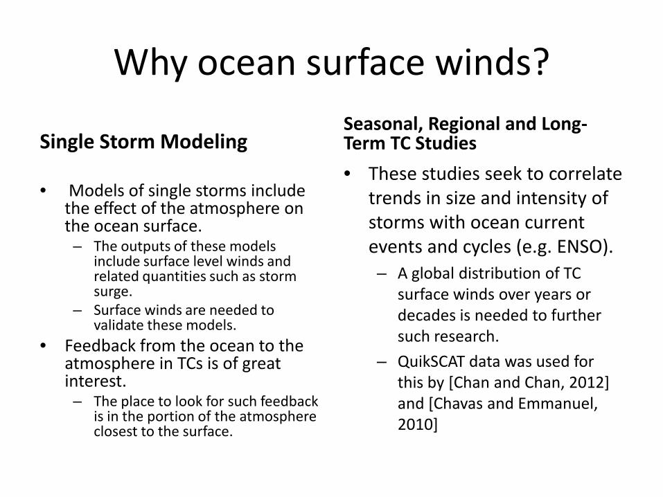
Why ocean surface winds?
Single Storm Modeling
• Models of single storms include the effect of the atmosphere on the ocean surface.– The outputs of these models
include surface level winds and related quantities such as storm surge.
– Surface winds are needed to validate these models.
• Feedback from the ocean to the atmosphere in TCs is of great interest.– The place to look for such feedback
is in the portion of the atmosphere closest to the surface.
Seasonal, Regional and Long-Term TC Studies• These studies seek to correlate
trends in size and intensity of storms with ocean current events and cycles (e.g. ENSO). – A global distribution of TC
surface winds over years or decades is needed to further such research.
– QuikSCAT data was used for this by [Chan and Chan, 2012] and [Chavas and Emmanuel, 2010]

Why scatterometer winds?
Comparison with other data• Currently the most common sources of
surface winds in TCs are: – Best track data.
• Typically a point estimate.• Inconsistently defined due to production by
different international agencies.– Models and Data Assimulations (e.g.
H*WINDS)• May have systematic errors .• Are infrequently produced.
– Aircraft data (e.g. SFMR)• Only available when overflights are performed• Consist of a handful of 1-D linear profiles
• Scatterometer winds have the advantages of– Frequent observations of storms.– Global coverage– Whole fields rather than point or line
measurement.– Data not models
Improvements Performed• Previously available scatterometer winds are
inaccurate.– Rain contamination [Yueh and Stiles,2002] [Nie and
Long, 2007].– Decreased sensitivity at high winds.[Fernandez et al,
2006],[Donelan et al, 2004]• We produce speeds that are corrected for rain
contamination and make optimal use of the available wind sensitivity.
• Toward this end we fit a mapping (simple neural network[Stiles and Dunbar, 2010]) from 9 scatterometer measurements to wind speed.
– Inputs are 8 sets of backscatter values• 2 different azimuths, • 2 different polarizations, • 2 different spatial scales (12.5 and 87.5 km)• a rain rate from the scatterometer noise channel
[Ahmad et al, 2005].– The ground truth speeds are from H*WINDS data from
2005 Atlantic hurricanes.• Attempt to correct wind direction in rain is left for
future work.– Nominal direction retrievals from JPL QuikSCAT L2B
products are maintained.

QuikSCAT Data Set• http://tropicalcyclone.jpl.nasa.gov• 21600 total storm scenes from October 1999 to November
2009• 11435 scenes with best track center within the image,
including:– 3295 TS, 788 CAT-1, 367 CAT-2, 330 CAT-3, 289 CAT-4, 55 CAT-5
• Data on the site includes:– JPEG Images of tropical cyclone optimized winds and two
versions of the JPL global wind product.– Netcdf files containing, all three wind sets, SRAD rain rates, all 8
backscatter sets, and SSM/I co-locations– A comprehensive set of best track data from a variety of
sources.

QuikSCAT 1999-2009 Data Set
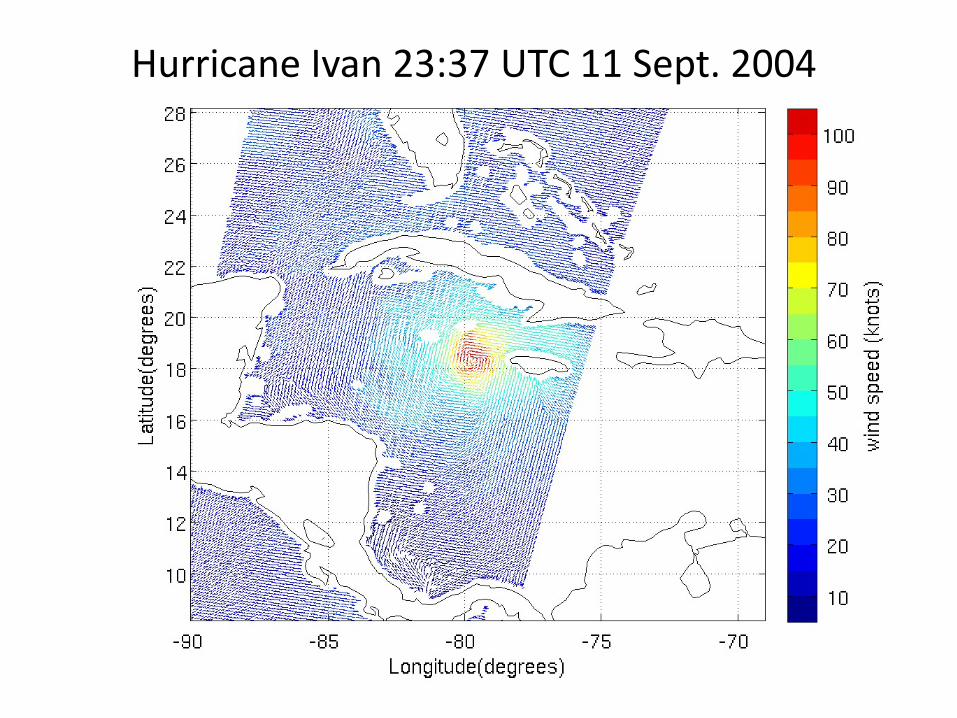
Hurricane Ivan 23:37 UTC 11 Sept. 2004

Examples Maximum Speed Tracks – Ivan 2004


Max Wind Speed Statistics

non-2005 H*WINDS SFMR 2005 and other years

N AVG STD FSPHWind 127 6.6 20.5 13%N Net 339 4.7 26.1 21%JPL v3 339 -4.9 27.5 20%JPL v2 339 26.2 45.9 11%
50-kt Radii (nm) 64-kt Radii (nm)
Validation: QuikSCAT–NHC Best Track
N AVG STD FSPHWind 39 -3.1 9.9 18%N Net 132 -1.2 18.9 35%JPL v3 132 -10.1 23.5 23%JPL v2 132 1.5 23.3 24%
Max. Wind (kt)N AVG STD FSP
HWind 127 11.9 36.5 11%N Net 329 22.7 40.5 23%
JPL v3 329 8.3 37.4 30%JPL v2 329 31.9 47.2 18%
34-kt Radii (nm)
N AVG STD FSPHWind 127 4.7 13.7 13%N Net 338 1.8 18.7 15%JPL v3 338 -8.6 19.3 12%JPL v2 338 11.6 36.1 10%
Green denotes superior QuikSCAT-only retrieval

Max Winds Location Statistics (compare to [Ulhorn and Black, 2007])

Rainfree NRCS vs Wind Speed
1. Solid lines are QuikSCAT and OSCAT w/o Hist. Match
2. Dotted lines are OSCAT w Hist Match

Average Wind Speed Vs. Rain Rate

OceanSAT-2 Retrievals
BERYL
IRENETHANE
ROLF
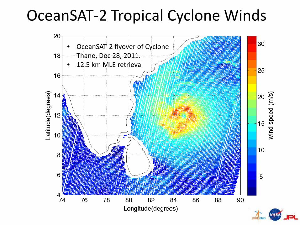
OceanSAT-2 Tropical Cyclone Winds
• OceanSAT-2 flyover of Cyclone Thane, Dec 28, 2011.
• 12.5 km MLE retrieval

OceanSAT-2 Tropical Cyclone Winds• OceanSAT-2 flyover of Cyclone
Thane, Dec 28, 2011. • Neural Network wind speeds
using histogram matching of inputs.
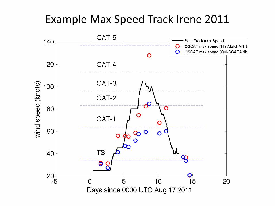
Example Max Speed Track Irene 2011

Summary• Wind tropical cyclones speed fields have been
– Optimized for accuracy– Produced for all ten years of the QuikSCAT mission including over 5,000 observations of
tropical storms and above.– Validated vs. H*WINDS, SFMR, and best track wind speeds.– Made available online to the community at large in a browsable data base.
• Ancilary data such as backscatter imagery and co-located rain information are also included.• We now begin the scientific exploitation of the QuikSCAT TC dataset.
– Initial investigations will include:• Distribution of max winds as a function of storm movement and geographic location• Correlation of storm features with rapid intensification and de-intensification events• Storm size estimation and trend analysis
• We also plan to produce similar datasets for OceanSAT-2 and ASCAT– Sample OceanSAT-2 fields have been produced and we are currently validating and optimizing
them.– ASCAT fields are planned for the following year.
• A paper describing the production and validation of the QuikSCAT data set is in prep.

Acknowledgements
• This work described in this presentation is funded by NASA’s Ocean Vector Winds program.
• The website portal used to distribute the data set is part of a program funded by NASA’s Hurricane Science Research program.

References• Ahmad, K. A., W. L. Jones, T. Kasparis, S. W. Vergara, I. S. Adams, and J. D. Park (2005), Oceanic rain
rate estimates from the QuikSCAT Radiometer: A Global Precipitation Mission pathfinder, J. Geophys. Res., 110, D11101, 26 pages, 2005.
• Chan, Kelvin T. F., Johnny C. L. Chan, “Size and Strength of Tropical Cyclones as Inferred from QuikSCAT Data”. Monthly. Weather. Review., 140, 811–824. 2012.
• Chavas, D. R. and K. A. Emanuel, “A QuikSCAT climatology of tropical cyclone size,”Geophysical Research Letters, VOL. 37, L18816, doi:10.1029/2010GL044558, 2010.
• Donelan M. A., Haus B. K., Reul N., Plant W. J., Stiassnie M., Graber H. C., Brown O. B., Saltzman E.S (2004). “On the limiting aerodynamic roughness of the ocean in very strong winds”. Geophysical Research Letters, 31(18), -. Publisher's official version: http://dx.doi.org/10.1029/2004GL019460, Open Access version : http://archimer.ifremer.fr/doc/00000/10873/
• Fernandez, D. Esteban; Carswell, J. R.; Frasier, S.; Chang, P. S.; Black, P. G.; Marks, F. D. “Dual-polarized C- and Ku-band ocean backscatter response to hurricane-force winds,” J. Geophys. Res., Vol. 111, No. C8, 2006.
• Congling Nie; David G. Long; , "A C-Band Wind/Rain Backscatter Model," Geoscience and Remote Sensing, IEEE Transactions on , vol.45, no.3, pp.621-631, March 2007, doi: 10.1109/TGRS.2006.888457
• Stiles, B.W.; Dunbar, R.S.; , "A Neural Network Technique for Improving the Accuracy of Scatterometer Winds in Rainy Conditions," Geoscience and Remote Sensing, IEEE Transactions on , vol.48, no.8, pp.3114-3122, Aug. 2010
• Stiles, B. W., and Yueh, S. H., “Impact of rain on Spaceborne Ku-Band Wind Scatterometer Data,”IEEE Transactions on Geoscience and Remote Sensing, Vol 40, No 9, pp 1973-1983, 2002.
• Uhlhorn, E. W., and P. G. Black, J. L. Franklin, M. Goodberlet, J. Carswell, and A. S. Goldstein, 2007: “Hurricane surface wind measurements from an operational Stepped Frequency Microwave Radiometer”. Mon. Wea. Rev., 135, 1370–1385.
Backups

Example Max Speed Track Rolf 2011

Example Max Speed Track Thane 2011-2012

Example Max Speed Track Beryl 2012

Hurricane Isabel, 1028 UTC 15 Sept 2003

Examples Maximum Speed Tracks – Isabel 2003

OceanSAT-2 Tropical Cyclone Winds• OceanSAT-2 is a 13.4 GHz ocean wind
scatterometer operated by the Indian Space Research Organization (ISRO).
• For the past two years ISRO has been collaborating with NASA/JPL and NOAA to refine the calibration of the OceanSAT-2 backscatter data.
• The goal of the collaboration is to extend the Ku-band scatterometerwind data record initiated by QuikSCAT.
• A crucial element of this effort has been the repointing of the QuikSCATinstrument to match the OceanSAT-2 viewing geometry.
• Although QuikSCAT ceased nominal operations in November 2009, its precisely calibrated backscatter measurements remain useful for cross-platform calibration.
• To date the ISRO/NASA/NOAA collaboration has resulted in:
– More robust wind retrieval in low wind areas.
– Absolute backscatter calibration tuned to match QuikSCAT data within 0.1 dB.
– Improved wind accuracy as compared to numerical wind products and buoys.
– Ongoing monitoring of calibration drift by comparison between QuikSCAT and OceanSAT-2 backscatter values.
• The fruitfulness of the collaboration is further illustrated by the tropical cyclone winds on the next slide.
– The OceanSAT-2 operational wind product is binned at 50 km with a conservative land mask employed to insure accurate winds.
– JPL has retrieved winds at higher resolutions and closer to the coast.
– Cases are shown before and after calibration improvements.
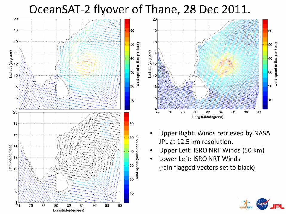
OceanSAT-2 flyover of Thane, 28 Dec 2011.
• Upper Right: Winds retrieved by NASA JPL at 12.5 km resolution.
• Upper Left: ISRO NRT Winds (50 km)• Lower Left: ISRO NRT Winds
(rain flagged vectors set to black)