
MULTIMODAL TRANSPORTATION PLANNING IN … · GARVER, JR., Co-Chairman, ... laying the foundation...
35
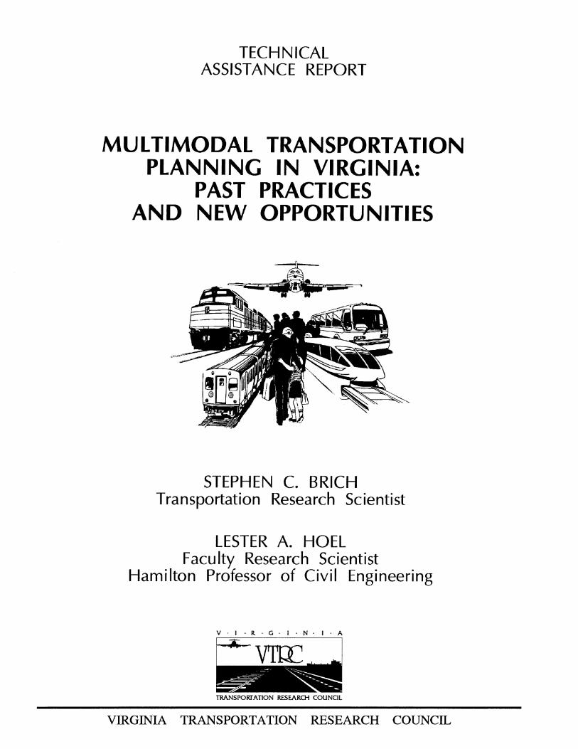
TECHNICAL ASSISTANCE REPORT MULTIMODAL TRANSPORTATION PLANNING IN VIRGINIA: PAST PRACTICES AND NEW OPPORTUNITIES STEPHEN C. BRICH Transportation Research Scientist LESTER A. HOEL Faculty Research Scientist Hamilton Professor of Civil Engineering V. -R G N A VIRGINIA TRANSPOR]'ATION RESEARCH COUNCIL TRANSPORTATION RESEARCH COUNCIL
Transcript of MULTIMODAL TRANSPORTATION PLANNING IN … · GARVER, JR., Co-Chairman, ... laying the foundation...
TECHNICAL ASSISTANCE REPORT
MULTIMODAL TRANSPORTATION PLANNING IN VIRGINIA:
PAST PRACTICES AND NEW OPPORTUNITIES
STEPHEN C. BRICH Transportation Research Scientist
LESTER A. HOEL Faculty Research Scientist
Hamilton Professor of Civil Engineering
V. -R G N A
VIRGINIA
TRANSPOR]'ATION RESEARCH COUNCIL
TRANSPORTATION RESEARCH COUNCIL

TECHNICAL ASSISTANCE REPORT
MULTIMODAL TRANSPORTATION PLANNING IN VIRGINIA: PAST PRACTICES AND NEW OPPORTUNITIES
Stephen C. Brich Transportation Research Scientist
Lester A. Hoel Faculty Research Sciemist
Hamilton Professor of Civil Engineering
(The opinions, findings, and conclusions expressed in this report are those of the authors and not necessarily those of
the sponsoring agencies.)
Virginia Transportation Research Council (A Cooperative Organization Sponsored Jointly by the
Virginia Department of Transportation and the University of Virginia)
In Cooperation with the U.S. Department of Transportation Federal Highway Administration
Charlottesville, Virginia
September 1994 VTRC 95-TAR1

MULTIMODAL PLANNING RESEARCH ADVISORY COMMITTEE
L. J. BEVON, Co-Chairman, Head, Department of Rail & Public Transportation C. D. GARVER, JR., Co-Chairman, Asst. Commissioner Planning & Programming, VDOT E. D. ARNOLD, JR., Executive Secretary, Virginia Transportation Research Council D. W. BERG, Assistant, Rail & Public Transportation Administration S. E. BLAKE, Transportation Research Board C. BOLITHO, Director of Development and Marketing, Peninsular Transportation District
Commission T. J. CHRISTOFFEL, Executive Director, Lord Fairfax Planning District Commission B. R. CLARKE, Assistant, Transportation Planning Division Administration, VDOT G. R. CONNER, Assistant, Rail & Public Transportation Administration S. A. CURTIS, Chief Engineer for Port Development, Virginia Port Authority D. L. FARMER, Chief Transportation Planner, Hampton Roads Planning District Commission M. S. HOLLIS, Urban Division Administrator, VDOT A. HOWARD, Chief of Transportation, Fifth Planning District Commission R. C. LOCKWOOD, Transportation Planning Division Administrator, VDOT Y. LLORT, District Operations & Planning Engineer, VDOT D. N. LYSY, Director of Transportation, Richmond Regional Planning District Commission C. S. SORRELL, District Administrator, VDOT S. R. STEELE, Ph.D., Unit 1517 M. L. TISCHER, Ph.D., Policy Analysis/Intergovernmental Relations, VDOT B. TURNER, Federal Highway Administration M. A. WATERS, Planning and Promotion, Virginia Department of Aviation W. W. WHITE, District Tunnels & Toll Facilities Engineer, VDOT B. W. WINGO, Resident Vice President Public Affairs, Norfolk Southern Corporation C. H. ZELLER, Transportation Planning, VDOT

TABLE OF CONTENTS
Executive Summary v
Introduction 1
Intermodal Surface Transportation Efficiency Act of 1991 1
Supplememary Regulations 4
Multimodal Transportation Planning in Virginia 10
Research Agenda for Imermodal and Multimodal Planning 19
Conclusion 25
References 26
iii

List of Acronyms
ADA BMS CAAA CMAQ CMS COT-21 EPA FAA FHWA FRA FTA IMS ISTEA MARAD MPO NHS NPRM NTS PMS PTMS SIP SMS SOV STIP STP STRAHNET TCM TDM TIP TMA TMS VDH&T VDOT VDR&PT VRE VTB
Americans with Disabilities Act Bridge Management System Clean Air Act Amendment Congestion Mitigation and Air Quality Improvement Program Congestion Management System Commission on Transportation in the Twenty-First Century Environmental Protection Agency Federal Aviation Administration Federal Highway-,. Administration Federal Railroad Administration Federal Transit Administration Intermodal Management System Intermodal Surface Transportation Efficiency Act of 1991 Maritime Administration Metropolitan Planning Organization National Highway System Notice of Proposed Rule Making National Transportation System Pavement Management System Public Transportation Management System State Implementation Plan Safety Management System Single Occupancy Vehicle Statewide Transportation Improvement Program Surface Transportation Program Strategic Highway Network Transportation Control Measure Transportation Demand Management Transportation Improvement Program Tramportation Management Area Traffic Management System Virginia Department of Highways and Transportation Virginia Department of Transportation Virginia Department of Rail and Public Transportation Virginia Railway Express Virginia Transportation Board

EXECUTIVE SUMMARY
National Perspective
The Intermodal Surface Transportation Efficiency Act of 1991 (ISTEA) provided the nation with a means of maintaining its existing infrastructure while laying the foundation for a national intermodal transportation system. ISTEA was passed to ensure that the United States would have an economically efficient, environmentally sound intermodal transportation system. This system will allow the nation to be competitive in a global economy while ensuring the energy-efficient movement of both people and goods.
ISTEA established the National Highway System (NHS), consisting of 155,000 miles (249,448 kin)of major roadways throughout the United States. The NHS roadways are a
compilation of existing roadways, not newly constructed roadways, currently designated as
interstate, urban and rural principal arterials, and highways. Although the NHS is composed solely of highways, the U.S. Secretary of Transportation, Frederico Pefia, has stated that the U.S. DOT or Congress will undertake the establishment of a National Transportation System (NTS). The NHS will provide the backbone for the proposed NTS.
ISTEA also provided the nation with an array of avenues to create a state-of-the-art intermodal transportation system, one of which allows each state to be more flexible with the federal funds it receives. For example, in the past, federal highway funds could be used only for highway purposes. Now, those funds can be used for transit projects and bicycle and/or pedestrian facilities, as well as for highway purposes, depending on the state's needs.
In order to promote intermodal transportation, Congress, through ISTEA, created the Office of Intermodalism. This office provides states with information pertaining to the movement of people and goods on the nation's intermodal facilities. An advisory board composed of representatives from each U.S. DOT administration was created to aid in carrying out the Secretary's recommendations.
ISTEA also included many new regulations. The two most notable are the Interim Final Regulations for the Management Systems and the Statewide Planning: Metropolitan Planning Regulations.
The Management System Regulations require each state to develop, establish, and implement a systematic process to manage pavements, bridges, safety, congestion, public transportation facilities and equipment, and intermodal facilities. These systems promise to improve the efficiency with which states utilize valuable resources and increase the safety of highways and transit facilities. The results from the Management Systems are to be input data

for the Statewide Transportation Planning Process and the Metropolitan Planning Process. These systems will change the way states do business for years to come.
In November 1993, the Federal Highway Administration (FHWA), in conjunction with the Federal Transit Administration (FTA), issued the Final Rules for Statewide Planning: Metropolitan Planning. These new regulations govern the development of statewide transportation plans and programs, as well as those of the Metropolitan Planning Organizations (MPOs), ensuring that the statewide and metropolitan plans would meet the requirements for federal funding. The planning process has essentially remained the same, consisting of the four- step process and using the 3Cs (continuing, comprehensive, cooperative). The decision-making process has changed. States must now explicitly consider 23 factors and MPOs must consider 15 factors when developing their transportation plans. Both states and MPOs must also develop a multimodal transportation improvement program that has been reviewed and commented on by the public. The projects contained within the first three years of each of the improvement programs must be financially constrained. In other words, each project must have its funding source identified and there must be ample funds to proceed with each of the projects identified.
Virginia Perspective
Virginia has typically taken a "needs-based" mode-by-mode approach when determining the requirements for state investments in transportation. Because of the ISTEA legislation, states have to develop true multimodal transportation plans. Arguably, Virginia's approach has not been truly multimodal. Transportation plans and needs assessments have been prepared by combining individual plans for the separate modes rather than developing an integrated plan for the efficient use of all modes. For instance, a study by the Commission on Transportation in the Twenty-First Century (COT-21) set the stage for a $10 billion highway construction program spread over 12.5 years, but placed little emphasis on intermodal and multimodal transportation services. This initiative undoubtedly had an economic impact on the highway construction industry, the infrastructure added to the state, and the state's response to a critical need, but the planning activities related to this effort were essentially focused on single-mode highway transportation. Corridors were studied with a primary focus on the projected traffic volumes. Much less attention was paid to the mix of modes and management strategies that could serve this demand. This is not an indictment of the transportation agencies. Separate modal planning has simply been the Commonwealth's historical focus, and the institutions which carry out transportation planning have remained consistent with this historical focus. The challenge to the Commonwealth is to develop institutions and a planning process more consistent with a multimodal focus.
Transportation has always been a vital element of Virginia's economy. In 1992, the Secretary of Economic Development for Virginia issued a report entitled Virginia's Economic
vi

Development Policy, which discussed the importance of transportation to the economic well- being of the Commonwealth. The report stated that Virginia's transportation facilities are major assets for the promotion of economic growth. The report listed five elements of transportation infrastructure representing Virginia's excellent services: (1) superior seaports, (2) extensive interstate highway and rail systems, (3) commercial air service at 13 airports, (4) the capability of reaching markets across the U.S. and the world quickly, and (5) the ability to serve domestic and international business and recreational travelers. The report also noted that since transportation is an integral component of economic development, the Commonwealth should continue to focus on developing and maintaining an integrated and high-quality transportation system.
Virginia's transportation infrastructure is by no means meager. The highway system includes 54,000 miles of interstate, primary, and secondary roads. Of these 54,000 miles (86,905 km), 1,090 miles (1,754 km) are on the interstate system, and 1,800 miles (2,897 km) make up the arterial network serving communities of 3,500 people or more. Virginia's rail network, excluding yards and sidings, totals approximately 3,295 miles (5,303 km). Two of the nation's largest railroads, the CSX Corporation and the Norfolk Southern Corporation, are headquartered within the state. Intercity rail passenger service is provided by AMTRAK, which operates eight trains with scheduled stops in Virginia. Metro rail is provided to commuters in the Virginia suburbs of Washington, D.C. A new component to the commuter rail network is the Virginia Rail Express (VRE), which operates from Fredericksburg and Manassas to Washington, D.C. Virginia is served by 13 airports with commercial service to over 600 worldwide destinations. Another 64 airports are licensed for public use, and the majority of these can accommodate multi-engine aircraft. Virginia also has one of the finest natural ports in the world as well as three inland ports. The Port of Hampton Roads is served by an ice-free 50 ft (15.24 m) deep- water channel capable of handling large volumes of cargo. Virginia also maintains the Virginia Inland Port in Front Royal, which is a collection point for containers from West Virginia, Ohio, Pennsylvania, and Northern Virginia.
A recem study of the trust fund allocation formula, •° which reported on transportation infrastructure needs in Virginia over the next 20 years, recommended a reallocation of the amount that each mode receives. The study showed that although highways are allocated 85 percem of funds available for transportation, future highway needs are estimated to be no more than 79 percem of the needs for all modes. Future public transportation needs are estimated to be approximately 15.77 percent, while its current allocation is only 8.4 percent. Aviation and port facility needs were determined to be much lower than those for highway and public transportation facilities. The needs of aviation and the needs of port facilities were estimated to be 2.25 percent and 3.32 percent of the total transportation needs, respectively. Rail is not curremly funded by the state, but the study made a strong case for involving the Commonwealth in supporting rail facilities.
vii

Issues for Research and Discussion
Recently, the Transportation Research Board (TRB) held two national conferences to address intermodal and multimodal transportation planning issues and develop suggested research agendas for the future. Multimodal planning focuses on system choices and adapts a generic, non-mode-specific approach to defining and evaluating transportation problems; it then attempts to provide an unbiased estimate of each mode's contribution, singly or in combination, to solve the problem. Intermodal planning, on the other hand, examines the policy and service interactions between modes, focusing on ensuring ease of movement for both people and goods when transferring from one mode to another.
The conclusions reached by conference participants provide valuable insight into the current status and prospects for developing integrated transportation plans. (1) Altering the planning process will take several years. (2) A great deal of effort will be needed to re-invigorate relationships between federal, state, and regional planning efforts. (3) Multimodal planning must reflect community values and quality of life criteria, as well as providing mobility. (4) Benefits and costs must be properly assessed and land use issues require a high priority. (5) Effective multimodal planning demands that traditional "adversaries" establish new relationships. Planning interests cannot be limited to transportation. Private business and environmental advocates must be included. The new planning environment will affect the way the private sector provides facilities and services. New kinds of collaborative efforts will be needed to serve
a broader range of goals than in the past. In addition, freight and commodity planning must be evaluated to integrate land use, congestion, and other planning programs.
Several areas of research for multimodal and intermodal transportation planning have applicability to Virginia. The ISTEA Management Systems identified the need for states to rate the performance of their transportation systems to determine their effectiveness. These performance measures can be qualitative and/or quantitative. Virginia may also develop mobility indices to inform system users, as well as engineers and planners, how the system is functioning at any given time. This may be valuable to commuters deciding which mode of transportation to select during rush hour.
The balance between freight movement by highway and rail also needs investigation. Virginia is currently reviewing methods to improve performance along the I-81 corridor where trucks represent nearly 45 percent of the traffic. One way to increase the safety of the facility may be to divert a percentage of freight movement in the corridor to rail. To do this, Virginia needs to address the connectivity of these two modes.
This summary of ISTEA legislation, past Virginia transportation studies, and two TRB conferences on intermodal and multimodal transportation shows that Virginia needs to begin viewing its transportation resources as a system rather than a combination of individual modes.
viii

MULTIMODAL TRANSPORTATION PLANNING IN VIRGINIA" PAST PRACTICES AND NEW OPPORTUNITIES
Stephen C. Brich Transportation Research Scientist
Lester A. Hoel Faculty Research Scientist
Hamilton Professor of Civil Engineering
INTRODUCTION
On December 18, 1991, the Congress of the United States of America passed a landmark legislative act to foster the country's ailing transportation system, the Intermodal Surface Transportation Efficiency Act of 1991 (ISTEA). The goal of ISTEA is a national intermodal transportation system, economically efficient and environmentally sound, to help the nation compete in the global economy, and move people and goods in an energy-efficient manner. ISTEA requires states to consider new methods to improve intermodal connectivity, reduce energy consumption and air pollution, and increase mobility for elderly and disabled passengers while promoting economic development at home and abroad.
Intermodal Surface Transportation Efficiency Act of 1991
National Highway System
ISTEA established the National Highway System (NHS), which consists of 155,000 miles (249,448 km) of major roadways within the United States. The NHS is a compilation of the Interstate System, urban and rural principal arterials and highways that provide access to other ports and airports, and roadways designated under the Strategic Highway Network (STRAHNET) for defense purposes. The NHS provides an interconnected system of principal arterial routes serving major population centers, international border crossings, ports, airports, etc. As a requirement of ISTEA, the Secretary of Transportation, in consultation with the states, must designate the NHS by September 30, 1995. Although the NHS is composed solely of highways, the U.S. Secretary of Transportation, Frederico Pefia, has stated that the U.S. DOT and/or Congress will undertake the establishment of a National Transportation System (NTS). The NHS will provide the backbone for the proposed NTS.

Surface Transportation Program
ISTEA also established a Surface Transportation Program (STP), which authorizes $23.9 billion of funding over six years for construction, reconstruction, rehabilitation, resurfacing, restoration, and operational improvements for highways and bridges. These improvements include the construction and/or reconstruction necessary to accommodate other transportation modes. STP also provides flexible funding opportunities for capital costs to transit projects that are eligible for assistance under the Federal Transit Act, as well as to publicly owned intracity and intercity bus terminals and facilities. Car pooling, fringe and corridor parking facilities, and pedestrian and bicycle facilities are other examples of the type of projects funded under STP. The funding for various projects depends on location. Urban areas will receive a different level of funding than rural areas.
Congestion Mitigation and Air Quality Improvement Program
The Congestion Mitigation and Air Quality Improvement Program (CMAQ) is another program established by ISTEA. CMAQ provides states with $6 billion over six years for programs to improve air quality in non-attainment areas. These funds permit states to implement Transportation Control Measures (TCMs) and develop air quality programs that are designed to attain the national standards for carbon monoxide (CO), ozone (O3), and even small particulate matter (PM•0).
CMAQ funds are primarily used for projects that expand or initiate transportation services with air quality benefits. CMAQ projects for specific non-attainment areas focus on the emissions that the non-attainment area is noted for, and the projects are coordinated with the area's Metropolitan Planning Organization (MPO).
As a result of ISTEA and the Clean Air Act Amendments (CAAAs), MPOs are now responsible for formulating an area's Transportation Improvement Program (TIP), which includes federally funded highway and transit projects and TCMs. The TIP must be in coordination with the State Implementation Plan (SIP) for achieving attainment. All projects that are funded with CMAQ funds must be included in the TIP and must conform with the SIP. The TCMs developed for a state air quality plan have the highest priority for funding under this program.
States with no non-attainment areas are still eligible to use CMAQ funding provided the projects meet the eligibility requirements for funding under the CMAQ and the STP.
The federal share for fimding depends on the type of project to be undertaken. Currently, the federal share for non-interstate projects is 80 percent, while for interstate projects it is 90 percent. Activities that include traffic control signalization and commuter car pooling/van

pooling may be allowed up to 100 percent. Pedestrian and bicycle facilities must be funded at a federal share of 80 percent.
CMAQ projects thus far can be categorized as follows:
Transit Improvements (includes commuter rail) Ride-Share Services Traffic Flow Improvements (includes upgrading signal timings) Demand Management Strategies Pedestrian and Bicycle Facilities Programs Inspection and Maintenance Programs
Bicycle Transportation and Pedestrian Walkways
Bicycle transportation facilities and pedestrian walkways may also be constructed using federal funds under ISTEA. For bicycle facilities to be federally funded, the project must show that bicycle use will be principally for transportation and not for recreation. CMAQ and STP funds may be allocated for the construction of both types of facilities as well as for projects that relate to the safe usage of bicycles. NHS funds may also be used to fund the construction of bicycle facilities on land adjacent to any highway on the NHS. In cases where bridge decks need reconstruction or replacement, federal funds may be used to rehabilitate the bridge for safe bicycle movement.
Federal funds may also be used to fund a position within a state department of transportation for a Bicycle and Pedestrian Coordinator to promote and facilitate the use of non- motorized vehicles. Bicycle and pedestrian plans developed by the MPOs and states will be incorporated into their respective long-range transportation plans.
Intermodal Transportation
To achieve its purpose of promoting intermodal transportation, ISTEA created the Office of Intermodalism, under the U.S. Secretary of Transportation. This office provides states and MPOs with information on the movement of people and goods on intermodal transportation systems. ISTEA also established the Intermodal Transportation Advisory Board, consisting of the administrators of the Federal Highway Administration (FHWA), Federal Aviation Administration (FAA), Maritime Administration (MARAD), Federal Railroad Administration (FRA), and the Federal Transit Administration (FTA). This advisory board is responsible for providing recommendations to the Secretary of Transportation.

Supplementary Regulations
ISTEA also contained several sections relating to Metropolitan Planning and Statewide Planning, as well as the Management Systems. In November 1993 and December 1993, the FHWA and the FTA issued joint regulations on Statewide Planning:Metropolitan Planning and the Interim Final Regulations for the Management Systems.
Management Systems
Under ISTEA, the FHWA and the FTA jointly require each state, in cooperation with MPOs, to develop and establish systems for managing highway pavement on federal-aid highways (PMS), bridges, both on and off federal-aid highways (BMS), highway safety (SMS); traffic congestion (CMS), public transportation facilities and equipment (PTMS), and intermodal transportation facilities and systems (IMS). Each state must also develop, establish, and implement a traffic monitoring system for highways and public transportation facilities and equipment (TMS).
The management systems are a systematic process to assist states and MPOs in decision- making. These systems should improve the efficiency with which states use valuable resources and increase the safety of highways and transit facilities. Each system must include performance measures, data collection and analysis techniques, determination of needs, criteria used for selection of strategies, and an evaluation of effectiveness. The results from the Management Systems are to be input data for the Statewide Transportation Planning Process and the Metropolitan Planning Process (Figure 1). It should be noted that the systems were not designed to be one or two-year projects. They are a long-term, iterative approach to the way states do business.
Planning Regulations
ISTEA contains several sections relating to Statewide Planning and Metropolitan Planning. In November 1993, FHWA and FTA jointly issued the Final Rules for Statewide Planning:Metropolitan Planning. These Final Rules replace the existing planning regulations governing the development of transportation plans and programs for urbanized areas as well as the development of statewide plans and programs. These new regulations were issued to ensure that statewide and metropolitan plans and programs meet the requirements for federal highway and transit funding.

Figure 1
SYSTEM PERFORMANCE
STRATEGIES
PLANNING PROCESS
TRANSPORTATION PLAN
IMPLEMENTATION
SOURCE: U.S. Department of Transportation. Management and Monitoring Systems. 1993. Vol. 58, No. 229. Washington, D.C." Federal Register.
Statewide Transportation Planning
The new statewide planning regulations require each state to carry out a continuing, comprehensive, and intermodal statewide transportation planning process. This includes the developmem of a statewide transportation plan and a TIP that facilitate the efficient and economic movement of people and goods in all areas of the state. The statewide plan needs to consider a wide range of transportation needs for both passengers and freight and for all modes of transportation, including their connections.
In developing the statewide transportation plan, the state must coordinate with other planning organizations for public involvement and data collection and analysis. The public involvement process must be proactive, early and continuous. The state must provide sufficient time and information for public comment, similar to the Notice of Proposed Rule Making (NPRM) used by the federal government.
These regulations require the statewide transportation plan to address all areas of the state for a period of not less than 20 years. The plan must be imermodal and contain methodology for connecting bicycle transportation and pedestrian walkways with other modes. The regulations also require the states to explicitly consider 23 factors when developing their transportation

plan. These factors are listed in Table 1. Two factors (Indian tribal governmems and international border crossings) are not valid for the Commonwealth of Virginia; however, they still must be addressed. The plan must be coordinated with MPOs, make reference to other planning reports significant to its development, and summarize the financial resources required. The state must develop the plan by January 1, 1995. It will be the basis for approving subsequent statewide transportation improvement programs (STIPs).
TABLE 1 STATE PLANNING FACTORS
Transportation needs identified by the management systems Federal, state, and local energy use goals, objectives, etc. Strategies for inclusion of bicycle facilities and pedestrian walkways International border crossings Transportation needs of non-metropolitan areas
Any metropolitan plan Connectivity between metropolitan planning areas within the state with those areas in other states Recreation and tourism Any plan developed pursuant to the federal Water Pollution Control Act Transportation Systems Management (TSM) and investment strategies to utilize existing facilities to their fullest potential Overall social, economic, energy, and environmental effects of transportation decisions Methods to reduce and prevent traffic congestion Methods to expand and enhance appropriate transit services (includes commuter rail) Effects of transportation decisions on land use Strategies for identifying and implementing transportation enhancements Innovative mechanisms for financing (e.g., tolls, congestion pricing) Preservation of right-of-way (ROW) for future construction Long-range needs of the state's transportation system for the movement of people and goods Methods to enhance the efficient movement of commercial vehicles Use of life-cycle cost analysis in designs Coordination of transportation plans developed for metropolitan areas Investment strategies to improve adjoining state local roads Concerns of Indian tribal governments

Statewide Transportation Improvement Program
In addition to the statewide transportation plan, the regulations require each state to develop its own STIP for all areas of the state. The metropolitan areas are required to develop their own TIP. Once the TIP has been approved by the MPO and the Governor, it must be included into the STIP without any modifications.
The STIP must be developed for a period of not less than three years. It must include a list of priority projects to be carried out in its first three years. The projects contained within the STIP must be consistent with those identified in the statewide transportation plan and must conform to Environmental Protection Agency (EPA) regulations. These same projects must be financially constrained by year; that is, the state must identify where funding will come from for each of the projects broken down by years. Projects contained in any of the first three years may be "juggled." This allows states to reprioritize projects and their associated funds. Once these steps have been completed, the state must submit the entire proposed STIP to FHWA and FTA for joint approval.
Metropolitan Transportation Planning and Programming
These regulations also require MPOs to have a continuing, cooperative, and comprehensive (3C) transportation planning process. The 3C planning process should provide integrated, intermodal transportation systems that facilitate the efficient and economic movement of people and goods while supporting community development and the social goals of the metropolitan area.
It is the MPO's responsibility to carry out the metropolitan planning process in cooperation with state and local transit officials. For MPOs located within non-attainment areas, the MPO must also coordinate the development of their transportation plan with the development of the state implementation plan (SIP), including the development of the transportation control measures (TCMs). As with the statewide transportation plan, the MPO must now explicitly consider 15 factors when developing their transportation plan (Table 2).
As in developing the STIP, the Metropolitan Planning Process requires the MPO to provide for a proactive public involvement process. Public involvement must begin early in the development of the TIP and continue throughout the entire planning process. The public involvement process should include public notices of activities and the allocation of time for the review and submission of comments at key decision points.

TABLE 2 MPO PLANNING FACTORS
•
•
•
•
•
•
•
•
Preservation of existing transportation facilities Consistency with federal, state, and local energy use goals, objectives, etc. Relief and prevention of congestion (CMS) Effects of transportation decisions on land use and development Programming of expenditures Effects of ALL transportation projects undertaken (should include cost analyses) International border crossings and access to ports, airports, etc. Connectivity between metropolitan planning areas within the state with those areas in other states Transportation needs identified from the management systems Preservation of right-of-way (ROW) for future construction Enhancement of the efficient movement of freight Use of life-cycle cost analysis in designs Overall social, economic, energy, and environmental effects of transportation decisions Expansion, enhancement, and increased use of transit services Capital investments to increase security in transit systems
Relation to the Management Systems
The MPO is required to use the managemem systems as a means to identify community transportation needs. The CMS, PTMS, and IMS must each be a component of the Metropolitan Planning Process. The MPO may not expend federal funds for any project that significantly increases the capacity for single occupant vehicles (SOVs), unless the project is a result of the CMS. In areas that are designated as Transportation Management Areas (TMAs), the Metropolitan Planning Process must include the development of a CMS that effectively manages all existing and future transportation facilities through the use of travel demand management (TDM) strategies. The planning process should provide for periodic investigations of the effectiveness of the management systems in enhancing the transportation investment decisions and the overall efficiency of the metropolitan transportation system.

Metropolitan Transportation Plan
The planning regulations require the metropolitan transportation plan to address a period of not less than 20 years. The plan should include both long and short-range strategies to provide a tree intermodal transportation system for moving people and goods efficiently. This plan must also contain methodologies for interconnecting bicycle transportation and pedestrian walkways with other modes. The plan shall"
identify projected transportation demand for persons and goods assess capital investments and other measures to preserve existing transportation systems reflect a multimodal evaluation of transportation identify proposed transportation enhancement activities.
The MPO must review and update this plan at least once every three years. In addition, the plan must be reviewed by the MPO, FHWA, and FTA to determine whether or not it conforms to CAAA and other EPA regulations. Even though the plan does not need approval by the FHWA and FTA, copies of the plan must be forwarded to these agencies for review.
Metropolitan Transportation Improvement Program
In addition to the metropolitan transportation plan, the regulations require each metropolitan area to develop its own TIP in cooperation with state and local public transit operators. Once the TIP has been approved by the MPO, the Governor is required to approve it, after which the TIP will be included into the STIP without any modifications.
The MPO must develop the TIP for a period of not less than three years. The TIP may extend more than three years if financial information regarding the projects for the additional years is provided. The TIP must include a list of priority projects to be carried out in its first three years. The projects in the TIP must be consistent with the transportation plan and must conform to EPA regulations. The projects must be financially constrained by year; that is, the MPO must define where funding will come from for each of the projects, broken down by year.
The TIP shall include, for each project, descriptive material to identify the project or its phase, estimated total cost, the amount of federal funds and non-federal funds to be obligated each program year, the locality responsible for overseeing the project, and identification of projects that come under the Americans with Disabilities Act (ADA). The regulations also require the TIP to identify the criteria and process used for prioritizing projects, and list projects that have been completed from the TIP and whether any major delays were encountered.

Multimodal Transportation Planning in Virginia
The Commission on Transportation for the Twenty-First Century
In 1987, a landmark study of transportation needs was completed by the Commission on Transportation in the Twenty-First Century (COT-21). Phase I of the study, completed in 1986, had three major objectives" (1) to confirm the critical highway and transportation needs of the Commonwealth, (2) to explore alternate means of financing transportation, and (3) to examine the feasibility of a separate fund for highway construction.
The transportation challenge for Virginia was seen as reducing or eliminating highway congestion in urban areas. The report noted that in many of our cities and suburban jurisdictions our major challenge is traffic congestion. Intraurban trips that once took minutes now take hours. The report noted that congestion also (1) increases vehicle accident rates and operating costs, (2) contributes to air pollution problems, (3) increases shipping costs of raw materials and goods produced in the Commonwealth, (4) reduces industrial productivity and business efficiency, and (5) serves as an impediment to increased economic development. The report noted that while the congestion problem is the result of many factors, it is basically a problem of the traffic on Virginia's roads outpacing the Commonwealth's highway construction program.
The second problem identified by COT-21 was the lack of accessibility of rural areas. Unpaved roads, excessive grades, limited sight distances, and inadequate shoulders contribute to unsafe road conditions and excessive time spent in transporting coal, lumber, and agricultural products.
Other problems noted were the need for public transportation by commuters and special users, rehabilitation of bridges, industrial rail access to promote economic development, and the need to expand existing ports and airports.
To determine transportation needs, a series of public hearings were held and an analysis of needs assessment studies was prepared by the Virginia Department of Highways and Transportation (VDH&T). It was estimated that $10.2 billion would be required primarily for highways over a six-year period, although some of these funds ($245 million) were set aside for transit. Funding needs of other modes were to be examined in greater detail during Phase II of the work. A general picture of needs for other modes was furnished by the providers of these services and described as follows. Needs indicated are total requirements, and with the exception of mass transit, the level of state funding is not indicated.
Airports. In 1985 Virginia had 55 publicly owned airports. Revenue needs have been met mostly by the Federal Aviation Trust Fund, airport concessions and fees, personal property taxes, local general revenues, and bonds. Airport needs were projected to total $250 million over
10

the next 10 years exclusive of Washington National and Washington Dulles International Airports.
Mass Transit. In 1985, $35 million in state assistance was given to 31 systems throughout the Commonwealth. A consulting report estimated a future need of $705 million in capital alone over the next six years and state support for capital and operating costs of $470 to $669 million over the next six years.
Rail. In 1986, the General Assembly adopted budget language authorizing funding of "industrial access rail tracks if the construction of these tracks will have a positive impact upon the economic development of the state." The cost of these projects is unknown. Commuter rail was also funded by the state for the first time in 1986, and it was anticipated that several areas of the Commonwealth would seek substantial support in the future.
Ports. At the time of the report, the Virginia Port Authority had substantially increased its volume of activities by 35 percent from the previous year alone, from 2.7 million tons to 3.6 tons (1984-85). It was estimated that the Port of Hampton Roads would be operating at well over
100 percent capacity by 1991 without additional expansion. Port expansion was estimated to cost $300-400 million over the next 10 years.
As noted, the Phase I study was geared primarily to highway needs, estimated at over $1 billion per year. Accordingly, the remainder of the report dealt with (1) the capacity of the construction industry to handle a major expansion of the highway system; (2) sources of needed revenue, estimated at $6-7 billion within the Commonwealth; and (3) mechanisms for allocating funds for roads and highways and managing new revenues for transportation needs.
The study concluded that (1) commitment by the Commonwealth to a stable, predictable, long term construction program is critical to industry adjustment and cost-effective expenditure of funds; (2) taxes should be raised from four sources: sales, gasoline, titling, and interest on
current and future highway fund balances; and (3) management of transportation funds should be coordinated for all modes of transportation by creating a Virginia Transportation Board (VTB) with expansion of membership and authority. Renaming the Virginia Department of Highways and Transportation as the Virginia Department of Transportation (VDOT) was also recommended.
As is evident from this report, the major focus of COT-2 l's work was the identification of highway needs and projects coupled with the resolution of issues such as financing, implementation, and management. Little emphasis was placed on the interaction of highways and other modes. The approach to resolving "congestion" problems was to add new highway lanes. Little mention was made of limiting demand through traffic management means or
11

encouraging the use of other modes. Rather, a single-minded effort was made to develop a mechanism for accelerating the highway construction program within the Commonwealth.
As a result of the Phase I study, a legislative package was enacted establishing a 12.5 year, $10 billion road construction program, creating an integrated Virginia Transportation Board with authority to coordinate the financing of all modes of transportation, and increasing funding by $1.8 billion over 10 years for Virginia's ports, airports, and public transportation systems. The distribution of the funding was: highways, 85 percent; public transportation, 8.4 percent; ports, 4.2 percent; airports, 2.4 percent.
The Phase I report suggested an examination of the needs of the other modes in greater detail during Phase II. However, COT-21 was asked to shift its focus and look at the pressing needs of Virginia's local governments. Specifically, COT-21 examined (1) creating innovative financing techniques that could be made available to local governments, (2) determining if local units of government should be granted additional authority for controlling transportation networks, and (3) exploring ways to improve cooperation between VDOT and local governments.
The Phase II report contained 26 recommendations. Several of these are relevant to the problems of multimodal transportation planning. They are:
1. VDOT should more clearly articulate a planning process that considers the five- year update of the twenty-year needs inventory, a ten-year planning horizon, the six-year improvement program, and the annual updating process.
2. VDOT should cominue to emphasize modal linkages and be accountable for modal and intermodal considerations in establishing its planning objectives.
3. VDOT should expand its traffic management initiatives into a system of transportation management that would include mass transit and other modal altematives.
4. The transportation needs of Virginia's human services should be studied, with special emphasis on rural and intracity transportation requirements. This study should include an action plan and examination of funding sources for both human service and public transportation, with a close look at how these sources can be pooled effectively. Such a study would be in accord with the preliminary plan for the coordination of services prepared by the Department for the Rights of the Disabled.
COT-21 set the stage for a major highway construction program over a 12 year period. This initiative had an economic impact on the highway construction industry and the state's
12

infrastructure, and responded to a critical need. Yet, the planning activities that were related to this effort were essentially focused on single-mode highway transportation rather than intermodal interactions. Corridors were studied with a primary focus on projected traffic volumes, and less attention was paid to the mix of modes and management strategies that could possibly serve this demand in a more flexible way.
A 1989 study entitled State Multimodal and Intermodal Transportation provided a comprehensive overview of state efforts to use multimodal and intermodal transportation plans, programs, and projects to promote economic development or respond to competitive market conditions. • The report mentioned the Committee on Transportation for the Twenty-First Century as having separated its recommendations by individual mode with needs generally divided into separate projects, and the report suggested that in Virginia multimodal planning strategies are not yet fully developed.
Transportation and Economic Policy in Virginia
A 1992 report by the Secretary of Economic Development, entitled Virginia Economic Development Policy, discussed the importance of transportation to the economic well being of the Commonwealth. The report is a synthesis of studies and reports on economic development and other approaches that address current and future challenges.
Historically, Virginia has shown stability during national and intemational business cycles. Virginia's basic industries are business services, manufacturing, government, tourism, agriculture, forestry, fisheries, coal mining, and port activity. Over the 30-year period between 1960 and 1980, Virginia's population grew at a rate exceeding the national average, as did its per capita personal income, service industry, nonagricultural and manufacturing employment. The boom years were the 1980s, a decade in which the population grew by almost 16 percent and employment increased by 34 percent.
A strong contributing factor was the defense buildup, which accounted for 5 percent of the state's population growth. The recession of 1990-91 changed these growth trends, and in Virginia, employment declined in all categories except government. The outlook for the 1990s is optimistic but growth is expected to be slower than that of the nation. Virginia's net migration is expected to decline, and its labor force will grow at a slower pace than in the 1980s.
Significant factors in the state's recovery and economic growth are (1) increased competition for business in securing and maintaining national and international markets, (2) decreased defense spending, (3) downsizing, retooling, and implementing new technology and management techniques, (4) upgrading job skills of the work force, (5) meeting higher standards
13

for the wise use of natural resources, and (6) absorbing the backlog of commercial real estate resulting from speculative overbuilding in the 1980s.
The report lists a number of key assets that will allow Virginia to address the challenge of change: (1) a favorable attitude toward business, (2) strategic location on the Atlantic Coast, (3) ample and motivated work force, (4) excellent transportation facilities and utilities, (5) a strong educational system, and (6) abundant and diverse natural, historic, and cultural resources.
It is no surprise to see transportation facilities listed as a major asset for Virginia's promotion of economic growth. No state can compete nationally or internationally without high quality, transportation services. In fact, a major goal for multimodal transportation planning is to ensure that the system moves goods and people efficiently and economically within the state and to international destinations.
The elements of the transportation infrastructure that are identified as representing Virginia's excellent services are:
1. superior seaports, including the Virginia Inland Port 2. extensive interstate highway and rail systems 3. commercial air service at 13 airports, including Dulles International 4. the ability to quickly reach world markets across the U.S. and around the world 5. the ability to serve domestic and international business and recreational travelers.
The report listed six goals to achieve economic development in the Commonwealth, one of which is "to promote infrastructure and physical development to support economic development." The report noted that transportation planning, an integral component of economic development, focuses on developing and maintaining an integrated and high-quality transportation system. Economic development goals for transportation are to:
1. develop, expand, and maintain mechanisms for adequate financing for construction of highways, mass transit, airports, and ports
2. increase transportation alternatives for the general public and special population groups 3. encourage long-term cooperative planning with local governments.
Virginia's Transportation Infrastructure
The Virginia transportation system consists of four major modes: highways, railroads, air facilities, and ports. Most cities operate public transportation services, typically buses, with the exception of the Metro rail in Washington, D.C. Virginia transportation is administered by a Secretary of Transportation with oversight of all modes, although the responsibility for each
14

mode is vested in a separate department. For example, highways are under the purview of VDOT, and mass transit is under the purview of the Virginia Department of Rail and Public Transportation (VDR&PT). Airports are under the jurisdiction of the Virginia Department of Aviation, and ports are under the Virginia Port Authority. Information published by the Department of Commerce and Trade provides an overview of the system.
The Virginia highway system includes more than 54,000 (86,905 km) miles of interstate, primary, and secondary roads. The highway system has been maintained and enhanced due to
revenues generated by the General Assembly in 1986. The highway system places Virginia in a
central location with respect to many cities in the northeast. Six major interstates traverse the state, serving both north-south and east-west traffic. There are 1,090 miles (1,754 km) of interstate system, most of which have been completed. In addition, a state highway network of about 1,800 miles (2,897 km) of arterial roads supplements the interstate system, with a network of four-lane roads connecting almost all communities of 3,500 population or greater not served by interstate highways. Virginia also maintains several bridge tunnels in the Hampton Roads area and the Chesapeake Bay Bridge Tunnel linking the Eastern Shore with the mainland. Further, Virginia has an extensive scenic byways program of rural roads for leisurely travel through historic and rural areas.
Virginia also provides reliable rail transportation service. Two of the nation's largest railroads are headquartered in the state, the CSX Corporation in Richmond and the Norfolk Southern Corporation in Norfolk. Rail freight service is provided by four Class I, one Class II, and seven Class III railroads. The railroad network in Virginia, exclusive of yards and sidings, totals approximately 3,295 miles (5,303 km). Virginia is the junction for major north-south routes on the Richmond, Fredericksburg, and Potomac Railroad, CSX Transportation, Inc., and Southern Railway. The CSX and Norfolk and Western Railway both terminate in Tidewater. The Eastern Shore Railroad Company maintains a line from Norfolk to points north. Several short lines connect with these main lines. Coal accounts for 70 percent of the rail freight carried in Virginia.
Intercity rail passenger service is provided by AMTRAK, which operates eight trains with scheduled stops in Virginia. Metro rail is provided for commuters in the Virginia suburbs of Washington, D.C. In addition to the Metro system, commuter rail is available via the Virginia Railway Express (VRE) from Fredericksburg and Manassas to Washington, D.C. A state
program authorizes funds for the construction and improvement of railroad tracks and facilities to serve new or expanded industrial or commercial businesses.
Thirteen airports serve Virginia, with commercial air service to over 600 world-wide destinations. These airports also offer complete general aviation services, including corporate jet facilities. Another 64 airports are licensed for public use, of which 43 can accommodate multiengine aircraft. Fifty of the 75 airports have instrument approach facilities. Northem
15

Virginia has excellent international air service with Washington National and Washington Dulles International Airports. In 1991, these airports carried 300 million pounds (1.35 x 10⁸ kg) of air freight and 26 million passengers. Washington National is one of the busiest airports in the nation, serving 15 carriers. Twenty-three domestic and international airlines are serviced at Dulles. Major capital improvement programs are underway at both airports, an extensive reconstruction and renovation program at National and a major expansion including an underground "people mover" system to connect the mid-field terminals at Dulles.
Virginia ports include one of the finest natural harbors in the world as well as three inland ports. The Hampton Roads harbor and shipping center includes marine terminals in Newport News, Norfolk, Portsmouth, and Chesapeake. The ice-free port is served by a 50 ft (15.24 m) deep water channel capable of handling large volumes of cargo. There are long-term expansion plans for the port. Privately-owned coal facilities have made Hampton Roads a world leader in handling coal; nearly half of all coal exported from the U.S. moves through this facility. There are three river ports, Alexandria on the Potomac and Hopewell and Richmond on the James River. Virginia also maintains an inland container terminal, the Virginia Inland Port, in Front Royal. This terminal is a collection point where containers from West Virginia, Ohio, Pennsylvania, and Northern Virginia are placed on special trains for direct shipment to the Port of Hampton Roads. Since shippers pay only the direct cost to the inland port, the arrangement provides a competitive edge for the Hampton Roads port over other northeast ports. The Hampton Roads area is also served by a general purpose foreign trade zone in Suffolk, a 21-acre (8.50 ha) site, with 97,000 sq ft (9,012 m • ) of warehouse space served by rail and truck.
Implications for Intermodal Research
The foregoing sketch of the extensive transportation facilities available in Virginia for interstate and intemational travel paints a bright picture of the services provided to industry and the traveling public. These well-engineered and maintained facilities should place Virginia in a
strong position to attract industry, given that other factors are equally positive. Each of the modes is working diligently to improve service to its customers. The highway system has been greatly enhanced, and improvements continue to be made thanks to a continuous source of revenue. Railroad services are improving as industry seeks to be competitive and retain its market share. Significantly, rail freight is dominated by the movement of a single commodity, coal. Air transportation has also expanded its services with major investments in the two national and intemational airports serving Northem Virginia and in the commercial airports throughout the state. Finally, the Port of Hampton Roads also seeks to be competitive with other East Coast ports such as Baltimore, Philadelphia, and Charleston.
What are the implications of these systems for multimodal and imermodal freight and passenger planning? One of the most obvious is the interaction between these modes and the extent to which they provide an "interconnected" or "seamless" transportation service. Each
16

mode, whether it be air, highway, rail, or port, strives to maintain the highest level of service for its users on the point-to-point element of the trip. However, service often rapidly deteriorates once the passenger deplanes or a freight container is deposited on the dock waiting area. For example, when three trains arrive at Union Station in Washington, D.C. within five minutes of each other, the facility is inadequate to accommodate such a large influx of passengers. The escalators are full, ticket counters are congested, and there is a wait for ground transportation.
Very little is said in the informational material for Virginia's economic development program about destination-to-destination service. Emphasis is placed primarily on the quality and quantity of the modes themselves. Each mode tends to act independently, striving to increase capacity, throughput, and level and quality of service, but the interface of these modes is not fully addressed.
Another area is the availability of choice for the user. As one mode becomes more and more attractive, alternative modes decline or even disappear. When this occurs, the traveling public or the shipper becomes the captive of that single mode. When highways became ubiquitous and provided a higher level of service than public transportation, ridership declined to the point where it was no longer economical to maintain service. Without public subsidies for capital and operating expenses, this mode would cease to exist. Similarly, commuter rail declined, although its importance to central city viability is undisputed. Internationally, when air travel outpaced the steamship in time and cost, the passenger liner all but disappeared. Truck transportation has eroded the market share of the railroads, because good roads helped the trucking industry to expand in territories unserved by rail. Another role for multimodal planning is to assure that the competitive advantages of Virginia's transportation facilities are not lost due to a public policy that favors one mode over another.
Transportation Facility Needs to the Year 2010
A recent study of the transportation trust fund allocation formula established by the Commission on Transportation for the Twenty-First Century reported on transportation infrastructure needs in Virginia for the next 20 years. Based on these estimates a reallocation of the amounts for each mode was recommended. Needs were assessed for highways, public transportation, aviation, ports, and rail.
Highway needs were derived from results of the 2020 statewide plan, which considers the current adequacy of system elements in comparison to standards of geometrics and level of service. It was estimated that the total need will be $37.14 billion over 20 years, of which $18.9 billion is unfunded. Highway needs were estimated to consume 78.53 percent of the needs for all modes, whereas their current allocation is 85 percent.
17

Public transportation needs were estimated for Northem Virginia based on a regional planning process that included commuter rail and Metro rail service. For other areas, needs were based on average capital expenditures, expanded over 20 years. Operation and ridesharing needs were based on projected budgets and represented all needs whether or not state funding was involved. Finally, the needs estimates were expanded by 50 percent to account for increased service. A total needs assessment of $10.817 billion was estimated, which represented 15.45 percent of the total (current allocation is 8.4%).
Aviation needs were based on estimates prepared by the Virginia Department of Aviation and addressed capital facilities, navigational equipment, a heliport, and new general aviation and commercial airports. Aviation capital needs were estimated at $2.8 billion, or 2.25 percent of the total.
The idemification of port facility needs was based on future market factors and trends in the U.S. and Atlantic Coast container shipping industry. Based on general cargo forecasts and an evaluation of the sufficiency of cargo facilities, improvements were identified and costed. Through the year 2020 port capital needs would be an estimated $1.2 billion, or 3.32 percem of total.
Finally, rail improvements were investigated and a strong case was made for involving the Commonwealth in supporting rail facilities. Among the reasons cited were to:
link all parts of the Commonwealth eliminate hazards and assure safe intermodal interfaces assure access to rural areas relieve congested highway corridors respond to environment and energy concerns provide a multimodal transportation system.
It was recommended that the rail program provide money for rail industrial access and freight rail. An estimate of rail needs for the purposes outlined, to be raised by a special fund, was $168 million. In addition to this amount, a rail industrial access program provides assistance to new or expanding businesses for constructing rail access to their facilities. This program has been in operation since 1987.
The reallocation of the Transportation Trust Fund revenues, set by the earlier Commission on Transportation for the Twenty-First Century, was revised to reflect the updated needs assessmem. The new recommended allocations are: highway, 78.66 percem; public transportation, 15.77 percent; aviation, 2.25 percent; ports, 3.32 percent. These percentages reflect changing needs and funding sources and are similar in magnitude to earlier estimates of the Commission.
18

Again, the study took a "needs based" approach and determined the requirements for state investmems in individual modes. A survey of other states indicated that no obviously superior methods were found. Little was said regarding interactions among modes or how the planning process will be altered under ISTEA. Each need category satisfies a constituent department and permits it to plan and can3, out its work with the assurance of fund continuity.
A Research Agenda for Intermodal and Multimodal Planning
Background and Definitions
Recently, the Transportation Research Board (TRB) held two conferences to address intermodal and multimodal transportation planning and developed suggested research agendas for the future. Both multimodal and intermodal planning are essential if states are to develop a coordinated and integrated transportation system. This section describes the results and findings of these workshops and suggests research topics that may have relevance in Virginia.
First, a distinction was made between "multimodal" and "intermodal" planning. The consensus of the participants at the intermodal planning issues conference was that multimodal planning provides the general context within which intermodal planning occurs. Multimodal planning focuses on system choices and adapts a generic, non-mode-specific approach to defining and evaluating transportation problems, and then attempts to provide an unbiased estimation of each mode's contribution, either singularly or in combination, to solve the problem.
Intermodal planning examines the policy and service interactions between modes, to
ensure ease of movement for both people and goods when transferring from one mode to another. For intermodal transportation, the points of connection are examined as well as the links that connect major junctions. Examples of connection points are airports, transit terminals, warehousing centers, and port facilities. Intermodal travel should be viewed from the perspective of the total trip, from origin to final destination and all links in between. Only in this way can the relative merits of various improvement strategies be compared.
Intermodal transportation includes the movement of passengers and freight, and some believe insufficient attention has been devoted to intermodal concerns especially in the area of freight transportation. This is surprising, given that the movement of goods is essential to the state's economy. However, freight transportation interests are not always fully represented on transportation policy boards and decision-making bodies. Accordingly, the intermodal conference recommended that the state transportation agencies and MPOs incorporate freight
19

considerations into transportation planning, including the education or training of transportation professionals.
In presenting a research agenda, recommendations of the intermodal and multimodal workshops were examined, since the collective wisdom of many transportation professionals was reflected in those efforts. These research efforts may or may not be appropriate for completion within the context of the Multimodal Research Advisory Committee or within the scope of the Research Council's resources. Some may be of national scope, or involve technology transfer. Nonetheless, topics may emerge that are focused, timely, feasible, and with high payoff.
Multimodal Planning Issues
Both the intermodal and multimodal conferences addressed the issue of multimodal planning. From an intermodal perspective, there are two levels of planning interest: large and small. Large scale multimodal planning refers to public policy that affects market interests. At this level, freight interests seek partnerships with other transportation groups to influence areas such as taxation, weight limits, regulation, etc. The role of state and federal government is to
ensure consistency among states and to facilitate multimodal planning. Small scale, or metropolitan scale, multimodal planning involves the different modes in partnerships to influence planning.
Effective multimodal planning should include both public and private constituents from all modes throughout the process, from establishing goals and criteria to developing alternatives, evaluations, and recommendations. In developing these plans, traditional mobility concerns should be tempered by community values, environmental interests, economic development, and competitiveness needs. A solid information base including both passengers and freight and reflecting demographic patterns, land use, and economic and fiscal issues, is essential.
The requirements for effective multimodal planning, if not met, become a taxonomy of barriers to planning. Planning barriers include lack of commitment by partners to the process, turf issues, lack of input, competition among private and public agencies, lack of good freight data, existence of proprietary data bases, lack of analytical capability to make decisions about modal options (especially freight versus passengers), lack of data and understanding about land use, air quality, and mobility, and a lack of guidance from the federal government, including examples of best practices.
Similar concerns were voiced by attendees at the conference on transportation planning, programming, and finance. Among the questions raised were (1) institutional barriers that prevent the development of consistent statewide and regional priorities and performance measures, (2) institutional steps that would integrate the multitude of agencies and groups that need to be involved in the process of multimodal planning, (3) institutional changes necessary to
20

strengthen the link between local governments who control land use and state agencies who control investment decisions, and (4) development of mechanisms for achieving consensus
among participants in the planning process.
The conclusions reached by conference participants provide valuable insight into the status of and prospects for developing integrated transportation plans: (1) altering the planning process will require patience over several years; (2) a great deal of effort will be needed to re- invigorate relationships between federal, state, and regional planning efforts; (3) multimodal planning must derive from a vision that reflects community values, quality of life criteria, and an emphasis on providing mobility; (4) benefits and costs properly assessed must receive greater emphasis, and land use issues require an important priority; (5) effective multimodal planning will require traditional "adversaries" to establish new relationships. Planning interests cannot be limited to transportation but must include private business and advocates for a clean environment. The new planning environment will affect the role of the private sector in providing facilities and services. New kinds of collaborative efforts will be needed to serve a broader range of goals than in the past. Freight and commodity planning must integrate land use, congestion, and other planning programs.
Multimodal Research Areas" Planning
Areas of multimodal research from the perspective of integration within the planning process are to:
1. Develop a manual of best practices for reaching consensus on complex transportation issues. The importance of effective public participation and consensus building in the transportation planning process is a key element of workable plans. No longer in the planning profession does the transportation agency dictate a product. By adding new players to the table, we both diversify and complicate the decision process. Policy makers need to be trained in consensus-building and public information skills, so a better-informed public can participate more actively in decision-making.
2. Develop effective methods for rural planning. The emphasis on regulations in urban planning procedures is an unnecessary and burdensome requirement for rural areas. Needs of rural areas and smaller urban areas should be addressed in a manner that reflects their unique qualities.
3. Identify means to secure accurate freight movement data when shippers are concerned with proprietary and privileged information.
Examine traditional definitions of trip types. In the past, the journey to work was
21

considered as the single most important trip, but now the work trip is often linked to shopping, child care, and recreation.
5. Examine the changing nature of demographics and incorporate these into planning and forecasting. New methods of data collection are needed to track changing behavior. New techniques that supersede the conventional origin-destination survey are needed, such as travel panels, trip diaries, and focus groups. Better automated ways to track travel time and modal operational reliability and useful ways of measuring mobility are required.
6. Define reasonable, subjective, and non-quantifiable policy or goal-oriented measures for multimodal evaluation and modal performance. Subjective non-quantifiable measures are required to assist policy-oriented programs.
7. Inventory the analytical tools available for the analysis of multimodal issues. Among the elements to be integrated are:
Determining how to mix people and goods into analysis for multimodal planning Improving market and customer research capabilities Examining peak hour pricing approaches and parking policy options Reviewing the effectiveness of transportation control measures and their performance Identifying means of revenue sharing between jurisdictions Identifying ways to integrate highway, transit, truck, passenger, freight, rail, and air quality modeling into the planning process.
8. ldentify means to better monitor and forecast out-of-area travel for a given region, particularly areas affected by seasonal freight or tourist movements. Develop models to forecast impacts.
9. Develop models for more timely and accurate energy, VMT, and ADT type information for use in developing performance measures. Some areas of potential application are to:
Evaluate current data collection methods and the consolidation of data to produce more useful programs. Examine vehicle characteristics, type and rate of replacement, energy and air quality aspects of fleet composition for major service providers, and use of alternative fuels. Develop an understanding of freight movement from a rail perspective. Develop a handbook on urban goods movement.
Develop freight research initiatives. Educate local governments concerning freight
22

movement needs. Balance freight research between truck and rail. Identify examples of international successes with integration of transportation and land use.
Other potemial projects:
Developing models for the creation of MPOs in new urban areas. Developing methods for implementing transportation planning in multi-regional areas. Identifying effective public participation strategies. Monitoring and reporting institutional changes that occur. Developing case studies of successes and failures in multimodal planning. Developing a guide for sources of data, especially for goods movement.
Multimodal Research Areas: Intermodal
Areas of research from the perspective of improving the understanding of intermodal interactions are to"
1. Develop an extension of existing planning models from modal planning to an analytical model that encompasses tradeoffs between modes and among the many community and economic factors, as required by ISTEA.
2. Develop a mobility index for both people and freight to allow the measurement of tradeoffs between modes in similar units. The index should incorporate broad-based values.
3. Quantify the costs and benefits of modal alternatives, life-cycle costs, long-term subsidy requirements, and external costs for use in modal comparisons.
4. Develop a variety of multimodal performance measures that reflect customer desires, rather than system measures alone.
5. Develop tools to identify and measure the impacts on the transportation system of operational improvements such as ramp metering, grade crossing improvements, etc.
6. Sponsor symposia on techniques for consensus-based decision making, conflict resolution, public involvement, and mediation in transportation.
7. Utilize the potential of geographic information systems in route identification, selection of alternatives, and investment decisions based on improvements in system characteristics.
23

8. Investigate operations and facility design for intermodal improvements such as curbside management and airport access. Develop mechanisms for seamless connectivity.
9. Develop analytical tools to allow investmem decisions to be examined from the perspective of mobility rather than modal characteristics.
Develop an understanding of congestion and congestion-reduction strategies.
11. Evaluate the cost and effectiveness of labor in service industries and mechanisms for improving labor and cost-containment strategies.
12. Develop an understanding of institutional and regulatory issues by stakeholders to assist in the creation of effective partnerships.
Research Themes
The preceding array of research topics related to multimodal and imermodal planning suggests several research themes that should be pursued:
Consensus building and consensus-based decision making • Developing skills to reach consensus.
• Identifying techniques for conflict resolution.
Rural multimodal planning • Develop simplified procedures. • Reflect unique qualities of rural areas.
Freight movement • Acquire data. • Balance between truck and rail. • Educate state/local planners about freight. • Identify sources of data.
Travel characteristics • Trip types • Changing demographics • Data collection techniques • Out-of-area travel
24

Performance measures
• Quantitative • Qualitative • Mobility indices • Customer oriented
Analytical tools for evaluation • Cost and benefits of modal alternatives • Operational improvements
Modeling • Multimodal system • Trade-off between modes • Geographic information systems
Partnerships • Identification of successful arrangements • Role of partnerships in funding decisions and in the planning process • Institutional and regulatory issues
Operations and facility design • Urban goods/curbside interface • Airport access
• Providing seamless connectivity
Economic Development • Impacts of transportation on community development • Impacts of rail service abandonment • Provision of industrial access programs and their potential impacts
Technology • Identification and evaluation of new and emerging technology • Innovations in grade crossing improvements • High speed rail • High speed civilian air transport
CONCLUSION
As this summary of ISTEA legislation, past transportation studies, and the two TRB conferences relating to imermodal and multimodal transportation shows, Virginia needs to begin
25

viewing its transportation resources as a system rather than a combination of individual modes. Virginia could become a research leader in developing the kind of imermodal transportation system needed to compete in a global economy.
REFERENCES
Intermodal Surface Transportation Efficiency Act of 1991. 1.991. U.S. Public Law 102- 240. 102 "u Cong., Washington, D.C.
2. U.S. Department of Transportation. 1993. Management and Monitoring Systems. Vol. 58, No. 229. Washington, D.C." Federal Register.
U.S. Departmem of Transportation. 1993. Statewide Planning," Metropolitan Planning. Vol. 58, No. 207. Washington, D.C." Federal Register.
Transportation Research Board. 1993. ISTEA and Intermodal Planning." Concept, Practice, Vision. Special Report 240. Washington, D.C.
Transportation Research Board. 1993. Transportation Planning, Programming, and Finance. Circular 406. Washington, D.C.
The Commission on Transportation in the Twemy-First Cemury. 1986. Confronting Virginia's Transportation Challenge, Phase I. Richmond.
The Commission on Transportation in the Twenty-First Century. 1987. Confronting Virginia's Transportation Challenge, Phase IL Richmond.
Virginia Departmem of Economic Development. 1992. Virginia Economic Development Policy. Richmond.
Virginia Departmem of Economic Development. 1992. Virginia Facts and Figures. Richmond.
Virginia Department of Transportation. 1993. A Study of Transportation Trust Fund Allocation Formulae. Richmond.
Lyndon B. Johnson School of Public Affairs. 1989. State Multimodal and Intermodal Transportation. Research Report 90.
26


![Garver, [Reseña] Ober, Political Dissent in Democratic Athens](https://static.fdocuments.in/doc/165x107/577cd71a1a28ab9e789e10f8/garver-resena-ober-political-dissent-in-democratic-athens.jpg)