Multi-Scale Features of the Meiyu-Baiu Front and ...
20
Journal of the Meteorological Society of Japan, Vol. 85B, pp. 103--122, 2007 103 Multi-Scale Features of the Meiyu-Baiu Front and Associated Precipitation Systems Kozo NINOMIYA Frontier Research Center for Global Change, Japan Agency for Marine-Earth Science and Technology, Yokohama, Japan and Yoshiaki SHIBAGAKI Osaka Electro-Communication University, Osaka, Japan (Manuscript received 12 September 2006, in final form 26 February 2007) Abstract The multi-scale features of the Meiyu-Baiu front (MBF) and associated precipitation systems are de- scribed based on the recent observational studies for the intense rainfalls period in July of 1991. The MBF extends from the Yangtze River basin to the Japan Islands along the northwestern rim of the westward protruding North Pacific subtropical anticyclone. A blocking ridge develops over Primor- skiy Kray of Russia, while a cold upper low develops over Mongolia during this period. The low-level jet stream, nearly moist neutral stratification, and a strong gradient of the specific humidity characterize the MBF. The thermal gradient in the Meiyu front is weak, whereas the relatively large thermal gradi- ent in the Baiu front is sustained between the tropical maritime airmass and the polar maritime airmass. The strong meridional convergence of the moisture flux sustains the large precipitation in the MBF. The differential advection of the equivalent potential temperature generates convective instability against the stabilizing effect of the cumulus convection, and sustains moist neutral stratification and in- tense precipitation. The northward ageostrophic winds from the northwestern rim of the westward pro- truding subtropical anticyclone causes strong low-level convergence in the MBF. The short-wave trough that propagates along the southern rim of the upper cold low couples with the short-wave trough in the MBF. The coupling of the troughs causes the development of the subsynoptic- scale depression (SD) and the associated subsynoptic-scale cloud system. Successively with the develop- ment of the SD, a series of the meso-a-scale cloud systems are formed along the long trailing portions of the SD. Thus the ‘‘cloud system family’’ with a length of @2000 km, which consists of a subsynoptic-scale cloud system and a few meso-a-scale cloud systems aligned along the trailing portion of the SD, is formed along the MBF. Features and the development process of the subsynoptic- and meso-a-scale cloud sys- tems are studied in detail. 1. Introduction The East Asia summer monsoon rainfall is identified as Meiyu in China, Changma in Ko- rea, and Baiu in Japan, respectively. Meiyu and Baiu have been studied from various view- points (see review papers; Ninomiya and Mura- Corresponding author: Kozo Ninomiya, Frontier Research Center for Global Change, Yokohama 236-0001, Japan. E-mail: [email protected] ( 2007, Meteorological Society of Japan
Transcript of Multi-Scale Features of the Meiyu-Baiu Front and ...

Journal of the Meteorological Society of Japan, Vol. 85B, pp. 103--122, 2007 103
Multi-Scale Features of the Meiyu-Baiu Front and
Associated Precipitation Systems
Kozo NINOMIYA
Frontier Research Center for Global Change, Japan Agency for Marine-Earth Science and Technology,Yokohama, Japan
and
Yoshiaki SHIBAGAKI
Osaka Electro-Communication University, Osaka, Japan
(Manuscript received 12 September 2006, in final form 26 February 2007)
Abstract
The multi-scale features of the Meiyu-Baiu front (MBF) and associated precipitation systems are de-scribed based on the recent observational studies for the intense rainfalls period in July of 1991.
The MBF extends from the Yangtze River basin to the Japan Islands along the northwestern rim ofthe westward protruding North Pacific subtropical anticyclone. A blocking ridge develops over Primor-skiy Kray of Russia, while a cold upper low develops over Mongolia during this period. The low-level jetstream, nearly moist neutral stratification, and a strong gradient of the specific humidity characterizethe MBF. The thermal gradient in the Meiyu front is weak, whereas the relatively large thermal gradi-ent in the Baiu front is sustained between the tropical maritime airmass and the polar maritimeairmass.
The strong meridional convergence of the moisture flux sustains the large precipitation in the MBF.The differential advection of the equivalent potential temperature generates convective instabilityagainst the stabilizing effect of the cumulus convection, and sustains moist neutral stratification and in-tense precipitation. The northward ageostrophic winds from the northwestern rim of the westward pro-truding subtropical anticyclone causes strong low-level convergence in the MBF.
The short-wave trough that propagates along the southern rim of the upper cold low couples with theshort-wave trough in the MBF. The coupling of the troughs causes the development of the subsynoptic-scale depression (SD) and the associated subsynoptic-scale cloud system. Successively with the develop-ment of the SD, a series of the meso-a-scale cloud systems are formed along the long trailing portions ofthe SD. Thus the ‘‘cloud system family’’ with a length of@2000 km, which consists of a subsynoptic-scalecloud system and a few meso-a-scale cloud systems aligned along the trailing portion of the SD, is formedalong the MBF. Features and the development process of the subsynoptic- and meso-a-scale cloud sys-tems are studied in detail.
1. Introduction
The East Asia summer monsoon rainfall isidentified as Meiyu in China, Changma in Ko-rea, and Baiu in Japan, respectively. Meiyuand Baiu have been studied from various view-points (see review papers; Ninomiya and Mura-
Corresponding author: Kozo Ninomiya, FrontierResearch Center for Global Change, Yokohama236-0001, Japan.E-mail: [email protected]( 2007, Meteorological Society of Japan

kami 1987; Tao and Chen 1987; Ding 1991;Ninomiya and Akiyama 1992; Ninomiya 2004).Previous studies on Meiyu-Baiu are classifiedinto ‘‘East Asia monsoon studies’’, ‘‘large-scalestudies’’ and ‘‘synoptic- and meso-scale studies’’.
East Asia monsoon studies discussed the in-fluences of the Indian monsoon, the North Pa-cific subtropical anticyclone (NPSA), 30–50 dayoscillations, and ENSO on the East Asia mon-soon. Murakami et al. (1999) discussed the sim-ilarities and differences between the summermonsoons over the Southeastern Asia and theEast Asia. Nitta (1987), Kawamura et al. (1996)and Ueda and Yasunari (1996) studied the sea-sonal change of the East Asia monsoon in rela-tion to the Rossby wave train emitted fromthe tropical convective region. Kawamura andMurakami (1998) studied the seasonal marchof the monsoons over the Southeastern Asiaand the western North Pacific by defining theslowly and the rapidly varying annual cycle.Lu and Dong (2001) studied the westwardextension of the NPSA in summer. These prob-lems can not be discussed within the pages per-mitted for this review.
The west-to-east elongated rain zone formedin the rain season is called by the Meiyu-Baiufront (MBF). The large-scale studies discussedstructure and formation process of the MBF.Ninomiya (1984) pointed out that the MBF isa quasi-stationary precipitation zone formedalong the northwestern rim of the NPSA. Heconcluded that the MBF is a unique subtropicalmoisture front in the northern summer hemi-sphere, characterized by the strong moisturegradient in its pole-ward side and the interiorthick moist layer with moist-neutral stratifica-tion. Kodama (1992, 1993, 1999) showed thatthe MBF, the South Pacific convergence zoneand the South Atlantic convergence zone com-monly form along the subtropical jet stream onthe eastern side of a quasi-anchored trough,which lies east-pole-ward of the respective lo-calized off-equatorial heat source. In the lowertroposphere, these zones are formed along thepole-ward rim of the respective subtropicalanticyclone, and characterized as pole-wardboundaries of the moist tropical airmass. Theheat source makes a strong subtropical jet anda significant low-level pole-ward flow.
The synoptic- and meso-scale studies dis-cussed features of the MBF and associated
precipitation systems. Matsumoto et al. (1970,1971) and Akiyama (1973, 1975) showed thatthe MBF is characterized by a low-level jet(LLJ), strong moisture gradient and the moistneutral stratification. They showed importantinfluences of the moisture transport along thewestern rim of the NPSA, the confluence andconvergence of the Indian monsoon westerlieswith the North Pacific trade easterlies, and themid-high latitude circulation systems on theMBF. Tao and Chen (1987) and Ding (1991)pointed out that the confluence and conver-gence of the monsoon westerlies and the tradeeasterly winds over the South China Sea is animportant condition for the occurrence of theintense Meiyu rainfalls. Ding (1991) pointedout that ‘‘the Tibetan Plateau vortices’’ are theimportant rain-producing circulation systemsover China. Matsumoto and Tsuneoka (1970),Akiyama (1978, 1984, 1989, 1990a, 1990b), Ni-nomiya (1978), Ninomiya and Yamazaki (1979),Ninomiya et al. (1988a, b) studied various mes-oscale precipitation systems in the MBF. Nino-miya and Akiyama (1992) stressed the multi-scale features of the MBF.
For all the aforementioned studies, the MBFhave not been fully understood yet, since fea-tures of the MBF vary significantly from caseto case. The present review paper will discusssynoptic- and meso-scale features of the MBF,mainly based on the recent observationalstudies on the MBF in 1991 (Ninomiya 2000,2001; Ninomiya and Shibagaki 2003; Shibagakiand Ninomiya 2005). The main data usedfor the studies are the ECMWF re-analysisdata, the global analysis data (GANL) of JapanMeteorological Agency (JMA) and the cloud-topequivalent blackbody temperature (TBB) ob-tained from the infrared radiation (IR) obser-vations from the Geostationary MeteorologicalSatellite (GMS) of JMA.
2. Overview of the Meiyu-Baiu front inJuly 1991
Remarkable west-east variations of the NPSAoccurred in June and July 1991 (Ninomiya andKobayashi 1999). The first westward extensionof the NPSA occurred in the early June. It re-treated once eastward in the late June. Then,the second westward extension took place inthe early July. Figure 1 shows maps of 10-dayaveraged ‘‘Ch’’, which is the amount of cloud
104 Journal of the Meteorological Society of Japan Vol. 85B

higher than 400 hPa estimated by TBB, for 21–30 June and 1–10 July 1991. In Fig. 1, ‘‘theclear area’’, which is defined as Ch smallerthan 0.1, coincides with the subsiding area inthe NPSA. The horse-shoe shaped cloud areasurrounds the clear area. The clear area pro-trudes westward during 1–10 July, and simul-taneously the MBF cloud zone is intensifiedalong the western rim of the NPSA.
Figure 2A shows 10-day averaged TBB for 1–10 July 1991. The zone of low-TBB labeled byC-1 corresponds to the MBF. The total precipi-tation in C-1 over China exceeded 600 mm dur-
Fig. 1. Distribution of 10-day averagedCh (amount of cloud whose top is higherthan 400 hPa) for 21–30 June 1991(A),and 1–10 July 1991 (B). The blackarea, stippled area, dense-hatched areaand thin-hatched areas indicate thearea of Ch more than 0.7, 0.5, 0.3 and0.1, respectively. The blank area indi-cates the area with Ch less than 0.1.
Fig. 2. A: The 10-day averaged TBB for1–10 July 1991. The isopleths are givenat 5�C intervals and the minus sign ofTBB is omitted. In this map, C-1, C-2,C-3, C-4 and C-5 indicate five majorcloud areas.B: The 10-day averaged wind velocity(m s�1) at 850 hPa for 1–10 July 1991.C: The 10-day averaged geopotentialheight at 500 hPa for 1–10 July 1991.The height contours are given at 30 minterval. The maximum wind axes at850, 500 and 200 hPa are indicated.The shading shows the area higherthan 3000 m above the sea level.
July 2007 K. NINOMIYA and Y. SHIBAGAKI 105
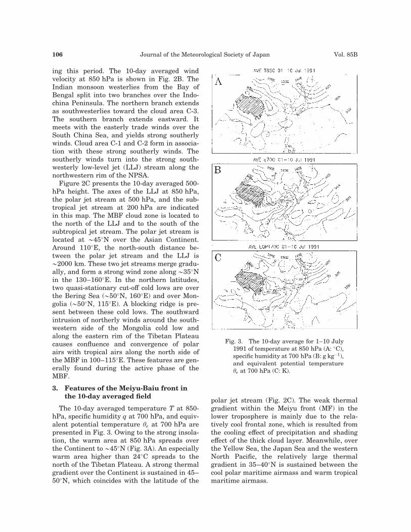
ing this period. The 10-day averaged windvelocity at 850 hPa is shown in Fig. 2B. TheIndian monsoon westerlies from the Bay ofBengal split into two branches over the Indo-china Peninsula. The northern branch extendsas southwesterlies toward the cloud area C-3.The southern branch extends eastward. Itmeets with the easterly trade winds over theSouth China Sea, and yields strong southerlywinds. Cloud area C-1 and C-2 form in associa-tion with these strong southerly winds. Thesoutherly winds turn into the strong south-westerly low-level jet (LLJ) stream along thenorthwestern rim of the NPSA.
Figure 2C presents the 10-day averaged 500-hPa height. The axes of the LLJ at 850 hPa,the polar jet stream at 500 hPa, and the sub-tropical jet stream at 200 hPa are indicatedin this map. The MBF cloud zone is located tothe north of the LLJ and to the south of thesubtropical jet stream. The polar jet stream islocated at @45�N over the Asian Continent.Around 110�E, the north-south distance be-tween the polar jet stream and the LLJ is@2000 km. These two jet streams merge gradu-ally, and form a strong wind zone along@35�Nin the 130–160�E. In the northern latitudes,two quasi-stationary cut-off cold lows are overthe Bering Sea (@50�N, 160�E) and over Mon-golia (@50�N, 115�E). A blocking ridge is pre-sent between these cold lows. The southwardintrusion of northerly winds around the south-western side of the Mongolia cold low andalong the eastern rim of the Tibetan Plateaucauses confluence and convergence of polarairs with tropical airs along the north side ofthe MBF in 100–115�E. These features are gen-erally found during the active phase of theMBF.
3. Features of the Meiyu-Baiu front inthe 10-day averaged field
The 10-day averaged temperature T at 850-hPa, specific humidity q at 700 hPa, and equiv-alent potential temperature ye at 700 hPa arepresented in Fig. 3. Owing to the strong insola-tion, the warm area at 850 hPa spreads overthe Continent to@45�N (Fig. 3A). An especiallywarm area higher than 24�C spreads to thenorth of the Tibetan Plateau. A strong thermalgradient over the Continent is sustained in 45–50�N, which coincides with the latitude of the
polar jet stream (Fig. 2C). The weak thermalgradient within the Meiyu front (MF) in thelower troposphere is mainly due to the rela-tively cool frontal zone, which is resulted fromthe cooling effect of precipitation and shadingeffect of the thick cloud layer. Meanwhile, overthe Yellow Sea, the Japan Sea and the westernNorth Pacific, the relatively large thermalgradient in 35–40�N is sustained between thecool polar maritime airmass and warm tropicalmaritime airmass.
Fig. 3. The 10-day average for 1–10 July1991 of temperature at 850 hPa (A: �C),specific humidity at 700 hPa (B: g kg�1),and equivalent potential temperatureye at 700 hPa (C: K).
106 Journal of the Meteorological Society of Japan Vol. 85B

At 700 hPa (Fig. 3B), low q is present tothe north of the Tibetan Plateau and over thepolar maritime areas. An area with very largeq (@10 g kg�1) protrudes eastward from thesoutheastern foot of the Tibetan Plateau as themoist tongue along the MBF. The largest q gra-dient of @5 g kg�1 (500 km)�1 appears alongthe MBF near 100–120�E. The MBF is thusidentified as the ‘‘moisture front’’. The ascend-ing motion in the moist tongue (Fig. 4A) indi-cates that the formation of the moist tongueis mainly owing to the vertical advection of q.The map of ye at 700 hPa (Fig. 3C) indicatesa similar pattern to the map of q. The largestye of @344 K is associated with the moisttongue, and the largest ye gradient of @15 K(500 km)�1 appears along the north side of theMBF.
The vertical velocity o at 500 hPa is pre-sented in Fig. 4A. The largest upward velocityof@�10 hPa h�1 appears over the intense rain-fall area of the MF. The strong subsidence oc-curs in both north and south sides of the MF.
Figure 4B shows the 10-day averaged ðQM/cpÞat 600 hPa. The apparent latent heat sourceQM is evaluated by
QM ¼ �Lðqq/qt þ uqq/qx þ vqq/qy þ oqq/qpÞð1Þ
The zone of large ðQM/cpÞ is present over theintense rainfall zone. The vertically (fromthe surface to 300 hPa) integrated apparentmoisture sink (QM/L, figure is not presented)reaches @35 mm d�1 in the intense rainfallzone (@30�N, 115�E). This value is consistentwith the observed precipitation averaged overthe width of the precipitation zone.
The winds at 200 hPa (Fig. 4C) show theTibetan anticyclone over @27�N, 85�E. Theeastern part of the Tibetan anticyclone mergeswith the west-east oriented narrow anticycloniczone over @27�N. At 200 hPa, the subtropicaljet stream with a maximum wind velocity of@40 m s�1 is along@40�N, and the easterly jetwith wind velocity of@25 m s�1 is elongated at@17�N.
The meridional-vertical cross sections along115�E of the 10-day averaged zonal wind veloc-ity u, meridional wind velocity v, vertical veloc-ity o, and equivalent potential temperature ye
are presented in Fig. 5. In these cross sections,the intense rainfall zone is in 29–33�N. In
Fig. 5A, the maximum of u around 700 hPa at@27�N is the MBF LLJ. The core of the sub-tropical jet stream is at @200 hPa near 37�N,and the easterly jet stream is at@100 hPa and17�N. In Fig. 5B, the large southerly winds (in925–600 hPa over @27�N) appear to the southof the intense rainfall zone, while the largenortherly winds (in 700–500 hPa over 37�N)appear to the north of the intense rainfall zone.The dominant meridional current in the upper
Fig. 4. A: The 10-day averaged vertical-p-velocity at 500 hPa (hPa h�1).B: The 10-day averaged �QM /cp (K d�1)at 600 hPa for 1–10 July 1991.C: The 10-day averaged wind velocity(m s�1) at 200 hPa for 1–10 July 1991.
July 2007 K. NINOMIYA and Y. SHIBAGAKI 107

troposphere is the northerly flow at 150 hPaand @25�N, which is the outflow from theupper-level anticyclone formed over the intenserainfall area. The strong low-level meridionalconvergence capped by the strong upper-levelmeridional divergence appears in the intenserainfall zone. Strong ascending motion is con-centrated within the intense rainfall zone, andsubsidence is on both the northern and south-ern sides of the ascending motion (Fig. 5C).
In Fig. 5D, a thick layer of vertically uniformye extends from 925 to 300 hPa within theintense rainfall zone near @30�N. Convectivelyunstable stratification is present in both thesubtropical and higher latitudes. In these re-
gions, convection is inhibited by the subsidence.The convective instability is released selec-tively only in the MBF, where the ascendingmotion is strong.
4. Influence of large-scale circulationson the Meiyu-Baiu front
As shown in Fig. 4A and Fig. 5C, strong as-cending motion appears within the MBF, whilestrong subsidence appears on the south sideof the MBF. The 10-day averaged divergenceat 850 hPa (Fig. 6A) shows a dipole of strongconvergence (in the MBF) and divergence (tothe south of the MBF) over southern China.The ageostrophic wind velocity ðua; vaÞ, which
Fig. 5. Meridional-height section along 115�E of 10-day averaged (A) u-component of wind (A; m s�1),v-component of wind (B: m s�1), vertical-p-velocity (C: hPa h�1), and equivalent potential tempera-ture (D: K) for 1–10 July 1991.
108 Journal of the Meteorological Society of Japan Vol. 85B
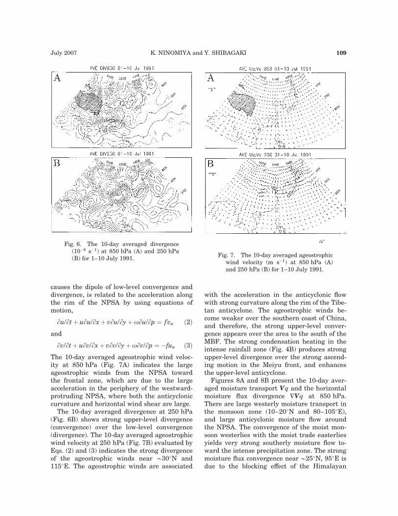
causes the dipole of low-level convergence anddivergence, is related to the acceleration alongthe rim of the NPSA by using equations ofmotion,
qu/qt þ uqu/qx þ vqu/qy þ oqu/qp ¼ fva ð2Þ
and
qv/qt þ uqv/qx þ vqv/qy þ oqv/qp ¼ �fua ð3Þ
The 10-day averaged ageostrophic wind veloc-ity at 850 hPa (Fig. 7A) indicates the largeageostrophic winds from the NPSA towardthe frontal zone, which are due to the largeacceleration in the periphery of the westward-protruding NPSA, where both the anticycloniccurvature and horizontal wind shear are large.
The 10-day averaged divergence at 250 hPa(Fig. 6B) shows strong upper-level divergence(convergence) over the low-level convergence(divergence). The 10-day averaged ageostrophicwind velocity at 250 hPa (Fig. 7B) evaluated byEqs. (2) and (3) indicates the strong divergenceof the ageostrophic winds near @30�N and115�E. The ageostrophic winds are associated
with the acceleration in the anticyclonic flowwith strong curvature along the rim of the Tibe-tan anticyclone. The ageostrophic winds be-come weaker over the southern coast of China,and therefore, the strong upper-level conver-gence appears over the area to the south of theMBF. The strong condensation heating in theintense rainfall zone (Fig. 4B) produces strongupper-level divergence over the strong ascend-ing motion in the Meiyu front, and enhancesthe upper-level anticyclone.
Figures 8A and 8B present the 10-day aver-aged moisture transport Vq and the horizontalmoisture flux divergence ‘Vq at 850 hPa.There are large westerly moisture transport inthe monsoon zone (10–20�N and 80–105�E),and large anticyclonic moisture flow aroundthe NPSA. The convergence of the moist mon-soon westerlies with the moist trade easterliesyields very strong southerly moisture flow to-ward the intense precipitation zone. The strongmoisture flux convergence near @25�N, 95�E isdue to the blocking effect of the Himalayan
Fig. 6. The 10-day averaged divergence(10�6 s�1) at 850 hPa (A) and 250 hPa(B) for 1–10 July 1991.
Fig. 7. The 10-day averaged ageostrophicwind velocity (m s�1) at 850 hPa (A)and 250 hPa (B) for 1–10 July 1991.
July 2007 K. NINOMIYA and Y. SHIBAGAKI 109

Mountains, while the large moisture conver-gence in the MBF is due to the large influxalong the northwestern rim of the NPSA.Strong moisture flux divergence exists near@22�N, 110�E, where strong subsidence takesplace.
The 10-day averaged zonal moisture flux di-vergence ðquq/qxÞ and the meridional moistureflux divergence ðqvq/qyÞ at 850 hPa are furtherexamined (see Fig. 10 of Ninomiya 2000). Theseterms are actually calculated in the l–f coordi-nate system. The zonal moisture flux conver-gence is very strong over the South China Sea,where the Indian monsoon westerlies meet thetrade easterly winds. This strong zonal mois-ture flux convergence causes the large south-erly moisture flux toward the frontal zone, andthe strong meridional moisture flux divergenceover the monsoon confluence region. Thus, themonsoon confluence zone plays the role ofthe channel transporting the moisture fromthe tropical oceanic region toward the MBF.
Meanwhile, the meridional moisture flux con-vergence is very strong within the intense rain-fall zone over China. Large parts of the meri-dional moisture flux convergence are consumedas precipitation, but the remaining parts aretransported eastward. Thus, the Meiyu frontalzone plays the role to transport the moisturefrom the monsoon confluence region to theBaiu frontal zone.
Figure 9A shows the 10-day averaged�ðqye/qpÞ in the layer between 850 and500 hPa. The stratification over oceanic areasnorth of @35�N is convectively stable. Thestratification over the oceanic areas south of@30�N, and the continental area south of@45�N, is convectively unstable. In these areas,the subsiding motion inhibits the cumulus con-vection, and therefore the unstable stratifica-tion is maintained.
The intense convective precipitation zone ofMBF is characterized by the nearly moist neu-
Fig. 8. A: The 10-day averaged moistureflux Vq (g kg�1 m s�1) at 850 hPa for1–10 July 1991.B: The moisture flux divergence div Vq(10�5 g kg�1 s�1) at 850 hPa.
Fig. 9. A: The 10-day averaged verticalstability �qye/qp (K (100 hPa)�1) in850–500 hPa.B: Differential advection of ye,q½ðuqye/qx þ vqye/qy þ oqye/qpÞ�/qp (K(100 hPa)�1 d�1) in 850–500 hPa for 1–10 July 1991.
110 Journal of the Meteorological Society of Japan Vol. 85B

tral stratification (Fig. 9A and Fig. 5D). This in-dicates the release of the convective instabilityowing to the cumulus convection. For the suste-nance of the strong convective precipitationfor more than 10 days, successive generation ofconvective instability, against the stabilizingeffect of the convective clouds, is needed. Thelocal time change of convective stability due tothe differential advection of ye is expressed by
½�qðqye/qpÞ/qt�ADV
¼ q½ðuqye/qx þ vqye/qy þ oqye/qpÞ�/qp ð4Þ
The 10-day averaged value of ½�qðqye/qpÞ/qt�ADV
evaluated for the layer between 850 and500 hPa is shown in Fig. 9B. The negative dif-ferential advection (generation of convective in-stability) is present over the MBF. The differen-tial advection generates convective instability,while the convective clouds release the instabil-ity. As the result, the large precipitation andnearly moist neutral stratification are main-tained within the MBF.
We next discuss the sustenance of the stronggradient of ye along the northern side of theMBF (Fig. 3C). Ninomiya (1984) studied the ef-fects of the large-scale circulation on the fronto-genesis by evaluating dj‘yej/dt. Since the MBFremains quasi-stationary at the almost sameplace during the studied period, we evaluateqj‘yej/qt at 700 hPa due to large-scale advec-tion by
½qj‘yej/qt�ADV
¼ �½ðqye/qxÞ2 þ ðqye/qyÞ2��1/2
� ½ðqye/qxÞqfuðqye/qxÞ þ vðqye/qyÞ
þ oðqye/qpÞg/qx
þ ðqye/qyÞqfuðqye/qxÞ þ vðqye/qyÞ
þ oðqye/qpÞg/qy� ð5Þ
The 10-day averaged value of ½qj‘yej/qt�ADV at700 hPa shows (see Fig. 14B of Ninomiya2000) large value of @30 K (1000 km)�1 d�1
over the northern side of the MBF. This large½qj‘yej/qt�ADV sustains the strong gradient of ye
against the decrease of ye in the lower tropo-sphere due to the convective transport of ye.
5. Meiyu-Baiu frontal disturbances
As pointed out by many authors (e.g.,Matsumoto and Tsuneoka 1970; Ninomiya and
Akiyama 1971; Akiyama 1984, 1989; Ninomiyaand Akiyama 1992), the MBF cloud zone is arow of cloud systems of various scales alignedalong the front.
The latitude-time section of TBB along the129.5�E meridian for 25 June–15 July 1991(Fig. 10) shows the temporal variations ofthe MBF cloud zone. The MBF cloud zone (30–35�N) is clearly separated from the ITCZ (0–10�N) and the polar frontal cloud zone (45–60�N) by areas of small cloud amount. In Fig.10, cloud systems on 29 June, 1, 4 and 7 Julyexhibit relatively wide north-south extension,while other cloud systems have smaller north-south extension.
On successive TBB maps (see Fig. 9 of Nino-miya and Shibagaki 2003), the MBF appearsas the chain of cloud systems of the subsynop-tic- and meso-scale. These cloud systems propa-gate eastward along the MBF with a speed of@1000 km d�1. The major cloud systems accom-pany cyclonic vorticity cores at 850 and 500 hPa(Fig. 15 in Section 7).
The longitude-time section of z850 (850 hPavorticity) along 35�N, and that of TBB along
Fig. 10. Latitude-time section of TBBalong 129.5�E meridian. The isoplethsare given at 10�C intervals and the mi-nus sign of TBB is omitted. The stip-pling indicates an area where TBB isless than �30�C.
July 2007 K. NINOMIYA and Y. SHIBAGAKI 111

33.5�N are presented in Figs. 11A and 11B, re-spectively. Large diurnal variations of cloudsare seen in the 90–105�E zone (Fig. 11B).These cloud systems, which develop in the af-ternoon within the anticyclonic circulation, arenot sustained in the night. Significant diurnalvariation is not seen in the MBF. The longi-tude-time section (Fig. 11A) shows eastwardpropagation of the core of z850 with cloud sys-tems. However, Fig. 11B shows finer structureof cloud systems as compared with z850 becausethe TBB data have higher resolution. The
wavelength of the major disturbances in Fig.11B is estimated to be @2000 km, which fallson the border between macro-b- and meso-a-scale (Orlanski 1975). Therefore, these distur-bances are identified as subsynoptic-scale MBFdisturbances in the present report. Some au-thors (e.g., Matsumoto et al. 1971; Ninomiyaand Akiyama 1971; Ninomiya and Yamazaki1979; Yoshizumi 1977) indicated them asmedium-scale disturbances.
We next examine temporal variations of V850
(850 hPa wind velocity), o500 (500 hPa verticalvelocity) and T850 (850 hPa temperature) bycalculating the standard deviations of thesequantities within the 10-day period. For exam-ple, the standard deviation of temperature T isdefined at each grid point as
STDðTÞ ¼ ½SðT � TmÞ2/N �1/2 ð7Þ
Here, Tm is the average value within the 10-day period, and N is the number of samples (inthis case, N ¼ 20; 12-hourly data over 10 days).
The STD ðV850Þ in Fig. 12A and STD ðo500Þin Fig. 12B are large within the MBF in 115–160�E. It is notable that STD ðo500Þ alreadyattains its maximum in the area of intenseprecipitation over China, while STD ðV850Þ in-creases gradually on the downstream side ofthe intense precipitation area and has a maxi-mum of @8 m s�1 over the Japan Islands. Thisindicates that the MBF disturbances are gener-ated in the Meiyu frontal zone as convectivesystems, and then develop into subsynoptic-scale circulation systems as they propagateeastward. These disturbances reach the maturestage within@1 day after the generation in theintense precipitation region.
The distribution of STD ðT850Þ in Fig. 12C hasdifferent features from STD ðV850Þ and STDðo500Þ. The STD ðT850Þ is very small in the in-tense precipitation region over China, wherethe horizontal thermal gradient is small. Thearea of relatively large STD ðT850Þ in the Baiufront in 135–160�E indicates the developmentof the disturbances is owing to the baroclinicinstability.
As seen in Fig. 11B, a few meso-a-scalecloud systems occur between the successivesubsynoptic-scale cloud systems. Many of themeso-a-scale cloud systems are accompanied byvorticity maximum at 850 and 500 hPa. Mean-while, smaller mesoscale cloud systems are not
Fig. 11. A: The longitude-time section of850 hPa vorticity z850 (unit in 10�6 s�1)at 35�N.B: The longitude-time section of TBBat 32.5�N. The isopleths are at 10�C in-tervals, and the minus sign of TBB isomitted.
112 Journal of the Meteorological Society of Japan Vol. 85B

necessarily associated with the significant vor-ticity maxima, and are not sustained beyond@20 hours.
According to Eady’s baroclinic instabilitymodel (Gill 1982), the maximum growth rate ofthe baroclinic wave, smax, is given by
smax ¼ 0:310ð f /NÞðqUg/qzÞ; ð6Þ
at the wave number defined by
NkH ¼ 0:803f ; ð7Þ
N, k, H, f , and ðqUg/qzÞ are the Brunt-Vaisallafrequency ðN2 ¼ gq ln y/qzÞ, wave number inthe direction of the thermal wind vector, halfdepth of the layer in which the disturbances ex-ists, Coriolis parameter and the vertical shearof the geostrophic wind velocity, respectively.The wavelength of the most unstable baroclinicwave and its growth rate are estimated fromthe 10-day averaged quantities in the lower tro-posphere within 125–140�E. We obtain a wave-length of@3100 km, and the maximum growthrate of @5:4 � 10�6 s�1, which corresponds tothe e-folding time of @48 hours. This estimateof the most unstable baroclinic wave coincides,roughly speaking, with the wavelength of thesubsynoptic-scale frontal disturbances.
For the meso-a-scale frontal cloud systems,ye should be used for the evaluation, since thecloud zone is very moist in 1000–700 hPa layer.When N is replaced by N � ðN�2 ¼ gq ln ye/qzÞ,the wavelength of the most unstable wave is@600 km and its growth rate is 2:8 � 10�5 s�1,which corresponds to the e-folding time of @10hour. These values are consistent, at least qual-itatively, with the observed spacing betweenthe meso-a-scale cloud systems in the MBF. Itshould be also mentioned that the MBF andcloud systems interact each other. While thefront provides environmental conditions favor-able for the cloud systems, the successive devel-opment of the cloud systems works to sustainthe moist neutral stratification of the front.
The meso-a-scale cloud systems begin to de-velop over the area of intense precipitationaround @115�E, where the horizontal thermalgradient is very weak. This fact suggests theimportant role of condensation heating for thegeneration of the mesoscale convective systems,as theoretically discussed by Tokioka (1973).
6. Influence of the mid-latitudedisturbances on Meiyu-Baiu front
In the latitude-time section of TBB along the129.5�E meridian (Fig. 10), cloud systems on 29June, 1, 4 and 7 July exhibit relatively widenorth-south extension. The case of 6–7 Julyis discussed referring Ninomiya (2001). Figure13A shows the map of TBB for 00 UTC 6 July1991. The narrow north-south extending cloudzone (hereafter noted as N-S cloud zone) ex-tends northward from the MBF over @120�E.At this stage, the north-south extension of the
Fig. 12. Standard deviation of wind ve-locity (m s�1) at 850 hPa (A), vertical-p-velocity (hPa h�1) at 500 hPa (B), andtemperature (K) at 850 hPa (C) for 1–10 July 1991.
July 2007 K. NINOMIYA and Y. SHIBAGAKI 113

cloud zone reaches to@2500 km and the wholecloud system exhibits the large l-shaped cloudpattern. The maximum 1-day precipitation inthe MBF and in the N-S cloud zone reaches to@150 and@50 mm d�1, respectively.
Figure 13B shows 500-hPa height field at 00UTC 6 July. The location of the surface depres-
sion and the MBF are presented in this map.Figure 13C shows the distribution of potentialvorticity on 324 K isentropic surface. Two coldcut-off lows are located over 48�N, 107�Eand 53�N, 154�E. A developed quasi-stationaryridge extends over @125�E meridian betweenthe cold lows. A MBF depression is generatedaround 115�E under the influence of the short-wave trough over @35�N and 115�E. The N-Scloud zone is formed to the east of ‘‘the coupledtrough’’, which is recognized as a maximumzone of potential vorticity elongating from theshort-wave trough in the northern latitude to-ward the short-wave trough in the southernlatitude.
The ascending motions appear in both theMBF and the N-S cloud zone (not presented).We demonstrate the quasi-geostrophic verticalcirculation associated with the coupled troughsand the quasi-stationary ridge by presentingdiv Q. The Q-vector ðQ1;Q2Þ is defined by
Q1 ¼ � R
p
� �qug
qx� qT
qxþ qvg
qx� qT
qy
� �ð8Þ
and
Q2 ¼ � R
p
� �qug
qy� qT
qxþ qvg
qy� qT
qy
� �ð9Þ
The div Q obtained for 00 UTC 6 July 1991(see Fig. 10A of Ninomiya 2001) shows a zoneof positive value (subsidence) to the east of thequasi-stationary ridge and a zone of negativevalue (ascending) to the east of the coupledtrough. Thus, the distribution of div Q is con-sistent with the cloud pattern.
Figure 14 summarizes the features of circula-tion systems which caused the l-shaped cloudzone. In this figure, locations of the northernshort-wave trough and the southern short-wave trough are given at 24-hour interval. Thelocations of the MBF depression, cut-off lowsand the quasi-stationary ridge at 500 hPa at00 UTC 6 July are also presented. The axesof the maximum wind zones at 500- and 850-hPa in the 10-day averaged field for 1–10 Julyare also illustrated. The northern short-wavetrough around the cut-off low (@50�N and105�E), propagates along the northern maxi-mum wind zone. The southern short-wavetrough propagates along the north side of theMBF maximum wind zone at 500 hPa. The
Fig. 13. A: Map of TBB at 00 UTC 6 July1991. The minus sign of TBB is omit-ted. The stippling indicates area whereTBB is colder than �30�C.B: The 500 hPa height at 00 UTC 6July 1991. The locations of surface de-pressions and the MBF are shown.C: the potential vorticity (unit in10�7 K kg�1 m2 s�1) on 324 K isen-tropic surface at 00 UTC 6 July 1991.
114 Journal of the Meteorological Society of Japan Vol. 85B
MBF depression is generated to the east of theTibetan Plateau when the southern short-wavetrough passes over the Plateau. Within the lon-gitudinal zone in 105–120�E, the elongatingtrough is formed by the coupling of the north-ern and southern short-wave troughs. Thecoupled trough and the N-S cloud zone becomespredominant on 6 July.
7. Family of the mesoscale cloud systemin MBF
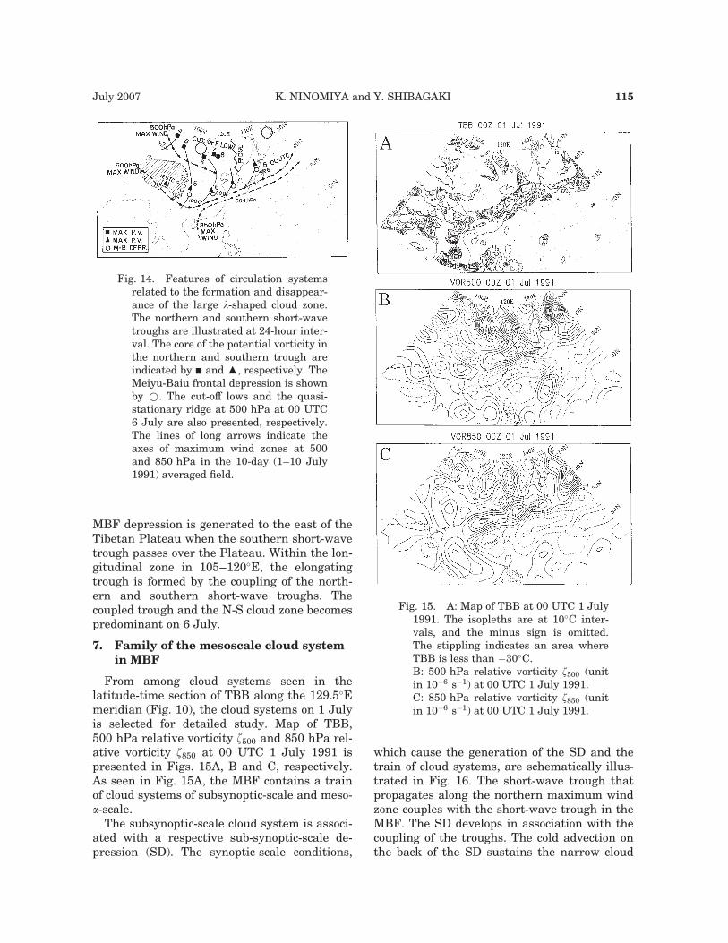
From among cloud systems seen in thelatitude-time section of TBB along the 129.5�Emeridian (Fig. 10), the cloud systems on 1 Julyis selected for detailed study. Map of TBB,500 hPa relative vorticity z500 and 850 hPa rel-ative vorticity z850 at 00 UTC 1 July 1991 ispresented in Figs. 15A, B and C, respectively.As seen in Fig. 15A, the MBF contains a trainof cloud systems of subsynoptic-scale and meso-a-scale.
The subsynoptic-scale cloud system is associ-ated with a respective sub-synoptic-scale de-pression (SD). The synoptic-scale conditions,
which cause the generation of the SD and thetrain of cloud systems, are schematically illus-trated in Fig. 16. The short-wave trough thatpropagates along the northern maximum windzone couples with the short-wave trough in theMBF. The SD develops in association with thecoupling of the troughs. The cold advection onthe back of the SD sustains the narrow cloud
Fig. 14. Features of circulation systemsrelated to the formation and disappear-ance of the large l-shaped cloud zone.The northern and southern short-wavetroughs are illustrated at 24-hour inter-val. The core of the potential vorticity inthe northern and southern trough areindicated by n and C, respectively. TheMeiyu-Baiu frontal depression is shownby c. The cut-off lows and the quasi-stationary ridge at 500 hPa at 00 UTC6 July are also presented, respectively.The lines of long arrows indicate theaxes of maximum wind zones at 500and 850 hPa in the 10-day (1–10 July1991) averaged field.
Fig. 15. A: Map of TBB at 00 UTC 1 July1991. The isopleths are at 10�C inter-vals, and the minus sign is omitted.The stippling indicates an area whereTBB is less than �30�C.B: 500 hPa relative vorticity z500 (unitin 10�6 s�1) at 00 UTC 1 July 1991.C: 850 hPa relative vorticity z850 (unitin 10�6 s�1) at 00 UTC 1 July 1991.
July 2007 K. NINOMIYA and Y. SHIBAGAKI 115

zone in the long trailing portions of the SD. Oneseries of the cloud zone with a length of@2000 km consists of a family of subsynoptic-scale cloud system and meso-a-scale cloud sys-tems aligned along the trailing portion of thepreceding SD.
A few mesoscale inner-systems are seenwithin a subsynoptic-scale cloud system. Activeconvective clouds are favored in its southwest-ern portion, and banded structures of cloudsare found.
The cold TBB and sharp boundary of the coldTBB area of the meso-a-scale cloud systemsindicate that the main part of them consistsof active convective clouds. They appear on sat-ellite cloud images (not presented) as eitheroval-shaped cloud clusters or leaf-shaped cloudsystems with a cloud band in its southwesterntail.
These meso-a-scale cloud systems are classi-fied into three types according to their lifetimeand the magnitude of the associated vorticity.
Type-A meso-a-scale cloud systems are ac-companied by the cyclonic vorticity in the lowerand middle troposphere. The magnitude of thevorticity is less than 4 � 10�5 s�1, which issmaller than that of the subsynoptic-scaledepression. They do not necessarily developinto a frontal depression. They form withinthe moist and convectively unstable airmassover the southern China and develop as theypropagate along the MBF. The lowest TBB is@�60�C. The horizontal spacing between thesubsynoptic-scale cloud systems and/or meso-a-scale cloud systems is@500 km.
Type-B meso-a-scale cloud systems are ac-companied by cyclonic vorticity in the lower tro-posphere. They form within the moist and con-vectively unstable airmass over southern Chinaand weaken when they propagate into the sta-ble airmass. The lowest TBB of the cloud sys-tem is @�50�C, and their horizontal extent is@200 km.
Type-C meso-a-scale cloud systems areformed over the southern China to the south ofthe Meiyu front, during the afternoon due tostrong insolation heating. Many of them arenot sustained beyond 12 hours.
On the basis of the aforementioned features,a conceptual model of the meso-scale cloud sys-tem family in the MBF is proposed in Fig. 16.
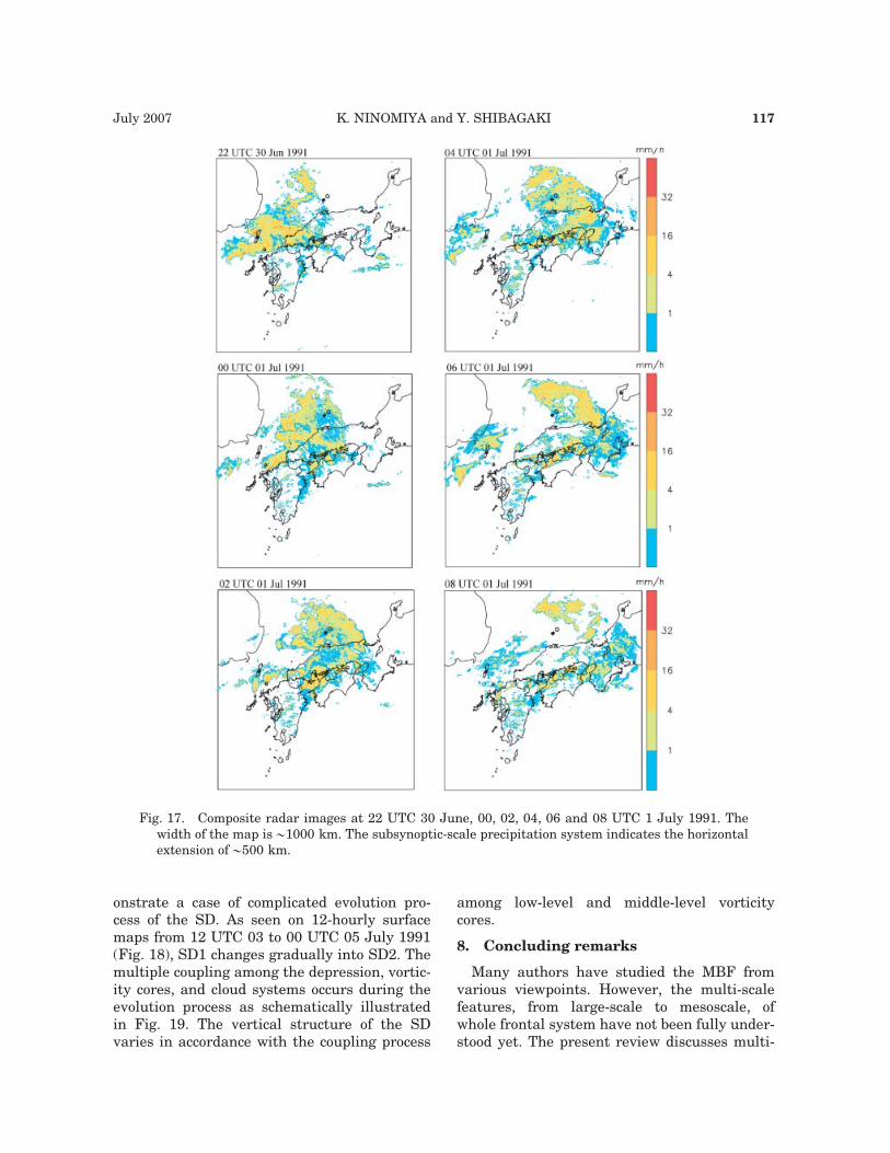
Radar observations show the inner fine struc-ture in the cloud systems. As examples, com-posite radar images at 21 UTC 30 June, 00, 03and 06 UTC 1 July 1991 are presented in Fig.17. A sub-synoptic-scale and a following meso-a-scale precipitation system are seen in theseimages. The organization of the convective cellsin these precipitation systems varies rapidlywith time. A few bands of convective cells areformed in the trailing portion of the precipita-tion systems. Variations in the vertical motionassociated with the passage of organized con-vections in these cloud systems are analyzedby MU radar (Shibagaki et al. 1997, 2000).
As already discussed, SD develops in associa-tion with low and middle-level vorticity coreand meso-a-scale cloud systems. However, thesimple one-to-one correspondence among themis not necessary lasted for the whole life timeof a SD. Shibagaki and Ninomiya (2005) dem-
Fig. 16. Conceptual model of the MBFcloud zone. The cloud zone consists ofa few ‘‘cloud system families’’. A‘‘cloud system family’’ consists of a sub-synoptic-scale cloud system of a SD(indicated by S) and a few meso-a-scalecloud systems (indicated by a).
Cold lows and a blocking ridge in themiddle latitudes, and the NPSA havestrong influences on the MBF cloud sys-tems. Rows of large and small arrowsindicate the 500-hPa and 850-hPamaximum wind axes respectively. Theshort-wave trough that propagatesalong the northern maximum windzone couples with the short-wavetrough in the MBF. The SD develops inassociation with the coupling of thetroughs. Then a few meso-a-scale cloudclusters form along the trailing portionof the preceding SD.
116 Journal of the Meteorological Society of Japan Vol. 85B
onstrate a case of complicated evolution pro-cess of the SD. As seen on 12-hourly surfacemaps from 12 UTC 03 to 00 UTC 05 July 1991(Fig. 18), SD1 changes gradually into SD2. Themultiple coupling among the depression, vortic-ity cores, and cloud systems occurs during theevolution process as schematically illustratedin Fig. 19. The vertical structure of the SDvaries in accordance with the coupling process
among low-level and middle-level vorticitycores.
8. Concluding remarks
Many authors have studied the MBF fromvarious viewpoints. However, the multi-scalefeatures, from large-scale to mesoscale, ofwhole frontal system have not been fully under-stood yet. The present review discusses multi-
Fig. 17. Composite radar images at 22 UTC 30 June, 00, 02, 04, 06 and 08 UTC 1 July 1991. Thewidth of the map is@1000 km. The subsynoptic-scale precipitation system indicates the horizontalextension of@500 km.
July 2007 K. NINOMIYA and Y. SHIBAGAKI 117

scale features of the MBF and associated cloudsystems observed during 1–10 July 1991 basedon recent studies. Important features describedin the present review are:
(1) The west-to-east elongated MBF cloud zonewith intense rainfalls is characterized bythe strong moisture gradient and the inte-rior moist-neutral stratification. Such MBFappears in the specific periods of the MBseason.
(2) The west-to-east elongated MBF with in-tense precipitation is sustained under thespecific large-scale conditions, such as thewestward protruding NPSA and confluenceof the Indian monsoon westerlies with thePacific trade easterly winds, development ofthe blocking ridge over 130–140�E, and twocold lows to the east and west of the block-ing ridge.
(3) A dipole of the low-level convergence in
the MBF and divergence to the south ofthe MBF is a significant feature in thewest-to-east elongated MBF. This dipole isowing to the strong ageostrophic winds inthe western periphery of the westward pro-truding NPSA.
(4) During the 10-day period, four subsynoptic-scale cloud systems associated with SDsformed with a time interval of 2–3 days(wavelengths of 2000–3000 km), when thewesterly troughs in the middle latitudescouple with the short wave troughs inMBF. The subsynoptic-scale cloud systemconsists of mesoscale convective systemsand widespread clouds in its southern andnortheastern portions, respectively.
(5) The cold advection on the back of the SDsustains a cloud zone along its long trailingportion. A few meso-a-scale convective cloudsystems develop in the long trailing portionof the preceding SD. Thus, the west-to-eastelongated Meiyu-Baiu cloud zone consistsof a few ‘‘cloud system families’’. A ‘‘cloudsystem family’’ consists of a precedingsub-synoptic-scale cloud system and a fewmeso-a-scale cloud systems which arealigned along the trailing portion of the pre-ceding subsynoptic-scale cloud system.
(6) Meso-a-scale cloud systems have featuresof oval-shaped cloud cluster or leaf-shapedcloud systems with a cloud band in itssouthwestern portion. Meso-b-g-scale innerconvective systems are seen in meso-a-scalecloud systems. Meso-a-scale cloud systemsare categorized into three types based onthe horizontal extent of the cloud area, du-ration, and the magnitude of the associatedvorticity. Type-A and Type-B meso-a-scalecloud systems last for 20–30 hours. TheType-A meso-a-scale cloud systems are ac-companied by cyclonic vorticity in the lowerand middle troposphere, while the Type-Bmeso-a-scale cloud systems are only accom-panied by low-level vorticity. The shorter-lived Type-C meso-a-scale cloud systemsare not accompanied by a cyclonic vorticitycore.
(7) The multiple coupling among the depres-sion, vorticity cores, and cloud systems oc-curs during the evolution process of theSD. The vertical structure of the SD variesin accordance with the coupling process
Fig. 18. 12-hourly surface maps from 12UTC 03 to 00 UTC 05 July 1991.
118 Journal of the Meteorological Society of Japan Vol. 85B

among low-level and middle-level vorticitycores.
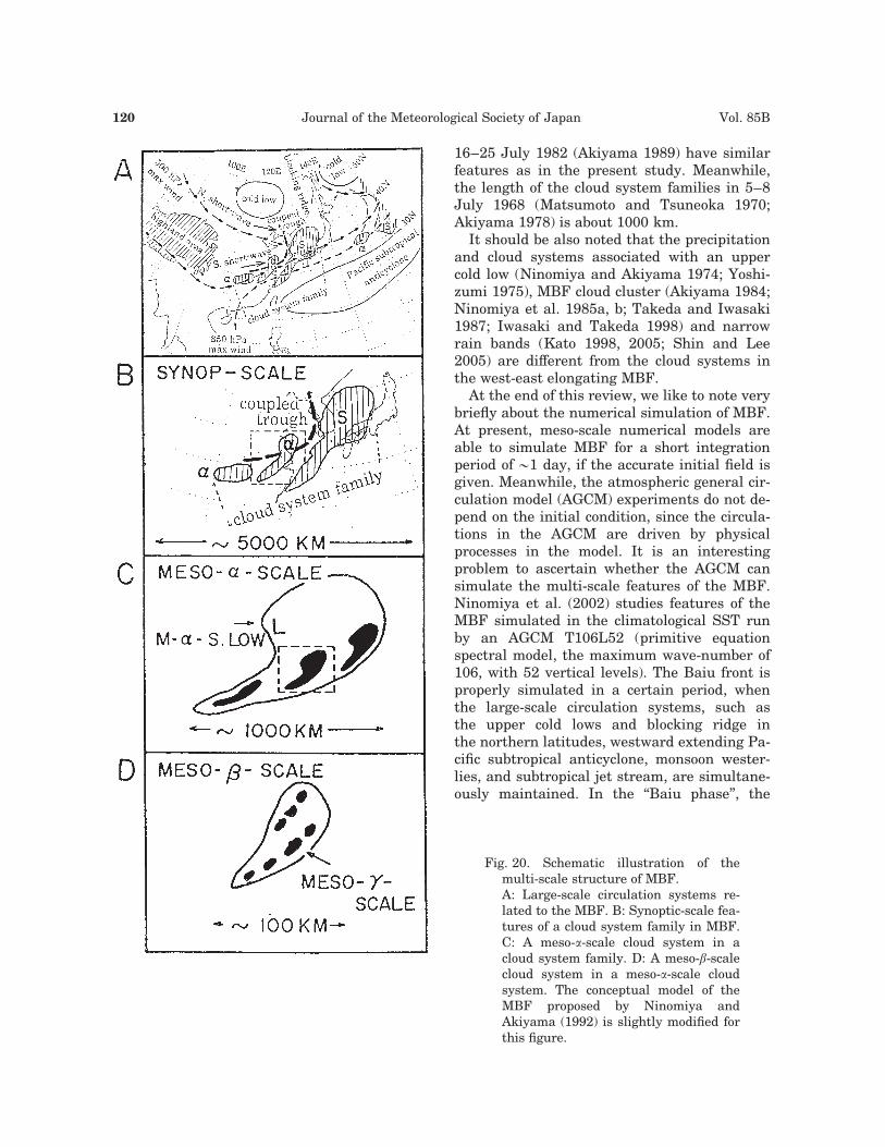
On the basis of the aforementioned features,a conceptual model of the MBF proposed by Ni-nomiya and Akiyama (1992) is slightly modifiedas shown in Fig. 20. It should be noted thatthe ‘‘concept of the synoptic-scale MBF’’ cannot applied for the meso-scale analysis. In themeso-scale map, we only recognize ‘‘the frontal
zone’’. The narrow cloud bands in the trailingportion of the SD or meso-a-scale system is notthe MBF itself. They should be regarded as afine-structure in the frontal zone. Although themulti-scale structure of the Meiyu-Baiu cloudzone is evident, the physical reasons why a fewkinds of cloud systems are coexisting in thefrontal zone have not been explained.
The results of the previous papers should becompared with the present paper. The cases in
Fig. 19. Schematic illustration of the multiple coupling among the depressions (SD1 and SD2), vor-ticity cores (z850-a, z850-b, z850-c, z500-a, z500-b and z500-c) and cloud systems (CS-A and CS-B).MbCS is an active meso-b-scale cloud system in CS-A. Dashed line indicates vertical trough axisof SD. The vertical structure of the SD varies in accordance with the coupling process among low-level and middle-level vorticity cores. F-, D- and M-stage indicates formation, development andmature stage of the SD, respectively.
July 2007 K. NINOMIYA and Y. SHIBAGAKI 119
16–25 July 1982 (Akiyama 1989) have similarfeatures as in the present study. Meanwhile,the length of the cloud system families in 5–8July 1968 (Matsumoto and Tsuneoka 1970;Akiyama 1978) is about 1000 km.
It should be also noted that the precipitationand cloud systems associated with an uppercold low (Ninomiya and Akiyama 1974; Yoshi-zumi 1975), MBF cloud cluster (Akiyama 1984;Ninomiya et al. 1985a, b; Takeda and Iwasaki1987; Iwasaki and Takeda 1998) and narrowrain bands (Kato 1998, 2005; Shin and Lee2005) are different from the cloud systems inthe west-east elongating MBF.
At the end of this review, we like to note verybriefly about the numerical simulation of MBF.At present, meso-scale numerical models areable to simulate MBF for a short integrationperiod of @1 day, if the accurate initial field isgiven. Meanwhile, the atmospheric general cir-culation model (AGCM) experiments do not de-pend on the initial condition, since the circula-tions in the AGCM are driven by physicalprocesses in the model. It is an interestingproblem to ascertain whether the AGCM cansimulate the multi-scale features of the MBF.Ninomiya et al. (2002) studies features of theMBF simulated in the climatological SST runby an AGCM T106L52 (primitive equationspectral model, the maximum wave-number of106, with 52 vertical levels). The Baiu front isproperly simulated in a certain period, whenthe large-scale circulation systems, such asthe upper cold lows and blocking ridge inthe northern latitudes, westward extending Pa-cific subtropical anticyclone, monsoon wester-lies, and subtropical jet stream, are simultane-ously maintained. In the ‘‘Baiu phase’’, the
Fig. 20. Schematic illustration of themulti-scale structure of MBF.A: Large-scale circulation systems re-lated to the MBF. B: Synoptic-scale fea-tures of a cloud system family in MBF.C: A meso-a-scale cloud system in acloud system family. D: A meso-b-scalecloud system in a meso-a-scale cloudsystem. The conceptual model of theMBF proposed by Ninomiya andAkiyama (1992) is slightly modified forthis figure.
120 Journal of the Meteorological Society of Japan Vol. 85B

synoptic- and meso-a-scale features of the MBFare simulated, for a certain extent. In thisphase, a few meso-a-scale precipitation systemsare generated in the trailing portion of the pre-ceding depression, and form a ‘‘MBF precipita-tion system family’’ with a length of@2000 km.In both real and model atmospheres, properlarge-scale conditions are necessary for the for-mation of the MBF with multi-scale structure.
Acknowledgment
The present authors would like to expresstheir sincere thinks to many colleagues andfriends for their supports and advices forthe present study. The present authors extendtheir special thanks to Dr. N. Yamazaki of Me-teorological Research Institute for providingGMS data.
References
Akiyama, T., 1973: The large-scale aspects of thecharacteristic features of the Baiu front. Pap.Meteor. Geophy., 24, 157–188.
Akiyama, T., 1975: Southerly transversal moistureflux into the extremely intense rainfall zone inthe Baiu season. J. Meteor. Soc. Japan, 53,304–316.
Akiyama, T., 1978: Meso-scale pulsation of convec-tive rain in medium-scale disturbances devel-oped in Baiu front. J. Meteor. Soc. Japan, 56,267–283.
Akiyama, T., 1984: A medium-scale cloud cluster in aBaiu front. Part 1: Evolution process and finestructure. J. Meteor. Soc. Japan, 62, 485–504.
Akiyama, T., 1989: Large, synoptic and meso-scalevariations of the Baiu front during July 1982.Part 1: Cloud features. J. Meteor. Soc. Japan,67, 57–81.
Akiyama, T., 1990a: Large, synoptic and meso-scalevariations of the Baiu front during July 1982.Part 2: Frontal structure and disturbances. J.Meteor. Soc. Japan, 68, 559–574.
Akiyama, T., 1990b: Large, synoptic and meso-scalevariations of the Baiu front during July 1982.Part 3: Space-time scale and structure of fron-tal disturbances. J. Meteor. Soc. Japan, 68,705–727.
Ding, Y.-H., 1991: Monsoon over China, Kluwer Aca-demic Pub. 419 pp.
Gill, A.E., 1982: Atmosphere-ocean dynamics. Aca-demic Press, 602 pp.
Iwasaki, H. and T. Takeda, 1993: Structure and be-havior of meso-scale cloud clusters travelingover the Baiu-frontal zone. J. Meteor. Soc.Japan, 71, 733–747.
Kato, T., 1998: Numerical simulation of the band-shaped torrential rain observed over southernKyushu, Japan on 1 August 1993. J. Meteor.Soc. Japan, 76, 97–128.
Kato, T., 2005: Structure of the band-shaped precipi-tation system inducing the heavy rainfall ob-served over northern Kyushu, Japan on 29June 1999. J. Meteor. Soc. Japan, 84, 129–153.
Kawamura, R. and T. Murakami, 1998: Baiu nearJapan and its relation to summer monsoonsover Southeast Asia and the western North Pa-cific. J. Meteor. Soc. Japan, 76, 619–639.
Kawamura, R., T. Murakami, and B. Wang, 1996:Tropical and mid-latitude 45-day perturbationsover the western Pacific during the northernsummer. J. Meteor. Soc. Japan, 74, 867–890.
Kodama, Y.-M. 1992: Large-scale common features ofsubtropical precipitation zones (the Baiu fron-tal zone, the SPCZ, and the SACZ). Part I:Characteristics of subtropical frontal zones. J.Meteor. Soc. Japan, 70, 813–836.
Kodama, Y.-M., 1993: Large-scale common featuresof subtropical convergence zones (the Baiufrontal zone, the SPCZ, and the SACZ). PartII: Conditions of the circulations for generatingthe STCZs. J. Meteor. Soc. Japan, 71, 581–610.
Kodama, Y.-M., 1999: Roles of the atmospheric heatsources in maintaining the subtropical conver-gence zones -an aqua-planet GCM study. J. At-mos. Sci., 56, 4032–4049.
Lu, R. and B. Dong, 2001: Westward extension ofNorth Pacific subtropical high in summer. J.Meteor. Soc. Japan, 79, 1229–1241.
Matsumoto, S. and Y. Tsuneoka, 1970: Time-lapsecomposite echo pattern of wave disturbancesembedded in the Baiu front. J. Meteor. Soc.Japan, 48, 189–203.
Matsumoto, S., K. Ninomiya, and S. Yoshizumi,1971: Characteristics of the Baiu front withheavy rainfall. J. Meteor. Soc. Japan, 49, 267–281.
Matsumoto, S., S. Yoshizumi, and M. Takeuchi,1970: On the structure of the Baiu front andassociated intermediate-scale disturbances inthe lower atmosphere. J. Meteor. Soc. Japan,48, 479–491.
Murakami, T., J. Matsumoto, and A. Yatagai, 1999:Similarities as well as differences betweensummer monsoons over Southeast Asia andwestern North Pacific. J. Meteor. Soc. Japan,77, 887–906.
Ninomiya, K., 1978: Heavy rainfalls associated withfrontal depression in Asian subtropical humidregion. J. Meteor. Soc. Japan, 56, 253–266.
Ninomiya, K., 1984: Characteristics of Baiu front asa predominant subtropical front in the summer
July 2007 K. NINOMIYA and Y. SHIBAGAKI 121

northern hemisphere. J. Meteor. Soc. Japan,62, 880–894.
Ninomiya, K., 2000: Large- and meso-a-scale charac-teristics of Meiyu-Baiu front associated withintense rainfalls in 1–10 July 1991. J. Meteor.Soc. Japan, 78, 141–157.
Ninomiya, K., 2001: Large l-shaped cloud zoneformed around 6 July 1991 with pole-wardmoisture transport from intense rainfall areain Meiyu-Baiu front. J. Meteor. Soc. Japan, 79,805–813.
Ninomiya, K., 2004: Large- and mesoscale features ofMeiyu-Baiu front associated with intense rain-falls. East Asian Monsoons, edit. C.-P. Chang,World Scientific, 404–435.
Ninomiya, K. and T. Akiyama, 1971: The develop-ment of medium-scale disturbances in theBaiu front. J. Meteor. Soc. Japan, 49, 663–698.
Ninomiya, K. and T. Akiyama, 1974: Band structureof mesoscale echo clusters associated with low-level jet stream. J. Meteor. Soc. Japan, 52,300–313.
Ninomiya, K. and T. Akiyama, 1992: Multi-scale fea-tures of Baiu, the summer monsoon over Japanand the East Asia. J. Meteor. Soc. Japan, 70,467–495.
Ninomiya, K. and C. Kobayashi, 1999: Precipitationand moisture balance of the Asian summermonsoon in 1991. Part 2. J. Meteor. Soc. Ja-pan, 77, 79–99.
Ninomiya, K. and T. Murakami, 1987: The earlysummer rainy season (Baiu) over Japan, Chap-ter 4, Monsoon Meteorology, Oxford UniversityPress, 93–121.
Ninomiya, K. and Y. Shibagaki, 2003: Cloud systemfamilies in the Meiyu-Baiu Front observed dur-ing 1–10 July 1991. J. Meteor. Soc. Japan, 81,193–209.
Ninomiya, K. and K. Yamazaki, 1979: Heavy rain-falls associated with frontal depression inAsian subtropical humid region (II). J. Meteor.Soc. Japan, 57, 399–413.
Ninomiya, K., T. Akiyama, and M. Ikawa, 1988a:Evolution process and fine structure of a long-lived meso-a-scale convective system in Baiufront. Part 1. J. Meteor. Soc. Japan, 66, 331–350.
Ninomiya, K., T. Akiyama, and M. Ikawa, 1988b:Evolution process and fine structure of a long-lived meso-a-scale convective system in Baiufront. Part 2. J. Meteor. Soc. Japan, 66, 351–371.
Ninomiya, K., T. Enomoto, T. Nishimura, T. Suzuki,
and S. Matsumura, 2003: Synoptic- and meso-scale variations of the Baiu front simulated inan AGCM. J. Meteor. Soc. Japan, 81, 1387–1405.
Nitta, T., 1987: Convective activities in the tropicalwestern Pacific and their impact on the North-ern Hemisphere summer circulation. J. Meteor.Soc. Japan, 65, 373–390.
Orlanski, J., 1975: A rational subdivision of scalesfor atmospheric process. Bull. Amer. Meteor.Soc., 56, 527–530.
Shin, C.-S. and T.-Y. Lee, 2005: Development mecha-nisms for the heavy rainfalls of 6–7 August2002 over middle of Korean Peninsula. J. Me-teor Soc. Japan, 83, 683–709.
Shibagaki, Y. and K. Ninomiya, 2005: Multi-scale in-teraction processes associated with develop-ment of a sub-synoptic scale depression on theMeiyu-Baiu frontal zone. J. Meteor Soc. Japan,83, 219–236.
Shibagaki, Y., M.D. Yamanaka, H. Hashiguchi, A.Watanabe, H. Uyeda, Y. Maekawa, and S. Fu-kao, 1997: Hierarchical structures of verticalvelocity variations and precipitation cloudsnear the Baiu frontal cyclone center observedby the MU and meteorological radars. J. Me-teor. Soc. Japan, 75, 569–596.
Shibagaki, Y., M.D. Yamanaka, S. Shimizu, H.Uyeda, A. Watanabe, Y. Maekawa, and S. Fu-kao, 2000: Meso-b to g-scale wind circulationsassociated with precipitating cloud near Baiufront observed by the MU and meteorologicalradars. J. Meteor. Soc. Japan, 78, 69–961.
Takeda, T. and H. Iwasaki, 1987: Some characteris-tics of meso-scale cloud clusters observed inEast Asia between March and October 1980.J. Meteor. Soc. Japan, 65, 507–513.
Tao, S. and L. Chen, 1987: A review of recentresearch on the East Asia summer monsoonover China. Monsoon Meteorology, Edit. P.-C.Chang and T.N. Krishnamurti, Oxford Univ.Press, 50–92.
Tokioka, T., 1973: A stability study of medium-scaledisturbances with inclusion of convective ef-fects. J. Meteor. Soc. Japan, 51, 1–10.
Ueda, H. and T. Yasunari, 1996: Maturing process ofsummer monsoon over the western North Pa-cific. J. Meteor. Soc. Japan, 74, 493–508.
Yoshizumi, S., 1975: Development of an instabilityline under a cut-off low. Pap. Meteor. Geophys.,26, 167–180.
Yoshizumi, S., 1977: On the structure of intermedi-ate scale disturbances on the Baiu front. J. Me-teor. Soc. Japan, 55, 107–120.
122 Journal of the Meteorological Society of Japan Vol. 85B