Mt. Carmel Junction OHV Trails - Utah. Carmel Junction OHV Trails HOW TO GET THERE Location: Virgin...
4
Transcript of Mt. Carmel Junction OHV Trails - Utah. Carmel Junction OHV Trails HOW TO GET THERE Location: Virgin...
Mt. Carmel Junction OHV Trails
HOW TO GET THERELocation: Virgin RiverDistance from Salt Lake City: Approximately 287 miles or 5 hours.Travel Route. South on I-15, east on SR 20 and south on US 89 to Mt. Carmel Junction.
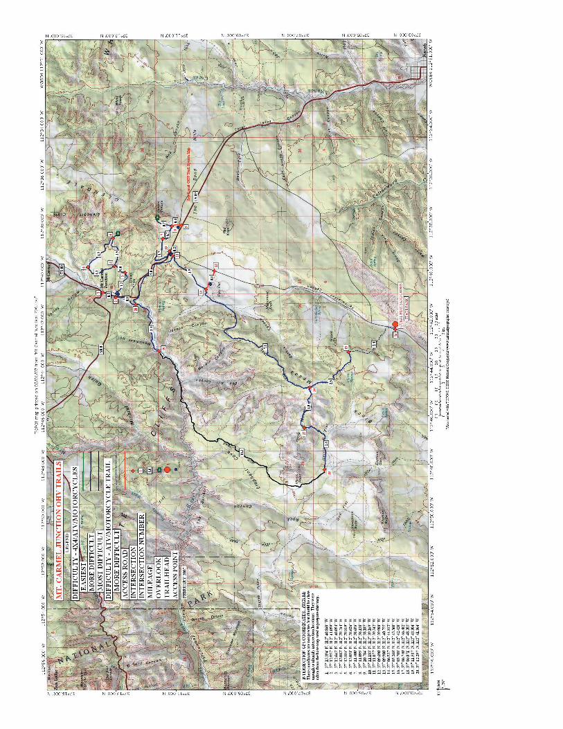
RIDE DESCRIPTIONAccess Points: There are six recommended access points; Thunderbird Motel in Mt. Carmel Junction, three points along US 89, Clay Flat and Coral Pink Sand Dunes State Park. The access points along US 89 and at Clay Flat do not have improved parking areas or any other facilities. Total Miles of Recommended Trail: 47.4Length of Loops: 8.5 to 30+ miles Types of Trail: Trails vary from ATV created trails to old Jeep trails to graded county roads. The route down the Virgin River can be impassable during high water events such as spring runoff and thunderstorms. One section of ATV trail has a difficulty rating of extreme. Do not attempt to ride this trail unless you are an expert rider on a 4-wheel drive machine. Ride Time: A few hours to all day. Difficulty: __ X_ Easiest __X_ More Difficult _X__ Most Difficult _X_ Extreme Elevation: 4,895 to 6,400 feet. Best season to ride: Spring and fall. Summer temperatures can be very hot.Things to see: The trail along the Virgin River offers spectacular views of red-rock canyons and cliffs. The overlooks east of US 89 also have great views of red-rock areas. There is easy access to Coral Pink Sand Dunes State Park. Vegetation is pinyon pine, juniper and ponderosa pine with cottonwood along the river
SERVICES Water, Food, Lodging and Fuel: Mt. Carmel Junction.Restrooms: Mt. Carmel Junction and Coral Pink Sand Dunes.Camping: Camping is permitted on BLM administered lands, but is limited to 14 days in any one spot. There is a good campground at the State Park.
CAUTIONSSigning: Recommended routes shown on this map have not been signed for OHV use. There may be BLM or county signs giving general directions at a few intersections. GPS waypoint information has been provided to aid route finding. Gates: Leave all gates as you find them. If they are open, leave open. Close if closed.Livestock: Do not harass. Slow down and let them get out of the way. Wildlife: Look, but don’t disturb. Historic Structures and Cultural Resources: Man-made structures on public lands more than 50 years of age are protected under the Antiquities Act. It is also unlawful to remove cultural artifacts. View, but do not move or remove any of these objects. Fire: Check with the BLM office in Kanab for open fire restrictions. This area can burn nearly anytime of the year. You will be responsible for any damage and cost associated with a wildfire you cause.Waste: If you packed it in, pack it out. Do not bury trash. Special equipment needed: Make sure you have plenty of fuel to complete your trip. Bring plenty of water during the hot summer months.Caution: Never ride alone and always wear your helmet.
TRAVEL RESTRICTIONS Bureau of Land Management: All recommended routes administered by the Bureau of Land Management (BLM) are currently open to off-highway vehicle (OHV) use under existing land management plans. As new Resource Management Plans and Travel Plans are completed, these routes may or may not remain open or may have limitations on how and when they may be used. Until new plans and/or closure orders are in place, opera-tion of vehicles on these routes is legal. However, all riders are encouraged to stay on existing roads and trails and the BLM has the following recommendation to minimize impacts associated with use of these routes.
The Parunuweap Wilderness Study Area lies within the big loop of this trail system and is closed to OHV travel. Do not travel on any of the existing routes within this loop.
Contact the Bureau of Land management in Kanab at (435) 644-4600 or write to Kanab Field Office, 318 N. First East, Kanab, Utah 84741 for additional information concerning this area and trail conditions.
The publication of this map and text is a unilateral action by the Utah Division of Parks and Recreation under authority of Utah OHV Laws and Rules. The BLM is taking no action at this time to propose or endorse this system of trails nor are they designating any trails for OHV use.
Utah School and Institutional Trust Lands Administration (SITLA): All existing roads and trails under jurisdiction of this agency are open to OHV travel.
Kane County: Recommended routes under county jurisdiction are currently open to OHV travel.
Private land: The recommended routes cross a parcel of private land on a county road between intersection 19 and 20. Stay on the road and do not remove or disturb any property on adjacent lands. MAP LIMITATIONS: This map does not display all existing roads and trails open for OHV use in this area. The Utah Division of Parks and Recreation recommends the primary routes to introduce riders to the area and to help them have a great riding/driving experience. Difficulty ratings, mileages, vehicle type recommenda-tions and other information for these routes are noted on the map to assist trip planning. This information is not provided for the other OHV routes shown on the map. Most of these routes receive little or no maintenance and riders should not assume routes will always be pass-able. Weather and other natural phenomenon can change conditions. More up-to-date information may be available from the Bureau of Land Management or Kane County.
This map was prepared using the National Geographic TOPO program. The base map for this program does not include landownership. Because this program provides a relatively inexpensive way to produce maps, the Divi-sion has accepted this limitation and hope users will also. By keeping cost low, more maps can be produced.
DIFFICULTY RATINGEasiest (green) Gravel or dirt surfaces which are relatively flat and wide. Generally wide enough for an ATV to pass a full-sized vehicle. May be dusty but are relatively smooth throughout with no rocks or roots protruding more than three inches above the surface.
More Difficult (blue) Loose gravel, sandy, rocky or slickrock surface. May have short sections which are nar-row. Can have blind turns, steep or roller coaster grades, minor drop-offs, dust, ruts and frequent changes in riding surfaces. Occasional obstacles may strike the frame.

Most Difficult (black) Rocky surfaces, sharp turns, switchbacks, steep grades, narrow passages, low overhangs, ledges and large rocks. Can be slippery and muddy when wet. May have tree stumps, limbs or other debris. Machines with low ground clearance may strike or high center on obstacles. Some riders may be more comfort-able using 4-wheel drive machines.
Extreme (red) These routes may be extremely steep and rocky with ledges and drop-offs, narrow switchbacks, boulders and uneven or unbalanced trail surfaces. There may be long stretches of loose rock or deep sand on steep grades with extreme side-slopes. Some obstacles will high center most machines. Four-wheel drive is recommended. In some areas it may be necessary to walk machines over or have a helping third hand. These routes require experienced riders with a full array of good riding skills. All users should consider riding abili-ties and machine capabilities before attempting these routes.
This map was prepared by the Utah Division of Parks and Recreation using OHV registration and gas tax funds. It may be viewed online at www.stateparks.utah.gov. This map is subject to change at any time to reflect changing conditions. As a minimum, it will be reviewed annually. Telephone 1-800 OHV RIDE for more information.