MSN 1827 (M) - FISG - Catagorisation of... · 2015-11-22 · Maritime and Coastguard Agency...
25
Maritime and Coastguard Agency MERCHANT SHIPPING NOTICE MSN 1827 (M) Categorisation of Waters. Notice to all Owners, Operators and Masters. This Notice supersedes Merchant Shipping Notice MSN 1776(M).. PLEASE NOTE:- Where this document provides guidance on the law it should not be regarded as definitive. The way the law applies to any particular case can vary according to circumstances - for example, from vessel to vessel and you should consider seeking independent legal advice if you are unsure of your own legal position. Summary. This statutory Merchant Shipping Notice sets out the categorisations of waters in the United Kingdom Key Points x The notice replaces and augments MSN 1776(M) x The changes and additions are shown in bold and italics respectively x The categorisations determine the waters not regarded as “sea” for the purposes of Merchant Shipping legislation (excepting marine pollution). 1. Annex Definition. 1.1 The Annex to this Merchant Shipping Notice sets out the categorisations that apply to waters in the United Kingdom. These categorisations are given statutory force by way of Regulation 2 of the Merchant Shipping (Categorisation of Waters) Regulations 1992. 2. Amendments. 2.1 Amendments to Merchant Shipping Notice MSN 1776 and its Annex are shown in bold and additions are shown in italics. 3. Definitions of the Four Types of Categorised Waters. 3.1 Category A: Narrow Rivers and canals where the depth of water is generally less than 1.5 metres. - 1 -
Transcript of MSN 1827 (M) - FISG - Catagorisation of... · 2015-11-22 · Maritime and Coastguard Agency...
Maritime and Coastguard Agency
MERCHANT SHIPPING NOTICE
MSN 1827 (M)
Categorisation of Waters. Notice to all Owners, Operators and Masters. This Notice supersedes Merchant Shipping Notice MSN 1776(M)..
PLEASE NOTE:- Where this document provides guidance on the law it should not be regarded as definitive. The way the law applies to any particular case can vary according to circumstances - for example, from vessel to vessel and you should consider seeking independent legal advice if you are unsure of your own legal position.
Summary.
This statutory Merchant Shipping Notice sets out the categorisations of waters in the United Kingdom Key Points
x The notice replaces and augments MSN 1776(M) x The changes and additions are shown in bold and italics respectively x The categorisations determine the waters not regarded as “sea” for the purposes of Merchant Shipping legislation (excepting marine pollution).
1. Annex Definition. 1.1 The Annex to this Merchant Shipping Notice sets out the categorisations that apply to waters in the United Kingdom. These categorisations are given statutory force by way of Regulation 2 of the Merchant Shipping (Categorisation of Waters) Regulations 1992. 2. Amendments. 2.1 Amendments to Merchant Shipping Notice MSN 1776 and its Annex are shown in bold and additions are shown in italics. 3. Definitions of the Four Types of Categorised Waters. 3.1 Category A: Narrow Rivers and canals where the depth of water is generally less than 1.5 metres.
- 1 -
3.2 Category B: Wider rivers and canals where the depth of water is generally 1.5 metres or more and where the significant wave height could not be expected to exceed 0.6 metres at any time. 3.3 Category C: Tidal rivers and estuaries and large, deep lakes and lochs where the significant wave height could not be expected to exceed 1.2 metres at any time. 3.4 Category D: Tidal rivers and estuaries where the significant wave height could not be expected to exceed 2.0 metres at any time. 4. Application . 4.1 These categorisations apply specifically to the operation of Class IV, V and VI Passenger Ships and also determine which waters are not regarded as “sea” for the purposes of regulations made, or treated as made, under Section 85 of the Merchant Shipping Act 1995. 4.2 Under the Merchant Shipping (Prevention of Oil Pollution) Regulations 1996 it should be noted that “sea” includes any estuaries or arms of the sea. 4.3 These categorisations should not be confused with classifications for Passenger Ships as designated in the Merchant Shipping (Passenger Ships on Domestic Voyages) Regulations 2000 which implement the EC Directive on Safety Rules and Standards for Domestic Passenger Ships. 4.4 The categorisations shown in the Annex apply at all times of the year unless otherwise indicated. “Summer” means the months of April to October, inclusive, and “winter” means the months of November to March, inclusive. 5 Enforcement date. 5.1 This Notice will come into force on 1 April 2011.
- 2 -
More Information Navigational Safety Branch Maritime and Coastguard Agency Bay 2/04 Spring Place 105 Commercial Road Southampton SO15 1EG Tel : +44 (0) 23 8032 9394 Fax : +44 (0) 23 8032 9204 e-mail: [email protected] General Inquiries: [email protected] MCA Website Address: www.mcga.gov.uk File Ref: MS046/004/0004 Published: February 2011 Please note that all addresses and telephone numbers are correct at time of publishing © Crown Copyright 2011. Safer Lives, Safer Ships, Cleaner Seas. When printed by the MCA the material used contains a minimum 75% post-consumer waste paper
- 3 -
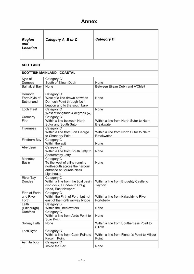
Annex
Region and Location
Category A, B or C
Category D
SCOTLAND SCOTTISH MAINLAND - COASTAL
Kyle of Durness
Category C South of Eilean Dubh
None
Balnakiel Bay
None Between Eilean Dubh and A’Chleit
Dornoch Forth/Kyle of Sutherland
Category C West of a line drawn between Dornoch Point through No 1 beacon and to the south bank
None
Loch Fleet Category C West of longitude 4 degrees (w)
None
Cromarty Firth
Category C Within a line between North Sutor and South Sutor
Within a line from North Sutor to Nairn Breakwater
Inverness Category C Within a line from Fort George to Chanonry Point
Within a line from North Sutor to Nairn Breakwater
Findhorn Bay Category C Within the spit
None
Aberdeen Category C Within a line from South Jetty to Abercromby Jetty
None
Montrose Basin
Category C To the west of a line running north-south across the harbour entrance at Scurdie Ness Lighthouse
None
River Tay – Dundee
Category C Within a line from the tidal basin (fish dock) Dundee to Craig Head, East Newport
Within a line from Broughty Castle to Tayport
Firth of Forth and River Forth
Category C Within the Firth of Forth but not east of the Forth railway bridge
Within a line from Kirkcaldy to River Portobello
Leith (Edinburgh)
Category B Within the Breakwaters
None
Dumfries Category C Within a line from Airds Point to Scar Point
None
Solway Firth None Within a line from Southerness Point to Silloth
Loch Ryan Category C Within a line from Cairn Point to Kircolm Point
Within a line from Finnart's Point to Milleur Point
Ayr Harbour Category C Inside the Bar
None
- 4 -
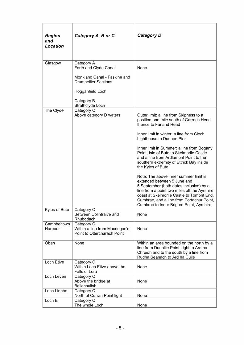
Region and Location
Category A, B or C
Category D
Glasgow
Category A Forth and Clyde Canal Monkland Canal - Faskine and Drumpellier Sections Hogganfield Loch Category B Strathclyde Loch
None
The Clyde
Category C Above category D waters
Outer limit: a line from Skipness to a position one mile south of Garroch Head thence to Farland Head Inner limit in winter: a line from Cloch Lighthouse to Dunoon Pier Inner limit in Summer: a line from Bogany Point, Isle of Bute to Skelmorlie Castle and a line from Ardlamont Point to the southern extremity of Ettrick Bay inside the Kyles of Bute Note: The above inner summer limit is extended between 5 June and 5 September (both dates inclusive) by a line from a point two miles off the Ayrshire coast at Skelmorlie Castle to Tomont End, Cumbrae, and a line from Portachur Point, Cumbrae to Inner Brigurd Point, Ayrshire
Kyles of Bute Category C Between Colintraive and Rhubodach
None
Campbeltown Harbour
Category C Within a line from Macringan's Point to Ottercharach Point
None
Oban None Within an area bounded on the north by a line from Dunollie Point Light to Ard na Chruidh and to the south by a line from Rudha Seanach to Ard na Cuile
Loch Etive Category C Within Loch Etive above the Falls of Lora
None
Loch Leven Category C Above the bridge at Ballachulish
None
Loch Linnhe Category C North of Corran Point light
None
Loch Eil
Category C The whole Loch
None
- 5 -
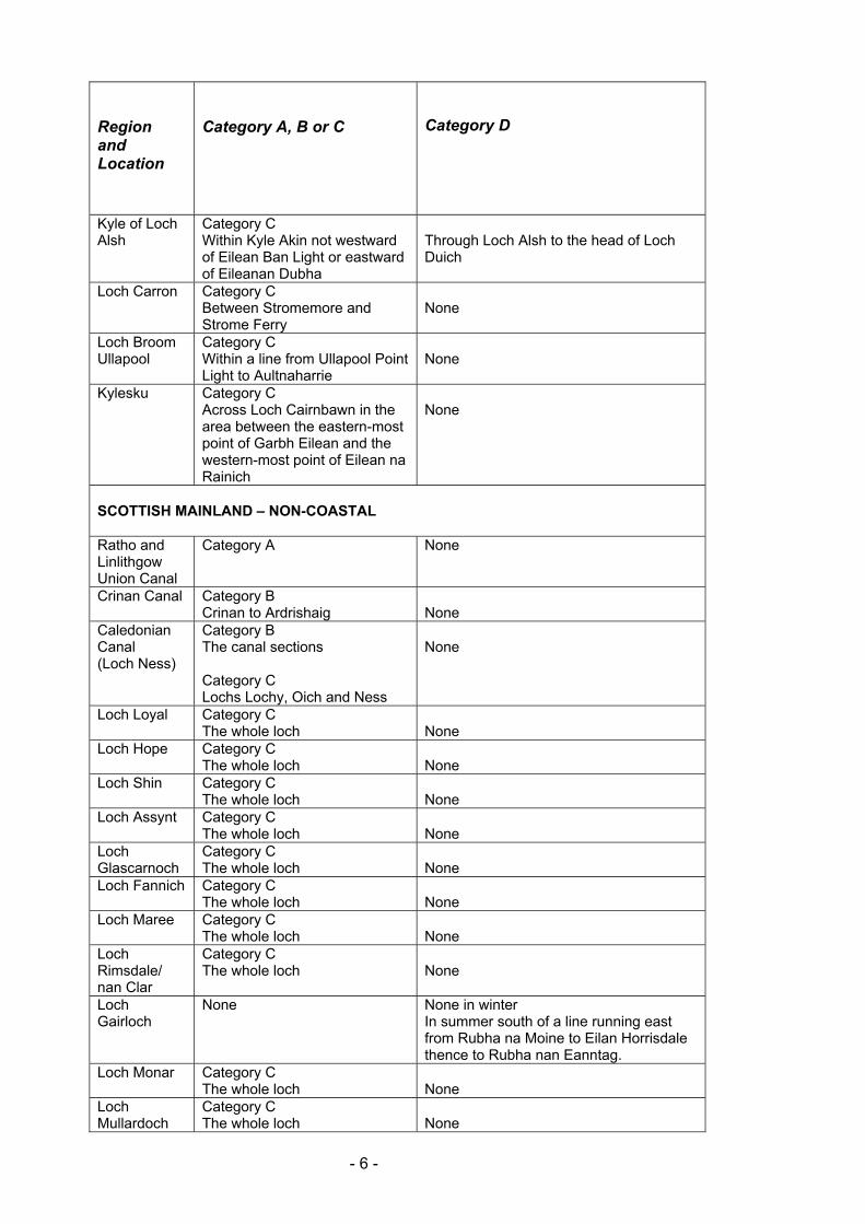
Region and Location
Category A, B or C
Category D
Kyle of Loch Alsh
Category C Within Kyle Akin not westward of Eilean Ban Light or eastward of Eileanan Dubha
Through Loch Alsh to the head of Loch Duich
Loch Carron
Category C Between Stromemore and Strome Ferry
None
Loch Broom Ullapool
Category C Within a line from Ullapool Point Light to Aultnaharrie
None
Kylesku Category C Across Loch Cairnbawn in the area between the eastern-most point of Garbh Eilean and the western-most point of Eilean na Rainich
None
SCOTTISH MAINLAND – NON-COASTAL Ratho and Linlithgow Union Canal
Category A None
Crinan Canal
Category B Crinan to Ardrishaig
None
Caledonian Canal (Loch Ness)
Category B The canal sections Category C Lochs Lochy, Oich and Ness
None
Loch Loyal
Category C The whole loch
None
Loch Hope Category C The whole loch
None
Loch Shin Category C The whole loch
None
Loch Assynt Category C The whole loch
None
Loch Glascarnoch
Category C The whole loch
None
Loch Fannich Category C The whole loch
None
Loch Maree Category C The whole loch
None
Loch Rimsdale/ nan Clar
Category C The whole loch
None
Loch Gairloch
None None in winter In summer south of a line running east from Rubha na Moine to Eilan Horrisdale thence to Rubha nan Eanntag.
Loch Monar Category C The whole loch
None
Loch Mullardoch
Category C The whole loch
None
- 6 -
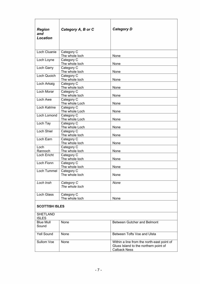
Region and Location
Category A, B or C
Category D
Loch Cluanie Category C The whole loch
None
Loch Loyne Category C The whole loch
None
Loch Garry Category C The whole loch
None
Loch Quoich Category C The whole loch
None
Loch Arkaig Category C The whole loch
None
Loch Morar Category C The whole loch
None
Loch Awe Category C The whole Loch
None
Loch Katrine Category C The whole Loch
None
Loch Lomond Category C The whole Loch
None
Loch Tay Category C The whole Loch
None
Loch Shiel Category C The whole loch
None
Loch Earn Category C The whole loch
None
Loch Rannoch
Category C The whole loch
None
Loch Ericht Category C The whole loch
None
Loch Fionn Category C The whole loch
None
Loch Tummel
Category C The whole loch
None
Loch Insh Category C The whole loch
None
Loch Glass Category C The whole loch
None
SCOTTISH ISLES SHETLAND ISLES
Blue Mull Sound
None Between Gutcher and Belmont
Yell Sound
None Between Tofts Voe and Ulsta
Sullom Voe None Within a line from the north-east point of Gluss Island to the northern point of Calback Ness
- 7 -
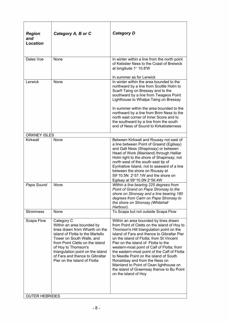
Region and Location
Category A, B or C
Category D
Dales Voe None In winter within a line from the north point of Kebister Ness to the Coast of Breiwick at longitude 1q 10.8'W In summer as for Lerwick
Lerwick None In winter within the area bounded to the northward by a line from Scottle Holm to Scarfi Taing on Bressay and to the southward by a line from Twageos Point Lighthouse to Whalpa Taing on Bressay In summer within the area bounded to the northward by a line from Brim Ness to the north east corner of Inner Score and to the southward by a line from the south end of Ness of Sound to Kirkabisterness
ORKNEY ISLES Kirkwall None Between Kirkwall and Rousay not east of
a line between Point of Graand (Egilsay) and Galt Ness (Shapinsay) or between Head of Work (Mainland) through Helliar Holm light to the shore of Shapinsay; not north west of the south east tip of Eynhallow Island, not to seaward of a line between the shore on Rousay at 59q10.5N 2q57.1W and the shore on Egilsay at 59q10.0N 2q56.4W
Papa Sound None Within a line bearing 225 degrees from Point of Grand on Papa Stronsay to the shore on Stronsay and a line bearing 180 degrees from Cairn on Papa Stronsay to the shore on Stronsay (Whitehall Harbour).
Stromness
None To Scapa but not outside Scapa Flow
Scapa Flow
Category C Within an area bounded by lines drawn from Wharth on the island of Flotta to the Martello Tower on South Walls, and from Point Cletts on the island of Hoy to Thomson's triangulation point on the island of Fara and thence to Gibraltar Pier on the Island of Flotta
Within an area bounded by lines drawn from Point of Cletts on the island of Hoy to Thomson's Hill triangulation point on the island of Fara and thence to Gibraltar Pier on the island of Flotta; from St Vincent Pier on the island of Flotta to the western-most point of Calf of Flotta; from the eastern-most point of the Calf of Flotta to Needle Point on the island of South Ronaldsay and from the Ness on Mainland to Point of Oxan lighthouse on the island of Graemsay thence to Bu Point on the island of Hoy
OUTER HEBRIDES
- 8 -
Region and Location
Category A, B or C
Category D
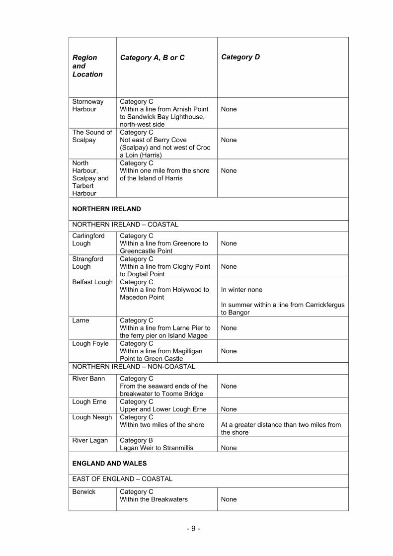
Stornoway Harbour
Category C Within a line from Arnish Point to Sandwick Bay Lighthouse, north-west side
None
The Sound of Scalpay
Category C Not east of Berry Cove (Scalpay) and not west of Croc a Loin (Harris)
None
North Harbour, Scalpay and Tarbert Harbour
Category C Within one mile from the shore of the Island of Harris
None
NORTHERN IRELAND NORTHERN IRELAND – COASTAL
Carlingford Lough
Category C Within a line from Greenore to Greencastle Point
None
Strangford Lough
Category C Within a line from Cloghy Point to Dogtail Point
None
Belfast Lough
Category C Within a line from Holywood to Macedon Point
In winter none In summer within a line from Carrickfergus to Bangor
Larne Category C Within a line from Larne Pier to the ferry pier on Island Magee
None
Lough Foyle
Category C Within a line from Magilligan Point to Green Castle
None
NORTHERN IRELAND – NON-COASTAL
River Bann Category C From the seaward ends of the breakwater to Toome Bridge
None
Lough Erne Category C Upper and Lower Lough Erne
None
Lough Neagh
Category C Within two miles of the shore
At a greater distance than two miles from the shore
River Lagan Category B Lagan Weir to Stranmillis
None
ENGLAND AND WALES EAST OF ENGLAND – COASTAL
Berwick
Category C Within the Breakwaters
None
- 9 -
Region and Location
Category A, B or C
Category D
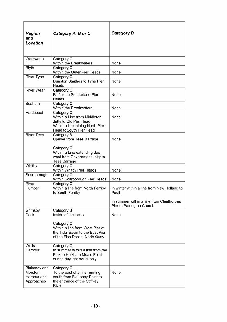
Warkworth
Category C Within the Breakwaters
None
Blyth Category C Within the Outer Pier Heads
None
River Tyne Category C Dunston Staithes to Tyne Pier Heads
None
River Wear
Category C Fatfield to Sunderland Pier Heads
None
Seaham
Category C Within the Breakwaters
None
Hartlepool
Category C Within a Line from Middleton Jetty to Old Pier Head Within a line joining North Pier Head to South Pier Head
None
River Tees
Category B Upriver from Tees Barrage Category C Within a Line extending due west from Government Jetty to Tees Barrage
None
Whitby Category C Within Whitby Pier Heads
None
Scarborough Category C Within Scarborough Pier Heads
None
River Humber
Category C Within a line from North Ferriby to South Ferriby
In winter within a line from New Holland to Paull In summer within a line from Cleethorpes Pier to Patrington Church
Grimsby Dock
Category B Inside of the locks Category C Within a line from West Pier of the Tidal Basin to the East Pier of the Fish Docks, North Quay
None
Wells Harbour
Category C In summer within a line from the Bink to Holkham Meals Point during daylight hours only
Blakeney and Morston Harbour and Approaches
Category C To the east of a line running south from Blakeney Point to the entrance of the Stiffkey River
None
- 10 -
Region and Location
Category A, B or C
Category D
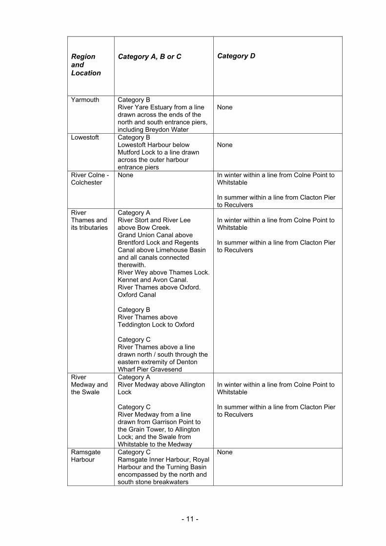
Yarmouth Category B River Yare Estuary from a line drawn across the ends of the north and south entrance piers, including Breydon Water
None
Lowestoft Category B Lowestoft Harbour below Mutford Lock to a line drawn across the outer harbour entrance piers
None
River Colne - Colchester
None In winter within a line from Colne Point to Whitstable In summer within a line from Clacton Pier to Reculvers
River Thames and its tributaries
Category A River Stort and River Lee above Bow Creek. Grand Union Canal above Brentford Lock and Regents Canal above Limehouse Basin and all canals connected therewith. River Wey above Thames Lock. Kennet and Avon Canal. River Thames above Oxford. Oxford Canal Category B River Thames above Teddington Lock to Oxford Category C River Thames above a line drawn north / south through the eastern extremity of Denton Wharf Pier Gravesend
In winter within a line from Colne Point to Whitstable In summer within a line from Clacton Pier to Reculvers
River Medway and the Swale
Category A River Medway above Allington Lock Category C River Medway from a line drawn from Garrison Point to the Grain Tower, to Allington Lock; and the Swale from Whitstable to the Medway
In winter within a line from Colne Point to Whitstable In summer within a line from Clacton Pier to Reculvers
Ramsgate Harbour
Category C Ramsgate Inner Harbour, Royal Harbour and the Turning Basin encompassed by the north and south stone breakwaters
None
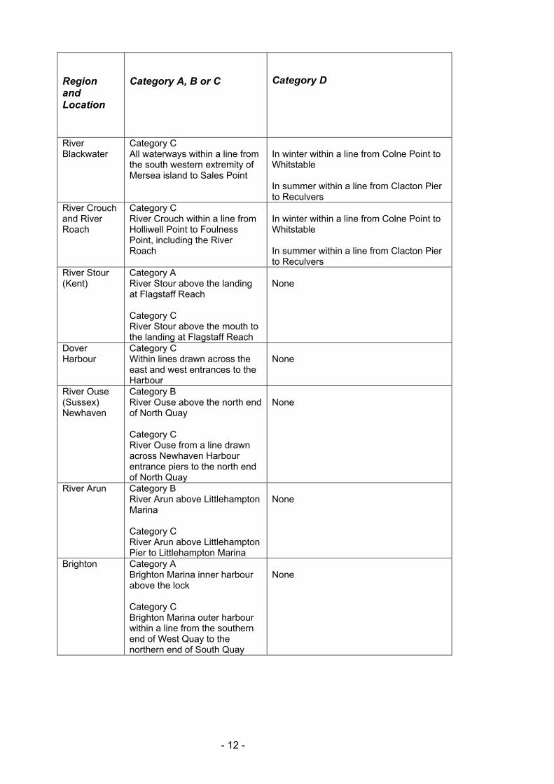
- 11 -
Region and Location
Category A, B or C
Category D
River Blackwater
Category C All waterways within a line from the south western extremity of Mersea island to Sales Point
In winter within a line from Colne Point to Whitstable In summer within a line from Clacton Pier to Reculvers
River Crouch and River Roach
Category C River Crouch within a line from Holliwell Point to Foulness Point, including the River Roach
In winter within a line from Colne Point to Whitstable In summer within a line from Clacton Pier to Reculvers
River Stour (Kent)
Category A River Stour above the landing at Flagstaff Reach Category C River Stour above the mouth to the landing at Flagstaff Reach
None
Dover Harbour
Category C Within lines drawn across the east and west entrances to the Harbour
None
River Ouse (Sussex) Newhaven
Category B River Ouse above the north end of North Quay Category C River Ouse from a line drawn across Newhaven Harbour entrance piers to the north end of North Quay
None
River Arun Category B River Arun above Littlehampton Marina Category C River Arun above Littlehampton Pier to Littlehampton Marina
None
Brighton Category A Brighton Marina inner harbour above the lock Category C Brighton Marina outer harbour within a line from the southern end of West Quay to the northern end of South Quay
None
- 12 -
Region and Location
Category A, B or C
Category D
River Adur and Southwick Canal
Category B River Adur above the west end of Tarmac Wharf, and within Southwick Canal Category C Within a line drawn across Shoreham Harbour entrance to Southwick Canal Lock and to the west end of Tarmac Wharf
None
Chichester Category B East of a line joining Cobnor Point and Chalkdock Point Category C Within a line drawn between Eastoke point and the church spire, West Wittering
Inside the Isle of Wight within an area bounded by lines drawn between the church spire, West Wittering, to Trinity Church, Bembridge to the eastward, and the Needles and Hurst Point to the westward
Langstone Harbour
Category C Within a line drawn between Eastney Point and Gunner Point
Inside the Isle of Wight within an area bounded by lines drawn between the church spire, West Wittering, to Trinity Church, Bembridge to the eastward, and the Needles and Hurst Point to the westward
Portsmouth Category C Within a line drawn across the harbour entrance from Fort Blockhouse to the Round Tower
Inside the Isle of Wight within an area bounded by lines drawn between the church spire, West Wittering, to Trinity Church, Bembridge to the eastward, and the Needles and Hurst Point to the westward
Bembridge, Isle of Wight
Category C Within Brading Harbour
Inside the Isle of Wight within an area bounded by lines drawn between the church spire, West Wittering, to Trinity Church, Bembridge to the eastward, and the Needles and Hurst Point to the westward
Cowes, Isle of Wight
Category C The River Medina within a line from the Breakwater Light on the east bank to the Watch House Light on the west bank
Inside the Isle of Wight within an area bounded by lines drawn between the church spire, West Wittering, to Trinity Church, Bembridge to the eastward, and the Needles and Hurst Point to the westward
Southampton Category C Within a line from Calshot Castle to Hook Beacon
Inside the Isle of Wight within an area bounded by lines drawn between the church spire, West Wittering, to Trinity Church, Bembridge to the eastward, and the Needles and Hurst Point to the westward
- 13 -
Region and Location
Category A, B or C
Category D
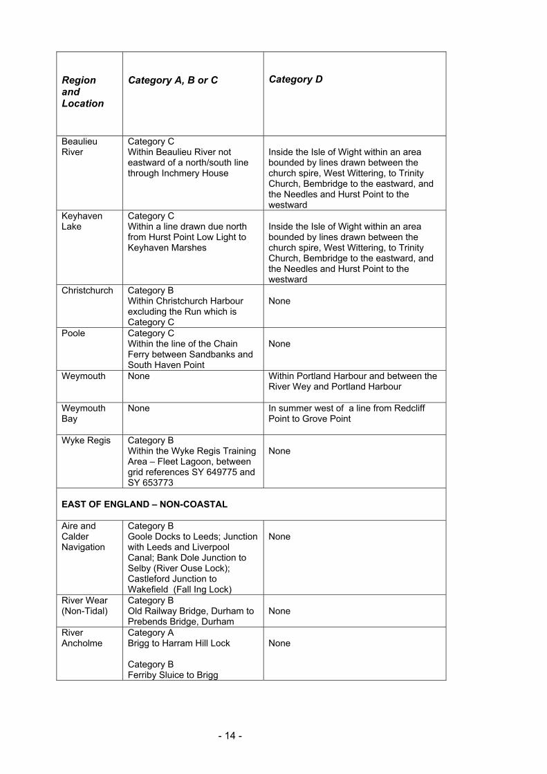
Beaulieu River
Category C Within Beaulieu River not eastward of a north/south line through Inchmery House
Inside the Isle of Wight within an area bounded by lines drawn between the church spire, West Wittering, to Trinity Church, Bembridge to the eastward, and the Needles and Hurst Point to the westward
Keyhaven Lake
Category C Within a line drawn due north from Hurst Point Low Light to Keyhaven Marshes
Inside the Isle of Wight within an area bounded by lines drawn between the church spire, West Wittering, to Trinity Church, Bembridge to the eastward, and the Needles and Hurst Point to the westward
Christchurch Category B Within Christchurch Harbour excluding the Run which is Category C
None
Poole Category C Within the line of the Chain Ferry between Sandbanks and South Haven Point
None
Weymouth None Within Portland Harbour and between the River Wey and Portland Harbour
Weymouth Bay
None In summer west of a line from Redcliff Point to Grove Point
Wyke Regis Category B Within the Wyke Regis Training Area – Fleet Lagoon, between grid references SY 649775 and SY 653773
None
EAST OF ENGLAND – NON-COASTAL Aire and Calder Navigation
Category B Goole Docks to Leeds; Junction with Leeds and Liverpool Canal; Bank Dole Junction to Selby (River Ouse Lock); Castleford Junction to Wakefield (Fall Ing Lock)
None
River Wear (Non-Tidal)
Category B Old Railway Bridge, Durham to Prebends Bridge, Durham
None
River Ancholme
Category A Brigg to Harram Hill Lock Category B Ferriby Sluice to Brigg
None
- 14 -
Region and Location
Category A, B or C
Category D
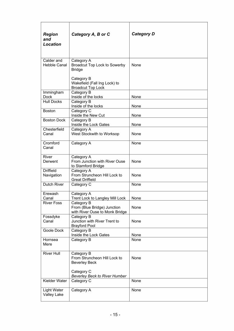
Calder and Hebble Canal
Category A Broadcut Top Lock to Sowerby Bridge Category B Wakefield (Fall Ing Lock) to Broadcut Top Lock
None
Immingham Dock
Category B Inside of the locks
None
Hull Docks Category B Inside of the locks
None
Boston Category C Inside the New Cut
None
Boston Dock Category B Inside the Lock Gates
None
Chesterfield Canal
Category A West Stockwith to Worksop
None
Cromford Canal
Category A None
River Derwent
Category A From Junction with River Ouse to Stamford Bridge
None
Driffield Navigation
Category A From Struncheon Hill Lock to Great Driffield
None
Dutch River
Category C None
Erewash Canal
Category A Trent Lock to Langley Mill Lock
None
River Foss Category B From (Blue Bridge) Junction with River Ouse to Monk Bridge
None
Fossdyke Canal
Category B Junction with River Trent to Brayford Pool
None
Goole Dock Category B Inside the Lock Gates
None
Hornsea Mere
Category B None
River Hull
Category B From Struncheon Hill Lock to Beverley Beck Category C Beverley Beck to River Humber
None
Kielder Water
Category C None
Light Water Valley Lake
Category A None
- 15 -
Region and Location
Category A, B or C
Category D
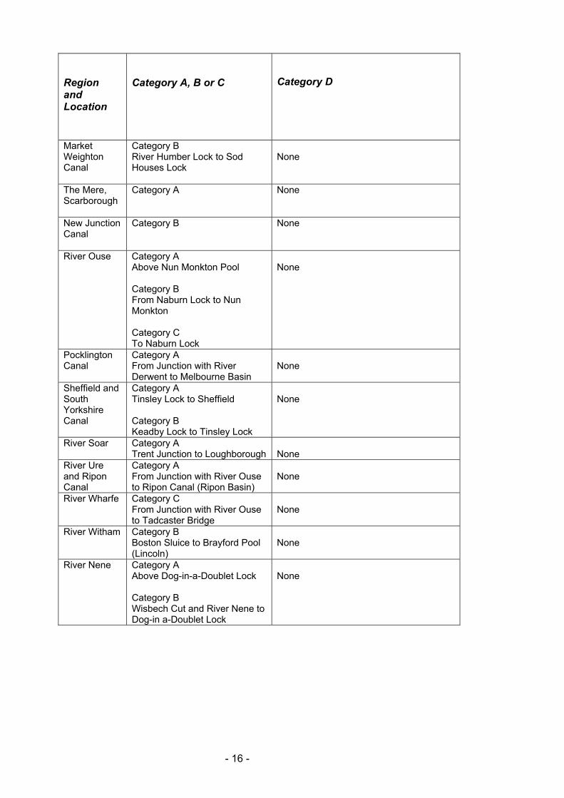
Market Weighton Canal
Category B River Humber Lock to Sod Houses Lock
None
The Mere, Scarborough
Category A None
New Junction Canal
Category B None
River Ouse Category A Above Nun Monkton Pool Category B From Naburn Lock to Nun Monkton Category C To Naburn Lock
None
Pocklington Canal
Category A From Junction with River Derwent to Melbourne Basin
None
Sheffield and South Yorkshire Canal
Category A Tinsley Lock to Sheffield Category B Keadby Lock to Tinsley Lock
None
River Soar Category A Trent Junction to Loughborough
None
River Ure and Ripon Canal
Category A From Junction with River Ouse to Ripon Canal (Ripon Basin)
None
River Wharfe Category C From Junction with River Ouse to Tadcaster Bridge
None
River Witham Category B Boston Sluice to Brayford Pool (Lincoln)
None
River Nene Category A Above Dog-in-a-Doublet Lock Category B Wisbech Cut and River Nene to Dog-in a-Doublet Lock
None
- 16 -
Region and Location
Category A, B or C
Category D
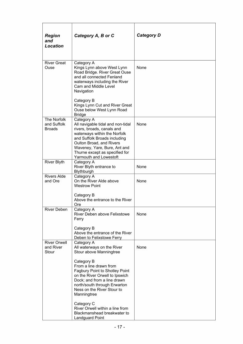
River Great Ouse
Category A Kings Lynn above West Lynn Road Bridge. River Great Ouse and all connected Fenland waterways including the River Cam and Middle Level Navigation Category B Kings Lynn Cut and River Great Ouse below West Lynn Road Bridge
None
The Norfolk and Suffolk Broads
Category A All navigable tidal and non-tidal rivers, broads, canals and waterways within the Norfolk and Suffolk Broads including Oulton Broad, and Rivers Waveney, Yare, Bure, Ant and Thurne except as specified for Yarmouth and Lowestoft
None
River Blyth Category A River Blyth entrance to Blythburgh
None
Rivers Alde and Ore
Category A On the River Alde above Westrow Point Category B Above the entrance to the River Ore
None
River Deben Category A River Deben above Felixstowe Ferry Category B Above the entrance of the River Deben to Felixstowe Ferry
None
River Orwell and River Stour
Category A All waterways on the River Stour above Manningtree Category B From a line drawn from Fagbury Point to Shotley Point on the River Orwell to Ipswich Dock; and from a line drawn north/south through Erwarton Ness on the River Stour to Manningtree Category C River Orwell within a line from Blackmanshead breakwater to Landguard Point
None
- 17 -
Region and Location
Category A, B or C
Category D
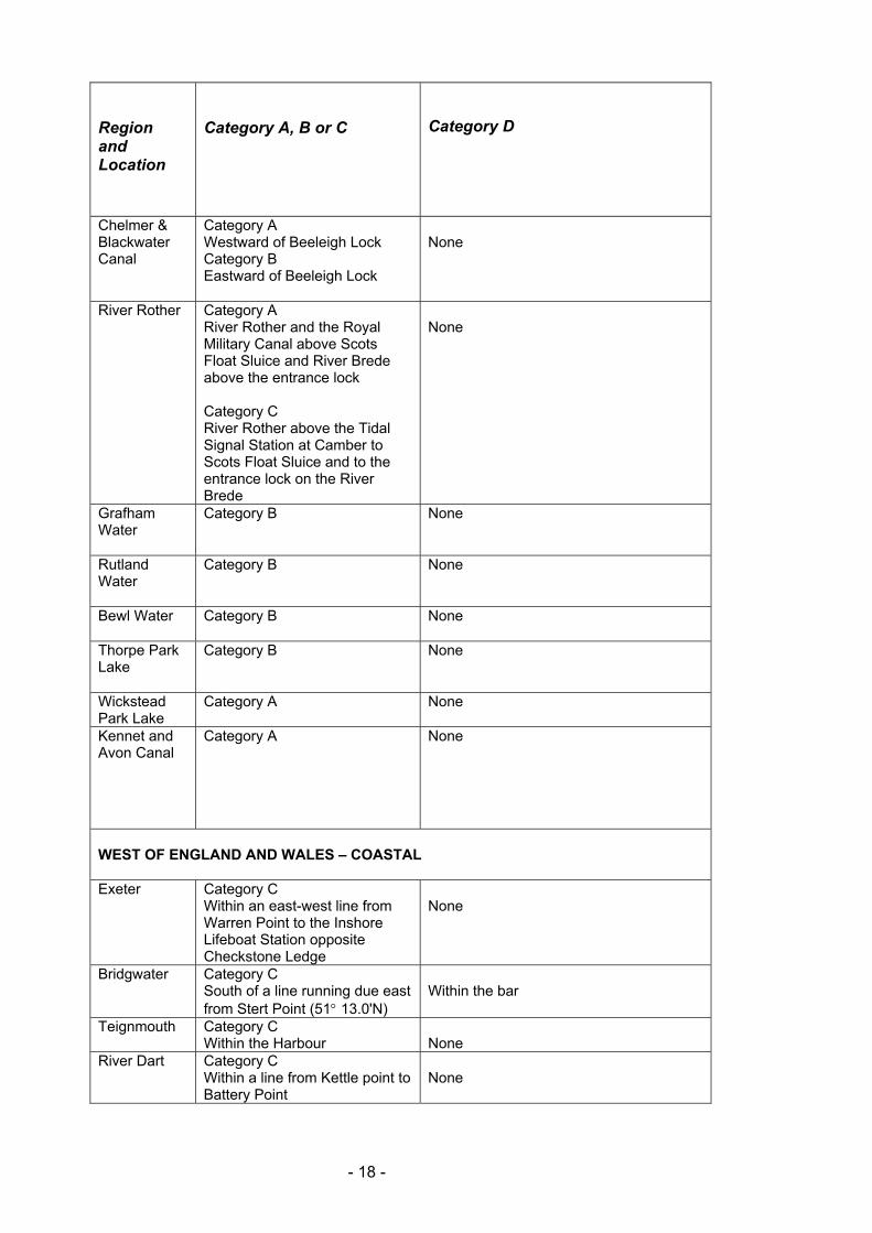
Chelmer & Blackwater Canal
Category A Westward of Beeleigh Lock Category B Eastward of Beeleigh Lock
None
River Rother
Category A River Rother and the Royal Military Canal above Scots Float Sluice and River Brede above the entrance lock Category C River Rother above the Tidal Signal Station at Camber to Scots Float Sluice and to the entrance lock on the River Brede
None
Grafham Water
Category B None
Rutland Water
Category B None
Bewl Water
Category B None
Thorpe Park Lake
Category B None
Wickstead Park Lake
Category A
None
Kennet and Avon Canal
Category A
None
WEST OF ENGLAND AND WALES – COASTAL Exeter Category C
Within an east-west line from Warren Point to the Inshore Lifeboat Station opposite Checkstone Ledge
None
Bridgwater Category C South of a line running due east from Stert Point (51q 13.0'N)
Within the bar
Teignmouth Category C Within the Harbour
None
River Dart Category C Within a line from Kettle point to Battery Point
None
- 18 -
Region and Location
Category A, B or C
Category D
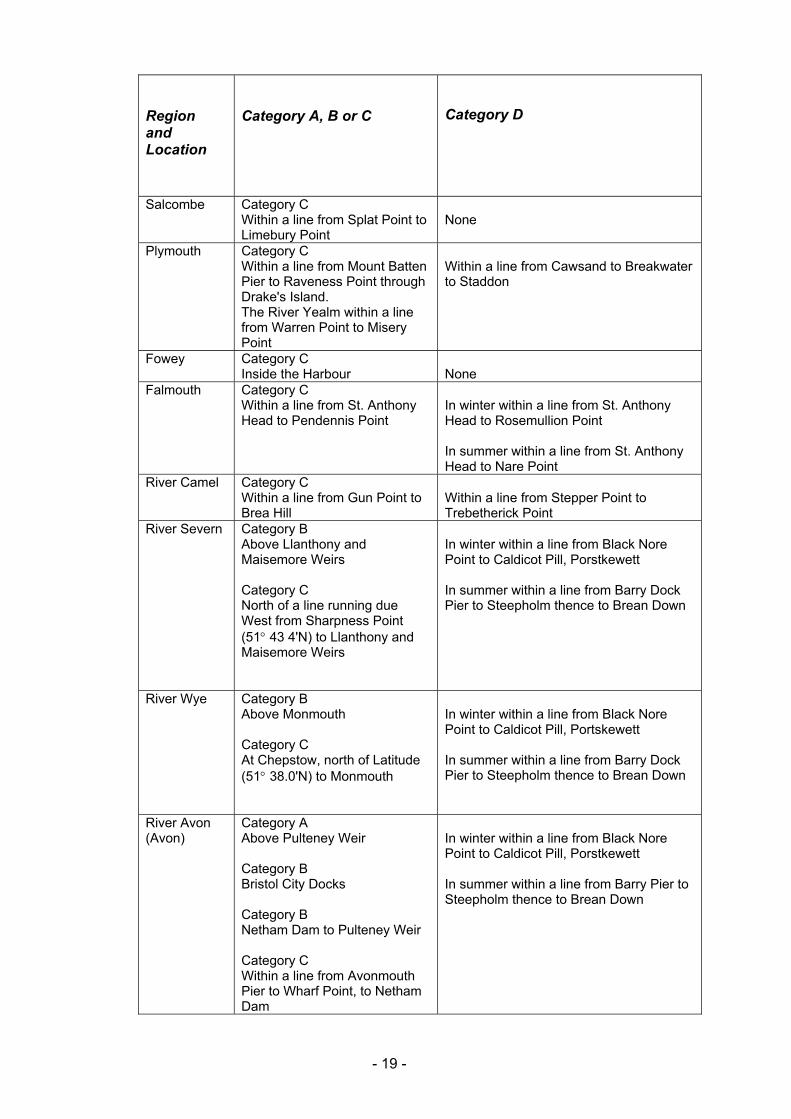
Salcombe Category C Within a line from Splat Point to Limebury Point
None
Plymouth Category C Within a line from Mount Batten Pier to Raveness Point through Drake's Island. The River Yealm within a line from Warren Point to Misery Point
Within a line from Cawsand to Breakwater to Staddon
Fowey Category C Inside the Harbour
None
Falmouth Category C Within a line from St. Anthony Head to Pendennis Point
In winter within a line from St. Anthony Head to Rosemullion Point In summer within a line from St. Anthony Head to Nare Point
River Camel Category C Within a line from Gun Point to Brea Hill
Within a line from Stepper Point to Trebetherick Point
River Severn Category B Above Llanthony and Maisemore Weirs Category C North of a line running due West from Sharpness Point (51q 43 4'N) to Llanthony and Maisemore Weirs
In winter within a line from Black Nore Point to Caldicot Pill, Porstkewett In summer within a line from Barry Dock Pier to Steepholm thence to Brean Down
River Wye Category B Above Monmouth Category C At Chepstow, north of Latitude (51q 38.0'N) to Monmouth
In winter within a line from Black Nore Point to Caldicot Pill, Portskewett In summer within a line from Barry Dock Pier to Steepholm thence to Brean Down
River Avon (Avon)
Category A Above Pulteney Weir Category B Bristol City Docks Category B Netham Dam to Pulteney Weir Category C Within a line from Avonmouth Pier to Wharf Point, to Netham Dam
In winter within a line from Black Nore Point to Caldicot Pill, Porstkewett In summer within a line from Barry Pier to Steepholm thence to Brean Down
- 19 -
Region and Location
Category A, B or C
Category D
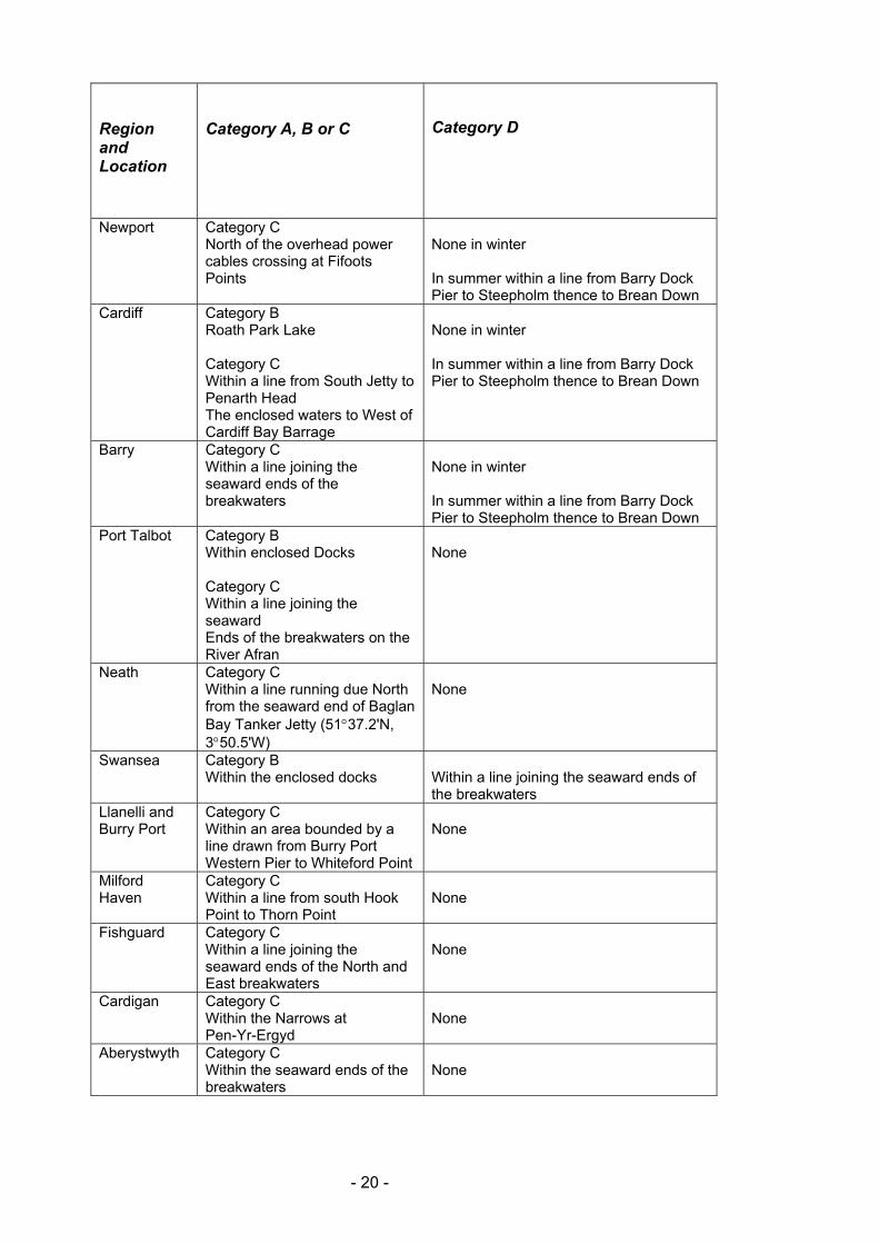
Newport Category C North of the overhead power cables crossing at Fifoots Points
None in winter In summer within a line from Barry Dock Pier to Steepholm thence to Brean Down
Cardiff Category B Roath Park Lake Category C Within a line from South Jetty to Penarth Head The enclosed waters to West of Cardiff Bay Barrage
None in winter In summer within a line from Barry Dock Pier to Steepholm thence to Brean Down
Barry Category C Within a line joining the seaward ends of the breakwaters
None in winter In summer within a line from Barry Dock Pier to Steepholm thence to Brean Down
Port Talbot Category B Within enclosed Docks Category C Within a line joining the seaward Ends of the breakwaters on the River Afran
None
Neath Category C Within a line running due North from the seaward end of Baglan Bay Tanker Jetty (51q37.2'N, 3q50.5'W)
None
Swansea Category B Within the enclosed docks
Within a line joining the seaward ends of the breakwaters
Llanelli and Burry Port
Category C Within an area bounded by a line drawn from Burry Port Western Pier to Whiteford Point
None
Milford Haven
Category C Within a line from south Hook Point to Thorn Point
None
Fishguard Category C Within a line joining the seaward ends of the North and East breakwaters
None
Cardigan Category C Within the Narrows at Pen-Yr-Ergyd
None
Aberystwyth
Category C Within the seaward ends of the breakwaters
None
- 20 -
Region and Location
Category A, B or C
Category D
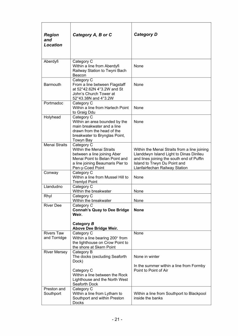
Aberdyfi Category C Within a line from Aberdyfi Railway Station to Twyni Bach Beacon
None
Barmouth
Category C From a line between Flagstaff at 52°42.62N 4°3.2W and St John’s Church Tower at 52°43.38N and 4°3.2W
None
Portmadoc Category C Within a line from Harlech Point to Graig Ddu
None
Holyhead Category C Within an area bounded by the main breakwater and a line drawn from the head of the breakwater to Brynglas Point, Towyn Bay
None
Menai Straits Category C Within the Menai Straits between a line joining Aber Menai Point to Belan Point and a line joining Beaumaris Pier to Pen-y-Coed Point
Within the Menai Straits from a line joining Llanddwyn Island Light to Dinas Dinlleu and lines joining the south end of Puffin Island to Trwyn Du Point and Llanfairfechan Railway Station
Conway Category C Within a line from Mussel Hill to Tremlyd Point
None
Llandudno Category C Within the breakwater
None
Rhyl Category C Within the breakwater
None
River Dee Category C Connah’s Quay to Dee Bridge Weir. Category B Above Dee Bridge Weir.
None
Rivers Taw and Torridge
Category C Within a line bearing 200q from the lighthouse on Crow Point to the shore at Skern Point
None
River Mersey Category B The docks (excluding Seaforth Dock) Category C Within a line between the Rock Lighthouse and the North West Seaforth Dock
None in winter In the summer within a line from Formby Point to Point of Air
Preston and Southport
Category C Within a line from Lytham to Southport and within Preston Docks
Within a line from Southport to Blackpool inside the banks
- 21 -
Region and Location
Category A, B or C
Category D
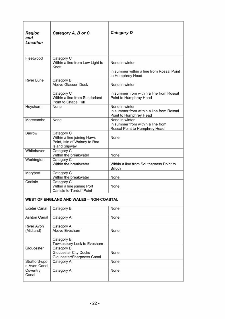
Fleetwood Category C Within a line from Low Light to Knott
None in winter In summer within a line from Rossal Point to Humphrey Head
River Lune Category B Above Glasson Dock Category C Within a line from Sunderland Point to Chapel Hill
None in winter In summer from within a line from Rossal Point to Humphrey Head
Heysham None None in winter In summer from within a line from Rossal Point to Humphrey Head
Morecambe None None in winter In summer from within a line from Rossal Point to Humphrey Head
Barrow Category C Within a line joining Haws Point, Isle of Walney to Roa Island Slipway
None
Whitehaven Category C Within the breakwater
None
Workington Category C Within the breakwater
Within a line from Southerness Point to Silloth
Maryport Category C Within the breakwater
None
Carlisle Category C Within a line joining Port Carlisle to Torduff Point
None
WEST OF ENGLAND AND WALES – NON-COASTAL Exeter Canal
Category B None
Ashton Canal Category A None
River Avon (Midland)
Category A Above Evesham Category B Tewkesbury Lock to Evesham
None
Gloucester Category B Gloucester City Docks Gloucester/Sharpness Canal
None
Stratford-upon-Avon Canal
Category A None
Coventry Canal
Category A None
- 22 -
Region and Location
Category A, B or C
Category D
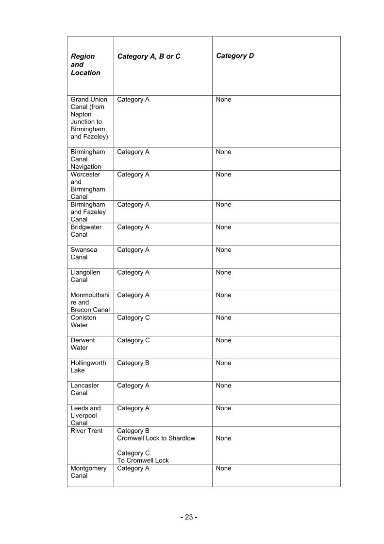
Grand Union Canal (from Napton Junction to Birmingham and Fazeley)
Category A None
Birmingham Canal Navigation
Category A None
Worcester and Birmingham Canal
Category A None
Birmingham and Fazeley Canal
Category A None
Bridgwater Canal
Category A None
Swansea Canal
Category A None
Llangollen Canal
Category A None
Monmouthshire and Brecon Canal
Category A None
Coniston Water
Category C None
Derwent Water
Category C None
Hollingworth Lake
Category B None
Lancaster Canal
Category A None
Leeds and Liverpool Canal
Category A None
River Trent Category B Cromwell Lock to Shardlow Category C To Cromwell Lock
None
Montgomery Canal
Category A None
- 23 -
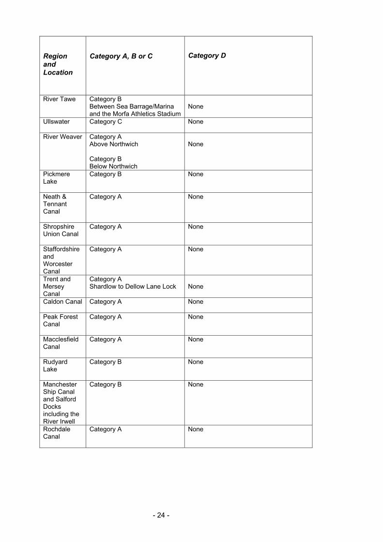
Region and Location
Category A, B or C
Category D
River Tawe Category B Between Sea Barrage/Marina and the Morfa Athletics Stadium
None
Ullswater
Category C None
River Weaver Category A Above Northwich Category B Below Northwich
None
Pickmere Lake
Category B None
Neath & Tennant Canal
Category A None
Shropshire Union Canal
Category A None
Staffordshire and Worcester Canal
Category A None
Trent and Mersey Canal
Category A Shardlow to Dellow Lane Lock
None
Caldon Canal
Category A None
Peak Forest Canal
Category A None
Macclesfield Canal
Category A None
Rudyard Lake
Category B None
Manchester Ship Canal and Salford Docks including the River Irwell
Category B None
Rochdale Canal
Category A None
- 24 -
- 25 -
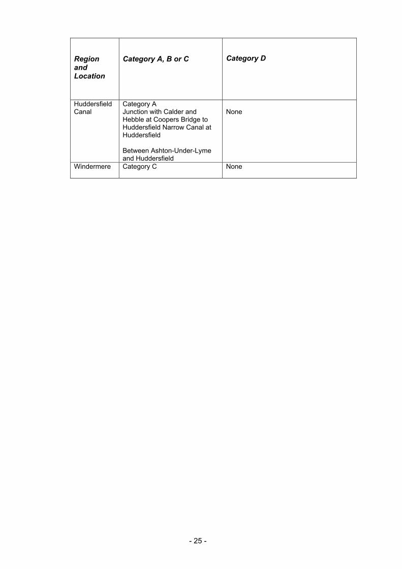
Region and Location
Category A, B or C
Category D
Huddersfield Canal
Category A Junction with Calder and Hebble at Coopers Bridge to Huddersfield Narrow Canal at Huddersfield Between Ashton-Under-Lyme and Huddersfield
None
Windermere
Category C None