Moving Forward from Vulnerability to Adaptation - Udall...
38
Moving Forward from Vulnerability to Adaptation: Climate Change, Drought, and Water Demand in the Urbanizing Southwestern United States and Northern Mexico Avanzando desde la Vulnerabilidad hacia la Adaptación: El Cambio Climático, la Sequía, y la Demanda del Agua en Áreas Urbanas del Suroeste de los EEUU y el Norte de México Edited by Margaret Wilder, Christopher A. Scott, Nicolás Pineda-Pablos, Robert G. Varady, and Gregg M. Garfin With contributions by Rachel Beaty, Luís Brito, Anne Browning-Aiken, Delphine Clavreul, Rolando Díaz-Caravantes, Gregg M. Garfin, Oscar Lai, Jamie McEvoy, Emily McGovern, Barbara Morehouse, José Luís Moreno, Carolina Neri, Lucas Oroz, Nicolás Pineda-Pablos, Andrea Prichard, Alejandro Salazar-Adams, Christopher A. Scott, Jeremy Slack, Robert G. Varady, Christopher Watts, and Margaret Wilder January 2012
Transcript of Moving Forward from Vulnerability to Adaptation - Udall...
PB i
Moving Forward from Vulnerability to Adaptation: Climate Change, Drought, and Water Demand in the Urbanizing Southwestern
United States and Northern Mexico
Avanzando desde la Vulnerabilidad hacia la Adaptación: El Cambio Climático, la Sequía, y la Demanda del Agua en Áreas Urbanas del Suroeste de
los EEUU y el Norte de México
Edited by Margaret Wilder, Christopher A. Scott, Nicolás Pineda-Pablos, Robert G. Varady, and Gregg M. Garfin
With contributions by Rachel Beaty, Luís Brito, Anne Browning-Aiken, Delphine Clavreul, Rolando Díaz-Caravantes, Gregg M. Garfin,
Oscar Lai, Jamie McEvoy, Emily McGovern, Barbara Morehouse, José Luís Moreno, Carolina Neri, Lucas Oroz, Nicolás Pineda-Pablos, Andrea Prichard, Alejandro Salazar-Adams,
Christopher A. Scott, Jeremy Slack, Robert G. Varady, Christopher Watts, and Margaret Wilder
January 2012
ii iii
Moving Forward from Vulnerability to Adaptation Avanzando desde la Vulnerabilidad hacia la Adaptación
Edited by Margaret Wilder, Christopher A. Scott, Nicolás Pineda-Pablos, Robert G. Varady, and Gregg M. Garfin
Published by the Udall Center for Studies in Public Policy, The University of Arizona.Copyright 2012 by the Arizona Board of Regents.All rights reserved.
ISBN 978-1-931143-42-4
Udall Center PublicationsRobert Merideth, Editor in ChiefEmily McGovern, Editorial AssociateAriel Mack, Graphic Designer
Editing by Emily McGovernDesign and layout by Renee La Roi
Udall Center for Studies in Public PolicyThe University of Arizona803 E. First St., Tucson, AZ 85719(520) 626-4393udallcenter.arizona.edu
Cover photos, clockwise from top left:Ambos Nogales, courtesy of www.nogales-mexico.com; Puerto Peñasco, Jamie McEvoy; Tucson, istock; Hermosillo, Nicolás Pineda
Please cite this document as: Wilder, M, C. A. Scott, N. Pineda-Pablos, R. G. Varady, R. G., and G. M. Garfin (eds.). (2012). Moving Forward from Vulnerability to Adaptation: Climate Change, Drought, and Water Demand in the Urbanizing Southwestern United States and Northern Mexico. (Avanzando desde la Vulnerabilidad hacia la Adaptación: El Cambio Climático, la Sequía, y la Demanda del Agua en Áreas Urbanas del Suroeste de los EEUU y el Norte de México.) Tucson: Udall Center for Studies in Public Policy, The University of Arizona.

Puerto Peñasco
55
CHAPTER 3
PUERTO PEÑASCO
Moving Forward from Vulnerability to Adaptation
56
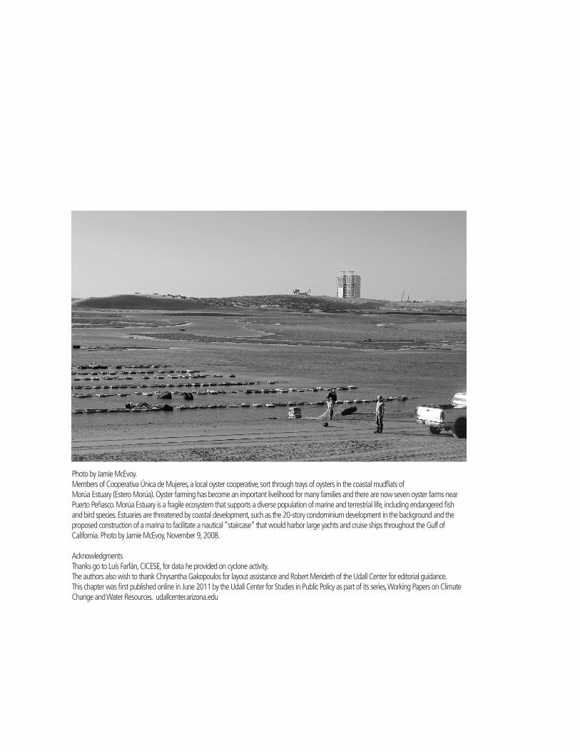
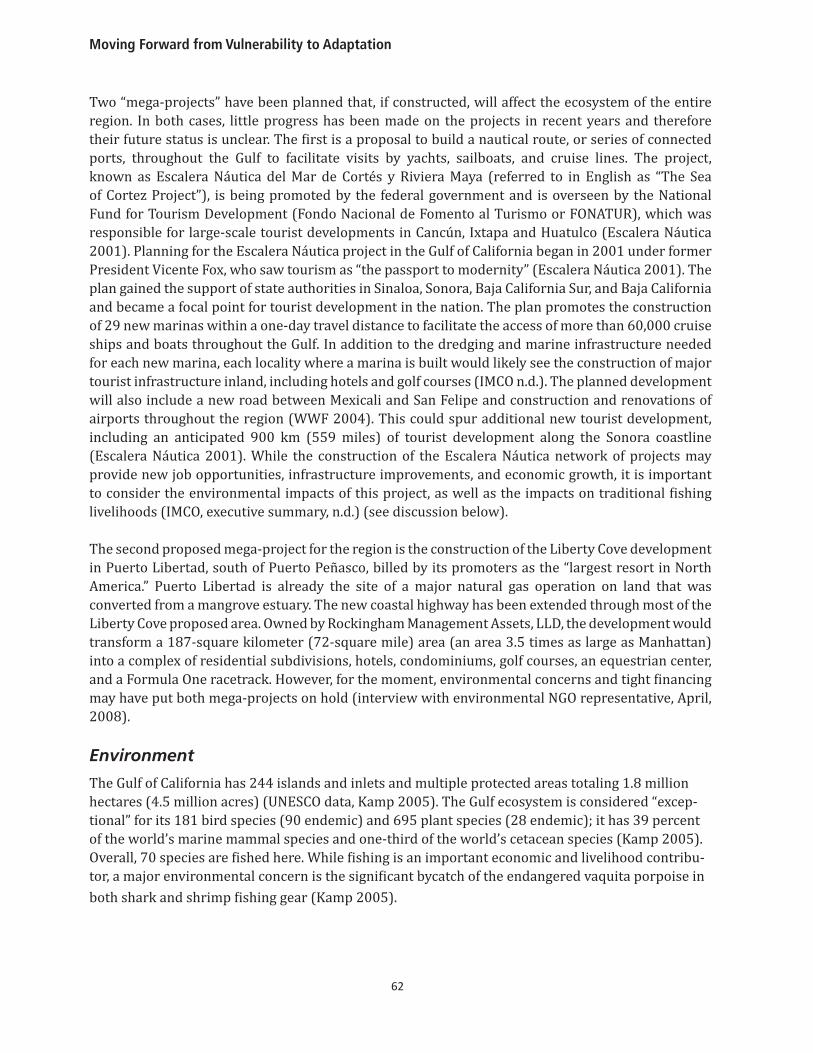
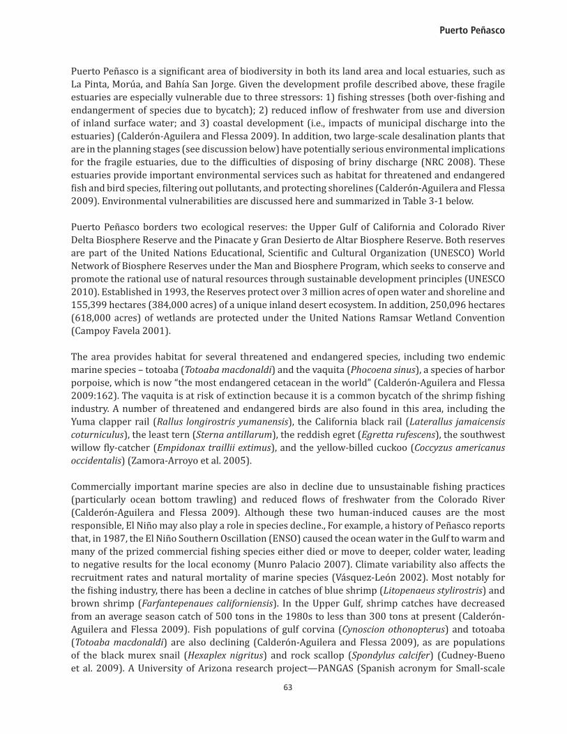
Photo by Jamie McEvoy.Members of Cooperativa Única de Mujeres, a local oyster cooperative, sort through trays of oysters in the coastal mudflats ofMorúa Estuary (Estero Morúa). Oyster farming has become an important livelihood for many families and there are now seven oyster farms near Puerto Peñasco. Morúa Estuary is a fragile ecosystem that supports a diverse population of marine and terrestrial life, including endangered fish and bird species. Estuaries are threatened by coastal development, such as the 20-story condominium development in the background and the proposed construction of a marina to facilitate a nautical “staircase” that would harbor large yachts and cruise ships throughout the Gulf of California. Photo by Jamie McEvoy, November 9, 2008.
AcknowledgmentsThanks go to Luís Farfán, CICESE, for data he provided on cyclone activity.The authors also wish to thank Chrysantha Gakopoulos for layout assistance and Robert Merideth of the Udall Center for editorial guidance.This chapter was first published online in June 2011 by the Udall Center for Studies in Public Policy as part of its series, Working Papers on Climate Change and Water Resources. udallcenter.arizona.edu
Puerto Peñasco
57
Water and Urban Development: Coastal Vulnerability in Puerto Peñasco
By Margaret Wilder, Jamie McEvoy, Gregg M. Garfin, Rachel Beaty, and Emily McGovern
A. Introduction A burgeoning coastal resort town, Puerto Peñasco1 in Sonora, Mexico, hugs the Gulf of California. Lo-cated four and a half hours from Tucson and Phoenix, Arizona, and Hermosillo, Sonora, by car, Puerto Peñasco is a favorite destination for landlocked Sonorans and Arizonans, university students, and retired winter visitors. Puerto Peñasco has attracted large numbers of North Americans who build second homes in luxury subdivisions that wind along the coast. Puerto Peñasco has a number of environmentally distinctive surroundings, including two estuaries—the Morua and La Pinta Estuar-ies—and a national biosphere reserve that provides habitat for hundreds of plant and animal species. The biodiversity of the Gulf of California and pristine beauty of its waters caused it to be called the “aquarium of the world” by oceanographer Jacques Cousteau (Kamp 2005). Due to actual and antici-pated increases in population associated with Puerto Peñasco’s tourism-centered economic strategy, many endangered species and their habitats are under stress, with implications for the human popu-lations that depend on the coastal estuaries for livelihood and employment. Climate factors exac-erbate water vulnerability in Puerto Peñasco. High summer temperatures and low average annual precipitation (~4 inches, or 10.16 cm) create high evapotranspiration rates, especially during the summer monsoon season. Groundwater aquifers have been stretched to their limit. Municipal water managers are searching for new, sustainable water sources. Many hotels and resorts have already installed their own desalination plants as a means of generating more water for their businesses and municipal planners have looked to such alternative technologies as a model. Two desalination plants—one a municipal plant, one a binational plant (for Arizona and Sonora)—are in the planning stages. Identifying and securing sufficient water supply to sustain Puerto Peñasco’s urban growth as a tourism destination while limiting severe damage to its fragile environmental resources is a major challenge facing the region.
This case study of urban water vulnerability and climate variability and change is based on our research in Puerto Peñasco from 2008-2011. The study identifies priority vulnerabilities related to water and climate and assesses the adaptive capacity of water-management and emergency-preparedness institutions to address future water supply challenges. We discuss desalination as the region’s principal adaptive strategy, allowing for increased population growth, while also examining the potential impacts, both direct and indirect, of such technologies. We take into account the different vulnerabilities that already exist within the municipality and the environment of the Upper Gulf of California coast, along with potential future increases in each of these.
1 Puerto Peñasco generally refers to both the city and the municipality. Ninety-eight percent of the municipality’s population is concentrated in the city.
Moving Forward from Vulnerability to Adaptation
58
Research QuestionsFour major questions guided the Puerto Peñasco case study, based on the research questions for the overarching Moving Forward project:
• How is urban water sector vulnerability defined in Puerto Peñasco and what are the key indicators?
• What is the institutional capacity of this binational region to develop adaptive strategies for future water management, at a 5 to 20+ year horizon?
• How can the capacity of water managers and preparedness planners to use climate science and information to improve long-range and “adaptive” decision-making best be institutionalized?
• How can climate science best be integrated into the planning process to enhance the resilience of Puerto Peñasco to climatic and water-resources uncertainties?
Study MethodologyIn Puerto Peñasco, we utilized a variety of research methods to assess urban vulnerability and adaptive capacity. The research team made 15 fieldwork trips and conducted about 30 in-person, semi-structured interviews, including multiple interviews with the local, state-level, and national water managers, disaster relief planners, and non-governmental organizations. Among the agencies and organizations interviewed were representatives of the Organismo Operador Municipal de Agua Potable Alcantarillado y Saneamiento (the Municipal Operating Agency for Wastewater and Sanitation, OOMAPAS), Protección Civil, desalination project coordinators and engineers, developers, ejido residents, colonia residents, and staff from the Center for the Study of Deserts and Oceans (CEDO). We sponsored a daylong stakeholder workshop in Puerto Peñasco on October 2, 2009, attended by about 80 decisionmakers, water managers, and disaster relief officials from Puerto Peñasco and other cities in Sonora.
B. Background: The Puerto Peñasco RegionIn 1927 fishermen established the region’s first permanent fishing camps in what would later become the municipality of Puerto Peñasco (often called “Rocky Point,” the English translation, by Arizonans). In an effort to open up trade routes, government authorities authorized the construction of a railroad between Mexicali, in Baja California, and Puerto Peñasco in 1937. Many of the railroad workers and their families settled in Puerto Peñasco (Munro Palacio 2007). Migrant agricultural laborers also began to pass through Puerto Peñasco on their way to harvest fields in Mexicali and in the United States as part of the Bracero Program in the 1940s. Small shops and guesthouses were established to accommodate the new arrivals. In 1942 the highway between Arizona and Puerto Peñasco was completed. Remarkably, this was the first highway to be built in the state of Sonora (see Figure 3-1). This highway was important for attracting tourism to Puerto Peñasco, connecting trade routes and facilitating transportation between Baja California, other parts of northwestern Mexico, and the southwestern United States.
With rumors that Japanese submarines had been sighted in the Gulf of California in 1939, the U.S. government was eager to work with Mexican authorities to develop better transportation routes to protect the region from a foreign invasion in the Gulf (Munro Palacio 2007). The first airport in Puerto Peñasco was built in 1942 for a meeting between Presidents Franklin D. Roosevelt and Lázaro Cárdenas to discuss national security issues. Though the presidential meeting never took place in Puerto Peñasco, the infrastructure improvements in the region made it an attractive place for other visitors – including sport fishermen who started coming to the region in 1944 in search of sailfish and marlin (Munro Palacio 2007).
Puerto Peñasco
59
With abundant shrimp and fish populations, commercial fisherman also moved to Puerto Peñasco. But by the 1980s, unsustainable fishing practices and reduced flows of freshwater into the Upper Gulf were negatively impacting populations of many commercially important marine species (see discussion below). In 1987, the El Niño Southern Oscillation (ENSO) caused the ocean water in the Gulf to warm and many of the prized commercial fishing species either died or moved to deeper, colder water. Largely as a result, businesses were forced to close and hundreds of people left Puerto Peñasco in search of new livelihood opportunities (Munro Palacio 2007). This provides an early example of how climate variability can affect social and economic stability in the region.
After the fishing bust in the 1980s, a tourism boom began in the 1990s. The passing of the North American Free Trade Agreement (NAFTA) in 1994 encouraged American investors to build condominiums and resorts along the expansive sandy beaches of Puerto Peñasco. But as evidenced by the recent economic downturn, the second-home and tourist industry is susceptible to exogenous shocks.
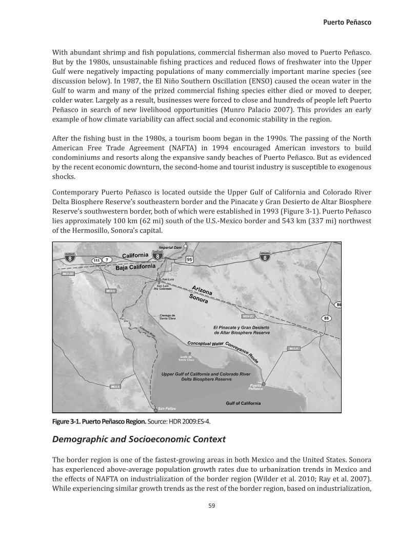
Contemporary Puerto Peñasco is located outside the Upper Gulf of California and Colorado River Delta Biosphere Reserve’s southeastern border and the Pinacate y Gran Desierto de Altar Biosphere Reserve’s southwestern border, both of which were established in 1993 (Figure 3-1). Puerto Peñasco lies approximately 100 km (62 mi) south of the U.S.-Mexico border and 543 km (337 mi) northwest of the Hermosillo, Sonora’s capital.
Figure 3-1. Puerto Peñasco Region. Source: HDR 2009:ES-4.
Demographic and Socioeconomic Context
The border region is one of the fastest-growing areas in both Mexico and the United States. Sonora has experienced above-average population growth rates due to urbanization trends in Mexico and the effects of NAFTA on industrialization of the border region (Wilder et al. 2010; Ray et al. 2007). While experiencing similar growth trends as the rest of the border region, based on industrialization,
Moving Forward from Vulnerability to Adaptation
60
Puerto Peñasco’s increasing population has been driven by the expansion of the tourist industry. In the last decade, the population has grown rapidly due to both the increasing number of tourists and U.S. investors—second-home buyers and hotel owners—and the increasing number of Mexican na-tionals who have migrated to Puerto Peñasco in the hopes of securing employment in the growing tourist sector (Comité de Planeación Municipal 2007). From 1970 to 2000 the population grew from 12,436 residents to over 31,157—a 260.8 percent increase. Between 2000 and 2010, the population of this once quiet fishing village increased by 46 percent, from 31,157 to 57,342 inhabitants (INEGI 2010).
In addition to the permanent residents, the number of tourists swells the actual population at any given time and creates additional demands on the municipality’s infrastructure and water supply. More than a million tourists visit Puerto Peñasco each year (Association of Puerto Peñasco Developers). Part of its appeal involves its low costs relative to California or Baja California (Norte and Sur) coastal destinations (USTDA 2008). Puerto Peñasco visitors spend an estimated average of $50USD daily, as compared to $96USD in Rosarito, Baja California, and $450USD in Los Cabos, Baja California Sur. March, April, and May are the peak tourism months, with a smaller peak in October; most visitors are from Phoenix (24 percent), Mexicali (11 percent), and Tucson (10 percent) (H. Ayuntamiento 2007). As of 2005, the municipality had 10,924 rentable guest rooms, including hotel rooms (30 percent of total) and time-share vacation homes and condominiums (70 percent). RVs are also an important part of the tourist industry; 11 different trailer parks exist with a total of 1,626 spaces. The restaurant and bar industry has also increased due to tourism growth (H. Ayuntamiento 2007). Even with recent investments in the tourist sector, the economic indicators for Puerto Peñasco remain at or below the state level because most jobs offer below-average salaries.2 Tourism contributes significantly to the local economy, accounting for 42.3 percent of Puerto Peñasco’s economy (Secretaria de Economía 2003). The higher paid jobs in the real estate sector contribute another 25.6 percent to the economy. Puerto Peñasco accounts for 2.94 percent of the state’s total tourism industry and 18.58 percent of the state’s total real estate industry (Secretaria de Economia 2003).
Fishing continues to be the other important economic sector in Puerto Peñasco, accounting for 9.7 percent of the city’s economic activity (Secretaria de Economia 2003). The municipality’s 12 seafood-packing plants generate more than 3,000 tons of seafood annually, most of which is exported to Arizona and California (USTDA 2008; H. Ayuntamiento 2007). The principal export is shrimp. With over 125 large fishing boats and 300 smaller fishing boats, Puerto Peñasco is the primary seafood producer in Sonora, selling to both domestic and international markets (H. Ayuntamiento 2007) and making up 10.3 percent of the total Sonoran fishing economy (Secretaria de Economia 2003). The industry provides over 1,300 jobs and offers some of the best salaries in the region.3
2 The average per capita income of 28,400 pesos ($2,185USD) in Puerto Peñasco is significantly lower than the state’s per capita average of 45,600 pesos ($3,508USD). The most highly paid jobs are in the real estate sector, with per capita incomes of 60,100 pesos ($4,624USD), but there are fewer opportunities in this sector. Salaries in the tourist industry of 27,700 pesos ($2,131USD) are below the municipal average. A study on competitiveness and sustainability by IMCO (n.d) suggests that incorporating principles of sustainable development would provide greater benefits for local residents. These imply incorporating local knowledge and skills and recruiting local residents for higher paying jobs as guides, chefs, and artisans, for which salaries can average more than $15,000USD/year. This contrasts with the conventional model of development, which typically brings in outsiders and foreigners to assume the more prestigious and higher-paying jobs, while employing local residents for lower-paying jobs such as housekeeping, gardening, and bellmen with average salaries of less than $7,800USD/year. 3 Jobs in the fishing industry have an average per capita salary of 34,200 pesos ($2,631USD).
Puerto Peñasco
61
Puerto Peñasco is especially vulnerable to the vicissitudes of the U.S. economy, given the high interdependence of the local economy with that of the southwestern United States. Since 2008, the global recession has had devastating impacts on Puerto Peñasco’s development, leading to some local black humor that Puerto Peñasco should be nicknamed “Muerto Peñasco” (dead Peñasco). The downturn in Puerto Peñasco’s economy has created economic vulnerability for local residents dependent upon employment in local tourism industry.
Future Growth The most recent planning documents indicate that construction trends are likely to accelerate in the future. However, the extent to which the recent recession has impacted these plans remains unknown. Mexico’s tourism and sustainable development plan indicates Puerto Peñasco is targeted to be one of Mexico’s 32 major resort destinations. Municipal officials estimate that the population could more than double to 98,000 habitants by 2030 (H. Ayuntamiento 2007). As of 2005, a number of development projects were either being built or were in the process of being authorized. These proposed projects were expected to add 26,002 rentable guest rooms. An additional 22,839 rooms were to be authorized, pending completion of the sales permits. Two other major construction projects—the Mayan Palace and Sandy Beach Resort—were expected to add another 105,554 rooms (H. Ayuntamiento 2007).
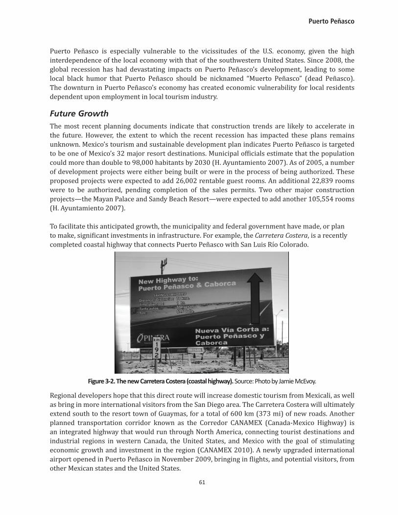
To facilitate this anticipated growth, the municipality and federal government have made, or plan to make, significant investments in infrastructure. For example, the Carretera Costera, is a recently completed coastal highway that connects Puerto Peñasco with San Luis Río Colorado.
Figure 3-2. The new Carretera Costera (coastal highway). Source: Photo by Jamie McEvoy.
Regional developers hope that this direct route will increase domestic tourism from Mexicali, as well as bring in more international visitors from the San Diego area. The Carretera Costera will ultimately extend south to the resort town of Guaymas, for a total of 600 km (373 mi) of new roads. Another planned transportation corridor known as the Corredor CANAMEX (Canada-Mexico Highway) is an integrated highway that would run through North America, connecting tourist destinations and industrial regions in western Canada, the United States, and Mexico with the goal of stimulating economic growth and investment in the region (CANAMEX 2010). A newly upgraded international airport opened in Puerto Peñasco in November 2009, bringing in flights, and potential visitors, from other Mexican states and the United States.
Moving Forward from Vulnerability to Adaptation
62
Two “mega-projects” have been planned that, if constructed, will affect the ecosystem of the entire region. In both cases, little progress has been made on the projects in recent years and therefore their future status is unclear. The first is a proposal to build a nautical route, or series of connected ports, throughout the Gulf to facilitate visits by yachts, sailboats, and cruise lines. The project, known as Escalera Náutica del Mar de Cortés y Riviera Maya (referred to in English as “The Sea of Cortez Project”), is being promoted by the federal government and is overseen by the National Fund for Tourism Development (Fondo Nacional de Fomento al Turismo or FONATUR), which was responsible for large-scale tourist developments in Cancún, Ixtapa and Huatulco (Escalera Náutica 2001). Planning for the Escalera Náutica project in the Gulf of California began in 2001 under former President Vicente Fox, who saw tourism as “the passport to modernity” (Escalera Náutica 2001). The plan gained the support of state authorities in Sinaloa, Sonora, Baja California Sur, and Baja California and became a focal point for tourist development in the nation. The plan promotes the construction of 29 new marinas within a one-day travel distance to facilitate the access of more than 60,000 cruise ships and boats throughout the Gulf. In addition to the dredging and marine infrastructure needed for each new marina, each locality where a marina is built would likely see the construction of major tourist infrastructure inland, including hotels and golf courses (IMCO n.d.). The planned development will also include a new road between Mexicali and San Felipe and construction and renovations of airports throughout the region (WWF 2004). This could spur additional new tourist development, including an anticipated 900 km (559 miles) of tourist development along the Sonora coastline (Escalera Náutica 2001). While the construction of the Escalera Náutica network of projects may provide new job opportunities, infrastructure improvements, and economic growth, it is important to consider the environmental impacts of this project, as well as the impacts on traditional fishing livelihoods (IMCO, executive summary, n.d.) (see discussion below).
The second proposed mega-project for the region is the construction of the Liberty Cove development in Puerto Libertad, south of Puerto Peñasco, billed by its promoters as the “largest resort in North America.” Puerto Libertad is already the site of a major natural gas operation on land that was converted from a mangrove estuary. The new coastal highway has been extended through most of the Liberty Cove proposed area. Owned by Rockingham Management Assets, LLD, the development would transform a 187-square kilometer (72-square mile) area (an area 3.5 times as large as Manhattan) into a complex of residential subdivisions, hotels, condominiums, golf courses, an equestrian center, and a Formula One racetrack. However, for the moment, environmental concerns and tight financing may have put both mega-projects on hold (interview with environmental NGO representative, April, 2008).
Environment The Gulf of California has 244 islands and inlets and multiple protected areas totaling 1.8 million hectares (4.5 million acres) (UNESCO data, Kamp 2005). The Gulf ecosystem is considered “excep-tional” for its 181 bird species (90 endemic) and 695 plant species (28 endemic); it has 39 percent of the world’s marine mammal species and one-third of the world’s cetacean species (Kamp 2005). Overall, 70 species are fished here. While fishing is an important economic and livelihood contribu-tor, a major environmental concern is the significant bycatch of the endangered vaquita porpoise in both shark and shrimp fishing gear (Kamp 2005).
Puerto Peñasco
63
Puerto Peñasco is a significant area of biodiversity in both its land area and local estuaries, such as La Pinta, Morúa, and Bahía San Jorge. Given the development profile described above, these fragile estuaries are especially vulnerable due to three stressors: 1) fishing stresses (both over-fishing and endangerment of species due to bycatch); 2) reduced inflow of freshwater from use and diversion of inland surface water; and 3) coastal development (i.e., impacts of municipal discharge into the estuaries) (Calderón-Aguilera and Flessa 2009). In addition, two large-scale desalination plants that are in the planning stages (see discussion below) have potentially serious environmental implications for the fragile estuaries, due to the difficulties of disposing of briny discharge (NRC 2008). These estuaries provide important environmental services such as habitat for threatened and endangered fish and bird species, filtering out pollutants, and protecting shorelines (Calderón-Aguilera and Flessa 2009). Environmental vulnerabilities are discussed here and summarized in Table 3-1 below.
Puerto Peñasco borders two ecological reserves: the Upper Gulf of California and Colorado River Delta Biosphere Reserve and the Pinacate y Gran Desierto de Altar Biosphere Reserve. Both reserves are part of the United Nations Educational, Scientific and Cultural Organization (UNESCO) World Network of Biosphere Reserves under the Man and Biosphere Program, which seeks to conserve and promote the rational use of natural resources through sustainable development principles (UNESCO 2010). Established in 1993, the Reserves protect over 3 million acres of open water and shoreline and 155,399 hectares (384,000 acres) of a unique inland desert ecosystem. In addition, 250,096 hectares (618,000 acres) of wetlands are protected under the United Nations Ramsar Wetland Convention (Campoy Favela 2001).
The area provides habitat for several threatened and endangered species, including two endemic marine species – totoaba (Totoaba macdonaldi) and the vaquita (Phocoena sinus), a species of harbor porpoise, which is now “the most endangered cetacean in the world” (Calderón-Aguilera and Flessa 2009:162). The vaquita is at risk of extinction because it is a common bycatch of the shrimp fishing industry. A number of threatened and endangered birds are also found in this area, including the Yuma clapper rail (Rallus longirostris yumanensis), the California black rail (Laterallus jamaicensis coturniculus), the least tern (Sterna antillarum), the reddish egret (Egretta rufescens), the southwest willow fly-catcher (Empidonax traillii extimus), and the yellow-billed cuckoo (Coccyzus americanus occidentalis) (Zamora-Arroyo et al. 2005).
Commercially important marine species are also in decline due to unsustainable fishing practices (particularly ocean bottom trawling) and reduced flows of freshwater from the Colorado River (Calderón-Aguilera and Flessa 2009). Although these two human-induced causes are the most responsible, El Niño may also play a role in species decline., For example, a history of Peñasco reports that, in 1987, the El Niño Southern Oscillation (ENSO) caused the ocean water in the Gulf to warm and many of the prized commercial fishing species either died or move to deeper, colder water, leading to negative results for the local economy (Munro Palacio 2007). Climate variability also affects the recruitment rates and natural mortality of marine species (Vásquez-León 2002). Most notably for the fishing industry, there has been a decline in catches of blue shrimp (Litopenaeus stylirostris) and brown shrimp (Farfantepenaues californiensis). In the Upper Gulf, shrimp catches have decreased from an average season catch of 500 tons in the 1980s to less than 300 tons at present (Calderón-Aguilera and Flessa 2009). Fish populations of gulf corvina (Cynoscion othonopterus) and totoaba (Totoaba macdonaldi) are also declining (Calderón-Aguilera and Flessa 2009), as are populations of the black murex snail (Hexaplex nigritus) and rock scallop (Spondylus calcifer) (Cudney-Bueno et al. 2009). A University of Arizona research project—PANGAS (Spanish acronym for Small-scale
Moving Forward from Vulnerability to Adaptation
64
Fisheries in the Northern Gulf—Environment and Society)—collaborates with local fishermen and other regional researchers and NGO’s (including CEDO, see sidebar below) to promote sustainable small-scale fishing and marine conservation in the Upper Gulf.4
In sum, rapid tourist and urban development, increasing water demands and seawater desalination in and around Puerto Peñasco, along with climate change, will have important consequences for the fishing industry and the ecosystems that support it.
Table 3-1. Summary of Environmental Vulnerabilities around Puerto Peñasco.
The environmental impacts of urban and tourist development are also a concern in the region—particularly the mega-projects Escalera Náutica and the proposed Liberty Cove development in Puerto Libertad. Environmental NGOs, like Pro Esteros, fear that the project “will compromise a unique desert and coastal ecosystem” and have called for more in-depth environmental reviews (Thompson 2003). The fishing industry is directly threatened by plans to dredge estuaries in order to develop marinas and tourist developments (Guido 2006). Other environmental concerns include increased demand for scarce water resources, increased wastewater and solid waste, and land use changes that result in more impermeable surfaces and disrupt habitat (such as the construction of hotels, parking lots and roadways).
In addition to these mega-projects, local authorities in Puerto Peñasco are feeling pressure to authorize and support the development of infrastructure, hotels and condominium projects that would impact the sensitive marine reefs, wetlands and the estuaries of La Pinta, Morúa, and Bahía
4 A short video describing the goals and research of PANGAS can be viewed on the project’s website at: http://www.pangas.arizona.edu/en/researchers
Environmental Vulnerabilities
1. Located near the boundary of two important ecological reserves.2. Ecosystem provides habitat to hundreds of species of birds, plants, and
commercially important marine animals – many of which are endemic species.
3. Fragile estuary ecosystems are threatened by coastal development (especially proposed mega-projects), urban runoff, dredging to construct marinas, brine discharge from desalination plants, reduced inflows of freshwater, and unsustainable fishing practices (particularly ocean-bottom trawling).
4. High climate variability in year-to-year climate is characteristic of arid regions.
5. Variability of precipitation patterns related to El Niño-Southern Oscillation contributes primarily to fall and winter precipitation variability, which can produce some ferociously wet winters.
6. Climate change will exacerbate conditions of marginal precipitation and reduce the effectiveness of groundwater recharge due to increased evaporation.
7. Increasing demands for scarce water supplies.
Puerto Peñasco
65
San Jorge (Guido 2005). These new developments are encroaching upon the Federal Maritime Land Zone (Zona Federal Maritimo Terrestre), which preserves 20 meters (66 feet) from the water’s edge of coastal land as public land where development should not be allowed to occur. These developments threaten a protected species of scallop—the rock scallop—and the least tern.
Despite these negative impacts, the local government is strongly supporting such development—as indicated by the increasing number of permits approved for the construction of new hotels in the last decade. As reported by Guido (2005), the local government has authorized all proposed projects and local agencies willingly provide the necessary paperwork to affirm water availability and approve land use changes.5 To address the concerns of water availability for future growth, the municipality is seriously considering two separate plans for the construction of a desalination plant to meet increased water demands; a separate planning process is underway to study the feasibility of a binational desalination plant (see discussion below).
30 YEARS PROTECTING THE UPPER GULF: CENTER FOR THE STUDY OF DESERTS AND OCEANS
An important local environmental NGO in Puerto Peñasco is the Intercultural Center for the Study of Deserts and Oceans (Centro Intercultural de Estudios de Desiertos y Océanos, CEDO). CEDO was established in 1980 and promotes environmental research, education, and conservation in the Northern Gulf of California (CEDO 2010). Its main conservation efforts involve working with local fisherman and divers to promote more sustainable fishing practices, co-management and monitoring of commercial and non-commercial marine resources, and establishment of cooperative management practices to ensure the sustainable harvest of marine resources. CEDO has also participated in a study on the endangered vaquita and encourages fisherman to use alternative fishing methods that do not rely on gillnets, which can easily ensnare and kill the small vaquita (Dalton 2010). In addition to work on sustainable fisheries, CEDO also promotes the sustainable management of coastal wetlands by working to conserve public and private land, using legal tools to promote conservation and develop alternative economic options that protect livelihoods. CEDO works with a group of local women to support the operation of an oyster cooperative that uses sustainable aquaculture techniques to raise and harvest oysters and promotes eco-tourist activities such as kayaking and birdwatching tours (CEDO 2010; see also photo at beginning of this chapter).
C. Climate Variability, Climate Change, and Impacts
Climate Variability
Located in an arid desert region, Puerto Peñasco experiences high temperature extremes in the sum-mer months (July-September), ranging between 30°C (86°F) and 43°C (109°F). These high temper-atures can create dangerous heat wave conditions. Average annual precipitation is only 93.7 mm (3.7 in) due to Puerto Peñasco’s location in the rain shadow of mountains on northern Mexico’s Baja California peninsula. Puerto Peñasco experiences substantial seasonality in precipitation, due to its location on the northwest fringe of the North American Monsoon (NAM)6 circulation pattern. July and August are the wettest months, wherein precipitation is delivered through torrential convective
5 Again, while the development in the tourism industry has undoubtedly been affected by the recent global recession, we do not know to what extent. 6 The NAM precipitation pattern results in highly variable intraseasonal, interannual, and interdecadal precipitation patterns contributing to frequent and intense floods and droughts (Hallack-Alegria and Wallace 2007; Magaña and Conde 2000; Comrie and Glenn 1998).
Moving Forward from Vulnerability to Adaptation
66
thunderstorms; however, little precipitation occurs during the rest of the year. The greatest rates of evaporation occur from May to September, with an average monthly evaporation rate of 210 mm (8.27 in). In contrast, the coolest months, December, January, and February, have temperatures reach-ing below 11°C (51.8°F); during these cooler months, the region experiences an average of 10 to 30 days in which minimum temperatures are below freezing (USTDA 2008; H. Ayuntamiento 2007).
Flooding occurs during the summer monsoon season, especially in Puerto Peñasco’s wetlands and estuaries. Flooding river water often mixes with tidewater, leading to a more expansive area of inundation. Unfortunately, current development patterns and plans fail to take these sensitive estuary and wetland areas into account (H. Ayuntamiento 2007). In January 2010, unusually heavy rains and strong winds, brought on by a tropical storm, flooded and destroyed city infrastructure in the colonias (neighborhoods) of San Rafael and Nuevo Peñasco. Protección Civil reported that 15 houses lost their roofs, 15 houses were completely razed, and 42 electrical cables were cut or knocked down. Two hundred and forty residents had to seek refuge at one of the two established shelters in the city (the gymnasium and the fire station). In addition to this example of winter flooding, initiated by an El Niño-generated tropical storm, there is evidence for increasing intensity of summer monsoon precipitation (Cavazos et al. 2008). Cavazos and her colleagues report increases in intensity of summer and warm season precipitation, due to an increased contribution of tropical storm moisture. In a further study of trends in intense precipitation, Arriaga-Ramírez and Cavazos confirmed these trends for northwest Mexico, during 1960-1997, for June-October (Arriaga-Ramírez and Cavazos 2010). These recent studies expand upon results noted in a recent U.S. Climate Change Science Program synthesis and assessment product on climate change extremes (Kunkel et al. 2008), which also characterized rainfall in northwest Mexico, as becoming “more erratic with a tendency towards high intensity rainfall events, a shorter monsoon, and shorter wet spells.”
Nevertheless, Puerto Peñasco itself is not especially prone to such natural disasters because of its location. Baja’s extensive mountain ranges and the two nearby large islands (Tiburón and Angel de la Guarda) located in the Gulf form natural barriers and usually protect the municipality from such extreme weather events. However, it is important to note that cyclones can develop in the Gulf of California, typically beginning in the latter part of July. From 1951 to 2003, 14 tropical cyclones have affected Puerto Peñasco; since 2003, no cyclones have passed near Peñasco (pers. comm., Luís Farfán, CICESE. La Paz, Baja California Sur, Mexico). According to a municipal study, the municipality has an estimated 0.05 percent chance of being hit by a hurricane (used interchangeably with the term “cyclone”) and a 0.10 percent of being struck by tropical storms (H. Ayuntamiento 2007).
Like the rest of the Arizona-Sonora border region, from 1996 to 2006 Puerto Peñasco was in an extended drought. Less water has not translated into less water usage; along with population growth has come an increase in consumption. Groundwater aquifers are being overused to the extent that other surrounding aquifers are also being overexploited. Such overdrafting of aquifers can result in a saline intrusion and land subsidence. Municipality officials are finding it increasingly difficult to guarantee residents with a reliable and secure water supply. Furthermore, with lower water tables more electricity is needed to pump water, thus increasing pumping costs. Farmers in the few ejidos (communal farms) north of the city of Puerto Peñasco have found that the increased cost of groundwater pumping, along with reduced agricultural credit availability, have made farming in the region increasingly financially prohibitive. The ejidos have drastically declined in population and are now all but devoid of people (interviews with ejidatarios, April 23, 2009).
Puerto Peñasco
67
Climate ChangeRegional climate change is expected to lead to a 2 to 3° C increase in annual temperature and a 5 to 15 percent decrease in annual precipitation by 2080-99, in comparison with a 1980-99 base period, based on 21 global climate models (GCMs), using an A1B greenhouse gas emissions scenario (IPCC 2007). All models agree on the increase in annual temperature and more than 75 percent of models agree on the decrease in annual precipitation. Higher temperatures will accelerate evapotranspira-tion rates; combined with decreasing rainfall, projected impacts for the region include more severe and pro longed droughts. It is expected that this northwest region of Mexico will experience increased temperatures, increased evaporation, increased variability of rainfall, and longer dry spells (Seager et al. 2007; Díaz-Caravantes and Wilder n.d). Regional models predict that surface temperatures may increase by as much as 2° C (3.6° F) (Magaña and Conde 2000). While precipitation projections re-main uncertain, there will most likely be an increase in rainfall variability. Extreme weather events including floods, droughts, and heat waves are expected to become more intense and frequent. The El Niño-Southern Oscillation is an important factor contributing to interannual variability in regional precipitation. Two GCMs that best capture seasonal precipitation and temperature of the region in-dicate that future aridity in the region will increase dramatically during La Niña episodes; this has important implications for surface flows and groundwater recharge, as well as for regional water demand, as the already reliably dry La Niña winters are projected to be warmer and even drier than at present (Dominguez et al. 2010).
Moving Forward from Vulnerability to Adaptation
68
D. Urban Water Infrastructure
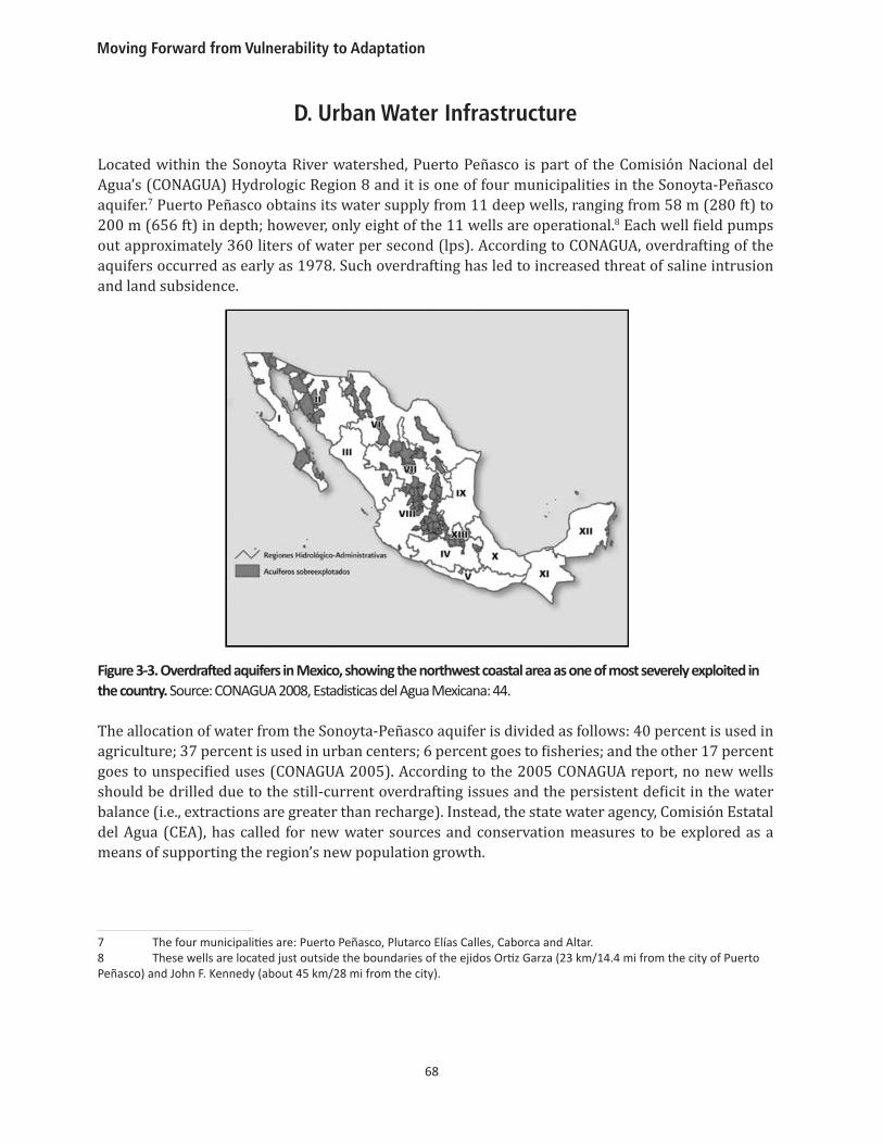
Located within the Sonoyta River watershed, Puerto Peñasco is part of the Comisión Nacional del Agua’s (CONAGUA) Hydrologic Region 8 and it is one of four municipalities in the Sonoyta-Peñasco aquifer.7 Puerto Peñasco obtains its water supply from 11 deep wells, ranging from 58 m (280 ft) to 200 m (656 ft) in depth; however, only eight of the 11 wells are operational.8 Each well field pumps out approximately 360 liters of water per second (lps). According to CONAGUA, overdrafting of the aquifers occurred as early as 1978. Such overdrafting has led to increased threat of saline intrusion and land subsidence.
Figure 3-3. Overdrafted aquifers in Mexico, showing the northwest coastal area as one of most severely exploited in the country. Source: CONAGUA 2008, Estadisticas del Agua Mexicana: 44.
The allocation of water from the Sonoyta-Peñasco aquifer is divided as follows: 40 percent is used in agriculture; 37 percent is used in urban centers; 6 percent goes to fisheries; and the other 17 percent goes to unspecified uses (CONAGUA 2005). According to the 2005 CONAGUA report, no new wells should be drilled due to the still-current overdrafting issues and the persistent deficit in the water balance (i.e., extractions are greater than recharge). Instead, the state water agency, Comisión Estatal del Agua (CEA), has called for new water sources and conservation measures to be explored as a means of supporting the region’s new population growth.
7 The four municipalities are: Puerto Peñasco, Plutarco Elías Calles, Caborca and Altar. 8 These wells are located just outside the boundaries of the ejidos Ortiz Garza (23 km/14.4 mi from the city of Puerto Peñasco) and John F. Kennedy (about 45 km/28 mi from the city).
Puerto Peñasco
69
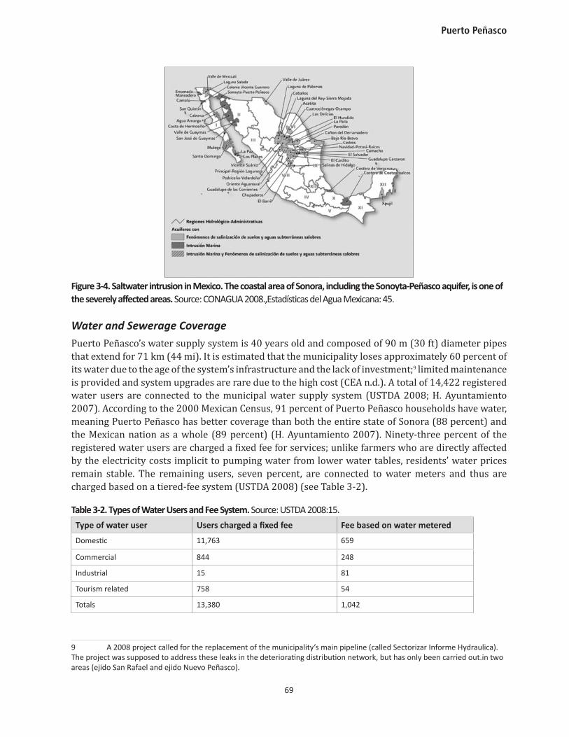
Figure 3-4. Saltwater intrusion in Mexico. The coastal area of Sonora, including the Sonoyta-Peñasco aquifer, is one of the severely affected areas. Source: CONAGUA 2008.,Estadísticas del Agua Mexicana: 45.
Water and Sewerage CoveragePuerto Peñasco’s water supply system is 40 years old and composed of 90 m (30 ft) diameter pipes that extend for 71 km (44 mi). It is estimated that the municipality loses approximately 60 percent of its water due to the age of the system’s infrastructure and the lack of investment;9 limited maintenance is provided and system upgrades are rare due to the high cost (CEA n.d.). A total of 14,422 registered water users are connected to the municipal water supply system (USTDA 2008; H. Ayuntamiento 2007). According to the 2000 Mexican Census, 91 percent of Puerto Peñasco households have water, meaning Puerto Peñasco has better coverage than both the entire state of Sonora (88 percent) and the Mexican nation as a whole (89 percent) (H. Ayuntamiento 2007). Ninety-three percent of the registered water users are charged a fixed fee for services; unlike farmers who are directly affected by the electricity costs implicit to pumping water from lower water tables, residents’ water prices remain stable. The remaining users, seven percent, are connected to water meters and thus are charged based on a tiered-fee system (USTDA 2008) (see Table 3-2).
Table 3-2. Types of Water Users and Fee System. Source: USTDA 2008:15.
Type of water user Users charged a fixed fee Fee based on water metered
Domestic 11,763 659
Commercial 844 248
Industrial 15 81
Tourism related 758 54
Totals 13,380 1,042
9 A 2008 project called for the replacement of the municipality’s main pipeline (called Sectorizar Informe Hydraulica). The project was supposed to address these leaks in the deteriorating distribution network, but has only been carried out.in two areas (ejido San Rafael and ejido Nuevo Peñasco).
Moving Forward from Vulnerability to Adaptation
70
A lower percentage of households in Puerto Peñasco have a connection to the sewage system, 69 percent relative to 78 percent nationally (H. Ayuntamiento 2007). Of those connected in Puerto Peñasco, about 85 percent are domestic, 10 percent commercial, and the remainder tourism or commercial uses. The 240 liters per second (lps) of sewage collected is directed into one of the two wastewater treatment facilities in the area (USTDA 2008). The Mayan Palace, a private tourist resort, operates one of these systems—an oxidant pond—and accepts and treats only the effluent generated by its own resort. A group of tourism businesses runs the second plant, using a sludge system. Golf courses and green spaces receive the treated effluent from both facilities and use it for irrigation (USTDA 2008; H. Ayuntamiento 2007).
There is a clear link between demands on infrastructure and the growing tourism economy, especially in terms of water supply. More tourists will invariably mean an increase in water demands. According to municipality officials, the tourist sector uses approximately 599 liters per day per capita and 320 liters per day per room (H. Ayuntamiento 2007). In addition to a hotel, resorts often build a golf course, which uses an average of 30 lps (or 9 million liters annually) for irrigation purposes. Currently, all of the residual and treated water from the treatment facilities is siphoned off and used to irrigate resort golf courses (CEA n.d.).
E. Water Institutions and Management
Since the introduction of Mexico’s 1992 water reforms and their 2004 update, the responsibility for managing water has shifted from the federal level to the state or municipal level. However, Mexico’s decentralization strategy has not been fully implemented to extend to taxation authority and cost recovery (Wilder 2010; Scott and Banister 2008). A significant limitation is that municipal authorities lack adequate financial and technical resources (Pineda 2002). For example, the local water management agency, OOMAPAS, manages and operates Puerto Peñasco’s potable water service and sewerage network. OOMAPAS-Peñasco has a significant degree of non-collection of water fees owed to the agency; moreover, the trend is moving in the wrong direction, with proportionately less fees collected as the population has increased (Table 3-3).
Table 3-3. Cost Recovery for Water Service Provision in Puerto Peñasco. Source: USTDA 2008:15.
Year Water/wastewater charges (million pesos)
Amount collected (million pesos)
Percent of total collected
Percent uncollected
2003 28.6 21.7 76 24
2004 31 25.3 82 18
2005 35 28.4 81 19
2006 45 35.6 79 21
OOMAPAS—as managed by the previous municipal administration of Puerto Peñasco (2006-2009)—emphasized five programs to improve water management in the municipality (interview with water agency personnel, April 24, 2009). However, with changes in administration since 2009, it remains unclear which of these programs will be continued, discontinued, or re-vamped. The five programs focus on: education, conservation, legal and economic incentives, and investment in
Puerto Peñasco
71
physical infrastructure.10 One of these programs, begun in 2008, promotes water meter installation. Initially, as in many Latin American cities, metering was met with resistance by colonia residents. Metering is a significant improvement that water utilities believe is necessary to allow accountability for precise volumetric measurement of consumption. People who had grown accustomed to fixed rates for their water typically feared that metering would increase their monthly water bill. Some residents have destroyed the meters or have collected petitions to have meters removed. At present, only four colonias have meters. Despite its unpopularity, OOMAPAS still hopes to expand the network of meters.11 OOMAPAS bundles the water supply and wastewater management services into a single customer bill based on the total volume of water used. In addition to collecting payment, OOMPAPAS has introduced a new, tiered scheme for metered water users, wherein different sectors are charged at different levels.12
Another program undertaken by the previous administration was a water-sectorization project (Sectorizar Informe Hidraulica). One of the municipality’s greatest challenges has been maintaining adequate water pressure so that water reaches the city’s center. Sixty percent of water was being lost in the system. The sectorization program was initiated by the CEA with the goal of equalizing the distribution of the city’s water pressure, allowing all areas to enjoy the same amount of pressure. In 2007, the city spent 49 million pesos ($3.8 million USD) to install 18.5 km (11.5 mi) of 76 cm (30 in) PVC pipe and a large water tower with 8,000 m³ of storage capacity. A year later, the city’s main water line was replaced with PVC piping. Since the repairs, the city’s water pressure has jumped from 270lps to 550 lps (interview, municipal water manager, April 9, 2010).13
10 Two water conservation education programs were developed by OOMAPAS-Peñasco. The first program, “Cuidado del Agua” (“Caring for the Water”) is a program based in primary, secondary, and post-secondary schools. Youth in this program are trained to become “inspectors” who keep an eye out for misuse of water in their colonia. As “inspectors,” students can report incidences of water misuse to OOMAPAS and then the agency can follow up with any necessary legal action. The second program is “OOMAPAS en tu Colonia.” (“OOMAPAS in your Neighborhood”)—a program meant specifically for adults. In this program, OOMAPAS employees go to various colonias and conduct home-visits. Adults learn how OOMAPAS operates and how they, as citizens, can help conserve water. A third program assumes a more regulatory approach, imposing fines for the misuse of water, such as overwatering landscaping; using water to clean sidewalks or patios; using too much water to wash a car; or not fixing a leak within the specified time period. Residents are typically given three warnings before receiving a fine of 700 pesos ($54USD). 11 Associated with the metering program, OOMAPAS has changed the tariff rates to encourage water conservation. OOMAPAS tries to assure residents that metering will actually work in their favor because residents were previously charged a flat rate for using 0 to 20 m³. The average water bill for a two-month period in a non-metered flat-rate household was 370-390 pesos ($29-30USD). But the new tariff system allows residents to pay for smaller blocks of water beginning with a minimal charge for 0 to10 m³. According to OOMAPAS, most metered residents use less than 10 m³ and now pay only 45-70 pesos ($3.50-5.40USD) for a two-month period. 12 Domestic metered households pay $45 pesos ($3.50USD) for 1 to10 m³, plus 5 pesos ($0.39USD) for each additional cubic meter from 11 to 20 m³. Commercial metered users pay 98 pesos ($7.60USD) for 1 to10 m³, plus 10 pesos ($0.78USD) for each additional cubic meter from 11 to 20 m³. The metered tourist industries have a minimum quantity of 20 m³ and pay 279 pesos ($22USD) for 0 to 20 m³. They pay an additional 11 pesos ($0.85USD) for the next additional 21-30 m³. 13 However, large amounts of sand have been sucked into the piping from the intake wells and remain present in the distribution system. Increased water pressure had caused this sand to enter household plumbing systems and even clog some pipes. To address the sand issue, city officials have since constructed a supply tank where pumped water accumulates before being distributed through the pipe network; this allows the water to settle and for the particulates to collect on the bottom where they will eventually be scraped out prior to water distribution. Thus far, the sectorization program has only been carried out in two areas (ejido San Rafael and ejido Nuevo Peñasco). OOMAPAS personnel indicated that the new administration will make sure that this program is carried out in the remaining 10 sectors (interview, municipal water manager, April 9, 2010).
Moving Forward from Vulnerability to Adaptation
72
F. Water Demand and Proposed Water Infrastructure Improvements
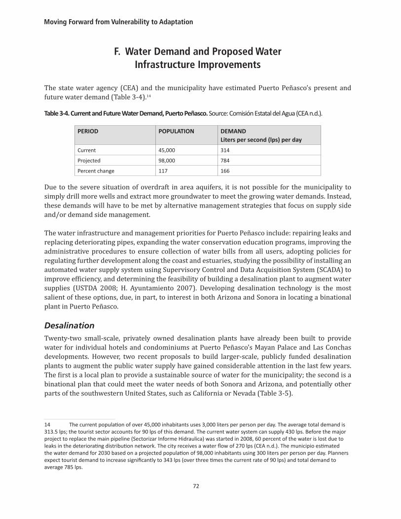
The state water agency (CEA) and the municipality have estimated Puerto Peñasco’s present and future water demand (Table 3-4).14
Table 3-4. Current and Future Water Demand, Puerto Peñasco. Source: Comisión Estatal del Agua (CEA n.d.).
PERIOD POPULATION DEMAND Liters per second (lps) per day
Current 45,000 314
Projected 98,000 784
Percent change 117 166
Due to the severe situation of overdraft in area aquifers, it is not possible for the municipality to simply drill more wells and extract more groundwater to meet the growing water demands. Instead, these demands will have to be met by alternative management strategies that focus on supply side and/or demand side management.
The water infrastructure and management priorities for Puerto Peñasco include: repairing leaks and replacing deteriorating pipes, expanding the water conservation education programs, improving the administrative procedures to ensure collection of water bills from all users, adopting policies for regulating further development along the coast and estuaries, studying the possibility of installing an automated water supply system using Supervisory Control and Data Acquisition System (SCADA) to improve efficiency, and determining the feasibility of building a desalination plant to augment water supplies (USTDA 2008; H. Ayuntamiento 2007). Developing desalination technology is the most salient of these options, due, in part, to interest in both Arizona and Sonora in locating a binational plant in Puerto Peñasco.
DesalinationTwenty-two small-scale, privately owned desalination plants have already been built to provide water for individual hotels and condominiums at Puerto Peñasco’s Mayan Palace and Las Conchas developments. However, two recent proposals to build larger-scale, publicly funded desalination plants to augment the public water supply have gained considerable attention in the last few years. The first is a local plan to provide a sustainable source of water for the municipality; the second is a binational plan that could meet the water needs of both Sonora and Arizona, and potentially other parts of the southwestern United States, such as California or Nevada (Table 3-5).
14 The current population of over 45,000 inhabitants uses 3,000 liters per person per day. The average total demand is 313.5 lps; the tourist sector accounts for 90 lps of this demand. The current water system can supply 430 lps. Before the major project to replace the main pipeline (Sectorizar Informe Hidraulica) was started in 2008, 60 percent of the water is lost due to leaks in the deteriorating distribution network. The city receives a water flow of 270 lps (CEA n.d.). The municipio estimated the water demand for 2030 based on a projected population of 98,000 inhabitants using 300 liters per person per day. Planners expect tourist demand to increase significantly to 343 lps (over three times the current rate of 90 lps) and total demand to average 785 lps.
Puerto Peñasco
73
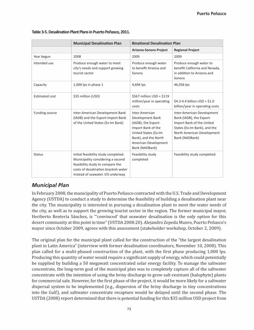
Table 3-5. Desalination Plant Plans in Puerto Peñasco, 2011.
Municipal Desalination Plan Binational Desalination Plan
Arizona-Sonora Project Regional Project
Year begun 2008 2009 2009
Intended use Produce enough water to meet city’s needs and support growing tourist sector
Produce enough water to benefit Arizona and Sonora
Produce enough water to benefit California and Nevada, in addition to Arizona and Sonora
Capacity 1,000 lps in phase 1 4,694 lps 46,936 lps
Estimated cost $35 million (USD) $567 million USD + $119 million/year in operating costs
$4.3-4.4 billion USD + $1.0 billion/year in operating costs
Funding source Inter-American Development Bank (IADB) and the Export-Import Bank of the United States (Ex-Im Bank)
Inter-American Development Bank (IADB), the Export-Import Bank of the United States (Ex-Im Bank), and the North American Development Bank (NADBank)
Inter-American Development Bank (IADB), the Export-Import Bank of the United States (Ex-Im Bank), and the North American Development Bank (NADBank)
Status Initial feasibility study completed. Municipality considering a second feasibility study to compare the costs of desalination brackish water instead of seawater. EIS underway.
Feasibility study completed
Feasibility study completed.
Municipal PlanIn February 2008, the municipality of Puerto Peñasco contracted with the U.S. Trade and Development Agency (USTDA) to conduct a study to determine the feasibility of building a desalination plant near the city. The municipality is interested in pursuing a desalination plant to meet the water needs of the city, as well as to support the growing tourist sector in the region. The former municipal mayor, Heriberto Rentería Sánchez, is “‘convinced’ that seawater desalination is the only option for this desert community at this point in time” (USTDA 2008:20). Alejandro Zepeda Munro, Puerto Peñasco’s mayor since October 2009, agrees with this assessment (stakeholder workshop, October 2, 2009).
The original plan for the municipal plant called for the construction of the “the largest desalination plant in Latin America” (interview with former desalination coordinators, November 10, 2008). This plan called for a multi-phased construction of the plant, with the first phase producing 1,000 lps. Producing this quantity of water would require a significant supply of energy, which could potentially be supplied by building a 50 megawatt concentrated solar energy facility. To manage the saltwater concentrate, the long-term goal of the municipal plan was to completely capture all of the saltwater concentrate with the intention of using the briny discharge to grow salt-resistant (halophyte) plants for commercial sale. However, for the first phase of the project, it would be more likely for a saltwater dispersal system to be implemented (e.g., dispersion of the briny discharge in tiny concentrations into the Gulf), and saltwater concentrate recapture would be delayed until the second phase. The USTDA (2008) report determined that there is potential funding for this $35 million USD project from
Moving Forward from Vulnerability to Adaptation
74
both the Inter-American Development Bank (IADB) and the Export-Import Bank of the United States (Ex-Im Bank).
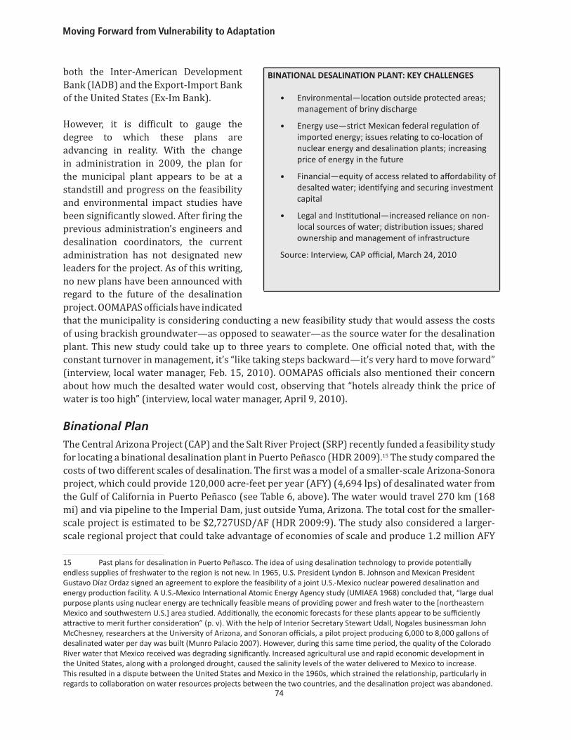
However, it is difficult to gauge the degree to which these plans are advancing in reality. With the change in administration in 2009, the plan for the municipal plant appears to be at a standstill and progress on the feasibility and environmental impact studies have been significantly slowed. After firing the previous administration’s engineers and desalination coordinators, the current administration has not designated new leaders for the project. As of this writing, no new plans have been announced with regard to the future of the desalination project. OOMAPAS officials have indicated that the municipality is considering conducting a new feasibility study that would assess the costs of using brackish groundwater—as opposed to seawater—as the source water for the desalination plant. This new study could take up to three years to complete. One official noted that, with the constant turnover in management, it’s “like taking steps backward—it’s very hard to move forward” (interview, local water manager, Feb. 15, 2010). OOMAPAS officials also mentioned their concern about how much the desalted water would cost, observing that “hotels already think the price of water is too high” (interview, local water manager, April 9, 2010).
Binational Plan The Central Arizona Project (CAP) and the Salt River Project (SRP) recently funded a feasibility study for locating a binational desalination plant in Puerto Peñasco (HDR 2009).15 The study compared the costs of two different scales of desalination. The first was a model of a smaller-scale Arizona-Sonora project, which could provide 120,000 acre-feet per year (AFY) (4,694 lps) of desalinated water from the Gulf of California in Puerto Peñasco (see Table 6, above). The water would travel 270 km (168 mi) and via pipeline to the Imperial Dam, just outside Yuma, Arizona. The total cost for the smaller-scale project is estimated to be $2,727USD/AF (HDR 2009:9). The study also considered a larger-scale regional project that could take advantage of economies of scale and produce 1.2 million AFY
15 Past plans for desalination in Puerto Peñasco. The idea of using desalination technology to provide potentially endless supplies of freshwater to the region is not new. In 1965, U.S. President Lyndon B. Johnson and Mexican President Gustavo Díaz Ordaz signed an agreement to explore the feasibility of a joint U.S.-Mexico nuclear powered desalination and energy production facility. A U.S.-Mexico International Atomic Energy Agency study (UMIAEA 1968) concluded that, “large dual purpose plants using nuclear energy are technically feasible means of providing power and fresh water to the [northeastern Mexico and southwestern U.S.] area studied. Additionally, the economic forecasts for these plants appear to be sufficiently attractive to merit further consideration” (p. v). With the help of Interior Secretary Stewart Udall, Nogales businessman John McChesney, researchers at the University of Arizona, and Sonoran officials, a pilot project producing 6,000 to 8,000 gallons of desalinated water per day was built (Munro Palacio 2007). However, during this same time period, the quality of the Colorado River water that Mexico received was degrading significantly. Increased agricultural use and rapid economic development in the United States, along with a prolonged drought, caused the salinity levels of the water delivered to Mexico to increase. This resulted in a dispute between the United States and Mexico in the 1960s, which strained the relationship, particularly in regards to collaboration on water resources projects between the two countries, and the desalination project was abandoned.
BINATIONAL DESALINATION PLANT: KEY CHALLENGES
• Environmental—location outside protected areas; management of briny discharge
• Energy use—strict Mexican federal regulation of imported energy; issues relating to co-location of nuclear energy and desalination plants; increasing price of energy in the future
• Financial—equity of access related to affordability of desalted water; identifying and securing investment capital
• Legal and Institutional—increased reliance on non-local sources of water; distribution issues; shared ownership and management of infrastructure
Source: Interview, CAP official, March 24, 2010
Puerto Peñasco
75
(46,936 lps) to be pumped to Imperial Dam via canal for $1,183USD/AF (less than half the cost of the smaller-scale project). This larger project could provide enough water to augment supplies in California and Nevada, in addition to Arizona and Sonora. As indicated in the report, “Desalinated water conveyed to Imperial Dam will displace Colorado River water that can then be exchanged for users in Arizona, and possibly the other basin states, which would then divert the additional Colorado River water through their existing, expanded, or new infrastructure” (HDR 2009:7).
Arizona water managers are not the only ones considering the option of partnering with Mexico to build a binational desalination plant. In a report commissioned by the seven Colorado River Basin states (Arizona, California, Colorado, Nevada, New Mexico, Utah, and Wyoming), the states considered 12 different long-term augmentation strategies (Colorado River Water Consultants 2008). Among these was the construction of an ocean-water desalination plant in California, Baja California, or the Gulf of California. The freshwater produced by the plant would “be used in California or Mexico in place of water otherwise diverted from the Colorado River, thereby adding to the available supply in the Colorado River and avoiding the costs of long-distance diversion” (p. 10). In May of 2010, water managers from the nine U.S.-Mexico border states gathered in San Diego, California to discuss binational desalination (WEF 2010). In 2005, Nevada was charging forward with plans to build a desalination plant in San Diego and/or Tijuana in exchange for their Colorado River water to serve the city of Las Vegas (Southwest Nevada Water Authority 2009, accessed 4/6/2011 at http://www.snwa.com/assets/ pdf/wr_instate_presentation.pdf). However, current Southern Nevada Water Authority (SNWA) administrators have taken a more negative view of desalination based on anticipated high costs and the unreliable nature of Colorado River flows.
From a geopolitical standpoint, a binational desalination plant would make the U.S. southwest more dependent upon friendly and collaborative relations between the United States and Mexico. Overall, we have argued elsewhere (Wilder et al. 2010) that the proposed binational desalination plant has low potential for contributing to regional adaptive capacity (see sidebar, above).
Desalination may be the preferred water augmentation alternative in Sonora and Arizona because it is less politically divisive than other options, such as rural-to-urban or inter-basin transfers, strict conservation measures, or limiting future growth. For example, during a stakeholder workshop in Hermosillo, Sonora, Mexican federal water managers emphasized that a major statewide water infrastructure plan, known as “Sonora SI” would promote efficiency, water reuse and desalination so that agriculture would not lose a single drop of water. Similarly, Kohlhoff and Roberts (2007) have argued that rural-to-urban transfers in Arizona will be more politically difficult than many policy experts have suggested. Instead, in the long term, Arizona may need to partner with either Sonora or California to build a desalination plant along the coastline in exchange for an equivalent portion of that state’s Colorado River water. Although both Californian and Mexican coasts provide opportunities for desalination, California is less likely to be interested in cooperating with Arizona because protecting its coastal views and property values are priorities for California. Environmental regulations are more daunting and complex in California. Any desalination plants that are permitted to be built on the California coast will likely be used to serve California’s own growing water demands. Building a desalination plant in Mexico is the most “promising and farsighted” augmentation strategy for Arizona (Kohlhoff and Roberts 2007: 276).
Despite these challenges, the USTDA (2008) report determined that potential funding exists for the project through the Inter-American Development Bank (IADB) and the Export-Import Bank of the
Moving Forward from Vulnerability to Adaptation
76
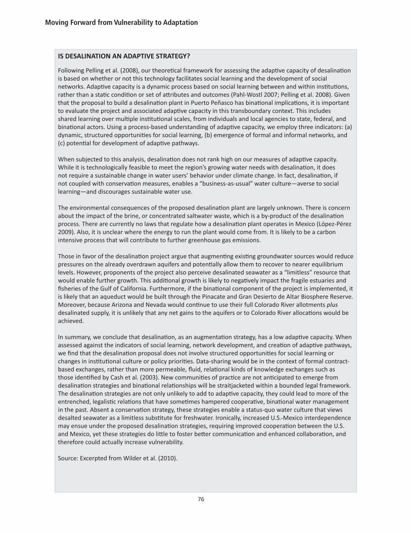
IS DESALINATION AN ADAPTIVE STRATEGY?
Following Pelling et al. (2008), our theoretical framework for assessing the adaptive capacity of desalination is based on whether or not this technology facilitates social learning and the development of social networks. Adaptive capacity is a dynamic process based on social learning between and within institutions, rather than a static condition or set of attributes and outcomes (Pahl-Wostl 2007; Pelling et al. 2008). Given that the proposal to build a desalination plant in Puerto Peñasco has binational implications, it is important to evaluate the project and associated adaptive capacity in this transboundary context. This includes shared learning over multiple institutional scales, from individuals and local agencies to state, federal, and binational actors. Using a process-based understanding of adaptive capacity, we employ three indicators: (a) dynamic, structured opportunities for social learning, (b) emergence of formal and informal networks, and (c) potential for development of adaptive pathways.
When subjected to this analysis, desalination does not rank high on our measures of adaptive capacity. While it is technologically feasible to meet the region’s growing water needs with desalination, it does not require a sustainable change in water users’ behavior under climate change. In fact, desalination, if not coupled with conservation measures, enables a “business-as-usual” water culture—averse to social learning—and discourages sustainable water use.
The environmental consequences of the proposed desalination plant are largely unknown. There is concern about the impact of the brine, or concentrated saltwater waste, which is a by-product of the desalination process. There are currently no laws that regulate how a desalination plant operates in Mexico (López-Pérez 2009). Also, it is unclear where the energy to run the plant would come from. It is likely to be a carbon intensive process that will contribute to further greenhouse gas emissions.
Those in favor of the desalination project argue that augmenting existing groundwater sources would reduce pressures on the already overdrawn aquifers and potentially allow them to recover to nearer equilibrium levels. However, proponents of the project also perceive desalinated seawater as a “limitless” resource that would enable further growth. This additional growth is likely to negatively impact the fragile estuaries and fisheries of the Gulf of California. Furthermore, if the binational component of the project is implemented, it is likely that an aqueduct would be built through the Pinacate and Gran Desierto de Altar Biosphere Reserve. Moreover, because Arizona and Nevada would continue to use their full Colorado River allotments plus desalinated supply, it is unlikely that any net gains to the aquifers or to Colorado River allocations would be achieved.
In summary, we conclude that desalination, as an augmentation strategy, has a low adaptive capacity. When assessed against the indicators of social learning, network development, and creation of adaptive pathways, we find that the desalination proposal does not involve structured opportunities for social learning or changes in institutional culture or policy priorities. Data-sharing would be in the context of formal contract-based exchanges, rather than more permeable, fluid, relational kinds of knowledge exchanges such as those identified by Cash et al. (2003). New communities of practice are not anticipated to emerge from desalination strategies and binational relationships will be straitjacketed within a bounded legal framework. The desalination strategies are not only unlikely to add to adaptive capacity, they could lead to more of the entrenched, legalistic relations that have sometimes hampered cooperative, binational water management in the past. Absent a conservation strategy, these strategies enable a status-quo water culture that views desalted seawater as a limitless substitute for freshwater. Ironically, increased U.S.-Mexico interdependence may ensue under the proposed desalination strategies, requiring improved cooperation between the U.S. and Mexico, yet these strategies do little to foster better communication and enhanced collaboration, and therefore could actually increase vulnerability.
Source: Excerpted from Wilder et al. (2010).
Puerto Peñasco
77
United States (Ex-Im Bank). NADBank may be an additional source of financing. NADBank’s Jorge Garcés stated that while NADBank had not yet received any formal proposals for the binational desalination plant, they remain interested and opened to binational proposals. He reiterated the NADBank’s willingness to provide funding. Like Sanchez and Munro, the NADBank sees desalination as an “important part of meeting future water needs” (Garcés 2010).
While the need for Puerto Peñasco to augment its water supply is urgent, Arizona water managers have long-term plans in place, at a high confidence level, based on rural-to-urban transfers, reuse and recharge, storage capacity, desalination of brackish groundwater, and conservation. As one CAP official stated, “Realistically, we don’t need the water yet – we especially don’t need a big project for awhile” (interview, March 24, 2010). Adding binational desalination to the CAP’s water portfolio isn’t likely to happen for at least another 20 to 30 years. However, the official observed that given the complexities of a binational arrangement, Arizona “needs to be thinking about it now.”
G. Urban Water Vulnerability and Adaptive Capacity
In this section, we summarize key findings about priority vulnerability areas and discuss adaptive capacity by returning to the four questions we posed for each of the linked case studies.
How is urban water sector vulnerability defined in Puerto Peñasco and what are the key indicators? This study has documented three major characteristics of urban water vulnerability in Puerto Peñasco: 1) environmental vulnerability in the Gulf of California; 2) lack of sufficient existing water sources to meet current and projected water demand; and 3) challenges associated with desalination, including costs and affordability, and management of briny discharge.
During a stakeholder workshop with water managers and decision-makers at the local, state, and national levels in Puerto Peñasco, participants indicated on a survey that their perception of the greatest vulnerabilities in the water sector in the face of climate change included both physical and social elements of vulnerability. Given a list of 11 potential sources of water-sector vulnerability in Puerto Peñasco, the top three indicated were: overdrafting of aquifers (57 percent), lack of long-term (5-20 year horizon) water management and planning (56 percent), and urban growth (45 percent). Water sector vulnerabilities included: water scarcity, diminishing surface water levels and low dam levels, overdrawn aquifers, extreme events (especially droughts and heavy rains), desertification, and sea level rise. Social factors seen as contributing to vulnerability within the water sector included: increasing water demands, overuse or misuse of water resources, golf courses (which are a major water user in Puerto Peñasco), limited ability to evaluate damage and needs during extreme meteorological events, deteriorating or sub-optimal water infrastructure, limited ability to capture rain and run-off during extreme precipitation events, and limited understanding of the vulnerabilities by decision-makers. Additional social factors that participants identified were data needs, information management, and science-stakeholder communication. They noted a need for high quality climate information, but also a lack of baseline data, along with a need for more climate information and better networks for data and information exchange.
Moving Forward from Vulnerability to Adaptation
78
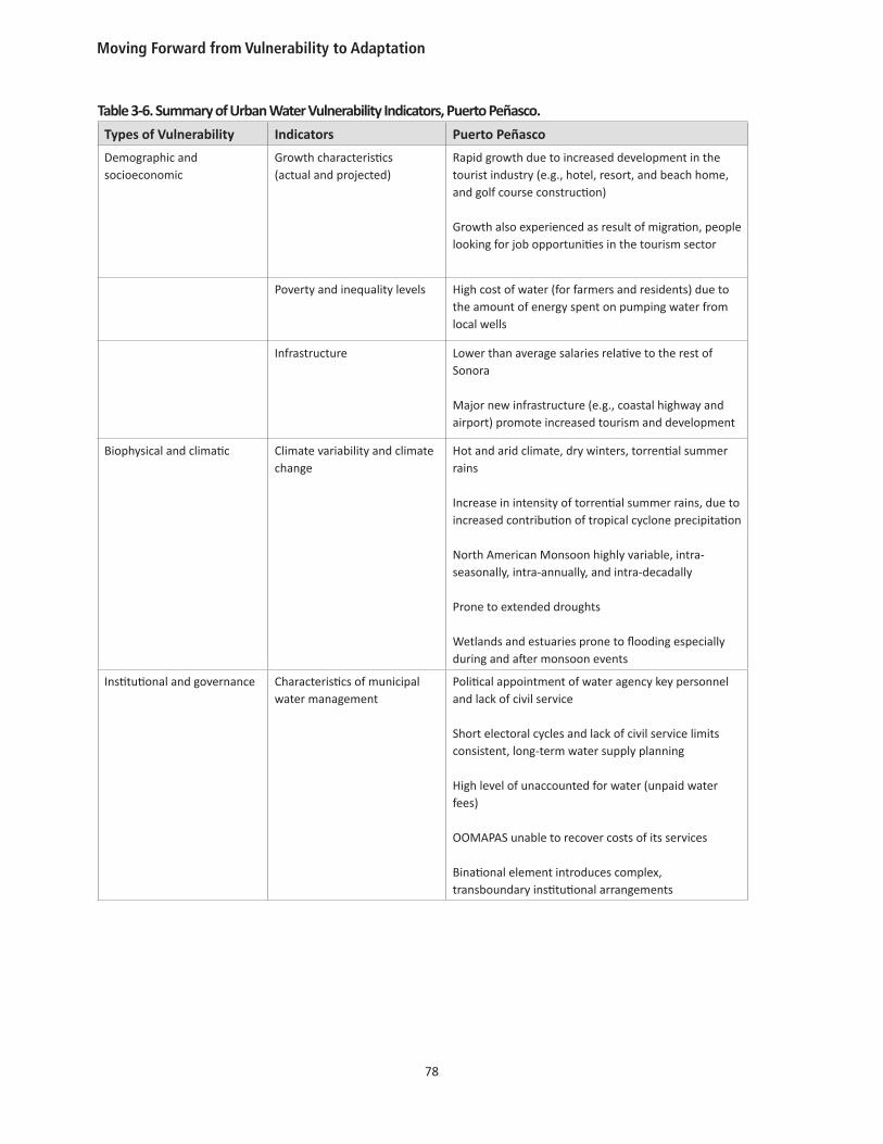
Table 3-6. Summary of Urban Water Vulnerability Indicators, Puerto Peñasco.
Types of Vulnerability Indicators Puerto Peñasco
Demographic and socioeconomic
Growth characteristics (actual and projected)
Rapid growth due to increased development in the tourist industry (e.g., hotel, resort, and beach home, and golf course construction)
Growth also experienced as result of migration, people looking for job opportunities in the tourism sector
Poverty and inequality levels High cost of water (for farmers and residents) due to the amount of energy spent on pumping water from local wells
Infrastructure Lower than average salaries relative to the rest of Sonora
Major new infrastructure (e.g., coastal highway and airport) promote increased tourism and development
Biophysical and climatic Climate variability and climate change
Hot and arid climate, dry winters, torrential summer rains
Increase in intensity of torrential summer rains, due to increased contribution of tropical cyclone precipitation
North American Monsoon highly variable, intra-seasonally, intra-annually, and intra-decadally
Prone to extended droughts
Wetlands and estuaries prone to flooding especially during and after monsoon events
Institutional and governance Characteristics of municipal water management
Political appointment of water agency key personnel and lack of civil service
Short electoral cycles and lack of civil service limits consistent, long-term water supply planning
High level of unaccounted for water (unpaid water fees)
OOMAPAS unable to recover costs of its services
Binational element introduces complex, transboundary institutional arrangements
Puerto Peñasco
79
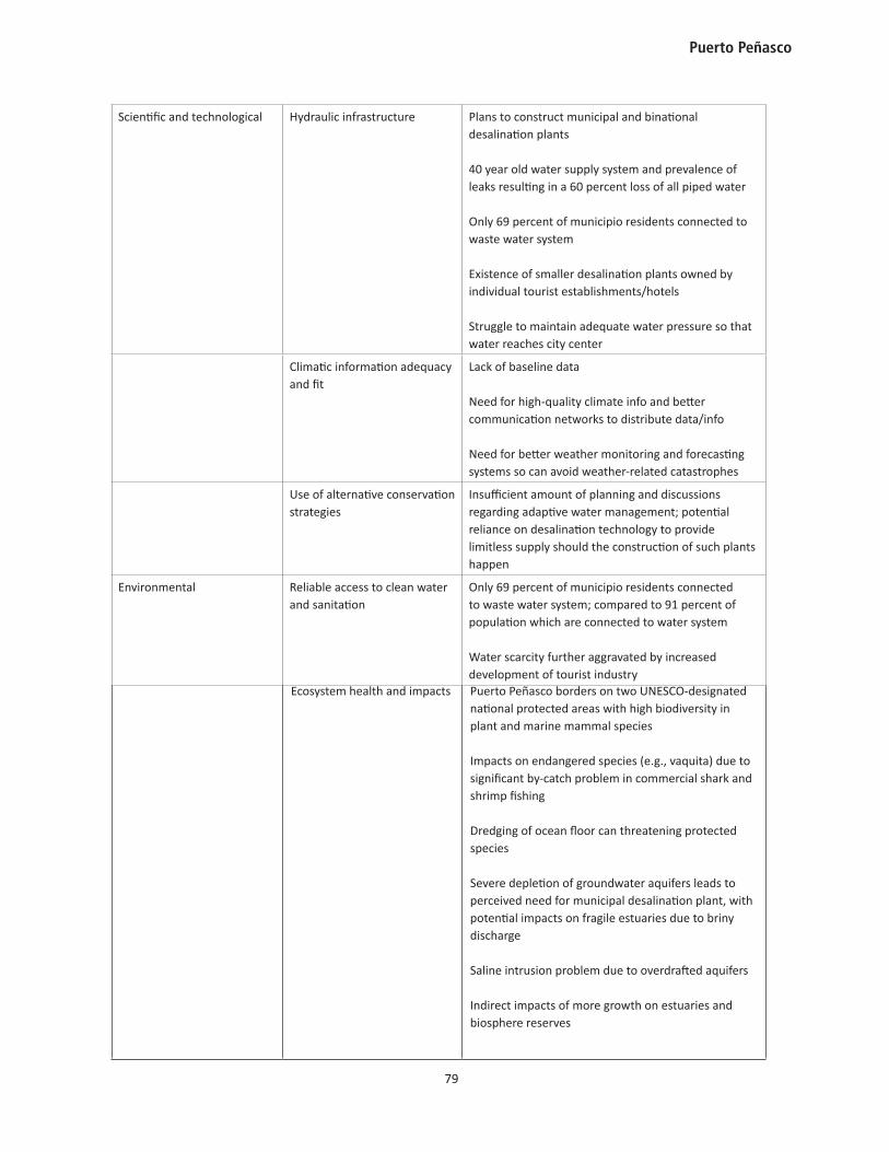
Scientific and technological Hydraulic infrastructure Plans to construct municipal and binational desalination plants
40 year old water supply system and prevalence of leaks resulting in a 60 percent loss of all piped water
Only 69 percent of municipio residents connected to waste water system
Existence of smaller desalination plants owned by individual tourist establishments/hotels
Struggle to maintain adequate water pressure so that water reaches city center
Climatic information adequacy and fit
Lack of baseline data
Need for high-quality climate info and better communication networks to distribute data/info
Need for better weather monitoring and forecasting systems so can avoid weather-related catastrophes
Use of alternative conservation strategies
Insufficient amount of planning and discussions regarding adaptive water management; potential reliance on desalination technology to provide limitless supply should the construction of such plants happen
Environmental Reliable access to clean water and sanitation
Only 69 percent of municipio residents connected to waste water system; compared to 91 percent of population which are connected to water system
Water scarcity further aggravated by increased development of tourist industry
Ecosystem health and impacts Puerto Peñasco borders on two UNESCO-designated national protected areas with high biodiversity in plant and marine mammal species
Impacts on endangered species (e.g., vaquita) due to significant by-catch problem in commercial shark and shrimp fishing
Dredging of ocean floor can threatening protected species
Severe depletion of groundwater aquifers leads to perceived need for municipal desalination plant, with potential impacts on fragile estuaries due to briny discharge
Saline intrusion problem due to overdrafted aquifers
Indirect impacts of more growth on estuaries and biosphere reserves
Moving Forward from Vulnerability to Adaptation
80
What is the institutional capacity of this transboundary region to develop adaptive strategies for future water management, at a 5 to 20 year horizon?
The principal adaptive strategy planned to address insufficient water supply to meet current and projected demand is focused on desalination strategies. Lack of sufficient water supply is the result of over-drafting of groundwater aquifers (common not just in Puerto Peñasco but along the entire coast of Sonora) coupled with increasing demand due to urban growth and tourism development. Climate variability, including both prolonged droughts and highly-variable precipitation (and storm events), creates management challenges for local water managers. In Puerto Peñasco, future water supply planning is focused on providing a sustainable source of water via municipal and a binational desalination plants. Desalination has had a difficult history at times in Sonora, such as when a major desalination plant planned for Hermosillo was canceled by the incoming state governor in 2002. With relatively weak municipal institutional strength (e.g., lack of fiscal and technical resources), Puerto Peñasco will need to turn outward to CONAGUA, CEA, and to binational collaborators (as evidenced by their relationship with USTDA) to develop sufficient capacity to meet the future demands. With respect to desalination, while it has many apparent positive benefits, we have argued that in itself it does not so much represent potential adaptive capacity as it represents doing “business as usual” (Wilder et al. 2010). As recognized by the regional water authority in southern Nevada, desalination is not a panacea to resolve water-related vulnerability. Puerto Peñasco may need to call on additional institutional and technological resources from outside the municipality to provide assistance with such tasks as doing desalination well, in a way that protects the local environment and local social and economic interests, and also with identifying diversifying strategies to meet long-term water needs.
How can the capacity of water managers and preparedness planners to use climate science and information to improve long-range and “adaptive” deci-sion-making best be institutionalized?
The results from a non-probabilistic survey questionnaire that our research team asked workshop participants (October 2, 2009 in Peñasco) to complete shed light on the climate information needs of Puerto Peñasco water managers and disaster relief planners.16
• Sources of Climate Information. The most commonly used source of information for making
16 Questionnaires asked the following questions, with responses listed: Which of the following sources of information do you use to make forecasts, understand historic water and climate conditions, and water and hydrology information: SMN = 67 percent, Conagua = 54 percent, NOAA 46 percent, TV, radio and newspapers = 44 percent (n= 48). For Puerto Peñasco and other regions along the coast, what type of water and climate information is most useful? (select 3 from a list of 16 options): top 4 responses: temperature by season (55 percent), groundwater level (51 percent), seasonal climate forecasts (51 percent), and rainfall by season (43 percent) (n~48). What type of climate change information would be most useful for helping to create plans for the next 20 to 50 years? (select from a list of 18) top 3 responses: water and energy (67 percent), groundwater levels (63 percent), sea level rise (56 percent) (n = 48). Which of the following topics would you be most interested in collaborating on in terms of climate change and planning for future sustainability? Answers: urban water supply, energy and desalination (37 percent), risk management training/capacity for droughts, storms, floods, and heat waves (19 percent), and regional agriculture and water supply (17 percent) (n=47).
Puerto Peñasco
81
forecasts, understanding historic water and climate conditions, and obtaining water and hydrology information are the Mexican National Weather Service (Servicio Meteorológico Nacional, SMN), the National Water Commission (Comisión Nacional del Agua, CNA), the National Oceanic and Atmospheric Administration (NOAA), and television, radio and newspapers.
• Most Useful Weather and Climate Information. Respondents indicated that the top four (of 16) most useful water and climate information for planning in Puerto Peñasco and other coastal regions were: temperature by season (55 percent), groundwater level (51 percent), seasonal climate forecasts (51 percent), and rainfall by season (43 percent).
• Most Useful Climate Change Information for Long-Term Planning (20-50 years). Respondents highlighted water and energy (67 percent), groundwater levels (63 percent), and sea level rise (56 percent), as the types of climate change information that would be most useful for helping to create long-term plans at the 20-50 year horizon.
• Identifying Priorities for Future Collaborative Research. Respondents expressed interest in potential future collaborative research in the following areas: urban water supply, energy and desalination (37 percent), risk management training/capacity for droughts, storms, floods, and heat waves (19 percent), and regional agriculture and water supply (17 percent).
Discussion during the stakeholder workshop regarding climate information and data needs underscored the need for financial investments to improve the weather monitoring and forecasting systems. While it was noted that more data on historic climate are needed, it was also recognized that the variability of temperature and precipitation patterns will be affected by climate change, making the historic record perhaps less useful. Managers noted the need to know what the 10 year oscillations might be expected under conditions of climate change.
Managers also highlighted the need to be able translate information to the public. For example, it was noted that scientific organizations such as NOAA and NASA have the resources to predict exactly where the runoff will go and can determine how much precipitation a storm may produce. If this information is available and arrives in time, then it could be used to prevent weather-related catastrophes. Managers stated that most natural disasters are predicted ahead of time, but emergency preparedness planners have to be well equipped with information and be informed; and even then, not all harm and damage can be prevented.
• Qualitative Comments on Stakeholder Concerns for Climate Variability and Urban Water Vulnerability. In addition to identifying and prioritizing climate information needs, we asked participants at the workshop to discuss the high-priority vulnerabilities relating to the future urban water supply. One participant surmised that the greatest challenges facing the water sector in the next 5 to 10 years will not be technical, but social. Many participants agreed that the greatest challenges are related to the management of scarce resources including transferring water between sectors and watersheds, as well as between the United States and Mexico, sharing and negotiating over scarce resources, increasing demands for water, and a lack of funding for management and infrastructure improvements.
Moving Forward from Vulnerability to Adaptation
82
A recurring theme at the workshop was the need to focus on demand management and cultivate a “cultura del agua” (water culture) or “cultura del desierto” (desert culture). Some suggested tools to facilitate this social change included: expanding legal and institutional arrangements to encourage the efficient use of water, full collection of payment for services in order to incentivize water efficiency, fines for wasting water, educational programs, and investments for improving the efficiency of water infrastructure and reducing leaks.
The greatest concerns expressed by water managers included: managing water under conditions of non-stationarity (e.g., non-linear change, associated with a range of uncertainty regarding future climate change and impacts); extreme events, damage to infrastructure during extreme events; the need to introduce flexible planning measures into their agencies’ planning and decision-making processes; and lack of communication between scientists, water mangers and policymakers, as well as between different agencies and levels of government. For example, water managers from CNA lamented that it took three years for politicians to listen to their suggestion to increase water tariffs. Additionally, an animated discussion revolved around the lack of communication between water managers, civil protection services, and residents of the coastal community of Guaymas when a near-hurricane strength storm made landfall with residents claiming they had received little or no warning about the devastating strength of tropical storm Jimena.
The top priorities, as identified by water managers and decision-makers during the stakeholder workshop in Puerto Peñasco, for managing variability and climate change in an adaptive manner in the next 5-10 years include: investing in infrastructure and diversifying the sources of water (e.g., groundwater protection, improve rainwater filtration and rainwater harvesting, wastewater reuse, desalination, improved efficiency, and greater storage); increasing water user education and developing a “cultura del desierto”; expanding the coverage of meteorological stations; and improving the collection and dissemination of climate information.
COMMENTS BY STAKEHOLDERS, PUERTO PEÑASCO WORKSHOP, OCTOBER 2, 2009
“Why worry about climate change when we already have problems with water management as it is? We need to make plans to improve our current water management.” –Water manager, Sonora
“Depoliticize decision-making within water management agencies and professionalize the water management agency in order to change the planning horizon. Rather than thinking about what will benefit them in their three-year period [corresponding to mayoral terms], managers need to be thinking about long term investments.” –Water manager, Sonora
“We need to consider the voices and actions of key stakeholders—namely agriculturalists, who use over 80 percent of the total available water. This would necessitate the development (or re-development) of institutional mechanisms for allowing a broader participation of agriculturalists in the decision-making processes, along with the implementation of institutional, market and regulatory mechanisms to induce more efficient water use in agriculture.” –University researcher, Sonora
“We need better communication between water managers and decision-makers. For example, in order to raise the water tariffs, it took three years for CNA to be heard by politicians. Water managers, scientists and decision-makers have to work together and communicate. Additionally, there is a need for greater participation by all stakeholders in the planning process.” –Water manager, Sonora
“Right now we have a good opportunity in water governance with a flexibility that will be important, for the state and federal levels to plan together for the coming years, to defend proposals and see how to invest resources. We need to move away from (only) planning, which is at times very self-critical and slows down the process, very politicized. But there are plans that are moving forward on consumptive human use, irrigation support to become more efficient, and…institutional support, too.” –Climatologist, Sonora
Puerto Peñasco
83
• Stakeholder Perspectives on Desalination as an Adaptive Strategy to Reduce Urban Water Vulnerability. During the stakeholder workshop, a significant emphasis was placed on the need to consider new technologies, including desalination, and both large and small-scale technologies to capture precipitation during extreme weather events. It was suggested by a national SMN representative that with enhanced capacity to capture and store stormwater runoff, water managers could shift their view of extreme precipitation events from a “disaster” to an “opportunity.”
Of 38 stakeholders who responded to a question on our online questionnaire regarding the appropriateness of desalination as an adaptive strategy, a total of 66 percent (42 percent strongly agree and 24 percent agree) agreed that desalination is an appropriate and “adaptive” strategy for confronting the water availability challenges of this region. In addition, 51 percent agreed or strongly agreed that their city will very likely receive desalinated water in the near future to meet needs, while 40 percent disagreed or strongly disagreed with this statement
One of the most salient points raised in the desalination discussion was that major infrastructure improvements would have to occur before the construction of a multi-million dollar desalination plant, in order to ensure that the expensively manufactured water would not be wasted in a leaky network. Furthermore, metering and payment for services would need to be expanded so that users would be incentivized to save water. Therefore, it was widely agreed that an emphasis on efficiency improvements is a necessary precursor to the implementation of desalination technology, and that desalination should be complementary to other demand management strategies, including conservation, institutional changes, and market mechanisms. This sentiment was also reflected in the survey, in which 42 percent (n=31 for question) of respondents strongly agreed and 23 percent agreed that desalination is just one of many options available for future water management (while 19 percent disagreed and 10 percent strongly disagreed with this statement).
Desalination, as presented by its proponents, would have three benefits for the local municipality. First, it would allow the city to overcome the natural water scarcity that has posed a limit to continued urban growth (USTDA 2008). The former municipal desalination planning coordinator noted that once a desalination plant is built, many of the fears that investors have will be relieved. With the uncertainty of water provision resolved, the region could open up 400 kilometers of coastline for development. As Smith (2009) observes, desalination allows regions to “have limitless development ‘cake’ and eat it too.” Second, given the abundance of saltwater, desalination has come to be viewed as a nearly “drought-proof” water resource (Kohlhoff and Roberts 2007:276; see also “Tapping the Oceans” 2008; National Research Council 2008). Third, the new source of water could take pressure off already overdrawn aquifers, allowing them to recover to near-equilibrium levels.
Some of the concerns that were raised about a move toward water supply augmentation via desalination at the stakeholder workshop in Puerto Peñasco include: the high energy demand of desalination and the increased contribution to greenhouse gas production, the water-energy nexus, disposal of the salt concentrate discharge, the high cost of the construction and operation of the project and the burden of increased water costs for users, sea level rise and effects on new coastal infrastructure related to desalination, and the location of the plant intake and discharge being near the biosphere reserve.
Moving Forward from Vulnerability to Adaptation
84
At least two issues related to desalination were not adequately addressed in interviews, presentations or stakeholder workshops. First, there was no discussion of the environmental risks posed by the chemical waste associated with the desalination process, including iron chloride as an anticoagulant, hypochlorite as an oxidant, sulfuric acid to equilibrate the ph-level for the membranes, sodium bisulphate, an anti-scalant, and calcium carbonate. Second, there was little recognition of the growth inducement potential and related environmental impacts. In arid regions where scarce water resources have limited urban growth, the introduction of “limitless” desalinated water is likely to encourage urban growth, which is associated with a range of environmental impacts including increased air and water pollution, habitat fragmentation, coastal development, saline intrusion into agriculture, and loss of biodiversity (Smith 2009; Sax et al. 2006; Cooley et al. 2006; Johnson 2001). At the Border Governors Binational Desalination Conference in San Diego in 2010, water managers noted that their job is to find a way to provide water to meet demands. The task of managing demand and making decisions about the level and type of development that produces that demand is the responsibility of other governmental agencies.
H. Implications for Policy and Planning
In sum, the major challenges and vulnerabilities in the water sector include: 1) the politicized management of the water agencies, where three year terms inhibit long-term planning; 2) lack of payment for water services; 3) lack of coordination and communication between different levels of government and scientists and decision-makers; 4) the need to improve current water management regardless of future concerns about climate change; 5) the role of desalination as an augmentation strategy; 6) the natural scarcity of water the arid region, for which climate change will only increase the challenges of the management of this scarce resource; 7) disagreement over how to manage the resource as it is; 8) a need to understand the context of water management and climate change – including both the climate variability and the social vulnerability; and 9) the importance of the role of planning for a more adaptive water management in the future. Other details of vulnerabilities are documented in Table 3-6, above.
Policy improvements suggested by workshop participants in Puerto Peñasco include: the need to promote watershed-scale management, protect aquifers, develop new laws for wastewater treatment and expand wastewater reuse, develop laws for rainwater harvesting in new developments, and improve the planning process in order to integrate land-use planning with water resource management. Building the institutional capacity to identify climate information and product needs and to use them appropriately will help make long-term water supply planning more sustainable. The expansion of climate science use in planning for urban water needs in Puerto Peñasco and in influencing future decisions about the desirability and design of desalination plants could make a critical difference to environmentally-sound management of natural and marine resources and species in the Upper Gulf of California.
Puerto Peñasco
85
ReferencesArriaga-Ramírez, S., and Cavazos, T. (2010). Regional trends of daily precipitation indices in northwest Mexico and southwest United States. Journal of Geophysical Research, 115, D14111, 10 pages, doi:10.1029/2009JD013248.
Calderón-Aguilera, L. E., and Flessa., K. W. (2009). Just Add Water?: Transboundary Colorado River Flow and Ecosystem Services in the Upper Gulf of California. In L. López-Hoffman, E. MCGovern, R. Varaday, and K. Flessa (Eds.), Conservation of Shared Environments: Learning from the United States and Mexico (pp. 154- 169). Tucson, AZ: University of Arizona Press.
Campoy Favela, J. R. (2001). Information Sheet on Ramsar Wetlands: Wetlands of the Rio Colorado Delta. Retrieved April 18, 2011 from http://www.wetlands.org/reports/ris/4MX005en.pdf
Canamex. (2010). What is Canamex? Retrieved March 31, 2011, from http://www.canamex.org/background.asp.
Cavazos, T., Turrent, C. and Lettenmaier, D. P. (2008). Extreme precipitation trends associated with tropical cyclones in the core of the North American monsoon. Geophysical Research Letters, 35.
Cash, D., Clark, W., Alcock, F., Dickson, N., Eckley, N., Guston, D., et al. (2003). Knowledge Systems for Sustainable Development. Proceeding of the National Academy of Sciences, 100 (14), 8086-8091.
Centro Intercultural de Estudios de Desiertos y Océanos (CEDO). (2010). Integrando ciencia y comunidad para la conservación del Norte de Golfo de California y el Desierto Sonorense. Retrieved March 7, 2011, from http://www.cedointercultural.org.
Colorado River Water Consultants. (2008). Study of Long-Term Augmentation Options for the Water Supply of the Colorado River System. Retrieved December 29 , 2010, from http://snwa.com/html/wr_colrvr_augmentation.html.
Comisión Estatal del Agua (CEA). (n.d.). Estudio de Acuífero de la Cuenca Sonoyta. Presentation at the Arizona-Mexico Commission Water Committee.
Comisión Nacional del Agua (CONAGUA). (2005). Determinación de la Disponibilidad de Agua en el Acuífero Sonoyta-Puerto Peñasco, Estado de Sonora. Subdirección General Técnica, Gerencia de Aguas Subterránneas, Subgerencia de Evaluación y Ordenamiento de Acuíferos.
Comisión Nacional del Agua (CONAGUA). (2008). Estadísticas del Agua Mexicana.
Comité de Planeación Municipal. (2007). Plan Municipal de Desarrollo 2007-2010: Puerto Peñasco. Ayuntamiento de Puerto Peñasco, Presidencia Municipal.
Comrie, A., and Glenn, E. (1998). Principal Component-Based Regionalization of Precipitation Regimes across the Southwest United States and Northern Mexico, with an Application to Monsoon Precipitation Variability. Climate Research, 10, 201-15.
Cooley, H., Gleick, P., and Wolff, G. (2006). Desalination: With a Grain of Salt, A California Perspective. Oakland, California: A Report of the Pacific Institute for Studies in Development, Environment, and Security.
Moving Forward from Vulnerability to Adaptation
86
Cudney-Bueno, R., Bourillón, L., Sáenz-Arroyo, A., Torre-Cosío, J., Turk-Boyer, P., and Shaw, W. (2009). Governance and the Effects of Marine Reserves in the Gulf of California, Mexico. Ocean and Coastal Management, 52, 207-218.
Dalton, R. (2010, June 8). Endangered-porpoise numbers fall to just 250: Time is running out for vanishing vaquitas. Nature.
Díaz-Caravantes, R., and Wilder, M. (In progress). Water, Climate Change, and Peri-Urban Vulnerabilities in Northwest Mexico. Geoforum.
Dominguez, F., Cañon, J. and Valdes, J. (2010). IPCC-AR4 climate simulations for the Southwestern US: the importance of future ENSO projections. Climatic Change, 99, 499-514.
Escalera Náutica. (2001). Escalera Náutica del Mar de Cortés: El megaproyecto turístico del siglo XXI. Retrieved March 7, 2011, from http://www.escaleranautica.com/general.html.
Garcés, J. (2010, May 26). North American Development Bank Process. Border Governors’ Binational Desalination Conference. San Diego, CA.
Guido, S., Ochoa, F., Cantú, A., Castillo, A., Vargas, J. T., Armenta, M., et al. (2005). Desarrollo turístico regional? Monitoreo de los desarrollos turísticos e immobilarios costeros del noreste de México 2005-2006. Alianza para la sustentabilitdad del Noroeste Costero, A.C. (Alcosta) .
H. Ayuntamiento de Puerto Peñasco. (2007). Programa de Desarrollo Urbano-Turístico de Puerto Peñasco. Final Report.
Hallack-Alegria, M., and Wallace, D. W. (2007). Annual and Warm Season Drought Intensity-Duration-Frequency Analysis for Sonora, Mexico. Climate, 20, 1897-1909.
HDR. (2009, June 5). Investigation of Binational Desalination for the Benefit of Arizona, United States and Sonora, Mexico. HDR.
INEGI. (2010). Mexico en cifras: Información nacional, por entidad federative y municipios. Retrieved June 29, 2011, from www.inegi.gob.mx.
Instituto Mexicano para la Competitividad A.C. (IMCO). (n.d.). Resumen Ejecutivo: Región Noroese-Alternativa Competitiva al Desarrollo de la Región. Final Report.
Intergovernmental Panel on Climate Change (IPCC). (2007). IPCC Fourth Assessment Report: Climate Change 2007. IPCC.
Johnson, M. P. (2001). Environmental Impacts of Urban Sprawl: A Survey of the Literature and Proposed Research Agenda. Environment and Planning, 33, 717-735.
Kamp, R., 2005. An Overview of environmental and other impacts of the Potential DKRW LNG plant/pipeline and Arizona Clean Fuels refinery in Tacna, Arizona with oil port and pipeline. Report for Proyecto Fronterizo de Educacion Ambiental, Playas de Tijuana, Baja California, August 19, 2005. Retrieved April 6, 2011, from http://www.wildsonora.com/ws/sites/default/files/dkrw-lng-plant-pipeline-tacna-fuels-refinery.pdf.
Puerto Peñasco
87
Kohlhoff, K. F. (1988). Urban Use of Arizona Rural Groundwater. American Water Works Association, 80(3), 46-50.
Kohlhoff, K., and Roberts, D. (2007). Beyond the Colorado River: Is an International Water Aumentation Consortium in Arizona’s Future? Arizona Law Review, 49(2), 257-97.
Kunkel, K. E., Bromirski, P. D., Brooks, H. E., Cavazos, T., Douglas, A. V., Easterling, D. R., Emanuel, K. A., Groisman, P. Y., Holland, G. J., Knutson, T. R., Komar, P. D., Levinson, D. H., and Smith, R. L. (2008). Observed Changes in Weather and Climate Extremes. Weather and Climate Extremes in a Changing Climate. Regions of Focus: North America, Hawaii, Caribbean, and U.S. Pacific Islands: A Report by the U.S. Climate Change Science Program and the Subcommittee on Global Change Research, Karl, T. R., Miller, C. D., Hassol, S, J., Waple, A. M., and Murray, W. L., eds., U.S. Climate Change Science Program.
López-Pérez, M. (2009, June 5). Desalination Plants in Mexico: Operation, Issues, and Regulation. Phoenix, AZ: Presented at the Arizona-Mexico Commission Water Committee Summer Plenary.
Magaña, V., and Conde, C. (2000). Climate and Freshwater Resources in Northern Mexico, Sonora: A Case Study. Environmental Monitoring and Assessment (61), 167-85.
Munro Palacio, G. (2007). A Brief History of Puerto Peñasco. Puerto Peñasco, Sonora: De Cierto Mar Editores.
National Research Council. (2008). Desalination: A National Perspective. Washington, D.C.: The National Academies Press.
Pahl-Wostl, C. (2007). Transitions Towards Adaptive Management of Water Facing Climate and Global Change. Journal of Water Resources Management, 21(1), 49-62.
Pelling, M., High, C., Dearing, J., and Smith, D. (2008). Shadow Spaces for Social Learning: A Relational Understanding of Adaptive Capacity to Climate Change within Organizations. Environment and Planning A, 40, 867-84.
Pineda, N. P. (2002). La política urbana de agua potable en el México del centralismo y los subsidios a la municipalización, la autosuficiencia y la privatización. Región y sociedad. Revista del Colegio de Sonora, 24, 41-69.
Ray, A., Garfin, G., Wilder, M., Vásquez-León, M., and Comrie, A. (2007). Applications of Monsoon Research: Opportunities to Inform Decisionmaking and Reduce Regional Vulnerability. Journal of Climate, 20(9), 1608-1627.
Sax, J., Barton, H., Leshy, J. D., and Abrams, R. H. (2006). Legal Control of Water Resources, 4th Edition. West Group.
Scott, C.A. and Banister, J.M. (2008). The dilemma of water management “regionalization” in Mexico under centralized resource allocation. International Journal of Water Resources Development, 24(1): 61–74, DOI: 10.1080/07900620701723083.
Moving Forward from Vulnerability to Adaptation
88
Seager, R., Ting, M., Held, I., Kushnir, Y., Lu, J., Vecchi, G., and Huang, H.-P. (2007). Model Projections of an Imminent Transition to a More Arid Climate in Southwestern North America. Science, 316, 1181-1184.
Secretaría de Economía, Subsecretaria de Desarrollo Económico de Sonora. (2003). Puerto Peñasco: Información Básica. Retrieved March 31, 2011, from http://obson.files.wordpress.com/2009/02/copresonpuerto.pdf.
Smith, W. (2009). Problem-Centered vs. Discipline-Centered Research for the Exploration of Sustainability. Journal of Contemporary Water Research and Education, 142, 76-82.
“Tapping the Oceans.” (2008, June 7). The Economist, 387:8583.
Thompson, B. R. (2003, January 20). Mexico Sees Light at the Top of the Nautical Stairs. Retrieved March 7, 2011, from http://mexidata.info/id52.html.
U.S. Trade and Development Agency (USTDA). Request for Proposals. Retrieved December 2, 2008, from http://www.ustda.gov/RFP/200751022B_MEX.pdf.
U.S.-Mexico-International Atomic Energy Agency (UMIAEA). (1968). Nuclear Power and Water: Desalting Plants for Southwest United States and Northwest Mexico. Oakridge, TN: USAEC Division of Techinical Information Extension.
United Nations Educational, Scientific and Cultural Organization (UNESCO). (2010). Biosphere Reserves: Learning Sites for Sustianable Development. Retrieved March 7, 2011, from http://www.unesco.org/new/en/natural-sciences/environment/ecological-sciences/biosphere-reserves/.
Vasquez-Leon, M. (2002). Assessing the Vulnerability to Climate Risk: The Case of Small-Scale Fishing in the Gulf of California, Mexico. Investigaciones Marinas, 30(1).
Water Educational Foundation (WEF). (2010). 2010 Border Governors’ Binational Desalination Conference. Retrieved March 7, 2011, from http://www.watereducation.org/doc.asp?id=1390
Wilder, M. (2010). Water Governance in Mexico: Political and Economic Apertures and a Shifting State-Citizen Relationship. Ecology and Society, 15 (2).
Wilder, M., Scott, C., Varady, R., Pineda, N., Garfin, G., and McEvoy, J. (2010). Adapting Across Boundaries: Knowledge, Social Learning and Resilience in the U.S.-Mexico Border Region. Annals of the Association of American Geographers, 100(4), 1-12.
World Wildlife Fund (WWF). (2004). Strengthening Policy Tools to Achieve Integrated Coastal Management: Sept 2001-March 2004. Mexico City: WWF Mexico Program Office.
Zamora-Arroyo, F., Cornelius, S., Pitt, J., Glenn, E., Nagler, P., Moreno, M., et al. (2005). Conservation Priorities in the Colorado River Delta, Mexico and the United States. Retrieved from http://www.sonoran.org.
Puerto Peñasco
89
Acronyms
AF—Año fiscal (fiscal year)AFY—Acre-feet per yearAZRise—Arizona Research Institute for Solar EnergyCAP—Central Arizona ProjectCEA—Comision Estatal del Agua (State Water Commission)CEDO—Center for Protection of Deserts and Oceans (Centro Intercultural de Estudios de Desiertos y Océanos)CONAGUA—Comisión Nacional del AguaEx-Im Bank—Export-Import Bank of the United StatesFONATUR—Fondo Nacional de Fomento del Turismo (National Fund for Tourism Promotion)GDP-Gross Domestic ProductH. Ayuntamiento—Honorable AyuntamientoIMCO—Mexican Institute for Competitiveness IADB—Inter-American Development BankINEGI—Instituto Nacional de Estadística y GeografíaMAB—Man and Biosphere ProgramNADB—North American Development Bank NAFTA—North American Free Trade AgreementNAM—North American MonsoonNASA—National Aeronautics and Space AdministrationNGO—Non-Governmental OrganizationsNOAA—National Oceanic and Atmospheric AdministrationOECD—Organization for Economic Cooperation and DevelopmentOOMAPAS—Organismo Operador Municipal de Agua Potable Alcantarillado y Saneamiento (Municipal Operating Agency for Wastewater and Sanitation) RV—Recreational VehicleSCADA—Supervisory Control and Data Acquisition systemSMN—Servicio Meteorológico Nacional (National Meteorological Service)SONORA SI—Sonora Integrated SystemSRP—Salt River ProjectUMIAEA—U.S.-Mexico-International Atomic Energy AgencyUN-United NationsUNESCO—United Nations Educational, Scientific and Cultural OrganizationUSD—United States’ DollarUSTDA—U.S. Trade and Development AgencyWEF—Water Environment FederationWWF—World Wildlife Fund

Moving Forward from Vulnerability to Adaptation
90