MOUNT PETER STRUCTURE PLAN PART 4 - TRUNK INFRASTRUCTURE ... · MOUNT PETER MASTER PLANNING PART 4...
33
TRUNK INFRASTRUCTURE MOUNT PETER STRUCTURE PLAN PART 4 - TRUNK INFRASTRUCTURE REPORT
Transcript of MOUNT PETER STRUCTURE PLAN PART 4 - TRUNK INFRASTRUCTURE ... · MOUNT PETER MASTER PLANNING PART 4...

TRU
NK
INFR
AS
TRU
CTU
RE
MOUNT PETER STRUCTURE PLAN PART 4 - TRUNK INFRASTRUCTURE REPORT

MOUNT PETER MASTER PLANNING PART 4 - TRUNK INFRASTRUCTURE REPORT
Page i
DISCLAIMER This Trunk Infrastructure Report is one of a series of reports which forms part of the draft Structure Plan for Mount Peter. Please note that this report is a draft document only. Whilst every care is taken to ensure the accuracy of this report and draft Structure Plan, Cairns Regional Council (CRC) accepts no liability for the accuracy of or inferences from the material contained in this publication, or for any action as a result of any person's or group's interpretations, deductions or conclusions relying on this material. The CRC accepts no liability for any loss, damage or injury (including consequential loss, damage or injury) from any use of this report and draft Structure Plan. COPYRIGHT This document is and shall remain the property of the Cairns Regional Council. Using or copying this document or any part of it without specific authorisation is absolutely prohibited. P.O. Box 359 Cairns, Qld., 4870 Tel: (07) 4044 3044 Fax: (07) 4044 302
Document Control
Author Reviewer Version Date
Name Initials Name Initials
Ver A April 2010 Kerry Nisbet KN Adrian Sains AS
MOUNT PETER MASTER PLANNING GROUP

MOUNT PETER MASTER PLANNING PART 4 - TRUNK INFRASTRUCTURE REPORT
Page ii
TRUNK INFRASTRUCTURE REPORT TABLE OF CONTENTS
EXECUTIVE SUMMARY ..........................................................................................................1
1. BACKGROUND ................................................................................................................2
2. OBJECTIVE ......................................................................................................................2
3. GROWTH...........................................................................................................................2
4. DENSITY ...........................................................................................................................3
5. SEQUENCING ..................................................................................................................4
0-5 years............................................................................................................................4 6-10 years .........................................................................................................................4 11-15 years .......................................................................................................................5 16-20 years .......................................................................................................................5 21-25 years .......................................................................................................................6
6. ROADS...............................................................................................................................6
6.1 Bruce Highway........................................................................................................6 6.2 Internal Trunk Roads & Bridges..........................................................................6 6.3 Quarry Access .........................................................................................................7
7. PUBLIC TRANSPORT & MOBILITY..........................................................................8
7.1 Busway .....................................................................................................................8 7.2 Local Bus Routes ....................................................................................................8 7.3 Shared Paths...........................................................................................................8
8. CANE RAIL .......................................................................................................................9
8.1 Main Line..................................................................................................................9 8.2 Cane Rail Spur Lines .............................................................................................9
9. WATER ..............................................................................................................................9
9.1 Bulk Supply .............................................................................................................9
10. STORMWATER MANAGEMENT ................................................................................12
10.1 Flooding..................................................................................................................12 10.2 Water Quality........................................................................................................13
11. ENERGY...........................................................................................................................13
12. ALTERNATIVE ENERGY .............................................................................................13
13. TELECOMMUNICATIONS ..........................................................................................14
14. PARKS & OPEN SPACE ..............................................................................................14
15. COMMUNITY SERVICES ............................................................................................15
16. RATES ASSUMPTIONS...............................................................................................16
MOUNT PETER MASTER PLANNING PART 4 - TRUNK INFRASTRUCTURE REPORT
Page iii
17. DEMAND .........................................................................................................................17
18. LOCAL FUNCTION CHARGE .....................................................................................19
19. INFRASTRUCTURE CONTRIBUTIONS..................................................................20
REFERENCES ...........................................................................................................................21 APPENDICES APPENDIX A - GROWTH & SEQUENCING
• MAP 08 MOUNT PETER STRUCTURE PLAN AREA PRECINCTS
• GROWTH RATES
• MOUNT PETER MPU DENSITY CALCULATIONS – FEBRUARY 2010
• MAP 09 MOUNT PETER STRUCTURE PLAN AREA DEVELOPMENT ENTITLEMENTS
• INDICATIVE SEQUENCING PLAN
• INDICATIVE 5 & 10 YEAR DEVELOPMENT PLAN
APPENDIX B - INFRASTRUCTURE PLANS
• FIGURE 1 DEVELOPABLE AREA
• FIGURE 2 ROADS
• FIGURE 3 CYCLEWAY NETWORK, SHARED PATHS AND WALKING TRACKS
• FIGURE 4 BRIDGES
• FIGURE 5 WATER SUPPLY NETWORK
• FIGURE 6 SEWERAGE NETWORK
• FIGURE 7 RECYCLED WATER NETWORK
• FIGURE 8 PARKS AND OPEN SPACE
• FIGURE 9 STORMWATER INFRASTRUCTURE
APPENDIX C - SUPPLEMENTARY INFRASTRUCTURE SKETCHES
• INDICATIVE BRIDGE CROSS SECTIONS
• EXISTING CANE RAIL AT GRADE CROSSINGS
• INDICATIVE BUSWAY-SUB ARTERIAL-CANE RAIL CROSS SECTIONS
APPENDIX D - INFRASTRUCTURE SCHEDULES APPENDIX E – SUPPORTING PHOTOGRAPHS

MOUNT PETER MASTER PLANNING PART 4 - TRUNK INFRASTRUCTURE REPORT
Page 1
EXECUTIVE SUMMARY
The Mount Peter MPA is currently a greenfield site comprising approximately 3330 hectares with a developable area of 1549 hectares. It is expected to provide for an ultimate population of over 40,000 people, with an average residential density between 15 – 20 dwellings per hectare (dw/ha).
The Trunk Infrastructure Report summarises the critical trunk infrastructure issues and provides growth and related development entitlements to support the Mount Peter Structure Plan. The primary objective of the report is to highlight trunk infrastructure requirements to support the phases of development within the 0-5yr, 6-10yr and +10yr to the ultimate scenario at 25 years.
The Trunk Infrastructure report contains details of the Mount Peter Priority Infrastructure Plan (PIP) and Infrastructure Charging Schedules (ICS) components which will ultimately be integrated with the Cairns PIP/ICS. The Mount Peter PIP/ICS components have been structured to apportion all Mount Peter trunk infrastructure costs to the residents and businesses of Mount Peter i.e. applying the principle of “user pays”. This is consistent with the Cairns PIP/ICS approach, State guidance and the approach applied in other major greenfield sites in Queensland.
The report includes an assessment of the Local Function Charge for State Controlled Roads incorporated into the Mount Peter PIP/ICS. This applies the same charging methodology used for local trunk roads with an adjustment for the amount of road capacity consumed by local traffic movements from Mount Peter.
The report identifies staging to inform Council’s capital works programme. An Infrastructure Agreement may be required to accompany the approval of a Master Plan where other existing infrastructure funding mechanisms (i.e. the Priority Infrastructure Plan) or planning scheme measures do not provide a satisfactory basis from which to address relevant infrastructure provision and funding .
Further detailed information is presented in the Mount Peter Structure Plan documentation and supporting technical reports listed in reference documents.
The table below summaries the costs and charges associated with trunk infrastructure. Schedules are provided in Appendix D.
TOTAL Charge / EDU
ROADS $ 350.0 m $14,033
COMMUNITY FACILITIES $ 17.5 m $949
PARKS AND OPEN SPACE $ 123.6 m $6,689
POTABLE WATER SUPPLY $ 39.7 m $2,070
RECYCLED WATER $ 72.5 m $3,307
WASTE WATER $ 124.0 m $6,462
TOTAL $ 727.5 m
TOTAL Charge / hectare
STORMWATER $ 56.7 m $44,329
TOTAL Charge / EDU
LOCAL FUNCTION CHARGE for STATE CONTROLLED ROADS $ 42.6 m $1,145
The above charges are subject to further review by Council’s Priority Infrastructure Plan team.
MOUNT PETER MASTER PLANNING PART 4 - TRUNK INFRASTRUCTURE REPORT
Page 2
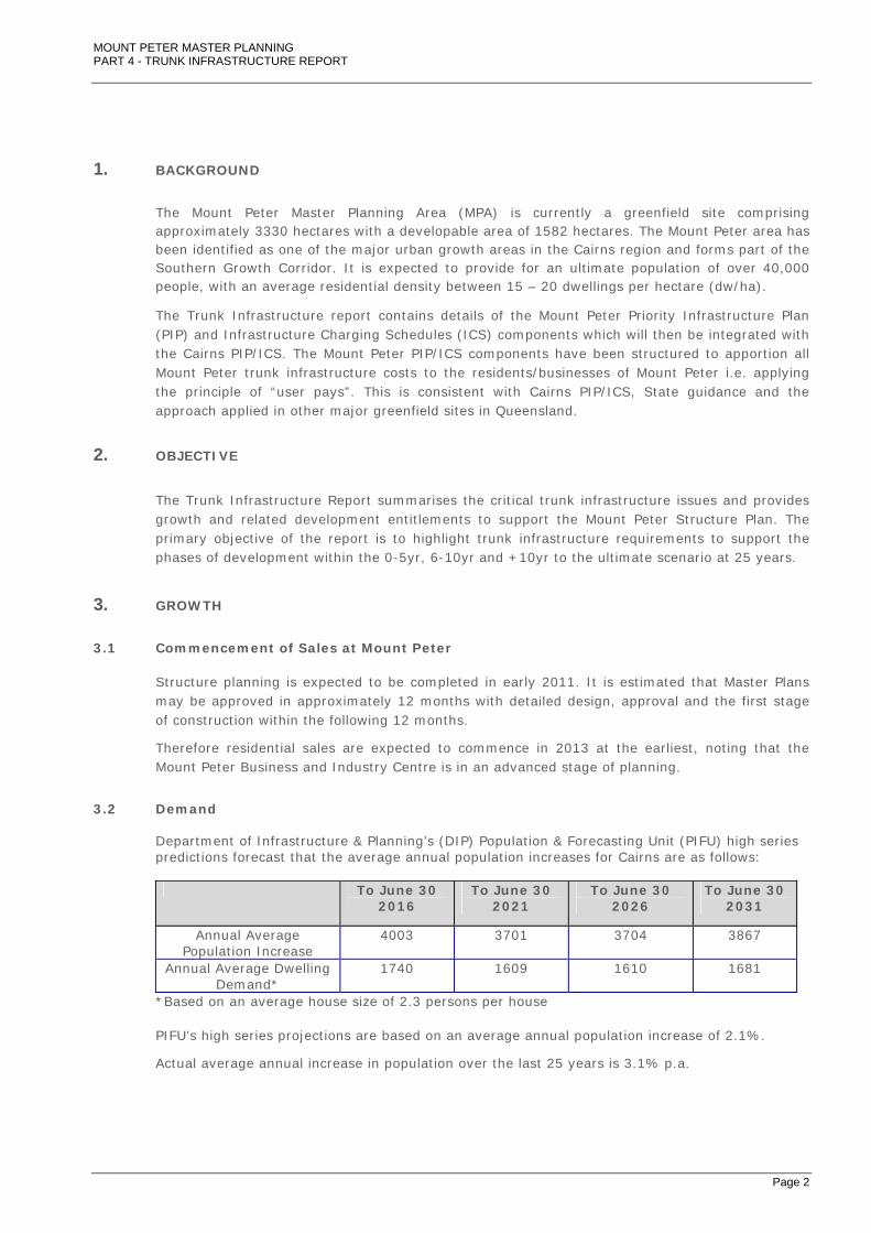
1. BACKGROUND
The Mount Peter Master Planning Area (MPA) is currently a greenfield site comprising approximately 3330 hectares with a developable area of 1582 hectares. The Mount Peter area has been identified as one of the major urban growth areas in the Cairns region and forms part of the Southern Growth Corridor. It is expected to provide for an ultimate population of over 40,000 people, with an average residential density between 15 – 20 dwellings per hectare (dw/ha).
The Trunk Infrastructure report contains details of the Mount Peter Priority Infrastructure Plan (PIP) and Infrastructure Charging Schedules (ICS) components which will then be integrated with the Cairns PIP/ICS. The Mount Peter PIP/ICS components have been structured to apportion all Mount Peter trunk infrastructure costs to the residents/businesses of Mount Peter i.e. applying the principle of “user pays”. This is consistent with Cairns PIP/ICS, State guidance and the approach applied in other major greenfield sites in Queensland.
2. OBJECTIVE
The Trunk Infrastructure Report summarises the critical trunk infrastructure issues and provides growth and related development entitlements to support the Mount Peter Structure Plan. The primary objective of the report is to highlight trunk infrastructure requirements to support the phases of development within the 0-5yr, 6-10yr and +10yr to the ultimate scenario at 25 years.
3. GROWTH
3.1 Commencement of Sales at Mount Peter
Structure planning is expected to be completed in early 2011. It is estimated that Master Plans may be approved in approximately 12 months with detailed design, approval and the first stage of construction within the following 12 months.
Therefore residential sales are expected to commence in 2013 at the earliest, noting that the Mount Peter Business and Industry Centre is in an advanced stage of planning.
3.2 Demand
Department of Infrastructure & Planning’s (DIP) Population & Forecasting Unit (PIFU) high series predictions forecast that the average annual population increases for Cairns are as follows:
To June 30
2016 To June 30
2021 To June 30
2026 To June 30
2031
Annual Average Population Increase
4003 3701 3704 3867
Annual Average Dwelling Demand*
1740 1609 1610 1681
*Based on an average house size of 2.3 persons per house
PIFU’s high series projections are based on an average annual population increase of 2.1%.
Actual average annual increase in population over the last 25 years is 3.1% p.a.

MOUNT PETER MASTER PLANNING PART 4 - TRUNK INFRASTRUCTURE REPORT
Page 3
Take up rates are based on research from South East Queensland (SEQ) cases and are influenced by a number of factors including:
• proximity of existing development;
• provision of facilitating infrastructure;
• timing of support services such as retailing, recreation, and education;
• depth of market competition;
• the number of development fronts able to be generated; and
• prevailing property cycle.
Historical growth in major master planned communities in SEQ, such as Greater Springfield, North Lakes, and Coomera, indicates that desired sales rates take 5-8 years to achieve.
SEQ greenfield developments at Forest Lake (7,000 lots) and North Lakes (10,000 lots) each achieved average annual sales of around 400 to 600 per year. Therefore, total demand for Mount Peter of approximately 800 to 1,000 lots per year is considered reasonable. This represents up to 60% of the supply for Cairns.
These assumptions result in the target population being reached by 2035 with a supply life of approximately 23 years.
3.3 Summary
Annual growth is provided in Appendix A (Growth Rates). The five year increments for a population of 42,500 and an overall planning duration of 25 years are derived from base data provided by the Department of Infrastructure & Planning’s Planning and Information Forecasting Unit (PIFU). The rates have been modified to take account of research from SEQ cases.
4. DENSITY
The spreadsheet in Appendix A (Mount Peter MPU Density Calculations – February 2010) provides a possible model for land use areas, densities, residential and commercial components, open space allocations and the distribution of density across the two District centre cores and frames.
Summary outcomes from the analysis of this model are presented for each Master Plan Unit (MPU) on Map 09 Mount Peter Structure Plan Area - Development Entitlements in Appendix A.
Dwellings Population
Year 5 - 2017 1,745 4,013
Year 10 5,393 12,403
Year 15 9,358 21,523
Year 20 13,720 31,555
Year 25 – 2037 18,484 42,514
MOUNT PETER MASTER PLANNING PART 4 - TRUNK INFRASTRUCTURE REPORT
Page 4
5. SEQUENCING
The following commentary outlines the major components of infrastructure works in five year intervals.
A schematic plan of how the development will be sequenced is provided in Appendix A (Indicative Sequencing Plan).
Department of Transport & Main Roads (DTMR) studies and consultation on the future staging requirements for upgrading the Bruce Highway are ongoing. Consequently, this report excludes commentary on detailed sequencing of these works with the exception of highlighting critical aspects, including the Local function Charge for State Controlled Roads (LFCSCR) estimate.
0-5 years
Development south of Edmonton is expected to progress south along Mount Peter Road with a requirement to reconstruct Mount Peter Road only as far as the first stages of development.
Early phases of development in the NE Precinct will not require significant trunk road works, these being limited to traffic signal enhancements to the Bruce Highway/Thomson Road intersection.
With existing base traffic levels on the Bruce Highway between Edmonton and Gordonvale approaching trigger levels for upgrading the highway from two (2) to four (4) lanes, development in the vicinity of Draper Road/Maitland Road will require significant early works to State infrastructure. Department of Transport & Main Roads (DTMR) are currently considering funding and staging of these works to enable the sequencing of development in Mount Peter to be initiated as indicated above.
The existing Maitland Road alignment will initially be retained via the low flood immunity ‘ford’ crossing of Wrights Creek until such time that Draper Road development has a direct connection with Maitland Road.
Preliminary strategic assessment of water and sewer infrastructure indicates there is potential capacity in the Gordonvale network in the southern areas of Mount Peter, subject to augmenting the Gordonvale Wastewater Treatment Plant (WWTP), and also the Edmonton network to service the northern areas of Mount Peter via the existing treatment plant in Edmonton.
The provision of energy via the Ergon electricity network can be readily delivered through extending the existing networks prior to major augmentation of the grid. Alternative energy sources are likely to be solar orientated due to the absence of trunk gas services in the Cairns Southern Corridor.
It has been assumed that the cane rail line will remain in-situ throughout the development period. This may be subject to change following further investigation and consultation. Development fronts from the north and south will minimise the impact of the cane rail line, which is most significant at Maitland Road and the southern stretches of Mount Peter Road where the cane rail line crosses the thoroughfare at-grade.
Park services will include approximately 10 hectares of passive open space comprising open space in local neighbourhood centres and the rehabilitation of Downs Park in the township east of the Bruce Highway.
6-10 years
Access to the emerging regional centre in Edmonton will be critical and will trigger the need for road and bridge augmentations north of Petersen Road to link Chay Road with Walker Road.

MOUNT PETER MASTER PLANNING PART 4 - TRUNK INFRASTRUCTURE REPORT
Page 5
These road and bridge augmentations are accounted for in the current Planning Scheme Policy 4:04:05 – Trunk Infrastructure Contributions – January 2010.
It is likely that an early at-grade connection to the Bruce Highway will be required at Deppeler Road to provide enhanced access to the NE employment area. The ultimate configuration and timing of roads in this area will be informed by ongoing Bruce Highway assessment and consultation by DTMR. Preliminary engineering assessment indicates that the northern east-west four (4) lane sub-arterial link from the Bruce Highway (Deppeler Road) interchange to Mount Peter Road will require an embankment cut at the northern end of the ‘unnamed hill’. Various configurations and staging of the east-west sub-arterial could be adopted to limit the impact on the ‘unnamed hill’. Consideration must be given to the noise, air and aesthetic impacts given the proximity of the existing community and also the environmental and cultural impacts.
Park facilities would include the first phase of a District standard Sports Park in the Coopers Road area and the initial staged works for the Metropolitan standard Sports Park north of Mackey Creek. The first phase of this work would be limited to sports fields with higher level facilities following at +10 years. Approximately 21 hectares of passive open space will be required in local neighbourhood parks and linear open space connecting to existing open space; these include recreational cycling and walking trails.
Other facilities will include a District multi-purpose community centre established in the Coopers Road area and a Local multi-purpose community centre established north of Draper Road.
11-15 years
With the Draper Road development progressing north and connecting to Maitland Road there will be a need to realign Maitland Road to enhance flood immunity and provide a new crossing over Wrights Creek.
The Wrights Creek bridge infrastructure requirements are significant. Preliminary assessment indicates that a realigned Maitland Road (to the shortest practical crossing point) will require a bridge crossing of 185m total span from high bank to high bank. This route deviates from the Maitland Road reserve therefore there will be associated land acquisition and road construction costs.
Park services will include a District Sports Park delivered south of Maitland Road and approximately 22 hectares of passive open space delivered in local neighbourhood and mixed use centres and through linear parks providing connectivity to existing open space; these include recreational cycling and walking trails. With the Wrights Creek bridge crossing in place, and the Hussey Road centre supported by a transit station on the busway, the Metropolitan standard Sports facility would be viable in this location and would form a major focal point for the regionally significant Wrights Creek - Grays Creek corridor. It is expected that the first phase of rehabilitation works in the Wrights Creek – Grays Creek waterway corridor would have commenced.
A District standard multi-purpose community centre will be required in the Maitland Road area.
16-20 years
Improved road and public transport linkages will unlock the potential for further ‘conventional’ development in the south west of Mount Peter fringing the western hill slopes and the existing key resource areas.
Upgrades to the Bruce Highway will ultimately require a grade separated interchange at Maitland Road and given the retention of the cane rail bridge over the Bruce Highway this will require

MOUNT PETER MASTER PLANNING PART 4 - TRUNK INFRASTRUCTURE REPORT
Page 6
relocation of the proposed grade separated interchange. Relocation of the junction to the north would compound the separation issues with respect to accessibility for the residential population south of Maitland Road; therefore, by agreement with DTMR, the junction has been indicatively shown as relocated 300m to the south of the existing location. The ultimate solution is subject to further detailed investigation by developers and/or DTMR.
Expanding Metropolitan standard sport services on Mount Peter Road and the District Sports Parks near Hussey Road and Deppeler Road will provide extensive active recreation space. Approximately 25 hectares of passive open space would be delivered in local neighbourhood parks to the south west of the MPA and in linear parks providing connectivity to open space in the Maitland Road area. Linear cycling and walking trails would be extended to the surrounding hills and the flood plains to the east of the Bruce Highway. Passive open space in the Wrights Creek – Grays Creek waterway corridor would be partially complete.
21-25 years
The final stages of formal sports facilities will be completed and approximately 28 hectares of passive open space would be delivered to complete neighbourhood parks, the Wrights Creek-Grays Creek works and linear cycling and walking trails.
6. ROADS
6.1 Bruce Highway
The ongoing Cairns Bruce Highway Upgrade Project planning study, led by DTMR, examines the long term options to improve safety and traffic flow, reduce congestion and enhance access for users between the Cairns CBD and Mount Peter.
The Structure Plan has been developed with an assumption that in the ultimate scenario the Bruce Highway will include three (3) grade separated interchanges. This includes a new grade separated interchange at Deppeler Road, a relocated grade separated Maitland Road interchange (300m to south to avoid Cane Rail conflicts) and a grade separated interchange at Draper Road.
There are no conflicts between the network proposed in the Structure Plan and the current DTMR planning. The detailed traffic modelling undertaken for the Mount Peter MPA reaffirms DTMR planning that the Bruce Highway will need to be a grade separated six (6) lane road from north of Deppeler Road; a grade separated six (6) lane road between Deppeler Road and Maitland Road and a grade separated four (4) lane road south of Maitland Road.
DTMR are currently considering funding and staging of works between Gordonvale and Edmonton to enable the sequencing of development in Mount Peter to be initiated as indicated above. A ‘Local Function Charge’ for State Controlled Road, as per PIP requirements has been determined using the same methodology applied as per Cairns Regional Council’ ’s PIP/ICS and is scheduled in Appendix D. The charge includes for the widening of the Bruce Highway from four (4) to six (6) lanes between Maitland Road and Deppeler Road, applying local government road construction rates.
6.2 Internal Trunk Roads & Bridges
Within the MPA, there is currently limited road provision due to the rural nature of the development. The key road elements are the Bruce Highway, Mount Peter Road and a number of connecting east west routes, which are primarily rural in form. Maitland Road, in the south of the site is a designated haulage route for the key resource areas to the south west of the MPA.
MOUNT PETER MASTER PLANNING PART 4 - TRUNK INFRASTRUCTURE REPORT
Page 7
A hierarchy of roads has been developed for the Mount Peter MPA. This proposes a sub-arterial road network via Maitland Road and Mount Peter Road; providing access to the regional centre of Edmonton and centres within Mount Peter. Demands estimated on these roads indicate that four (4) lanes are only required where the roads pass through District centres. At Maitland Road, on the approach to the Bruce Highway, six (6) lanes will be required. A new four (4) lane east - west sub-arterial road is also required to connect Mount Peter Road to the proposed Deppeler Road interchange and the principle employment area to the east of the Bruce Highway.
A major collector network of two (2) lane roads supplements this sub-arterial network providing connections to destinations within the Mount Peter MPA.
Assuming north and south development fronts as outlined in the sequencing commentary, the additional traffic movements on Maitland Road in the early phases of development are not expected to be significant. Therefore, the need to consider upgrades to the flood immunity at the existing Wrights Creek floodway may be deferred to later phases.
In the ultimate scenario the Wrights Creek infrastructure requirements are significant. Preliminary assessment indicates that a realigned Maitland Road to the shortest practical crossing point (see Appendix C - MPMPG – SK3-0) will require a bridge crossing of 185m total span from high bank to high bank, with the potential to reduce the span by 35m by introducing embankments and analysing flood impacts at detail design. This route deviates from the Maitland Road reserve therefore there will be associated land acquisition and road construction costs.
Road network planning assumes that the northern east-west link from the Bruce Highway Deppeler Road interchange to Mount Peter Road will require an embankment cut at the northern end of the ‘unnamed hill’ to accommodate the ultimate four (4) lane sub-arterial connection. Various configurations of the east-west sub arterial could be adopted to limit the impact on the ‘unnamed hill’. Consideration must be given to the noise, air and aesthetic impacts given the proximity of the existing community.
Plans in Appendix B provide an indicative layout of trunk road infrastructure.
Appendix C - MPMPG SK-01 Trunk Infrastructure Location Plan identifies the principle waterway crossing locations. Associated sketch long sections provide schematics for preliminary bridge sizing and are also included in Appendix C.
Proposed road cross sections will comply with section D1 and D3 of the Planning Scheme Policy 4:03:02, FNQROC Development Manual and Section 2.12 Queensland Streets unless it can be satisfactorily demonstrated that an alternative layout is more appropriate for the purpose and function of the road.
The sub-arterial roads through the spine of the MPA include the proposed busway in the median. This is discussed further in Section 7.1.
Collector streets and roads higher in the road hierarchy, and all streets which are located within or close to District or Mixed Use Centres, or provide access in high density development will have on-road cycle lanes on both sides.
6.3 Quarry Access
Through the preliminary planning process an alternative quarry access route has been considered, providing a more direct link with Maitland Road and avoiding the need to pass through the proposed Hussey Road mixed use centre and close to the Metropolitan Sports complex. The alternative route would utilise the Davies Road reserve and the southern section of Mount Peter Road, thereby avoiding the major bridge crossing of Wrights Creek and potential conflicts with proposed local neighbourhoods. There is no early requirement to initiate further assessment as significant urban development in this area is expected to be +10 years. Any proposal to reconfigure the quarry access will need to be cognisant of the requirement to retain
MOUNT PETER MASTER PLANNING PART 4 - TRUNK INFRASTRUCTURE REPORT
Page 8
the KRA designation. An allowance has been made in trunk costs as the route would be additional to normal neighbourhood roads.
7. PUBLIC TRANSPORT & MOBILITY
7.1 Busway
The Cairns Transit Network Study objective is to identify a new busway corridor between the Cairns CBD and Gordonvale. Assessment by DTMR, informed by the Mount Peter Structure Planning process, has concluded that the busway should be located in the central median of the arterial roads of Mount Peter i.e. the main north – south spine roads. The cross sections in Appendix C provide indicative road reserve requirements at mid block, at major transit stops, and where traffic turns across the busway at road intersections. The cane rail has been located central to the busway to allow for the potential to divert the line (subject to further consultation and studies).
The infrastructure schedules do not allow for construction costs or land resumptions associated with the busway i.e. medians, bus lanes, transit stops and additional roadworks and signalling associated with the interface between road traffic and the busway. On completion of studies and public consultation DTMR will provide preliminary infrastructure schedules that will enable Council and DTMR to negotiate how the relative funding responsibilities will be determined. Appendix C includes preliminary typical cross sections illustrating how Mount Peter Road, the busway and the cane rail line could be configured.
7.2 Local Bus Routes
Local bus routes have been proposed for sub-arterial and major collector streets. Associated street furniture is included in the cost schedules. Collector streets are two lane and do not include additional lanes for bus services. All creek crossings on these routes are assumed to be 20m spans.
7.3 Shared Paths
Early phases of development will be serviced via designated cycle lanes on the road network. In the ultimate scenario the infrastructure schedules allows for 27 km of off-road shared path recreational routes through active and passive open space. This includes five (5) significant bridge structures to enhance connectivity. Shared paths will connect to the existing off road route to the east of Edmonton that connects to the Cairns southern corridor network and will include lighting to P3 standard to enhance safety and lengthen the hours of use. Modifications to the existing routes will be required in conjunction with Bruce Highway grade separation and are expected to be considered in current assessment by DTMR e.g. crossing at Collinson Creek. For passive open space allocations and allowance for land acquisition in the schedules it has been assumed that all off road shared paths are in 10m wide corridors.

MOUNT PETER MASTER PLANNING PART 4 - TRUNK INFRASTRUCTURE REPORT
Page 9
8. CANE RAIL
8.1 Main Line
The Cane Rail line through Mount Peter is a significant operational constraint to meeting the desired objectives outlined in the Mount Peter Structure Plan. The impact of the line is greatest in the three (3) month cane harvesting period when up to six (6) cane trains per day, up to 600 metres in length, traverse the site at 10-40km/hr, either servicing local cane farms or providing a link from the Barron River delta to the mill in Gordonvale. Elsewhere in Cairns, where the cane line is currently traversing through existing residential areas, it is generally located within a fenced corridor.
Whilst there is future potential to implement a diversion of the Cairns to Gordonvale cane rail line, any proposal to do so will first require agreement, consultation, investigation, and planning with the Mulgrave Mill (as owners of the cane rail line) State government, Cairns Regional Council and cane growers. Therefore, it is has been assumed that the main north-south line through Mount Peter will remain in place for a minimum of 20-25 years; in effect requiring staged infrastructure configurations to accommodate an asset that may eventually be relocated.
In the short term the immediate infrastructure impacts relate to the retention of three (3) at-grade cane rail crossings and the integration of the line with the proposed busway.
In the medium term and ultimate scenario (assuming the cane rail remains) it is expected that the Bruce Highway/Maitland Road intersection will be positioned approximately 300 metres to the south of the current location, thereby facilitating the construction of a grade separated interchange at this location and also avoiding the need to cross the cane rail line on Maitland Road if travelling east-west. The associated realignment of Maitland Road facilitates a link into the proposed sub-arterial road bridge crossing over Wrights Creek. The existing Maitland Road would be retained as a local road with the designated haulage route diverted to the new route.
Appendix C includes preliminary typical cross sections illustrating how Mount Peter Road, the busway and the cane rail line could be configured.
8.2 Cane Rail Spur Lines
The two (2) at-grade spur lines will require audible/visual warnings in the short term. However, as development proceeds, and local cane production ceases, the spur lines will be removed.
9. WATER
9.1 Bulk Supply
In order to assess water and sewerage issues an equivalent population (EP) of 57,946 EP has been applied; this is composed of 51,755 EP for the residential component based on 18,484 dwellings at 2.8 EP per ET in accordance with CRC and FNQROC and an additional allowance of 10% for the non-residential component (equivalent to approximately 32EP/ha) and a further 1,000 EP for open space/community. Ultimately the EP demand is dependent on the nature of the ultimate industrial and commercial uses. These water and sewerage demands will be refined during the master planning process.
The Overall Water Supply Strategy for Cairns Planning Report (Cairns Regional Council, March 2009) recommends two new future water sources, the Barron River Water Scheme and the Mulgrave River Aquifer. This report has been adopted by Council and it is proposed that Stage 1 will be from the Mulgrave River Aquifer. This will require a future
MOUNT PETER MASTER PLANNING PART 4 - TRUNK INFRASTRUCTURE REPORT
Page 10
Behana-Mulgrave water treatment plant to be located in the southern end of the Mount Peter MPA to support development. Cairns Regional Council are implementing measures to reduce per capita demand to defer the timing of these new water supplies. Ultimately, the works to enhance bulk water supply will also benefit areas external to Mount Peter; therefore, the cost of these works will ultimately be shared with development external to Mount Peter. For the purposes of this report, the costs are based on providing equivalent treatment capacity to Mount Peter based on unit rates. These will need to be refined by Council as part of the ongoing planning and design for bulk water supply. There is an existing 800mm diameter trunk main that runs along the eastern boundary of the Mount Peter site between Gordonvale and Edmonton that has the capacity to provide a future connection point(s) to supply Mount Peter. The connection point will supply dedicated trunk mains to the proposed local reservoir storage. The potential exists to use the second existing 400mm diameter main to provide a direct connection into the initial stages of development. Additional local storage capacity is required to service the development. The existing Draper Road reservoir has spare capacity to service the initial stages of development. A new main on Petersen Road and new storage at Coombak Close will service the northern area. There is potential to recommission the existing Coombak Close Reservoir to defer the timing of the future reservoir. Total storage capacity of approximately 47ML (potable and non-potable) will ultimately be required. High level storage or booster pump station(s) will be required to supply higher elevation areas. Timing will need to be confirmed during master planning as will the staging of internal infrastructure requirements.
The Mount Peter Business and Industry Centre to the north east, with the exception of the parcel fronting Deppeler Road (Lot 3 SP 105994), is proposed to be serviced by existing and proposed water supply infrastructure located in Thomson Road and in the Edmonton area. Therefore, planning and the future PIP for this land will be prepared and considered by Cairns Regional Council separately to Mount Peter.
Sewerage (Wastewater) A sewerage planning study into the existing nearby Edmonton and Gordonvale Wastewater Treatment Plant catchments has been completed by Cairns Regional Council. It is proposed that flow from Mount Peter will initially be directed to both of these existing plants using existing and interim spare capacity as identified in the Edmonton Gordonvale Sewerage Planning Network Reserve Capacity for Mount Peter development (Arup, 28 July 2009) and confirmed in the Edmonton and Gordonvale Sewerage Planning Report (Arup, February 2010)- (‘the Planning Report’). The reports indicate that there is spare capacity at the existing Gordonvale Wastewater Treatment Plant (WWTP) of approximately 1,212 EP in 2011 and 388 EP in 2031 (ultimate), with capacity to expand the plant by a further 2,000EP. The reports indicate that the Edmonton Wastewater Treatment Plant (WWTP) has spare capacity of approximately 1,695 EP in 2008 and 576 EP in 2011 before augmentation is required. The timing of the augmentation of the Edmonton WWTP will depend on actual growth. Allowing for the employment land in the north east, the report identifies a future 20,000EP augmentation will be required. Mount Peter is proposed to utilise existing and future spare capacity in the Edmonton WWTP for at least the first 5 years.

MOUNT PETER MASTER PLANNING PART 4 - TRUNK INFRASTRUCTURE REPORT
Page 11
Given the scale of the proposed development and need to provide recycled water, a new wastewater/recycled water treatment plant in proximity to the development area is proposed. This assumption is based on conclusions from the Mount Peter MPA to Edmonton WWTP Sewerage Infrastructure Investigation (Cardno, June 2009) that identified there is a substantial additional cost in transporting the sewage a further 7km and associated costs to upgrade the Edmonton plant and transfer of recycled water back to Mount Peter. The proposed local treatment is subject to obtaining the necessary regulatory approvals and securing land. A new Mount Peter plant will be required in 5 to 10 years depending on growth rates. The interim transfer to Edmonton WWTP would then be phased out and flows transferred to the new Mount Peter Wastewater and Recycled Water Treatment Plant. Given the ultimate spare capacity in the Gordonvale network, the proposed initial service from Mount Peter has been retained and the cost of providing ultimate treatment at Gordonvale has been included. The cost of treatment at Gordonvale or the proposed new Mount Peter plant is similar. The proposed Mount Peter treatment plant will need to incorporate sufficient on site wet weather storage to prevent emergency wastewater point discharges and is likely to require a provision of land for the irrigation and disposal of effluent over and above that re-used by households, open space and any potential agricultural irrigation opportunities. The Planning Report indicates that there is existing and ultimate spare capacity in the Gordonvale sewerage network pump stations and mains of 1,145 EP. Therefore, it is proposed to discharge in to this network for the first 5 years. This could be made permanent with an augmentation of the WWTP (as noted above). A pump station and rising main are required to transfer flows to the existing pump station. The Planning Report indicates that there will be spare capacity in the Edmonton sewerage network pump stations and rising mains following augmentation planned for 2010/2011. However, the upstream 600mm diameter gravity trunk sewer will require a 450mm diameter augmentation and at this time a scheduled augmentation date has not been confirmed. An interim discharge point for the first 5 years is proposed at the existing pump station at Swallow Road. A pump station and rising main are required to transfer flows to the pump station in this period. These works are dependent on the timing of the augmentation of the parallel gravity trunk sewer currently forecast as required in 2010/2011.
Detailed internal sewerage infrastructure requirements cannot be finalised until the developable area, yields and survey and final surface levels are confirmed during Master Planning. However, the natural contours across the site appear to be generally suitable for a gravity based trunk collection system. The proposed location for key trunk sewer mains is along natural drainage paths and creek lines. It is likely that some localised pump stations will be required. The design requirements for gravity sewers on steep slopes will need to be considered during detailed design.
The employment area to the north east with the exception of the parcel fronting Deppeler Road (Lot 3 SP 105994) is proposed to be serviced by existing and proposed sewerage infrastructure on Thomson Road and in the Edmonton area. This has predominately already been considered in the Edmonton and Gordonvale Sewerage Planning Report (Arup, February 2010). Therefore, planning and the future PIP for this land will be prepared and considered by Cairns Regional Council separately to Mount Peter.

MOUNT PETER MASTER PLANNING PART 4 - TRUNK INFRASTRUCTURE REPORT
Page 12
Recycled Water
For the purposes of infrastructure modelling it is assumed that potable substitution would apply to toilet flushing and outdoor uses, which is equivalent to approximately 55% of household demand. Fire fighting is proposed from the potable network in accordance with FNQROC. The recycled water infrastructure required in Mount Peter will require a network of pipes, pump stations and storages similar to the proposed water network, albeit at a different size. This will be supplied from the proposed Mount Peter wastewater/recycled water treatment plant. Recycled water provision to the employment land to the north east will depend on final end use which is currently unknown. Therefore, it is not possible to forecast and plan the infrastructure requirements. However, a proposed supply of recycled water to the north east has been allowed through the provision of nominal trunk mains to the area that will need to be addressed during Master Planning or through individual infrastructure agreements as re-use opportunities are defined.
10. STORMWATER MANAGEMENT
10.1 Flooding
In accordance with National, State and Local Planning Policies, areas intended to be developed are to be located above the 100 year ARI event. For the Mount Peter MPA, the exclusion of all development within the existing 100 year ARI flood extents as defined in the preliminary flood model is not an acceptable working principle as the remaining area is insufficient to achieve the objectives for the study area and would lead to conflicts with the current FNQ regional planning. Hence floodplain filling will be necessary to achieve the objectives for the Mount Peter MPA.
A Hazard Mapping Assessment, based on the CSIRO, 2000, ‘Floodplain Management in Australia: Best Practice Principles and Guidelines – SCARM Report 73’, for the 100 Year ARI existing flood event defined the future fill extents to support development. Developable areas were extended to include areas of Medium and Low hazard subject to meeting the design principles already assumed for flood management. This is shown on Map 03 Mount Peter Structure Plan Area – Flood Hazard Mapping.
For the majority of areas, the extent of inundation is within the adopted waterway buffers; therefore, the impact of filling outside these buffer areas is negligible. Filling was assessed for areas where the existing flood hazard was low to medium to allow for additional developable area within the base model 100 year ARI flood extents.
To provide additional supporting information for the planning process, the existing condition flood models were modified to provide predicted peak flows and flood extents for an urbanised ultimate development that includes floodplain filling (without any compensatory cut) and no detention basins. The assessment was based on the final ultimate fill extent and precinct layout. Total catchment analysis indicates that downstream impacts in the ultimate scenario are minimal (<20-30mm) therefore there are no significant benefits to regional stormwater management in developing infrastructure plans for detention by individual catchments. Whilst further detailed analysis will be required to demonstrate that individual development sites have no detrimental downstream impact, the current provisions assume there are no trunk detention requirements. Developments that do not control the point of discharge to the major floodways will need to consider interim detention requirements (this would not be considered as trunk infrastructure).

MOUNT PETER MASTER PLANNING PART 4 - TRUNK INFRASTRUCTURE REPORT
Page 13
10.2 Water Quality
The three overriding principles driving the water quality management approach for the Mount Peter MPA are:
• A ‘daylight’ approach for stormwater conveyance by utilising swales to convey flows rather than concrete pipes and channels.
• Upstream flows from undeveloped areas are to be separated from urban stormwater as far as reasonably practicable.
• Adoption of a combination of best management practices in Water Sensitive Urban Design (WSUD) at various scales to ensure treatment prior to discharge to the receiving waterways.
Treatment measures will be required at three of the four spatial scales; allotment, street, neighbourhood and development. Preliminary estimates indicate that 2% of the catchment area may be necessary to achieve guideline reductions in target stormwater pollutants when utilising bio-retention or wetland systems.
Where overland flowpaths that would cross third party land cannot be established, the extent of the end-of-line treatment system required will be substantially reduced by the requirement for individual development sites to control water quality well before the point of discharge to the major floodways. Notwithstanding this, the Queensland Government Priority Infrastructure Planning: Draft advisory note for planning of stormwater network (Dec 2008) requires that revegetation and stabilisation of waterway and riparian areas and land acquisition costs are allowed for in transferring to public ownership all waterway corridors that can accommodate a major flood event. In this report it has been assumed that all treatment measures will be in end of line devices and that these devices and engineered overland flow paths are included in the PIP / ICS schedules. The option to pipe major flows may be considered by developers at the master planning stage; these costs are not included in schedules nor are they creditable.
11. ENERGY
Ergon Energy have confirmed that whilst there is sufficient energy production to service future growth, there is a need to enhance power distribution; hence, new service corridors will be required in the southern corridor. To service the ultimate development of the area Ergon would require 2-3 suitably located 132/22kV Zone substation sites, at 10,000m2 for each site, and associated 132kV line easements. Initially power can be delivered to Mount Peter via a sub surface 22kV supply. A joint Powerlink-Ergon planning study will be undertaken to determine if a new 132kV line within the study area will be required to service the projected growth.
For the purposes of meeting placemaking and tropical design outcomes it is assumed that all trunk supplies will be sub surface.
Land acquisition costs have not been allowed for as this cost will be borne by Ergon/ development proponent.
12. ALTERNATIVE ENERGY
Whilst it is possible that localised gas storage and reticulation at a neighbourhood level could be established to service Mount Peter (as achieved in Coomera Waters in SEQ), it is unlikely that trunk gas supply will be available in the southern corridor in the foreseeable future. Therefore alternative sources of energy are likely to be predominantly supplied via solar at the lot or building level and have no impact on trunk assessment.

MOUNT PETER MASTER PLANNING PART 4 - TRUNK INFRASTRUCTURE REPORT
Page 14
13. TELECOMMUNICATIONS
Telstra has numerous exchanges in the Cairns southern corridor; however, the addition of a point of concentration, most likely an exchange site within or near the project area, would be required should conventional services be delivered.
Opportunities to exploit the Federal Governments roll out of ‘Fibre to the Property’ will need to be explored further. The civil construction of underground conduits and pits for fibre optics is similar to the current method of installing traditional Telstra services in greenfield development, in that a series of ground pits and pipes are laid out around the development to carry fibre past each premises. Typically implementation with an ‘open access provider’ requires the developer to build the telecommunications network at the same time as civil construction. The telecommunications network is most likely to be designed with the expectation that multiple telecommunication providers will utilise the infrastructure.
14. PARKS & OPEN SPACE
Requirements and specifications for land for sports and recreation parks for all parts of Cairns are set out in the Public Parks and Land for Community Purposes - Trunk Infrastructure Planning Study, prepared by Cairns Regional Council. This PPLPC Study underpins the Cairns Draft Planning Scheme Policy 4:04:05 – Trunk Infrastructure Contributions. The current CRC policy of 4.5ha of land per 1000 people has been applied to determine requirements for a target population of 42,500 people.
As per the open space minimum supply requirements proposed in the PPLCP Study, the structure plan makes provision for a minimum of 191 hectares of land for open space, sport and recreation. This provides for:
• 106 hectares of land for informal recreational open space
• 85 hectares of land for organised sporting open space.
This quantum of open space will need to be distributed in accordance with Council’s desired standards of service.
In summary the notional allocation of open space for recreation parks included in the schedules is as follows:
MPU Town Centre
Park Min. 2 ha
Local Recreational Park
Min. 1 ha
District Recreational Park Min. 100m width
Metropolitan Recreational Park
(Waterway Corridor)
Shared Path Min. 10m
width
Total Passive Open Space
1 1 2 5 8
3 0 2 7 5 14
2 & 4 2 9 15 3 29
5 & 6 0 7 4 3 14
7 & 8 2 7 20 8 4 41
TOTAL 4 26 44 12 20 106
The Wrights Creek Corridor presents a key opportunity to locate some of the larger areas of recreational open space for Mount Peter. A determination of precise opportunities (in terms of location and size of parks) is dependent upon a detailed understanding of flood levels and
MOUNT PETER MASTER PLANNING PART 4 - TRUNK INFRASTRUCTURE REPORT
Page 15
identification of high bank. A $500k allowance has been made in the schedules to facilitate development of a Management Plan for the Wrights Creek – Grays Creek waterway corridor to determine future desired outcomes, rehabilitation works and management regimes.
Given the forecast population of approximately 4000 residents at year 5 and 12,500 residents at year 10, and the likely development fronts in the north and south parts of Mount Peter at that time, the following is proposed:
Years 0-5 2ha Local Parks 4ha District Recreational Parks
Years 6-10 5ha Local Parks 4 ha District Recreational Parks 2ha linear trails 10ha District Sports Park (D2) 15ha Metropolitan Sports Park (M1) The extent of facilities, services and embellishments for the above provision will be dependent on the outcomes of the Needs Assessment. However, the rates assumptions include rates per hectare for typical embellishments, for example, fencing, goal posts and lighting, which vary according to the type of facility. Metropolitan sporting precinct 1, located in MPU 5 in the central part of Mount Peter, will not be delivered until the second half of the development. It may contain an indoor sports facility and swimming pool. Development of these high level facilities is unlikely to be warranted until the population has reached a threshold of 20-30,000 people, anticipated to occur about 15-20 years into the development.
15. COMMUNITY SERVICES
The PIP requires a supply of 0.3 ha/1000 persons for local community purposes (i.e. community facilities). This has been detailed in the Community Facilities, Human Services and Community Development Technical Report. Provision is to be made for land acquisition for community service infrastructure within the MPA. No facility costs are included as these are not classified as trunk infrastructure. However, facility costs will be estimated for the purposes of Council’s capital works programming.
Land acquisition for a 6ha local cemetery within the MPA and for a 12ha waste transfer depot external to the MPA has been included in the PIP/ICS Schedules.

MOUNT PETER MASTER PLANNING PART 4 - TRUNK INFRASTRUCTURE REPORT
Page 16
16. RATES ASSUMPTIONS
Roads
• Sub-Arterial and Trunk Collector Road rates from summary ‘Cost per m for Network Roads’ #854357 v4 June 2009 Rates
• Intersection rates from summary ‘Cost per m for Network Roads’ #854357 v4 June 2009 Rates
• Bridge Rates currently applied across Cairns (in Planning Scheme Policy 4:04:05) vary depending on local conditions. Therefore average rates have been applied as follows:
o Sub-arterial bridges (concrete) $4,384/m2 + 20% for approaches o Major collector bridges (assumed 20m span concrete culverts) $1,065/ m2 + 20% for
approaches
• Allowance for road acquisition costs at $225k/ha – schedules allow for full reserve to be acquired at first stage of construction (busway and cane rail widths are not included)
o Sub-arterial undivided – 2 lanes = 25m o Industrial Collector Street - 4 lanes (with cycle lanes) = 26m o Sub-arterial median divided - 2 lanes = 28m wide o Sub-arterial with parking and median divided - 4 lanes = 40m wide o Major collector / bus route – 20m
• Cane Rail crossings at grade - nominal $100k to install traffic control at 2 sites and $300k
at Hussey Rd. Note: no allowance made for integrating roads or busway with cane rail other than at existing at grade crossings (subject to detail design).
Shared Paths • Off Road Recreational Shared Paths - $300/m
• Shared Path Bridge average 4m wide - $5,000/m
Parks • Town Centre Park embellishments - $1.5M/ha
• Sports Park embellishments - $500k/ha
• All other park embellishments $300k/ha
• Park land acquisition based on average rates across Cairns Region - $225k/ha
Stormwater • Land acquisition based on average park acquisition rates across Cairns Region - $225k/ha
• Floodways average 20m wide – associated infrastructure $350k/ha
• Bio-detention / wetlands (end of line) – associated infrastructure $500k/ha
Community Facilities • Land acquisition within the MPA at $225k/ha
• Land acquisition external to the MPA (on existing cane fields) at $150k/ha

MOUNT PETER MASTER PLANNING PART 4 - TRUNK INFRASTRUCTURE REPORT
Page 17
Water & Sewer
• Rates and quantities as included in the Cardno Water Supply, Sewerage and Recycled Water Technical Report - February 2010 (note: rates have built in 20% contingency and 20% on-costs)
• Land acquisition external to the MPA for WWTP (on existing cane fields) at $150k/ha (no allowance for land acquisition for dispersal through irrigation of agricultural land)
• Land acquisition for reservoirs within the MPA (on hill slopes) at $150k/ha
17. DEMAND
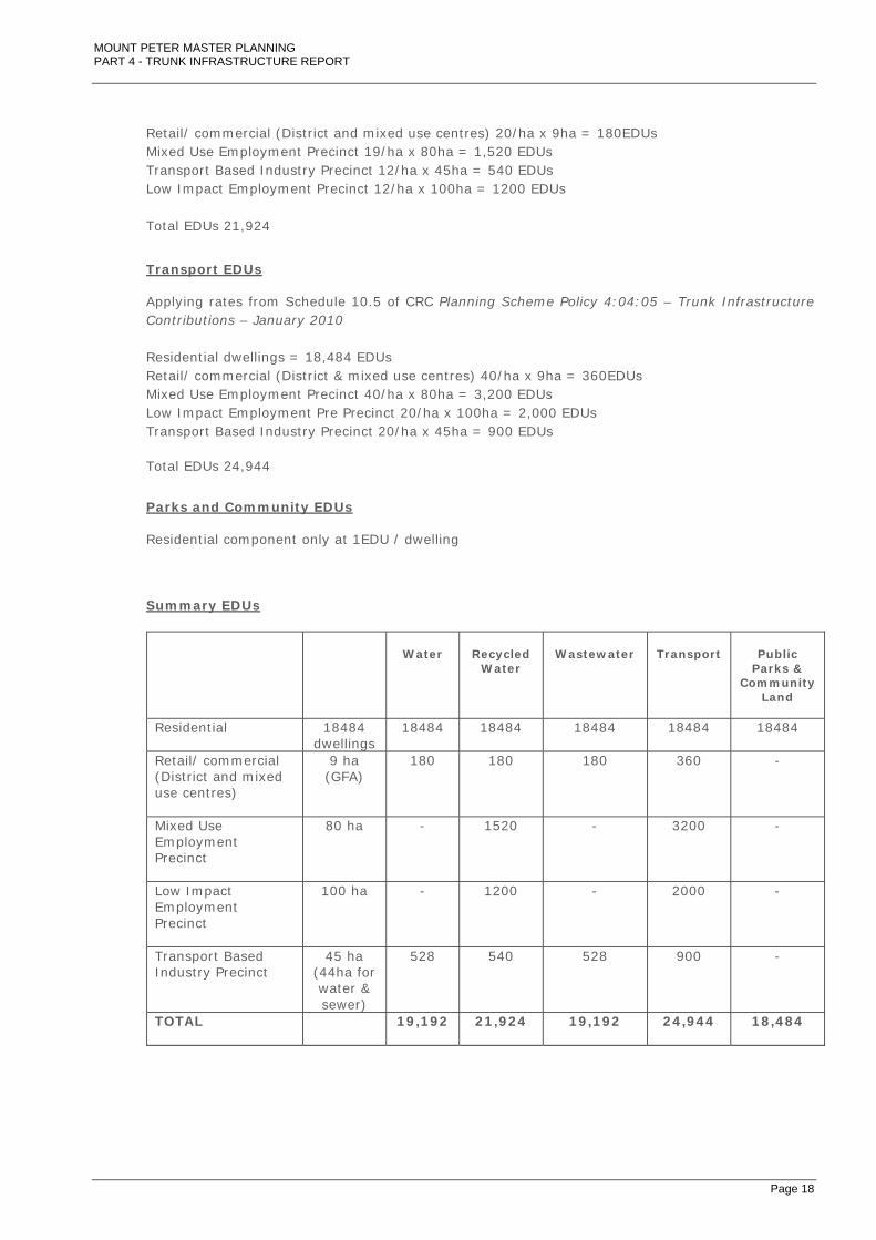
An Equivalent Demand Unit (EDU) is the unit of demand used to determine demand for infrastructure as a result of a proposed development. This unit is based on a comparison with the demand of one standard detached residential dwelling on a standard allotment (401m2 to 900m2). For the purposes of this high level review EDUs have been determined for broad hectare densities of particular uses; this being as follows for the Mount Peter MPA: Residential…………………………………………………………………………………18,484 dwellings Retail/ commercial (District and mixed use centres)…………………9 ha (GFA) Mixed Use Employment Precinct…………………..……………………………80 ha Low Impact Employment Precinct……………………………………………100 ha Transport Based Industry Precinct…………………………………………..…45 ha Potable Water & Wastewater EDUs Note: Reservoirs, treatment works and pipe sizes have been sized to service high end demands The northern part of the north east employment area is assumed to be included in the Edmonton catchment for water & sewer i.e. 83% of the developable area including all ‘Low Impact’ and ‘Mixed Use Employment’ precincts. Therefore, for water & sewer only 44ha of the ‘Transport Based Industry’ precinct is included in the demand calculation. For recycled water the entire NE Employment area is included in the Mount Peter demand. Applying rates from Schedule 10.1 of CRC Planning Scheme Policy 4:04:05 – Trunk Infrastructure Contributions – January 2010 Residential dwellings = 18,484 EDUs Retail/ commercial (District and mixed use centres) 20/ha x 9ha = 180EDUs Transport Based Industry 12/ha x 44ha = 528 EDUs Total EDUs 19,192
Recycled Water EDUs For recycled water the entire NE Employment area is included in the Mount Peter demand. Applying rates from Schedule 10.1 of CRC Planning Scheme Policy 4:04:05 – Trunk Infrastructure Contributions – January 2010 Residential dwellings = 18,484 EDUs
MOUNT PETER MASTER PLANNING PART 4 - TRUNK INFRASTRUCTURE REPORT
Page 18
Retail/ commercial (District and mixed use centres) 20/ha x 9ha = 180EDUs Mixed Use Employment Precinct 19/ha x 80ha = 1,520 EDUs Transport Based Industry Precinct 12/ha x 45ha = 540 EDUs Low Impact Employment Precinct 12/ha x 100ha = 1200 EDUs Total EDUs 21,924
Transport EDUs Applying rates from Schedule 10.5 of CRC Planning Scheme Policy 4:04:05 – Trunk Infrastructure Contributions – January 2010 Residential dwellings = 18,484 EDUs Retail/ commercial (District & mixed use centres) 40/ha x 9ha = 360EDUs Mixed Use Employment Precinct 40/ha x 80ha = 3,200 EDUs Low Impact Employment Pre Precinct 20/ha x 100ha = 2,000 EDUs Transport Based Industry Precinct 20/ha x 45ha = 900 EDUs Total EDUs 24,944
Parks and Community EDUs Residential component only at 1EDU / dwelling
Summary EDUs
Water
Recycled
Water
Wastewater
Transport
Public
Parks & Community
Land
Residential 18484 dwellings
18484 18484 18484 18484 18484
Retail/ commercial (District and mixed use centres)
9 ha (GFA)
180 180 180 360 -
Mixed Use Employment Precinct
80 ha - 1520 - 3200 -
Low Impact Employment Precinct
100 ha - 1200 - 2000 -
Transport Based Industry Precinct
45 ha (44ha for water & sewer)
528 540 528 900 -
TOTAL
19,192 21,924 19,192 24,944 18,484

MOUNT PETER MASTER PLANNING PART 4 - TRUNK INFRASTRUCTURE REPORT
Page 19
Stormwater (stream management) & Water Quality The Infrastructure Contributions for each catchment are established on the following basis.
Cost of Stream Management Works Infrastructure Contribution Rate =
Total Equivalent Contributing Area
The total equivalent contributing area is the developable area excluding parks and stormwater infrastructure. Contributing areas calculated from the MPU Density Calculations – February 2010 (Appendix B) are as follows: Residential………………………………………………………………………904 ha
District & mixed used centres……………………………………….160 ha
Industrial / commercial (NE employment area)…………..218 ha
Total equivalent contributing area....................1,280 ha
18. LOCAL FUNCTION CHARGE FOR STATE CONTROLLED ROADS
The assessment of the Local Function Charge for State Controlled Roads (LFCSCR) applies the same charging methodology used for local trunk roads with an adjustment for the amount of road capacity consumed by local traffic movements from Mount Peter. Only that proposed State owned infrastructure that is directly attributable to Mount Peter usage is included in the calculations as follows:
Local Function Item
Description (includes 20% addition for +10yrs +20% contingency + 7.5% fees)
Total (S)
Maitland Road to Deppeler Road
Upgrade 4 lanes to 6 lanes to sub-arterial standard (4,400m)
22,309,848
Intersection upgrade to Maitland Road Upgrade 4 to 6 lanes 810,900
Intersection upgrade to Deppeler Road
Upgrade 4 to 6 lanes 810,900
Widening Wrights Creek Bridge
50m span upgrade 4 to 6 lanes 12m wide + approaches (20%) 4,829,414
Widening Collinsons Creek Bridge(Deppeler Rd)
50m span upgrade 4 to 6 lanes 12m wide + approaches (20%)
4,829,414
Sub Total 33,590,477
Local Use factor (from traffic modelling)
85% 28,551,905
EDUs 24,944
Total $1,145
MOUNT PETER MASTER PLANNING PART 4 - TRUNK INFRASTRUCTURE REPORT
Page 20
19. INFRASTRUCTURE CONTRIBUTIONS
Infrastructure contribution by infrastructure type:
TOTAL Charge / EDU
ROADS $ 350.0 m $14,033
COMMUNITY FACILITIES $ 17.5 m $949
PARKS AND OPEN SPACE $ 123.6 m $6,689
POTABLE WATER SUPPLY $ 39.7 m $2,070
RECYCLED WATER $ 72.5 m $3,307
WASTE WATER $ 124.0 m $6,462
TOTAL $ 727.5 m
TOTAL Charge / hectare*
STORMWATER $ 56.7 m $44,329 * Developable area excluding parks and stormwater infrastructure
TOTAL Charge / EDU
LOCAL FUNCTION CHARGE for STATE CONTROLLED ROADS $ 42.6 m $1,145
The above charges are subject to further review by Council’s Priority Infrastructure Plan team.
MOUNT PETER MASTER PLANNING PART 4 - TRUNK INFRASTRUCTURE REPORT
Page 21
REFERENCES
Mount Peter Master Planning Group Technical Reports – Version 6:
1. Environmental Constraints and Opportunities Technical Report (Feb 2010)
2. Transport, Mobility and Access Technical Report (Feb 2010)
3. Community Facilities, Human Services and Community Development Technical Report (Feb 2010)
4. Sport and Recreation Technical Report (Feb 2010)
5. Stormwater Technical Report (Feb 2010)
6. Water Supply, Sewerage and Recycled Water Technical Report (Feb 2010)
7. Other Physical Infrastructure Technical Report (Feb 2010)
Cairns Regional Council Planning Scheme Policy 4:04:05 – Trunk Infrastructure Contributions – January 2010

MOUNT PETER MASTER PLANNING PART 4 - TRUNK INFRASTRUCTURE REPORT
Page 22
APPENDICES APPENDIX A - GROWTH & SEQUENCING
• MAP 08 MOUNT PETER STRUCTURE PLAN AREA PRECINCTS
• GROWTH RATES
• MOUNT PETER MPU DENSITY CALCULATIONS – FEBRUARY 2010
• MAP 09 MOUNT PETER STRUCTURE PLAN AREA DEVELOPMENT ENTITLEMENTS
• INDICATIVE SEQUENCING PLAN
• INDICATIVE 5 & 10 YEAR DEVELOPMENT PLAN
APPENDIX B - INFRASTRUCTURE PLANS
• FIGURE 1 DEVELOPABLE AREA
• FIGURE 2 ROADS
• FIGURE 3 CYCLEWAY NETWORK, SHARED PATHS AND WALKING TRACKS
• FIGURE 4 BRIDGES
• FIGURE 5 WATER SUPPLY NETWORK
• FIGURE 6 SEWERAGE NETWORK
• FIGURE 7 RECYCLED WATER NETWORK
• FIGURE 8 PARKS AND OPEN SPACE
• FIGURE 9 STORMWATER INFRASTRUCTURE
APPENDIX C - SUPPLEMENTARY INFRASTRUCTURE SKETCHES
• INDICATIVE BRIDGE CROSS SECTIONS
• EXISTING CANE RAIL AT GRADE CROSSINGS
• INDICATIVE BUSWAY-SUB ARTERIAL-CANE RAIL CROSS SECTIONS
APPENDIX D - INFRASTRUCTURE SCHEDULES APPENDIX E – SUPPORTING PHOTOGRAPHS

MOUNT PETER MASTER PLANNING PART 4 - TRUNK INFRASTRUCTURE REPORT
APPENDIX A - GROWTH & SEQUENCING
• MAP 08 MOUNT PETER STRUCTURE PLAN AREA PRECINCTS
• GROWTH RATES
• MOUNT PETER MPU DENSITY CALCULATIONS – FEBRUARY 2010
• MAP 09 MOUNT PETER STRUCTURE PLAN AREA DEVELOPMENT ENTITLEMENTS
• INDICATIVE SEQUENCING PLAN
• INDICATIVE 5 & 10 YEAR DEVELOPMENT PLAN

MOUNT PETER MASTER PLANNING PART 4 - TRUNK INFRASTRUCTURE REPORT
APPENDIX B - INFRASTRUCTURE PLANS
• FIGURE 1 DEVELOPABLE AREA
• FIGURE 2 ROADS
• FIGURE 3 CYCLEWAY NETWORK, SHARED PATHS AND WALKING TRACKS
• FIGURE 4 BRIDGES
• FIGURE 5 WATER SUPPLY NETWORK
• FIGURE 6 SEWERAGE NETWORK
• FIGURE 7 RECYCLED WATER NETWORK
• FIGURE 8 PARKS AND OPEN SPACE
• FIGURE 9 STORMWATER INFRASTRUCTURE

MOUNT PETER MASTER PLANNING PART 4 - TRUNK INFRASTRUCTURE REPORT
APPENDIX C - SUPPLEMENTARY INFRASTRUCTURE SKETCHES
• INDICATIVE BRIDGE CROSS SECTIONS
• EXISTING CANE RAIL AT GRADE CROSSINGS
• INDICATIVE BUSWAY-SUB ARTERIAL-CANE RAIL CROSS SECTIONS

MOUNT PETER MASTER PLANNING PART 4 - TRUNK INFRASTRUCTURE REPORT
APPENDIX D - INFRASTRUCTURE SCHEDULES

MOUNT PETER MASTER PLANNING PART 4 - TRUNK INFRASTRUCTURE REPORT
APPENDIX E - SUPPORTING PHOTOGRAPHS

MOUNT PETER MASTER PLANNING PART 4 - TRUNK INFRASTRUCTURE REPORT
Photo 01: Photo 02: Mount Peter Road and Bridge over Stoney Creek Cane Rail running parallel to Mount Peter Road
Photo 03: Photo 04: Cane Rail crossing of Mount Peter Road (north of Cain Rail Spur Line at Mount Peter and Hussey Hussey Road intersection) Road Intersection
MOUNT PETER MASTER PLANNING PART 4 - TRUNK INFRASTRUCTURE REPORT
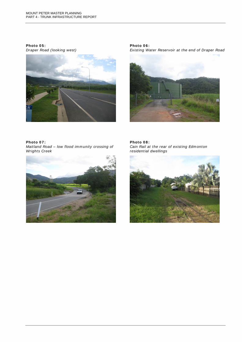
Photo 05: Photo 06: Draper Road (looking west) Existing Water Reservoir at the end of Draper Road
Photo 07: Photo 08: Maitland Road – low flood immunity crossing of Cain Rail at the rear of existing Edmonton Wrights Creek residential dwellings