Moulton Heights - IEMA · Moulton Heights : Non-Technical Summary 7722974v2 progression of the West...
26
Moulton Heights Volume 1: Environmental Statement Non Technical Summary December 2014 Roundhill Northampton Limited
-
Upload
truongdien -
Category
Documents
-
view
218 -
download
0
Transcript of Moulton Heights - IEMA · Moulton Heights : Non-Technical Summary 7722974v2 progression of the West...
Moulton HeightsVolume 1: Environmental Statement Non Technical Summary December 2014
Roundhill Northampton Limited

Moulton Heights : Non-Technical Summary
7722974v2
1.0 Introduction
This Environmental Statement (“ES”) Non Technical Summary (“NTS”) has 1.1been produced to accompany an outline planning application submitted on behalf of Roundhill Northampton Limited (“the Client”) in respect of land to the north of Mouton (known as ‘Moulton Heights’), north of Northampton.
The ES assesses an outline planning application for:- 1.2
1,000 residential dwellings, including accommodation for the elderly, local and 1.3community facilities (primary school provision), ancillary retail and service uses (to be provided within two new village centres), development of a local relief road, mixed-use development (comprising a range of commercial floorspace), access, infrastructure, open space landscaping and associated works (all matters reserved) The planning application is accompanied with a masterplan which illustrates how the site could be developed, and provides a series of parameters within which detailed layouts will be prepared.
1.1 The proposed development falls within part 10(b) (Infrastructure Projects) of Schedule 2 of the Town and Country Planning (Environmental Impact Assessment) Regulations 2011 (the ‘2011 Regulations’). Part 10(b) relates to “urban development projects” where sites are over 0.5 hectares. For such developments, Environmental Impact Assessment (“EIA”) is required in situations where the development could give rise to significant environmental effects. The applicant has determined to undertake an EIA in respect of the proposed development.
The Purpose of the Environmental Statement
The EIA Process
The EIA process aims to ensure that any significant effects arising from a 1.4development are systematically identified, assessed and presented to help a local planning authority, statutory consultees and other key stakeholders in their understanding of the impacts arising from development. If measures are required to minimise or reduce effects then these are clearly identified.
For the Moulton Heights scheme, EIA has been carried out to consider the 1.5likely significant effects that may arise during the construction and operation of the development and due to its potential relationship to future developments in the area. It has been completed with regard to best practice and relevant legislation and has addressed the following matters agreed with Daventry District Council (“DDC”) as being required to assess the impact of development:-
1 Land use;
2 Socio-Economic;
3 Transport;

:
7722974v2
4 Visual Impact;
5 Ecology;
6 Arboriculture;
7 Water Management;
8 Noise;
9 Air Quality;
10 Cultural Heritage and Archaeology;
11 Ground Conditions; and
12 Cumulative Effects
The Site
The application site extends to an area of circa 66 ha and is located to the 1.6north of the village of Moulton, approximately 7km north-east of Northampton town centre.
The site is bound by Holcot Road to the west; agricultural fields to the north; 1.7the A43 to the east; and a mixture of agricultural fields and industrial units to the south, beyond which lies residential development.
The site comprises mainly agricultural fields in use for arable farming, with 1.8some small areas of woodland.
A watercourse runs close to the southern border of the site, and a small area of 1.9land within the immediate vicinity of the watercourse is designated as Flood Zone 3. The remainder of the site lies within Flood Zone 1.
The site does not fall within designated greenbelt and does not contain any 1.10listed buildings or scheduled monuments. It does not contain any statutorily designated environmental sites.
The Planning Application Proposals
Description of the Proposed Development
The ES assesses an outline planning application for development of up to 1.111,000 residential dwellings, including accommodation for the elderly, local and community services and facilities, development of a local relief road, mixed use development adjacent to the A43, access, infrastructure, open space, landscaping and associated works. All matters (appearance; layout; scale; landscaping and means of access) are reserved for future consideration by the Council.
Layout
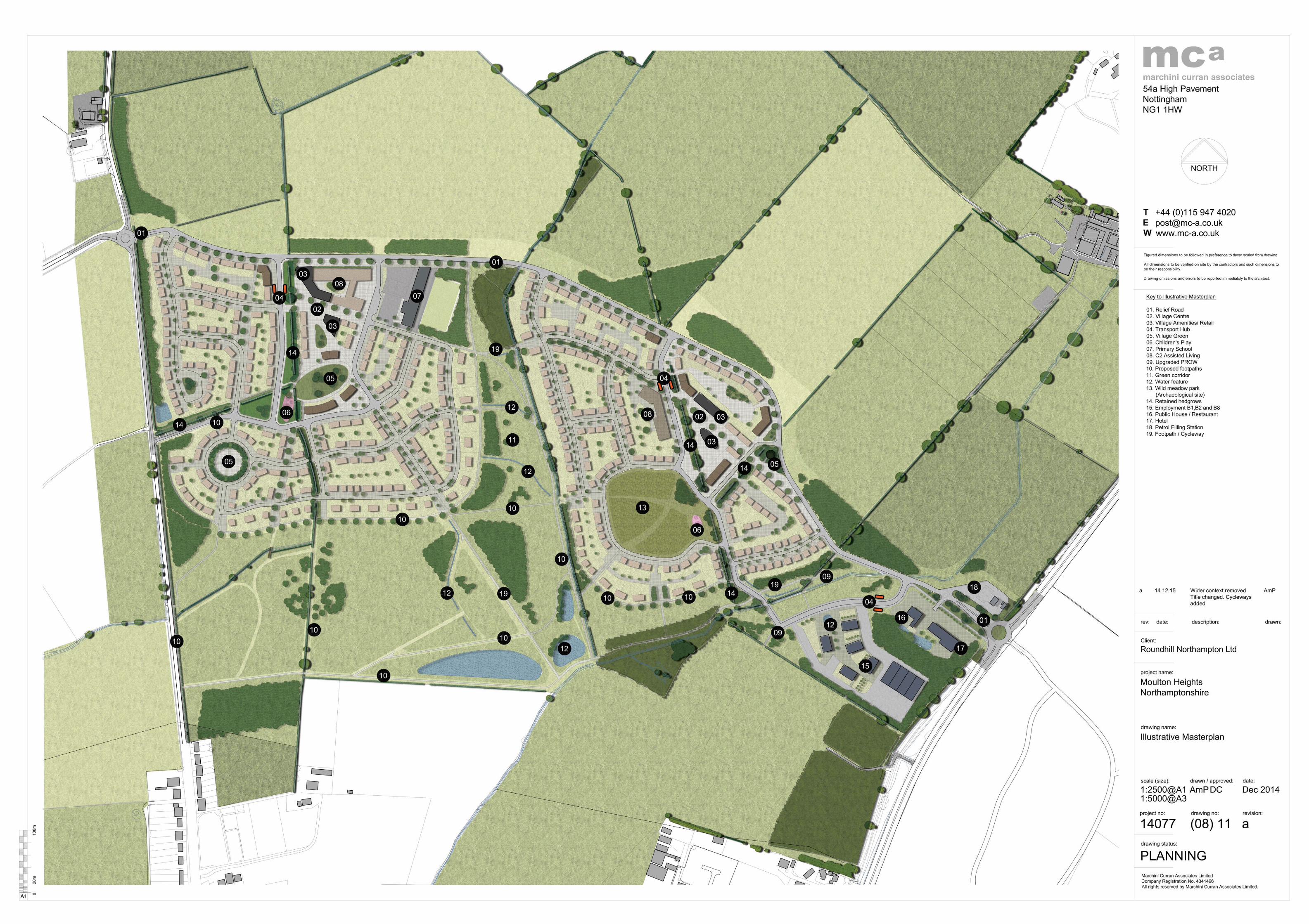
The final layout details for the site will be the subject of a future application for 1.12Reserved Matters approval. The parameters plan and illustrative masterplan

Moulton Heights : Non-Technical Summary
7722974v2
(included at Appendices B2 and B3 of the ES and in part at Section 14.0 of this document) specify the development framework relating to land use, including the development envelopes at the site, key access routes and open spaces within the site.
Scale
The maximum heights indicated in Table 1.1 have been assessed within the 1.13ES, and the scale parameters for residential dwellings and associated community buildings within the site can be identified as:
Table 1.1 Storey Heights (Residential and Non-Residential)
Storeys Width (max)*
Height (ridge height) (max)
Depth (max)
1 13m 9m 12m
1.5 13m 9m 12m
2 24m 11m 12m
2.5 25m 11m 12m
Non-residential uses**
- 15m -
* including multiple dwelling blocks ** The precise configuration of the non-1.14residential buildings is not yet known and the width/depth will be determined at a later date
Appearance
The final appearance details of the development are reserved for future 1.15approval or condition discharge. The surrounding context will be central to informing the final character of the site, as well as the appearance of the new homes. Careful analysis of the local vernacular will result in the design of new buildings that are well integrated with their surroundings.
Landscaping
For the purposes of this assessment, the parameter plans and indicative 1.16masterplan set out the areas of built development and open space (located at Appendices B2 and B3 of the ES). An illustrative landscape strategy has also been prepared which specifies areas of public and natural open space and woodland planting, as well as limited off-site planting. The illustrative landscaping layout is included at Appendix B4 of the ES.
Access
The indicative site masterplan and parameter plans (included at Appendix B3 1.17and B2 respectively) identify access to the site via three points from the existing highway network as follows (though the detailed layout of these are yet to be designed):

:
7722974v2
1 Via a new four-armed roundabout junction located on the A43 (primary access point). From this access point, the primary internal link road will generally follow a north-westerly alignment and terminate on the western side of the development, at the current junction of Holcot Road / Boughton Fair Lane;
2 Via a new four-armed roundabout at the existing junction of Holcot Lane / Boughton Fair Lane (secondary access point); and
3 Via a new, bus only access point provided via a new priority junction into the western side of the site from Holcot Road (public transport access point). This route will be open to buses, cyclists and pedestrians only.
The illustrative site masterplan and parameter plans (included at Appendix B4 1.18and B2 respectively) also indicate introduction of a ‘Green Relief Road’ through the site, linking from the A43 to Holcot Road.
Numerous bus stops are located in proximity to the site on Overstone Road 1.19and Holcot Road. These provide hourly services from Northampton to Kettering, as well as intermediate services to villages such as Moulton and Broughton.
Sustainability/Energy
A commitment to achieving the following sustainability standards is confirmed: 1.20
1 Code for Sustainable Homes (CfSH) Level 4 across all new dwellings; and
2 BREEAM rating of ‘Very Good’, for all non-residential (commercial) buildings.
A high quality of design throughout the development will help to promote 1.21respect towards the environment and increase the overall sustainability benefits of the site.
The site also occupies an excellent opportunity to facilitate sustainable 1.22development and sustainable living through the inclusion of new, local retail services and community facilities within dedicated village centres; the opportunity to design new infrastructure which encourages safe cycling and walking within the site, and to established cycle and walking networks elsewhere that link into the existing walking and cycling network and therefore will offer sustainable connectivity to the wider area; and the provision of new Public Transport Hubs within each village, the commercial development providing local job opportunities accessible by non-car means; and future off-site community uses.
Alternatives
Potential alternatives to the proposed development have been considered in 1.23the context of the need for the development, with consideration given to

Moulton Heights : Non-Technical Summary
7722974v2
progression of the West Northamptonshire Joint Core Strategy (JCS), scheme design evolution and local consultation.
The land at North Moulton (the application site) was promoted for allocation as 1.24a Sustainable Urban Extension (SUE) to accommodate 2,000 dwellings and supporting/ancillary community infrastructure in the West Northamptonshire JCS. The JPU’s Strategic Environmental Assessment (SEA) concluded that other sites could accommodate development on land with less landscape quality, and which were directly connected to the urban area of Northampton, and the site was not ultimately allocated.
The ‘alternative’ land to which this application relates has been modified in 1.25response to these issues, as well as consultation with statutory stakeholders and the local community, resulting in a substantially reduced scheme of up to 1,000 houses, with development concentrated towards the lower contours of land north of Moulton whilst retaining the buffer landscaping with high connectivity levels between the established Moulton Village and the new development.
The Examining Inspector introduced amendments to the proposed Policy R1 of 1.26the JCS to ensure sufficient flexibility to allow for development proposals in the rural areas. The alternative proposition now submitted for planning permission meets these policy objectives.
In addition to this policy compliance, Daventry District Council is unable to 1.27demonstrate a 5-year housing land supply, and there is a demonstrable absence of alternatives to meet this housing shortfall elsewhere. Further, the provision of affordable housing and the housing mix of the development, which responds to local community aspirations, cannot be met elsewhere and is further justification for the application proposals.
Consideration has also been given to alternative layouts. The illustrative layout 1.28has evolved over a number of years in response to consultation with the local community, statutory consultees, and assessment of technical issues within the ES. Most notably, the masterplan has responded to archaeological finds as these were uncovered, as well as key views to Moulton. Of the alternative layouts considered, the final illustrative masterplan provides the best approach to the delivery of much needed housing and local infrastructure whilst respecting environmental assets and constraints.
2.0 Land Use
A detailed survey of land use, soils and agricultural land quality has been 2.1undertaken. The results show the site to be predominantly in use as arable farmland, all farmed by Overstone Grange Farm, one of the two owners of land at the site. As this farm business would benefit directly from the sale of the land for the proposed development, there are not considered to be any significant adverse effects on farm businesses.

:
7722974v2
The land was found to have a mixture of soil types, none supporting valuable 2.2habitats, but much of the site has a high capacity to absorb excess rainfall. Development therefore has the potential to reduce this capacity and adversely affect local flooding, as well as resulting in the loss of valuable topsoil resources. Mitigation for these potential impacts involves the inclusion of Sustainable Urban Drainage Systems, stripping, stockpiling and reuse of all topsoils and compliance with published good practice guidelines for protection of soils on construction sites. The potential adverse effects of the proposed development on soils with appropriate mitigation are considered minor.
Much of the site (50.6 ha) comprises best and most versatile agricultural land, 2.3as is common around Northampton. The permanent loss of agricultural land to development cannot be mitigated, and the loss is regarded as a major adverse effect, which are weighed against the benefits of the proposed development in accordance with the National Planning Policy Framework.
3.0 Socio-Economic
This chapter considers the potential socio-economic effects of the proposed 3.1development, including population structure, employment levels, housing stock and the availability of local services and facilities.
The proposals will deliver a substantial residential led mixed-use development 3.2comprising of up to 1,000 dwellings on the north-eastern fringe of Northampton within the District of Daventry. The proposed development will provide 7.8% the District’s identified annual housing requirement including affordable homes and assisted living units.
The proposals will also have important positive economic impacts in Daventry 3.3and Northampton and their respective labour markets through the creation of new jobs at both construction and operational stages, along with housing that will increase local labour supply.
The scale of housing and population growth resulting from this development 3.4will provide important benefits for Daventry and Northampton. The additional resident population generated will be sizeable (estimated at approximately 2,270 people) but its net impact on primary education provision, primary healthcare and other community facilities will be negligible or positive since adequate levels of additional facilities of this type exist in this area or will be provided as part of the development or within other major developments nearby.
One potential negative impact of the proposed development would be its 3.5impact on secondary school provision but this will be mitigated by the provision of land to the south of site to the local education authority, which is intended to be used for the development of a new secondary school in the future.

Moulton Heights : Non-Technical Summary
7722974v2
The proposed development would have a negative impact on hospital bed 3.6provision across Northampton but this could be mitigated against in conjunction with the local PCT and NHS Trust.
Another potential negative impact of the proposed development would be its 3.7impact upon outdoor sports facilities and allotment provision. Required facilities cannot be provided on-site due to the topography, but this will be mitigated by financial contributions towards the provision of facilities off-site. The proposals are in compliance with open space requirements and the provision of other amenity and play space within the site exceeds standards. Given that the open space and recreational needs of the new residents would be fully met (and indeed exceeded), and given that the wider Daventry area is deficient in open space provision generally, the proposed development will be of substantial benefit to the local community.
The most significant impacts of the proposed development on the local 3.8economy would be:
1 A capital investment of approximately £126.6 million;
2 Provision of up to 1,000 dwelling units within Daventry, of which a significant proportion would be affordable and more would be assisted living units thereby, improving the quality of the housing stock;
3 Some 1,485 person-years of construction work (149 full time employees (“FTE”));
4 611 direct permanent job opportunities based on the site (487 FTEs), a net additional gain of 438 FTE jobs locally;
5 Provision of retail and education within the site to serve residents; and,
6 Over 26.5ha of open space provision.
Overall, the proposed development represents a significant new capital 3.9investment in the area and will improve the quality of local housing, and increase population, economic activity and expenditure in the local area without creating significant adverse impacts on existing facilities. It will also provide substantial amounts of new open space, new retail, and a new hotel and petrol filling station to serve the local area. On this basis, there will be no significant adverse socio economic effects, although the provision of housing and employment opportunities will be a significant beneficial effect.
4.0 Transport and Access
The effect of the proposed development on the surrounding transport network 4.1has been assessed, including the potential effects of the predicted traffic associated with the proposed development in the opening and operational phases. In terms of the study area, this has been defined through discussions with Northamptonshire County Council, and includes the following key roads on the surrounding highway network:
1 A43 Kettering Road, North of Sywell Road/Holcot Road

:
7722974v2
2 Sywell Road
3 Holcot Road
4 A43 Kettering Road, South of Sywell Road/Holcot Road
5 A43 Kettering Road, North of Overstone Road/Overstone Lane
6 Overstone Road
7 Overstone Lane
8 A43 Park View, South of Overstone Road/Overstone Lane
9 A43 Thorpeville, North of Roundabout
10 Chater Street
11 High Street, West of Chater Street
12 Church Street
13 Cross Street
14 Northampton Lane North
15 The Grove
16 Holcot Road, South of Boughton Fair Lane
17 Boughton Fair Lane
18 Holcot Road, North of Boughton Fair Lane
19 Proposed Link Road
An assessment of the developments traffic impact has been undertaken, using 4.2the Northampton Strategic Traffic Model (NSTM), for the following scenarios: 2013 (Baseline Assessment Year), 2021 (Opening Forecast Year) and 2026 (Future Forecast Year – Full Development). Within this assessment, consideration has also been given to any potential increase in accidents, severance, fear / intimidation and pedestrian delay as well as any potential impacts from dust and dirt during the construction period.
In terms of mitigation, in addition to providing vehicular access points on the 4.3A43 (primary access point), the junction of Boughton Fair Lane / Holcot Road (secondary access point) and a dedicated ‘Bus-Only’ access on Holcot Road, the proposals also include to provide a new off-site footway along Holcot Road, and linking the proposed development into the village of Moulton.
A Construction Phase Management Plan will also be developed to ensure that 4.4any impacts from construction traffic are minimised. This plan will include the provision for wheel wash facilities and road sweeping in order the minimise the impacts from dust and dirt.
The assessment has accounted for cumulative impact associated with the 4.5proposed development through known committed and allocated development within the vicinity of the site. Confirmation has been provided by NCC that the NSTM, through its forecast years within the traffic model that it accounts for
Moulton Heights : Non-Technical Summary
7722974v2
committed and allocated development. Hence, the aspect of the cumulative impact has been fully assessed.
5.0 Landscape and Visual Impact
There are predicted to be significant adverse landscape effects on the 5.1identified landscape receptors during the construction phase of the Moulton Heights development. These receptors include the characteristic landscape patterns and features of the rolling farmland slopes to the north of Moulton and the quality of local views.
However, the negative effects associated with construction activities are of a 5.2temporary nature and should be set against the long-term major positive effects of the extensive new tree and woodland planting (on-site and off-site), which will knit the new development into the surrounding farmland landscape, retaining and enhancing its predominantly rural character.
At a local scale, the characteristic small scale, meadow and woodland 5.3landscapes of the lower slopes within the Rolling Ironstone Valley Slopes landscape type will extend further upslope and subtle variations in landscape pattern will more strongly reflect local landform. The contrast in landscape scale will be enhanced, but the transition will be more abrupt. New wetlands will contribute to the diverse character of the upper Page’s Brook Valley landscape.
Similarly, the significant negative visual effects that are predicted during the 5.4construction phase will shift from a negative to a neutral (no perceptible change) or positive impact as the new planting matures. Five years is a relatively short time in the life of a tree and it will typically take 10-15 years for a native woodland tree belt to provide a full visual screen.
There are no predicted outstanding adverse landscape and/or visual effects 5.5following completion of the development and the maturation of the new landscape scheme.
It would not be appropriate for a new village development on a relatively 5.6elevated rural site to be completely enclosed by new woodland planting and the landscape of the new development at Moulton Heights is designed to provide views to and from the residential areas, with new houses partially visible in some locations. The landscape along the A43 corridor will be enhanced to provide a positive gateway to Moulton and the farmland landscape setting on the slopes to the north and east of the village will also be enhanced, with new woodland planting designed to extend and reinforce the existing pattern of woodlands and field hedgerows.
Whilst significant cumulative landscape effects are predicted as a result of 5.7changes to the rural farmland character of the wider landscape in this part of the Rolling Ironstone Slopes landscape and the erosion of gaps between local villages if the Moulton Heights, Overstone Leys and Overstone Green

:
7722974v2
developments are implemented together. No significant cumulative visual effects are predicted because the Overstone Leys and Overstone Green development would dominate the gateway views to Moulton and indeed to this part of the Vale of Northampton from the east. In this context, the Moulton Heights development would seem a relatively minor and logical part of this wider development of a sustainable urban extension to Northampton. Overall, the new woodlands, copses and hedgerows (including in particular the extensive off-site woodland planting to be implemented as part of Moulton Heights) would create a stronger sense of enclosure within the immediate landscape setting to Moulton. It would increase the robustness of this landscape and its capacity to absorb the planned new built development associated with the sustainable urban extension (at Overstone Leys/Overstone Green) and the smaller Moulton Heights development.
Overall the landscape and visual impacts of the new Moulton Heights 5.8development are predicted to be positive once the new planting has matured.
6.0 Ecology
Chapter G of the ES covers the assessment methodology and the baseline 6.1conditions at the site with respect to Ecology. The site was subject to a suite of ecological surveys in 2013 and 2014. Specific surveys for bats, Badgers, Otters, water voles, reptiles, Great Crested Newts and birds were undertaken within the site.
There are no statutory designated sites of nature conservation interest within 6.2the site boundary. The nearest statutory designated site is Crowfields Common LNR which lies 1km to the south of the site. It is not considered that the development proposals would result in any significant effects on statutory designated sites in terms of light, noise, water and air pollution impacts or recreational pressure.
Two non-statutory designated sites are located in the surroundings of the site, 6.3namely Hog Hole Spinney Local Wildlife Site (“LWS”) (located 0.3km to the south-west) and Cowpasture Spinney LWS (located 0.7km to the east). It is not considered that the development proposals would result in any significant effects on these LWSs in terms of pollution of light, noise, water air or recreational pressure.
The nearest Special Protection Area (“SPA”) and Ramsar site is the Upper 6.4Nene Gravel Pits SPA / Ramsar site, which is also designated as a SSSI. This SPA / Ramsar site / Site of Special Scientific Interest (“SSSI”) is situated approximately 8.3km to the south-east of the site at its closest point and is separated by significant areas of urban development and agricultural land. Given that the proposed development will include provision of significant areas of informal open space for recreational use, it is considered that the proposed development would not have any effect upon the SPA / Ramsar site / SSSI.
Moulton Heights : Non-Technical Summary
7722974v2
The majority of the site comprises of arable land with areas of semi-improved 6.5grassland present at the boundaries and an improved grassland field present in the east. Hedgerows divide this arable land into a series of fields. The rest of the site comprises of woodland, plantations, a pond and two streams.
The vast majority of the habitats present in the site of ecological value will be 6.6retained under the development proposals. No mitigation is required for the loss of arable habitats within the site. As for the minor loss of other habitats, the provision, and management of extensive areas of species-rich landscape planting, including new species-rich grassland, trees, a pond and the bolster planting of hedgerow will provide a significant enhancement over the existing situation. As such, there will be no net loss of features of ecological importance.
Construction methods of best practice have been proposed throughout this 6.7Chapter in order to alleviate any potential adverse impacts on retained habitats.
Protected, rare or notable fauna identified within the site includes bats, 6.8Badgers and birds.
Overall the level of bat activity recorded within the site was generally low. 6.9Whilst the proposals will result in minor losses to suitable commuting and foraging habitats, the completed development will provide significant enhancements in the form of species-rich areas of grassland, hedgerow bolster planting and a large pond. Where lighting is necessary during construction and operational phases, light spillage will be reduced and directed away from features that offer suitable foraging opportunities for bats. Bat boxes are to be erected on suitable retained trees to provide additional roosting opportunities for bats. Overall, there will be a significant enhancement in the opportunities for bats across the site.
Badger surveys undertaken at the site revealed the presence of two main setts 6.10along with other evidence of Badger activity. During the construction phase none of these setts will be lost, however, one may need to be temporarily closed under licence from Natural England depending on its proximity to the development footprint. The requirement for any works under licence will be determined at the detailed application stage. Appropriate measures have been put forward to safeguard Badgers during the construction phase. Considering the enhancement of existing and newly created habitats, opportunities for Badgers across the site would be significantly enhanced within its completed form.
The bird surveys identified that the site supports a number of bird species. 6.11Only a very small minority of bird habitat will be lost during the construction phase. In any event, clearance of this habitat will be undertaken outside of the bird breeding season (March-July inclusive) where possible. In addition to those key habitats being retained, the provision of species-rich grassland, tree planting and a pond, and the installation of bird boxes, will provide additional

:
7722974v2
foraging and nesting habitats for birds and will be a significant enhancement over the existing situation.
Despite two years of survey effort, the reptile surveys did not identify any 6.12reptiles within the site itself, however, given that surveys identified reptiles in the wider study area, mitigation is proposed on a precautionary basis during construction to safeguard individuals from harm. The provision of species-rich grassland will provide opportunities for reptiles in the local area and will be a significant enhancement over the existing situation.
Specific surveys were undertaken for Otters, Water Voles and Great Crested 6.13Newts, however, none of these species were recorded within the site. In any event, it is possible that the site in its completed form will provide novel opportunities for these species.
With the implementation of appropriate mitigation, and through the provision of 6.14enhancement through the creation and management of habitats, and provision of artificial roosting and nesting features there are predicted to be net benefits for species as a result of the proposed development.
Taking into account the potential impacts arising from both the construction 6.15and completed development phases and off-setting these, where necessary, with appropriate mitigation, the proposed development complies with relevant planning policies contained within the NPPF and the Daventry District Local Plan 1997 and the emerging West Northamptonshire Joint Core Strategy.
In conclusion, all relevant ecological issues have been addressed within this 6.16chapter. On the evidence of the specific ecological surveys undertaken, and with the implementation of mitigation and enhancement recommended in this report, the impact of the proposed development upon the natural environment will be an increase in the variety and quality of semi-natural habitat present on site from habitat enhancements, creation and management.
7.0 Arboriculture
A pre-development tree and hedgerow survey was undertaken on a 66 hectare 7.1parcel of farmland to the north of Moulton in Northamptonshire. The field work was completed in September 2014.
The survey recorded a total of 39 individual trees (predominantly English Oak 7.2and Ash), 10 groups of trees including two small woodlands, and 13 field hedgerows of mixed native species.
Of the individual trees approximately two thirds were found to be of moderate 7.3or high quality, whilst a similar proportion of the groups were also found to be of moderate or high quality. All but one of the hedgerows was moderate quality, largely because of their wildlife and conservation value.
The findings of the survey will be used to ensure that at least all trees and 7.4hedgerows of moderate or high quality are incorporated into the design of the

Moulton Heights : Non-Technical Summary
7722974v2
proposed development, however in some areas there will be small scale losses where sections of hedgerow will need to be removed to allow the construction of access roads.
An arboricultural impact assessment was subsequently undertaken, based on 7.5the proposed master plan, is included as Chapter H of the ES. The conclusion of our assessment was that the overall significance of effects on the arboricultural features of the site will be negligible.
8.0 Water Management
The Water Management chapter of the ES considers the potential impacts of 8.1the proposed residential-led development on surface water (hydrology), groundwater (hydrogeology) and flood risk of the assessment site.
There are three ordinary watercourses within the vicinity of the site and Pitsford 8.2Water to the north. A small pond is located within the southern portion of the site. According to the Environment Agency (“EA”), the site is partially underlain by a Secondary A superficial aquifer to the north of the site. The southern half of the site is underlain by a Secondary A bedrock aquifer, while small portions of the northern half of the site are underlain by a Secondary B bedrock aquifer.
The EA Flood Map for Planning indicates the majority of the site is located in 8.3Flood Zone 1, with a small portion of land adjacent to Moulton Brook to the south of the site located in Flood Zone 3. The risk of groundwater flooding varies across the site due to topography and underlying soil/ground conditions. The risk of flooding from surface water is predominantly low very; however, areas adjacent to Moulton Brook and a small unnamed watercourse (referred to as Trib01) are indicated to be at a high risk of flooding from this source. However, the site is shown to slope from north to south and towards on-site watercourses. As such, the risk of flooding from groundwater and surface water would not be expected to accumulate to any significant depth at the site itself.
No water quality data is available for watercourses within 1 km of the site. 8.4However, the overall ecological status of Pitsford Water is assessed as Moderate, whilst the underlying groundwater body is assessed to have a good overall status.
Potential effects that could occur through the construction and operational 8.5phases of the proposed development have been assessed. These include effects on surface water runoff (including its quality); risk of pollution to water bodies and groundwater from contaminants, accidental spillages, suspended sediments and foul water; existing land drainage regimes; and impacts on flood risk from increased impermeable areas and the build up of debris and/or rubbish in drainage ditches.
The likely effects of the proposed development during the construction and 8.6operational phases of the development have the potential to result in water

:
7722974v2
environmental impacts of moderate significance. Such impacts may however, be mitigated by a range of operational, control and monitoring measures capable of control through the imposition of suitably worded planning conditions.
Mitigation measures include the adoption of best practice construction methods 8.7and construction management processes; an Environmental Management System; foul water sealed storage vessels that are to be disposed of off-site; raised finished floor levels of residential dwellings; bridge design; water body maintenance; and a surface water drainage scheme.
The assessment has demonstrated that the effects during the construction and 8.8operational phases following the application of the identified mitigation measures on hydrology and flood risk will be minimal, with environmental impacts on the water environment considered to be not significant.
9.0 Noise
An EIA has been undertaken to assess the potential noise impacts of the 9.1proposed development.
In relation to the requirements of the 2011 Regulations , the aspects of the 9.2environment which may be significantly affected include human beings and material assets as follows:
1 Potential impact of the construction noise of the proposed development on existing noise sensitive receptors.
2 Potential impact of the road traffic noise generated by the proposed development on existing noise sensitive receptors.
3 Potential impact of the fixed plant and equipment noise generated by the proposed mixed use development (adjacent to the A43 Kettering Road) on existing noise sensitive receptors.
On the basis of an assessment using significance criteria, the potential noise 9.3impacts were identified as being negligible using recognised acoustic guidance, standards and target criteria.
Notwithstanding this, mitigation measures by means of suitably worded 9.4planning conditions have been identified to control potential noise impacts.
The residual noise effects associated with the proposed development are 9.5considered to be negligible.
10.0 Air Quality
An air quality assessment has been undertaken which considers the potential 10.1effects of dust and fine particulate matter (PM10) emissions from the construction phase of works and the potential air quality effects of additional

Moulton Heights : Non-Technical Summary
7722974v2
road traffic associated with the operational phase of the development. The air quality assessment has considered air quality at twelve representative existing sensitive receptor locations, all of which are considered to be moderately sensitive.
The risk of dust soiling effects is considered to be low for earthworks, 10.2construction and trackout. The risk of human health effects is classed as low for earthworks, construction and trackout.
With the site specific mitigation measures in place, as detailed in section K6.0 10.3of this ES chapter, the significance of dust and fine particulate effects for earthworks, construction activities and trackout are considered to have a minor adverse impact.
The air quality assessment predicts that there will be a minor adverse, minor 10.4beneficial or neutral impact on concentrations of nitrogen dioxide (NO2) and PM10 at the twelve existing sensitive receptors considered, in 2021 and 2026. It may however be possible to further reduce the impact with the implementation of various mitigation strategies.
When taking account of the future development to the south, i.e. the future 10.5secondary school and leisure centre, the assessment predicts that there will be a minor adverse impact on concentrations of NO2 and PM10 at the twelve existing sensitive receptors considered. It should be noted that the future development is not included within the planning application for the proposed development.
All predicted NO2 and PM10 concentrations are well below the objective/limit 10.6values in the air quality assessment for 2021 and 2026. NO2 and PM10 concentrations are predicted to be well below the respective annual mean air quality objectives at the three proposed sensitive receptor locations, for all scenarios considered. Measures to mitigate air quality on site are not therefore required.
11.0 Cultural Heritage and Archaeology
Consultation with the Northamptonshire Historic Environment indicated a 11.1potential for the presence of buried archaeological remains within the boundary of the site. As a consequence of this, a geophysical survey of the entire site and a trial trenching evaluation equating to approximately 1% of the site has been undertaken at the predetermination stage to inform on the potential impact to buried archaeological remains. Both these surveys extended outside of the finalised site boundary and identified focal locations of activity within and outside of the site boundary.
Consequently, the results of the predetermination fieldwork guided the outline 11.2master plan such that the most extensive and important archaeological remains identified are located either partially or wholly outside of the site boundary or within areas of proposed green space some of which has been
:
7722974v2
specifically earmarked as a wild meadow. The potential impact to the most important buried remains has therefore been removed or minimised. In respect of other buried remains located within areas of proposed built development, there is no evidence to indicate the presence of remains of greater than medium importance. Furthermore, the likelihood of the presence of further, as yet unknown remains, of greater than local importance is, as a consequence of the effectiveness of the geophysical survey, considered low. As such it is anticipated that further work at the predetermination stage for outline consent would not be required. Rather, a suitable mitigation strategy could be established through consultation with the Development Control Archaeologist.
12.0 Ground Conditions
The assessment of ground conditions impacts was informed by a desk study 12.1for the wider site area which included a review of site history and available historical boreholes in the surrounding area.
Ground conditions underlying the site have been confirmed to consist of 12.2Glacial Sand and Gravel and Glacial Till (Granular and Cohesive superficial strata) overlying bedrock of the Stamford Member (formerly the Lower Estuarine Series), with localised areas of Rutland Formation (part of the Great Oolite Group) in the northwest of the site and the Northampton Sand Formation (part of the Jurassic Inferior Oolite Group) along the southern. ‘Made Ground’ (material deposited or disturbed by man) may also present overlying the superficial glacial deposits. Localised groundwater is likely to be present within the superficial deposits with the main groundwater body within the bedrock strata.
Potential sources of contamination on site include farming machinery (potential 12.3for fuel/oil leaks from vehicles) and the presence of Made Ground. The degree of contamination arising from previous land uses is typically a function of previous site practices, operational procedures and the degree/condition of any hardstandings that may have been in place at the time.
The assessment of impacts has focussed on the suitability of the site for the 12.4proposed land uses as well as the health and safety of construction workers.
Based on available information, the potential pollutants which may be 12.5encountered at the site are not considered to pose any significant risks to current users of the site. Neither are they considered to pose any significant risks to future users of the proposed development, providing suitable mitigation measures are undertaken and any ‘hot spots’ which may be identified during the scheme specific ground investigation or construction works are removed. This may include provision of appropriate ‘clean cover’ in proposed soft landscaping areas.
Impacts associated with ground gas such as methane or carbon dioxide, if any, 12.6will be mitigated by the provision of appropriate gas protection measures in accordance with best practice guidelines.

Moulton Heights : Non-Technical Summary
7722974v2
The site is considered to be suitable for residential and commercial use with 12.7appropriate minor mitigation measures.
Based on available information, the potential pollutants which may be in the 12.8soils on site are considered to pose a minor risk to human receptors and their property during construction, assuming appropriate health and safety controls are implemented.
In general, the use of mitigation measures such as standard construction 12.9procedures (bunding of fuel storage areas, avoiding the stockpiling of contaminated material etc) means that the risks to groundwater during the construction and operational stages can be considered to be minor to negligible.
Health impacts associated with the inhalation of ground gases, if any, will be 12.10mitigated by the provision of appropriate gas protection measures in accordance with best practice guidelines.
With all mitigation measures in place no significant impacts to human health or 12.11environmental receptors are expected to arise from the ground conditions at the site.
13.0 Cumulative Effects
The table below reviews whether the inter-relationship between effects arising 13.1from the development may give rise to additional impacts not previously identified. It also considers whether effects may arise when the development is considered alongside other schemes or proposals in the surrounding area, the likelihood of the other developments proceeding and the ability or necessity of the applicant to mitigate any such effects for those other sites.
Table 13.1
Environmental Topic Effects During Construction
Effects during Operation
Land Use Major adverse to beneficial Major adverse to beneficial
Socio-Economic Moderate positive Minor to moderate positive
Transport No impacts Minor negative
Landscape and Visual Impact
Temporary adverse Positive
Ecology No impacts Minor to moderate beneficial
Arboriculture No impacts Beneficial
Water Management No impacts No impacts
Noise No impacts No impacts
Air Quality Minor adverse Minor adverse to minor beneficial
Cultural Heritage and Archaeology
No impacts No impacts
Ground Conditions No impacts No impacts

:
7722974v2
A range of mitigation measures have been identified throughout the ES which 13.2are capable of being enforced through planning conditions or a s106 Legal Agreement in relation to the development.
Some negative residual effects remain in relation to specific sensitive receptors 13.3in relation to farmland, transport, air quality and landscape and visual in certain locations. However, these must be balanced against the significant beneficial environmental effects on socio-economics, ecology and, in other locations, landscape and visual impact.
14.0 Availability of Environmental Statement
The Non Technical Summary (“NTS”) of this ES is available free of charge at 14.1Daventry District Council’s (“DCC”) Planning Office, or at the NLP office in Leeds. A hard copy of the ES is available for viewing at the Council’s offices (Lodge Road, Daventry, NN11 4FP) during normal office hours. Hard copies of the ES can be purchased for £100 with electronic copies purchased for £10 by contacting Suzanne Phillipson at NLP (telephone 0113 3971397). Representations to Daventry District Council should be made in writing to the above and marked for the attention of Steve Ellis.
15.0 Key Scheme Plans
Please see scheme plans attached. 15.1

Moulton Heights : Non-Technical Summary
7722974v2
Appendix 1 Site Location (Red Line) Plan
Appendix 2 Illustrative Site Masterplan


Moulton Heights : Non-Technical Summary
7722974v2
Appendix 3 Key Parameter Plans (detailing access, density, landscape)