Morgantown progress 20110110_mpo
16
1/10/2011 1 Morgantown Traffic Improvement Project State Project No U331-ACS-1 Progress as of 1/11/2011 PI: Andrew P. Nichols, PhD, PE Rahall Transportation Institute/Marshall University Project Working Group Bruce Kenney (WVDOH) Project Engineer Bill Austin (Morgantown Monongalia MPO) Kevin Burgess (FHWA) Terry Hough (City of Morgantown) Perry Keller (WVDOH) Fouad Shoukry (WVDOH) Donny Williams (WVDOH) 2
-
Upload
jing-zhang-aicp -
Category
Documents
-
view
220 -
download
1
Transcript of Morgantown progress 20110110_mpo

1/10/2011
1
Morgantown Traffic Improvement ProjectState Project No U331-ACS-1
Progress as of 1/11/2011
PI: Andrew P. Nichols, PhD, PERahall Transportation Institute/Marshall University
Project Working Group Bruce Kenney (WVDOH) Project Engineer
Bill Austin (Morgantown Monongalia MPO) Kevin Burgess (FHWA) Terry Hough (City of Morgantown) Perry Keller (WVDOH) Fouad Shoukry (WVDOH) Donny Williams (WVDOH)
2
1/10/2011
2
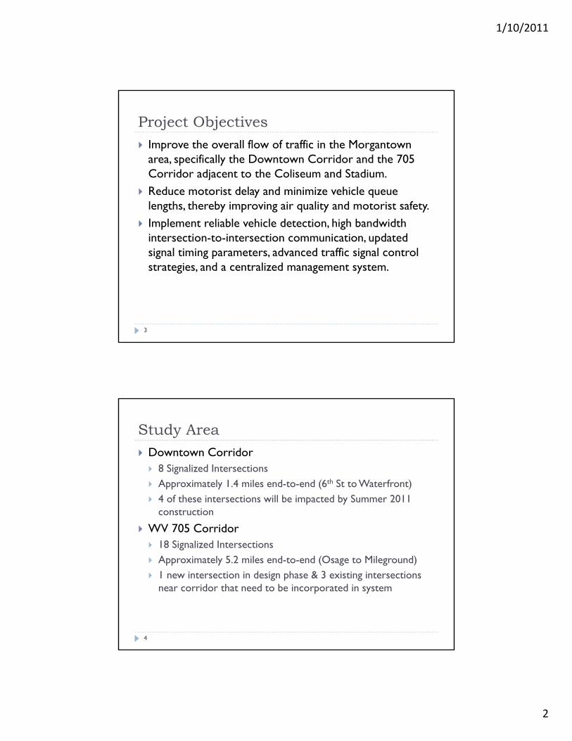
Project Objectives Improve the overall flow of traffic in the Morgantown
area, specifically the Downtown Corridor and the 705 Corridor adjacent to the Coliseum and Stadium.
Reduce motorist delay and minimize vehicle queue lengths, thereby improving air quality and motorist safety.
Implement reliable vehicle detection, high bandwidth intersection-to-intersection communication, updated signal timing parameters, advanced traffic signal control strategies, and a centralized management system.
3
Study Area Downtown Corridor 8 Signalized Intersections Approximately 1.4 miles end-to-end (6th St to Waterfront) 4 of these intersections will be impacted by Summer 2011
construction
WV 705 Corridor 18 Signalized Intersections Approximately 5.2 miles end-to-end (Osage to Mileground) 1 new intersection in design phase & 3 existing intersections
near corridor that need to be incorporated in system
4

1/10/2011
3
Downtown Corridor Intersections1. Beechurst Ave @ Sixth Street
2. Beechurst Ave @ Campus Drive
3. University Ave @ Fayette Street
4. University Ave @ Walnut Street
5. University Ave @ Pleasant Street
6. University Ave @ Foundry Street
7. Don Knotts Blvd @ Hurley Street
8. Don Knotts Blvd @ Waterfront Place
5
Downtown Corridor (← North)
6

1/10/2011
4
WV 705 Corridor IntersectionsA. Osage Road @ University Towne Center Dr. B. Osage Road @ US-19/WV-7 (Sheetz)C. Monongahela Blvd @ Boyers AvenueD. Patteson Drive @ Monongahela BlvdE. Patteson Drive @ Burger King & KrogersF. Patteson Drive @ University AvenueG. Van Voorhis Road @ Elmer Prince DriveH. Van Voorhis Road @ WVU Parking Lot & Applebee’s (to be constructed)I. Chestnut Ridge Road @ Van Voorhis RoadJ. Chestnut Ridge Road @ North Elem School DriveK. Chestnut Ridge Road @ Pineview DriveL. Chestnut Ridge Road @ Willowdale RoadM. WV 705 @ Suncrest Town Centre & WVU Research ParkN. WV 705 @ Stewartstown RoadO. WV 705 @ US 119 (Mileground)P. Stewartstown Road @ Suncrest Town Centre (off mainline)Q. Willowdale Road @ Elmer Prince Drive (off mainline)R. Beechurst Avenue @ Evansdale Drive (off mainline)
7
WV 705 Corridor (↑ North)
8

1/10/2011
5
Project Major TasksA. Downtown Corridor Signal Design & ImplementationB. Downtown Corridor Signal TimingC. Downtown Circulation StudyD. 705 Corridor Signal Design & ImplementationE. 705 Corridor Advance Signal Control Evaluation and
Timing Plan DevelopmentF. Van Voorhis & Chestnut Ridge Rd Alternatives AnalysisG. Van Voorhis & Chestnut Ridge Rd Intersection Design
9
A. Downtown Signal Design & ImplementSummary & Status
Summary: The purpose of this task was to design, procure, and implement the following intersection upgrades Sensys Wireless Vehicle Detection System Wireless Intersection-to-Intersection Communication System Update Basic Signal Timing Parameters
Status: Design and procurement are complete. Construction is scheduled for January/February 2011. Some work won’t be completed until after the downtown widening in Summer 2011.
10

1/10/2011
6
Sensys Wireless Detection Sensor battery life estimated at 10 years Installation time approximately 5 min/sensor Interfaces with existing cabinets
11
B. Downtown Corridor Signal TimingSummary & Status
Summary: The purpose of this task is to collect existing traffic volume and travel time information along the corridor and use this information to develop new signal timing plans. Signals will be coordinated and monitored via a centralized computer system.
Status: Data has been collected and timing plans are being developed for a Summer 2011 deployment.
12

1/10/2011
7
GPS Travel TimeDowntown Corridor SB – 7:00AM–2:45PM
Longest 21.73 min @ 4:55pm
13August (8/5/10) October (10/21/10)
Congestion
GPS Travel Time Downtown Corridor SB – 2:45–6:00PM
14August (8/5/10) October (10/21/10)
Congestion

1/10/2011
8
GPS Travel TimeDowntown Corridor NB – 7:00AM–2:45PM
August (8/5/10) October (10/21/10)15
GPS Travel TimeDowntown Corridor NB – 2:45–6:00PM
16August (8/5/10) October (10/21/10)

1/10/2011
9
C. Downtown Circulation StudySummary & Status
17
Summary: The purpose of this task is to collect origin-destination data through the CBD and use that information to evaluate alternative network configurations. A public meeting will be held to obtain public input.
Status: This task is planned to be completed during Spring and Summer 2011.
Planned O-D Data Collection
18

1/10/2011
10
D. 705 Corr. Signal Design and ImplementSummary & Status
19
Summary: The purpose of this task was to design, procure, and implement the following intersection upgrades Sensys Wireless Vehicle Detection System Wireless Intersection-to-Intersection Communication System Update Basic Signal Timing Parameters
Status: Design and procurement are complete. Construction is scheduled for January/February 2011.
E. 705 Corr. Advanced Signal Control Evaluation and Timing Plan Development Summary & Status
20
Summary: The purpose of this task is to collect existing traffic volume and travel time information along the corridor and use this information to design and evaluate an adaptive traffic signal control system. Signals will be coordinated and monitored via a centralized computer system. Bluetooth readers will be installed along the corridor to collect ongoing travel time data for evaluation purposes.
Status: Data has been collected and the control system is in the design phase. New signal control is anticipated to be deployed during Summer 2011.

1/10/2011
11
GPS Travel Time Data705 Corridor EB – 7:30–9:30AM
21August (8/5/10) October (10/21/10)
Left-turn Offset?
GPS Travel Time Data705 Corridor EB – 9:30AM–12:30PM
22August (8/5/10) October (10/21/10)
Left-turn Offset?
Poor Offset

1/10/2011
12
GPS Travel Time Data705 Corridor EB – 12:30–6:00PM
23August (8/5/10) October (10/21/10)
Left-turn Offset?
GPS Travel Time Data705 Corridor WB – 7:30–9:30AM
24August (8/5/10) October (10/21/10)
No offset reference
Congestion
Poor Offset

1/10/2011
13
GPS Travel Time Data705 Corridor WB – 9:30AM–12:30PM
25August (8/5/10) October (10/21/10)
Congestion
Poor Offset
GPS Travel Time Data705 Corridor WB – 12:30–6:00PM
26August (8/5/10) October (10/21/10)
Congestion
Poor Offset
No offset reference

1/10/2011
14
F. Van Voorhis & Chestnut AnalysisSummary & Status
27
Summary: The purpose of this task is to analyze alternative intersection configurations to identify a preferred alternative that will improve the safety and minimize delay. The alternatives currently being considered are a roundabout and realignment (shown on following slides).
Status: The alternatives are being evaluated and a preliminary report will be issued in March 2011.
Re-Alignment with Signalization
28

1/10/2011
15
Re-Alignment with Signal & Re-Route
29
3-lane Roundabout
30

1/10/2011
16
2-lane Roundabout w/o SB RT Lane
31
G. Van Voorhis & Chestnut DesignSummary & Status
32
Summary: The purpose of this task is to complete the design of the preferred alternative.
Status: The schedule of this task will be dictated by the progress of the feasibility task.


![Monongalia mirror (Morgantown, Va. [W. Va.]).(Morgantown, Va. … · 2017. 12. 17. · Tlie now Mediclnul Herb. Theintroduction of Canrlnlagua from Cali¬ fornia, lias been an inestimable](https://static.fdocuments.in/doc/165x107/602b95f880e74e0a3b0047b3/monongalia-mirror-morgantown-va-w-vamorgantown-va-2017-12-17-tlie.jpg)


![Monongalia mirror (Morgantown, Va. [W. Va.]).(Morgantown ... › lccn › sn86092163 › ... · BflSf*9SMES General Advertiser, a *AND. '-:4Ti,Reductionin g'rict.achadwick&co'S. "fTJ8T'r«;flv»(l](https://static.fdocuments.in/doc/165x107/5f21b36855a2340bed471ebe/monongalia-mirror-morgantown-va-w-vamorgantown-a-lccn-a-sn86092163.jpg)