Moran & Wilson-Parr (2015) IWM83
34
ISSN 1393 – 6670 Hen Harrier Special Protection Area (SPA) Habitat Mapping Project 2014 Irish Wildlife Manuals No. 83
-
Upload
ryan-wilson-parr -
Category
Documents
-
view
24 -
download
6
Transcript of Moran & Wilson-Parr (2015) IWM83
ISSN 1393 – 6670
Hen Harrier Special Protection
Area (SPA) Habitat Mapping
Project 2014
Irish Wildlife Manuals No. 83


Hen Harrier Special Protection Area (SPA)
Habitat Mapping Project 2014
Moran, P. ¹ & Wilson-Parr, R.²
¹ Forest, Environmental Research & Services Ltd, Sillogue, Kilberry, Navan, Co. Meath.
www.fersltd.ie
² Golden Eagle Trust Ltd, 22 Fitzwilliam Square, Dublin 2. www.goldeneagletrust.org
Citation:
Moran, P. & Wilson-Parr, R. (2015) Hen Harrier Special Protection Area (SPA) Habitat Mapping
Project 2014. Irish Wildlife Manuals, No. 83. National Parks and Wildlife Service, Department of
Arts, Heritage and the Gaeltacht, Ireland.
Keywords: Hen Harrier, Circus cyaneus, Special Protection Area (SPA), mapping, habitat, GIS,
Site list: 004160; 004161; 004162; 004165; 004167; 004168.
The NPWS Project Officer for this report was: David Tierney; [email protected]
Irish Wildlife Manuals Series Editors: F. Marnell & R. Jeffrey
© National Parks and Wildlife Service 2015
ISSN 1393 – 6670


Hen Harrier Habitat Mapping Project 2014
__________________________________
Contents
Executive Summary ........................................................................................................................................ 1
Acknowledgements ........................................................................................................................................ 2
Introduction ..................................................................................................................................................... 3
Methodology ................................................................................................................................................... 4
Selected Sites ................................................................................................................................................ 4
Definition of Habitat Categories ............................................................................................................... 6
Preparation of Digital Habitat Maps ...................................................................................................... 15
Mapping to boundaries (attribute “LAND_PARCE”) ..................................................................... 15
Correction of existing datasets (attribute “BOUND_COR”) ........................................................... 15
Mapping of Habitat .................................................................................................................................. 16
Sources of Data .............................................................................................................................................. 19
OSI Vector Mapping 1:5000 ..................................................................................................................... 19
Digital Globe Satellite Imagery ............................................................................................................... 19
FORESTRY12 dataset ............................................................................................................................... 19
Data regarding planting rotation within the SPAs (Coillte) ............................................................... 20
NPWS Blanket Bog NHA polygon dataset ............................................................................................ 20
Ground Truthing ....................................................................................................................................... 20
Limitations ..................................................................................................................................................... 21
Quality Control ............................................................................................................................................. 22
Outputs ........................................................................................................................................................... 23
Bibliography & Relevant Literature ........................................................................................................... 28


Hen Harrier Habitat Mapping Project 2014
__________________________________
1
Executive Summary
Under Article 4 of the Birds Directive (Directive 2009/ 147/EC) six Special Protection Areas (SPAs),
covering a total land area of c.1,671km², has been classified for the conservation of the Hen Harrier
Circus cyaneus in Ireland. A survey of breeding Hen Harrier reported that 128 to 172 breeding pairs
were recorded in 2010 which was broadly similar to the totals recorded in the previous survey in 2005.
However notable declines were recorded in some traditional strongholds of this species’ breeding
range (Ruddock et al., 2012).
In 2014 a Hen Harrier Habitat Mapping Project focusing on these SPAs and based on remote sensing
techniques was undertaken. This produced a contemporary geospatially digitised habitat map for the
six SPAs. Habitat categories that broadly correspond to the Fossitt Classification system (Smith et al.,
2011) distinguish habitats of ecological relevance to Hen Harrier and a mapping resolution
corresponding to the Ordnance Survey Ireland 1:5000 base-map allow land use within discreet
enclosed land parcels to be readily identifiable.
Digital Globe Satellite Imagery 2013 was utilised for aerial interpretation of habitats. Several existing
geospatially referenced datasets (National forest inventory datasets, National Parks & Wildlife Service
habitat datasets) provided habitat data coverage equivalent to c.55% of the SPA land area. A digital
geodatabase created within ArcGIS 10.2 integrated, categorised and quantified a total, c.169,152ha
(1,691km²) of habitat within and overlapping the SPA boundaries.
The habitat map showed that strictly within the SPA network for breeding Hen Harrier, land
managed for conifer plantation forest was the predominate habitat type, comprising c.52.3% of the
total SPA area. Open peatland habitats formed c.20.2%; low intensity managed grasslands c.12.2%;
medium to intensively managed grassland c.9%; non-habitat (built surfaces etc.) c.3.3%; scrub c.1.7%;
broadleaved woodland and other natural and semi-natural open habitats comprised the remaining
c.1%.
The mapping output covers an extensive area to a high thematic resolution (broadly Fossitt Habitat
Level 3), and as such will serve as an important tool for spatial planning in SPAs, including
environmental impact assessments (EIAs) and assessments required under Article 6 of the Habitats
Directive to protect the Natura 2000 network.
This Irish Wildlife Manual provides detailed information on the methods employed in the production
of this digital geodatabase. This will inform any future analyses of the recorded data as well as
providing a template for the production of updated habitat maps of these important Hen Harrier
areas.

Hen Harrier Habitat Mapping Project 2014
__________________________________
2
Acknowledgements
We would like to express our sincere appreciation and gratitude to all FERS Ltd staff for their
contribution to the Hen Harrier Habitat Mapping Project: Dr Kevin Black, Dr Ruth Carden, Kate Mc
Knutt, Michelle O’Neill, Dr Sarah Ryan and Dr Emma Reeves. Thanks to Gareth John, Brian Carroll,
Terence O’Rourke, Charles Stefanazzi and Mel Conway of the NPWS GIS Unit that provided technical
support and access to spatial vector and raster datasets for use in the project. Thanks also to Robert
Ovington of the Department of Environment, Community & Local Government for advice on
outlining methodology options and data sources and to Margaret Guerin and Aoife Shinners of
Ordnance Survey Ireland for assistance in accessing digital imagery. We would like to express our
gratitude to Frank Barrett of the Forest Service, Department of Agriculture, Food & the Marine; and,
Sharon Fitzpatrick and Marie Roche of Coillte for providing access to the Forest Inventory databases.

Hen Harrier Habitat Mapping Project 2014
__________________________________
3
Introduction
The EU Birds Directive (Council Directive 2009/147/EC on the Conservation of Wild Birds) provides
for the classification of Special Protection Areas (SPAs) across all member states to protect birds at
their breeding, moulting and wintering areas as well as staging posts along their migration routes. The
Directive instructs Member States to classify the most suitable sites as SPAs for regularly occurring
migratory species and for those species listed on Annex I to the Directive.
The Hen Harrier Circus cyaneus is listed on Annex 1 and is also Amber listed on the Birds of
Conservation Concern in Ireland (Colhoun & Simmons, 2013). Six SPAs covering a total land area of
c.167,117ha (1,671km²) have been classified for the conservation of this breeding species. A survey of
breeding Hen Harrier reported that 128 to 172 breeding pairs were recorded in 2010 which was
broadly similar to the totals recorded in the previous survey in 2005. However notable declines were
recorded in some traditional strongholds of this species’ breeding range (Ruddock et al., 2012).
Detailed knowledge of the extent and nature of the various habitats contained within these large SPAs
can provide valuable insights into the conservation condition of the breeding Hen Harrier
populations. Importantly the conservation management of these areas can be significantly improved
when it is based on such high resolution data.
Traditional methods of habitat mapping, involving field surveys of the entire area of the SPAs would
be prohibitively expensive and time-consuming. As such, remote sensing techniques are more suited
to the task of habitat-mapping such an extensive area (approximately 1700 km2).
To this end, the National Parks and Wildlife Service (NPWS) though a public procurement process
awarded a contract entitled “Provision of habitat data for six Hen Harrier Special Protection Areas
using remote techniques” to Forest Environmental Research and Services Ltd.
The output of this project consists of polygon and linear shape-file habitat features for each of the six
SPAs. The purpose of this brief report is to provide the information to allow a 3rd party to optimally
interrogate the habitat data and to provide the methodology utilised in order to allow for a repeat of
the mapping work to be done as a part of future monitoring such that any future maps produced will
be directly comparable.

Hen Harrier Habitat Mapping Project 2014
__________________________________
4
Methodology
Selected Sites
Ireland has designated six sites as SPAs for breeding Hen Harrier (see Table 1 and Figure 1).
Table 1: Special Protection Areas designated for breeding Hen Harrier
Site Code Site Name Land Area (hectares)*
IE0004160 Slieve Bloom Mountains SPA 21,771
IE0004161 Stacks to Mullaghareirk
Mountains, West Limerick Hills
and Mount Eagle SPA
56,610
IE0004162 Mullaghanish to Musheramore
Mountains SPA
4,961
IE0004165 Slievefelim to Silvermines
Mountains SPA
20,917
IE0004167 Slieve Beagh SPA 3,449
IE0004168 Slieve Aughty Mountains SPA 59,407
* Areas from NPWS SPA Shapefile ITM Positional Accuracy Improved (PAI) Version 3.

Hen Harrier Habitat Mapping Project 2014
__________________________________
5
Figure 1: Locations of selected SPAs for Habitat Mapping Project.
Hen Harrier Habitat Mapping Project 2014
__________________________________
6
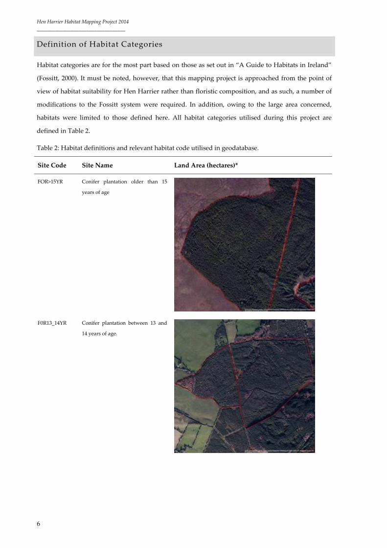
Definition of Habitat Categories
Habitat categories are for the most part based on those as set out in “A Guide to Habitats in Ireland”
(Fossitt, 2000). It must be noted, however, that this mapping project is approached from the point of
view of habitat suitability for Hen Harrier rather than floristic composition, and as such, a number of
modifications to the Fossitt system were required. In addition, owing to the large area concerned,
habitats were limited to those defined here. All habitat categories utilised during this project are
defined in Table 2.
Table 2: Habitat definitions and relevant habitat code utilised in geodatabase.
Site Code Site Name Land Area (hectares)*
FOR>15YR Conifer plantation older than 15
years of age
F0R13_14YR Conifer plantation between 13 and
14 years of age.

Hen Harrier Habitat Mapping Project 2014
__________________________________
7
FOR9_12YR Conifer plantation between 9 and 12
years of age.
FOR4_8YR Conifer plantation between 4 and 8
years of age.
FOR<3YR Conifer plantation of up to and
including 3 years of age.
FOR_UNK Conifer plantation of unknown
planting date.
Image not applicable

Hen Harrier Habitat Mapping Project 2014
__________________________________
8
CL Clear-fell conifer plantation.
UNPRO Unproductive sparse conifer
plantation. Stands of conifer
plantation at a high elevation on
blanket peat typically above 400m
above sea level (asl) or at the
upward unenclosed margins of
forest parcels.
GA1 Improved agricultural grassland.
Fields of high intensity managed
grassland with <30% Juncus cover
typified by a homogenous colour
and obvious indications of
management.

Hen Harrier Habitat Mapping Project 2014
__________________________________
9
MG_C3 Mosaic grassland. Fields of
moderate to low intensity managed
grassland with clustered Juncus
cover ranging from 30 – 39%.
Additional habitat categories may be
present and relevant attribute fields
must be allocated values.
MG_C4 Mosaic grassland. Fields of
moderate to low intensity managed
grassland with clustered Juncus
cover ranging from 40 – 49%.
Additional habitat categories may be
present and relevant attribute fields
must be allocated values.
MG_D3 Mosaic grassland. Fields of
moderate to low intensity managed
grassland with dispersed Juncus
cover ranging from 30 – 39%.
Additional habitat categories may be
present and relevant attribute fields
must be allocated values.

Hen Harrier Habitat Mapping Project 2014
__________________________________
10
MG_D4 Mosaic grassland. Fields of
moderate to low intensity managed
grassland with dispersed Juncus
cover ranging from 40 – 49%.
Additional habitat categories may be
present and relevant attribute fields
must be allocated values.
RG Rough grassland. Fields of low
intensity or evidently unmanaged
grassland with Juncus cover >50%.
Additional habitat categories may be
present and relevant attribute fields
must be allocated values. This
category was originally set at >70%,
however there were concerns over
mismatches between subjectivity
and interpretation of
orthophotography and field
validation. Fields with >50% Juncus
had only slight grazing/management
and structurally were representative
of vegetation of >1m in height and
with several years growth. It is
considered that this >50% also
retains the relevance of this habitat
category to the Hen Harrier. This
revised category is more efficient for
ortho-processing and offers greater
consistency with field validation.

Hen Harrier Habitat Mapping Project 2014
__________________________________
11
GS1 Dry calcareous grassland and
neutral grassland. Unimproved or
semi-improved dry grassland that
may be either calcareous or neutral,
but not acid. Associated with low
intensity agriculture and typically
occurs on free-draining mineral
soils.
GS3 Dry-humid acid grassland.
Unimproved or low to medium
intensity managed grassland that
occurs on free-draining soils that
may be dry, humid, but not
waterlogged. This type of grassland
mainly occurs on mineral rich or
peaty podzols in upland areas.
Floristically, this habitat category
can occur in medium to intensively
managed agricultural fields,
however emphasis should always be
on structural condition relevant to
the Hen Harrier and any indication
of medium to intensive management
in acid grassland should be
categorised as GA1.
GM1 Marsh. Marsh is found on level
ground near riverbanks, lakeshores
and in other places where mineral or
shallow peaty soils are waterlogged,
and where the water table is close to
ground level for most of the year.

Hen Harrier Habitat Mapping Project 2014
__________________________________
12
HH Heath. Combined categorisation for
dry siliceous heath and wet heath.
Heath includes areas where the
vegetation is open and there is at
least 25% cover of dwarf ericaceous
shrubs, or where mosses dominate
in the case of some montane areas.
Additional habitat categories may be
present and relevant attribute fields
must be allocated values.
HD1 Bracken. Areas of open vegetation
that are dominated by Bracken
(Pteridium aquilinum). Cover of the
fern may be patchy or continuous,
but should exceed 50% cover
overall.
PB2 Upland Blanket Bog. Upland blanket
bog occurs on flat or gently sloping
ground above 150m asl and is
widespread on hills and mountains
through the Republic of Ireland. The
150m asl limit serves to distinguish
upland from lowland blanket peat
but is loosely applied.

Hen Harrier Habitat Mapping Project 2014
__________________________________
13
PB3 Lowland Blanket Bog. Lowland
Blanket Bog is largely confined to
wetter regions along the western
seaboard where the annual rainfall
exceeds 1250mm, occurring on flat
or gently sloping ground below
150m.
PB4 Cutover Bog. This category should
be used in situations where part of
the original mass of peat has been
removed through turf cutting or
other forms of peat extraction.
WD1 Mixed Broadleaved Woodland. This
general category includes woodland
areas with 75 – 100% cover of trees,
and 0 – 25% cover of conifers. Trees
may include native and non-native
species.

Hen Harrier Habitat Mapping Project 2014
__________________________________
14
WS1 Scrub. This broad category includes
areas that are dominated by at least
50% cover of shrubs, stunted trees or
bramble. The canopy height is
generally less than 5m, or 4m in the
case of wetland areas. Scrub can be
either open, or dense and
impenetrable.
WN5 Riparian Woodland. Riparian Woodland
is dominated by stands of Willows that
may include native (Salix cinerea, S.
pupurea, S. triandra) and non-native (S.
fragilis, S. alba, S. viminalis) species.
Alder (Alnus glutinosa) is occasional.
Fossitt defines this habitat as wet
woodland of river margins (gallery
scrub) and low islands that are subject
to frequent flooding or where water
levels fluctuate as a result of tidal
movement (in lower reaches of river
systems) however for the purposes of
this mapping project, Salix is an
important habitat for prey species of
the Hen Harrier in cases where it
colonises wet hollows and disturbed
peat and acid grasslands, along upland
stream catchments and where it
encroaches onto open habitats at the
edges of unmanaged track ways, fire
breaks and between parcels of conifer
plantation.
WL1_A Hedgerow with an intact and dense
structure. Hedgerows over 20m in
length and between 3 to 4m width.
WL1_B Hedgerow with a boxed or
moderate structure. Hedgerows over
20m in length and between 1 to 3m
width.
WL1_C Hedgerow with sparse, in some
cases a fragmented structure.

Hen Harrier Habitat Mapping Project 2014
__________________________________
15
Hedgerow over 20m length less than
1m in width.
WL1_D Hedgerow unmanaged and
overgrown over 20m length and
over 5m width.
WL2 Treeline. A treeline is a narrow row
of trees that is greater than 5m in
height and typically occurs along
field or property boundaries. Most
treelines are planted and are often
regularly spaced.
Preparation of Digital Habitat Maps
Mapping to boundaries (attribute “LAND_PARCE”)
The OSI 1:5000 boundary line was chosen as the base-layer upon which all habitat mapping was
based. The SPA boundary data to be used for all habitat mapping was version 3 (Positioning Accuracy
Improved (PAI) SPA boundaries in ITM). Previous versions of the SPA boundary were mapped on six
inch maps and there are a number of discrepancies in SPA boundaries fitting neatly onto field
boundaries in OSI 1:5000. If there were fields traversing the SPA boundary whole field, as it exists in
the OSI 1:5000 base layer, was mapped. For this reason, a 500m buffer round the SPA boundary was
established prior to mapping to ensure that any overlap was afforded full coverage in the habitat map.
All habitats mapped by discrete polygons/lines were assigned an attribute “LAND_PARCE” within
the relevant shape-file. “Select by location”, was utilised to select if the discrete polygon/line feature
was within the SPA boundary. Features contained within the SPA boundary have a value of “IN” for
this attribute. Features traversing the SPA boundary, or outside of the boundary but considered of
importance with regards to providing an ecological corridor (such as a hedgerow bounding a field
that has been excluded from the SPA) have a value of “OUT” for this attribute.
Correction of existing datasets (attribute “BOUND_COR”)
All habitats mapped by discrete polygons were assigned an attribute “BOUND_COR” within the
relevant shape-file. This attribute notes whether an existing shape-file (FORESTRY12 or NPWS shape-
file) has been extended or corrected to fit the Digital Globe Imagery 2013 or OSI 1:5000 boundary lines.

Hen Harrier Habitat Mapping Project 2014
__________________________________
16
There were three potential categories:
1) Shape-file polygon belonging to an external dataset used in the mapping process has
undergone correction to fit to the OSI 1:5000 anchor layer (having a value of 1 in the
“BOUND_COR” attribute).
2) Shape-file polygon belonging to an external dataset used in the mapping process has
undergone correction to fit to the actual habitats as represented on the Digital Globe
Orthophotography (having a value of 2 in the “BOUND_COR” attribute).
3) Shape-file polygon belonging to an external dataset used in the mapping process has
undergone correction to fit to both the OSI 1:5000 anchor layer and the actual habitats as
represented on the Digital Globe Orthophotography (having a value of 3 in the
“BOUND_COR” attribute).
Where the mapping of a discrete habitat polygon was not based on a pre-existing resource, the value
assigned to the “BOUND_COR” attribute is 0.
Mapping of Habitat
Habitat (with an attribute “HABITAT_CO” indicating the habitat code of the mapped habitat) was
mapped according to the habitat definitions as set out in Table 2. Habitat occurring in enclosed land
parcels (fields) was mapped on a polygon basis (utilising the autocomplete polygon create feature and
trace). There were several habitats in which additional habitat classes were recorded – (MG_C3,
MG_C4, MG_D3, MG_D4, RG, HH and WS1). It was required that additional habitat classes be
categorised and a subjective assessment of its cover with the land parcel noted (see below).
Outside of fields, habitat mapping was carried out on the basis of discrete polygons of habitat >25m²
where possible. Again, there were several habitats in which additional habitat classes were recorded –
(MG_C3, MG_C4, MG_D3, MG_D4, RG, HH and WS1). It was required that additional habitat classes
be categorised and a subjective assessment of its cover with the land parcel noted
Hedgerows and treelines were mapped (utilising the create feature and trace) as linear features and fit
OSI 1:5000 as relevant.
The attributes associated with additional habitats are described below:
“ADD_HAB” – denotes an additional habitat category occurring within a discrete polygon.
“ADD_HAB2” – denotes a second additional habitat category occurring within a discrete
polygon.

Hen Harrier Habitat Mapping Project 2014
__________________________________
17
Associated with the attributes “ADD_HAB” and “ADD_HAB2” were fields quantifying the
proportion of additional habitat occurring (“ADD_HAB_CO” and “ADD_HAB2_C” respectively).
For “ADD_HAB_CO”, the following values were assigned:
0 0 – 9% Additional habitat cover in total within polygon.
1 10 – 19% Additional habitat cover in total within polygon.
2 20 – 29% Additional habitat cover in total within polygon.
3 30 – 39% Additional habitat cover in total within polygon.
4 40 – 49% Additional habitat cover in total within polygon.
For “ADD_HAB2_C”, the following values were assigned:
0 0 – 9% Additional habitat cover in total within polygon.
1 10 – 19% Additional habitat cover in total within polygon.
2 20 – 29% Additional habitat cover in total within polygon.
Associated with each mapped polygon/line feature are a number of other attributes:
AREA_HA (polygon habitats only)
This attribute denotes the area of the polygon feature in hectares. This value is determined by utilising
the “Calculate Geometry” function.
SHAPE_LENG (linear habitats only)
This attribute denotes the length of the linear feature in metres. This value is determined by utilising
the “Calculate Geometry” function.
SITE_NAME
This attribute denotes the name of the SPA within which the polygon/linear feature occurs.
SITE_NUMBE
This attribute denotes the site number of the SPA within which the polygon/linear feature occurs.

Hen Harrier Habitat Mapping Project 2014
__________________________________
18
SURVEY_TYP
This attribute denotes the data-type on which discrete polygon/linear features were mapped, and is
based on the guidelines outlined in “Best Practice Guidance for Habitat Survey and Mapping” (Smith
et al 2011). The value assigned to this attribute for each polygon/line feature is according to the
following convention:
S Habitat classification verified by ground truthing.
DC Habitat classification is derived from desktop interpretation of Digital Globe Satellite imagery
supplemented by additional data sources of good quality (FORESTRY12, existing NPWS datasets).
DD Habitat classification is derived from desktop interpretation of Digital Globe Satellite imagery
only.
PRIMARY_SE
The rotation of pre-thicket forestry (for the purposes of this project forestry belonging to the following
categories FOR9_12YR, FOR4-8YR, FOR<3YR and FOR_UNK), i.e. primary or secondary rotation, was
considered of utmost importance owing to the importance of this habitat for Hen Harrier. It was
initially hoped to categorise this based on OSI orthophotography from 2000. If forestry was not
present within the forest parcel identified from the Digital Globe Satellite imagery in the 2000 ortho,
the forestry parcel would be considered primary rotation. This method, however, proved to be
unsuccessful. Following consultation with Coillte, a database outlining the rotation status of a
proportion of the forestry within the appropriate age class at each site was provided, and in
combination with the FORESTRY12 data provided information on a proportion of the forestry at each
site. One of the primary functions of ground truthing parcels of forestry of unknown planting date
was to determine if the forestry was primary or secondary rotation. The default value of this attribute
is 0, indicating unknown rotation. A value of 1 denotes primary rotation and a value of 2 denotes
secondary rotation.

Hen Harrier Habitat Mapping Project 2014
__________________________________
19
Sources of Data
It should be noted that although numerous sources of data were made available for the purposes of
the project, the degree to which data could be used was limited, and the primary sources of data
utilised were:
1) OSI vector mapping 1:5000 (boundary line).
2) Digital Globe Satellite Imagery (most up to date version available 2013 imagery)
3) FORESTRY12 dataset as updated by Frank Barrett of the Forest Service until 27/01/14.
4) Data regarding planting rotation within the SPAs as provided by Sharon Fitzpatrick of Coillte.
5) NPWS Blanket Bog NHA polygon data set.
OSI Vector Mapping 1:5000
OSI vector mapping (1:5000) was provided, and from this data, the “boundary line” OSI data was
utilised as the anchor for habitat mapping. Where possible (for the most part individual fields),
discrete polygons were mapped to the OSI 1:5000 boundary line.
Digital Globe Satellite Imagery
While the Digital Globe Satellite Imagery (from orthophotography collected and sourced
predominantly from the summer of 2013) is available online, NPWS also provided a hard copy of the
relevant tiles. In order to speed up the habitat classification process, the off-line hard-copy of the
imagery was utilised. The relevant tiles for each site were merged using the “mosaic to new raster”
function within ArcGIS. Non-forestry habitat classification was based almost entirely on this dataset.
FORESTRY12 dataset
NPWS was provided with the FORESTRY12 dataset updated by Frank Barrett (until 27/01/14).
Utilising this dataset, the attribute “pyear” was utilised to categorise forestry according to the age
classes required by habitat definitions. Where the attribute “pyear” was blank, the forestry was
assigned to the category FOR_UNK (plantation of unknown planting date). It should be noted that
this dataset was not anchored on the OSI 1:5000 base map and although the dataset provided
information as to the age of forestry parcels, all forestry parcels required digitisation.

Hen Harrier Habitat Mapping Project 2014
__________________________________
20
Data regarding planting rotation within the SPAs (Coillte)
The FORESTRY12 dataset provides no information as to rotation. Having consulted with Frank Barrett
of the Forestry Service, Coillte were consulted and Sharon Fitzpatrick, Resource GIS Analyst with
Coillte, provided a dataset with limited information regarding rotation. This allowed the assigning of
primary or secondary rotation to a proportion of the forestry parcels of the appropriate age cohort.
NPWS Blanket Bog NHA polygon dataset
While NPWS provided numerous datasets, such as those generated by the semi-natural grasslands
survey, the upland survey, the semi-native woodland survey, etc., the only dataset that yielded
meaningful data on the scale required was the NPWS Blanket Bog NHA polygon data set. This data
set was consulted, in conjunction with Digital Globe Satellite imagery when assigning habitats to
habitat categories PB2, PB3 and PB4.
Ground Truthing
Limited ground truthing was carried out at each of the six SPA sites. Although the initial tender
proposed a maximum of 15 days to be spent on ground truthing, in reality, 41 person-days were spent
ground truthing, with 29 person-days spent in the field, and a further 12 days in the choosing of sites,
preparation of site packs, etc. Parcels of forestry of unknown planting date were chosen as the primary
habitat type to visit, with adjacent habitats also being ground truthed.
Forestry parcels of the type FOR_UNK were exported as a shape-file. Each parcel was assigned a
unique ID number and then sites were chosen at random to allow for a representative sample of sites
from within the SPA boundary to be visited. It must be noted, however, that for the most part, forestry
of unknown planting date is located on private lands. In order to avoid conflict with potentially
hostile landowners therefore, sites at which access/viewing from public roads was possible were given
priority. Having chosen field sites, each site was designated a unique FID, and a site pack
(approximately 15 sites per day), consisting of paper copies of the OSI base-map and the Digital Globe
Imagery of each ground truth site were prepared. Using a 64GB IPAD with both wireless and cellular
connectivity, all sites were located using Google Maps and bookmarked with the unique FID. When in
the field Google Maps on the IPAD was utilised to navigate between sites, and to verify that the
correct location was visited during ground truthing.
Having identified the forest parcel and adjudged whether the parcel was primary or secondary
rotation, a selection of surrounding habitat parcels (and in particular mosaic grassland and rough

Hen Harrier Habitat Mapping Project 2014
__________________________________
21
grassland habitats) were ground truthed by marking the habitat type present on the print-out of the
Digital Globe Imagery for each site. Having completed ground truthing at each site, the marked aerial
images were utilised to update the habitat map in ArcGIS. Ecologists involved in site pack preparation
and ground truthing were: Dr Patrick Moran; Dr Ruth Carden; Kate Mc Knutt; Michelle O’Neill; Dr
Sarah Ryan and Dr Emma Reeves.
Limitations
The single largest limitation the project encountered concerned the lack of existing datasets mapped to
the OSI 1:5000 basemap. None of the datasets provided (including the SPA boundary) were mapped
to the OSI 1:5000 basemap. This, critically, more than doubled the amount of work required to fulfil
the requirements of the tender. The primary data-source utilised for identifying non-forestry habitats
was the Digital Globe Satellite Imagery. The categorisation of habitats based on the interpretation of
aerial images has an inherent limitation in that it is dependent on the ecologist interpreting the image.
The categorisation of many of the habitat types is subjective, and different ecologists may assign
different habitat categories.
The existing NPWS datasets, such as the Semi-Natural Grasslands and Semi-native Woodland
datasets were based on the Fossitt categorisation of habitats. The mapping carried out for this project
was, for the most part, only loosely based on the Fossitt categorisation of habitats, and focussed on
structural and management aspects, rather than species composition. As a result, the data present in
these data-sets (which was very limited given the huge scale of the mapping project) was of no
significant use. The exception was the NPWS blanket bog NHA polygon dataset, which was of
sufficient scale to be utilised for the purposes of this project.
As part of the tendering process the ground truthing part of the work was predicted to constitute
approximately 15 days of the overall work. This was a significant underestimation of the actual days
required to successfully undertake a robust ground truthing approach. A minimum of 60 days, and
preferably 90 days should be allowed for ground truthing in any future monitoring survey of this
scale.
An inherent bias exists in the sites chosen for ground truthing. This bias is present owing to the fact
that much of the land surveyed was in private ownership, and access/viewing from a public road was
considered a priority in site choice. This bias is unavoidable owing to the potentially hostile nature of
land-owners as regards surveys of this kind.
Ground truthing indicated that the designation of grassland as Rough Grassland or Mosaic Grassland
is best carried out using interpretation of aerial images rather than site visits, unless a lengthy walk-

Hen Harrier Habitat Mapping Project 2014
__________________________________
22
through survey of the field is undertaken. An ecologist’s view on the ground (and especially from the
side of the road if the land in question is private) is very limited relative to aerial imagery.
Ground truthing indicated the rapidity with which Rough Grassland and Mosaic Grassland can be
rendered into Improved Agricultural Grassland through very basic management. Ground truthing
indicated that the habitat GS3 is regularly underestimated as it is often a large component of areas of
heath and some areas of rough grassland.
Quality Control
Several processes were involved in the quality control of each dataset:
Several ecologists were involved in the mapping of each site. This exercise was carried out in
order to negate some of the inter-ecologist differences in aerial interpretation of habitats.
Following the initial completion of each site, habitat mapping was independently reviewed by
Ryan Wilson-Parr. This was an iterative process, with the feedback regarding habitat
categorisation in sites feeding into the mapping of subsequent sites. The most common
comment concerned the difference between a botanists interpretation of semi-natural
grassland types (based on floristic composition) and the importance of different types of
grassland from a Hen Harrier point of view (largely structural and therefore management as
opposed to floristic composition)
Having taken into account the independent reviews, and the ground truthing, polygon and
linear habitat shape-files were prepared for each site, and GIS quality controls carried out on
these shape-files.
GIS quality controls consisted of -
Multi-part polygon check –
This check was to ensure that no multi-part polygons were present within the dataset. The dataset
table was converted to an excel spreadsheet, and a check for any duplicate FID values was carried out
within excel using conditional formatting.
Geometry Check –
Having carried out the multi-part polygon check, the check geometry tool (which generates a report of
any geometry problems within a feature class dataset) within ArcGIS was utilised to ensure that
polygon and linear data sets were free of geometry errors.

Hen Harrier Habitat Mapping Project 2014
__________________________________
23
Intersection
Utilising the intersect feature of the Geoprocessing tools within ArcGIS, any overlaps, etc. were
identified. Through a combination of manual checking and automated checking using ETGeowizards
(clean polygon, clean polyline, etc.), any overlaps, slivers, etc. were repaired to ensure the dataset was
free from topological errors.
Outputs
The output of this project is the provision of habitat geodatabase (based primarily on remote
techniques) for six Hen Harrier Special Protection Areas. The output consists of 12 shape-files (a
polygon habitat shape-file and a linear habitat shape-file for each of the six Hen Harrier Special
Protection Areas) and this report, which describes the methodology utilised to generate the shape-
files. In total, c.169,152ha (1,691km²) of habitat was digitised, with approximately 53% of the area
mapped based on data provided by FORESTRY12, and the remainder based largely on the
interpretation by ecologists of Digital Globe Satellite Imagery of the six sites. A summary of habitat
categories and areas within each of the six Hen Harrier SPAs is provided in Table 2 below.

Hen Harrier Habitat Mapping Project 2014
__________________________________
24
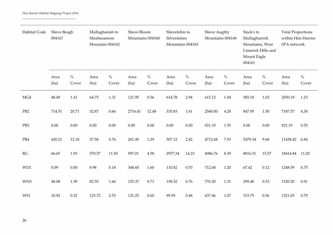
Table 2: Summary of habitat cover in six SPAs from 2013 Digital Globe Satellite Imagery.
Habitat Code Slieve Beagh
004167
Mullaghanish to
Musheramore
Mountain 004162
Slieve Bloom
Mountains 004160
Slievefelim to
Silvermines
Mountains 004165
Slieve Aughty
Mountains 004168
Stack's to
Mullaghareirk
Mountains, West
Limerick Hills and
Mount Eagle
004161
Total Proportions
within Hen Harrier
SPA network.
Area
(ha)
%
Cover
Area
(ha)
%
Cover
Area
(ha)
%
Cover
Area
(ha)
%
Cover
Area
(ha)
%
Cover
Area
(ha)
%
Cover
Area
(ha)
%
Cover
FOR_UNK 91.08 2.64 73.74 1.49 1855.06 8.52 647.61 3.10 2384.42 4.01 3088.90 5.46 8140.81 4.87
FOR_UNPRO 88.32 2.56 155.48 3.13 568.99 2.61 588.97 2.82 519.48 0.87 688.14 1.22 2609.38 1.56
FOR<3YR 35.59 1.03 86.98 1.75 631.40 2.90 119.27 0.57 824.52 1.39 613.09 1.08 2310.85 1.38
FOR>15YR 718.15 20.82 930.39 18.75 8226.01 37.78 7189.68 34.37 20706.54 34.86 18262.42 32.26 56033.19 33.53
FOR13_14 145.84 4.23 139.63 2.81 572.74 2.63 485.71 2.32 2097.41 3.53 2043.56 3.61 5484.89 3.28
FOR4_8 155.75 4.51 164.20 3.31 985.75 4.53 728.90 3.48 2070.00 3.48 1459.26 2.58 5563.86 3.33
FOR_CL 6.42 0.19 0.00 0.00 54.99 0.25 14.00 0.07 53.55 0.09 111.28 0.20 240.24 0.14

Hen Harrier Habitat Mapping Project 2014
__________________________________
25
Habitat Code Slieve Beagh
004167
Mullaghanish to
Musheramore
Mountain 004162
Slieve Bloom
Mountains 004160
Slievefelim to
Silvermines
Mountains 004165
Slieve Aughty
Mountains 004168
Stack's to
Mullaghareirk
Mountains, West
Limerick Hills and
Mount Eagle
004161
Total Proportions
within Hen Harrier
SPA network.
Area
(ha)
%
Cover
Area
(ha)
%
Cover
Area
(ha)
%
Cover
Area
(ha)
%
Cover
Area
(ha)
%
Cover
Area
(ha)
%
Cover
Area
(ha)
%
Cover
FOR9_12 308.10 8.93 94.02 1.90 419.52 1.93 1316.92 6.30 2375.48 4.00 2539.31 4.49 7053.35 4.22
GA1 155.56 4.51 602.81 12.15 424.09 1.95 1083.15 5.18 3501.76 5.89 3414.28 6.03 9181.65 5.49
GS1 0.00 0.00 0.00 0.00 12.71 0.06 14.58 0.07 239.29 0.40 636.45 1.12 903.03 0.54
GS3 12.38 0.36 712.39 14.36 291.84 1.34 337.86 1.62 313.95 0.53 379.75 0.67 2048.17 1.23
GM1 0.00 0.00 0.00 0.00 40.94 0.19 35.64 0.17 254.99 0.43 73.04 0.13 404.61 0.24
HD1 0.00 0.00 4.13 0.08 33.79 0.16 16.89 0.08 70.62 0.12 50.56 0.09 175.99 0.11
HH 235.80 6.84 872.32 17.58 2092.10 9.61 2177.24 10.41 5174.76 8.71 3746.64 6.62 14298.86 8.56
MG3 111.99 3.25 46.17 0.93 274.01 1.26 789.03 3.77 776.50 1.31 992.52 1.75 2990.22 1.79
Hen Harrier Habitat Mapping Project 2014
__________________________________
26
Habitat Code Slieve Beagh
004167
Mullaghanish to
Musheramore
Mountain 004162
Slieve Bloom
Mountains 004160
Slievefelim to
Silvermines
Mountains 004165
Slieve Aughty
Mountains 004168
Stack's to
Mullaghareirk
Mountains, West
Limerick Hills and
Mount Eagle
004161
Total Proportions
within Hen Harrier
SPA network.
Area
(ha)
%
Cover
Area
(ha)
%
Cover
Area
(ha)
%
Cover
Area
(ha)
%
Cover
Area
(ha)
%
Cover
Area
(ha)
%
Cover
Area
(ha)
%
Cover
MG4 48.49 1.41 64.75 1.31 121.95 0.56 614.78 2.94 615.12 1.04 585.10 1.03 2050.19 1.23
PB2 714.51 20.71 32.87 0.66 2716.41 12.48 335.83 1.61 2540.00 4.28 847.95 1.50 7187.57 4.30
PB3 0.00 0.00 0.00 0.00 0.00 0.00 0.00 0.00 921.19 1.55 0.00 0.00 921.19 0.55
PB4 420.21 12.18 37.58 0.76 281.49 1.29 507.12 2.42 4712.68 7.93 5479.34 9.68 11438.42 6.84
RG 66.65 1.93 570.57 11.50 997.01 4.58 2977.34 14.23 4986.76 8.39 8816.51 15.57 18414.84 11.02
WD1 0.09 0.00 8.98 0.18 348.60 1.60 110.82 0.53 712.68 1.20 67.42 0.12 1248.59 0.75
WN5 48.08 1.39 82.55 1.66 155.37 0.71 158.52 0.76 776.20 1.31 299.48 0.53 1520.20 0.91
WS1 10.92 0.32 125.72 2.53 131.25 0.60 99.95 0.48 637.46 1.07 315.75 0.56 1321.05 0.79

Hen Harrier Habitat Mapping Project 2014
__________________________________
27
Habitat Code Slieve Beagh
004167
Mullaghanish to
Musheramore
Mountain 004162
Slieve Bloom
Mountains 004160
Slievefelim to
Silvermines
Mountains 004165
Slieve Aughty
Mountains 004168
Stack's to
Mullaghareirk
Mountains, West
Limerick Hills and
Mount Eagle
004161
Total Proportions
within Hen Harrier
SPA network.
Area
(ha)
%
Cover
Area
(ha)
%
Cover
Area
(ha)
%
Cover
Area
(ha)
%
Cover
Area
(ha)
%
Cover
Area
(ha)
%
Cover
Area
(ha)
%
Cover
BL3 / GA2 75.93 2.20 155.86 3.14 535.36 2.46 567.66 2.71 2141.82 3.61 2099.78 3.71 5576.41 3.34
Total SPA
Boundary
3449.86 4961.14 21771.38 20917.47 59407.18 56610.53 167117.56

Hen Harrier Habitat Mapping Project 2014
__________________________________
28
Bibliography & Relevant Literature
Fossitt, J. (2000) A Guideline to Habitats in Ireland. The Heritage Council, Kilkenny, Ireland.
Ruddock, M. & Dunlop, B.J., O’Toole, L., Mee, A., Nagle, T. (2012) Republic of Ireland National Hen
Harrier Survey 2010. Irish Wildlife Manual, No. 59. National Parks and Wildlife Service, Department of Arts,
Heritage and the Gaeltacht, Dublin, Ireland.
Smith, G. F., O’Donoghue, P., O’Hora, K., Delaney, E. (2011) Best Practice Guidance for Habitat Survey and
Mapping. The Heritage Council, Kilkenny.