
Monterey Bay National Sanctuary Permit # MBNMS … Survey Location (including a full-sized...
30
EXHIBIT G California State Lands Commission Presurvey Notice Requirements for Permittees to Conduct Geophysical Survey Activities All parts of the Presurvey Notice must be adequately filled out and submitted to the CSLC staff a minimum of twenty-one (21) calendar days prior to the proposed survey date to ensure adequate review and approval time for CSLC staff. Note that one or more of the items may require the Permittee to plan well in advance in order to obtain the necessary documentation prior to the Notice due date (e.g., permits from other State or Federal entities). Please use the boxes below to verify that all the required documents are included in the Presurvey Notice. If "No" is checked for any item, please provide an explanation in the space provided. If additional space is needed, please attach separate pages. Please use the boxes below to verify that all the required documents are included in the Presurvey Notice. If "No" is checked for any item, please provide an explanation in the space provided. If additional space is needed, please attach separate pages. Yes No X □ Geophysical Survey Permit Exhibit F X □ Survey Location (including a full-sized navigation chart and GPS coordinates for each proposed track line and turning point) Explanation: _______________________________________________________ X □ Permit(s) or Authorization from other Federal or State agencies (if applicable) Explanation: Monterey Bay National Sanctuary Permit # MBNMS-2014-029A, California State Parks permit X □ 21-Day Written Notice of Survey Operations to Statewide Geophysical Coordinator/ X □ U.S. Coast Guard Local Notice to Mariners X □ Harbormaster and Dive Shop Notifications Explanation: _______________________________________________________ X □ Marine Wildlife Contingency Plan Explanation: _______________________________________________________ X □ Oil Spill Contingency Plan Explanation: _______________________________________________________ □ X Verification of California Air Resources Board's Tier 2-Certified Engine Requirement Explanation: Vehicle engines are gasoline fueled and exempt from Tier 2 Certification X □ Verification of Equipment Service and/or Maintenance (must verify sound output) Explanation: _______________________________________________________ □ X Permit(s) or Authorization from California Department of Fish and Wildlife for surveys in or affecting Marine Protected Area(s) (if applicable). Explanation: N/A .________________________________________________________________________________ NOTE: CSLC staff will also require verification that current biological information was obtained and transmitted as outlined in Section 5 of this permit
Transcript of Monterey Bay National Sanctuary Permit # MBNMS … Survey Location (including a full-sized...

EXHIBIT G
California State Lands Commission Presurvey Notice Requirements for Permittees to Conduct Geophysical Survey Activities
All parts of the Presurvey Notice must be adequately filled out and submitted to the CSLC staff a minimum of twenty-one (21) calendar days prior to the proposed survey date to ensure adequate review and approval time for CSLC staff. Note that one or more of the items may require the Permittee to plan well in advance in order to obtain the necessary documentation prior to the Notice due date (e.g., permits from other State or Federal entities). Please use the boxes below to verify that all the required documents are included in the Presurvey Notice. If "No" is checked for any item, please provide an explanation in the space provided. If additional space is needed, please attach separate pages.
Please use the boxes below to verify that all the required documents are included in the Presurvey Notice. If "No" is checked for any item, please provide an explanation in the space provided. If additional space is needed, please attach separate pages.
Yes No
X □ Geophysical Survey Permit Exhibit F
X □ Survey Location (including a full-sized navigation chart and GPS coordinates for each proposed track line and turning point)
Explanation: _______________________________________________________ X □ Permit(s) or Authorization from other Federal or State agencies (if applicable)
Explanation: Monterey Bay National Sanctuary Permit # MBNMS-2014-029A, California State Parks permit
X □ 21-Day Written Notice of Survey Operations to Statewide Geophysical Coordinator/
X □ U.S. Coast Guard Local Notice to Mariners
X □ Harbormaster and Dive Shop Notifications
Explanation: _______________________________________________________
X □ Marine Wildlife Contingency Plan
Explanation: _______________________________________________________ X □ Oil Spill Contingency Plan
Explanation: _______________________________________________________ □ X Verification of California Air Resources Board's Tier 2-Certified Engine Requirement Explanation: Vehicle engines are gasoline fueled and exempt from Tier 2 Certification X □ Verification of Equipment Service and/or Maintenance (must verify sound output) Explanation: _______________________________________________________ □ X Permit(s) or Authorization from California Department of Fish and Wildlife for surveys
in or affecting Marine Protected Area(s) (if applicable). Explanation: N/A .________________________________________________________________________________ NOTE: CSLC staff will also require verification that current biological information was obtained and
transmitted as outlined in Section 5 of this permit

EXHIBIT F
PRESURVEY NOTIFICATION FORM
Applicant/Permittee's Mailing Address: Date: 10/11/17
Jenny White Jurisdiction: Federal ____State _X_Both ___
USGS Pacific Coastal and Marine Geology If State: Permit #PRC 8394 2885 Mission Street Region: III Santa Cruz, CA 95060 Area: Santa Cruz, CA
GEOPHYSICAL SURVEY PERMIT
Check one: X New survey ____ Time extension of a previous survey
U.S.G.S. Pacific Coastal and Marine Science Center will conduct a geophysical survey offshore California in the survey area outlined on the accompanying navigation chart segment. If you foresee potential interference with commercial fishing or other activities, please contact the person(s) listed below:
FEDERAL WATERS (outside 3 nautical miles) 1) Applicant's representative: N/A 2) Federal representative: (e.g., Bureau of Ocean Energy Management [BOEM] or National Science Foundation [NSF]) NOTE: Any comments regarding potential conflicts in Federal waters must be received by the
Applicant's Representative and lead Federal agency within ten (10) days of the receipt of this notice.
STATE WATERS (Inside 3 nautical miles) 1) Permittee's representative: Jenny White 2) CSLC representative: Richard Greenwood NOTE: Any comments regarding potential conflicts in State waters should be received as soon as possible by the Permittee's representative, no more than fifteen (15) days after the receipt of this notice. This notice is for two five-day and three one-day surveys between November 1st, 2017 and October 12th, 2018 to assess changes in seafloor morphology related to storms and seasonal and other longer-term factors (e.g. El Nino/Southern Oscillation (ENSO), and to possible anthropogenic influences on nearshore sediment processes that affect shoreline evolution. The survey will be conducted inside the proposed expected dates of operation based on tides and surf/weather conditions.

1. Expected Dates of Operation: March 12-16 (Spring option 2), March 26-30 (Spring option 1), September 24-28 (Fall option 1), October 8-12 (Fall option 2), and a maximum of three 1-day surveys in response to wave conditions. The timing of these event response surveys will be linked with wave conditions and cannot be planned out in advance.
2. Hours of Operation: 7AM to 5PM
3. Vessel Names: Personal Watercraft - Jet Skis
4. Vessel Official Number: N/A
5. Vessel Radio Call Sign: None Assigned
6. Vessel Captain's Name: TBD
7. Vessel will monitor Radio Channel(s): 82a,16 8. Vessel Navigation System: Differential GPS 9. Equipment to be used:
1. Odom Echotrac Bathymetric Echo Sounder
a. Frequency (Hz, kHz): 200 kHz b. Source level: (dB re 1 µPa at 1 meter (m) (rms): 93 dB RMS c. Number of beams, across track beam width, and along track beam width: 1 beam, 9° conical beam. 5m along track, 5m across track d. Pulse rate and length: 4.5-13.5 pps at 34-500 µ seconds depending on water depth. e. Rise time: 7 µ seconds f. Estimated distances to the 190 dB, 180 dB, and 160 dB re 1 uPa (rms) isopleths, 190 dB: <1M ; 180 dB: <1M ; 160 dB: <1M
These estimates are based on the underwater sound propagation equation: RSPL= SL-20log (R/Ro)-AR, where RSPL=received sound potential level SL= RMS source level re. 1 uPa (rms) based on manufacturer's specifications R= Distance Ro= Reference Distance (1 m) A= sound absorption coefficient
g. Deployment depth: 0.25 m h. Tow speed: 4 knots i. Approximate length of cable tow: 0

Applicant's Representative: Jenny White US Geological Survey 2885 Mission Street Santa Cruz, CA 95060 831-460-7544 California State Lands Representative: Richard B. Greenwood Statewide Geophysical Coordinator 200 Oceangate, 12th Floor Long Beach, CA 90802-4331 (562) 590-5201

The survey area is bounded by the coordinates:
Upper L: 36.979, -122.041 Lower L; 36.806, -122 .041 Upper R: 36.979, -121.788 Lower R: 36.806, -121.788
The track line coordinates are:
Line No. Start Line End Line LAT LON LAT LON
1 -122.041 36.95316 -122.041 36.95316 2 -122.038 36.95285 -122.038 36.95285 3 -122.035 36.95236 -122.035 36.95236 4 -122.033 36.95201 -122.033 36.95201 5 -122.03 36.95197 -122.03 36.95197 6 -122.028 36.95204 -122.028 36.95204 7 -122.025 36.95393 -122.025 36.95393 8 -122.025 36.95622 -122.025 36.95622 9 -122.026 36.95795 -122.026 36.95795 10 -122.026 36.95896 -122.026 36.95896

11 -122.025 36.95998 -122.025 36.95998 12 -122.025 36.96091 -122.025 36.96091 13 -122.025 36.96182 -122.025 36.96182 14 -122.024 36.96268 -122.024 36.96268 15 -122.023 36.96385 -122.023 36.96385
015_1 -122.022 36.96404 -122.022 36.96404 16 -122.021 36.96424 -122.021 36.96424
016_1 -122.021 36.96441 -122.021 36.96441 17 -122.02 36.96459 -122.02 36.96459
017_1 -122.02 36.96466 -122.02 36.96466 18 -122.019 36.96473 -122.019 36.96473
018_1 -122.019 36.9648 -122.019 36.9648 19 -122.018 36.96487 -122.018 36.96487
019_1 -122.017 36.96492 -122.017 36.96492 20 -122.017 36.96497 -122.017 36.96497
020_1 -122.016 36.96501 -122.016 36.96501 21 -122.016 36.96505 -122.016 36.96505
021_1 -122.015 36.96509 -122.015 36.96509 22 -122.015 36.96513 -122.015 36.96513
022_1 -122.014 36.96513 -122.014 36.96513 23 -122.014 36.96512 -122.014 36.96512
023_1 -122.013 36.96505 -122.013 36.96505 24 -122.012 36.96498 -122.012 36.96498
024_1 -122.012 36.96491 -122.012 36.96491 25 -122.011 36.96485 -122.011 36.96485
025_1 -122.011 36.96478 -122.011 36.96478 26 -122.01 36.96471 -122.01 36.96471
026_1 -122.009 36.96464 -122.009 36.96464 27 -122.009 36.96457 -122.009 36.96457
027_1 -122.008 36.96451 -122.008 36.96451 28 -122.008 36.96444 -122.008 36.96444
028_1 -122.007 36.96438 -122.007 36.96438 29 -122.007 36.96431 -122.007 36.96431
029_1 -122.006 36.96421 -122.006 36.96421 30 -122.005 36.96412 -122.005 36.96412
030_1 -122.005 36.964 -122.005 36.964 31 -122.004 36.96389 -122.004 36.96389
031_1 -122.004 36.96377 -122.004 36.96377 32 -122.003 36.96365 -122.003 36.96365
032_1 -122.003 36.96353 -122.003 36.96353 33 -122.002 36.9634 -122.002 36.9634
033_1 -122.002 36.96328 -122.002 36.96328 34 -122.001 36.96315 -122.001 36.96315 35 -122 36.96292 -122 36.96292 36 -121.999 36.96269 -121.999 36.96269 37 -121.998 36.9629 -121.998 36.9629 38 -121.997 36.96208 -121.997 36.96208
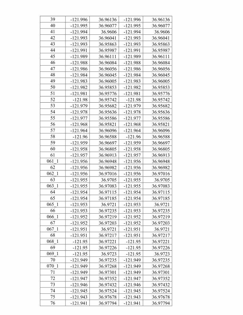
39 -121.996 36.96136 -121.996 36.96136 40 -121.995 36.96077 -121.995 36.96077 41 -121.994 36.9606 -121.994 36.9606 42 -121.993 36.96041 -121.993 36.96041 43 -121.993 36.95863 -121.993 36.95863 44 -121.991 36.95987 -121.991 36.95987 45 -121.989 36.96111 -121.989 36.96111 46 -121.988 36.96084 -121.988 36.96084 47 -121.986 36.96056 -121.986 36.96056 48 -121.984 36.96045 -121.984 36.96045 49 -121.983 36.96005 -121.983 36.96005 50 -121.982 36.95853 -121.982 36.95853 51 -121.981 36.95776 -121.981 36.95776 52 -121.98 36.95742 -121.98 36.95742 53 -121.979 36.95682 -121.979 36.95682 54 -121.978 36.95636 -121.978 36.95636 55 -121.977 36.95586 -121.977 36.95586 56 -121.968 36.95821 -121.968 36.95821 57 -121.964 36.96096 -121.964 36.96096 58 -121.96 36.96588 -121.96 36.96588 59 -121.959 36.96697 -121.959 36.96697 60 -121.958 36.96805 -121.958 36.96805 61 -121.957 36.96913 -121.957 36.96913
061_1 -121.956 36.96948 -121.956 36.96948 62 -121.956 36.96982 -121.956 36.96982
062_1 -121.956 36.97016 -121.956 36.97016 63 -121.955 36.9705 -121.955 36.9705
063_1 -121.955 36.97083 -121.955 36.97083 64 -121.954 36.97115 -121.954 36.97115 65 -121.954 36.97185 -121.954 36.97185
065_1 -121.953 36.9721 -121.953 36.9721 66 -121.953 36.97235 -121.953 36.97235
066_1 -121.952 36.97219 -121.952 36.97219 67 -121.952 36.97203 -121.952 36.97203
067_1 -121.951 36.9721 -121.951 36.9721 68 -121.951 36.97217 -121.951 36.97217
068_1 -121.95 36.97221 -121.95 36.97221 69 -121.95 36.97226 -121.95 36.97226
069_1 -121.95 36.9723 -121.95 36.9723 70 -121.949 36.97235 -121.949 36.97235
070_1 -121.949 36.97268 -121.949 36.97268 71 -121.949 36.97301 -121.949 36.97301 72 -121.947 36.97352 -121.947 36.97352 73 -121.946 36.97432 -121.946 36.97432 74 -121.945 36.97524 -121.945 36.97524 75 -121.943 36.97678 -121.943 36.97678 76 -121.941 36.97794 -121.941 36.97794
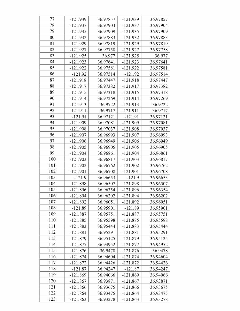
77 -121.939 36.97857 -121.939 36.97857 78 -121.937 36.97904 -121.937 36.97904 79 -121.935 36.97909 -121.935 36.97909 80 -121.932 36.97883 -121.932 36.97883 81 -121.929 36.97819 -121.929 36.97819 82 -121.927 36.97758 -121.927 36.97758 83 -121.925 36.977 -121.925 36.977 84 -121.923 36.97641 -121.923 36.97641 85 -121.922 36.97581 -121.922 36.97581 86 -121.92 36.97514 -121.92 36.97514 87 -121.918 36.97447 -121.918 36.97447 88 -121.917 36.97382 -121.917 36.97382 89 -121.915 36.97318 -121.915 36.97318 90 -121.914 36.97269 -121.914 36.97269 91 -121.913 36.9722 -121.913 36.9722 92 -121.911 36.9717 -121.911 36.9717 93 -121.91 36.97121 -121.91 36.97121 94 -121.909 36.97081 -121.909 36.97081 95 -121.908 36.97037 -121.908 36.97037 96 -121.907 36.96993 -121.907 36.96993 97 -121.906 36.96949 -121.906 36.96949 98 -121.905 36.96905 -121.905 36.96905 99 -121.904 36.96861 -121.904 36.96861 100 -121.903 36.96817 -121.903 36.96817 101 -121.902 36.96762 -121.902 36.96762 102 -121.901 36.96708 -121.901 36.96708 103 -121.9 36.96653 -121.9 36.96653 104 -121.898 36.96507 -121.898 36.96507 105 -121.896 36.96354 -121.896 36.96354 106 -121.894 36.96202 -121.894 36.96202 107 -121.892 36.96051 -121.892 36.96051 108 -121.89 36.95901 -121.89 36.95901 109 -121.887 36.95751 -121.887 36.95751 110 -121.885 36.95598 -121.885 36.95598 111 -121.883 36.95444 -121.883 36.95444 112 -121.881 36.95291 -121.881 36.95291 113 -121.879 36.95125 -121.879 36.95125 114 -121.877 36.94952 -121.877 36.94952 115 -121.876 36.9478 -121.876 36.9478 116 -121.874 36.94604 -121.874 36.94604 117 -121.872 36.94426 -121.872 36.94426 118 -121.87 36.94247 -121.87 36.94247 119 -121.869 36.94066 -121.869 36.94066 120 -121.867 36.93871 -121.867 36.93871 121 -121.866 36.93675 -121.866 36.93675 122 -121.864 36.93475 -121.864 36.93475 123 -121.863 36.93278 -121.863 36.93278

124 -121.861 36.93085 -121.861 36.93085 125 -121.86 36.92893 -121.86 36.92893 126 -121.858 36.927 -121.858 36.927 127 -121.857 36.92508 -121.857 36.92508 128 -121.855 36.92313 -121.855 36.92313 129 -121.854 36.92113 -121.854 36.92113 130 -121.853 36.91912 -121.853 36.91912 131 -121.852 36.91712 -121.852 36.91712 132 -121.85 36.91513 -121.85 36.91513 133 -121.849 36.91314 -121.849 36.91314 134 -121.848 36.91114 -121.848 36.91114 135 -121.846 36.90915 -121.846 36.90915 136 -121.845 36.90716 -121.845 36.90716 137 -121.844 36.90517 -121.844 36.90517 138 -121.842 36.90319 -121.842 36.90319 139 -121.841 36.9012 -121.841 36.9012 140 -121.84 36.89921 -121.84 36.89921 141 -121.838 36.89722 -121.838 36.89722 142 -121.837 36.89523 -121.837 36.89523 143 -121.836 36.89322 -121.836 36.89322 144 -121.834 36.8912 -121.834 36.8912 145 -121.833 36.88923 -121.833 36.88923 146 -121.832 36.88727 -121.832 36.88727 147 -121.83 36.88531 -121.83 36.88531 148 -121.829 36.88334 -121.829 36.88334 149 -121.828 36.88137 -121.828 36.88137 150 -121.826 36.87941 -121.826 36.87941 151 -121.825 36.87744 -121.825 36.87744 152 -121.823 36.87547 -121.823 36.87547 153 -121.822 36.87344 -121.822 36.87344 154 -121.821 36.87142 -121.821 36.87142 155 -121.82 36.86939 -121.82 36.86939 156 -121.819 36.86736 -121.819 36.86736 157 -121.817 36.86527 -121.817 36.86527 158 -121.816 36.86319 -121.816 36.86319 159 -121.815 36.86111 -121.815 36.86111 160 -121.814 36.85903 -121.814 36.85903 161 -121.813 36.85687 -121.813 36.85687 162 -121.812 36.85479 -121.812 36.85479 163 -121.812 36.85396 -121.812 36.85396 164 -121.811 36.85314 -121.811 36.85314 165 -121.808 36.85315 -121.808 36.85315 166 -121.808 36.85211 -121.808 36.85211 167 -121.808 36.85113 -121.808 36.85113 168 -121.808 36.8503 -121.808 36.8503 169 -121.807 36.84952 -121.807 36.84952 170 -121.807 36.84873 -121.807 36.84873

171 -121.806 36.84791 -121.806 36.84791 172 -121.806 36.84712 -121.806 36.84712 173 -121.805 36.8464 -121.805 36.8464 174 -121.804 36.84563 -121.804 36.84563 175 -121.804 36.8448 -121.804 36.8448 176 -121.804 36.8439 -121.804 36.8439 177 -121.804 36.84296 -121.804 36.84296 178 -121.803 36.84202 -121.803 36.84202 179 -121.804 36.84098 -121.804 36.84098 180 -121.803 36.84016 -121.803 36.84016 181 -121.803 36.8393 -121.803 36.8393 182 -121.803 36.83844 -121.803 36.83844 183 -121.802 36.83757 -121.802 36.83757 184 -121.802 36.83671 -121.802 36.83671 185 -121.801 36.83585 -121.801 36.83585 186 -121.801 36.83499 -121.801 36.83499 187 -121.801 36.83413 -121.801 36.83413 188 -121.8 36.83201 -121.8 36.83201 189 -121.799 36.82995 -121.799 36.82995 190 -121.798 36.82789 -121.798 36.82789 191 -121.796 36.82583 -121.796 36.82583 192 -121.795 36.82377 -121.795 36.82377 193 -121.794 36.82171 -121.794 36.82171 194 -121.793 36.81965 -121.793 36.81965
194_1 -121.792 36.81855 -121.792 36.81855 195 -121.792 36.81744 -121.792 36.81744
195_1 -121.791 36.81625 -121.791 36.81625 196 -121.79 36.81507 -121.79 36.81507
196_1 -121.79 36.8143 -121.79 36.8143 196_2 -121.79 36.81353 -121.79 36.81353 197 -121.789 36.81276 -121.789 36.81276
197_1 -121.789 36.81202 -121.789 36.81202 197_2 -121.789 36.81128 -121.789 36.81128 198 -121.789 36.81054 -121.789 36.81054
198_1 -121.789 36.80979 -121.789 36.80979 198_2 -121.788 36.80905 -121.788 36.80905 199 -121.788 36.8083 -121.788 36.8083 200 -121.791 36.80713 -121.791 36.80713
200_1 -121.795 36.80608 -121.795 36.80608 200_2 -121.794 36.80617 -121.794 36.80617 200_3 -121.793 36.80626 -121.793 36.80626 200_4 -121.792 36.80634 -121.792 36.80634


Marine Wildlife Mitigation Plan Storm Impact Study Bathymetric Survey
Monterey Bay, CA.
(November 1, 2017 – October 12, 2018)
1.0 INTRODUCTION
This marine wildlife mitigation plan is prepared in compliance with the USGS Pacific Coastal and Marine Science Center's existing State Geophysical Permit PRC 8394. This plan is intended to provide guidance to USGS vehicle operators and scientific field personnel collecting geophysical data for the Pacific Coastal and Marine Science Center (PCMSC) in Santa Cruz, CA to avoid significant impacts to marine wildlife that may occur during regular geophysical surveys.
1.1 Regulatory Basis
Species that are either currently in danger or soon likely to be in danger of extinction throughout all or a portion of its range are protected by the Endangered Species Act of 1973. The United States Fish and Wildlife Service (USFWS), and the National Oceanic and Atmospheric Administration (NOAA) National Marine Fisheries Service (NMFS) implement the Endangered Species Act. During the consultation with NMFS to issue a permit for the offshore geophysical survey, it was determined no incidental take permits are required to use the equipment identified in this document to conduct scientific data acquisition in federal waters offshore of the California coast.
1.2 Geophysical Survey Purpose and Objectives The USGS Pacific Coastal and Marine Science Center will study and evaluate the effects of storms on important geological resources and processes of the northern Monterey Bay, California. The primary coastal feature that will be studied is the beach sediments that make up the region's littoral cell. The beaches of the northern Monterey Bay have strong seasonal dynamics and respond to wave forcing and coarse-grained sediment supplies that come primarily from coastal streams and rivers (Hicks and Inman, 1987; Dingier and Reiss, 2002; Warrick and Barnard, 2012). The sediments of these beaches are commonly the first—and in some places the final—defenses against coastal flooding during winter storms, and these sediments provide important recreational and ecological resources (Dugan et al, 2003). The goal of this effort is to build a better understanding of the dynamics of littoral sediment—both onshore and offshore of the beach—so that better predictions of coastal change and coastal flooding can be made for the Monterey Bay region. Focus will be placed on mapping nearshore topography and bathymetry in high-resolution; focus will also be placed on mapping regions near sediment sources such as rivers and creeks and near important coastal resources along the Santa Cruz littoral cell. This work will allow the USGS to evaluate the important patterns, processes and effects of the geological systems in the northern Monterey Bay, and this work would continue the beneficial research relationships between the USGS and the Monterey Bay National

Marine Sanctuary (e.g., Eittreim et al., 2002; Storlazzi et al, 2007; Storlazzi et al., 2013). We are particularly interested in the effects of storms during El Nino winters (such as 2015-16), when seasonally higher water levels and larger waves have historically had significant impacts on the beaches in the region, and on the effects of major floods, which deliver new sediment to the coast, and on the effects of major wave events which redistribute new and existing sediments. PCMSC will contact the NOAA Long Beach Office staff and local whale-watching operations to acquire information on the current composition and relative abundance of marine wildlife offshore as well as any pinniped haul out sites. Whale activity is moderate at the moment. The peak whale season is February - May in the Monterey Bay. Lines near pinniped haul out sites will be surveyed only when pinnipeds are not present; while pinnipeds are present surveyors will not approach within 91m (300’) of haul out sites. Additionally, one day prior to survey activities, the NOAA Long Beach office or local whale watching operations will be contacted to get an update on marine wildlife sightings in the area. This information will be conveyed to the captain and crew prior to the survey.
A review of environmental responsibility of project operations will be conducted by the chief scientist in charge of the survey operations prior to commencing the first day of operations. When new personnel will be in the crew, this training will be repeated at least for those new to the crew. They will be made aware of their individual responsibility and will be shown how to be aware of possible environmental impacts and how to mitigate them during the geophysical survey operations. Information relating to seasonality, as an indication of the types of animals that might be in our survey area, at the time of survey work will also be presented to the crew. A copy of this document will be provided to the crew of our survey vehicles.
All personnel will be expected to be consistently aware that they are to be alert to any presence of marine wildlife while they are performing their duties. There are a number of signs/indications of marine wildlife presence and each crew member will be responsible to maintain vigilance for those signs within the constraints of their project duties. Some of those indications are:
a. Sounds - such as splashing, vocalizations (by animals and birds), and blowing (breathing).
b. Visual indications - birds aggregating, changes in water character such as areas of rippled water, white water caused by splashing, changes in color or shape of the ocean surface
1.3 Survey Schedule and Layout The Project will take place from November 1, 2017 to October 12, 2018. These dates include tidal windows when data may be collected during two five-day surveys (Spring and Fall) and up to three one-day storm response surveys. The proposed mapping areas are along the sandy-beach fronted shorelines of the northern Monterey Bay; the survey vehicles will not be used near rocky reefs and kelp beds. For safety reasons, the survey vehicles are always used in tandem—two at a time— with personnel support on the adjacent beach. Depending on survey date, the survey vehicles will be launched from either Santa Cruz Harbor or Moss Landing Harbor and will transit at safe speeds to the

survey locations. Surveys will be conducted during high tides, and across-shore transects will be surveyed from the surf zone (about 1 m depth) to 1-2 km offshore. Survey vehicle operators will operate on survey lines only when conditions are safe and swimmers, paddlers, and wildlife are not present. Data collected in this region are critical however, as most of the sand movement in nearshore areas occurs at shallow depths. Sediment volume changes will be calculated from profile data to determine the rates of net sediment transport between different reaches of the beach, as well as the rates of net on- or offshore transport. This will aid in determining littoral drift rates and in constructing a sediment budget for the system.
Figure 1. Regional Map of Survey Area

US Geological Survey - Pacific Coastal and Marine Science Center Marine Wildlife Mitigation Plan - Santa Cruz
4
2.0 Survey Equipment and Activities
Bathymetric mapping will utilize two USGS Coastal Profiling Systems (CPS), which consist of a personal watercraft instrumented with GPS-based mapping systems and fathometers (Figure 3a). The CPS are identical to the systems used in previously permitted research in the MBNMS (see Storlazzi et al., 2007). CPS are not operated in high surf (generally greater than 5 feet) or in difficult weather conditions such as fog or rain. All CPS operators are USGS employees, insured, and safety-certified by the U.S. Department of Interior.
PCMSC proposes to use the following equipment to collect the required data:
• Odom Echotrac CV100 echo sounder using a 200 kHz, 9° downward conical beam transducer
The proposed survey will require the use of a marine vehicle and in-water equipment that generate noise during data acquisition. The results of modeling of the noise generated by the survey equipment is shown in Table 1. Those results indicate that operational source level used for these surveys are less than 160 dB at any range.
Table 1. Distances to Received Pressure Levels from Equipment Sound Source
Sounder System Frequency (kHz)
Source Level (dB
peak)
Source Level (dB
rms)
Distance toSL160 dBrms
(meters)
Distance to SL 180 dB
(rms) (meters)
Distance toSL190 dB (rms) (meters)
Odom Echotrac CV100 Echo Sounder 200 kHz 109 93 <1 <1 <1
These estimates are based on the underwater sound propagation equation: RSPL= SL-20log (R/Ro)-AR where,
RSPL=Recieved sound potential level SL= RMS source level re. 1 uPa (rms) based on manufacturer's specifications R= Distance Ro= Reference Distance (1 m) A= sound absorption coefficient
The greatest distance from the sound source to the 160 dB level (<1 m) for the proposed equipment) is considered the "safety zone" for this equipment. However, because the operating frequency of 200 kHz is above the cutoff hearing threshold for marine mammals, CSLC has determined that the observance of the "safety zones" is not a requirement for this survey (personal communication, K. Keen, CSLC).

US Geological Survey - Pacific Coastal and Marine Science Center Marine Wildlife Mitigation Plan - Santa Cruz
5
3.0 Marine Wildlife
3.1 Marine Wildlife
The following discusses the marine wildlife that have been recorded within the project region, those taxa that are most likely to be within the larger project region during survey operations, and methods that will be instituted by the vehicle operator to reduce or eliminate potential impacts to marine wildlife during transit and survey operations.
Table 2 provides information on the seasonal variations in the marine wildlife that are expected to be or have been reported within the Project area.
Table 2: Abundance Estimates for Marine Mammals and Reptiles of California Unless Otherwise Indicated
Common Name Scientific Name
Population Estimate Current Population Trend
REPTILES Cryptodira
Olive Ridley turtle Lepidochelys olivacea
1.39 million (Eastern Tropical Pacific)**
Increasing
Green turtle Chelonia mydas
3,319-3,479** (Eastern Pacific Stock)
Increasing
Loggerhead turtle Caretta caretta
1,000 (California)**
Decreasing
Leatherback turtle Dermochelys coriacea
178 (California)**
Decreasing
MAMMALS Mysticeti
California gray whale Eschrichtius robustus
18,017 (Eastern North Pacific Stock)
Fluctuating annually
Fin whale Balaenoptera physalus
2,624 (California/Oregon/Washington Stock)
Increasing off California
Humpback whale Megaptera novaeangliae
1,878 (California/Oregon/Washington Stock)
Increasing
Blue whale Balaenoptera musculus
2,046 (Eastern North Pacific Stock)
Unable to determine
Minke whale Balaenoptera acutorostrata
202 (California/Oregon/Washington Stock)
No long-term trends suggested
Northern right whale Eubalaena japonica
17 (based on photo-identification) (Eastern North Pacific Stock)
No long-term trends suggested
Sei whale Balaenoptera borealls
83 (Eastern North Pacific Stock)
No long-term trends suggested
Odontoceti Short-beaked common dolphin Delphinus delphis
343,990 (California/Oregon/Washington Stock)
Unable to determine
Long-beaked common dolphin Delphinus capensls
17,127 (California Stock)
Unable to determine
Dall's porpoise Phocoenoides dalli
32,106 (California/Oregon/Washington Stock)
Unable to determine
Harbor porpoise Phocoena phocoena
1,478 (Morro Bay Stock)
Increasing
Pacific white-sided dolphin Lagenorhynchus obllquldens
21,406 (California/Oregon/Washington Stock)
No long-term trends suggested
Risso's dolphin Grampus griseus
4,913 (California/Oregon/Washington Stock)
No long-term trends suggested
Short-finned pilot whale Globicephala macrorhynchus
465 (California/Oregon/Washington Stock)
No long-term trends suggested

US Geological Survey - Pacific Coastal and Marine Science Center Marine Wildlife Mitigation Plan - Santa Cruz
6
Bottlenose dolphin Turslops truncates
684 (California/Oregon/Washington Offshore Stock)
No long-term trends suggested
290 (California Coastal Stock)
No long-term trends suggested
Northern right whale dolphin Llssopelphis borealis
6,019 (California/Oregon/Washington Stock)
No long-term trends suggested
Sperm whale Physeter macrocephalus
751 (California/Oregon/Washington Stock)
No long-term trends suggested
Killer whale Orcinus orca
85 (Eastern North Pacific Southern
Resident Stock)
Decreasing
162 (Eastern North Pacific Offshore Stock)
No long-term trends suggested
Pinnipedia California sea lion Zalophus californianus
141,842 (U.S. Stock)
Unable to determine; increasing in most recent three year period
Northern fur seal Callorhinus ursinus
5,395 (San Miguel Island Stock)
Increasing
Guadalupe fur seal Arctocephalus townsendi
3,028 (Mexico Stock) Undetermined in California
Increasing
Northern (Steller) sea lion Eumetopias jubatus
2,479 California Stock
Decreasing
Northern elephant seal Mirounga angustirostris
74,913 Increasing
Pacific harbor seal Phoca vitulina richardsi
31,600 Stable
Fissipedia Southern sea otter Enhydra lutris nereis
2,711* Unable to determine
Estimates provided by National Marine Fisheries Service (NOAA Fisheries 2011) *
Estimate provided by USGS (2010) ** Estimates provided by National Marine Fisheries Service (NMFS) (2004), Marquez, et al. (2002), Eguchi et ai. (2007), Benson
et al. (2007), and NMFS (2007). Estimates are based on number of current numbers of nesting females.
During the transit periods, there is a potential for encountering marine wildlife. Table 3 lists those species that are likely to occur in the survey area

US Geological Survey - Pacific Coastal and Marine Science Center Marine Wildlife Mitigation Plan - Santa Cruz
7
Table 3. Marine Wildlife Species and Most Likely Periods of Occurrence within the Survey Area
Family Common Name
MonthofOccurrence<1)J F M A M J J A S O N D
REPTILESCyptodira
Olive Ridley turtle (T) (2) Green turtle (T)(1),(2) Loggerhead turtle (T) (2) Leatherback turtle (E) (2)
MAMMALSMysticeti
California gray whale Blue whale (E) Fin whale (E) Humpback whale (E) Minke whale Sei whale (E) Northern right whale (E)
OdontocetiShort-beakedcommondolphin
Dall'sporpoise Harborporpoise
Long-beakedcommondolphin Pacificwhite-sideddolphin Risso'sdolphin Spermwhale Short-finnedpilotwhale Bottlenosedolphin Northernrightwhaledolphin Killerwhale
PinnipediaNorthernfurseal (3) Californiasealion Northernelephantseal(4) Pacificharborseal Guadalupefurseal(T) Stellersealion
FissipediaSouthernseaotter(T)(5)
Relativelyuniformdistribution Notexpectedtooccur Mostlikelytooccurduetoseasonaldistribution
(E)Federallylistedendangeredspecies. (T)Federallylistedthreatenedspecies.(1)NotUsed(2)Rarelyencountered,butmaybepresentyear-round.GreatestabundanceduringJulythroughSeptember.(3)Onlyasmallpercentoccurovercontinentalshelf(exceptnearSanMiguelrookery,May-November).(4)Commonnearlandduringwinterbreedingseasonandspringmoltingseason.(5)Onlynearshore(divinglimit100feet).Sources:BonnellandDailey(1993),NOAAFisheries(2011),NCCOS(2007)
US Geological Survey - Pacific Coastal and Marine Science Center Marine Wildlife Mitigation Plan - Santa Cruz
8
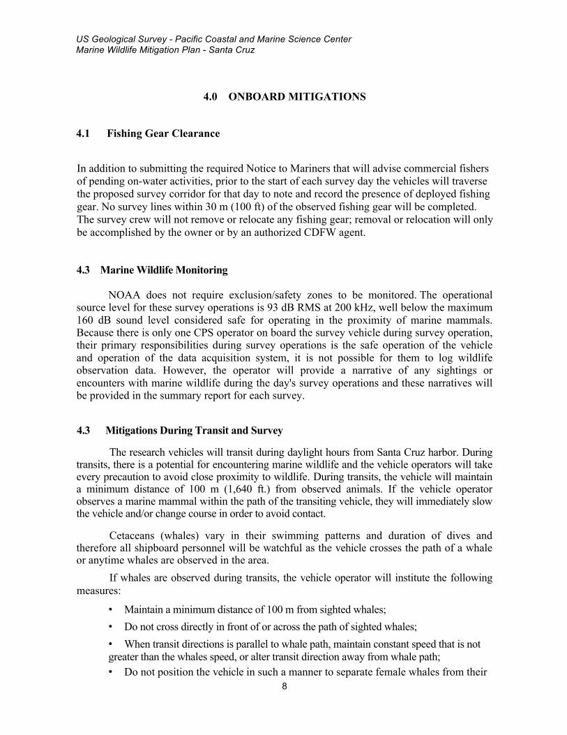
4.0 ONBOARD MITIGATIONS
4.1 Fishing Gear Clearance
In addition to submitting the required Notice to Mariners that will advise commercial fishers of pending on-water activities, prior to the start of each survey day the vehicles will traverse the proposed survey corridor for that day to note and record the presence of deployed fishing gear. No survey lines within 30 m (100 ft) of the observed fishing gear will be completed. The survey crew will not remove or relocate any fishing gear; removal or relocation will only be accomplished by the owner or by an authorized CDFW agent.
4.3 Marine Wildlife Monitoring
NOAA does not require exclusion/safety zones to be monitored. The operational source level for these survey operations is 93 dB RMS at 200 kHz, well below the maximum 160 dB sound level considered safe for operating in the proximity of marine mammals. Because there is only one CPS operator on board the survey vehicle during survey operation, their primary responsibilities during survey operations is the safe operation of the vehicle and operation of the data acquisition system, it is not possible for them to log wildlife observation data. However, the operator will provide a narrative of any sightings or encounters with marine wildlife during the day's survey operations and these narratives will be provided in the summary report for each survey.
4.3 Mitigations During Transit and Survey
The research vehicles will transit during daylight hours from Santa Cruz harbor. During transits, there is a potential for encountering marine wildlife and the vehicle operators will take every precaution to avoid close proximity to wildlife. During transits, the vehicle will maintain a minimum distance of 100 m (1,640 ft.) from observed animals. If the vehicle operator observes a marine mammal within the path of the transiting vehicle, they will immediately slow the vehicle and/or change course in order to avoid contact.
Cetaceans (whales) vary in their swimming patterns and duration of dives and therefore all shipboard personnel will be watchful as the vehicle crosses the path of a whale or anytime whales are observed in the area.
If whales are observed during transits, the vehicle operator will institute the following measures:
• Maintain a minimum distance of 100 m from sighted whales; • Do not cross directly in front of or across the path of sighted whales; • When transit directions is parallel to whale path, maintain constant speed that is not greater than the whales speed, or alter transit direction away from whale path; • Do not position the vehicle in such a manner to separate female whales from their

US Geological Survey - Pacific Coastal and Marine Science Center Marine Wildlife Mitigation Plan - Santa Cruz
9
calves; • If a whale engages in evasive or defensive action, slow the vehicle and move away
from the animal until the animal calms or moves out of the area. During survey operations, the vehicle will maintain survey a speed of approximately 4
knots and will maintain a heading that coincides with survey track lines. If marine wildlife is observed within the vicinity of the vehicle, the vehicle operator will take precautions to avoid collision, ending and restarting the track line survey if necessary.
If a collision with marine wildlife occurs, the vehicle operator will document the conditions under which the accident occurred, including the following:
• Location of the vehicle when the collision occurred (latitude and longitude); • Date and time; • Speed and heading of the vehicle; • Observed conditions (e.g., wind speed and direction, swell height, visibility in miles
or kilometers, and presence of rain or fog); • Species of marine wildlife contacted; and • Organization, vehicle ID and name of master in charge of the vehicle at time of
accident.
In accordance with NOAA requirements, after a collision, the vehicle should stop, if safe to do so. The vehicle may proceed after confirming that it will not further damage the animal by doing so. The vehicle will then communicate by radio or telephone all details to the vehicle's base of operations. The PCMG Marine Operations Superintendent will contact the Stranding Coordinator, NMFS, Southwest Region, Long Beach, to obtain instructions. Alternatively, the vehicle captain may contact the NMFS Stranding Coordinator directly using the marine operator to place the call or directly from an onboard telephone, if available to:
NOAA Southwest Regional Stranding Coordinator
National Marine Fisheries Service 501 West Ocean Blvd, Suite 4200
Long Beach, CA 90802-4213 562-980-4017
Contact: Justin Viezbicke Email: [email protected]
It is unlikely that the vehicle will be asked to stand by until NOAA or CDFW personnel arrive, however this will be determined by the Stranding Coordinator. According to the MMPA, the vehicle operator is not allowed to aid injured marine wildlife or recover the carcass unless requested to do so by the NOAA Stranding Coordinator.

US Geological Survey - Pacific Coastal and Marine Science Center Marine Wildlife Mitigation Plan - Santa Cruz
10
Although NOAA has primary responsibility for marine mammals in both state and federal waters, the CDFG will also be advised that an incident has occurred in state waters affecting a protected species. Reports should be communicated to the federal and state agencies listed below:
Federal
Justin Viezbicke, California Stranding
Coordinator National Marine Fisheries Service
Long Beach, California (562) 980-4017
State Enforcement Dispatch Desk
California Department of Fish and Wildlife
Long Beach, California (562) 590-5132
State California State Lands Commission Division of Environmental Planning
and Management Sacramento, California
(916) 574-1938
4.4 Operational Measures
Soft Start
The soft-start technique required for sonar equipment operating above the hearing threshold for marine mammals at 200 kHz is predicated on research investigations of low frequency side lobes for 200 kHz sonar systems (Deng et al., 200 kHz Commercial Sonar Systems Generate Lower Frequency Side Lobes Audible to Some Marine Mammals, PLOS ONE, 2014). This work was based on a measured 90 kHz sub harmonic at 141 dB re. 1µPA @ 1m generated by a 200 kHz sonar signal at 195 dB re. 1µPA @ 1m and a marine mammal hearing threshold of 70 dB . Modeling of our system's equivalent source levels based on their measurements, our echo sounder would generate a 90 kHz harmonic at 69 dB re. 1µPA @ 1m, which is below the hearing threshold of concern, within 1 m from the vehicle. We conclude from this that a soft start technique has no practical application for our survey operations. However, we nonetheless intend to take a conservative approach by increasing power upon startup at a 25% increase in power from zero to our operational power level of 93 dB over a five minute period.
Wildlife Monitoring
Marine wildlife monitoring will not be required by onboard personnel for these operations, but the operator will provide a narrative of any observations that occur within the survey area.. Because the survey echo sounder operated above 200 kHz, no safety zone is required. However, USGS will take the following precautionary measures:
• Not approach within 91 m of the haul-out site (consistent with NMFS guidelines); • Expedite survey activity in this area in order to minimize the potential for disturbance of
pinnipeds on land; • Pinniped haul out site location is given in Table 4. • The vehicle will continuously monitor the daily survey area to ascertain the presence,
species and location of any marine wildlife is apparent in the intended survey area. The

US Geological Survey - Pacific Coastal and Marine Science Center Marine Wildlife Mitigation Plan - Santa Cruz
11
vehicle master and onboard personnel will be watchful whales or marine mammals are observed in the area. The vehicle operator shall observe the following guidelines:
• Make every effort to maintain distance from sighted marine mammals and other marine wildlife; • Do not cross directly in front of (perpendicular to) migrating whales or any other marine mammal
or turtle; • When paralleling marine mammals or turtles, the vehicle will operate at a constant speed that is
not faster than that of the animals; • Care will be taken to ensure female whales are not separated from their calves; and, if
a whale engages in evasive or defensive action, the vehicle will reduce speed or stop until the animal calms or moves out of the area.
Table 4 Pinniped Haul Out Locations
LOCATION SPECIES LATITUDE LONGITUDEPointSantaCruz,SantaCruz,CA CaliforniaSeaLion 36.95 -122.03SoquelPoint,SantaCruz,CA CaliforniaSeaLion 36.95 -122.98CementShip,Aptos,CA CaliforniaSeaLion 36.97 -122.91
Vehicle Speed
The CPS operator will refrain from erratic operating behavior when transiting to the survey site and shall operate at, or less than, a speed of approximately 4 knots once on survey station.
Limitations on equipment usage
Limitations on the frequency, pulse length, and pulse rate will be implemented to reduce potential harmful noises. The shortest possible pulse length and lowest pulse rate (pings per second) will be used, dependent on water depth.
4.5 Monitoring Reporting
A Post Survey Field Operations and Compliance Report will be submitted to CSLC staff as soon as possible but no more than 30 days after the completion of survey activities.

US Geological Survey - Pacific Coastal and Marine Science Center Marine Wildlife Mitigation Plan - Santa Cruz
12

US Geological Survey - Pacific Coastal and Marine Geology Science Center Oil Spill Contingency Plan - Monterey Bay Storm Impact Study
1
U.S. GEOLOGICAL SURVEY
PACIFIC COASTAL AND MARINE GEOLOGY SCIENCE CENTER
MANAGEMENT OF ACCIDENTAL DISCHARGE AND VESSEL INCIDENTS DURING OFFSHORE GEOPHYSICAL SURVEYS
1.0 INTRODUCTION
The survey operations will be conducted using two USGS personal watercraft (jet skis) that comprise our Coastal Profiling Systems (CPS). Because of the vehicle's small size, it is anticipated that response to any operational spills will be quickly identified and response will be initiated quickly and efficiently by the vehicle operator. Oil spills in United States (U.S.) marine waters shall be reported immediately.
2.0 OPERATIONAL SPILLS
Operational spills might involve one or more of the following substances carried on board the vehicles: (i) fuel and (ii) lube oil. The vehicles are equipped with woven polypropylene sheets (5 sheets) for rapid absorption of surface oil and protective gloves (1 pair), and a disposal bag (1) This oil spill materials are located in waterproof bags carried on each vehicle. This spill kit is rated to clean up .25 gallons of liquid. All of the liquids (listed below) that could cause a hazardous spill are either in the fuel tank or in the vehicle engine. Spill occurrence will likely be during fueling, in the event of grounding or if any instance occurred that punctured the gas tank. In the event a spill occurred in the engine compartment, the oil spill kit would be used to contain the hazardous liquids and the bilge would not be emptied until it could be pumped out at a hazardous waste facility. We do not anticipate a spill of greater than .25 gallons.
(i) Fuel:
A spill kit shall be available for use in the event of a spill. If the fuel is spilled on the deck, it shall be immediately removed, bagged and disposed of at an appropriate hazardous waste reception facility. In the event of spillage in the water, the vessel master shall notify the Coast Guard and port facility.
(ii) Lube oil:
A spill kit shall be available for use in the event of a spill. If the oil is spilled in the machinery space, it shall be immediately removed, bagged and disposed of at an appropriate hazardous waste reception facility. In the event of spillage in the water, the vehicle operator shall notify the Coast Guard and port facility.

US Geological Survey - Pacific Coastal and Marine Geology Science Center Oil Spill Contingency Plan - Monterey Bay Storm Impact Study
2
3.0 EMPLOYEE TRAINING ON OIL SPILL CONTINGENCY PLAN
Prior to the launching of the vessel for any activities, all captain and crew members on the vessel will have read the Oil Spill Contingency Plan, understand procedures to be implemented in the event of an oil spill, and know where the oil spill kit is located on the vessel.
4.0 VESSEL FUELING
All vessel fueling will be conducted at an approved docking facility. No cross vessel fueling will be performed. Appropriate spill avoidance measures during filling procedures will be observed. Refueling of the CPS is not allowed at the shoreline unless there is a compelling reason to do so and sufficient spill response equipment to address a spill is on site (i.e., sorbent and containment materials equal to approximately one-third the capacity of the fuel tank).
5.0 PRIORITY ACTIONS TO ENSURE PERSONNEL AND VESSEL SAFETY
Safety of vehicle operators and the vehicles are paramount. In the event that a crewman's injuries require outside emergency assistance, the PCMSC safety officer shall be contacted immediately and emergency personnel contacted. While awaiting emergency assistance, the on board vessel master or qualified vessel crew personnel will render first aid and/or CPR. The nearest emergency medical facilities for this area is:
Dominican Hospital Emergency Department 1555 Soquel Dr, Santa Cruz, CA 95065 (831) 462-7710
6.0 MITIGATING ACTIVITIES
If safety of both the vessel and the personnel has been addressed, the vessel master shall care for the following issues:
• Assessment of the situation and monitoring of all activities as documented evidence. • Care for further protection of the personnel, use of protective gear, assessment of further
risk to health and safety. • Containment of the spilled material by absorption and safe disposal within leak proof
containers of all used material onboard until proper delivery ashore, with due consideration to possible fire risk.
• Decontamination of personnel after finishing the cleanup process.

US Geological Survey - Pacific Coastal and Marine Geology Science Center Oil Spill Contingency Plan - Monterey Bay Storm Impact Study
3
7.0 EMERGENCY CONTACTS FOR STATE AND FEDERAL AGENCIES
Emergency numbers for U.S.C.G. for the San Francisco and Central Coast Areas are:
Pacific SAR Coordinator - Alameda: 510-437-3700
Rescue Coordination Center, Alameda: 510-437-3700
Any oil spill in U.S. marine waters shall be reported immediately to the following state and agencies:
West Coast Oil Spill hot-line 800-OELS-911, or Department of Fish and Game CalTIP 888-CFG-CALTip (Californians Turn In Poachers & Polluters) (888-334-2258). and U.S. Coast Guard National Response Center 800-424-8802 California Office of Emergency Services (OES) 800-OILS-911 or 800-852-7550.
During the phone call, the following information will be given over the phone.
a. Name and telephone number of caller. b. Spill location c. What was spilled (oil, gas, diesel, etc.) d. Estimated size of spill e. The date & time spill was identified (same day). f. Any oiled or threatened wildlife g. Source of spill, if known h. Activity observed at the spill site
After taking the necessary actions, the spill will be reported in writing to the Governor's Office of Emergency Services on their forms.
Additionally, California Department of Fish and Game certified wildlife rescue/response organizations will be contacted about the spill. In the Southern California area, these include the following contacts:
Oiled Wildlife Care Network Animal Advocates 1-877-UCD-OWCN 323-651-1336
California Wildlife Center South Bay Wildlife Rehab 310-458-9453 310-378-9921

US Geological Survey - Pacific Coastal and Marine Geology Science Center Oil Spill Contingency Plan - Monterey Bay Storm Impact Study
4


![Convergence of Wachspress coordinates: from polygons to ...jiri/papers/14KoBa.pdf · convex polygons are Wachspress coordinates [14], mean value coordinates [4], and harmonic coordinates](https://static.fdocuments.in/doc/165x107/5f6dfe23261f61015179236e/convergence-of-wachspress-coordinates-from-polygons-to-jiripapers-convex.jpg)


![Interpolation via Barycentric Coordinates · • Moving least squares coordinates [Manson and Schaefer, 2010] • Cubic mean value coordinates [Li and Hu, 2013] • Poisson coordinates](https://static.fdocuments.in/doc/165x107/6062738927364e51e610e629/interpolation-via-barycentric-coordinates-a-moving-least-squares-coordinates-manson.jpg)


