MONTENEGRO MARITIME SAFETY DEPARTMENT - pomorstvo… · maritime safety department . ... 067 642...
33
SAFETY AND SECURITY OF NAVIGATION INFORMATION FOR NAVIGATORS MONTENEGRO MARITIME SAFETY DEPARTMENT www.pomorstvo.me
-
Upload
vuongkhuong -
Category
Documents
-
view
225 -
download
0
Transcript of MONTENEGRO MARITIME SAFETY DEPARTMENT - pomorstvo… · maritime safety department . ... 067 642...
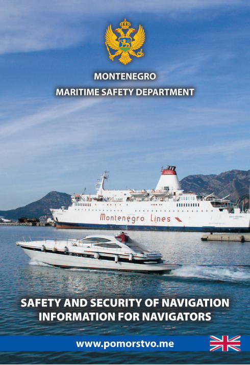
SAFETY AND SECURITY OF NAVIGATIONINFORMATION FOR NAVIGATORS
MONTENEGRO
MARITIME SAFETY DEPARTMENT
www.pomorstvo.me
SAFETY AND SECURITY OF NAVIGATIONINFORMATION FOR NAVIGATORS
MONTENEGROMARITIME SAFETY DEPARTMENT
ASSISTANCE AND INFORMATION: VHF ch16/ch24; 030/19833; 067 642 179; 030/313-241
Publisher:MARITIME SAFETY DEPARTMENT
B A R
Printing:500 copies
Printed at:Krug, Bar
II EditionMay, 2010
ASSISTANCE AND INFORMATION: VHF ch16/ch24; 030/19833; 067 642 179; 030/313-241
5
SAFETY AND SECURITY OF NAVIGATION
We are reminding you of the things you should know, the things you should pay attention to, if you have decided to go out to sea; what the law requires of you, what the experience teaches us, who you can count on, and all of this so that the time you spend on boat, yacht or ship can be all that you’ve expected it to be-enjoying the liberty of movement.
There is no safe navigation without a good preparation, knowledge and obeying the regulations, as well as all those rules of behaviour at sea which the experience taught us. Our intention is to introduce or remind you of all the things you should pay attention to when preparing to go out to sea.
The most responsible persons for the safety of the boat and crew are the skipper and the crew itself. Nevertheless, one should know that, for the safety and security of navigation, prevention of accidents and providing assistance in case of accidents or avera-ges, there are: Maritime Safety Department, Harbour Master’s Offices Bar and Kotor and Maritime Border Police.
NAUTICAL CHARTS AND PUBLICATIONS
Nautical charts of the coastal sea area of Montenegro, Skadar Lake and other nautical publications can be purchased in Maritime Safety Department:
Name: Telephone: Fax: Mobile:Maritime Safety Department 030/313-241 030/313-274 069 355 111
ADRIATIC SEA
Adriatic Sea covers the surface area of 138.595 km2. Total length of its coastline (land and islands) is 7.912 km. Land coastline of the Adriatic is 3.737 km; the length of the Adriatic Sea is 783 km and its width up to 217 km.
The shallowest part of the Adriatic is in the Bay of Trieste (25 m) and the seabed drops steadily towards the south Adriatic where the biggest measured depth is 1.240 m. From the total number of 1.250 islands, islets and rocks, 1.185 are in Croatia.
Sea temperature grows from north to south. The lowest sea temperatures are measured in February (from 7°C to 13°C) and the highest in August (from 22°C to 25°C). The Adriatic is considered to be one of seas with the highest salinity. The salinity drops from north to south and the average salinity is 25,3 ‰.
ASSISTANCE AND INFORMATION: VHF ch16/ch24; 030/19833; 067 642 179; 030/313-241
6
ASSISTANCE AND INFORMATION: VHF ch16/ch24; 030/19833; 067 642 179; 030/313-241
Sea transparence is lowest in the north Adriatic (5-39 m), and highest in the south Adriatic (16-56 m). Air temperature is lowest in January with average value of 10°C in the south and 2°C in the north Adriatic, and highest in July when average values range from 22°C to 26°C.
Montenegrin coastline total length 294 kmTotal length of the sea border of Montenegro 148 kmLength of the border with Croatia 22 kmLength of the border with Albania 22 kmLength of the border territorial sea – epicontinental shelf 104 kmSurface area of inland sea of Montenegro 362 km2
Surface area of the territorial sea of Montenegro 2.099 km2
Surface area of the epicontinental shelf 3.885 km2
THE LAKE OF SKADARNational Park ‘’Lake of Skadar’’, with its surface area of 372.3 km2, is
the biggest reservoir of fresh water in the Balkans.Ime: Telefon: E-mail:National Park ‘Skadar Lake’ +382 20 879 100 [email protected]’ center - Vranjina +382 20 879 103Visitors’ center - Virpazar +382 20 711 104Head of Protection Office +382 69 124 999Duty surveyor +382 69 124 998
With its flora and fauna, many islands, monasteries, churches and mosques, the Lake of Skadar is a natural park where three different cultures meet; it is the area of expanding tourism, eco-tourism, agricultural and nautical tourism; the area of established art colonies, inviting bathing places, ideal place for bird-watching, bicy-cle outings, kayak and canoe rides.
National Park ‘’Lake of Skadar’’ is a significant dwelling place of waterfowls (over 270 species).
Length of the Lake of Skadar 44 kmWidth of the Lake of Skadar 14 kmTotal length of the Lake of Skadar coastline 207 kmLength of the Montenegrin area of the Lake of Skadar 149.5 kmTotal surface area of the Lake of Skadar 372.3 km2
Surface area of the Montenegrin part of the Lake of Skadar 229.8 km2
Length of the state border with Albania 38 kmAverage depth of the Lake of Skadar 5.01 m
ASSISTANCE AND INFORMATION: VHF ch16/ch24; 030/19833; 067 642 179; 030/313-241 ASSISTANCE AND INFORMATION: VHF ch16/ch24; 030/19833; 067 642 179; 030/313-241
7
MARITIME SAFETY DEPARTMENT
Maritime Safety Department (www.msd-ups.org) is a state-controlled department, primarily authorized for: expert and technical survey in the area of determining the ability for navigation of sea-going ships and other vessels, performing technical surveys and issuing adequate certificates; registration of yachts; prevention of pollution and protection of marine environment; improvement and maintenance of navigable waterways; functionality of safety of navigation objects – light-houses; functionality of the radio service for the safety of navigation and the safety of life at sea, in accordance with national and international rules and regulations in these fields; organization and coordination of the search and rescue operations at sea.
Name: Telephone: Fax: E-mail:
Maritime Safety Department 030/313-241 030/313-274 [email protected]
MARITIME RESCUE COORDINATION CENTER (MRCC BAR)
Maritime Safety Department is, for your safety, involved in the activities of organization and coordination of the search and rescue operations at sea, through the Maritime Rescue Coordination Center (MRCC BAR), in accordance with the National Plan for Maritime Search and Rescue and the International Convention on Search and Rescue, 1979.
The National plan establishes principles of work, tasks and responsibilities, sanctions and rules of conduct for authorized offi-cers, as well as the manner of using the equipment during periods of readiness and during search and rescue at sea.
Name: Telephone: Mobile:Maritime Safety Department 030/313-241 067 642 179Maritime Rescue Coordination Center (MRCC BAR)
030/19833 067 642 179
Secretariat of the Coast Guard Coordination Body of MNE - Bar
030/312-156 063 285 280
Coast radio station ‘’BARRADIO’’ 030/313-088 067 642 179Harbour Master’s Office Bar 030/312-733 069 290 274Harbour Master’s Office Kotor 032/304-312 069 681 504Operational Center of the Maritime Border Police (MBP) of MNE - Podgorica
020/247-689 063 285 277
ASSISTANCE AND INFORMATION: VHF ch16/ch24; 030/19833; 067 642 179; 030/313-241
8
ASSISTANCE AND INFORMATION: VHF ch16/ch24; 030/19833; 067 642 179; 030/313-241
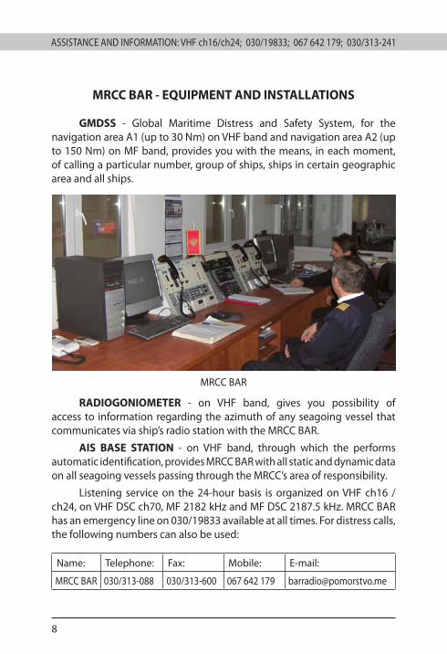
MRCC BAR - EQUIPMENT AND INSTALLATIONS
GMDSS - Global Maritime Distress and Safety System, for the navigation area A1 (up to 30 Nm) on VHF band and navigation area A2 (up to 150 Nm) on MF band, provides you with the means, in each moment, of calling a particular number, group of ships, ships in certain geographic area and all ships.
MRCC BAR
RADIOGONIOMETER - on VHF band, gives you possibility of access to information regarding the azimuth of any seagoing vessel that communicates via ship’s radio station with the MRCC BAR.
AIS BASE STATION - on VHF band, through which the performs automatic identification, provides MRCC BAR with all static and dynamic data on all seagoing vessels passing through the MRCC’s area of responsibility.
Listening service on the 24-hour basis is organized on VHF ch16 /ch24, on VHF DSC ch70, MF 2182 kHz and MF DSC 2187.5 kHz. MRCC BAR has an emergency line on 030/19833 available at all times. For distress calls, the following numbers can also be used:
Name: Telephone: Fax: Mobile: E-mail:
MRCC BAR 030/313-088 030/313-600 067 642 179 [email protected]
ASSISTANCE AND INFORMATION: VHF ch16/ch24; 030/19833; 067 642 179; 030/313-241 ASSISTANCE AND INFORMATION: VHF ch16/ch24; 030/19833; 067 642 179; 030/313-241
9
COORDINATION BODY OF THE COAST GUARD OF MONTENEGRO
Beside Maritime Safety Department, taking part in the activities of the Coordination Body of Montenegrin Coast Guard (KTOS), are the representatives from the Harbour Master’s Offices Bar and Kotor, Maritime Border Police and the Regional Center for Under-water De-mining and Diving Training from Bijela.
Assigned tasks of the KTOS are following: search and rescue operations at sea; prevention of terrorist attacks; combating drugs smuggling, illegal immigration and international organized crime; protection of the sea border, ports, approaches to coasts and areas in between; protection of maritime traffic; protection of natural resources, etc.
The KTOS area of responsibility is divided in 6 sectors, and these are: Podgorica (Božaj/Virpazar), Herceg Novi, Kotor, Budva, Bar and Ulcinj.
SECRETARIAT OF THE COORDINATION BODY OF THE COAST GUARD OF MONTENEGRO
Also, an integral part of the Coordination Body of Montenegrin Coast Guard (KTOS) is the Secretariat which has its own watch -keeping service active around the clock.
These are contact numbers of the Secretariat of KTOS:
Name: Telephone: Fax: Mobile:
Secretariat KTOS 030/312-156 030/312-159 063 285 280
RESCUE UNITS ON THE ALERT
For search and rescue operations the most important things are the timely information and position of those asking for help.
MRCC BAR is in charge of organization and coordination of search and rescue operations at sea, and, in accordance with the evaluation of the situation at hand, of making decisions on ways and scope of engaging other subjects of Montenegrin Coast Guard Coordination Body, in accordance with their responsibilities.
For your safety and security at sea, MRCC BAR is in a position to engage 21 fast smaller boats, 4 large vessels and 5 tug boats, as well as aviation units of the Ministry of Internal Affairs and the Army of Montenegro.
ASSISTANCE AND INFORMATION: VHF ch16/ch24; 030/19833; 067 642 179; 030/313-241
10
ASSISTANCE AND INFORMATION: VHF ch16/ch24; 030/19833; 067 642 179; 030/313-241
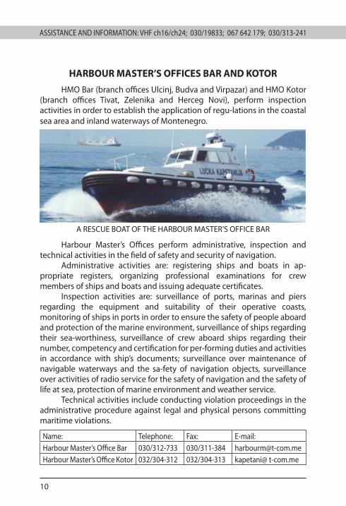
HARBOUR MASTER’S OFFICES BAR AND KOTOR
HMO Bar (branch offices Ulcinj, Budva and Virpazar) and HMO Kotor (branch offices Tivat, Zelenika and Herceg Novi), perform inspection activities in order to establish the application of regu-lations in the coastal sea area and inland waterways of Montenegro.
A RESCUE BOAT OF THE HARBOUR MASTER’S OFFICE BAR
Harbour Master’s Offices perform administrative, inspection and technical activities in the field of safety and security of navigation.
Administrative activities are: registering ships and boats in ap-propriate registers, organizing professional examinations for crew members of ships and boats and issuing adequate certificates.
Inspection activities are: surveillance of ports, marinas and piers regarding the equipment and suitability of their operative coasts, monitoring of ships in ports in order to ensure the safety of people aboard and protection of the marine environment, surveillance of ships regarding their sea-worthiness, surveillance of crew aboard ships regarding their number, competency and certification for per-forming duties and activities in accordance with ship’s documents; surveillance over maintenance of navigable waterways and the sa-fety of navigation objects, surveillance over activities of radio service for the safety of navigation and the safety of life at sea, protection of marine environment and weather service.
Technical activities include conducting violation proceedings in the administrative procedure against legal and physical persons committing maritime violations.
Name: Telephone: Fax: E-mail:Harbour Master’s Office Bar 030/312-733 030/311-384 [email protected] Master’s Office Kotor 032/304-312 032/304-313 kapetani@ t-com.me
ASSISTANCE AND INFORMATION: VHF ch16/ch24; 030/19833; 067 642 179; 030/313-241 ASSISTANCE AND INFORMATION: VHF ch16/ch24; 030/19833; 067 642 179; 030/313-241
11
MARITIME BORDER POLICE
Maritime Border Police, as a branch of the State Border Sector, a part of the Police Administration, is a specialized, organized, trained and equipped unit for the activities regarding safety and security on water and coastal sea area.
The Maritime Border Police consists of 3 Maritime Border Police divisions: Podgorica, Herceg Novi and Bar. Within the framework of the Maritime Border Police divisions there are Vessel Units which are basic and independent operational units of the Border State Police, equipped for all activities and tasks for safety and security on water and coastal sea area. These Vessel Units of the Maritime Border Police are: Podgorica (Virpazar and Božaj), Herceg Novi, Kotor, Budva, Bar and Ulcinj.
Members of the Maritime Border Police perform the following activities and tasks connected with the safety on water: control of the state border on water and coastal sea area; security of Monte-negro; safety of life, personal and property safety of citizens; prevention of criminal acts and violations; detection and appre-hension of perpetrators of criminal acts and violations and their consequent transfer to competent authority; security connected activities etc.
The basic task of the Maritime Border Police is performing acti-vities and tasks of control of the State Border on water and coastal sea area, the length of which on the Adriatic Sea is 148 km, on Ska-dar Lake 38 km and on Bojana river 28 km.
At the moment, the Maritime Border Police disposes of 2 patrol boats and 19 patrol vessels, which are on immediate and constant duty (24 hours) for all specific tasks.
Also, the Maritime Border Police performs multisensory moni-toring of aquatorium of Adriatic Sea, Skadar Lake and river Bojana, which includes all types of monitoring (radar, visual, electronic, sound, etc.).
Contact telephones of the Operational Centre of the MBP:
Name: Telephone: Mobile:
Operational Centre of MBP 020/202-851 063 284 716
ASSISTANCE AND INFORMATION: VHF ch16/ch24; 030/19833; 067 642 179; 030/313-241
12
ASSISTANCE AND INFORMATION: VHF ch16/ch24; 030/19833; 067 642 179; 030/313-241
REGIONAL CENTER FOR DIVERS TRAINING IN UNDERWATER EOD
Bijela, Herceg Novi - MONTENEGRO
UNDERWATER ACTIVITIES - DIVING
Underwater activities imply activities during which a person is below the surface of the water, with or without diving equipment, technical aids or apparatus controlled from the surface or auto-matically.
You can go diving if the Regional Center for Underwater De-mining and Diving Training has issued you with the Diving Identi-fication Card.
This card is valid for the period of one year, and it is issued only to those individuals holding certificates of diving training, issued by an international diving school, recognized by the Regional Center.
Underwater activities are organized by diving centers, clubs and other legal persons which have the permit for performing these activities, issued by the Regional Center.
The diving area has to be visibly marked. The marking is done by placing a signal buoy in the center of the diving area, of orange or red color, of at least 30 cm in diameter or by the diving flag (orange triangular flag with a diagonal white stripe) or by the International Code of Signals flag “A” or by putting the diving flag high on the vessel from which the divers go under water.
Contact telephones of the Regional Center:
Name: Contact numbers:
Regional Center for Underwater De-mining and Diving Training - Bijela
031/683-477 031/683-375
E-mail: [email protected]: www.rcud.co.me
ASSISTANCE AND INFORMATION: VHF ch16/ch24; 030/19833; 067 642 179; 030/313-241 ASSISTANCE AND INFORMATION: VHF ch16/ch24; 030/19833; 067 642 179; 030/313-241
13
IMPORTANT TELEPHONE NUMBERS:Name: Telephone: Mobile:Maritime Safety Department 030/313-241 067 642 179
Maritime Rescue Coordination Center (MRCC BAR)
030/19833 067 642 179
Coast radio station ‘’BARRADIO’’ 030/313-088 067 642 179
Harbour Master’s Office Bar 030/312-733 069 290 274
Harbour Master’s Office Kotor 032/304-312 069 681 504
Operational Center of the Navy of MNE - Bar 030/440-122 067 222 588
Police 122
Fire Department 123
Emergency/Ambulance 124
General informations 1181
NAVIGABLE UNIT HERCEG NOVI AND KOTOR 031/678-008
Duty officer of the Navigable unit of Herceg Novi and Kotor
063 284 773
Head of the Navigable unit of Herceg Novi and Kotor
063 284 714
NAVIGABLE UNIT BAR, BUDVA AND UCINJ 030/312-156
Duty officer of the Navigable unit of Bar, Budva and Ulcinj
063 285 280
Head of the Navigable unit of Bar, Budva and Ulcinj
063 284 716
Head of Maritime police 063 285 277
Harbour Master’s Branch Office Ulcinj 030/421-780 069 290 258
Harbour Master’s Branch Office Budva 033/451-227 069 290 257
Harbour Master’s Branch Office Virpazar 020/711-126 069 290 274
Harbour Master’s Branch Office Tivat 032/671-262 069 040 063
Harbour Master’s Branch Office Zelenika 031/678-276 069 086 220
Harbour Master’s Branch Office Herceg Novi 031/678-276 069 086 220
Tourist Organisation of Ulcinj 030/412-206
Tourist Organisation of Bar 030/311-633
Tourist Organisation of Budva 033/402-814
Tourist Organisation of Kotor 032/325-947
Tourist Organisation of Kotor 032/671-324
Tourist Organisation of Herceg Novi 031/350-820
ASSISTANCE AND INFORMATION: VHF ch16/ch24; 030/19833; 067 642 179; 030/313-241
14
ASSISTANCE AND INFORMATION: VHF ch16/ch24; 030/19833; 067 642 179; 030/313-241
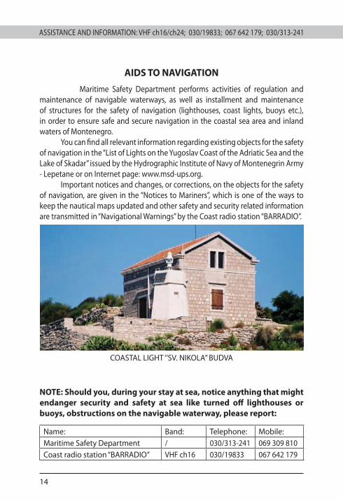
AIDS TO NAVIGATION
Maritime Safety Department performs activities of regulation and maintenance of navigable waterways, as well as installment and maintenance of structures for the safety of navigation (lighthouses, coast lights, buoys etc.), in order to ensure safe and secure navigation in the coastal sea area and inland waters of Montenegro.
You can find all relevant information regarding existing objects for the safety of navigation in the “List of Lights on the Yugoslav Coast of the Adriatic Sea and the Lake of Skadar” issued by the Hydrographic Institute of Navy of Montenegrin Army - Lepetane or on Internet page: www.msd-ups.org.
Important notices and changes, or corrections, on the objects for the safety of navigation, are given in the “Notices to Mariners”, which is one of the ways to keep the nautical maps updated and other safety and security related information are transmitted in “Navigational Warnings” by the Coast radio station “BARRADIO”.
COASTAL LIGHT ‘’SV. NIKOLA’’ BUDVA
NOTE: Should you, during your stay at sea, notice anything that might endanger security and safety at sea like turned off lighthouses or buoys, obstructions on the navigable waterway, please report:
Name: Band: Telephone: Mobile:Maritime Safety Department / 030/313-241 069 309 810Coast radio station “BARRADIO“ VHF ch16 030/19833 067 642 179
ASSISTANCE AND INFORMATION: VHF ch16/ch24; 030/19833; 067 642 179; 030/313-241 ASSISTANCE AND INFORMATION: VHF ch16/ch24; 030/19833; 067 642 179; 030/313-241
15
COAST RADIO STATION “BARRADIO” – 4OB
Maritime Safety Department performs activities of radio service, for the safety of life at sea and the safety of navigation, through the Coast radio station “BARRADIO”.
Basic activity of the Coast radio station is keeping watch on international distress and safety frequencies (VHF ch16, VHF DSC ch70, MF 2182 kHz and MF DSC 2187,5 kHz), which is performed around the clock, seven days of the week.
As a part of its activities, the Coast radio station “BARRADIO” also performs following services:
- radio service for the safety of navigation on VHF and MF band;
- transmission of navigational warnings(VHF ch16/24);
- reception of messages for medical assistance (VHF ch16);
- commercial radio service (VHF ch24/ch20 and MF 1720.4 kHz);
- transmission of weather bulletins (VHF ch24);
- monitoring of ships with dangerous cargo (VHF ch12) - ADRIATIC TRAFFIC;
- reception and forwarding of messages for automatic alert for ships in case of a terorist attack (SSAS), in accordance with the ISPS Code;
Besides knowing the contact number 030/19833, use of radio station and GMDSS transmission, you also need to be familiar with other ways you can contact the Coast radio station “BARRADIO”:
Name: Telephone: Fax: Mobile: E-mail:
“BARRADIO“ 030/313-088 030/313-600 067 642 179 [email protected]
As a part of their daily activities, operators on the Coast radio sta-tion “BARRADIO” also perform monitoring over the sea belt of Montenegro. Your every call will be answered and you will be given information and in-structions you need regarding navigation itself or sea condition, and any-thing regarding security and safety at sea.
ASSISTANCE AND INFORMATION: VHF ch16/ch24; 030/19833; 067 642 179; 030/313-241
16
ASSISTANCE AND INFORMATION: VHF ch16/ch24; 030/19833; 067 642 179; 030/313-241
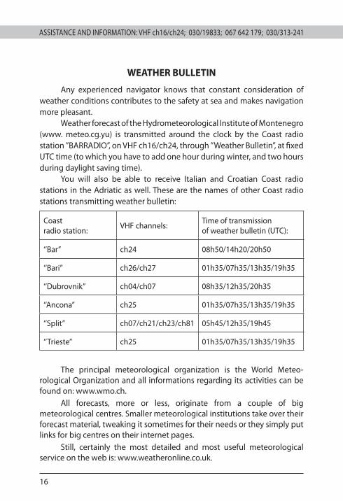
WEATHER BULLETIN
Any experienced navigator knows that constant consideration of weather conditions contributes to the safety at sea and makes navigation more pleasant.
Weather forecast of the Hydrometeorological Institute of Montenegro (www. meteo.cg.yu) is transmitted around the clock by the Coast radio station ”BARRADIO”, on VHF ch16/ch24, through ’’Weather Bulletin’’, at fixed UTC time (to which you have to add one hour during winter, and two hours during daylight saving time).
You will also be able to receive Italian and Croatian Coast radio stations in the Adriatic as well. These are the names of other Coast radio stations transmitting weather bulletin:
Coast radio station:
VHF channels:Time of transmission of weather bulletin (UTC):
‘’Bar’’ ch24 08h50/14h20/20h50
‘’Bari’’ ch26/ch27 01h35/07h35/13h35/19h35
‘’Dubrovnik’’ ch04/ch07 08h35/12h35/20h35
‘’Ancona’’ ch25 01h35/07h35/13h35/19h35
‘’Split’’ ch07/ch21/ch23/ch81 05h45/12h35/19h45
‘’Trieste’’ ch25 01h35/07h35/13h35/19h35
The principal meteorological organization is the World Meteo-rological Organization and all informations regarding its activities can be found on: www.wmo.ch.
All forecasts, more or less, originate from a couple of big meteorological centres. Smaller meteorological institutions take over their forecast material, tweaking it sometimes for their needs or they simply put links for big centres on their internet pages.
Still, certainly the most detailed and most useful meteorological service on the web is: www.weatheronline.co.uk.
ASSISTANCE AND INFORMATION: VHF ch16/ch24; 030/19833; 067 642 179; 030/313-241 ASSISTANCE AND INFORMATION: VHF ch16/ch24; 030/19833; 067 642 179; 030/313-241
17
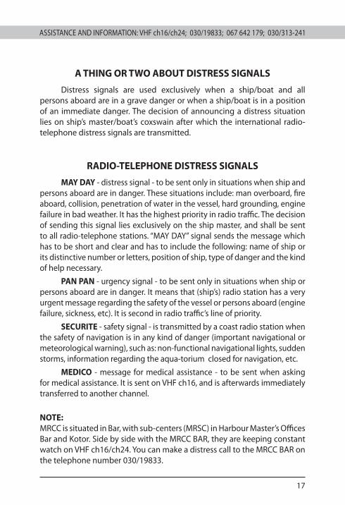
A THING OR TWO ABOUT DISTRESS SIGNALS
Distress signals are used exclusively when a ship/boat and all persons aboard are in a grave danger or when a ship/boat is in a position of an immediate danger. The decision of announcing a distress situation lies on ship’s master/boat’s coxswain after which the international radio-telephone distress signals are transmitted.
RADIO-TELEPHONE DISTRESS SIGNALS
MAY DAY - distress signal - to be sent only in situations when ship and persons aboard are in danger. These situations include: man overboard, fire aboard, collision, penetration of water in the vessel, hard grounding, engine failure in bad weather. It has the highest priority in radio traffic. The decision of sending this signal lies exclusively on the ship master, and shall be sent to all radio-telephone stations. “MAY DAY” signal sends the message which has to be short and clear and has to include the following: name of ship or its distinctive number or letters, position of ship, type of danger and the kind of help necessary.
PAN PAN - urgency signal - to be sent only in situations when ship or persons aboard are in danger. It means that (ship’s) radio station has a very urgent message regarding the safety of the vessel or persons aboard (engine failure, sickness, etc). It is second in radio traffic’s line of priority.
SECURITE - safety signal - is transmitted by a coast radio station when the safety of navigation is in any kind of danger (important navigational or meteorological warning), such as: non-functional navigational lights, sudden storms, information regarding the aqua-torium closed for navigation, etc.
MEDICO - message for medical assistance - to be sent when asking for medical assistance. It is sent on VHF ch16, and is afterwards immediately transferred to another channel.
NOTE: MRCC is situated in Bar, with sub-centers (MRSC) in Harbour Master’s Offices Bar and Kotor. Side by side with the MRCC BAR, they are keeping constant watch on VHF ch16/ch24. You can make a distress call to the MRCC BAR on the telephone number 030/19833.
ASSISTANCE AND INFORMATION: VHF ch16/ch24; 030/19833; 067 642 179; 030/313-241
18
ASSISTANCE AND INFORMATION: VHF ch16/ch24; 030/19833; 067 642 179; 030/313-241
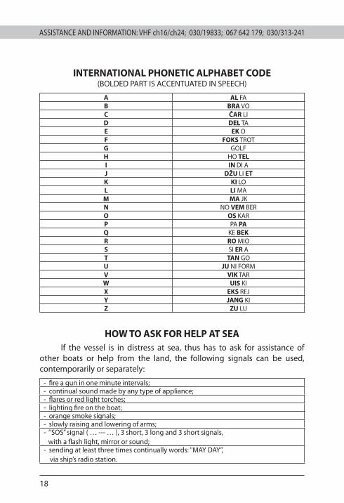
INTERNATIONAL PHONETIC ALPHABET CODE(BOLDED PART IS ACCENTUATED IN SPEECH)
A AL FAB BRA VOC ČAR LID DEL TAE EK OF FOKS TROTG GOLFH HO TELI IN DI AJ DŽU LI ETK KI LOL LI MAM MA JKN NO VEM BERO OS KARP PA PAQ KE BEKR RO MIOS SI ER AT TAN GOU JU NI FORMV VIK TARW UIS KIX EKS REJY JANG KIZ ZU LU
HOW TO ASK FOR HELP AT SEAIf the vessel is in distress at sea, thus has to ask for assistance of
other boats or help from the land, the following signals can be used, contemporarily or separately:
- fire a gun in one minute intervals;- continual sound made by any type of appliance;- flares or red light torches;- lighting fire on the boat;- orange smoke signals;- slowly raising and lowering of arms;- ‘’SOS’’ signal ( … --- … ), 3 short, 3 long and 3 short signals, with a flash light, mirror or sound;- sending at least three times continually words: ‘’MAY DAY’’, via ship’s radio station.
ASSISTANCE AND INFORMATION: VHF ch16/ch24; 030/19833; 067 642 179; 030/313-241 ASSISTANCE AND INFORMATION: VHF ch16/ch24; 030/19833; 067 642 179; 030/313-241
19
WINDS ON THE MONTENEGRIN COAST
Modern navigator needs to have basic knowledge of the weather, in order to be able to, from the weather bulletin given via media and local indicators, draw a picture of the development of weather conditions for the area of navigation.
In the South Adriatic region there are 8 types of winds whose directions of blowing are following: Tramontana from north (N), Bura from northeast (NE), Levant from east (E), Jugo–Široko from south-east (SE), Jugo–Oštro from south (S), Lebić from southwest (SW), Pulenat from west (W) and Mistral from northwest (NW).
Tramontana is a type of bura blowing mainly from north (N). It is a local, cold, dry and short-lived (1 day) wind. It is followed by clear skies and high air pressure.
Bura is a dry, usually strong and cold squally wind blowing from NNE to ENE along the coast, during the whole year, but more frequently during winter months. Bura can be cyclonic and, in this case more often, anticyclonic (followed by a high air pressure). Bura is more often during winter. It gains hurricane power at the end of October, in December, January and March. During summer it lasts usually one day and sometimes even just several hours. In winter, it can sometimes last for 14 days, with occasional breaks.
Levant is a type of Bura, blowing from east. It is short-lived, steady and moderately strong. It is a transitional wind when Jugo becomes Bura or vice versa. In winter, it is followed by rain and moderately cold weather.
Jugo is a warm, moist wind of moderate speed and steady direction. It mostly blows from SE (Jugo-Široko) to S (Jugo-Oštro). It can create very high waves and usually brings rain. In the South Adriatic, Jugo is stronger and more frequent than in the North Adriatic, during all seasons, especially from March to June (in the North Adriatic) and from autumn to the end of winter (in the South Adriatic). During summer, it usually lasts up to 3 days; during winter to 9 days and sometimes, with breaks, it can last up to 21 days.
Lebić is a wind blowing mainly from SSW to WSW. It is especially strong during winter months; it creates high waves and it is followed by heavy rain and poor visibility. It usually blows one to two days, and in the summer only for few hours.
Pulenat blows from west (W). It blows rarely and comes sud-denly. It is a short-lived, cold and dangerous wind.

ASSISTANCE AND INFORMATION: VHF ch16/ch24; 030/19833; 067 642 179; 030/313-241
20
ASSISTANCE AND INFORMATION: VHF ch16/ch24; 030/19833; 067 642 179; 030/313-241
Mistral blows from NW. Mistral is a pleasant and refreshing wind of even and soft to moderate strength. It is followed by nice and steady weather. It starts blowing around 9am or 10am as a soft breeze, and reaches its peak around 2 pm; it usually ends before sunset. From the morning towards the afternoon it changes the direction to the right, or, to put it simply, it follows the sun; it starts as a southeast wind and, going southwest, it turns to northwest.
WIND ROSE
Beside local winds on the Adriatic, there is also local and short-lived bad weather called nevera or neverin, which is a type of sudden storm. Nevera can happen in all seasons, but it is more frequent in the summer. Nevera’s features are strong wind gusts, heavy rain, lightning and thunder as well as a temperature drop.
SIGNS OF WEATHER AGGRAVATION
- wreath around the Sun or the Moon, with accompanying damp wind;- pale Moon and a wreath (ring) around it;- exceptionally high tides;- no Mistral wind;- red skies or rainbow early in the morning;- winter Mistral is announcing wind and rain;- strong wind in the morning with clear skies;- Bura turning to E and especially to SE, with clear skies;- grey wall of clouds in the west, especially in the evening;- pale yellow Sun before setting;- drop of air pressure;- constant low pressure during bad weather means the condition will last.
ASSISTANCE AND INFORMATION: VHF ch16/ch24; 030/19833; 067 642 179; 030/313-241 ASSISTANCE AND INFORMATION: VHF ch16/ch24; 030/19833; 067 642 179; 030/313-241
21
PROTECTION OF SEA AGAINST POLLUTION FROM SHIPS
In the world today there is a grave danger of environment pollution caused by harmful substances. The vision of ecological disaster asks for organized undertakings for the environment protection, both in international and national and local frameworks. Especially, world seas need to be protected against pollution since they represent a significant source of human life and survival. Of the total amount of water on the planet 97% is salt water, meaning seas and oceans, and 3% is fresh water.
The sources of pollution can vary and can come from land, air, damages of marine and land oil pipelines; can be caused by exploration and exploitation of sea resources (primarily oil), dumping of harmful substances from ships, etc. Nevertheless, a significant amount of pollution is caused by ships. Wrecks, resulting in ecological disasters, such as wrecks of “Torrey Canyon”, “Amoco Cadiz” and “Exon Valdez” should not be forgotten.
-
Sea pollution can be physical, chemical and biological:
PHYSICAL POLLUTION: caused by discharge of water of high temperature from ship’s facilities. This water causes the increase of sea temperature, which results in speeding up of biochemical reactions with the increased use of oxygen. The lack of oxygen and the generated amount of substance form reactions disrupt the metabolism and physiological balance of aquatic organisms, thus creating the conditions for the development of microorganisms and viruses.
CHEMICAL POLLUTION: caused by discharge of oil, waste oil, oily waste, harmful substances, sewage and garbage from ships.
BIOLOGICAL POLLUTION: caused by spreading about of bacteria, viruses and insects from ships, which are often the cause of water-related diseases and even epidemics.
ASSISTANCE AND INFORMATION: VHF ch16/ch24; 030/19833; 067 642 179; 030/313-241
22
ASSISTANCE AND INFORMATION: VHF ch16/ch24; 030/19833; 067 642 179; 030/313-241
EXTRACT FORM REGULATIONS FOR THE PROTECTION OF SEA AGAINST POLLUTION FROM SHIPS
It is forbidden to discharge from ships into sea:
- oil, sludge, waste oil, oily mixtures, oily waste, bilge water and ballast waters;
- harmful liquid substances in bulk;- harmful substances in package form;- sewage and garbage.
Exceptionally, these provisions shall not apply:
- if discharge is performed for the safety of life or security of ship;- if discharge is the result of damage of ship or has occurred for other
similar reasons, with all necessary measures for the prevention of discharge previously taken.
EXTRACT FROM REGULATIONS FOR THE PROTECTION OF SEA AGAINST POLLUTION FROM BOATS
It is forbidden to discharge from boats into sea:
- oil, waste oil, oily mixtures, oily waste, bilge water and ballast waters.
Boat owners shall keep the waste in boat tanks or other receptacles for waste and discharge it in appropriate facilities for the reception and handling of hard and liquid waste in the marinas.
NOTE: Should you notice any occurences regarding sea pollution, please report these to one of the following institutions:
Name: VHF: Telephone: Mobile:
Maritime Safety Department / 030/313-240 069 632 930
Coast radio station ‘’BARRADIO’’ VHF ch16/24 030/19833 067 642 179
Harbour Master’s Office Bar VHF ch16/12 030/312-733 069 290 274
Harbour Master’s Office Kotor VHF ch16/12 032/304-312 069 681 504
ASSISTANCE AND INFORMATION: VHF ch16/ch24; 030/19833; 067 642 179; 030/313-241 ASSISTANCE AND INFORMATION: VHF ch16/ch24; 030/19833; 067 642 179; 030/313-241
23
COASTAL SEA SAILING
Vessels, while sailing in the coastal sea area of Montenegro, are not allowed to come near the coast, in accordance with the following:
- Vessels employed in the public transportation at sea at a distance less than 300 meters;
- Vessels for sport and pleasure and yachts at a distance less than 200 meters;
- Motor and sailing boats at a distance less than 150 meters;
- Boats using oars at a distance less than 50 meters;
- All boats must navigate in the water area beside bathing places at a distance greater than 50 meters from the line of the arranged or built bathing place, or 150 meters from the coast of the natural bathing place;
- Gliders are allowed to glide only at a distance greater than 200 meters from the coast and in the area where gliding is not prohibited;
- Jet boats (scooters, jet-ski, etc.) are allowed to glide only in the area where these activities are allowed, not closer than 300 meters from the coast, as designated by the authorized Harbour Master’s Office; jet boats can pass to the area where gliding is allowed only through the designated sea passages as slowly as possible.
NOTE: Swimming outside the designated water area of the arranged or built bathing place, and at a distance greater than 100 meters from the coast of the natural bathing place, is strictly prohibited.
ASSISTANCE AND INFORMATION: VHF ch16/ch24; 030/19833; 067 642 179; 030/313-241
24
ASSISTANCE AND INFORMATION: VHF ch16/ch24; 030/19833; 067 642 179; 030/313-241
REGISTER OF YACHTS
The procedure for registration, maintenance of records and deleting of data from the Register of Yachts is assigned to Maritime Safety Department, in accordance with the Law on Yachts (’’Official Gazzete of Montenegro’’, No. 46/07).
DOCUMENTATION NECESSARY FOR REGISTRATIONFor a yacht registration the following documents are submitted:
- Application for registration with the proposed name of the yacht;- Endorsed copy of identification document for person or a copy of
document of registration of a legal person owning the yacht;- Ownership certificate, statement of intended use and appropriate
authorization when the person submitting the application for registration of a yacht is not the owner, co-owner or charterer;
- Confirmation of regulated mandatory insurance at the amount not less than 800.000 EUR;
- Request for issuance of a Radio Licence;- Decision for deletion of a yacht from an earlier Register or, in the
case of the first registration, Certificate of Built;- Endorsed copy of a purchase agreement or, in the case of the first
registration, builder’s document with owner’s name recorded;- International Tonnage Certificate or Builder’s Certificate
with technical characteristics, includung data on tonnage measurement.
FEES FOR REGISTRATION, RENEWAL AND ERASING OF REGISTRATIONFor registration and renewal of Registration Certificate:
LENGHT OF A YACHT AMOUNT IN EUROS7 to 12 meters 350,00 EUR12 to 17 meters 500,00 EUR17 to 24 meters 800,00 EURover 24 meters 1.200,00 EUR
The fee for erasing a yacht from the Register is 150 EUR.
CONTACT TELEPHONES
Name: Telephone: Fax: Mobile:
Register of Yachts 030/303-808 030/303-809 069 309 779
ASSISTANCE AND INFORMATION: VHF ch16/ch24; 030/19833; 067 642 179; 030/313-241 ASSISTANCE AND INFORMATION: VHF ch16/ch24; 030/19833; 067 642 179; 030/313-241
25
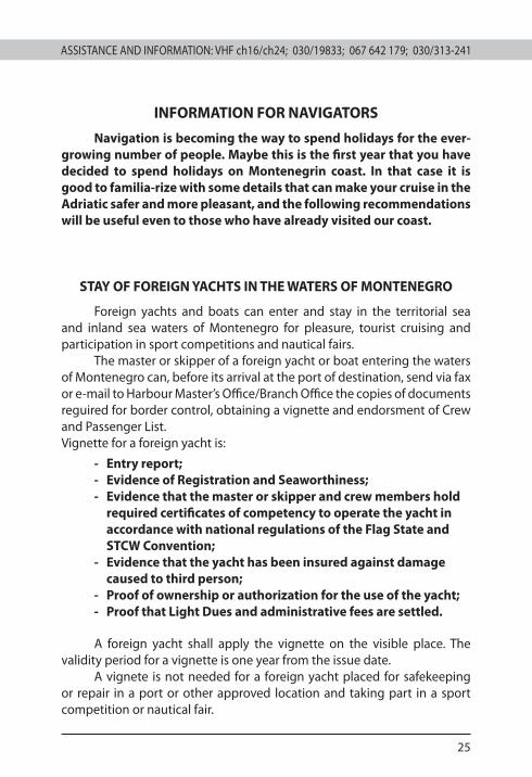
INFORMATION FOR NAVIGATORS
Navigation is becoming the way to spend holidays for the ever-growing number of people. Maybe this is the first year that you have decided to spend holidays on Montenegrin coast. In that case it is good to familia-rize with some details that can make your cruise in the Adriatic safer and more pleasant, and the following recommendations will be useful even to those who have already visited our coast.
STAY OF FOREIGN YACHTS IN THE WATERS OF MONTENEGRO
Foreign yachts and boats can enter and stay in the territorial sea and inland sea waters of Montenegro for pleasure, tourist cruising and participation in sport competitions and nautical fairs.
The master or skipper of a foreign yacht or boat entering the waters of Montenegro can, before its arrival at the port of destination, send via fax or e-mail to Harbour Master’s Office/Branch Office the copies of documents reguired for border control, obtaining a vignette and endorsment of Crew and Passenger List.Vignette for a foreign yacht is:
- Entry report;- Evidence of Registration and Seaworthiness;- Evidence that the master or skipper and crew members hold
required certificates of competency to operate the yacht in accordance with national regulations of the Flag State and STCW Convention;
- Evidence that the yacht has been insured against damage caused to third person;
- Proof of ownership or authorization for the use of the yacht;- Proof that Light Dues and administrative fees are settled.
A foreign yacht shall apply the vignette on the visible place. The validity period for a vignette is one year from the issue date.
A vignete is not needed for a foreign yacht placed for safekeeping or repair in a port or other approved location and taking part in a sport competition or nautical fair.
ASSISTANCE AND INFORMATION: VHF ch16/ch24; 030/19833; 067 642 179; 030/313-241
26
ASSISTANCE AND INFORMATION: VHF ch16/ch24; 030/19833; 067 642 179; 030/313-241
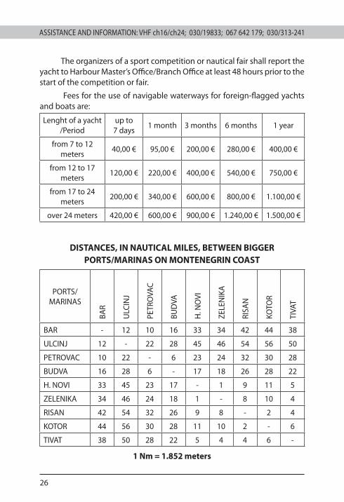
The organizers of a sport competition or nautical fair shall report the yacht to Harbour Master’s Office/Branch Office at least 48 hours prior to the start of the competition or fair.
Fees for the use of navigable waterways for foreign-flagged yachts and boats are:
Lenght of a yacht /Period
up to 7 days
1 month 3 months 6 months 1 year
from 7 to 12 meters
40,00 € 95,00 € 200,00 € 280,00 € 400,00 €
from 12 to 17 meters
120,00 € 220,00 € 400,00 € 540,00 € 750,00 €
from 17 to 24 meters
200,00 € 340,00 € 600,00 € 800,00 € 1.100,00 €
over 24 meters 420,00 € 600,00 € 900,00 € 1.240,00 € 1.500,00 €
DISTANCES, IN NAUTICAL MILES, BETWEEN BIGGER PORTS/MARINAS ON MONTENEGRIN COAST
PORTS/MARINAS
BAR
ULC
INJ
PETR
OVA
C
BUD
VA
H. N
OVI
ZELE
NIK
A
RISA
N
KOTO
R
TIVA
T
BAR - 12 10 16 33 34 42 44 38
ULCINJ 12 - 22 28 45 46 54 56 50
PETROVAC 10 22 - 6 23 24 32 30 28
BUDVA 16 28 6 - 17 18 26 28 22
H. NOVI 33 45 23 17 - 1 9 11 5
ZELENIKA 34 46 24 18 1 - 8 10 4
RISAN 42 54 32 26 9 8 - 2 4
KOTOR 44 56 30 28 11 10 2 - 6
TIVAT 38 50 28 22 5 4 4 6 -
1 Nm = 1.852 meters
ASSISTANCE AND INFORMATION: VHF ch16/ch24; 030/19833; 067 642 179; 030/313-241 ASSISTANCE AND INFORMATION: VHF ch16/ch24; 030/19833; 067 642 179; 030/313-241
27
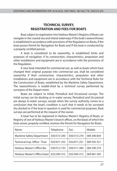
TECHNICAL SURVEY, REGISTRATION AND FEES FOR BOATS
Boat subject to registration into Harbour Master’s Registry of Boats can navigate in the coastal sea and inland waterways if the boat’s seaworthiness is established in accordance with provisions of the Regulation on Boats, if the boat posses Permit for Navigation for Boats and if the boat is conducted by a properly certified person.
A boat is considered to be seaworthy, in established limits and purposes of navigation, if its construction, characteristics, propulsion and other installations and equipment are in accordance with the provisions of the Regulation.
A new boat intended for commercial use, as well as boats which have changed their original purpose into commercial use, shall be considered seaworthy if their construction, characteristics, propulsion and other installations and equipment are in accordance with the Technical Rules for the Construction of Boats, established by the Maritime Safety Department. The seaworthiness is establi-shed by a technical survey performed by surveyors of the Depart-ment.
Boats are subject to Initial, Periodical and Occasional surveys. The Initial survey can be docking or in-water survey; Periodical and Occasional are always in-water surveys, except when the survey authority comes to a conclusion that the boat’s condition is such that it needs to be surveyed dry-docked or if the boat in question is used for commercial purposes. Boat surveys are performed at the request of the owner.
A boat has to be registered in Harbour Master’s Registry of Boats, or Registry of one of Harbour Master’s branch offices, on the bases of which the boat owner, properly certified, receives the Permit for Navigation for Boats.
Name: Telephone: Fax: Mobile:
Maritime Safety Department 030/313-240 030/313-274 069 296 834
Technical Insp. Office - Tivat 032/671-252 032/671-251 069 505 521
Harbour Master’s Office Bar 030/312-733 030/311-384 069 290 274
Harbour Master’s Office Kotor 032/304-312 032/304-313 069 681 504
ASSISTANCE AND INFORMATION: VHF ch16/ch24; 030/19833; 067 642 179; 030/313-241
28
ASSISTANCE AND INFORMATION: VHF ch16/ch24; 030/19833; 067 642 179; 030/313-241
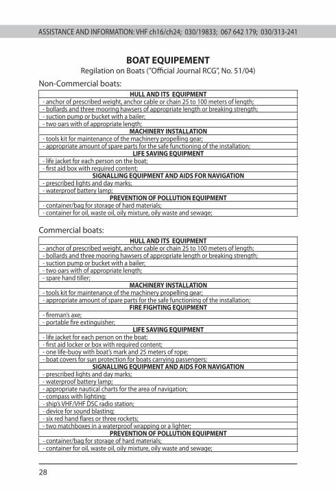
BOAT EQUIPEMENT Regilation on Boats (’’Official Journal RCG’’, No. 51/04)
Non-Commercial boats:HULL AND ITS EQUIPMENT
- anchor of prescribed weight, anchor cable or chain 25 to 100 meters of length;- bollards and three mooring hawsers of appropriate length or breaking strength; - suction pump or bucket with a bailer; - two oars with of appropriate length;
MACHINERY INSTALLATION- tools kit for maintenance of the machinery propelling gear;- appropriate amount of spare parts for the safe functioning of the installation;
LIFE SAVING EQUIPMENT- life jacket for each person on the boat;- first aid box with required content;
SIGNALLING EQUIPMENT AND AIDS FOR NAVIGATION- prescribed lights and day marks;- waterproof battery lamp;
PREVENTION OF POLLUTION EQUIPMENT - container/bag for storage of hard materials; - container for oil, waste oil, oily mixture, oily waste and sewage;
Commercial boats: HULL AND ITS EQUIPMENT
- anchor of prescribed weight, anchor cable or chain 25 to 100 meters of length;- bollards and three mooring hawsers of appropriate length or breaking strength; - suction pump or bucket with a bailer;- two oars with of appropriate length;- spare hand tiller;
MACHINERY INSTALLATION- tools kit for maintenance of the machinery propelling gear;- appropriate amount of spare parts for the safe functioning of the installation;
FIRE FIGHTING EQUIPMENT- fireman’s axe;- portable fire extinguisher;
LIFE SAVING EQUIPMENT- life jacket for each person on the boat;- first aid locker or box with required content;- one life-buoy with boat’s mark and 25 meters of rope;- boat covers for sun protection for boats carrying passengers;
SIGNALLING EQUIPMENT AND AIDS FOR NAVIGATION- prescribed lights and day marks;- waterproof battery lamp;- appropriate nautical charts for the area of navigation;- compass with lighting;- ship’s VHF/VHF DSC radio station;- device for sound blasting;- six red hand flares or three rockets; - two matchboxes in a waterproof wrapping or a lighter;
PREVENTION OF POLLUTION EQUIPMENT- container/bag for storage of hard materials; - container for oil, waste oil, oily mixture, oily waste and sewage;
ASSISTANCE AND INFORMATION: VHF ch16/ch24; 030/19833; 067 642 179; 030/313-241 ASSISTANCE AND INFORMATION: VHF ch16/ch24; 030/19833; 067 642 179; 030/313-241
29
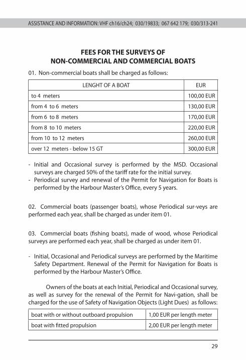
FEES FOR THE SURVEYS OF NON-COMMERCIAL AND COMMERCIAL BOATS
01. Non-commercial boats shall be charged as follows:
LENGHT OF A BOAT EUR
to 4 meters 100,00 EUR
from 4 to 6 meters 130,00 EUR
from 6 to 8 meters 170,00 EUR
from 8 to 10 meters 220,00 EUR
from 10 to 12 meters 260,00 EUR
over 12 meters - below 15 GT 300,00 EUR
- Initial and Occasional survey is performed by the MSD. Occasional surveys are charged 50% of the tariff rate for the initial survey.
- Periodical survey and renewal of the Permit for Navigation for Boats is performed by the Harbour Master’s Office, every 5 years.
02. Commercial boats (passenger boats), whose Periodical sur-veys are performed each year, shall be charged as under item 01.
03. Commercial boats (fishing boats), made of wood, whose Periodical surveys are performed each year, shall be charged as under item 01.
- Initial, Occasional and Periodical surveys are performed by the Maritime Safety Department. Renewal of the Permit for Navigation for Boats is performed by the Harbour Master’s Office.
Owners of the boats at each Initial, Periodical and Occasional survey, as well as survey for the renewal of the Permit for Navi-gation, shall be charged for the use of Safety of Navigation Objects (Light Dues) as follows:
boat with or without outboard propulsion 1,00 EUR per length meter
boat with fitted propulsion 2,00 EUR per length meter
ASSISTANCE AND INFORMATION: VHF ch16/ch24; 030/19833; 067 642 179; 030/313-241
30
ASSISTANCE AND INFORMATION: VHF ch16/ch24; 030/19833; 067 642 179; 030/313-241
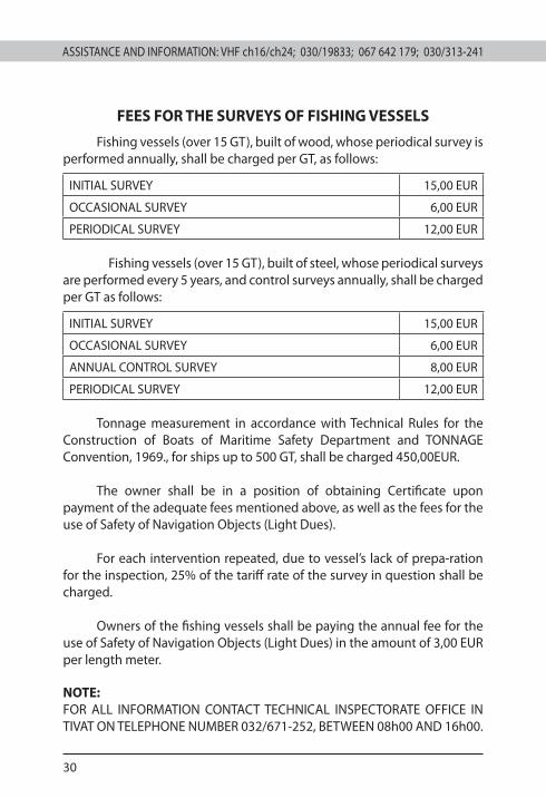
FEES FOR THE SURVEYS OF FISHING VESSELS
Fishing vessels (over 15 GT), built of wood, whose periodical survey is performed annually, shall be charged per GT, as follows:
INITIAL SURVEY 15,00 EUR
OCCASIONAL SURVEY 6,00 EUR
PERIODICAL SURVEY 12,00 EUR
Fishing vessels (over 15 GT), built of steel, whose periodical surveys are performed every 5 years, and control surveys annually, shall be charged per GT as follows:
INITIAL SURVEY 15,00 EUR
OCCASIONAL SURVEY 6,00 EUR
ANNUAL CONTROL SURVEY 8,00 EUR
PERIODICAL SURVEY 12,00 EUR
Tonnage measurement in accordance with Technical Rules for the Construction of Boats of Maritime Safety Department and TONNAGE Convention, 1969., for ships up to 500 GT, shall be charged 450,00EUR.
The owner shall be in a position of obtaining Certificate upon payment of the adequate fees mentioned above, as well as the fees for the use of Safety of Navigation Objects (Light Dues).
For each intervention repeated, due to vessel’s lack of prepa-ration for the inspection, 25% of the tariff rate of the survey in question shall be charged.
Owners of the fishing vessels shall be paying the annual fee for the use of Safety of Navigation Objects (Light Dues) in the amount of 3,00 EUR per length meter.
NOTE:FOR ALL INFORMATION CONTACT TECHNICAL INSPECTORATE OFFICE IN TIVAT ON TELEPHONE NUMBER 032/671-252, BETWEEN 08h00 AND 16h00.
ASSISTANCE AND INFORMATION: VHF ch16/ch24; 030/19833; 067 642 179; 030/313-241 ASSISTANCE AND INFORMATION: VHF ch16/ch24; 030/19833; 067 642 179; 030/313-241
31
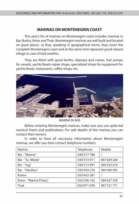
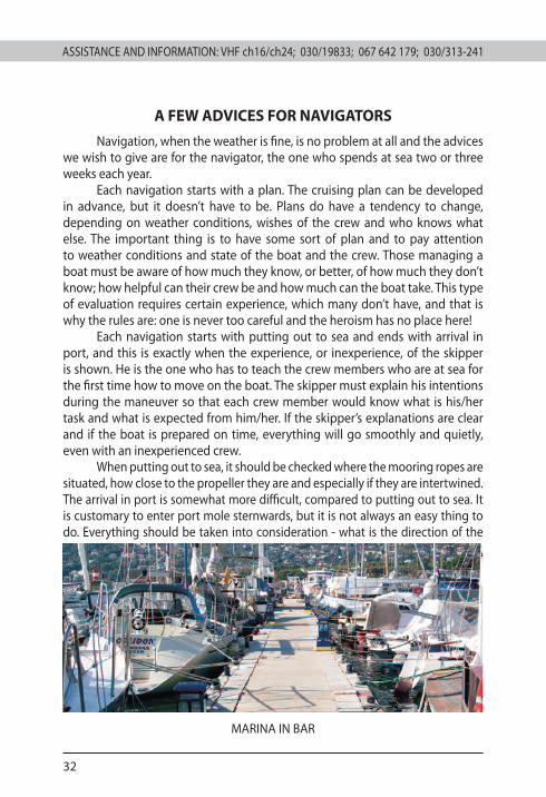
MARINAS ON MONTENEGRIN COAST
This year’s list of marinas on Montenegrin coast includes marinas in Bar, Budva, Kotor and Tivat. Montenegrin marinas are well built and located on great places, so that, speaking in geographical terms, they cover the complete Montenegrin coast and at the same time represent good natural refuge in case of bad weather.
They are fitted with good berths, slipways and cranes, fuel pumps for vessels, yachts/boats repair shops, specialized shops for equipment for yachts/boats, restaurants, coffee shops, etc.
MARINA IN BAR
Before entering Montenegrin marinas, make sure you use upda-ted nautical charts and publications. For safe depths of the marinas you can contact their owners.
In order to have all neccesary information about Montenegrin marinas, we offer you their contact telephone numbers:
Marina: Telephone: Mobile:
Bar - ‘’Marina’’ 030/317-786 /
Bar - ‘’Sv. Nikola’’ 030/313-911 067 829 260
Bar - ‘’Jug’’ 030/313-991 069 025 616
Bar - ‘’Nautilus’’ 030/303-276 069 469 092
Budva 033/452-281 /
Kotor - ‘’Marina Prčanj’’ 032/336-162 069 627 359
Tivat 032/671-039 067 521 771
ASSISTANCE AND INFORMATION: VHF ch16/ch24; 030/19833; 067 642 179; 030/313-241
32
ASSISTANCE AND INFORMATION: VHF ch16/ch24; 030/19833; 067 642 179; 030/313-241
A FEW ADVICES FOR NAVIGATORS
Navigation, when the weather is fine, is no problem at all and the advices we wish to give are for the navigator, the one who spends at sea two or three weeks each year.
Each navigation starts with a plan. The cruising plan can be developed in advance, but it doesn’t have to be. Plans do have a tendency to change, depending on weather conditions, wishes of the crew and who knows what else. The important thing is to have some sort of plan and to pay attention to weather conditions and state of the boat and the crew. Those managing a boat must be aware of how much they know, or better, of how much they don’t know; how helpful can their crew be and how much can the boat take. This type of evaluation requires certain experience, which many don’t have, and that is why the rules are: one is never too careful and the heroism has no place here!
Each navigation starts with putting out to sea and ends with arrival in port, and this is exactly when the experience, or inexperience, of the skipper is shown. He is the one who has to teach the crew members who are at sea for the first time how to move on the boat. The skipper must explain his intentions during the maneuver so that each crew member would know what is his/her task and what is expected from him/her. If the skipper’s explanations are clear and if the boat is prepared on time, everything will go smoothly and quietly, even with an inexperienced crew.
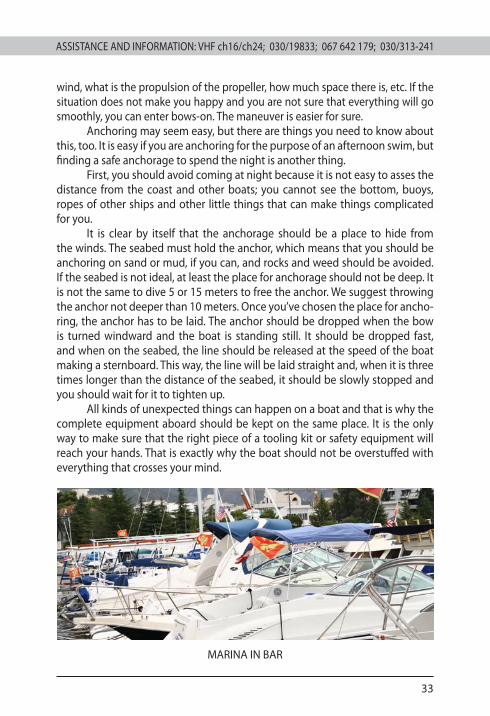
When putting out to sea, it should be checked where the mooring ropes are situated, how close to the propeller they are and especially if they are intertwined. The arrival in port is somewhat more difficult, compared to putting out to sea. It is customary to enter port mole sternwards, but it is not always an easy thing to do. Everything should be taken into consideration - what is the direction of the
MARINA IN BAR
ASSISTANCE AND INFORMATION: VHF ch16/ch24; 030/19833; 067 642 179; 030/313-241 ASSISTANCE AND INFORMATION: VHF ch16/ch24; 030/19833; 067 642 179; 030/313-241
33
wind, what is the propulsion of the propeller, how much space there is, etc. If the situation does not make you happy and you are not sure that everything will go smoothly, you can enter bows-on. The maneuver is easier for sure.
Anchoring may seem easy, but there are things you need to know about this, too. It is easy if you are anchoring for the purpose of an afternoon swim, but finding a safe anchorage to spend the night is another thing.
First, you should avoid coming at night because it is not easy to asses the distance from the coast and other boats; you cannot see the bottom, buoys, ropes of other ships and other little things that can make things complicated for you.
It is clear by itself that the anchorage should be a place to hide from the winds. The seabed must hold the anchor, which means that you should be anchoring on sand or mud, if you can, and rocks and weed should be avoided. If the seabed is not ideal, at least the place for anchorage should not be deep. It is not the same to dive 5 or 15 meters to free the anchor. We suggest throwing the anchor not deeper than 10 meters. Once you’ve chosen the place for ancho-ring, the anchor has to be laid. The anchor should be dropped when the bow is turned windward and the boat is standing still. It should be dropped fast, and when on the seabed, the line should be released at the speed of the boat making a sternboard. This way, the line will be laid straight and, when it is three times longer than the distance of the seabed, it should be slowly stopped and you should wait for it to tighten up.
All kinds of unexpected things can happen on a boat and that is why the complete equipment aboard should be kept on the same place. It is the only way to make sure that the right piece of a tooling kit or safety equipment will reach your hands. That is exactly why the boat should not be overstuffed with everything that crosses your mind.
MARINA IN BAR
www.pomorstvo.me