MODIS (Moderate Resolution Imaging Spectrometer)
19
01/18/2022 1 PREPARED BY: Uttam Pudasaini
-
Upload
uttam-pudasaini -
Category
Technology
-
view
392 -
download
0
description
This slide provides a detail overview of MODIS sensors and it also mentions about the MODIS receiving station at Nepal.
Transcript of MODIS (Moderate Resolution Imaging Spectrometer)

04/13/2023 1
PREPARED BY:Uttam Pudasaini

04/13/2023 2
TABLE OF CONTENTS
Background Introduction Launch Objectives Design Concepts Focal Plane Major Band Of MODIS Sensor MODIS PRODUCTS Receiving station of MODIS
Receiving station at ICIMOD ,NEPAL

04/13/2023 3
A SHORT HISTORY
1983 – NASA began to explore the concept of a polar-orbiting platform to complement a manned polar-orbiting space station
Beginning as System Z, gained momentum with NASA’s proposed “Global Habitability” program
After Challenger disaster, polar space station disappeared as did manned servicing requirement
System Z became EOS – Earth Observing System Several instrument suites were developed Surface Imaging and Sounding Package (SISP) included the Moderate
Resolution Imaging Spectrometer
MODIS soon split into 2 concepts MODIS-N focused primarily on land and atmosphere sensing but
included some ocean bands MODIS-T (tilting) focused on ocean
Due to budget constraints, MODIS-T vanished, replaced by MODIS-N

04/13/2023 4
INTRODUCTION
The Moderate Resolution Imaging Spectroradiometer
(MODIS), one of the key instruments for NASA’s Earth
Observing System (EOS), was built by Raytheon Santa
Barbara Remote Sensing (SBRS)
MODIS Proto Flight Model (PFM) was launched on board
Terra spacecraft on 12/18/99 (first light on 02/24/00). http://terra.nasa.gov
MODIS Flight Model 1 (FM1) on Aqua spacecraft was
launched on 05/04/02 (first light on 06/24/02) http://eos-pm.gsfc.nasa.gov
04/13/2023 5
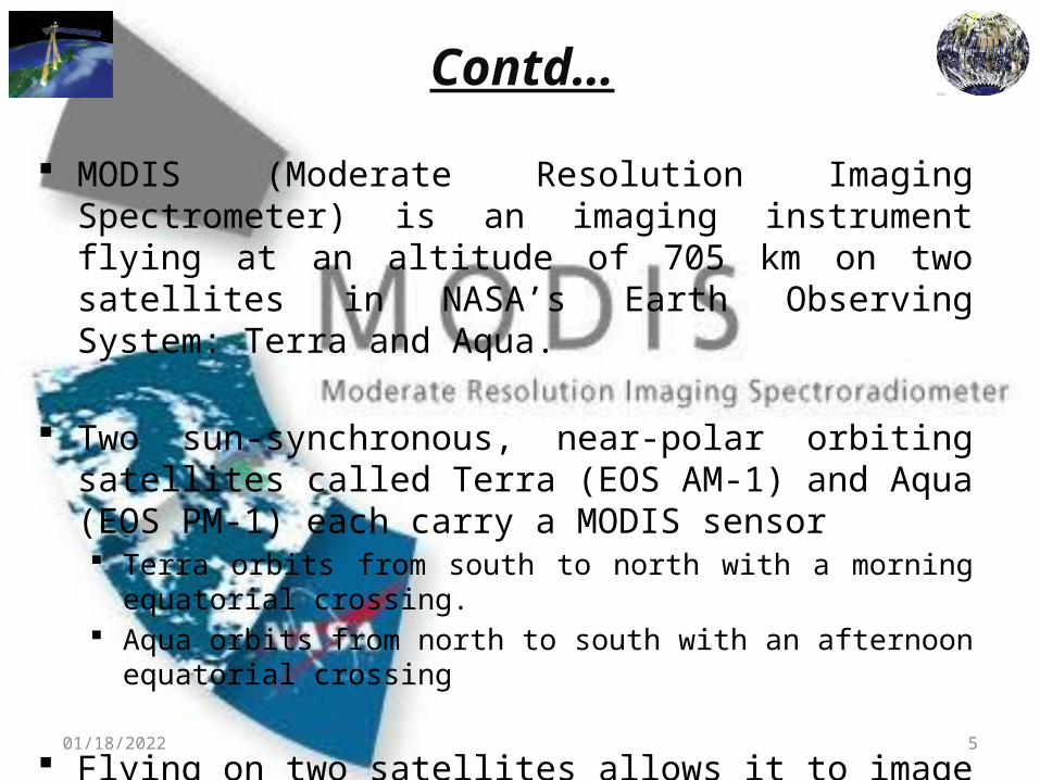
Contd…
MODIS (Moderate Resolution Imaging Spectrometer) is an imaging instrument flying at an altitude of 705 km on two satellites in NASA’s Earth Observing System: Terra and Aqua.
Two sun-synchronous, near-polar orbiting satellites called Terra (EOS AM-1) and Aqua (EOS PM-1) each carry a MODIS sensor Terra orbits from south to north with a morning equatorial crossing. Aqua orbits from north to south with an afternoon equatorial crossing
Flying on two satellites allows it to image the same area at different times of the day as well as cover the entire earth in one or two days.

04/13/2023 6
MODIS SCAN CAVITY AND OBCS

04/13/2023 7
LAUNCH OBJECTIVES
Unprecedented look at terrestrial, atmospheric, and ocean phenomenology for a wide and diverse community of users throughout the world.
To develop a valid global, interactive Earth system models able to predict global change accurately enough to assist policy makers in making sound decisions concerning the protection of our environment

04/13/2023 8

04/13/2023 9
DESIGN CONCEPTS The Scan Mirror Assembly uses a continuously rotating double-sided
scan mirror to scan ±55-degrees
The MODIS instrument consists of a cross-track scan mirror, collecting optics and individual detector elements.
The swath dimensions of MODIS are 2330km (across track) by 10km (along track at nadir).
The along track swath dimension is due to the optical set-up as well as the scanning mechanism of MODIS.
In contrast to other scanning sensors like e.g. AVHRR, MODIS is observing within one scan ten lines of 1km spatial resolution (40 lines of 250m resolution and 20 lines of 500m resolution, respectively).
04/13/2023 10
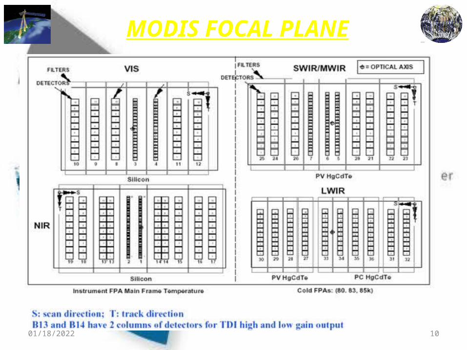
MODIS FOCAL PLANE

04/13/2023 11
Major Bands of MODIS Sensors MODIS reflectance products focuses on Red, Blue, NIR AND MIR
Red band highly related with plant growth- to calculate EVI(enhanced) AND NDVI
Blue band Shortest and nosiest band to monitor atmospheric dust and other
particles travelling across the globe Eliminating atmospheric noise on the calculation of vegetation indices The bands help monitor changes in vegetation ,soil and atmosphere
that can influence in calculation of ecosystem variables like vegetation indices
NIR to visualize land and water (land reflects it while water bodies almost absorb it all)
MIR band to determine cloud properties vegetation and soil moisture

04/13/2023 12

04/13/2023 13
Its coarse spatial resolution is designed to observe land, ocean, and atmospheric conditions at a regional and global scale.
The MODIS instrument provides high radiometric sensitivity (12 bit) in 36 spectral bands ranging in wavelength from 0.4 µm to 14.4 over a 2330 km swath.
20 Reflective Solar Bands (RSB): 0.4 - 2.2 microns
16 Thermal Emissive Bands (TEB) 3.5 - 14.5 microns
Bands are imaged at a nominal resolution of 250 m at nadir, with
five bands at 500 m, and the remaining 29 bands at 1 km.
CONTD…
04/13/2023 14
MODIS PRODUCTS Availability of a suite of products ranging from raw images to
highly processed products such as vegetation indices. Products are made on varying temporal schedules, some of
which are made as often as daily and every 8 days. Products are all archived and available, usually at no charge. MODIS products are organized into different processing
levels. Level 0 products are raw digital number images. Level 1 products include raw radiance and calibrated
radiance images. . Level 2 and 3 products have more processing and are
derived from lower level products.
04/13/2023 15
WHERE TO GET MODIS PRODUCTS???
Level 1 and atmosphere products are available through the Level 1 and Atmospheric Archive and Distribution System (LAADS). http://ladsweb.nascom.nasa.gov/
Level 2 and 3 Land Products are available through Nasa’s Warehouse Inventory Search Too (WIST) and the Land Processes Distributed Active Archive Center (LPDAAC) Data Pool at the U. S. Geological Survey EROS Data Center (EDC). https://lpdaac.usgs.gov/get_data

04/13/2023 16
MODIS on board the Terra and Aqua spacecraft have the feature of Direct Broadcast capability together with an on board data storage and a transmission capability initiated by a ground command.
Direct Broadcast means that all raw data collected on board are immediately transmitted to ground.
Everybody on the world can listen to the downloaded data whenever the satellite is above their horizon assuming appropriate hard- and software equipment.
An Overpass Predictor delivered by NASA can be used to determine when there will be a TERRA / AQUA spacecraft overpass. More than 50 stations world-wide are now in operation for receiving MODIS data by Direct Broadcast.
RECEIVING STATION

04/13/2023 17
MODIS receiving station at ICIMOD,NEPAL
MODIS, a sensor onboard NASA's Terra and Aqua satellites, includes the mid-infrared, allows the application to identify the locations of thermal anomalies, and thus active fires.
The Forest Fire Detection and Monitoring System application uses real-time data downloaded by ICIMOD's MODIS receiving station.
The application also adds key information from SERVIR-Himalaya, including administrative unit (i.e., district), protected area identification, land cover, elevation, and slope, as well as road network data.
The MODIS data, with ancillary data, are used to identify the affected areas, provide district-level fire count statistics, and provide information such as the distance to the nearest road.
The user can overlay the MODIS data with, for example, the land cover data, to assess the damage caused by the forest fire. A key feature of this application is its ability to send fire alerts via SMS/text message and/or emails to fire officials on their mobile telephones.

04/13/2023 18
References
http://modis.gsfc.nasa.gov/
http://www.icimod.org/?q=10092
Images used in my slides are snapshots from presentation slides of different individuals

04/13/2023 19
THANK YOU