Modifications at PTH 1 / 1A and PTH 1 Overpass Over CP Railway
16
Modifications at PTH 1 / 1A and PTH 1 Overpass Over CP Railway PTH 1 and 1A Interchange Study
Transcript of Modifications at PTH 1 / 1A and PTH 1 Overpass Over CP Railway

Modifications at PTH 1 / 1A andPTH 1 Overpass Over CP RailwayPTH 1 and 1A Interchange Study

1 PTH 1 AND PTH 1A WEST INTERCHANGE STUDY
Thank you for viewing this presentation for the PTH 1 and PTH 1A West Interchange Project.
Please view the following boards for information on the project.
Public engagement was conducted during the initial stages of this project to collect feedback on potential design alternatives. With the completion of the detailed design stage, Manitoba Infrastructure is pleased to present the final design for the PTH 1 and 1A interchange.
The intent of this information session is to:
• To share the final design for the PTH 1 / 1A Interchange;
• To explain how stakeholder and community input has been considered and/or addressed; and
• To share important details regarding the next steps, including the construction schedule.
Welcome!
2 PTH 1 AND PTH 1A WEST INTERCHANGE STUDY
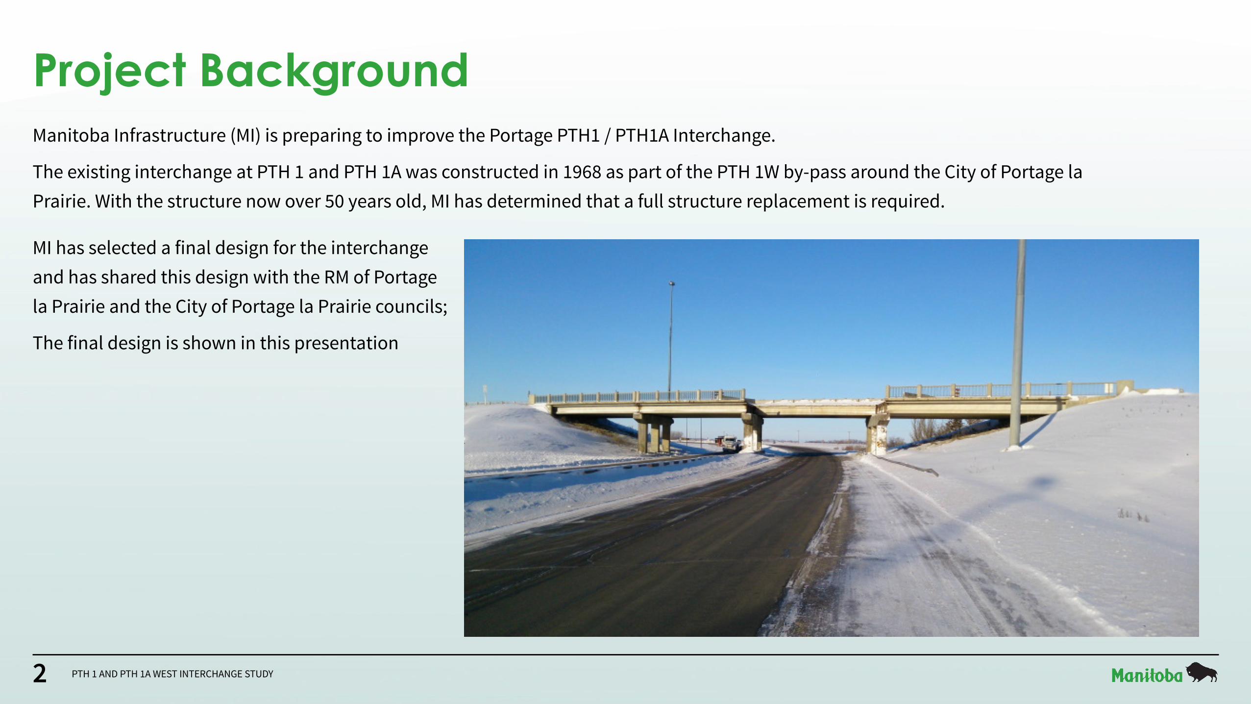
Project BackgroundManitoba Infrastructure (MI) is preparing to improve the Portage PTH1 / PTH1A Interchange.
The existing interchange at PTH 1 and PTH 1A was constructed in 1968 as part of the PTH 1W by-pass around the City of Portage la Prairie. With the structure now over 50 years old, MI has determined that a full structure replacement is required.
MI has selected a final design for the interchange and has shared this design with the RM of Portage la Prairie and the City of Portage la Prairie councils;
The final design is shown in this presentation

3 PTH 1 AND PTH 1A WEST INTERCHANGE STUDY
Study Area Overview
Study Area LimitStudy Area Limit
RailRail
LEGENDLEGEND
Road
40W
Road
40W
Road
39W
Road
39W
CN Rivers SubdivisonCN Rivers Subdivison
Trans-Canada Highway
Trans-Canada Highway
Service Road SWService Road SW
Port
age
Div
ersi
onPo
rtag
e D
iver
sion
PTH 1PTH 1
CP Carberry SubdivisionCP Carberry Subdivision
Existing Overpass
Structure to be Replaced
Existing Rail Overpass
Structure to be Rehabilitated
To BrandonTo Brandon
To Winnipeg
To Winnipeg
To Portage la PrairieTo Portage la Prairie
Can
Oat
Driv
eCa
n O
at D
rive
PTH 1A (City Route)
PTH 1A (City Route)
PTH 1APTH 1A
N
• The study area focuses on the current PTH 1 and PTH 1A Interchange as well as the existing vehicle and rail overpass.
• The area includes two rail lines (CN Rivers and CP Carberry) as well as several local roadways including Road 40 West, the service road southwest of the interchange and Can Oat Drive to the east of the interchange, which extends southeast along the TransCanada Highway, eventually meeting Yellowquill Trail.

4 PTH 1 AND PTH 1A WEST INTERCHANGE STUDY
x
x
x
x
x
x
Final DesignN
* The final design requires no land acquisition and improves highway geometry from the existing interchange.
To Winnipeg
To Brandon To Portage
CP Rail
Service Road
Service Road
Can-
Oat
Dr.
Road
40W
The design features two roundabouts to facilitate access to and from PTH 1
and PTH 1A in all directions. Both roundabouts have been
designed to accommodate agricultural vehicles.
The final design features a new two-lane undivided overpass structure with
increased clearances from 4.9 m to a minimum 5.4 m.
A new all directional intersection will
be construction to provide access to the
service road.
New extended acceleration lanes on eastbound and westbound PTH 1 will support easier
merging.The railway overpass will
be rehabilitated with an increase in roadway width under the bridge.
This roadway is being designed to accommodate
agricultural vehicles.
To improve safety, the access at Road 40W will be
permanently closed and vehicle turnarounds will be implemented on the
north and south side of the highway.
LegendLegend
Final Road Alignment
Road to be Closed
Traffic Direction and Movement
XX

5 PTH 1 AND PTH 1A WEST INTERCHANGE STUDY
Final Design• The Final Design features two roundabouts,
similar to the recently completed roundabout at the intersection of PTH 2 and PTH 3 (shown at left).
• The roundabouts are designed to facilitate the movement of large vehicles including long combination vehicles (LCVs) and large agricultural vehicles.
• Roundabouts are designed with an ‘apron’ around the centre island which allows vehicles with larger turning radii to mount the curb move to freely through to their destination.
• Slower speeds increase safety and enable a constant flow of traffic with fewer stoppages.
The roundabouts included in the final design will be similar to the recently constructed PTH 2 and PTH 3 roundabout near Oak Bluff, MB.

6 PTH 1 AND PTH 1A WEST INTERCHANGE STUDY
Final Design Feedback
What Was Heard How It Was ConsideredParticipants noted instances where fast-moving passenger vehicles have collided with
slow-moving agricultural vehicles in the area.The westbound acceleration lane on PTH 1 has been extended to provide more
merging length and visibility for slower moving agricultural vehicles.Participants noted the closure of the access at the south intersection of PTH 1 and
Road 40W would add travel time for individuals accessing the properties to the south of PTH 1.
The final design allows individuals to access properties south of PTH 1 through the proposed roundabout without adding significant travel time to their trip.
Participants inquired whether a right-in, right-out access could be maintained at the PTH 1 and Road 40W intersection.
A right-in, right-out access is not viable, as it would be located within the deceleration lane ramp exit to Portage, which creates a safety issue. However, this design provides
reasonable access to the properties south of PTH 1.Participants inquired whether an extension of the south or north service road west with a new service road bridge crossing the Portage diversion could be
accommodated as part of the design.
This request would require a functional study of all roads and accesses west of the Portage diversion and is not being pursued at this time.
Participants inquired whether the roundabouts could accommodate long combination vehicle (LCV) movements.
The roundabouts will be designed to accommodate LCVs and typical agricultural equipment.
• Throughout the functional and preliminary design phases of the project, feedback was provided to the project team by key stakeholders and members of the public. This information was collected through direct meetings with affected stakeholders, public surveys, comments received, and conversations with those who attended the public open house.
• This information was provided to the design team to be incorporated into the project where possible.
• The table shown here summarizes this feedback, indicating what was heard, and how it was considered as part of the final design.

7 PTH 1 AND PTH 1A WEST INTERCHANGE STUDY
Final Design FeedbackWhat Was Heard How It Was Considered
Operators of slow-moving agricultural equipment voiced concerns with being mixed with fast-moving traffic at the overpass.
Reduced speed at the roundabouts will more closely match the speeds of all users.
Participants inquired whether the new overpass structure would be built with a higher vertical clearance than the existing overpass structure.
The new bridge is designed with increased vertical clearance (5.4 m. / 17.7 ft.) according to current overpass structure design codes and constructed to better
withstand any future collisions.Long Plain First Nation has plans for future development near the intersection of
PTH 1 and Yellowquill Trail. To accommodate this development, pavement repairs and intersection improvements may be required.
This request is outside the scope of the study area, but MI will connect with Long Plain First Nation to discuss their plans for future development.
Participants inquired whether pedestrian/biking pathways could be incorporated in the interchange design.
There are no existing pedestrian/biking facilities or plans for future facilities near the study area to connect to. Any future pedestrian/biking facilities should consider
locations away from the overpass for improved safety considerations.
Participants highlighted concerns with the existing lighting along the interchange. Modifications to the existing lighting for the new interchange are being developed.

8 PTH 1 AND PTH 1A WEST INTERCHANGE STUDY
PTH 1 Overpass Structure• The drawing at the left (top) shows a
cross section of the overpass structure superimposed on the old structure as it appears heading into Portage la Prairie. The old structure is shown in blue. Of note is the increased clearance from 4.9m to 5.4m.
• The drawing at left (bottom) is a full cross section of PTH 1, with the new PTH 1A bridge in place. A new acceleration lane is added for eastbound traffic to facilitate safer merging at speed. PTH 1 Road Surface
PTH 1A EastPTH 1A West
Existing Bridge Structure
PTH 1A Overpass
Westbound2 Lanes
Eastbound2 Lanes + 1 Acceleration Lane
ExistingClearance4.9 m
Proposed Clearance (Min.)
5.4 m
9 PTH 1 AND PTH 1A WEST INTERCHANGE STUDY
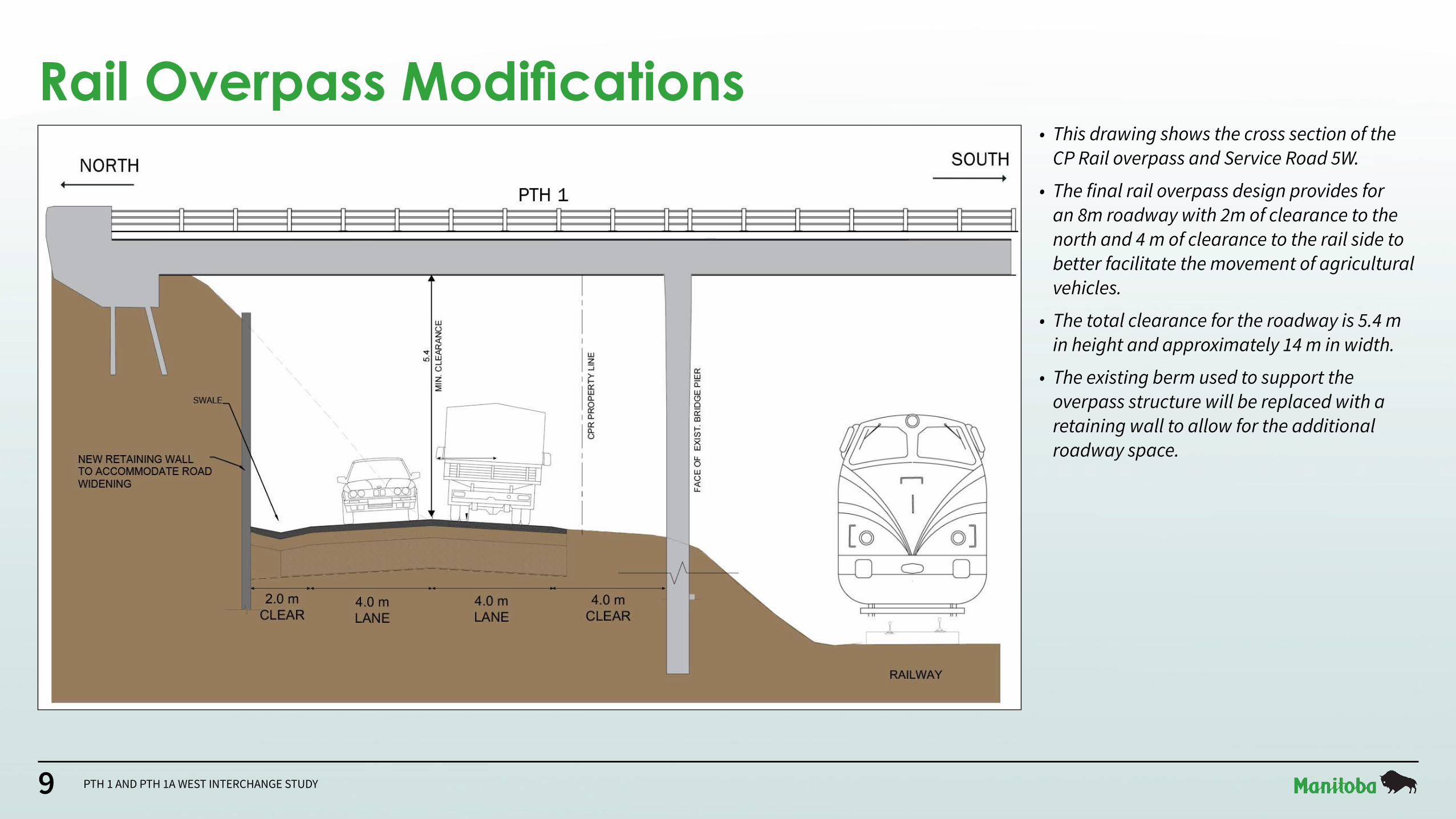
Rail Overpass Modifications• This drawing shows the cross section of the
CP Rail overpass and Service Road 5W.
• The final rail overpass design provides for an 8m roadway with 2m of clearance to the north and 4 m of clearance to the rail side to better facilitate the movement of agricultural vehicles.
• The total clearance for the roadway is 5.4 m in height and approximately 14 m in width.
• The existing berm used to support the overpass structure will be replaced with a retaining wall to allow for the additional roadway space.

10 PTH 1 AND PTH 1A WEST INTERCHANGE STUDY
Temporary Detour (Short Term)• The first component of the interchange to be constructed
will be the eastern roundabout.
• To facilitate the roundabout’s construction, the exit ramp from PTH 1 to PTH 1A Saskatchewan Avenue (shown in red) will be closed, requiring a temporary detour that will last approximately 6-8 weeks.
• The drawing at left shows the temporary detour route and the location of signage along PTH 1.
• All traffic continuing west of the interchange on PTH 1 will be unaffected.
• During this initial construction period, westbound traffic on PTH 1 must transfer to Can Oat Drive (shown in green) to enter Portage la Prairie.
• Existing southbound traffic on Can Oat Drive travelling to PTH 1 must do so at Yellowquill Trail (shown in blue).
N
INTERCHANGE RAMP CLOSED
ACCESS PORTAGE LA PRAIRIEAT CAN OAT DRIVE
NEXT RIGHT
INTERCHANGE RAMP CLOSED
ACCESS PORTAGE LA PRAIRIEAT CAN OAT DRIVE
1 KM AHEAD
INTERCHANGE RAMP CLOSED
ACCESS PORTAGE LA PRAIRIEAT CAN OAT DRIVE
2 KM AHEAD
EASTBOUND RAMP TRAFFIC DETOURED TO CAN-OAT DRIVE
SOUTHBOUND TRAFFIC ON CAN-OAT DRIVE UNAFFECTED

11 PTH 1 AND PTH 1A WEST INTERCHANGE STUDY
Construction Period Detour PlanEast Side
Roundabout• Once work is complete on the eastern
roundabout, construction of the interchange structure will commence.
• To facilitate construction of the interchange structure, a new detour will be inplemented throughout the remainder of the construction period.
• During this time, traffic on PTH 1 (the red and blue lines) will use one lane in each direction and the eastern roundabout.
• Those entering Portage la Prairie or exiting the city onto PTH 1 in either direction can also use the roundabout.
• Local traffic south of the interchange will utilize the Service Road and Can Oat Drive (the green and yellow lines) for access during this period.
• This detour will remove all traffic from the PTH 1A overpass, such that work can be completed on the overpass structure unimpeded by traffic, allowing for a safer and faster construction process.

12 PTH 1 AND PTH 1A WEST INTERCHANGE STUDY
Detour FeedbackWhat Was Heard How It Was Considered
Participants noted a desire to ensure access into Portage was maintained and large volumes of truck traffic were not by-passed
through Portage during construction.
Direct access in and out of Portage (one lane each direction), as well as an option for trucks to by-pass Portage, will be provided
during construction.
Participants inquired whether the eastbound diversion bridge could potentially remain open for agricultural vehicles during
construction.
The eastbound diversion bridge will remain open to provide access to the south service road during construction.
Participants noted that the amount of dust and safety issues will increase if more traffic is directed to use the south service road.
Typical dust control and grading measures will be implemented, if necessary, to ensure safe driving conditions during
construction.
Participants noted that the detour could cause a bottleneck of traffic.
MI will implement advance work zone signage to ensure safe merging conditions during construction.
Participants noted concerns regarding the delay in traffic near the PTH 1A and Road 39W intersection during construction.
The traffic analysis shows good Level of Service with minimal traffic delay through the PTH 1A and Road 39W intersection
during construction.
Participants inquired whether the detour would accommodate long combination vehicle (LCV) movements.
The detour geometry will accommodate LCV movements.
Participants noted concerns with the amount of traffic proposed to be merging into a single lane near the PTH 1 and Yellowquill
Road intersection. Cross-over locations will be analyzed to reduce traffic impacts.
Participants inquired whether the detour would result in throw-away costs or whether some of the detour infrastructure could be
incorporated in the design.
MI plans to limit the amount of throw-away costs incurred when constructing the detour.
• During the functional and preliminary design phase of the project, feedback was provided concerning the proposed detour routes.
• The table shown here summarizes this feedback, indicating what was heard, and how it was incorporated or considered as part of the two detours.

13 PTH 1 AND PTH 1A WEST INTERCHANGE STUDY
Construction TimelineSubject to the contractor’s scheduling, the timeline for construction of the PTH 1 and PTH 1A interchange is anticipated as follows:
Key Milestone Proposed Time FrameDetailed Design January to August 2021
Construction Tendering August 2021
Construction Start September 2021
Temporary Detour Construction September to October 2021 (six to eight weeks)
New Overpass and Associated Roadworks Construction November 2021 to October 2023
Construction Completion and Open to Traffic October 2023
Clean up and Landscaping works Summer 2024

14 PTH 1 AND PTH 1A WEST INTERCHANGE STUDY
Next StepsThe next steps for this project include:
• Respond to questions as they arise
• Issue tender for construction
• Enter Construction Stage

15 PTH 1 AND PTH 1A WEST INTERCHANGE STUDY
Thank you
Questions or comments related to the PTH 1 and 1A Interchange Study can be directed to:[email protected]
For more information, visit the project webpage at:www.gov.mb.ca/mit/wms/structures/design.html