MODERN OPEN PITS Master of all you survey...MineSight and SAFEmine, Hexagon Mining seamlessly links...
7
M ine surveyors and geotechnical engineers are just two examples of decision makers who need solutions with the flexibility and performance to function in a wide variety of monitoring applications. For slope monitoring, 3D Laser Mapping’s SiteMonitor4D is described as “a state-of the art monitoring system using advanced laser scanning technology with powerful, easy to use software.” The automated slope monitoring system was developed in partnership with geotechnical engineers and mining surveyors, and is a portable self-contained system that can be moved into areas of limited access. It is used for monitoring large open pits, small satellite pits and volume measurement. The solution includes a laser scanner, software and IT infrastructure amongst other bespoke elements, giving the user the ability to exploit the potential of laser scanning for measuring change. Depending on the model of laser scanner being used, the solution can measure a 140 mm grid over a highwall every 30 minutes at 1,000 m range and has a range of up to 6,000 m. With a better than 10 mm accuracy for its geo- referenced data, SiteMonitor4D is a safe and accurate well-established monitoring solution. Critical decisions can be made with confidence in real time, helping to prevent or mitigate any risk of slope failure. The analysis module creates a streamlined workflow for geotechnical and structural engineers using a variety of tools to inspect data, such as 2D and 3D visualisations as well as displacement and volume graphs. “SiteMonitor4D gives us the opportunity to capture large scale data with little human interface”, commented Frans Benade of Anglo American Platinum. “This gives us time to focus on the detailed information in a dynamic, fast moving, production environment.” SiteMonitor4D works by defining a grid of points, called nodes, completely covering the area of interest. The nodes do not need a target so there is no requirement for prisms - the theoretical locations are defined only in the coordinate system of the scanner. Targets are used for range and atmospheric correction. When an area is measured, the scanner returns to each of the nodes and takes a range measurement. For large open pit mining operations, a range of up to 6 km is more important than speed of acquisition. For smaller, open pit mines and engineering works, a measurement rate of 122,000 points per second and accuracy up to 4 mm will be preferably over long-range performance. “3D Laser Mapping are no strangers to providing specialist solutions to the mining industry; the company has been providing both SiteMonitor4D and the central, multisensory management system SiteMonitorGE for some time. There’s more in the SiteMonitor solutions pipeline”, according to Dr Graham Hunter, Executive Chairman of 3D Laser Mapping. “Due to the ongoing expansion and successes the business has achieved in the past twelve months, including a number of major product launches, we are expanding the senior management in mining and monitoring area of activity, and appointed Colin Thomson as Technical Director for Mining and Monitoring in September 2014. Colin is well known in the African market as a knowledgeable professional in the field of geotechnical monitoring systems.” RIEGL has added a new terrestrial laser scanner to its portfolio. The VZ-2000 is RIEGL’s fastest terrestrial laser scanner to date. It comes with a 1 MHz pulse repetition rate and up to 400,000 effective measurements per second, providing a range performance of more than 2,000 m. “The VZ-2000 is a great surveying tool MODERN OPEN PITS 52 International Mining | DECEMBER 2014 Large open pit mines come with unique challenges with regard to slope stability monitoring, slope strengthening, mine planning and even dealing with obstructions, reports Paul Moore Master of all you survey The PT Redpath Indonesia Kali Kabur river rock project was completed successfully in May 2014 with no accidents or incidents SiteMonitor4D can measure a 140 mm grid over a highwall every 30 min at 1,000 m range and has a range of up to 6,000 m
Transcript of MODERN OPEN PITS Master of all you survey...MineSight and SAFEmine, Hexagon Mining seamlessly links...

Mine surveyors and geotechnical
engineers are just two examples of
decision makers who need solutions
with the flexibility and performance to function
in a wide variety of monitoring applications. For
slope monitoring, 3D Laser Mapping’s
SiteMonitor4D is described as “a state-of the art
monitoring system using advanced laser
scanning technology with powerful, easy to use
software.” The automated slope monitoring
system was developed in partnership with
geotechnical engineers and mining surveyors,
and is a portable self-contained system that can
be moved into areas of limited access. It is used
for monitoring large open pits, small satellite
pits and volume measurement. The solution
includes a laser scanner, software and IT
infrastructure amongst other bespoke elements,
giving the user the ability to exploit the
potential of laser scanning for measuring
change.
Depending on the model of laser scanner
being used, the solution can measure a 140 mm
grid over a highwall every 30 minutes at 1,000 m
range and has a range of up to 6,000 m. With a
better than 10 mm accuracy for its geo-
referenced data, SiteMonitor4D is a safe and
accurate well-established monitoring solution.
Critical decisions can be made with confidence
in real time, helping to prevent or mitigate any
risk of slope failure. The analysis module
creates a streamlined workflow for geotechnical
and structural engineers using a variety of tools
to inspect data, such as
2D and 3D visualisations
as well as displacement
and volume graphs.
“SiteMonitor4D gives
us the opportunity to
capture large scale data
with little human
interface”, commented
Frans Benade of Anglo
American Platinum. “This
gives us time to focus on the detailed
information in a dynamic, fast moving,
production environment.”
SiteMonitor4D works by defining a grid of
points, called nodes, completely covering the
area of interest. The nodes do not need a target
so there is no requirement for prisms - the
theoretical locations are defined only in the
coordinate system of the scanner. Targets are
used for range and atmospheric correction.
When an area is measured, the scanner returns
to each of the nodes and takes a range
measurement. For large open pit mining
operations, a range of up to 6 km is more
important than speed of acquisition. For smaller,
open pit mines and engineering works, a
measurement rate of 122,000 points per second
and accuracy up to 4 mm will be preferably over
long-range performance.
“3D Laser Mapping are no strangers to
providing specialist solutions to the mining
industry; the company has been providing both
SiteMonitor4D and the central, multisensory
management system SiteMonitorGE for some
time. There’s more in the SiteMonitor solutions
pipeline”, according to Dr Graham Hunter,
Executive Chairman of 3D Laser Mapping.
“Due to the ongoing expansion and
successes the business has achieved in the past
twelve months, including a number of major
product launches, we are expanding the senior
management in mining and monitoring area of
activity, and appointed Colin Thomson as
Technical Director for Mining and Monitoring in
September 2014. Colin is well known in the
African market as a knowledgeable professional
in the field of geotechnical monitoring systems.”
RIEGL has added a new terrestrial laser
scanner to its portfolio. The VZ-2000 is RIEGL’s
fastest terrestrial laser scanner to date. It comes
with a 1 MHz pulse repetition rate and up to
400,000 effective measurements per second,
providing a range performance of more than
2,000 m. “The VZ-2000 is a great surveying tool
MODERN OPEN PITS
52 International Mining | DECEMBER 2014
Large open pit minescome with uniquechallenges with regardto slope stabilitymonitoring, slopestrengthening, mineplanning and evendealing withobstructions, reportsPaul Moore
Master of all you survey
The PT Redpath IndonesiaKali Kabur river rock projectwas completed successfully
in May 2014 with noaccidents or incidents
SiteMonitor4D canmeasure a 140 mm gridover a highwall every 30min at 1,000 m rangeand has a range of up to6,000 m
54 International Mining | DECEMBER 2014
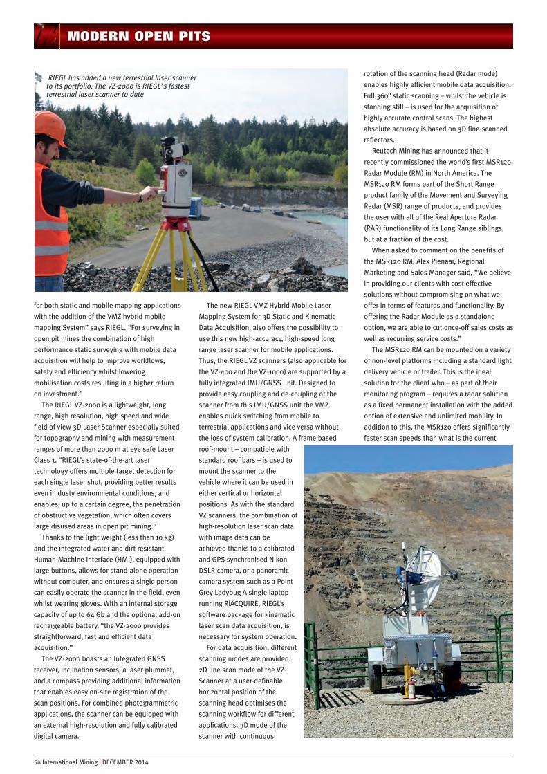
for both static and mobile mapping applications
with the addition of the VMZ hybrid mobile
mapping System” says RIEGL. “For surveying in
open pit mines the combination of high
performance static surveying with mobile data
acquisition will help to improve workflows,
safety and efficiency whilst lowering
mobilisation costs resulting in a higher return
on investment.”
The RIEGL VZ-2000 is a lightweight, long
range, high resolution, high speed and wide
field of view 3D Laser Scanner especially suited
for topography and mining with measurement
ranges of more than 2000 m at eye safe Laser
Class 1. “RIEGL’s state-of-the-art laser
technology offers multiple target detection for
each single laser shot, providing better results
even in dusty environmental conditions, and
enables, up to a certain degree, the penetration
of obstructive vegetation, which often covers
large disused areas in open pit mining.”
Thanks to the light weight (less than 10 kg)
and the integrated water and dirt resistant
Human-Machine Interface (HMI), equipped with
large buttons, allows for stand-alone operation
without computer, and ensures a single person
can easily operate the scanner in the field, even
whilst wearing gloves. With an internal storage
capacity of up to 64 Gb and the optional add-on
rechargeable battery, “the VZ-2000 provides
straightforward, fast and efficient data
acquisition.”
The VZ-2000 boasts an Integrated GNSS
receiver, inclination sensors, a laser plummet,
and a compass providing additional information
that enables easy on-site registration of the
scan positions. For combined photogrammetric
applications, the scanner can be equipped with
an external high-resolution and fully calibrated
digital camera.
The new RIEGL VMZ Hybrid Mobile Laser
Mapping System for 3D Static and Kinematic
Data Acquisition, also offers the possibility to
use this new high-accuracy, high-speed long
range laser scanner for mobile applications.
Thus, the RIEGL VZ scanners (also applicable for
the VZ-400 and the VZ-1000) are supported by a
fully integrated IMU/GNSS unit. Designed to
provide easy coupling and de-coupling of the
scanner from this IMU/GNSS unit the VMZ
enables quick switching from mobile to
terrestrial applications and vice versa without
the loss of system calibration. A frame based
roof-mount – compatible with
standard roof bars – is used to
mount the scanner to the
vehicle where it can be used in
either vertical or horizontal
positions. As with the standard
VZ scanners, the combination of
high-resolution laser scan data
with image data can be
achieved thanks to a calibrated
and GPS synchronised Nikon
DSLR camera, or a panoramic
camera system such as a Point
Grey Ladybug A single laptop
running RiACQUIRE, RIEGL’s
software package for kinematic
laser scan data acquisition, is
necessary for system operation.
For data acquisition, different
scanning modes are provided.
2D line scan mode of the VZ-
Scanner at a user-definable
horizontal position of the
scanning head optimises the
scanning workflow for different
applications. 3D mode of the
scanner with continuous
rotation of the scanning head (Radar mode)
enables highly efficient mobile data acquisition.
Full 360° static scanning – whilst the vehicle is
standing still – is used for the acquisition of
highly accurate control scans. The highest
absolute accuracy is based on 3D fine-scanned
reflectors.
Reutech Mining has announced that it
recently commissioned the world’s first MSR120
Radar Module (RM) in North America. The
MSR120 RM forms part of the Short Range
product family of the Movement and Surveying
Radar (MSR) range of products, and provides
the user with all of the Real Aperture Radar
(RAR) functionality of its Long Range siblings,
but at a fraction of the cost.
When asked to comment on the benefits of
the MSR120 RM, Alex Pienaar, Regional
Marketing and Sales Manager said, “We believe
in providing our clients with cost effective
solutions without compromising on what we
offer in terms of features and functionality. By
offering the Radar Module as a standalone
option, we are able to cut once-off sales costs as
well as recurring service costs.”
The MSR120 RM can be mounted on a variety
of non-level platforms including a standard light
delivery vehicle or trailer. This is the ideal
solution for the client who – as part of their
monitoring program – requires a radar solution
as a fixed permanent installation with the added
option of extensive and unlimited mobility. In
addition to this, the MSR120 offers significantly
faster scan speeds than what is the current
MODERN OPEN PITS
RIEGL has added a new terrestrial laser scannerto its portfolio. The VZ-2000 is RIEGL’s fastestterrestrial laser scanner to date

norm in all mining applications, higher 3D spatial resolutions and a much
greater coverage area even at very short distances. Product highlights
include the following:
n Full operational scan from 30 to 1,200 m
n Faster scan speed
n Higher 3D spatial resolution
n Non-DTM dependence allows for greater on-site flexibility
n Greater coverage area – especially at shorter distances.
n Superior operational availability
n Reduced service intervals
n Minimal number of moving parts.
Hexagon unites technologiesProductive mining companies know technology drives their future. Faced
with rising energy costs, scarcer high grade ores, declining commodity
prices, and tighter profit margins, mines must quickly adapt to survive.
Enter Hexagon Mining, arguably the first company to unite the world’s
leading software innovators and create an unprecedented spread of
technologies within the mining vertical.
Launched this year by global information technology giant, Hexagon AB,
Hexagon Mining is unique among the industry’s software players. The group
states: “Hexagon Mining is the only company to solve surface and
underground challenges
by integrating design,
planning, and operations
technologies for safer,
more productive mines.
Combining the innovative
technologies of Devex
Mining, Leica
Geosystems Mining,
MineSight and
SAFEmine, Hexagon
Mining seamlessly links
mine planning, design,
fleet and production
management,
optimisation, fatigue
monitoring, and collision
avoidance software for a
comprehensive flow of
data across all
operations.”
“We strongly believe
the industry needs a supplier with a 360-degree vision, connecting the best
products, capabilities and solutions,” says Hexagon Mining President,
Guilherme Bastos. “No other vendor has ever assembled such a large
spread of technologies within the mining vertical. Hexagon Mining wants to
reshape traditional ways of thinking about the industry, and offer a smarter
way to mine.”
While that may start with Hexagon Mining’s existing products, the
company told IM that exciting new technology is also in the pipeline. The
fleet management and optimisation expertise offered by Leica Geosystems
Mining, for instance, presents immediate relief for mines facing tough times
with rising capital expenditure and operating costs. Hexagon Mining
believes fleet management represents a huge opportunity to minimise
energy consumption, reduce carbon footprints, and save money.
MineSight’s activity-based planning product, Atlas, lets the mine planner
define an operational plan down to the lowest level of detail needed. Leica’s
fleet management solution optimises the real-time scheduling and dispatch
of mobile mining equipment. With a fleet management solution in place,
DECEMBER 2014 | International Mining 55
MODERN OPEN PITS
Guilherme Bastos, President of the new HexagonMining
Mobilize your RIEGL 3D Terrestrial Laser Scanner
RIEGL LMS GmbH, Austria RIEGL USA Inc. RIEGL Japan Ltd. RIEGL China Ltd.
www.riegl.com
MOBILElaser mapping
easymounting
STATIClaser scanning
RIEGLRIEGL VMZ - VMZ -vertical setup
IMU/GNSS unit
RIEGL VMZ -horizontal setup
Fro
m s
tatic
to m
ob
ile s
ca
nnin
g in
a fe
w s
tep
s!
WNEW RIEGL® VMZ
fully integrated IMU/GNSS unit to supportRIEGL VZ-400, VZ-1000 and VZ-2000 scanners for mobile (kinematic) data acquisition
quick transition from mobile to terrestrial applications,and vice versa, without losing system calibration
image acquisition with fully integrated NIKON® DSLR camera and/or POINTGREY ladybug® camera
easy system operation and data processingwith RIEGL’s standard software packages for static and mobile scanning applications
® registered trademarks
RIEGL® VMZ Hybrid Mobile Laser Mapping System
dispatchers possess all the information they
need to ensure daily operations are efficient and
to plan.
Hexagon comments: “Supposing the planning
product could seamlessly connect to the fleet
management solution, effortlessly defining plans
and setting operational goals. What if operational
changes fed directly back to the planning system
to update the plan for the next iteration? The
newly united partners are already working on
developing this synergistic product. Likewise,
operations can be monitored in real time via the
fleet management solution scrutinising a mine’s
every move. How fast is a shovel loading? Is the
operator performing well? Is weather affecting
travel times? Are blending arrangements or
targets changing? With the answers to these
questions, mines can quickly make decisions on
critical equipment needs. By adjusting and
making the most of their assets, a company can
lower its operating costs.”
Hexagon Mining says it will focus on business
intelligence and business analytics, (BI/BA)
identifying lost time that’s non-productive:
breaks, crew stand-down times, lunches,
equipment breakdowns. By analysing such
information and feeding it back into MineSight’s
planning and operational programs, customers
can plan and schedule around real information
coming from their mine.
Hexagon Mining also plans to build a standard
BI/BA product across all the products it supports.
Web/mobile dashboards will display safety information,
product KPIs, critical work stoppage events,
production equipment statistics, and more. “There
are dollars in these details,” says Bastos. “We
help our customers make the most of their data.”
The drill and blast cycle is also integral to
Hexagon Mining’s vision, says the group.
“Drawing upon visualisation and automation
software, together with MineSight’s Axis product,
the company will focus on tracking grade and
rock fragmentation. This part of the mining cycle
is too important to get wrong”, says Bastos.
“Poor fragmentation has major upstream costs
for crusher energy, refining ... the whole mining
process. Get the crushing and grinding right the
first time and you really save energy costs and
decrease the hit on the local energy grid. So
we’re looking to close that loop via Leica’s drill
fleet management machine guidance, and
MineSight’s drill and blast modules. This is all
about breaking down silos and creating a
seamless platform through which data flows
smoothly.”
Essential to that integration and pervading all
Hexagon Mining solutions is safety. “SAFEmine
has set a global benchmark for solutions that
prevent mining accidents. More than 18,000
mining vehicles in 45 mines worldwide are
equipped with SAFEmine’s Collision Avoidance
Systems (CAS).” Now the Switzerland-based
company has launched FatigueMonitor, which is
integrated with CAS.
“CAS protects vehicle operators from collisions
in the constrained mining environment,” says
Bastos. “SAFEmine’s data shows that a lot of
mining accidents happen due to fatigue. Fatigue
Monitor smartly fuses CAS data with PerClos and
body clock inputs that can detect early signs of
fatigue and prevent this type of accident.”
In addition to the CAS and fatigue monitoring
solutions, SAFEmine’s versatile safety package
includes SafetyCentre and ShovelAssist.
SafetyCentre is made for haul trucks, displaying
all relevant safety information via cameras and
radar, and other sensors, such as tire pressure.
ShovelAssist is a solution to avoid damaging light
vehicles and clean-up equipment around shovels.
Bastos concludes: “At Hexagon, we are not
just imagining bridging the gap between short
term planning and operations, or connecting fleet
operations with mine planning, or making
analytics and business intelligence holistic and
universal; we are making these solutions a
reality. Integration and automation across the
entire mining chain is the goal. We have all the
necessary ingredients to achieve that goal.”
Hexagon Mining will exploit existing GIS and
CAD technology within the greater Hexagon
family. Technologies such as Smart H2O from
Hexagon Solutions offer the potential to monitor
tailings dams and water dams in critical areas.
The new unified company is headquartered in
Tucson, Arizona, with more than 30 offices across
five continents:
n Belo Horizonte, Brazil-based Devex Mining
delivers leading solutions for fleet and
production optimisation, process automation,
machine maintenance, business intelligence
and analytics, and autonomous control.
n Co-headquartered in Brisbane, Australia and
Tucson, Arizona, Leica Geosystems Mining
delivers leading solutions for fleet and
production optimization, high-precision
machine guidance, machine maintenance,
business intelligence and analytics, and
autonomous control.
n Tucson, Arizona-based MineSight is a
comprehensive modelling and mine planning
platform, offering integrated solutions for
exploration, modelling, design, scheduling and
operation.
n Baar, Switzerland-based SAFEmine is the
leader in collision avoidance and fatigue
monitoring systems, delivering extensible
solutions that save lives.
Slope stabilisation progressSafety, cost efficiency and sustainability - these
properties are described as what have made the
TECCO® Slope Stabilisation System from
Geobrugg “one-of-a-kind and successful all over
the world”. Now with three levels of mesh
strengths, Geobrugg has expanded the field of
application of the TECCO SYSTEM3 many times
over. It can now be applied to nearly any slope,
regardless of whether it is solid rock, soil, or
anything in between. Additionally, two new spike
plate sizes further expand the range of
application and allow optimisation of anchor
spacing. The revised RUVOLUM® dimensioning
software makes it possible to quickly and
accurately plan safety measures.
Geobrugg states: “For years, TECCO has been
making a name for itself all over the world as a
highly efficient system for stabilising slopes. So
far the possibilities have been great – but now
Geobrugg expanded the TECCO Slope
Stabilisation System. Starting in 2014, additional
TECCO meshes made of 2 mm and 4 mm
diameter high-tensile steel wire are being added
to the well-known 3 mm mesh. This full
complement of meshes can now be used to
optimally secure nearly any slope, and the
designer will be able to find the right solution for
any geological conditions with this versatile
system. The additions to the new TECCO
SYSTEM3 are not limited to just the expanded
mesh options. The newly developed P66 spike
MODERN OPEN PITS
56 International Mining | DECEMBER 2014
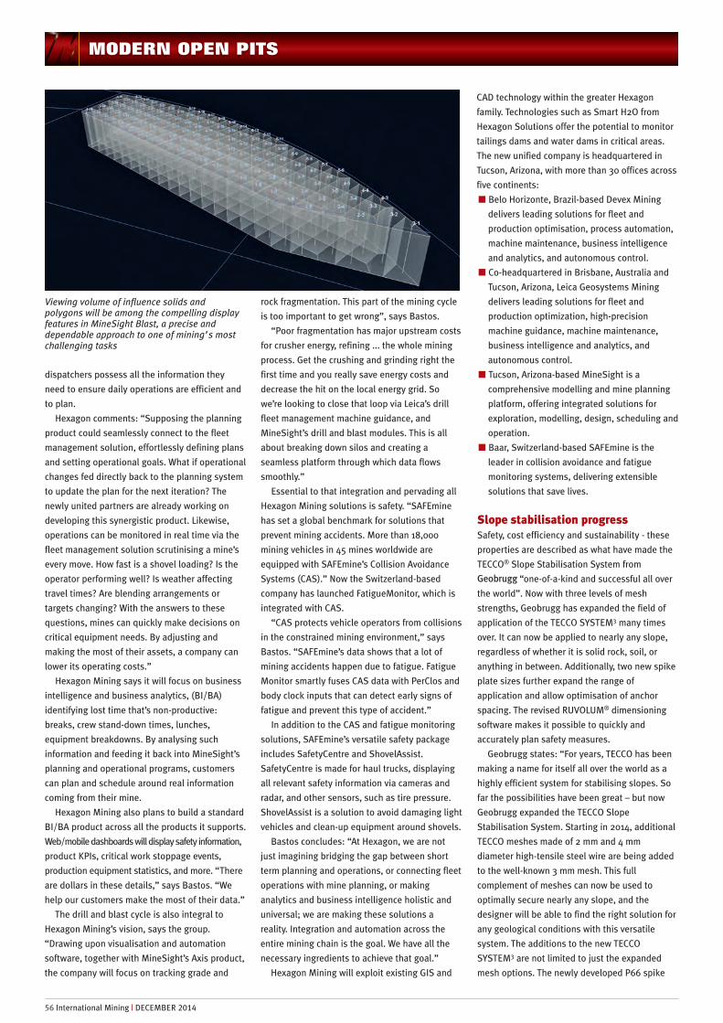
Viewing volume of influence solids andpolygons will be among the compelling displayfeatures in MineSight Blast, a precise anddependable approach to one of mining’s mostchallenging tasks

plate increases the load transfer of all meshes,
and enables lower total project costs and faster
installation times. The interaction of the TECCO
meshes with this spike plate allows larger anchor
spacing of up to 3.5 m, and reduces surface
deformations. This means TECCO is now not only
setting new standards in versatility, but also in
efficiency.”
The key to the success of the TECCO SYSTEM3
according to the company lies in the large-scale
field experiments performed by the Geobrugg
Group in the last two years. To perform realistic
tests of the calculated results, an experiment was
conducted together with the Bern University of
Applied Sciences in Burgdorf. A test box (10 x 12
x 1.2 m) filled with gravel was covered with high-
strength TECCO mesh. The mesh was anchored in
the box with spike plates and nails with a
spacing up to 3.5 m x 3.5 m. Tests with a gradual
raising of the box showed that the mesh can
successfully hold back 230 t of material up to a
slope angle of 85° with only a small amount of
deformation. The decisive performance factors
are the local load transfer from the mesh to the
nail, and the punching strength of the mesh on
the upper edge of the spike plate.
The full scale testing provided detailed,
scientific proof of the key to the success of
TECCO mesh – the high tensile wire. All three
TECCO meshes are made with high tensile steel
wire with a strength of at least 1,770N/mm2. This
is important as the full scale testing showed that
success or failure of the stabilisation system is
completely dependent upon the ability of the
mesh to transfer loads from the slope to the
nails. The only way to achieve this efficiently and
safely is to use mesh with high-tensile wire. Plus
the unique diamond shape of TECCO enables this
critical load transfer from the mesh to the spike
plates.
“Thanks to the sleek profile of mesh and the
lustreless zinc-aluminum coating, the TECCO
mesh blends into the landscape. After vegetation
has grown through, it is nearly invisible. The
vegetation process can be accelerated with the
TECMAT® grass seed mat. TECMAT stabilises the
topsoil layer, and prevents seeds from washing
away.” The TECCO SYSTEM3 is completed with
the expanded RUVOLUM online dimensioning
software, which Geobrugg makes available to
planners free of charge at
http://applications.geobrugg.com/application.ht
m. This makes designing the mesh and nailing of
the stabilisation system extremely easy. The
software helps the designer select the optimal
combination of mesh, plate, and anchor spacing
by performing a detailed analysis of the
interaction between the system components and
the slope. Geobrugg also offers RUVOLUM
application workshops to teach the proper use of
the system. “The planners learn how to use the
software purposefully, efficiently and reliably.”
Open pit network agreement3D-P, the provider of technology products for the
mining industry, recently announced the addition
of Rajant’s Kinetic Mesh product line to the
company’s list of wireless technologies and
expertise. The company stated: “3D-P has long
been an industry leader in designing and
deploying wireless networks for the open pit
mining vertical, with over 80 mine-wide
deployments around the world. The agreement
with Rajant Corporation names 3D-P as a Kinetic
Mesh solution partner for the mining industry,
allowing 3D-P to apply their extensive knowledge
of outdoor wireless mesh networking to the
deployment of Rajant technology globally.”
Rajant for its part “recognises that 3D-P meets
the following requirements of their Kinetic Mesh
Solution Partner Program”:
n Core wireless design and network expertise,
tailored to the mining industry. In addition to
demonstrating expertise in Rajant technology
the partner must also offer expertise in the
design, implementation, and ongoing value
added services for all of the supporting
technology used in the LAN, back-haul, and
distribution network layers that support a
successful wireless deployment.
n Application expertise in a wide variety of third
party mining applications, including their
associated communication protocols and
networking requirements.
MODERN OPEN PITS
DECEMBER 2014 | International Mining 57

n Integration expertise in a wide variety of third
party mining specific hardware platforms and
software applications, including their
respective interfaces. The partner must
demonstrate a working knowledge of the
hardware and software tools required to
successfully integrate these platforms and
applications onto a Rajant wireless network,
providing easy access to the stakeholder's
data.
“Merging 3D-P’s proven outdoor wireless
design philosophies with the high throughput,
low latency, and roaming capabilities of the
Rajant Kinetic Mesh product line is truly exciting,
providing a major capability shift in wireless
networking for mining,” stated Ron White, VP of
Technology and CTO at 3D-P. “3D-P is our first
Kinetic Mesh solution partner and the timing could
not be more perfect. With the current market
acceleration we are witnessing in the mining
industry and in vehicle-to-vehicle communications,
we look forward to having 3D-P’s support and
expertise in bringing these opportunities to
fruition,” stated Paul Hellhake, CTO at Rajant.
Removing a river rock at Kali KaburManaging large open pit mines also involves
unique challenges beyond the norm. Geoff
Gibson works as General Foreman for PT Redpath
Indonesia for the Alimak Department and High
Scaling Special Projects. He has been personally
involved with developing the high scaling team
and completing a variety of complex high scaling
projects over his six years with the company.
Well known to IM readers, the Grasberg mine
is located in the Indonesian Province of Papua,
approximately 100 km from the south coast. PT
Redpath Indonesia began as a small contractor to
the mine in 1982 and has grown to become the
primary underground development mining
contractor on site. Redpath’s scope of work has
since expanded to include the High Scaling Crew;
a small group of men with the task of working on
any project outside of the underground
development scope requiring the use of technical
rope skills, hand held and mechanical mining
techniques. Over the years, the High Scaling
Crew has worked on projects such as rock fall
protection barriers, landslide remediation,
installing break through protection barriers and
soil nailing.
PT Freeport Indonesia tasked the Redpath
High Scaling Crew, to remove part of the Kali
Kabur river rock (approximately 40 m long, 15 m
high, 16 m deep located at 2,380 ft above sea
level) in order to allow the river to flow in a
straight line, preventing it from cutting into the
river’s bank and to protect the landscape.
Locating suitable places to construct buildings is
difficult around the mine property due to the
mountainous environment. Waste rock from the
underground mine development is continually
used to build up surrounding areas to allow
building construction projects to expand and to
safeguard roadways. The Kali Kabur river rock
acts as a diversion to the flow of the river, which
when the water level rises enough, washes out
the deposited material over a steep bank and
puts the nearby roadway in danger of collapsing
into the water.
There were a number of different methods
proposed to remove the rock. Among them,
benching from the top down, and also driving a
raise through the rock and blasting it from the
inside out. Due to concerns Freeport expressed
with fly rock, and the presence of a very flat face
at a good angle for drilling, the team decided to
long hole drill the rock. The High Scaling Crew
opted to use a drill rig they themselves designed
and is commonly used on vertical projects at the
mine. The rock was to be drilled along its entire
length at a 1.5 m x 1.5 m pattern using a 45 mm
drill bit. The rock was drilled from left to right
with the first three rows drilled close together
and on gradual changing angles all the while
keeping an eye on the left edge to compensate
for the amount of ground that needed to be
broken. Additionally, the fact that the base of the
custom drill is 2 m wide, its size would not
accommodate moving the drill close enough to
the edge of the rock to drill straight holes.
A tugger (air winch) was installed beside the
roadway, which was used to raise and lower the
drill rig on the opposite side of the river. An
anchor cable was installed along the top of the
rock, running the length of the flat face with a
pulley block attached to run the tugger cable
through. The drill rig was transported to the rock
using a helicopter and a long line (a 30 m sling
attached to the bottom of the helicopter). The
High Scaling Crew, hanging on the face of the
rock using static ropes, received and unhooked
the drill from the long line. Two cables were
installed from the roadway to the Kali Kabur river
rock; one cable was used to suspend the bull
hose and water line, providing air and water for
the drill, while another cable was used as a zip
line to ferry equipment directly to the other side.
Immediately, access to the rock proved to be
the biggest challenge. A small three-cable bridge
was installed from one side of the river to the
other, with one cable for walking on, and two
cables on either side for handrails, essentially
forming a “V” shape. By day, this was an efficient
way to cross the river, however, overnight when
the Indonesian tropical rain fall was high and the
water level rose, the boulders into which the
small “V” footbridge were attached, would shift
and stretch the cables. The cables would become
submerged, causing them to become too slack to
walk on to cross the river. On one occasion, the
boulder on the near side of the river actually
disappeared overnight taking the cables with it.
While the crew continued working and
crossing the ever repaired “V” footbridge, a
decision was made to install a proper cabled
suspension bridge spanning the 65 m from one
side of the river to the other. The bridge was
constructed with minimal interruption to the
work already in progress on the rock. Two large
concrete forms were placed in a hole dug by an
excavator, followed by rebar formwork for D-
plates and handrail beams installed inside the
form and finally, concrete was poured. The
anchor on the other side of the river was a large
freestanding boulder with a gently sloping
surface. D-plates and two more posts for
handrails were installed in the same
configuration as in the concrete block on the
opposite side of the river. Five 0.75 in cables
were then pulled across to the other side of the
river using ropes, pulled up by hand and
anchored to the D-plates on the freestanding
boulder. On the roadside, the cables were
tensioned using come-alongs and chain blocks.
Three cables made up the base of the bridge
while two extra cables ran through the pipes on
the beams rising approximately 1.5 m creating a
handrail.
It was after this stage of construction the
project was interrupted due to a large fall of
ground in the underground at Big Gossan mine in
May of 2013. The crew was relocated to assist
with the rescue and recovery of those involved.
Following the accident, Redpath’s High Scaling
Crew was put to work underground, installing
rehab throughout all areas of the underground
mines. It would be five months before the crew
returned to continue working on the Kali Kabur
river rock.
The first task was to complete the construction
of the suspension bridge as the “V” footbridge
had again disappeared. Lengths of four inch
channel with two by four inch timber inside the
channel were bolted down to the two outside
cables using Crosby clamps. Two by four inch
timbers were then laid perpendicular to the four
inch channels and nailed down. This method of
creating a walkway was used for the full length of
the bridge, along with using nylon rope to lash
the handrail to the support cables below. A safety
cable and gate were also installed on the bridge
to prevent access and allow the workers to tie-off
while traveling along the bridge.
The long hole drilling commenced first using a
S36 drill but this proved to be very heavy and
difficult to manoeuvre on the face. Subsequently
the drill was changed out for a Boart Longyear
Secan jackleg, the drill that the rig was designed
to work with. This turned out to be the best
option and was able to drill long holes up to 16m
long until breakthrough. With a 9 m x 9 m
pattern, probe holes were drilled to breakthrough
MODERN OPEN PITS
58 International Mining | DECEMBER 2014
IDS slope monitoring radar systemSafety through slope movement awareness… www.idscorporation.com
IDS offers a scalable radar solution for:
Global monitoring of all slope instabilitiesSafety critical monitoringEarly detection of slow movements in support of mine planning
TIMEEARLY DETECTION OFSLOPE MOVEMENTSLONG TERMSAFETY CRITICAL MONITORING
SPACEALL SIZES OF SLOPE MOVEMENTSFULL PIT COVERAGECRITICAL AREAS
IDS(REV2)_August14.pdf 1 17/07/2014 13:53

acting as a guide for the driller for the depths of
the subsequent holes. The drilling operation
typically consisted of 1 driller, an off-sider and
tugger operator/nipper. The drill steels were
changed out using pipe wrenches by the off-
sider, while the driller would operate the feed
and rotation. The extension steels and tools
were slung on the side of the face close by to the
drill to allow easy access by the off-sider. The
tugger operator lowered or raised the drill at the
end of every hole/row.
To reduce tripping hazards and to save time, a
man-riding zip line was installed from the end of
the bridge on the far side of the river connecting
directly to the Kali Kabur river rock. This zip line
was also used to ferry equipment that was
carried by hand over the bridge to the river rock.
Maintenance, repairs and modifications were
carried out during the entire job. The design of
the drill rig made it easy to change out a drill if
there was an issue. The drill would be unbolted
hauled up to the zip line and sent back across the
river where it was changed out with a spare drill.
The face was a very consistent angle which
meant almost all of the holes were drilled on the
same angle, slightly lower than horizontal to
allow the cuttings to exit the hole. The typical use
for the drill’s rig design allowed the slide way
where the drill is mounted to change the angle,
however, due to the consistent angle of the
natural face of the rock, this feature was not
necessary so the adjusting bar was welded to
prevent it from moving at all. This weld actually
helped reduce the amount of vibration travelling
through the drill rig allowing more power to be
transferred to the steel and reduced the wear and
tear on other parts of the rig.
Gibson told IM: “With a limited amount of
physical space and the proximity of the road,
vehicular traffic was always an issue with a
constant stream of haul trucks, excavators and
other equipment passing the work area. Once the
suspension bridge was constructed, it restricted
haul trucks from tipping waste rock required to
prevent the road embankment from undercutting
when almost daily heavy rainfall would cause the
river to swell and rage wildly. As expected, the
area along the road under the bridge began to
undercut compromising bridge safety. With the
use of a spotter, trucks would have to back up
quite close to the bridge and tip over the edge,
angling the rock material towards the bottom of
the bridge. No damage was caused to the bridge
throughout this delicate task. Due to the wild
nature of the river, it was not uncommon for large
sections of poly pipe, which fed water to the drill,
sometimes up to 100 m in length, to disappear
overnight. “
A variety of methods for blasting were
discussed and trialled on the Kali Kabur rock. The
first method for blasting included the use of
emulsion, but this proved unsuccessful. After
reviewing a video of the blast, the emulsion
could be seen ejecting from the hole at the time
of the blast. With the results from the trail blast,
the High Scaling Crew turned to stick powder and
loaded the holes using multiple detonators along
the length of the hole. To tamp the stick powder,
long lengths of electrical conduit were joined
together. This proved to be a much more
successful method of blasting. The blast plan
was designed by Orica and loaded by the High
Scaling Crew because of their trained expertise
using ropes for working at heights. The rock was
removed with several blasts with no reports of
any damage from fly rock. Following a blast, an
excavator would clean the material from the site
and push it into the river, where it would be
carried down stream by the force of the moving
water. A final bench was taken along the
riverside, drilling down into the submerged rock
to further help correct the flow of water.
Gibson concludes: “The Kali Kabur river rock
project was completed successfully in May 2014
with no accidents or incidents. Redpath’s High
Scaling Crew is proud of their 8 years of
providing safe, incident free work; working
diligently and adapting to their potentially high
risk environments. Enough of the large Kali Kabur
rock was removed to route the river flow in the
desired direction, allowing PT Freeport Indonesia
to continue expanding areas for future
construction along this section of river.” IM
IDS slope monitoring radar systemSafety through slope movement awareness… www.idscorporation.com
IDS offers a scalable radar solution for:
Global monitoring of all slope instabilitiesSafety critical monitoring Early detection of slow movements in support of mine planning
TIMEEARLY DETECTION OF
SLOPE MOVEMENTSLONG TERMSAFETY CRITICAL MONITORING
SPACEALL SIZES OF
SLOPE MOVEMENTSFULL PIT COVERAGECRITICAL AREAS
IDS(REV2)_August14.pdf 1 17/07/2014 13:53
MODERN OPEN PITS