Modern departures in fire severity and area vary by forest … departures in fire severity and area...
28
Modern departures in fire severity and area vary by forest type, Sierra Nevada and southern Cascades, California, USA CHRIS MALLEK, 1 HUGH SAFFORD, 2,3, JOSHUA VIERS, 4 AND JAY MILLER 5 1 Department of Plant Sciences, University of California, Davis, California 95616 USA 2 USDA Forest Service, Pacific Southwest Region, Vallejo, California 94592 USA 3 Department of Environmental Science and Policy, University of California, Davis, California 95616 USA 4 School of Engineering, University of California, Merced, California 95343 USA 5 USDA Forest Service, Pacific Southwest Region, Fire and Aviation Management, McClellan, California 95652 USA Citation: Mallek, C., H. Safford, J. Viers, and J. Miller. 2013. Modern departures in fire severity and area vary by forest type, Sierra Nevada and southern Cascades, California, USA. Ecosphere 4(12):153. http://dx.doi.org/10.1890/ES13-00217. 1 Abstract. Acute changes in ecological disturbance regimes can have major consequences for ecosystems and biota, including humans, living within them. Human suppression of fire in the western United States over the last century has caused notable changes to many ecosystems, especially in lower elevation, semiarid forest types dominated historically by fire tolerant taxa like Pinus and Quercus. Recent increases in fire activity in western US forests have highlighted the need for restoration of ecological structure and function, but management targets for restoration in different forest types remain uncertain. Working in the forests of eastern California, we evaluated the direction and magnitude of change in burned area and fire severity between the period prior to Euro-American settlement (;1500–1850) and the ‘‘modern’’ period (1984–2009). We compared total annual area burned; proportional area burned at low-moderate severity and high severity; and annual area burned at low-moderate severity and high severity between the two time periods in seven forest types. We also examined modern trends in fire area and severity. We found that modern rates of burning are far below presettlement levels for all forest types. However, there were major differences between low to middle elevation forests and high elevation forests regarding the components of this departure. Low and middle elevation forests are currently burning at much higher severities than during the presettlement period, and the departure in fire area is overwhelmingly expressed in the low to moderate severity categories; in these forest types, mean annual area of high severity fire is not notably different between the modern and presettlement periods. In higher elevation forests on the other hand, the modern departure in fire area is expressed equally across fire severity categories. Our results underline the critical need for forest and fire restoration in the study area, especially in low and middle elevation forests adapted to frequent, low severity fire. Expanded management of naturally ignited fires for resource benefit is clearly needed, but in many parts of our study area, strategic reduction of forest fuels will likely be necessary before large-scale restoration of fire becomes ecologically, politically, and financially feasible. Key words: California, USA; ecological restoration; fire area; fire severity; Sierra Nevada. Received 5 July 2013; revised 14 September 2013; accepted 23 September 2013; final version received 14 November 2013; published 31 December 2013. Corresponding Editor: F. Biondi. Copyright: Ó 2013 Mallek et al. This is an open-access article distributed under the terms of the Creative Commons Attribution License, which permits unrestricted use, distribution, and reproduction in any medium, provided the original author and source are credited. http://creativecommons.org/licenses/by/3.0/ E-mail: [email protected] v www.esajournals.org 1 December 2013 v Volume 4(12) v Article 153
Transcript of Modern departures in fire severity and area vary by forest … departures in fire severity and area...
Modern departuresin fire severity and area vary by forest type,
Sierra Nevada and southern Cascades, California, USA
CHRIS MALLEK,1 HUGH SAFFORD,2,3,� JOSHUA VIERS,4 AND JAY MILLER5
1Department of Plant Sciences, University of California, Davis, California 95616 USA2USDA Forest Service, Pacific Southwest Region, Vallejo, California 94592 USA
3Department of Environmental Science and Policy, University of California, Davis, California 95616 USA4School of Engineering, University of California, Merced, California 95343 USA
5USDA Forest Service, Pacific Southwest Region, Fire and Aviation Management, McClellan, California 95652 USA
Citation: Mallek, C., H. Safford, J. Viers, and J. Miller. 2013. Modern departures in fire severity and area vary by forest
type, Sierra Nevada and southern Cascades, California, USA. Ecosphere 4(12):153. http://dx.doi.org/10.1890/ES13-00217.
1
Abstract. Acute changes in ecological disturbance regimes can have major consequences for ecosystems
and biota, including humans, living within them. Human suppression of fire in the western United States
over the last century has caused notable changes to many ecosystems, especially in lower elevation,
semiarid forest types dominated historically by fire tolerant taxa like Pinus and Quercus. Recent increases in
fire activity in western US forests have highlighted the need for restoration of ecological structure and
function, but management targets for restoration in different forest types remain uncertain. Working in the
forests of eastern California, we evaluated the direction and magnitude of change in burned area and fire
severity between the period prior to Euro-American settlement (;1500–1850) and the ‘‘modern’’ period
(1984–2009). We compared total annual area burned; proportional area burned at low-moderate severity
and high severity; and annual area burned at low-moderate severity and high severity between the two
time periods in seven forest types. We also examined modern trends in fire area and severity. We found
that modern rates of burning are far below presettlement levels for all forest types. However, there were
major differences between low to middle elevation forests and high elevation forests regarding the
components of this departure. Low and middle elevation forests are currently burning at much higher
severities than during the presettlement period, and the departure in fire area is overwhelmingly expressed
in the low to moderate severity categories; in these forest types, mean annual area of high severity fire is
not notably different between the modern and presettlement periods. In higher elevation forests on the
other hand, the modern departure in fire area is expressed equally across fire severity categories. Our
results underline the critical need for forest and fire restoration in the study area, especially in low and
middle elevation forests adapted to frequent, low severity fire. Expanded management of naturally ignited
fires for resource benefit is clearly needed, but in many parts of our study area, strategic reduction of forest
fuels will likely be necessary before large-scale restoration of fire becomes ecologically, politically, and
financially feasible.
Key words: California, USA; ecological restoration; fire area; fire severity; Sierra Nevada.
Received 5 July 2013; revised 14 September 2013; accepted 23 September 2013; final version received 14 November 2013;
published 31 December 2013. Corresponding Editor: F. Biondi.
Copyright: � 2013 Mallek et al. This is an open-access article distributed under the terms of the Creative Commons
Attribution License, which permits unrestricted use, distribution, and reproduction in any medium, provided the
original author and source are credited. http://creativecommons.org/licenses/by/3.0/
� E-mail: [email protected]
v www.esajournals.org 1 December 2013 v Volume 4(12) v Article 153

INTRODUCTION
Fire is an ancient and geographically wide-spread ecological disturbance process that influ-ences the composition, structure and function ofecosystems at local to global scales (Harris 1958,Glasspool et al. 2004, Chuvieco et al. 2008,Krawchuk et al. 2009). These influences are bestunderstood using the concept of fire regimes(Heinselman 1981), which describe the spatial,temporal, and magnitudinal aspects of fire thatcharacterize different ecosystems. At local andregional scales, anthropogenic changes in fireregimes, sometimes amplified by positive fire-vegetation feedbacks, can present significantchallenges to the conservation of biota, themanagement of natural resources, and theprovision of ecosystem goods and services(D’Antonio and Vitousek 1992, Cochrane et al.1999, Noss et al. 2006). This is an area ofincreasing concern because ecosystems that arealready under stress from altered fire regimes areprobably more vulnerable to climate-drivenecological change (Stephens et al. 2010). At theglobal scale, widespread changes in fire regimesdriven by changes in climate and/or directhuman intervention, particularly in the world’sforested ecosystems, have the potential to signif-icantly affect the terrestrial carbon sink, atmo-spheric carbon dioxide concentration, and globaltemperature (Bowman et al. 2009, Pan et al.2011). Such changes also threaten biodiversity,the scale and speed of various biological,hydrological, pedological, and geological pro-cesses, and in some cases, human safety andsecurity (Dale et al. 2001, Folke et al. 2004, Pausasand Keeley 2009).
Like most other regions influenced by aMediterranean-type climate, fire has been akeystone ecological process in California ecosys-tems for millennia (Sugihara et al. 2006, Keeley etal. 2012). However, most California fire regimeschanged abruptly with the arrival of Euro-American settlers in the middle to late 19thcentury. Initially, changes in forested ecosystemsarose due to the effects of disease and displace-ment on Native American populations and theirburning traditions, as well as intensive resourceuse, including logging and grazing, by Euro-Americans (Beesley 1996, Stephens and Sugihara2006). Later, and more profoundly, these changes
were driven by a national policy of wildland firesuppression, adopted by the U.S. government inthe early 20th century and implemented withparticular effectiveness following the SecondWorld War.
The ecological consequences of the fire sup-pression policy are understood to differ depend-ing on the ecosystem type and its correspondingnatural fire regime (Schoennagel et al. 2004, Nosset al. 2006). In forest types characterized byrelatively infrequent fires with a notable highseverity component, fire exclusion is thought tohave had relatively little effect on ecosystemcomposition, structure, and function because theperiod of effective fire exclusion has beencomparable to or shorter than average presettle-ment fire-free intervals (Safford and van deWater 2013). Moreover, California forests charac-terized by these types of fire regimes often occurat relatively high elevations or in otherwiseremote locations such that fire exclusion beganlater and/or has been implemented less aggres-sively than in forests closer to human populationcenters (North et al. 2009, Safford and Van deWater 2013). In contrast, in forests historicallycharacterized by frequent, low- to moderate-severity fires, fire exclusion has resulted insignificant shifts in ecosystem composition,structure, and function including, among otherthings, increases in tree density and forest fuels,reduction in structural heterogeneity, a shift indominance from shade-intolerant (e.g., Pinusspp.) to shade-tolerant (e.g., Abies spp.) treespecies, increased drought stress during theannual dry period, decreases in understory plantdiversity, and lowered rates of nutrient cycling(Parsons and DeBenedetti 1979, Agee 1993,Barbour et al. 1993, 2007, Skinner and Chang1996, Gruell 2001, Sugihara et al. 2006).
Critically, increases in vertical and horizontalfuel continuity and fuel load resulting from fireexclusion, together with climate change, havebeen implicated in recently observed increases inannual area burned and fire severity in certainforest types in the Sierra Nevada and adjacentareas (Westerling et al. 2006, Miller et al. 2009b,Miller and Safford 2012). Despite these docu-mented increases over the last several decades,the western United States as a whole remains in alarge ‘‘fire deficit’’ (Marlon et al. 2012). Marlon etal. (2012) used a reconstruction of historic fire
v www.esajournals.org 2 December 2013 v Volume 4(12) v Article 153
MALLEK ET AL.

activity from sedimentary charcoal records toshow that current burning rates are anomalouslylow under the reigning climate. This currentdivergence of fire and climate is unprecedentedin at least the last 1500 years, and is due to firesuppression policies (Marlon et al. 2012). Suchpolicies are decreasingly successful however indampening the growing inertia for fire activitybeing driven by increasing forest fuels andwarmer and drier conditions during western USfire seasons (Westerling et al. 2006, Miller et al.2009b, Miller and Safford 2012). The conservationimplications of this fire-climate-vegetation feed-back for California forests are considerable,particularly for already threatened species thatare closely associated with late-seral foresthabitat such as the California spotted owl (Strixoccidentalis occidentalis), Pacific fisher (Martespennanti ), and northern goshawk (Accipiter gen-tilis) (Lawler et al. 2012, North 2012).
While there is general agreement about theneed to restore fire as an ecological process in theSierra Nevada and adjacent forested areas(Barbour et al. 1993, Skinner and Chang 1996,Sugihara et al. 2006, North et al. 2012), uncer-tainties remain about the amount of fire requiredfor restoration, the extent to which differentdegrees of fire severity should be emphasized inthese efforts, and how this may vary across theecoregion’s distinct forest types. Much has beenrecently made of the ecological value of highseverity fire, as dead and dying trees created byintense fires are important habitat for a variety ofbiota (Hutto 2008, Swanson et al. 2011). Howeverthe extent of high severity burning variesdramatically among forest types and climateregions (Agee 1993, Schoennagel et al. 2004,Noss et al. 2006), and—in the absence of localstudies—extrapolations of ecologically appropri-ate fire patterns and biotic responses from oneforest type or geographic region to another arehighly uncertain and problematic. An under-standing of the differences between contempo-rary fire patterns and those of the past isimportant for clarifying these uncertainties(Swetnam et al. 1999, Safford et al. 2012b), as isan understanding of recent trends, particularlywith regard to annual area burned at differentlevels of fire severity. Previous modern vs.presettlement comparisons and trend assess-ments have focused on fire frequencies, annual
area burned and proportional area burned atdifferent levels of fire severity (McKelvey et al.1996, Skinner and Chang 1996, Miller andSafford 2008, 2012, Miller et al. 2009b, Saffordand Van de Water 2013). However, we know ofno modern-vs.-presettlement comparisons ortrend assessments that focus explicitly on annualarea burned while discriminating between foresttypes and different levels of fire severity.
The goal of this study was to aid regionalresource management planning for the studyarea’s ;6 million ha of forests by clarifyingpriorities for the restoration of fire as anecological process. We did this primarily byexamining contemporary patterns of burning inrelation to fire regimes that are believed to havemaintained biologically diverse and resilientforested ecosystems prior to widespread Euro-American intervention in the middle to late1800s. Specifically, we ask the following ques-tions: (1) What are the contemporary annual ratesof burning at high severity and low-to-moderateseverity in the forests of the Sierra Nevada andadjacent mountains? (2) To what extent do theserates differ from the rates prior to Euro-Americansettlement? (3) How do these modern-vs.-preset-tlement differences vary among forest types? (4)To what extent have recent trends exacerbated orameliorated these differences? We also provideresults of parallel analyses for annual areaburned and proportional area burned at differentlevels of fire severity because these are thevariables that completely explain variation inthe annual area of high severity fire (AAHS).
METHODS
Study regionOur goal was to evaluate the net direction and
magnitude of change in two components of thefire regime, burned area and fire severity,between the period prior to Euro-Americansettlement (pre-1850, ‘‘presettlement’’) and the‘‘modern’’ period, defined here as the 26-yearperiod between 1984 and 2009, in mountainforests of eastern and northeastern California(Fig. 1). In order to be consistent with previousecological assessments and management plan-ning efforts for the area, we focused our analysison the study area used for the Sierra NevadaEcosystem Project (SNEP 1996), which subse-
v www.esajournals.org 3 December 2013 v Volume 4(12) v Article 153
MALLEK ET AL.

quently formed the basis for the Sierra NevadaForest Plan Amendment (SNFPA; USDA 2004),which in turn guides forest management onForest Service lands throughout the study area.This area also forms the boundary for the ForestService’s bioregional assessment and sciencesynthesis programs that are supporting the new
round of Forest planning. The defining geo-graphic feature of the area, encompassing ap-proximately 120,000 km2, is a north-southtrending chain of mountains consisting of theSierra Nevada in the southern and centralportions of the study area, together with thesouthern Cascade Range, Modoc Plateau, and
Fig. 1. Map of study area. Red polygons indicate fires that burned within the study area during the modern
period (1984–2009), and were mapped for burn severity (see inset A for detail). Black polygons indicate fires
within the study area that burned during the same period and were not mapped for burn severity because they
(B) did not occur on lands managed by the US Forest Service or Yosemite National Park, or (C) were less than 40
ha in size.
v www.esajournals.org 4 December 2013 v Volume 4(12) v Article 153
MALLEK ET AL.
Warner Mountains in the north; the WhiteMountains form part of the southeastern bound-ary of the area (Fig. 1). Elevation ranges fromapproximately 300 m above sea level along thewestern boundary to over 4000 m along theSierra Nevada crest. The climate is Mediterra-nean-type with cool, wet winters and warm, drysummers. Vegetation in the region is dominatedby forest and woodland. Oak (Quercus spp.)woodlands dominate much of the lower eleva-tions along the western boundary, transitioningto yellow pine (Pinus ponderosa and/or P. jeffreyi )and mixed conifer forests at middle elevations(Table 1). Red fir (Abies magnifica) forests domi-nate above 1800–2000 m elevation, depending onlatitude. Lodgepole pine (Pinus contorta) anddifferent varieties of subalpine forest are foundat the highest elevations. Pinyon pine (mostly P.monophylla) and juniper (Juniperus spp.) wood-lands occur at lower elevations to the north andeast (Barbour et al. 2007).
Modern-vs.-presettlement means comparisonsFor all forestlands combined, and for a suite of
the most common forest types, we carried outcomparisons of the following wildfire statisticsbetween the presettlement and modern periods:(1) annual area burned (AABpre vs. AABmod); (2)proportional area burned at low-to-moderateseverity (PLMSpre vs. PLMSmod) and high sever-ity (PHSpre vs. PHSmod); and (3) annual areaburned at low-to-moderate severity (AALMSpre
vs. AALMSmod) and high severity (AAHSpre vs.AAHSmod). We began by identifying and map-ping the forest types to be used in the study. Forour forest classification, we used the ‘‘pre-Euro-American settlement fire regime groups’’ (PFRs)developed by Van de Water and Safford (2011),which organized California ecosystems into 28broad categories on the basis of presettlement fireregime and dominant plant species. Of these, weidentified 12 PFRs that were dominated by trees,and were known to occur within the study area.We then mapped the distributions of these PFRforest types in a geographic information system(GIS) by grouping and reclassifying forest typesrepresented in the LANDFIRE Biophysical Set-tings layer (BpS; www.landfire.gov, accessed 14July 2011) into PFR forest types based onsimilarities in fire regime and species dominance(see Appendix: Table A1). In contrast to mapsdepicting current vegetation distributions, theBpS layer is a modeled output of potentialvegetation representing the distributions of veg-etation types as they are hypothesized to haveexisted prior to Euro-American settlement, basedon topography, climate, soils, and the presettle-ment disturbance regime (Rollins 2009). We usedthe reclassified BpS layer, as opposed to maps ofexisting vegetation, to stratify all of our analysesbecause fire regimes both influence and areinfluenced by vegetation, and maps representingexisting vegetation may thus confound the abilityto detect shifts in fire regime over time. Although
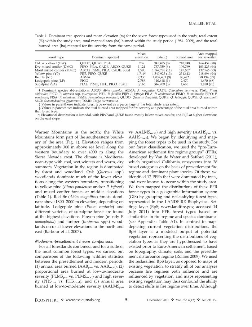
Table 1. Dominant tree species and mean elevation (m) for the seven forest types used in the study, total extent
(%) within the study area, total mapped area (ha) burned within the study period (1984–2009), and the total
burned area (ha) mapped for fire severity from the same period.
Forest type Dominant species�Mean
elevation Extent� Burned areaArea mappedfor severity§
Oak woodland (OW) QUDO, QUWI, PISA 756 941,485 (8) 210,948 164,452 (78)Dry mixed conifer (DMC) PIPO, PILA, CADE, ABCO, QUKE 1,121 737,759 (6) 109,769 103,225 (94)Moist mixed conifer (MMC) ABCO, PSME, PILA, CADE, SEGI 1,590 1,367,706 (11) 147,607 137,746 (93)Yellow pine (YP) PIJE, PIPO, QUKE 1,714} 1,540,923 (13) 231,613 218,696 (94)Red fir (RF) ABMA 2,335 1,037,403 (9) 88,422 78,494 (89)Lodgepole pine (LP) PICO 2,786 110,618 (1) 2,470 1,670 (68)Subalpine (SA) PIAL, PIMO, PIFL, PICO, TSME 3,163 346,709 (3) 1,686 1,180 (70)
� Dominant species abbreviations: ABCO: Abies concolor; ABMA: A. magnifica; CADE: Calocedrus decurrens; PIAL: Pinusalbicaulis; PICO: P. contorta ssp. murrayana; PIFL: P. flexilis; PIJE: P. jeffreyi; PILA: P. lambertiana; PIMO: P. monticola; PIPO: P.ponderosa; PISA: P. sabiniana; PSME: Pseudotsuga menziesii; QUDO: Quercus douglasii; QUKE: Q. kelloggii; QUWI: Q. wislizenii;SEGI: Sequoiadendron giganteum; TSME: Tsuga mertensiana.
� Values in parentheses indicate forest type extent as a percentage of the total study area extent.§ Values in parentheses indicate the total burned area mapped for fire severity as a percentage of the total area burned within
that forest type.} Elevational distribution is bimodal, with PIPO and QUKE found mostly below mixed conifer, and PIJE at higher elevations
on the east slope.
v www.esajournals.org 5 December 2013 v Volume 4(12) v Article 153
MALLEK ET AL.

there are some local discrepancies between theBpS product and Forest Service existing vegeta-tion mapping, the BpS output is the only map ofpotential vegetation in California that is based ona transparent and peer-reviewed modeling pro-cess, incorporates the effects of fire, includeslands of all management jurisdictions, andextends across our entire study region. The finalset of forest types for our analysis consisted ofPFRs that individually occupied sufficient ex-tents to allow robust statistical assessment of firepatterns for the modern period, and collectivelyrepresented the great majority of forest area inthe study area. Of the 12 PFR forest types in ourstudy region, we retained eight that eachrepresented at least 1% of the total mappedforest area, but then removed the pinyon-juniperPFR (5% of the study area) due to insufficientpresettlement fire regime information. The sevenforest types included in our final analysis arelisted in Table 1, in order of their mean elevation.In the text, we refer to the first four (OW, YP,DMC, MMC) as ‘‘low and middle elevation’’forest types, and the last three (LP, RF, SA) as‘‘high elevation’’ forest types.
To estimate AABpre, we divided the estimatedareal extent of each forest type in our reclassifiedBpS map (Table 1) by the presettlement firerotation (FRpre) of that forest type (Table 2),defined as the number of years required for fireto burn an area within a forest type equivalent tothe forest type’s total extent (Heinselman 1973).
Information on FRpre for each forest type wasgathered and synthesized from published litera-ture (Table 2; Appendix: Fig. A1). Fire historystudies in the study region often do not producedirect estimates of FRpre because fires in theforests of our study area generally fail tosufficiently alter overstory vegetation to permitsimple visual delineation of past fire perimeters,and because interpolation of fire perimeters fromfire scars on trees requires intensive samplingwhich can be relatively costly and time-consum-ing. In rare instances, fire-scar studies haveinferred FR based on the assumption that theproportion of sample units recording fire in agiven year reflects the proportion of the studyarea burned in that year, and we accepted theseestimates (see Taylor and Skinner 2003, andFarris et al. 2010 for an example and validation,respectively). A more consistently reported met-ric is the mean fire interval. The relationshipbetween mean fire interval and FR is complex(Baker and Ehle 2001, Reed 2006). However, wefound that one variant, the grand mean fireinterval (i.e., the mean of tree-level mean fireintervals; GMFI), reasonably identified with FRin studies that reported both metrics for identicallocations and periods of time (n ¼ 12, medianerror (%)¼�4.79, root mean squared error (%)¼30.02; Appendix: Fig. A2). Therefore, with theexception of the SA forest type (explanation inAppendix), we accepted GMFI as a proxy forFRpre in studies where no FRpre was explicitly
Table 2. Major forest types in the study area, estimates of fire rotation prior to Euro-American settlement, and
literature used to generate estimates.
Forest type�
Fire rotation (years)
LiteratureMean Range
OW 18 12–25 McClaran and Bartolome 1989, Mensing 1988DMC 23 11–34 Beaty and Taylor 2001, 2007, Bekker and Taylor 2001, Everett 2008, Kilgore and
Taylor 1979, Scholl and Taylor 2010, Stephens 2001, Taylor and Scholl 2012MMC 31 15–70 Agee 1991, 1993; Beaty and Taylor 2001, Bekker and Taylor 2001, Collins and
Stephens 2007, Kilgore and Taylor 1979, Stephens and Collins 2004, Taylor andSkinner 1998, Swetnam et al. 2009, Taylor 2000, Taylor and Skinner 2003, Taylorand Solem 2001
YP 22 11–34 Agee 1993, Taylor 2000, Beaty and Taylor 2001, Bekker and Taylor 2001, North et al.2009,� Stephens et al. 2003, Taylor 2004, 2010
RF 61 25–76 Bekker and Taylor 2001, Pitcher 1987, Scholl 1999, Skinner 2003, Stephens 2001,Taylor 2000, Taylor and Solem 2001
LP 63 46–80 Agee 1993, Bekker and Taylor 2001, Taylor and Solem 2001SA 394 75–721 Bekker and Taylor 2001, Dickman and Cook 1989, Rourke 1988, Skinner 2003, van
Wagtendonk 1995
� See Table 1 for key to forest type abbreviations.� Study’s authors provided fire dates.
v www.esajournals.org 6 December 2013 v Volume 4(12) v Article 153
MALLEK ET AL.
reported.For five of the seven PFR forest types,
estimates of PHSpre were obtained by averagingestimates from two sources: the BpS modelingoutput documentation (http://www.landfire.gov/NationalProductDescriptions24.php), where‘‘percent stand replacement fire’’was the variableused, and Stephens et al. (2007), where ‘‘percentcrown burned’’ was the variable used (for moredetails on the fire severity comparisons, seeAppendix). Estimates from the BpS documenta-tion followed the LANDFIRE vegetation classifi-cation, and were cross-walked to our forest types,as above (see Appendix: Table A1). Because eachforest type in our analysis was mapped as acomposite of multiple BpS forest types, weestimated PHSpre for each forest type by calcu-lating an area-weighted average PHSpre across itsBpS constituents. The estimates from Stephens etal. (2007) followed the forest classification ofBarbour and Major (1977), and also had to becross-walked to our forest type classificationprior to averaging (Appendix: Table A2). Fortwo of the seven PFR forest types, we used onlythe BpS estimate of PHSpre. Specifically, in thecase of oak woodland, Stephens et al. (2007) didnot estimate PHSpre. In the case of red fir, becauseof the dearth of quantitative information on fireseverities in red fir forests at the time of theirresearch, Stephens et al. were forced to maketheir PHSpre estimate based primarily on fieldobservations of contemporary fires and theSugihara et al. (2006) simplification of the redfir fire regime as ‘‘bimodal’’ (S. Stephens, personalcommunication). Taken together, the followinginformation sources suggest that Stephens etal.’s (2007) estimate of 50% PHSpre is very high:(1) post-2007 publication of fire severity resultsfrom wildland fire use areas in Sierra Nevada redfir forests (8–13% high severity [HS]) (Miller andSafford 2008, Thode et al. 2011, Miller et al. 2012);(2) the release of the final LANDFIRE BpSmodels (20% HS in red fir); (3) estimates of fireseverity for the Sierra Nevada made during thelate 19th century (8% HS in mostly red fir forests)(Leiberg 1902); and (4) a review of red firliterature (e.g., Kilgore 1971, Kilgore and Briggs1972, Agee 1993, Taylor 1993, Chappell and Agee1996). In this case, rather than insert our ownestimate in place of Stephens et al. (2007), weelected to use only the BpS value (20%, which
itself may be an overestimate; see Discussion).PLMSpre estimates were calculated by subtract-ing PHSpre from one.
We constrained all assessments of modernburning to the 26-year period from 1984 to 2009because these were the only years for whichhigh-quality fire severity data were continuouslyavailable for the largest geographic area withinthe study area. In addition, 1984 appeared to be areasonable cutoff for the modern period giventhat several studies have found that the mid-1980s coincided with a marked transition towardgreater fire activity in the region (Westerling etal. 2006, Miller et al. 2009b). AABmod in eachforest type was calculated by overlaying yearlyfire perimeter maps (www.frap.fire.ca.gov, ac-cessed 14 July 2011) onto the reclassified BpSlayer in a GIS. Perimeters of prescribed fires werenot included. Similarly, for each forest type,AALMSmod and AAHSmod were obtained byoverlaying yearly fire severity maps onto thereclassified BpS layer. PLMSmod and PHSmod
were calculated simply by dividing AALMSmod
and AAHSmod, respectively, by their sum. Thefire severity maps were derived by comparingpre- and post-fire Landsat thematic mapperimagery to calculate the relative differencenormalized burn ratio (RdNBR; Miller andThode 2007, Miller et al. 2009a, b), and field-calibrated to reflect spatial variation in theComposite Burn Index (CBI; Key and Benson2005). CBI breakpoints for separating low-to-moderate severity pixels from high severitypixels followed those of Miller and Thode(2007). Based on calibration to hundreds of fieldplots across the Sierra Nevada, the CBI boundarybetween moderate and high severity fire corre-sponds to approximately 95% first-year postfiremortality in forest canopy trees (Miller et al.2009a); i.e., our definition of high severity fire isequivalent to ‘‘stand-replacing’’ fire. Modern fireseverity data were available only for fires largerthan 40 ha that occurred at least partially on landmanaged by either the U.S. Forest Service orYosemite National Park. These fires accountedfor 89% of the total area burned in our seven PFRforest types during the modern period. Amongindividual forest types, the proportion of totalarea burned that was mapped for fire severityranged from 68% to 94% (Table 1). For thoseremaining fires which had not been mapped
v www.esajournals.org 7 December 2013 v Volume 4(12) v Article 153
MALLEK ET AL.
using RdNBR, we used PLMSmod and PHSmod toestimate the unmapped extent of areas burned ateither level of fire severity, and incorporatedthese extents into AALMSmod and AAHSmod,respectively. We did not include fires occurringexclusively on private lands, as these fires andthe lands they burn are not managed by the U.S.Forest Service or National Park Service, andbecause fire-killed and -damaged timber on suchlands is usually harvested within weeks tomonths of the fire event. This greatly complicatesfire severity measurements from the one-yearpostfire Landsat images, and also essentiallyremoves such lands from the pool of availablehabitat for animals requiring high numbers ofdead and dying trees.
Modern trendsTo understand how recent trends may have
either exacerbated or ameliorated modern-pre-settlement differences, we used time seriesregressions to examine trends in AABmod,PHSmod, and AAHSmod over the modern period(1984–2009) for all forest types combined and foreach forest type separately. We used a Bayesian,rather than frequentist, approach to inferencebecause this allowed us to make direct probabil-ity statements about the direction and magnitudeof trends, which is what land managers andpolicy makers are primarily interested in know-ing. Candidate models consisted of three basictypes, described here in order of accumulatingcomplexity: (1) generalized linear models (GLMs)in which AABmod and AAHSmod were modeledusing a gamma distribution with log linkfunction, and PHSmod was modeled using abinomial distribution with logit link function;(2) generalized linear mixed effects models(GLMMs) which explicitly accounted for inter-annual variation in excess of that expected underour GLMs through the inclusion of a randomyear effect; and (3) GLMMs that accounted forpotential temporal autocorrelation by adding atime-ordered structure to the random year effectin the form of autoregressive (AR) and/ormoving-average (MA) functions. Intercept-onlymodels were not considered in our analysesbecause our stated goal was to evaluate thedirection and magnitude of all trends, rather thansimply address the question of whether or nottrends ‘exist’. In addition, no attempt was made
to model (i.e., control for) spatial autocorrelationin the analyses of PHSmod as our goal was todescribe trends in the observations themselves,not trends in the processes underlying thoseobservations.
Regression parameters were estimated usingMarkov Chain Monte Carlo (MCMC) proceduresbecause this method simultaneously accommo-dated the non-Gaussian and autocorrelativefeatures of our candidate models. Uninformativepriors were used in all MCMC runs. All modelswere implemented in WinBUGS 1.4.3 (Lunn et al.2000) with three chains and thinned after aninitial burn-in to generate 10,000 independentsamples, resulting in a total of 30,000 samples perparameter. Convergence was assessed throughvisual inspection of the chains and with Gelmanand Rubin’s diagnostic (Gelman and Rubin 1992).The resulting model fit was assessed usingposterior predictive distributions (Gelman et al.1996), Ljung-Box-modified Box-Pierce tests, andautocorrelation plots of the residuals. Finalmodel selection was made by comparing thedeviance information criterion (DIC), whichpenalizes for poor model fit and model complex-ity, and we selected the model with the lowestDIC (Spiegelhalter et al. 2002). To clarify thedegree of confidence that the time series datarepresented upward trends over time, posteriorprobabilities were calculated for the hypothesisthat slope coefficients in the best models weregreater than zero. In addition, to facilitateinterpretation of the estimated magnitude ofchange over time, regression parameter estimates(b) were transformed to represent annual percentchange using the formula b (%)¼ (eb� 1) 3 100.Thus, the transformed regression parameters forthe analyses of AABmod and AAHSmod indicatethe annual percent change in area burned andarea burned at high severity, respectively; andthose for PHSmod indicate the annual percentchange in the odds that a site burned at highseverity, given that it burned at all.
RESULTS
Modern-versus-presettlement means comparisonsWe obtained 43 estimates of pre-Euro-Ameri-
can FR from 28 published studies (Table 2).Median record length was 200 years (interquar-tile range ¼ 144 to 277 years). Among the seven
v www.esajournals.org 8 December 2013 v Volume 4(12) v Article 153
MALLEK ET AL.

forest types considered in this study, we foundthe greatest number of empirical presettlementFR estimates for MMC (n¼ 12), DMC (n¼ 8), andYP (n¼ 8), and the fewest for OW (n¼ 2), LP (n¼3), and SA (n ¼ 4).
Comparisons between AABmod and AABpre
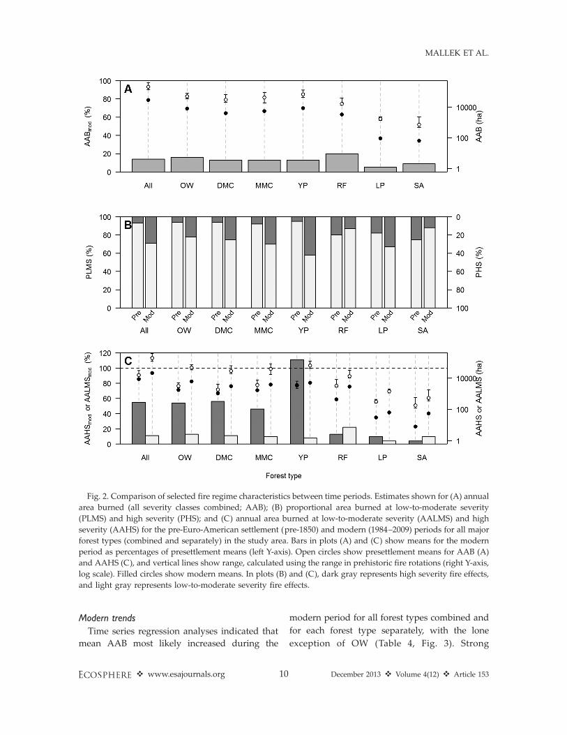
indicated that modern (1984–2009) rates ofburning are far below their presettlement (pre-1850) levels throughout forests in the study area.For study area forests as a whole, AABmod wasonly 14% of AABpre (Table 3, Fig. 2A), represent-ing a shift in overall fire rotation from 28 yearsprior to Euro-American settlement to 200 yearsduring the modern period. This suggests that theburned-area deficit accumulated over a 33-yearperiod would surpass the total extent of all theforest types used in our study combined. Amongforest types, we found considerable variation inAABmod and AABpre. Nevertheless, AABmod
values were less than 20% of their correspondingpresettlement means in all cases (Fig. 2A).
For study area forests as a whole, fire effectsduring the modern period were qualitativelydifferent from those during the presettlementperiod. For all forest types combined, thepercentage of burned area that experienced highseverity fire effects during the modern period(29%) was more than four times greater than thesame estimate for the presettlement period (7%)(Table 3, Fig. 2B). Conversely, the percentage ofburned area that experienced low to moderateseverity fire effects during the modern period(71%) was approximately three-quarters of pre-settlement levels (93%). Low and middle eleva-tion forest types (OW, DMC, MMC, and YP),which collectively represented the majority of theforestland in our study area (75%), exhibitedvalues for PHSmod that were consistently more
than three times greater (for YP, eight timesgreater) than corresponding values for thepresettlement period. For high elevation foresttypes (RF, LP, and SA), PHSmod and PHSpre weremore alike.
Differences between the modern and presettle-ment periods in mean annual area burned withineach of the two severity categories (i.e.,AAHSmod vs. AAHSpre, and AALMSmod vs.AALMSpre) reflect the combined effects of chang-es in AAB and PHS/PLMS. For all forest typescombined, although mean annual area burnedduring the modern period was less than theestimated presettlement mean for both categoriesof fire severity, the disparity was much greaterfor low to moderate severity than for highseverity (Fig. 2C). AAHSmod was 55% ofAAHSpre, whereas AALMSmod was only 11% ofAALMSpre. This contrast between severity cate-gories was largely a manifestation of the patternobserved across the four lower- to middle-elevation forest types which comprised morethan three-quarters of the total study area. Foreach of these forest types (OW, DMC, MMC, andYP), AAHSmod was within the range of thecorresponding presettlement estimates, andgreater than 45% of the estimated presettlementmean. Pooling across all four low and middleelevation forest types, AAHSmod accounted for68% of AAHSpre. In contrast, AALMSmod for eachof these low and middle elevation forest typeswas consistently outside and below the range ofpresettlement estimates, and less than 15% of theestimated presettlement mean. For the higherelevation forest types (RF, LP, SA), AAHSmod
was 12% of AAHSpre (range 4–13%), whileAALMSmod constituted 20% of AALMSpre (range4–22%) (Table 3, Fig. 2B).
Table 3. Summary of selected fire regime characteristics for modern and pre-Euro-American periods.
Forest type�
AAB (ha) PHS (%) PLMS (%) AAHS (ha) AALMS (ha)
mod pre mod pre mod pre mod pre mod pre
All 30,481 215,759 29 7 71 93 8,869 16,113 21,612 199,646OW 8,113 51,168 22 6 78 94 1,771 3,275 6,342 47,893DMC 4,222 31,461 25 6 75 94 1,061 1,903 3,161 29,558MMC 5,677 44,076 30 8 70 92 1,685 3,658 3,992 40,418YP 8,908 69,411 42 5 58 95 3,727 3,349 5,182 66,062RF 3,401 17,007 13 20 87 80 449 3,384 2,952 13,662LP 95 1,758 33 18 67 82 31 323 64 1,435SA 65 879 12 25 88 75 8 220 57 659
� See Table 1 for key to forest type abbreviations.
v www.esajournals.org 9 December 2013 v Volume 4(12) v Article 153
MALLEK ET AL.
Modern trends
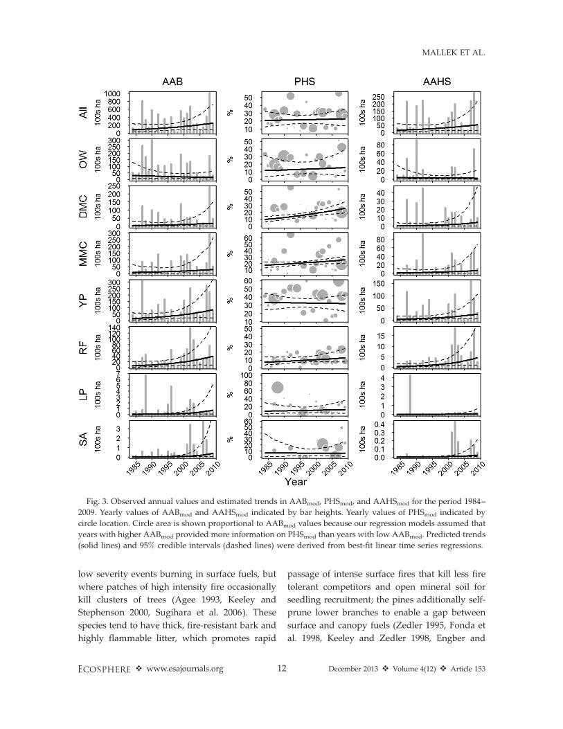
Time series regression analyses indicated that
mean AAB most likely increased during the
modern period for all forest types combined and
for each forest type separately, with the lone
exception of OW (Table 4, Fig. 3). Strong
Fig. 2. Comparison of selected fire regime characteristics between time periods. Estimates shown for (A) annual
area burned (all severity classes combined; AAB); (B) proportional area burned at low-to-moderate severity
(PLMS) and high severity (PHS); and (C) annual area burned at low-to-moderate severity (AALMS) and high
severity (AAHS) for the pre-Euro-American settlement (pre-1850) and modern (1984–2009) periods for all major
forest types (combined and separately) in the study area. Bars in plots (A) and (C) show means for the modern
period as percentages of presettlement means (left Y-axis). Open circles show presettlement means for AAB (A)
and AAHS (C), and vertical lines show range, calculated using the range in prehistoric fire rotations (right Y-axis,
log scale). Filled circles show modern means. In plots (B) and (C), dark gray represents high severity fire effects,
and light gray represents low-to-moderate severity fire effects.
v www.esajournals.org 10 December 2013 v Volume 4(12) v Article 153
MALLEK ET AL.

evidence of an increase in mean AAB (i.e., Pr(b .
0) � 0.95) was found for the two highest-elevation forest types, LP and SA, where meanAAB most likely increased at rates of 16.82%year�1 and 21.58% year�1, respectively. In addi-tion, modest evidence of increases in mean AAB(i.e., Pr(b . 0) � 0.90) were found for the next-highest forest types, YP and RF, where meanAAB most likely increased at rates of 7.04%year�1 and 8.17% year�1, respectively. Evidenceof an increase in mean AAB for all forestlandscombined was only slightly weaker (Pr(b . 0) ¼0.89). The remaining lower-elevation forest typesshowed no clear evidence of trend in mean AABduring the modern period.
In contrast to the findings for AAB, strongevidence of positive trends in mean PHS werefound exclusively among forest types at lowerelevations, including DMC and MMC (Table 4,Fig. 3). During the modern period, the expectedodds of an area burning with high severityeffects, as opposed to low-to-moderate severityeffects, most likely increased at a rate of 4.87%year�1 in DMC, and 2.04% year�1 in MMC. Theremaining lower-elevation forest types showedno clear evidence of trend in mean PHS duringthe modern period.
Evidence of positive trends in mean AAHSfollowed a similar pattern to that found for AAB.Mean AAHS most likely increased during themodern period for all forest types combined andfor each forest type separately, with the exceptionof OW (Table 4, Fig. 3). Evidence of an increase inmean AAHS was strong (i.e., Pr(b . 0) � 0.95),or at least modest (i.e., Pr(b . 0) � 0.90), for fiveof the seven forest types examined. Strongevidence of an increase was found for each of
the three highest-elevation forest types, includingRF, LP, and SA, where mean AAHS most likelyincreased at the rates of 10.72% year�1, 17.99%year�1, and 19.08% year�1, respectively. Modestevidence of an increase in mean AAHS wasfound for DMC and YP, where mean AAHS mostlikely increased at the rates of 10.05% year�1 and7.29% year�1, respectively.
DISCUSSION
Our principal finding is that while modern(1984–2009) regional rates of burning at low-to-moderate severity (AALMS) were far below theirpresettlement levels for all forest types weexamined, departures in regional rates of burn-ing at high severity (AAHS) were evident onlyfor high-elevation forests (red fir, lodgepole pine,subalpine). Modern regional rates of burning athigh severity exhibited comparatively little or nodeparture from their presettlement levels in low-and middle-elevation forests. Previous studieshave documented reductions in rates of burningin forests of the Sierra Nevada and adjacentmountains (McKelvey et al. 1996, Caprio andGraber 2000, Safford and Van de Water 2013),but, to our knowledge, our findings represent thefirst quantitative characterization of how changesin rates of burning vary by both forest type andfire severity.
Ecologically speaking, our most notable find-ing is that there is a large modern deficit in lowand moderate severity fire in lower and middleelevation forest types in the study area. Thehistorically dominant tree species in these foresttypes—mostly from the genera Pinus and Quer-cus—are adapted to fire regimes dominated by
Table 4. The direction and magnitude (median and 95% credible interval) of the rate of change (b[%]) in AABmod,
PHSmod, and AAHSmod, for each forest type during the period 1984–2009, and the probability that the data
indicate an upward trend (Pr[b . 0]).
Forest type
AABmod PHSmod AAHSmod
b (%) Pr(b . 0) b (%) Pr(b . 0) b (%) Pr(b . 0)
All 4.65 (�3.00, 13.04) 0.89 0.48 (�3.60, 4.64) 0.59 5.06 (�4.78, 15.37) 0.86OW �2.86 (�12.13, 6.60) 0.27 1.36 (�7.00, 10.54) 0.62 �1.71 (�16.37, 14.72) 0.41DMC 6.36 (�8.07, 20.77) 0.82 4.87 (1.81, 8.02) .0.99 10.05 (�6.26, 27.01) 0.91MMC 5.87 (�10.63, 23.08) 0.77 2.04 (�0.34, 4.17) 0.96 7.26 (�9.04, 24.55) 0.82YP 7.04 (�2.50, 17.27) 0.93 �0.26 (�3.46, 2.92) 0.43 7.29 (�2.92, 17.86) 0.93RF 8.17 (�2.18, 18.82) 0.94 2.55 (�2.23, 7.54) 0.86 10.72 (�0.19, 22.43) 0.97LP 16.82 (1.87, 33.36) 0.99 1.73 (�8.64, 12.89) 0.63 17.99 (1.17, 36.12) 0.98SA 21.58 (1.47, 43.71) 0.98 �0.32 (�13.96, 15.20) 0.48 19.08 (1.69, 36.85) 0.99
v www.esajournals.org 11 December 2013 v Volume 4(12) v Article 153
MALLEK ET AL.
low severity events burning in surface fuels, but
where patches of high intensity fire occasionally
kill clusters of trees (Agee 1993, Keeley and
Stephenson 2000, Sugihara et al. 2006). These
species tend to have thick, fire-resistant bark and
highly flammable litter, which promotes rapid
passage of intense surface fires that kill less fire
tolerant competitors and open mineral soil for
seedling recruitment; the pines additionally self-
prune lower branches to enable a gap between
surface and canopy fuels (Zedler 1995, Fonda et
al. 1998, Keeley and Zedler 1998, Engber and
Fig. 3. Observed annual values and estimated trends in AABmod, PHSmod, and AAHSmod for the period 1984–
2009. Yearly values of AABmod and AAHSmod indicated by bar heights. Yearly values of PHSmod indicated by
circle location. Circle area is shown proportional to AABmod values because our regression models assumed that
years with higher AABmod provided more information on PHSmod than years with low AABmod. Predicted trends
(solid lines) and 95% credible intervals (dashed lines) were derived from best-fit linear time series regressions.
v www.esajournals.org 12 December 2013 v Volume 4(12) v Article 153
MALLEK ET AL.
Varner 2012). Historically, topography interactedwith the fire regime in these forests to createhighly heterogeneous stand structures that sup-ported a high diversity of plants and animals(North et al. 2009). Litter decomposition rates inlow and middle elevation forests in the studyarea are extremely slow (Hart et al. 1992), andlong fire-free intervals lead to accumulation offuel and fundamental changes in soil and litternutrient dynamics (Johnson et al. 2009). The lackof low and moderate severity fire in these forestsover most of the last century has also increasedtree densities and canopy cover; changed treespecies dominance patterns (from fire tolerant/shade intolerant species to fire intolerant/shadetolerant species, e.g., in the genera Abies andCalocedrus); reduced soil interception of light andwater; changed surface and ground water hy-drology; decreased herbaceous production anddiversity in the understory; reduced criticalforaging habitat for animals; led to higher ratesof adult tree mortality from insects, diseases andwater stress; and resulted in a major fire regimetransition to one dominated by infrequent, large,and highly severe fires (Agee 1993, Barbour et al.1993, Allen et al. 2002, Bales et al. 2006, Sugiharaet al. 2006, Fettig et al. 2007, Miller et al. 2009b,North et al. 2009, Van Mantgem et al. 2009, Millerand Safford 2012, North 2012). It is telling thatthe conifer types in our study region thatsupported the lowest severity fires during thepresettlement period (YP, DMC, MMC), nowsupport the highest severity fires (YP¼ 42%, areaweighted mean of the three types ¼ 34%).
Areas of high severity fire create ecologicallyimportant patches of dead and dying trees andearly seral conditions (Hutto 2008, Swanson et al.2011). At some level, areas of high severity firehave always occurred in Sierra Nevada forests ofall types. Before Euro-American settlement, therelative importance of high severity fire in lowand middle elevation forests in our study regionwas low however, and—because modern firesare burning at such high severity—our resultsindicate little to no departure in the averageannual area of high severity fire in theseecosystems. Rather, strong evidence of modernvs. presettlement differences in the occurrence ofhigh severity fire in these forest types exists onlyfor its spatial configuration, not its overall spatialextent; i.e., individual fires and high severity
patches within fires tend to be larger undermodern than under presettlement conditions. Forexample, Miller et al. (2012) show that modernfires in our study region over the last quarter-century in fire-suppressed yellow pine andmixed conifer forests average over 2600 ha insize. Data from contemporary reference (i.e.,unlogged and no fire suppression) forests andreconstructions of fire size from studies ofpresettlement landscapes suggest that averagefires under presettlement conditions were at leastan order of magnitude smaller (Show and Kotok1923, Taylor and Skinner 1998, Minnich et al.2000, Taylor 2000, Beaty and Taylor 2001, Taylorand Solem 2001, Collins and Stephens 2007; B. M.Collins, personal communication; A. H. Taylor,personal communication). In low and middleelevation forests, high severity patch size hasalso risen, with a dominance of small, scatteredpatches in presettlement and reference estimatestransitioning to more contiguous, coarser-grained patchiness in modern fire-suppressedforests. High severity patches more than a fewhectares in size were relatively unusual (althoughnot unknown) in fires in Sierra Nevada yellowpine and mixed conifer forests before Euro-american settlement (Sudworth 1900, Show andKotok 1923, Kilgore 1973, Agee 1993, Skinner1995, Skinner and Chang 1996, Weatherspoonand Skinner 1996, Keeley and Stephenson 2000),but in recent years high severity patches .500 hahave become a regular occurrence (Miller andSafford 2008, Miller et al. 2012). Between 1984and 2006, mean high severity patch size in ForestService fires in the study area nearly doubled(Miller et al. 2009b). Comparisons betweencurrent reference yellow pine and mixed coniferforests (mean patch sizes 1.7–4.2 ha) and ForestService forests (managed primarily under full firesuppression; mean patch sizes .12 ha) furtherreflect these changes (Minnich et al. 2000, Collinsand Stephens 2010, Miller et al. 2012).
Our finding that high elevation and low tomiddle elevation forests experienced roughlysimilar levels of departure in overall burned areawas somewhat surprising. For a variety ofreasons, modern fire regimes in higher elevationforests in the western United States are generallythought to have changed little in response tohuman management over the last century (Agee1993, Schoennagel et al. 2004, Noss et al. 2006,
v www.esajournals.org 13 December 2013 v Volume 4(12) v Article 153
MALLEK ET AL.

Sugihara et al. 2006). Presettlement fire returnintervals in these forest types were much longerthan in lower elevation forests, and a century offire suppression has only resulted in zero to twomissed fire cycles on most of the landscape(Safford and Van de Water 2013). In California,high elevation forests are much more likely thanlow and middle elevation forests to be found inwilderness areas and National Parks, wheretimber extraction was minimal or nonexistentand where modern fire suppression policies areoften relaxed. Additionally, road densities inthese forests are relatively low, which inhibitseasy fire fighter access. Very low ecosystemproductivity in high elevation forests also leadsto slower plant growth and lower rates of fuelaccumulation between fires (Barbour et al. 2007).
There are a number of sources of possible errorin our high elevation estimates that must betaken into account before we develop an ecolog-ical explanation of the high elevation results.These include: (1) the possibility that the LAND-FIRE vegetation map may be relatively lessaccurate at higher elevations, due to lowernumbers of high elevation field samples support-ing the vegetation modeling; (2) the relativelyshort temporal window of our analysis for highelevation ecosystems that are naturally charac-terized by infrequent fire events (this may becompensated for by the very large size of ourstudy area); and (3) the higher proportion ofsmall (,40 ha) fires at high elevations, whichcould lead to underreporting of modern areaburned in red fir and subalpine forests andsubsequent inflation of our measures of depar-ture.
Another factor that influences our estimate ofdeparture in high elevation forests is the set of
values we used for presettlement PHS. OurPHSpre approximations derive from two sources:estimates made from literature sources and fieldobservations (Stephens et al. 2007) and estimatesderived from state-and-transition modeling car-ried out by fire and forest ecology experts(LANDFIRE BpS models; Rollins 2009). Table 5compares our PHSpre estimates for a set of foresttypes and forest type combinations againstindependent estimates made from referenceareas (both current and presettlement; see Ap-pendix). In Table 5, our estimates of PHSpre forlower and middle elevation forest types (YP,DMC, MMC plus some LP and RF) are closelycorroborated by the independent sources. Incontrast, our estimates for PHSpre in the highestelevation forest types (RF and SA) seem high(Table 5). Most estimates of fire severity in theseforest types, whether from contemporary orpresettlement sources, suggest that natural se-verities of fire are probably below the 20–25%PHSpre values we used in our study (Kilgore1971, Kilgore and Briggs 1972, Weaver 1974,Agee 1993, 2005, Taylor 1993, Chappell and Agee1996, Miller et al. 2009b, 2012; M. D. Meyer,personal communication). The implications of ourprobable overestimate of PHSpre in red fir andsubalpine forest are that the real differencesbetween presettlement and current annual areaburned at high severity (AAHS) for high eleva-tion forests are likely less than our analysissuggests. Substituting the independent referenceestimates (Table 5) for PHSpre in Table 3 results inan AAHSpre of 1871 ha for red fir and 62 ha forsubalpine forest. Using these values, the depar-tures in high elevation forest between modernand presettlement AAB in the high severity andlow þ moderate severity classes become more
Table 5. Comparisons of independent reference estimates of percent high severity in wildland fires with
presettlement estimates used in this study. See Appendix for details.
PFR forest types Independent sources
Estimate of percent high severity
Independent reference estimates This study (PHSpre)�
YP þ DMC Minnich et al. 2000, Stephens et al. 2008;Safford et al., unpublished manuscript
4–8 5.3
YP þ DMC þ MMC Show and Kotok 1925 5 6.1MMC þ RF þ LP Collins et al. 2009 13 12.6RF Leiberg 1902, Miller et al. 2009b, 2012 8–13 19.9SA Miller et al. 2009b 7 25All combined Leiberg 1902 8 7
� Presettlement high severity estimates weighted by presettlement area burned within each PFR type listed in column 1.
v www.esajournals.org 14 December 2013 v Volume 4(12) v Article 153
MALLEK ET AL.

similar: combining RF and SA, AAHSmod is23.3% of presettlement, AALMSmod is 18.9% ofpresettlement.
Therefore, assuming that the departure wemeasured in overall burned area in the highelevation forest types is real—if slightly exagger-ated—then it is not due to a general change infire behavior, but rather to a change in overallburned area. In other words, higher elevationfires do not appear to be burning in a qualita-tively different manner today than before Euro-american settlement, there are just fewer of them.High elevation fires are relatively easy to put out.The needles of high elevation conifers tend to beshort and highly compact, and they form moist,dense litter layers that are difficult to ignite andslow to burn. The fire season is short, andsummer daytime temperatures are low andrelative humidities high. Soils are rocky andforest stands are often open and separated byareas of low flammability (Fonda et al. 1998,Sugihara et al. 2006, Barbour et al. 2007). All ofthese factors lead to a high success rate when asuppression decision is made on a high elevationfire. Most fires in our study area are still subjectto fire suppression, especially on Forest Serviceand private lands. Although high elevation firesare not as zealously suppressed as low elevationfires (and there are a number of high elevationwilderness areas where fires are often managedrather than suppressed), natural fire rotations forthe higher elevation forest types are 3–20 timeslonger than lower elevation types (Table 2). Thissuggests that, all else being equal, fire suppres-sion can cause departures at higher elevationssimilar to those at lower elevations even wheneffective suppression is only 1/3 to 1/20 asintense. In other words, the intensity of effectivefire suppression necessary to produce a givenmodern-vs.-presettlement departure declinesrapidly with elevation, and this could potentiallycompensate for any elevation gradient in firesuppression effort.
Our trend analyses indicate that the strongestincreases in annual area burned (and AABHS) inour modern study period occurred in the highelevation forest types (Table 4). A number offactors could help to explain this trend. First ofall, since the late 1970s fire management policiesin progressively larger areas of high elevationwilderness in the Sierra Nevada have been
converted from a fire suppression focus to a firemanagement focus. This is especially the case inYosemite and Sequoia-Kings Canyon NationalParks (van Wagtendonk 2007). Second, climatewarming in the study area has led to drier andlonger fire seasons, rain replacing snow in manyprecipitation events, declining snowpack, and anupward migration of the elevation of the freezingline (Safford et al. 2012a). These changes arehaving major impacts on higher elevation eco-systems, especially red fir forests, which occur atthe elevation of greatest snowpack and justabove the freezing line in winter storms (Saffordand Van de Water 2013). The loss of snow isincreasing tree regeneration and leading to thefilling of canopy gaps and formerly perennialsnowpatches with small trees in subalpine forests(Dolanc et al. 2012). These dynamics are gradu-ally leading to higher fuel continuity, but thesystem remains patchy, with generally thinnersoils and low productivity. Overall, generalbehavior of fire in high elevation forests has notchanged dramatically from presettlement times,but as climate warming proceeds, climaticconditions appropriate for burning are becomingmore common and the length of the fire season isincreasing (Westerling et al. 2006). As snowpackcontinues to decrease, summers warm, and forestdensification accelerates (Dolanc et al. 2012,Safford et al. 2012a), we would predict that firebehavior in high elevation forests will becomemore extreme.
Miller and Safford (2012) recently found thatthe area of high severity fire in yellow pine andmixed conifer forest types had increased signif-icantly between 1984 and 2010 (P , 0.01). Thisdiffers somewhat from our finding that yellowpine high severity fire area only increasedmarginally (posterior probability ¼ 0.92), andmixed conifer (posterior probability , 0.90) evenless, but dissimilarities in the time period, studyarea, and analysis help to explain the difference.Miller and Safford (2012) studied only ForestService managed lands in the study area,included an extra year of fire data (2010),combined the yellow pine and mixed conifertypes in their analysis, and employed ARIMAtime-series regression modeling. To see to whatextent the combination of yellow pine and mixedconifer forest types accounted for the difference,we reran our analysis combining the yellow pine
v www.esajournals.org 15 December 2013 v Volume 4(12) v Article 153
MALLEK ET AL.

and mixed conifer types and obtained a posteriorprobability of 0.92 for the combination. We thenremoved the National Park fires from our datasetand reran the same analysis, which resulted in aposterior probability of .0.94. Other reasons forthe differences include the extra year of fire data,and the use of a fourth-order autoregressivefunction in Miller and Safford (2012; ARIMAmodels using only the first-order autoregressivefunction were not statistically significant). Underthe Bayesian framework, our Forest Service only,yellow pine-mixed conifer combined analysissuggests a greater than 94% chance (put anotherway, .15:1 odds) that the area of high severityfire increased between 1984 and 2009. We shouldalso note that we chose to remain conservative inour analysis and employed ‘‘naıve’’ (uninformed)priors. Since previous work had shown increasesin the percent of high severity fire in the samestudy region between 1984 and 2006 (Miller et al.2009b), we might have incorporated informativepriors in our analysis, which would have resultedin posterior probabilities well over 0.95.
As with the yellow pine and mixed coniferforest types, our trend results for AAHSmod inred fir were also slightly different from Millerand Safford (2012). We found a posteriorprobability of 0.96 for an increasing trendbetween 1984 and 2009, Miller and Safford(2012) found a traditional statistical probabilityof P ¼ 0.06 (equivalent to a posterior probabilityof 0.94) for the same trend. As above, these minordifferences find their roots in the different areasand years of analysis.
Implications for managementOur results have important implications for the
management of fire, forests, and wildlife in thestudy area and surrounding regions. The ecolog-ical consequences of fire suppression and thesubsequent fire deficit in frequent-fire foresttypes in the western US have been understoodfor many years (see Introduction; Weaver 1943,Biswell 1972, Parsons and Debenedetti 1979,Agee 1993, Sugihara et al. 2006). Nonetheless,under current federal policies almost all fires,whether naturally ignited or not, are put outwithin days of ignition. The exception in ourstudy area is National Park Service lands(Yosemite, Sequoia-Kings Canyon, and LassenNational Parks), where many fires are managed
for resource benefits, and a few Forest Servicewilderness areas, where some fires are managedin similar fashion. Outside of these limited areas,nearly the only fires that reach any size are thosethat escape control under severe climatologicalconditions, in heavy fuels, and/or in inaccessibletopography (Calkin et al. 2005). Since almost allfires occurring under moderate conditions areput out, areas burned by wildfire in thecontemporary study area suffer a statisticalpredisposition to burn at higher severity. This isespecially evident in lower and middle elevationforests like yellow pine and mixed conifer, wheresteadily increasing levels of forest fuels due to acentury-and-counting of fire suppression, andthe effects of warming climates, decreasingsnowpack, and drier late summer days on firebehavior are accelerating forest biomass loss tofire (Miller et al. 2009b, Miller and Safford 2012).
To a great extent, current forest managementpractices in the study area are responding tothese trends by focusing on protection of humanlives and infrastructure from wildfire. Such workis critical, but the intense emphasis on short-term,small-scale and stop-gap measures leaves vastareas of forest ecosystems in the study areaincreasingly vulnerable to threshold-type ecolog-ical events (‘‘type conversions’’) caused byinteractions between severe fires, drought, cli-mate warming, insects and diseases, and otherstressors (Barbour et al. 1993, Dale et al. 2001,Allen et al. 2010). In addition, almost all fuelsmanagement in the western US is focused oncreating conditions where fires can be moreeasily suppressed, not creating conditions whereforests will be more resilient if wildfire arrives(Reinhardt et al. 2008). It is important toremember that in California’s climate and igni-tion environment, the question in many foresttypes is not ‘‘if’’ fire will arrive, but rather‘‘when’’.
Our results show that departures in areaburned in the study area are proportionallysimilar in low/middle and high elevation forests,but the areal signature of the fire deficit is anorder of magnitude greater in the former (c.170,000 ha per year vs. c. 16,000 ha). In highelevation forest types like red fir and subalpine,fire severities of all types are lacking in nearlyequal measure, and restoration of fire throughexpanded use of managed (versus suppressed)
v www.esajournals.org 16 December 2013 v Volume 4(12) v Article 153
MALLEK ET AL.

wildfire is likely to rapidly realize ecologicalbenefits. In low and middle elevation forests likeyellow pine and mixed conifer however, thecritical deficit is in low and moderate severityfire, and the management focus must be not onlyon increasing the area burned, but also replacinghigh severity hectares with low and moderateseverity hectares. As Pyne (2009) put it, we needto replace the ‘‘wrong kind of fire’’ with the‘‘right kind of fire.’’ In these lower and middleelevation forests, expanded use of managedwildfire is also called for under moderateweather and fuels conditions, but the latter arerelatively rare on the modern landscape. Ourresults support the notion that forest fuels willneed to be strategically reduced in many areas ofyellow pine and mixed conifer forest beforerestoration of fire as a beneficial ecologicalprocess becomes ecologically, politically, andfinancially feasible (Allen et al. 2002, Arno andFiedler 2005, Moghaddas et al. 2010, Stephens etal. 2010, North et al. 2012).
Through their management of vegetation andfire, federal agencies like the Forest Service,Bureau of Land Management, and National ParkService have significant effects on wildlife habi-tat. For the Forest Service and BLM, thepopulation status of a handful of wildlife specieshas become the principal arbiter of managementpolicies and practices across northern Californiaand the Pacific Northwest. In the study area, theCalifornia spotted owl (Strix occidentalis occiden-talis), northern goshawk (Accipiter gentilis), andCalifornia populations of fisher (Martes pennanti )are carnivores whose life histories include a closeassociation with old forest and complex foreststructure, primarily in mixed conifer forests.Current population sizes of these species aresmall and population growth rates are near zeroor negative (Blakesley et al. 2010, Spencer et al.2011). These conditions have led to controversy,litigation, and a resultant agency ‘‘hands off’’policy towards these species that is focused onavoiding the short term putative threats of activeforest management. Forest conditions havechanged drastically since Euroamerican settle-ment however, and current trends in climate, fuelloads, forest density, and fire size and severitysuggest that long term sustainability of habitatfor these species is uncertain (McKenzie et al.2004, Miller et al. 2009b, Scheller et al. 2011,
Lawler et al. 2012, Miller and Safford 2012,Safford et al. 2012a). Indeed, over the last 15years, a wave of large and severe fires in easternOregon and northern California has substantiallyreduced the number of high value habitat areasfor spotted owl (Courtney et al. 2004, Spies et al.2006, Healey et al. 2008, Keane et al. 2010, Clarket al. 2011). Likewise, demographic and habitatsuitability modeling of the isolated southernSierra Nevada fisher population indicate thatlarge and severe fires in the absence of strategicforest management approaches could substan-tially reduce long-term habitat quality andpopulation size for this species (Scheller et al.2011, Thompson et al. 2011). Long-term retentionof old forest in the study area will requiresubstantially more integration of forest, fuels,and fire management than is currently the case,as well as a longer-term view of the costs andbenefits of current fire management policies(Stephens and Ruth 2005). On the other hand,under current and projected future trends, earlyseral habitats in the study area are likely toexpand greatly in area (McKenzie et al. 2004,Lenihan et al. 2008, Cole 2010, Gedalof 2011,Miller and Safford 2012, Safford et al. 2012a).Study area species with demonstrated depen-dence on high severity fire (e.g., black-backedwoodpecker [Picoides arcticus]) will likely benefitfrom these trends.
ACKNOWLEDGMENTS
We thank our anonymous reviewers and the editorfor constructive comments on the original submission.Marc Meyer and Susan Roberts also provided critiqueof an early draft. Authors’ division of labor: C. Mallekcarried out analyses and wrote the paper; H. Saffordinitiated and funded the study and wrote the paper; J.Viers wrote the paper; J. Miller carried out analyses.
LITERATURE CITED
Agee, J. K. 1991. Fire history along an elevationalgradient in the Siskiyou Mountains, Oregon.Northwest Science 65:188–199.
Agee, J. K. 1993. Fire ecology of the Pacific Northwest.Island Press, Washington, D.C., USA.
Allen, C. D., K. Alison, H. C. Macalady, D. Bachelet, N.McDowell, M. Vennetier, T. Kitzberger, A. Rigling,D. D. Breshears, E. H. Hogg, P. Gonzalez, et al.2010. A global overview of drought and heat-induced tree mortality reveals emerging climate
v www.esajournals.org 17 December 2013 v Volume 4(12) v Article 153
MALLEK ET AL.

change risks for forests. Forest Ecology andManagement 259:660–684.
Allen, C. D., M. Savage, D. A. Falk, K. F. Suckling,T. W. Swetnam, T. Schulke, P. B. Stacey, P. Morgan,M. Hoffman, and T. J. Klingel. 2002. Ecologicalrestoration of southwestern ponderosa pine eco-systems: a broad perspective. Ecological Applica-tions 12:1418–1433.
Arno, S. F., and C. E. Fiedler. 2005. Mimicking nature’sfire: restoring fire-prone forests in the West. IslandPress, Washington, D.C., USA.
Baker, W. L., and D. Ehle. 2001. Uncertainty in surface-fire history: the case of ponderosa pine forests inthe western United States. Canadian Journal ofForest Research 31:1205–1226.
Bales, R. C., N. P. Molotch, T. H. Painter, M. D.Dettinger, R. Rice, and J. Dozier. 2006. Mountainhydrology of the western United States. WaterResources Research 42:W08432.
Barbour, M. G., B. Pavlik, F. Drysdale, and S.Lindstrom. 1993. California’s changing landscapes:diversity and conservation of California vegetation.California Native Plant Society, Sacramento, Cal-ifornia, USA.
Barbour, M. G., T. Keeler-Wolf, and A. A. Schoenherr.2007. Terrestrial vegetation of California. Thirdedition. University of California Press, Berkeley,California, USA.
Barbour, M. G., and J. Major. 1977. Terrestrialvegetation of California. John Wiley and Sons,New York, New York, USA.
Beaty, R. M., and A. H. Taylor. 2001. Spatial andtemporal variation of fire regimes in a mixedconifer forest landscape, Southern Cascades, Cal-ifornia, USA. Journal of Biogeography 28:955–966.
Beaty, R. M., and A. H. Taylor. 2007. Fire disturbanceand forest structure in old-growth mixed coniferforests in the northern Sierra Nevada, California.Journal of Vegetation Science 18:879–890.
Beesley, D. 1996. Reconstructing the landscape: anenvironmental history, 1820-1960. Pages 3–24 inSierra Nevada ecosystem project final report toCongress. Wildland Resources Center Report 37.University of California, Davis, California, USA.
Bekker, M. F., and A. H. Taylor. 2001. Gradient analysisof fire regimes in montane forests of the southernCascade Range. Plant Ecology 155:15–28.
Biswell, H. H. 1972. Fire ecology in ponderosa pine-grassland. Proceedings of the Tall Timbers FireEcology Conerence 12:69–97.
Blakesley, J. A., M. E. Seamans, M. M. Conner, A. B.Franklin, G. C. White, R. J. Gutierrez, J. E. Hines,J. D. Nichols, T. E. Munton, D. W. H. Shaw, J. J.Keane, et al. 2010. Population dynamics of spottedowls in the Sierra Nevada, California. WildlifeMonographs. 174:1–36.
Bowman, D. M., J. K. Balch, P. Artaxo, W. J. Bond, J. M.
Carlson, M. A. Cochrane, C. M. D’Antonio, R.DeFries, F. H. Johnston, J. E. Keeley, M. A.Krawchuk, et al. 2009. Fire in the earth system.Science 324:481–484.
Brown, P. M., C. L. Wienk, and A. J. Symstad. 2008.Fire and forest history at Mount Rushmore.Ecological Applications 18:1984–1999.
Calkin, D. E., K. M. Gebert, J. G. Jones, and R. P.Neilson. 2005. Forest Service large fire area burnedand suppression expenditure trends, 1970–2002.Journal of Forestry 103(4):179–183.
Caprio, A. C., and D. M. Graber. 2000. Returning fire tothe mountains: can we successfully restore theecological role of pre-Euroamerican fire regimes inthe Sierra Nevada? Pages 1–12 in D. N. Cole, editor.Proceedings of the wilderness science in a time ofchange conference. USDA Forest Service, RockyMountain Research Station, Missoula, Montana,USA.
Chappell, C. B. and J. K. Agee. 1996. Fire severity andtree seedling establishment in Abies magnificaforests, southern Cascades, Oregon. EcologicalApplications 6:628–640.
Chuvieco, E., L. Giglio, and C. Justice. 2008. Globalcharacterization of fire activity: toward definingfire regimes from Earth observation data. GlobalChange Biology 14:1488–1502.
Clark, D. A., R. G. Anthony, and L. S. Andrews. 2011.Survival rates of northern spotted owls in post-firelandsacpes of southern Oregon. Journal of RaptorResearch 45:38–47.
Cochrane, M. A., A. Alencar, M. D. Schulze, C. M.Souza, D. C. Nepstad, P. Lefebvre, and E. A.Davidson. 1999. Positive feedbacks in the firedynamic of closed canopy tropical forests. Science284:1832–1835.
Cole, K. L. 2010. Early vegetation response to Holocenewarming as an analog for current and futurechanges. Conservation Biology 24:29–37.
Collins, B. M., and S. L. Stephens. 2007. Fire scarringpatterns in Sierra Nevada wilderness areas burnedby multiple wildland fire use fires. Fire Ecology3(2):53–67.
Collins, B. M., and S. L. Stephens. 2010. Stand-replacing patches within a ‘mixed severity’ fireregime: quantitative characterization using recentfires in a long-established natural fire area. Land-scape Ecology 25:927–939.
Courtney, S. P., J. A. Blakesley, R. E. Bigley, M. L. Cody,J. P. Dumbacher, R. C. Fleischer, A. B. Franklin, J. F.Franklin, R. J. Gutierrez, J. M. Marzluff, and L.Sztukowski. 2004. Scientific evaluation of the statusof the Northern Spotted Owl. Sustainable Ecosys-tems Institute, Portland, Oregon, USA.
Dale, V. H., L. A. Joyce, S. McNulty, R. P. Neilson, M. P.Ayres, M. D. Flannigan, P. J. Hanson, L. C. Irland,A. E. Lugo, and C. J. Peterson. 2001. Climate
v www.esajournals.org 18 December 2013 v Volume 4(12) v Article 153
MALLEK ET AL.
change and forest disturbances. BioScience 51:723–734.
D’Antonio, C. M., and P. M. Vitousek. 1992. Biologicalinvasions by exotic grasses, the grass/fire cycle, andglobal change. Annual Review of Ecology andSystematics 23:63–87.
Dickman, A., and S. Cook. 1989. Fire and fungus in amountain hemlock forest. Canadian Journal ofBotany 67:2005–2016.
Dolanc, C. R., J. H. Thorne, and H. D. Safford. 2012.Widespread shifts in the demographic structure ofsubalpine forests in the Sierra Nevada, California,1934 to 2007. Global Ecology and Biogeography22:264–276.
Engber, E. A., and J. M. Varner III. 2012. Patterns offlammability of the California oaks: the role of leaftraits. Canadian Journal of Forest Research42:1965–1975.
Everett, R. G. 2008. Dendrochronology-based firehistory of mixed-conifer forests in the San JacintoMountains, California. Forest Ecology and Man-agement 256:1805–1814.
Farris, C. A., C. H. Baisan, D. A. Falk, S. R. Yool, andT. W. Swetnam. 2010. Spatial and temporalcorroboration of a fire-scar-based fire history in afrequently burned ponderosa pine forest. Ecologi-cal Applications 20:1598–1614.
Fettig, C. J., K. D. Klepzig, R. F. Billings, A. S. Munson,T. E. Nebeker, J. F. Negron, and J. T. Nowak. 2007.The effectiveness of vegetation management prac-tices for prevention and control of bark beetleoutbreaks in coniferous forests of the western andsouthern United States. Forest Ecology and Man-agement 238:24–53.
Folke, C., S. Carpenter, B. Walker, M. Scheffer, T.Elmqvist, L. Gunderson, and C. S. Holling. 2004.Regime shifts, resilience, and biodiversity inecosystem management. Annual Review of Ecolo-gy, Evolution, and Systematics 35:557–581.
Fonda, R. W., L. A. Belanger, and L. L. Burley. 1998.Burning characteristics of western conifer needles.Northwest Science 72:1–9.
Gedalof, Z. 2011. Climate and spatial patterns ofwildfire in North America. Pages 89–116 in D.McKenzie, C. Miller, and D. A. Falk, editors. Thelandscape ecology of fire. Springer, New York,New York, USA.
Gelman, A., X. L. Meng, and H. Stern. 1996. Posteriorpredictive assessment of model fitness via realizeddiscrepancies. Statistica Sinica 6:733–760.
Gelman, A., and D. B. Rubin. 1992. Inference fromiterative simulation using multiple sequences.Statistical Science 7:457–472.
Glasspool, I. J., D. Edwards, and L. Axe. 2004.Charcoal in the Silurian as evidence for the earliestwildfire. Geology 32:381–383.
Gruell, G. E. 2001. Fire in Sierra Nevada forests: a
photographic interpretation of ecological changesince 1849. Mountain Press, Missoula, Montana,USA.
Harris, T. M. 1958. Forest fire in the Mesozoic. Journalof Ecology 46:447–453.
Hart, S. C., M. K. Firestone, and E. A. Paul. 1992.Decomposition and nutrient dynamics of ponder-osa pine needles in a Mediterranean-type climate.Canadian Journal of Forest Research 22:306–314.
Healey, S. P., W. B. Cohen, T. A. Spies, M. Moeur, D.Pflugmacher, M. G. Whitley, and M. Lefsky. 2008.The relative impact of harvest and fire uponlandscape-level dynamics of older forests: lessonsfrom the Northwest Forest Plan. Ecosystems11:1106–1119.
Heinselman, M. L. 1973. Fire in the virgin forests of theBoundary Waters Canoe Area, Minnesota. Quater-nary Research 3:329–382.
Heinselman, M. L. 1981. Fire intensity and frequencyas factors in the distribution of and structure ofnorthern ecosystems. Pages 7–57 in H. A. Mooney,T. M. Bonnicksen, N. L. Christensen, J. E. Lotan,and W. A. Reiners, editors. Fire regimes andecosystem properties, proceedings of the confer-ence. General Technical Report WO-GTR-26. USDAForest Service, Washington, D.C., USA.
Hood, S. M., S. L. Smith, and D. R. Cluck. 2007.Delayed conifer tree mortality following fire inCalifornia. Pages 261–283 in Restoring fire-adaptedecosystems: proceedings of the 2005 nationalsilviculture workshop. General Technical ReportPNW-GTR-203. USDA Forest Service, PacificSouthwest Research Station, Albany, California,USA.
Hutto, R. L. 2008. The ecological importance of severewildfires: some like it hot. Ecological Applications18:1827–1834.
Johnson, D. W., W. W. Miller, R. B. Susfalk, J. D.Murphy, R. A. Dahlgren, and D. W. Glass. 2009.Biogeochemical cycling in forest soils of the easternSierra Nevada Mountains, USA. Forest Ecologyand Management 258:2249–2260.
Keane, J. J., C. V. Gallagher, R. A. Gerrard, G. Jehle, andP. A. Shaklee. 2010. California spotted owl module.Plumas-Lassen Administrative Study annual re-port, 2010. USDA Forest Service, Pacific SouthwestResearch Station, Albany , California, USA. http://www.fs.fed.us/r5/hfqlg/monitoring/resource_reports/wildlife/
Keeley, J. E., W. J. Bond, R. A. Bradstock, J. G. Pausas,and P. W. Rundel. 2012. Fire in Mediterraneanecosystems: Ecology, evolution, and management.Cambridge University Press, Cambridge, UK.
Keeley, J. E., and N. L. Stephenson. 2000. Restoringnatural fire regimes in the Sierra Nevada in an eraof global change. Pages 255–265 in D. N. Cole, S. F.McCool, and J. O’Loughlin, editors. Wilderness
v www.esajournals.org 19 December 2013 v Volume 4(12) v Article 153
MALLEK ET AL.

science in a time of change. Conference proceed-ings, RMRS-P-15. USDA Forest Service, RockyMountain Research Station, Fort Collins, Colorado,USA.
Keeley, J. E., and P. H. Zedler. 1998. Evolution of lifehistories in Pinus. Pages 219–250 in D. M. Richard-son, editor. Ecology and biogeography of Pinus.Cambridge University Press, Cambridge, UK.
Key, C. H., and N. C. Benson. 2005. Landscapeassessment: Remote sensing of severity, the Nor-malized Burn Ratio. Pages LA1-LA51. in D. C.Lutes, editor. FIREMON: Fire effects monitoringand inventory system. General Technical ReportRMRS-GTR-164-CD. USDA Forest Service, RockyMountain Research Station, Ogden, Utah, USA.
Kilgore, B. M. 1971. The role of fire in managing red firforest. Transactions of the North American Wildlifeand Natural Resource Conference 36:405–416.
Kilgore, B. M. 1973. The ecological role of fire inSierran conifer forest: its application to nationalpark management. Quaternary Research 3:496–513.
Kilgore, B. M., and G. S. Briggs. 1972. Restoring fire tohigh elevation forests in California. Journal ofForestry 70:266–271.
Kilgore, B. M., and D. Taylor. 1979. Fire history of aSequoia-mixed conifer forest. Ecology 60:129–142.
Krawchuk, M. A., M. A. Moritz, M. A. Parisien, J. VanDorn, and K. Hayhoe. 2009. Global pyrogeogra-phy: the current and future distribution of wildfire.PLoS One 4(4):e5102.
Lawler, J. J., H. D. Safford, and E. H. Girvetz. 2012.Martens and fishers in a changing climate. Pages371–397 in K. B. Aubry, editor. Biology andconservation of Martens, Sables, and Fishers: anew synthesis. Cornell University Press, Ithaca,New York, USA.
Leiberg, J. B. 1902. Forest conditions in the northernSierra Nevada, California. Government PrintingOffice, Washington, D.C., USA.
Lenihan, J. H., D. Bachelet, R. P. Neilson, and R.Drapek. 2008. Response of vegetation distribution,ecosystem productivity, and fire to climate changescenarios for California. Climatic Change 87(Supplement 1):S215–S230.
Lunn, D. J., A. Thomas, N. Best, and D. Spiegelhalter.2000. WinBUGS: a Bayesian modelling framework:concepts, structure, and extensibility. Statistics andComputing 10:325–337.
Marlon, J. R., P. J. Bartlein, D. G. Gavin, C. J. Long, R. S.Anderson, C. E. Briles, K. J. Brown, D. Colombaroli,D. J. Hallett, M. J. Power, E. A. Scharf, and M. K.Walsh. 2012. Long-term perspective on wildfires inthe western USA. Proceedings of the NationalAcademy of Sciences USA 109:E535–E543.
McClaran, M. P., and J. W. Bartolome. 1989. Fire-related recruitment in stagnant Quercus douglasii
populations. Canadian Journal of Forest Research19:580–585.
McKelvey, K. S., C. N. Skinner, C. R. Chang, D. C.Erman, S. J. Husari, D. J. Parsons, J. W. vanWagtendonk, and C. P. Weatherspoon. 1996. Anoverview of fire in the Sierra Nevada. Pages 1033–1040 in Sierra Nevada ecosystem project finalreport to Congress. Wildland Resources CenterReport 37. University of California, Davis, Califor-nia, USA.
McKenzie, D., Z. Gedalof, D. L. Peterson, and P. Mote.2004. Climate change, wildfire, and conservation.Conservation Biology 18:890–902.
Mensing, S. A. 1988. Blue oak (Quercus douglasii )regeneration in the Tehachapi Mountains, KernCounty, California. Thesis. University of California,Berkeley, California, USA.
Miller, J. D., B. M. Collins, J. A. Lutz, S. L. Stephens,J. W. van Wagtendonk, and D. A. Yasuda. 2012.Differences in wildfires among ecoregions and landmanagement agencies in the Sierra Nevada region,California, USA. Ecosphere 3:80.
Miller, J. D., E. E. Knapp, C. H. Key, C. N. Skinner, C. J.Isbell, R. M. Creasy, and J. W. Sherlock. 2009a.Calibration and validation of the relative differ-enced Normalized Burn Ratio (RdNBR) to threemeasures of fire severity in the Sierra Nevada andKlamath Mountains, California, USA. RemoteSensing of Environment 113:645–656.
Miller, J. D. and H. D. Safford. 2008. Sierra Nevada fireseverity monitoring 1984-2004. USDA Forest Ser-vice, Pacific Southwest Region, Vallejo, California,USA.
Miller, J. D. and H. D. Safford. 2012. Trends in wildfireseverity: 1984-2010 in the Sierra Nevada, ModocPlateau, and southern Cascades, California, USA.Fire Ecology 8:41–57.
Miller, J. D., H. D. Safford, M. Crimmins, and A. E.Thode. 2009b. Quantitative evidence for increasingforest fire severity in the Sierra Nevada andsouthern Cascade Mountains, California and Ne-vada, USA. Ecosystems 12:16–32.
Miller, J. D., and A. E. Thode. 2007. Quantifying burnseverity in a heterogeneous landscape with arelative version of the delta Normalized Burn Ratio(dNBR). Remote Sensing of Environment 109:66–80.
Minnich, R. A., M. G. Barbour, J. H. Burk, and J. Sosa-Ramirez. 2000. Californian mixed-conifer forestsunder unmanaged fire regimes in the Sierra SanPedro Martir, Baja California, Mexico. Journal ofBiogeography 27:105–129.
Moghaddas, J. J., B. M. Collins, K. Menning, E. E. Y.Moghaddas, and S. L. Stephens. 2010. Fuel treat-ment effects on modeled landscape-level firebehavior in the northern Sierra Nevada. CanadianJournal of Forest Research 40:1751–1765.
v www.esajournals.org 20 December 2013 v Volume 4(12) v Article 153
MALLEK ET AL.

North, M. P., K. P. van de Water, S. L. Stephens, andB. M. Collins. 2009. Climate, rain-shadow, andhuman-use influences in fire regimes in the easternSierra Nevada, California, USA. Fire Ecology5(3):20–34.
North, M. P. 2012. Managing Sierra Nevada forests.General Technical Report PSW-GTR-237. USDAForest Service, Pacific Southwest Research Station,Albany, California, USA.
North, M. P., B. M. Collins, and S. Stephens. 2012.Using fire to increase the scale, benefits, and futuremaintenance of fuels treatments. Journal of Forest-ry 110:392–401.
North, M. P., P. Stine, K. O’Hara, W. Zielinski, and S.Stephens, editors. 2009. An ecosystem managementstrategy for Sierran mixed-conifer forests. USDAForest Service, Pacific Southwest Research Station,Albany, California, USA.
Noss, R. F., J. F. Franklin, W. L. Baker, T. Schoennagel,and P. B. Moyle. 2006. Managing fire-prone forestsin the western United States. Frontiers in Ecologyand the Environment 4:481–487.
Pan, Y., J. M. Chen, R. Birdsey, K. McCullough, L. He,and F. Deng. 2011. Age structure and disturbancelegacy of North American forests. Biogeosciences8:715–732.
Parsons, D. J., and S. H. DeBenedetti. 1979. Impact offire suppression on a mixed-conifer forest. ForestEcology and Management 2:21–33.
Parsons, R. A., E. K. Heyerdahl, R. E. Keane, B. Dorner,and J. Fall. 2007. Assessing accuracy of point fireintervals across landscapes with simulation mod-elling. Canadian Journal of Forest Research37:1605–1614.
Pausas, J. G. and J. E. Keeley. 2009. A burning story: therole of fire in the history of life. BioScience 59:593–601.
Pitcher, D. C. 1987. Fire history and age structure inred fir forests of Sequoia National Park, California.Canadian Journal of Forest Research 17:582–587.
Pratt, S., L. Holsinger, and R. E. Keane. 2006. Usingsimulation modeling to assess historical referenceconditions for vegetation and fire regimes for theLANDFIRE Prototype Project. Pages 277–314 inM. G. Rollins and C. K. Frame, editors. TheLANDFIRE Prototype Project: nationally consistentand locally relevant geospatial data for wildlandfire management. General Technical Report RMRS-GTR-175. USDA Forest Service, Rocky MountainResearch Station, Ft. Collins, Colorado, USA.
Pyne, S. J. 2009. The human geography of fire: aresearch agenda. Progress in Human Geography33:443–446.
Reed, W. J. 2006. A note on fire frequency concepts anddefinitions. Canadian Journal of Forest Research36:1884–1888.
Reinhardt, E. D., R. E. Keane, D. E. Calkin, and J. D.
Cohen. 2008. Objectives and considerations forwildland fuel treatment in forested ecosystems ofthe interior western United States. Forest Ecologyand Management 256:1997–2006.
Rollins, M. G. 2009. LANDFIRE: a nationally consis-tent vegetation, wildland fire, and fuel assessment.International Journal of Wildland Fire 18:235–249.
Rourke, M. D. 1988. The biogeography and ecology offoxtail pine, Pinus balfouriana (Grev. & Balf.), in theSierra Nevada of California. Dissertation. Univer-sity of Arizona, Tucson, Arizona, USA.
Safford, H. D., M. North, and M. D. Meyer. 2012a.Climate change and the relevance of historicalforest conditions. Pages 23–46 in M. P. North,editor. Managing Sierra Nevada forests. GeneralTechnical Report PSW-GTR-237. USDA ForestService, Pacific Southwest Research Station, Al-bany, California, USA.
Safford, H. D., and K. P. Van de Water. 2013. Using FireReturn Interval Departure (FRID) analysis to mapspatial and temporal changes in fire frequency onNational Forest lands in California. Research PaperPSW-RP-266. USDA Forest Service, Pacific South-west Research Station, Albany, California, USA.
Safford, H. D., J. A. Wiens, and G. D. Hayward. 2012b.The growing importance of the past in managingecosystems of the future. Pages 319–327 in J. A.Wiens, G. D. Hayward, H. D. Safford, and C. M.Giffen, editors. Historical environmental variationin conservation and natural resource management.Wiley-Blackwell, Oxford, UK.
Scheller, R. M., W. D. Spencer, H. Rustigian-Romsos,A. D. Syphard, B. C. Ward, and J. R. Strittholt. 2011.Using stochastic simulation to evaluate competingrisks of wildfires and fuels management on anisolated forest carnivore. Landscape Ecology26:1491–1504.
Schoennagel, T., T. T. Veblen, and W. H. Romme. 2004.The interaction of fire, fuels, and climate acrossRocky Mountain forests. BioScience 54:661–676.
Scholl, A. E. 1999. The structure and dynamics of anoldgrowth red fir (Abies magnifica A. Murr.)–western white pine (Pinus monticola Dougl. Ex.Don) forest in the Carson Range, Nevada, USA.Dissertation. Pennsylvania State University, Uni-versity Park, Pennsylvania, USA.
Scholl, A. E., and A. H. Taylor. 2010. Fire regimes,forest change, and self-organization in an old-growth mixed-conifer forest, Yosemite NationalPark, USA. Ecological Applications 20:362–380.
Show, S. B. and E. I. Kotok. 1923. Forest fires inCalifornia, 1911-1920. An analytical study. USDACircular 243. USDA, Washington, D.C., USA.
Show, S. B. and E. I. Kotok. 1925. Fire and the forest(California pine region). USDA Circular 358.USDA, Washington, D.C., USA.
Skinner, C. N. 1995. Change in spatial characteristics of
v www.esajournals.org 21 December 2013 v Volume 4(12) v Article 153
MALLEK ET AL.

forest openings in the Klamath Mountains ofnorthwestern California, USA. Landscape Ecology10:219–228.
Skinner, C. N. 2003. Fire history of upper montane andsubalpine glacial basins in the Klamath Mountainsof northern California. Pages 145–151 in K. E. M.Galley, R. C. Klinger, and N. G. Sugihara, editors.Proceedings of Fire Conference 2000: The FirstNational Congress on Fire Ecology, Prevention, andManagement. Miscellaneous Publication No. 13.Tall Timbers Research Station, Tallahassee, Florida,USA.
Skinner, C. N., and C. Chang. 1996. Fire regimes, pastand present. Pages 1041–1069 in Sierra Nevadaecosystem project final report to Congress. Wild-land Resources Center Report 37. University ofCalifornia, Davis, California, USA.
SNEP. 1996. Sierra Nevada Ecosystem Project. Finalreport to Congress. Centers for Water and Wild-land Resources, University of California, Davis,California, USA.
Spencer, W., H. Rustigian-Romsos, J. Strittholt, R.Scheller, W. Zielinski, and R. Truex. 2011. Usingoccupancy and population models to assess habitatconservation opportunities for an isolated carni-vore population. Biological Conservation 144:788–803.
Spiegelhalter, D. J., N. G. Best, B. P. Carlin, and A. VanDer Linde. 2002. Bayesian measures of modelcomplexity and fit. Journal of the Royal StatisticalSociety: Series B (Statistical Methodology) 64:583–639.
Spies, T. A., M. A. Hemstrom, A. Youngblood, and S.Hummel. 2006. Conserving old-growth forestdiversity in disturbance-prone landscapes. Conser-vation Biology 20:351–362.
Stephens, S. L. 2001. Fire history differences in adjacentJeffrey pine and upper montane forests in theeastern Sierra Nevada. International Journal ofWildland Fire 10:161–167.
Stephens, S. L., and B. M. Collins. 2004. Fire regimes ofmixed conifer forests in the north-central SierraNevada at multiple spatial scales. NorthwestScience 78:12–23.
Stephens, S. L., D. L. Fry, and E. Franco-Vizcaıno. 2008.Wildfire and spatial patterns in forests in north-western Mexico: the United States wishes it hadsimilar problems. Ecology and Society 13:10–21.
Stephens, S. L., and P. Z. Fule. 2005. Western pineforests with continuing frequent fire regimes:possible reference sites for management. Journalof Forestry 103:357–362.
Stephens, S. L., R. E. Martin, and N. E. Clinton. 2007.Prehistoric fire area and emissions from California’sforests, woodlands, shrublands and grasslands.Forest Ecology and Management 251:205–216.
Stephens, S. L., C. I. Millar, and B. M. Collins. 2010.
Operational approaches to managing forests of thefuture in Mediterranean regions within a context ofchanging climates. Environmental Research Letters5(2):024003.
Stephens, S. L., and L. W. Ruth. 2005. Federal forest-fire policy in the United States. Ecological Appli-cations 15:532–542.
Stephens, S. L., C. N. Skinner, and S. J. Gill. 2003.Dendrochronology-based fire history of Jeffreypine-mixed conifer forests in the Sierra San PedroMartir, Mexico. Canadian Journal of Forest Re-search 33:1090–1101.
Stephens, S. L., and N. G. Sugihara. 2006. Firemanagement and policy since European settlement.Pages 431–443 in N. G. Sugihara, J. W. vanWagtendonk, K. E. Shaffer, J. O. Fites-Kaufman,and A. E. Thode, editors. Fire in California’secosystems. University of California Press, Berke-ley, California, USA.
Sudworth, G. B. 1900. Stanislaus and Lake TahoeForest Reserves, California and adjacent territory.Annual Report of the US Geological Survey21(5):505–561.
Sugihara, N., J. W. van Wagtendonk, K. Shaffer, J.Fites-Kaufman, and A. E. Thode, editors. 2006. Firein California’s ecosystems. University of CaliforniaPress, Berkeley, California, USA.
Swanson, M. E., J. F. Franklin, R. L. Beschta, C. M.Crisafulli, D. A. DellaSala, R. L. Hutto, D. B.Lindenmayr, and F. J. Swanson. 2011. The forgottenstage of forest succession: early-successional eco-systems on forest sites. Frontiers in Ecology and theEnvironment 9:117–125.
Swetnam, T. W., C. D. Allen, and J. L. Betancourt. 1999.Applied historical ecology: using the past tomanage for the future. Ecological Applications9:1189–1206.
Swetnam, T. W., C. H. Baisan, A. C. Caprio, P. M.Brown, R. Touchan, R. S. Anderson, and D. J.Hallett. 2009. Multi-millennial fire history of theGiant Forest, Sequoia National Park, California,USA. Fire Ecology 5:120–150.
Taylor, A. H. 1993. Fire history and structure of red fir(Abies magnifica) forests, Swain Experimental For-est, Cascade rage, northeastern California. Canadi-an Journal of Forest Research 23:1672–1678.
Taylor, A. H. 2000. Fire regimes and forest changes inmid and upper montane forests of the southernCascades, Lassen Volcanic National Park, Califor-nia, USA. Journal of Biogeography 27:87–104.
Taylor, A. H. 2004. Identifying forest reference condi-tions on early cut-over lands, Lake Tahoe Basin,USA. Ecological Applications 14:1903–1920.
Taylor, A. H. 2010. Fire disturbance and foreststructure in an old-growth Pinus ponderosa forest,southern Cascades, USA. Journal of VegetationScience 21:561–572.
v www.esajournals.org 22 December 2013 v Volume 4(12) v Article 153
MALLEK ET AL.

Taylor, A. H., and C. N. Skinner. 1998. Fire history andlandscape dynamics in a late-successional reserve,Klamath Mountains, California, USA. Forest Ecol-ogy and Management 11:285–301.
Taylor, A. H., and C. N. Skinner. 2003. Spatial patternsand controls on historical fire regimes and foreststructure in the Klamath Mountains. EcologicalApplications 13:704–719.
Taylor, A. H., and M. N. Solem. 2001. Fire regimes andstand dynamics in an upper montane forestlandscape in the Southern Cascades, CaribouWilderness, California. Journal of the TorreyBotanical Society 128:350–361.
Thode, A. E., J. W. van Wagtendonk, J. D. Miller, andJ. F. Quinn. 2011. Quantifying the fire regimedistributions for severity in Yosemite NationalPark, California, USA. International Journal ofWildland Fire 20:223–239.
Thompson, C. M., W. J. Zielinski, and K. L. Purcell.2011. Evaluating management risks using land-scape trajectory analysis: a case study of Californiafisher. Journal of Wildlife Management 75:1164–1176.
USDA. 2004. Sierra Nevada Forest Plan Amendment.Record of Decision. USDA Forest Service, PacificSouthwest Region, Vallejo, California, USA.
Van de Water, K. M., and H. D. Safford. 2011. Asummary of fire frequency estimates for Californiavegetation before Euro-American settlement. FireEcology 7(3):26–58.
Van Horne, M. L., and P. Z. Fule. 2006. Comparingmethods of reconstructing fire history using firescars in a southwestern United States ponderosapine forest. Canadian Journal of Forest Research36:855–867.
van Mantgem, P. J., N. L. Stephenson, J. C. Byrne, L. D.Daniels, J. F. Franklin, P. Z. Fule, M. E. Harmon,A. J. Larson, J. M. Smith, A. H. Taylor, and T. T.Veblen. 2009. Widespread increase of tree mortalityrates in the western United States. Science 323:521–
524.van Wagtendonk, J. W. 2007. The history and evolution
of wildland fire use. Fire Ecology 3:3–17.van Wagtendonk, J. W. 1995. Large fires in wilderness
areas. Pages 113–116 in J. K. Brown, R. W. Mutch,C. W. Spoon, and R. H. Wakimoto, editors.Proceedings: Symposium on Fire in Wildernessand Park Management. General Technical ReportINT-GTR-320. USDA Forest Service, IntermountainResearch and Experiment Station, Ogden, Utah,USA.
van Wagtendonk, J. W., and D. R. Cayan. 2008.Temporal and spatial distribution of lightning inCalifornia in relation to large-scale weather pat-terns. Fire Ecology 4:34–56.
van Wagtendonk, J. W., and J. Fites-Kaufman. 2006.Sierra Nevada bioregion. Pages 264–294 in N. G.Sugihara, J. W. van Wagtendonk, K. E. Shaffer, J. O.Fites-Kaufman, and A. E. Thode, editors. Fire inCalifornia’s ecosystems. University of CaliforniaPress, Berkeley, California, USA.
Weatherspoon, C. P., and C. N. Skinner. 1996.Landscape-level strategies for forest fuel manage-ment. Pages 1471–1492 in Sierra Nevada ecosystemproject final report to Congress. Wildland Resourc-es Center Report 37, University of California,Davis, California, USA.
Weaver, H. 1943. Fire as an ecological and silviculturalfactor in the ponderosa-pine region of the Pacificslope. Journal of Forestry 41:7–15.
Weaver, H. 1974. Effects of fire on temperate forests:western United States. In T. T. Kozlowski and C. E.Ahlgren, editors. Fire and ecosystems. AcademicPress, New York, New York, USA.
Westerling, A. L., H. G. Hidalgo, D. R. Cayan, andT. W. Swetnam. 2006. Warming and earlier springincrease western US forest wildfire activity. Science313:940–943.
Zedler, P. H. 1995. Are some plants born to burn?Trends in Ecology and Evolution 10:393–395.
SUPPLEMENTAL MATERIAL
APPENDIX
We refrained from using GMFI for estimating
FRpre in the subalpine (SA) forest type for three
reasons. First, because fires in SA are generally
smaller than those in forests at lower elevations
(Skinner 2003, van Wagtendonk and Fites-Kauf-
man 2006), we would expect spatial autocorre-
lation in GMFI to be comparatively low such
that greater sampling intensities (i.e., number of
trees sampled per unit area) may be required to
achieve comparable levels of confidence when
estimating the GMFI of the population (Parsons
et al. 2007). Second, most studies use a targeted
sampling approach, and while this is appropri-
ate in relatively homogenous landscapes where
the probability of fire occurrence is spatially
uniform (van Horne and Fule 2006), the hetero-
geneous fuel structure (van Wagtendonk and
Fites-Kaufman 2006) and high incidence of
lightning (van Wagtendonk and Cayan 2008) in
SA suggests a relatively fine-grain spatial pat-
v www.esajournals.org 23 December 2013 v Volume 4(12) v Article 153
MALLEK ET AL.
terning in fire frequency. As a consequence,studies based on preferential sampling of fire-scarred trees are more likely to underestimatethe GMFI of the population. Third, fires in SAare generally less frequent than in forests atlower elevations (van Wagtendonk and Fites-Kaufman 2006), which means that the preferen-tial loss of long fire intervals from the tree-ringrecord produces a more severe downward biasin estimates of the population GMFI than is thecase for forests where intervals between fires aremuch shorter relative to tree-ring record (Par-sons et al. 2007).
Further details regarding the fire severitycomparisons
1. The LANDFIRE Biophysical Settings (BpS)vegetation models are summarized at( h t tp : / /www. landf i r e .gov /Nat iona lProductDescriptions24.php) and describedin Pratt et al. (2006). For our presettlementhigh fire severity estimate we used thepercent of fires occurring as ‘‘stand replace-ment fires’’ in the fire interval table provid-ed at the end of each BpS model descriptionat the website above. The BpS modelingproject defined stand replacement fires to bethose with .90% mortality of canopy trees(Pratt et al. 2006). The BpS estimates ofpercent high fire severity thus includesomewhat more tree mortality than ourRdNBR-based metric, which includes areaswith greater than ;95% mortality (Miller etal. 2009a). Put another way, a more exactcomparison between the BpS-based preset-tlement estimates of high severity fire andour modern estimates would require thatthe BpS estimates be reduced somewhat.We chose to remain conservative in ourcomparisons and did not adjust the BpSestimates.
2. The presettlement high fire severity esti-mates from Stephens et al. (2007) are basedon percent consumption of canopy fuels(‘‘percent crown burned’’). This is a verysimilar measure to our measure, since bothfocus on biomass lost in the canopy trees,however our measurements are made oneyear after fire and thus include somedelayed mortality, whereas Stephens et al.(2007) refer only to the immediate effects of
fire. We would thus expect Stephens et al.’s(2007) estimate to be low by some degree.Hood et al. (2007) modeled mortalityprobability curves for the dominant treespecies in most of our conifer forest types,including models based on percent crownlength killed (this was a better predictorthan crown volume killed). Hood et al.’s(2007) models are for two years after fire,and show the following approximate mor-tality probabilities for 5% crown lengthkilled (ignoring insect interactions, whichtend to become a major mortality drivermore than a year after fire, especially whenfires occur in the dormant season, which isthe dominant season burning in the studyarea [Fettig et al. 2007]): red fir, range 0–0.25, mean 0.05; incense cedar, range 0–0.03,mean 0.02; white fir, range 0.2–0.22, mean0.075; ponderosa and Jeffrey pine, range0.02–0.08, mean 0.04. These values suggestthat, on average, Stephens et al.’s (2007)severity metric (percent consumption ofcrown) is actually a relatively accuratemeasure of crown mortality one or twoyears after fire, and lend us confidence inour comparisons with the Stephens et al.(2007) values.
3. Our low-to-moderate fire severity classincluded areas classified as ‘‘unchanged’’by the RdNBR measure. ‘‘Unchanged’’means that the spectral differences betweenpre and postfire LANDSAT-TM imageswere not sufficient to be recognized, andsuch areas may or may not have burned(Miller and Thode 2007). Given this uncer-tainty, we chose to remain conservative andcombined unchanged and low-moderateseverity into a single class. Since some ofthe unchanged areas did not burn, thispractice systematically overestimates thearea actually burned at low-to-moderateseverity. The mathematical ramification ofthis is that our estimates of the percentageof fire area burning at high severity areunderestimates of the actual percentage, tothe same degree.
4. Actual fire-caused mortality is much higherthan the percent of high severity fire, whichin most RdNBR-based studies indicates thepercent of fire area where mortality was
v www.esajournals.org 24 December 2013 v Volume 4(12) v Article 153
MALLEK ET AL.
greater than ;95% (Miller et al. 2009a). Asan example, Miller and Safford (2008)measured fire severity by low, moderate,and high severity classes forest wildfires onForest Service lands in the study area for theperiod 2000–2004, and found that thepercentages of unchanged vs. low vs.moderate vs. high severity averaged12:30:30:28. Low severity fire was definedas ,25% mortality (of canopy trees), andmoderate would be 25–95%. Therefore, inthis case a rough estimate of expected treemortality would be 30 3 0.125þ 30 3 0.60þ28 3 0.975 ¼ 49.1% overall canopy treemortality. Also, satellite imagery can onlymeasure what it sees, thus understory treesare strongly underrepresented in our re-sults. Finally, trees continue to die for yearsafter fire, depending on such factors asinsect populations, climate, and so on.Considering these factors, our modernmeasures of high severity fire notablyunderplay the actual underlying rates oftree mortality.
Details regarding Table 5Collins et al. (2010) studied fire severity in a
large area of Yosemite National Park dominatedby moist mixed conifer (MMC), red fir (RF) andlodgepole pine (LP) where naturally ignited fireshave been allowed to burn since the 1970s. Theyfound that a total of 13% of the fire areas theyassessed over a 31-year period had burned athigh (stand replacing) severity. Our area-weight-ed PHSpre for the MMC, RF, and LP forest typesin the Sierra Nevada is 12.6%. Another contem-porary source of reference fire regime informa-tion is the Sierra San Pedro Martir National Parkin northern Baja California, Mexico. This area isin the southernmost part of the North AmericanMediterranean climate zone and supports yellowpine (YP) and dry mixed conifer (DMC) foreststhat are very similar to those of drier portions ofthe Sierra Nevada (Stephens and Fule 2005).Unlike the Sierra Nevada, most of the Sierra SanPedro Martir was not logged and fire suppres-sion has only been in effect for the last fewdecades, so the forests are much closer to pre-Euroamerican settlement conditions. Minnich etal. (2000) reported results from aerial photo
interpretation of two fires that burned in theSierra San Pedro Martir in 1989. Using photosfrom 1991, they estimated that 16% of theanalyzed fire area had experienced .90% mor-tality, thus perhaps 8% or so experienced standreplacing fire effects (.95% mortality). Aerialphoto analysis is known to underestimate thearea of low severity fire, as fire extent is primarilymapped based on fire effects to canopy trees, sosurface fires are difficult to pick out, especiallywhen a number of years have passed since thefire event. Consequently, we view Minnich et al.’s(2000) numbers as an upper estimate of fireseverity. Stephens et al. (2008) used field plots tomeasure severity in a fire area in the Sierra SanPedro Martir. Only one of their 27 plots (4% oftheir sample area) experienced high severityeffects (.95% mortality). We are also currentlycarrying out an RdNBR-based assessment of 25years of fire severity patterns in the Sierra SanPedro Martir; our preliminary results similarlysuggest an average of ,10% high severity fire inYP and DMC forests. In comparison with thesereference site results, our area weighted PHSprefor the YP and DMC forest types in the SierraNevada is 5.3%.
Show and Kotok (1925) stated that fires in the‘‘California pine region’’, which equates toyellow pine-mixed conifer forest, rarely burnedthe forest canopy, but killed canopy trees throughheat from surface fires and successive scarringand hollowing out of the trunk, which resulted intypical fire-caused losses of about 5% of the‘‘merchantable forest’’ (mature trees). Our area-weighted PHSpre for YP, DMC, and MMC forestsin the study area is 6.1%.
Leiberg (1902) carried out a field inventory offorestlands in the northern Sierra Nevada at thebeginning of the 20th century and made esti-mates of the amount and severity of burning thathad occurred in his study region over theprevious century. Euroamerican presence in theSierra Nevada was minimal until after 1850, andexclusion of fire from most Sierra Nevada forestsis not noticed in the fire scar record until at leastthe 1870s or 1880s (Sugihara et al. 2006), soLeiberg’s (1902) results at least partly reflectpresettlement conditions. Leiberg tallied burnedarea by watershed for the northern Sierra Nevadaand estimated that 8% of the 19th century firearea had experienced ‘‘total destruction’’, i.e.,
v www.esajournals.org 25 December 2013 v Volume 4(12) v Article 153
MALLEK ET AL.

stand replacement. Leiberg’s (1902) assessmentdid not quantitatively discern among forest types(athough most of the fires he visited had takenplace in upper elevation mixed conifer and red firforests). In comparison, our independent PHSpreestimate for all forest types combined is 7%.
Quantitative estimates of reference fire sever-ities in higher elevation forests include Miller etal. (2012), who estimated 8% high severity fire inred fir forests in wildland fire use areas inYosemite National Park over a recent 26 yearperiod, and Leiberg (1902), whose 19th century
estimate of 8% HS was predominantly measuredin forests with a red fir component. Because ofthe minor impacts of fire suppression on highelevation forests, Miller et al.’s (2009b) estimatesof RF (13%) and SA (7%) high fire severity onForest Service lands are also germane. Qualita-tive considerations of fire severity in unmanagedred fir stands also substantiate a predominantlylow and moderate severity fire regime (Kilgore1971, Kilgore and Briggs 1972, Weaver 1974,Agee 1993, 2005, Taylor 1993, Chappell andAgee 1996).
Table A1. LANDFIRE Biophysical Settings (BpS) units grouped by the seven forest types used in this study.
BpS BpS code Area (ha)
Oak woodland (OW)California Central Valley Mixed Oak Savanna 11120 37California Lower Montane Blue Oak-Foothill Pine Woodland and Savanna 11140 659,597East Cascades Oak-Ponderosa Pine Forest and Woodland 10600 1,491Mediterranean California Mixed Oak Woodland 10290 280,029North Pacific Oak Woodland 10080 332
Dry Mixed Conifer (DMC)Mediterranean California Dry-Mesic Mixed Conifer Forest and Woodland 10270 737,721Northern Rocky Mountain Dry-Mesic Montane Mixed Conifer Forest 10450 39
Moist Mixed Conifer (MMC)Southern Rocky Mountain Mesic Montane Mixed Conifer Forest and Woodland 10520 440Klamath-Siskiyou Lower Montane Serpentine Mixed Conifer Woodland 10210 80Mediterranean California Mesic Mixed Conifer Forest and Woodland 10280 1,360,819Northern Rocky Mountain Dry-Mesic Montane Mixed Conifer Forest 10450 103Northern Rocky Mountain Foothill Conifer Wooded Steppe 11650 2Southern Rocky Mountain Dry-Mesic Montane Mixed Conifer Forest and Woodland 10510 2Northern Rocky Mountain Foothill Conifer Wooded Steppe 11650 5,854Southern Rocky Mountain Ponderosa Pine Woodland 10540 90Klamath-Siskiyou Upper Montane Serpentine Mixed Conifer Woodland 10220 315
Yellow Pine (YP)Southern Rocky Mountain Ponderosa Pine Savanna 11170 1California Montane Jeffrey Pine(-Ponderosa Pine) Woodland 10310 1,295,623Mediterranean California Lower Montane Black Oak-Conifer Forest and Woodland 10300 209,389Northern Rocky Mountain Ponderosa Pine Woodland and Savanna, Mesic 10531 1Northern Rocky Mountain Ponderosa Pine Woodland and Savanna, Xeric 10532 21,064
Red Fir (RF)Mediterranean California Red Fir Forest 10320 45,715Mediterranean California Red Fir Forest, Cascades 10321 429,617Mediterranean California Red Fir Forest, Southern Sierra 10322 562,071
Lodgepole Pine (LP)Rocky Mountain Poor-Site Lodgepole Pine Forest 11670 7,958Sierra Nevada Subalpine Lodgepole Pine Forest and Woodland 10580 7,644Sierra Nevada Subalpine Lodgepole Pine Forest and Woodland, Dry 10582 30,301Sierra Nevada Subalpine Lodgepole Pine Forest and Woodland, Wet 10581 64,714
Subalpine (SA)Inter-Mountain Basins Subalpine Limber-Bristlecone Pine Woodland 10200 1,029Mediterranean California Subalpine Woodland 10330 312,753North Pacific Dry-Mesic Silver Fir-Western Hemlock-Douglas-fir Forest 11740 2North Pacific Maritime Dry-Mesic Douglas-fir-Western Hemlock Forest 10370 544North Pacific Maritime Mesic-Wet Douglas-fir-Western Hemlock Forest 10390 27North Pacific Mountain Hemlock Forest, Xeric 10412 6,005North Pacific Wooded Volcanic Flowage 11730 432Northern California Mesic Subalpine Woodland 10440 4,302Rocky Mountain Subalpine-Montane Limber-Bristlecone Pine Woodland 10570 2,286
v www.esajournals.org 26 December 2013 v Volume 4(12) v Article 153
MALLEK ET AL.

Fig. A1. Sampling locations for fire history studies used to estimate pre-Euro-American fire rotations. Symbols
for nearby sampling locations slightly offset to permit visibility.
v www.esajournals.org 27 December 2013 v Volume 4(12) v Article 153
MALLEK ET AL.

Fig. A2. Grand mean fire intervals (GMFI) and composite mean fire intervals (CMFI) plotted against fire
rotation. Estimates obtained from fire-scar-based fire history studies in western North American that reported all
three metrics for the same study location and period. Median error (%) and root mean square error (%) for GMFI
were�4.79 and 30.02, respectively. The same statistics for CMFI were�66.76 and 63.25, respectively. Data were
obtained from the following studies: Taylor (2000), Beaty and Taylor (2001), Bekker and Taylor (2001), Brown et
al. (2008), and Scholl and Taylor (2010).
Table A2. Crosswalk table between forest types used in this study and forest types for which Stephens et al.
(2007) estimated presettlement fire severity (originally from Barbour and Major 1977).
This study Barbour and Major (1988) and Stephens et al. (2007)
Oak Woodland (OW) Oak woodlandYellow Pine (YP) Ponderosa/shrub, Great Basin pineDry Mixed Conifer (DMC) Mixed coniferMoist Mixed Conifer (MMC) Mixed coniferRed Fir (RF) Red firLodgepole Pine (LP) Lodgepole/subalpineSubalpine (SA) Lodgepole/subalpine
v www.esajournals.org 28 December 2013 v Volume 4(12) v Article 153
MALLEK ET AL.