Modeling bat activity across the fire- managed landscape of Mammoth Cave Nat’l Park using...
61
Modeling bat activity across the fire-managed landscape of Mammoth Cave Nat’l Park using remotely-sensed forest canopy data Dodd, L.E. 1 , M.J. Lacki 1 , N.S. Skowronski 2 , M.B. Dickinson 2 , & L.K. Rieske 3 1 Forestry Department, University of Kentucky 2 Northern Research Station, US Forest Service
-
Upload
brenda-floyd -
Category
Documents
-
view
214 -
download
0
Transcript of Modeling bat activity across the fire- managed landscape of Mammoth Cave Nat’l Park using...

Modeling bat activity across the fire-managed landscape of Mammoth Cave Nat’l Park using remotely-sensed forest canopy data
Dodd, L.E.1, M.J. Lacki1, N.S. Skowronski2, M.B. Dickinson2, & L.K. Rieske3 1Forestry Department, University of Kentucky2Northern Research Station, US Forest Service 3Entomology Department, University of Kentucky

Remote Sensing & Wildlife
• Large-scale patterns1
• Feasibility • Necessity
1 Vierling et al. 2008. Frontiers in Ecology & the Environment 6: 90-98. Hudak et al. 2009. Remote Sensing 1: 934-951..

Bats at Mammoth Cave • Variable foraging & habitat use across species1
• Prey availability & forest canopy structure
• White-nose syndrome• Now at Mammoth Cave; changing predator-prey dynamics?
1Swartz et al. 2003. Pp. 257-300 in: Bat Ecology. Lacki et al. 2007. Pp. 83–128 in: Bats in Forests: Conservation and Management


Core Hibernacula
- 2004
- 2005
- 2007
- 2009
- 2008
- 2010
Burn Areas
Mammoth Cave Nat’l Park

Core Hibernacula
- 2004
- 2005
- 2007
- 2009
- 2008
- 2010
Burn Areas
Survey Transects, Aug 2010 onward
Mammoth Cave Nat’l Park

Core Hibernacula
- 2004
- 2005
- 2007
- 2009
- 2008
- 2010
Burn Areas
Survey Transects, Aug 2010 onward
Mammoth Cave Nat’l Park

Methods

Methods

MethodsBat Activity
• Zero-crossing acoustic surveys• Spanning 2010-2012 (still ongoing)
• 170 nights (1,086 detector / nights)• Emphasis on April-May, Aug-Oct
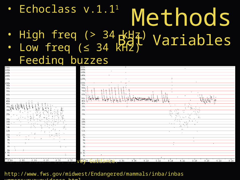
MethodsBat Variables
• Echoclass v.1.11
• High freq (> 34 kHz) • Low freq (≤ 34 kHz) • Feeding buzzes
1USFWS. Indiana Bat Survey Guidance. http://www.fws.gov/midwest/Endangered/mammals/inba/inbasummersurveyguidance.html
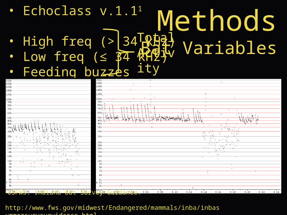
MethodsBat Variables
• Echoclass v.1.11
• High freq (> 34 kHz) • Low freq (≤ 34 kHz) • Feeding buzzes
Total Activity
1USFWS. Indiana Bat Survey Guidance. http://www.fws.gov/midwest/Endangered/mammals/inba/inbasummersurveyguidance.html

MethodsLiDAR Survey
Figure by Renslow
• LiDAR = Light Detection and Ranging • Discrete-return scanning LiDAR1
• 900-1,600 nm wavelength• > 4 pulses / m²
1Skowronski et al. 2007. Remote Sensing of Environment 108: 123-129.

MethodsLiDAR Survey
Figure by Renslow
• LiDAR = Light Detection and Ranging • Data collected Fall 2010 (leaf-off) via fixed-wing aircraft
MethodsLiDAR Variables
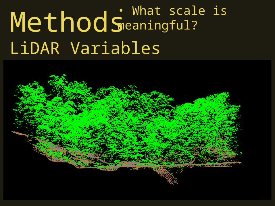
• What scale is meaningful?
MethodsLiDAR Variables
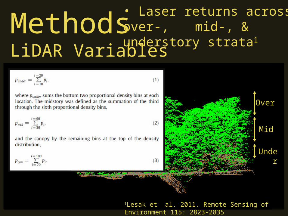
1Lesak et al. 2011. Remote Sensing of Environment 115: 2823-2835
• Laser returns across over-, mid-, & understory strata1
Under
Mid
Over

MethodsLiDAR Variables
15 m
• Laser returns across over-, mid-, & understory strata1
•15 m radii around survey points1
1Lesak et al. 2011. Remote Sensing of Environment 115: 2823-2835
Under
Mid
Over

MethodsLiDAR Variables
• Strata (absolute & relative)• Over-, mid-, & understory
• Determining canopy shape• Mid:Over, Under:Mid, & Under:Over

MethodsLiDAR Variables
• Strata (absolute & relative)• Over-, mid-, & understory
• Determining canopy shape• Mid:Over, Under:Mid, & Under:Over
• Gap Index• Percentage of pixels with no laser returns >3 m height
• ANOVAs for site, temporal, & fire effects
Analysis & Results

• ANOVAs for site, temporal, & fire effects• Multiple linear regressions relating activity to forest veg
• Response variables: - high freq pulses - low freq pulses - feeding buzzes
• Predictive models: - understory - midstory - overstory - “total” clutter
• Model selection using Akaike’s Information Criterion• Models in SAS 9.0, then protocol of Burnham & Anderson1
1Model Selection & Multimodal Inference, 2nd Edition
Analysis & Results

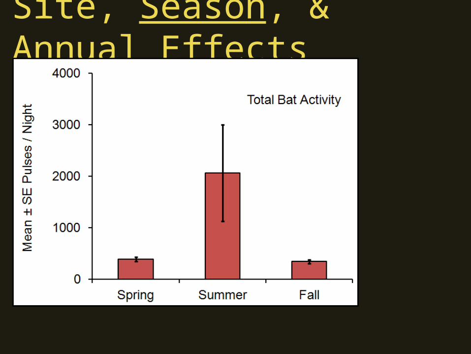
Site, Season, & Annual Effects

Site, Season, & Annual Effects
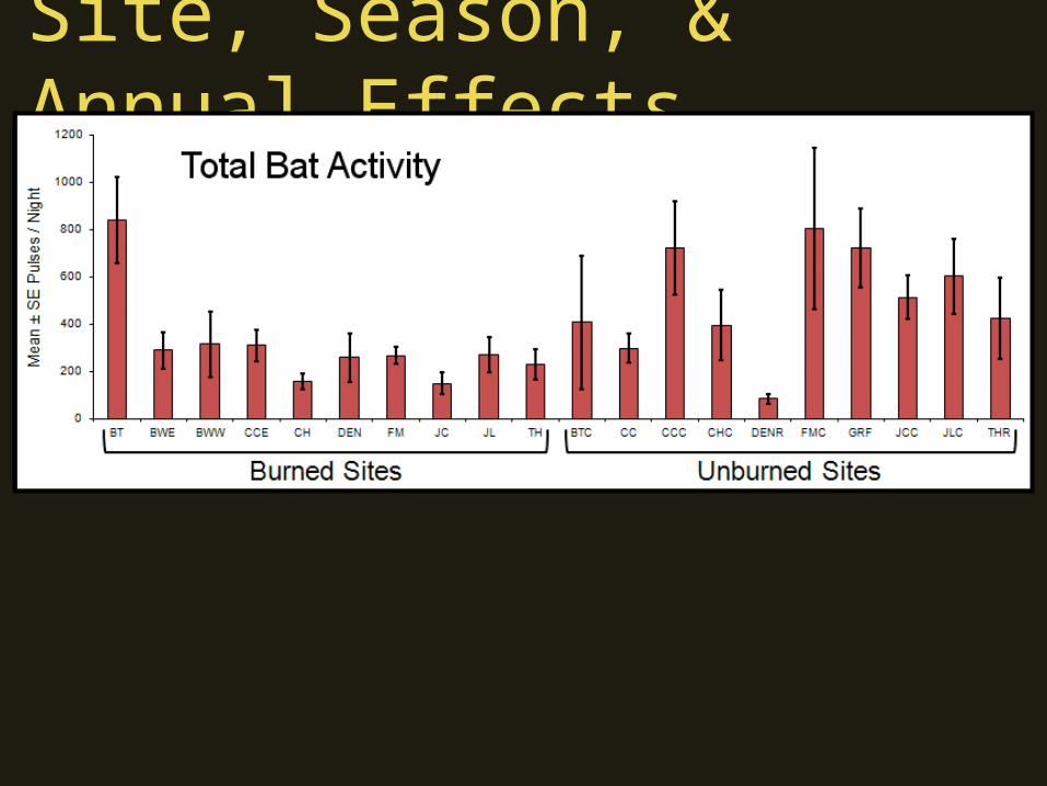
• Unsurprisingly, lots of variation across sites!

Site, Season, & Annual Effects
Far fewer replicates (n = 6)

Site, Season, & Annual Effects
Site, Season, & Annual Effects

Site, Season, & Annual Effects
High Freq: F2,1083 = 3.6, P = 0.02Low Freq: F2,1083 = 29.2, P < 0.01
A A B
a b c

Site, Season, & Annual Effects
Site, Season, & Annual Effects
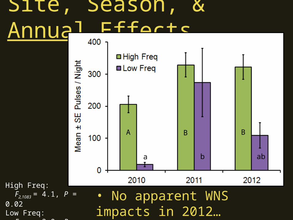
A B B
a b ab
• No apparent WNS impacts in 2012…
High Freq: F2,1083 = 4.1, P = 0.02Low Freq: F2,1083 = 3.0, P = 0.05
Site, Season, & Annual Effects

Site, Season, & Annual Effects
• Sites surveyed in Fall 2010

Effect of Fire
Core Hibernacula
- 2004
- 2005
- 2007
- 2009
- 2008
- 2010
Burn Areas
Survey Transects, Aug 2010 onward
• Repeated visits have created a time-series…
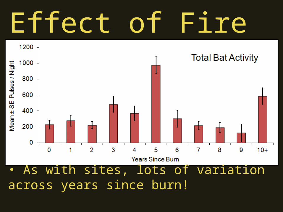
• As with sites, lots of variation across years since burn!
Effect of Fire

Effect of Fire
Far fewer replicates (n ~ 5)

Effect of Fire
Far more replicates (n > 200 each)

Effect of Fire

High Freq: F2,1083 = 11.1, P < 0.01Low Freq: F2,1083 = 1.0, P = 0.37
A B B
Effect of Fire

A B B
Feeding Buzzes F2,1083 = 11.1, P < 0.01
Effect of Fire

Effect of Fire
Core Hibernacula
- 2004
- 2005
- 2007
- 2009
- 2008
- 2010
Burn Areas
Survey Transects, Aug 2010 onward
Effect of Fire
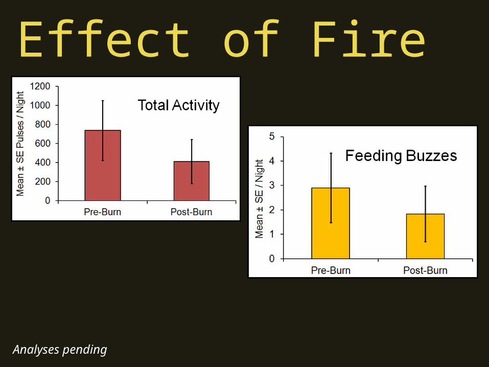
Analyses pending

Effect of Fire
Analyses pending

Effect of Fire
Analyses pending
Effect of Fire Relation to Canopy Clutter
• Data within first year of burning (2010-2011)


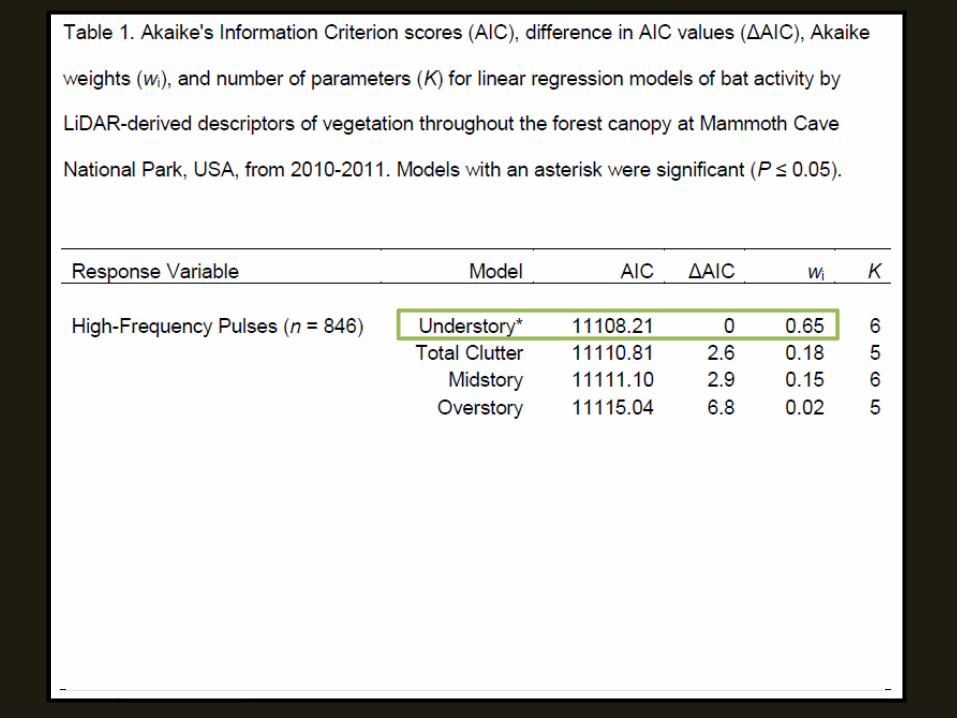


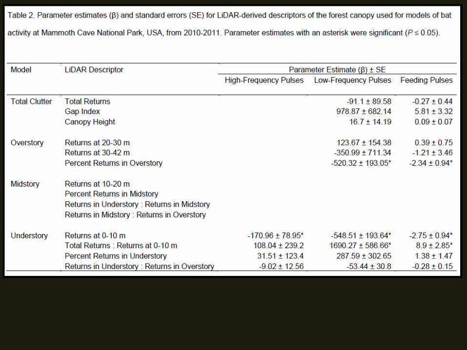
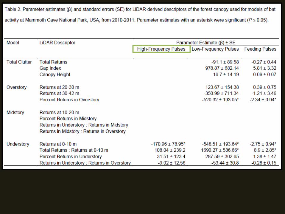

• High frequency echolocators negatively associated a cluttered understory

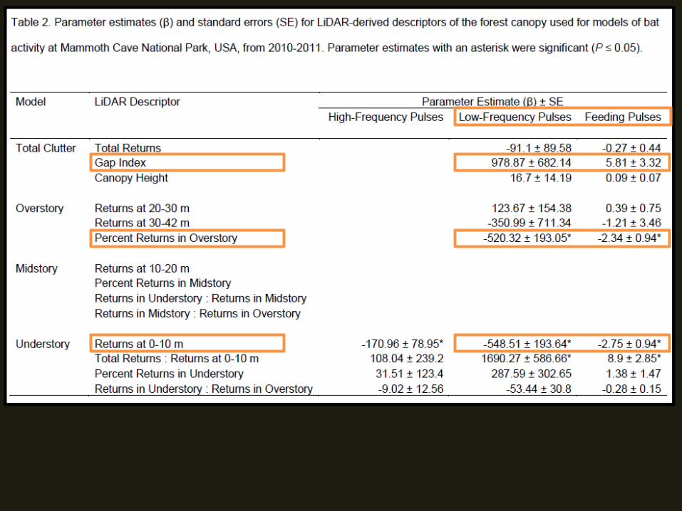
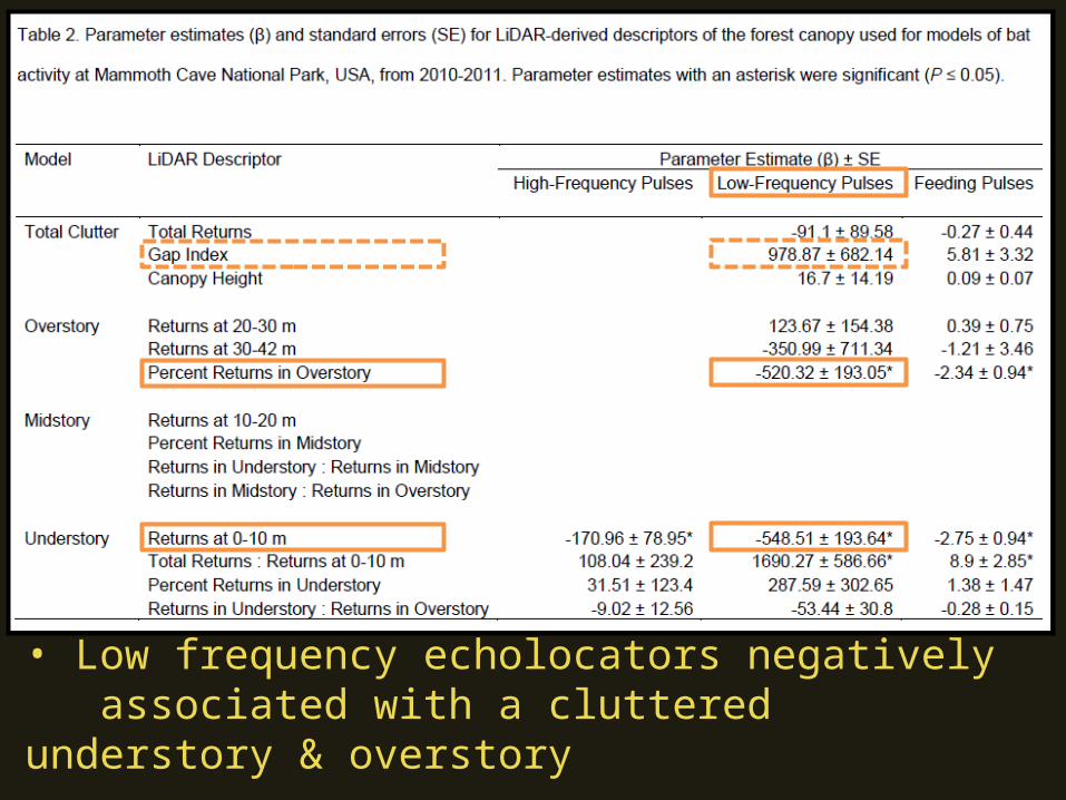
• Low frequency echolocators negatively associated with a cluttered understory & overstory

• Feeding buzzes negatively associated with a cluttered understory & overstory; positively associated with canopy gaps
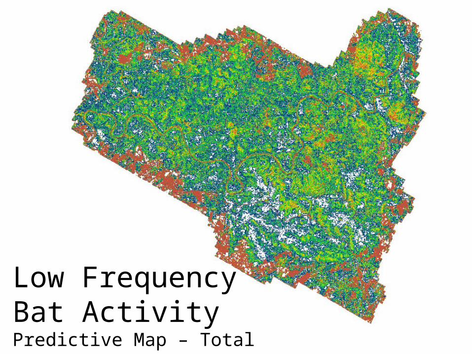
Low Frequency Bat ActivityPredictive Map – Total Clutter
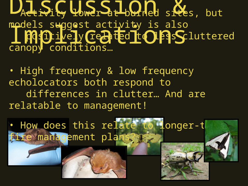
Discussion & Implications• Activity lower at burned sites, but models suggest activity is also positively related to less-cluttered canopy conditions… • High frequency & low frequency echolocators both respond to differences in clutter… And are relatable to management!
• How does this relate to longer-term fire management plans?
• Funding– Joint Fire Science Program
• NPS Personnel– Dr. Rick Toomey– Steve Thomas– Shannon Trimboli
• Tech Support!– Tracy Culbertson– Stella James– Klint Rose– Jennifer Winters
Thanks!