
MLM Consulting Engineers Ltd Main Tel: 01223...
88
MLM Consulting Engineers Ltd Main Tel: 01223 815560 Building 7200, Cambridge Research Park, Cambridge CB25 9TL Main Fax: 01223 815630 Eunomia Research and Consulting Ltd Broadway Lane, South Cerney (SITA Site) Phase 2 Geoenvironmental Assessment Report Document Ref: 771376/R3 Prepared: P Webb/M Henderson Issue: 4 Geoenvironmental Engineer Date: April 2014 Checked: J Warth Senior Environmental Consultant Approved: M Henderson Principal Environmental Consultant
-
Upload
truongliem -
Category
Documents
-
view
227 -
download
0
Transcript of MLM Consulting Engineers Ltd Main Tel: 01223...

MLM Consulting Engineers Ltd Main Tel: 01223 815560 Building 7200, Cambridge Research Park, Cambridge CB25 9TL Main Fax: 01223 815630
Eunomia Research and Consulting Ltd
Broadway Lane, South Cerney (SITA Site)
Phase 2 Geoenvironmental Assessment Report Document Ref: 771376/R3 Prepared: P Webb/M Henderson Issue: 4 Geoenvironmental Engineer
Date: April 2014
Checked: J Warth Senior Environmental Consultant
Approved: M Henderson Principal Environmental Consultant
Broadway Lane, South Cerney (SITA site) © MLM Consulting Engineers Ltd Phase II Geoenvironmental Assessment
771376/Reports/R3_Issue4
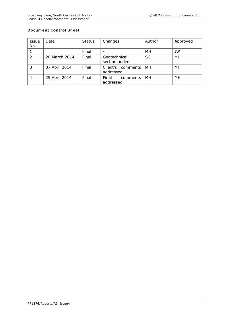
Document Control Sheet Issue No
Date Status Changes Author Approved
1 Final - MH JW 2 20 March 2014 Final Geotechnical
section added SC MH
3 07 April 2014 Final Client’s comments addressed
MH MH
4 29 April 2014 Final Final comments addressed
MH MH
Broadway Lane, South Cerney (SITA site) © MLM Consulting Engineers Ltd Phase II Geoenvironmental Assessment
771376/Reports/R3_Issue4
Contents
Page
Executive Summary i-ii Limitations and Exceptions iii 1 Introduction 1
1.1 General 1 1.2 Terms of Reference 1 1.3 Technical Approach 1 1.4 Proposed Development 1
2 The Site 2
2.1 Location and Description 2 2.2 Geology 2 2.3 Hydrogeology 2 2.4 Hydrology 2
3 Previous Assessment 3
3.1 General 3 4 Ground Investigation 4
4.1 Site Work 4 4.2 Investigation Rationale 4 4.3 Installations 4 4.4 In Situ Testing 4 4.5 Sampling 5 4.6 Post-Fieldwork Monitoring 5 4.7 Chemical Laboratory Analysis 5 4.8 Geotechnical Testing 6
5 Ground and Groundwater Conditions 7
5.1 General 7 5.2 Made Ground 7 5.3 Northmore Sand and Gravel Member 7 5.4 Kellaways Clay Member 7 5.5 Groundwater Conditions 8 5.6 Contamination Observations 8 5.7 Ground Gas/Vapour Conditions 8
6 Material Properties 9
6.1 General 9 6.2 Made Ground 9 6.3 Northmore Sand and Gravel Member 9 6.4 Kellaways Clay Member 9-10
7 Geotechnical Assessment 151
7.1 General 151 7.2 Existing Buried Construction 151 7.3 Excavations 161-12 7.4 Foundations 162-13 7.5 Ground Floor Slabs 163 7.6 Pavement Construction 164 7.7 Below Ground Concrete Design 164 7.8 Soakaway Potential 164
Broadway Lane, South Cerney (SITA site) © MLM Consulting Engineers Ltd Phase II Geoenvironmental Assessment
771376/Reports/R3_Issue4
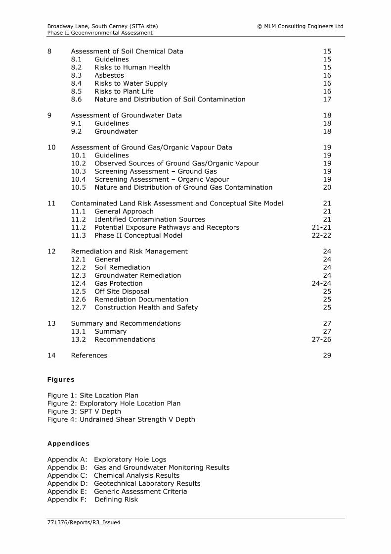
8 Assessment of Soil Chemical Data 15 8.1 Guidelines 15 8.2 Risks to Human Health 15 8.3 Asbestos 16 8.4 Risks to Water Supply 16 8.5 Risks to Plant Life 16 8.6 Nature and Distribution of Soil Contamination 17
9 Assessment of Groundwater Data 18
9.1 Guidelines 18 9.2 Groundwater 18
10 Assessment of Ground Gas/Organic Vapour Data 19
10.1 Guidelines 19 10.2 Observed Sources of Ground Gas/Organic Vapour 19 10.3 Screening Assessment – Ground Gas 19 10.4 Screening Assessment – Organic Vapour 19 10.5 Nature and Distribution of Ground Gas Contamination 20
11 Contaminated Land Risk Assessment and Conceptual Site Model 21
11.1 General Approach 21 11.2 Identified Contamination Sources 21 11.2 Potential Exposure Pathways and Receptors 21-21 11.3 Phase II Conceptual Model 22-22
12 Remediation and Risk Management 24
12.1 General 24 12.2 Soil Remediation 24 12.3 Groundwater Remediation 24 12.4 Gas Protection 24-24 12.5 Off Site Disposal 25 12.6 Remediation Documentation 25 12.7 Construction Health and Safety 25
13 Summary and Recommendations 27
13.1 Summary 27 13.2 Recommendations 27-26
14 References 29 Figures Figure 1: Site Location Plan Figure 2: Exploratory Hole Location Plan Figure 3: SPT V Depth Figure 4: Undrained Shear Strength V Depth Appendices Appendix A: Exploratory Hole Logs Appendix B: Gas and Groundwater Monitoring Results Appendix C: Chemical Analysis Results Appendix D: Geotechnical Laboratory Results Appendix E: Generic Assessment Criteria Appendix F: Defining Risk
Broadway Lane, South Cerney (SITA site) © MLM Consulting Engineers Ltd Phase II Geoenvironmental Assessment
N: 771376/Reports/R3_Issue4 i
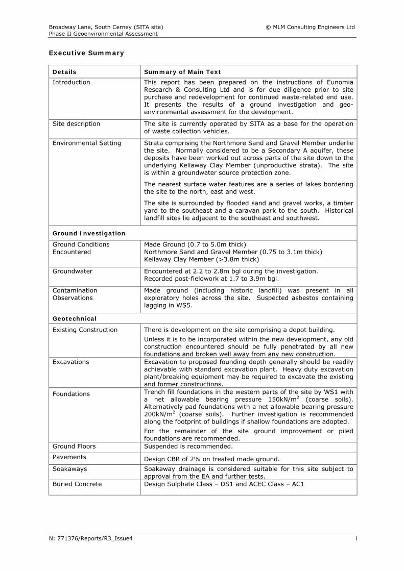
Executive Summary Details Summary of Main Text Introduction This report has been prepared on the instructions of Eunomia
Research & Consulting Ltd and is for due diligence prior to site purchase and redevelopment for continued waste-related end use. It presents the results of a ground investigation and geo-environmental assessment for the development.
Site description The site is currently operated by SITA as a base for the operation of waste collection vehicles.
Environmental Setting
Strata comprising the Northmore Sand and Gravel Member underlie the site. Normally considered to be a Secondary A aquifer, these deposits have been worked out across parts of the site down to the underlying Kellaway Clay Member (unproductive strata). The site is within a groundwater source protection zone.
The nearest surface water features are a series of lakes bordering the site to the north, east and west.
The site is surrounded by flooded sand and gravel works, a timber yard to the southeast and a caravan park to the south. Historical landfill sites lie adjacent to the southeast and southwest.
Ground Investigation
Ground Conditions Encountered
Made Ground (0.7 to 5.0m thick) Northmore Sand and Gravel Member (0.75 to 3.1m thick) Kellaway Clay Member (>3.8m thick)
Groundwater Encountered at 2.2 to 2.8m bgl during the investigation. Recorded post-fieldwork at 1.7 to 3.9m bgl.
Contamination Observations
Made ground (including historic landfill) was present in all exploratory holes across the site. Suspected asbestos containing lagging in WS5.
Geotechnical
Existing Construction
There is development on the site comprising a depot building. Unless it is to be incorporated within the new development, any old construction encountered should be fully penetrated by all new foundations and broken well away from any new construction.
Excavations Excavation to proposed founding depth generally should be readily achievable with standard excavation plant. Heavy duty excavation plant/breaking equipment may be required to excavate the existing and former constructions.
Foundations
Trench fill foundations in the western parts of the site by WS1 with a net allowable bearing pressure 150kN/m2 (coarse soils). Alternatively pad foundations with a net allowable bearing pressure 200kN/m2 (coarse soils). Further investigation is recommended along the footprint of buildings if shallow foundations are adopted. For the remainder of the site ground improvement or piled foundations are recommended.
Ground Floors Suspended is recommended.
Pavements Design CBR of 2% on treated made ground. Soakaways Soakaway drainage is considered suitable for this site subject to
approval from the EA and further tests. Buried Concrete Design Sulphate Class – DS1 and ACEC Class – AC1
Broadway Lane, South Cerney (SITA site) © MLM Consulting Engineers Ltd Phase II Geoenvironmental Assessment
N: 771376/Reports/R3_Issue4 ii
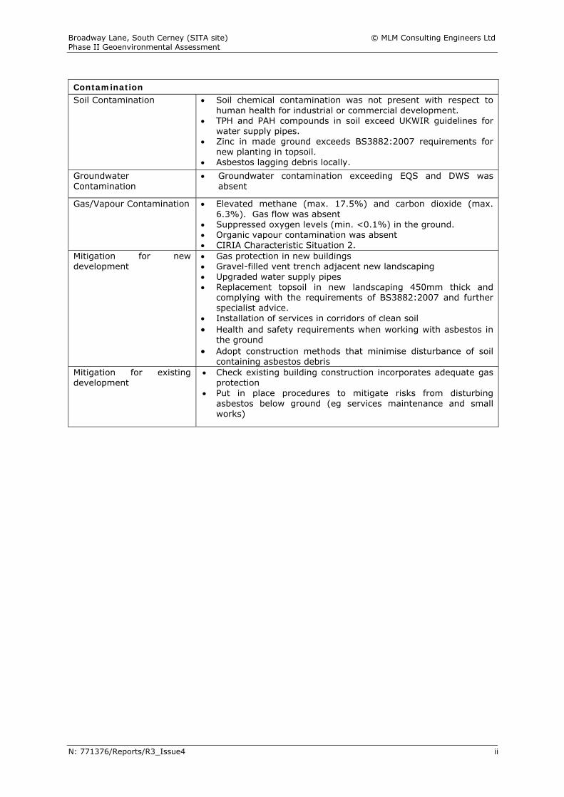
Contamination Soil Contamination
Soil chemical contamination was not present with respect to human health for industrial or commercial development.
TPH and PAH compounds in soil exceed UKWIR guidelines for water supply pipes.
Zinc in made ground exceeds BS3882:2007 requirements for new planting in topsoil.
Asbestos lagging debris locally. Groundwater Contamination
Groundwater contamination exceeding EQS and DWS was absent
Gas/Vapour Contamination
Elevated methane (max. 17.5%) and carbon dioxide (max. 6.3%). Gas flow was absent
Suppressed oxygen levels (min. <0.1%) in the ground. Organic vapour contamination was absent CIRIA Characteristic Situation 2.
Mitigation for new development
Gas protection in new buildings Gravel-filled vent trench adjacent new landscaping Upgraded water supply pipes Replacement topsoil in new landscaping 450mm thick and
complying with the requirements of BS3882:2007 and further specialist advice.
Installation of services in corridors of clean soil Health and safety requirements when working with asbestos in
the ground Adopt construction methods that minimise disturbance of soil
containing asbestos debris Mitigation for existing development
Check existing building construction incorporates adequate gas protection
Put in place procedures to mitigate risks from disturbing asbestos below ground (eg services maintenance and small works)
Broadway Lane, South Cerney (SITA site) © MLM Consulting Engineers Ltd Phase II Geoenvironmental Assessment
N: 771376/Reports/R3_Issue4 iii
Limitations and Exceptions 1. This report and its findings should be considered in relation to the terms and
conditions proposed and scope of works agreed between MLM Consulting Engineers and the client.
2. The Executive Summary, Conclusions and Recommendations sections of the
report provide an overview and guidance only and should not be specifically relied upon until considered in the context of the whole report and the development, if any, proposed.
3. The assessment and interpretation of contamination and associated risks are
based on the scope of work agreed with the client and the report may not be sufficient to fully address contaminations or to allow detailed remediation design to proceed without further investigation and analysis.
4. Any assessments made in this report are based on the ground conditions as
revealed by the exploratory holes and pits, together with the results of any field or laboratory testing undertaken and, where appropriate, other relevant data which may have been obtained for the sites including previous site investigation reports. There may be special conditions appertaining to the site, however, which have not been revealed by the investigation and which have not, therefore, been taken into account in the report. The assessment may be subject to amendment in the light of additional information becoming available.
5. Interpretations and recommendations contained in the report represent our
professional opinions, which were arrived at in accordance with currently accepted industry practices at the time of reporting and based on current legislation in force at that time.
6. Where the data available from previous site investigation reports, supplied by the
Client, have been used, it has been assumed that the information is correct. No responsibility can be accepted by MLM Consulting Engineers for inaccuracies within the data supplied.
7. Whilst the report may express an opinion of possible configuration of strata
between or beyond exploratory hole or pit locations, or on the possible presence of features based on visual, verbal or published evidence, this is for guidance only and no liability can be accepted for the accuracy.
8. Comments on groundwater conditions are based on observations made at the
time of the investigation unless otherwise stated. It should be noted, however, that groundwater levels vary due to seasonal or other effects.
9. The copyright in this report and other plans and documents prepared by MLM
Consulting Engineers is owned by them and no such report, plan or document may be reproduced, published or adapted without their written consent. Complete copies of this report may, however, be made and distributed by the Client as an expedient in dealing with matters related to its commission.
10. This report is prepared and written in the context of the proposals stated in the
introduction to this report and should not be used in a differing context. Furthermore, new information, improved practices and legislation may necessitate an alteration to the report in whole or in part after its submission. Therefore, with any change in circumstances or after the expiry of one year from the date of the report, the report should be referred to us for re-assessment and, if necessary, re-appraisal.
Broadway Lane, South Cerney (SITA site) © MLM Consulting Engineers Ltd Phase II Geoenvironmental Assessment
771376/Reports/R3_Issue4 1
1 Introduction
1.1 General This report has been prepared by MLM Consulting Engineers Limited (MLMCEL) on the instructions of Eunomia Research & Consulting Ltd (Eunomia) and is for due diligence prior to purchase of the site and redevelopment for a commercial waste-related end use. The site is on Broadway Lane, South Cerney and, for the purpose of this study, is know as the “SITA Site”. The report provides an assessment of ground conditions with respect to contamination risks to health and safety and the environment and provides a summary of recommended mitigation or remediation measures based on a conceptual site model (CSM) and generic quantitative risk assessment (GQRA). A geotechnical assessment is included to assist in the design of future construction.
1.2 Terms of Reference The terms of reference for the work were set out in the MLMCEL proposal DMB/771376/001/MHE dated 21 August 2013. 1.3 Technical Approach The geo-environmental and geotechnical work undertaken by MLMCE follows the Association of Geotechnical and Geoenvironmental Specialists (AGS) Good Practice Guidelines for Site Investigations. The process of contamination assessment adopted in this report generally follows the model procedures for the management of contaminated land described in the Environment Agency Contaminated Land Report 11. It also takes into account the guidance issued in the National Planning Policy Framework (NPPF), NHBC Standards Chapter 4.1 Land quality: Managing ground conditions and Cotswold District Council Development of potentially contaminated land – guidance for developers, agents and consultants. The format of the report is in general accordance with the reporting requirements of BS5930:1999+A2:2010. 1.4 Proposed Development It is understood that the future development, following purchase of the site, will be for a waste-related end use, possibly comprising a vehicle depot or waste transfer station. Details of the future development, including a proposed layout, have not been provided.
Broadway Lane, South Cerney (SITA site) © MLM Consulting Engineers Ltd Phase II Geoenvironmental Assessment
771376/Reports/R3_Issue4 2
2 The Site
2.1 Location and Description
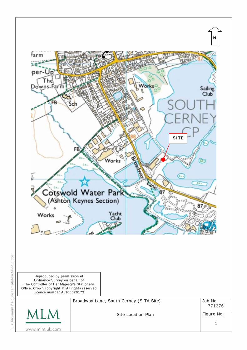
The site is located off Broadway Lane approximately 0.95km to the south of the centre of South Cerney. It is irregular in shape and covers an area of approximately 2.47 hectares. It is bordered to the north, east and west by lakes (former gravel extraction pits) to the southeast by a timber yard and to the south by Broadway Lane and a caravan park. The site is occupied by SITA, with a central spine road and hardstanding for parking (waste collection vehicles and staff cars). A depot building is on the northern side of the road and an unsurfaced area south of the road is used for the storage of empty waste receptacles (skips and wheelie bins). The National Grid reference for the site is 405270 196150. A location plan of the site is presented as Figure 1. 2.2 Geology The geological map of the area shows the site to be underlain in the southwest by River Terrace Deposits (Northmore Sand and Gravel Member) over Kellaway Clay (mudstone). In the northeast, the sand and gravel has been worked out and infilled down to the Kellaway Clay.
2.3 Hydrogeology
The Environment Agency website provides the following hydrogeological information:
Table 2.1 Aquifer and Groundwater Source Protection Zone Designation Aspect Designation Description
Groundwater Source Protection Zone
SPZ2 Outer protection zone. Defined by a 400 day travel time from a point below the water table. This zone has a minimum radius of 250 or 500m around the source, depending on the size of the abstraction.
Aquifer Designation – Superficial Deposit
Secondary A (in the southwest)
Permeable layers capable of supporting water supplies at a local rather than strategic scale, and in some cases forming an important source of base flow to rivers
Aquifer Designation – Bedrock Deposit (Kellaway Clay)
Unproductive Strata
These are deposits with low permeability that have negligible significance for water supply or river base flow.
2.4 Hydrology A large area of open water, comprising flooded former sand and gravel workings, is located adjacent to the north, east and west of the site. The site is not shown to be in an area likely to be affected by flooding from rivers without defences.
Broadway Lane, South Cerney (SITA site) © MLM Consulting Engineers Ltd Phase II Geoenvironmental Assessment
771376/Reports/R3_Issue4 3
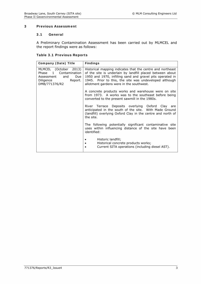
3 Previous Assessment
3.1 General A Preliminary Contamination Assessment has been carried out by MLMCEL and the report findings were as follows: Table 3.1 Previous Reports Company (Date) Title Findings
MLMCEL (October 2013) Phase 1 Contamination Assessment and Due Diligence Report. DMB/771376/R2
Historical mapping indicates that the centre and northeast of the site is underlain by landfill placed between about 1950 and 1970, infilling sand and gravel pits operated in 1945. Prior to this, the site was undeveloped although allotment gardens were in the southwest. A concrete products works and warehouse were on site from 1973. A works was to the southeast before being converted to the present sawmill in the 1980s. River Terrace Deposits overlying Oxford Clay are anticipated in the south of the site. With Made Ground (landfill) overlying Oxford Clay in the centre and north of the site. The following potentially significant contaminative site uses within influencing distance of the site have been identified: Historic landfill; Historical concrete products works; Current SITA operations (including diesel AST).
Broadway Lane, South Cerney (SITA site) © MLM Consulting Engineers Ltd Phase II Geoenvironmental Assessment
771376/Reports/R3_Issue4 4
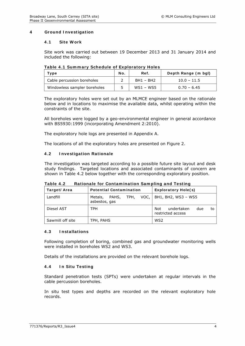
4 Ground Investigation
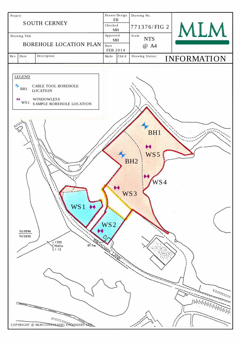
4.1 Site Work Site work was carried out between 19 December 2013 and 31 January 2014 and included the following: Table 4.1 Summary Schedule of Exploratory Holes
Type No. Ref. Depth Range (m bgl)
Cable percussion boreholes 2 BH1 – BH2 10.0 – 11.5
Windowless sampler boreholes 5 WS1 – WS5 0.70 – 6.45
The exploratory holes were set out by an MLMCE engineer based on the rationale below and in locations to maximise the available data, whilst operating within the constraints of the site.
All boreholes were logged by a geo-environmental engineer in general accordance with BS5930:1999 (incorporating Amendment 2:2010). The exploratory hole logs are presented in Appendix A. The locations of all the exploratory holes are presented on Figure 2. 4.2 Investigation Rationale The investigation was targeted according to a possible future site layout and desk study findings. Targeted locations and associated contaminants of concern are shown in Table 4.2 below together with the corresponding exploratory position.
Table 4.2 Rationale for Contamination Sampling and Testing Target/Area Potential Contamination Exploratory Hole(s)
Landfill Metals, PAHS, TPH, VOC, asbestos, gas
BH1, BH2, WS3 – WS5
Diesel AST TPH Not undertaken due to restricted access
Sawmill off site TPH, PAHS WS2
4.3 Installations Following completion of boring, combined gas and groundwater monitoring wells were installed in boreholes WS2 and WS3. Details of the installations are provided on the relevant borehole logs. 4.4 In Situ Testing Standard penetration tests (SPTs) were undertaken at regular intervals in the cable percussion boreholes. In situ test types and depths are recorded on the relevant exploratory hole records.
Broadway Lane, South Cerney (SITA site) © MLM Consulting Engineers Ltd Phase II Geoenvironmental Assessment
771376/Reports/R3_Issue4 5
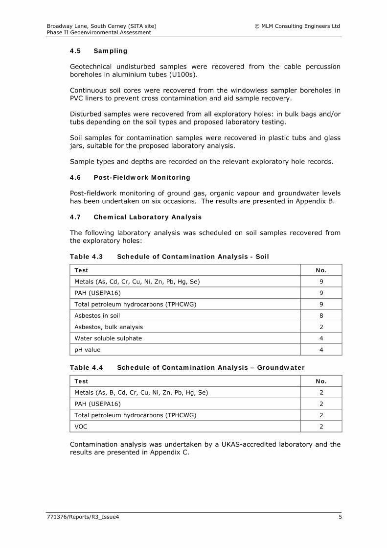
4.5 Sampling Geotechnical undisturbed samples were recovered from the cable percussion boreholes in aluminium tubes (U100s). Continuous soil cores were recovered from the windowless sampler boreholes in PVC liners to prevent cross contamination and aid sample recovery. Disturbed samples were recovered from all exploratory holes: in bulk bags and/or tubs depending on the soil types and proposed laboratory testing. Soil samples for contamination samples were recovered in plastic tubs and glass jars, suitable for the proposed laboratory analysis. Sample types and depths are recorded on the relevant exploratory hole records. 4.6 Post-Fieldwork Monitoring Post-fieldwork monitoring of ground gas, organic vapour and groundwater levels has been undertaken on six occasions. The results are presented in Appendix B. 4.7 Chemical Laboratory Analysis The following laboratory analysis was scheduled on soil samples recovered from the exploratory holes: Table 4.3 Schedule of Contamination Analysis - Soil
Test No.
Metals (As, Cd, Cr, Cu, Ni, Zn, Pb, Hg, Se) 9
PAH (USEPA16) 9
Total petroleum hydrocarbons (TPHCWG) 9
Asbestos in soil 8
Asbestos, bulk analysis 2
Water soluble sulphate 4
pH value 4
Table 4.4 Schedule of Contamination Analysis – Groundwater
Test No.
Metals (As, B, Cd, Cr, Cu, Ni, Zn, Pb, Hg, Se) 2
PAH (USEPA16) 2
Total petroleum hydrocarbons (TPHCWG) 2
VOC 2
Contamination analysis was undertaken by a UKAS-accredited laboratory and the results are presented in Appendix C.
Broadway Lane, South Cerney (SITA site) © MLM Consulting Engineers Ltd Phase II Geoenvironmental Assessment
771376/Reports/R3_Issue4 6
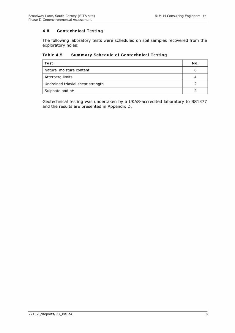
4.8 Geotechnical Testing The following laboratory tests were scheduled on soil samples recovered from the exploratory holes: Table 4.5 Summary Schedule of Geotechnical Testing
Test No.
Natural moisture content 6
Atterberg limits 4
Undrained triaxial shear strength 2
Sulphate and pH 2
Geotechnical testing was undertaken by a UKAS-accredited laboratory to BS1377 and the results are presented in Appendix D.
Broadway Lane, South Cerney (SITA site) © MLM Consulting Engineers Ltd Phase II Geoenvironmental Assessment
771376/Reports/R3_Issue4 7
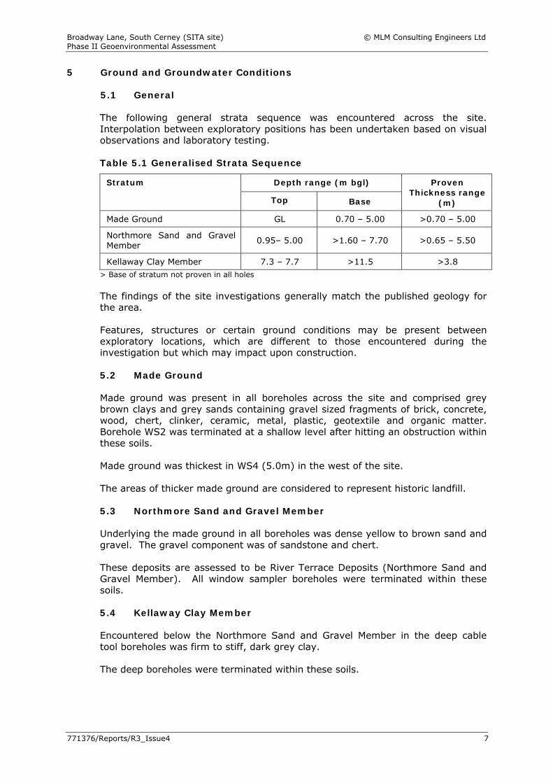
5 Ground and Groundwater Conditions 5.1 General
The following general strata sequence was encountered across the site. Interpolation between exploratory positions has been undertaken based on visual observations and laboratory testing. Table 5.1 Generalised Strata Sequence
Depth range (m bgl) Stratum
Top Base
Proven Thickness range
(m)
Made Ground GL 0.70 – 5.00 >0.70 – 5.00
Northmore Sand and Gravel Member 0.95– 5.00 >1.60 – 7.70 >0.65 – 5.50
Kellaway Clay Member 7.3 – 7.7 >11.5 >3.8 > Base of stratum not proven in all holes The findings of the site investigations generally match the published geology for the area. Features, structures or certain ground conditions may be present between exploratory locations, which are different to those encountered during the investigation but which may impact upon construction. 5.2 Made Ground Made ground was present in all boreholes across the site and comprised grey brown clays and grey sands containing gravel sized fragments of brick, concrete, wood, chert, clinker, ceramic, metal, plastic, geotextile and organic matter. Borehole WS2 was terminated at a shallow level after hitting an obstruction within these soils. Made ground was thickest in WS4 (5.0m) in the west of the site. The areas of thicker made ground are considered to represent historic landfill. 5.3 Northmore Sand and Gravel Member Underlying the made ground in all boreholes was dense yellow to brown sand and gravel. The gravel component was of sandstone and chert. These deposits are assessed to be River Terrace Deposits (Northmore Sand and Gravel Member). All window sampler boreholes were terminated within these soils. 5.4 Kellaway Clay Member Encountered below the Northmore Sand and Gravel Member in the deep cable tool boreholes was firm to stiff, dark grey clay. The deep boreholes were terminated within these soils.
Broadway Lane, South Cerney (SITA site) © MLM Consulting Engineers Ltd Phase II Geoenvironmental Assessment
771376/Reports/R3_Issue4 8
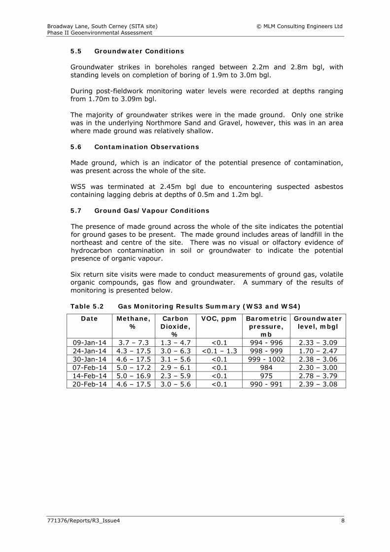
5.5 Groundwater Conditions Groundwater strikes in boreholes ranged between 2.2m and 2.8m bgl, with standing levels on completion of boring of 1.9m to 3.0m bgl. During post-fieldwork monitoring water levels were recorded at depths ranging from 1.70m to 3.09m bgl. The majority of groundwater strikes were in the made ground. Only one strike was in the underlying Northmore Sand and Gravel, however, this was in an area where made ground was relatively shallow. 5.6 Contamination Observations Made ground, which is an indicator of the potential presence of contamination, was present across the whole of the site. WS5 was terminated at 2.45m bgl due to encountering suspected asbestos containing lagging debris at depths of 0.5m and 1.2m bgl. 5.7 Ground Gas/Vapour Conditions The presence of made ground across the whole of the site indicates the potential for ground gases to be present. The made ground includes areas of landfill in the northeast and centre of the site. There was no visual or olfactory evidence of hydrocarbon contamination in soil or groundwater to indicate the potential presence of organic vapour. Six return site visits were made to conduct measurements of ground gas, volatile organic compounds, gas flow and groundwater. A summary of the results of monitoring is presented below. Table 5.2 Gas Monitoring Results Summary (WS3 and WS4)
Date Methane, %
Carbon Dioxide,
%
VOC, ppm Barometric pressure,
mb
Groundwater level, mbgl
09-Jan-14 3.7 – 7.3 1.3 – 4.7 <0.1 994 - 996 2.33 – 3.09 24-Jan-14 4.3 – 17.5 3.0 – 6.3 <0.1 – 1.3 998 - 999 1.70 – 2.47 30-Jan-14 4.6 – 17.5 3.1 – 5.6 <0.1 999 - 1002 2.38 – 3.06 07-Feb-14 5.0 – 17.2 2.9 – 6.1 <0.1 984 2.30 – 3.00 14-Feb-14 5.0 – 16.9 2.3 – 5.9 <0.1 975 2.78 – 3.79 20-Feb-14 4.6 – 17.5 3.0 – 5.6 <0.1 990 - 991 2.39 – 3.08
Broadway Lane, South Cerney (SITA site) © MLM Consulting Engineers Ltd Phase II Geoenvironmental Assessment
771376/Reports/R3_Issue4 9
6 Material Properties 6.1 General
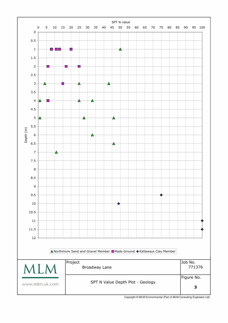
The following presents a summary of the properties of the soils encountered, based on field observations, in situ field testing and laboratory test results. For the purposes of property designation, soils are divided into fine soils (clays and silts) and coarse soils (sands and gravels). Soil plasticity class for fine soils is based on the classification system of BS5930, adopting modified plasticity index values (based on percentage passing 425μm sieve). Volume change potential of fine soils on change of moisture content has been assessed using guidance provided in BRE Digest 240 - Part 1. Equivalent approximate undrained shear strengths (cu) and equivalent approximate coefficients of volume compressibility (mv) have been calculated from recorded SPT N values, adopting f1 and f2 values respectively (based on CIRIA 143) appropriate to the recorded plasticity. The angle of shearing resistance (φ) of the coarse soils has been derived from the uncorrected standard penetration resistance N using the relationship published by Peck et al (1967). 6.2 Made Ground The made ground is inherently variable and as such representative values of geotechnical properties are impracticable to determine. However, a single test indicated the natural moisture content in the fine fraction of these materials to be 18% and plasticity index to be 16%. On this basis these soils are classified as of intermediate plasticity (CI soils). In situ SPT testing in granular suggests that they are generally medium dense (N values range from 11 to 13). In situ SPT testing in cohesive soil suggests that they are generally low strength (N values range from 6 to 15 but are generally around 8). The uncorrected SPT N values plotted against depth for the site are shown on Figure 3. 6.3 Northmore Sand and Gravel Member In situ SPT N values within the coarse fraction of these materials range from 1 to 45, but are generally within the range 25 to 45, showing them to be of medium dense to dense relative density. Angles of shearing resistance based on these results range from 34º to 40º. The very low N values were obtained within windowless sample holes, it is likely that the tests were undertaken in soils disturbed by ‘boiling’ effect. 6.4 Kellaways Clay Member Recorded natural moisture contents in the fine fraction of these materials range from 18% to 23% and plasticity indices from 27% to 36%. On this basis these soils are classified as of intermediate to high plasticity (CI to CH soils) and of medium swelling/shrinkage potential on change of moisture content.
Broadway Lane, South Cerney (SITA site) © MLM Consulting Engineers Ltd Phase II Geoenvironmental Assessment
771376/Reports/R3_Issue4 10
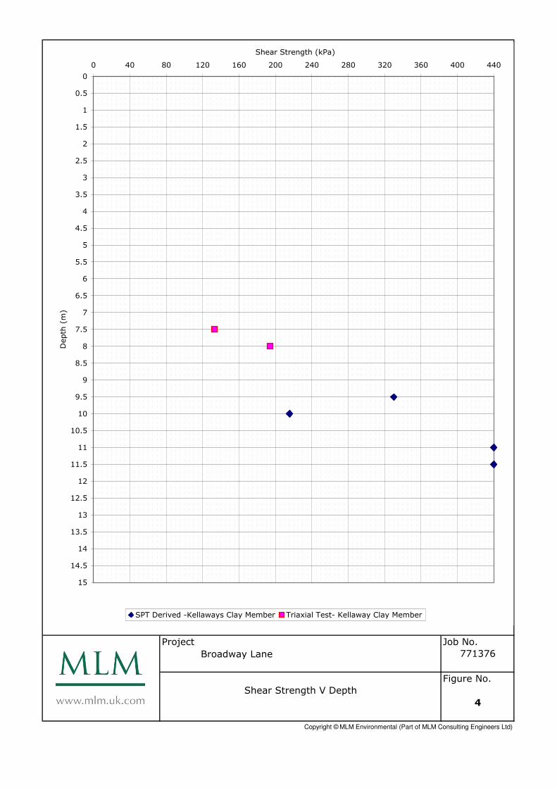
In situ SPT N values within the fine fraction of these materials range from 49 to refusal (N value of greater than 50). The SPTs were terminated when the blow counts reached 50, therefore in the following analysis, where refusal had been reached, the blow counts have been extrapolated for a penetration of 300mm to maximum value of 100 (Clayton 1995). Approximate undrained shear strengths based on these results range from 220kN/m2 to 440kN/m2, adopting an f1 value of 4.4 (based on an ‘average’ plasticity of 30%). As shown on Figure 3 these values compare well with the results of the laboratory triaxial tests, where undrained shear strengths of 133kN/m2 to 194kN/m2 are recorded on samples from 7.5m bgl to 8.0m bgl.
Broadway Lane, South Cerney (SITA site) © MLM Consulting Engineers Ltd Phase II Geoenvironmental Assessment
771376/Reports/R3_Issue4 11
7 Geotechnical Assessment
7.1 General
This geotechnical assessment is based on the parameters determined from the field work and laboratory analysis as described in section 6. It presents a geotechnical assessment of possible foundation solutions and infrastructure design; it does not constitute a detailed design report for the proposed development. No proposed development plans, details or loads were made available at the time of compiling this report and the following assessment is a general appraisal for buildings founded at ground level. The merits of the available options discussed should be reviewed by the foundation/structural engineers. It is anticipated that finished ground levels will be at, or close to, existing ground levels. Should this not be the case then this assessment may need to be reviewed. 7.2 Existing Buried Construction There are former constructions at the site and it is possible that existing buried construction including tanks/foundations/services will be encountered below the site. Unless it is to be incorporated within the new development, any old construction encountered should be fully penetrated by all new foundations and broken well away from any new construction. Any soil disturbed by excavation of foundations and tanks should also be fully penetrated by new foundations. 7.3 Excavations Excavation to anticipated founding depths should be readily achievable using standard excavation plant. However, excavation through any buried construction may require heavy-duty excavation plant/ripping plant/blasting/the use of specialist breaking equipment. Random and sudden falls should be expected from the faces of near vertically sided excavations put down at the site. This situation is likely to be prevalent in the made ground/ natural coarse soils/low strength natural fine and is likely to be exacerbated by water inflows. Temporary trench support, or battering of excavation sides, is likely to be required for all excavations that are to be left open for any length of time, and will definitely be required where man entry is required. Particular attention should be paid to excavation at, or close to, site boundaries, adjoining existing roads and buildings, where collapse of excavation faces could have a disproportionate effect. A risk assessment of the stability of any open excavation should be undertaken by a competent person and appropriate measures adopted to ensure safe working practise in and around open excavations. Further guidance on responsibilities and requirements for working near, and in, excavations can be obtained from the Construction Design and Management Regulations (2007).
Broadway Lane, South Cerney (SITA site) © MLM Consulting Engineers Ltd Phase II Geoenvironmental Assessment
771376/Reports/R3_Issue4 12
Recorded groundwater levels are generally within the made ground. Based on site observations, it is considered that sump will not be sufficient to deal with anticipated flows and alternative methods of dewatering including cut-offs, or well points, may prove necessary. However, it should be recognised that groundwater levels will fluctuate seasonally and the timing of construction may dictate the extent of groundwater control required. Any water pumped from excavations is likely to need to be passed via settlement tanks before being discharged to the sewer; discharge consents will also be required. 7.4 Foundations The appropriate foundation solution adopted for the site will depend not only on ground conditions, but also on structural loading, load distribution and the limiting criteria for movement or settlement of the buildings, which may have high specification finishes and unevenly distributed loadings so that settlement, and particularly differential settlement, will need to be maintained within tight tolerances. The made ground is considered unsuitable in their present condition for use as founding soils on the basis of its relatively low strength and high compressibility and should be fully penetrated by all new foundations. 7.4.1 Strip/Trench Fill Foundations The presence of deep made ground below the ground water level will preclude the use of traditional trench fill foundations across most parts of the site except in areas where the depth of made ground is shallow. Buildings with small footprints can be founded by WS1 but will require confirmatory investigation to ensure that the depth to the underlying Northmore Sand and Gravel Member is above the water level and the sides will be stable. The findings of the assessment will need to be assessed by a geotechnical engineer before final design. Based on the design soil parameters provided in earlier sections of this report, as a guide, an allowable net bearing capacity of 150kN/m2 should be available for a 1m wide trench fill foundation bearing on the natural Northmore Sand and Gravel Member at a depth of 1m bgl. 7.4.2 Pad Foundations Pad foundations can be considered around WS1 where the depth to the Northmore Sand and Gravel Member is above the water level but confirmatory site investigation will be required around the footprint of any buildings in this area and the findings will need to be assessed by a geotechnical engineer before the final design is confirmed. Based on the design soil parameters provided in earlier sections of this report, as a guide, an allowable net bearing pressure of 200kN/m2 should be available for a pad 2m square bearing on the natural Northmore Sand and Gravel Member. NB should enlarging the strips/pads be considered (for example because loads are such that the quoted bearing pressure is inadequate based on the size of foundation identified) this will probably lead to increased settlements and the above recommendations should be reviewed.
Broadway Lane, South Cerney (SITA site) © MLM Consulting Engineers Ltd Phase II Geoenvironmental Assessment
771376/Reports/R3_Issue4 13
7.4.3 Piled Foundations In the north eastern parts of the site deep made ground preclude the use of shallow foundations and therefore ground improvement or deep foundations are recommended. Ground improvement using vibro treated stone columns or vibro treated concrete columns could be considered. Following treatment allowable bearing pressure of 125kN/m2 can be anticipated. It is recommended that specialist contractors are approached for their proposals and budget. Pre-boring may be required locally at least to ensure penetration through the denser made ground, or to penetrate, push aside or break up obstructions. Where penetration to full depth is not possible, the obstructions should be removed, or if this is not practicable, the column layout redesigned to allow foundations to span/cantilever over the untreated area. Alternatively piled foundations can be considered. Driven piles, bored piles with the use of casing or CFA piles should be suitable for this site. However, the choice of piling system and detailed design of piles are beyond the scope of this report and should be undertaken the specialist piling contractor taking into account the following considerations. Obstructions in the ground, such as old foundations can cause piles to stop at
shallower than design depth, or deviate from the vertical, thereby reducing their capacity
Pile, and in particular bored pile, installation can create preferential pathways for the migration of contaminants to the groundwater
Boring of piles in coarse soils is likely to result in loosening of the soils, with resultant reduced shaft friction
Groundwater was observed during the boring of the intrusive holes/the post-fieldwork monitoring and temporary casing is likely to be/may be required for bored piles unless CFA piles with placement of concrete as the pile is withdrawn, are used
Piles should extend a minimum of five pile diameters into the bearing stratum to fully mobilise end-bearing resistance
The potential effects of negative skin friction on piles The made ground and/or natural low strength soils will provide only minimal
lateral resistance and piles should be designed to be sufficiently rigid, and to have sufficient embedment into the founding soils to minimise the risk of unacceptable lateral movement
7.5 Ground Floor Slabs In the western parts of the site by WS1, ground conditions are such that ground bearing slabs should be acceptable. However, in the remainder of the site following preparation/regrading it is anticipated that in excess of 600mm of made ground will remain below floor slabs. On this basis, floor slabs should be suspended. However for industrial units, suspended slabs may be uneconomic and any ground bearing solution should be designed based on a CBR of 2% following treatment as described in Section 7.6. For more heavily loaded slabs or slabs sensitive to differential and/or total settlement, some form of ground improvement technique may be required to improve the underlying soils or alternatively a piled slab may be necessary for more significant loadings.
Broadway Lane, South Cerney (SITA site) © MLM Consulting Engineers Ltd Phase II Geoenvironmental Assessment
771376/Reports/R3_Issue4 14
7.6 Pavement Construction Following site preparation/re-grading the sub-grade will comprise mainly made ground. The made ground is mixed and variable and it is recommended that, where encountered at formation level, these deposits be excavated to a depth of 0.5m below formation level (or to suitable natural soils, whichever is reached first) and the sub-formation rolled. The excavated material should be sorted to remove any oversize or otherwise unsuitable materials (although the nature of the made ground at this site means that much of it will be unsuitable for reuse and may have to be discarded), prior to recompacting the suitable materials in thin layers compatible with the compaction plant employed. Any deficit in material should be made up in suitable imported material suitably compacted as above. Following this treatment an overall design CBR of 2% should be available. 7.7 Below Ground Concrete Design Based on the results of the pH and water soluble sulphate determinations on soil samples and in accordance with the categorisation system of BRE Special Digest 1, the soils below the site fall within the design sulphate class DS-1, with a corresponding Aggressive Chemical Environment for Concrete (ACEC) class of AC-1. 7.8 Soakaway Potential The Environment Agency or the Local Authority are unlikely to accept soakaways discharging into made ground and discharge should be below the made ground into the natural granular soil. The presence of high groundwater needs to be considered in the design. Soakaway tests are recommended.
Broadway Lane, South Cerney (SITA site) © MLM Consulting Engineers Ltd Phase II Geoenvironmental Assessment
771376/Reports/R3_Issue4 15
8 Assessment of Soil Chemical Data 8.1 Guidelines This section presents a generic quantitative risk assessment (GQRA) of potential soil contamination. GQRA involves a comparison of chemical laboratory results to generic assessment criteria (GAC) that are considered appropriate and relevant to the context of the site. The purpose of the GQRA is to identify potential sources of contamination for further evaluation in the Contaminated Land Risk Assessment section of the report. GAC used in human health risk assessments have been adopted from the following guidance: Soil guideline values (SGV) derived using the Contaminated Land Exposure
Assessment (CLEA) model and published on the Environment Agency website. These GAC are for arsenic, cadmium, mercury, nickel, selenium, BTEX compounds and phenols. The SGVs do not differentiate between ‘with’ and ‘without’ plant uptake. For the purpose of the assessment the term GAC is taken to mean SGV. It should be noted that SGV have been withdrawn from use, however in the absence of any replacement guidance they are used in the assessment
GAC published jointly by LQM and the Chartered Institute of Environmental Health. Currently these are for TPH aromatic/aliphatic, polyaromatic hydrocarbons, chlorophenols, chlorinated solvents and certain metals. GAC for TPH and PAH compounds are soil organic matter dependent
Risks to water supply pipes have been assessed using guidance published by UKWIR. The guidance provides threshold concentrations above which organic compounds can permeate water supply pipes, impact on their construction and cause a water quality issue for consumers. Previous guidance from WRAS has been withdrawn but may still be in use by certain water supply companies. For the purposes of this assessment it is assumed that polyethylene water supply pipework will be adopted. Potential risks to plant life, such as for future landscaping, are assessed through BS3882:2007. This standard sets out the threshold values in soil above which phytotoxic effects can occur on plants (not human health) from the metals copper, nickel and zinc. A full list of GAC used in the assessment is included in Appendix E. Appropriately sensitive testing methods have been adopted throughout and on this basis, where contaminants are recorded at less than detection limits, they are considered to be ‘not present’. 8.2 Risks to Human Health The development proposals are for continued commercial waste end use. For the purpose of human health risk assessment, the closest designated site end use to this is commercial/industrial land use, which has been adopted for this assessment. Soil organic matter (SOM) content was measured in one sample of made ground and was recorded at 2.9%. A SOM band of 2.5% has, therefore, been used for the purposes of this assessment.
Broadway Lane, South Cerney (SITA site) © MLM Consulting Engineers Ltd Phase II Geoenvironmental Assessment
771376/Reports/R3_Issue4 16
None of the contaminant concentrations are recorded above their respective GAC and, therefore, further assessment of these contaminants in relation to human health risks is not considered to be necessary. 8.3 Asbestos Pieces of chrysotile asbestos lagging were identified in WS5 at 0.5m and 1.2m. However, of the 10 No. soil samples tested as part of the MLM investigation no asbestos free fibres were identified in soil. 8.4 Risks to Water Supply Concentrations of TPH and PAH compounds in excess of the relevant threshold values (TVs) for organic compounds listed in the UKWIR Guidance were recorded in samples of made ground (through which any new water supply pipes are likely to pass). Table 8.1 below provides a summary of the concentrations recorded above UKWIR threshold values. Results below TVs are not presented in the table as further assessment of these contaminants is considered unnecessary.
Table 8.1 Soil Test Results Exceeding UKWIR Threshold Values
Contaminant TV Min Max Location Exceeding (loc., depth, conc., soil)
TPH >C11-C20 10 <0.6 565.8 WS1, 0.3m, 565.8, MG
BH2, 1.7-2.0m, 190.6, MG
Total PAH 2 <2 48 WS2, 0.2m, 48, MG
WS4, 0.5m, 33, MG
WS4, 3.0m, 6.3, MG All concentrations in mg kg-1 MG denotes made ground
8.5 Risks to Plant Life Recorded concentrations of zinc in made ground are locally in excess of BS3882:2007 guideline values. Table 8.2 below provides a summary of the concentrations recorded above BS3882:2007 threshold values. Results below TVs are not presented in the table as further assessment of these contaminants is considered unnecessary.
Table 8.2 Soil Test Results Exceeding BS3882:2007 Threshold Values
Contaminant TV Min Max Location Exceeding (loc., depth, conc., soil)
Zinc 300 <10 670 WS2, 0.2m, 520, MG
WS2, 0.6m, 670, MG All concentrations in mg kg-1 MG denotes made ground
Broadway Lane, South Cerney (SITA site) © MLM Consulting Engineers Ltd Phase II Geoenvironmental Assessment
771376/Reports/R3_Issue4 17
8.6 Nature and Distribution of Soil Contamination Soil chemical contamination was absent for the purpose of risks to human health. Levels of organic compounds and zinc in made ground exceed guidance values for water supply pipes and plant life. Asbestos containing lagging debris was found only in WS5, however, given the site’s past use for disposing of industrial waste, similar materials can be anticipated throughout the areas of historical landfill.
Broadway Lane, South Cerney (SITA site) © MLM Consulting Engineers Ltd Phase II Geoenvironmental Assessment
771376/Reports/R3_Issue4 18
9 Assessment of Groundwater Data
This section presents a GQRA to identify potential sources of groundwater contamination that could impact on controlled waters. 9.1 Guidelines In assessing the levels of compounds in groundwater beneath the site, the results of the analyses have been compared to Environmental Quality Standards (EQS) for List 1 and List 2 dangerous substances. There are no EQS for TPH or PAH compounds and reference is made to an EQS of 30µg l-1 for benzene and 10µg l-1 for naphthalene respectively, as alternatives. EQS have been chosen over more onerous Drinking Water Standards (DWS) as the underlying secondary aquifer (sand and gravel) has been mostly worked out down to unproductive strata (Oxford Clay). EQS for some metals are banded according to water hardness. The hardness of the groundwater samples was not measured as part of this assessment but the Waterwise map of water hardness for the British Isles indicates a water hardness of >200mg mg CaCO3 l-1 for the site location and for the purposes of this assessment the EQS values for the 200 – 250mg CaCO3 l-1 range have been adopted. 9.2 Groundwater None of the contaminant concentrations are recorded above their respective EQS and, therefore, further assessment of these contaminants in relation to groundwater and surface water risks is not considered necessary.
Broadway Lane, South Cerney (SITA site) © MLM Consulting Engineers Ltd Phase II Geoenvironmental Assessment
771376/Reports/R3_Issue4 19
10 Assessment of Ground Gas/Organic Vapour Data
This section presents a GQRA to identify potential sources of gas and organic vapour in the ground that could impact on human health. 10.1 Guidelines
The proposed development is commercial and the potential impact of ground gas on development is assessed through the British Standard BS8485:2007 and the Characteristic Situations published by CIRIA (C665). A generic quantitative risk assessment for organic vapour (v-GQRA) has been undertaken in accordance with the CIRIA VOC Handbook C682 to assess the potential impact on human health from the indoor inhalation of vapour generated by organic compounds in soil. For TPH, the LQM GAC are considered to be protective of human health from the indoor inhalation of organic vapour. 10.2 Observed Sources of Ground Gas/Organic Vapour Made ground was encountered in boreholes throughout the site and is a potential source of ground gas.
There is a historic landfill site in the centre and north of the site (deep made ground) which is identified as a potential source of the recorded ground gases. 10.3 Screening Assessment – Ground Gas Gas monitoring results are summarised in Table 10.1 below, together with the Gas Screening Value (GSV) calculated from site maxima of gas concentrations and flow. Table 10.1 Site Maximum Gas Concentrations and Flow Rate
Parameter Site Maxima GSV
Methane 17.5% 0.0175 l hr-1
Carbon dioxide 6.3% 0.0063 l hr-1
Flow rate <0.1 l hr-1 -
The calculated GSVs place the site in a CIRIA Characteristic Situation 1. However, since the methane and carbon dioxide concentrations are in excess of 5%, this initial rating is increased to Characteristic Situation 2. Ground gases such as methane and carbon dioxide will displace gases such as oxygen, which are essential to healthy plant growth. The levels of oxygen during monitoring were very low (<0.1% on five of six occasions) and would be capable of causing die-back in new planting (particularly deep-rooted varieties). 10.4 Screening Assessment – Organic Vapour Based on soil test results, v-GAC for TPH compounds in soil are not exceeded. This indicates that there is no risk to human health from the indoor inhalation of vapour generated by hydrocarbons in soil. This conclusion is supported by the results of monitoring, which indicates that VOCs were effectively absent during fieldwork and return monitoring visits.
Broadway Lane, South Cerney (SITA site) © MLM Consulting Engineers Ltd Phase II Geoenvironmental Assessment
771376/Reports/R3_Issue4 20
10.5 Nature and Distribution of Ground Gas/Organic Vapour Elevated concentrations of methane and carbon dioxide have been identified in both the boreholes fitted with gas monitoring standpipes. The levels in WS4 were higher than in WS3; this indicates that the historic landfill beneath the site is the source of ground gas, which then has the ability to migrate through natural soils to affect adjoining parts of the site (and possibly off site). Organic vapour contamination was absent across the site. The presence of methane and carbon dioxide in the ground have caused the depletion of oxygen.
Broadway Lane, South Cerney (SITA site) © MLM Consulting Engineers Ltd Phase II Geoenvironmental Assessment
771376/Reports/R3_Issue4 21
11 Contaminated Land Risk Assessment and Conceptual Site Model
11.1 General Approach
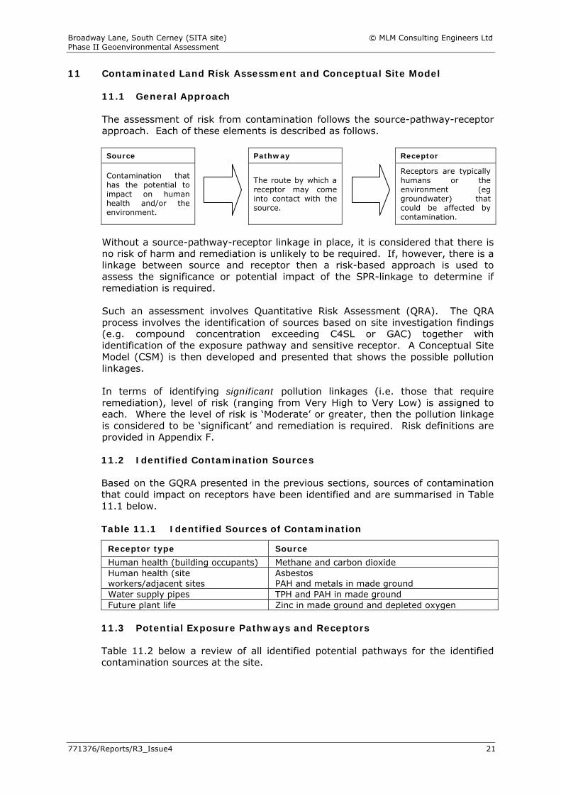
The assessment of risk from contamination follows the source-pathway-receptor approach. Each of these elements is described as follows. Source Pathway Receptor
Contamination that has the potential to impact on human health and/or the environment.
The route by which a receptor may come into contact with the source.
Receptors are typically humans or the environment (eg groundwater) that could be affected by contamination.
Without a source-pathway-receptor linkage in place, it is considered that there is no risk of harm and remediation is unlikely to be required. If, however, there is a linkage between source and receptor then a risk-based approach is used to assess the significance or potential impact of the SPR-linkage to determine if remediation is required. Such an assessment involves Quantitative Risk Assessment (QRA). The QRA process involves the identification of sources based on site investigation findings (e.g. compound concentration exceeding C4SL or GAC) together with identification of the exposure pathway and sensitive receptor. A Conceptual Site Model (CSM) is then developed and presented that shows the possible pollution linkages. In terms of identifying significant pollution linkages (i.e. those that require remediation), level of risk (ranging from Very High to Very Low) is assigned to each. Where the level of risk is ‘Moderate’ or greater, then the pollution linkage is considered to be ‘significant’ and remediation is required. Risk definitions are provided in Appendix F. 11.2 Identified Contamination Sources Based on the GQRA presented in the previous sections, sources of contamination that could impact on receptors have been identified and are summarised in Table 11.1 below. Table 11.1 Identified Sources of Contamination
Receptor type Source Human health (building occupants) Methane and carbon dioxide Human health (site workers/adjacent sites
Asbestos PAH and metals in made ground
Water supply pipes TPH and PAH in made ground Future plant life Zinc in made ground and depleted oxygen
11.3 Potential Exposure Pathways and Receptors Table 11.2 below a review of all identified potential pathways for the identified contamination sources at the site.

Broadway Lane, South Cerney (SITA site) © MLM Consulting Engineers Ltd Phase II Geoenvironmental Assessment
771376/Reports/R3_Issue4 22
Table 11.2 Pathways and Receptors
Receptor Pathway Present Notes
Human Health
Dermal contact, ingestion or inhalation of soil and soil dust
NO Site use is low sensitivity (commercial/ industrial) and will be capped with buildings and hardstanding.
Migration in permeable strata and inhalation of gas and organic vapour
YES Buildings are on site and occupied.
Future site users
Migration in permeable strata, accumulation and risk of explosion
YES Buildings are on site and occupied for commercial use.
Adjacent site users Ingestion/inhalation of windblown dust
YES The nearest sensitive land use is a caravan park 30m south.
Construction workers and services maintenance staff
Dermal contact, ingestion or inhalation
YES Site workers could be exposed to contamination during construction and services maintenance.
Development
Future plant life Plant uptake in garden or landscape area
YES Some areas of landscape may be proposed.
Water supply pipes Contact with contaminated material
YES New services would be constructed below ground in contaminated soil.
Environment
Surface water: lakes Groundwater movement
YES Shallow groundwater is likely to be in hydraulic connection with the lakes.
Shallow groundwater: worked out sand and gravel
Leaching from soil/downward fluid flow
YES Made ground is in direct contact with water-bearing strata.
Deep groundwater: Strata below Oxford Clay
Deep foundations breaching impermeable layer
NO The site is underlain by a significant thickness of Oxford Clay which would not be penetrated by piles.
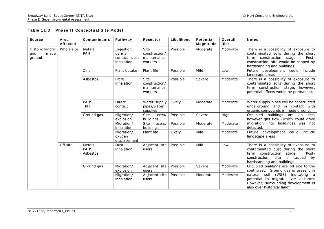
11.4 Phase II Conceptual Model Based on the sources, pathways and receptors identified above, Table 11.3 below summarises all complete pollutant linkages for the site and identifies the level of risk from each.
Broadway Lane, South Cerney (SITA Site) © MLM Consulting Engineers Ltd Phase II Geoenvironmental Assessment
N: 771376/Reports/R3_Issue4 23
Table 11.3 Phase II Conceptual Site Model Source Area
Affected Contaminants Pathway Receptor Likelihood Potential
Magnitude Overall Risk
Notes
Metals PAH
Ingestion, dermal contact dust inhalation
Site construction/ maintenance workers
Possible Moderate Moderate There is a possibility of exposure to contaminated soils during the short term construction stage. Post-construction, site would be capped by hardstanding and buildings.
Zinc Plant uptake Plant life Possible Mild Low Future development could include landscape areas
Asbestos Fibre inhalation
Site construction/ maintenance workers
Possible Severe Moderate There is a possibility of exposure to contaminated soils during the short term construction stage, however, potential effects would be permanent.
PAHS TPH
Direct contact
Water supply pipes/water supplies
Likely Moderate Moderate Water supply pipes will be constructed underground and in contact with organic compounds in made ground.
Migration/ explosion
Site users/ buildings
Possible Severe High
Migration/ inhalation
Site users/ buildings
Possible Moderate Moderate
Occupied buildings are on site, however gas flow (which could drive migration into buildings) was not detected.
Whole site
Ground gas
Migration/ oxygen displacement
Plant life Likely Mild Moderate Future development could include landscape areas
Metals PAHS Asbestos
Dust inhalation
Adjacent site users
Possible Mild Low There is a possibility of exposure to contaminated dust during the short term construction stage. Post-construction, site is capped by hardstanding and buildings.
Migration/ explosion
Adjacent site users
Possible Severe Moderate
Historic landfill and made ground
Off site
Ground gas
Migration/ inhalation
Adjacent site users
Possible Moderate Moderate
Occupied buildings are off site to the southwest. Ground gas is present in natural soil (WS3) indicating a potential to migrate over distance. However, surrounding development is also over historical landfill.
Broadway Lane, South Cerney (SITA Site) © MLM Consulting Engineers Ltd Phase II Geoenvironmental Assessment
771376/Reports/R3_Issue4 24
12 Remediation and Risk Management
12.1 General
This assessment has identified potential hazards at the site with possible SPR-linkages, which could represent potentially unacceptable risks to human health, the groundwater and future plant growth. Mitigation of the SPR-linkages summarised in Table 11.3 is recommended to reduce the impact of contamination on site occupants. 12.2 Soil Remediation Specific soil remediation is not considered to be required. However, mitigation is recommended as follows: Table 12.1 Summary of Recommended Mitigation
Aspect Description
Direct contact by construction workers
Construction workers should be provided with, and made to use, suitable PPE, including asbestos masks when dealing with potentially contaminated soils.
Watching brief during groundworks and discrete picking and/or excavation and disposal.
Direct contact by future maintenance workers
Bedding, backfill and surround to all services constructed in clean imported materials such that installation of new pipework and future maintenance is in clean soil.
Water supply pipes Upgraded water supply pipes in line with water supply company requirements.
Plant life Imported clean topsoil min. 450mm thick complying with the requirements of BS3882:2007 and subject to further specialist advice.
Mitigation is not required beneath buildings or hardstanding as these break the pathway between source and receptor.
12.3 Groundwater Remediation Groundwater contamination is absent and groundwater remediation is not considered to be required. 12.4 Gas Protection The site has been classified as CIRIA Characteristic Situation 2 based on methane and carbon dioxide concentrations in the ground. Gas protection measures should be incorporated in the design of future buildings in accordance with CIRIA report C665 and British Standard BS8485:2007. At this stage, it is understood that new buildings are likely to be proposed on site, however, their form and construction is not known. Therefore, the following guidance on gas protection design is given for both commercial and industrial building types for Characteristic Situation 2:
Broadway Lane, South Cerney (SITA Site) © MLM Consulting Engineers Ltd Phase II Geoenvironmental Assessment
771376/Reports/R3_Issue4 25
Commercial buildings should be designed with at least two levels of protection. From Table 3 of BS8485:2007, this level of protection can be provided by one or a combination of subfloor ventilation, floor slab and/or membrane.
Industrial buildings should be designed with at least one level of protection. From Table 3 of BS8485:2007, this level of protection can be provided by one or a combination of subfloor ventilation, floor slab and/or membrane.
The reduced levels of oxygen in the ground could impact on plant life. Installation of shallow gravel-filled gas vent trenches alongside areas of planting would assist in raising oxygen levels in the root zones of new planting. It has been proven through monitoring that ground gas beneath the site has the potential to migrate beyond the areas of the site underlain by landfill. While this could indicate a potential for off site migration, it should be noted that surrounding land is also underlain by landfill. The net result would be that surrounding land could not be protected from gas beneath the subject site. 12.5 Off Site Disposal It is anticipated that the natural excavated soils will be classified as inert for off-site disposal purposes and that the made ground would be classified as non-hazardous. Asbestos containing material should be hand picked from soils and would be classified as hazardous waste. Non-hazardous and hazardous soils require pre-treatment prior to disposal. Pre-treatment is a generic term that is used to describe the process of separating, sorting and screening soils at the time of their removal which can offer cost reductions through reducing the hazardous nature and volume of soil waste. Costs for disposal of non-hazardous/hazardous soils are significant compared to disposal of inert material. Some additional testing may be necessary for the receiving landfill to confirm its acceptability to receive all waste types. 12.6 Remediation Documentation Based on the findings and recommendations of this report, specific remediation measures will not be required. However, there are contamination-related construction issues that will need to be addressed through appropriate design and site work procedures. 12.7 Construction Health and Safety It is recommended that construction workers at the site adopt appropriate personal hygiene precautions at the site and use personal protective equipment as required, particularly provision of washing facilities, wearing of gloves and avoidance of hand to mouth contact (eg eating or smoking), especially when dealing with made ground containing asbestos containing materials. Handling of soil and water should be minimised and dust suppression measures should be implemented, particularly during any excavation through the made ground. Soils should be dampened during excavation and handling to limit dust, and lorries suitably sheeted. Surface run-off from vehicle washing, dust suppression or storms, during construction, should be controlled to prevent entry into watercourses and off-site drainage systems.

Broadway Lane, South Cerney (SITA Site) © MLM Consulting Engineers Ltd Phase II Geoenvironmental Assessment
771376/Reports/R3_Issue4 26
Gas and vapour monitoring should be carried out before entry into deep excavations and confined spaces.
These precautions are considered to be industry standard when developing sites of this nature, and reference can be made to the HSE document HSG66 Protection of workers and the general public during development of contaminated land for further information.
Broadway Lane, South Cerney (SITA Site) © MLM Consulting Engineers Ltd Phase II Geoenvironmental Assessment
771376/Reports/R3_Issue4 27
13 Summary and Recommendations
13.1 Summary The site is underlain by historic landfill and made ground overlying partially worked out sand and gravel and Oxford Clay. There is no chemical contamination in soil for the proposed future commercial or industrial use, assuming the site will be capped with buildings and external hardstanding areas. Soils did contain discrete pieces of asbestos (chrysotile) lagging, however, free fibres were absent. Organic compounds (TPH and PAH) in soil pose risks to plastic water supply pipes. High levels of methane and carbon dioxide were present in the ground, however gas flow was absent. The site is CIRIA Characteristic Situation 2. The source of ground gas is historical landfill beneath the site, however surrounding land is also underlain by landfill and there is therefore the potential for ground gases to migrate both away from the site and on to the site from surrounding areas. Planting in future landscape areas could be adversely affected by zinc in soil and depleted oxygen levels. There is no groundwater contamination beneath the site. Excavated natural soils should be suitable for re-use at the site. Excavated soils disposed of off-site are likely to be classified as inert (for natural soils), non-hazardous (for made ground) and hazardous waste (for asbestos containing lagging debris). Trench fill foundations are considered suitable in the western parts by WS1. Ground improvement or piled foundations are considered suitable for the remainder of the site. There is likely to be adequate infiltration capacity in natural soils for soakaway drainage. This is subject to the findings of soakaway testing. Soakaways should not be built in deep made ground. 13.2 Recommendations In the western parts of the site by WS1, the natural Northmore Sand and Gravel Member should be suitable as a founding stratum and an allowable net bearing capacity of 150kN/m2 should be available for a trench fill foundation 1m. For the remainder of the site, the made ground is considered too deep for traditional foundations and ground improvement or a piled foundation is recommended. Existing buried construction should be fully penetrated by, and broken away from new foundations.
Broadway Lane, South Cerney (SITA Site) © MLM Consulting Engineers Ltd Phase II Geoenvironmental Assessment
771376/Reports/R3_Issue4 28
For new construction on site, the following mitigation of contamination will be required: Gas protection in new buildings; Protected water supply pipes; Gravel-filled gas vent trench alongside areas of planting; Clean imported topsoil for new landscaping in accordance with
requirements of Table 12.1. Installation of services in corridors of clean soil; Health & Safety requirements when working with asbestos in the ground; Adopt construction methods that minimise the disturbance of soils
containing asbestos (eg adopt displacement piling methods that do not bring arisings to the surface)
Assuming that all existing buildings and infrastructure will continue in use, the following further advice is provided: Check existing building construction incorporates adequate gas protection Put in place procedures to mitigate risks from disturbing asbestos below
ground (eg for future services maintenance and small works)
Broadway Lane, South Cerney (SITA Site) © MLM Consulting Engineers Ltd Phase II Geoenvironmental Assessment
771376/Reports/R3_Issue4 29
14 References 1. Association of Geotechnical and Geoenvironmental Specialists (2004). A
Clients Guide to Site Investigations. 2. Association of Geotechnical and Geoenvironmental Specialists (2006). AGS
Guidelines for Good Practise in Site Investigations. 3. Association of Geotechnical and Geoenvironmental Specialists (1999). Code
of Conduct for Site Investigations. 4. Association of Geotechnical and Geoenvironmental Specialists (2005).
Management of Risk Associated with the Preparation of Ground Reports. 5. Association of Geotechnical and Geoenvironmental Specialists (2005).
Guidelines for the Preparation of the Ground Report.
6. Association of Geotechnical and Geoenvironmental Specialists (2000). Guidelines for Combined Geoenvironmental and Geotechnical Investigations.
7. British Standards Institution (2011) BS10175 Investigation of Potentially
Contaminated Sites - Code of Practice
8. British Standards Institution (2010) BS5930:1999+A2:2010 Code of practice for site investigation
9. British Standards Institution (2007) BS3882:2007. Specification for topsoil.
10. British Standards Institution (2007) BS8485:2007. Code of practice for the
characterization and remediation from ground gas in affected developments.
11. British Geological Survey 1:50,000 scale Geology Map, Solid and Drift Edition - Sheet 252 Swindon
12. CIRIA (2009) The VOCs Handbook: Investigating, assessing and managing
risks from inhalation of VOCs at land affected by contamination. Report C682
13. DEFRA & Environment Agency (2004) Model procedures for the
management of contaminated land. Contaminated Land Report 11.
14. DEFRA and Environment Agency Environment Agency. Contaminated Land Exposure Assessment Model (CLEA). Soil guideline value (SGV) series reports (downloaded from the EA website).
15. European Community (1976) Environmental Quality Standards for List 1 and
List 2 Dangerous Substances (EC Directive 76/464/EEC). 16. Health and Safety Executive (1991). HSG66. Protection of workers and the
general public during the development of contaminated land. 17. Land Quality Management Ltd and Chartered Institute of Environmental
Health (2006) Generic assessment criteria for human health risk assessment.

Broadway Lane, South Cerney (SITA Site) © MLM Consulting Engineers Ltd Phase II Geoenvironmental Assessment
771376/Reports/R3_Issue4 30
18. UK Water Industry Research (UKWIR) (2011) Guidance for the Selection of Water Supply Pipes to be used in Brownfield Sites.
Figures
Figure 1: Site Location Plan Figure 2: Exploratory Hole Location Plan
Figure 3: SPT V Depth Figure 4: Undrained Shear Strength V Depth
Job No. 771376
Broadway Lane, South Cerney (SITA Site)
Site Location Plan
Figure No. 1
N
SITE
E:\D
ocum
ents
\Fig
ure
tem
plat
es\A
4-Pf
ig.d
oc
Reproduced by permission of Ordnance Survey on behalf of
The Controller of Her Majesty’s Stationery Office. Crown copyright © All rights reserved
Licence number AL100020173
LEGEND
BH1
WS1
CABLE TOOL BOREHOLE
LOCATION
WINDOWLESS
SAMPLE BOREHOLE LOCATION
BH1
WS5
WS4
WS3
WS2
WS1
BH2
. . . . .
Scale
Drawing Title
Drawing Status:
Project
Approved
Date
Checked
Drawn/Design
Drawing No.
Rev Date
Description
Made Chk'd
@ A4
SOUTH CERNEY
BOREHOLE LOCATION PLAN
ER
MH
MH
FEB 2014
NTS
771376/FIG 2
INFORMATION
COPYRIGHT © MLM CONSULTING ENGINEERS LTD
Project Job No.
Broadway Lane
Figure No.
771376
SPT N Value Depth Plot - Geology
3
Copyright © MLM Environmental (Part of MLM Consulting Engineers Ltd)
0
0.5
1
1.5
2
2.5
3
3.5
4
4.5
5
5.5
6
6.5
7
7.5
8
8.5
9
9.5
10
10.5
11
11.5
12
0 5 10 15 20 25 30 35 40 45 50 55 60 65 70 75 80 85 90 95 100
SPT N valueDepth (m)
Northmore Sand and Gravel Member Made Ground Kellaways Clay Member
Project Job No.
Broadway Lane
Figure No.
Copyright © MLM Environmental (Part of MLM Consulting Engineers Ltd)
771376
Shear Strength V Depth
4
0
0.5
1
1.5
2
2.5
3
3.5
4
4.5
5
5.5
6
6.5
7
7.5
8
8.5
9
9.5
10
10.5
11
11.5
12
12.5
13
13.5
14
14.5
15
0 40 80 120 160 200 240 280 320 360 400 440
Shear Strength (kPa)
Depth (m)
SPT Derived -Kellaways Clay Member Triaxial Test- Kellaway Clay Member
Appendices
Appendix A: Exploratory Hole Logs Appendix B: Gas and Groundwater Monitoring Results
Appendix C: Chemical Analysis Results Appendix D: Geotechnical Laboratory Results
Appendix E: Generic Assessment Criteria Appendix F: Defining Risk

Appendix A
Exploratory Hole Logs
1.45
2.45
3.45
4.45
5.45
7.45
0.05
2.30
2.80
7.30
10.00
0.05
2.25
0.50
4.50
2.70
0.00
10.00
1.90
2.80
Paviors(MADE GROUND)
Grey SAND with many fine to coarse gravel sizedand cobble sized fragments of concrete, withoccasional fragments of geotextile.(MADE GROUND)
Soft brown slightly sandy silty CLAY with occasionalfine to coarse, sub-angular to sub-rounded chert,gravel and occasional fine to coarse gravel sizedfragments of concrete.
Grey brown SAND and GRAVEL. Gravel is fine tocoarse sub-angular to sub-rounded chert.
Firm to stiff dark grey CLAY.(OXFORD CLAY)
End of Borehole at 10.00 m
0.5
1.0
1.5
2.0
2.5
3.0
3.5
4.0
4.5
5.0
5.5
6.0
6.5
7.0
7.5
8.0
8.5
9.0
9.5
10.0
10.5
11.0
Leve
l
Lege
nd
(mAO
D)
Project:Location:
Client:
Start of Drilling:Completion:
(mAOD)Ground Level:
Project Engineer:
EXPLORATORY
Depth Water
IN SITU TESTS/SAMPLING
Thic
knes
s
Remarks:
Water StrikeWater Standing
Environmental Sample
Bulk Sample
Standard Penetration Test -
Standard Penetration Test -Solid Cone Method
Split Spoon Method
E
B
S
C
Sam
ple
Ref
.
Drilling Method:D
epth
(m
)
(m)SPT
(m)
STRATA
Description of Strata
N=17 SPT "N" Value with number ofblows per 75mm in brackets
U Undisturbed Sample
Jar SampleJWater SampleW
Inst
alla
tion
Det
ails
Well Installation/Backfill Legend:
Concrete
Filter Slotted Pipe
Piezometer Tip
Logged by:
Arisings
Results
She
arStr
engt
h
Project ID:
(kPa
)
Notes:Casing Depth (m bgl):Well Diameter (mm):
Legend:
Bentonite
Backfill
Gravel
Backfill Details: Pipe Details:
Plain Pipe
(Type) (m)
Coordinates:
Chi
selli
ngTi
me
(min
s)
Chi
selli
ngD
epth
(m
)
D Small Disturbed Sample
HOLE REFERENCE:
(Part of MLM Consulting Engineers Ltd)Copyright © MLM Environmental
Groundwater encountered at 3.0m. 2.Refusal at10.0m on possible mudstone band
1.
South Cerney
Eunomia771376
1.00
M HendersonC.Nunn
30/01/201430/01/2014
-
-
Cable Percussion
BH1
MLM EnvironmentalBuilding 7200Cambridge Research ParkCambridgeCB25 9TLTel: 01223 815600Fax: 01223 815630email: [email protected]
(C) N=11(1,3,3,3,2,3)
(C) N=6(1,2,2,1,1,2)
(C) N=43(4,6,8,10,12,13)
(C) N=25(3,5,5,4,8,8)
(C) N=28(2,4,6,4,9,9)
(C) N=11(3,3,2,2,2,5)

1.45
2.45
3.45
4.45
5.45
6.95
0.30
1.70
2.20
7.70
8.00
11.30
0.30
1.40
0.50
5.50
0.30
3.30
0.20
0.00
11.30
2.002.20
Concrete(MADE GROUND)
Crushed concrete recovered as buff grey SAND withmany fine to coarse gravel sized and cobble sizedfragments of concrete and rare clinker.
Soft light brown sandy CLAY with many fine tocoarse gravel sized fragments of concrete and someblack staining (no odour).
Firm to coarse GRAVEL.
CLAY(OXFORD CLAY)
Very stiff CLAY(OXFORD CLAY)
End of Borehole at 11.50 m
0.5
1.0
1.5
2.0
2.5
3.0
3.5
4.0
4.5
5.0
5.5
6.0
6.5
7.0
7.5
8.0
8.5
9.0
9.5
10.0
10.5
11.0
Leve
l
Lege
nd
(mAO
D)
Project:Location:
Client:
Start of Drilling:Completion:
(mAOD)Ground Level:
Project Engineer:
EXPLORATORY
Depth Water
IN SITU TESTS/SAMPLING
Thic
knes
s
Remarks:
Water StrikeWater Standing
Environmental Sample
Bulk Sample
Standard Penetration Test -
Standard Penetration Test -Solid Cone Method
Split Spoon Method
E
B
S
C
Sam
ple
Ref
.
Drilling Method:D
epth
(m
)
(m)SPT
(m)
STRATA
Description of Strata
N=17 SPT "N" Value with number ofblows per 75mm in brackets
U Undisturbed Sample
Jar SampleJWater SampleW
Inst
alla
tion
Det
ails
Well Installation/Backfill Legend:
Concrete
Filter Slotted Pipe
Piezometer Tip
Logged by:
Arisings
Results
She
arStr
engt
h
Project ID:
(kPa
)
Notes:Casing Depth (m bgl):Well Diameter (mm):
Legend:
Bentonite
Backfill
Gravel
Backfill Details: Pipe Details:
Plain Pipe
(Type) (m)
Coordinates:
Chi
selli
ngTi
me
(min
s)
Chi
selli
ngD
epth
(m
)
D Small Disturbed Sample
HOLE REFERENCE:
(Part of MLM Consulting Engineers Ltd)Copyright © MLM Environmental
Borehole backfilled with arisings.2. Refusal at 11.50m on possible mudstone band.
1.
South Cerney
Eunomia771376
1.00
M HendersonC.Nunn
31/01/201431/01/2014
-
-
Cable Percussion
BH2
MLM EnvironmentalBuilding 7200Cambridge Research ParkCambridgeCB25 9TLTel: 01223 815600Fax: 01223 815630email: [email protected]
(C) N=13(1,3,5,3,3,2)
(C) N=17(1,0,2,4,4,7)
(C) N=25(1,3,4,5,7,9)
(C) N=33(2,4,6,8,8,11)
(C) N=46(3,7,10,10,12,14)
(C) N=46(3,6,9,12,12,13)
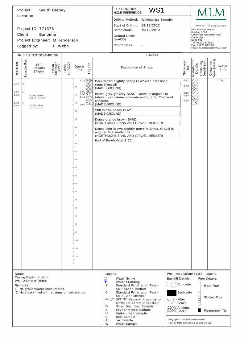
E
0.12
0.800.951.10
1.60
0.12
0.68
0.150.15
0.50
Dark brown slightly sandy CLAY with occasionalroots (Topsoil)(MADE GROUND)
Brown grey gravelly SAND. Gravel is angular totabular sandstone, concrete and quartz. Cobble ofconcrete.(MADE GROUND)
Stiff brown sandy CLAY.(MADE GROUND)
Dense orange brown SAND,(NORTHMORE SAND AND GRAVEL MEMBER)
Dense light brown slightly gravelly SAND. Gravel isangular fine sandstone.(NORTHMORE SAND AND GRAVEL MEMBER)End of Borehole at 1.60 m
0.5
1.0
1.5
2.0
2.5
3.0
3.5
4.0
4.5
5.0
5.5
6.0
6.5
7.0
7.5
8.0
8.5
9.0
9.5
10.0
10.5
11.0
Leve
l
Lege
nd
(mAO
D)
Project:Location:
Client:
Start of Drilling:Completion:
(mAOD)Ground Level:
Project Engineer:
EXPLORATORY
Depth Water
IN SITU TESTS/SAMPLING
Thic
knes
s
Remarks:
Water StrikeWater Standing
Environmental Sample
Bulk Sample
Standard Penetration Test -
Standard Penetration Test -Solid Cone Method
Split Spoon Method
E
B
S
C
Sam
ple
Ref
.
Drilling Method:D
epth
(m
)
(m)SPT
(m)
STRATA
Description of Strata
N=17 SPT "N" Value with number ofblows per 75mm in brackets
U Undisturbed Sample
Jar SampleJWater SampleW
Inst
alla
tion
Det
ails
Well Installation/Backfill Legend:
Concrete
Filter Slotted Pipe
Piezometer Tip
Logged by:
Arisings
Results
She
arStr
engt
h
Project ID:
(kPa
)
Notes:Casing Depth (m bgl):Well Diameter (mm):
Legend:
Bentonite
Backfill
Gravel
Backfill Details: Pipe Details:
Plain Pipe
(Type) (m)
Coordinates:
Chi
selli
ngTi
me
(min
s)
Chi
selli
ngD
epth
(m
)
D Small Disturbed Sample
HOLE REFERENCE:
(Part of MLM Consulting Engineers Ltd)Copyright © MLM Environmental
No groundwater encountered.1.Hole backfilled with arisings on completion. 2.
South Cerney
Eunomia771376
M HendersonP. Webb
19/12/201319/12/2013
-
-
Windowless Sampler
WS1
MLM EnvironmentalBuilding 7200Cambridge Research ParkCambridgeCB25 9TLTel: 01223 815600Fax: 01223 815630email: [email protected]
Dry
(C) 50/245mm(8,14,14,14,16,6)
(C) 50/165mm(21,4,21,22,7)
0.30
0.801.00
1.501.60
E
D

angular fine to medium sandstone and ceramic.(MADE GROUND)
Black organic material (wood fragments) withplastic.(MADE GROUND)End of Borehole at 0.70 m
0.5
1.0
1.5
2.0
2.5
3.0
3.5
4.0
4.5
5.0
5.5
6.0
6.5
7.0
7.5
8.0
8.5
9.0
9.5
10.0
10.5
11.0
Leve
l
Lege
nd
(mAO
D)
Project:Location:
Client:
Start of Drilling:Completion:
(mAOD)Ground Level:
Project Engineer:
EXPLORATORY
Depth Water
IN SITU TESTS/SAMPLING
Thic
knes
s
Remarks:
Water StrikeWater Standing
Environmental Sample
Bulk Sample
Standard Penetration Test -
Standard Penetration Test -Solid Cone Method
Split Spoon Method
E
B
S
C
Sam
ple
Ref
.
Drilling Method:D
epth
(m
)
(m)SPT
(m)
STRATA
Description of Strata
N=17 SPT "N" Value with number ofblows per 75mm in brackets
U Undisturbed Sample
Jar SampleJWater SampleW
Inst
alla
tion
Det
ails
Well Installation/Backfill Legend:
Concrete
Filter Slotted Pipe
Piezometer Tip
Logged by:
Arisings
Results
She
arStr
engt
h
Project ID:
(kPa
)
Notes:Casing Depth (m bgl):Well Diameter (mm):
Legend:
Bentonite
Backfill
Gravel
Backfill Details: Pipe Details:
Plain Pipe
(Type) (m)
Coordinates:
Chi
selli
ngTi
me
(min
s)
Chi
selli
ngD
epth
(m
)
D Small Disturbed Sample
HOLE REFERENCE:
(Part of MLM Consulting Engineers Ltd)Copyright © MLM Environmental
Obstruction encountered at 0.7m.1.No groundwater encountered. 2.Hole backfilled with arisings on completion 3.
South Cerney
Eunomia771376
M HendersonP. Webb
19/12/201319/12/2013
-
-
Windowless Sampler
WS2
MLM EnvironmentalBuilding 7200Cambridge Research ParkCambridgeCB25 9TLTel: 01223 815600Fax: 01223 815630email: [email protected]
Dry0.20
0.60
E
E0.500.70
0.50
0.20
Brown slightly clayey gravelly SAND. Gravel is
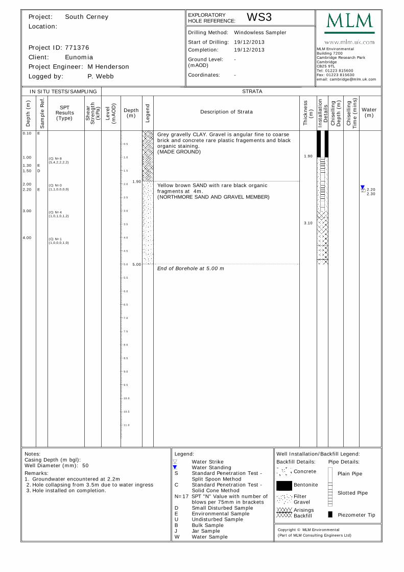
1.00
1.301.50
2.002.20
3.00
4.00
E
ED
E
1.90
5.00
1.90
3.10
2.202.30
Grey gravelly CLAY. Gravel is angular fine to coarsebrick and concrete rare plastic fragements and blackorganic staining.(MADE GROUND)
Yellow brown SAND with rare black organicfragments at 4m.(NORTHMORE SAND AND GRAVEL MEMBER)
End of Borehole at 5.00 m
0.5
1.0
1.5
2.0
2.5
3.0
3.5
4.0
4.5
5.0
5.5
6.0
6.5
7.0
7.5
8.0
8.5
9.0
9.5
10.0
10.5
11.0
Leve
l
Lege
nd
(mAO
D)
Project:Location:
Client:
Start of Drilling:Completion:
(mAOD)Ground Level:
Project Engineer:
EXPLORATORY
Depth Water
IN SITU TESTS/SAMPLING
Thic
knes
s
Remarks:
Water StrikeWater Standing
Environmental Sample
Bulk Sample
Standard Penetration Test -
Standard Penetration Test -Solid Cone Method
Split Spoon Method
E
B
S
C
Sam
ple
Ref
.
Drilling Method:D
epth
(m
)
(m)SPT
(m)
STRATA
Description of Strata
N=17 SPT "N" Value with number ofblows per 75mm in brackets
U Undisturbed Sample
Jar SampleJWater SampleW
Inst
alla
tion
Det
ails
Well Installation/Backfill Legend:
Concrete
Filter Slotted Pipe
Piezometer Tip
Logged by:
Arisings
Results
She
arStr
engt
h
Project ID:
(kPa
)
Notes:Casing Depth (m bgl):Well Diameter (mm):
Legend:
Bentonite
Backfill
Gravel
Backfill Details: Pipe Details:
Plain Pipe
(Type) (m)
Coordinates:
Chi
selli
ngTi
me
(min
s)
Chi
selli
ngD
epth
(m
)
D Small Disturbed Sample
HOLE REFERENCE:
(Part of MLM Consulting Engineers Ltd)Copyright © MLM Environmental
Groundwater encountered at 2.2m1.Hole collapsing from 3.5m due to water ingress 2.Hole installed on completion. 3.
South Cerney
Eunomia771376
50
M HendersonP. Webb
19/12/201319/12/2013
-
-
Windowless Sampler
WS3
MLM EnvironmentalBuilding 7200Cambridge Research ParkCambridgeCB25 9TLTel: 01223 815600Fax: 01223 815630email: [email protected]
(C) N=8(5,4,2,2,2,2)
(C) N=0(1,1,0,0,0,0)
(C) N=4(1,0,1,0,1,2)
(C) N=1(1,0,0,0,1,0)
0.10
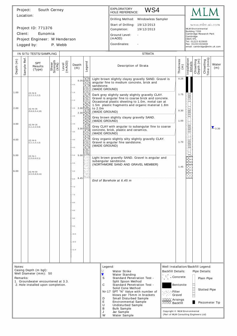
(2,3,5,8,9,11)
1.00
2.00
3.00
4.00
5.00
6.00
0.25
2.00
2.30
3.30
5.00
6.45
0.25
1.75
0.30
1.00
1.70
1.45
3.30
Light brown slightly clayey gravelly SAND. Gravel isangular fine to medium concrete, brick andsandstone.(MADE GROUND)
Dark grey slightly sandy slightly gravelly CLAY.Gravel is angular fine to coarse brick and concrete.Occasional plastic sheeting to 1.0m, metal can at1.5m plastic fragments and organic material 1.8mto 2.0m(MADE GROUND)
Grey brown slightly clayey gravelly SAND.(MADE GROUND)
Grey CLAY with angular to subangular fine to coarseconcrete, brick, plastic and ceramics.(MADE GROUND)
Grey organic slightly silty slightly gravelly CLAY.Gravel is angular fine sandstone.(MADE GROUND)
Light brown gravelly SAND. Gravel is angular andsubangular sandstone.(NORTHMORE SAND AND GRAVEL MEMBER)
End of Borehole at 6.45 m
0.5
1.0
1.5
2.0
2.5
3.0
3.5
4.0
4.5
5.0
5.5
6.0
6.5
7.0
7.5
8.0
8.5
9.0
9.5
10.0
10.5
11.0
Leve
l
Lege
nd
(mAO
D)
Project:Location:
Client:
Start of Drilling:Completion:
(mAOD)Ground Level:
Project Engineer:
EXPLORATORY
Depth Water
IN SITU TESTS/SAMPLING
Thic
knes
s
Remarks:
Water StrikeWater Standing
Environmental Sample
Bulk Sample
Standard Penetration Test -
Standard Penetration Test -Solid Cone Method
Split Spoon Method
E
B
S
C
Sam
ple
Ref
.
Drilling Method:D
epth
(m
)
(m)SPT
(m)
STRATA
Description of Strata
N=17 SPT "N" Value with number ofblows per 75mm in brackets
U Undisturbed Sample
Jar SampleJWater SampleW
Inst
alla
tion
Det
ails
Well Installation/Backfill Legend:
Concrete
Filter Slotted Pipe
Piezometer Tip
Logged by:
Arisings
Results
She
arStr
engt
h
Project ID:
(kPa
)
Notes:Casing Depth (m bgl):Well Diameter (mm):
Legend:
Bentonite
Backfill
Gravel
Backfill Details: Pipe Details:
Plain Pipe
(Type) (m)
Coordinates:
Chi
selli
ngTi
me
(min
s)
Chi
selli
ngD
epth
(m
)
D Small Disturbed Sample
HOLE REFERENCE:
(Part of MLM Consulting Engineers Ltd)Copyright © MLM Environmental
Groundwater encountered at 3.3.1.Hole installed upon completion. 2.
South Cerney
Eunomia771376
50
M HendersonP. Webb
19/12/201319/12/2013
-
-
Windowless Sampler
WS4
MLM EnvironmentalBuilding 7200Cambridge Research ParkCambridgeCB25 9TLTel: 01223 815600Fax: 01223 815630email: [email protected]
(C) N=8(1,2,2,2,2,2)
(C) N=25(5,8,6,5,4,10)
(C) N=15(1,1,2,2,5,6)
(C) N=6(1,1,1,2,1,2)
(C) N=1(1,0,0,0,0,1)
(C) N=33
Grey brown slightly sandy gravelly SAND. Gravel isangular fine to coarse brick and concrete. Suspectedasbestos lagging debris at 0.5m and 1.2m.(MADE GROUND)
End of Borehole at 2.45 m
0.5
1.0
1.5
2.0
2.5
3.0
3.5
4.0
4.5
5.0
5.5
6.0
6.5
7.0
7.5
8.0
8.5
9.0
9.5
10.0
10.5
11.0
Leve
l
Lege
nd
(mAO
D)
Project:Location:
Client:
Start of Drilling:Completion:
(mAOD)Ground Level:
Project Engineer:
EXPLORATORY
Depth Water
IN SITU TESTS/SAMPLING
Thic
knes
s
Remarks:
Water StrikeWater Standing
Environmental Sample
Bulk Sample
Standard Penetration Test -
Standard Penetration Test -Solid Cone Method
Split Spoon Method
E
B
S
C
Sam
ple
Ref
.
Drilling Method:D
epth
(m
)
(m)SPT
(m)
STRATA
Description of Strata
N=17 SPT "N" Value with number ofblows per 75mm in brackets
U Undisturbed Sample
Jar SampleJWater SampleW
Inst
alla
tion
Det
ails
Well Installation/Backfill Legend:
Concrete
Filter Slotted Pipe
Piezometer Tip
Logged by:
Arisings
Results
She
arStr
engt
h
Project ID:
(kPa
)
Notes:Casing Depth (m bgl):Well Diameter (mm):
Legend:
Bentonite
Backfill
Gravel
Backfill Details: Pipe Details:
Plain Pipe
(Type) (m)
Coordinates:
Chi
selli
ngTi
me
(min
s)
Chi
selli
ngD
epth
(m
)
D Small Disturbed Sample
HOLE REFERENCE:
(Part of MLM Consulting Engineers Ltd)Copyright © MLM Environmental
Slight water seepage in base of hole.1.Hole abandonded due to suspected asbestos. 2.Hole backfilled with bentonite pellets 3.
South Cerney
Eunomia771376
M HendersonP. Webb
19/12/201319/12/2013
-
-
Windowless Sampler
WS5
MLM EnvironmentalBuilding 7200Cambridge Research ParkCambridgeCB25 9TLTel: 01223 815600Fax: 01223 815630email: [email protected]
(C) N=20(3,2,3,6,6,5)
(C) N=7(2,2,2,2,2,1)
1.00
2.00 2.00
2.00
2.00

Appendix B
Gas and Groundwater Monitoring Results
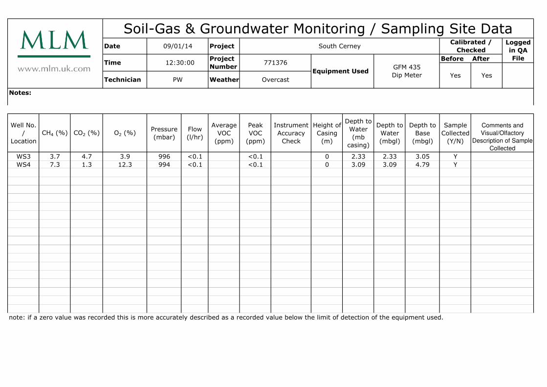
Before After
Notes:
Well No.
/
Location
CH4 (%) CO2 (%) O2 (%)Pressure
(mbar)
Flow
(l/hr)
Average
VOC
(ppm)
Peak
VOC
(ppm)
Instrument
Accuracy
Check
Height of
Casing
(m)
Depth to
Water
(mb
casing)
Depth to
Water
(mbgl)
Depth to
Base
(mbgl)
Sample
Collected
(Y/N)
WS3 3.7 4.7 3.9 996 <0.1 <0.1 0 2.33 2.33 3.05 Y
WS4 7.3 1.3 12.3 994 <0.1 <0.1 0 3.09 3.09 4.79 Y
note: if a zero value was recorded this is more accurately described as a recorded value below the limit of detection of the equipment used.
Soil-Gas & Groundwater Monitoring / Sampling Site DataLogged
in QA
File
Calibrated /
CheckedDate 09/01/14 Project South Cerney
Time 12:30:00Project
Number771376
Equipment UsedGFM 435
Dip Meter Technician PW Weather Overcast
Yes Yes
Comments and
Visual/Olfactory
Description of Sample
Collected

Appendix C
Results of Chemical Analysis
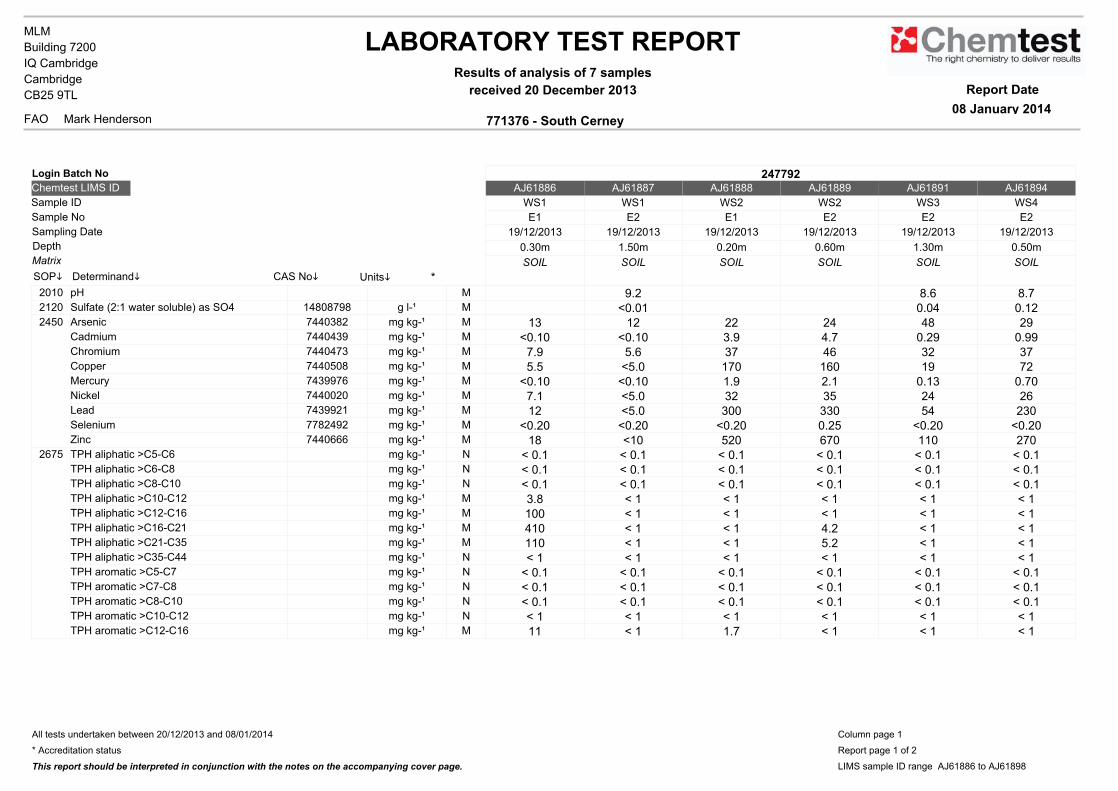
LABORATORY TEST REPORTResults of analysis of 7 samples
received 20 December 2013
771376 - South CerneyFAO
MLM
Mark Henderson
Building 7200
IQ Cambridge
Cambridge
CB25 9TL Report Date
08 January 2014
247792AJ61886 AJ61887 AJ61888 AJ61889 AJ61891 AJ61894
WS1 WS1 WS2 WS2 WS3 WS4
E1 E2 E1 E2 E2 E2
19/12/2013 19/12/2013 19/12/2013 19/12/2013 19/12/2013 19/12/2013
0.30m 1.50m 0.20m 0.60m 1.30m 0.50m
SOIL SOIL SOIL SOIL SOIL SOIL
2010 pH M 9.2 8.6 8.72120 Sulfate (2:1 water soluble) as SO4 14808798 g l-¹ M <0.01 0.04 0.122450 Arsenic 7440382 mg kg-¹ M 13 12 22 24 48 29
Cadmium 7440439 mg kg-¹ M <0.10 <0.10 3.9 4.7 0.29 0.99Chromium 7440473 mg kg-¹ M 7.9 5.6 37 46 32 37Copper 7440508 mg kg-¹ M 5.5 <5.0 170 160 19 72Mercury 7439976 mg kg-¹ M <0.10 <0.10 1.9 2.1 0.13 0.70Nickel 7440020 mg kg-¹ M 7.1 <5.0 32 35 24 26Lead 7439921 mg kg-¹ M 12 <5.0 300 330 54 230Selenium 7782492 mg kg-¹ M <0.20 <0.20 <0.20 0.25 <0.20 <0.20Zinc 7440666 mg kg-¹ M 18 <10 520 670 110 270
2675 TPH aliphatic >C5-C6 mg kg-¹ N < 0.1 < 0.1 < 0.1 < 0.1 < 0.1 < 0.1TPH aliphatic >C6-C8 mg kg-¹ N < 0.1 < 0.1 < 0.1 < 0.1 < 0.1 < 0.1TPH aliphatic >C8-C10 mg kg-¹ N < 0.1 < 0.1 < 0.1 < 0.1 < 0.1 < 0.1TPH aliphatic >C10-C12 mg kg-¹ M 3.8 < 1 < 1 < 1 < 1 < 1TPH aliphatic >C12-C16 mg kg-¹ M 100 < 1 < 1 < 1 < 1 < 1TPH aliphatic >C16-C21 mg kg-¹ M 410 < 1 < 1 4.2 < 1 < 1TPH aliphatic >C21-C35 mg kg-¹ M 110 < 1 < 1 5.2 < 1 < 1TPH aliphatic >C35-C44 mg kg-¹ N < 1 < 1 < 1 < 1 < 1 < 1TPH aromatic >C5-C7 mg kg-¹ N < 0.1 < 0.1 < 0.1 < 0.1 < 0.1 < 0.1TPH aromatic >C7-C8 mg kg-¹ N < 0.1 < 0.1 < 0.1 < 0.1 < 0.1 < 0.1TPH aromatic >C8-C10 mg kg-¹ N < 0.1 < 0.1 < 0.1 < 0.1 < 0.1 < 0.1TPH aromatic >C10-C12 mg kg-¹ N < 1 < 1 < 1 < 1 < 1 < 1TPH aromatic >C12-C16 mg kg-¹ M 11 < 1 1.7 < 1 < 1 < 1
*UnitsiCAS NoiDeterminandiSOPi
Matrix
Depth
Sample No
Sample ID
Chemtest LIMS ID
Login Batch No
Sampling Date
All tests undertaken between 20/12/2013 and 08/01/2014
* Accreditation status
This report should be interpreted in conjunction with the notes on the accompanying cover page.
Column page 1
Report page 1 of 2
LIMS sample ID range AJ61886 to AJ61898
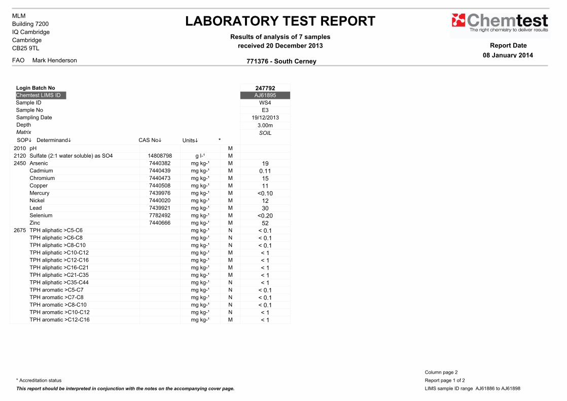
LABORATORY TEST REPORTResults of analysis of 7 samples
received 20 December 2013
771376 - South CerneyFAO
MLM
Mark Henderson
Building 7200
IQ Cambridge
Cambridge
CB25 9TL Report Date
08 January 2014
247792AJ61895
WS4
E3
19/12/2013
3.00m
SOIL
2010 pH M
2120 Sulfate (2:1 water soluble) as SO4 14808798 g l-¹ M
2450 Arsenic 7440382 mg kg-¹ M 19Cadmium 7440439 mg kg-¹ M 0.11Chromium 7440473 mg kg-¹ M 15Copper 7440508 mg kg-¹ M 11Mercury 7439976 mg kg-¹ M <0.10Nickel 7440020 mg kg-¹ M 12Lead 7439921 mg kg-¹ M 30Selenium 7782492 mg kg-¹ M <0.20Zinc 7440666 mg kg-¹ M 52
2675 TPH aliphatic >C5-C6 mg kg-¹ N < 0.1TPH aliphatic >C6-C8 mg kg-¹ N < 0.1TPH aliphatic >C8-C10 mg kg-¹ N < 0.1TPH aliphatic >C10-C12 mg kg-¹ M < 1TPH aliphatic >C12-C16 mg kg-¹ M < 1TPH aliphatic >C16-C21 mg kg-¹ M < 1TPH aliphatic >C21-C35 mg kg-¹ M < 1TPH aliphatic >C35-C44 mg kg-¹ N < 1TPH aromatic >C5-C7 mg kg-¹ N < 0.1TPH aromatic >C7-C8 mg kg-¹ N < 0.1TPH aromatic >C8-C10 mg kg-¹ N < 0.1TPH aromatic >C10-C12 mg kg-¹ N < 1TPH aromatic >C12-C16 mg kg-¹ M < 1
*UnitsiCAS NoiDeterminandiSOPi
Matrix
Depth
Sample No
Sample ID
Chemtest LIMS ID
Login Batch No
Sampling Date
* Accreditation status
This report should be interpreted in conjunction with the notes on the accompanying cover page.
Column page 2
Report page 1 of 2
LIMS sample ID range AJ61886 to AJ61898

LABORATORY TEST REPORTResults of analysis of 7 samples
received 20 December 2013
771376 - South CerneyFAO
MLM
Mark Henderson
Building 7200
IQ Cambridge
Cambridge
CB25 9TL Report Date
08 January 2014
247792AJ61886 AJ61887 AJ61888 AJ61889 AJ61891 AJ61894
WS1 WS1 WS2 WS2 WS3 WS4
E1 E2 E1 E2 E2 E2
19/12/2013 19/12/2013 19/12/2013 19/12/2013 19/12/2013 19/12/2013
0.30m 1.50m 0.20m 0.60m 1.30m 0.50m
SOIL SOIL SOIL SOIL SOIL SOIL
2675 TPH aromatic >C16-C21 mg kg-¹ M 41 < 1 2.1 < 1 < 1 1.4TPH aromatic >C21-C35 mg kg-¹ N 16 < 1 5.5 1.6 < 1 4.8TPH aromatic >C35-C44 mg kg-¹ N < 1 < 1 < 1 < 1 < 1 < 1Total Petroleum Hydrocarbons mg kg-¹ N 690 < 10 11 13 < 10 < 10
2700 Naphthalene 91203 mg kg-¹ M < 0.1 < 0.1 0.22 < 0.1 < 0.1 < 0.1Acenaphthylene 208968 mg kg-¹ M < 0.1 < 0.1 1.2 < 0.1 < 0.1 1.6Acenaphthene 83329 mg kg-¹ M < 0.1 < 0.1 0.89 < 0.1 < 0.1 0.37Fluorene 86737 mg kg-¹ M < 0.1 < 0.1 0.69 < 0.1 < 0.1 0.36Phenanthrene 85018 mg kg-¹ M < 0.1 < 0.1 5.9 < 0.1 < 0.1 3.1Anthracene 120127 mg kg-¹ M < 0.1 < 0.1 1.4 < 0.1 < 0.1 1.3Fluoranthene 206440 mg kg-¹ M < 0.1 < 0.1 7.1 < 0.1 0.23 4.7Pyrene 129000 mg kg-¹ M < 0.1 < 0.1 5.4 < 0.1 0.18 3.9Benzo[a]anthracene 56553 mg kg-¹ M < 0.1 < 0.1 3.5 < 0.1 0.61 2.6Chrysene 218019 mg kg-¹ M < 0.1 < 0.1 4.4 < 0.1 0.13 2.1Benzo[b]fluoranthene 205992 mg kg-¹ N < 0.1 < 0.1 4.1 < 0.1 < 0.1 3.2Benzo[k]fluoranthene 207089 mg kg-¹ N < 0.1 < 0.1 3 < 0.1 < 0.1 1.8Benzo[a]pyrene 50328 mg kg-¹ M < 0.1 < 0.1 3.8 < 0.1 < 0.1 2.6Dibenzo[a,h]anthracene 53703 mg kg-¹ M < 0.1 < 0.1 0.53 < 0.1 < 0.1 0.44Indeno[1,2,3-cd]pyrene 193395 mg kg-¹ M < 0.1 < 0.1 2.6 < 0.1 < 0.1 2.3Benzo[g,h,i]perylene 191242 mg kg-¹ M < 0.1 < 0.1 3.2 < 0.1 < 0.1 2.2Total (of 16) PAHs mg kg-¹ M < 2 < 2 48 < 2 < 2 33
All tests undertaken between 20/12/2013 and 08/01/2014
* Accreditation status
This report should be interpreted in conjunction with the notes on the accompanying cover page.
Column page 1
Report page 2 of 2
LIMS sample ID range AJ61886 to AJ61898
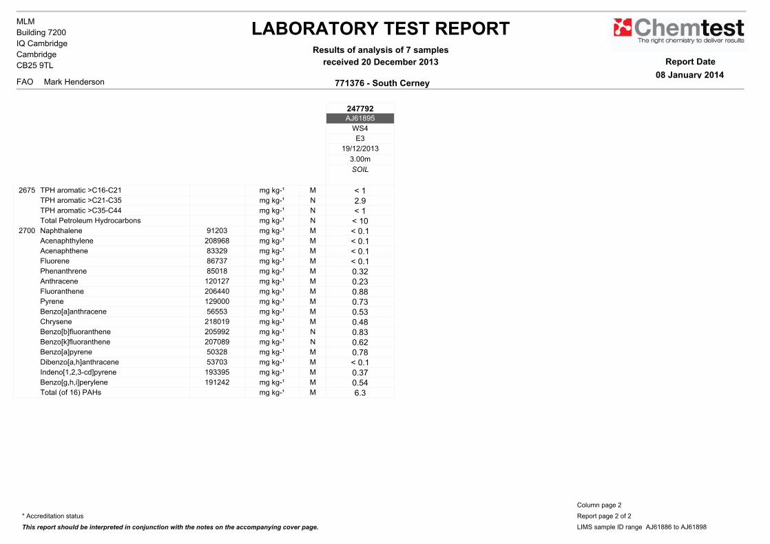
LABORATORY TEST REPORTResults of analysis of 7 samples
received 20 December 2013
771376 - South CerneyFAO
MLM
Mark Henderson
Building 7200
IQ Cambridge
Cambridge
CB25 9TL Report Date
08 January 2014
247792AJ61895
WS4
E3
19/12/2013
3.00m
SOIL
2675 TPH aromatic >C16-C21 mg kg-¹ M < 1TPH aromatic >C21-C35 mg kg-¹ N 2.9TPH aromatic >C35-C44 mg kg-¹ N < 1Total Petroleum Hydrocarbons mg kg-¹ N < 10
2700 Naphthalene 91203 mg kg-¹ M < 0.1Acenaphthylene 208968 mg kg-¹ M < 0.1Acenaphthene 83329 mg kg-¹ M < 0.1Fluorene 86737 mg kg-¹ M < 0.1Phenanthrene 85018 mg kg-¹ M 0.32Anthracene 120127 mg kg-¹ M 0.23Fluoranthene 206440 mg kg-¹ M 0.88Pyrene 129000 mg kg-¹ M 0.73Benzo[a]anthracene 56553 mg kg-¹ M 0.53Chrysene 218019 mg kg-¹ M 0.48Benzo[b]fluoranthene 205992 mg kg-¹ N 0.83Benzo[k]fluoranthene 207089 mg kg-¹ N 0.62Benzo[a]pyrene 50328 mg kg-¹ M 0.78Dibenzo[a,h]anthracene 53703 mg kg-¹ M < 0.1Indeno[1,2,3-cd]pyrene 193395 mg kg-¹ M 0.37Benzo[g,h,i]perylene 191242 mg kg-¹ M 0.54Total (of 16) PAHs mg kg-¹ M 6.3
* Accreditation status
This report should be interpreted in conjunction with the notes on the accompanying cover page.
Column page 2
Report page 2 of 2
LIMS sample ID range AJ61886 to AJ61898
LABORATORY TEST REPORT
Report Date
08 January 2014
Results of analysis of 8 samples
received 20 December 2013
771376 - South CerneyFAO Mark Henderson
Building 7200
IQ Cambridge
Cambridge
CB25 9TL
MLM
Asbestos in Soils
Login Batch No:
Chemtest ID Sample ID Sample Desc
SOP 2190
ACM Type Asbestos IdentificationUKAS Accredited UKAS Accredited
AJ61886 WS1 E1 0.30 - No Asbestos DetectedAJ61887 WS1 E2 1.50 - No Asbestos DetectedAJ61888 WS2 E1 0.20 - No Asbestos DetectedAJ61889 WS2 E2 0.60 - No Asbestos DetectedAJ61891 WS3 E2 1.30 - No Asbestos DetectedAJ61894 WS4 E2 0.50 - No Asbestos DetectedAJ61895 WS4 E3 3.00 - No Asbestos DetectedAJ61898 WS5 B 0.00 - 2.00 lagging Chrysotile
Depth (m)
247792
Qualitative Results
The detection limit for this method is 0.001%
Steve McGrath
Asbestos Analyst
Signed
All tests undertaken between 06-Jan-2014 and 6-Jan-2014 at our asbestos testing facility in
Coventry
Report page 1 of 1
LIMS sample ID range AJ61886 to AJ61898
LABORATORY TEST REPORT Report Date
14 January 2014
Results of analysis of 2 samples
received 20 December 2013
771376 - South CerneyFAO Mark Henderson
Building 7200
IQ Cambridge
Cambridge
CB25 9TL
MLM
248013AJ61896 AJ61897
WS5 WS5
E1 E2
0.50 1.20
2185 Actinolite Not detected Not detectedAmosite Not detected Not detectedAnthophyllite Not detected Not detectedChrysotile Not detected Not detectedCrocidolite Not detected Not detectedTremolite Not detected Not detectedMaterial Concrete Board
Login Batch No
Chemtest LIMS ID
Sample ID
Sample No
SOPi Determinandi CAS Noi
All tests undertaken between 14-Jan-2014 and 14-Jan-2014 at our asbestos testing facility in Coventry.
Signed
Lauren Quinn
Asbestos Analyst
Column page 1
Report page 1 of 1
LIMS sample ID range AJ61896 to AJ61897
2183
Notes to accompany report:
l The in-house procedure SOP 2185 is in accordance with the requirements of Appendix 2 of the Analyst Guide
(HSG248)
l The results relate only to the items tested as supplied by the client
l Comments and interpretations are not UKAS accredited
l Amosite is alternatively termed ‘brown asbestos’
l Chrysotile is alternatively termed ‘white asbestos’
l Crocidolite is alternatively termed ‘blue asbestos’
l Samples associated with asbestos in building surveys are retained for sixmonths (HSG 264 refers)
l Comments or interpretations are beyond the scope of UKAS accreditation
LABORATORY TEST REPORTResults of analysis of 1 sample
received 4 February 2014
771376 - South CerneyFAO
MLM
Mark Henderson
Building 7200
IQ Cambridge
Cambridge
CB25 9TL Report Date
12 February 2014
250568AJ79001
BH2
E3
31/1/2014
1.70m - 2.00m
SOIL
2625 Organic matter % M 2.92450 Arsenic 7440382 mg kg-¹ M 5.9
Cadmium 7440439 mg kg-¹ M <0.10Chromium 7440473 mg kg-¹ M <5.0Copper 7440508 mg kg-¹ M <5.0Mercury 7439976 mg kg-¹ M <0.10Nickel 7440020 mg kg-¹ M <5.0Lead 7439921 mg kg-¹ M 5.3Selenium 7782492 mg kg-¹ M <0.20Zinc 7440666 mg kg-¹ M 12
2675 TPH aliphatic >C5-C6 mg kg-¹ N < 0.1TPH aliphatic >C6-C8 mg kg-¹ N < 0.1TPH aliphatic >C8-C10 mg kg-¹ N < 0.1TPH aliphatic >C10-C12 mg kg-¹ M < 1TPH aliphatic >C12-C16 mg kg-¹ M 48TPH aliphatic >C16-C21 mg kg-¹ M 130TPH aliphatic >C21-C35 mg kg-¹ M 28TPH aliphatic >C35-C44 mg kg-¹ N < 1TPH aromatic >C5-C7 mg kg-¹ N < 0.1TPH aromatic >C7-C8 mg kg-¹ N < 0.1TPH aromatic >C8-C10 mg kg-¹ N < 0.1TPH aromatic >C10-C12 mg kg-¹ N < 1TPH aromatic >C12-C16 mg kg-¹ M 3.8TPH aromatic >C16-C21 mg kg-¹ M 8.8
*UnitsiCAS NoiDeterminandiSOPi
Matrix
Depth
Sample No
Sample ID
Chemtest LIMS ID
Login Batch No
Sampling Date
All tests undertaken between 04/02/2014 and 12/02/2014
* Accreditation status
This report should be interpreted in conjunction with the notes on the accompanying cover page.
Column page 1
Report page 1 of 2
LIMS sample ID range AJ78995 to AJ79001
LABORATORY TEST REPORTResults of analysis of 1 sample
received 4 February 2014
771376 - South CerneyFAO
MLM
Mark Henderson
Building 7200
IQ Cambridge
Cambridge
CB25 9TL Report Date
12 February 2014
250568AJ79001
BH2
E3
31/1/2014
1.70m - 2.00m
SOIL
2675 TPH aromatic >C21-C35 mg kg-¹ N 6.4TPH aromatic >C35-C44 mg kg-¹ N < 1Total Petroleum Hydrocarbons mg kg-¹ N 220
2700 Naphthalene 91203 mg kg-¹ M < 0.1Acenaphthylene 208968 mg kg-¹ M < 0.1Acenaphthene 83329 mg kg-¹ M < 0.1Fluorene 86737 mg kg-¹ M < 0.1Phenanthrene 85018 mg kg-¹ M < 0.1Anthracene 120127 mg kg-¹ M < 0.1Fluoranthene 206440 mg kg-¹ M < 0.1Pyrene 129000 mg kg-¹ M < 0.1Benzo[a]anthracene 56553 mg kg-¹ M < 0.1Chrysene 218019 mg kg-¹ M < 0.1Benzo[b]fluoranthene 205992 mg kg-¹ N < 0.1Benzo[k]fluoranthene 207089 mg kg-¹ N < 0.1Benzo[a]pyrene 50328 mg kg-¹ M < 0.1Dibenzo[a,h]anthracene 53703 mg kg-¹ M < 0.1Indeno[1,2,3-cd]pyrene 193395 mg kg-¹ M < 0.1Benzo[g,h,i]perylene 191242 mg kg-¹ M < 0.1Total (of 16) PAHs mg kg-¹ M < 2
All tests undertaken between 04/02/2014 and 12/02/2014
* Accreditation status
This report should be interpreted in conjunction with the notes on the accompanying cover page.
Column page 1
Report page 2 of 2
LIMS sample ID range AJ78995 to AJ79001
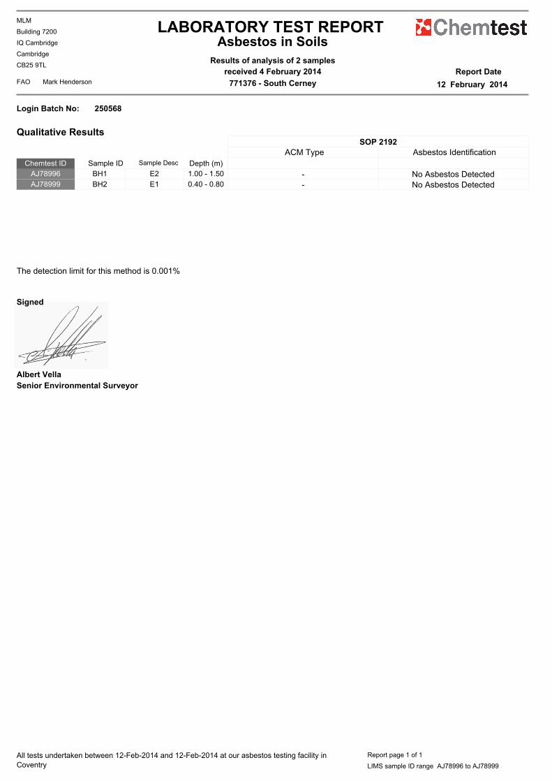
LABORATORY TEST REPORT
Report Date
12 February 2014
Results of analysis of 2 samples
received 4 February 2014
771376 - South CerneyFAO Mark Henderson
Building 7200
IQ Cambridge
Cambridge
CB25 9TL
MLM
Asbestos in Soils
Login Batch No:
Chemtest ID Sample ID Sample Desc
SOP 2192
ACM Type Asbestos Identification
AJ78996 BH1 E2 1.00 - 1.50 - No Asbestos DetectedAJ78999 BH2 E1 0.40 - 0.80 - No Asbestos Detected
Depth (m)
250568
Qualitative Results
The detection limit for this method is 0.001%
Albert Vella
Senior Environmental Surveyor
Signed
All tests undertaken between 12-Feb-2014 and 12-Feb-2014 at our asbestos testing facility in
Coventry
Report page 1 of 1
LIMS sample ID range AJ78996 to AJ78999

LABORATORY TEST REPORTResults of analysis of 2 samples
received 13 January 2014
771376 - South CerneyFAO
MLM
M Henderson
Building 7200
IQ Cambridge
Cambridge
CB25 9TL Report Date
23 January 2014
248569AJ66372 AJ66373
WS3 WS4
EW EW
9/1/2014 9/1/2014
2.30m 3.03m
WATER WATER
1450 Arsenic 7440382 µg l-¹ U 2.3 2.2Boron 7440428 µg l-¹ U 310 350Cadmium 7440439 µg l-¹ U <0.080 <0.080Chromium 7440473 µg l-¹ U <1.0 <1.0Copper 7440508 µg l-¹ U 3.6 3.3Mercury 7439976 µg l-¹ U <0.5 <0.5Nickel 7440020 µg l-¹ U 7.0 <1.0Lead 7439921 µg l-¹ U 3.1 1.3Selenium 7782492 µg l-¹ U 4.7 1.6Zinc 7440666 µg l-¹ U 140 36
1675 TPH aliphatic >C5-C6 µg l-¹ N < 0.1 < 0.1TPH aliphatic >C6-C8 µg l-¹ N < 0.1 < 0.1TPH aliphatic >C8-C10 µg l-¹ N < 0.1 < 0.1TPH aliphatic >C10-C12 µg l-¹ N < 0.1 < 0.1TPH aliphatic >C12-C16 µg l-¹ N < 0.1 < 0.1TPH aliphatic >C16-C21 µg l-¹ N < 0.1 < 0.1TPH aliphatic >C21-C35 µg l-¹ N < 0.1 < 0.1TPH aliphatic >C35-C44 µg l-¹ N < 0.1 < 0.1TPH aromatic >C5-C7 µg l-¹ N < 0.1 < 0.1TPH aromatic >C7-C8 µg l-¹ N < 0.1 < 0.1TPH aromatic >C8-C10 µg l-¹ N < 0.1 < 0.1TPH aromatic >C10-C12 µg l-¹ N < 0.1 < 0.1TPH aromatic >C12-C16 µg l-¹ N < 0.1 < 0.1TPH aromatic >C16-C21 µg l-¹ N < 0.1 < 0.1
*UnitsiCAS NoiDeterminandiSOPi
Matrix
Depth
Sample No
Sample ID
Chemtest LIMS ID
Login Batch No
Sampling Date
All tests undertaken between 13/01/2014 and 23/01/2014
* Accreditation status
This report should be interpreted in conjunction with the notes on the accompanying cover page.
Column page 1
Report page 1 of 5
LIMS sample ID range AJ66372 to AJ66373

LABORATORY TEST REPORTResults of analysis of 2 samples
received 13 January 2014
771376 - South CerneyFAO
MLM
M Henderson
Building 7200
IQ Cambridge
Cambridge
CB25 9TL Report Date
23 January 2014
248569AJ66372 AJ66373
WS3 WS4
EW EW
9/1/2014 9/1/2014
2.30m 3.03m
WATER WATER
1675 TPH aromatic >C21-C35 µg l-¹ N < 0.1 < 0.1TPH aromatic >C35-C44 µg l-¹ N < 0.1 < 0.1Total Petroleum Hydrocarbons µg l-¹ N < 10 < 10Total Aliphatic Hydrocarbons µg l-¹ N < 5 < 5Total Aromatic Hydrocarbons µg l-¹ N < 5 < 5
1700 Naphthalene 91203 µg l-¹ U <0.1 <0.1Acenaphthylene 208968 µg l-¹ U <0.1 <0.1Acenaphthene 83329 µg l-¹ U <0.1 <0.1Fluorene 86737 µg l-¹ U <0.1 <0.1Phenanthrene 85018 µg l-¹ U <0.1 <0.1Anthracene 120127 µg l-¹ U <0.1 <0.1Fluoranthene 206440 µg l-¹ U <0.1 <0.1Pyrene 129000 µg l-¹ U <0.1 <0.1Benzo[a]anthracene 56553 µg l-¹ U <0.1 <0.1Chrysene 218019 µg l-¹ U <0.1 <0.1Benzo[b]fluoranthene 205992 µg l-¹ N <0.1 <0.1Benzo[k]fluoranthene 207089 µg l-¹ N <0.1 <0.1Benzo[a]pyrene 50328 µg l-¹ U <0.1 <0.1Dibenzo[a,h]anthracene 53703 µg l-¹ U <0.1 <0.1Indeno[1,2,3-cd]pyrene 193395 µg l-¹ U <0.1 <0.1Benzo[g,h,i]perylene 191242 µg l-¹ U <0.1 <0.1Total (of 16) PAHs µg l-¹ U <2 <2
1760 Methyl tert-butylether 1634044 µg l-¹ N <1.0 <1.0Dichlorodifluoromethane 75718 µg l-¹ U <1.0 <1.0Chloromethane 74873 µg l-¹ U <1.0 <1.0
All tests undertaken between 13/01/2014 and 23/01/2014
* Accreditation status
This report should be interpreted in conjunction with the notes on the accompanying cover page.
Column page 1
Report page 2 of 5
LIMS sample ID range AJ66372 to AJ66373
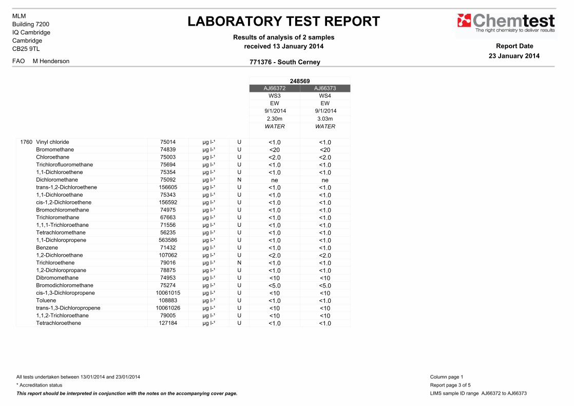
LABORATORY TEST REPORTResults of analysis of 2 samples
received 13 January 2014
771376 - South CerneyFAO
MLM
M Henderson
Building 7200
IQ Cambridge
Cambridge
CB25 9TL Report Date
23 January 2014
248569AJ66372 AJ66373
WS3 WS4
EW EW
9/1/2014 9/1/2014
2.30m 3.03m
WATER WATER
1760 Vinyl chloride 75014 µg l-¹ U <1.0 <1.0Bromomethane 74839 µg l-¹ U <20 <20Chloroethane 75003 µg l-¹ U <2.0 <2.0Trichlorofluoromethane 75694 µg l-¹ U <1.0 <1.01,1-Dichloroethene 75354 µg l-¹ U <1.0 <1.0Dichloromethane 75092 µg l-¹ N ne netrans-1,2-Dichloroethene 156605 µg l-¹ U <1.0 <1.01,1-Dichloroethane 75343 µg l-¹ U <1.0 <1.0cis-1,2-Dichloroethene 156592 µg l-¹ U <1.0 <1.0Bromochloromethane 74975 µg l-¹ U <1.0 <1.0Trichloromethane 67663 µg l-¹ U <1.0 <1.01,1,1-Trichloroethane 71556 µg l-¹ U <1.0 <1.0Tetrachloromethane 56235 µg l-¹ U <1.0 <1.01,1-Dichloropropene 563586 µg l-¹ U <1.0 <1.0Benzene 71432 µg l-¹ U <1.0 <1.01,2-Dichloroethane 107062 µg l-¹ U <2.0 <2.0Trichloroethene 79016 µg l-¹ N <1.0 <1.01,2-Dichloropropane 78875 µg l-¹ U <1.0 <1.0Dibromomethane 74953 µg l-¹ U <10 <10Bromodichloromethane 75274 µg l-¹ U <5.0 <5.0cis-1,3-Dichloropropene 10061015 µg l-¹ U <10 <10Toluene 108883 µg l-¹ U <1.0 <1.0trans-1,3-Dichloropropene 10061026 µg l-¹ U <10 <101,1,2-Trichloroethane 79005 µg l-¹ U <10 <10Tetrachloroethene 127184 µg l-¹ U <1.0 <1.0
All tests undertaken between 13/01/2014 and 23/01/2014
* Accreditation status
This report should be interpreted in conjunction with the notes on the accompanying cover page.
Column page 1
Report page 3 of 5
LIMS sample ID range AJ66372 to AJ66373
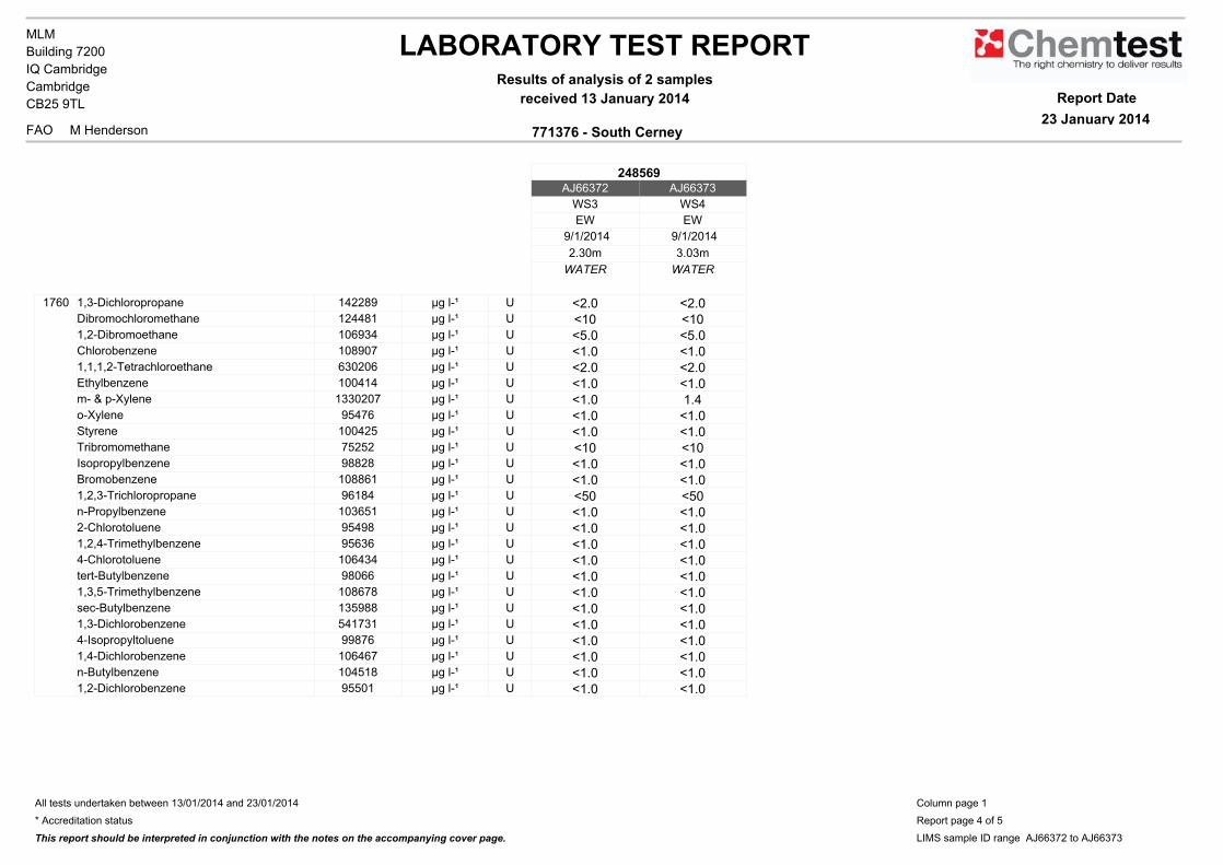
LABORATORY TEST REPORTResults of analysis of 2 samples
received 13 January 2014
771376 - South CerneyFAO
MLM
M Henderson
Building 7200
IQ Cambridge
Cambridge
CB25 9TL Report Date
23 January 2014
248569AJ66372 AJ66373
WS3 WS4
EW EW
9/1/2014 9/1/2014
2.30m 3.03m
WATER WATER
1760 1,3-Dichloropropane 142289 µg l-¹ U <2.0 <2.0Dibromochloromethane 124481 µg l-¹ U <10 <101,2-Dibromoethane 106934 µg l-¹ U <5.0 <5.0Chlorobenzene 108907 µg l-¹ U <1.0 <1.01,1,1,2-Tetrachloroethane 630206 µg l-¹ U <2.0 <2.0Ethylbenzene 100414 µg l-¹ U <1.0 <1.0m- & p-Xylene 1330207 µg l-¹ U <1.0 1.4o-Xylene 95476 µg l-¹ U <1.0 <1.0Styrene 100425 µg l-¹ U <1.0 <1.0Tribromomethane 75252 µg l-¹ U <10 <10Isopropylbenzene 98828 µg l-¹ U <1.0 <1.0Bromobenzene 108861 µg l-¹ U <1.0 <1.01,2,3-Trichloropropane 96184 µg l-¹ U <50 <50n-Propylbenzene 103651 µg l-¹ U <1.0 <1.02-Chlorotoluene 95498 µg l-¹ U <1.0 <1.01,2,4-Trimethylbenzene 95636 µg l-¹ U <1.0 <1.04-Chlorotoluene 106434 µg l-¹ U <1.0 <1.0tert-Butylbenzene 98066 µg l-¹ U <1.0 <1.01,3,5-Trimethylbenzene 108678 µg l-¹ U <1.0 <1.0sec-Butylbenzene 135988 µg l-¹ U <1.0 <1.01,3-Dichlorobenzene 541731 µg l-¹ U <1.0 <1.04-Isopropyltoluene 99876 µg l-¹ U <1.0 <1.01,4-Dichlorobenzene 106467 µg l-¹ U <1.0 <1.0n-Butylbenzene 104518 µg l-¹ U <1.0 <1.01,2-Dichlorobenzene 95501 µg l-¹ U <1.0 <1.0
All tests undertaken between 13/01/2014 and 23/01/2014
* Accreditation status
This report should be interpreted in conjunction with the notes on the accompanying cover page.
Column page 1
Report page 4 of 5
LIMS sample ID range AJ66372 to AJ66373
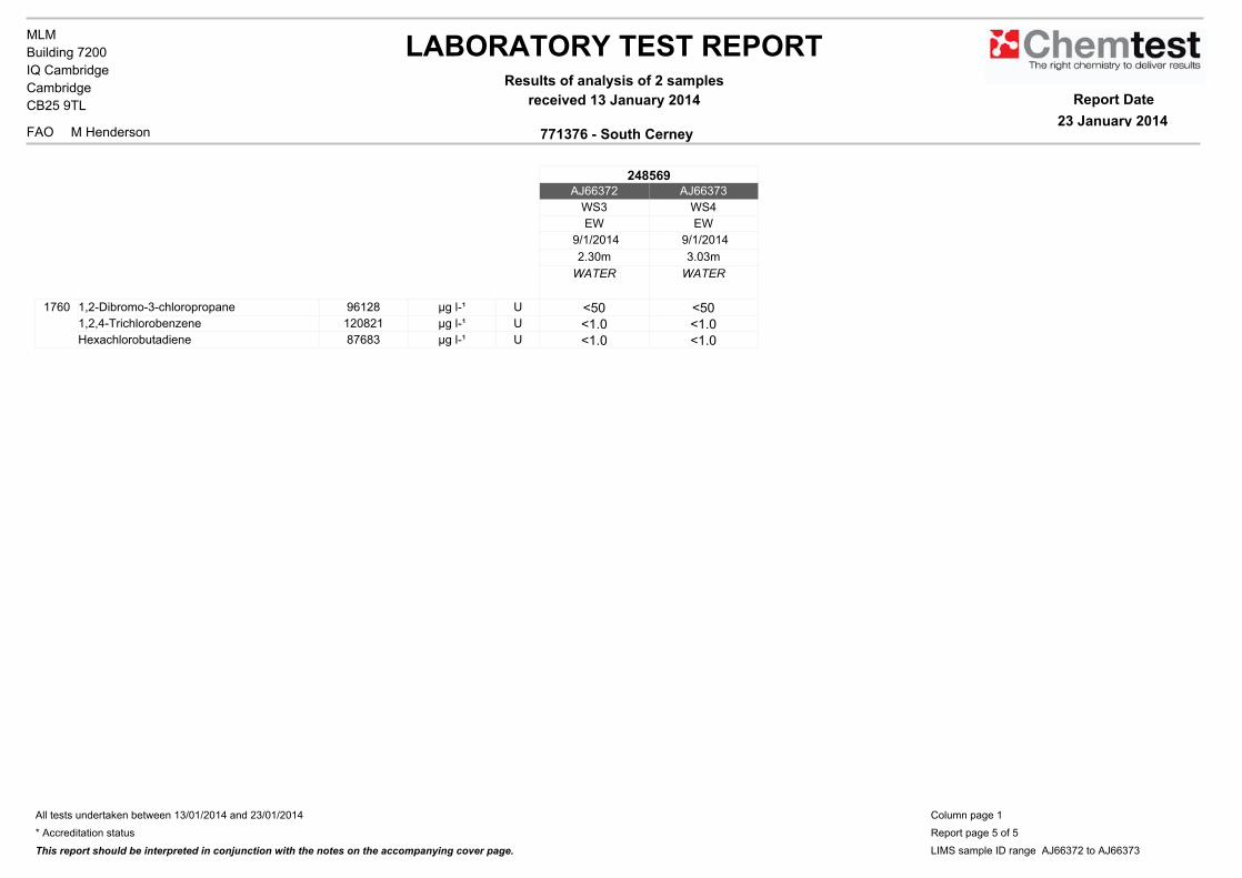
LABORATORY TEST REPORTResults of analysis of 2 samples
received 13 January 2014
771376 - South CerneyFAO
MLM
M Henderson
Building 7200
IQ Cambridge
Cambridge
CB25 9TL Report Date
23 January 2014
248569AJ66372 AJ66373
WS3 WS4
EW EW
9/1/2014 9/1/2014
2.30m 3.03m
WATER WATER
1760 1,2-Dibromo-3-chloropropane 96128 µg l-¹ U <50 <501,2,4-Trichlorobenzene 120821 µg l-¹ U <1.0 <1.0Hexachlorobutadiene 87683 µg l-¹ U <1.0 <1.0
All tests undertaken between 13/01/2014 and 23/01/2014
* Accreditation status
This report should be interpreted in conjunction with the notes on the accompanying cover page.
Column page 1
Report page 5 of 5
LIMS sample ID range AJ66372 to AJ66373

Appendix D
Geotechnical Laboratory Results


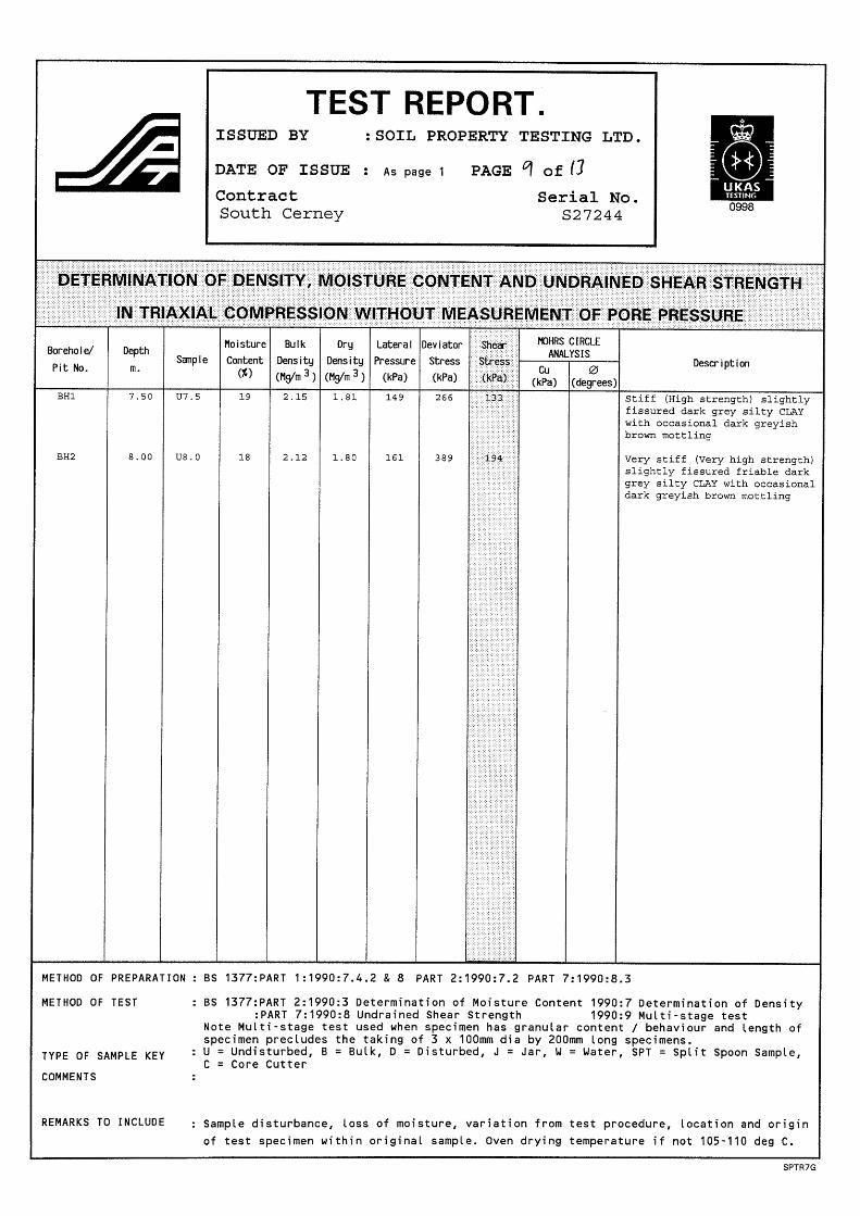
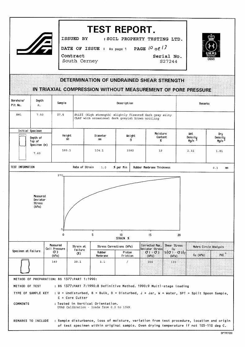
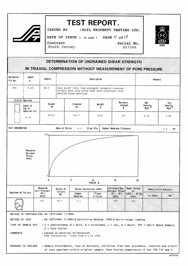
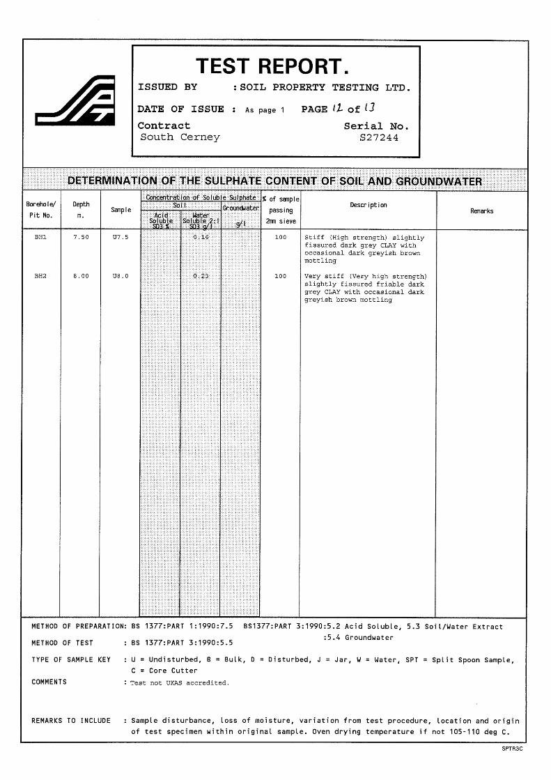
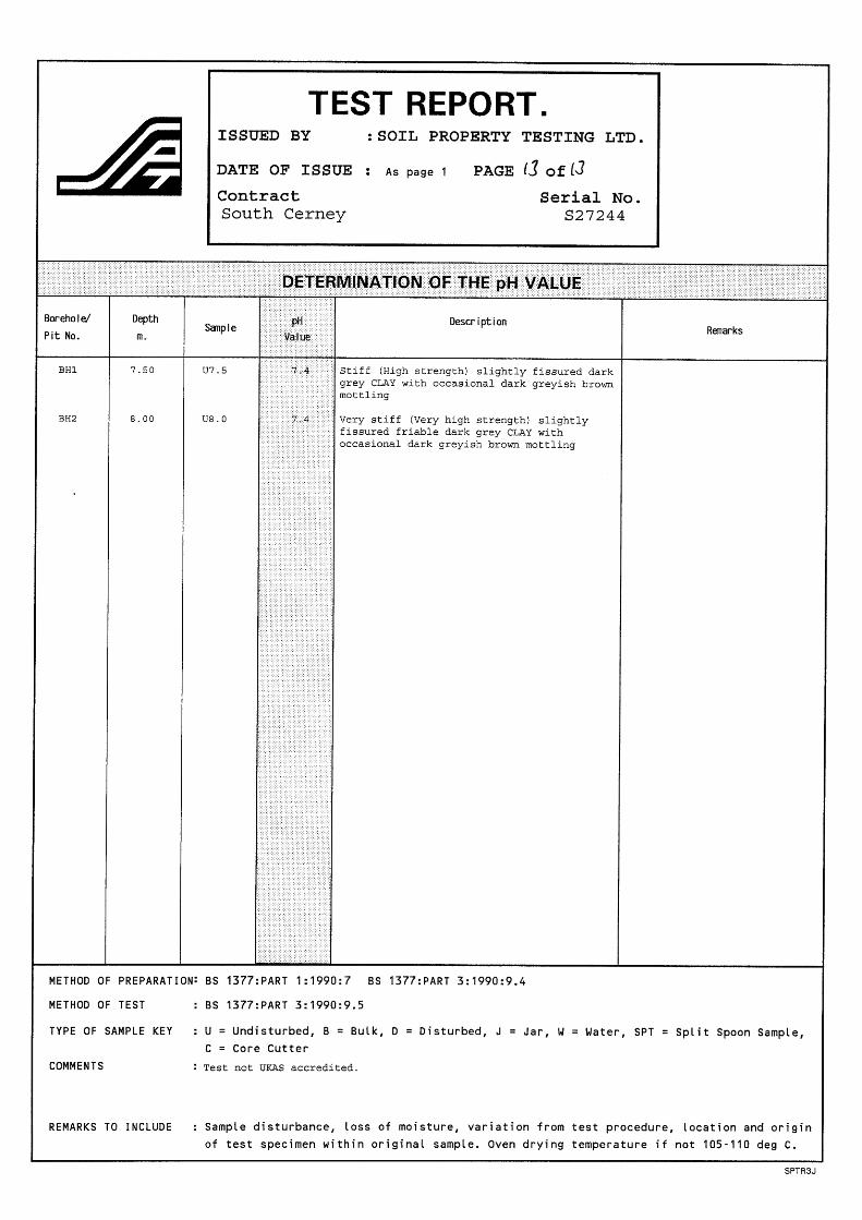

Appendix E
Generic Assessment Criteria
Assessment Criteria – Human Health (soil)
Residential Provisional C4SL Criteria Source
With plant uptake
Without plant uptake Comm. POSresi POSpark
Arsenic Yorkshire CLF 37 40 640 79 168 Cadmium Yorkshire CLF 26 149 410 220 880 Chromium (VI) Yorkshire CLF 21 21 49 23 250 Lead Yorkshire CLF 210 330 6000 760 1400 Benzene Yorkshire CLF 0.87 3.3 98 140 230 Benzo[a]pyrene (marker) Yorkshire CLF 5.0 5.3 76 10 21 Metals Criteria Source Residential Commercial Arsenic SGV 05.09 32 640 Cadmium SGV 07.09 10 230 Chromium (total) LQM/CIEH 3000 3.04E+04 Chromium (IV) LQM/CIEH 4.3 35 Copper LQM/CIEH 2330 7.17E+04 Lead SGV 10 450 750 Mercury SGV 03.09 170 3600 Nickel SGV 03.09 130 1800 Selenium SGV 03.09 350 1.30E+04 Zinc LQM/CIEH 3750 6.65E+05 Antimony EIC/AGS/CL:AIRE 550 7500 Barium EIC/AGS/CL:AIRE 1300 2.2E+04 Beryllium LQM/CIEH 12 1950 Boron LQM/CIEH 291 1.92E+05 Molybdenum EIC/AGS/CL:AIRE 670 1.70E+04 Vanadium LQM/CIEH 140 4250 TPHCWG carbon banding SOM 1% SOM 2.5% SOM 6% SOM 1% SOM 2.5% SOM 6% aliphatic EC>5-6 LQM/CIEH 30 55 110 3400 6200 1.3E+04 aliphatic EC>6-8 LQM/CIEH 73 160 370 8300 1.8E+04 4.2E+04 aliphatic EC>8-10 LQM/CIEH 19 46 110 2100 5100 1.2E+04 aliphatic EC>10-12 LQM/CIEH 93 230 540 1.0E+04 2.4E+04 4.9E+04 aliphatic EC>12-16 LQM/CIEH 740 1700 3000 6.1E+04 8.3E+04 9.1E+04 aliphatic EC>16-35 LQM/CIEH 4.5E+04 6.4E+04 7.6E+04 1.6E+06 1.8E+06 1.8E+06 aromatic EC>5-7 (benzene) LQM/CIEH 65 130 280 2.8E+04 4.9E+04 9.0E+04 aromatic EC>7-8 (toluene) LQM/CIEH 120 270 611 5.9E+04 1.1E+05 1.9E+05 aromatic EC>8-10 LQM/CIEH 27 65 151 3700 8600 1.8E+04 aromatic EC>10-12 LQM/CIEH 69 160 346 1.7E+04 2.9E+04 3.45E+04 aromatic EC>12-16 LQM/CIEH 140 310 593 3.6E+04 3.7E+04 3.78E+04 aromatic EC>16-21 LQM/CIEH 250 480 770 2.8E+04 2.8E+04 2.8E+04 aromatic EC>21- 35 LQM/CIEH 890 1100 1230 2.8E+04 2.8E+04 2.8E+04 PAH Compounds SOM 1% SOM 2.5% SOM 6% SOM 1% SOM 2.5% SOM 6% Acenaphthene LQM/CIEH 2009 210 480 1000 8.5E+04 9.8E+04 1.0E+05 Acenaphthylene LQM/CIEH 2009 170 400 850 8.4E+04 9.7E+04 1.0E+05 Anthracene LQM/CIEH 2009 2300 4900 9200 5.3E+05 5.4E+05 5.4E+05 Benzo[a]anthracene LQM/CIEH 2009 3.1 4.7 5.9 90 95 97 Benzo[a]pyrene LQM/CIEH 2009 0.83 0.94 1 14 Benzo[b]fluoranthene LQM/CIEH 2009 5.6 6.5 7 100 Benzo[ghi]perylene LQM/CIEH 2009 44 46 47 650 660 660 Benzo[k] fluoranthene LQM/CIEH 2009 8.5 9.6 10 140 Chrysene LQM/CIEH 2009 6 8 9.3 140 Dibenzo[ah]anthracene LQM/CIEH 2009 0.76 0.86 0.9 13 Fluoranthene LQM/CIEH 2009 260 460 670 2.3E+04 Fluorene LQM/CIEH 2009 160 380 780 6.4E+04 6.9E+04 7.1E+04 Indeno[123-cd]pyrene LQM/CIEH 2009 3.2 3.9 4.2 60 61 62 Naphthalene LQM/CIEH 2009 1.5 3.7 8.7 200 480 1100 Phenanthrene LQM/CIEH 2009 92 200 380 2.2E+04 2.2E+04 2.3E+04 Pyrene LQM/CIEH 2009 560 1000 1600 5.4E+04 BTEX Compounds Benzene SGV 03.09 0.33 95 Toluene SGV 03.09 610 4400 Ethylbenzene SGV 03.09 350 2800 o-Xylene SGV 03.09 250 2600 m-Xylene SGV 03.09 240 3500 p-Xylene SGV 03.09 230 3200 Other Compounds Cyanide, total Dutch IV 50 50 Phenol, total SGV 06.09 420 3200 Notes: 1. SGV based on sandy loam soil with SOM 6% (except TPH and PAH compounds) 2. All units mg kg-1 3. Where GAC for TPH are exceeded, consider calculating SSAC to determine if risk is from ingestion or from inhalation 4. GAC for TPH used as v-GAC in organic vapour assessment 5. BaP C4SL is used as a surrogate marker for genotoxic PAHs. Assessment of an individual PAH compound against LQM/CIEH
GAC is not required.
Assessment Criteria – Controlled Waters
EQS (µg l-1) UK DWS (µg l-1) EQS (µg l-1)
UK DWS (µg l-1)
List 1 dangerous substances Fresh Estuary Marine Mercury 1 0.5 0.3 1 Endrin 0.005 0.1 Cadmium 5 5 2.5 5 Total 'Drins 0.03 - Hexachlorocyclohexane 0.1 0.02 0.02 - Hexachlorobenzene 0.03 - Carbon tetrachloride 12 - Hexachlorobutadiene 0.1 - Total DDT 0.025 0.5 Chloroform 12 - pp DDT 0.01 - 1,2-dichloroethane 10 - Pentachlorophenol 2 0.1 Trichlorethylene 10 - Dieldrin 0.01 0.03 Perchlorethylene 10 - Isodrin 0.005 0.1 Trichlorobenzene 0.4 - Aldrin 0.01 0.03
List 2 dangerous substances 1,1,1-Trichloroethane 100 - Fenitrothion 0.01 0.1 1,1,2-Trichloroethane 400 - Flucofuron 1 0.1 2,4-D (ester) 1 - Iron 1000 200 2,4-D (non-ester) 40 - Linuron 2 0.1 2,4-Dichlorophenol 20 - Malathion 0.01 0.1 2-Chlorophenol 50 - Mecoprop 20 0.1 4-Chloro-3-methyl-phenol 40 - Mevinphos 0.02 0.1 Arsenic 50 10 Naphthalene (PAH) 10 0.1 Atrazine & Simazine 2 0.1 Omethoate 0.01 0.1 Azinphos-methyl 0.01 0.1 PCSDs 0.05 0.1 Bentazone 500 0.1 Permethrin 0.01 0.1 Benzene (use for TPH) 30 1 pH 6 - 9 6.5 - 10 Biphenyl 25 - Sulcofuron 25 0.1 Boron 2000 1000 Toluene 50 0.1 Chloronitrotoluenes 10 - Triazaphos 0.005 0.1 Cyfluthrin 0.001 0.1 Tributyltin 0.02 0.1 Demeton 0.5 0.1 Trifluralin 0.1 0.1 Dichlorvos 0.001 0.1 Triphenyltin 0.02 0.1 Dimethoate 1 0.1 Xylene (m and p, o) 30 - Endosulphan 0.003 0.1
List 2 dangerous substances (hardness related)
Hardness (mg l-1 CaCO3) 0-50 >50 -100
>100 -150
>150 -200
>200 -250
>250
Suitable for all fish Copper 1 6 10 10 10 28 2000 Nickel 50 100 150 150 200 200 20 Vanadium 20 20 20 20 60 60 - Suitable for salmonid (game) fish Chromium 5 10 20 20 50 50 50 Lead 4 10 10 20 20 20 25 Zinc 8 50 75 75 75 125 - Suitable for Cyprinid (coarse) fish Chromium 150 175 200 200 250 250 50 Lead 20 125 125 250 250 250 25 Zinc 75 175 250 250 250 500 -
Other Compounds Acrylamide 0.1 Tetrachloroethene and Trichloroethene 10 Antimony 5 Trihalomethanes (ii) 100 Benzo(a)pyrene 0.01 Vinyl chloride 0.5 Bromate 10 Aluminium 200 Cyanide 50 Iron 200 1, 2-dichloroethane 3 Manganese 50 Epichlorohydrin 0.1 Sodium 200 Fluoride 1.5 Tetrachloromethane 3 Heptachlor 0.03 Ammonium 0.5 mg l-1 Heptachlor epoxide (iii) 0.03 Nitrate 50 mg l-1 Other pesticides 0.1 Nitrite 0.5 mg l-1 Pesticides (total) 0.5 Chloride 250 mg l-1 Polycyclic aromatic hydrocarbons (i) 0.1 Sulphate 250 mg l-1 Selenium 10 TPH (1989 Regs) 10
Notes:
i. Specified compounds are benzo[b]fluoranthene, benzo[k]fluoranthene, benzo[g,h,i]-perylene, indeno[1,2,3-c,d]pyrene. ii. Specified compounds are chloroform, bromoform, dibromochloromethane, bromodichloro-methane.
Unless stated otherwise all units µg l-1
Assessment Criteria – Water Supply Pipes Substance [1] WRAS
(withdrawn) Anglian Water UK WIR
PE PVC Organic compounds TPH 50 50 – 1000 [2] - TPH >C5-C10 - - 2 1.4 TPH >C11-C20 - - 10 [3] NL TPH >C21-C40 - - 500 [3] NL Extended VOC suite - - 0.5 [3] 0.125 [3] Extended SVOC suite - - 2 [3] 1.4 [3] BTEX + MTBE - - 0.1 0.03
Notes: 1. All units mg kg-1 in soil. 2 The threshold for TPH is 1000mg kg-1 provided no other organic compounds are present. If the TPH level exceeds 50mg
kg-1 then the sum of TPH plus other organic compounds must not be greater than the upper threshold. If the other compounds are not tested for then the threshold for TPH must be set at the lower threshold.
3. All UKWIR TV’s (except BTEX and MTBE) are based on taste and odour detection threshold. 4. PE – polyethylene; PVC – polyvinyl chloride
Chlorinated hydrocarbons Dichloromethane - 1 - - 1,2-dichloroethane - 0.2 - - 1,1,1-trichloroethane - 8 - - 1,2-dichloropropane - 0.1 - - Tetrachloromethane - 0.15 - - Trichloroethene - 1.5 - - Tetrachloroethene - 0.5 - - Vinyl chloride - 0.1 - - Methyl bromide - 10 - - Total - 7 - - Aromatic hydrocarbons Benzene - 0.5 0.1 0.03 Ethylbenzene - 0.5 0.1 0.03 Trimethyl benzene - 0.1 - - Propylbenzene - 2 - - Toluene - 0.25 0.1 0.03 Xylenes - 0.5 0.1 0.03 Phenol 5 1 2 [3] 0.4 [3] Cresol - 1 2 [3] 0.04 [3] Total - 7 - - Chlorinated phenols Chlorophenols - 0.5 - - Dichlorophenols - 0.5 - - Trichlorophenols - 0.5 - - 2,4,6-trichlorophenol - 0.5 - - Pentachlorophenol - 0.5 - - Total - 1 2 [3] 0.04 [3] Chlorinated aromatic hydrocarbons Chlorobenzene - 0.5 - - Dichlorobenzene - 0.5 - - Trichlorobenzene - 0.5 - - Pentachlorobenzene - 0.5 - - Total - 1 - - Polyaromatic hydrocarbons Naphthalene - 5 - - Anthracene - 10 - - Phenanthrene - 10 - - Fluoranthene - 10 - - Pyrene - 10 - - Benzo[a]pyrene - 1 - - Total 50 20 2 1.4 Other organic compounds Tetrahydrafurane - 4 - - Styrene - 5 - - Pyridine - 2 - - Ethers - - 0.5 1 Nitrobenzene - - 0.5 [3] 0.4 [3] Ketones - - 0.5 [3] 0.02 [3] Aldehydes - - 0.5 0.02 Amines - - Detected NL

Appendix F
Defining Risk
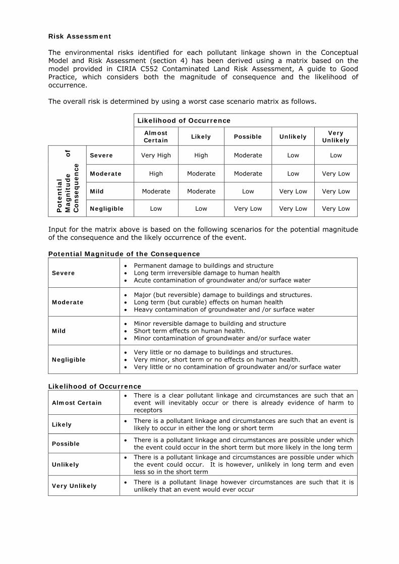
Risk Assessment The environmental risks identified for each pollutant linkage shown in the Conceptual Model and Risk Assessment (section 4) has been derived using a matrix based on the model provided in CIRIA C552 Contaminated Land Risk Assessment, A guide to Good Practice, which considers both the magnitude of consequence and the likelihood of occurrence. The overall risk is determined by using a worst case scenario matrix as follows. Likelihood of Occurrence Almost
Certain Likely Possible Unlikely Very Unlikely
Severe Very High High Moderate Low Low
Moderate High Moderate Moderate Low Very Low
Mild Moderate Moderate Low Very Low Very Low
Pot
enti
al
Mag
nit
ud
e of
C
onse
qu
ence
Negligible Low Low Very Low Very Low Very Low
Input for the matrix above is based on the following scenarios for the potential magnitude of the consequence and the likely occurrence of the event. Potential Magnitude of the Consequence
Severe Permanent damage to buildings and structure Long term irreversible damage to human health Acute contamination of groundwater and/or surface water
Moderate Major (but reversible) damage to buildings and structures. Long term (but curable) effects on human health Heavy contamination of groundwater and /or surface water
Mild Minor reversible damage to building and structure Short term effects on human health. Minor contamination of groundwater and/or surface water
Negligible Very little or no damage to buildings and structures. Very minor, short term or no effects on human health. Very little or no contamination of groundwater and/or surface water
Likelihood of Occurrence
Almost Certain There is a clear pollutant linkage and circumstances are such that an
event will inevitably occur or there is already evidence of harm to receptors
Likely There is a pollutant linkage and circumstances are such that an event is likely to occur in either the long or short term
Possible There is a pollutant linkage and circumstances are possible under which the event could occur in the short term but more likely in the long term
Unlikely There is a pollutant linkage and circumstances are possible under which
the event could occur. It is however, unlikely in long term and even less so in the short term
Very Unlikely There is a pollutant linage however circumstances are such that it is unlikely that an event would ever occur