MINUTES OF THE FIRST MEETING ADVISORY ......2010/02/26 · KRY/EDL/RWH/edl/mlh 04/16/10 #150282 v4...
33
KRY/EDL/RWH/edl/mlh 04/16/10 #150282 v4 MINUTES OF THE FIRST MEETING ADVISORY COMMITTEE ON REGIONAL TRANSPORTATION PLANNING DATE: February 26, 2010 TIME: 10:00 a.m. PLACE: Zoofari Conference Center 9715 West Bluemound Road Milwaukee, Wisconsin Committee Members Present Brian Dranzik, Chairman ............................................................................ Fiscal and Policy Administrator, Milwaukee County Department of Transportation and Public Works Fred Abadi ............................................................................... Director of Public Works, City of Waukesha Sandra K. Beaupre ........................................................................................... Director, Bureau of Planning, Division of Transportation Investment Management, Wisconsin Department of Transportation John M. Bennett ................................................... City Engineer/Director of Public Works, City of Franklin Scott Brandmeier .............................. Director of Public Works and Village Engineer, Village of Fox Point Shane Crawford .................................................................. Deputy County Administrator-Central Services, Walworth County Public Works Department Steve Coons ....................................................................... Systems Planning Supervisor, Southeast Region (Representing Sheri Schmit) Wisconsin Department of Transportation Robert R. Dreblow ................................... Highway Commissioner, Ozaukee County Highway Department Jon Edgren ............................................................................. Highway Commissioner, Washington County Gary Evans .................................................................................................. Manager, Highway Engineering, (Representing Allison Bussler) Waukesha County Department of Public Works Thomas M. Grisa .................................................................... Director of Public Works, City of Brookfield Anita Gulotta-Connelly ........................................... Managing Director, Milwaukee County Transit System Richard M. Jones ......................................... Commissioner of Public Works/City Engineer, City of Racine William A. Kappel ................................................................. Director of Public Works, City of Wauwatosa Jeff Katz .................................................................................................................................. Civil Engineer, (Representing David Prott) Racine County Department of Public Works Michael M. Lemens ...................................................................... Director of Engineering, City of Kenosha Jeffrey J. Mantes ........................................................... Commissioner of Public Works, City of Milwaukee Dwight E. McComb .............................................................. Planning and Program Development Engineer, Federal Highway Administration, U.S. Department of Transportation George Melcher ....................................................Director of Planning and Development, Kenosha County Jeffrey S. Polenske .................................................................................... City Engineer, City of Milwaukee Jack Takerian ....................................................................................................................... Interim Director, Milwaukee County Department of Transportation and Public Works Interested Parties Present Ald. Willie Wade ....................................................... Alderman, City of Milwaukee Aldermanic District 7, and Liaison to the Environmental Justice Task Force Staff Members Present Kenneth R. Yunker ......................................................................................... Executive Director, SEWRPC Christopher T. Hiebert ..................................................................Chief Transportation Engineer, SEWRPC
Transcript of MINUTES OF THE FIRST MEETING ADVISORY ......2010/02/26 · KRY/EDL/RWH/edl/mlh 04/16/10 #150282 v4...

KRY/EDL/RWH/edl/mlh 04/16/10 #150282 v4
MINUTES OF THE FIRST MEETING
ADVISORY COMMITTEE ON REGIONAL TRANSPORTATION PLANNING
DATE: February 26, 2010 TIME: 10:00 a.m. PLACE: Zoofari Conference Center 9715 West Bluemound Road Milwaukee, Wisconsin
Committee Members PresentBrian Dranzik, Chairman ............................................................................ Fiscal and Policy Administrator,
Milwaukee County Department of Transportation and Public Works Fred Abadi ............................................................................... Director of Public Works, City of Waukesha Sandra K. Beaupre ........................................................................................... Director, Bureau of Planning,
Division of Transportation Investment Management, Wisconsin Department of Transportation
John M. Bennett ................................................... City Engineer/Director of Public Works, City of Franklin Scott Brandmeier .............................. Director of Public Works and Village Engineer, Village of Fox Point Shane Crawford .................................................................. Deputy County Administrator-Central Services,
Walworth County Public Works Department Steve Coons ....................................................................... Systems Planning Supervisor, Southeast Region (Representing Sheri Schmit) Wisconsin Department of Transportation Robert R. Dreblow ................................... Highway Commissioner, Ozaukee County Highway Department Jon Edgren ............................................................................. Highway Commissioner, Washington CountyGary Evans .................................................................................................. Manager, Highway Engineering, (Representing Allison Bussler) Waukesha County Department of Public Works Thomas M. Grisa .................................................................... Director of Public Works, City of BrookfieldAnita Gulotta-Connelly ........................................... Managing Director, Milwaukee County Transit System Richard M. Jones ......................................... Commissioner of Public Works/City Engineer, City of Racine William A. Kappel ................................................................. Director of Public Works, City of WauwatosaJeff Katz .................................................................................................................................. Civil Engineer, (Representing David Prott) Racine County Department of Public Works Michael M. Lemens ...................................................................... Director of Engineering, City of KenoshaJeffrey J. Mantes ........................................................... Commissioner of Public Works, City of Milwaukee Dwight E. McComb .............................................................. Planning and Program Development Engineer,
Federal Highway Administration, U.S. Department of Transportation George Melcher ....................................................Director of Planning and Development, Kenosha County Jeffrey S. Polenske .................................................................................... City Engineer, City of Milwaukee Jack Takerian ....................................................................................................................... Interim Director,
Milwaukee County Department of Transportation and Public Works
Interested Parties PresentAld. Willie Wade ....................................................... Alderman, City of Milwaukee Aldermanic District 7, and Liaison to the Environmental Justice Task Force
Staff Members PresentKenneth R. Yunker ......................................................................................... Executive Director, SEWRPC Christopher T. Hiebert .................................................................. Chief Transportation Engineer, SEWRPC
- 2 - Ryan Hoel ....................................................................................................... Principal Engineer, SEWRPC Eric Lynde .......................................................................................................... Planner/Engineer, SEWRPC WELCOME AND ROLL CALL Mr. Yunker indicated that Mr. Dranzik, Fiscal and Policy Administrator, Milwaukee County Department of Transportation and Public works, and Southeastern Wisconsin Regional Planning Commission Commissioner, was asked by the Regional Planning Commission to chair the Advisory Committee. Chairman Dranzik welcomed all of those in attendance. He asked members present to introduce themselves and indicated roll call would be accomplished through a sign-in roster circulated by Commission staff. CONSIDERATION AND DISCUSSION OF PRELIMINARY DRAFT OF CHAPTER I, “INTRODUCTION” OF “REVIEW, UPDATE, AND REAFFIRMATION OF THE YEAR 2035 REGIONAL TRANSPORTATION PLAN” Chairman Dranzik asked Mr. Yunker to lead the Committee through a review of the preliminary draft of Chapter I, “Introduction.” Mr. Yunker noted that there is a need to conduct an interim review and update of the regional transportation plan for 2035, including an assessment of the implementation to date of the regional transportation plan, a review of the forecasts underlying the plan, and a monitoring of transportation system performance. There being no comments or discussion regarding Chapter I, Mr. Kappel motioned to approve Chapter I. Mr. Crawford seconded the motion, and the motion passed unanimously. CONSIDERATION AND DISCUSSION OF PRELIMINARY DRAFT OF CHAPTER II, “YEAR 2035 REGIONAL TRANSPORTATION PLAN” OF “REVIEW, UPDATE, AND REAFFIRMATION OF THE YEAR 2035 REGIONAL TRANSPORTATION PLAN” Chairman Dranzik asked Mr. Yunker to lead the Committee through a review of the preliminary draft of Chapter II, “Year 2035 Regional Transportation Plan.” Mr. Yunker indicated that this chapter included a review of the current regional transportation plan for 2035, adopted by the Commission in June 2006. He reviewed the five elements of the plan—public transit, bicycle and pedestrian facilities, transportation systems management, travel demand management, and arterial streets and highways. Mr. Yunker noted that Federal agency representatives are non-voting members of the Advisory Committee, and that Commission staff would add language to the draft chapter to reflect this distinction.
[Secretary’s Note: The following text is proposed to replace the third sentence of the first paragraph under the heading, “Introduction,” located on page 1 of draft Chapter II: “The Advisory Committee included representatives of the seven counties and 147 municipalities of the Region, and representatives from the Wisconsin Departments of Transportation and Natural Resources. In addition, representatives from the U. S. Department of Transportation and the U.S. Environmental Protection Agency served on the Committee as non-voting members.”]
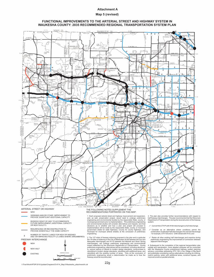
Mr. Yunker also noted that Map 5 showing the functional improvements to the arterial street and highway system in Waukesha County recommended in the adopted year 2035 regional transportation plan would be corrected to show the planned widening to six traffic lanes of Capitol Drive (STH 190) between CTH F and STH 16 (see Attachment A to these minutes). He indicated that this correction would also change the planned mileage of arterials recommended to be resurfaced to 3,189 route-miles instead of 3,191

- 3 -
route-miles, and the planned mileage of arterials recommended for widening upon reconstruction to provide additional through traffic lanes to 360 route-miles instead of 358 route-miles.
During and following Mr. Yunker’s review of the draft chapter, the following questions were raised and comments made by Advisory Committee members:
1. Mr. Abadi suggested that the section of the draft chapter on rapid transit service include a discussion on the type of vehicle to be used for rapid transit bus service. Mr. Yunker indicated that a brief description of rapid transit vehicles would be added to the draft chapter.
[Secretary’s Note: The following text is proposed to replace the first bullet under the heading, “Rapid Transit Service,” located on page 5 of draft Chapter II: “The rapid transit service would be provided by buses with commuter seating and amenities, and would operate in both directions during all time periods of the day and evening providing both traditional commute and reverse-commute service.”]
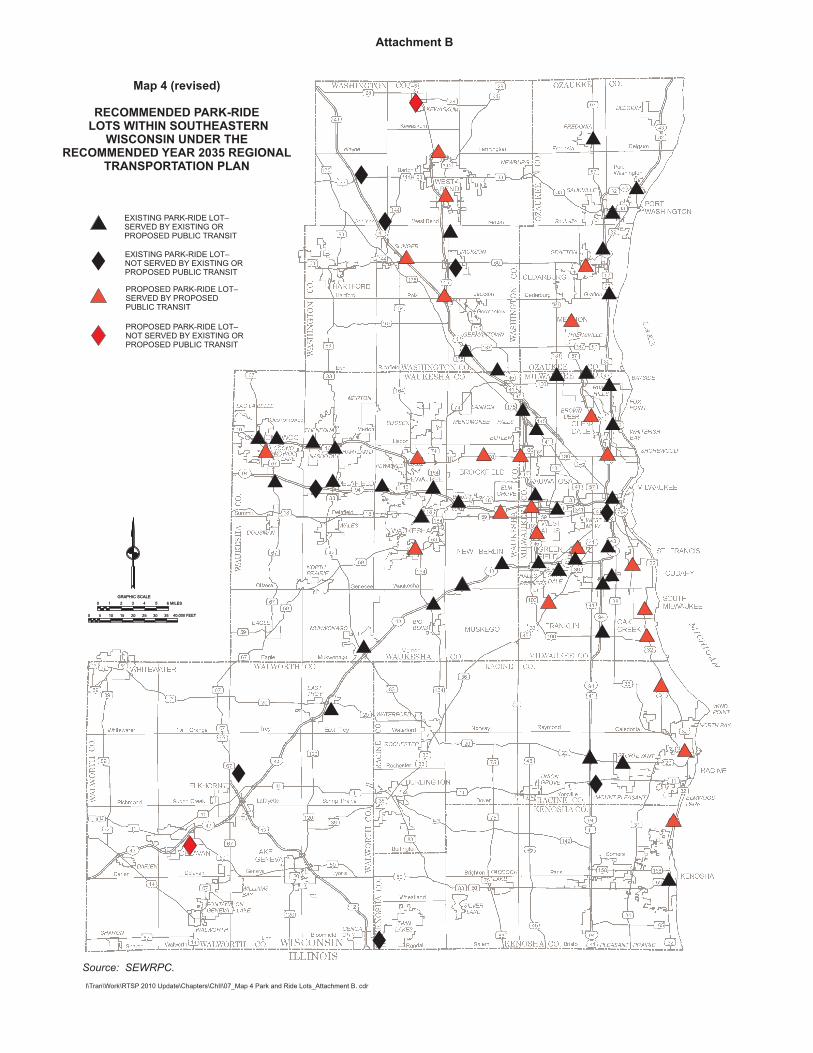
2. Mr. Abadi indicated that the Waukesha Metro Transit Center should be included as a park-ride facility on Map 4 of the draft chapter. Mr. Yunker indicated that Commission staff would revise Map 4 to reflect this comment (see Attachment B to these minutes).
3. Mr. Dreblow asked that Map 1 of the draft chapter include a proposed park-ride facility at the intersection of Mequon Road and IH 43 in Ozaukee County.
[Secretary’s Note: A proposed park-ride facility at the IH 43 and Mequon Road interchange will be included as a suggested amendment to the public transit element of the regional transportation plan, to be considered by the Advisory Committee as part of the list of suggested amendments in draft Chapter VI.]
4. Mr. Polenske asked that the alignments for the Milwaukee downtown connector study shown in Map 2 of the draft chapter be refined to reflect the most recent alignments being considered. Mr. Yunker indicated that Commission staff would make this revision, and that it may be appropriate to include a more detailed discussion on the current status of the downtown connector study, in Chapter 5 which reviews the implementation to date of the year 2035 regional transportation plan.
There being no further comments or discussion regarding Chapter II, Mr. Crawford motioned to approve the preliminary draft Chapter II as revised. Ms. Gulotta-Connelly seconded the motion, and the motion passed unanimously.
CONSIDERATION AND DISCUSSION OF PRELIMINARY DRAFT OF CHAPTER III, “REVIEW OF YEAR 2035 PLAN FORECASTS” OF “REVIEW, UPDATE, AND REAFFIRMATION OF THE YEAR 2035 REGIONAL TRANSPORTATION PLAN”
Chairman Dranzik asked Mr. Yunker to lead the Committee through a review of the preliminary draft of Chapter III, “Review of Year 2035 Plan Forecasts.” Mr. Yunker stated that this chapter included a review of the continued validity of the forecasts prepared under the regional transportation plan for 2035. He stated that original forecasts based on data from 2000 or 2005 were compared to current year 2008 data, and that the actual growth trends during these periods were generally consistent with the plan’s forecasts. He noted, however, that estimated 2008 regional transit ridership was slightly below regional transportation plan forecasts for 2008 by about 5.8%, likely due to lack of dedicated transit funding and a regional transit authority, a renewal of adequate annual State financial assistance to transit, and fare increases exceeding the rate of general price inflation during that period.

- 4 -
During Mr. Yunker’s review the following question was raised:
1. Mr. Grisa asked if the chapter could include a discussion of the current economic downturn. Mr. Yunker stated that Commission staff would add a discussion of the current economic downturn.
[Secretary’s Note: The following text is proposed to be added after the last sentence of the first paragraph under the heading, “Demographic and Economic Forecasts,” located on page 1 of draft Chapter III: “An economic downturn has been experienced in the Region since 2008. The implications of the downturn on the plan forecasts will be reviewed over the next few years.”]
There being no further comments or discussion regarding Chapter III, Mr. Kappel motioned to approve the preliminary draft Chapter III as revised. Mr. Grisa seconded the motion, and the motion passed unanimously.
CONSIDERATION AND DISCUSSION OF PRELIMINARY DRAFT OF CHAPTER IV, “REVIEW OF TRANSPORTATION SYSTEM PERFORMANCE” OF “REVIEW, UPDATE, AND REAFFIRMATION OF THE YEAR 2035 REGIONAL TRANSPORTATION PLAN”
Chairman Dranzik asked Mr. Yunker to lead the Committee through a review of the preliminary draft of Chapter IV, “Review of Transportation System Performance.” Mr. Yunker stated that this chapter included a review of the current performance of the transportation system with respect to pavement condition, bridge condition, traffic congestion, traffic crash history, arterial highway and transit travel time, and transportation system air pollutant emissions. He noted that in general only minor changes in system performance had occurred since the adoption of the year 2035 regional transportation plan, with the only exception being a significant reduction in air pollutant emissions. He also noted that Commission staff would be including additional performance measures—transit crashes, mileage per transit road calls, freight congestion on truck routes, and park-ride utilization—in the chapter in the appropriate sections (see Attachment C to these minutes).
During Mr. Yunker’s review the following questions were raised and comments made by Committee members:
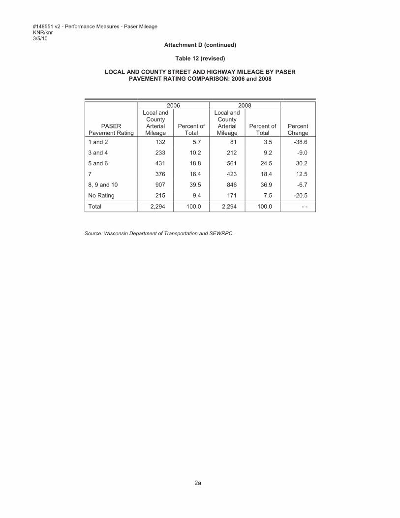
1. Mr. Evans indicated that Waukesha County assesses their roadway facilities with a different method than the Pavement Surface Evaluation and Rating (PASER) system, and that Map 6 and Table 12 should be updated to reflect the ratings from their method of rating pavement. Mr. Yunker indicated that Commission staff would contact Waukesha County staff to obtain the data from the County’s rating system, and would update Map 6 and Table 12 accordingly (see Attachment D to these minutes).
2. Mr. Abadi asked that a discussion on the causes of reduction in regional air pollutant emissions be added to the section of the draft chapter on transportation air pollutant emissions. Mr. Yunker indicated that this discussion would be added in the appropriate section.
[Secretary’s Note: The second sentence of the last paragraph on page 5 of draft Chapter IV has been revised to read as follows: “Estimated air pollutant emissions have declined for all pollutants, and particularly volatile organic compounds and nitrogen oxides due to cleaner, more efficient vehicles, with the exception being carbon dioxide emissions and ammonia which are estimated to have increased from 2001 to 2010 as fuel consumption has increased over these years.”]

- 5 -
There being no further comments or discussion regarding Chapter IV, Mr. Mantes motioned to approve the preliminary draft Chapter IV as revised. Ms. Gulotta-Connelly seconded the motion, and the motion passed unanimously.
CONSIDERATION AND DISCUSSION OF PRELIMINARY DRAFT OF CHAPTER V, “REVIEW OF IMPLEMENTATION TO DATE OF YEAR 2035 REGIONAL TRANSPORTATION PLAN” OF “REVIEW, UPDATE, AND REAFFIRMATION OF THE YEAR 2035 REGIONAL TRANSPORTATION PLAN”
Chairman Dranzik asked Mr. Yunker to lead the Committee through a review of the preliminary draft of Chapter V, “Review of Implementation to Date of Year 2035 Regional Transportation Plan.” Mr. Yunker stated that the chapter included a review of the implementation of the year 2035 regional transportation plan since its adoption in June, 2006. He reviewed the implementation to date of each of the five elements of the plan, noting that the plan covers about 30 years, and any implementation over the first three and one-half years of this period would be limited. In regards to the significant expansion of public transit recommended in the plan, Mr. Yunker explained that the plan had recognized that this expansion would likely require State legislation to create local dedicated transit funding and a regional transit authority (RTA). He stated that RTA and local dedicated transit funding legislation for southeastern Wisconsin had been introduced to the transportation committees of the State Senate and State Assembly as Senate Bill 511 and Assembly Bill 723, respectively, and that the section on public transit in the draft chapter would be revised accordingly.
[Secretary’s Note: The last three sentences in the first paragraph under the heading, “Public Transit” located on page 1 of the draft chapter are proposed to be replaced with the following text: “In the 2009-2011 State budget, Governor Doyle proposed a regional transit authority (RTA) with a 0.5 percent sales tax local dedicated funding, but the State Legislature rejected his proposal, and it was not included in the adopted budget. The budget did create a multi-county commuter rail authority with vehicle rental fee dedicated funding. Governor Doyle has since worked with State legislators to develop modified RTA and local dedicated funding legislation for southeastern Wisconsin, which was introduced in February 2010 as Senate Bill 511 and Assembly Bill 723 to the transportation committees of the Senate and Assembly, respectively. This legislation would create interim RTAs which would be allowed to select from a menu of dedicated funding options to fund their local transit systems, with the interim RTAs eventually combining to form a single RTA in southeastern Wisconsin.”]
Mr. Yunker noted that the section of the chapter on bicycle and pedestrian facilities would be revised to reflect Federal policy and State statute requiring bicycle and pedestrian accommodation on all Federal or State funded projects unless demonstrated to be prohibitive.
[Secretary’s Note: The last sentence in the first paragraph under the heading, “Bicycle and Pedestrian Facilities” located on page 2 of the draft chapter is proposed to be replaced with the following text: “Wisconsin State Statutes and Federal policy require that bicycle accommodations be provided in all new highway construction and reconstruction projects funded with State or Federal funds, unless it is demonstrated that such accommodation is prohibitive.”]
Mr. Yunker stated that Commission staff would add a section on the implementation to date of the accommodation of bicycles on the arterial street and highway system under the section on bicycle and pedestrian facilities in the draft chapter (see Attachment E to these minutes). He noted that the mileage of

- 6 -
arterial streets and highways that provided bicycle accommodation through paved shoulders, bicycle lanes, or separate paths increased from about 633 miles in 2004 to about 650 miles in 2009.
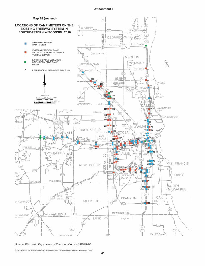
Mr. Yunker noted that on page 3 of the draft chapter under the section on transportation system management that the number of ramp-meters increased to 127 location rather than 130 location, the number of freeway variable message signs increased to 25 locations rather than 29 location, the number of freeway closed-circuit television cameras increased to 103 locations rather than 114 locations, and the number of variable message signs increased to 16 locations rather than 14 locations. He added that the maps and figures would also be revised to reflect the update to the number of ramp-meters, variable message signs, and closed-circuit television cameras, and variable message signs (see Attachment F to these minutes).
During Mr. Yunker’s review the following questions were raised and comments made by Committee members:
1. Mr. Abadi requested that the text of the chapter note that Table 21 shows a decline of almost 6% in fixed-route (bus) vehicle-miles from 2006 to 2008. Mr. Yunker indicated that Commission staff would revise the text of the public transit section of the chapter to include specific language regarding the decline of fixed-route vehicle-miles from 2006 to 2008.
[Secretary’s Note: The first sentence in the second paragraph under the heading, “Public Transit” located on page 2 of the draft chapter has been revised to read as follows: “As shown in Table 21, as a result of the lack of State legislation to date, the amount of transit service in Southeastern Wisconsin has declined from the time of plan adoption in 2006 to 2008, including a decrease of almost 6 percent in fixed-route bus service.”]
2. Mr. Crawford asked why Walworth County was not included in the RTA and local dedicated transit funding legislation. Mr. Yunker indicated that he believed that Walworth County was not included in the legislation because there currently is no public transit system in Walworth County. Mr. Yunker noted that Walworth County could be included in an RTA in southeastern Wisconsin at a later date.
3. Mr. Polenske requested that more detail on the Milwaukee downtown connector study, a discussion on the City of Milwaukee’s bicycle plan, and more detail on the City’s parking management efforts, be included in the draft chapter. Mr. Yunker indicated that Commission staff would update the respective sections of the draft chapter to reflect each of these efforts.
[Secretary’s Note: The second sentence in the last paragraph under the heading, “Public Transit” located on page 2 of the draft Chapter V is proposed to be replaced with the following text: “Through the Milwaukee downtown connector study, the City of Milwaukee has nearly completed plans for a downtown streetcar line, with three potential routes for the line currently under study. In a March 2009 split of $91.5 million in Interstate Cost Estimate (ICE) funding, $54.9 million was provided to implement the streetcar line. Milwaukee County expects to use the remaining $36.6 million in ICE funds to implement express transit service through the creation of a bus rapid transit line, and potentially apply for Federal Transit Administration funds for additional bus rapid transit lines in the County.”
The following text is proposed to be added on page 3 of the draft Chapter V, prior to the heading “Transportation Systems Management”: “The City of Milwaukee is nearing completion of a bicycle plan that recommends a broad range of measures to improve
- 7 -
conditions for bicycling in Milwaukee. This plan will help to implement the recommendations of the regional plan’s bicycle and pedestrian element.”
For the City’s parking management efforts, the following text is proposed to be added to the first paragraph at the top of page 4 of the draft Chapter V: “The system will provide motorists with real-time information about available parking in the downtown area through signs located throughout the central business district, freeway dynamic message signs, a website, and a telephone line. A data source will also be available to allow real-time parking information applications to be created for mobile devices or websites.”]
4. Ms. Gulotta-Connelly requested that a description of the implementation of Milwaukee County Transit System’s (MCTS) Bikes on Buses initiative to install bike racks on all MCTS buses be included in the draft chapter. Mr. Yunker indicated that a description of the initiative would be added in the appropriate section.
[Secretary’s Note: The following text is proposed to be added under the heading, “Travel Demand Management,” located on page 4 of the draft chapter: “In 2009, Milwaukee County Transit System equipped all buses with bike racks. While not a specific recommendation of the year 2035 regional transportation system plan, the installation of the bike racks on buses in Milwaukee County would promote the use of transit and bicycle modes of transportation.”]
5. Mr. Mantes requested that a description of the potential implementation of high-speed rail service in southeastern Wisconsin be included in the draft chapter. Mr. Yunker indicated that a description of the potential high speed rail service would be added in the appropriate section of the draft chapter.
[Secretary’s Note: The following text is proposed to be added prior to the heading, “Bicycle and Pedestrian Facilities,” located on page 2 of the draft chapter: “In January 2010, the State of Wisconsin received $810 million in Federal Railroad Administration American Recovery and Reinvestment Act of 2009 High Speed Rail (FRA ARRA HSR) funds for the implementation of new high speed service between Madison and Milwaukee with stations in Brookfield, Oconomowoc, and Watertown. The new service is expected to begin in 2013 with a maximum speed of 79 mph. A maximum speed of 110 mph is expected following improvements to the existing rail lines that are planned to be completed in 2016. An additional $12 million in FRA ARRA HSR funds was received by the State for improvements to the current Hiawatha Amtrak service line between Chicago and Milwaukee. In addition, $1 million in FRA ARRA HSR funds were received for the conduct of a study of potential new high speed rail service between Madison and Minneapolis.”]
6. Mr. Kappel requested that in the major review and reevaluation of the regional transportation plan, to be initiated in 2011, the projects which received ARRA funding be identified. Mr. Yunker indicated that this would be done in the major review and reevaluation of the plan, to be initiated in 2011.
There being no further comments or discussion regarding Chapter V, Mr. Crawford motioned to approve the preliminary draft Chapter V as revised. Mr. Dreblow seconded the motion, and the motion passed unanimously.

- 8 -
CONSIDERATION AND DISCUSSION OF PRELIMINARY DRAFT OF CHAPTER VI, “UPDATE OF YEAR 2035 REGIONAL TRANSPORTATION PLAN” OF “REVIEW, UPDATE, AND REAFFIRMATION OF THE YEAR 2035 REGIONAL TRANSPORTATION PLAN”
Chairman Dranzik asked Mr. Yunker to lead the Committee through a review of the preliminary draft of Chapter VI, “Update of Year 2035 Regional Transportation Plan.” Mr. Yunker stated that the chapter presented potential amendments to the year 2035 regional transportation plan, including amendments which have been identified in Walworth and Washington County jurisdictional highway system planning efforts. He explained that it also included an assessment of the potential to accomplish the plan within the remaining 25 years of the plan’s design period, particularly given the financial constraints of existing available resources. He noted that following the transmittal of the draft chapters of the plan update to the Advisory Committee, Federal Highway Administration and Federal Transit Administration staff had advised Commission staff that the potential funding attendant to the pending RTA and local dedicated transit funding legislation for southeastern Wisconsin could reasonably be considered available to implement the transit recommendations of the plan. Mr. Yunker indicated that with this change, existing revenue resources would appear to be adequate to implement fully the recommendations of the year 2035 regional transportation plan.
Mr. Yunker stated that the year 2035 regional transportation plan assumed that all freeway segments in southeastern Wisconsin would need to be reconstructed by the year 2035. He stated that Commission staff had since identified about 122 miles of freeway that perhaps may not require reconstruction by the year 2035. However, he noted that in discussing these segments with WisDOT staff, WisDOT staff had indicated that these 122 miles of freeway may indeed require reconstruction by the year 2035. Moreover, given the State highway funding in the 2009-2011 Wisconsin State budget, there should be adequate funding for the reconstruction of the entire freeway system by the year 2035. Mr. Yunker stated that as a result, Commission staff would propose the plan continue to recommend that all freeway segments in southeastern Wisconsin will be reconstructed by the year 2035.
Following Mr. Yunker’s review of the draft chapter, Mr. Kappel asked if approval of the chapter should be postponed until the proposed revisions have been made and a revised Chapter VI is forwarded to the Advisory Committee for consideration. Mr. Yunker responded that the Advisory Committee does not necessarily need to approve the chapter at this time, but could approve in concept the revisions to the chapter that have been presented if the Committee is in agreement with the revisions discussed. Mr. Kappel then motioned to approve in concept the revisions to Chapter VI proposed by Commission staff with the result that the year 2035 regional transportation plan is reaffirmed and remains the regional plan, with the minor amendments identified in Walworth and Washington County jurisdictional highway system planning efforts. Mr. Brandmeier seconded the motion and Chairman Dranzik asked the Advisory Committee for discussion and comments regarding the motion.
1. Mr. Crawford asked whether the planned extension of the USH 12 freeway between the Cities of Elkhorn and Whitewater had been included in the amendments to the plan. Mr. Yunker stated that because the year 2035 plan recommended the USH 12 extension and the Walworth County Jurisdictional Highway Planning Committee had recommended that the long-planned extension of USH 12 remain in the plan, no amendment to the plan for USH 12 was needed.
2. Mr. Mantes requested that the plan recommendation to widen to eight lanes 19 miles of freeway in the City of Milwaukee between the Zoo and Marquette interchanges and between the Mitchell Interchange and Silver Spring Drive be reconsidered by the Advisory Committee. He cited the potential property acquisition and other impacts the widening of these 19 miles of freeway could have on the property owners adjacent to these segments of freeway. Mr. Yunker stated that during the preparation of the regional freeway reconstruction plan and also the year 2035 regional
- 9 -
transportation plan, this issue had been examined. He noted that the studies had concluded that not widening these freeway segments would not be expected to divert significant additional traffic to any other part of the freeway system, or have an adverse impact on the operations of the remainder of the freeway system. He stated that the studies indicated that congestion would be expected to increase on these freeway segments, and some traffic would be diverted to surface arterial streets, largely located in the City of Milwaukee. He added that during the regional freeway reconstruction planning, the Commission staff had recommended that as a compromise that these 19 miles of freeway not be recommended in the final plan for widening to eight lanes, but the regional plan would recommend that during the preliminary engineering for the reconstruction of these freeway segments, alternatives which would not provide additional traffic lanes would be evaluated, along with alternatives which would provide additional traffic lanes. If the preliminary engineering concluded that additional traffic lanes not be provided, the plan under this amendment would not be changed. If the preliminary engineering concluded that these freeway segments should be widened, then the regional plan would be amended to include the additional lanes. The Advisory Committee to the regional freeway reconstruction planning effort rejected the staff recommendation.
Mr. Yunker noted that Commission staff recognizes that these 19 miles of freeway are different from other freeway segments in southeastern Wisconsin. He noted that high density neighborhoods are located immediately adjacent to these freeway segments. He also noted the potential for the development of fixed guideway transit in these freeway segment corridors, which could serve these neighborhoods and connect directly to the Milwaukee central business district. He added that while this fixed guideway transit could not be expected to alleviate traffic congestion on these 19 miles of the freeway system, it would provide an alternative in the freeway corridors.
Mr. Yunker suggested amending the motion on the floor to include in the draft chapter the request by the City of Milwaukee that the Advisory Committee consider an amendment to the plan to remove the widening to eight lanes of the 19 miles of freeway in the City of Milwaukee. Messrs. Kappel and Brandmeier accepted the amendment to the motion.
Ms. Beaupre asked whether there would be enough time to resolve the issue of the widening of the 19 miles of freeway in the City of Milwaukee prior to the proposed June 2010 completion of the interim review and update of the regional transportation plan. Mr. Yunker clarified that the Advisory Committee would not be committing to resolve the issue by the completion of the interim update and review of the plan, but would rather be allowing the issue to be discussed during the preparation of the interim update and review of the plan. Mr. Grisa asked whether Commission staff would have sufficient time to compile information on the issue, and noted that a major regional transportation plan update would be initiated in 2011. Mr. Yunker indicated that much of the work regarding this issue had already been completed as part of the year 2035 plan preparation. He stated that Commission staff could present this information regarding the widening of the 19 miles of freeway in the City of Milwaukee to the Advisory Committee at a subsequent meeting.
3. Mr. Bennett asked when Commission staff would like to receive suggested amendments to the year 2035 regional transportation plan update, which may be included in the chapter. Mr. Yunker indicated that Commission staff would appreciate receiving the suggested amendments within the next couple weeks.
There being no further comments or discussion regarding Chapter VI, Chairman Dranzik noted that the Committee had a motion on the floor to approve in concept the revisions to the preliminary draft
- 10 -
Chapter VI, and that the 2035 regional transportation plan is reaffirmed and remains the regional plan, with the minor amendments identified in Walworth and Washington County jurisdictional highway system planning efforts. He added that the motion further amends the draft Chapter VI to acknowledge that the City of Milwaukee has requested the Advisory Committee to consider an amendment to the plan to remove the widening to eight lanes of the 19 miles of freeway in the City of Milwaukee. The motion passed unanimously.
ADJOURNMENT
Mr. Yunker indicated that a public meeting would be held in late March 2010, to provide information about, and obtain input on, the interim review and update of the year 2035 regional transportation plan, and that a newsletter would be prepared and distributed by Commission staff. He noted that the public meeting would likely be held in open house format from about 5:00 p.m. to 7:00 p.m. at the Milwaukee Downtown Transit Center, and that Advisory Committee members are encouraged to attend.
The first meeting of the Advisory Committee on Regional Transportation Planning to consider an interim review and update of the year 2035 regional transportation plan was adjourned at 11:30 a.m. on a motion by Mr. Bennett, seconded by Mr. Crawford, and carried unanimously by the Committee.
Signed
Kenneth R. Yunker Recording Secretary
JJ
THE FOLLOWING NOTES SUPPLEMENT THERECOMMENDATIONS PORTRAYED ON THIS MAP:
1. Each proposed arterial street and highway improvement and expansion,and, as well, preservation project, would need to undergo preliminaryengineering and environmental studies by the responsible State, county, ormunicipal government prior to implementation. The preliminary engineeringand environmental studies will consider alternatives and impacts, and finaldecisions as to whether and how a plan and project will proceed toimplementation will be made by the responsible State, county, or municipalgovernment (State for state highways, County for county highways, andmunicipal for municipal arterial streets) at the conclusion of preliminaryengineering.
2. The 127 miles of freeway widening proposed in the plan and in particularthe 19 miles of widening in the City of Milwaukee (IH 94 between the Zoo andMarquette interchanges and IH 43 between the Mitchell and Silver Springinterchanges), will undergo preliminary engineering and environmentalimpact statement by the Wisconsin Department of Transportation. Duringpreliminary engineering, alternatives will be considered, including rebuild-as-is, various options of rebuild to modern design standards, compromises torebuilding to modern design standards, rebuilding with additional lanes, andrebuilding with the existing number of lanes. Only at the conclusion ofpreliminary engineering would a determination be made as to how thefreeway would be reconstructed.
3. The plan also provides further recommendations with respect tohalf freeway interchanges. The plan recommends that the WisconsinDepartment of Transportation during the reconstruction of the freewaysystem:
Convert the CTH P with IH 94 interchange to a full interchange.
Consider as an alternative where conditions permit thecombination of selected half interchanges into one full interchange- for example, STH 100 and S. 124th Street with IH 43; and
Retain all other existing half interchanges and examine duringpreliminary engineering the improvement of connection betweenadjacent interchanges.
4. Subsequent to the completion of the regional transportation planupdate and reevaluation, more detailed analyses will be conductedwith the Waukesha County jurisdictional highway system planningadvisory committee addressing STH 164 in the Village of Big Bendand potentially considering various alternatives including do-nothing,restrict parking, widen with additional lanes, construct bypass, andimprove/construct parallel arterials.
�
�
�
ARTERIAL STREET OR HIGHWAYNEW
WIDENING AND/OR OTHER IMPROVEMENT TOPROVIDE SIGNIFICANT ADDITIONAL CAPACITY
RESERVE RIGHT-OF-WAY TO ACCOMMODATEFUTURE IMPROVEMENT (ADDITIONAL CAPACITYOR NEW FACILITY)
FREEWAY INTERCHANGE
NEW
NEW HALF
EXISTING
RESURFACING OR RECONSTRUCTION TOPROVIDE ESSENTIALLY THE SAME CAPACITY
4 NUMBER OF TRAFFIC LANES FOR NEW OR WIDENEDAND /OR IMPROVED FACILITY (2 LANES WHERE UNNUMBERED)
GRAPHIC SCALE0 1 2 MILES
0 4000 8000 12000 16000 FEET
W175
VV
Y
VV
Q
E
VV
VV
EF
EF
KE
EK
C
K
CWCW CW
P
K
Z
P
BB
Z
DR
P
C
C
E
DR
E
G JFT
TT
TT
M
Y
O
D
ES
I
I
I O
Y
U
X X
DX
X
H
I
I
G
C
C
G
D
Z
ZZ
CI
Z
D
ZC
ZC
CI
Z
N
ZZ
N
ZNN
E
I
NN
LO
LO
EE
E
NN
L
U
Y
YG
OO
LHH
ES
XX
I
NN
S
D
D
E
DE
ZZ
D
T
TJ
G
SS
GR KF
F
T
JJ
M
G
SS
KE
KEJJ
JK
P
BB
BB
RK
MD
KF
JK
K KK
YY
VV
45
1818
18
18
74
74164
164
164
190
16
190
164
164
59
59
59
83
59
59
83 164
36
67
67
67
16483
67
16
67
83
16
94
94
94
43
43
YV
W
YY
O
4541
145
175
74
100
4
444
4
4
4
44
4
4
4
4
4
4
4
44
4
44
4
44
4
4
4
4
8
4
6
6
4
44 4
4
4
44
4
444
4
44
44
4
44444 4
4
44
4
4
44
4
4
4
4 444
4
44
4
44
4
64
4
44
4
4
44
4
4
44
6
6
66
66
44
84
4
8
8
8 8
88
8
8 866
6
66
4
6
4
4
8
Map 5 (revised)
FUNCTIONAL IMPROVEMENTS TO THE ARTERIAL STREET AND HIGHWAY SYSTEM INWAUKESHA COUNTY: 2035 RECOMMENDED REGIONAL TRANSPORTATION SYSTEM PLAN
22g
66
Attachment A
I:\Tran\Work\RTSP2010 Update\Chapters\Ch II\14_Map 5 Waukesha_attachmentA.cdr
Map 4 (revised)
RECOMMENDED PARK-RIDELOTS WITHIN SOUTHEASTERN
WISCONSIN UNDER THERECOMMENDED YEAR 2035 REGIONAL
TRANSPORTATION PLAN
Source: SEWRPC.
GRAPHIC SCALE0
0
1
5
2
10
3
15
4
20
5
25
6 MILES
30 35 40,000 FEET
EXISTING PARK-RIDE LOT–SERVED BY EXISTING ORPROPOSED PUBLIC TRANSIT
EXISTING PARK-RIDE LOT–NOT SERVED BY EXISTING ORPROPOSED PUBLIC TRANSIT
PROPOSED PARK-RIDE LOT–NOT SERVED BY EXISTING ORPROPOSED PUBLIC TRANSIT
PROPOSED PARK-RIDE LOT–SERVED BY PROPOSEDPUBLIC TRANSIT
GRAPHIC SCALE0
0
1
5
2
10
3
15
4
20
5
25
6 MILES
30 35 40,000 FEET
Attachment B
19aI\Tran\Work\RTSP 2010 Update\Chapters\ChII\07_Map 4 Park and Ride Lots_Attachment B. cdr
RWH/mlh 3/25/10 #150287 v1 - Attachment to Chap 4-Review/Update of 2035 RTP
Attachment C
Additional Performance Measures to be Added to Preliminary Draft Chapter 4, “Review of Transportation System Performance”
of SEWRPC Memorandum:
THE REVIEW, UPDATE AND REAFFIRMATION OF THE YEAR 2035 REGIONAL TRANSPORTATION PLAN
(The following text is proposed to be added under the heading,” Traffic Congestion,” which begins at the bottom of Page 2 of the draft chapter)
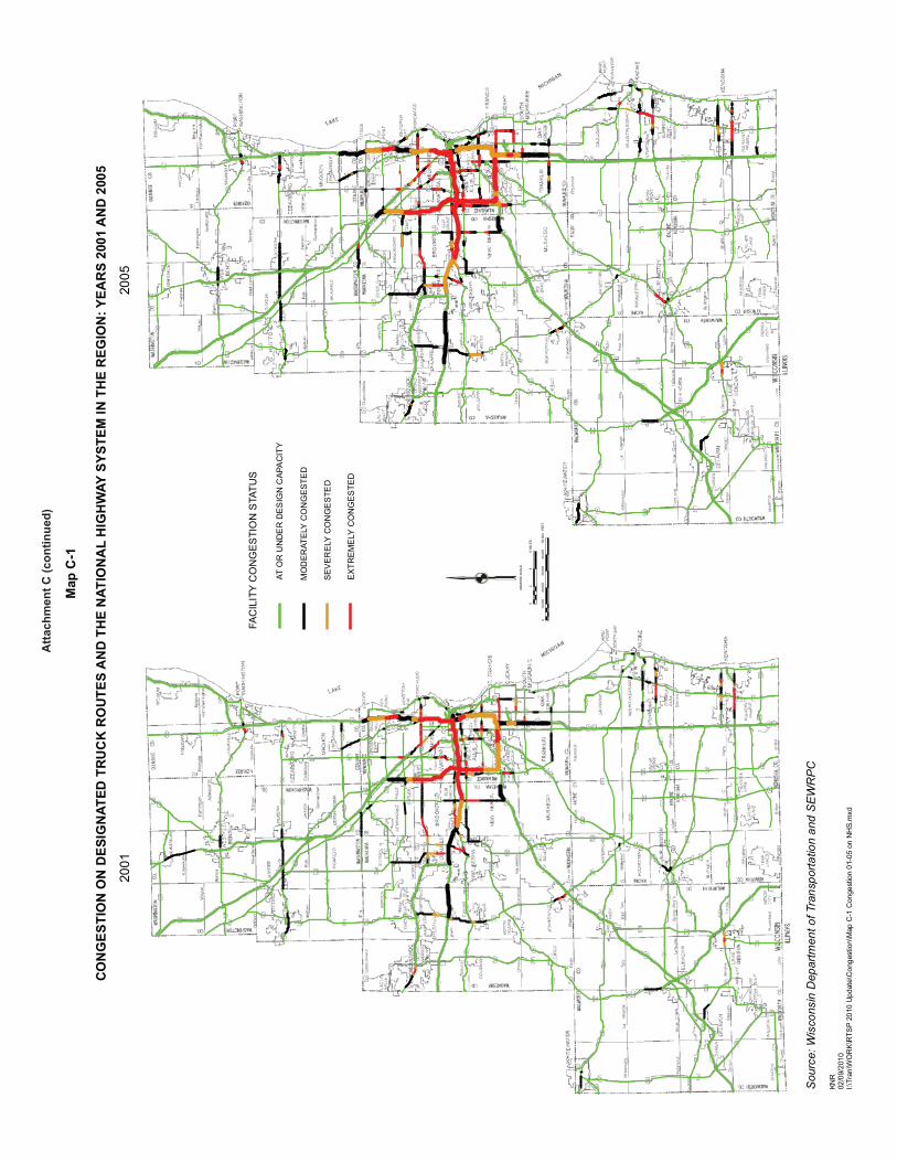
Congestion On Designated Truck Routes And National Highway System
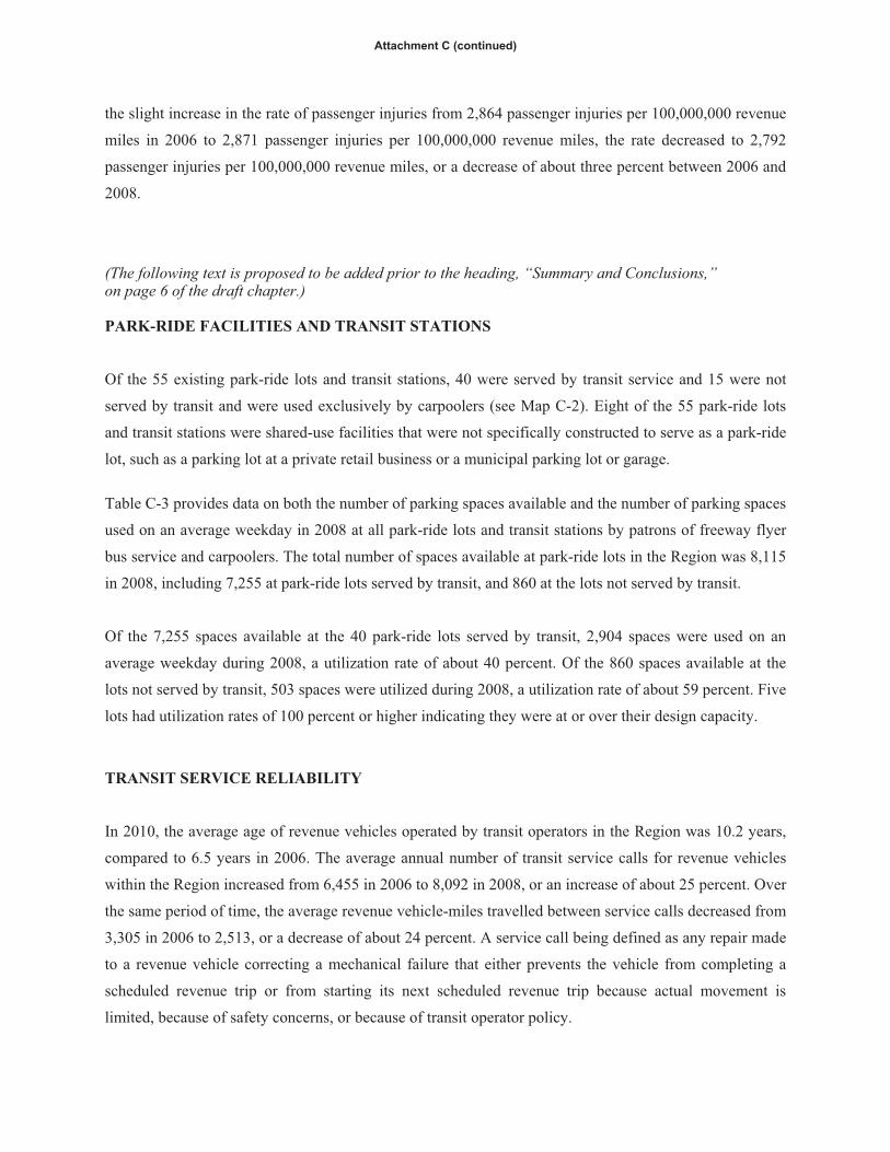
Table C-1 and Map C-1 present the existing level of traffic congestion experienced on designated truck
routes and the National Highway System in the year 2005 and compared to the congestion level
experience in 2001. The State of Wisconsin maintains a truck operations map that identifies streets and
highways for operation of vehicles and combination of vehicles for which the overall lengths cannot be
limited. In addition, the truck operators map identifies restricted truck routes where the overall lengths are
limited. The National Highway System includes highways important to the nation’s economy, defense,
and mobility. The coverage of these two systems illustrates the ability of freight to move throughout the
region. The miles of designated truck routes and National Highway System carrying traffic volumes
exceeding their design capacity increased from 202 miles in 2001 to 221 miles in 2005, or by about nine
percent. As congestion on these roadways increase, the travel time of freight movement is adversely
affected.
(The following text is proposed to be added under the heading, “Vehicle Traffic Crashes,” which begins on page 4 of the draft chapter.)
Transit Crashes and Passenger Injuries
Table C-2 provides a comparison of the number and rate of transit crashes resulting in property damage
and the number of passenger injuries for the years 2006, 2007, and 2008. Following a slight reduction of
the rate of transit crashes from 3,728 crashes per 100,000,000 revenue miles in 2006 to 3,720 crashes per
100,000,000 revenue miles in 2007, the rate of transit crashes then increased to 4,514 crashes per
100,000,000 revenue miles in 2008, or an increase of about 21 percent between 2006 and 2008. Following
the slight increase in the rate of passenger injuries from 2,864 passenger injuries per 100,000,000 revenue
miles in 2006 to 2,871 passenger injuries per 100,000,000 revenue miles, the rate decreased to 2,792
passenger injuries per 100,000,000 revenue miles, or a decrease of about three percent between 2006 and
2008.
(The following text is proposed to be added prior to the heading, “Summary and Conclusions,” on page 6 of the draft chapter.)
PARK-RIDE FACILITIES AND TRANSIT STATIONS
Of the 55 existing park-ride lots and transit stations, 40 were served by transit service and 15 were not
served by transit and were used exclusively by carpoolers (see Map C-2). Eight of the 55 park-ride lots
and transit stations were shared-use facilities that were not specifically constructed to serve as a park-ride
lot, such as a parking lot at a private retail business or a municipal parking lot or garage.
Table C-3 provides data on both the number of parking spaces available and the number of parking spaces
used on an average weekday in 2008 at all park-ride lots and transit stations by patrons of freeway flyer
bus service and carpoolers. The total number of spaces available at park-ride lots in the Region was 8,115
in 2008, including 7,255 at park-ride lots served by transit, and 860 at the lots not served by transit.
Of the 7,255 spaces available at the 40 park-ride lots served by transit, 2,904 spaces were used on an
average weekday during 2008, a utilization rate of about 40 percent. Of the 860 spaces available at the
lots not served by transit, 503 spaces were utilized during 2008, a utilization rate of about 59 percent. Five
lots had utilization rates of 100 percent or higher indicating they were at or over their design capacity.
TRANSIT SERVICE RELIABILITY
In 2010, the average age of revenue vehicles operated by transit operators in the Region was 10.2 years,
compared to 6.5 years in 2006. The average annual number of transit service calls for revenue vehicles
within the Region increased from 6,455 in 2006 to 8,092 in 2008, or an increase of about 25 percent. Over
the same period of time, the average revenue vehicle-miles travelled between service calls decreased from
3,305 in 2006 to 2,513, or a decrease of about 24 percent. A service call being defined as any repair made
to a revenue vehicle correcting a mechanical failure that either prevents the vehicle from completing a
scheduled revenue trip or from starting its next scheduled revenue trip because actual movement is
limited, because of safety concerns, or because of transit operator policy.
Attachment C (continued)
Map
C-1
CO
NG
ESTI
ON
ON
DES
IGN
ATED
TR
UC
K R
OU
TES
AN
D T
HE
NAT
ION
AL
HIG
HW
AY S
YSTE
M IN
TH
E R
EGIO
N: Y
EAR
S 20
01 A
ND
200
5
Sou
rce:
Wis
cons
in D
epar
tmen
t of T
rans
porta
tion
and
SE
WR
PC
KNR
02/0
9/20
10I:\
Tran
\WO
RK
\RTS
P 20
10 U
pdat
e\C
onge
stio
n\M
ap C
-1 C
onge
stio
n 01
-05
on N
HS.
mxd
2001
GR
APH
IC S
CA
LE
010
,000
20,0
0030
,000
40,0
0050
,000
FEE
T
02
46
MIL
ES
FAC
ILIT
Y C
ON
GES
TIO
N S
TATU
S
AT O
R U
ND
ER
DE
SIG
N C
APA
CIT
Y
MO
DE
RAT
ELY
CO
NG
ES
TED
SE
VE
RE
LY C
ON
GE
STE
D
2005
EX
TRE
ME
LY C
ON
GE
STE
D
Atta
chm
ent C
(con
tinue
d)

#
X
###
#
#
###
#
#
# ##
#
#X
#
#
#
#
# #****
X
#
X
#****
#
X
#
X
#
X
##
#
#
# #
#
# ##
##
#
#
X
###****
XY
#
#
#
#
2
3
4
5
6
7 8 9
10
11
38
12
13
1416
18
19 20
21
22 23
24
26
27
29
30
31
32
33
34
35
36
37
39
40
42 43 44
4546
4748 49
50
5253
54
55
1
25
15
28
41
1751
Map C-2
EXISTING PARK-RIDE LOTS AND TRANSIT STATIONS
LOCATED WITHIN SOUTHEASTERNWISCONSIN: 2008
Source: SEWRPC
I:\Tran\WORK\RTSP 2010 Update\Transit\Map C-2 Park Ride lots numbered.mxd
0 1 2 3 4 5 6 MILES
³FEET0 5 10 15 20 25 30 35 40,000
#
X
PARK-RIDE LOT -- SERVED BY EXISTING OR PROPOSED PUBLIC TRANSIT
PARK-RIDE LOT -- NOT SERVED BY EXISTING OR PROPOSED PUBLIC TRANSIT
Attachment C (continued)
2PARK-RIDE LOT NUMBER(SEE TABLE C-3)
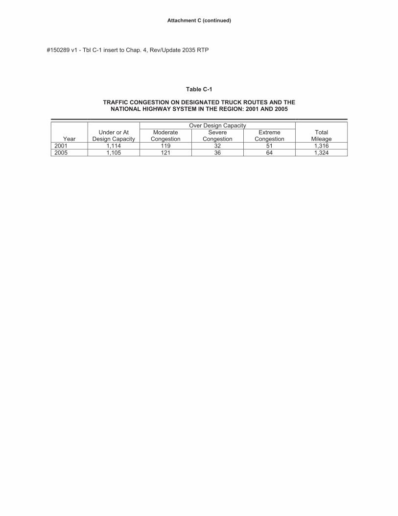
#150289 v1 - Tbl C-1 insert to Chap. 4, Rev/Update 2035 RTP
Table C-1
TRAFFIC CONGESTION ON DESIGNATED TRUCK ROUTES AND THE NATIONAL HIGHWAY SYSTEM IN THE REGION: 2001 AND 2005
Year Under or At
Design Capacity
Over Design CapacityTotal
Mileage Moderate
Congestion Severe
Congestion Extreme
Congestion 2001 1,114 119 32 51 1,3162005 1,105 121 36 64 1,324
Attachment C (continued)
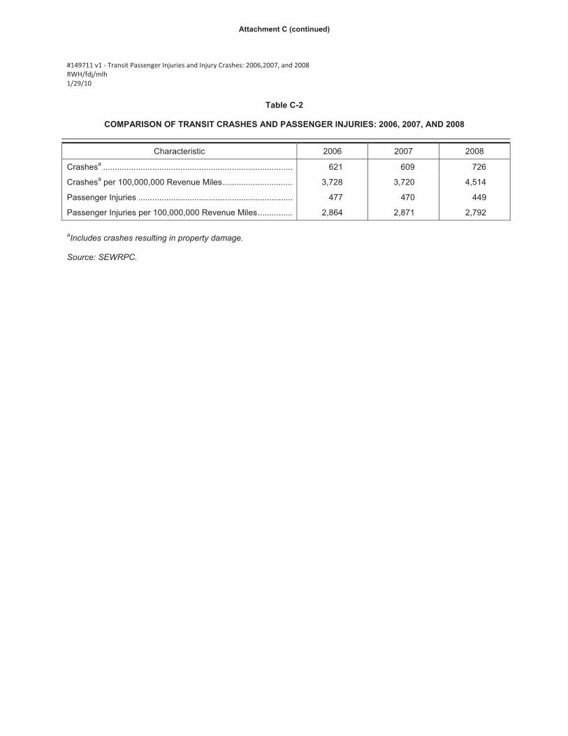
���#149711�v1���Transit�Passenger�Injuries�and�Injury�Crashes:�2006,2007,�and�2008��RWH/fdj/mlh�1/29/10�
�Table C-2
COMPARISON OF TRANSIT CRASHES AND PASSENGER INJURIES: 2006, 2007, AND 2008
Characteristic 2006 2007 2008
Crashesa ................................................................................. 621 609 726
Crashesa per 100,000,000 Revenue Miles .............................. 3,728 3,720 4,514
Passenger Injuries .................................................................. 477 470 449
Passenger Injuries per 100,000,000 Revenue Miles ............... 2,864 2,871 2,792
�aIncludes crashes resulting in property damage.
Source: SEWRPC.
Attachment C (continued)
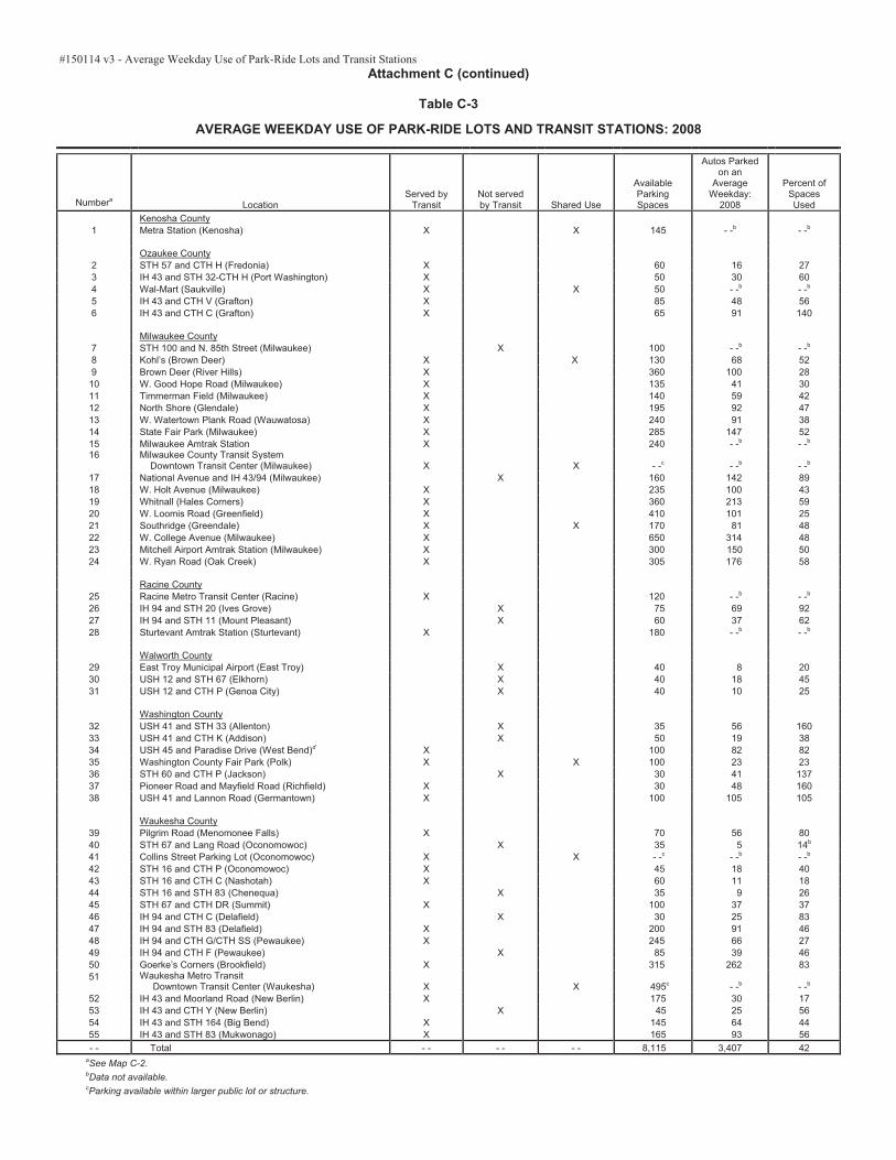
#150114 v3 - Average Weekday Use of Park-Ride Lots and Transit StationsAttachment C (continued)
Table C-3
AVERAGE WEEKDAY USE OF PARK-RIDE LOTS AND TRANSIT STATIONS: 2008
NumberaLocation
Served by Transit
Not served by Transit Shared Use
Available ParkingSpaces
Autos Parked on an
Average Weekday:
2008
Percent of SpacesUsed
Kenosha County1 Metra Station (Kenosha) X X 145 - -b - -b
Ozaukee County 2 STH 57 and CTH H (Fredonia) X 60 16 273 IH 43 and STH 32-CTH H (Port Washington) X 50 30 604 Wal-Mart (Saukville) X X 50 - -b - -b
5 IH 43 and CTH V (Grafton) X 85 48 566 IH 43 and CTH C (Grafton) X 65 91 140 Milwaukee County7 STH 100 and N. 85th Street (Milwaukee) X 100 - -b - -b
8 Kohl’s (Brown Deer) X X 130 68 529 Brown Deer (River Hills) X 360 100 2810 W. Good Hope Road (Milwaukee) X 135 41 3011 Timmerman Field (Milwaukee) X 140 59 4212 North Shore (Glendale) X 195 92 4713 W. Watertown Plank Road (Wauwatosa) X 240 91 3814 State Fair Park (Milwaukee) X 285 147 5215 Milwaukee Amtrak Station X 240 - -b - -b
16 Milwaukee County Transit System Downtown Transit Center (Milwaukee) X X - -c - -b - -b
17 National Avenue and IH 43/94 (Milwaukee) X 160 142 8918 W. Holt Avenue (Milwaukee) X 235 100 4319 Whitnall (Hales Corners) X 360 213 5920 W. Loomis Road (Greenfield) X 410 101 2521 Southridge (Greendale) X X 170 81 4822 W. College Avenue (Milwaukee) X 650 314 4823 Mitchell Airport Amtrak Station (Milwaukee) X 300 150 5024 W. Ryan Road (Oak Creek) X 305 176 58
Racine County25 Racine Metro Transit Center (Racine) X 120 - -b - -b
26 IH 94 and STH 20 (Ives Grove) X 75 69 9227 IH 94 and STH 11 (Mount Pleasant) X 60 37 6228 Sturtevant Amtrak Station (Sturtevant) X 180 - -b - -b
Walworth County29 East Troy Municipal Airport (East Troy) X 40 8 2030 USH 12 and STH 67 (Elkhorn) X 40 18 4531 USH 12 and CTH P (Genoa City) X 40 10 25
Washington County32 USH 41 and STH 33 (Allenton) X 35 56 160 33 USH 41 and CTH K (Addison) X 50 19 3834 USH 45 and Paradise Drive (West Bend)d X 100 82 8235 Washington County Fair Park (Polk) X X 100 23 2336 STH 60 and CTH P (Jackson) X 30 41 137 37 Pioneer Road and Mayfield Road (Richfield) X 30 48 160 38 USH 41 and Lannon Road (Germantown) X 100 105 105
Waukesha County39 Pilgrim Road (Menomonee Falls) X 70 56 8040 STH 67 and Lang Road (Oconomowoc) X 35 5 14b
41 Collins Street Parking Lot (Oconomowoc) X X - -c - -b - -b
42 STH 16 and CTH P (Oconomowoc) X 45 18 4043 STH 16 and CTH C (Nashotah) X 60 11 1844 STH 16 and STH 83 (Chenequa) X 35 9 2645 STH 67 and CTH DR (Summit) X 100 37 3746 IH 94 and CTH C (Delafield) X 30 25 8347 IH 94 and STH 83 (Delafield) X 200 91 4648 IH 94 and CTH G/CTH SS (Pewaukee) X 245 66 2749 IH 94 and CTH F (Pewaukee) X 85 39 4650 Goerke’s Corners (Brookfield) X 315 262 8351 Waukesha Metro Transit
Downtown Transit Center (Waukesha) X X 495c - -b - -b
52 IH 43 and Moorland Road (New Berlin) X 175 30 1753 IH 43 and CTH Y (New Berlin) X 45 25 5654 IH 43 and STH 164 (Big Bend) X 145 64 4455 IH 43 and STH 83 (Mukwonago) X 165 93 56- - Total - - - - - - 8,115 3,407 42
aSee Map C-2. bData not available. cParking available within larger public lot or structure.

Source: Wisconsin Department of Transportation and SEWRPC.
Map 6 (revised)
PASER PAVEMENT RATING FOR COUNTY AND LOCAL ARTERIALS: 2008
I:\Tran\WORK\RTSP 2010 Update\Pavement Ratings\Map 6 WISLR Pavement Ratings_Attachment D.mxd
0 1 2 3 4 5 6 MilesGRAPHIC SCALE
0 8,000 16,000 24,000 32,000 40,000 Feet
PASER PAVEMENT RATING
1-2 (81 MILES)
3-4 (212 MILES)
5-6 (561 MILES)
7 (423 MILES)
8, 9, 10 (846 MILES)
NO RATING (171 MILES)
1a
Attachment D
#148551 v2 - Performance Measures - Paser Mileage KNR/knr 3/5/10
2a
Attachment D (continued)
Table 12 (revised)
LOCAL AND COUNTY STREET AND HIGHWAY MILEAGE BY PASER PAVEMENT RATING COMPARISON: 2006 and 2008
2006 2008
PercentChange
PASERPavement Rating
Local and County ArterialMileage
Percent of Total
Local and County ArterialMileage
Percent of Total
1 and 2 132 5.7 81 3.5 -38.6
3 and 4 233 10.2 212 9.2 -9.0
5 and 6 431 18.8 561 24.5 30.2
7 376 16.4 423 18.4 12.5
8, 9 and 10 907 39.5 846 36.9 -6.7
No Rating 215 9.4 171 7.5 -20.5
Total 2,294 100.0 2,294 100.0 - -
Source: Wisconsin Department of Transportation and SEWRPC.

RWH/mlh/edl 3/11/10 #150290 v1 - Attachment E, Insert to Chap 5-Rev/Update 2035 RTP
Attachment E
(The following text is proposed to be added to Chapter 5, “Review of Implementation to Date of Year 2035 Regional Transportation Plan,” of SEWRPC Memorandum, Review Update, and Reaffirmation of the Year 2035 Regional Transportation System Plan, under the heading, Bicycle and Pedestrian Facilities, which begins on page 2 of the draft chapter.)
Accommodation Of Bicycles on the Arterial Street and Highway System
On arterial streets and highways with a rural cross-section, bicycles may be accommodated with a four-
foot paved shoulder and six-foot gravel shoulder on a two traffic-lane facility, and with an eight-foot
paved shoulder on a four-traffic lane facility. On arterial streets with an urban cross section, bicycles may
be accommodated with bicycle lanes five to six feet in width, or with a widened outside lane of 14 feet.
Accommodations may also be provided on urban and rural arterials with parallel, physically separate
paths of eight to 12 feet in width (five to six feet for one-way paths) and ten feet of separation from the
travel lanes. Map E-1 identifies those arterial streets and highways which provided bicycle
accommodations through paved shoulders, bicycle lanes, or separate paths in 2009. The mileage of
arterial streets and highways that provided bicycle accommodations through paved shoulders, bicycle
lanes, or separate paths increased from about 633 miles in 2004 to about 650 miles in 2009, or about a
three percent increase. Data is not available to identify those urban arterials with outside lanes of 14 feet
in width which also accommodate bicycles.
BICYCLE LANE
SEPARATE PATH WITHIN ROADWAY RIGHT-OF-WAY
PAVED SHOULDER
Map E-1
ACCOMMODATION OF BICYCLES ON THE SURFACE
ARTERIAL STREET AND HIGHWAY SYSTEM: 2009
ARTERIAL STREET ORHIGHWAY WITHOUTBICYCLE ACCOMODATION
Source: SEWRPCI:\Tran\WORK\RTSP 2010 Update\Bike Ped\Map E1 Bike Accom on Arts 09.mxd
0 1 2 3 4 5 Miles
GRAPHIC SCALE
0 8,000 16,000 24,000 Feet
Attachment E (continued)
") ")")
") ")
")")") ")
")")
")") ")
") ")")
")")")")")")
")")")")")") ") ") ")
")")
")")")
") ")
")")
")
")")
")
")
")
")
")")
")
")
")")")")
") ")
") ")
") ")
") ")
") ")
")")
")")")")
")")
")
") ")")")
")
")
")")")
")")")
")
")")
")
") ")") ")")
")") ")")
")
") ")
") ")
")
")")
")")
")")
")
")
")")
")")")
") ")
")
")
")
")")")
4
5
6
7 8
9
10 1112
13 14
15
16
17
18 19
2021
22
23
24
25
26
27
28
29
30
31
32
34
3536
34 39
40 41
42
44 45
46 47
484950
51
52 53
54 5556
57 58
60
61
6263
64
65
66
6768
6970
71 7273 74
75 7677
78
79
80
8182
83
84 85
8687
88
89
90
91 92
93
94
95
9697
98
99
100101
102103
104
105
106108
110111112
113
114 115
116 117
118 119
120 121
122123
124125
126 127
37
43
59
107
109
33
31
2
Source: Wisconsin Department of Transportation and SEWRPC.
Map 18 (revised)
LOCATIONS OF RAMP METERS ON THE EXISTING FREEWAY SYSTEM IN
SOUTHEASTERN WISCONSIN: 2010
I:\Tran\WORK\RTSP 2010 Update\Traffic Operations\Map 18 Ramp Meters Updated_attachment F.mxd
EXISTING FREEWAYRAMP METER
EXISTING FREEWAY RAMP METER WITH HIGH-OCCUPANCYVEHICLE BYPASS
0 0.5 1 1.5 2 2.5 3 MilesGRAPHIC SCALE
0 4,000 8,000 12,000 16,000 20,000 Feet
")
")
REFERENCE NUMBER (SEE TABLE 23)7
3a
EXISTING DATA COLLECTION SITE -- NON ACTIVE RAMP METER
")
Attachment F

KNR/knr#148656
Attachment F (continued)
Table 23 (revised)
LOCATION OF RAMP METERS ON THE EXISTING FREEWAY SYSTEM IN SOUTHEASTERN WISCONSIN: 2010
Reference Numbera Ramp Meter Location IH 94 East-West Corridor
1 Westbound at CTH SSc
2 Eastbound at CTH SSc
3 Westbound at CTH G 4 Eastbound at CTH Gc
5 Westbound at CTH T 6 Eastbound at CTH T (Grandview Boulevard) 7 Eastbound at STH 164 / CTH J 8 Eastbound at CTH F 9 Westbound at CTH JJ 10 Eastbound at USH 18 11 Eastbound at Barker Road 12 Westbound at CTH O (Moorland Road) 13 CTH O (Moorland Road) Southbound to Eastbound IH 94 14 CTH O (Moorland Road) Northbound to Eastbound IH 94 15 Westbound at STH 100 (S. 108th Street) 16 Eastbound at STH 100 (S. 108th Street) 17 Westbound at STH 181 (N. 84th Street)
18 Eastbound at STH 181 ( N. 84th Street) 19 Westbound at N. 70th Street 20 Eastbound at N. 68th Street 21 Westbound at Hawley Road 22 Eastbound at Hawley Road 23 Eastbound at Mitchell Boulevard 24 Westbound at Mitchell Boulevard 25 USH 41 Southbound to Westbound IH 94 26 USH 41 Southbound to Eastbound IH 94 27 STH 341 Northbound to Eastbound IH 94 28 STH 341 Northbound to Westbound IH 94 29 Westbound at N. 35th Street 30 Eastbound at N. 35th Street 31 Westbound at N. 28th Street 32 Eastbound at N. 25th Street 33 Westbound N. 17th Streetc34 Westbound at W. Tory Hill Street and N. 11th Streetb35 Westbound at N. 7th Street and W. Clybourn Avenueb
36 Northbound/Southbound at N. 2nd Street and W. Clybourn Avenueb
IH 94 South Corridor 37 Northbound at S. 9th Street and Walker Street 38 Southbound at S. 9th Street and Mineral Street 39 Northbound at S. 6th Street and Mineral Street 40 Southbound at Lapham Boulevard 41 Northbound at Lapham Boulevard 42 Southbound at Becher Street 43 Northbound at Becher Street 44 Southbound at Holt Avenue 45 Northbound at Holt Avenue 46 Southbound at W. Howard Avenue 47 Northbound at W. Howard Avenue 48 Westbound CTH Y (W. Layton Avenue) to Northbound IH 94 49 Eastbound CTH Y (W. Layton Avenue) to Northbound IH 94 50 Southbound at S. 20th Street, south of CTH Y (W. Layton Avenue) 51 STH 119 Westbound to Northbound IH 94 52 Southbound at CTH ZZ (W. College Avenue) 53 Northbound at CTH ZZ (W. College Avenue) 54 Southbound at CTH BB (W. Rawson Avenue) 55 Westbound CTH BB (W. Rawson Avenue) to Northbound IH 94 56 Eastbound CTH BB (W. Rawson Avenue) to Northbound IH 94
3b

KNR/knr#148656
Attachment F (continued)
Table 23 (continued)
Reference Numbera Ramp Meter Location IH 94 South Corridor -- continued
57 Southbound at STH 100 (W. Ryan Road) 58 Northbound at STH 100 (W. Ryan Road)
IH 43 North Corridor 59 Southbound at CTH C (Pioneer Road)c
60 Southbound at STH 57/167 (Mequon Road) 61 Southbound at Milwaukee—Ozaukee County Line Road 62 Eastbound STH 100 (W. Brown Deer Road) to Southbound IH 43 63 Westbound STH 100 (W. Brown Deer Road) to Southbound IH 43 64 Southbound at CTH PP (W. Good Hope Road) 65 Southbound at W. Silver Spring Drive 66 Southbound at W. Hampton Avenue 67 Southbound at Green Bay Avenue 68 Southbound at N. 9th Street and W. Abert Place 69 Northbound at Atkinson Avenue 70 Southbound at W. Keefe Avenue 71 Southbound at W. Locust Street 72 Northbound at W. Locust Street 73 Southbound at W. North Avenue 74 Northbound at W. North Avenue 75 Southbound at W. Fond du Lac Avenue (W. McKinley Avenue)b
76 Northbound at W. Fond du Lac Avenueb
77 Northbound at W. Highland Avenue and W. Kilbourn Avenueb
78 Southbound at W. Wisconsin Avenueb
IH 43 South Corridor 79 Northbound at STH 100 (S. 108th Street)
IH 894 Corridor 80 Eastbound STH 59 (W. Greenfield Avenue) to Northbound IH 894 81 Westbound STH 59 (W. Greenfield Avenue) to Northbound IH 894 82 Southbound at STH 59 (W. Greenfield Avenue) 83 Northbound at W. Lincoln Avenue 84 Southbound at W. National Avenue 85 Northbound at W. National Avenue 86 Northbound at CTH NN (W. Oklahoma Avenue) 87 Northbound at W. Beloit Road 88 Southbound at W. Beloit Road 89 Westbound at S. 84th Street 90 Eastbound at STH 24 (W. Forest Home Avenue) 91 Eastbound at CTH U (S. 76th Street) 92 Westbound at S. 60th Street 93 Eastbound at S. 60th Street 94 Westbound at STH 36 (S. Loomis Road) 95 Eastbound at STH 36 (S. Loomis Road) 96 Southbound WIS 241 (S. 27th Street) to Westbound IH 894 97 Northbound WIS 241 (S. 27th Street) to Westbound IH 894 98 Eastbound at WIS 241 (S. 27th Street)
USH 45 Corridor 99 Southbound at Lannon Road 100 Southbound at CTH Q (Washington—Waukesha County Line Road) 101 Northbound at Pilgrim Road 102 Southbound at Pilgrim Road 103 Southbound at STH 74 (Main Street) 104 Northbound at STH 74 (Main Street) 105 Northbound at N. 124th Street (Waukesha—Milwaukee County Line) 106 Southbound at N. 124th Street (Waukesha—Milwaukee County Line) 107 Northbound STH 145 to Northbound USH 45c
108 Westbound CTH PP (W. Good Hope Road) to Southbound USH 45 109 Southbound from STH 145 to USH 45c
110 Northbound at CTH PP (W. Good Hope Road)
3c

KNR/knr#148656
Attachment F (continued)
Table 23 (continued)
Reference Numbera Ramp Meter Location USH 45 Corridor--continued
111 Eastbound CTH PP (W. Good Hope Road) to Southbound USH 45 112 Northbound at USH 41 (W. Appleton Avenue) 113 Southbound at STH 175 (W. Appleton Avenue) 114 Southbound at CTH E (W. Silver Spring Drive) 115 Northbound at CTH E (W. Silver Spring Drive) 116 Southbound at CTH EE (W. Hampton Avenue) 117 Northbound at CTH EE (W. Hampton Avenue) 118 Southbound at STH 190 (W. Capitol Drive) 119 Northbound at STH 190 (W. Capitol Drive) 120 Southbound at W. Burleigh Street 121 Northbound at W. Burleigh Street 122 Southbound at W. North Avenue 123 Northbound at W. North Avenue 124 Southbound at Watertown Plank Road 125 Northbound at Watertown Plank Road 126 Southbound at N. 97th Street and W. Wisconsin Avenue 127 Northbound at W. Wisconsin Avenue
aSee Map 18. bRamp Meter added after 2004. cExists as Data Collection Site, but does not have active Ramp Meter.
Source: Wisconsin Department of Transportation and SEWRPC.
3d

XY
XYXY
XY
XY
XYXY
XYXY
XY
XY XY
XY
XY
XY
XY
XY
XY
XY
XY
XY
XYXY
XY
XY
1 2 3 4
56 7 8 9 10
11
1213
14
15
47
48
4950
51
525354
555657
23242526
2930
313233
3435
36
37
38
39
40
41
42
43
44
45
46
998280
81797877
76
75
74737271
70
64
65 67 6968
9897
969594
9392
91
908988
8786
8584
83
1
2 4 5
24
89
25
10
11
12
2120
17
1918
23
22
16
14
15
SEE INSET
66
3
13
Source: Wisconsin Department of Transportation and SEWRPC.
Map 19 (revised)
LOCATIONS OF VARIABLE MESSAGE SIGNS AND CLOSED-CUIRCUIT TELEVISION CAMERAS ON THE EXISTING FREEWAY SYSTEM IN
SOUTHEASTERN WISCONSIN: 2010
I:\Tran\WORK\RTSP 2010 Update\Traffic Operations\Map 19 VMS and CCTV on freeway update_attachment F.mxd
VARIABLE MESSAGE SIGN AND REFERENCE NUMBER (SEE TABLE 24)
CLOSED-CIRCUIT TELEVISION CAMERAS AND REFERENCE NUMBER (SEE TABLE 24)
0 1 2 3 4 5 6 MilesGRAPHIC SCALE
0 8,000 16,000 24,000 32,000 40,000 Feet
XY XY
102
101
100
16 17 18
19
20 21 22
27
28
6362
6160
59
67
Greenfield Ave
National Ave
Wisconsin Ave
Highland Blvd
16th
St
1st
St
6th
St
Stat
27th
St
,-94
,-43
0141
QR57QR59
QR38
01341
0118
,-94
58
103
INSET
!(
XY
7
7
3e
Attchment F (continued)

KNR/knr#148674
Attachment F (continued)
Table 24 (revised)
LOCATIONS OF VARIABLE MESSAGE SIGNS AND CLOSED-CIRCUIT TELEVISION CAMERAS ON THE EXISTING FREEWAY SYSTEM IN SOUTHEASTERN WISCONSIN: 2010
Reference Numbera Variable Message Sign Locations 1 IH 94 eastbound at STH 16 2 IH 94 eastbound at Brookfield Road 3 IH 94 westbound at Calhoun Roadb
4 IH 94 eastbound at Elm Grove Road 5 IH 94 eastbound at S. 89th Street 6 IH 94 eastbound at N. 30th Streetb 7 IH 94 westbound at N. 22nd Street 8 IH 43 and IH 94 northbound at Kinnickinnic River 9 IH 43 and IH 94 southbound at Oklahoma Avenue 10 IH 94 northbound at CTH ZZ (W. College Avenue) 11 IH 94 northbound at W. Drexel Avenueb
12 IH 94 northbound at CTH G 13 IH 94 northbound at CTH Cd
14 IH 43 southbound at Ozaukee—Milwaukee County Line Road 15 IH 43 southbound at W. Locust Street 16 IH 43 northbound at W. Walnut Streetb 17 IH 43 northbound at CTH T (W. Beloit Road) 18 IH 894 and USH 45 southbound at STH 59 (W. Greenfield Avenue) 19 IH 894 and USH 45 northbound at Cleveland Avenue 20 IH43 and IH 894 eastbound at S. 72nd Street 21 IH43 and IH 894 westbound at STH 36 (W. Loomis Road) 22 USH 41 and USH 45 southbound at STH 145 23 USH 45 southbound at W. Burleigh Street 24 USH 41 southbound at W. Cherry Street 25 STH 119 westbound at Mitchell Airport
Reference Numbera Closed-Circuit Television Camera Locations 1 IH 94 at STH 67b
2 IH 94 at STH 83b
3 IH 94 at CTH SSb
4 IH 94 at CTH Fb
5 IH 94 at Springdale Road 6 IH 94 at USH 18 (Blue Mound Road) 7 IH 94 at Calhoun Road 8 IH 94 at CTH O (Moorland Road) 9 IH 94 at Sunnyslope Road 10 IH 94 at S. 121st. Street 11 IH 94 at STH 100 (N. 108th Street) 12 IH 94 at IH 894 and USH 45 (Zoo Interchange) 13 IH 94 at S. 92nd Street 14 IH 94 at S. 76th Street 15 IH 94 at Hawley Road 16 IH 94 at Mitchell Boulevard 17 IH 94 at N. 35th Street 18 IH 94 at N. 30th Street 19 IH 94 at N. 20th Streetc 20 IH 94 at N. 13th Streetc 21 IH 794 at N 7th Street (James Lovell Boulevard)b
22 IH 794 at N. 2nd Street 23 IH 794 at Lincoln Memorial Drive (Lake Interchange)b
24 IH 794 at Daniel W. Hoan bridge 25 IH 794 at south end of Daniel W. Hoan bridgeb
26 IH 794 at S Carferry Driveb
27 IH 94 and IH 43 at STH 59 (W. National Avenue) 28 IH 94 and IH 43 at W. Mitchell Street 29 IH 94 and IH 43 at STH 38 (Chase Avenue)
3f
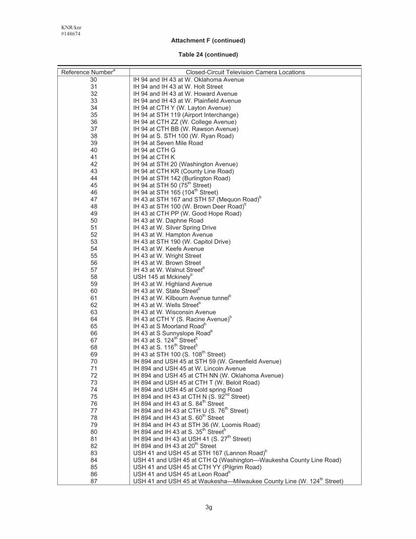
KNR/knr#148674
Attachment F (continued)
Table 24 (continued)
Reference Numbera Closed-Circuit Television Camera Locations 30 IH 94 and IH 43 at W. Oklahoma Avenue
31 IH 94 and IH 43 at W. Holt Street 32 IH 94 and IH 43 at W. Howard Avenue 33 IH 94 and IH 43 at W. Plainfield Avenue 34 IH 94 at CTH Y (W. Layton Avenue) 35 IH 94 at STH 119 (Airport Interchange) 36 IH 94 at CTH ZZ (W. College Avenue) 37 IH 94 at CTH BB (W. Rawson Avenue) 38 IH 94 at S. STH 100 (W. Ryan Road) 39 IH 94 at Seven Mile Road 40 IH 94 at CTH G 41 IH 94 at CTH K 42 IH 94 at STH 20 (Washington Avenue) 43 IH 94 at CTH KR (County Line Road) 44 IH 94 at STH 142 (Burlington Road) 45 IH 94 at STH 50 (75th Street) 46 IH 94 at STH 165 (104th Street) 47 IH 43 at STH 167 and STH 57 (Mequon Road)b
48 IH 43 at STH 100 (W. Brown Deer Road)b
49 IH 43 at CTH PP (W. Good Hope Road) 50 IH 43 at W. Daphne Road 51 IH 43 at W. Silver Spring Drive 52 IH 43 at W. Hampton Avenue 53 IH 43 at STH 190 (W. Capitol Drive) 54 IH 43 at W. Keefe Avenue 55 IH 43 at W. Wright Street 56 IH 43 at W. Brown Street 57 IH 43 at W. Walnut Streetb 58 USH 145 at Mckinelyb
59 IH 43 at W. Highland Avenue 60 IH 43 at W. State Streetb 61 IH 43 at W. Kilbourn Avenue tunnelb 62 IH 43 at W. Wells Streetb 63 IH 43 at W. Wisconsin Avenue 64 IH 43 at CTH Y (S. Racine Avenue)b
65 IH 43 at S Moorland Roadb
66 IH 43 at S Sunnyslope Roadb
67 IH 43 at S. 124th Streetb 68 IH 43 at S. 116th Streetb 69 IH 43 at STH 100 (S. 108th Street) 70 IH 894 and USH 45 at STH 59 (W. Greenfield Avenue) 71 IH 894 and USH 45 at W. Lincoln Avenue 72 IH 894 and USH 45 at CTH NN (W. Oklahoma Avenue) 73 IH 894 and USH 45 at CTH T (W. Beloit Road) 74 IH 894 and USH 45 at Cold spring Road 75 IH 894 and IH 43 at CTH N (S. 92nd Street) 76 IH 894 and IH 43 at S. 84th Street 77 IH 894 and IH 43 at CTH U (S. 76th Street) 78 IH 894 and IH 43 at S. 60th Street 79 IH 894 and IH 43 at STH 36 (W. Loomis Road) 80 IH 894 and IH 43 at S. 35th Streetb 81 IH 894 and IH 43 at USH 41 (S. 27th Street) 82 IH 894 and IH 43 at 20th Street 83 USH 41 and USH 45 at STH 167 (Lannon Road)b
84 USH 41 and USH 45 at CTH Q (Washington—Waukesha County Line Road) 85 USH 41 and USH 45 at CTH YY (Pilgrim Road) 86 USH 41 and USH 45 at Leon Roadb
87 USH 41 and USH 45 at Waukesha—Milwaukee County Line (W. 124th Street)
3g

KNR/knr#148674
Attachment F (continued)
Table 24 (continued)
Reference Numbera Closed-Circuit Television Camera Locations 88 USH 41 and USH 45 at STH 145 89 USH 41 and USH 45 at CTH PP (W. Good Hope Road) 90 USH 45 and STH 100 at USH 41 (W. Appleton Avenue) 91 USH 45 at CTH E (W. Silver Spring Drive) 92 USH 45 at STH 190 (W. Capitol Drive) 93 USH 45 at W. Burleigh Road 94 USH 45 at W. Center Street 95 USH 45 at W. North Avenue 96 USH 45 at STH 100 (Mayfair Road) 97 USH 45 at Watertown Plank Road 98 USH 45 at USH 18 (Bluemound Road) 99 IH 43 and IH 94 at Mitchell Interchange 100 USH 41 at USH 18 (Bluemound Road) 101 STH 341 at Stadium 102 STH 341 at STH 59 (W. National Avenue) 103 Wisconsin Department of Transportation Traffic Operations Centere
aSee Map 19. bLocation added after 2004. cLocation updated after 2004. dLocation currently inactive, will be restored with completion of IH 94 North South Project. eLocation no longer active after 2004.
Source: Wisconsin Department of Transportation and SEWRPC.
3h
XY
XY
XY
XYXY
XYXY
XY
XY
XY
XY
XY
XY
XY
XY
Source: Wisconsin Department of Transportation and SEWRPC.
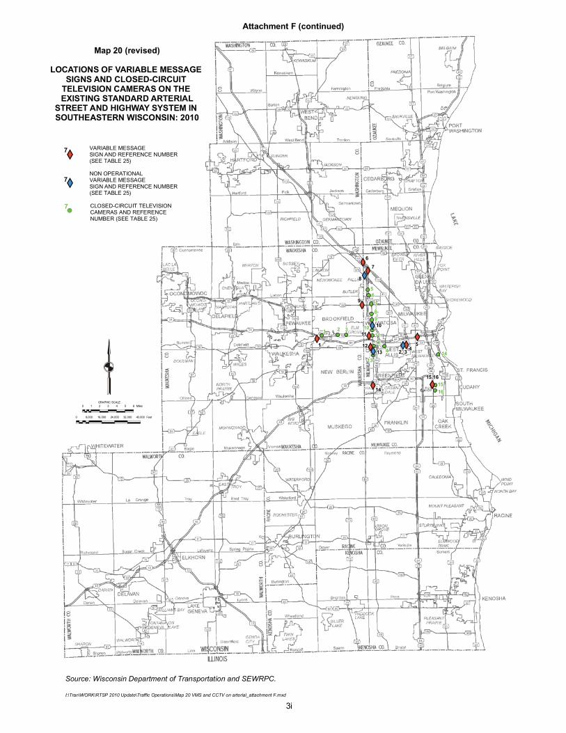
Map 20 (revised)
LOCATIONS OF VARIABLE MESSAGE SIGNS AND CLOSED-CIRCUIT
TELEVISION CAMERAS ON THE EXISTING STANDARD ARTERIAL
STREET AND HIGHWAY SYSTEM IN SOUTHEASTERN WISCONSIN: 2010
I:\Tran\WORK\RTSP 2010 Update\Traffic Operations\Map 20 VMS and CCTV on arterial_attachment F.mxd
VARIABLE MESSAGE SIGN AND REFERENCE NUMBER (SEE TABLE 25)
CLOSED-CIRCUIT TELEVISION CAMERAS AND REFERENCE NUMBER (SEE TABLE 25)
0 1 2 3 4 5 6 MilesGRAPHIC SCALE
0 8,000 16,000 24,000 32,000 40,000 Feet
1
1
!(
XY
11
12
14
45
9
76
2 3
4 14
1516
13
1211
10
987
65
7
7
3i
15,16
10
13
8
NON OPERATIONALVARIABLE MESSAGE SIGN AND REFERENCE NUMBER (SEE TABLE 25)
XY7
2, 3
Attachment F (continued)
KNR/knr #148732
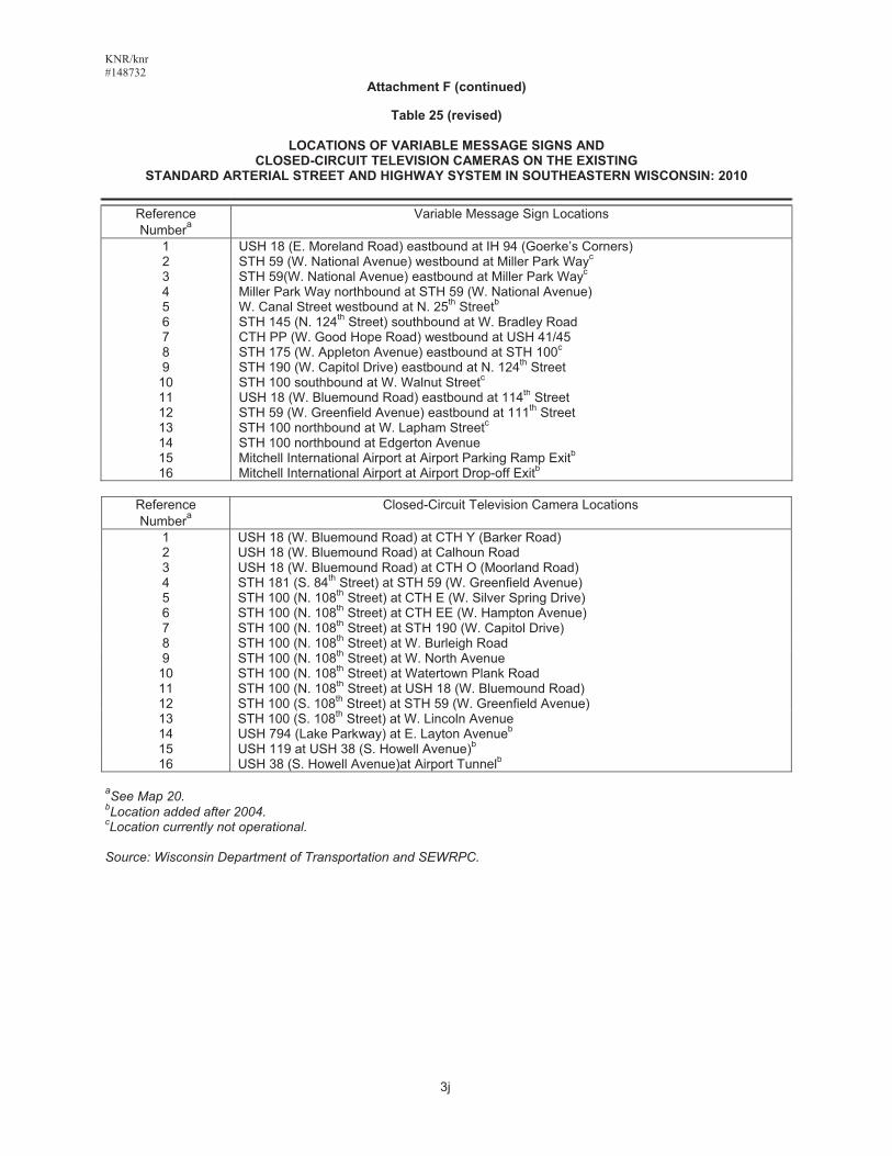
Attachment F (continued)
Table 25 (revised)
LOCATIONS OF VARIABLE MESSAGE SIGNS AND CLOSED-CIRCUIT TELEVISION CAMERAS ON THE EXISTING
STANDARD ARTERIAL STREET AND HIGHWAY SYSTEM IN SOUTHEASTERN WISCONSIN: 2010
Reference Numbera
Variable Message Sign Locations
1 USH 18 (E. Moreland Road) eastbound at IH 94 (Goerke’s Corners) 2 STH 59 (W. National Avenue) westbound at Miller Park Wayc
3 STH 59(W. National Avenue) eastbound at Miller Park Wayc
4 Miller Park Way northbound at STH 59 (W. National Avenue) 5 W. Canal Street westbound at N. 25th Streetb6 STH 145 (N. 124th Street) southbound at W. Bradley Road 7 CTH PP (W. Good Hope Road) westbound at USH 41/45 8 STH 175 (W. Appleton Avenue) eastbound at STH 100c
9 STH 190 (W. Capitol Drive) eastbound at N. 124th Street 10 STH 100 southbound at W. Walnut Streetc11 USH 18 (W. Bluemound Road) eastbound at 114th Street 12 STH 59 (W. Greenfield Avenue) eastbound at 111th Street 13 STH 100 northbound at W. Lapham Streetc14 STH 100 northbound at Edgerton Avenue 15 Mitchell International Airport at Airport Parking Ramp Exitb16 Mitchell International Airport at Airport Drop-off Exitb
Reference Numbera
Closed-Circuit Television Camera Locations
1 USH 18 (W. Bluemound Road) at CTH Y (Barker Road) 2 USH 18 (W. Bluemound Road) at Calhoun Road 3 USH 18 (W. Bluemound Road) at CTH O (Moorland Road) 4 STH 181 (S. 84th Street) at STH 59 (W. Greenfield Avenue) 5 STH 100 (N. 108th Street) at CTH E (W. Silver Spring Drive) 6 STH 100 (N. 108th Street) at CTH EE (W. Hampton Avenue) 7 STH 100 (N. 108th Street) at STH 190 (W. Capitol Drive) 8 STH 100 (N. 108th Street) at W. Burleigh Road 9 STH 100 (N. 108th Street) at W. North Avenue
10 STH 100 (N. 108th Street) at Watertown Plank Road 11 STH 100 (N. 108th Street) at USH 18 (W. Bluemound Road) 12 STH 100 (S. 108th Street) at STH 59 (W. Greenfield Avenue) 13 STH 100 (S. 108th Street) at W. Lincoln Avenue 14 USH 794 (Lake Parkway) at E. Layton Avenueb
15 USH 119 at USH 38 (S. Howell Avenue)b
16 USH 38 (S. Howell Avenue)at Airport Tunnelb
aSee Map 20. bLocation added after 2004. cLocation currently not operational.
Source: Wisconsin Department of Transportation and SEWRPC.
3j