MINNOVA inc.
38
MINNOVA inc. 1990 ANNUAL REPORT BRENDA-OKANAGAN JOINT VENTURE 825646 BY: VANCOUVER OFFICE STAFF MARCH 1991
Transcript of MINNOVA inc.

MINNOVA i n c . 1990 ANNUAL REPORT
BRENDA-OKANAGAN JOINT VENTURE 825646
BY: VANCOUVER OFFICE STAFF MARCH 1991

S U M M A R Y A N D H I G H L I G H T S
The Brenda - Minnova Joint Venture has now completed it's second year
and in the process has evaluated a great many potential ventures within and close to the
J V area. Of these, four projects continue as active exploration targets into 1991,
although they will be compared closely with several new acquisitions under consideration
before funding is committed. A total of $1,441,100 has been expended on exploration to
date.
Seven projects were active in 1990 of which three saw drilling. Figure 1
shows the breakdown of the expenditures while Figure 2 compares this with 1989
expenditures. It is apparent that the proportion of funds spent on drilling increased
significantly in 1990, however it is still well short of the 50% or so which we would like
to see. This problem will be addressed in formulating the 1991 plans.
A summary of the projects is as follows:
target is epithermal gold related to N W trending, Hg rich
structures. Favourable host for bulk tonnage is present, but
targets are not developing. A limited amount of target
generation work remains to be done.
porphyry potential was evaluated and eliminated. No further
work planned.
presence of gold confirmed but no targets with tonnage
potential were found. Claims have been kept in good standing
while strong activity continues on the adjacent Elk property
(Fairfield/Placer).
Last Chance
Clapper
Wart

Richter several occurrences of anomalous gold associated with intrusive
activity point to porphyry or skarn potential. Given this
model, remaining areas of the property can be rapidly
evaluated.
Rainbow precious metal values were returned from the Midway Mine
area where a Mesozoic porphyry intrudes thrust related
serpentine, however tonnage potential was eliminated. Several
bulk tonnage cpithcrmal targets remain to be tested.
Athelslan high grade veins with limited past production arc postulated
to be leakage features from a larger listwanite system within
serpentines at shallow depths below. Dril l testing planned for
1991.
General numerous submittals continue to be received and evaluated.
Particular emphasis has been placed on porphyry and related
targets in Nicola rocks.

1990 PROJECT EXPENDITURES Summary by Work Type
% OF
PROJECT GEOL GEOPH GEOCH DRILL LINE TRENCH HOTELS OPTIONS 'OTHER TOTAL BUDGET
LAST CHANCE 22.9 0.0 17.8 56.9 3.5 9.5 5.4 0.0 0.4 116.4 16%
CLAPPER 2.8 7.6 1.7 0.0 0.0 0.0 0.5 0.0 0.0 12.6 2 %
WART 4.6 9.0 7.3 0.0 0.0 0.0 1.0 0.0 0.4 22.2 3%
FERROUX 1.3 0.0 0.8 0.0 0.0 0.0 0.0 0.0 0.6 2.7 0 %
RICHTER 48.0 12.8 15.8 50.7 0.0 0.0 9.3 0.0 1.5 138.1 19%
GENERAL 57.4 0.1 6.9 0.5 0.0 0.0 2.0 0.0 0.0 66.8 9 %
TAM O'SHANTER 74.3 50.1 42.9 89.3 9.2 10.0 10.3 38.0 11.9 336.0 4 7 %
ATH - JACKPOT 1.7 0.0 1.0 0.0 3.3 0.0 0.2 10.5 0.1 16.8 2 %
TOTALS 212.9 79.6 94.0 197.4 16.0 19.5 28.7 48.5 14.9 711.5 212.9 79.6 94.0 197.4 16.0 19.5 28.7 48.5 14.9 711.5
% 3 0 % 1 1 % 1 3 % 2 8 % 2 % 3 % 4 % 7 % 2 %
DIRECT EXPENDITURES
ADMINISTRATION
TOTAL
= $711,530
= $79,564
= $791,094
* includes property maintenance, staking, etc.
Figure 1.

ANALYSIS OF EXPENDITURES By Work Type
(%>
Geol Geoph Geoch Drill Line Trench Hotel Option Other
1989 1990
Figure 2.
L A S T C H A N C E
P N 622
C J . Clayton
INTRODUCTION
The Last Chance property consists of the L C Group (contiguous L C 1-4
claims, 71 units) and the separate L C 5 claim (20 units). It is located approximately 18
km north-northwest of the western end of Kamloops Lake. High mercury values and
other metals (Au, Cu, Ag) occur in Nicola Group and Ashcroft Formation rocks proximal
to major north-northwest trending structures that control Sabiston Creek and Carabine
Creek near Kamloops Lake. These major structures trend across the northerly L C Group
and may control mineralisation in this area. On the southern L C 5 claim argillic
alteration is prevalent along lahar cliffs proximal to a large breccia pipe in Eocene
volcanics. Chalcedonic veining within the breccia pipe may indicate a precious metal
bearing epithermal system at depth.
1990 PROGRAM
Work by Minnova during 1990 extended the existing L C grid to the
southeast. Trenching on the L C grid was followed by three diamond drill holes. A grid
was also established on the southern L C 5 claim to cover strong argillicly altered cliffs
in the vicinity of the breccia pipe
Linecutting - 6.0 line km on LC grid extensions 8.5 line km on SR grid

Geology - 1:2500 scale mapping and sampling of the LC grid extensions and SR grid. 1:5000 contour mapping and sampling around breccia pipe.
Geochemistry - 13 rock samples taken from LC grid, 41 from SR grid; 54 were analyzed for Cu, Pb, Zn, Ag, As, Sb, Au, Hg; 41 for trace elements and major oxides. 112 rock samples from 21 trenches. 137 drill core samples. 592 soil samples from LC grid, SR grid and contour sampling analyzed for Cu, Pb, Zn, Ag, As, Sb, Au, Hg
Trenching - 454 metres, 21 trenches
Drilling - three holes totalling 614.9 metres
RESULTS
Mapping and trenching during 1990 successfully defined the contact between
the basaltic/andesitic breccia, and the chert pebble conglomerate to the southeast on the
L C grid. Precious metal values obtained from rock samples returned low gold values
ranging from 1 - 12 ppb, and silver from 0.2 to 2.7 ppm. A n anomalous zone of Hg in
soils from the 1989 program was further extended to the southwest across much of the
1990 grid area. This feature roughly parallels the breccia/conglomerate contact. Arsenic
results were not useful over the 1990 grid extensions. Trenching helped define the
volcanic/conglomerate contact and one sample of conglomerate from trench TR90-5 taken
near the volcanic contact was found to contain 5000 ppb A u (1.8 g/t, 0.053 oz/t). Mercury
values in this trench reached 250000 ppb. Silver and base metal values, however, were
low. Results of drilling were disappointing with the highest A u value of 29 ppb. Hg
values, however, reached as high as 893750 ppb.

Compilation of results from the 1990 program and previous programs
indicates a large northwest trending structure may be present roughly 500m to 1km
northeast of the 1989 and 1990 grids. This may be an extension of the Carabine Creek
fault.
RECOMMENDA TIONS
1. A short (1 week) reconnaissance mapping and sampling program to precisely
locate the structure indicated by airborne geophysics is recommended.
2. Depending on results of above, extend L C grid to cover this area.
3. Soil sample and run ground geophysics (mag/VLF) over this area.
4. Extend grid lines from the SR grid to cover the entire breccia pipe and
detail sample this area.
5. Trenching and/or drill best targets.
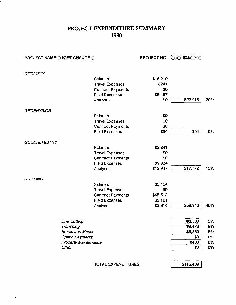
PROJECT EXPENDITURE SUMMARY 1990
PROJECT NAME: LAST C H A N C E PROJECT NO. 6 2 2
GEOLOGY
Salaries
Travel Expenses
Contract Payments
Field Expenses
Analyses
$16,210
$241
$0
$6,467
$0 $22,918 2 0 %
GEOPHYSICS
GEOCHEMISTRY
DRILLING
Salaries
Travel Expenses
Contract Payments
Field Expenses
Salaries
Travel Expenses
Contract Payments
Field Expenses
Analyses
Salaries
Travel Expenses
Contract Payments
Field Expenses
Analyses
$0
$0
$0
$54
$2,841
$0
$0
$1,984
$12,947
$5,454
$0
$45,513
$2,161
$3,814
$54 0 %
$17,772 1 5 %
$56,942 4 9 %
Line Cutting $3,500 3 %
Trenching $9,473 8 %
Hotels and Meals $5,350 5 %
Option Payments $0 0 %
Property Maintenance $400 0 %
Other $0 0 %
TOTAL EXPENDITURES $116,409 |


C L A P P E R
P N 642
C.J. Clayton
INTRODUCTION
The Clapper property, consisting of 68 units straddling the Coquihalla
Highway 29 km north of Merritt, is situated within the Nicola Mining Division. The
north-south trending Clapperton Fault is thought to have the same sources of mineralisa
tion as the Swakum Mountain vein/skarn system a few kilometres to the west. The 1989
program consisted of an airborne geophysical survey, heavy mineral sampling, and detailed
mapping and sampling of shear zones. Results were generally poor with only low gold
values returned.
1990 PROGRAM
Minnova's 1990 exploration program consisted of seven reconnaissance I.P.
and magnetometer lines, and soil sampling.
Geochemistry - 106 contour soil samples analyzed for Ag, As, Ba, Cu, Pb, Zn, Sb, and Au.
Geophysics - seven reconnaissance I.P. and magnetometer lines using pole/dipole electrode array
RESULTS
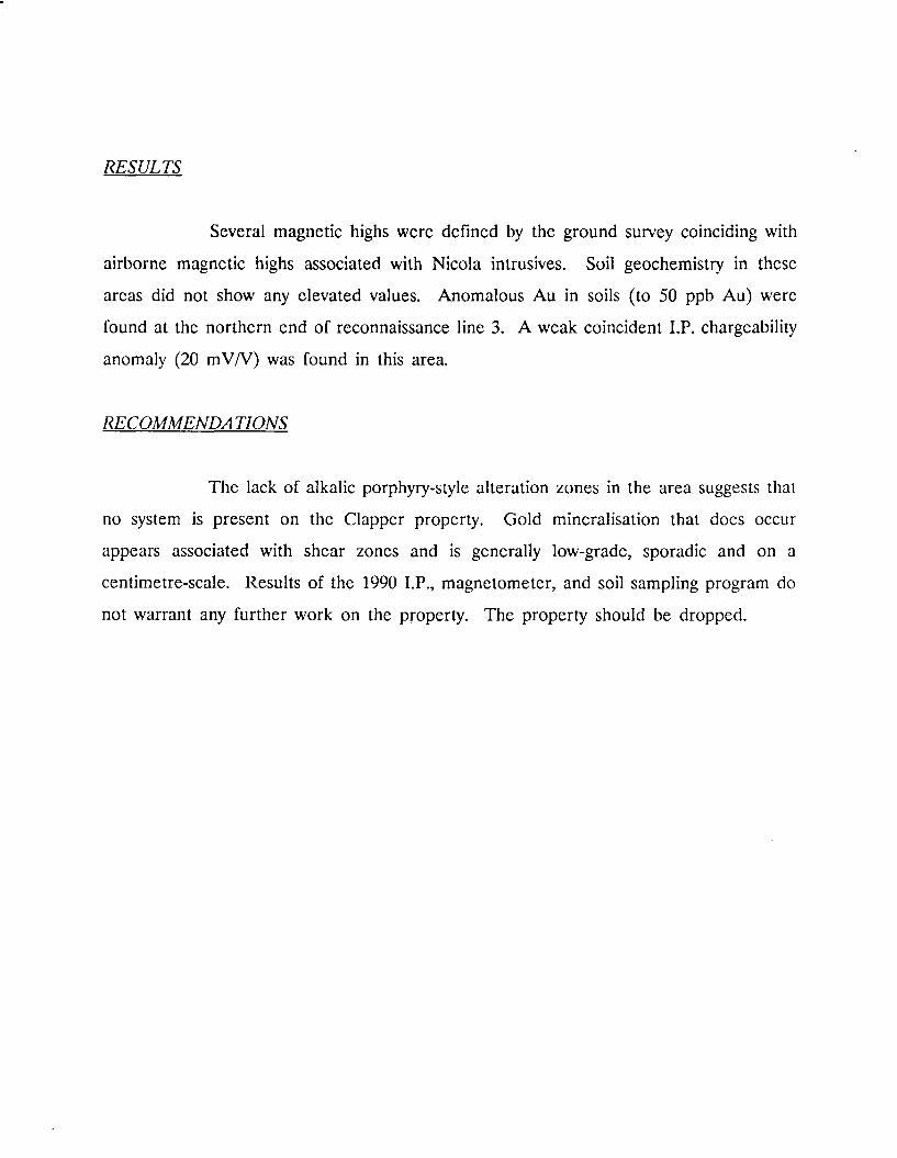
Several magnetic highs were defined by the ground survey coinciding with
airborne magnetic highs associated with Nicola intrusives. Soil geochemistry in these
areas did not show any elevated values. Anomalous A u in soils (to 50 ppb Au) were
found at the northern end of reconnaissance line 3. A weak coincident I.P. chargeability
anomaly (20 mV/V) was found in this area.
RECOMMENDA TIONS
The lack of alkalic porphyry-style alteration zones in the area suggests that
no system is present on the Clapper property. Gold mineralisation that does occur
appears associated with shear zones and is generally low-grade, sporadic and on a
centimetre-scale. Results of the 1990 LP. , magnetometer, and soil sampling program do
not warrant any further work on the property. The property should be dropped.

PROJECT EXPENDITURE SUMMARY 1990
PROJECT NAME: CLAPPER PROJECT NO. 642
GEOLOGY
Salaries
Travel Expenses
Contract Payments
Field Expenses
Analyses
$1,907
$5
$0
$889
$0 $2,801 2 2 %
GEOPHYSICS
Salaries
Travel Expenses
Contract Payments
Field Expenses
$0
$0
$7,551
$10 $7,560 6 0 %
GEOCHEMISTRY
Salaries
Travel Expenses
Contract Payments
Field Expenses
Analyses
$524
$0
$0
$51
$1,133 $1,708 14%
DRILLING
Salaries
Travel Expenses
Contract Payments
Field Expenses
Analyses
$0
$0
$0
$0
$0 $0 0%
Line Cutting $0 0%
Trenching $0 0%
Hotels and Meals $525 4 %
Option Payments $0 0 %
Property Maintenance $0 0 %
Other $0 0 %
TOTAL EXPENDITURES $12,594 |

W A R T P R O P E R T Y
P N 643
C.J. Clayton
INTRODUCTION
The Wart Group is situated within the Similkameen Mining Division of
south-central British Columbia, straddling the Okanagan Connector Highway approximate
ly 36 kilometres southeast of Merritt. Interest in the property was stimulated in 1989 by
trenching of the Elk claims to the south, operated by Fairfield Minerals/Placer Dome.
Anomalous gold values on that property were returned from clay, sericite, pyrite alteration
zones associated with quartz veining. Reconnaissance work continued in 1990 on the
property to assess the potential of the area as a gold target.
7990 PROGRAM
Minnova's 1990 exploration program consisted of airborne geophysics
(magnetometer and V L F ) in the early part of the year, followed by contour soil sampling,
continued heavy mineral sampling of stream sediments, and rock sampling of areas
exposed by construction work along the Okanagan Connector Highway.
Geology - sampling of clay altered fault/shear zones exposed in new roadcuts. reconnaissance scale (1:10000) mapping and sampling of available outcrop in the north west part of the group.
Geochemistry - 19 rock samples were taken; 18 were analyzed for a 12 trace element ICP, 1 for trace elements and major oxides. 106 contour soil samples analyzed for Ag, As Cu, K, Mn, Mo, Na, Ni, Pb, Sb, Zn, Cr, and Au.
Geophysics - approximately 117 line kilometres of airborne geophysics was flown covering the entire property.

RESULTS
Sampling of outcrop exposure in the northern part of the property failed to
produce any significant results. Two rock samples taken from a shear/fault zone in the
southeastern corner of the claims near the clover leaf off ramp returned anomalous
values (Au to 1110 ppb, A g to 19.4 ppm, As to 9857 ppm, Pb to 110 ppm, Sb to 46
ppm, Z n to 405 ppm, and Cr to 141).
Heavy mineral sampling did not reveal any areas warranting further follow-
up, nor did contour soil sampling, the highest A u value being 40 ppb. Other pathfinder
elements were not useful.
RECOMMENDA TIONS
1. Assessment should be filed for one year to retain the property while
Fairfield/Placer Dome continue work on the Elk claims.
2. Should the Elk property produce no further encouraging results it is
recommended the Wart claims be allowed to lapse.
PROJECT EXPENDITURE SUMMARY 1990
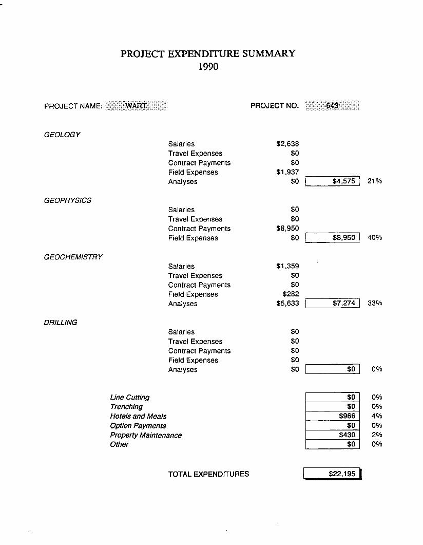
PROJECT NAME: W A R T PROJECT NO. 643
GEOLOGY
Salaries
Travel Expenses
Contract Payments
Field Expenses
Analyses
$2,638
$0
$0
$1,937
$0 $4,575 2 1 %
GEOPHYSICS
Salaries
Travel Expenses
Contract Payments
Field Expenses
$0
$0
$8,950
$0 $8,950 4 0 %
GEOCHEMISTRY
Salaries
Travel Expenses
Contract Payments
Field Expenses
Analyses
$1,359
$0
$0
$282
$5,633 $7,274 3 3 %
DRILLING
Salaries
Travel Expenses
Contract Payments
Field Expenses
Analyses
$0
$0
$0
$0
$0 $0 0%
Line Cutting $0 0%
Trenching $0 0 %
Hotels and Meals $966 4 %
Option Payments $0 0 %
Property Maintenance $430 2 %
Other $0 0 %
TOTAL EXPENDITURES $22,195 |

R I C H T E R
P N 656
C.J. Clayton
INTRODUCTION
The Richter property, consisting of 212 contiguous claim units, is situated
within the Osoyoos Mining Division between Oliver and Keremeos, B .C. Palaeozoic
meta-volcanics and meta-sediments intruded by Mesozoic plutons underlie the area. It
was staked in 1988 to cover several multi-elemental heavy mineral anomalies. Work in
1989 resulted in the identification of several potential drill targets within strongly albitized
and quartz vein stockwork zones proximal to Mesozoic intrusions.
Gold mineralisation appears associated with zones of albite alteration.
Albite alteration and albitite dyke have been important ore indicators in other regions
such as the Bralorne area, and the Abitibi-Lake Chicobi area. Skarn potential must also
be considered on the Richter property as satellite intrusions from larger plutonic bodies
are found near wide bands of calcareous sediments.
1990 PROGRAM
The 1990 program consisted of mapping and litho-geochemical sampling of
unmapped grid areas, further follow-up of heavy mineral anomalies, and further
reconnaissance scale mapping. Four diamond drill holes were drilled on the Testalinden
Grid in the 'Albite Zone* area to test its potential.

Linecutting - 1.1 line kin on Longhorn grid
Geology - 1:2500 scale mapping and sampling of the Reed Lake Grid; 1:1000 scale mapping and sampling of the 'Albite Zone'; preliminary 1:1000 scale mapping of Longhorn grid. 1:10000 reconnaissance traverses following up HM anomalies, and in areas flanking Mesozoic intrusions.
Geochemistry - 100 rock samples taken from Reed Lake grid; 24 rock samples from 'Albite Zone'area; 12 rock samples from Longhorn grid area; 38 rock samples from reconnaissance mapping and sampling. 164 drill core samples. 444 soil samples from Longhorn grid and reconnaissance sampling.
Geophysics - 10.0 line km Induced Polarization
Drilling - four holes totalling 462.46 metres
R E S U L T S
Mapping on the Reed Lake grid failed to generate any drill targets.
However, a small intrusion just to the north of the grid was sampled as part of the
reconnaissance program and did show elevated levels of gold (to 238 ppb Au).
Geochemical sampling (both soil and rock) of the Longhorn grid area showed several
anomalous results. Preliminary mapping indicates the grid to be underlain by a feldspar
porphyritic intrusion bordered by injection breccia and mafic hornfelsed rocks.
Drilling of the Testalinden Grid was disappointing. The 'Albite Zone' was
found to be a thin (<20 metres) tabular body with erratic A u values obtained from core
samples, the highest value being 226 ppb from the albitized rock itself and 0.66 g/t A u

from a quartz vein. Drilling of an I.P. anomaly on the eastern portion of the grid
returned consistently low A u values (maximum 54 ppb Au) but elevated A g and As
values (to 6.8 ppm Ag , to 705 ppm As) were reported. This zone contains pyrrhotite,
pyrite, and marcasite and is the likely cause of the anomaly in this area.
Contour soil geochemistry and heavy mineral samples taken from streams
draining the eastern region between Ridge grid and Reed Lake grid were anomalous (52
and 59 micrograms A u in heavy mineral sample). Also present here is a small intrusion.
This area has not been evaluated in detail as yet.
R E C O M M E N D A T I O N S
1. Reconnaissance mapping and sampling of the eastern region between Ridge
grid and Reed Lake grid.
2. Mapping and rock sampling of the Longhorn grid area should be completed.
3. The Reed Lake grid should be extended to the north to cover the intrusion
in this area.

PROJECT EXPENDITURE SUMMARY 1990
PROJECT NAME: RICHTER PROJECT NO. 656
GEOLOGY
GEOPHYSICS
Salaries
Travel Expenses
Contract Payments
Field Expenses
Analyses
Salaries
Travel Expenses
Contract Payments
Field Expenses
$35,383
$264
$0
$12,384
$0
$273
$0
$12,530
$35
$48,031 3 5 %
$12,837 9%
GEOCHEMISTRY
DRILLING
Salaries
Travel Expenses
Contract Payments
Field Expenses
Analyses
Salaries
Travel Expenses
Contract Payments
Field Expenses
Analyses
$6,826
$78
$0
$1,247
$7,635
$7,543
$0
$35,271
$4,278
$3,637
$15,786 1 1 %
$50,728 3 7 %
Line Cutting $0 0%
Trenching $0 0 %
Hotels and Meals $9,281 7 %
Option Payments $0 0 %
Property Maintenance $1,470 1 %
Other $0 0 %
TOTAL EXPENDITURES $138,133 |

L E G E N D ™ '
MESOZOIC | 4 | Grariodiorite PALEOZOIC KOBAU GROUP | 3 | Calcareous Phyllite
1 2 | Phyllite
| 1 | Quartzite
Soil Anomaly
Grid Location
Heavy Mineral Sample Location 98 Au in fj, g
MINNOVA ino FILE: D:\DWG\GEORICH
RICHTER P R O P E R T Y 1991 WORK PROPOSAL CJC/sg JANUARY 1991

B R E N D A G E N E R A L
P N 658, 624
I. D . Pirie
INTRODUCTION
The Brenda General budget is designed to allow reconnaissance work and
property examinations within the Brenda J V area. Project number 624 covers work done
within the original Discovery J V area (S. Okanagan only). P N 658 covers everything else.
Discovery, although the J V is no longer active, still holds a residual interest in the
Richter, Ferroux, G i l and Dusty Mac properties should they ever go into production.
1990 WORK PROGRAMME
Work under the Brenda General budget in 1990 almost exclusively involved
property examinations. A very large number of submittals were received, the highlights
of which are listed below. Some compilation work was also carried out for the Nicola
belt and the Greenwood area.
PROPERTIES REVIEWED
Properties Vendor Comments
Stump Leishman Tertiary shear with anomalous Cu, Ag and A u . Stump Lake area. Not rec.
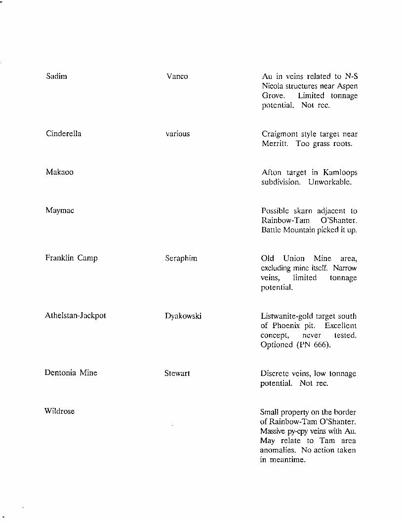
Sadim Vanco A u in veins related to N-S Nicola structures near Aspen Grove. Limited tonnage potential. Not rec.
Cinderella various Craigmont style target near Merritt. Too grass roots.
Makaoo Afton target in Kamloops subdivision. Unworkable.
Maymac Possible skarn adjacent to Rainbow-Tarn O'Shanter. Battle Mountain picked it up.
Franklin Camp Seraphim Old Union Mine area, excluding mine itself. Narrow veins, limited tonnage potential.
Athelstan-Jackpot Dyakowski Listwanite-gold target south of Phoenix pit. Excellent concept, never tested. Optioned (PN 666).
Dentonia Mine Stewart Discrete veins, low tonnage potential. Not rec.
Wildrose Small property on the border of Rainbow-Tarn O'Shanter. Massive py-cpy veins with Au. May relate to Tarn area anomalies. No action taken in meantime.

Croesus Skarn showing near Greenwood. Low PM's and BM's . Not rec.
Lucky Peto Porphyry prospect N E of Princeton. Much previous work. Nice system but low grade and poor location (farmland). Not rec.
Ophir - Ken Bombini Adjacent to Ath-Jack. If exploration concept works there, will be worth acquiring. No action in the meantime.
Siwash Adjacent to Fairfield/Placer play. Porphyry potential eliminated. Good high grade vein potential but low tonnage prospects therefore not rec.
Riverside Rock Ck. Res. Tertiary veins and breccias near Rock Creek. Also l i s t w a n i t e a f f i n i t i e s . I n t e r e s t i n g r e s u l t s . Monitoring.
Oro Denora Kettle R. Res. Skarn east of Phoenix. Many showings, past production. Needs modern exploration effort. Bid made but Can a max outbid.

Four Metals Bahris Vein system in Kobau of N . Washington. Some skarn potential. Evaluated thoroughly but see limited tonnage potential. Not rec.
Dickens-Deadman Dickens Three properties on Deadman River structure between Kamloops Lake and Vidette. Still under review.
Midway Robertson Several claim blocks staked on Mag highs near Midway. Very grass roots. No action taken at this time.
Whipsaw Worldwide Long known porphyry near Princeton. Large system, Cu-Mo, peripheral A u potential. Under review.

PROJECT EXPENDITURE SUMMARY 1990
PROJECT NAME: BRENDA GENERAL PROJECT NO. 658
GEOLOGY
Salaries
Travel Expenses
Contract Payments
Field Expenses
Analyses
$30,188
$1,737
$350
$14,740
$0 $47,015 8 7 %
GEOPHYSICS
Salaries
Travel Expenses
Contract Payments
Field Expenses
$82
$0
$0
$0 $82 0%
GEOCHEMISTRY
Salaries
Travel Expenses
Contract Payments
Field Expenses
Analyses
$2,141
$78
$0
$222
$2,695 $5,136 9%
DRILLING
Salaries
Travel Expenses
Contract Payments
Field Expenses
Analyses
$0
$0
$0
$0
$0 $0 0%
Line Cutting $0 0%
Trenching $0 0%
Hotels and Meals $1,883 3%
Option Payments $0 0%
Property Maintenance $0 0%
Other $0 0%
TOTAL EXPENDITURES $54,116 |
PROJECT EXPENDITURE SUMMARY 1990
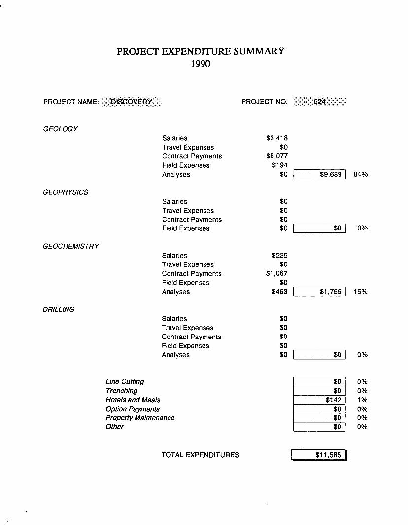
PROJECT NAME: DISCOVERY PROJECT NO. 621
GEOLOGY
Salaries
Travel Expenses
Contract Payments
Field Expenses
Analyses
$3,418
$0
$6,077
$194
$0 $9,689 840/o
GEOPHYSICS
Salaries
Travel Expenses
Contract Payments
Field Expenses
$0
$0
$0
$0 $0 0%
GEOCHEMISTRY
Salaries
Travel Expenses
Contract Payments
Field Expenses
Analyses
$225
$0
$1,067
$0
$463 $1,755 15%
DRILLING
Salaries
Travel Expenses
Contract Payments
Field Expenses
Analyses
$0
$0
$0
$0
$0 $0 0 %
Line Cutting $0 0%
Trenching $0 0 %
Hotels and Meals $142 1 %
Option Payments $0 0 %
Property Maintenance $0 0 %
Other $0 0 %
TOTAL EXPENDITURES $11,585 |

Clearwater,
YALAKOM
Pemberton Lillooet Lake
LOO Mile House A GOLDSTREAM
HONEYMOON
CHU CHUA GOLD HILL\
CHINOOK \ # B A R \ % ^ S ^ 1 A T 0 S U M
Barriere J^^^J:{ Shuswap MT. ARM0U2? ^ ^
LAST CHANCE
OK SBS
Kamloops i Lalct KAMLOOPS
Lillooet I Cache Creek
AFTON
SPROUT
Lytton
.CLAPPER
Merritt'
3fe MAGGIE ^ BRITANNIA
' O :
NORTH FORK
^SIMILK^ Hope
HEDLEY A
STUMP LAKE- .
GOLDSTAR A {//••.• HUNTINGTON!/
•; "w a r t
BRENDA
EJ&^FERROUX •-
.•, A-Beaver dell «'Pen tic ton \.".
A J ^ , A DUSTY\MAC INCO
nceton^
ATHELSTON JACKPOT
KeremeoB-^RtCHTER' L VELVET
'. VANCOUVER!
-'"Grand Forks RAINBOW TAM O'SHANTER
B.C. CANADA _ V JV A R E A A KETTLE
HECLA A # R e p " b U c
100 kilometers
Bellingham
MINNOVA inc FILE: D:\DWG\SOJVAREA
Joint Venture Properties
^ MINNOVA Properties
A Other Properties of Interest
MINNOVA I n c . / B R E N D A SOUTH OKANAGAN
JOINT V E N T U R E A R E A
DRH/sg JANUARY 1991

R A I N B O W - T A M O ' S H A N T E R
P N 661
Ian D . Pirie
INTRODUCTION
The Rainbow - Tarn O'Shanter property is part of the Brenda J V . It was
optioned in January of 1990 to cover a large part of the Tertiary Toroda Graben west of
the town of Greenwood. The rocks on the 3004- unit property hold significant potential
for skarn, porphyry and epithermal mineralization.
The property is under option from Dentonia Resources and Kettle River
Resources and a small portion of it is subject to an underlying agreement with D . Moore
("the Moore Option"). Minnova was attracted to it by past results from work done by
various operators who had various parts (but never all) of the property at various times.
In addition, a 1989 heavy mineral stream sediment survey had highlighted several of the
property's drainages.
1990 PROGRAM
Work by Minnova in 1990 was concentrated in the Midway Mine and Tarn
O'Shanter areas of the property with only limited reconnaissance work elsewhere. It
consisted of the following:
Linecutting
Geology
Geophysics
52.3 km on the Midway and Tarn grids
52 km
45.8 km Mag and VLF
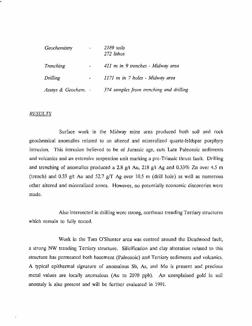
Geochemistry - 2189 soils
272 lithos
Trenching - 411 m in 9 trenches - Midway area
Drilling - 1171 m in 7 holes - Midway area
Assays & Geochem. - 374 samples from trenching and drilling
RESULTS
Surface work in the Midway mine area produced both soil and rock
geochemical anomalies related to an altered and mineralized quartz-feldspar porphyry
intrusion. This intrusion believed to be of Jurassic age, cuts Late Paleozoic sediments
and volcanics and an extensive serpentine unit marking a pre-Triassic thrust fault. Drilling
and trenching of anomalies produced a 2.8 g/t A u , 218 g/t A g and 0.33% Z n over 4.5 m
(trench) and 0.33 g/t A u and 52.7 g/T A g over 10.5 m (drill hole) as well as numerous
other altered and mineralized zones. However, no potentially economic discoveries were
made.
Also intersected in drilling were strong, northeast trending Tertiary structures
which remain to fully tested.
Work in the Tam O'Shanter area was centred around the Deadwood fault,
a strong N W trending Tertiary structure. Silicification and clay alteration related to this
structure has permeated both basement (Paleozoic) and Tertiary sediments and volcanics.
A typical epithermal signature of anomalous Sb, As, and M o is present and precious
metal values are locally anomalous (Au to 2070 ppb). A n unexplained gold in soil
anomaly is also present and will be further evaluated in 1991.

RECOMMENDA TIONS
1. Follow up epithennal targets in the Tarn O'Shanter area.
2. Further evaluate Tertiary structures in the Midway area and test for skarn
potential at the Phoenix stratigraphic level.
3. Evaluate Tertiary structures on the rest of the property.

PROJECT EXPENDITURE SUMMARY 1990
PROJECT NAME: RAINBOW PROJECT NO. 661
GEOLOGY
Salaries
Travel Expenses
Contract Payments
Field Expenses
Analyses
$48,552
$1,718
$0
$24,061
$0 $74,331 2 2 %
GEOPHYSICS
Salaries
Travel Expenses
Contract Payments
Field Expenses
$0
$0
$50,076
$0 $50,076 15%
GEOCHEMISTRY
Salaries
Travel Expenses
Contract Payments
Field Expenses
Analyses
$10,313
$0
$0
$1,399
$31,177 $42,889 1 3 %
DRILLING
Salaries
Travel Expenses
Contract Payments
Field Expenses
Analyses
$11,078
$0
$68,434
$4,598
$5,233 $89,343 2 7 %
Line Cutting $9,200 3 %
Trenching $10,000 3 %
Hotels and Meals $10,276 3 %
Option Payments $38,000 1 1 %
Property Maintenance $4,770 1 %
Other (property acquisition) $7,134 2 %
TOTAL EXPENDITURES $336,019 |
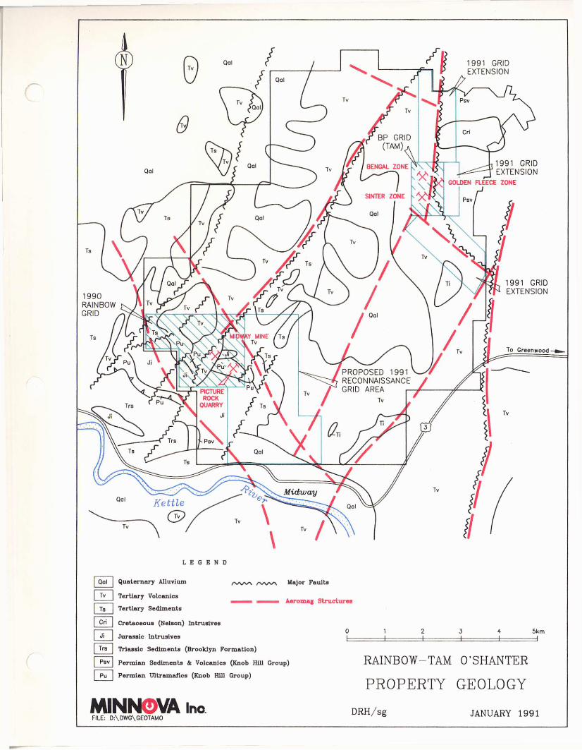
1 9 9 1 GRID EXTENSION
1991 GRID EXTENSION
To Greenwood
L E G E N D
Qal Quaternary Alluvium
Tv Tertiary Volcanics
Ta j Tertiary Sediments
Cretaceous (Nelson) Intrusives
/ v w \ / - s / w n Major Faults
• i i n - ' ini Aeromag Structures
Cri
| J' | Jurassic Intrusives 5km
=1 Trs Triassic Sediments (Brooklyn Formation)
[ Psv | Permian Sediments & Volcanics (Knob Hill Group)
| Pu | Permian Ultramafics (Knob Hill Group)
MINNOVA ho FILE: D:\DWG\GEOTAMO
RAINBOW- TAM O'SHANTER
PROPERTY GEOLOGY
DRH/sg JANUARY 1991
A T H E L S T A N - J A C K P O T
P N 666
C.J. Clayton
INTRODUCTION
The Athelstan-Jackpot property is situated within the Greenwood Mining
Division of south-central British Columbia, approximately 9 km east-southeast of
Greenwood, 4 km southeast of Phoenix, and 12 road km northwest of Grand Forks, B .C.
The property was acquired around the middle of the 1990 field season and covers an
area that has been worked intermittently in the past. Exploration of the property has
become more active in recent years. Gold is associated with massive arsenopyrite and
pyrite lenses within carbonate altered serpentinite (listwanite) forming large tabular lodes,
as well as smaller vein-like mineralised zones. The base of the serpentinite is defined by
the Lind Creek Thrust, an east-northeast trending, shallow north dipping fault.
Mineralising solutions are thought to have moved along the basal thrust and upward
along steep northeast trending faults that intersect the thrust.
1990 PROGRAM
As the property was acquired only recently Minnova's 1990 exploration
program consisted of re-establishing the 1986 grid, reconnaissance geological mapping, and
sampling of surface showings and outcrops.
Linecutting - approximately 25 km of existing grid was re-established and re-picketed at 25 m intervals.
Geology - 1:2000 mapping of 8 km of grid
Geochemistry - 32 rock samples were taken; 17 were analyzed for a 12 element ICP (Ag, As, Cu, Mn, Mo, Na, Ni, Pb, Sb, Zn, Cr) +Au, 15 for trace elements and major oxides.
R E S U L T S
Mapping of the area indicated that several previously outlined magnetic
anomalies were the result of strongly magnetic serpentinite zones. Not surprisingly,
several soil geochemical anomalies (Au, As) coincided with the Athelstan and Jackpot
workings within listwanite zones. One sample of quartz vein material from an old
working returned values of 4.2 g/t A u (0.123 oz/t) and 16.5 ppm Ag . Another sample of
a carbonate-clay altered shear/fault zone within listwanite returned 2.71 g/t A u (0.079 oz/t)
over approximately 0.5 metres.
Many of the old pits, shafts, and workings were located and mapped in but
not sampled in great detail as the immediate ground surrounding the openings was
considered unstable and unsafe at this time.
R E C O M M E N D A T I O N S
1. A program of systematic, representative sampling and mapping (1:1000) of
all old surface workings is recommended. This will provide a better
understanding of the nature of mineralisation in the area, as well as
providing information about mechanisms that may have a controlling
influence on where mineralisation occurs.

2. Magnetometer and V L F surveys are suggested to provide information on
structure and stratigraphy in the area. A brief compilation of 1990 mapping
and previous V L F geophysics shows that many of the old workings occur in
areas of shear/fault zones having coincident east-northeast trending V L F
conductor axes. This may be important in further exploration in other
areas of the property.
3. Soil sampling and litho-geochemical sampling should be conducted over the
re-established grid. Orientation surveys over mineralised and unmineralised
areas may be advisable to determine an appropriate suite of elements for
analysis, and for determining background values in the area.
4. Drilling of the best target areas will naturally follow the exploration
program. The intersection of the steep northeast trending structures with
the basal thrust is an excellent target area.

PROJECT EXPENDITURE SUMMARY 1990
PROJECT NAME: ATHELSTAN PROJECT NO. 666
GEOLOGY
Salaries
Travel Expenses
Contract Payments
Field Expenses
Analyses
$1,408
$0
$0
$305
$0 $1,713 10%
GEOPHYSICS
GEOCHEMISTRY
DRILLING
Salaries
Travel Expenses
Contract Payments
Field Expenses
Salaries
Travel Expenses
Contract Payments
Field Expenses
Analyses
Salaries
Travel Expenses
Contract Payments
Field Expenses
Analyses
$0
$0
$0
$0
$319
$0
$0
$0
$633
$0
$0
$0
$0
$0
$0
$952
0 %
6 %
$0 0 %
Line Cutting $3,300 2 0 %
Trenching $0 0 %
Hotels and Meals $187 1 %
Option Payments $10,530 6 3 %
Property Maintenance $85 1 % Other $0 0 %
TOTAL EXPENDITURES $16,767 |

A T H E L S T A N - J A C K P O T PROPERTY
1990 WORK SUMMARY C J C / s g JANUARY 1991