Minnesota Geospatial Information Office A Program Area of MN.IT Services September 23, 2015...
57
Minnesota Geospatial Information Office A Program Area of MN.IT Services September 23, 2015 Statewide Geospatial Advisory Council
-
Upload
marvin-turner -
Category
Documents
-
view
216 -
download
1
Transcript of Minnesota Geospatial Information Office A Program Area of MN.IT Services September 23, 2015...

Minnesota Geospatial Information OfficeA Program Area of MN.IT Services
September 23, 2015
Statewide Geospatial Advisory Council

Minnesota Geospatial Information OfficeA Program Area of MN.IT Services
• Call to order and introductions• Approval of June 24, 2015 meeting minutes• New council leadership team• Purpose of new leadership team• Clarifying the mission and role of the council• Discussion: Role of committees and workgroups• Break – Networking 30 min• Legislative update• Updates on major initiatives
– Next Generation 9-1-1– Vegetation buffer strip legislation/project– Parks and trails projects– MnGeo priority projects
• Conference updates• Announcements or other business• Adjourn
AGENDA

Minnesota Geospatial Information OfficeA Program Area of MN.IT Services
Where are you from?
What do you hope to bring to the Council?
What do you hope to get out of participation?
Welcome to the new term!
Introductions

Minnesota Geospatial Information OfficeA Program Area of MN.IT Services
Nancy Rader, MnGeo
Approval of June 24 minutes

Minnesota Geospatial Information OfficeA Program Area of MN.IT Services
New Council Leadership Team

Minnesota Geospatial Information OfficeA Program Area of MN.IT Services
New Council Leadership Team
1. Based on input from the members
2. 3-5 members
3. Set agenda and direction
4. Will meet between Council meetings
5. Elect Council Chair & Vice Chair

Minnesota Geospatial Information OfficeA Program Area of MN.IT Services
Leadership Team - Roles
Chair 1. Chair leadership team & Council
2. Work with CGIO & Council to set direction
3. Work with leadership team, CGIO & members’ input to set meeting agendas

Minnesota Geospatial Information OfficeA Program Area of MN.IT Services
Leadership Team - Roles
Vice Chair1. Serve as lead to obtain input from Council
members and Committees and Workgroups
2. Assist and fill in for Chair as needed
3. Provide input to help set direction
4. Provide input to help develop agendas

Minnesota Geospatial Information OfficeA Program Area of MN.IT Services
Leadership Team - Roles
Member1. Provide input
2. Assist in gathering input from Council members, Committees and Workgroups and the broader community in defining topics and setting agendas
Minnesota Geospatial Information OfficeA Program Area of MN.IT Services
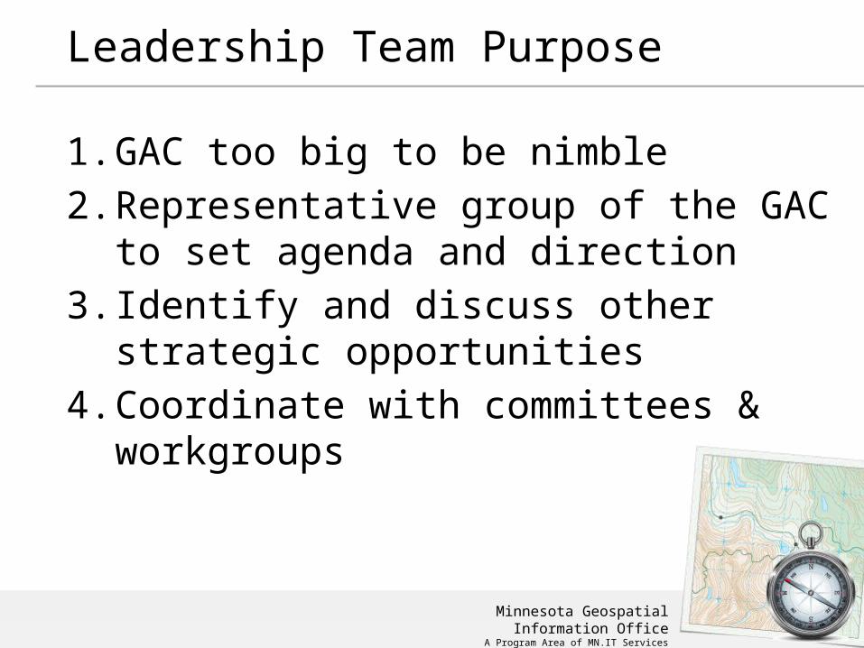
Leadership Team Purpose
1. GAC too big to be nimble
2. Representative group of the GAC to set agenda and direction
3. Identify and discuss other strategic opportunities
4. Coordinate with committees & workgroups

Minnesota Geospatial Information OfficeA Program Area of MN.IT Services
Clarifying the Mission and Role of the Council

Minnesota Geospatial Information OfficeA Program Area of MN.IT Services
Mission and Role of GAC
1. Background on GCGI
2. Background on GAC creation
3. What GAC has been and could be
4. Language
5. Feedback and discussion

Minnesota Geospatial Information OfficeA Program Area of MN.IT Services
Mission and Role of GAC
Governor’s Council on Geographic Information
1. Predecessor to the SWGAC
2. 1993 to 2009
3. MissionThe mission of the council is to promote efficient and effective use of resources by providing leadership and direction in the development, management and use of geographic information in Minnesota. The council makes recommendations in areas including, but not limited to: policies, institutional arrangements, standards, education and stewardship.

Minnesota Geospatial Information OfficeA Program Area of MN.IT Services
Mission and Role of GAC
Statewide Geospatial Advisory Council• 2009-
– Mission = advise MnGeo– Led and directed by MnGeo
• Opportunity…– Coordinate for geospatial community– Be more self directed

Minnesota Geospatial Information OfficeA Program Area of MN.IT Services
SWGAC Legislation
(a) The chief information officer must utilize a governance structure that includes an advisory council to provide recommendations for improving the operations and management of geospatial technology within state government and also on issues of importance to users of geospatial technology throughout the state.
(b) The Geospatial Advisory Council must advise the Minnesota Geospatial Information Office regarding the improvement of services statewide through the coordinated, affordable, reliable, and effective use of geospatial technology.

Minnesota Geospatial Information OfficeA Program Area of MN.IT Services
SWGAC Mission
Advise, support and make recommendations to MnGeo for improving services statewide through the coordinated, affordable, reliable, and effective use of geospatial technology.

Minnesota Geospatial Information OfficeA Program Area of MN.IT Services
SWGAC Guiding Principles
1. Promote effective investments in geospatial information
2. Promote geospatial information as a shared public resource
3. Support the establishment and use of geospatial standards and guidelines
4. Champion collaboration among geospatial practitioners and related stakeholders
5. Educate and inform policymakers related to the value and use of geospatial technology
6. Provide a forum for ideas and issues to be shared and acted upon by the geospatial community
7. Encourage all council sectors to contribute to the state geospatial infrastructure
8. Encourage all council members to communicate outcomes with relevant stakeholders
9. Encourage geospatial education at all levels

Minnesota Geospatial Information OfficeA Program Area of MN.IT Services
SWGAC Mission – concept language
Advise, support and make recommendations to MnGeo and act as a coordinating body for the Minnesota geospatial community, for improving services statewide through the coordinated, affordable, reliable, and effective use of geospatial technology.
Examples of work: • setting and endorsing standards • defining policy requirements and driving policy decisions• representing the geospatial community• advocating for project priorities

Minnesota Geospatial Information OfficeA Program Area of MN.IT Services
SWGAC Mission
Discussion
Advise, support and make recommendations to MnGeo and act as a coordinating body for the Minnesota geospatial community, for improving services statewide through the coordinated, affordable, reliable, and effective use of geospatial technology.
Examples of work: • setting and endorsing standards • defining policy requirements and driving policy decisions• representing the geospatial community• advocating for project priorities

Minnesota Geospatial Information OfficeA Program Area of MN.IT Services
Role of Committees and Workgroups

Minnesota Geospatial Information OfficeA Program Area of MN.IT Services
Committees and Workgroups
1. What are they?
2. Reporting relationship
3. Status
Minnesota Geospatial Information OfficeA Program Area of MN.IT Services
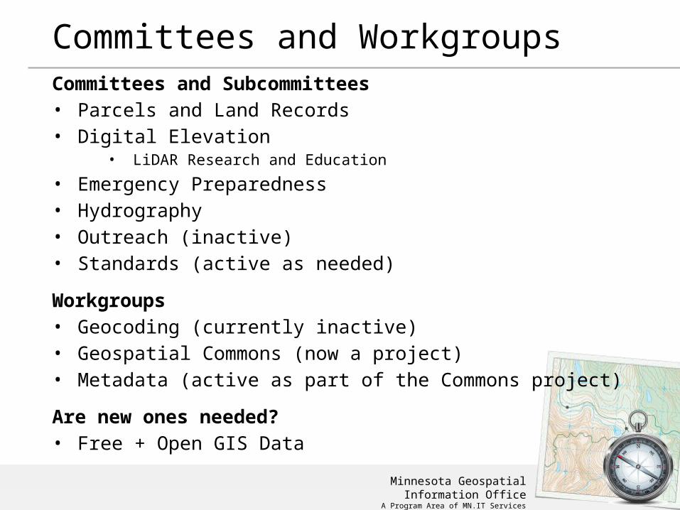
Committees and WorkgroupsCommittees and Subcommittees• Parcels and Land Records• Digital Elevation
• LiDAR Research and Education
• Emergency Preparedness• Hydrography• Outreach (inactive)• Standards (active as needed)
Workgroups• Geocoding (currently inactive)• Geospatial Commons (now a project)• Metadata (active as part of the Commons project)
Are new ones needed? • Free + Open GIS Data

Minnesota Geospatial Information OfficeA Program Area of MN.IT Services
Committees and Workgroups
Reporting relationships
1. Who do/should committees and workgroups report to?
2. MnGeo?
3. SWGAC?
4. State Geospatial Technical Committee?
5. One? Some? All?

Minnesota Geospatial Information OfficeA Program Area of MN.IT Services
Current Geospatial Governance
GeospatialTechnical
Committee
Commissioner
Statewide Advisory Council
MnGeo
Committees and Workgroups Standards and
Guidelines
Approval
Broader Geospatial Community
App
rove
d St
anda
rd o
r Pol
icy
Inpu
t and
idea
s on ne
eded
Stan
dard
s
Com
mun
icatio
n to Co
mm
unity
Gui
de a
nd a
ppro
ve
Inpu
t, G
uida
nce
Rec
omm
enda
tion
s, In
form
atio
n Sh
arin
g
Input, Guidance Recommendations, Information
Sharing
Input and ideas on needed Standards Communication to Community
Statewide Advisory Council

Minnesota Geospatial Information OfficeA Program Area of MN.IT Services
Committees and Workgroups
Current Status

Minnesota Geospatial Information OfficeA Program Area of MN.IT Services
+
30 minutes…

Minnesota Geospatial Information OfficeA Program Area of MN.IT Services
Legislative Update

Minnesota Geospatial Information OfficeA Program Area of MN.IT Services
Legislative happenings related to GIS
Three legislative actions…
1. Buffer strips along waterways
2. U of M Parks and Trails effort
3. 9-1-1 – Increase in fees to support the build out of Next Generation 9-1-1

Minnesota Geospatial Information OfficeA Program Area of MN.IT Services
Tim Loesch, MN.IT @ DNR
Status – Buffer Strips Along Public Waters

Minnesota Geospatial Information OfficeA Program Area of MN.IT Services
Legislation - Water Quality Improvement
(1) for all public waters, the more restrictive of:(i) a 50-foot average width, 30-foot minimum
width, continuous buffer of perennially rooted vegetation; or
(ii) the state shoreland standards and criteria adopted by the commissioner under section 103F.211; and
(2) for public drainage systems established under chapter 103E, a 16.5-foot minimum width continuous buffer of perennially rooted vegetation on ditches within the benefited area of public drainage systems.

Minnesota Geospatial Information OfficeA Program Area of MN.IT Services
Legislation - Water Quality Improvement
Buffer Strips$325,000 the first year and $325,000 the second year are for analysis and mapping in each county related to compliance with riparian buffer or alternate practice requirements and to provide statewide coordination and guidance to local units of government for implementation of buffer requirements. Maps must be provided to local units of government and made available to landowners on the Department of Natural Resources' Web site.

Minnesota Geospatial Information OfficeA Program Area of MN.IT Services
Minnesota Parks and Trails74.7 (e) $536,000 the first year and $555,000 the
74.8 second year are for coordination and projects
74.9 between the department, the Metropolitan
74.10 Council, and the Greater Minnesota Regional
74.11 Parks and Trails Commission; enhanced
74.12 Web-based information for park and trail
74.13 users; and support of activities of the Parks
74.14 and Trails Legacy Advisory Committee. Of
74.15 this amount, $260,000 the first year shall
74.16 be used for a grant to the University of
74.17 Minnesota Center for Changing Landscapes
74.18 to complete a legacy tracking project and
74.19 to implement a survey on use patterns, user
74.20 needs, and perceptions related to parks and
74.21 trails in Minnesota. The tracking project and
74.22 survey work must be done in collaboration
74.23 with the Department of Natural Resources,
74.24 Metropolitan Council, and Greater Minnesota
74.25 Regional Parks and Trails Commission.

Minnesota Geospatial Information OfficeA Program Area of MN.IT Services
Minnesota Parks and Trails
• Multiple projects• Three aspects
• Informational website• Legacy Fund tracking• Survey of Use - user needs, and perceptions
related to parks and trails in Minnesota
• Status – planning for moving all three forward is in process

Minnesota Geospatial Information OfficeA Program Area of MN.IT Services
• 9-1-1 – Increase in fees to support the build out of Next Generation 9-1-1
• Project is moving forward

Minnesota Geospatial Information OfficeA Program Area of MN.IT Services
Preparing for the 2016 Legislative Session
Is there new legislation needed?

Minnesota Geospatial Information OfficeA Program Area of MN.IT Services
Updates on major initiatives

Minnesota Geospatial Information OfficeA Program Area of MN.IT Services
Next Generation 9-1-1 GIS ProjectStatus Update9/22/2015Adam Iten, MnGeo

Minnesota Geospatial Information OfficeA Program Area of MN.IT Services
• Public Safety Answering Point (PSAP) Request for Information – Summary Report
• Initial NG9-1-1 GIS Data Collection• NG9-1-1 GIS Data Assessment and Preparation• Minnesota NG9-1-1 GIS Standards• Communication Plan
Current Tasks
Minnesota Geospatial Information OfficeA Program Area of MN.IT Services
PSAP RFI – Summary Report
• RFI purpose: to assess the status of GIS data and software at every PSAP in Minnesota
• Response status: 95 of 105 PSAPs (90%)
• Summary Report
• Distributed to stakeholders on 8/20
• Available on ECN website: https://dps.mn.gov/divisions/ecn/programs/911/Pages/gis-information.aspx
Minnesota Geospatial Information OfficeA Program Area of MN.IT Services
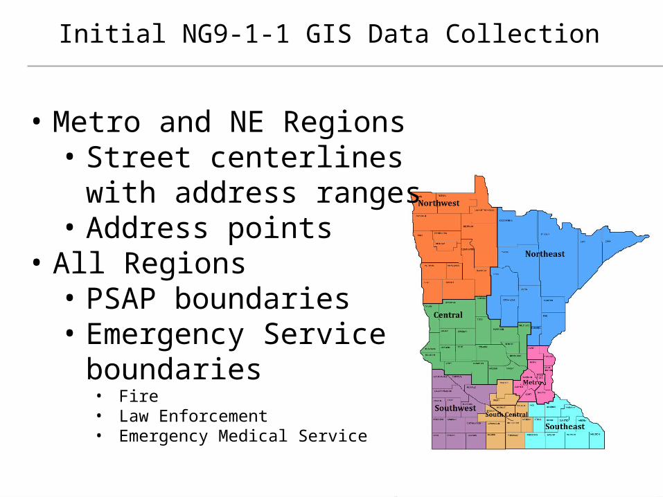
Initial NG9-1-1 GIS Data Collection
• Metro and NE Regions• Street centerlines with
address ranges• Address points
• All Regions• PSAP boundaries• Emergency Service
boundaries• Fire• Law Enforcement• Emergency Medical Service

Minnesota Geospatial Information OfficeA Program Area of MN.IT Services
NG9-1-1 GIS Data Assessment and Preparation
• NG9-1-1 GIS data request• FirstNet – needs all Public Safety Entity boundaries for reporting
purposes• MnGeo – inventory existing NG9-1-1 GIS data, build internal
processes, field mapping (local vs NENA schemas)• New GIS data workflow and repository• Document MESB’s current 9-1-1 GIS data preparation
processes in Metro region• Plan for NE region

Minnesota Geospatial Information OfficeA Program Area of MN.IT Services
Minnesota NG9-1-1 GIS Standards
• GIS data requirements for NG9-1-1 in Minnesota
• Align with NENA Standards
• Standards Workgroup
• Review and approval
• GIS Subcommittee
• NG9-1-1 Committee
• Statewide Emergency Communications Board (SECB)
• Statewide Geospatial Advisory Council (SWGAC)
• MN.IT
• Other States

Minnesota Geospatial Information OfficeA Program Area of MN.IT Services
Communication Plan
• ECN website
• Monthly
• Project newsletter
• GIS Subcommittee meeting
• NG9-1-1 Committee meeting
• SECB meeting
• Quarterly
• Regional PSAP/GIS meetings
• Statewide Geospatial Advisory Council

Minnesota Geospatial Information OfficeA Program Area of MN.IT Services
MN Department of Administration preparing an RFP for aerial imagery and planimetric mapping as a MSC Goal: pre-select 3 to 5 qualified vendors to bid on work orders
issued by government organizations As needs arise, new orders can be issued over the life of contract Available to all CPV members and state agencies Active between 2016 and 2020
Tentative Schedule RFP expected to be issued around October 1 Work orders expected to be accepted by year’s end Metropolitan Council preparing to fly in Spring 2016
Update will be given at Consortium Conference Session 9: Thursday 1:30 – 3:00
Aerial Imagery Master Services Contract

Minnesota Geospatial Information OfficeA Program Area of MN.IT Services
Address PointsMultiple efforts going on…MetroGIS – develop and implement a workflow and technical solution for gathering address point data from the seven metro counties, aggregating the data into one file and distributing the points, metadata and other supplementary information to the user community.
Next Generation 9-1-1 – create and perpetuate a standards-based statewide address point file suitable for meeting the needs of NextGen 9-1-1
Where we are at – Comparing data models and assessing data received by counties
Goal – Choose a standard and understand the need for supporting tools and processes by the end of October 2015

Minnesota Geospatial Information OfficeA Program Area of MN.IT Services
ParcelsBackgroundIn the works for some timewww.mngeo.state.mn.us/committee/standards/parcel_attrib/parcel_attrib.html
Business plan developed some time ago
Multiple standards have slowed the approval process
Data sharing beginning to open up thus bringing forward the need to move forward on a standard
Recent statewide data collection efforts require that a standard needs to be agreed upon

Minnesota Geospatial Information OfficeA Program Area of MN.IT Services
Status of current effort….
Recently met with Parcels and Land Records Committee and State Agencies to move discussion forward
Agreed on the DCDATS proposed standard with new ownership characteristics from NE MN work www.mngeo.state.mn.us/committee/cadastral/index.html

Minnesota Geospatial Information OfficeA Program Area of MN.IT Services
DCDATS +Proposal is to have DCDATS include a new attribute representing Generalized Ownership
Proposed domain:1 = County Fee2 = Tax Forfeit3 = State of Minnesota4 = United States of America5 = Municipal6 = Unknown7 = No Value8 = Tribal9 = Private

Minnesota Geospatial Information OfficeA Program Area of MN.IT Services
Next Steps• Compile input from State Agencies – Complete
• Meet with Land Records and Parcels Committee to gather their input – Complete
• Propose a direction• DCDATS + in short term – PRISM long term if
can more closely meet agency needs• Parcel Fabric template to improve adoption
• Standards Committee• Vet the direction – multiple groups

• Focus - Migration of all significant state geospatial resources to the Geospatial Commons
• Published resources accessible
• 15 Organizations• 443 Resources
• The site is now open to broader participation
• Integrating partners who want to represent their data via the Geospatial Commons
• Setting up Metadata Training
Status
MN Geospatial Commons

Minnesota Geospatial Information OfficeA Program Area of MN.IT Services
Conference Updates

Big take-aways from the FOSS4G Big Bang!
GeoForAll – “Our key aim is to make it possible for students in developing and poor developing and poor countries to be also able to get geospatial education” http://www.geoforall.org/ Internet of Things – SensorThings API: OGC standard to provide open and unified way to interconnect IoT devices, data and apps over the Webhttp://ogc-iot.github.io/ogc-iot-api/ OpenAerialMap – Distributed Commons for Searching and Hosting Free Imageryhttp://openaerialmap.org/
OpenDroneMap – Open Source Toolkit for processing Civilian Drone Imagery.http://opendronemap.github.io/odm/ http://2015.foss4g.org/
http://2015.foss4g.org/
GeoServer, PostGIS

To develop and support the GIS professional in Minnesota for the benefit of
our state and its citizens.
MN GIS/LIS Conference
Update

Minnesota Geospatial Information OfficeA Program Area of MN.IT Services
NACIS – Conference and Annual Meeting

Minnesota Geospatial Information OfficeA Program Area of MN.IT Services
La Crosse GIS Conference – May 2016
Explore mid-level and above GIS manager (city, county, state) emerging and hot button issues which typically do not receive in-depth consideration at either state or local events.
Program Committee is considering (full or partial tracks):
– Open data issues– Open source software solutions– Recent LiDAR developments– UAS/UAV/Drone technology explosion
and related information– Big Data– Government collaborative efforts and
issues– Utility and building information
management developments– Smart Grid
A joint event hosted by the following organizations:
Geospatial Information & Technology Association (GITA)
American Society for Photogrammetry and Remote Sensing – Western Great Lakes Region (ASPRS-WGLR)
Illinois GIS Association (ILGISA)
Iowa Geographic Information Council (IGIC)
MN GIS/LIS Consortium (MN GIS/LIS)
Wisconsin Land Information Association (WLIA)
SharedGeo (SG)

Minnesota Geospatial Information OfficeA Program Area of MN.IT Services
Announcements or other business

Minnesota Geospatial Information OfficeA Program Area of MN.IT Services
Adjourn…
Next meeting dates:
December 2, 2015March 2, 2016June 1, 2016