Mining with intelligence...mining lifecycle will ensure effective mineral production and deliver...
8
VIEW POINT Abstract The emergence of geospatial technologies such as GIS platforms and smart mapping herald a radical transformation in mining operations and promise a host of business benefits through strategic decisions obtained from map-driven intelligence enabling better risk mitigation and augmenting mine productivity, profitability with operational intelligence. The advent of geospatial technologies for mining industry effectiveness MINING WITH INTELLIGENCE
Transcript of Mining with intelligence...mining lifecycle will ensure effective mineral production and deliver...

VIEW POINT
Abstract
The emergence of geospatial technologies such as GIS platforms and smart mapping herald a radical transformation in mining operations and promise a host of business benefits through strategic decisions obtained from map-driven intelligence enabling better risk mitigation and augmenting mine productivity, profitability with operational intelligence.
The advent of geospatial technologies for mining industry effectiveness
MINING WITH INTELLIGENCE

External Document © 2020 Infosys Limited
• The need for proper demarcation of mine leases
• The use of complex and cumbersome methods for the discovery and extraction of ore minerals
• The inadequacies in fulfilling the demand of advanced technological platforms for managing mining and drilling databases
• Ineffective monitoring practices for the movement of mining fleet and equipment
• Unexpected failures of equipment due to excessive usage or poor maintenance
• Inadequate monitoring of stable assets like mineral ores that can be mined efficiently and movable assets like manpower
• The difficulties of adhering to stringent environmental compliance regulations
Rising demand and mining growth
Over the last two decades, a growing
need for industries and infrastructure
in developing economies has greatly
increased the demand for metals
and economically valuable minerals.
Simultaneously, sustainable mining laws
have been implemented by government
agencies to check the severe stress on
the environment caused by the industry.
However, even as the industry grows, its
operations are hampered by several major
challenges namely:

External Document © 2020 Infosys Limited
The importance of spatial data
The majority of proposed mining projects involve using various scientific tools for defining the geographies of prospective sites. Because mining is spatial in nature with location the key entity for mine planning, reliable geospatial data is essential to establish the intimate relationship between the earth’s surface and sub-surface horizons to discover precise ore bodies. From the targeting of
mineral potential to mine closure activities and attaining government approvals, all of these involve collection, compilation, processing, analyzing, displaying, and archiving volumes of surface and sub-surface mine data.
Once a mining lease is approved, even the movement of materials, fleets, monitoring of equipment’s, reclamation activities are
also entirely spatial in nature. To address these operations too, location data has always been key. Thus, the monitoring of stable and movable mine assets, infrastructure elements, and manpower across the mining enterprise requires the usage of geospatial technology platforms that provide overall clarity of what is happening on the ground.
Data Management Analysis & Planning Operational Awareness
External Document © 2020 Infosys Limited
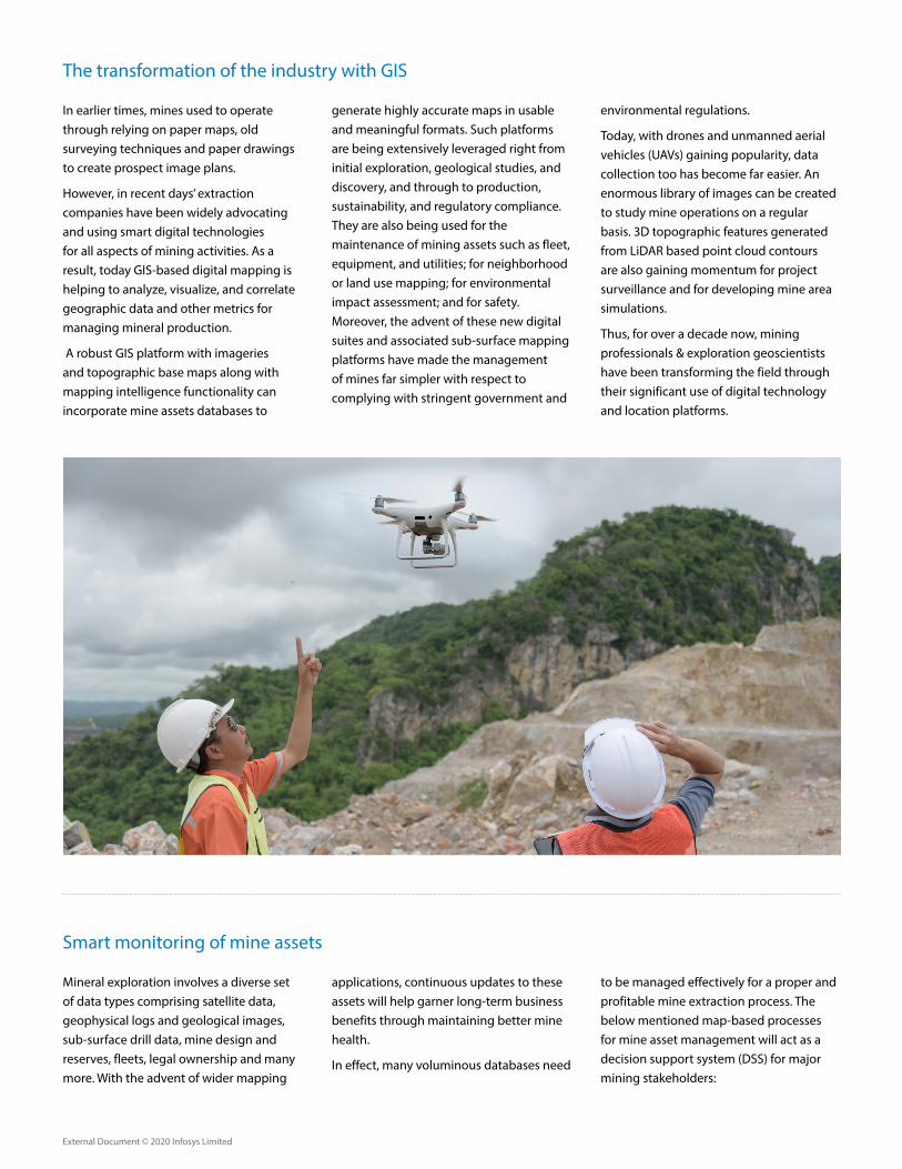
The transformation of the industry with GIS
In earlier times, mines used to operate through relying on paper maps, old surveying techniques and paper drawings to create prospect image plans.
However, in recent days’ extraction companies have been widely advocating and using smart digital technologies for all aspects of mining activities. As a result, today GIS-based digital mapping is helping to analyze, visualize, and correlate geographic data and other metrics for managing mineral production.
A robust GIS platform with imageries and topographic base maps along with mapping intelligence functionality can incorporate mine assets databases to
generate highly accurate maps in usable and meaningful formats. Such platforms are being extensively leveraged right from initial exploration, geological studies, and discovery, and through to production, sustainability, and regulatory compliance. They are also being used for the maintenance of mining assets such as fleet, equipment, and utilities; for neighborhood or land use mapping; for environmental impact assessment; and for safety. Moreover, the advent of these new digital suites and associated sub-surface mapping platforms have made the management of mines far simpler with respect to complying with stringent government and
environmental regulations.
Today, with drones and unmanned aerial vehicles (UAVs) gaining popularity, data collection too has become far easier. An enormous library of images can be created to study mine operations on a regular basis. 3D topographic features generated from LiDAR based point cloud contours are also gaining momentum for project surveillance and for developing mine area simulations.
Thus, for over a decade now, mining professionals & exploration geoscientists have been transforming the field through their significant use of digital technology and location platforms.
Smart monitoring of mine assets
Mineral exploration involves a diverse set of data types comprising satellite data, geophysical logs and geological images, sub-surface drill data, mine design and reserves, fleets, legal ownership and many more. With the advent of wider mapping
applications, continuous updates to these assets will help garner long-term business benefits through maintaining better mine health.
In effect, many voluminous databases need
to be managed effectively for a proper and profitable mine extraction process. The below mentioned map-based processes for mine asset management will act as a decision support system (DSS) for major mining stakeholders:

External Document © 2020 Infosys Limited
The proper demarcation of mining lease boundaries on a GIS platform with no discrepancies provides confidence both to the administrator and the lessee. Such location compliant prospecting licenses maps help mining authorities to prepare for lease auctioning and related working
plans of the mines. Further, it also becomes easier for purchased lessee for linking any other georeferenced mineral information leading to creation of single database system for that particular mineral site.
For instance, nodal government lease
approving agencies like the Indian Bureau of Mines are attempting to restrict encroachment of mining plots and other illegal activities through a georeferenced database of all leased assets, through a single coordinated GIS system.
1. Managing mine leases and mining permits
Mining asset data being spatial in nature can be mapped from available base maps and can be further managed through an effective stand-alone GIS system. This location-based GIS monitoring system can assist with viewing, querying and mapping legal boundaries, geology, resources, topography, environmental impact, and related datasets. Further, such a mapping platform can help with
operating surface and underground mines through transparent tracking of technical manpower working on mine benches, which is critical in-terms of maintaining mining activities round the clock. It can also support with real-time monitoring of mine equipment through giving information on machines available in close proximity to areas requiring specific mining and drilling activities, or on how such
equipment is occupied in mine benches. Such smart mapping applications can also assist with the health assessment and monitoring of these mine assets through automated reports.
Along with GIS digitization and creation of related asset databases, data repositories of such GIS mine layers designed at a data warehouse can be used instantly by decision makers.
2. Developing mine databases and monitoring mine assets
Contour Map generated from Satellite data for a Mine area 3D Terrain mode of a mine site developed using Satellite Stereo Imagery to understand the topography of the mineralized zone
Mineral Anomaly zones from Satellite Image Interpretation and Image classification technique
Sub-surface 3D-Bore hole database managed on location platform

External Document © 2020 Infosys Limited
Environmental compliance is key to both pre- and post-operation of mine activities. Hence GIS and an image platform plays an important role in understanding and monitoring the environmental impact occurring in and around a mine during its operational lifespan.
Environmental impacts can be addressed during mine closure programs using high resolution satellite images or drone data of the pre-operational site as a baseline for comparing with mined-out imagery. The cleanup of historic waste sites like mine and ore waste dumps can be easily
tracked using drone data. Also, acid mine drainage resulting from exposure of rock minerals and ore deposits leading to the concentration of toxic substances in water bodies can be monitored using aerial image acquisition and further processing of such images.
3. Monitoring the environmental impact
The use of temporal high-resolution satellite imagery and continuous usage of drones for data acquisition is gaining momentum to monitor landscape dynamics pertaining to mine lease boundaries & its assets. Land use or land cover analysis of the entire mining premises depicting change detection helps in understanding the site impact. Monitoring of competitors maintaining their mining activities within their assigned boundary pillars helps in tracking any encroachments & illegal actions.
Also, developing predictive models through monitoring land use changes using satellite data as input features to classify pixels of the image as forest, water, land, mineral is an emerging image classification technique in machine-learning algorithms.
4. Addressing site encroachment

External Document © 2020 Infosys Limited
Image annotation of mine objects from high-quality accurate images or videos helps to build a computer vision and machine learning based system to detect several objects like draglines, dozers, pumps, excavators, trucks, loaders, buildings, cables, tractors, and humans at
mine sites. This assists in development of real-time tracking algorithms and relevant models so as to detect mine assets and enable AI-enhanced equipment.
Material transportation in mines is among the biggest challenges of the industry. Hence methods of applying automation
with AI and machine learning into the value chain enables a mine to drive better productivity without breaks. AI has penetrated into the industry with several large companies testing and implementing AI through autonomous trucks and vehicles to manage large scale operations.
5. Developing machine learning models
Looking ahead
Mines are important and productive assets of any country that adds to the economy creating enormous employment opportunities. Hence, they need to be managed effectively, and sustainable mining activities need to be stimulated so as to maintain balance in the usage of our natural resources. For instance, one of our largest mining customer from Australia implements viable mining practices involving satellite studies, GPS, aerial surveys, Image detection, GIS platform as part of their operational workflow and they are continuously realizing the early return on investment as well as maintaining the transition to full mine closure using real-time data for meeting environmental norms.
Decision-makers need to embrace the increasing emergence of geospatial technology platforms and smart maps in the mining industry to revolutionize the way mines function to deliver refined commodities like Iron, Manganese, Chromite, base metals, coal etc. .
• Geospatial services in mining has a potential to lower operational costs by 30-40% through robust asset management and automation framework.
• Even deploying fleet optimization (or driverless automation) in material transformation has proved to reduce 50% loss due to fuel consumption and additional mileage/idle cost.
• Implementation of enterprise GIS will assist miners to eliminate Data redundancies and assists in increased collaboration among various departments deployed at various locations.
Thus such powerful positioning intelligence & real-time dynamics in mining lifecycle will ensure effective mineral production and deliver much-needed business gains through optimized workflows, mitigation of risk, and cost-effective insights into mining operation.
Annotated Mine Objects (autonomous trucks) using AI platform

© 2020 Infosys Limited, Bengaluru, India. All Rights Reserved. Infosys believes the information in this document is accurate as of its publication date; such information is subject to change without notice. Infosys acknowledges the proprietary rights of other companies to the trademarks, product names and such other intellectual property rights mentioned in this document. Except as expressly permitted, neither this documentation nor any part of it may be reproduced, stored in a retrieval system, or transmitted in any form or by any means, electronic, mechanical, printing, photocopying, recording or otherwise, without the prior permission of Infosys Limited and/ or any named intellectual property rights holders under this document.
For more information, contact [email protected]
Infosysbpm.com Stay Connected
References:
1. https://www.mining-technology.com/features/featurelay-of-the-land-the-role-of-geospatial-data-in-mining-4170674/
2. https://www.geospatialworld.net/article/mining-for-more/
3. https://www.esri.com/library/brochures/pdfs/gis-sols-for-mining.pdf
4. https://www.geospatialworld.net/article/mining-lease-survey-using-hybrid-technology/
5. https://www.mckinsey.com/industries/metals-and-mining/our-insights/behind-the-mining-productivity-upswing-technology-enabled-transformation
6. https://www.yellowfinbi.com/blog/2011/08/yfcommunitynews-location-intelligence-for-mining-and-exploration-106713
Authors:
Sudeep Rautray - Domain Lead, GIS Solution Design, Digital Interactive Services, Infosys BPM
Sudeep has over 12 years of work experience in GIS, Image Processing and data management. He has delivered solutions for various industrial segments relating to Mineral & Mining, Agriculture & forestry, Land Administration & Property Tax, Disaster Management, Urban Infrastructure, Utilities. Over the years he has served large corporates, e-governance sector, large utilities, public institutions for India and overseas locations. He has worked as domain consultant for reputed e-governance projects funded by International funding agencies. Immensely involved in project management, & operation activities on large geospatial engagements, has functioned as techno-commercial personal and Solution design professional.
In his current role at Infosys BPM, he is part of Solution design team responsible for pre-sales activities, developing GIS solutions for key industrial verticals, focuses on growth of GIS data services in new segments/geographies.
Sudeep holds a post-graduation degree in Applied Geology from College of Engineering, Anna University, Chennai and has also done his Master of Business Administration.
Dr. V. Pradeep Kishore – Solution Design Head, Infosys BPM
Dr. Pradeep leads the GIS data practice in Infosys BPM. He has close to 21 years of experience in the field of GIS, telecom OSS/BSS, mobility and telematics domain, and is involved in the consulting, solution architecture, program/project management, portfolio management for Indian and overseas clients (US/Middle-East). In Infosys BPM, he is responsible for leading the GTM strategy, presales, consulting, COE accountabilities - creating/owning business modeling/framework and contribution to all lines of GIS business/new wins.
Pradeep holds a Doctorate Degree in Disaster Management (landslides prediction) using GIS/remote sensing and has done his post-graduation in Applied Geology.