MINERALOGY AND CHEMISTRY OF GOLD IN THE .... 31 May 1985 No. 2 MINERALOGY AND CHEMISTRY OF GOLD IN...
12
Vol. 31 May 1985 No. 2 MINERALOGY AND CHEMISTRY OF GOLD IN THE VlRGlLlNA DISTRICT, HALIFAX COUNTY, VIRGINIA Michael A. Linden', James R. Craig2, and Todd N. Solberg* INTRODUCTION The Virgilina district of Halifax County in south central Virginia is a minor but well-documented gold region of the central Appalachians. The dis- trict (Figure I), which extends from Virginia into North Carolina with a total length of about 60 miles, was best known for its copper mines. From the mid-1800's until 1917 the mines in the Virginia portion of the district produced approximately 750,000 pounds of refined copper (Sweet, 1976) as well as significant by-product silver and minor amounts of gold. Gold was recovered primarily from the Red Bank mine and the Luce-Howard mine although numerous trenches, pits, and evi- dences of placer workings are present throughout the area. The district was selected for study because of its accessibility and limited size and because it appears to be representative of many gold occur- rences in Virginia and throughout the Piedmont. HISTORY OF GOLD MINING IN THE DISTRICT The Virgilina district is best known for its pro- duction of copper ores which have been described by Watson (1907), Laney (1917), Sweet (1976), and Sweet and Trimble (1983); much less is known of the gold recovery efforts. Although placer gold was no doubt found in the streams of the Virgilina district in the early to mid- 1800fs, active gold mining only began in about 1903 after the discovery of gold-bearing quartz veins at the site of the Red Bank mine by Mr. H. C. Crowley. The Virgilina Gold Mining Company purchased the property in 1905 and subsequently sarlk two ver- tical shafts, 50 and 200 feet deep, and developed 650 feet of drifts (Laney, 1917). Stoping was con- siderable down to the 70-foot level, but all work apparently was confined to a single vein. Two batteries of five stamps each (Figure 2) were used 1U. S. Forest Service, Roanoke, VA 24001 2Department of Geological Sciences, Virginia Polytechnic Institute and State University, Blacksburg, VA 24061
Transcript of MINERALOGY AND CHEMISTRY OF GOLD IN THE .... 31 May 1985 No. 2 MINERALOGY AND CHEMISTRY OF GOLD IN...

Vol. 31 May 1985 No. 2
MINERALOGY AND CHEMISTRY OF GOLD IN THE VlRGlLlNA DISTRICT, HALIFAX COUNTY, VIRGINIA
Michael A. Linden', James R. Craig2, and Todd N. Solberg*
INTRODUCTION
The Virgilina district of Halifax County in south central Virginia is a minor but well-documented gold region of the central Appalachians. The dis- trict (Figure I), which extends from Virginia into North Carolina with a total length of about 60 miles, was best known for its copper mines. From the mid-1800's until 1917 the mines in the Virginia portion of the district produced approximately 750,000 pounds of refined copper (Sweet, 1976) as well as significant by-product silver and minor amounts of gold. Gold was recovered primarily from the Red Bank mine and the Luce-Howard mine although numerous trenches, pits, and evi- dences of placer workings are present throughout the area. The district was selected for study because of its accessibility and limited size and because it appears to be representative of many gold occur- rences in Virginia and throughout the Piedmont.
HISTORY OF GOLD MINING IN THE DISTRICT
The Virgilina district is best known for its pro- duction of copper ores which have been described by Watson (1907), Laney (1917), Sweet (1976), and Sweet and Trimble (1983); much less is known of the gold recovery efforts.
Although placer gold was no doubt found in the streams of the Virgilina district in the early to mid- 1800fs, active gold mining only began in about 1903 after the discovery of gold-bearing quartz veins a t the site of the Red Bank mine by Mr. H. C. Crowley. The Virgilina Gold Mining Company purchased the property in 1905 and subsequently sarlk two ver- tical shafts, 50 and 200 feet deep, and developed 650 feet of drifts (Laney, 1917). Stoping was con- siderable down to the 70-foot level, but all work apparently was confined to a single vein. Two batteries of five stamps each (Figure 2) were used
1U. S. Forest Service, Roanoke, VA 24001
2Department of Geological Sciences, Virginia Polytechnic Institute and State University, Blacksburg, VA 24061

VIRGINIA DIVISION OF MINERAL RESOURCES

Now2 VIRGINIA MINERALS 19
to crush the vein material into a fine powder which @ was then passed in a stream of running water over
mercury-coated copper amalgamating plates. Large gold grains adhered to the mercury and were recovered; unfortunately, much of the very srnall- sized gold floated across the plates and was lost into the tailings pond. Cyanide leaching equipment was purchased to enhance gold recovery but was apparently never put into operation. Some shafts and drifts were driven at the Luce-Howard prop- erty, but activity there ceased prior to 1912 (Laney, 1917).
Accurate assay and production data are limited, but Watson (1907) reported that during 1906, a 6- foot-wide vein at the Red mine produced 10 tons of ore a day which were milled at an average value of $8.00 per ton. Based on the then current price of gold of $20.67 per troy ounce, the vein averaged at least 0.39 troy oz/ton. The ore was said to occur in "ore shoots" within the vein, and gold values were reportedly irregular in distribution. Through 1912 total gold production for the district equalled approximately $22,000 (a little over 1000 troy oun- ces). From 1937 to 1942 the Red Bank mine again produced minor amounts of gold, apparently from the extension of older workings (Sweet, 1971). Laney (1917) notes that the southern part of the gold-bearing portion of the Virgilina district con- tains many irregular quartz veins and is known locally as Gill's Mountain. During the course of the study, the investigators were made aware of the presence of small amounts of gold at a previously- unreported site near Gill's Mountain. The gold of this site appears similar in setting and chemistry to that of the Poole-Harris prospects.
REGIONAL GEOLOGY AND NATURE OF THE VEINS
The Virgilina district lies within the Precam- brian- to Cambrian-aged volcanic and sedimentary rocks, metamorphosed to greenschist facies, of the Aaron Formation in the Virgilina synclinorium (Laney, 1917; Glover and Sinha, 1973; Conley, 1978). The trends of gold-bearing quartz veins apparently are sub-parallel to the regional strike (north-northeast), the veins dip 60 to 90 degrees to the southeast and are contained primarily within the middle greenstone member of the Aaron For- mation. This greenstone member is a light-green actinolite-chlorite-epidote schist in the vicinity of the gold quartz veins and represents altered ande- sitic-basaltic flows and tuffs. The Virgilina quad- rangle, immediately to the west of the Nelson
Figure 2. Two batteries of stamps formerly used to crush gold-bearing rocks at the Red Bank mine.
quadrangle containing the once active gold mines, was mapped by Kreisa (1980), but the detailed geology of the area containing the gold-quartz veins remains to be deciphered. Glover (personal com- munication, 1981) has pointed out the possible close relationship of the veins to major faults and granitic intrusions in the area.
Although quartz veins are present throughout the Virgilina district, Laney (1917) reports that only those veins within the greenstone units are significantly mineralized. The veins, which appear to represent fissure fillings, and host rock replace- ment, are irregular in their geometry and range from an inch to more than 9 feet in thickness. The veins commonly have sharp contacts, but locally incorporate portions of the host rocks. The quartz is generally milky white because of an abundance of tiny fluid inclusions. In some areas, however, a second generation of vitreous clear quartz with crystal faces is also present. The age of the gold, relative to that of the two generations of quartz, is not known, but one specimen (supplied by P. Sweet of the Virginia Division of Mineral Resources and collected by Laney) contained gold with hemat- ite and copper-iron sulfides (Figure 3) and appeared to correspond to the first generation of milky quartz.
Siderite and ankerite are present locally admixed with the quartz; they are readily recognized by their brownish weathered surface. Specular hemat- ite is abundant locally and sometimes occurs as broken laths up to several centimeters in length. Epidote, chlorite, plagioclase feldspar, limonite, and a few lenses of jasper also are present. Minor amounts of chalcopyrite, pyrite, galena, magnetite, bornite, chalcocite, and covellite were observed.

20 VIRGINIA DIVISION OF I MINERAL RESOURCES V&31 -
The presence of the copper minerals with the gold suggests a possible genetic relationship between the gold-bearing veins and the copper-rich veins. This . relationship further is strengthened by Laney's (1917) comment that the copper-rich veins of the district are very slightly gold bearing and Johnson's (1983) discovery of gold in copper-bearing veins of the Daniel's mine in eastern Charlotte County a t the northern end of the district.
RECOVERY OF GOLD
Gold from the Virgilina district was recovered for this study from: (1) stream sediments (placer materials) by conventional panning techniques; (2) samples collected by Laney when he visited the area in the early 1900's; (3) dump materials adjacent to mine sites (lode samples); and (4) the stamp and adjacent waste pond a t the Red Bank mine. Stream sediments and waste-pond materials were wet sieved through a 40-mesh grid and hand panned to a heavy concentrate from which gold grains were picked. Dump material was pulverized in a jaw crusher and roller mill until approximately one- half passed through a 40-mesh grid; the entire samples was then hand panned. Only the sample collected by Laney had sufficient gold to be seen and analyzed without use of a concentration tech- nique. The placer gold particles (Figure 4) were generally rounded to flattened, with their longest dimension less than 1 mm. Gold grains recovered from vein materials were characteristically jagged and commonly displayed planar faces because of growth adjacent to quartz crystal faces. The mean particle size for gold recovered w a 0.29 mm, and more than 70 percent of all gold recovered was less than 0.35 mm; the largest grain observed was 1.13 mm across.
ANALYSIS AND COMPOSITION OF THE GOLD
Analysis of the gold was carried out under the direction of T. N. Solberg by means of the electron microprobe in the Department of Geological Scien- ces a t Virginia Polytechnic Institute and State University. This analysis permits non-destructive determination of the chemistry by measurement of the characteristic x-rays emitted by each element present when an electron beam impinges on the sample a t 15-20 kv. All gold particles were mounted in a cold-setting epoxy and then ground and pol- ished. In order to remove surface contamination (because of the malleable nature of the gold), gold
Figure 3. Gold (white phase) with intergrown chal- copyrite and bornite and marginal chalcocite (field of view = 0.12 mm). This sample was collected from the Red Bank Mine by F. B. Laney before 1917 and was supplied courtesy of the Virginia Division of Mineral Resources.
Figure 4. Typical placer gold grains from the Virgilina district. Grains are on a millimeter grid.
grains were lightly etched with a 1.5 percent potassium cyanide-ammonium persulfate solution. Analysis was carried out for gold, silver, copper, mercury, nickel, iron, cobalt, lead, palladium, zinc, antimony, and arsenic.
The "gold" of the Virgilina district, like that of most other areas, consists primarily of gold and silver with minor amounts of copper and only trace quantities of other metals (Antweiller and Camp- bell, 1977; Craig et al., 1981). As shown in Figure 5, the gold of the Virgilina district has been found to range in fineness (fineness = [(Au/(Au + Ag) x 1000; wt %I) from 612 to 985 with that from the
N o 2 VIRGINIA MINERALS
3 0 1 1 1 1 1 1 1 1 1 1 1 1 1 1 1 1 ~ l ~ ~ ~
- Red Bank, Luce - Howard Area N = 53
Poole - Harris Area N = 73 25
FINENESS [(A) Au + Ag x IOOO]
Figure 5. Histogram indicating the compositions of gold particles from the Red Bank, Luce-Howard, and Poole-Harris areas of Halifax County. Note the distinctly different, but slightly overlapping, populations.
northern portion of the area (Red Bank, Luce- Howard) having a significantly lower fineness (mean near 800) than that from the southern portion (Poole-Harris; mean near 920). This also correlates with gold particle size; the range from the Red Bank area is 0.005 to 0.54 mm; whereas, that from the Poole-Harris area is 0.005 to 1.13 mm. Thus, gold recovered from the Red Bank, Luce-Howard area, which displays lower fineness, tends to be smaller in particle size than gold recovered from the Poole-Harris area.
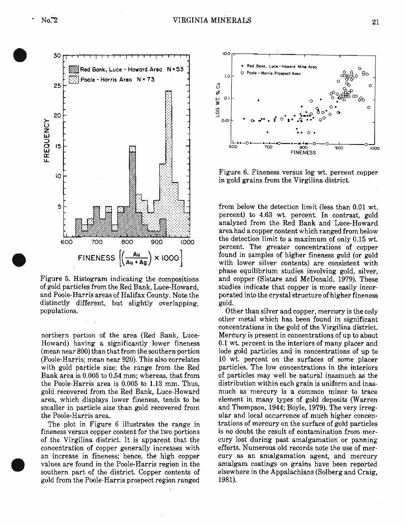
The plot in Figure 6 illustrates the range in fineness versus copper content for the two portions of the Virgilina district. It is apparent that the concentration of copper generally increases with an increase in fineness; hence, the high copper
@ values are found in the Poole-Harris region in the southern part of the district. Copper contents of gold from the Poole-Harris prospect region ranged
1 . . e * 0.
..-O.-.-.-Q-.-~l~-O-O 1 6 0 0 7 0 0 8 0 0 9 0 0 1000
FINENESS
1.0
I) 0
ae +' 01- 3 (3
S 001-
Figure 6. Fineness versus log wt. percent copper in 'gold grains from the Virgilina district.
Red Bonk, Luce- Howard Mine Area 0
0 Poole - Harris Prospect Area -
0
. 0 . 0. 0
%om0 e . . to.&'* a ,,.-• i 0 8 . .Q .. o0
from below the detection limit (less than 0.01 wt. percent) to 4.63 wt. percent. In contrast, gold analyzed from the Red Bank and Luce-Howard area had a copper content which ranged from below the detection limit to a maximum of only 0.15 wt. percent. The greater concentrations of copper found in samples of higher fineness gold (or gold with lower silver contents) are consistent with phase equilibrium studies involving gold, silver, and copper (Sistare and McDonald, 1979). These studies indicate that copper is more easily incor- porated into the crystal structure of higher fineness gold.
Other than silver and copper, mercury is the only other metal which has been found in significant concentrations in the gold of the Virgilina district. Mercury is present in concentrations of up to about 0.1 wt. percent in the interiors of many placer and lode gold particles and in concentrations of up to 10 wt. percent on the surfaces of some placer particles. The low concentrations in the interiors of particles may well be natural inasmuch as the distribution within each grain is uniform and inas- much as mercury is a common minor to trace element in many types of gold deposits (Warren and Thompson, 1944; Boyle, 1979). The very irreg- ular and local occurrence of much higher concen- trations of mercury on the surface of gold particles is no doubt the result of contamination from mer- cury lost during past amalgamation or panning efforts. Numerous old records note the use of mer- cury as an amalgamation agent, and mercury amalgam coatings on grains have been reported elsewhere in the Appalachians (Solberg and Craig, 1981).

22 VIRGINIA DIVISION OF MINERAL RESOURCES ~ $ 3 1 -
SUMMARY AND ACKNOWLEDGEMENTS
The setting of gold ores of the Virginia portion of the Virgilina district has been investigated and the mineralogy and chemistry characterized. Gold occurs as discreet particles and in association with hematite and minor sulfides in quartz veins which subparallel the attitude of the regional lithologies. The gold illustrates two compositional populations which correspond to different occurrences in the district. The experience and data gained provide a step in the development of a data base on Appa- lachian gold deposits which it is hoped will permit an understanding of the petrology and distribution of gold-bearing rocks.
The present contribution is an outgrowth of an M. S. thesis study a t VPI & SU by Linden (1981) and a portion of a larger study of gold in the Appalachians being carried out by J. R. Craig and T. N. Solberg. The work was supported by the Virginia Division of Mineral Resources, a Minerals and Mining Resources and Research Institute allot- ment grant, and National Science Foundation Grant No. EAR-8011418. We are indebted to Palmer Sweet and T. Edison Buchanan for their assistance in the field.
REFERENCES
Antweiller, J. C. and Campbell, W. L., 1977, Appli- cation of gold compositional analysis to mineral exploration in the United States: Jour. Geo- chem. Explor., v. 8, p. 17-29.
Boyle, R. W., 1979, The geochemistry of gold and its deposits (together with a chapter on geo- chemical prospecting for the element): Geol. Survey Canada Bull. 280,584 p.
Conley, J. F., 1978, Geology of the Piedmont of Virginia --- interpretations and problems, in Contributions to Virginia geology 111: Virginia Division of Mineral Resources Publication 7, p. 115-149.
Craig, J. R., Solberg, T. N., and Linden, M. A., 1981, Compositional ranges of Appalachian gold: Soc. Mining Eng. of AIME Trans., v. 274, p. 1870-1872,
Glover, L., I11 and Sinha, A. K., 1973, The Virgilina deformation -- A late Precambrian to early Cambrian (?) orogenic event in the central Piedmont of Virginia and North Carolina, in the Byron Copper Volume: Am. Jour. Sci., v. 273A, p. 234-251.
Johnson, N. E., 1983, A study of the vein copper mineralization of the Virgilina district, Virgi- nia and North Carolina: M. S. thesis, Virginia Polytechnic Institute and State University, 195 P.
Kreisa, R. D., 1980, Geology of the Omega, South Boston, Cluster Springs, and Virgilina quad- rangles: Virginia Division of Mineral Resour- ces Publication 5,22 p.
Laney, F. B., 1917, The geology and ore deposits of the Virgilina District of Virginia and North Carolina: Virginia Geol. Survey Bull. 14, 176 P.
Linden, M. A., 1981, Mineralogical and chemical characteristics of gold occurrences in the Vir- gilina district, Halifax County, Virginia: M. S. thesis, Virginia Polytechnic Institute and State University, 125 p.
Sistare, G. H., and McDonald, A. s.; 1979, Gold- silver-copper alloys, in Metals Handbook, Ninth Edition, Volume 2: Properties and Selec- tion: Nonferrous Alloys and Pure 'Metals: A. S. M., p. 680-682.
Solberg, T. N. and Craig, J. R., 1981, Chemical variations in gold from the central Appalach- ians of Virginia, in R. H. Geiss, ed., Microbeam analysis-1981: San Francisco Press, p. 163-166.
Sweet, P. C., 1971, Gold mines and prospects in Virginia: Virginia Division of Mineral Resour- ces, Virginia Minerals, v. 17, p. 25-33.
, 1976, Abandoned copper mines and prospects in the Virgilina district, Virginia: Virginia Division of Mineral Resources, Virginia Min- erals, v. 22, p. 25-34.
Sweet, P. C. and Trimble, D., 1983, Virginia Gold- Resource Data: Virginia Division of Mineral Resources Publication 45, 196 p.
Warren, H. V., and Thompson, R. M., 1944, Minor elements in gold: Econ. Geol., v. 39, p. 457-471.
Watson, T. L., 1907, Mineral Resources of Virginia: The Virginia Jamestown Exposition Commis- sion, Lynchburg, Virginia, J. P. Bell Company, Printers and Binders.
' No. Z VIRGINIA MINERALS
@ THE PINEY POINT FORMATION ALONG THE PAMUNKEY RIVER, VIRGINIA COASTAL PLAIN
Linda T. Deck
The Pamunkey River has long been recognized for the excellent outcrops of Eocene sediments along its banks. These sediments were named the Pamunkey Formation by Darton in 1891. Clark (1896) divided the Pamunkey Formation into the Aquia Creek and Woodstock stages and later with Martin (1901) raised the formation to group status with two formations, the Aquia and the Nanjemoy. In 1912 Clark and Miller described several addi- tional localities along the Pamunkey River that included beds younger than the type Nanjemoy. These younger beds, lithologically and paleontolog- ically distinct from the Nanjemoy, were studied by Ward (1984), who correlated them with the Piney Point Formation of Maryland (Otton, 1955). This is the only documented surface occurrence of
the Piney Point in Virginia. Along the Pamunkey River exposures of the
Piney Point consist of a basal clayey, glauconitic sand 8 feet thick overlain by a layer of concretions. Overlying the concretions is a 15-foot-thick clayey, glauconitic sand, an indurated oyster bed, and a soft, non-fossiliferous, burrowed, medium- to coarse-grained glauconitic sand. The three sections measured include most of the Piney Point, and have a distinctly different nature from the underlying Woodstock Member of the Nanjemoy Formation and the overlying Old Church Formation of Ward (1984). These sections are located along the Pamun- key River near Horseshoe (Figure 1). The strati- graphy of the Piney Point Formation is illustrated in Figures 2,3, and 4.
Figure 1. Portion of the Manquin 7.5-minute quadrangle showing the location of the measured sections.

24 VIRGINIA DIVISION OF MINERAL RESOURCES d h . 3 1 "
METERS METERS -
PINEY PO1141 FM.
-
HAHJEMOY FH.9 YOOOSTOCK
w ......... saw J S~~IIDSTOUE cLny - snno 30%-30% .................. .-...-... 0000
c m c m T m LnYa F-4 cLoyEy - snno ..a. - .. ...
W L L BE0 - s- '.'.h ..i.
CLnY . %nL. ---- [XI u n n w i L n t u
Figure 2. Locality 1, 3.9 miles downstream from the U. S. Highway 360 bridge (Figure 1). Water level through 7.5 feet is the dark green, well sorted clayey sand of the Woodstock Member of the Nan- jemoy Formation. An abrupt lithologic change marks the contact between the Nanjemoy and Piney Point formations. A 1.5-foot shell bed overlies this unconformity, grading upward to a light to medium grey-green shelly, sandy unit with little clay, the Piney Point Formation. I t contains the middle Claibornian oyster Cubitostrea selleforrnis (Conrad, 1832) and is 5 feet thick.
DESCRIPTION OF OSTRACODE FAUNA
Forty-five ostracode species are recognized in the six samples collected from the Piney Point For- mation (Deck, 1984, Table 1). Each individually occurring skeletal element, either a valve or a carapace, is counted as one specimen. Nearly all of these species range throughout the Piney Point, with the exception of those represented by less than ten specimens and Echinocythereis jacksonensis (Howe and Pyeatt), with a total of 17 specimens, found only in the upper portion of the formation (81LD30, 81LD31, 81LD32). Cyamocytheridea n. sp.1 (Deck, 1984), the most abundant species; totaled 307 specimens, while "Trachyleberis" johnsoni
PINEY POINT Fll.
Figure 3. Locality 2, 5.1 miles downstream from the U. S. Highway 360 bridge (Figure 1). This 11.5- foot exposure of Piney Point is light to medium grey-green, shelly, poorly sorted, glauconitic sand. A layer of concretions 1 foot thick occurs in the outcrop 6 feet above water level.
NET ERS
OLD CHURCH FM.
PINEY POINT FM.
Figure 4. Locality 3, 6.1 miles downstream from the U. S. Highway 360 bridge (Figure 1). The upper 21.5 feet of light to medium gray-green, shelly, poorly sorted, glauconitic sand of the Piney Point Formation is exposed. A lag deposit of shells, pebbles, and bone fragments occurs in the base of the overlying Old Church Formation of Ward (1984). A 3-foot-thick bed of the sandy clay of the Old Church completes the section.

*No. T VIRGINIA MINERALS 25

26 VIRGINIA DIVISION OF MINERAL RESOURCES B1.31-
Pooser, Buntoni aff. B. alabarnensis (Howe and Pyeatt), and Loxoconcha undet. sp. 2 are repre- sented by one specimen apiece. Twelve species recognized in the Piney Point samples have been described previously (Figure 5). The Table contains the ranges of these species. Eleven species have affinities with previously described species and eight additional species are considered distinct enough to be recognized as new species (Deck, 1984). The fourteen remaining species are not represented by enough specimens (at least 20) to be diagnosed because of lack of distinct charac- teristics.
Over 90 percent of all specimens recovered from the Piney Point are separate valves. Complete carapaces are rare. The valves are well preserved, showing hinge, muscle scar, external ornament, and radial pore canals clearly. Instars (immature shed carapaces) back to A-3 are common. Specimens from samples 81LD28, 81LD29A,' 81LD29B, and 81LD30 are very similar in pres- ervation, which is excellent. Specimens in samples 81LD31 and 81LD32 are not as well preserved as the four below them, resulting in pitting in Cya- rnocytheridea n. sp. 1 and sometimes indistingui- shable muscle scars or hinge characteristics.
Table. Range chart of previously described spe- cies; E-Early, M-Middle, L-Late.
Species E M L E M L E M L
Bairdoppilata platycoa Opimocythere martini Clithrocytheridea garretti Cocoaia grigsbyi Haplocytheridea montgomeryensis Ouachitaia caldwellemis Cushmanidea alta Cushmanidea gosportensis "Trachy1eberis"johnsoni Echinocythereis jacksonensis Triginglymus longicostata Hermanites collei
X X X X
X X X X X X X X
X X X X X X X X
X X X X
X X X X X X
X X X X X X X X X X
AGE OF THE OSTRACODE FAUNA AND DEPOSITIONAL
ENVIRONMENT OF THE PINEY POINT FORMATION
The age of the Piney Point ostracode fauna from the Pamunkey River exposures, determined by correlation with the ostracode faunas of the south- ern Atlantic Coastal Plain and the Gulf Coastal Plain, is middle Claibornian to middle Jacksonian. The Table is the range chart for the previously described Piney Point ostracodes. The majority of species occurrences and ranges fall within the middle Claibornian (8 occurrences), late Claibor- nian (11 occurrences), early Jacksonian (9 occur- rences) and middle Jacksonian (6 occurrences). The ostracode fauna of the Piney Point Formation is most like the fauna of the Gosport Formation of Alabama, which also is a mixture of middle Clai- bornian to middle Jacksonian forms (Blake, 1950). The Piney Point Formation appears to be time- transgressive, because early and middle Jackson- ian forms are present in the samples obtained from the Coastal Plain portion of Virginia. However, a strictly Claibornian ostracode fauna is found in the water well material identified by Brown, Miller, and Swain (1972) from the type locality in St. Marys County, Maryland.
The relatively high number of ostracode species (forty-five) found in the Piney Point and the mod- erate to high number of individuals suggest that it was deposited under normal marine conditions. The affinities of this ostracode fauna to those from the Gulf Coastal Plain support this idea as well. Environmentally, the two areas were quite similar, having a predominantly elastic sediment regime and warm temperatures, based on the molluscan fauna (Ward, 1984).
Slow sedimentation is indicated by the presence of glauconite throughout the Piney Point Forma- tion (Owens and Sohl, 1973). I t is further evidenced by the excellent preservation of the ostracodes. Most ostracode specimens were recovered as valves, not complete carapaces, and in a fossil assemblage the predominance of valves over carapaces has been correlated with slow sedimentation rates (Pokorny, 1965; Oerti, 1972). The preservation of the indi- vidual valves is excellent, indicating little trans- port, and probably quiet conditions as exist below wave-base. Asterigerina texana, the associated fora- minifera, prefers clear, warm waters (Paul Hud- dlestun, 1984 oral communication), which also sup- ports slow sedimentation with little transport or abrasion.
' NO. T' VIRGINIA MINERALS 27
The ecology of the ostracode genera in the Piney @ Point suggests that deposition occurred in a shallow shelf, warm, open marine system. Some of the genera, such as Haplocytheridea and Clithrocythe- ridea and related genera, are recognized as indic- ative of an intralittoral or marginal marine envir- onment. However, all identified genera are common in open marine waters as well (Van Mork- hoven, 1962).
ACKNOWLEDGEMENTS
I thank J. E. Hazel, L. W. Ward, Richard Bamb- ach, Ralph Chapman, Richard Benson, and Scott Lidgard for their help during various phases of this research. Financial and other support was provided by the Virginia Division of Mineral Resources, a Sigma Xi Grant-in-Aid of Research, the Department of Geological Sciences a t Virginia Polytechnic Institute and State University, the U. S. Geological Survey Paleontology and Strati- graphy Branch, and afellowship in the Department of Paleobiology, National Museum of Natural His- tory, Smithsonian Institution.
REFERENCES
Blake, D. B., 1950, Gos~ort Eocene Ostracoda from Little Stave Creek, Alabama: Jour. Paleont., v. 24, p. 174-184.
Brown, P. M., Miller, J. A., and Swain, F. M., 1972, Structural and stratigraphic framework, and spatial distribution of permeability of the Atlan- tic Coastal Plain, North Carolina to New York: U. S. Geol. Surv. Prof. Paper 796,79 p.
Clark, W. B., 1896, The Potomac River section of the middle Atlantic coast Eocene: American Jour. Sci., 4th Series, v. 1, p. 365-374.
-, and Martin, G. C., 1901, The Eocene deposits of Maryland: Maryland Geol. Surv., Eocene volume, p. 1-92, 122-204.
__, and Miller, B. L., 1912, Physiography and geology of the Coastal Plain Province of Virginia: Virginia Geol. Surv. Bull. 4, p. 1-58, 88-222.
Darton, N. H., 1891, Mesozoic and Cenozoic for- mations of eastern Virginia and Maryland: Geol. Soc. America Bull., v. 2, p. 431-450.
Deck, L. T., 1984, Ostracodes of the Piney Point Formation, Pamunkey River, Virginia, in L. W. Ward and K. Krafft, eds., Stratigraphy and paleontology of the outcropping Tertiary beds in the Pamunkey River region, central Virginia Coastal Plain, Guidebook for Atlantic Coastal Plain Geol. Assoc. 1984 field trip: Atlantic Coas- tal Plain Geol. Assoc., p. 186-191.
Oertli, H. J., 1972, The aspect of Ostracode faunas- -a possible new tool in petroleum sedimentology: Bull. Centre Rech. Pau - SNPA, 5 suppl., p. 137- 151.
Otton, E. G., 1955, Ground water resources of the southern Maryland Coastal Plain: Maryland Nat. Res. Bd. Bull. 15, 347 p.
Owens, J. P., and Sohl, N. F., 1973, Glauconites from New Jersey- Maryland Coastal Plain: their K-Ar ages and applications in stratigraphic stu- dies: Geol. Soc. America Bull., v. 84, p. 2811- 2838.
Pokorny, V., 1965, Some paleoecological problems in marine ostracode faunas, demonstrated on the Upper Cretaceous ostracodes of Bohemia, Cze- choslovakia: Pubbl. Staz. Zool. Napoli, v. 33, p. 462-479.
Van Markhoven, F. P. C. M., 1962, Post-Paleozoic Ostracoda: their morphology, taxonomy, and eco- nomic use: Elsevier Publishing Co., New York, 2 vols.
Ward, L. W., 1984, Stratigraphy of outcropping Tertiary beds along the Pamunkey River, central Virginia Coastal Plain, in L. W. Ward and K. Krafft, eds., Stratigraphy and paleontology of the outcropping Tertiary Beds in the Pamunkey River Region, central Virginia Coastal Plain, Guidebook for Atlantic Coastal Plain Geol. Assoc. 1984 field trip: Atlantic Coastal Plain Geol. Assoc., p. 11-78.
NEW PUBLICATIONS
PUBLICATION 43
Relationship of Stratigraphy to Occurrences of Oil and Gas in Western Virginia, by D. C. LeVan and E. K. Rader; one sheet, 1983.
$6.00
In this publication, the western portion of the State is divided into six areas, each having a representative stratigraphic column and brief sum- mary of oil and gas production. Oil and gas occur- rences are denoted by symbols representing major sources to small amounts or shows. These symbols have been placed in their relative stratigraphic position next to the corresponding formation or member. Published reports from which some of the data was collected are listed in references. The legend and map have been color-coded to aid in distinguishing dominant lithology.
This publication (one sheet) can be ordered from the Division for $6.00. A four percent sales tax will be added to in-State orders; postage will be billed.

Postmaster: Send address corrections to - Virginia Division of Mineral Resources Box 3667 Charlottesville, VA 22903
PUBLICATION 44
Selected Karst Features of the Northern Valley and Ridge Province, Virginia, by David A. Hubbard, Jr.; one sheet, 1983.
$4.00
This publication provides a guide to potentially hazardous karst areas. Sink holes and cave entran- ces are shown throughout the northern Valley and Ridge Province (scale 1:250,000). The map also shows contact lines, faults, and major drainage divides. Lithologic units are designated on the map by numbers and are listed in the explanation. The text includes karst development and potential karst hazards. Seperate lists of references are given for the text and map.
This publication (one sheet) can be ordered from the Division for $4.00. A four percent sales tax will be added to Virginia addresses; postage will be billed.
PUBLICATION 45
Virginia Gold-Resource Data, by Palmer C. Sweet and David Trimble; 196 p., 1983.
$10.00 Information on 226 gold mines and prospects is
listed in Virginia Gold-Resource Data. The mines and prospects are arranged alphabetically by county with 25 county location maps on which most of the mines and prospects are plotted. Their posi- tion from the nearest prominent locality is given as well as a field description presented under "Location Comments". Furthermore, their posi- tions can be determined on a geologic quadrangle map from the given latitude and longitude coor-
Virginia Minerals, Vol. 31, No. 2, May 1985
Virginia Minerals Second-class postage paid at Charlottesville, Virginia ISSN 0042-6652
dinates. In this computerized listing, a description of the deposit, exploration and development, and geology and mineralogy are given. Other pertinent information such as description, of workings (sur- face and underground) and present owner is also included. General references are cited for each mine or prospect.
Publication 45 can be obtained at the Division for $10.00. Sales tax (four percent) will be added to publications purchased by virginia residents; postage will be billed.
PUBLICATION 46
Coal-Bed Methane Resource Evaluation, Mont- gomery County, Virginia by C. B. Stanley, A. P. Shultz, and others; 59 p., 1983.
$5.00 In this investigation, the Mississippian age coal
beds near Blacksburg, Virginia (the Valley coal fields of southwestern Virginia) were evaluated for potential commercial quantities of methane. The area was tested by drilling three diamond core holes: the Sunnyside, Merrimac, and Prices Fork test wells. The gas content of Price Formation coals was determined and an analysis made for the Sunnyside and Merrimac test wells (the Prices Fork test well had to be abandoned). Stratigraphy and structure have been described for general geology as well as the Price and Maccrady forma- tions. Lithologic and geophysical well logs for the two test wells are presented. A detailed lithologic description of core for these wells concludes the report. The economic feasibility was examined by projecting well productivity and predicting finan- cial outcome.
This publication can be purchased at the Division for $5.00. Sales tax (four percent) will be added to publications purchased by Virginia residents; postage will be billed.